STREETSCAPE MASTER PLANS
2015
Prepared for Murrindindi Shire Council
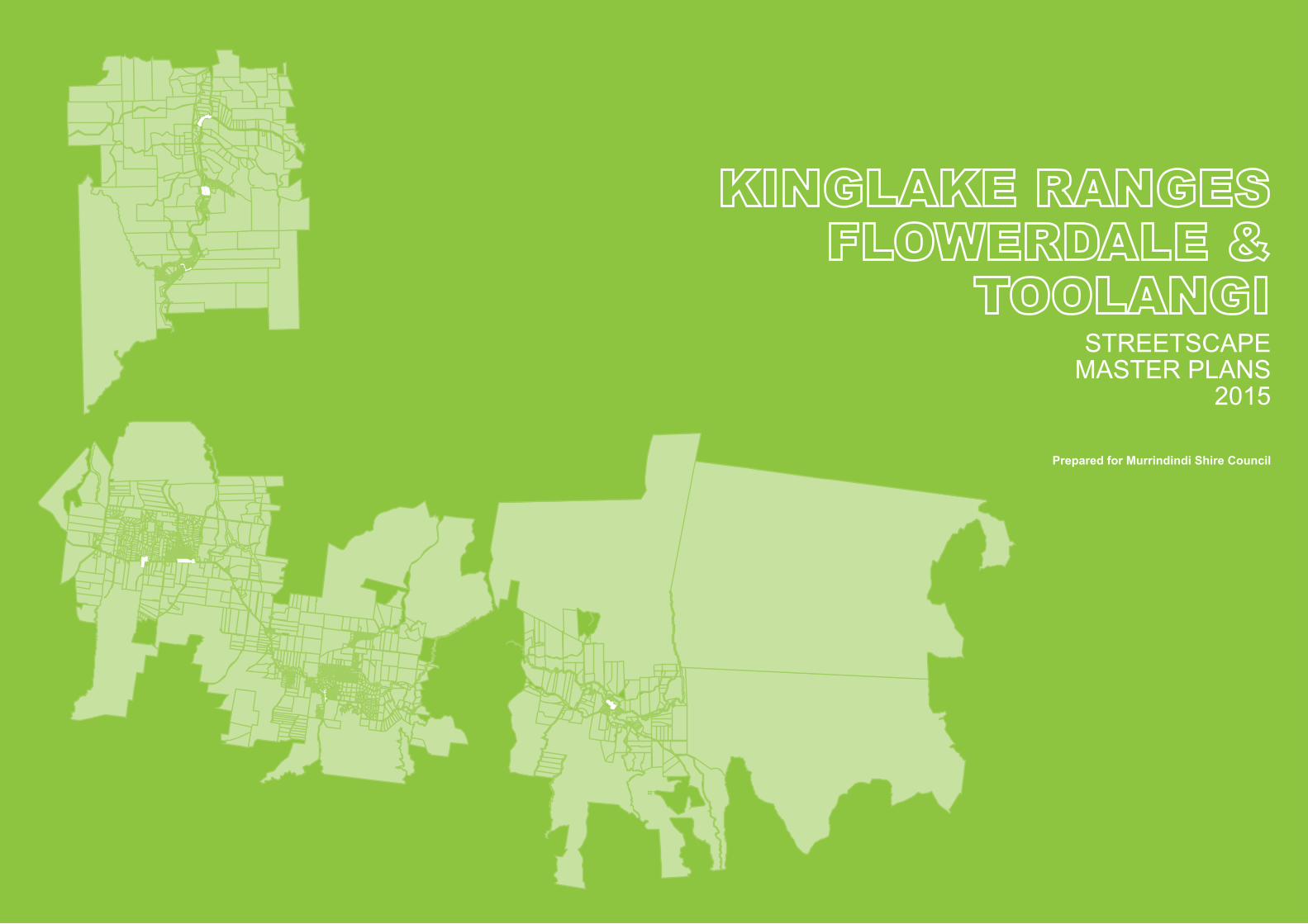
KINGLAKE RANGES, FLOWERDALE & TOOLANGI STREETSCAPE MASTER PLANS
M U R R I N D I N D I S H I R E C O U N C I L
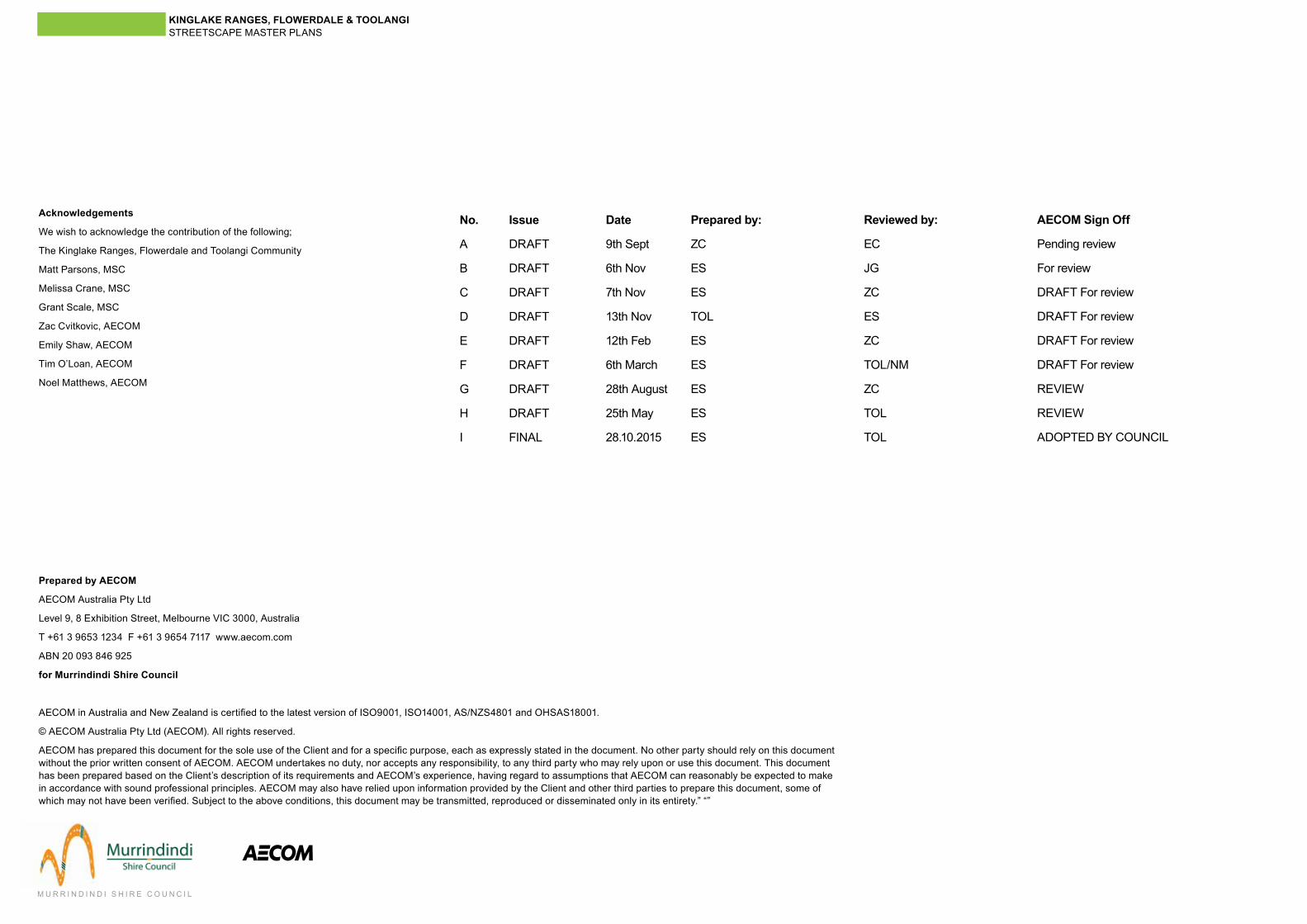
No.
A
B
C
D
E
F
G
H
I
Issue
DRAFT
DRAFT
DRAFT
DRAFT
DRAFT
DRAFT
DRAFT
DRAFT
FINAL
Date
9th Sept
6th Nov
7th Nov
13th Nov
12th Feb
6th March
28th August
25th May
28.10.2015
Prepared by:
ZC
ES
ES
TOL
ES
ES
ES
ES
ES
Reviewed by:
EC
JG
ZC
ES
ZC
TOL/NM
ZC
TOL
TOL
AECOM Sign Off
Pending review
For review
DRAFT For review
DRAFT For review
DRAFT For review
DRAFT For review
REVIEW
REVIEW
ADOPTED BY COUNCIL
Prepared by AECOM
AECOM Australia Pty Ltd
Level 9, 8 Exhibition Street, Melbourne VIC 3000, Australia
T +61 3 9653 1234 F +61 3 9654 7117 www.aecom.com
ABN 20 093 846 925
for Murrindindi Shire Council
AECOM in Australia and New Zealand is certified to the latest version of ISO9001, ISO14001, AS/NZS4801 and OHSAS18001.
© AECOM Australia Pty Ltd (AECOM). All rights reserved.
AECOM has prepared this document for the sole use of the Client and for a specific purpose, each as expressly stated in the document. No other party should rely on this document without the prior written consent of AECOM. AECOM undertakes no duty, nor accepts any responsibility, to any third party who may rely upon or use this document. This document has been prepared based on the Client’s description of its requirements and AECOM’s experience, having regard to assumptions that AECOM can reasonably be expected to make in accordance with sound professional principles. AECOM may also have relied upon information provided by the Client and other third parties to prepare this document, some of which may not have been verified. Subject to the above conditions, this document may be transmitted, reproduced or disseminated only in its entirety.” “”
Acknowledgements
We wish to acknowledge the contribution of the following;
The Kinglake Ranges, Flowerdale and Toolangi Community
Matt Parsons, MSC
Melissa Crane, MSC
Grant Scale, MSC
Zac Cvitkovic, AECOM
Emily Shaw, AECOM
Tim O’Loan, AECOM
Noel Matthews, AECOM
KINGLAKE RANGES, FLOWERDALE & TOOLANGI STREETSCAPE MASTER PLANS
M U R R I N D I N D I S H I R E C O U N C I L
1.1 Introduction
1.2 The Study Area
1.3 Report Structure
1.4 Design Themes
1.5 Aims and Objectives
1.6 The Vision
2.1 Toolangi
2.2 Kinglake
2.3 Kinglake West - Pheasant Creek
2.4 Flowerdale South
2.5 Flowerdale Central
2.6 Flowerdale North
3.1 Projects
- Toolangi - Kinglake - Kinglake West - Pheasant Creek - Flowerdale South - Flowerdale Central - Flowerdale North
5.1 Community Consultation feedback
4.1 Typical Vegetation Mixes
4.2 Furniture Types
4.3 Maintenance
Table of Contents


KINGLAKE RANGES, FLOWERDALE & TOOLANGI STREETSCAPE MASTER PLANS
M U R R I N D I N D I S H I R E C O U N C I L
3
The particular challenges that the communities of the Kinglake Ranges have faced in rebuilding and redefining themselves following the 2009 bushfires have been substantial and unique. The Murrindindi Shire Council and the Victorian State Government, together with the local communities have undertaken extensive work in managing the rebuilding effort, ensuring that this project brings a damaged community together and which also seamlessly integrates with a range of past projects and current initiatives that the communities are undertaking. In response to the 2009 bushfires and the Victorian Bushfires Royal Commission the Kinglake Flowerdale Toolangi Plan and Design Framework (KFT Plan) was initiated in 2010 and was latter adopted by Council as the ‘KFT Plan’ in February 2014.
A key recommendation of the KFT Plan was a need for more detailed streetscape master planning in town centres and community nodes to define potential future improvements and integrate a number of activities to be undertaken by Council and others. This Streetscape Masterplan provides a guide to future design and works in the public realm, roads, and some adjoining private land areas in the Kinglake, Kinglake West - Pheasant Creek, Flowerdale (northern, central and southern precincts) and Toolangi community precincts. While heavily guided by the study area communities, the plan has been prepared with the input of Murrindindi Shire Council and relevant authorities, such as VicRoads.
While the streetscape masterplans will inform future Council capital works programs and budget bids, Council will use the masterplans as a guide and is not bound to implementing all proposed works identified in them. The adopted masterplans, including identified projects and potential further actions, will be considered and prioritised against other works when determining Council’s annual budget and strategic resource plan (capital works program) allocations. Potential projects have been given an estimation of priority and indicative cost but do not indicate a proposed time frame or overall total cost for each project.
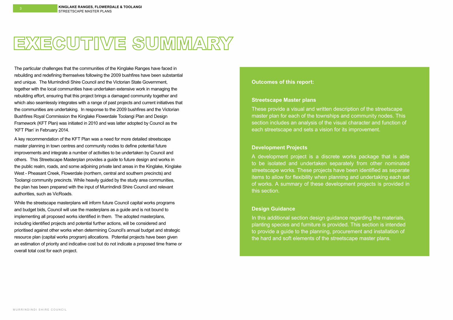
Outcomes of this report:
Streetscape Master plansThese provide a visual and written description of the streetscape master plan for each of the townships and community nodes. This section includes an analysis of the visual character and function of each streetscape and sets a vision for its improvement.
Development Projects A development project is a discrete works package that is able to be isolated and undertaken separately from other nominated streetscape works. These projects have been identified as separate items to allow for flexibility when planning and undertaking each set of works. A summary of these development projects is provided in this section.
Design GuidanceIn this additional section design guidance regarding the materials, planting species and furniture is provided. This section is intended to provide a guide to the planning, procurement and installation of the hard and soft elements of the streetscape master plans.
KINGLAKE RANGES, FLOWERDALE & TOOLANGI STREETSCAPE MASTER PLANS
M U R R I N D I N D I S H I R E C O U N C I L
4
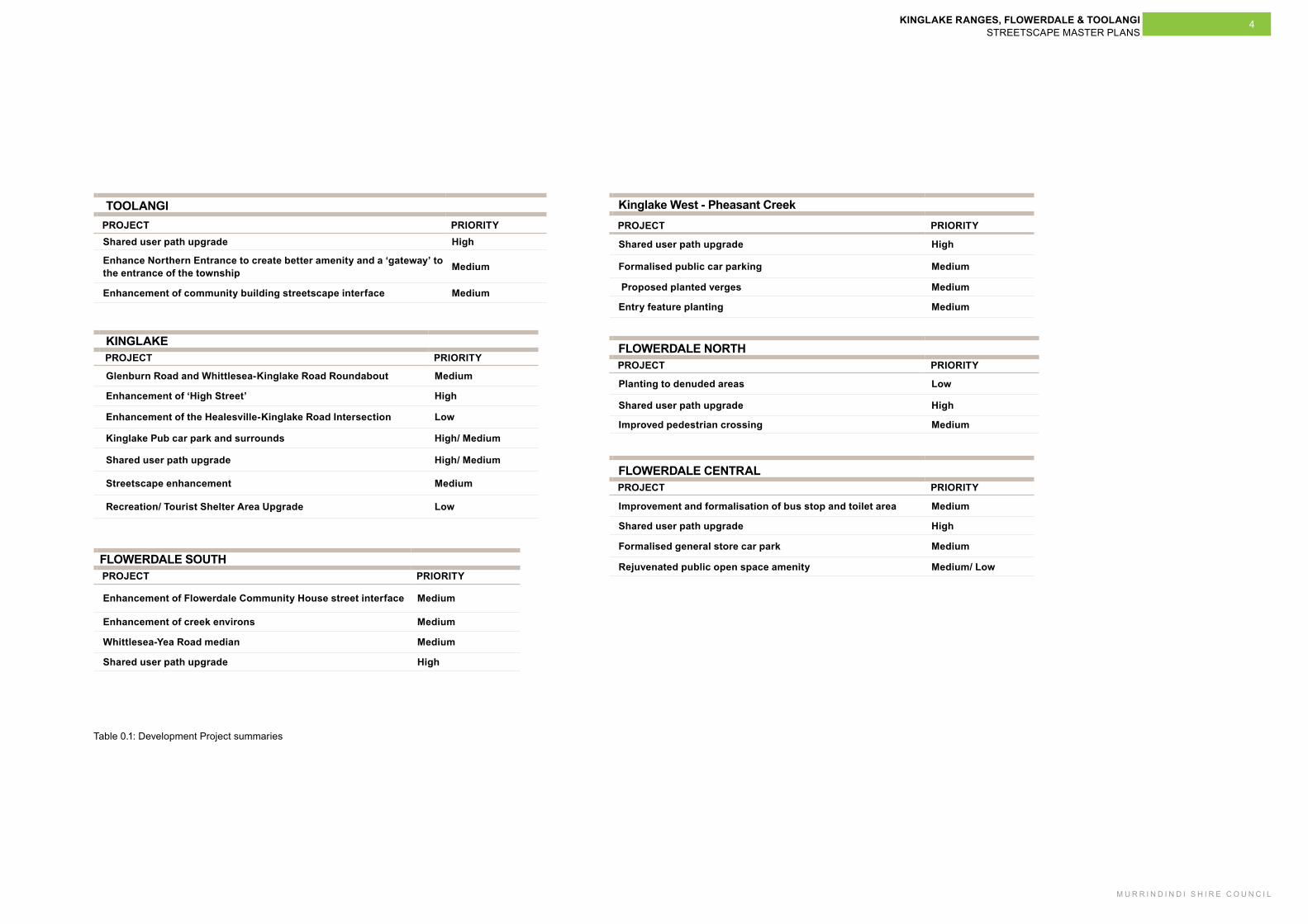
TOOLANGI PROJECT PRIORITY
Shared user path upgrade High
Enhance Northern Entrance to create better amenity and a ‘gateway’ to the entrance of the township Medium
Enhancement of community building streetscape interface Medium
KINGLAKE PROJECT PRIORITY
Glenburn Road and Whittlesea-Kinglake Road Roundabout Medium
Enhancement of ‘High Street’ High
Enhancement of the Healesville-Kinglake Road Intersection Low
Kinglake Pub car park and surrounds High/ Medium
Shared user path upgrade High/ Medium
Streetscape enhancement Medium
Recreation/ Tourist Shelter Area Upgrade Low
Kinglake West - Pheasant Creek PROJECT PRIORITY
Shared user path upgrade High
Formalised public car parking Medium
Proposed planted verges Medium
Entry feature planting Medium
FLOWERDALE SOUTH PROJECT PRIORITY
Enhancement of Flowerdale Community House street interface Medium
Enhancement of creek environs Medium
Whittlesea-Yea Road median Medium
Shared user path upgrade High
FLOWERDALE NORTH PROJECT PRIORITY
Planting to denuded areas Low
Shared user path upgrade High
Improved pedestrian crossing Medium
FLOWERDALE CENTRAL PROJECT PRIORITY
Improvement and formalisation of bus stop and toilet area Medium
Shared user path upgrade High
Formalised general store car park Medium
Rejuvenated public open space amenity Medium/ Low
Table 0.1: Development Project summaries


KINGLAKE RANGES, FLOWERDALE & TOOLANGI STREETSCAPE MASTER PLANS
M U R R I N D I N D I S H I R E C O U N C I L
7
1.1 Introduction1.1.1 BackgroundThe Kinglake Ranges, Flowerdale and Toolangi Streetscape Master Plans Report (KFT Streetscape Master Plans Report) intends to provide guidance on the most effective methods of managing the public realm and streetscape areas of each township. The report implements a key recommendation of the Kinglake Ranges, Flowerdale and Toolangi Plan and Design Framework (KFT Plan) adopted by Murrindindi Shire Council in 2014.
The KFT Plan was developed by the Victorian Bushfire Reconstruction and Recovery Authority (VBRRA) and Murrindindi Shire Council (MSC) to provide a vision for a sustainable future for the communities of Kinglake, Kinglake Central, Kinglake West - Pheasant Creek, Flowerdale (including Hazeldene), Toolangi and Castella.
Before the 2009 Victorian bushfires, MSC recognised the communities of the Kinglake Ranges, Flowerdale and Toolangi required a long-term strategic plan as a matter of urgency. As a consequence of the fires, the development of the KFT Plan received funding in Rebuilding Together: A Statewide Plan for Reconstruction and Recovery, released in October 2009.
The KFT Plan aims to:
- Provide a strategic framework to guide local townships and settlements of the Kinglake Ranges district as they develop to meet future demands.
- Retain the existing character of these towns through their future development.
- Guide the approach to future development and assist in the implementation of land use planning in Murrindindi Shire.
Direction 4 of the KFT Plan aims to create attractive, distinctive and vibrant towns, calling for the development of a detailed Streetscape Design Concepts Analysis for the purposes of assisting MSC in delivering appropriately designed streetscape infrastructure. The applicable actions under Direction 4 of the implementation strategy are as follows:
- A3.1 Re-cast the townships as gateways to the natural assets of the area through improved signage and wayfinding. Undertake a retail development strategy specifically for the study area to realise the potential for eco-toursim related expenditure.
- A4.2 Implement design frameworks prepared as part of this report to improve the attractiveness and functionality of settlements within the study area. This should also include protection of significant views, vistas and the establishment of landscape buffers.
- A4.4 Improve identity through a comprehensive way finding strategy which includes urban design elements such as community nodes, civic hubs, pathways, gateways and entry features and varied public open spaces.
An overall streetscape master plan will:
- Guide the approach to the future development in each settlement.
- Make recommendations to strengthen town centres and community hubs.
- Aim to improve the visual attractiveness, create better pedestrian and vehicular connections, and provide guidance for future development and the use of land.
1.2 Report Role and Structure1.2.1 Role of this documentThe KFT Streetscape Master Plans Report focuses on a series of individual areas within the Kinglake Ranges and provides guidance on how their more prominent streetscapes could be improved. This report also outlines the preferred outcomes of the urban and rural character of the individual areas within the Kinglake Ranges, paying particular attention to the larger and more highly frequented township areas, such as Kinglake.
It is critical that the KFT Streetscape Master Plans Report has a clear, well-defined, integrated and measurable set of guidelines to ensure the highest level of design quality is achieved. There are several strategic and guidance documents that are relevant to this project which is tasked with analysing and integrating all relevant documents into a concise and relevant set of principles and recommendations.
In this way, the streetscape master plans will respond to government policy concerning planning, design and good development principles and embrace design aspirations and policies situated in the Murrindindi Local Planning Policy framework.
The KFT Streetscape Master Plans Report clearly expresses a design vision and principles for the future development of the streetscape for each individual area. The report has not been developed as a prescriptive document but presents as a series of design considerations for each streetscape. Where appropriate, alternative approaches are outlined to meet differing conditions.
1.2.2 Report StructureIntroduction
Provides a background and an outline of the role, structure, principles and objectives of the KFT Streetscape Master Plans Report.
Streetscapes
Provides a description of each streetscape master plan. This section will include guidance on how to treat common elements to all or most streetscape master plans.
Projects
Identifies the individual initiatives and streetscape works required to successfully fulfil the streetscape master plans.
Design Guidance
Sets out basic requirements for vegetation, furniture and maintenance used in the streetscape master plans.
Appendices
Outlines the policy framework and strategies that underpin the streetscape master plans and precedents that have relevance to the project. This section also includes a summary of the community consultation sessions.
1.2.3 Key ConsiderationsWhen considering each streetscape, this report has categorised four ways of describing the township. Using a standardised method of describing the existing streetscape allows the report to more clearly articulate the main points that need to be considered when planning future development. Each ‘key consideration’ deals with a specific part of the streetscape and covers the physical, functional and visual aspects.
Built form and building use
The townships and streetscapes that are the focus of this report are not dominated by buildings, however in many streetscapes it is the single or small group of buildings that provides character to the township. Community buildings, for example, form the focus for many of the streetscapes considered in this report.
Visual character
The visual character of the streetscape is an important part of how the street is perceived and understood. The way in which a streetscape appears is the most immediately recognisable and distinctive identifier of any community. The visual character often reflects the values of its community and is a highly sensitive part of any streetscape and its future development. A clear definition of visual character more effectively allows the recommendations for future development to build on the existing character and not diminish it.
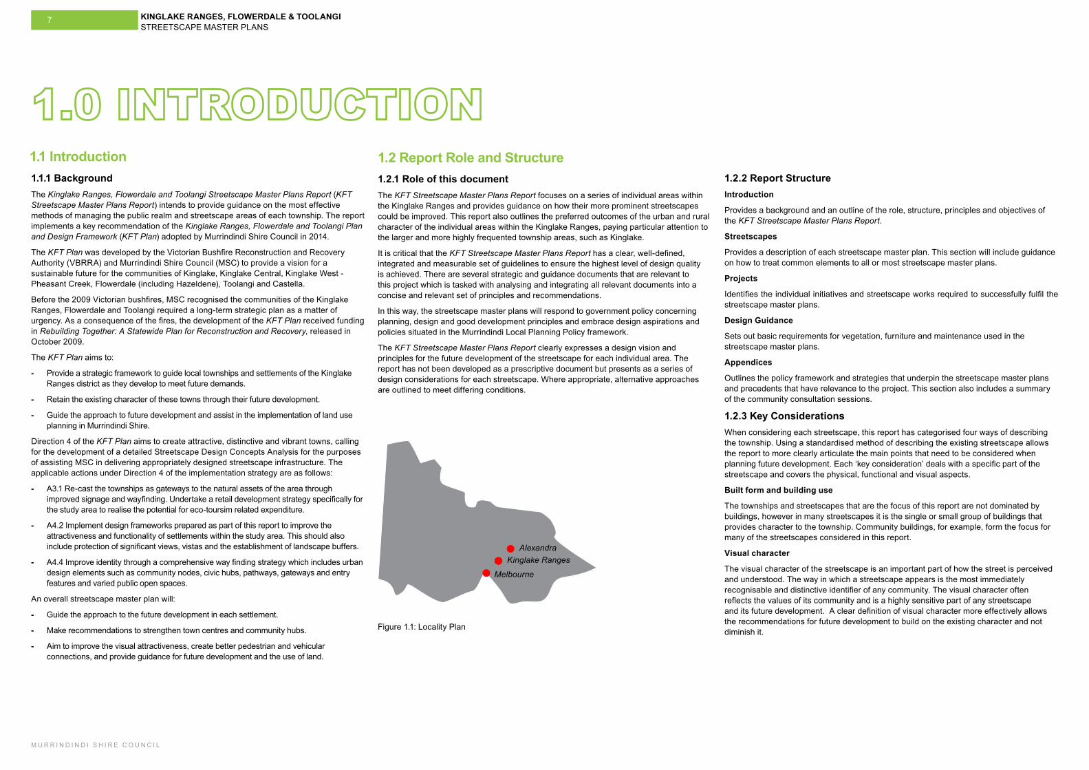
Kinglake RangesAlexandra
Melbourne
Figure 1.1: Locality Plan
KINGLAKE RANGES, FLOWERDALE & TOOLANGI STREETSCAPE MASTER PLANS
M U R R I N D I N D I S H I R E C O U N C I L
8
1.3 Aims and Objectives 1.4 Design Framework 1.3.1 Project aimTo prepare streetscape master plans that will guide future urban design and localised development in the civic precincts of Kinglake, Kinglake West - Pheasant Creek, Flowerdale and Toolangi.
1.3.2 Project objectivesThe project objectives describe what the streetscape master plans intend to achieve. The project will:
- Outline future development and the use of land within each civic precinct, providing guidance for the future design, style and type of streetscape development.
- Provide a framework for integrated streetscape infrastructure.
- Assist with preserving and strengthening the role, identity, sustainability and livability of settlements, town centres, and community hubs and civic precincts.
- Enhance the opportunity to provide design guidance for the Kinglake Ranges Heritage Trail.
- Identify key opportunities for placemaking ‘pop-up’ sites, including existing MSC and community sites.
- Identify road and roadside vegetation treatments appropriate to each respective precinct.
- Identify priorities for future community and infrastructure works to be undertaken by the community, MSC and State Government agencies within the streetscape areas.
- Ensure a high level of pedestrian and vehicle connectivity between and within settlements and civic areas.
- Assist with the creation of welcoming community spaces, capitalise on existing key view lines and provide quality gateways into and out of civic precincts.
- Outline a future implementation program for development and works in the streetscape areas.
1.4.1 ‘Creating Places for People’Creating Places for People: an Urban Design Protocol for Australian Cities is an urban design protocol developed by the Australian Federal Government to guide our built environment.
Creating Places for People is relevant to the KFT Streetscape Master Plans Report process as it ties the objectives and vision outlined in this report to a recognised Australia-wide protocol for developing better urban places. Creating Places for People matches the ‘aims’ for the design of places with desired ‘outcomes’, making it applicable for the streetscape master plans.
This report will use the Creating Places for People methodology as it provides a universal basis from which to develop the principles and descriptions of outcomes that are more readily translated to State and Local Government requirements. This project uses two of the key themes from Creating Places for People that are most relevant to these streetscapes. These themes are:
- Productivity and Sustainability
- Livability
1.4.2 Project principlesThe KFT Streetscape Master Plans Report has adopted a series of project-specific principles that build upon and complement the principles found in the Creating Places for People. The principles under each major design theme are:
Design theme 1: Productivity and SustainabilityPrinciples
- Enhancing the local economy, environment and community.
- Connecting physically and socially.
- Providing a diversity of options and experiences.
- Providing a sustainable, enduring and resilient urban environment.
Design theme 2: LivabilityPrinciples
- Providing comfortable and welcoming places.
- Providing vibrancy, with people activity.
- Prove a sense of safety.
- Provide walkable, enjoyable and cycleable places.
These streetscape master plans focuses on seven key township areas. Each is separated
Access, connections and circulation
The ease of getting to and moving around a streetscape is another significant consideration. Many of the streetscapes examined in this report have developed along roadways therefore providing a strong emphasis on the movement of motorised vehicles. This is largely to be expected as these vehicles are the primary method of getting to and from each township area. As communities develop and as the community and visitors are increasingly looking to walk and cycle between and around the townships, the streetscapes will need to better accommodate these forms of movement.
Another important aspect of access and circulation in the streetscape is that any new township development must look to enhance the ability for people to move around and through the streetscape, not diminish it. New developments may seek to alter the way in which the community access the streetscape or connect between parts of the same township area. It is critical that the streetscape be considered as a genuine public corridor and a series of community spaces and not as a series of isolated access points to private businesses.
Outdoor comfort and community involvement
The main street of any township is both the practical resupply and replenishment centre and also the place where the community is able to meet, pass news and spend time. The degree to which each streetscape in this report supports these uses greatly varies. In many cases, there are very few buildings or uses that attract people to the streetscape. The role of each streetscape is different. There is a need to provide a comfortable public space, whether it be for passive recreation (sitting and talking) or active play, all streetscapes need to perform a role for the community.
1.2.4 OpportunitiesThe Kinglake Ranges, Flowerdale and Toolangi Streetscape Master Plans Report outlines major opportunities for achieving improvements in the urban environment of seven independent streetscapes within the Kinglake Ranges district. The streetscape master plans provide an overall vision for the future and focus on the improvement of pedestrian access, visual character, coordination of design and works.
1.2.5 Future road design considerationsBeyond this report further road, traffic and civil engineering investigation and design will be required. Prior to commencing these advanced stages of work consideration will need to be given to the detailed requirements of the VicRoads Northern Region. Initial guidance provided by VicRoads regional office is as follows;
• An engineering assessment to check for compliance with the Austroads guide is to be undertaken.
• Landscaping proposals in all locations to be checked to maintain safe sight distances.
• Signage to be checked in all locations.
• Once streetscape projects have been programmed VicRoads Norther Region should be consulted with regard to operational requirements and compliance to standards.
KINGLAKE RANGES, FLOWERDALE & TOOLANGI STREETSCAPE MASTER PLANS
M U R R I N D I N D I S H I R E C O U N C I L
9
The streetscapes of the Kinglake Ranges, Flowerdale and Toolangi will realise their township
character through the creation of a walkable, connected, vibrant and enduring sequence of public places and opportunities for business to
develop alongside the homes of the community.
1.5 The Study Area 1.6 The Vision
“
A vision for the KFT Streetscape Master Plans Reports has been developed. This vision is:
‘The streetscapes of the Kinglake Ranges, Flowerdale and Toolangi will realise their township character through the creation of a walkable, connected, vibrant and enduring sequence of public places and opportunities for business to develop alongside the homes of the community.’
”
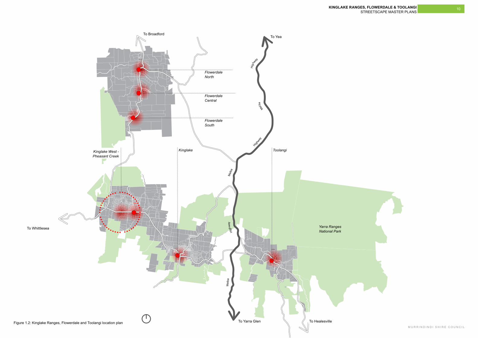
These streetscape master plansby several kilometres and has its own distinct character. These areas were originally identified in the KFT Plan, and are:
- Toolangi.
- Kinglake.
- Kinglake West - Pheasant Creek.
- Flowerdale South.
- Flowerdale Central.
- Flowerdale North.
KINGLAKE RANGES, FLOWERDALE & TOOLANGI STREETSCAPE MASTER PLANS
M U R R I N D I N D I S H I R E C O U N C I L
10
Flowerdale North
Flowerdale Central
Flowerdale South
ToolangiKinglake
To BroadfordTo Yea
To Whittlesea
To Yarra Glen To Healesville
Yarra Ranges National Park
Kinglake West - Pheasant Creek
Figure 1.2: Kinglake Ranges, Flowerdale and Toolangi location plan
M
elba
H
ighw
ay
M
elba
Highway
Mel
ba
Hig
hway

SITE SPECIFIC STRATEGIES
KINGLAKE RANGES, FLOWERDALE & TOOLANGI STREETSCAPE MASTER PLANS
M U R R I N D I N D I S H I R E C O U N C I L
13
2.1.2 Considerations and recommendationsBuilt form and building use
- Maintain the existing building heights and ensure any new built forms are highly sympathetic to the existing residential buildings.
Visual character
- Focus attention on improvements of the community precinct and create a sense of Toolangi’s township character.
Access, connections and circulation
- Improve the quality and visibility of pedestrian access through the township.
Outdoor comfort and community involvement
- Focus the majority of the public open space improvements on the community centre and primary school forecourt.
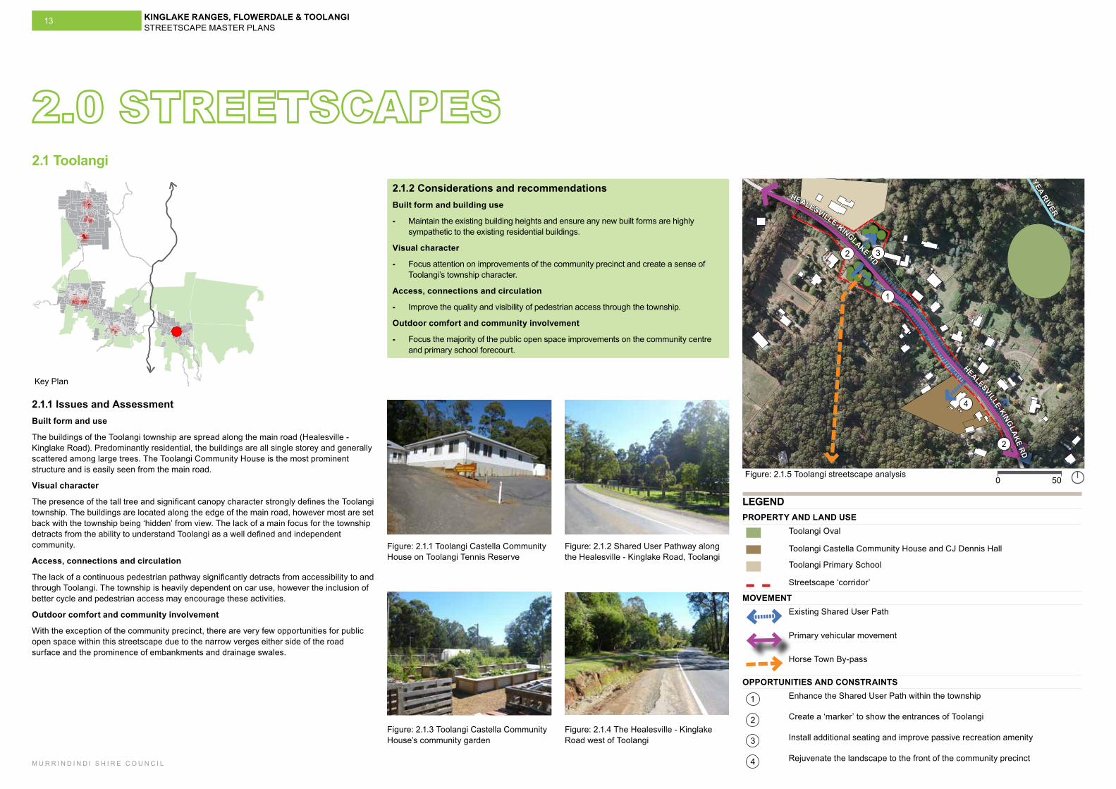
2.1.1 Issues and AssessmentBuilt form and use
The buildings of the Toolangi township are spread along the main road (Healesville - Kinglake Road). Predominantly residential, the buildings are all single storey and generally scattered among large trees. The Toolangi Community House is the most prominent structure and is easily seen from the main road.
Visual character
The presence of the tall tree and significant canopy character strongly defines the Toolangi township. The buildings are located along the edge of the main road, however most are set back with the township being ‘hidden’ from view. The lack of a main focus for the township detracts from the ability to understand Toolangi as a well defined and independent community.
Access, connections and circulation
The lack of a continuous pedestrian pathway significantly detracts from accessibility to and through Toolangi. The township is heavily dependent on car use, however the inclusion of better cycle and pedestrian access may encourage these activities.
Outdoor comfort and community involvement
With the exception of the community precinct, there are very few opportunities for public open space within this streetscape due to the narrow verges either side of the road surface and the prominence of embankments and drainage swales.
Figure: 2.1.5 Toolangi streetscape analysis
2.1 Toolangi
500
Figure: 2.1.1 Toolangi Castella Community House on Toolangi Tennis Reserve
Figure: 2.1.3 Toolangi Castella Community House’s community garden
Figure: 2.1.2 Shared User Pathway along the Healesville - Kinglake Road, Toolangi
Figure: 2.1.4 The Healesville - Kinglake Road west of Toolangi
LEGENDPROPERTY AND LAND USE
Toolangi Oval
Toolangi Castella Community House and CJ Dennis Hall
Toolangi Primary School
Streetscape ‘corridor’
MOVEMENTExisting Shared User Path
Primary vehicular movement
Horse Town By-pass
OPPORTUNITIES AND CONSTRAINTS
1 Enhance the Shared User Path within the township
2 Create a ‘marker’ to show the entrances of Toolangi
3 Install additional seating and improve passive recreation amenity
4 Rejuvenate the landscape to the front of the community precinct
YEA RIVER
Key Plan
4
2
2
1
HEALESVILLE-KINGLAKE RD
HEALESVILLE-KINGLAKE RD
3
KINGLAKE RANGES, FLOWERDALE & TOOLANGI STREETSCAPE MASTER PLANS
M U R R I N D I N D I S H I R E C O U N C I L
14
HEALESVILLE-KINGLAKE RD
Figure: 2.1.6 Toolangi proposed streetscape master plan100500
2
4
3
LEGEND
Master plan boundary
Existing vegetation
Existing building
Shared user path
Proposed parkland vegetation and seating (refer Project TO2)
Proposed streetscape vegetation (refer Project TO3)
1 Toolangi Primary School
2 Toolangi Castella Community House and CJ Dennis Hall
3 Toolangi Oval
4 Bus stop
Horse Town By-pass
P Investigate a location for and the feasibility of long-vehicle parking to support existing bridle trails
+ Proposed entrance signage including information on the locality, other nearby settlements and features of the area.
PROJECTS
Individual project boundary
TO1Project TO1 Shared user path upgrade as required
TO2Project TO2 Enhance northern entrance with vegetation and picnic furnishings to create better amenity and establish a ‘gateway’ to the entrance of the township
TO3 Project TO3 Enhance community building street interface with streetscape planting
1
TO1
TO2
TO3
To Kinglake
To Healesville
+
+
P
KINGLAKE RANGES, FLOWERDALE & TOOLANGI STREETSCAPE MASTER PLANS
M U R R I N D I N D I S H I R E C O U N C I L
15
2.2.2 Considerations and recommendationsBuilt form and building use
- Maintain low profile building heights (maximum 2 storey) with any new building forms.
- Encourage new commercial and retail development on the western side of the street to establish a consistent active retail street frontage.
Visual character
- Retain and strengthen the existing visual character already established with any new development.
- Maintain and enhance the key view lines in the streetscape (north-south) between the Kinglake Pub and the Parks Victoria Information Centre through the development of future buildings and landscape treatments.
- Maintain the existing significant trees and establish new ‘subordinate’ planting of street trees to compliment the existing vegetation canopy.
- Increase the existing streetscape landscape opportunities so as to build on the strong ‘leafy’ character of Kinglake.
Access, connections and circulation
- Explore opportunities for an additional east-west pedestrian crossing.
- Encourage a calmer traffic environment and investigate the narrowing of the width of the vehicle lanes to correspond to the future intended speed limits. This could include narrowing the overall carriageway or the introduction of a median in the street to support pedestrian crossings.
Outdoor comfort and community involvement
- Enhance the existing small ‘park’ spaces, encouraging the community to make greater use of these.
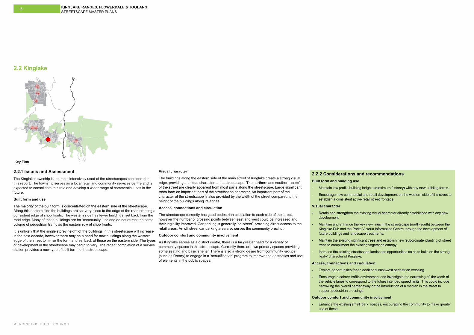
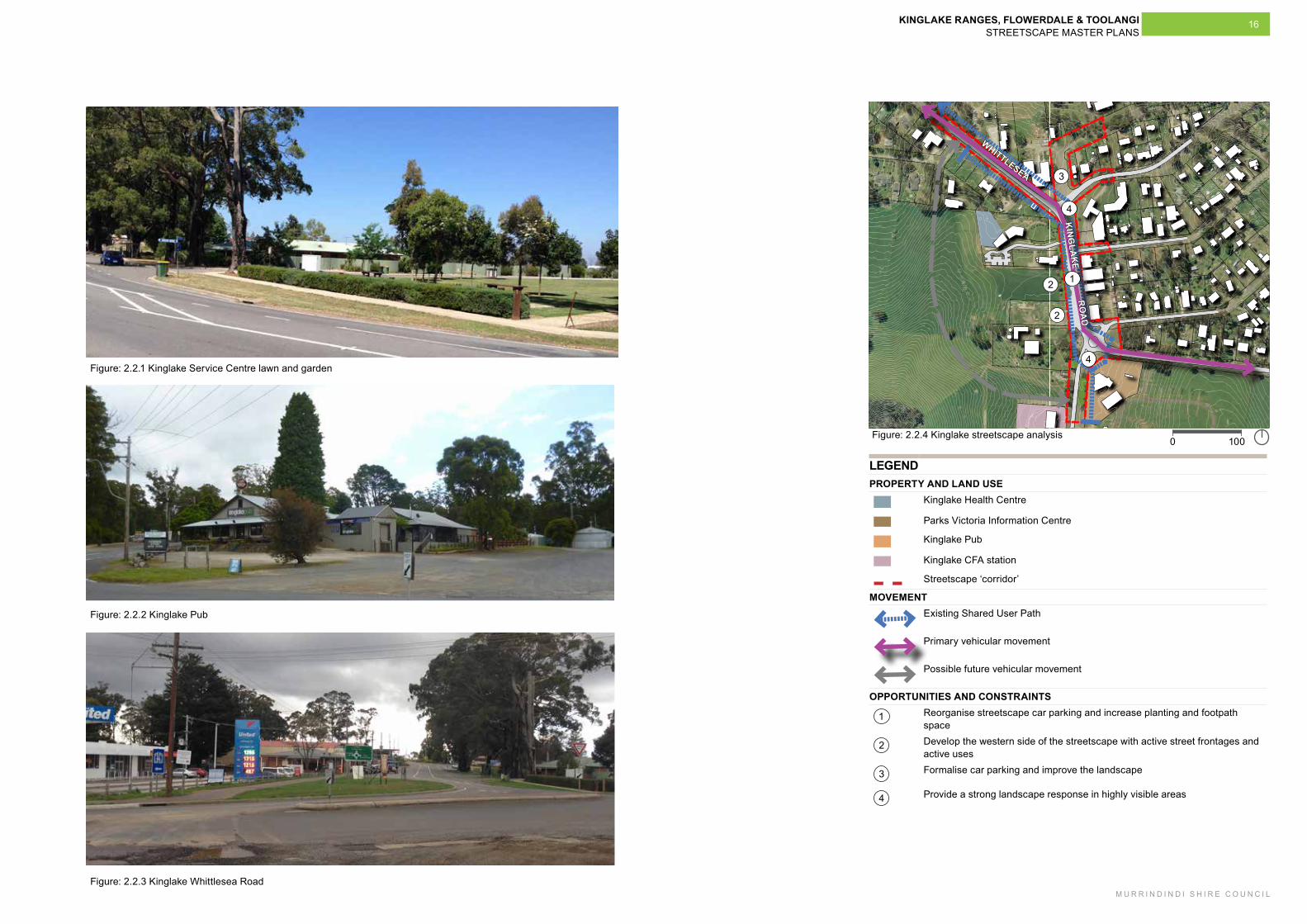
2.2.1 Issues and AssessmentThe Kinglake township is the most intensively used of the streetscapes considered in this report. The township serves as a local retail and community services centre and is expected to consolidate this role and develop a wider range of commercial uses in the future.
Built form and use
The majority of the built form is concentrated on the eastern side of the streetscape. Along this eastern side the buildings are set very close to the edge of the road creating a consistent edge of shop fronts. The western side has fewer buildings, set back from the road edge. Many of these buildings are for ‘community’ use and do not attract the same volume of pedestrian traffic as the eastern row of shop fronts.
It is unlikely that the single storey height of the buildings in this streetscape will increase in the next decade, however there may be a need for new buildings along the western edge of the street to mirror the form and set back of those on the eastern side. The types of development in the streetscape may begin to vary. The recent completion of a service station provides a new type of built form to the streetscape.
2.2 Kinglake
Key Plan
Visual character
The buildings along the eastern side of the main street of Kinglake create a strong visual edge, providing a unique character to the streetscape. The northern and southern ‘ends’ of the street are clearly apparent from most parts along the streetscape. Large significant trees form an important part of the streetscape character. An important part of the character of the streetscape is also provided by the width of the street compared to the height of the buildings along its edges.
Access, connections and circulation
The streetscape currently has good pedestrian circulation to each side of the street, however the number of crossing points between east and west could be increased and their legibility improved. Car parking is generally ‘on-street’, providing direct access to the retail areas. An off street car parking area also serves the community precinct.
Outdoor comfort and community involvement
As Kinglake serves as a district centre, there is a far greater need for a variety of community spaces in this streetscape. Currently there are two primary spaces providing some seating and basic shelter. There is also a strong desire from community groups (such as Rotary) to engage in a ‘beautification’ program to improve the aesthetics and use of elements in the public spaces.
KINGLAKE RANGES, FLOWERDALE & TOOLANGI STREETSCAPE MASTER PLANS
M U R R I N D I N D I S H I R E C O U N C I L
16
Figure: 2.2.1 Kinglake Service Centre lawn and garden
Figure: 2.2.2 Kinglake Pub
1000
12
2
3
4
Figure: 2.2.4 Kinglake streetscape analysis
4
LEGENDPROPERTY AND LAND USE
Kinglake Health Centre
Parks Victoria Information Centre
Kinglake Pub
Kinglake CFA station
Streetscape ‘corridor’
MOVEMENTExisting Shared User Path
Primary vehicular movement
Possible future vehicular movement
OPPORTUNITIES AND CONSTRAINTS
1 Reorganise streetscape car parking and increase planting and footpath space
2 Develop the western side of the streetscape with active street frontages and active uses
3 Formalise car parking and improve the landscape
4 Provide a strong landscape response in highly visible areas
WHITTLESEA
KIN
GLA
KE
RO
AD
Figure: 2.2.3 Kinglake Whittlesea Road
KINGLAKE RANGES, FLOWERDALE & TOOLANGI STREETSCAPE MASTER PLANS
M U R R I N D I N D I S H I R E C O U N C I L
17
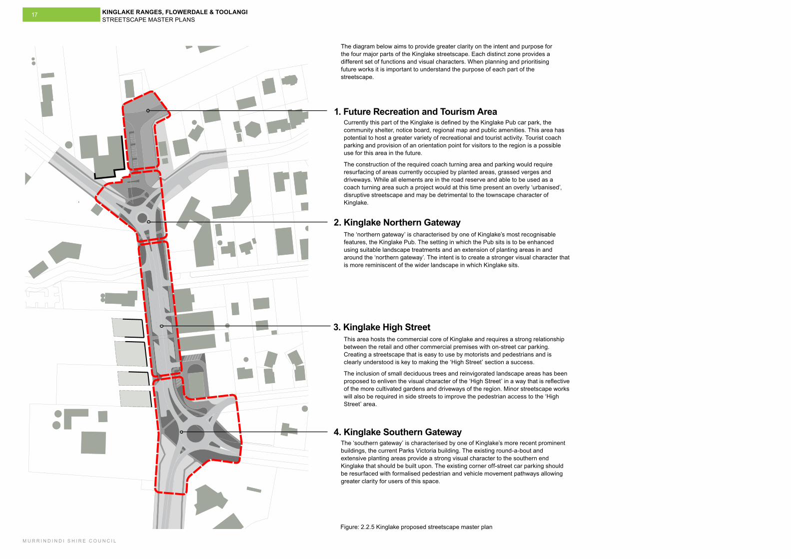
Figure: 2.2.5 Kinglake proposed streetscape master plan
1. Future Recreation and Tourism Area
2. Kinglake Northern Gateway
3. Kinglake High Street
4. Kinglake Southern Gateway
Currently this part of the Kinglake is defined by the Kinglake Pub car park, the community shelter, notice board, regional map and public amenities. This area has potential to host a greater variety of recreational and tourist activity. Tourist coach parking and provision of an orientation point for visitors to the region is a possible use for this area in the future.
The construction of the required coach turning area and parking would require resurfacing of areas currently occupied by planted areas, grassed verges and driveways. While all elements are in the road reserve and able to be used as a coach turning area such a project would at this time present an overly ‘urbanised’, disruptive streetscape and may be detrimental to the townscape character of Kinglake.
The diagram below aims to provide greater clarity on the intent and purpose for the four major parts of the Kinglake streetscape. Each distinct zone provides a different set of functions and visual characters. When planning and prioritising future works it is important to understand the purpose of each part of the streetscape.
The ‘northern gateway’ is characterised by one of Kinglake’s most recognisable features, the Kinglake Pub. The setting in which the Pub sits is to be enhanced using suitable landscape treatments and an extension of planting areas in and around the ‘northern gateway’. The intent is to create a stronger visual character that is more reminiscent of the wider landscape in which Kinglake sits.
This area hosts the commercial core of Kinglake and requires a strong relationship between the retail and other commercial premises with on-street car parking. Creating a streetscape that is easy to use by motorists and pedestrians and is clearly understood is key to making the ‘High Street’ section a success.
The inclusion of small deciduous trees and reinvigorated landscape areas has been proposed to enliven the visual character of the ‘High Street’ in a way that is reflective of the more cultivated gardens and driveways of the region. Minor streetscape works will also be required in side streets to improve the pedestrian access to the ‘High Street’ area.
The ‘southern gateway’ is characterised by one of Kinglake’s more recent prominent buildings, the current Parks Victoria building. The existing round-a-bout and extensive planting areas provide a strong visual character to the southern end Kinglake that should be built upon. The existing corner off-street car parking should be resurfaced with formalised pedestrian and vehicle movement pathways allowing greater clarity for users of this space.
KINGLAKE RANGES, FLOWERDALE & TOOLANGI STREETSCAPE MASTER PLANS
M U R R I N D I N D I S H I R E C O U N C I L
18
100500
Figure: 2.2.5 Kinglake proposed streetscape master plan
WH
ITTL
ESEA
KIN
GLA
KE
RO
AD
WHITTLESEA
KINGLAKE
ROAD
VICTORIA ROAD
HEALESVILLE - KINGLAKE ROAD
ROBERTSON ROAD
AITKEN
CRESCENT
GLENBURN ROAD
1
2
3
4
LEGENDMaster plan boundary
Existing buildings
Proposed buildings
Active Street Frontage
Key redevelopment site
Existing trees to be retained
Proposed street trees
Proposed Water Sensitive Urban Design (WSUD) streetscape planting
Proposed feature planting
Proposed grassed areas to be mulched areas with native grasses
Proposed Main Street Paving
Gravel car park surface
Shared user path (see Project KL5)
Temporary visual screening
Ref
er to
pg.
13
for m
ore
deta
ilR
efer
to p
g. 1
5 fo
r mor
e de
tail
5
6
7
8
9
1 Existing Kinglake Pub
2 Kinglake Petrol Station
3 Parks Victoria Information Centre
4 Kinglake Health Centre
5 Future potential coach turning area
6 Extended trees planting and gathering area
7 Remove water tank
8 Upgrade street shelter
9 Install kerb to define car park
AITKEN
CRESCENT
KINGLAKE RANGES, FLOWERDALE & TOOLANGI STREETSCAPE MASTER PLANS
M U R R I N D I N D I S H I R E C O U N C I L
19
250
1
C
C
B
B
A
A
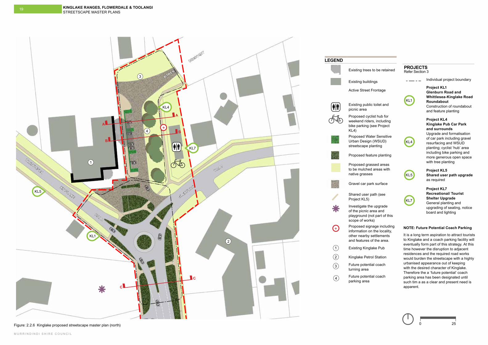
Figure: 2.2.6 Kinglake proposed streetscape master plan (north)
GLENBURN
ROAD
WHITTLESEA
KINGLAKE
ROAD
KL5
KL1
LEGEND
Existing trees to be retained
Existing buildings
Active Street Frontage
Existing public toilet and picnic area
Proposed cyclist hub for weekend riders, including bike parking (see Project KL4)Proposed Water Sensitive Urban Design (WSUD) streetscape planting
Proposed feature planting
Proposed grassed areas to be mulched areas with native grasses
Gravel car park surface
Shared user path (see Project KL5)
Investigate the upgrade of the picnic area and playground (not part of this scope of works)
+ Proposed signage including information on the locality, other nearby settlements and features of the area.
1 Existing Kinglake Pub
2 Kinglake Petrol Station
3 Future potential coach turning area
Future potential coach parking area
+
KL4
PROJECTSRefer Section 3
Individual project boundary
KL1
Project KL1 Glenburn Road and Whittlesea-Kinglake Road Roundabout Construction of roundabout and feature planting
KL4
Project KL4 Kinglake Pub Car Park and surrounds Upgrade and formalisation of car park including gravel resurfacing and WSUD planting; cyclist ‘hub’ area including bike parking and more generous open space with tree planting
KL5Project KL5 Shared user path upgrade as required
2
3
4
4
NOTE: Future Potential Coach Parking
It is a long term aspiration to attract tourists to Kinglake and a coach parking facility will eventually form part of this strategy. At this time however the disruption to adjacent residences and the required road works would burden the streetscape with a highly urbanised appearance out of keeping with the desired character of Kinglake. Therefore the a ‘future potential’ coach parking area has been designated until such tim a as a clear and present need is apparent.
KL7
KL7
Project KL7 Recreational/ Tourist Shelter Upgrade General planting and upgrading of seating, notice board and lighting
KINGLAKE RANGES, FLOWERDALE & TOOLANGI STREETSCAPE MASTER PLANS
M U R R I N D I N D I S H I R E C O U N C I L
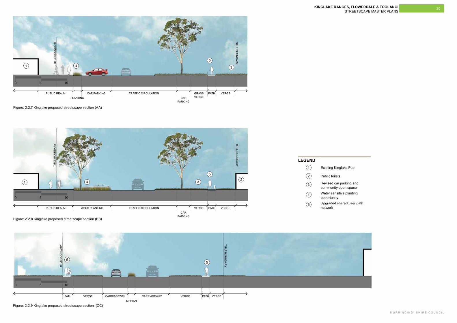
20
1050
1050
1050
Figure: 2.2.7 Kinglake proposed streetscape section (AA)
Figure: 2.2.8 Kinglake proposed streetscape section (BB)
Figure: 2.2.9 Kinglake proposed streetscape section (CC)
5
5
5
5
31 4
1234
LEGEND1 Existing Kinglake Pub
2 Public toilets
3 Revised car parking and community open space
4 Water sensitive planting opportunity
5 Upgraded shared user path network
TITL
E BO
UN
DA
RY
TITLE BOU
ND
AR
Y
PUBLIC REALM CAR PARKING TRAFFIC CIRCULATION
CAR PARKING
PLANTING
GRASS VERGE
PATH VERGE
TITL
E BO
UN
DA
RY
TITLE BOU
ND
AR
Y
PUBLIC REALM WSUD PLANTING TRAFFIC CIRCULATION
CAR PARKING
VERGE PATH VERGE
TITL
E BO
UN
DA
RY
TITLE BOU
ND
AR
Y
PATH VERGE
MEDIAN
CARRIAGEWAY CARRIAGEWAY VERGE PATH VERGE
KINGLAKE RANGES, FLOWERDALE & TOOLANGI STREETSCAPE MASTER PLANS
M U R R I N D I N D I S H I R E C O U N C I L
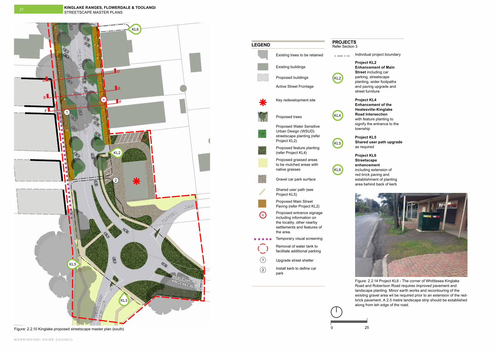
21
2
1
250
VICTORIA
HEALESVILLE-KINGLAKE ROAD
HEI
DEL
BER
G-
KIN
GLA
KE
ROAD
ROAD
WH
ITTLESEA
K
ING
LAK
E
RO
AD
Figure: 2.2.10 Kinglake proposed streetscape master plan (south)
KL3
D
D
E
E
F
F
KL5
KL2
KL6
+
LEGEND
Existing trees to be retained
Existing buildings
Proposed buildings
Active Street Frontage
Key redevelopment site
Proposed trees
Proposed Water Sensitive Urban Design (WSUD) streetscape planting (refer Project KL2)
Proposed feature planting (refer Project KL4)
Proposed grassed areas to be mulched areas with native grasses
Gravel car park surface
Shared user path (see Project KL5)
Proposed Main Street Paving (refer Project KL2)
+ Proposed entrance signage including information on the locality, other nearby settlements and features of the area.
Temporary visual screening
Removal of water tank to facilitate additional parking
1 Upgrade street shelter
2 Install kerb to define car park
PROJECTSRefer Section 3
Individual project boundary
KL2
Project KL2 Enhancement of Main Street including car parking, streetscape planting, wider footpaths and paving upgrade and street furniture
KL4
Project KL4 Enhancement of the Healesville-Kinglake Road Intersection with feature planting to signify the entrance to the township
KL5Project KL5 Shared user path upgrade as required
KL6
Project KL6 Streetscape enhancement including extension of red brick paving and establishment of planting area behind back of kerb
Figure: 2.2.14 Project KL6 - The corner of Whittlesea Kinglake Road and Robertson Road requires improved pavement and landscape planting. Minor earth works and recontouring of the exisitng gravel area wil be required prior to an extension of the red-brick pavement. A 2.5 metre landscape strip should be extablished along from teh edge of the road.
KINGLAKE RANGES, FLOWERDALE & TOOLANGI STREETSCAPE MASTER PLANS
M U R R I N D I N D I S H I R E C O U N C I L
22
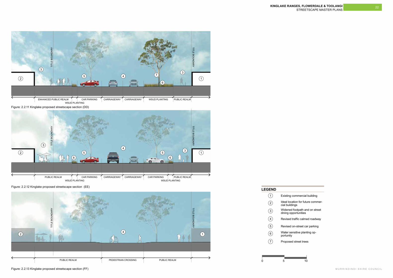
1050
LEGEND1 Existing commercial building
2 Ideal location for future commer-cial buildings
3 Widened footpath and on street dining opportunities
4 Revised traffic calmed roadway
5 Revised on-street car parking
6 Water sensitive planting op-portunity
7 Proposed street trees
1
1
1
2
2
2
3
3
3
3
4
4
4
5
5 5
6
66
7
Figure: 2.2.11 Kinglake proposed streetscape section (DD)
Figure: 2.2.12 Kinglake proposed streetscape section (EE)
Figure: 2.2.13 Kinglake proposed streetscape section (FF)
TITL
E BO
UN
DA
RY
TITLE BOU
ND
AR
Y
ENHANCED PUBLIC REALM CAR PARKING CARRIAGEWAY CARRIAGEWAY WSUD PLANTINGWSUD PLANTING
PUBLIC REALM
TITL
E BO
UN
DA
RY
TITLE BOU
ND
AR
Y
PUBLIC REALM PEDESTRIAN CROSSING PUBLIC REALM
TITL
E BO
UN
DA
RY
TITLE BOU
ND
AR
Y
PUBLIC REALM CAR PARKING CARRIAGEWAY CARRIAGEWAY CAR PARKINGWSUD PLANTING WSUD PLANTING
PUBLIC REALM
KINGLAKE RANGES, FLOWERDALE & TOOLANGI STREETSCAPE MASTER PLANS
M U R R I N D I N D I S H I R E C O U N C I L
23
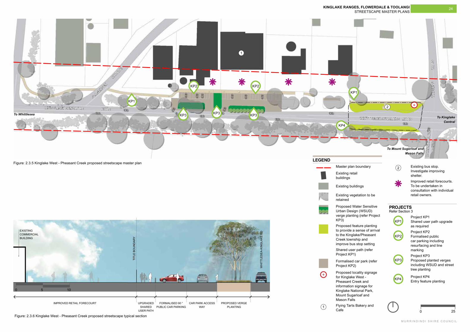
2.3.2 Considerations and recommendationsBuilt form and building use
- Maintain the existing building heights and ensure any new built forms are highly sympathetic to the existing commercial and residential buildings.
Visual character
- Consider the introduction of significant planting or public space that provides a stronger sense of identity in the settlement’s centre.
Access, connections and circulation
- Consider improvements to the consistency and quality of pedestrian access through the township.
Outdoor comfort and community involvement
- Consider the definition of a ‘main park’ that could assist with the creation of an identifiable ‘town centre’.
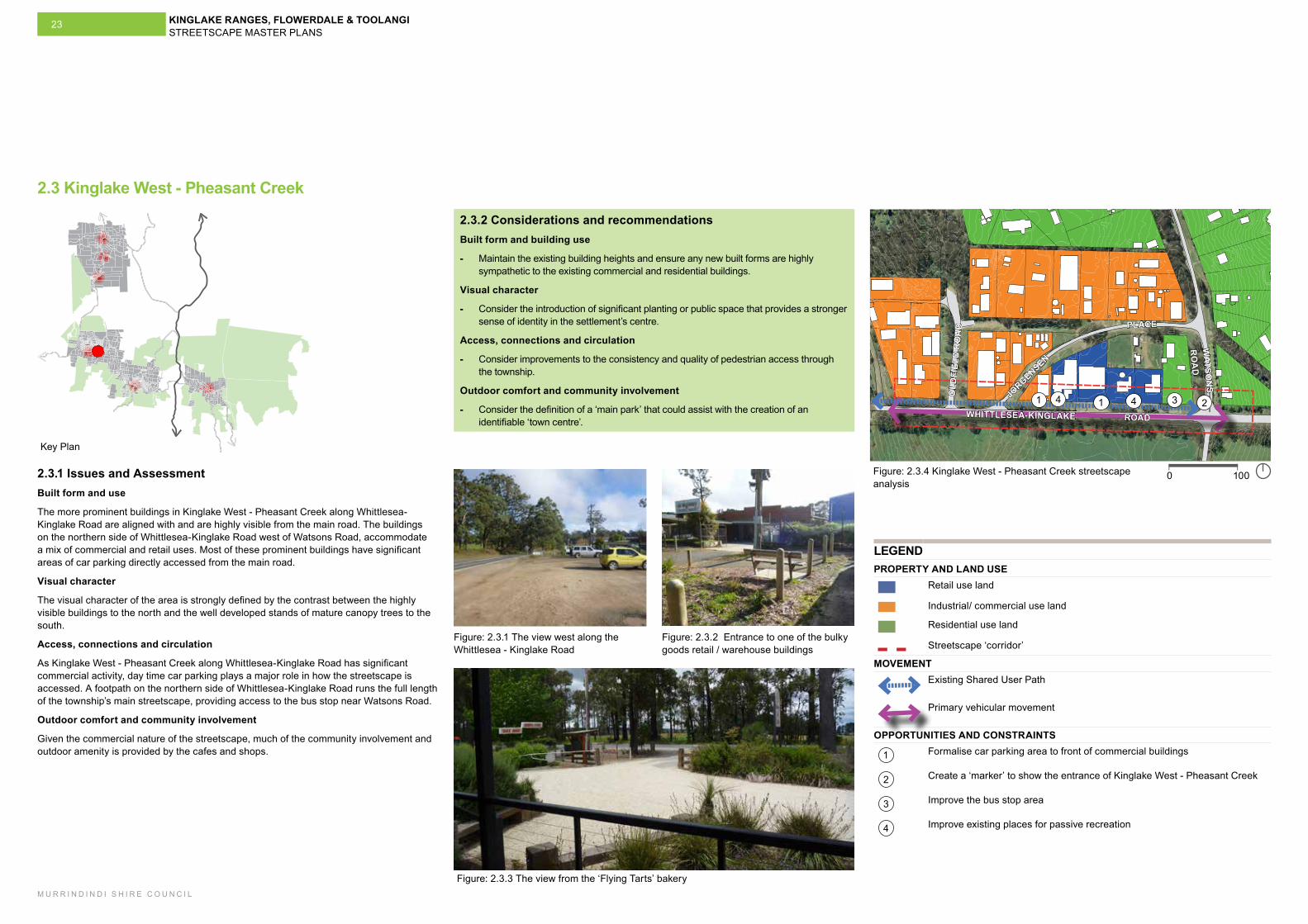
2.3 Kinglake West - Pheasant Creek
2.3.1 Issues and AssessmentBuilt form and use
The more prominent buildings in Kinglake West - Pheasant Creek along Whittlesea-Kinglake Road are aligned with and are highly visible from the main road. The buildings on the northern side of Whittlesea-Kinglake Road west of Watsons Road, accommodate a mix of commercial and retail uses. Most of these prominent buildings have significant areas of car parking directly accessed from the main road.
Visual character
The visual character of the area is strongly defined by the contrast between the highly visible buildings to the north and the well developed stands of mature canopy trees to the south.
Access, connections and circulation
As Kinglake West - Pheasant Creek along Whittlesea-Kinglake Road has significant commercial activity, day time car parking plays a major role in how the streetscape is accessed. A footpath on the northern side of Whittlesea-Kinglake Road runs the full length of the township’s main streetscape, providing access to the bus stop near Watsons Road.
Outdoor comfort and community involvement
Given the commercial nature of the streetscape, much of the community involvement and outdoor amenity is provided by the cafes and shops.
Figure: 2.3.1 The view west along the Whittlesea - Kinglake Road
Figure: 2.3.2 Entrance to one of the bulky goods retail / warehouse buildings
Figure: 2.3.3 The view from the ‘Flying Tarts’ bakery
1 1 234 4
1000
WHITTLESEA-KINGLAKE ROAD
OLD
FIEL
D R
OA
D
JORGENSEN
PLACE
WATSO
NS
RO
AD
LEGENDPROPERTY AND LAND USE
Retail use land
Industrial/ commercial use land
Residential use land
Streetscape ‘corridor’
MOVEMENTExisting Shared User Path
Primary vehicular movement
OPPORTUNITIES AND CONSTRAINTS
1 Formalise car parking area to front of commercial buildings
2 Create a ‘marker’ to show the entrance of Kinglake West - Pheasant Creek
3 Improve the bus stop area
4 Improve existing places for passive recreation
Figure: 2.3.4 Kinglake West - Pheasant Creek streetscape analysis
Key Plan
KINGLAKE RANGES, FLOWERDALE & TOOLANGI STREETSCAPE MASTER PLANS
M U R R I N D I N D I S H I R E C O U N C I L
24
LEGENDMaster plan boundary
Existing retail buildings
Existing buildings
Existing vegetation to be retained
Proposed Water Sensitive Urban Design (WSUD) verge planting (refer Project KP3)Proposed feature planting to provide a sense of arrival to the Kinglake/Pheasant Creek township and improve bus stop settingShared user path (refer Project KP1)
Formalised car park (refer Project KP2)
+ Proposed locality signage for Kinglake West - Pheasant Creek and information signage for Kinglake National Park, Mount Sugarloaf and Mason Falls
1 Flying Tarts Bakery and Cafe
Figure: 2.3.6 Kinglake West - Pheasant Creek proposed streetscape typical section
FORMALISED 90 ° PUBLIC CAR PARKING
CAR PARK ACCESS WAY
PROPOSED VERGE PLANTING
UPGRADED SHARED
USER PATH
EXISTING COMMERCIAL BUILDING
TITL
E BO
UN
DA
RY
WH
ITTL
ESE
A-K
ING
LAK
E R
D
IMPROVED RETAIL FORECOURT
250
1050
WHITTLESEA-KINGLAKE ROAD
WHITTLESEA-KINGLAKE ROAD
JORGENSEN
PARADE
WAT
SON
S
RO
AD
NAT
ION
AL
PAR
K
RO
AD
Figure: 2.3.5 Kinglake West - Pheasant Creek proposed streetscape master plan
KP1
KP1
KP3 KP3
KP2 KP2
KP3
2 Existing bus stop. Investigate improving shelter.Improved retail forecourts. To be undertaken in consultation with individual retail owners.
PROJECTS Refer Section 3
KP1Project KP1 Shared user path upgrade as required
KP2Project KP2 Formalised public car parking including resurfacing and line marking
KP3Project KP3 Proposed planted verges including WSUD and street tree planting
KP4 Project KP4 Entry feature planting
+
To WhittleseaTo Kinglake
Central
To Mount Sugerloaf and Mason Falls
1
2
KP4
KINGLAKE RANGES, FLOWERDALE & TOOLANGI STREETSCAPE MASTER PLANS
M U R R I N D I N D I S H I R E C O U N C I L
25
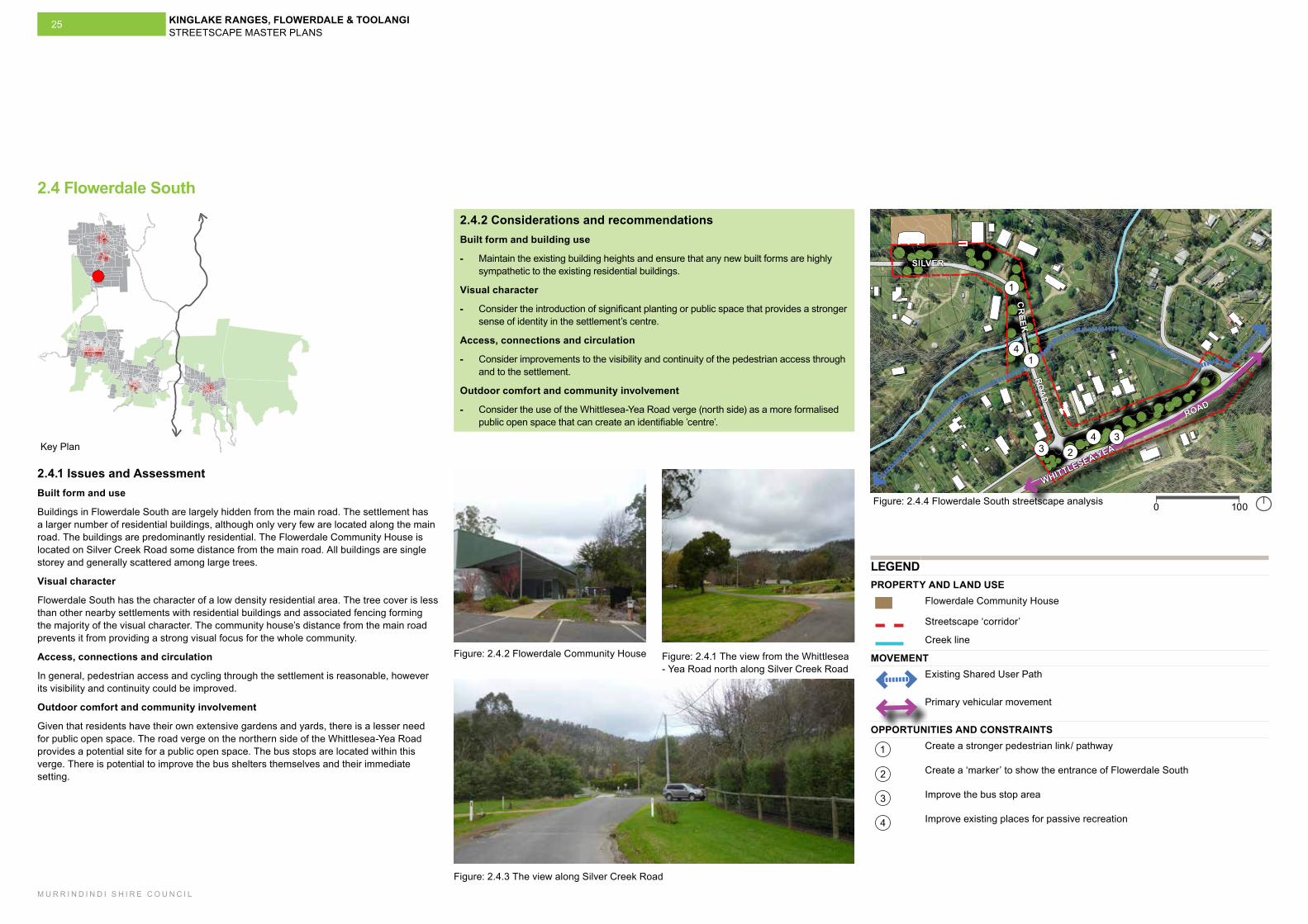
2.4.2 Considerations and recommendationsBuilt form and building use
- Maintain the existing building heights and ensure that any new built forms are highly sympathetic to the existing residential buildings.
Visual character
- Consider the introduction of significant planting or public space that provides a stronger sense of identity in the settlement’s centre.
Access, connections and circulation
- Consider improvements to the visibility and continuity of the pedestrian access through and to the settlement.
Outdoor comfort and community involvement
- Consider the use of the Whittlesea-Yea Road verge (north side) as a more formalised public open space that can create an identifiable ’centre’.
2.4 Flowerdale South
2.4.1 Issues and AssessmentBuilt form and use
Buildings in Flowerdale South are largely hidden from the main road. The settlement has a larger number of residential buildings, although only very few are located along the main road. The buildings are predominantly residential. The Flowerdale Community House is located on Silver Creek Road some distance from the main road. All buildings are single storey and generally scattered among large trees.
Visual character
Flowerdale South has the character of a low density residential area. The tree cover is less than other nearby settlements with residential buildings and associated fencing forming the majority of the visual character. The community house’s distance from the main road prevents it from providing a strong visual focus for the whole community.
Access, connections and circulation
In general, pedestrian access and cycling through the settlement is reasonable, however its visibility and continuity could be improved.
Outdoor comfort and community involvement
Given that residents have their own extensive gardens and yards, there is a lesser need for public open space. The road verge on the northern side of the Whittlesea-Yea Road provides a potential site for a public open space. The bus stops are located within this verge. There is potential to improve the bus shelters themselves and their immediate setting.
Figure: 2.4.1 The view from the Whittlesea - Yea Road north along Silver Creek Road
Figure: 2.4.2 Flowerdale Community House
Figure: 2.4.3 The view along Silver Creek Road
1
1
23
34
4
1000
WHITTLESEA-YEA
ROAD
SILVER
CR
EEK
ROA
D
LEGENDPROPERTY AND LAND USE
Flowerdale Community House
Streetscape ‘corridor’
Creek line
MOVEMENTExisting Shared User Path
Primary vehicular movement
OPPORTUNITIES AND CONSTRAINTS
1 Create a stronger pedestrian link/ pathway
2 Create a ‘marker’ to show the entrance of Flowerdale South
3 Improve the bus stop area
4 Improve existing places for passive recreation
Figure: 2.4.4 Flowerdale South streetscape analysis
Key Plan
KINGLAKE RANGES, FLOWERDALE & TOOLANGI STREETSCAPE MASTER PLANS
M U R R I N D I N D I S H I R E C O U N C I L
26
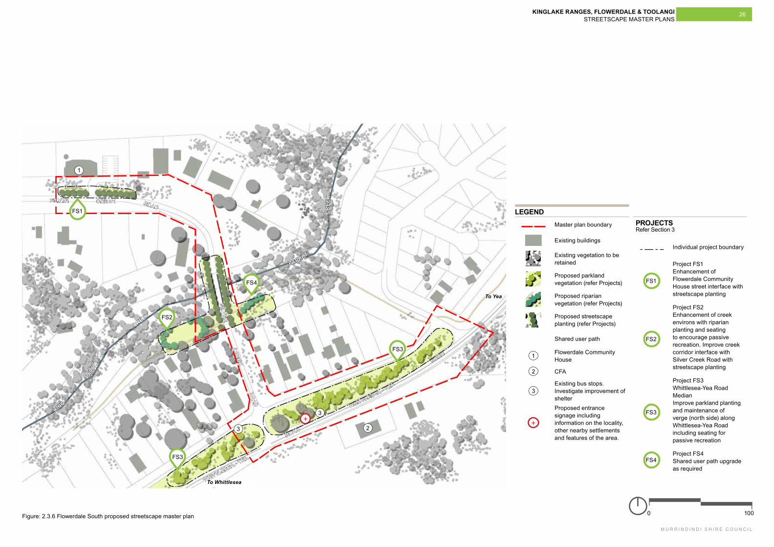
1000
SILVER CREEK ROAD
SILVER
CR
EEK RO
ADFigure: 2.3.6 Flowerdale South proposed streetscape master plan
LEGENDMaster plan boundary
Existing buildings
Existing vegetation to be retained
Proposed parkland vegetation (refer Projects)
Proposed riparian vegetation (refer Projects)
Proposed streetscape planting (refer Projects)
Shared user path
1 Flowerdale Community House
2 CFA
3Existing bus stops. Investigate improvement of shelter
+
Proposed entrance signage including information on the locality, other nearby settlements and features of the area.
1
KING
PARR
OT
CREEK
KING PARROT
C
REE
K
WHITTLESEA - YEA
ROAD
WHITTLESEA - YEA
ROAD
2
3+
FS2
FS4
FS1
FS3
FS3
PROJECTSRefer Section 3
Individual project boundary
FS1
Project FS1 Enhancement of Flowerdale Community House street interface with streetscape planting
FS2
Project FS2 Enhancement of creek environs with riparian planting and seating to encourage passive recreation. Improve creek corridor interface with Silver Creek Road with streetscape planting
FS3
Project FS3 Whittlesea-Yea Road Median Improve parkland planting and maintenance of verge (north side) along Whittlesea-Yea Road including seating for passive recreation
FS4Project FS4 Shared user path upgrade as required
To Whittlesea
To Yea
3
MO
OR
ES
RO
AD
KINGLAKE RANGES, FLOWERDALE & TOOLANGI STREETSCAPE MASTER PLANS
M U R R I N D I N D I S H I R E C O U N C I L
27
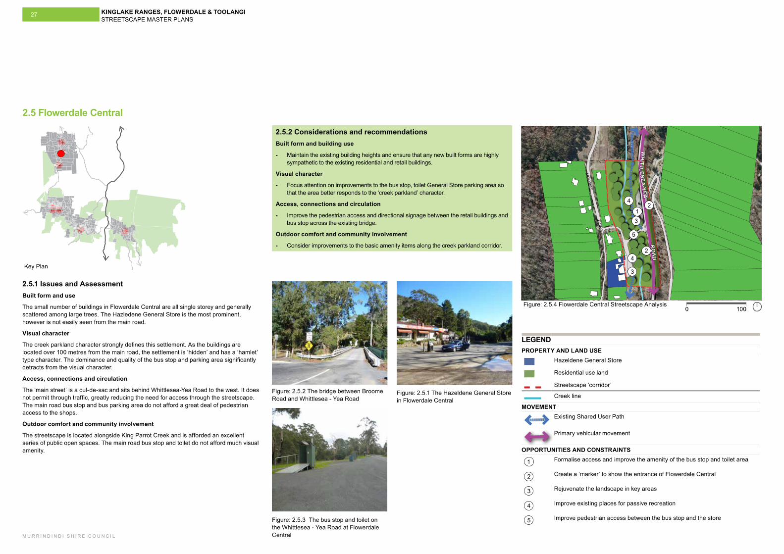
2.5.2 Considerations and recommendationsBuilt form and building use
- Maintain the existing building heights and ensure that any new built forms are highly sympathetic to the existing residential and retail buildings.
Visual character
- Focus attention on improvements to the bus stop, toilet General Store parking area so that the area better responds to the ‘creek parkland’ character.
Access, connections and circulation
- Improve the pedestrian access and directional signage between the retail buildings and bus stop across the existing bridge.
Outdoor comfort and community involvement
- Consider improvements to the basic amenity items along the creek parkland corridor.
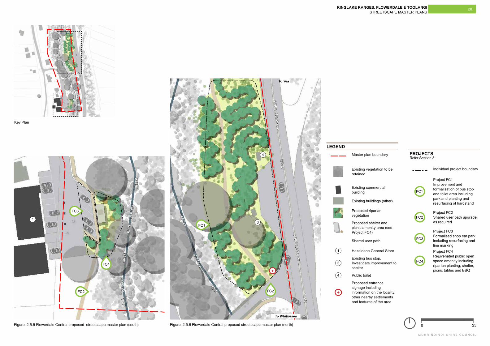
2.5.1 Issues and AssessmentBuilt form and use
The small number of buildings in Flowerdale Central are all single storey and generally scattered among large trees. The Hazledene General Store is the most prominent, however is not easily seen from the main road.
Visual character
The creek parkland character strongly defines this settlement. As the buildings are located over 100 metres from the main road, the settlement is ‘hidden’ and has a ‘hamlet’ type character. The dominance and quality of the bus stop and parking area significantly detracts from the visual character.
Access, connections and circulation
The ‘main street’ is a cul-de-sac and sits behind Whittlesea-Yea Road to the west. It does not permit through traffic, greatly reducing the need for access through the streetscape. The main road bus stop and bus parking area do not afford a great deal of pedestrian access to the shops.
Outdoor comfort and community involvement
The streetscape is located alongside King Parrot Creek and is afforded an excellent series of public open spaces. The main road bus stop and toilet do not afford much visual amenity.
2.5 Flowerdale Central
Figure: 2.5.1 The Hazeldene General Store in Flowerdale Central
Figure: 2.5.2 The bridge between Broome Road and Whittlesea - Yea Road
Figure: 2.5.3 The bus stop and toilet on the Whittlesea - Yea Road at Flowerdale Central
1
2
2
3
3
4
4
1000
5
Figure: 2.5.4 Flowerdale Central Streetscape Analysis
LEGENDPROPERTY AND LAND USE
Hazeldene General Store
Residential use land
Streetscape ‘corridor’
Creek line
MOVEMENTExisting Shared User Path
Primary vehicular movement
OPPORTUNITIES AND CONSTRAINTS
1 Formalise access and improve the amenity of the bus stop and toilet area
2 Create a ‘marker’ to show the entrance of Flowerdale Central
3 Rejuvenate the landscape in key areas
4 Improve existing places for passive recreation
5 Improve pedestrian access between the bus stop and the store
Key Plan
W
HITTLESEA
-YEA
R
OA
D
KINGLAKE RANGES, FLOWERDALE & TOOLANGI STREETSCAPE MASTER PLANS
M U R R I N D I N D I S H I R E C O U N C I L
28
250
WH
ITTLESEA-YEA
RO
AD
WH
ITTLESEA-YEA
RO
AD
4
31
Figure: 2.5.5 Flowerdale Central proposed streetscape master plan (south)
Key Plan
Figure: 2.5.6 Flowerdale Central proposed streetscape master plan (north)
KIN
G
PAR
RO
T
CR
EEK
KIN
G
PAR
RO
T
CR
EEK
KIN
G
PARR
OT
CREE
K
LEGENDMaster plan boundary
Existing vegetation to be retained
Existing commercial building
Existing buildings (other)
Proposed riparian vegetation
Proposed shelter and picnic amenity area (see Project FC4)
Shared user path
1 Hazeldene General Store
3Existing bus stop. Investigate improvement to shelter
4 Public toilet
+
Proposed entrance signage including information on the locality, other nearby settlements and features of the area.
FC2 FC2
FC4
+
FC1
FC3
PROJECTSRefer Section 3
Individual project boundary
FC1
Project FC1 Improvement and formalisation of bus stop and toilet area including parkland planting and resurfacing of hardstand
FC2Project FC2 Shared user path upgrade as required
FC3
Project FC3 Formalised shop car park including resurfacing and line marking
FC4
Project FC4 Rejuvenated public open space amenity including riparian planting, shelter, picnic tables and BBQ
To Yea
To Whittlesea
KINGLAKE RANGES, FLOWERDALE & TOOLANGI STREETSCAPE MASTER PLANS
M U R R I N D I N D I S H I R E C O U N C I L
29
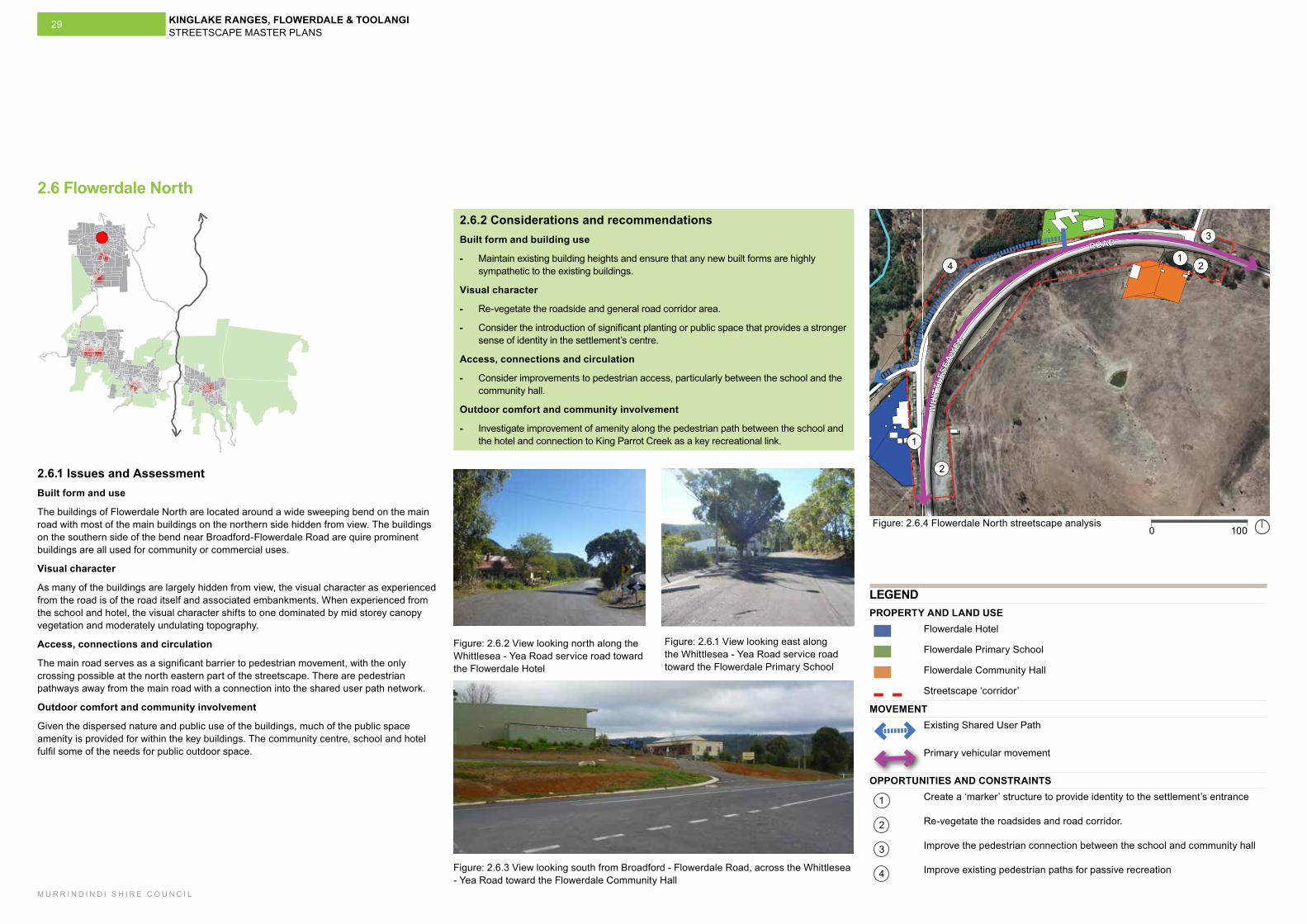
2.6.2 Considerations and recommendationsBuilt form and building use
- Maintain existing building heights and ensure that any new built forms are highly sympathetic to the existing buildings.
Visual character
- Re-vegetate the roadside and general road corridor area.
- Consider the introduction of significant planting or public space that provides a stronger sense of identity in the settlement’s centre.
Access, connections and circulation
- Consider improvements to pedestrian access, particularly between the school and the community hall.
Outdoor comfort and community involvement
- Investigate improvement of amenity along the pedestrian path between the school and the hotel and connection to King Parrot Creek as a key recreational link.
2.6.1 Issues and AssessmentBuilt form and use
The buildings of Flowerdale North are located around a wide sweeping bend on the main road with most of the main buildings on the northern side hidden from view. The buildings on the southern side of the bend near Broadford-Flowerdale Road are quire prominent buildings are all used for community or commercial uses.
Visual character
As many of the buildings are largely hidden from view, the visual character as experienced from the road is of the road itself and associated embankments. When experienced from the school and hotel, the visual character shifts to one dominated by mid storey canopy vegetation and moderately undulating topography.
Access, connections and circulation
The main road serves as a significant barrier to pedestrian movement, with the only crossing possible at the north eastern part of the streetscape. There are pedestrian pathways away from the main road with a connection into the shared user path network.
Outdoor comfort and community involvement
Given the dispersed nature and public use of the buildings, much of the public space amenity is provided for within the key buildings. The community centre, school and hotel fulfil some of the needs for public outdoor space.
2
2
3
41
1
1000Figure: 2.6.4 Flowerdale North streetscape analysis
WH
ITTL
ESEA
-YEA
ROAD
LEGENDPROPERTY AND LAND USE
Flowerdale Hotel
Flowerdale Primary School
Flowerdale Community Hall
Streetscape ‘corridor’
MOVEMENTExisting Shared User Path
Primary vehicular movement
OPPORTUNITIES AND CONSTRAINTS
1 Create a ‘marker’ structure to provide identity to the settlement’s entrance
2 Re-vegetate the roadsides and road corridor.
3 Improve the pedestrian connection between the school and community hall
4 Improve existing pedestrian paths for passive recreation
Figure: 2.6.1 View looking east along the Whittlesea - Yea Road service road toward the Flowerdale Primary School
Figure: 2.6.2 View looking north along the Whittlesea - Yea Road service road toward the Flowerdale Hotel
Figure: 2.6.3 View looking south from Broadford - Flowerdale Road, across the Whittlesea - Yea Road toward the Flowerdale Community Hall
K
ING
PAR
RO
T
CREEK
K
ING
PARR
OT
CREE
K
2.6 Flowerdale North
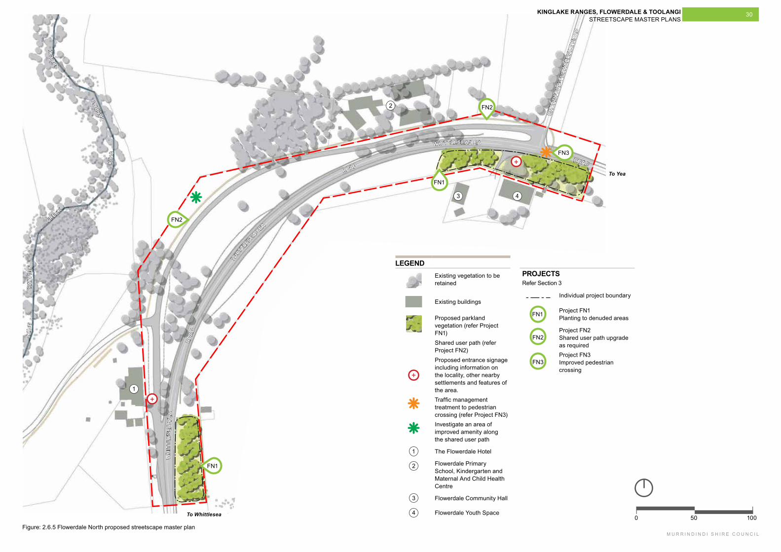
KINGLAKE RANGES, FLOWERDALE & TOOLANGI STREETSCAPE MASTER PLANS
M U R R I N D I N D I S H I R E C O U N C I L
30
3 4
100500
LEGENDExisting vegetation to be retained
Existing buildings
Proposed parkland vegetation (refer Project FN1)Shared user path (refer Project FN2)
+
Proposed entrance signage including information on the locality, other nearby settlements and features of the area.Traffic management treatment to pedestrian crossing (refer Project FN3)Investigate an area of improved amenity along the shared user path
1 The Flowerdale Hotel
2 Flowerdale Primary School, Kindergarten and Maternal And Child Health Centre
3 Flowerdale Community Hall
4 Flowerdale Youth Space
1
2
WH
ITTL
ESE
A-Y
EA
RO
AD
WHIT
TLESEA-Y
EA
ROAD
WHITTLESEA-YEA
ROAD
Figure: 2.6.5 Flowerdale North proposed streetscape master plan
K
ING
PAR
RO
T
CREEK
K
ING
PARR
OT
CREE
K
BRO
AD
FOR
D-F
LOW
ERDA
LE R
OA
D
FN3
FN2
+
FN1
FN2
To Whittlesea
To Yea
PROJECTS Refer Section 3
Individual project boundary
FN1 Project FN1 Planting to denuded areas
FN2Project FN2 Shared user path upgrade as required
FN3Project FN3 Improved pedestrian crossing
FN1
+


KINGLAKE RANGES, FLOWERDALE & TOOLANGI STREETSCAPE MASTER PLANS
M U R R I N D I N D I S H I R E C O U N C I L
33
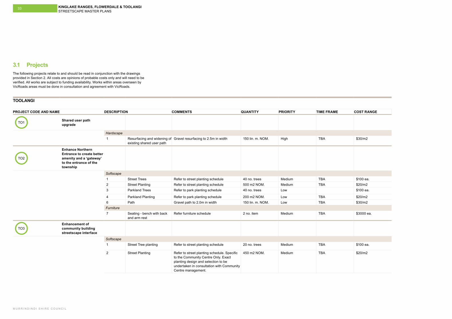
3.1 Projects
TOOLANGI
PROJECT CODE AND NAME DESCRIPTION COMMENTS QUANTITY PRIORITY TIME FRAME COST RANGE
TO1 Shared user path upgrade
Hardscape1 Resurfacing and widening of
existing shared user path Gravel resurfacing to 2.5m in width 150 lin. m. NOM. High TBA $30/m2
TO2
Enhance Northern Entrance to create better amenity and a ‘gateway’ to the entrance of the township
Softscape 1 Street Trees Refer to street planting schedule 40 no. trees Medium TBA $100 ea.2 Street Planting Refer to street planting schedule 500 m2 NOM. Medium TBA $20/m23 Parkland Trees Refer to park planting schedule 40 no. trees Low $100 ea.
4 Parkland Planting Refer to park planting schedule 200 m2 NOM. Low TBA $20/m26 Path Gravel path to 2.0m in width 150 lin. m. NOM. Low TBA $30/m2Furniture 7 Seating - bench with back
and arm restRefer furniture schedule 2 no. item Medium TBA $3000 ea.
TO3Enhancement of community building streetscape interface
Softscape1 Street Tree planting Refer to street planting schedule 20 no. trees Medium TBA $100 ea.
2 Street Planting Refer to street planting schedule. Specific to the Community Centre Only. Exact planting design and selection to be undertaken in consultation with Community Centre management.
450 m2 NOM. Medium TBA $20/m2
The following projects relate to and should be read in conjunction with the drawings provided in Section 2. All costs are opinions of probable costs only and will need to be verified. All works are subject to funding availability. Works within areas overseen by VicRoads areas must be done in consultation and agreement with VicRoads.
KINGLAKE RANGES, FLOWERDALE & TOOLANGI STREETSCAPE MASTER PLANS
M U R R I N D I N D I S H I R E C O U N C I L
34
Further actions for Toolangi - Investigate a location for and the feasibility of long-vehicle parking to support existing
bridle trails
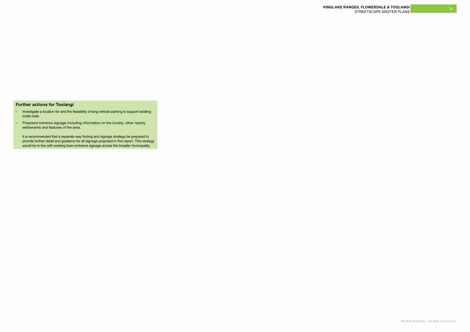
- Proposed entrance signage including information on the locality, other nearby settlements and features of the area. It is recommended that a separate way finding and signage strategy be prepared to provide further detail and guidance for all signage proposed in this report. This strategy would be in line with existing town entrance signage across the broader municipality.
KINGLAKE RANGES, FLOWERDALE & TOOLANGI STREETSCAPE MASTER PLANS
M U R R I N D I N D I S H I R E C O U N C I L
35
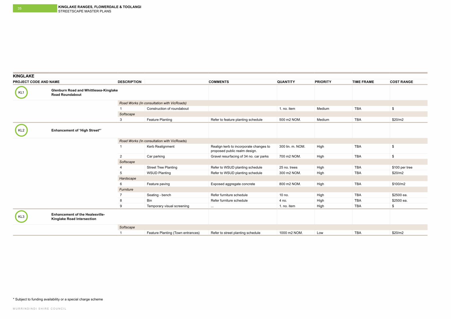
KINGLAKE PROJECT CODE AND NAME DESCRIPTION COMMENTS QUANTITY PRIORITY TIME FRAME COST RANGE
KL1 Glenburn Road and Whittlesea-Kinglake Road Roundabout
Road Works (In consultation with VicRoads)1 Construction of roundabout 1. no. item Medium TBA $Softscape3 Feature Planting Refer to feature planting schedule 500 m2 NOM. Medium TBA $20/m2
KL2 Enhancement of ‘High Street*’
Road Works (In consultation with VicRoads)1 Kerb Realignment Realign kerb to incorporate changes to
proposed public realm design. 300 lin. m. NOM. High TBA $
2 Car parking Gravel resurfacing of 34 no. car parks 700 m2 NOM. High TBA $Softscape4 Street Tree Planting Refer to WSUD planting schedule 25 no. trees High TBA $100 per tree5 WSUD Planting Refer to WSUD planting schedule 300 m2 NOM. High TBA $20/m2Hardscape 6 Feature paving Exposed aggregate concrete 800 m2 NOM. High TBA $100/m2Furniture7 Seating - bench Refer furniture schedule 10 no. High TBA $2500 ea.8 Bin Refer furniture schedule 4 no. High TBA $2500 ea.9 Temporary visual screening ... 1. no. item High TBA $
KL3 Enhancement of the Healesville-Kinglake Road Intersection
Softscape1 Feature Planting (Town entrances) Refer to street planting schedule 1000 m2 NOM. Low TBA $20/m2
* Subject to funding availability or a special charge scheme
KINGLAKE RANGES, FLOWERDALE & TOOLANGI STREETSCAPE MASTER PLANS
M U R R I N D I N D I S H I R E C O U N C I L
36
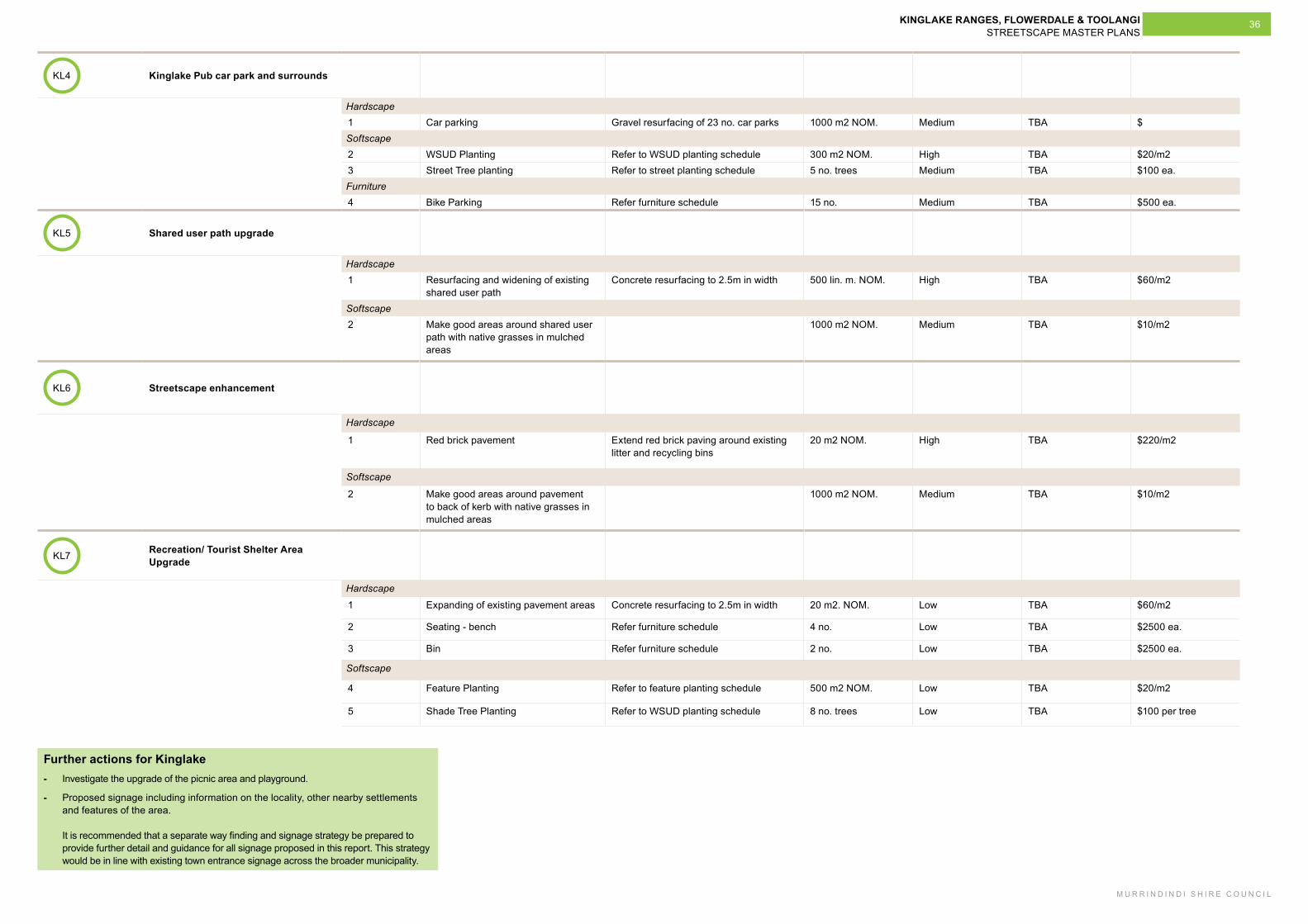
KL4 Kinglake Pub car park and surrounds
Hardscape 1 Car parking Gravel resurfacing of 23 no. car parks 1000 m2 NOM. Medium TBA $Softscape2 WSUD Planting Refer to WSUD planting schedule 300 m2 NOM. High TBA $20/m23 Street Tree planting Refer to street planting schedule 5 no. trees Medium TBA $100 ea.Furniture4 Bike Parking Refer furniture schedule 15 no. Medium TBA $500 ea.
KL5 Shared user path upgrade
Hardscape1 Resurfacing and widening of existing
shared user path Concrete resurfacing to 2.5m in width 500 lin. m. NOM. High TBA $60/m2
Softscape2 Make good areas around shared user
path with native grasses in mulched areas
1000 m2 NOM. Medium TBA $10/m2
KL6 Streetscape enhancement
Hardscape
1 Red brick pavement Extend red brick paving around existing litter and recycling bins
20 m2 NOM. High TBA $220/m2
Softscape
2 Make good areas around pavement to back of kerb with native grasses in mulched areas
1000 m2 NOM. Medium TBA $10/m2
KL7 Recreation/ Tourist Shelter Area Upgrade
Hardscape
1 Expanding of existing pavement areas Concrete resurfacing to 2.5m in width 20 m2. NOM. Low TBA $60/m2
2 Seating - bench Refer furniture schedule 4 no. Low TBA $2500 ea.
3 Bin Refer furniture schedule 2 no. Low TBA $2500 ea.
Softscape
4 Feature Planting Refer to feature planting schedule 500 m2 NOM. Low TBA $20/m2
5 Shade Tree Planting Refer to WSUD planting schedule 8 no. trees Low TBA $100 per tree
Further actions for Kinglake - Investigate the upgrade of the picnic area and playground.
- Proposed signage including information on the locality, other nearby settlements and features of the area. It is recommended that a separate way finding and signage strategy be prepared to provide further detail and guidance for all signage proposed in this report. This strategy would be in line with existing town entrance signage across the broader municipality.
KINGLAKE RANGES, FLOWERDALE & TOOLANGI STREETSCAPE MASTER PLANS
M U R R I N D I N D I S H I R E C O U N C I L
37
Kinglake West - Pheasant Creek
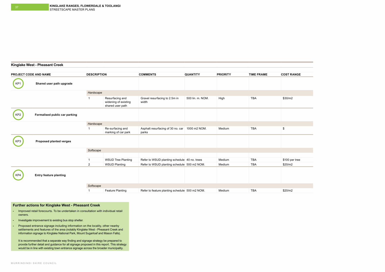
PROJECT CODE AND NAME DESCRIPTION COMMENTS QUANTITY PRIORITY TIME FRAME COST RANGE
KP1 Shared user path upgrade
Hardscape
1 Resurfacing and widening of existing shared user path
Gravel resurfacing to 2.5m in width
500 lin. m. NOM. High TBA $30/m2
KP2 Formalised public car parking
Hardscape1 Re-surfacing and
marking of car parkAsphalt resurfacing of 30 no. car parks
1000 m2 NOM. Medium TBA $
KP3 Proposed planted verges
Softscape
1 WSUD Tree Planting Refer to WSUD planting schedule 40 no. trees Medium TBA $100 per tree2 WSUD Planting Refer to WSUD planting schedule 500 m2 NOM. Medium TBA $20/m2
KP4 Entry feature planting
Softscape1 Feature Planting Refer to feature planting schedule 500 m2 NOM. Medium TBA $20/m2
Further actions for Kinglake West - Pheasant Creek - Improved retail forecourts. To be undertaken in consultation with individual retail
owners.
- Investigate improvement to existing bus stop shelter.
- Proposed entrance signage including information on the locality, other nearby settlements and features of the area (notably Kinglake West - Pheasant Creek and information signage to Kinglake National Park, Mount Sugarloaf and Mason Falls). It is recommended that a separate way finding and signage strategy be prepared to provide further detail and guidance for all signage proposed in this report. This strategy would be in line with existing town entrance signage across the broader municipality.
KINGLAKE RANGES, FLOWERDALE & TOOLANGI STREETSCAPE MASTER PLANS
M U R R I N D I N D I S H I R E C O U N C I L
38
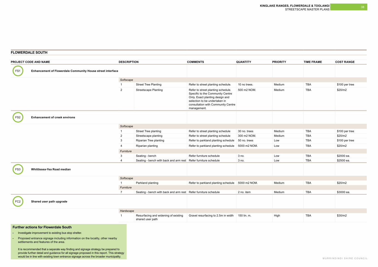
FLOWERDALE SOUTH
PROJECT CODE AND NAME DESCRIPTION COMMENTS QUANTITY PRIORITY TIME FRAME COST RANGE
FS1
Enhancement of Flowerdale Community House street interface
Softscape1 Street Tree Planting Refer to street planting schedule. 10 no trees. Medium TBA $100 per tree
2 Streetscape Planting Refer to street planting schedule. Specific to the Community Centre Only. Exact planting design and selection to be undertaken in consultation with Community Centre management.
500 m2 NOM. Medium TBA $20/m2
FS2 Enhancement of creek environs
Softscape
1 Street Tree planting Refer to street planting schedule 30 no. trees Medium TBA $100 per tree2 Streetscape planting Refer to street planting schedule 300 m2 NOM. Medium TBA $20/m23 Riparian Tree planting Refer to parkland planting schedule 50 no. trees Low TBA $100 per tree
4 Riparian planting Refer to parkland planting schedule 5000 m2 NOM. Low TBA $20/m2
Furniture3 Seating - bench Refer furniture schedule 3 no. Low TBA $2000 ea.4 Seating - bench with back and arm rest Refer furniture schedule 3 no. Low TBA $2500 ea.
FS3 Whittlesea-Yea Road median
Softscape1 Parkland planting Refer to parkland planting schedule 5000 m2 NOM. Medium TBA $20/m2Furniture 7 Seating - bench with back and arm rest Refer furniture schedule 2 no. item Medium TBA $3000 ea.
FC2 Shared user path upgrade
Hardscape1 Resurfacing and widening of existing
shared user path Gravel resurfacing to 2.5m in width 150 lin. m. High TBA $30/m2
Further actions for Flowerdale South - Investigate improvement to existing bus stop shelter.
- Proposed entrance signage including information on the locality, other nearby settlements and features of the area. It is recommended that a separate way finding and signage strategy be prepared to provide further detail and guidance for all signage proposed in this report. This strategy would be in line with existing town entrance signage across the broader municipality.
KINGLAKE RANGES, FLOWERDALE & TOOLANGI STREETSCAPE MASTER PLANS
M U R R I N D I N D I S H I R E C O U N C I L
39
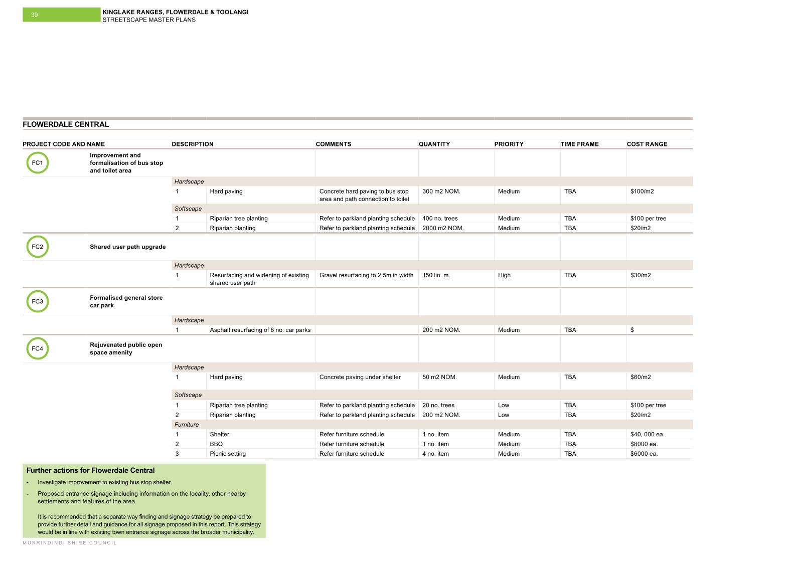
FLOWERDALE CENTRAL
PROJECT CODE AND NAME DESCRIPTION COMMENTS QUANTITY PRIORITY TIME FRAME COST RANGE
FC1Improvement and formalisation of bus stop and toilet area
Hardscape1 Hard paving Concrete hard paving to bus stop
area and path connection to toilet300 m2 NOM. Medium TBA $100/m2
Softscape1 Riparian tree planting Refer to parkland planting schedule 100 no. trees Medium TBA $100 per tree2 Riparian planting Refer to parkland planting schedule 2000 m2 NOM. Medium TBA $20/m2
FC2 Shared user path upgrade
Hardscape1 Resurfacing and widening of existing
shared user path Gravel resurfacing to 2.5m in width 150 lin. m. High TBA $30/m2
FC3 Formalised general store car park
Hardscape1 Asphalt resurfacing of 6 no. car parks 200 m2 NOM. Medium TBA $
FC4 Rejuvenated public open space amenity
Hardscape1 Hard paving Concrete paving under shelter 50 m2 NOM. Medium TBA $60/m2
Softscape
1 Riparian tree planting Refer to parkland planting schedule 20 no. trees Low TBA $100 per tree2 Riparian planting Refer to parkland planting schedule 200 m2 NOM. Low TBA $20/m2Furniture 1 Shelter Refer furniture schedule 1 no. item Medium TBA $40, 000 ea.2 BBQ Refer furniture schedule 1 no. item Medium TBA $8000 ea.3 Picnic setting Refer furniture schedule 4 no. item Medium TBA $6000 ea.
Further actions for Flowerdale Central - Investigate improvement to existing bus stop shelter.
- Proposed entrance signage including information on the locality, other nearby settlements and features of the area. It is recommended that a separate way finding and signage strategy be prepared to provide further detail and guidance for all signage proposed in this report. This strategy would be in line with existing town entrance signage across the broader municipality.
KINGLAKE RANGES, FLOWERDALE & TOOLANGI STREETSCAPE MASTER PLANS
M U R R I N D I N D I S H I R E C O U N C I L
40
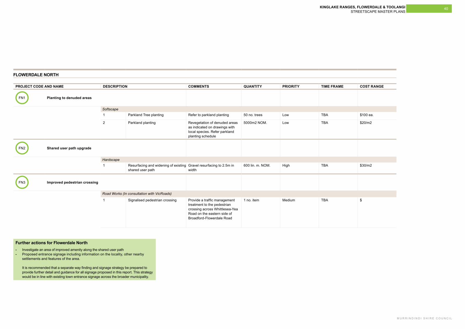
FLOWERDALE NORTH
PROJECT CODE AND NAME DESCRIPTION COMMENTS QUANTITY PRIORITY TIME FRAME COST RANGE
FN1 Planting to denuded areas
Softscape1 Parkland Tree planting Refer to parkland planting 50 no. trees Low TBA $100 ea.
2 Parkland planting Revegetation of denuded areas as indicated on drawings with local species. Refer parkland planting schedule
5000m2 NOM. Low TBA $20/m2
FN2 Shared user path upgrade
Hardscape1 Resurfacing and widening of existing
shared user path Gravel resurfacing to 2.5m in width
600 lin. m. NOM. High TBA $30/m2
FN3 Improved pedestrian crossing
Road Works (In consultation with VicRoads)
1 Signalised pedestrian crossing Provide a traffic management treatment to the pedestrian crossing across Whittlesea-Yea Road on the eastern side of Broadford-Flowerdale Road
1 no. item Medium TBA $
Further actions for Flowerdale North - Investigate an area of improved amenity along the shared user path - Proposed entrance signage including information on the locality, other nearby
settlements and features of the area. It is recommended that a separate way finding and signage strategy be prepared to provide further detail and guidance for all signage proposed in this report. This strategy would be in line with existing town entrance signage across the broader municipality.


KINGLAKE RANGES, FLOWERDALE & TOOLANGI STREETSCAPE MASTER PLANS
M U R R I N D I N D I S H I R E C O U N C I L
43
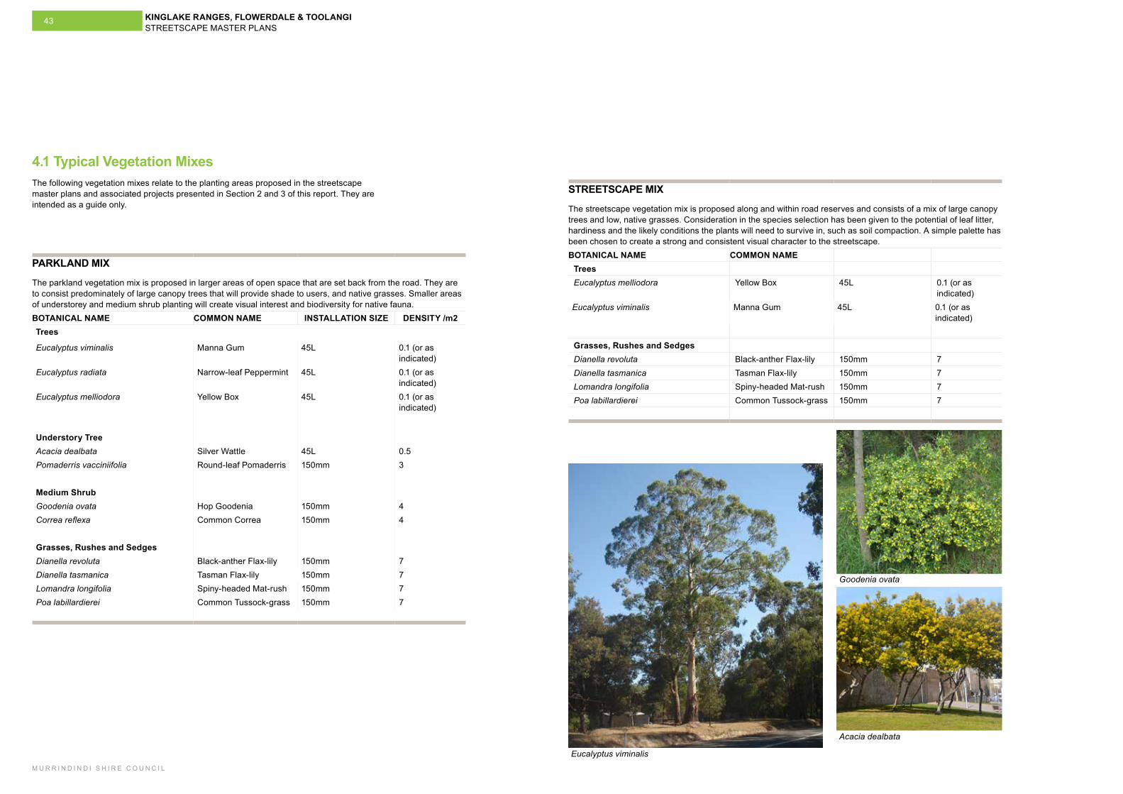
4.1 Typical Vegetation Mixes
PARKLAND MIX
The parkland vegetation mix is proposed in larger areas of open space that are set back from the road. They are to consist predominately of large canopy trees that will provide shade to users, and native grasses. Smaller areas of understorey and medium shrub planting will create visual interest and biodiversity for native fauna. BOTANICAL NAME COMMON NAME INSTALLATION SIZE DENSITY /m2Trees
Eucalyptus viminalis Manna Gum 45L 0.1 (or as indicated)
Eucalyptus radiata Narrow-leaf Peppermint 45L 0.1 (or as indicated)
Eucalyptus melliodora Yellow Box 45L 0.1 (or as indicated)
Understory TreeAcacia dealbata Silver Wattle 45L 0.5Pomaderris vacciniifolia Round-leaf Pomaderris 150mm 3
Medium ShrubGoodenia ovata Hop Goodenia 150mm 4Correa reflexa Common Correa 150mm 4
Grasses, Rushes and SedgesDianella revoluta Black-anther Flax-lily 150mm 7Dianella tasmanica Tasman Flax-lily 150mm 7Lomandra longifolia Spiny-headed Mat-rush 150mm 7Poa labillardierei Common Tussock-grass 150mm 7
STREETSCAPE MIX
The streetscape vegetation mix is proposed along and within road reserves and consists of a mix of large canopy trees and low, native grasses. Consideration in the species selection has been given to the potential of leaf litter, hardiness and the likely conditions the plants will need to survive in, such as soil compaction. A simple palette has been chosen to create a strong and consistent visual character to the streetscape. BOTANICAL NAME COMMON NAME
TreesEucalyptus melliodora Yellow Box 45L 0.1 (or as
indicated)Eucalyptus viminalis Manna Gum 45L 0.1 (or as
indicated)
Grasses, Rushes and SedgesDianella revoluta Black-anther Flax-lily 150mm 7Dianella tasmanica Tasman Flax-lily 150mm 7Lomandra longifolia Spiny-headed Mat-rush 150mm 7Poa labillardierei Common Tussock-grass 150mm 7
Eucalyptus viminalis
Goodenia ovata
Acacia dealbata
The following vegetation mixes relate to the planting areas proposed in the streetscape master plans and associated projects presented in Section 2 and 3 of this report. They are intended as a guide only.
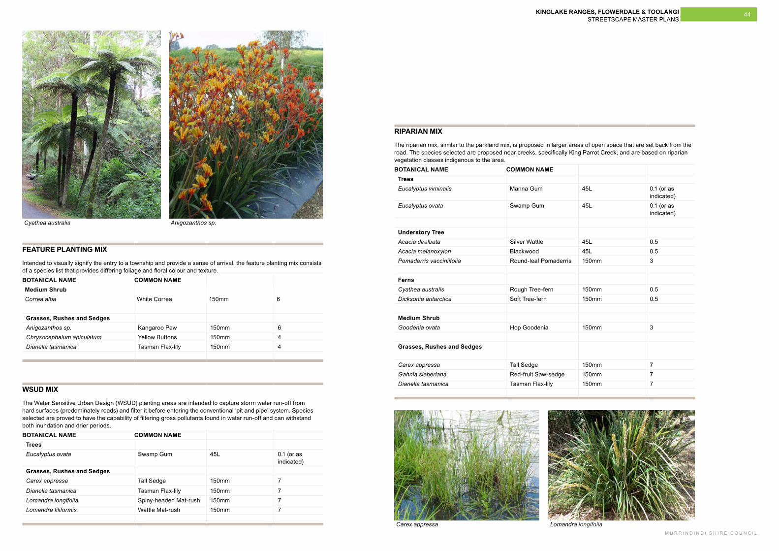
KINGLAKE RANGES, FLOWERDALE & TOOLANGI STREETSCAPE MASTER PLANS
M U R R I N D I N D I S H I R E C O U N C I L
44
FEATURE PLANTING MIX
Intended to visually signify the entry to a township and provide a sense of arrival, the feature planting mix consists of a species list that provides differing foliage and floral colour and texture. BOTANICAL NAME COMMON NAMEMedium ShrubCorrea alba White Correa 150mm 6
Grasses, Rushes and SedgesAnigozanthos sp. Kangaroo Paw 150mm 6Chrysocephalum apiculatum Yellow Buttons 150mm 4Dianella tasmanica Tasman Flax-lily 150mm 4
WSUD MIX
The Water Sensitive Urban Design (WSUD) planting areas are intended to capture storm water run-off from hard surfaces (predominately roads) and filter it before entering the conventional ‘pit and pipe’ system. Species selected are proved to have the capability of filtering gross pollutants found in water run-off and can withstand both inundation and drier periods. BOTANICAL NAME COMMON NAME
Trees Eucalyptus ovata Swamp Gum 45L 0.1 (or as
indicated)Grasses, Rushes and SedgesCarex appressa Tall Sedge 150mm 7
Dianella tasmanica Tasman Flax-lily 150mm 7Lomandra longifolia Spiny-headed Mat-rush 150mm 7Lomandra filiformis Wattle Mat-rush 150mm 7
RIPARIAN MIX
The riparian mix, similar to the parkland mix, is proposed in larger areas of open space that are set back from the road. The species selected are proposed near creeks, specifically King Parrot Creek, and are based on riparian vegetation classes indigenous to the area. BOTANICAL NAME COMMON NAME
TreesEucalyptus viminalis Manna Gum 45L 0.1 (or as
indicated)Eucalyptus ovata Swamp Gum 45L 0.1 (or as
indicated)
Understory TreeAcacia dealbata Silver Wattle 45L 0.5Acacia melanoxylon Blackwood 45L 0.5Pomaderris vacciniifolia Round-leaf Pomaderris 150mm 3
FernsCyathea australis Rough Tree-fern 150mm 0.5Dicksonia antarctica Soft Tree-fern 150mm 0.5
Medium ShrubGoodenia ovata Hop Goodenia 150mm 3
Grasses, Rushes and Sedges
Carex appressa Tall Sedge 150mm 7Gahnia sieberiana Red-fruit Saw-sedge 150mm 7Dianella tasmanica Tasman Flax-lily 150mm 7
Cyathea australis Anigozanthos sp.
Carex appressa Lomandra longifolia
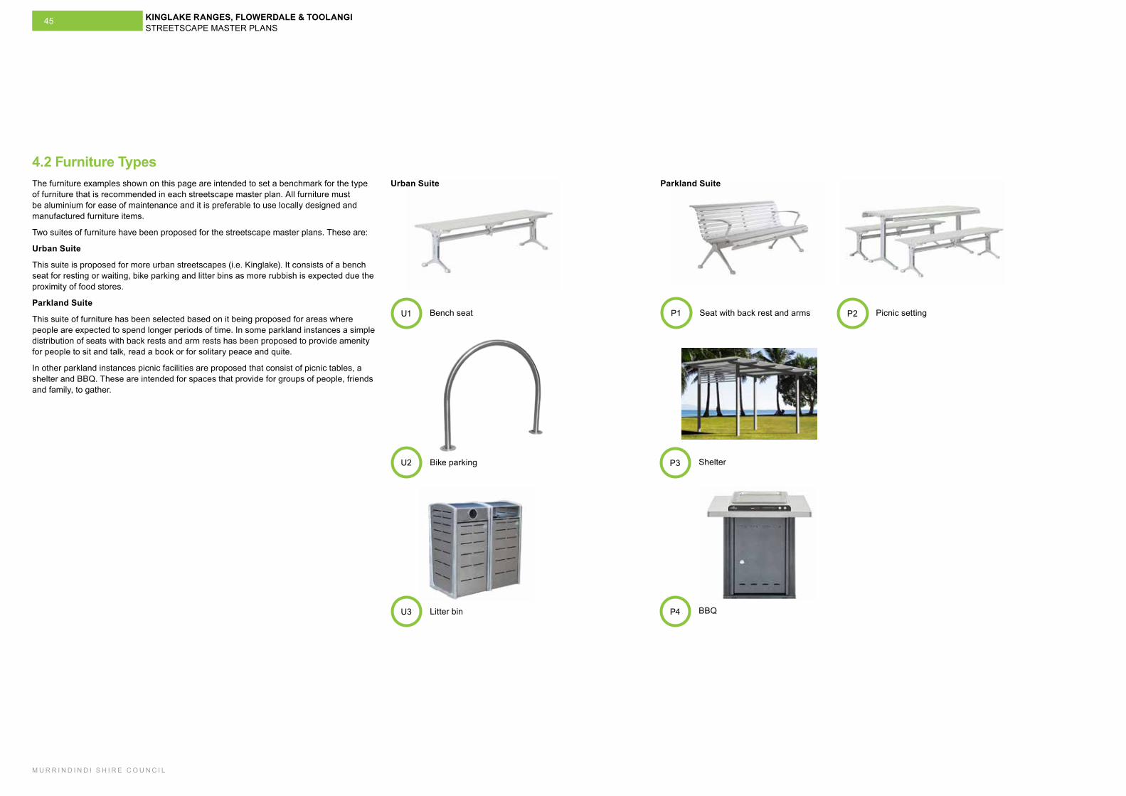
KINGLAKE RANGES, FLOWERDALE & TOOLANGI STREETSCAPE MASTER PLANS
M U R R I N D I N D I S H I R E C O U N C I L
45
4.2 Furniture TypesThe furniture examples shown on this page are intended to set a benchmark for the type of furniture that is recommended in each streetscape master plan. All furniture must be aluminium for ease of maintenance and it is preferable to use locally designed and manufactured furniture items.
Two suites of furniture have been proposed for the streetscape master plans. These are:
Urban Suite
This suite is proposed for more urban streetscapes (i.e. Kinglake). It consists of a bench seat for resting or waiting, bike parking and litter bins as more rubbish is expected due the proximity of food stores.
Parkland Suite
This suite of furniture has been selected based on it being proposed for areas where people are expected to spend longer periods of time. In some parkland instances a simple distribution of seats with back rests and arm rests has been proposed to provide amenity for people to sit and talk, read a book or for solitary peace and quite.
In other parkland instances picnic facilities are proposed that consist of picnic tables, a shelter and BBQ. These are intended for spaces that provide for groups of people, friends and family, to gather.
Bench seatU1
ShelterP3
BBQP4
Bike parkingU2
Litter binU3
Seat with back rest and armsP1 Picnic settingP2
Urban Suite Parkland Suite
KINGLAKE RANGES, FLOWERDALE & TOOLANGI STREETSCAPE MASTER PLANS
M U R R I N D I N D I S H I R E C O U N C I L
46
4.2 Road Design Notes (VicRoads)VicRoads North Eastern Region reviewed an advanced draft of streetscape master plans report in late 2015. As this document aims to provide a broad overview of the strategic direction for a series of streetscape environment upgrade proposals VicRoads were only able to provide higher level commentary at this time. It was recognised that as individual projects are developed from this report and road designs commence VicRoads will be provided the relevant level of information so that they are able to provide further and more detailed commentary, guidance and direction.
Through the development of this report the broader aspects of VicRoads landscape architectural and urban design approaches have been taken into account. These were established at the commencement of the streetscape master planning process (2014) and include the VicRoads Section 720 (Landscape). As this masterplan document seeks primarily to describe how the broader road and streetscape corridors and road environment may respond to future urban development, to provide greater amenity and intensity we have drawn from these broader design aspects.
KINGLAKE RANGES, FLOWERDALE & TOOLANGI STREETSCAPE MASTER PLANS
M U R R I N D I N D I S H I R E C O U N C I L
47
4.4 MaintenanceThe maintenance items listed below are recommendations for the proposed softscape works in each streetscape master plan only and should be incorporated and considered along side Council’s current maintenance regimes and work practices.
TOOLANGI
The following maintenance items for Toolangi relate to the proposed softscape works in Projects TO2 and TO3.Maintenance Item Description Softscape1 Streetscape/parkland planting areas Watering during establishment period only or
on an as needs basis following establishment period
Weed control – manual weed removal when required
Pruning/slashing when required
Plant replacement as required
KINGLAKE
The following maintenance items for Kinglake relate to the proposed softscape works in Project KL1, KL2, KL3 and KL4.
Maintenance Item Description Softscape1 Streetscape/parkland planting areas Watering during establishment period only or
on an as needs basis following establishment periodWeed control – manual weed removal when requiredPruning/slashing when requiredPlant replacement as required
2 Water Sensitive Urban Design (WSUD) planting areas
Watering during establishment period only or on an as needs basis following establishment period
Weed control – manual weed removal when required
Pruning/slashing when required
Plant replacement as required
Kinglake West - Pheasant Creek
The following maintenance items for Kinglake West - Pheasant Creek relate to the proposed softscape works in Project KP3.
Maintenance Item Description Softscape1 WSUD planting areas Watering during establishment period only or
on an as needs basis following establishment period
Weed control – manual weed removal when required
Pruning/slashing when required
Plant replacement as required
Removal of debris as required
FLOWERDALE SOUTH
The following maintenance items for Flowerdale South relate to the proposed softscape works in Projects FS1, FS2 and FS3.
Item Description Softscape1 Streetscape/Parkland planting areas Watering during establishment period only or
on an as needs basis following establishment period
Weed control – manual weed removal when required
Pruning/slashing when required
Plant replacement as required
KINGLAKE RANGES, FLOWERDALE & TOOLANGI STREETSCAPE MASTER PLANS
M U R R I N D I N D I S H I R E C O U N C I L
48
FLOWERDALE CENTRAL
The following maintenance items for Flowerdale Central relate to the proposed softscape works in Projects FC1 and FC4.
Item Description Softscape1 Parkland planting Watering during establishment period only or
on an as needs basis following establishment period
Weed control – manual weed removal when required
Pruning/slashing when required
Plant replacement as required
FLOWERDALE NORTH
The following maintenance items for Flowerdale North relate to the proposed softscape works in Project FN1.
Item Description Softscape1 Parkland planting Watering during establishment period only or
on an as needs basis following establishment period
Weed control – manual weed removal when required
Pruning/slashing when required
Plant replacement as required
Plant replacement as required


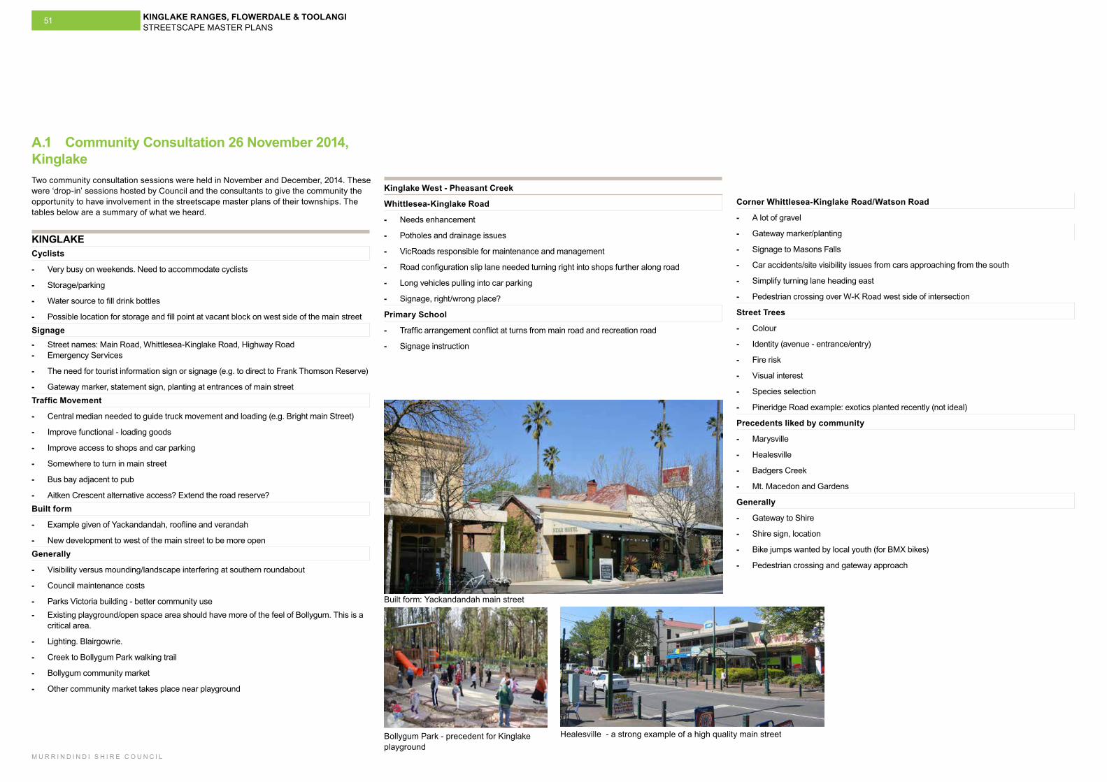
KINGLAKE RANGES, FLOWERDALE & TOOLANGI STREETSCAPE MASTER PLANS
M U R R I N D I N D I S H I R E C O U N C I L
51
Kinglake West - Pheasant Creek
Whittlesea-Kinglake Road
- Needs enhancement
- Potholes and drainage issues
- VicRoads responsible for maintenance and management
- Road configuration slip lane needed turning right into shops further along road
- Long vehicles pulling into car parking
- Signage, right/wrong place?
Primary School
- Traffic arrangement conflict at turns from main road and recreation road
- Signage instruction
KINGLAKECyclists
- Very busy on weekends. Need to accommodate cyclists
- Storage/parking
- Water source to fill drink bottles
- Possible location for storage and fill point at vacant block on west side of the main street Signage - Street names: Main Road, Whittlesea-Kinglake Road, Highway Road - Emergency Services
- The need for tourist information sign or signage (e.g. to direct to Frank Thomson Reserve)
- Gateway marker, statement sign, planting at entrances of main streetTraffic Movement
- Central median needed to guide truck movement and loading (e.g. Bright main Street)
- Improve functional - loading goods
- Improve access to shops and car parking
- Somewhere to turn in main street
- Bus bay adjacent to pub
- Aitken Crescent alternative access? Extend the road reserve?Built form
- Example given of Yackandandah, roofline and verandah
- New development to west of the main street to be more open Generally
- Visibility versus mounding/landscape interfering at southern roundabout
- Council maintenance costs
- Parks Victoria building - better community use - Existing playground/open space area should have more of the feel of Bollygum. This is a
critical area.
- Lighting. Blairgowrie.
- Creek to Bollygum Park walking trail
- Bollygum community market
- Other community market takes place near playground
A.1 Community Consultation 26 November 2014, Kinglake
Built form: Yackandandah main street
Bollygum Park - precedent for Kinglake playground
Healesville - a strong example of a high quality main street
Two community consultation sessions were held in November and December, 2014. These were ‘drop-in’ sessions hosted by Council and the consultants to give the community the opportunity to have involvement in the streetscape master plans of their townships. The tables below are a summary of what we heard.
Corner Whittlesea-Kinglake Road/Watson Road
- A lot of gravel
- Gateway marker/planting
- Signage to Masons Falls
- Car accidents/site visibility issues from cars approaching from the south
- Simplify turning lane heading east
- Pedestrian crossing over W-K Road west side of intersection
Street Trees
- Colour
- Identity (avenue - entrance/entry)
- Fire risk
- Visual interest
- Species selection
- Pineridge Road example: exotics planted recently (not ideal)
Precedents liked by community
- Marysville
- Healesville
- Badgers Creek
- Mt. Macedon and Gardens
Generally
- Gateway to Shire
- Shire sign, location
- Bike jumps wanted by local youth (for BMX bikes)
- Pedestrian crossing and gateway approach
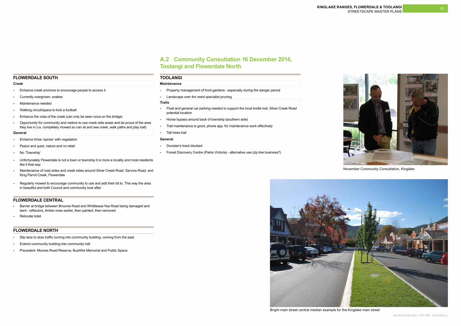
KINGLAKE RANGES, FLOWERDALE & TOOLANGI STREETSCAPE MASTER PLANS
M U R R I N D I N D I S H I R E C O U N C I L
52
FLOWERDALE SOUTHCreek
- Enhance creek environs to encourage people to access it
- Currently overgrown, snakes
- Maintenance needed
- Walking circuit/space to kick a football
- Enhance the vista of the creek (can only be seen once on the bridge)
- Opportunity for community and visitors to use creek side areas and be proud of the area they live in (i.e. completely mowed so can sit and see creek, walk paths and play ball)
General
- Enhance three ‘spines’ with vegetation
- Peace and quiet, nature and no retail
- No ‘Township’
- Unfortunately Flowerdale is not a town or township it is more a locality and most residents like it that way
- Maintenance of road sides and creek sides around Silver Creek Road. Service Road. and King Parrot Creek, Flowerdale
- Regularly mowed to encourage community to use and add their bit to. This way the area in beautiful and both Council and community look after
TOOLANGIMaintenance
- Property management of front gardens - especially during fire danger period
- Landscape over 4m need specialist pruning Trails - Float and general car parking needed to support the local bridle trail, Silver Creek Road
potential location
- Horse bypass around back of township (southern side)
- Trail maintenance is good, phone app. for maintenance work effectively
- Tall trees trail
General
- Dunstan’s track blocked
- Forest Discovery Centre (Parks Victoria) - alternative use (zip line business?)
FLOWERDALE NORTH - Slip lane to slow traffic turning into community building, coming from the east
- Extend community building into community hall
- Precedent: Moores Road Reserve, Bushfire Memorial and Public Space
FLOWERDALE CENTRAL - Barrier at bridge between Broome Road and Whittlesea-Yea Road being damaged and
bent - reflectors, timber ones earlier, then painted, then removed - Relocate toilet
A.2 Community Consultation 16 December 2014, Toolangi and Flowerdale North
Bright main street central median example for the Kinglake main street
November Community Consultation, Kinglake

Recommended