Strategic Housing and Economic
Land Availability Assessment
December 2018
www.eastsuffolk.gov.uk/suffolkcoastallocalplanreview
Suffolk Coastal Strategic Housing and Economic Land Availability Assessment (December 2018)
Contents
1. Introduction .................................................................................................................................... 1
2. Methodology ................................................................................................................................... 2
Stage 1: Site Identification .............................................................................................................. 4
Stage 2: Site assessment ................................................................................................................. 5
Stage 3. Windfall assessment ....................................................................................................... 11
Stage 4. Assessment Review ......................................................................................................... 11
Stage 5. Evidence base .................................................................................................................. 12
3. Results and Conclusions ................................................................................................................ 13
Appendix A: Call for Sites form ......................................................................................................... 16
Appendix B: Sites not subject to assessment through the SHELAA ................................................... 25
Appendix C: Sites made available for uses other than housing or employment use ....................... 30
Appendix D: Sites identified as unavailable ...................................................................................... 32
Appendix E: Housing and employment sites below size threshold .................................................. 43
Appendix F: Sites identified as not well related to settlement......................................................... 46
Appendix G: Unsuitable Sites (significant constraints) ..................................................................... 52
Appendix H: Suitability Criteria ......................................................................................................... 53
Appendix I: Unsuitable Sites ............................................................................................................. 60
Appendix J: Potential Sites ................................................................................................................ 65
Appendix K: Full list of sites identified as not potential.................................................................. 655
Appendix L: Committed housing supply (31.3.18) .......................................................................... 691
Appendix M: Trajectory of suitable, available and achievable sites ............................................... 709
Suffolk Coastal Strategic Housing and Economic Land Availability Assessment (December 2018)
1
1. Introduction
1.1 Suffolk Coastal District Council is producing a new Local Plan covering the period 2018 to
2036. The Local Plan will contain policies and site allocations to meet identified needs for
housing and employment land.
1.2 National planning policy set out in the National Planning Policy Framework states that
strategic policies should be informed by a local housing need assessment, conducted using
the standard method in national planning guidance. This identifies the minimum amount of
housing that the District must plan for. Needs for employment land are established through
the Ipswich Functional Economic Area Sector Needs Assessment (2017). Needs for retail
development are set out in the Ipswich and Suffolk Coastal Retail and Commercial Leisure
Town Centre Study (2017). These baseline needs are set out below:
Land use Baseline need (2018 – 2036)
Housing 10,476 dwellings (582 per annum x 18)
Employment Land 11.7 hectares1
Retail floorspace 4,100 – 5,000sqm convenience 7,700 – 13,100sqm comparison
1.3 The Strategic Housing and Economic Land Availability Assessment (SHELAA) is a key piece of
evidence informing the Local Plan. The purpose of the SHELAA is to identify the potential
supply of land available in Suffolk Coastal to meet the identified needs for housing and
employment land over the Local Plan period. The need figures above should be viewed as
baseline figures and the Local Plan can set more ambitious targets for housing and
employment development, where the SHELAA identifies that sufficient land is available to do
so.
1.4 The SHELAA also enables the Council to understand where in the District land is available,
and at the detailed level is also used to inform the selection of preferred sites for allocation
alongside other evidence such as consultation responses and Sustainability Appraisal.
1.5 The SHELAA does not in itself allocate sites for development. It identifies those sites that are
potentially suitable for allocation and which the Council can therefore consider further in
identifying sites to meet its Local Plan strategy. Identification as a potential site through the
SHELAA process does not afford a site any planning status. The SHELAA is a technical
document used to identify potentially suitable sites which are then considered further for
allocation in the Local Plan. Identification as a potential site through the SHELAA process
does not indicate that planning permission would be granted.
1 Note this updates Table 16.2 on page 202 of the Ipswich Economic Area Sector Needs Assessment
(September 2017), as the evidence used a 2014 base date.
Suffolk Coastal Strategic Housing and Economic Land Availability Assessment (December 2018)
2
1.6 A Draft SHELAA was published alongside consultation on the First Draft Local Plan. A number
of comments were received in relation to individual site assessments, in addition to new
sites and amended sites being submitted. The comments received are summarised in the
Consultation Statement which accompanies the Final Draft Local Plan. The Final SHELAA is
published alongside the Final Draft Local Plan..
1.7 Further information on SHELAA is available in the national Planning Practice Guidance which
can be viewed at https://www.gov.uk/guidance/housing-and-economic-land-availability-
assessment.
All sites are shown in the accompanying SHELAA map book.
2. Methodology
2.1 The national Planning Practice Guidance sets out a methodology for undertaking the
SHELAA, as summarised in the flowchart overleaf. This has been followed in undertaking this
SHELAA.

Suffolk Coastal Strategic Housing and Economic Land Availability Assessment (December 2018)
3
1. Site / Broad location identification
2. Site / broad location assessment
3. Windfall assessment
4. Assessment review
5. Final evidence base
Desktop review of existing information
Call for sites / broad locations
Site / broad location survey
Estimate
development
potential
Assess
suitability
Assess
availability
Assess
achievability
Overcoming constraints
Determine housing / economic development
potential of windfall sites
Review assessment and prepare draft trajectory.
Enough sites?
Assessment of
development
need for housing
and economic
uses
Produce report as part of evidence base
No
Yes
Determine assessment area and site size
Suffolk Coastal Strategic Housing and Economic Land Availability Assessment (December 2018)
4
Stage 1: Site Identification
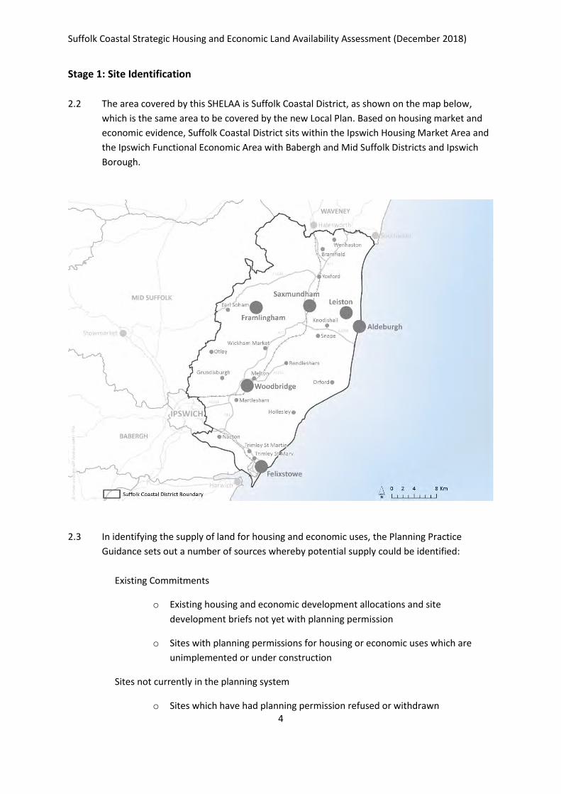
2.2 The area covered by this SHELAA is Suffolk Coastal District, as shown on the map below,
which is the same area to be covered by the new Local Plan. Based on housing market and
economic evidence, Suffolk Coastal District sits within the Ipswich Housing Market Area and
the Ipswich Functional Economic Area with Babergh and Mid Suffolk Districts and Ipswich
Borough.
2.3 In identifying the supply of land for housing and economic uses, the Planning Practice
Guidance sets out a number of sources whereby potential supply could be identified:
Existing Commitments
o Existing housing and economic development allocations and site
development briefs not yet with planning permission
o Sites with planning permissions for housing or economic uses which are
unimplemented or under construction
Sites not currently in the planning system
o Sites which have had planning permission refused or withdrawn
Suffolk Coastal Strategic Housing and Economic Land Availability Assessment (December 2018)
5
o Land in the Council’s ownership
o Surplus, or likely to become surplus, public sector land
o Vacant and derelict land and buildings
o Additional opportunities in established uses
Call for Sites
2.4 To identify those sites not currently in the planning system, a Call for Sites was undertaken
in autumn 2016. The Council has recently adopted the Site Allocations and Area Specific
Policies Development Plan Document (January 2017) and the Felixstowe Area Action Plan
Development Plan Document (January 2017). The Council therefore had records of
numerous sites that had been considered through the production of these documents, but
that had not been selected for allocation, which could be re-considered through the SHELAA
for the new Local Plan. The purpose of the Call for Sites was to identify further sites that
could be considered.
2.5 The Call for Sites was carried out during Autumn 2016 and involved direct contact with
individuals and organisations whose contact details are held on the Council’s consultation
database, as well as promoted on the Council’s website. Those submitting sites were asked
to submit details which would enable the Council to understand the availability and
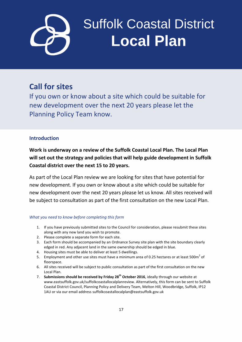
achievability of sites. A copy of the Call for Sites form is shown in Appendix A.
2.6 Through the subsequent Local Plan Issues and Options consultation (18th August – 30th
October 2017) and First Draft Local Plan consultation (20th July – 14th September 2018), the
Council provided an opportunity for further sites to be submitted. The Call for Sites form was
made available in order that details could be submitted. A further 55 sites were submitted
through the Issues and Options consultation and a further 15 were submitted through
consultation on the First Draft Local Plan.
All sites are shown on the maps in the accompanying SHELAA map book.
Stage 2: Site assessment
2.7 The purpose of this stage is to determine whether sites are deliverable or developable2.
Deliverable sites are those which are available now, offer a suitable location for
development now, and are achievable with a realistic prospect that housing will be delivered
on the site within five years. Developable sites are those which are in a suitable location for
housing development with a reasonable prospect that they will be available and coule be
viably developed at the point envisaged. The Local Plan will cover the timeframe to 2036 and
2 As defined in Annex 2: Glossary of the National Planning Policy Framework

Suffolk Coastal Strategic Housing and Economic Land Availability Assessment (December 2018)
6
the assessment will therefore consider the supply of sites over this period. Information in
relation to availability is obtained through the call for sites and site submissions process.
2.8 Those sites presented in the 2017 Issues and Options document, along with the additional
sites submitted through the Issues and Options consultation and the First Draft Local
Planconsultation, have been considered through the SHELAA.
2.9 Sites which have planning permission (as at 31.3.2018) have not been assessed for their
suitability or availability but are identified as part of the supply of land. As the Site
Allocations and Area Specific Policies DPD and the Felixstowe Area Action Plan DPD have
been adopted relatively recently (January 2017), site allocations contained in these have not
been revisited for suitability, and their contribution to supply is identified in Chapter 3. The
Council proposes to carry forward these allocations into the new Local Plan where they
remain unimplemented. Details of those sites which were contained in the 2017 Issues and
Options document or submitted through consultations, but which have planning permission
or are already allocated, are shown in Appendix B.
2.10 The assessment of sites is to determine their availability, suitability and achievability. For
those identified as available, suitable and achievable, an assessment of their development
potential was also undertaken.
2.11 A number of sites have been put forward for uses other than housing or employment land
(for example open space or areas to be protected from development). These have not been
assessed as they are not considered to be available for housing or employment uses. These
are listed in Appendix C. Whilst they may be suitable for allocation in the Local Plan to meet
other objectives, they do not form part of the supply of housing or economic land.
Availability
2.12 A site will normally be considered to be available where it is within the ownership of a
landowner or developer who has expressed an interest to develop or sell the site. This
assessment has been based upon information submitted through the Call for Sites process
and subsequent Local Plan consultations.
2.13 For sites that were held on the Council’s system and were presented in the 2017 Issues and
Options consultation, but where no contact had been received from a landowner / promoter
since before 2016, availability checks were carried out as part of the production of the Draft
SHELAA. Where no availability information was forthcoming, or where the Council received a
response to indicate that a site is not available, these sites were judged to be unavailable
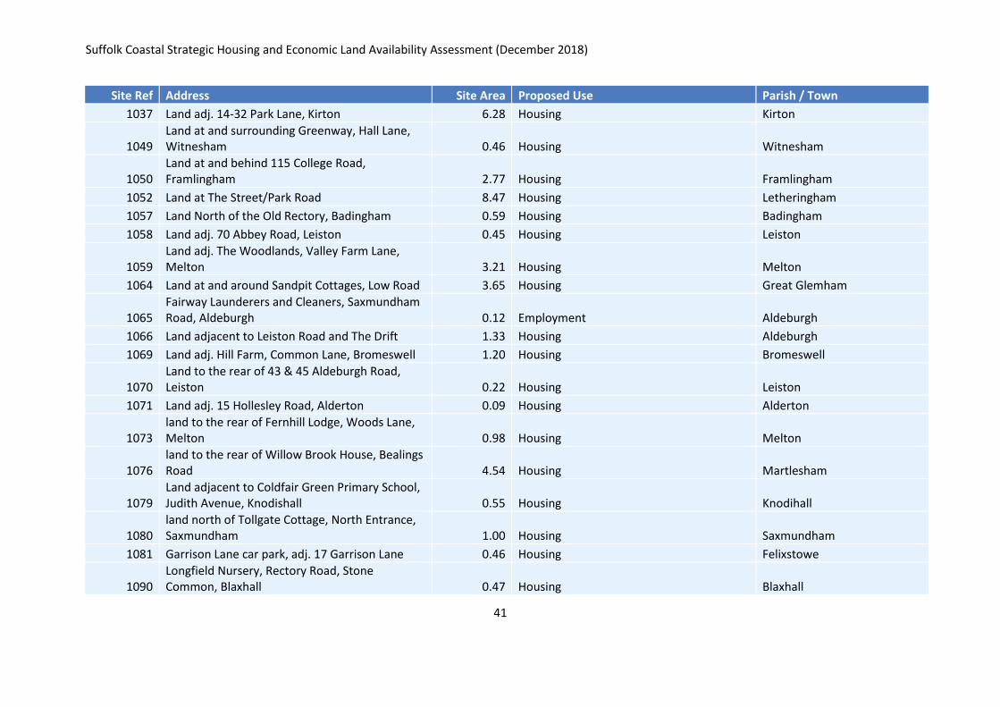
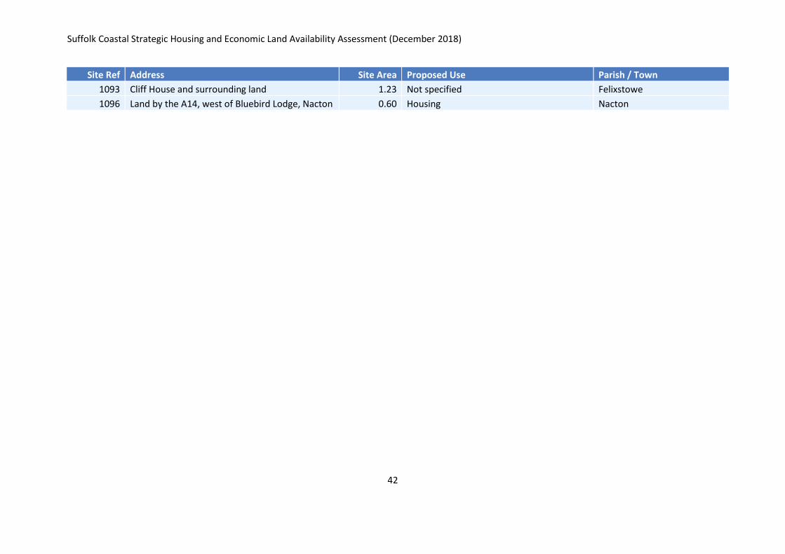
and were not assessed further. Those sites identified as unavailable are listed in Appendix D.
2.14 There are a small number of sites where availability is identified as uncertain. These are
instances where, for example, it is not clear whether all landowners fully support the
promotion of the site. In these cases, sites have been retained in the assessment but no
contribution towards supply is assumed.
Suffolk Coastal Strategic Housing and Economic Land Availability Assessment (December 2018)
7
Suitability
2.15 The suitability of a site includes planning and development considerations like access and
environmental features as well as physical constraints affecting the site, impacts of
development of the site, market attractiveness of proposed use of the site, its contribution
to regeneration and the amenity and environment of neighbouring areas.
2.16 The PPG states that the SHELAA should consider sites capable of delivering 5 or more
dwellings or economic development on sites of 0.25 hectares. Of the available sites, a
threshold of 0.2ha has been identified for housing sites, in order to ensure a wide choice of
smaller sites that may be suitable for development should insufficient sites of 0.25ha or
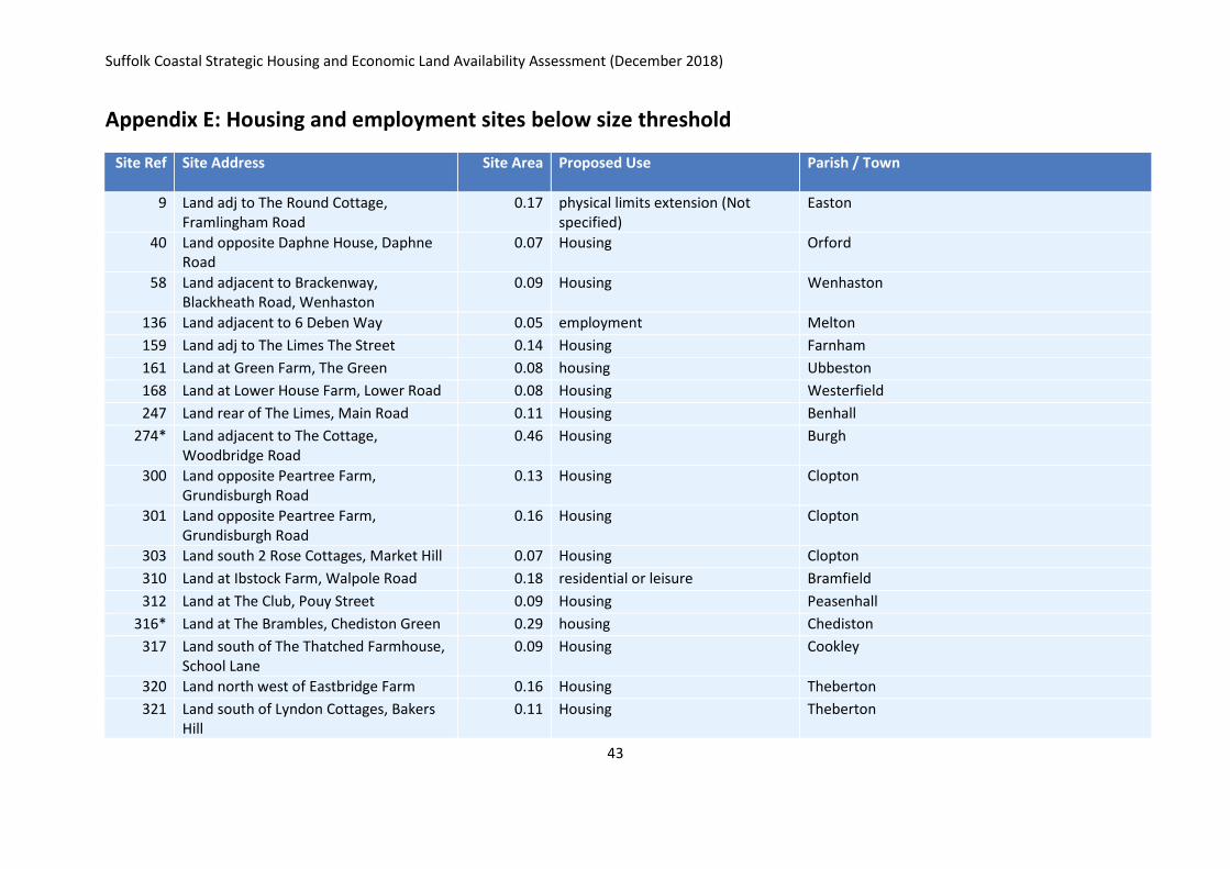
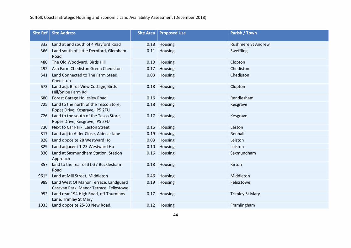
more be identified. Housing sites below 0.2ha and employment sites below 0.1ha were
discounted from the assessment and these are listed in Appendix E. Also shown in Appendix
E are sites that have been put forward for one dwelling only as these are not considered to
be available for a housing allocation, although they may come forward as windfall and
contribute to supply in that way, subject to compatibility with policies.
2.17 The SHELAA does not take into account the settlement hierarchy, as the settlement
hierarchy has been reviewed through the review of the Local Plan. However, the SHELAA has
included an assessment of how well related a site is to a settlement. Housing sites not
judged to be within, adjoining or well related to the form a settlement were discounted,
these are listed in Appendix F, and were not taken forward for further assessment. The
following criteria have been used in identifying whether a site is well related to an existing
settlement:
Site is within the existing Physical Limits Boundary; or
Site is adjacent / adjoining existing Physical Limits Boundary (including where
separated by the highway or other feature which forms part of the overall settlement
form e.g. playing field); or
Site is within, adjoining or adjacent a settlement (including where separated by the
highway or other feature which forms part of the overall settlement form e.g. playing
field) which doesn’t currently have settlement limits; or
Sites is adjacent / adjoining a site with planning permission or an allocated site, or
another SHELAA site that is well related; and
In relation to any of the above, the site is well related in scale and form to the existing
settlement pattern or other uses (such as transport connections) (part development of
a site may be recommended).
This has not been applied to sites put forward for employment uses.
2.18 Criteria for assessing the suitability of sites have been developed with authorities in the
Ipswich Housing Market Area / Functional Economic Area, which includes Babergh and Mid
Suffolk District Councils and Ipswich Borough Council, but adapted at local authority level to
reflect the circumstances of each authority (such as through inclusion of coastal change risk
in the Suffolk Coastal assessment).
Suffolk Coastal Strategic Housing and Economic Land Availability Assessment (December 2018)
8
2.19 The assessment has been undertaken through desk top assessment. Site visits have also
been undertaken. Information from Suffolk County Council has informed assessments in
relation to access, transport, archaeology and utilities / neighbouring uses (minerals and
waste). Engagement with utilities providers has also been undertaken.
2.20 The suitability of a site, through the criteria, is influenced by national planning policy, local
planning policy (where policy is up to date) and other factors including physical constraints
affecting the site, the impacts of the development of the site and the impacts on amenity
and environment of neighbouring areas.
2.21 When assessing sites across the District some will have constraints and impacts which are
insurmountable and thus undermine the suitability of development. Other sites will have
impacts and constraints which are surmountable, however, they may be costly to overcome
and have an impact on the achievability of development. And others will have surmountable
constraints and impacts that through mitigation could deliver the necessary development.
2.22 An initial check was undertaken to identify whether any sites had significant constraints that
would make them unsuitable for development. This involved a desktop assessment to
identify whether development of the site would result in:
Loss of Special Protection Area, Special Area of Conservation, SSSI or Ramsar;
Loss of a National Nature Reserve;
Loss of ancient woodland;
Development in Flood Zone 3b;
Loss of a Scheduled Monument;
Loss of Statutory Allotments;
Loss of Local Green Space.
2.21 Where any of the above were identified, further assessment was not undertaken. Sites
identified as having these absolute constraints are listed in Appendix G.
2.22 To assess the suitability of remaining sites a ‘red’, ‘amber’, ‘green’ approach has been
applied to assessing the various types of constraints and impacts which may affect the
development of sites.
2.23 ‘Red’ impacts and constraints rule out the suitability of a site. Any site assessed as ‘red’
against any type of constraint or impact has been discounted from the assessment as the
site will not be suitable for development.
2.24 ‘Amber’ impacts and constraints do not rule out the suitability of development. However,
some mitigation will be required in order for the site to be suitable. The feasibility and
extent of that mitigation would need to be established through further work in considering
potential site allocations. Therefore, sites assessed as ‘amber’ against any type of constraint
or impact are considered suitable providing those constraints can be overcome. In some
Suffolk Coastal Strategic Housing and Economic Land Availability Assessment (December 2018)
9
instances, the cumulative extent of a number of ‘amber’ impacts have resulted in an overall
conclusion of ‘red’.
2.25 The ‘green’ category represents no constraint or impact with respect to that type of impact
or constraint.
2.26 The criteria to assess the suitability of sites cover the following topics, and the full
assessment criteria is contained in Appendix H:
Access to site;
Utilities capacity;
Utilities Infrastructure;
Contamination;
Flood Risk;
Coastal change;
Market attractiveness;
Landscape / Townscape;
Biodiversity and Geodiversity;
Historic Environment;
Open space;
Transport and Roads;
Contribution to regeneration / re-use
Conclusions for sites judged to be unsuitable are shown in Appendix I.
2.27 Sites made available for consideration for employment or mixed use have been subject to
assessment as part of the production of the Council’s employment evidence, undertaken by
Lichfields, utilising the suitability criteria outlined above.
2.28 Potential employment sites are only selected for suitability where they are at least 0.1
hectares in size. It is anticipated that Local Plan policies would provide opportunities for
smaller sites to come forward to provide flexibility without these being specifically identified
in the Local Plan. To reflect the rural nature of the District and to provide evidence that
would enable an understanding of the potential from smaller sites in rural areas, a lower
threshold (than contained in the Planning Practice Guidance) has been applied.
Achievability
2.29 A site is considered to be achievable where there is a reasonable prospect that development
will occur on the site at a particular point in time (for the purposes of the new Local Plan
review this is within the time period to 2036). A key determinant of achievability will be the
economic viability of the site. This will be influenced by the market attractiveness of the site
and any known likely abnormal construction and development costs.
Suffolk Coastal Strategic Housing and Economic Land Availability Assessment (December 2018)
10
2.30 Information on viability and potential abnormal costs has been sought from landowners as
part of the Call for Sites process. Having regard to completions over recent years it is not
considered that there are any particular housing market constraints that would prevent
development from coming forward. The whole plan viability assessment includes cost
assumptions for abnormal costs should these arise as part of proposed developments.
2.31 Another factor affecting achievability will be whether a developer has capacity to complete
and let or sell a development over a certain period of time.
Summaries of assessments for those sites judged to be available, suitable and achievable
are contained in Appendix J.
A full schedule of all sites discounted through the assessments and checks listed above is
contained in Appendix K.
Suffolk Coastal Strategic Housing and Economic Land Availability Assessment (December 2018)
11
Stage 3. Windfall assessment
2.31 Windfall sites are sites which have not been specifically identified as part of the Local Plan
process. This could include a range of sites from brownfield sites becoming available through
relocation / closure of existing uses, conversions or development in accordance with
countryside policies.
2.32 As set out in the NPPF, local authorities may make allowance for windfall in the land supply
assessment where there is compelling evidence that sites have consistently become
available and will continue to provide a reliable source of supply.
2.33 To avoid double counting with sites identified as potential in the SHELAA, only average
delivery rates of for windfall sites below 0.2ha have been considered. Over the past 5 years
(2013/14 – 2017/18) this has been an average of 97 per annum. Many existing planning
permissions which will be built out over the next few years are on windfall sites and
therefore when projecting windfall trends forward it is important not to double count their
contribution. Consistent with the approach taken in the Housing Land Supply Assessment
(June 2018), and based on monitoring information, windfall contributions are therefore
counted as 50 per year from 2020/21 onwards.
Stage 4. Assessment Review
2.34 The total capacity of land for each use has been totalled and compared against the need (set
out in Section 1) for housing and employment use. If sufficient numbers of sites were not
found to meet the needs, the Council would need to try to identify further sites. The Council
may also undertake a reassessment of the development potential of already identified sites
to see if the development potential could be increased (for example through higher
densities or by revisiting sites previously discounted).
2.35 In estimating a dwelling yield for the purposes of the SHELAA a relatively conservative
approach has been applied, in order to ensure that potential is not over inflated at a stage
when potential constraints have not been assessed in detail. Consideration has been given
to the densities set out in the adopted Core Strategy as well as densities achieved over past
years.
2.36 The table overleaf sets out the densities that have been applied for the purposes of the
SHELAA assessment. The Local Plan will consider appropriate densities in relation to site
allocations, taking account of site specific circumstances.
Suffolk Coastal Strategic Housing and Economic Land Availability Assessment (December 2018)
12
Location
Estimated dwellings per
hectare
Within and adjoining Felixstowe 30
Within and adjoining Market towns 30
Communities surrounding Ipswich 25
Elsewhere 15
2.37 A number of sites were made available for a mix of housing and employment (or other types
of development like retail or community uses). Depending on the mix of uses proposed, an
appropriate reduction to potential yield has been applied.
2.38 The anticipated timescales for delivery are also an important consideration. An indicative
trajectory is plotted. For some larger sites, it is likely that delivery would extend beyond
2036 and therefore only the contribution to 2036 is plotted for the purposes of the SHELAA.
Stage 5. Evidence base
2.39 The outputs from the SHELAA are:
Details, including mapped information, of all sites considered;
An assessment of each site (for some this includes early discounting where for example
they are not available);
More details for those sites which are considered to be potential sites;
The potential type and quantity of development that could be delivered and an
indication of any potential barriers to deliver or commencement;
An indicative trajectory.
These outputs are presented in this SHELAA report.
Suffolk Coastal Strategic Housing and Economic Land Availability Assessment (December 2018)
13
3. Results and Conclusions
Housing Land
3.1 Under the proposed standard method for calculating housing need, the baseline housing
requirement that would need to be planned for in Suffolk Coastal is 582per annum (10,476
dwellings over the period 2018 – 2036).
Existing commitments
3.2 Existing commitments are sites that have planning permission, sites where there is a
resolution to grant permission (subject to Section 106 agreement) and sites allocated in the
existing plans (including Neighbourhood Plans). All sites with planning permission are
assumed to be deliverable unless there is clear evidence a site will not come forward within
the plan period. Appendix L sets out details of the anticipated delivery of sites with planning
permission (as at 31.3.18) over the period to 2036, based on the Council’s Housing Land
Supply Assessment published in June 2018. The table below summarises projected delivery
over a fifteen year period.
Commited supply Number of dwellings
Within 5 years (2018 – 2023) 4,274
6 - 15 years (2023 – 2033) 2,766
Sites not within the planning system
3.3 Based upon the information submitted to the Councils alongside officer judgements in
relation to delivery timescales and densities, an estimate has been made in relation to the
potential yield and timescales for delivery, in relation to those sites identified as suitable,
available and achievable.
3.4 This shows that there is potential capacity for 20,599 dwellings over the Local Plan period of
2018 – 2036. The indicative trajectory in Appendix M shows the estimated timescales for
delivery, as summarised in the table overleaf.
Suffolk Coastal Strategic Housing and Economic Land Availability Assessment (December 2018)
14
Number of dwellings
Within 5 years (2018 – 2023) 4,065
6 - 15 years (2023 – 2033) 15,284
Remainder of plan period 2033 - 2036 1,250
Beyond 2036 2,105
Total 2018 - 2036 20,599 (22,704 overall total)
3.5 It should be noted that this capacity is theoretical and is based on every potential site
coming forward. In reality this is unlikely as the market is unlikely to be able to support this
level of development and rate of delivery. Further, cumulative environmental and
infrastructure constraints may impact upon the practicality of this level of development
coming forward over the plan period.
Windfall
3.6 As stated in the methodology section, anticipated windfall on sites below 0.2ha is applied at
a rate of 50 per year from 2020/21 onwards to avoid double counting with small sites
already with planning permission. The estimated windfall for the Local Plan period is
therefore 800 dwellings.
Total Supply
3.7 Total identified land supply over the Local Plan period is summarised in the table below.
Source Land supply contribution
Committed supply 7,040
Sites not in the planning system 20,599
Potential windfall contribution 800
Total potential supply 2016 - 2036 28,439
3.8 When considered alongside the existing commitments it is clear that with a supply of 28,439
dwellings there is sufficient land supply to meet identified needs as set out in Section 1 of
this document.
Suffolk Coastal Strategic Housing and Economic Land Availability Assessment (December 2018)
15
Employment Land
3.9 Latest monitoring indicates that there is a current supply of 73.96ha of employment land,
within existing permissions and allocations3.
3.10 Sites identified as potential for employment through the assessment of sites not currently in
the planning system would provide an indicative supply of 434.5ha.
3.11 The total supply is therefore 508.5ha of employment land.
3.12 Numerically there is therefore sufficient land to meet employment land requirements. The
Local Plan will however need to consider the employment evidence and ensure that
sufficient land is provided to ensure flexibility in supply and to meet the qualitative needs of
employment sectors.
Retail
3.13 Some sites made available by or on behalf of landowners for a range of uses include retail as
a potential use. The Local Plan evidence base includes a Retail and Commercial Leisure Town
Centre Study that identifies relatively modest requirements for new retail floorspace in the
District. This evidence also identifies that convenience retail floorspace growth is most likely
to manifest itself in small supermarkets serving neighbourhood residents. The emerging
Local Plan approach to planning for new retail development is to consider it as a potential
ancillary use within sites made available for housing, employment or mixed use. Therefore
this SHLEAA does not specifically assess the suitability of sites for retail use.
3 Note that monitoring for the 2017/18 is still underway at the time of writing and therefore this figure may change
Suffolk Coastal Strategic Housing and Economic Land Availability Assessment (December 2018)
16
Appendix A: Call for Sites form
Suffolk Coastal Strategic Housing and Economic Land Availability Assessment (December 2018)
17
Call for sites If you own or know about a site which could be suitable for new development over the next 20 years please let the Planning Policy Team know.
Introduction
Work is underway on a review of the Suffolk Coastal Local Plan. The Local Plan
will set out the strategy and policies that will help guide development in Suffolk
Coastal district over the next 15 to 20 years.
As part of the Local Plan review we are looking for sites that have potential for
new development. If you own or know about a site which could be suitable for
new development over the next 20 years please let us know. All sites received will
be subject to consultation as part of the first consultation on the new Local Plan.
What you need to know before completing this form
1. If you have previously submitted sites to the Council for consideration, please resubmit these sites along with any new land you wish to promote.
2. Please complete a separate form for each site. 3. Each form should be accompanied by an Ordnance Survey site plan with the site boundary clearly
edged in red. Any adjacent land in the same ownership should be edged in blue. 4. Housing sites must be able to deliver at least 5 dwellings. 5. Employment and other use sites must have a minimum area of 0.25 hectares or at least 500m
2 of
floorspace. 6. All sites received will be subject to public consultation as part of the first consultation on the new
Local Plan. 7. Submissions should be received by Friday 28
th October 2016, ideally through our website at
www.eastsuffolk.gov.uk/suffolkcoastallocalplanreview. Alternatively, this form can be sent to Suffolk Coastal District Council, Planning Policy and Delivery Team, Melton Hill, Woodbridge, Suffolk, IP12 1AU or via our email address [email protected]
Suffolk Coastal District
Local Plan
Suffolk Coastal Strategic Housing and Economic Land Availability Assessment (December 2018)
18
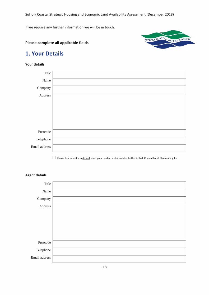
If we require any further information we will be in touch.
Please complete all applicable fields
1. Your Details
Your details
Title Name
Company Address
Postcode
Telephone Email address
+ Please tick here if you do not want your contact details added to the Suffolk Coastal Local Plan mailing list.
Agent details
Title Name
Company Address
Postcode
Telephone Email address
Suffolk Coastal Strategic Housing and Economic Land Availability Assessment (December 2018)
19
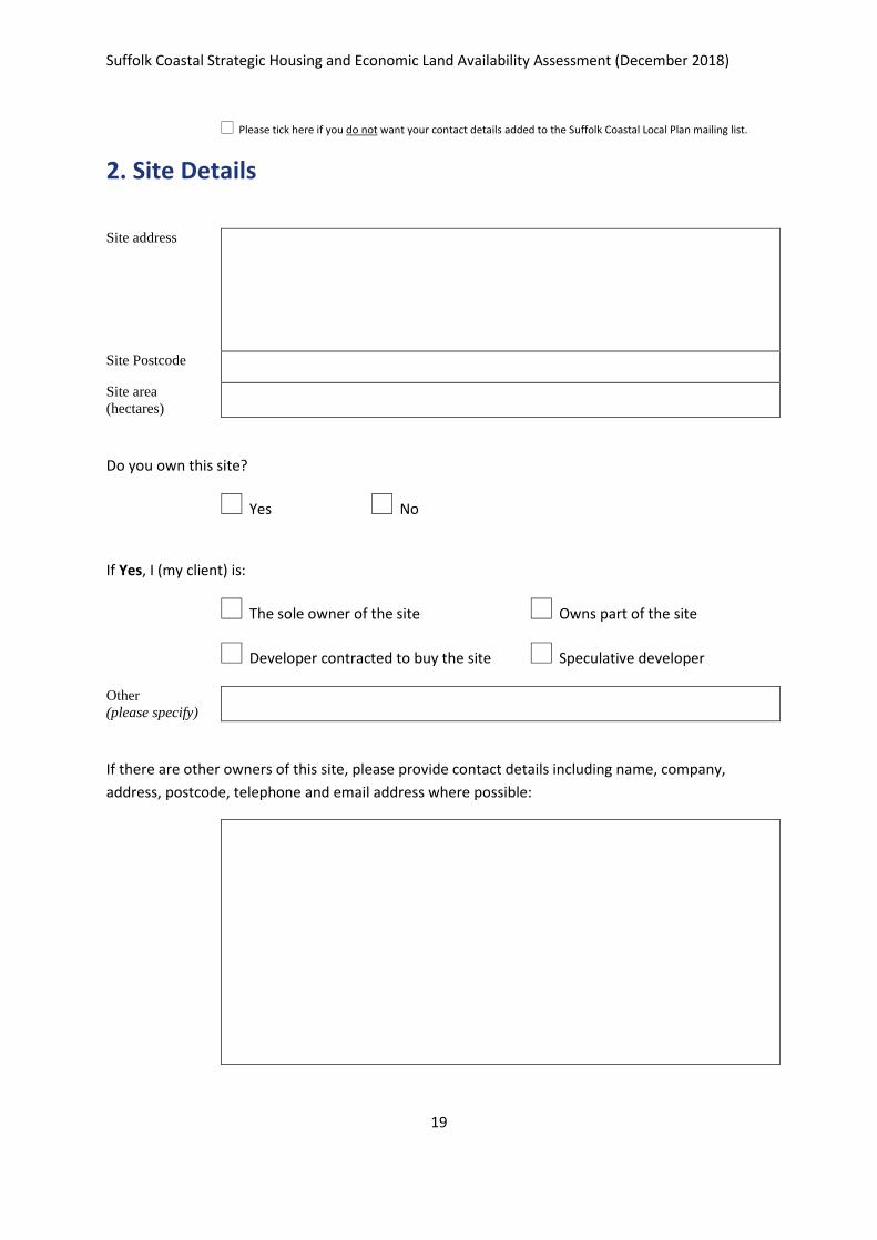
+ Please tick here if you do not want your contact details added to the Suffolk Coastal Local Plan mailing list.
2. Site Details
Site address
Site Postcode Site area
(hectares)
Do you own this site?
+ Yes + No
If Yes, I (my client) is:
+ The sole owner of the site + Owns part of the site
+ Developer contracted to buy the site + Speculative developer
Other
(please specify)
If there are other owners of this site, please provide contact details including name, company,
address, postcode, telephone and email address where possible:
Suffolk Coastal Strategic Housing and Economic Land Availability Assessment (December 2018)
20
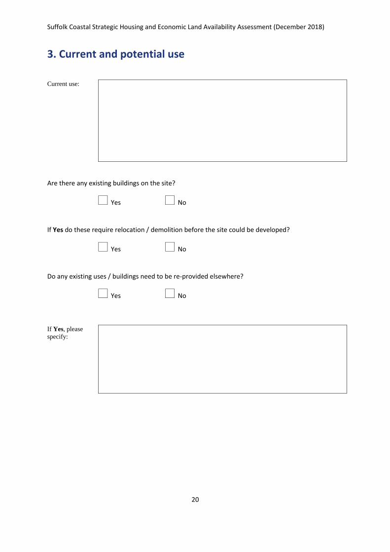
3. Current and potential use
Current use:
Are there any existing buildings on the site?
+ Yes + No
If Yes do these require relocation / demolition before the site could be developed?
+ Yes + No
Do any existing uses / buildings need to be re-provided elsewhere?
+ Yes + No
If Yes, please
specify:
Suffolk Coastal Strategic Housing and Economic Land Availability Assessment (December 2018)
21
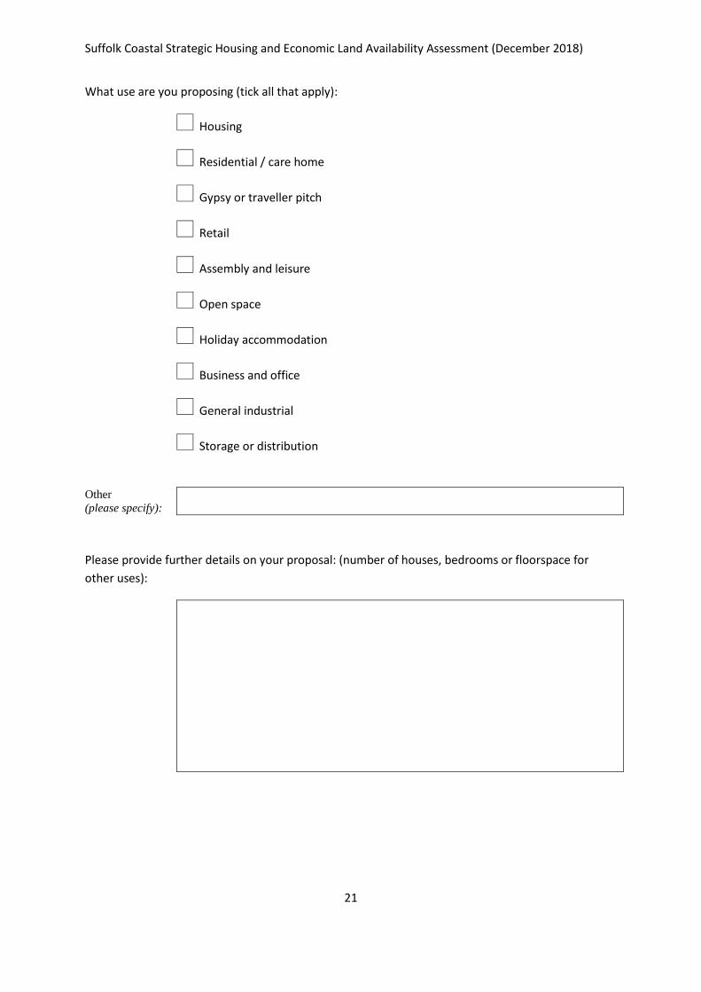
What use are you proposing (tick all that apply):
+ Housing
+ Residential / care home
+ Gypsy or traveller pitch
+ Retail
+ Assembly and leisure
+ Open space
+ Holiday accommodation
+ Business and office
+ General industrial
+ Storage or distribution
Other
(please specify):
Please provide further details on your proposal: (number of houses, bedrooms or floorspace for
other uses):
Suffolk Coastal Strategic Housing and Economic Land Availability Assessment (December 2018)
22
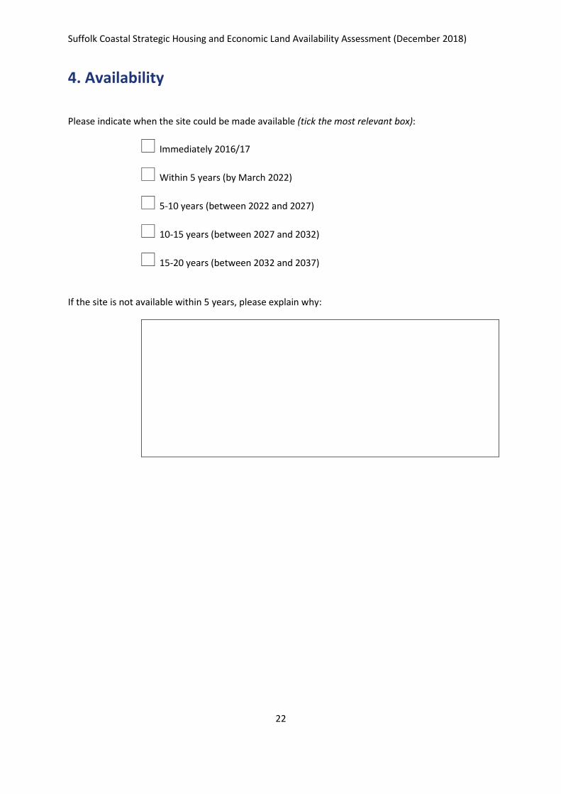
4. Availability
Please indicate when the site could be made available (tick the most relevant box):
+ Immediately 2016/17
+ Within 5 years (by March 2022)
+ 5-10 years (between 2022 and 2027)
+ 10-15 years (between 2027 and 2032)
+ 15-20 years (between 2032 and 2037)
If the site is not available within 5 years, please explain why:
Suffolk Coastal Strategic Housing and Economic Land Availability Assessment (December 2018)
23
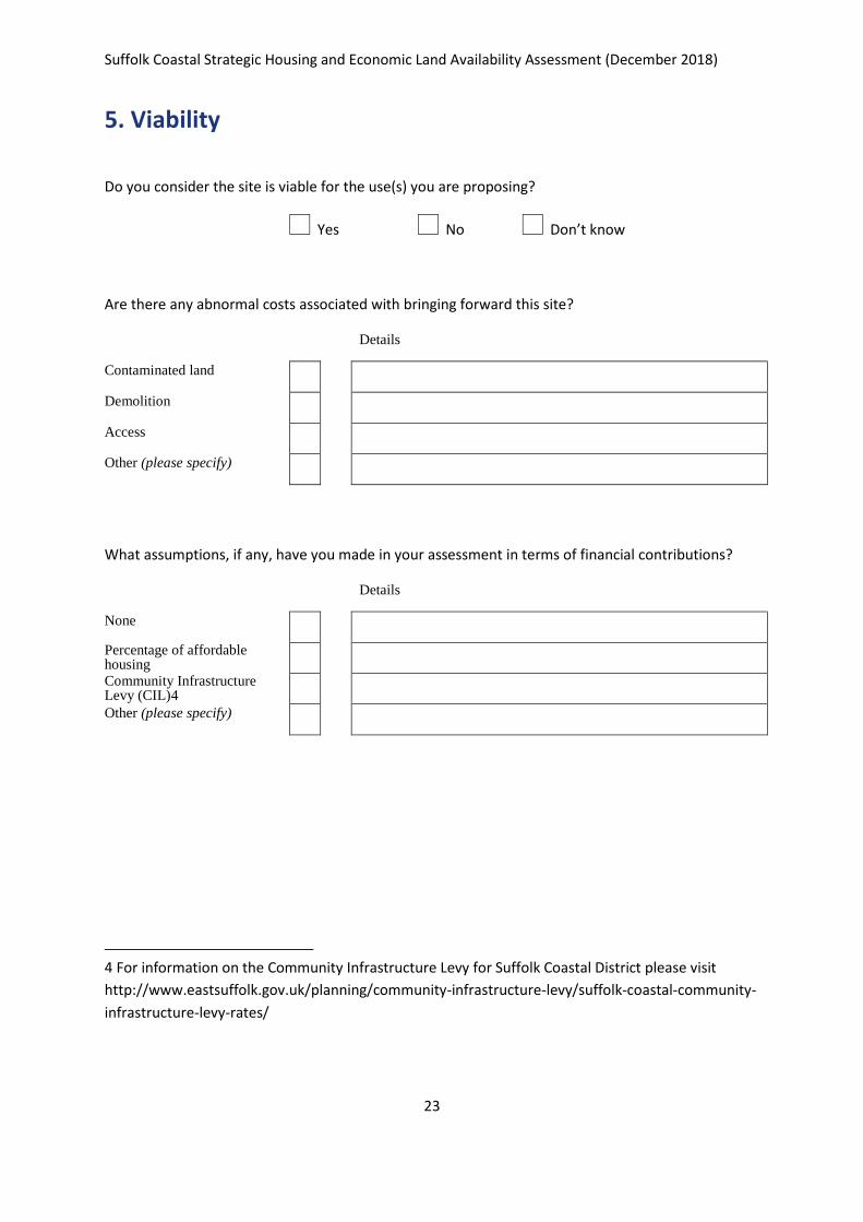
5. Viability
Do you consider the site is viable for the use(s) you are proposing?
+ Yes + No + Don’t know
Are there any abnormal costs associated with bringing forward this site?
Details
Contaminated land Demolition Access Other (please specify)
What assumptions, if any, have you made in your assessment in terms of financial contributions?
Details
None Percentage of affordable housing Community Infrastructure Levy (CIL)4 Other (please specify)
4 For information on the Community Infrastructure Levy for Suffolk Coastal District please visit
http://www.eastsuffolk.gov.uk/planning/community-infrastructure-levy/suffolk-coastal-community-
infrastructure-levy-rates/
Suffolk Coastal Strategic Housing and Economic Land Availability Assessment (December 2018)
24
6. Site visit
Are there any issues which would prevent officers of the Council undertaking a site visit?
(e.g. the site is secured and not visible from a public highway, an existing tenant)
+ Yes + No
If Yes please provide contact details of the person who should be contacted to arrange a site visit
7. Additional Comments
Thank your for completing this form. Please send to Suffolk Coastal District Council, Planning
Policy and Delivery Team, Melton Hill, Woodbridge, Suffolk, IP12 1AU.
Website: www.eastsuffolk.gov.uk/suffolkcoastallocalplanreview
Social media: www.twitter.com/eastsuffolk | www.facebook.com/eastsuffolkcouncils
Telephone: 01394 444550 /444363
Email: [email protected]
The information you have supplied may be processed by computer or form the basis of manual records. Suffolk Coastal District Council will use the data for purposes relevant to the preparation of the Suffolk Coastal Local Plan and for no other purpose. By responding you are accepting that your response and the information within it, including supporting documents, will be available for public inspection and published on line. However, personal addresses, telephone numbers and email addresses will be withheld.
Suffolk Coastal Strategic Housing and Economic Land Availability Assessment (December 2018)
25
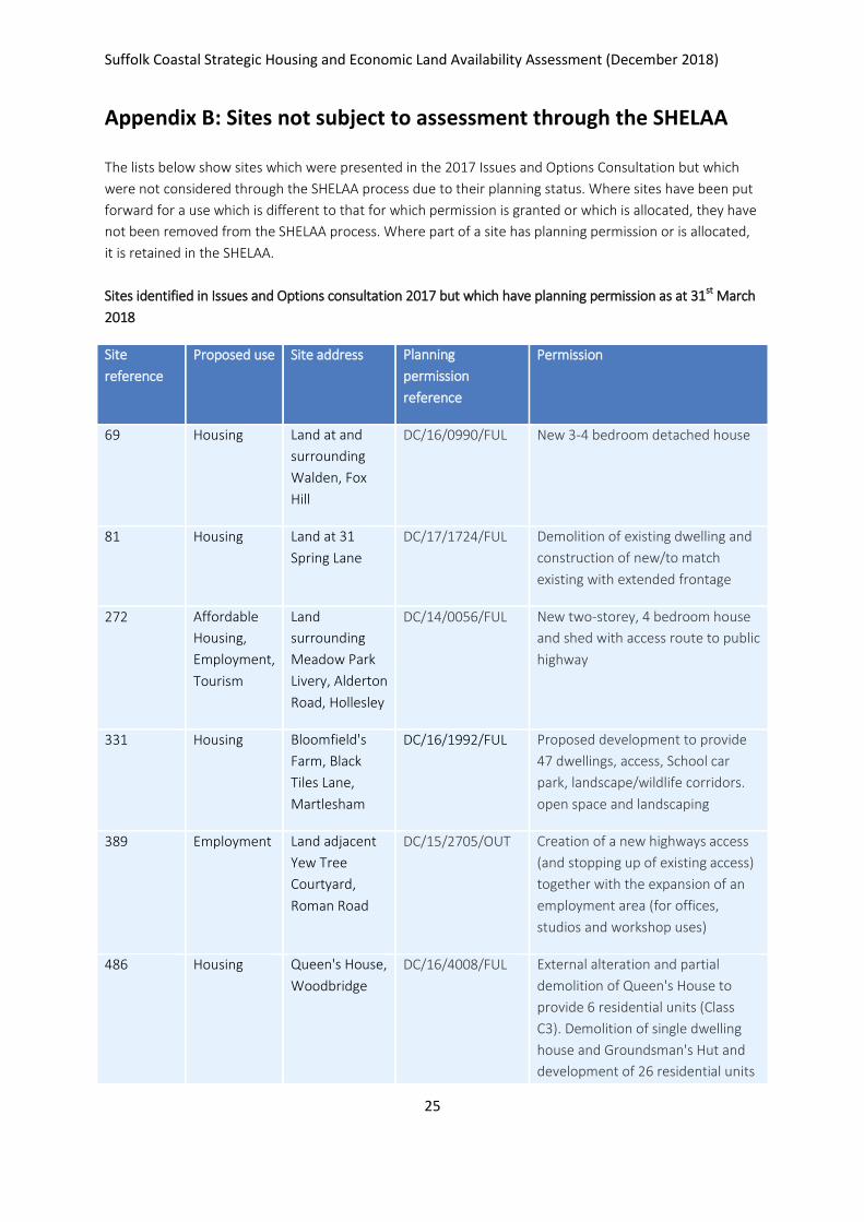
Appendix B: Sites not subject to assessment through the SHELAA
The lists below show sites which were presented in the 2017 Issues and Options Consultation but which
were not considered through the SHELAA process due to their planning status. Where sites have been put
forward for a use which is different to that for which permission is granted or which is allocated, they have
not been removed from the SHELAA process. Where part of a site has planning permission or is allocated,
it is retained in the SHELAA.
Sites identified in Issues and Options consultation 2017 but which have planning permission as at 31st March
2018
Site
reference
Proposed use Site address Planning
permission
reference
Permission
69 Housing Land at and
surrounding
Walden, Fox
Hill
DC/16/0990/FUL New 3-4 bedroom detached house
81 Housing Land at 31
Spring Lane
DC/17/1724/FUL Demolition of existing dwelling and
construction of new/to match
existing with extended frontage
272 Affordable
Housing,
Employment,
Tourism
Land
surrounding
Meadow Park
Livery, Alderton
Road, Hollesley
DC/14/0056/FUL New two-storey, 4 bedroom house
and shed with access route to public
highway
331 Housing Bloomfield's
Farm, Black
Tiles Lane,
Martlesham
DC/16/1992/FUL Proposed development to provide
47 dwellings, access, School car
park, landscape/wildlife corridors.
open space and landscaping
389 Employment Land adjacent
Yew Tree
Courtyard,
Roman Road
DC/15/2705/OUT Creation of a new highways access
(and stopping up of existing access)
together with the expansion of an
employment area (for offices,
studios and workshop uses)
486 Housing Queen's House,
Woodbridge
DC/16/4008/FUL External alteration and partial
demolition of Queen's House to
provide 6 residential units (Class
C3). Demolition of single dwelling
house and Groundsman's Hut and
development of 26 residential units
Suffolk Coastal Strategic Housing and Economic Land Availability Assessment (December 2018)
26
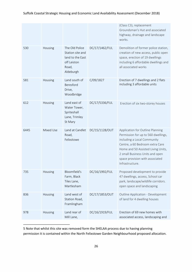
(Class C3), replacement
Groundsman's Hut and associated
highway, drainage and landscape
works.
530 Housing The Old Police
Station site and
land to the East
off Leiston
Road,
Aldeburgh
DC/17/1462/FUL Demolition of former police station,
creation of new access, public open
space, erection of 19 dwellings
including 6 affordable dwellings and
all associated works
581 Housing Land south of
Beresford
Drive,
Woodbridge
C/09/1827 Erection of 7 dwellings and 2 flats including 3 affordable units
612 Housing Land east of
Water Tower,
Spriteshall
Lane, Trimley
St Mary
DC/17/5336/FUL Erection of six two-storey houses
6445 Mixed Use Land at Candlet
Road,
Felixstowe
DC/15/1128/OUT Application for Outline Planning
Permission for up to 560 dwellings,
including a Local Community
Centre, a 60 Bedroom extra Care
Home and 50 Assisted Living Units,
2 small Business Units and open
space provision with associated
Infrastructure.
735 Housing Bloomfield's
Farm, Black
Tiles Lane,
Martlesham
DC/16/1992/FUL Proposed development to provide
47 dwellings, access, School car
park, landscape/wildlife corridors.
open space and landscaping
836 Housing Land west of
Station Road,
Framlingham
DC/17/1853/OUT Outline Application - Development
of land for 4 dwelling houses
978 Housing Land rear of
Mill Lane,
DC/16/1919/FUL Erection of 69 new homes with
associated access, landscaping and
5 Note that whilst this site was removed form the SHELAA process due to having planning
permission it is contained within the North Felixstowe Garden Neighbourhood proposed allocation.
Suffolk Coastal Strategic Housing and Economic Land Availability Assessment (December 2018)
27
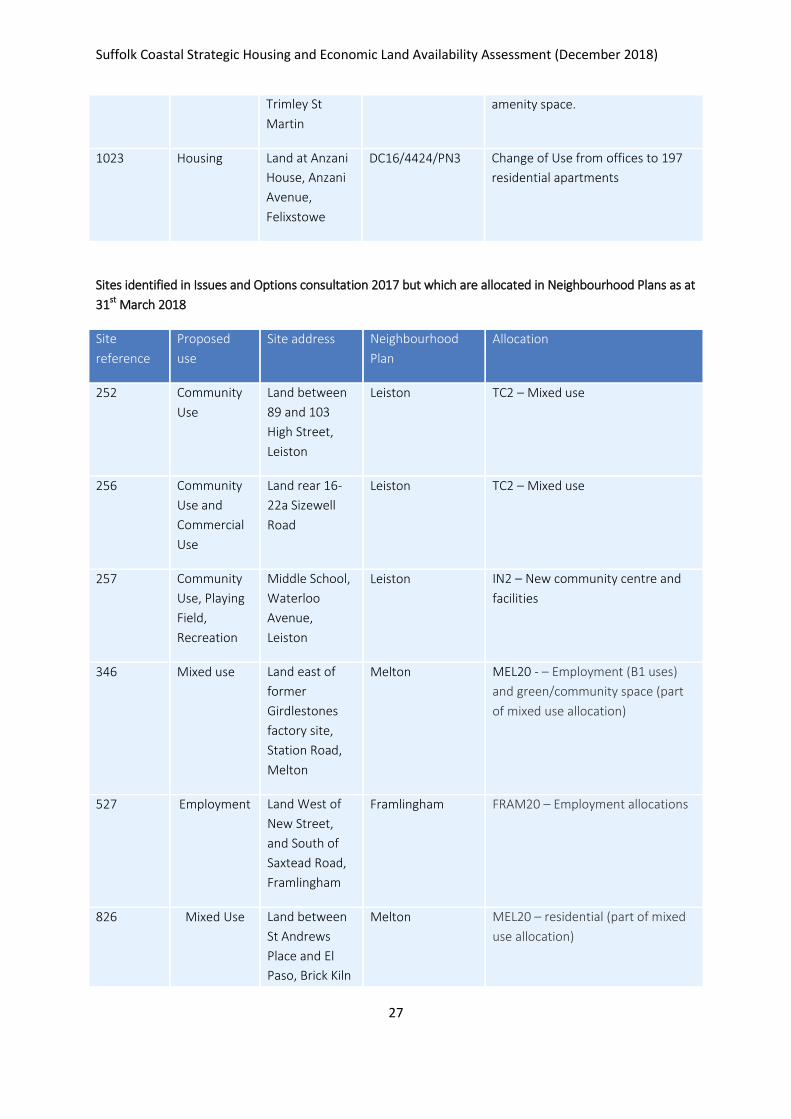
Trimley St
Martin
amenity space.
1023 Housing Land at Anzani
House, Anzani
Avenue,
Felixstowe
DC16/4424/PN3 Change of Use from offices to 197
residential apartments
Sites identified in Issues and Options consultation 2017 but which are allocated in Neighbourhood Plans as at
31st March 2018
Site
reference
Proposed
use
Site address Neighbourhood
Plan
Allocation
252 Community
Use
Land between
89 and 103
High Street,
Leiston
Leiston TC2 – Mixed use
256 Community
Use and
Commercial
Use
Land rear 16-
22a Sizewell
Road
Leiston TC2 – Mixed use
257 Community
Use, Playing
Field,
Recreation
Middle School,
Waterloo
Avenue,
Leiston
Leiston IN2 – New community centre and
facilities
346 Mixed use Land east of
former
Girdlestones
factory site,
Station Road,
Melton
Melton MEL20 - – Employment (B1 uses)
and green/community space (part
of mixed use allocation)
527 Employment Land West of
New Street,
and South of
Saxtead Road,
Framlingham
Framlingham FRAM20 – Employment allocations
826 Mixed Use Land between
St Andrews
Place and El
Paso, Brick Kiln
Melton MEL20 – residential (part of mixed
use allocation)
Suffolk Coastal Strategic Housing and Economic Land Availability Assessment (December 2018)
28
Lane
745 Housing Retail Leisure Office Storage
Woodbridge
Road,
Framlingham
Framlingham FRAM27
1056 Housing Land opposite
52-74 St
Margarets
Crescent,
Leiston
Leiston SA3 – Housing Allocation
Sites identified in Issues and Options consultation 2017 but which are allocated in the Site Allocations and
Area Specific Policies DPD (2017) or the Felixstowe Area Action Plan DPD (2017).
Site
reference
Proposed
use
Site address Plan Allocation
186
Employment Land adjacent
to the Sheperd
and Dog
Piggeries,
Felixstowe
Road, Nacton
Site Allocations
and Area Specific
Policies DPD 2017
Site forms part of SSP20 –
Ransomes employment allocation
436 Housing Land East of
Street Farm
Road,
Saxmundham
Site Allocations
and Area Specific
Policies DPD 2017
SSP14 – Housing allocations
712 Housing Land south of
Lower Road,
Westerfield
Site Allocations
and Area Specific
Policies DPD 2017
SSP17 – Housing allocation
1141 Employment Bentwaters
Park,
Rendlesham
Site Allocations
and Area Specific
Policies DPD 2017
SSP24 – Rendlesham (Bentwaters) –
employment area

Suffolk Coastal Strategic Housing and Economic Land Availability Assessment (December 2018)
29
It should also be noted that one site submitted through the First Draft Local Plan consultation but is
already an allocated site, as set out below.
Site
reference
Proposed
use
Site address Plan Allocation
1157 Employment Land west of
Ronald Land
Site Allocations
and Area Specific
Policies DPD 2017
SSP25 – Carlton Park, Main Road,
Kelsale-cum-Carlton
Suffolk Coastal Strategic Housing and Economic Land Availability Assessment (December 2018)
30
Appendix C: Sites made available for uses other than housing or employment use
Site Ref Address Site
Area Proposed Use Parish / Town
14 Land opposite the Post Office, High Street 0.10 Physical limits reduction Wickham Market
24 Land at recreation ground South of Post Mill Orchard and Post Mill Close 5.40 Recreation Grundisburgh
33 Land adjacent to Fromus House, Street Farm Road 0.18 Car parking Saxmundham
51 Opposite Primary School, Bridge Street, Bramfield 0.5 Area to be protected from development Bramfield
75 land to the rear of Leaside Lodge, B1077 0.70 Physical limits extension Witnesham
76 Land adj to Toad End, Little Street 0.16 Physical limits extension Yoxford
83 Land adjacent to 15 The Terrace 0.21 Area to be Protected from Development Aldeburgh
137 Land surrounding area of the Old Post Office, Old Post Office Lane 1.67 Area to be protected from development Blaxhall
147 Adair Lodge Gardens, off High Street 0.10 Area to be Protected from Development Aldeburgh
151 land South East of Hill Farm 0.79 Holiday units Iken
181 land to the north of the Park & Ride site 1.90 Holiday accommodation Martlesham
242 Land east Mill Farm, Rosemary Lane 0.67 Leisure Kelsale cum Carlton
249 Land east of Darsham Station 0.12 Car park Darsham
251 Land north of Ufford Road, Bredfield 2.92 Tourism Bredfield
323 Land west of Manor Farm 5.94 Camp site Hollesley
333 Land at and surrounding Woodbridge Town FC, A12 3.28 Recreation facility Martlesham
370 Land rear of St. Mary's Church, Church Road, Otley 8.61 Area to be Protected from Development Otley
699 Bentwaters Park, Rendlesham 92.80 Holiday lets Rendlesham
727 South of Snape Maltings 16.74 Tourism Tunstall
Suffolk Coastal Strategic Housing and Economic Land Availability Assessment (December 2018)
31
728 Land to the East of Snape Maltings 3.15 Tourism Tunstall
805 Land adj Old Glebe House, Main Road 18.05 Open space6 Westerfield
806 Land adj to Giffords, Tuddenham Lane 15.10 Open space7 Westerfield
912 Land opposite Brook House and Bridge House, Church Road 0.23 Access to development on adjacent site Chediston
1060 Land at Ipswich Town Football Club training ground, Playford Road, Rushmere St Andrew 8.72 Playing fields8 Rushmere St Andrew
1067 Yarn Hill, North of Hill Farm, Iken 0.90 Tourism Iken
1072 Land inc. superstore, parish rooms & Beardmore Retail Park, Martlesham 11.83 District Centre Martlesham
1094 Felixstowe Leisure Centre, Undercliff Road West 1.25 Leisure / tourism Felixstowe
1108 Land adj. Hill Cottages (B1069), Tunstall 2.41 Tourism Tunstall
1118 Land West of New Street, Framlingham 0.86 Playing field Framlingham
1142 Land adj. Gelham Hall, Gelham Hall Road, Wickham Market 1.74 Allotments Wickham Market
1148 Land at Mill Lane, Wickham Market 0.39 Car Park Wickham Market
6 Submitted alongside site 1083
7 Submitted alongside site 1083
8 Submitted alongside site 953
Suffolk Coastal Strategic Housing and Economic Land Availability Assessment (December 2018)
32
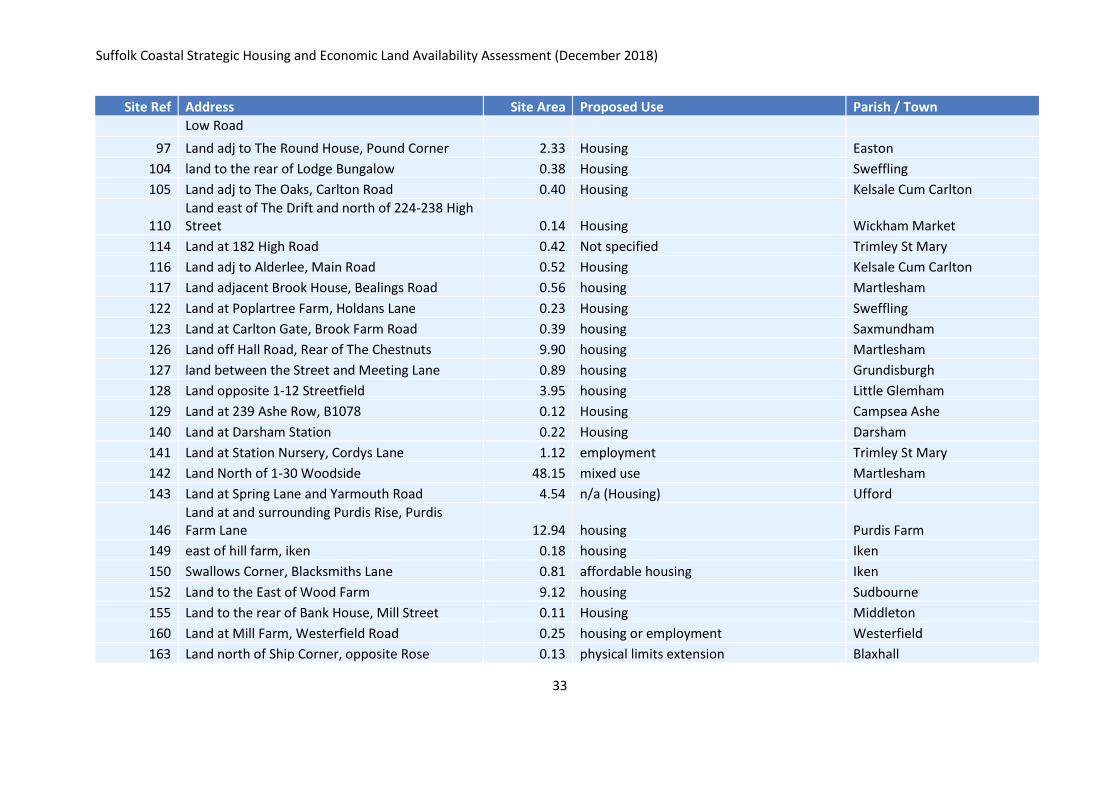
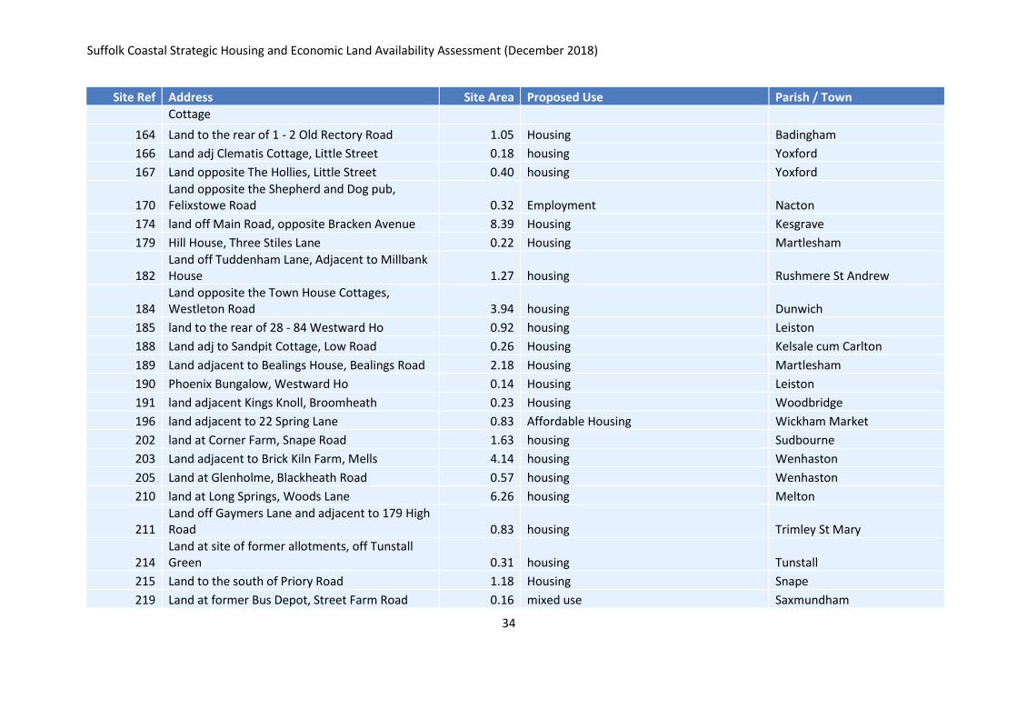
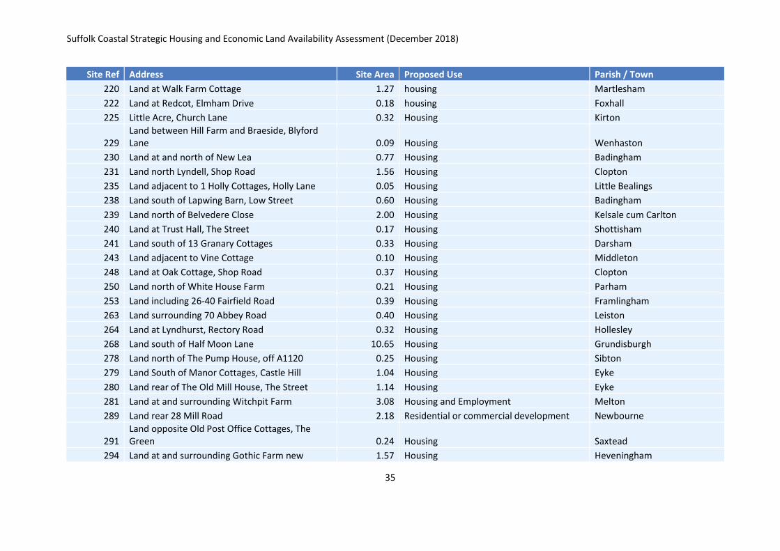
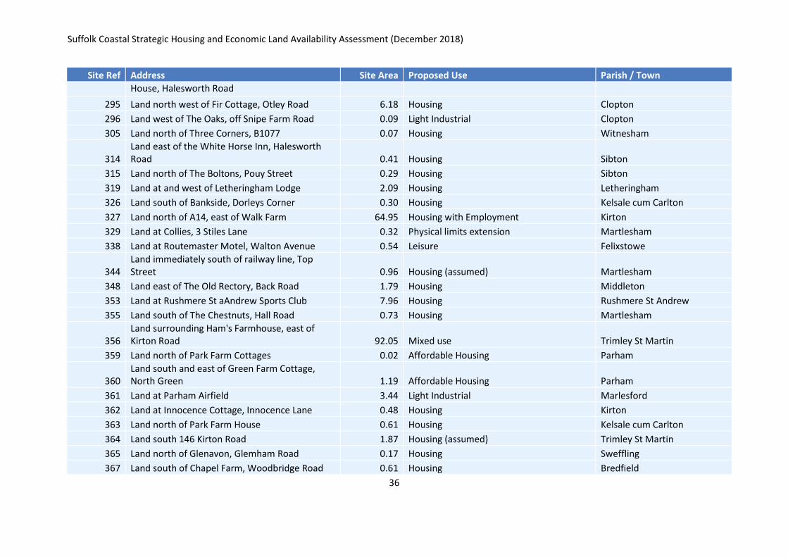
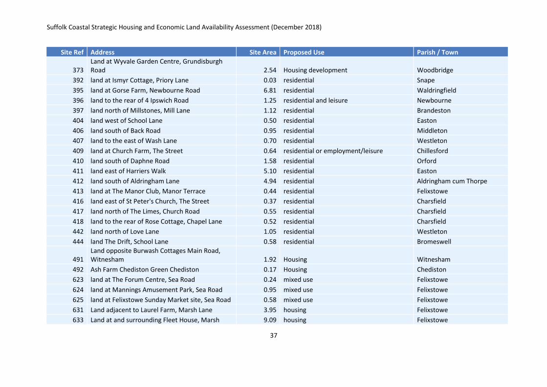
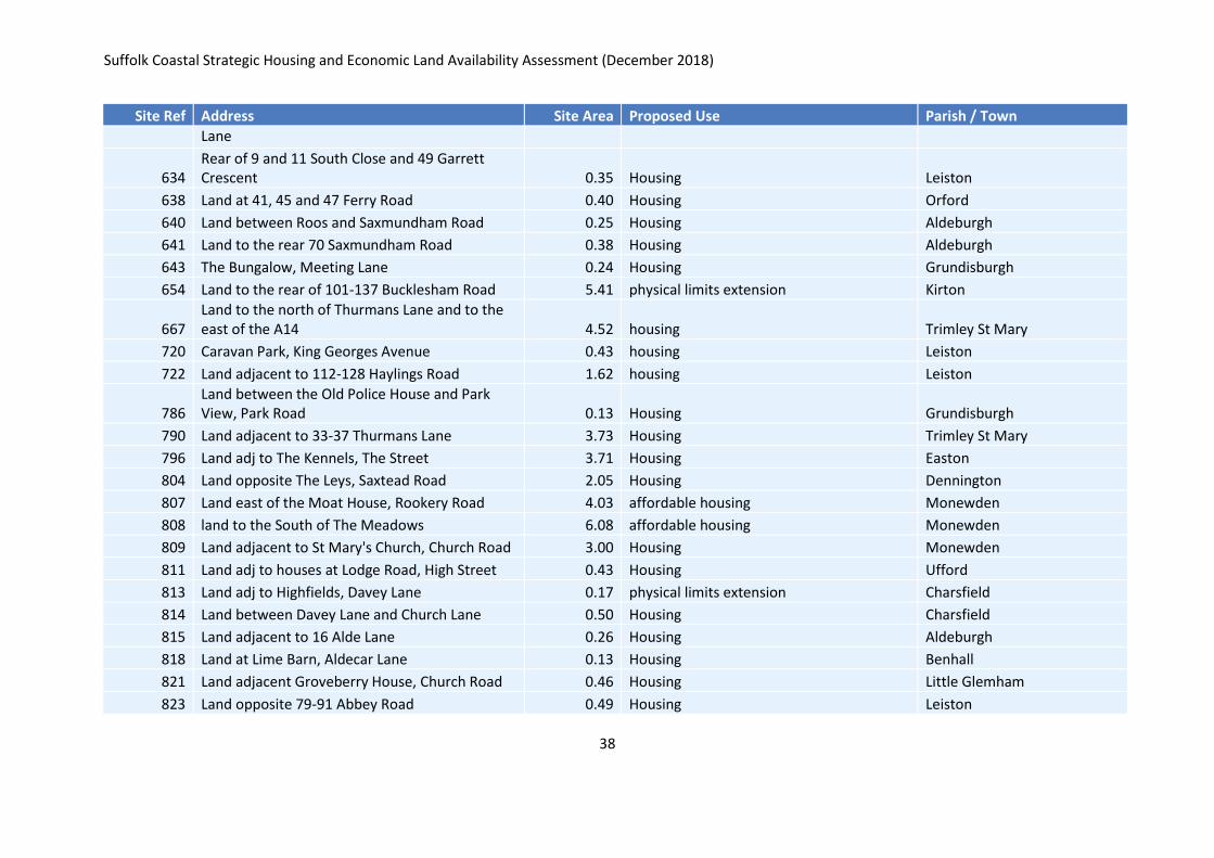
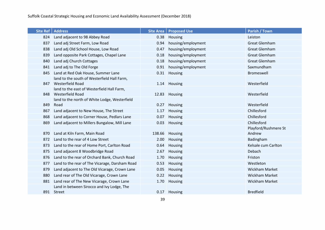
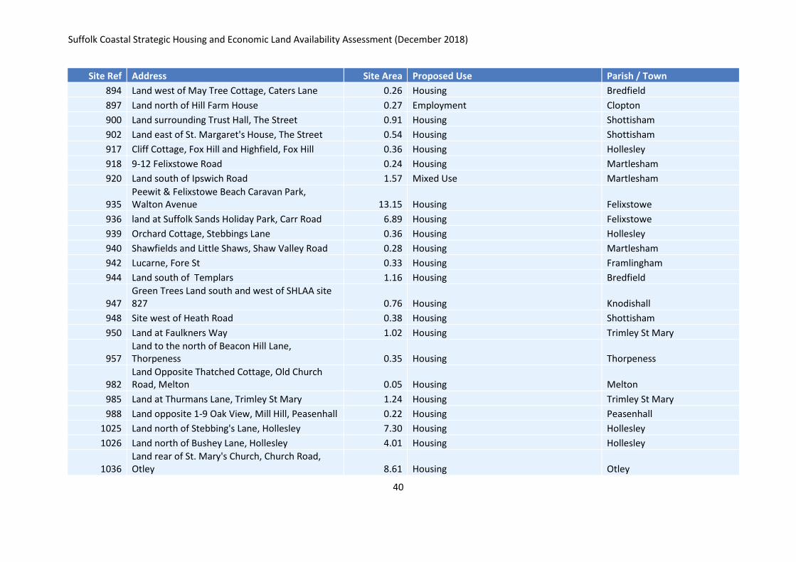
Appendix D: Sites identified as unavailable
Site Ref Address Site Area Proposed Use Parish / Town
2 Adjacent to Primary School, Hackney Road 2.38 Housing Peasenhall
4 land to the rear of Sunnyside, The Hill 0.48 Housing Westleton
5 land opposite The Red Lion, Main Road 1.29 Housing Martlesham
6 Land adj to Ivy Cottage, Boot Street 0.20 Housing Great Bealings
10 Land at Spring Farm, The Street 1.64 Housing Dennington
12 Waterloo Farm, Halesworth Road 2.11 housing Bramfield
19 Land adj 22 Grundisburgh Road 0.21 housing Great Bealings
22 The Pig Farm, Middleton Road 5.21 Housing Yoxford
32 Land adj to Riverside Villa, The Street 0.24 Housing Cretingham
42 The Coalyard, Wilford Bridge Road 0.31 Housing Melton
44 Adjacent to Bridge Cottage, Yarmouth Road 0.14 Housing Ufford
47 Land adjacent to Contrive Cottage, Mill Street 0.40 Housing Middleton
48 Land at Trailor Nursery, Bealings Road 0.20 Housing Martlesham
55 Land opposite Willoughby Villa, Main Road 0.40 Housing Parham
56 Land at and surrounding 22-24 Stoney Road 0.43 Housing Grundisburgh
57 Land at and surrounding 26 Stoney Road 0.19 Housing Grundisburgh
64 Bracken Hall, Main Road 1.15 Housing Kesgrave
66 land to the rear of Field End, Little Street 0.22 Housing Yoxford
67 Land adj The Old Dog, Lower Falkenham Road 0.18 Housing Falkenham
71 Land adjacent to The Glen, Bruisyard Road 0.40 Housing Peasenhall
80 Land adj Linden House, Lower Road 0.39 Housing Westerfield
84 Land adjacent to 35 Mill Lane 0.85 Housing Campsea Ashe
92 Land at The Chestnuts, Church Road 0.62 physical limits extension (not specified) Saxmundham
94 Land at The White Horse and Badingham House, 3.99 Physical limits extension (not specified) Badingham
Suffolk Coastal Strategic Housing and Economic Land Availability Assessment (December 2018)
33
Site Ref Address Site Area Proposed Use Parish / Town
Low Road
97 Land adj to The Round House, Pound Corner 2.33 Housing Easton
104 land to the rear of Lodge Bungalow 0.38 Housing Sweffling
105 Land adj to The Oaks, Carlton Road 0.40 Housing Kelsale Cum Carlton
110 Land east of The Drift and north of 224-238 High Street 0.14 Housing Wickham Market
114 Land at 182 High Road 0.42 Not specified Trimley St Mary
116 Land adj to Alderlee, Main Road 0.52 Housing Kelsale Cum Carlton
117 Land adjacent Brook House, Bealings Road 0.56 housing Martlesham
122 Land at Poplartree Farm, Holdans Lane 0.23 Housing Sweffling
123 Land at Carlton Gate, Brook Farm Road 0.39 housing Saxmundham
126 Land off Hall Road, Rear of The Chestnuts 9.90 housing Martlesham
127 land between the Street and Meeting Lane 0.89 housing Grundisburgh
128 Land opposite 1-12 Streetfield 3.95 housing Little Glemham
129 Land at 239 Ashe Row, B1078 0.12 Housing Campsea Ashe
140 Land at Darsham Station 0.22 Housing Darsham
141 Land at Station Nursery, Cordys Lane 1.12 employment Trimley St Mary
142 Land North of 1-30 Woodside 48.15 mixed use Martlesham
143 Land at Spring Lane and Yarmouth Road 4.54 n/a (Housing) Ufford
146 Land at and surrounding Purdis Rise, Purdis Farm Lane 12.94 housing Purdis Farm
149 east of hill farm, iken 0.18 housing Iken
150 Swallows Corner, Blacksmiths Lane 0.81 affordable housing Iken
152 Land to the East of Wood Farm 9.12 housing Sudbourne
155 Land to the rear of Bank House, Mill Street 0.11 Housing Middleton
160 Land at Mill Farm, Westerfield Road 0.25 housing or employment Westerfield
163 Land north of Ship Corner, opposite Rose 0.13 physical limits extension Blaxhall
Suffolk Coastal Strategic Housing and Economic Land Availability Assessment (December 2018)
34
Site Ref Address Site Area Proposed Use Parish / Town
Cottage
164 Land to the rear of 1 - 2 Old Rectory Road 1.05 Housing Badingham
166 Land adj Clematis Cottage, Little Street 0.18 housing Yoxford
167 Land opposite The Hollies, Little Street 0.40 housing Yoxford
170 Land opposite the Shepherd and Dog pub, Felixstowe Road 0.32 Employment Nacton
174 land off Main Road, opposite Bracken Avenue 8.39 Housing Kesgrave
179 Hill House, Three Stiles Lane 0.22 Housing Martlesham
182 Land off Tuddenham Lane, Adjacent to Millbank House 1.27 housing Rushmere St Andrew
184 Land opposite the Town House Cottages, Westleton Road 3.94 housing Dunwich
185 land to the rear of 28 - 84 Westward Ho 0.92 housing Leiston
188 Land adj to Sandpit Cottage, Low Road 0.26 Housing Kelsale cum Carlton
189 Land adjacent to Bealings House, Bealings Road 2.18 Housing Martlesham
190 Phoenix Bungalow, Westward Ho 0.14 Housing Leiston
191 land adjacent Kings Knoll, Broomheath 0.23 Housing Woodbridge
196 land adjacent to 22 Spring Lane 0.83 Affordable Housing Wickham Market
202 land at Corner Farm, Snape Road 1.63 housing Sudbourne
203 Land adjacent to Brick Kiln Farm, Mells 4.14 housing Wenhaston
205 Land at Glenholme, Blackheath Road 0.57 housing Wenhaston
210 land at Long Springs, Woods Lane 6.26 housing Melton
211 Land off Gaymers Lane and adjacent to 179 High Road 0.83 housing Trimley St Mary
214 Land at site of former allotments, off Tunstall Green 0.31 housing Tunstall
215 Land to the south of Priory Road 1.18 Housing Snape
219 Land at former Bus Depot, Street Farm Road 0.16 mixed use Saxmundham
Suffolk Coastal Strategic Housing and Economic Land Availability Assessment (December 2018)
35
Site Ref Address Site Area Proposed Use Parish / Town
220 Land at Walk Farm Cottage 1.27 housing Martlesham
222 Land at Redcot, Elmham Drive 0.18 housing Foxhall
225 Little Acre, Church Lane 0.32 Housing Kirton
229 Land between Hill Farm and Braeside, Blyford Lane 0.09 Housing Wenhaston
230 Land at and north of New Lea 0.77 Housing Badingham
231 Land north Lyndell, Shop Road 1.56 Housing Clopton
235 Land adjacent to 1 Holly Cottages, Holly Lane 0.05 Housing Little Bealings
238 Land south of Lapwing Barn, Low Street 0.60 Housing Badingham
239 Land north of Belvedere Close 2.00 Housing Kelsale cum Carlton
240 Land at Trust Hall, The Street 0.17 Housing Shottisham
241 Land south of 13 Granary Cottages 0.33 Housing Darsham
243 Land adjacent to Vine Cottage 0.10 Housing Middleton
248 Land at Oak Cottage, Shop Road 0.37 Housing Clopton
250 Land north of White House Farm 0.21 Housing Parham
253 Land including 26-40 Fairfield Road 0.39 Housing Framlingham
263 Land surrounding 70 Abbey Road 0.40 Housing Leiston
264 Land at Lyndhurst, Rectory Road 0.32 Housing Hollesley
268 Land south of Half Moon Lane 10.65 Housing Grundisburgh
278 Land north of The Pump House, off A1120 0.25 Housing Sibton
279 Land South of Manor Cottages, Castle Hill 1.04 Housing Eyke
280 Land rear of The Old Mill House, The Street 1.14 Housing Eyke
281 Land at and surrounding Witchpit Farm 3.08 Housing and Employment Melton
289 Land rear 28 Mill Road 2.18 Residential or commercial development Newbourne
291 Land opposite Old Post Office Cottages, The Green 0.24 Housing Saxtead
294 Land at and surrounding Gothic Farm new 1.57 Housing Heveningham
Suffolk Coastal Strategic Housing and Economic Land Availability Assessment (December 2018)
36
Site Ref Address Site Area Proposed Use Parish / Town
House, Halesworth Road
295 Land north west of Fir Cottage, Otley Road 6.18 Housing Clopton
296 Land west of The Oaks, off Snipe Farm Road 0.09 Light Industrial Clopton
305 Land north of Three Corners, B1077 0.07 Housing Witnesham
314 Land east of the White Horse Inn, Halesworth Road 0.41 Housing Sibton
315 Land north of The Boltons, Pouy Street 0.29 Housing Sibton
319 Land at and west of Letheringham Lodge 2.09 Housing Letheringham
326 Land south of Bankside, Dorleys Corner 0.30 Housing Kelsale cum Carlton
327 Land north of A14, east of Walk Farm 64.95 Housing with Employment Kirton
329 Land at Collies, 3 Stiles Lane 0.32 Physical limits extension Martlesham
338 Land at Routemaster Motel, Walton Avenue 0.54 Leisure Felixstowe
344 Land immediately south of railway line, Top Street 0.96 Housing (assumed) Martlesham
348 Land east of The Old Rectory, Back Road 1.79 Housing Middleton
353 Land at Rushmere St aAndrew Sports Club 7.96 Housing Rushmere St Andrew
355 Land south of The Chestnuts, Hall Road 0.73 Housing Martlesham
356 Land surrounding Ham's Farmhouse, east of Kirton Road 92.05 Mixed use Trimley St Martin
359 Land north of Park Farm Cottages 0.02 Affordable Housing Parham
360 Land south and east of Green Farm Cottage, North Green 1.19 Affordable Housing Parham
361 Land at Parham Airfield 3.44 Light Industrial Marlesford
362 Land at Innocence Cottage, Innocence Lane 0.48 Housing Kirton
363 Land north of Park Farm House 0.61 Housing Kelsale cum Carlton
364 Land south 146 Kirton Road 1.87 Housing (assumed) Trimley St Martin
365 Land north of Glenavon, Glemham Road 0.17 Housing Sweffling
367 Land south of Chapel Farm, Woodbridge Road 0.61 Housing Bredfield
Suffolk Coastal Strategic Housing and Economic Land Availability Assessment (December 2018)
37
Site Ref Address Site Area Proposed Use Parish / Town
373 Land at Wyvale Garden Centre, Grundisburgh Road 2.54 Housing development Woodbridge
392 land at Ismyr Cottage, Priory Lane 0.03 residential Snape
395 land at Gorse Farm, Newbourne Road 6.81 residential Waldringfield
396 land to the rear of 4 Ipswich Road 1.25 residential and leisure Newbourne
397 land north of Millstones, Mill Lane 1.12 residential Brandeston
404 land west of School Lane 0.50 residential Easton
406 land south of Back Road 0.95 residential Middleton
407 land to the east of Wash Lane 0.70 residential Westleton
409 land at Church Farm, The Street 0.64 residential or employment/leisure Chillesford
410 land south of Daphne Road 1.58 residential Orford
411 land east of Harriers Walk 5.10 residential Easton
412 land south of Aldringham Lane 4.94 residential Aldringham cum Thorpe
413 land at The Manor Club, Manor Terrace 0.44 residential Felixstowe
416 land east of St Peter's Church, The Street 0.37 residential Charsfield
417 land north of The Limes, Church Road 0.55 residential Charsfield
418 land to the rear of Rose Cottage, Chapel Lane 0.52 residential Charsfield
442 land north of Love Lane 1.05 residential Westleton
444 land The Drift, School Lane 0.58 residential Bromeswell
491 Land opposite Burwash Cottages Main Road, Witnesham 1.92 Housing Witnesham
492 Ash Farm Chediston Green Chediston 0.17 Housing Chediston
623 land at The Forum Centre, Sea Road 0.24 mixed use Felixstowe
624 land at Mannings Amusement Park, Sea Road 0.95 mixed use Felixstowe
625 land at Felixstowe Sunday Market site, Sea Road 0.58 mixed use Felixstowe
631 Land adjacent to Laurel Farm, Marsh Lane 3.95 housing Felixstowe
633 Land at and surrounding Fleet House, Marsh 9.09 housing Felixstowe
Suffolk Coastal Strategic Housing and Economic Land Availability Assessment (December 2018)
38
Site Ref Address Site Area Proposed Use Parish / Town
Lane
634 Rear of 9 and 11 South Close and 49 Garrett Crescent 0.35 Housing Leiston
638 Land at 41, 45 and 47 Ferry Road 0.40 Housing Orford
640 Land between Roos and Saxmundham Road 0.25 Housing Aldeburgh
641 Land to the rear 70 Saxmundham Road 0.38 Housing Aldeburgh
643 The Bungalow, Meeting Lane 0.24 Housing Grundisburgh
654 Land to the rear of 101-137 Bucklesham Road 5.41 physical limits extension Kirton
667 Land to the north of Thurmans Lane and to the east of the A14 4.52 housing Trimley St Mary
720 Caravan Park, King Georges Avenue 0.43 housing Leiston
722 Land adjacent to 112-128 Haylings Road 1.62 housing Leiston
786 Land between the Old Police House and Park View, Park Road 0.13 Housing Grundisburgh
790 Land adjacent to 33-37 Thurmans Lane 3.73 Housing Trimley St Mary
796 Land adj to The Kennels, The Street 3.71 Housing Easton
804 Land opposite The Leys, Saxtead Road 2.05 Housing Dennington
807 Land east of the Moat House, Rookery Road 4.03 affordable housing Monewden
808 land to the South of The Meadows 6.08 affordable housing Monewden
809 Land adjacent to St Mary's Church, Church Road 3.00 Housing Monewden
811 Land adj to houses at Lodge Road, High Street 0.43 Housing Ufford
813 Land adj to Highfields, Davey Lane 0.17 physical limits extension Charsfield
814 Land between Davey Lane and Church Lane 0.50 Housing Charsfield
815 Land adjacent to 16 Alde Lane 0.26 Housing Aldeburgh
818 Land at Lime Barn, Aldecar Lane 0.13 Housing Benhall
821 Land adjacent Groveberry House, Church Road 0.46 Housing Little Glemham
823 Land opposite 79-91 Abbey Road 0.49 Housing Leiston
Suffolk Coastal Strategic Housing and Economic Land Availability Assessment (December 2018)
39
Site Ref Address Site Area Proposed Use Parish / Town
824 Land adjacent to 98 Abbey Road 0.38 Housing Leiston
837 Land adj Street Farm, Low Road 0.94 housing/employment Great Glemham
838 Land adj Old School House, Low Road 0.47 housing/employment Great Glemham
839 Land opposite Park Cottages, Chapel Lane 0.18 housing/employment Great Glemham
840 Land adj Church Cottages 0.18 housing/employment Great Glemham
841 Land adj to The Old Forge 0.91 housing/employment Saxmundham
845 Land at Red Oak House, Summer Lane 0.31 Housing Bromeswell
847 land to the south of Westerfield Hall Farm, Westerfield Road 1.14 Housing Westerfield
848 land to the east of Westerfield Hall Farm, Westerfield Road 12.83 Housing Westerfield
849 land to the north of White Lodge, Westerfield Road 0.27 Housing Westerfield
867 Land adjacent to New House, The Street 1.17 Housing Chillesford
868 Land adjacent to Corner House, Pedlars Lane 0.07 Housing Chillesford
869 Land adjacent to Millers Bungalow, Mill Lane 0.03 Housing Chillesford
870 Land at Kiln Farm, Main Road 138.66 Housing Playford/Rushmere St Andrew
872 Land to the rear of 4 Low Street 2.00 Housing Badingham
873 Land to the rear of Home Port, Carlton Road 0.64 Housing Kelsale cum Carlton
875 Land adjacent 8 Woodbridge Road 2.67 Housing Debach
876 Land to the rear of Orchard Bank, Church Road 1.70 Housing Friston
877 Land to the rear of The Vicarage, Darsham Road 0.53 Housing Westleton
879 Land adjacent to The Old Vicarage, Crown Lane 0.05 Housing Wickham Market
880 Land rear of The Old Vicarage, Crown Lane 0.22 Housing Wickham Market
881 Land rear of The New Vicarage, Crown Lane 1.70 Housing Wickham Market
891 Land in between Sirocco and Ivy Lodge, The Street 0.17 Housing Bredfield
Suffolk Coastal Strategic Housing and Economic Land Availability Assessment (December 2018)
40
Site Ref Address Site Area Proposed Use Parish / Town
894 Land west of May Tree Cottage, Caters Lane 0.26 Housing Bredfield
897 Land north of Hill Farm House 0.27 Employment Clopton
900 Land surrounding Trust Hall, The Street 0.91 Housing Shottisham
902 Land east of St. Margaret's House, The Street 0.54 Housing Shottisham
917 Cliff Cottage, Fox Hill and Highfield, Fox Hill 0.36 Housing Hollesley
918 9-12 Felixstowe Road 0.24 Housing Martlesham
920 Land south of Ipswich Road 1.57 Mixed Use Martlesham
935 Peewit & Felixstowe Beach Caravan Park, Walton Avenue 13.15 Housing Felixstowe
936 land at Suffolk Sands Holiday Park, Carr Road 6.89 Housing Felixstowe
939 Orchard Cottage, Stebbings Lane 0.36 Housing Hollesley
940 Shawfields and Little Shaws, Shaw Valley Road 0.28 Housing Martlesham
942 Lucarne, Fore St 0.33 Housing Framlingham
944 Land south of Templars 1.16 Housing Bredfield
947 Green Trees Land south and west of SHLAA site 827 0.76 Housing Knodishall
948 Site west of Heath Road 0.38 Housing Shottisham
950 Land at Faulkners Way 1.02 Housing Trimley St Mary
957 Land to the north of Beacon Hill Lane, Thorpeness 0.35 Housing Thorpeness
982 Land Opposite Thatched Cottage, Old Church Road, Melton 0.05 Housing Melton
985 Land at Thurmans Lane, Trimley St Mary 1.24 Housing Trimley St Mary
988 Land opposite 1-9 Oak View, Mill Hill, Peasenhall 0.22 Housing Peasenhall
1025 Land north of Stebbing's Lane, Hollesley 7.30 Housing Hollesley
1026 Land north of Bushey Lane, Hollesley 4.01 Housing Hollesley
1036 Land rear of St. Mary's Church, Church Road, Otley 8.61 Housing Otley
Suffolk Coastal Strategic Housing and Economic Land Availability Assessment (December 2018)
41
Site Ref Address Site Area Proposed Use Parish / Town
1037 Land adj. 14-32 Park Lane, Kirton 6.28 Housing Kirton
1049 Land at and surrounding Greenway, Hall Lane, Witnesham 0.46 Housing Witnesham
1050 Land at and behind 115 College Road, Framlingham 2.77 Housing Framlingham
1052 Land at The Street/Park Road 8.47 Housing Letheringham
1057 Land North of the Old Rectory, Badingham 0.59 Housing Badingham
1058 Land adj. 70 Abbey Road, Leiston 0.45 Housing Leiston
1059 Land adj. The Woodlands, Valley Farm Lane, Melton 3.21 Housing Melton
1064 Land at and around Sandpit Cottages, Low Road 3.65 Housing Great Glemham
1065 Fairway Launderers and Cleaners, Saxmundham Road, Aldeburgh 0.12 Employment Aldeburgh
1066 Land adjacent to Leiston Road and The Drift 1.33 Housing Aldeburgh
1069 Land adj. Hill Farm, Common Lane, Bromeswell 1.20 Housing Bromeswell
1070 Land to the rear of 43 & 45 Aldeburgh Road, Leiston 0.22 Housing Leiston
1071 Land adj. 15 Hollesley Road, Alderton 0.09 Housing Alderton
1073 land to the rear of Fernhill Lodge, Woods Lane, Melton 0.98 Housing Melton
1076 land to the rear of Willow Brook House, Bealings Road 4.54 Housing Martlesham
1079 Land adjacent to Coldfair Green Primary School, Judith Avenue, Knodishall 0.55 Housing Knodihall
1080 land north of Tollgate Cottage, North Entrance, Saxmundham 1.00 Housing Saxmundham
1081 Garrison Lane car park, adj. 17 Garrison Lane 0.46 Housing Felixstowe
1090 Longfield Nursery, Rectory Road, Stone Common, Blaxhall 0.47 Housing Blaxhall
Suffolk Coastal Strategic Housing and Economic Land Availability Assessment (December 2018)
42
Site Ref Address Site Area Proposed Use Parish / Town
1093 Cliff House and surrounding land 1.23 Not specified Felixstowe
1096 Land by the A14, west of Bluebird Lodge, Nacton 0.60 Housing Nacton
Suffolk Coastal Strategic Housing and Economic Land Availability Assessment (December 2018)
43
Appendix E: Housing and employment sites below size threshold
Site Ref
Site Address Site Area Proposed Use Parish / Town
9 Land adj to The Round Cottage, Framlingham Road
0.17 physical limits extension (Not specified)
Easton
40 Land opposite Daphne House, Daphne Road
0.07 Housing Orford
58 Land adjacent to Brackenway, Blackheath Road, Wenhaston
0.09 Housing Wenhaston
136 Land adjacent to 6 Deben Way 0.05 employment Melton
159 Land adj to The Limes The Street 0.14 Housing Farnham
161 Land at Green Farm, The Green 0.08 housing Ubbeston
168 Land at Lower House Farm, Lower Road 0.08 Housing Westerfield
247 Land rear of The Limes, Main Road 0.11 Housing Benhall
274* Land adjacent to The Cottage, Woodbridge Road
0.46 Housing Burgh
300 Land opposite Peartree Farm, Grundisburgh Road
0.13 Housing Clopton
301 Land opposite Peartree Farm, Grundisburgh Road
0.16 Housing Clopton
303 Land south 2 Rose Cottages, Market Hill 0.07 Housing Clopton
310 Land at Ibstock Farm, Walpole Road 0.18 residential or leisure Bramfield
312 Land at The Club, Pouy Street 0.09 Housing Peasenhall
316* Land at The Brambles, Chediston Green 0.29 housing Chediston
317 Land south of The Thatched Farmhouse, School Lane
0.09 Housing Cookley
320 Land north west of Eastbridge Farm 0.16 Housing Theberton
321 Land south of Lyndon Cottages, Bakers Hill
0.11 Housing Theberton
Suffolk Coastal Strategic Housing and Economic Land Availability Assessment (December 2018)
44
Site Ref
Site Address Site Area Proposed Use Parish / Town
332 Land at and south of 4 Playford Road 0.18 Housing Rushmere St Andrew
366 Land south of Little Dernford, Glemham Road
0.11 Housing Sweffling
480 The Old Woodyard, Birds Hill 0.10 Housing Clopton
492 Ash Farm Chediston Green Chediston 0.17 Housing Chediston
541 Land Connected to The Farm Stead, Chediston
0.03 Housing Chediston
673 Land adj. Birds View Cottage, Birds Hill/Snipe Farm Rd
0.18 Housing Clopton
680 Forest Garage Hollesley Road 0.16 Housing Rendlesham
725 Land to the north of the Tesco Store, Ropes Drive, Kesgrave, IP5 2FU
0.18 Housing Kesgrave
726 Land to the south of the Tesco Store, Ropes Drive, Kesgrave, IP5 2FU
0.17 Housing Kesgrave
730 Next to Car Park, Easton Street 0.16 Housing Easton
817 Land adj to Alder Close, Aldecar lane 0.19 Housing Benhall
828 Land opposite 28 Westward Ho 0.03 Housing Leiston
829 Land adjacent 1-23 Westward Ho 0.10 Housing Leiston
830 Land at Saxmundham Station, Station Approach
0.16 Housing Saxmundham
857 land to the rear of 31-37 Bucklesham Road
0.18 Housing Kirton
961* Land at Mill Street, Middleton 0.46 Housing Middleton
989 Land West Of Manor Terrace, Landguard Caravan Park, Manor Terrace, Felixstowe
0.19 Housing Felixstowe
992 Land rear 194 High Road, off Thurmans Lane, Trimley St Mary
0.17 Housing Trimley St Mary
1033 Land opposite 25-33 New Road, 0.12 Housing Framlingham
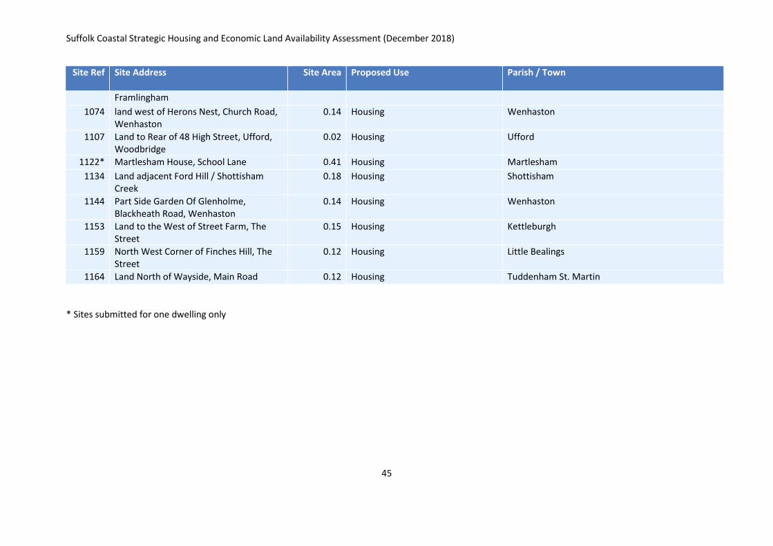
Suffolk Coastal Strategic Housing and Economic Land Availability Assessment (December 2018)
45
Site Ref
Site Address Site Area Proposed Use Parish / Town
Framlingham
1074 land west of Herons Nest, Church Road, Wenhaston
0.14 Housing Wenhaston
1107 Land to Rear of 48 High Street, Ufford, Woodbridge
0.02 Housing Ufford
1122* Martlesham House, School Lane 0.41 Housing Martlesham
1134 Land adjacent Ford Hill / Shottisham Creek
0.18 Housing Shottisham
1144 Part Side Garden Of Glenholme, Blackheath Road, Wenhaston
0.14 Housing Wenhaston
1153 Land to the West of Street Farm, The Street
0.15 Housing Kettleburgh
1159 North West Corner of Finches Hill, The Street
0.12 Housing Little Bealings
1164 Land North of Wayside, Main Road 0.12 Housing Tuddenham St. Martin
* Sites submitted for one dwelling only
Suffolk Coastal Strategic Housing and Economic Land Availability Assessment (December 2018)
46
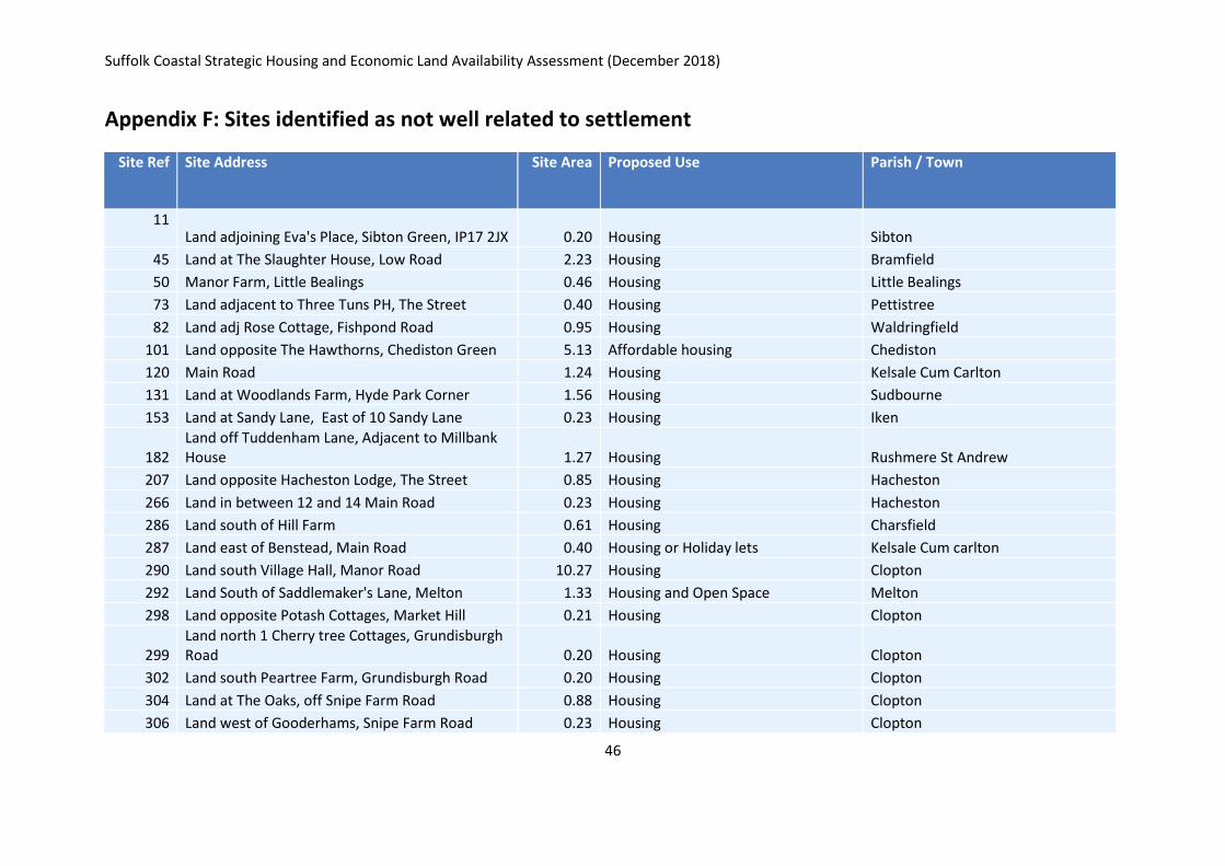
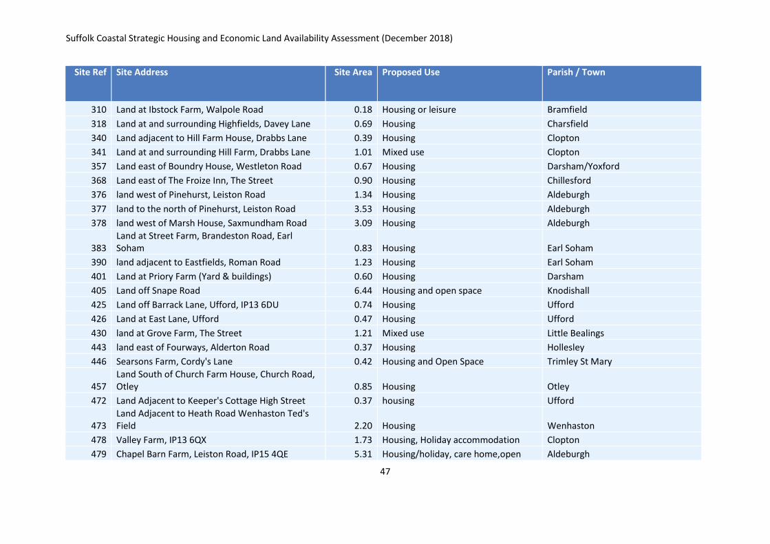
Appendix F: Sites identified as not well related to settlement
Site Ref
Site Address Site Area Proposed Use Parish / Town
11 Land adjoining Eva's Place, Sibton Green, IP17 2JX 0.20 Housing Sibton
45 Land at The Slaughter House, Low Road 2.23 Housing Bramfield
50 Manor Farm, Little Bealings 0.46 Housing Little Bealings
73 Land adjacent to Three Tuns PH, The Street 0.40 Housing Pettistree
82 Land adj Rose Cottage, Fishpond Road 0.95 Housing Waldringfield
101 Land opposite The Hawthorns, Chediston Green 5.13 Affordable housing Chediston
120 Main Road 1.24 Housing Kelsale Cum Carlton
131 Land at Woodlands Farm, Hyde Park Corner 1.56 Housing Sudbourne
153 Land at Sandy Lane, East of 10 Sandy Lane 0.23 Housing Iken
182 Land off Tuddenham Lane, Adjacent to Millbank House 1.27 Housing Rushmere St Andrew
207 Land opposite Hacheston Lodge, The Street 0.85 Housing Hacheston
266 Land in between 12 and 14 Main Road 0.23 Housing Hacheston
286 Land south of Hill Farm 0.61 Housing Charsfield
287 Land east of Benstead, Main Road 0.40 Housing or Holiday lets Kelsale Cum carlton
290 Land south Village Hall, Manor Road 10.27 Housing Clopton
292 Land South of Saddlemaker's Lane, Melton 1.33 Housing and Open Space Melton
298 Land opposite Potash Cottages, Market Hill 0.21 Housing Clopton
299 Land north 1 Cherry tree Cottages, Grundisburgh Road 0.20 Housing Clopton
302 Land south Peartree Farm, Grundisburgh Road 0.20 Housing Clopton
304 Land at The Oaks, off Snipe Farm Road 0.88 Housing Clopton
306 Land west of Gooderhams, Snipe Farm Road 0.23 Housing Clopton
Suffolk Coastal Strategic Housing and Economic Land Availability Assessment (December 2018)
47
Site Ref
Site Address Site Area Proposed Use Parish / Town
310 Land at Ibstock Farm, Walpole Road 0.18 Housing or leisure Bramfield
318 Land at and surrounding Highfields, Davey Lane 0.69 Housing Charsfield
340 Land adjacent to Hill Farm House, Drabbs Lane 0.39 Housing Clopton
341 Land at and surrounding Hill Farm, Drabbs Lane 1.01 Mixed use Clopton
357 Land east of Boundry House, Westleton Road 0.67 Housing Darsham/Yoxford
368 Land east of The Froize Inn, The Street 0.90 Housing Chillesford
376 land west of Pinehurst, Leiston Road 1.34 Housing Aldeburgh
377 land to the north of Pinehurst, Leiston Road 3.53 Housing Aldeburgh
378 land west of Marsh House, Saxmundham Road 3.09 Housing Aldeburgh
383 Land at Street Farm, Brandeston Road, Earl Soham 0.83 Housing Earl Soham
390 land adjacent to Eastfields, Roman Road 1.23 Housing Earl Soham
401 Land at Priory Farm (Yard & buildings) 0.60 Housing Darsham
405 Land off Snape Road 6.44 Housing and open space Knodishall
425 Land off Barrack Lane, Ufford, IP13 6DU 0.74 Housing Ufford
426 Land at East Lane, Ufford 0.47 Housing Ufford
430 land at Grove Farm, The Street 1.21 Mixed use Little Bealings
443 land east of Fourways, Alderton Road 0.37 Housing Hollesley
446 Searsons Farm, Cordy's Lane 0.42 Housing and Open Space Trimley St Mary
457 Land South of Church Farm House, Church Road, Otley 0.85 Housing Otley
472 Land Adjacent to Keeper's Cottage High Street 0.37 housing Ufford
473 Land Adjacent to Heath Road Wenhaston Ted's Field 2.20 Housing Wenhaston
478 Valley Farm, IP13 6QX 1.73 Housing, Holiday accommodation Clopton
479 Chapel Barn Farm, Leiston Road, IP15 4QE 5.31 Housing/holiday, care home,open Aldeburgh
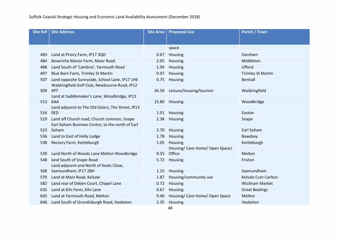
Suffolk Coastal Strategic Housing and Economic Land Availability Assessment (December 2018)
48
Site Ref
Site Address Site Area Proposed Use Parish / Town
space
483 Land at Priory Farm, IP17 3QD 0.67 Housing Darsham
484 Beveriche Manor Farm, Moor Road 2.05 Housing Middleton
488 Land South of 'Cambrai', Yarmouth Road 1.94 Housing Ufford
497 Blue Barn Farm, Trimley St Martin 0.97 Housing Trimley St Martin
507 Land opposite Sunnyside, School Lane, IP17 1HE 0.75 Housing Benhall
509 Waldringfield Golf Club, Newbourne Road, IP12 4PT 36.59 Leisure/housing/tourism Waldringfield
513 Land at Saddlemaker's Lane, Woodbridge, IP13 6AA 15.80 Housing Woodbridge
516 Land adjacent to The Old Osiers, The Street, IP13 0ED 1.01 Housing Easton
519 Land off Church road, Church common, Snape 2.38 Housing Snape
523 Earl Soham Business Centre, to the north of Earl Soham 2.70 Housing Earl Soham
536 Land to East of Holly Lodge 1.78 Housing Bawdsey
538 Rectory Farm, Kettleburgh 1.05 Housing Kettleburgh
539 Land North of Woods Lane Melton Woodbridge 9.55 Housing/ Care Home/ Open Space/ Office Melton
548 land South of Snape Road 5.72 Housing Friston
568 Land adjacent and North of Keats Close, Saxmundham, IP17 2BH 1.15 Housing Saxmundham
570 Land at Main Road, Kelsale 1.87 Housing/community use Kelsale Cum Carlton
582 Land rear of Deben Court, Chapel Lane 0.72 Housing Wickham Market
635 Land at Kiln Farm, Kiln Lane 0.67 Housing Great Bealings
645 Land at Yarmouth Road, Melton 9.46 Housing/ Care Home/ Open Space Melton
646 Land South of Grundisburgh Road, Hasketon 2.35 Housing Hasketon
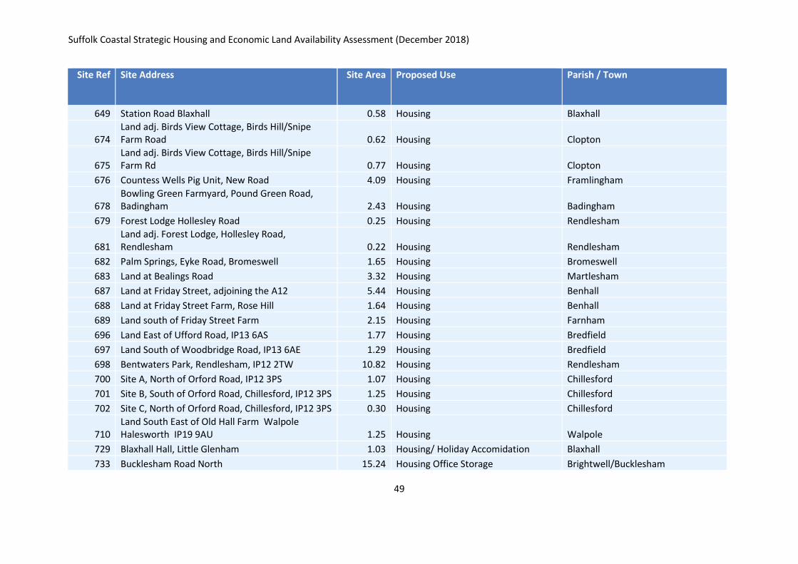
Suffolk Coastal Strategic Housing and Economic Land Availability Assessment (December 2018)
49
Site Ref
Site Address Site Area Proposed Use Parish / Town
649 Station Road Blaxhall 0.58 Housing Blaxhall
674 Land adj. Birds View Cottage, Birds Hill/Snipe Farm Road 0.62 Housing Clopton
675 Land adj. Birds View Cottage, Birds Hill/Snipe Farm Rd 0.77 Housing Clopton
676 Countess Wells Pig Unit, New Road 4.09 Housing Framlingham
678 Bowling Green Farmyard, Pound Green Road, Badingham 2.43 Housing Badingham
679 Forest Lodge Hollesley Road 0.25 Housing Rendlesham
681 Land adj. Forest Lodge, Hollesley Road, Rendlesham 0.22 Housing Rendlesham
682 Palm Springs, Eyke Road, Bromeswell 1.65 Housing Bromeswell
683 Land at Bealings Road 3.32 Housing Martlesham
687 Land at Friday Street, adjoining the A12 5.44 Housing Benhall
688 Land at Friday Street Farm, Rose Hill 1.64 Housing Benhall
689 Land south of Friday Street Farm 2.15 Housing Farnham
696 Land East of Ufford Road, IP13 6AS 1.77 Housing Bredfield
697 Land South of Woodbridge Road, IP13 6AE 1.29 Housing Bredfield
698 Bentwaters Park, Rendlesham, IP12 2TW 10.82 Housing Rendlesham
700 Site A, North of Orford Road, IP12 3PS 1.07 Housing Chillesford
701 Site B, South of Orford Road, Chillesford, IP12 3PS 1.25 Housing Chillesford
702 Site C, North of Orford Road, Chillesford, IP12 3PS 0.30 Housing Chillesford
710 Land South East of Old Hall Farm Walpole Halesworth IP19 9AU 1.25 Housing Walpole
729 Blaxhall Hall, Little Glenham 1.03 Housing/ Holiday Accomidation Blaxhall
733 Bucklesham Road North 15.24 Housing Office Storage Brightwell/Bucklesham
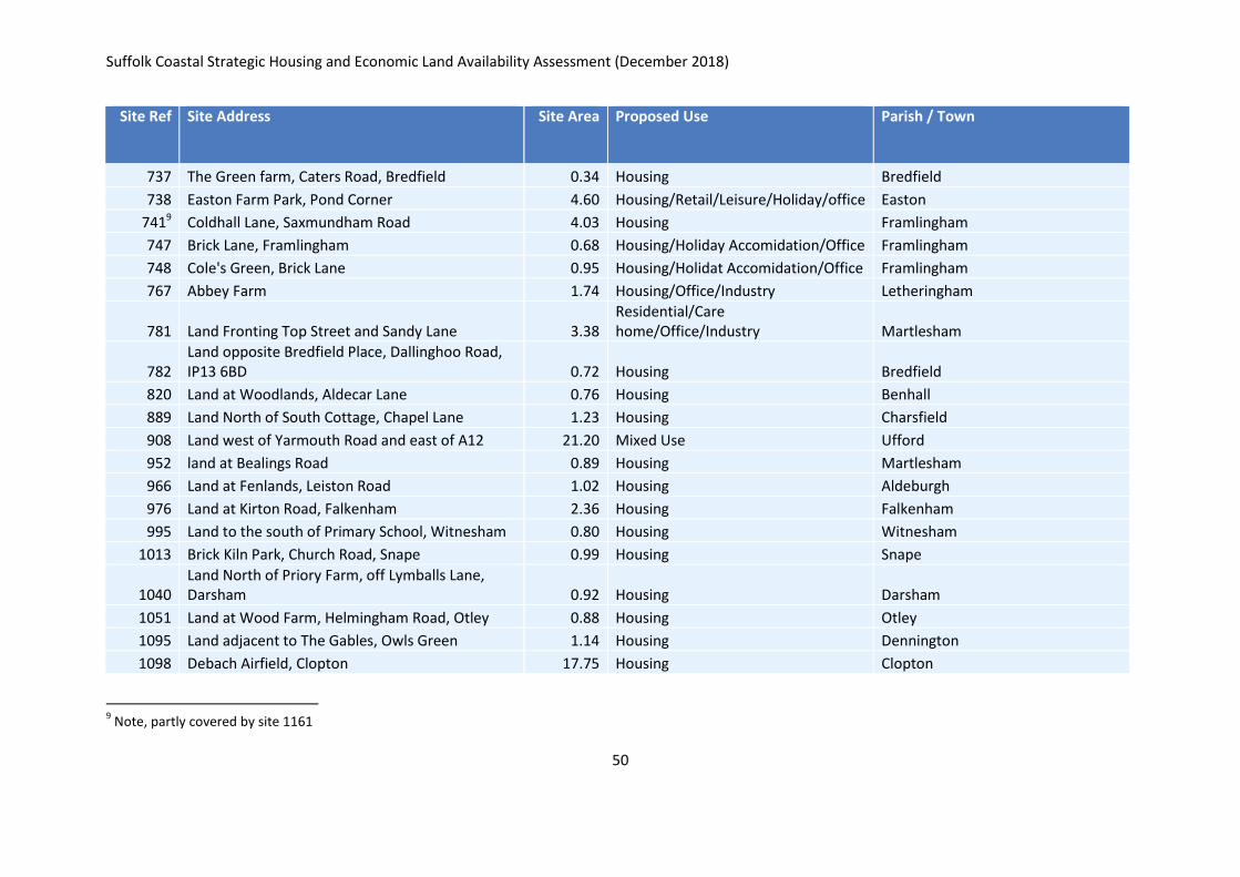
Suffolk Coastal Strategic Housing and Economic Land Availability Assessment (December 2018)
50
Site Ref
Site Address Site Area Proposed Use Parish / Town
737 The Green farm, Caters Road, Bredfield 0.34 Housing Bredfield
738 Easton Farm Park, Pond Corner 4.60 Housing/Retail/Leisure/Holiday/office Easton
7419 Coldhall Lane, Saxmundham Road 4.03 Housing Framlingham
747 Brick Lane, Framlingham 0.68 Housing/Holiday Accomidation/Office Framlingham
748 Cole's Green, Brick Lane 0.95 Housing/Holidat Accomidation/Office Framlingham
767 Abbey Farm 1.74 Housing/Office/Industry Letheringham
781 Land Fronting Top Street and Sandy Lane 3.38 Residential/Care home/Office/Industry Martlesham
782 Land opposite Bredfield Place, Dallinghoo Road, IP13 6BD 0.72 Housing Bredfield
820 Land at Woodlands, Aldecar Lane 0.76 Housing Benhall
889 Land North of South Cottage, Chapel Lane 1.23 Housing Charsfield
908 Land west of Yarmouth Road and east of A12 21.20 Mixed Use Ufford
952 land at Bealings Road 0.89 Housing Martlesham
966 Land at Fenlands, Leiston Road 1.02 Housing Aldeburgh
976 Land at Kirton Road, Falkenham 2.36 Housing Falkenham
995 Land to the south of Primary School, Witnesham 0.80 Housing Witnesham
1013 Brick Kiln Park, Church Road, Snape 0.99 Housing Snape
1040 Land North of Priory Farm, off Lymballs Lane, Darsham 0.92 Housing Darsham
1051 Land at Wood Farm, Helmingham Road, Otley 0.88 Housing Otley
1095 Land adjacent to The Gables, Owls Green 1.14 Housing Dennington
1098 Debach Airfield, Clopton 17.75 Housing Clopton
9 Note, partly covered by site 1161
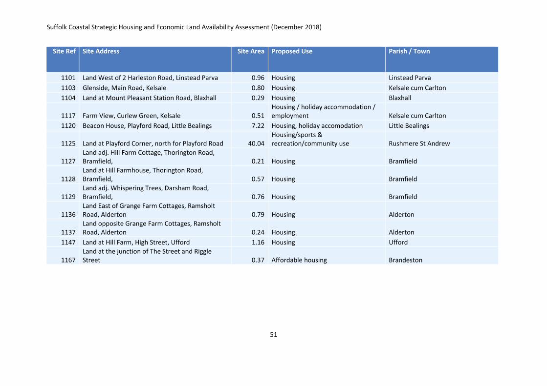
Suffolk Coastal Strategic Housing and Economic Land Availability Assessment (December 2018)
51
Site Ref
Site Address Site Area Proposed Use Parish / Town
1101 Land West of 2 Harleston Road, Linstead Parva 0.96 Housing Linstead Parva
1103 Glenside, Main Road, Kelsale 0.80 Housing Kelsale cum Carlton
1104 Land at Mount Pleasant Station Road, Blaxhall 0.29 Housing Blaxhall
1117 Farm View, Curlew Green, Kelsale 0.51 Housing / holiday accommodation / employment Kelsale cum Carlton
1120 Beacon House, Playford Road, Little Bealings 7.22 Housing, holiday accomodation Little Bealings
1125 Land at Playford Corner, north for Playford Road 40.04 Housing/sports & recreation/community use Rushmere St Andrew
1127 Land adj. Hill Farm Cottage, Thorington Road, Bramfield, 0.21 Housing Bramfield
1128 Land at Hill Farmhouse, Thorington Road, Bramfield, 0.57 Housing Bramfield
1129 Land adj. Whispering Trees, Darsham Road, Bramfield, 0.76 Housing Bramfield
1136 Land East of Grange Farm Cottages, Ramsholt Road, Alderton 0.79 Housing Alderton
1137 Land opposite Grange Farm Cottages, Ramsholt Road, Alderton 0.24 Housing Alderton
1147 Land at Hill Farm, High Street, Ufford 1.16 Housing Ufford
1167 Land at the junction of The Street and Riggle Street 0.37 Affordable housing Brandeston
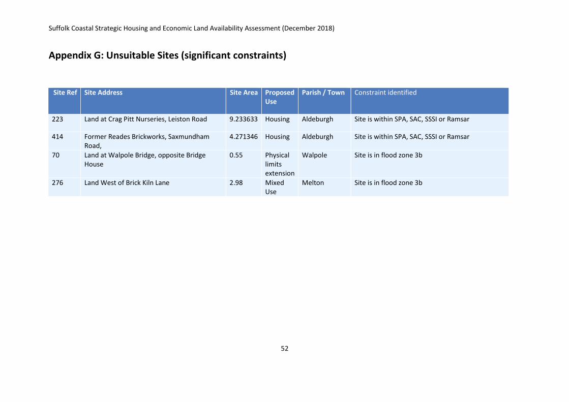
Suffolk Coastal Strategic Housing and Economic Land Availability Assessment (December 2018)
52
Appendix G: Unsuitable Sites (significant constraints)
Site Ref
Site Address Site Area Proposed Use
Parish / Town Constraint identified
223 Land at Crag Pitt Nurseries, Leiston Road 9.233633 Housing Aldeburgh Site is within SPA, SAC, SSSI or Ramsar
414 Former Reades Brickworks, Saxmundham Road,
4.271346 Housing Aldeburgh Site is within SPA, SAC, SSSI or Ramsar
70 Land at Walpole Bridge, opposite Bridge House
0.55 Physical limits extension
Walpole Site is in flood zone 3b
276 Land West of Brick Kiln Lane 2.98 Mixed Use
Melton Site is in flood zone 3b
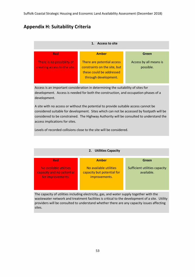
Suffolk Coastal Strategic Housing and Economic Land Availability Assessment (December 2018)
53
Appendix H: Suitability Criteria
1. Access to site
Red
There is no possibility of
creating access to the site.
Amber
There are potential access
constraints on the site, but
these could be addressed
through development.
Green
Access by all means is
possible.
Access is an important consideration in determining the suitability of sites for
development. Access is needed for both the construction, and occupation phases of a
development.
A site with no access or without the potential to provide suitable access cannot be
considered suitable for development. Sites which can not be accessed by footpath will be
considered to be constrained. The Highway Authority will be consulted to understand the
access implications for sites.
Levels of recorded collisions close to the site will be considered.
2. Utilities Capacity
Red
No available utilities capacity and no potential
for improvements.
Amber
No available utilities capacity but potential for
improvements.
Green
Sufficient utilities capacity available.
The capacity of utilities including electricity, gas, and water supply together with the wastewater network and treatment facilities is critical to the development of a site. Utility providers will be consulted to understand whether there are any capacity issues affecting sites.
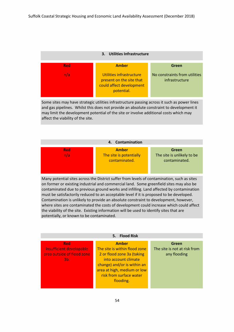
Suffolk Coastal Strategic Housing and Economic Land Availability Assessment (December 2018)
54
3. Utilities Infrastructure
Red
n/a
Amber
Utilities infrastructure present on the site that
could affect development potential.
Green
No constraints from utilities infrastructure
Some sites may have strategic utilities infrastructure passing across it such as power lines and gas pipelines. Whilst this does not provide an absolute constraint to development it may limit the development potential of the site or involve additional costs which may affect the viability of the site.
4. Contamination
Red n/a
Amber The site is potentially
contaminated.
Green The site is unlikely to be
contaminated.
Many potential sites across the District suffer from levels of contamination, such as sites on former or existing industrial and commercial land. Some greenfield sites may also be contaminated due to previous ground works and infilling. Land affected by contamination must be satisfactorily reduced to an acceptable level if it is proposed to be developed. Contamination is unlikely to provide an absolute constraint to development, however, where sites are contaminated the costs of development could increase which could affect the viability of the site. Existing information will be used to identify sites that are potentially, or known to be contaminated.
5. Flood Risk
Red Insufficient developable
area outside of flood zone 3b.
Amber The site is within flood zone
2 or flood zone 3a (taking into account climate
change) and/or is within an area at high, medium or low
risk from surface water flooding.
Green The site is not at risk from
any flooding
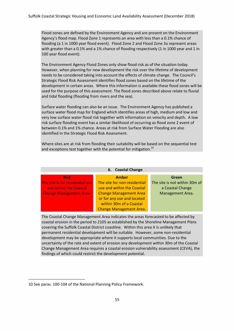
Suffolk Coastal Strategic Housing and Economic Land Availability Assessment (December 2018)
55
Flood zones are defined by the Environment Agency and are present on the Environment Agency’s flood map. Flood Zone 1 represents an area with less than a 0.1% chance of flooding (a 1 in 1000 year flood event). Flood Zone 2 and Flood Zone 3a represent areas with greater than a 0.1% and a 1% chance of flooding respectively (1 in 1000 year and 1 in 100 year flood event). The Environment Agency Flood Zones only show flood risk as of the situation today. However, when planning for new development the risk over the lifetime of development needs to be considered taking into account the effects of climate change. The Council’s Strategic Flood Risk Assessment identifies flood zones based on the lifetime of the development in certain areas. Where this information is available these flood zones will be used for the purpose of this assessment. The flood zones described above relate to fluvial and tidal flooding (flooding from rivers and the sea). Surface water flooding can also be an issue. The Environment Agency has published a surface water flood map for England which identifies areas of high, medium and low and very low surface water flood risk together with information on velocity and depth. A low risk surface flooding event has a similar likelihood of occurring as flood zone 2 event of between 0.1% and 1% chance. Areas at risk from Surface Water Flooding are also identified in the Strategic Flood Risk Assessment. Where sites are at risk from flooding their suitability will be based on the sequential test and exceptions test together with the potential for mitigation.10
6. Coastal Change
Red The site is for residential use
and within the Coastal Change Management Area.
Amber The site for non-residential use and within the Coastal Change Management Area or for any use and located
within 30m of a Coastal Change Management Area.
Green The site is not within 30m of
a Coastal Change Management Area.
The Coastal Change Management Area indicates the areas forecasted to be affected by coastal erosion in the period to 2105 as established by the Shoreline Management Plans covering the Suffolk Coastal District coastline. Within this area it is unlikely that permanent residential development will be suitable. However, some non-residential development may be appropriate where it supports local communities. Due to the uncertainty of the rate and extent of erosion any development within 30m of the Coastal Change Management Area requires a coastal erosion vulnerability assessment (CEVA), the findings of which could restrict the development potential.
10 See paras. 100-104 of the National Planning Policy Framework.
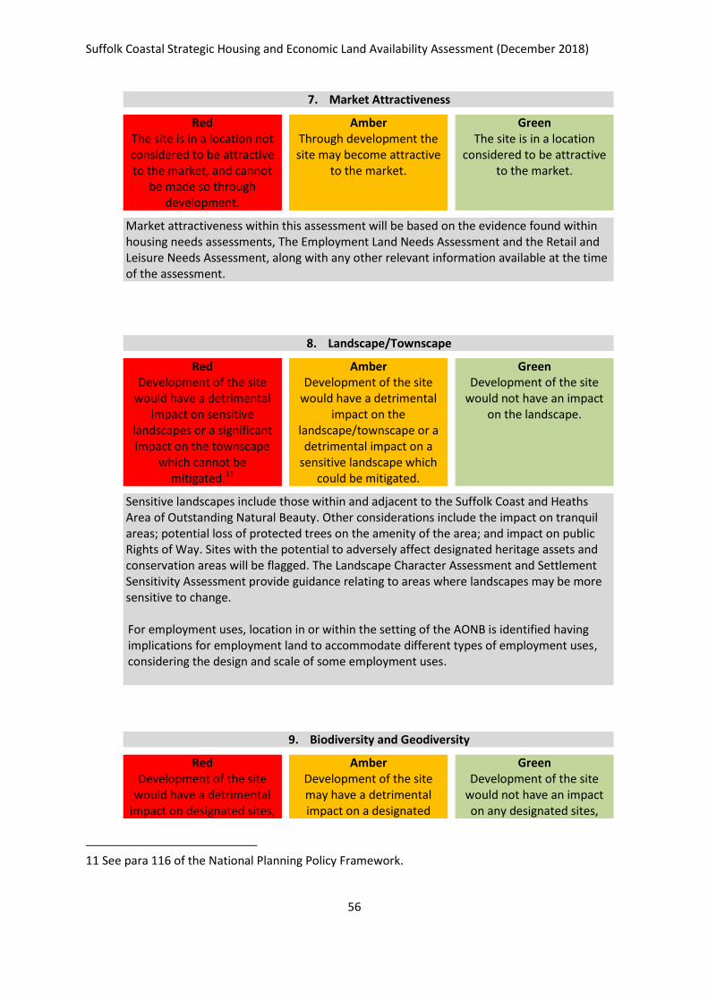
Suffolk Coastal Strategic Housing and Economic Land Availability Assessment (December 2018)
56
7. Market Attractiveness
Red The site is in a location not considered to be attractive to the market, and cannot
be made so through development.
Amber Through development the site may become attractive
to the market.
Green The site is in a location
considered to be attractive to the market.
Market attractiveness within this assessment will be based on the evidence found within housing needs assessments, The Employment Land Needs Assessment and the Retail and Leisure Needs Assessment, along with any other relevant information available at the time of the assessment.
8. Landscape/Townscape
Red Development of the site
would have a detrimental impact on sensitive
landscapes or a significant impact on the townscape
which cannot be mitigated.11
Amber Development of the site
would have a detrimental impact on the
landscape/townscape or a detrimental impact on a
sensitive landscape which could be mitigated.
Green Development of the site
would not have an impact on the landscape.
Sensitive landscapes include those within and adjacent to the Suffolk Coast and Heaths Area of Outstanding Natural Beauty. Other considerations include the impact on tranquil areas; potential loss of protected trees on the amenity of the area; and impact on public Rights of Way. Sites with the potential to adversely affect designated heritage assets and conservation areas will be flagged. The Landscape Character Assessment and Settlement Sensitivity Assessment provide guidance relating to areas where landscapes may be more sensitive to change. For employment uses, location in or within the setting of the AONB is identified having implications for employment land to accommodate different types of employment uses, considering the design and scale of some employment uses.
9. Biodiversity and Geodiversity
Red Development of the site
would have a detrimental impact on designated sites,
Amber Development of the site may have a detrimental impact on a designated
Green Development of the site
would not have an impact on any designated sites,
11 See para 116 of the National Planning Policy Framework.
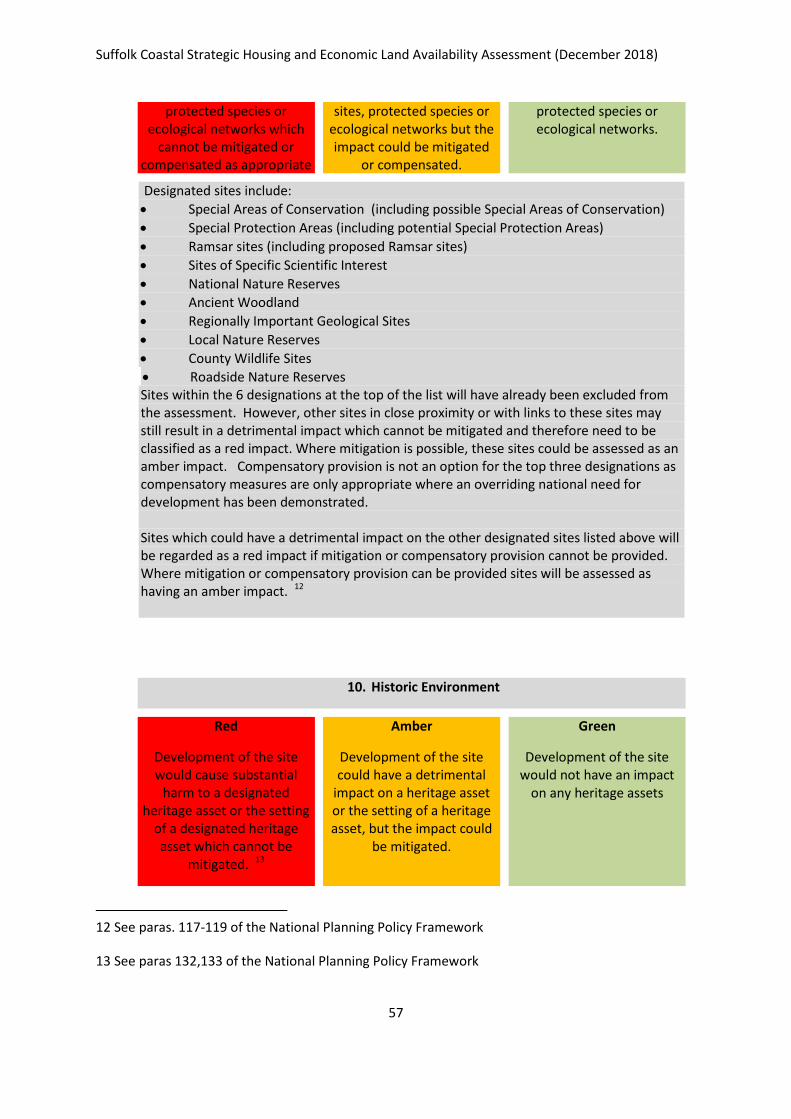
Suffolk Coastal Strategic Housing and Economic Land Availability Assessment (December 2018)
57
protected species or ecological networks which
cannot be mitigated or compensated as appropriate
sites, protected species or ecological networks but the impact could be mitigated
or compensated.
protected species or ecological networks.
Designated sites include:
Special Areas of Conservation (including possible Special Areas of Conservation)
Special Protection Areas (including potential Special Protection Areas)
Ramsar sites (including proposed Ramsar sites)
Sites of Specific Scientific Interest
National Nature Reserves
Ancient Woodland
Regionally Important Geological Sites
Local Nature Reserves
County Wildlife Sites
Roadside Nature Reserves Sites within the 6 designations at the top of the list will have already been excluded from the assessment. However, other sites in close proximity or with links to these sites may still result in a detrimental impact which cannot be mitigated and therefore need to be classified as a red impact. Where mitigation is possible, these sites could be assessed as an amber impact. Compensatory provision is not an option for the top three designations as compensatory measures are only appropriate where an overriding national need for development has been demonstrated. Sites which could have a detrimental impact on the other designated sites listed above will be regarded as a red impact if mitigation or compensatory provision cannot be provided. Where mitigation or compensatory provision can be provided sites will be assessed as having an amber impact. 12
10. Historic Environment
Red
Development of the site would cause substantial
harm to a designated heritage asset or the setting
of a designated heritage asset which cannot be
mitigated. 13
Amber
Development of the site could have a detrimental
impact on a heritage asset or the setting of a heritage asset, but the impact could
be mitigated.
Green
Development of the site would not have an impact
on any heritage assets
12 See paras. 117-119 of the National Planning Policy Framework
13 See paras 132,133 of the National Planning Policy Framework
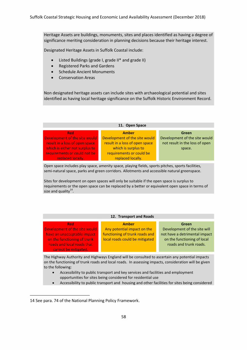
Suffolk Coastal Strategic Housing and Economic Land Availability Assessment (December 2018)
58
Heritage Assets are buildings, monuments, sites and places identified as having a degree of significance meriting consideration in planning decisions because their heritage interest.
Designated Heritage Assets in Suffolk Coastal include:
Listed Buildings (grade I, grade II* and grade II)
Registered Parks and Gardens
Schedule Ancient Monuments
Conservation Areas
Non designated heritage assets can include sites with archaeological potential and sites identified as having local heritage significance on the Suffolk Historic Environment Record.
11. Open Space
Red Development of the site would
result in a loss of open space which is either not surplus to requirements or could not be
replaced locally.
Amber Development of the site would
result in a loss of open space which is surplus to
requirements or could be replaced locally.
Green Development of the site would
not result in the loss of open space.
Open space includes play space, amenity space, playing fields, sports pitches, sports facilities, semi-natural space, parks and green corridors. Allotments and accessible natural greenspace. Sites for development on open spaces will only be suitable if the open space is surplus to requirements or the open space can be replaced by a better or equivalent open space in terms of size and quality
14.
12. Transport and Roads
Red Development of the site would have an unacceptable impact
on the functioning of trunk roads and local roads that
cannot be mitigated.
Amber Any potential impact on the
functioning of trunk roads and local roads could be mitigated
Green Development of the site will
not have a detrimental impact on the functioning of local
roads and trunk roads.
The Highway Authority and Highways England will be consulted to ascertain any potential impacts on the functioning of trunk roads and local roads. In assessing impacts, consideration will be given to the following:
Accessibility to public transport and key services and facilities and employment opportunities for sites being considered for residential use
Accessibility to public transport and housing and other facilities for sites being considered
14 See para. 74 of the National Planning Policy Framework.
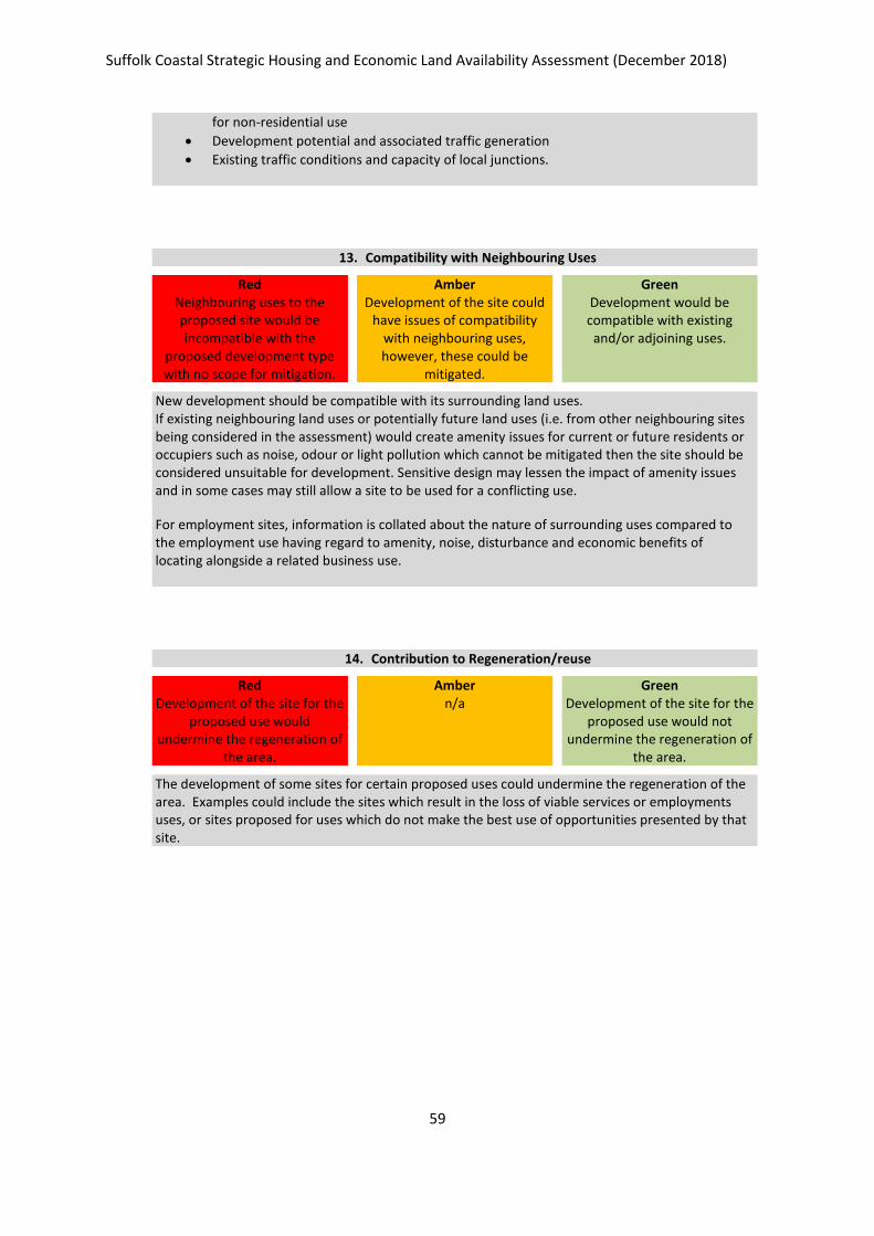
Suffolk Coastal Strategic Housing and Economic Land Availability Assessment (December 2018)
59
for non-residential use
Development potential and associated traffic generation
Existing traffic conditions and capacity of local junctions.
13. Compatibility with Neighbouring Uses
Red Neighbouring uses to the proposed site would be incompatible with the
proposed development type with no scope for mitigation.
Amber Development of the site could
have issues of compatibility with neighbouring uses, however, these could be
mitigated.
Green Development would be compatible with existing and/or adjoining uses.
New development should be compatible with its surrounding land uses. If existing neighbouring land uses or potentially future land uses (i.e. from other neighbouring sites being considered in the assessment) would create amenity issues for current or future residents or occupiers such as noise, odour or light pollution which cannot be mitigated then the site should be considered unsuitable for development. Sensitive design may lessen the impact of amenity issues and in some cases may still allow a site to be used for a conflicting use.
For employment sites, information is collated about the nature of surrounding uses compared to the employment use having regard to amenity, noise, disturbance and economic benefits of locating alongside a related business use.
14. Contribution to Regeneration/reuse
Red Development of the site for the
proposed use would undermine the regeneration of
the area.
Amber n/a
Green Development of the site for the
proposed use would not undermine the regeneration of
the area.
The development of some sites for certain proposed uses could undermine the regeneration of the area. Examples could include the sites which result in the loss of viable services or employments uses, or sites proposed for uses which do not make the best use of opportunities presented by that site.
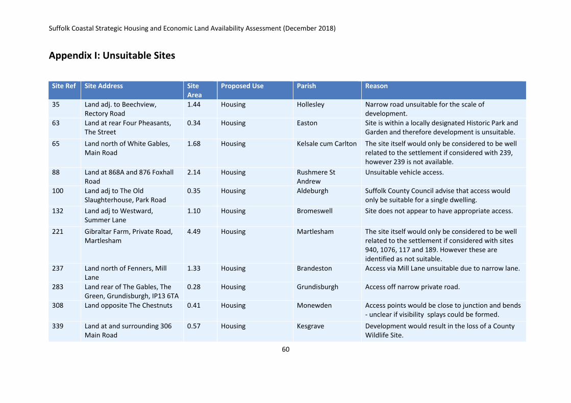
Suffolk Coastal Strategic Housing and Economic Land Availability Assessment (December 2018)
60
Appendix I: Unsuitable Sites
Site Ref
Site Address Site Area
Proposed Use Parish Reason
35 Land adj. to Beechview, Rectory Road
1.44 Housing Hollesley Narrow road unsuitable for the scale of development.
63 Land at rear Four Pheasants, The Street
0.34 Housing Easton Site is within a locally designated Historic Park and Garden and therefore development is unsuitable.
65 Land north of White Gables, Main Road
1.68 Housing Kelsale cum Carlton The site itself would only be considered to be well related to the settlement if considered with 239, however 239 is not available.
88 Land at 868A and 876 Foxhall Road
2.14 Housing Rushmere St Andrew
Unsuitable vehicle access.
100 Land adj to The Old Slaughterhouse, Park Road
0.35 Housing Aldeburgh Suffolk County Council advise that access would only be suitable for a single dwelling.
132 Land adj to Westward, Summer Lane
1.10 Housing Bromeswell Site does not appear to have appropriate access.
221 Gibraltar Farm, Private Road, Martlesham
4.49 Housing Martlesham The site itself would only be considered to be well related to the settlement if considered with sites 940, 1076, 117 and 189. However these are identified as not suitable.
237 Land north of Fenners, Mill Lane
1.33 Housing Brandeston Access via Mill Lane unsuitable due to narrow lane.
283 Land rear of The Gables, The Green, Grundisburgh, IP13 6TA
0.28 Housing Grundisburgh Access off narrow private road.
308 Land opposite The Chestnuts 0.41 Housing Monewden Access points would be close to junction and bends - unclear if visibility splays could be formed.
339 Land at and surrounding 306 Main Road
0.57 Housing Kesgrave Development would result in the loss of a County Wildlife Site.
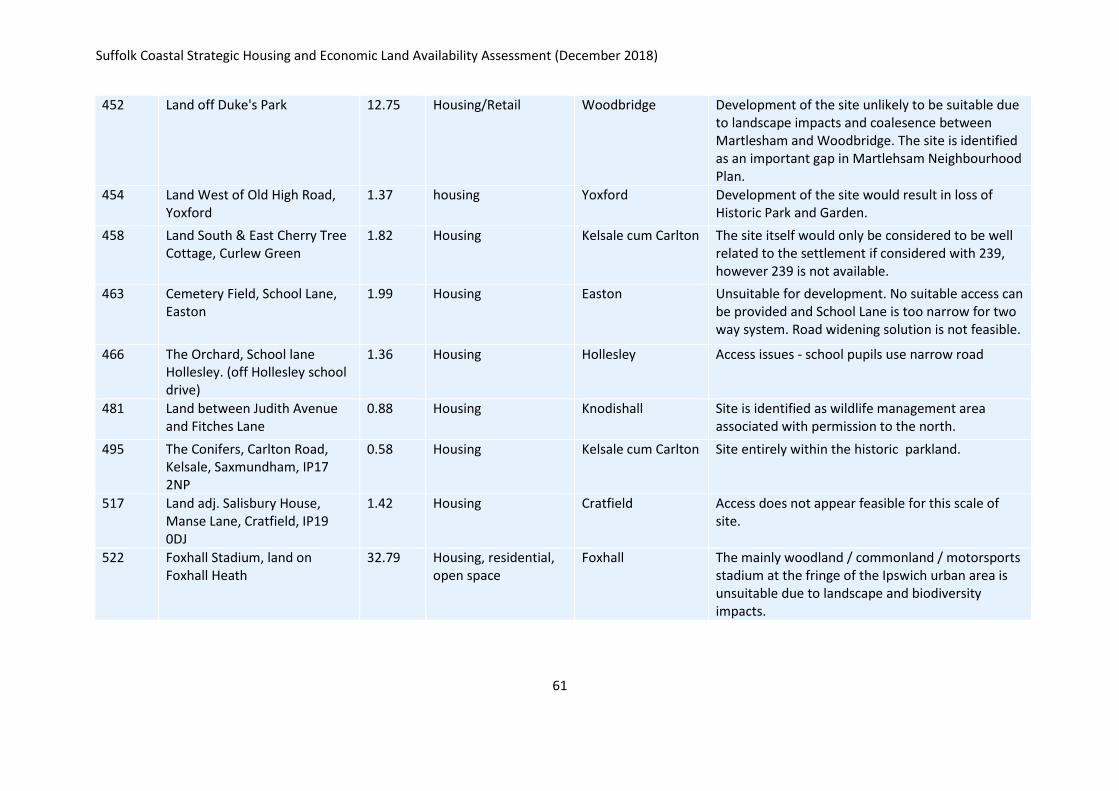
Suffolk Coastal Strategic Housing and Economic Land Availability Assessment (December 2018)
61
452 Land off Duke's Park 12.75 Housing/Retail Woodbridge Development of the site unlikely to be suitable due to landscape impacts and coalesence between Martlesham and Woodbridge. The site is identified as an important gap in Martlehsam Neighbourhood Plan.
454 Land West of Old High Road, Yoxford
1.37 housing Yoxford Development of the site would result in loss of Historic Park and Garden.
458 Land South & East Cherry Tree Cottage, Curlew Green
1.82 Housing Kelsale cum Carlton The site itself would only be considered to be well related to the settlement if considered with 239, however 239 is not available.
463 Cemetery Field, School Lane, Easton
1.99 Housing Easton Unsuitable for development. No suitable access can be provided and School Lane is too narrow for two way system. Road widening solution is not feasible.
466 The Orchard, School lane Hollesley. (off Hollesley school drive)
1.36 Housing Hollesley Access issues - school pupils use narrow road
481 Land between Judith Avenue and Fitches Lane
0.88 Housing Knodishall Site is identified as wildlife management area associated with permission to the north.
495 The Conifers, Carlton Road, Kelsale, Saxmundham, IP17 2NP
0.58 Housing Kelsale cum Carlton Site entirely within the historic parkland.
517 Land adj. Salisbury House, Manse Lane, Cratfield, IP19 0DJ
1.42 Housing Cratfield Access does not appear feasible for this scale of site.
522 Foxhall Stadium, land on Foxhall Heath
32.79 Housing, residential, open space
Foxhall The mainly woodland / commonland / motorsports stadium at the fringe of the Ipswich urban area is unsuitable due to landscape and biodiversity impacts.
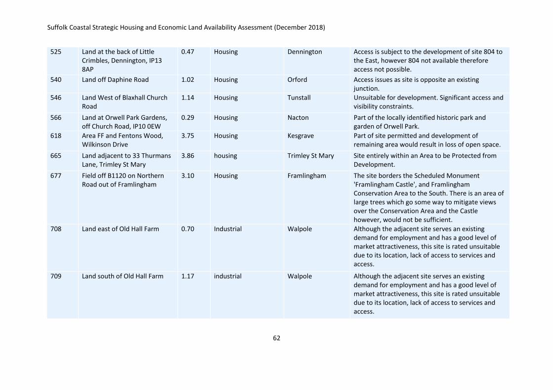
Suffolk Coastal Strategic Housing and Economic Land Availability Assessment (December 2018)
62
525 Land at the back of Little Crimbles, Dennington, IP13 8AP
0.47 Housing Dennington Access is subject to the development of site 804 to the East, however 804 not available therefore access not possible.
540 Land off Daphine Road 1.02 Housing Orford Access issues as site is opposite an existing junction.
546 Land West of Blaxhall Church Road
1.14 Housing Tunstall Unsuitable for development. Significant access and visibility constraints.
566 Land at Orwell Park Gardens, off Church Road, IP10 0EW
0.29 Housing Nacton Part of the locally identified historic park and garden of Orwell Park.
618 Area FF and Fentons Wood, Wilkinson Drive
3.75 Housing Kesgrave Part of site permitted and development of remaining area would result in loss of open space.
665 Land adjacent to 33 Thurmans Lane, Trimley St Mary
3.86 housing Trimley St Mary Site entirely within an Area to be Protected from Development.
677 Field off B1120 on Northern Road out of Framlingham
3.10 Housing Framlingham The site borders the Scheduled Monument 'Framlingham Castle', and Framlingham Conservation Area to the South. There is an area of large trees which go some way to mitigate views over the Conservation Area and the Castle however, would not be sufficient.
708 Land east of Old Hall Farm 0.70 Industrial Walpole Although the adjacent site serves an existing demand for employment and has a good level of market attractiveness, this site is rated unsuitable due to its location, lack of access to services and access.
709 Land south of Old Hall Farm 1.17 industrial Walpole Although the adjacent site serves an existing demand for employment and has a good level of market attractiveness, this site is rated unsuitable due to its location, lack of access to services and access.
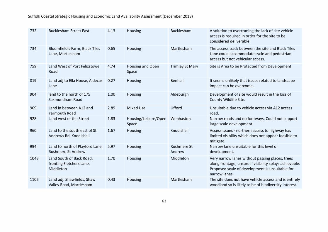
Suffolk Coastal Strategic Housing and Economic Land Availability Assessment (December 2018)
63
732 Bucklesham Street East 4.13 Housing Bucklesham A solution to overcoming the lack of site vehicle access is required in order for the site to be considered deliverable.
734 Bloomfield's Farm, Black Tiles Lane, Martlesham
0.65 Housing Martlesham The access track between the site and Black Tiles Lane could accommodate cycle and pedestrian access but not vehicular access.
759 Land West of Port Felixstowe Road
4.74 Housing and Open Space
Trimley St Mary Site is Area to be Protected from Development.
819 Land adj to Ella House, Aldecar Lane
0.27 Housing Benhall It seems unlikely that issues related to landscape impact can be overcome.
904 land to the north of 175 Saxmundham Road
1.00 Housing Aldeburgh Development of site would result in the loss of County Wildlife Site.
909 Land in between A12 and Yarmouth Road
2.89 Mixed Use Ufford Unsuitable due to vehicle access via A12 access road.
928 Land west of the Street 1.83 Housing/Leisure/Open Space
Wenhaston Narrow roads and no footways. Could not support large scale development.
960 Land to the south east of St Andrews Rd, Knodishall
1.67 Housing Knodishall Access issues - northern access to highway has limited visibility which does not appear feasible to mitigate.
994 Land to north of Playford Lane, Rushmere St Andrew
5.97 Housing Rushmere St Andrew
Narrow lane unsuitable for this level of development.
1043 Land South of Back Road, fronting Fletchers Lane, Middleton
1.70 Housing Middleton Very narrow lanes without passing places, trees along frontage, unsure if visibility splays achievable. Proposed scale of development is unsuitable for narrow lanes.
1106 Land adj. Shawfields, Shaw Valley Road, Martlesham
0.43 Housing Martlesham The site does not have vehicle access and is entirely woodland so is likely to be of biodiversity interest.
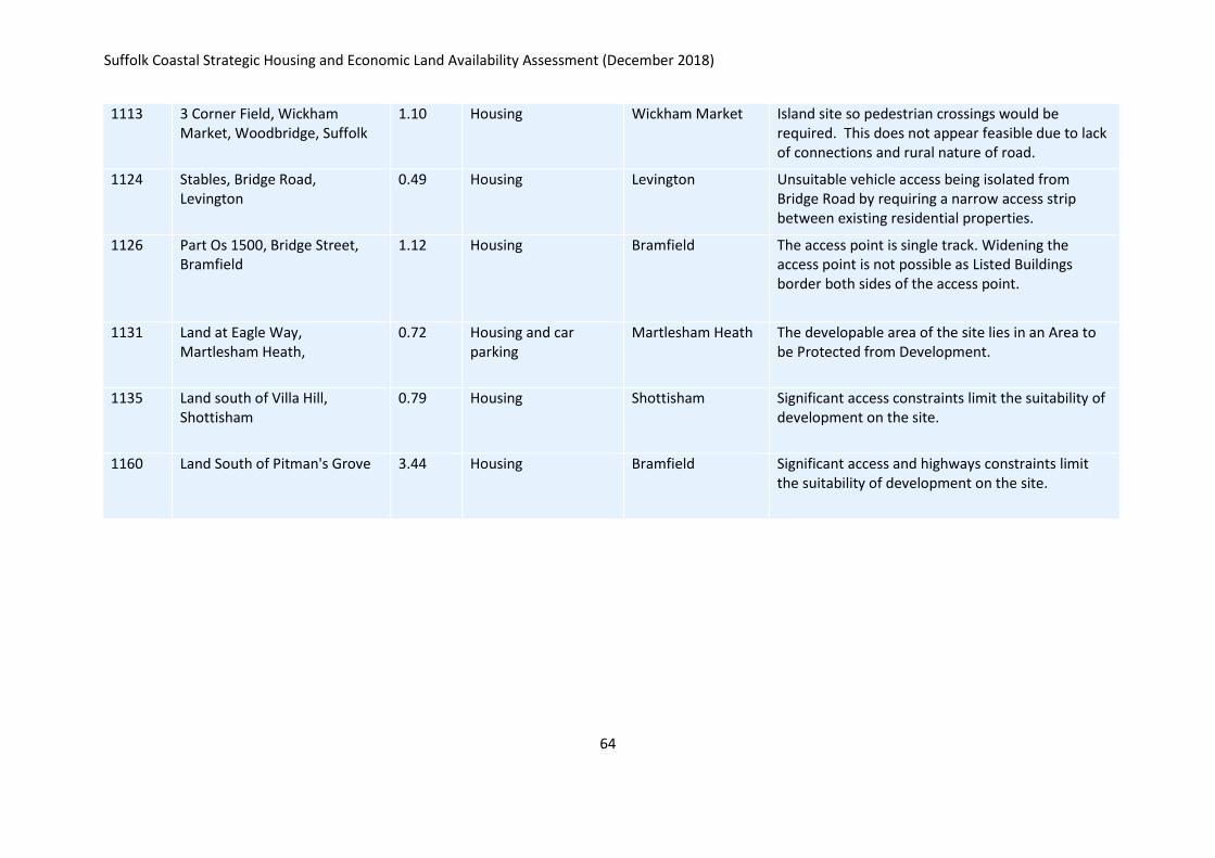
Suffolk Coastal Strategic Housing and Economic Land Availability Assessment (December 2018)
64
1113 3 Corner Field, Wickham Market, Woodbridge, Suffolk
1.10 Housing Wickham Market Island site so pedestrian crossings would be required. This does not appear feasible due to lack of connections and rural nature of road.
1124 Stables, Bridge Road, Levington
0.49 Housing Levington Unsuitable vehicle access being isolated from Bridge Road by requiring a narrow access strip between existing residential properties.
1126 Part Os 1500, Bridge Street, Bramfield
1.12 Housing Bramfield The access point is single track. Widening the access point is not possible as Listed Buildings border both sides of the access point.
1131 Land at Eagle Way, Martlesham Heath,
0.72 Housing and car parking
Martlesham Heath The developable area of the site lies in an Area to be Protected from Development.
1135 Land south of Villa Hill, Shottisham
0.79 Housing Shottisham Significant access constraints limit the suitability of development on the site.
1160 Land South of Pitman's Grove 3.44 Housing Bramfield Significant access and highways constraints limit the suitability of development on the site.
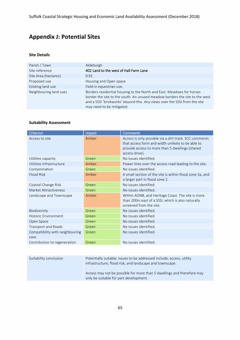
Suffolk Coastal Strategic Housing and Economic Land Availability Assessment (December 2018)
65
Appendix J: Potential Sites
Site Details
Parish / Town Aldeburgh
Site reference 402 Land to the west of Hall Farm Lane
Site Area (hectares) 0.91
Proposed use Housing and Open space
Existing land use Field in equestrian use.
Neighbouring land uses Borders residential housing to the North and East. Meadows for horses border the site to the south. An unused meadow borders the site to the west and a SSSI ‘brickworks’ beyond this. Any views over the SSSI from the site may need to be mitigated.
Suitability Assessment
Criterion Impact Comments
Access to site Amber Access is only possible via a dirt track. SCC comments that access form and width unlikely to be able to provide access to more than 5 dwellings (shared access drive).
Utilities capacity Green No issues identified.
Utilities Infrastructure Amber Power lines over the access road leading to the site.
Contamination Green No issues identified.
Flood Risk Amber A small section of the site is within flood zone 3a, and a larger part in flood zone 2.
Coastal Change Risk Green No issues identified.
Market Attractiveness Green No issues identified.
Landscape and Townscape Amber Within AONB, and Heritage Coast. The site is more than 200m east of a SSSI, which is also naturally screened from the site.
Biodiversity Green No issues identified.
Historic Environment Green No issues identified.
Open Space Green No issues identified.
Transport and Roads Green No issues identified.
Compatibility with neighbouring uses
Green No issues identified.
Contribution to regeneration Green No issues identified.
Suitability conclusion Potentially suitable. Issues to be addressed include; access, utility infrastructure, flood risk, and landscape and townscape. Access may not be possible for more than 5 dwellings and therefore may only be suitable for part development.

Suffolk Coastal Strategic Housing and Economic Land Availability Assessment (December 2018)
66
Availability
Is the site available? Yes
Evidence of availability / comments
Landowner submission
Achievability
Is the site achievable? Yes
Evidence of achievability Assmed - no specific issues identified
Are there any commencement issues?
None identified
Estimated dwellings yield 5
Estimated employment land yield (hectares) -
Estimated retail floorspace (sqm) -
Estimated commencement date 2023/24
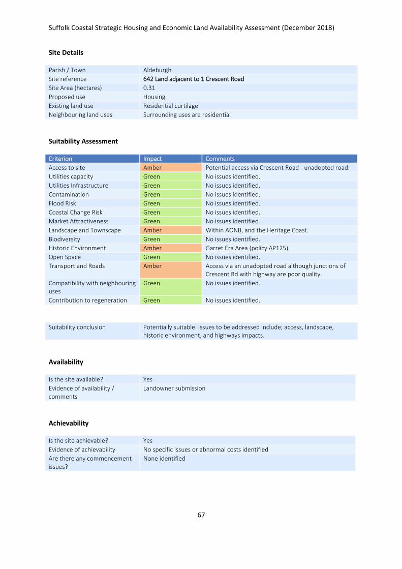
Suffolk Coastal Strategic Housing and Economic Land Availability Assessment (December 2018)
67
Site Details
Parish / Town Aldeburgh
Site reference 642 Land adjacent to 1 Crescent Road
Site Area (hectares) 0.31
Proposed use Housing
Existing land use Residential curtilage
Neighbouring land uses Surrounding uses are residential
Suitability Assessment
Criterion Impact Comments
Access to site Amber Potential access via Crescent Road - unadopted road.
Utilities capacity Green No issues identified.
Utilities Infrastructure Green No issues identified.
Contamination Green No issues identified.
Flood Risk Green No issues identified.
Coastal Change Risk Green No issues identified.
Market Attractiveness Green No issues identified.
Landscape and Townscape Amber Within AONB, and the Heritage Coast.
Biodiversity Green No issues identified.
Historic Environment Amber Garret Era Area (policy AP125)
Open Space Green No issues identified.
Transport and Roads Amber Access via an unadopted road although junctions of Crescent Rd with highway are poor quality.
Compatibility with neighbouring uses
Green No issues identified.
Contribution to regeneration Green No issues identified.
Suitability conclusion Potentially suitable. Issues to be addressed include; access, landscape, historic environment, and highways impacts.
Availability
Is the site available? Yes
Evidence of availability / comments
Landowner submission
Achievability
Is the site achievable? Yes
Evidence of achievability No specific issues or abnormal costs identified
Are there any commencement issues?
None identified

Suffolk Coastal Strategic Housing and Economic Land Availability Assessment (December 2018)
68
Estimated dwellings yield 9
Estimated employment land yield (hectares) -
Estimated retail floorspace (sqm) -
Estimated commencement date 2021/22
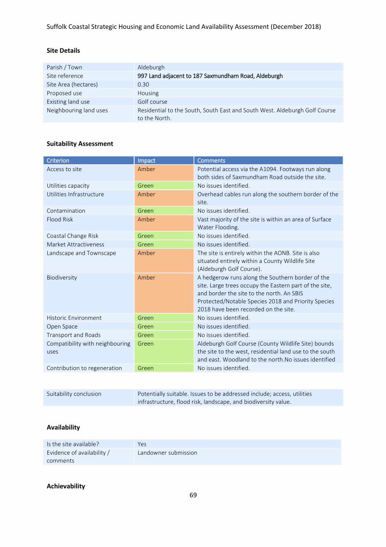
Suffolk Coastal Strategic Housing and Economic Land Availability Assessment (December 2018)
69
Site Details
Parish / Town Aldeburgh
Site reference 997 Land adjacent to 187 Saxmundham Road, Aldeburgh
Site Area (hectares) 0.30
Proposed use Housing
Existing land use Golf course
Neighbouring land uses Residential to the South, South East and South West. Aldeburgh Golf Course to the North.
Suitability Assessment
Criterion Impact Comments
Access to site Amber Potential access via the A1094. Footways run along both sides of Saxmundham Road outside the site.
Utilities capacity Green No issues identified.
Utilities Infrastructure Amber Overhead cables run along the southern border of the site.
Contamination Green No issues identified.
Flood Risk Amber Vast majority of the site is within an area of Surface Water Flooding.
Coastal Change Risk Green No issues identified.
Market Attractiveness Green No issues identified.
Landscape and Townscape Amber The site is entirely within the AONB. Site is also situated entirely within a County Wildlife Site (Aldeburgh Golf Course).
Biodiversity Amber A hedgerow runs along the Southern border of the site. Large trees occupy the Eastern part of the site, and border the site to the north. An SBIS Protected/Notable Species 2018 and Priority Species 2018 have been recorded on the site.
Historic Environment Green No issues identified.
Open Space Green No issues identified.
Transport and Roads Green No issues identified.
Compatibility with neighbouring uses
Green Aldeburgh Golf Course (County Wildlife Site) bounds the site to the west, residential land use to the south and east. Woodland to the north.No issues identified
Contribution to regeneration Green No issues identified.
Suitability conclusion Potentially suitable. Issues to be addressed include; access, utilities infrastructure, flood risk, landscape, and biodiversity value.
Availability
Is the site available? Yes
Evidence of availability / comments
Landowner submission
Achievability

Suffolk Coastal Strategic Housing and Economic Land Availability Assessment (December 2018)
70
Is the site achievable? Yes
Evidence of achievability No specific issues or abnormal costs identified
Are there any commencement issues?
None identified
Estimated dwellings yield 9
Estimated employment land yield (hectares) -
Estimated retail floorspace (sqm) -
Estimated commencement date 2023/24
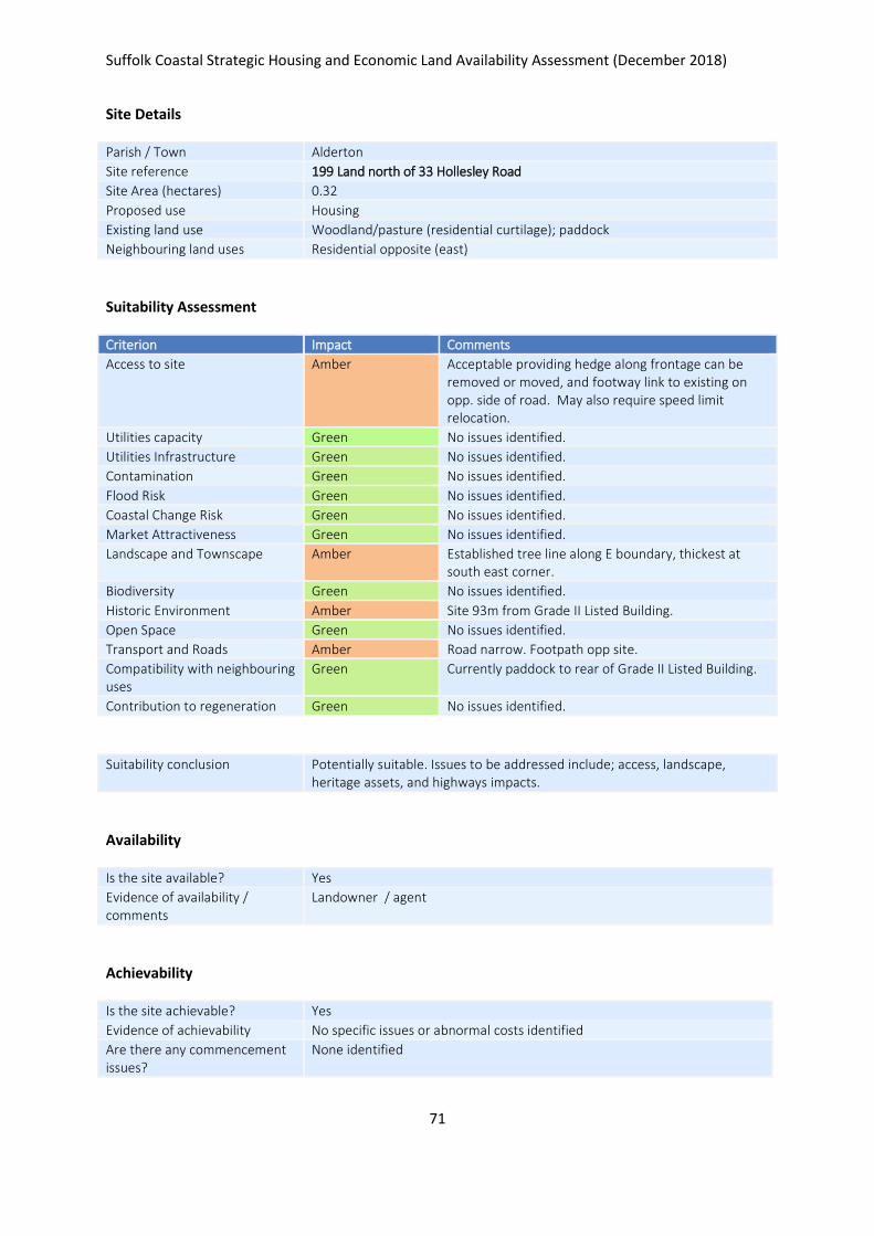
Suffolk Coastal Strategic Housing and Economic Land Availability Assessment (December 2018)
71
Site Details
Parish / Town Alderton
Site reference 199 Land north of 33 Hollesley Road
Site Area (hectares) 0.32
Proposed use Housing
Existing land use Woodland/pasture (residential curtilage); paddock
Neighbouring land uses Residential opposite (east)
Suitability Assessment
Criterion Impact Comments
Access to site Amber Acceptable providing hedge along frontage can be removed or moved, and footway link to existing on opp. side of road. May also require speed limit relocation.
Utilities capacity Green No issues identified.
Utilities Infrastructure Green No issues identified.
Contamination Green No issues identified.
Flood Risk Green No issues identified.
Coastal Change Risk Green No issues identified.
Market Attractiveness Green No issues identified.
Landscape and Townscape Amber Established tree line along E boundary, thickest at south east corner.
Biodiversity Green No issues identified.
Historic Environment Amber Site 93m from Grade II Listed Building.
Open Space Green No issues identified.
Transport and Roads Amber Road narrow. Footpath opp site.
Compatibility with neighbouring uses
Green Currently paddock to rear of Grade II Listed Building.
Contribution to regeneration Green No issues identified.
Suitability conclusion Potentially suitable. Issues to be addressed include; access, landscape, heritage assets, and highways impacts.
Availability
Is the site available? Yes
Evidence of availability / comments
Landowner / agent
Achievability
Is the site achievable? Yes
Evidence of achievability No specific issues or abnormal costs identified
Are there any commencement issues?
None identified

Suffolk Coastal Strategic Housing and Economic Land Availability Assessment (December 2018)
72
Estimated dwellings yield 5
Estimated employment land yield (hectares) -
Estimated retail floorspace (sqm) -
Estimated commencement date 2023/24
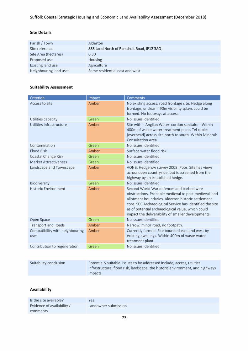
Suffolk Coastal Strategic Housing and Economic Land Availability Assessment (December 2018)
73
Site Details
Parish / Town Alderton
Site reference 855 Land North of Ramsholt Road, IP12 3AQ
Site Area (hectares) 0.30
Proposed use Housing
Existing land use Agriculture
Neighbouring land uses Some residential east and west.
Suitability Assessment
Criterion Impact Comments
Access to site Amber No existing access; road frontage site. Hedge along frontage, unclear if 90m visibility splays could be formed. No footways at access.
Utilities capacity Green No issues identified.
Utilities Infrastructure Amber Site within Anglian Water cordon sanitaire - Within 400m of waste water treatment plant. Tel cables (overhead) across site north to south. Within Minerals Consultation Area.
Contamination Green No issues identified.
Flood Risk Amber Surface water flood risk
Coastal Change Risk Green No issues identified.
Market Attractiveness Green No issues identified.
Landscape and Townscape Amber AONB. Hedgerow survey 2008: Poor. Site has views across open countryside, but is screened from the highway by an established hedge.
Biodiversity Green No issues identified.
Historic Environment Amber Second World War defences and barbed wire obstructions. Probable medieval to post medieval land allotment boundaries. Alderton historic settlement core. SCC Archaeological Service has identified the site as of potential archaeological value, which could impact the deliverability of smaller developments.
Open Space Green No issues identified.
Transport and Roads Amber Narrow, minor road, no footpath.
Compatibility with neighbouring uses
Amber Currently farmed. Site bounded east and west by existing dwellings. Within 400m of waste water treatment plant.
Contribution to regeneration Green No issues identified.
Suitability conclusion Potentially suitable. Issues to be addressed include; access, utilities infrastructure, flood risk, landscape, the historic environment, and highways impacts.
Availability
Is the site available? Yes
Evidence of availability / comments
Landowner submission

Suffolk Coastal Strategic Housing and Economic Land Availability Assessment (December 2018)
74
Achievability
Is the site achievable? Yes
Evidence of achievability No specific issues or abnormal costs identified
Are there any commencement issues?
None identified
Estimated dwellings yield 5
Estimated employment land yield (hectares) -
Estimated retail floorspace (sqm) -
Estimated commencement date 2021/22
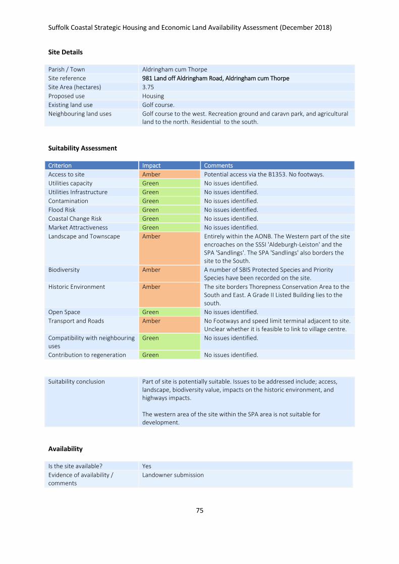
Suffolk Coastal Strategic Housing and Economic Land Availability Assessment (December 2018)
75
Site Details
Parish / Town Aldringham cum Thorpe
Site reference 981 Land off Aldringham Road, Aldringham cum Thorpe
Site Area (hectares) 3.75
Proposed use Housing
Existing land use Golf course.
Neighbouring land uses Golf course to the west. Recreation ground and caravn park, and agricultural land to the north. Residential to the south.
Suitability Assessment
Criterion Impact Comments
Access to site Amber Potential access via the B1353. No footways.
Utilities capacity Green No issues identified.
Utilities Infrastructure Green No issues identified.
Contamination Green No issues identified.
Flood Risk Green No issues identified.
Coastal Change Risk Green No issues identified.
Market Attractiveness Green No issues identified.
Landscape and Townscape Amber Entirely within the AONB. The Western part of the site encroaches on the SSSI 'Aldeburgh-Leiston' and the SPA 'Sandlings'. The SPA 'Sandlings' also borders the site to the South.
Biodiversity Amber A number of SBIS Protected Species and Priority Species have been recorded on the site.
Historic Environment Amber The site borders Thorepness Conservation Area to the South and East. A Grade II Listed Building lies to the south.
Open Space Green No issues identified.
Transport and Roads Amber No Footways and speed limit terminal adjacent to site. Unclear whether it is feasible to link to village centre.
Compatibility with neighbouring uses
Green No issues identified.
Contribution to regeneration Green No issues identified.
Suitability conclusion Part of site is potentially suitable. Issues to be addressed include; access, landscape, biodiversity value, impacts on the historic environment, and highways impacts. The western area of the site within the SPA area is not suitable for development.
Availability
Is the site available? Yes
Evidence of availability / comments
Landowner submission

Suffolk Coastal Strategic Housing and Economic Land Availability Assessment (December 2018)
76
Achievability
Is the site achievable? Yes
Evidence of achievability No specific issues or abnormal costs identified
Are there any commencement issues?
None identified
Estimated dwellings yield 56
Estimated employment land yield (hectares) -
Estimated retail floorspace (sqm) -
Estimated commencement date 2021/22
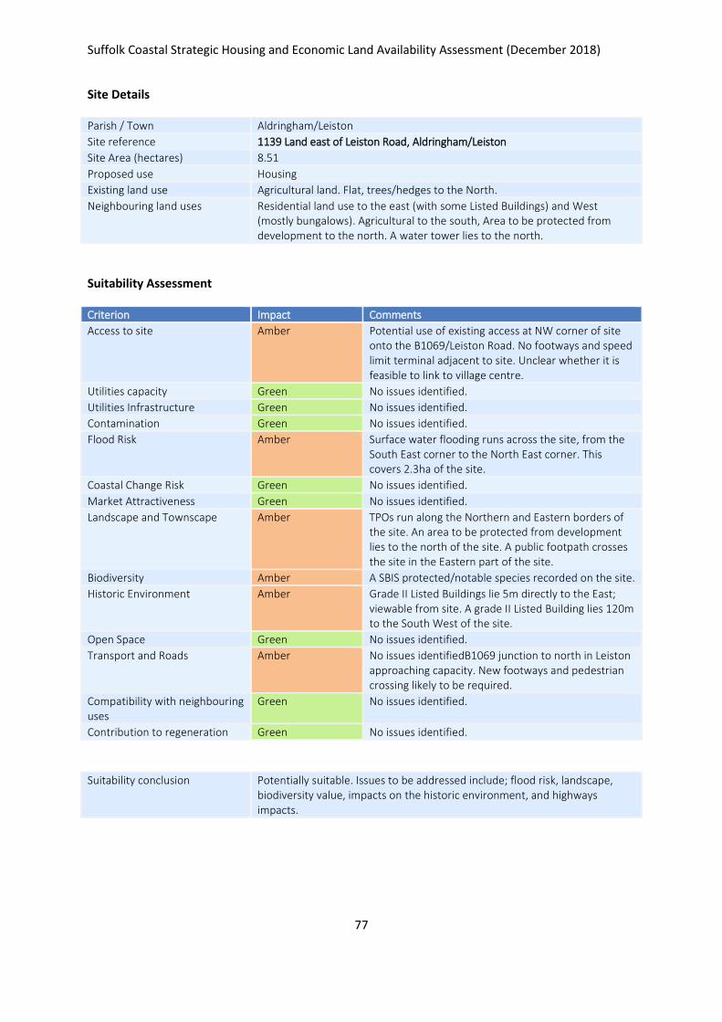
Suffolk Coastal Strategic Housing and Economic Land Availability Assessment (December 2018)
77
Site Details
Parish / Town Aldringham/Leiston
Site reference 1139 Land east of Leiston Road, Aldringham/Leiston
Site Area (hectares) 8.51
Proposed use Housing
Existing land use Agricultural land. Flat, trees/hedges to the North.
Neighbouring land uses Residential land use to the east (with some Listed Buildings) and West (mostly bungalows). Agricultural to the south, Area to be protected from development to the north. A water tower lies to the north.
Suitability Assessment
Criterion Impact Comments
Access to site Amber Potential use of existing access at NW corner of site onto the B1069/Leiston Road. No footways and speed limit terminal adjacent to site. Unclear whether it is feasible to link to village centre.
Utilities capacity Green No issues identified.
Utilities Infrastructure Green No issues identified.
Contamination Green No issues identified.
Flood Risk Amber Surface water flooding runs across the site, from the South East corner to the North East corner. This covers 2.3ha of the site.
Coastal Change Risk Green No issues identified.
Market Attractiveness Green No issues identified.
Landscape and Townscape Amber TPOs run along the Northern and Eastern borders of the site. An area to be protected from development lies to the north of the site. A public footpath crosses the site in the Eastern part of the site.
Biodiversity Amber A SBIS protected/notable species recorded on the site.
Historic Environment Amber Grade II Listed Buildings lie 5m directly to the East; viewable from site. A grade II Listed Building lies 120m to the South West of the site.
Open Space Green No issues identified.
Transport and Roads Amber No issues identifiedB1069 junction to north in Leiston approaching capacity. New footways and pedestrian crossing likely to be required.
Compatibility with neighbouring uses
Green No issues identified.
Contribution to regeneration Green No issues identified.
Suitability conclusion Potentially suitable. Issues to be addressed include; flood risk, landscape, biodiversity value, impacts on the historic environment, and highways impacts.

Suffolk Coastal Strategic Housing and Economic Land Availability Assessment (December 2018)
78
Availability
Is the site available? Yes
Evidence of availability / comments
Landowner submission
Achievability
Is the site achievable? Yes
Evidence of achievability No specific issues or abnormal costs identified
Are there any commencement issues?
None identified
Estimated dwellings yield 128
Estimated employment land yield (hectares) -
Estimated retail floorspace (sqm) -
Estimated commencement date 2023/24
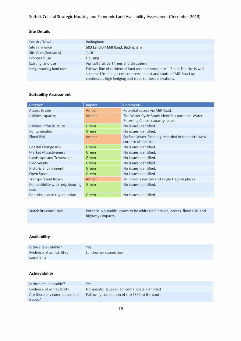
Suffolk Coastal Strategic Housing and Economic Land Availability Assessment (December 2018)
79
Site Details
Parish / Town Badingham
Site reference 503 Land off Mill Road, Badingham
Site Area (hectares) 1.16
Proposed use Housing
Existing land use Agricultural, part trees and shrubbery
Neighbouring land uses Follows line of residential land use and borders Mill Road. The site is well screened from adjacent countryside east and south of Mill Road by continuous high hedging and trees to these elevations.
Suitability Assessment
Criterion Impact Comments
Access to site Amber Potential access via Mill Road.
Utilities capacity Amber The Water Cycle Study identifies potential Water Recycling Centre capacity issues.
Utilities Infrastructure Green No issues identified.
Contamination Green No issues identified.
Flood Risk Amber Surface Water Flooding recorded in the north west cornern of the site.
Coastal Change Risk Green No issues identified.
Market Attractiveness Green No issues identified.
Landscape and Townscape Green No issues identified.
Biodiversity Green No issues identified.
Historic Environment Green No issues identified.
Open Space Green No issues identified.
Transport and Roads Amber Mill road is narrow and single track in places.
Compatibility with neighbouring uses
Green No issues identified.
Contribution to regeneration Green No issues identified.
Suitability conclusion Potentially suitable. Issues to be addressed include; access, flood risk, and highways impacts.
Availability
Is the site available? Yes
Evidence of availability / comments
Landowner submission
Achievability
Is the site achievable? Yes
Evidence of achievability No specific issues or abnormal costs identified
Are there any commencement issues?
Following completion of site SSP5 to the south

Suffolk Coastal Strategic Housing and Economic Land Availability Assessment (December 2018)
80
Estimated dwellings yield 17
Estimated employment land yield (hectares) -
Estimated retail floorspace (sqm) -
Estimated commencement date 2023/24
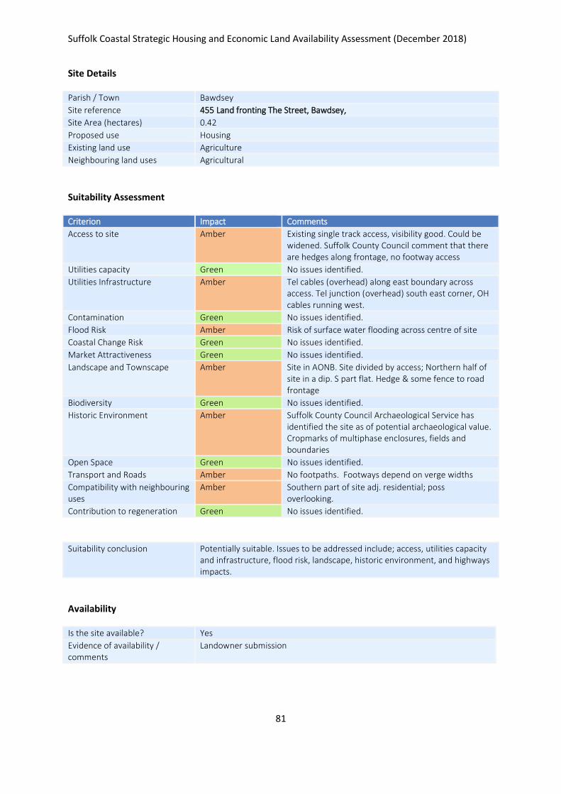
Suffolk Coastal Strategic Housing and Economic Land Availability Assessment (December 2018)
81
Site Details
Parish / Town Bawdsey
Site reference 455 Land fronting The Street, Bawdsey,
Site Area (hectares) 0.42
Proposed use Housing
Existing land use Agriculture
Neighbouring land uses Agricultural
Suitability Assessment
Criterion Impact Comments
Access to site Amber Existing single track access, visibility good. Could be widened. Suffolk County Council comment that there are hedges along frontage, no footway access
Utilities capacity Green No issues identified.
Utilities Infrastructure Amber Tel cables (overhead) along east boundary across access. Tel junction (overhead) south east corner, OH cables running west.
Contamination Green No issues identified.
Flood Risk Amber Risk of surface water flooding across centre of site
Coastal Change Risk Green No issues identified.
Market Attractiveness Green No issues identified.
Landscape and Townscape Amber Site in AONB. Site divided by access; Northern half of site in a dip. S part flat. Hedge & some fence to road frontage
Biodiversity Green No issues identified.
Historic Environment Amber Suffolk County Council Archaeological Service has identified the site as of potential archaeological value. Cropmarks of multiphase enclosures, fields and boundaries
Open Space Green No issues identified.
Transport and Roads Amber No footpaths. Footways depend on verge widths
Compatibility with neighbouring uses
Amber Southern part of site adj. residential; poss overlooking.
Contribution to regeneration Green No issues identified.
Suitability conclusion Potentially suitable. Issues to be addressed include; access, utilities capacity and infrastructure, flood risk, landscape, historic environment, and highways impacts.
Availability
Is the site available? Yes
Evidence of availability / comments
Landowner submission

Suffolk Coastal Strategic Housing and Economic Land Availability Assessment (December 2018)
82
Achievability
Is the site achievable? Yes
Evidence of achievability No specific issues or abnormal costs identified
Are there any commencement issues?
None identified
Estimated dwellings yield 6
Estimated employment land yield (hectares) -
Estimated retail floorspace (sqm) -
Estimated commencement date 2021/22
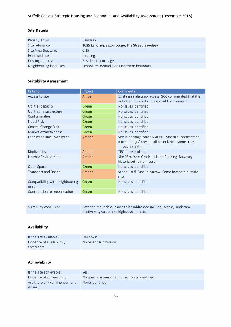
Suffolk Coastal Strategic Housing and Economic Land Availability Assessment (December 2018)
83
Site Details
Parish / Town Bawdsey
Site reference 1035 Land adj. Saxon Lodge, The Street, Bawdsey
Site Area (hectares) 0.25
Proposed use Housing
Existing land use Residential curtilage
Neighbouring land uses School, residential along northern boundary.
Suitability Assessment
Criterion Impact Comments
Access to site Amber Existing single track access. SCC commented that it is not clear if visibility splays could be formed.
Utilities capacity Green No issues identified.
Utilities Infrastructure Green No issues identified.
Contamination Green No issues identified.
Flood Risk Green No issues identified.
Coastal Change Risk Green No issues identified.
Market Attractiveness Green No issues identified.
Landscape and Townscape Amber Site in heritage coast & AONB. Site flat. Intermittent mixed hedge/trees on all boundaries. Some trees throughout site.
Biodiversity Amber TPO to rear of site
Historic Environment Amber Site 95m from Grade II Listed Building. Bawdsey historic settlement core
Open Space Green No issues identified.
Transport and Roads Amber School Ln & East Ln narrow. Some footpath outside site.
Compatibility with neighbouring uses
Green No issues identified.
Contribution to regeneration Green No issues identified.
Suitability conclusion Potentially suitable. Issues to be addressed include; access, landscape, biodiversity value, and highways impacts.
Availability
Is the site available? Unknown
Evidence of availability / comments
No recent submission
Achievability
Is the site achievable? Yes
Evidence of achievability No specific issues or abnormal costs identified
Are there any commencement issues?
None identified

Suffolk Coastal Strategic Housing and Economic Land Availability Assessment (December 2018)
84
Estimated dwellings yield 4
Estimated employment land yield (hectares) -
Estimated retail floorspace (sqm) -
Estimated commencement date 2023/24
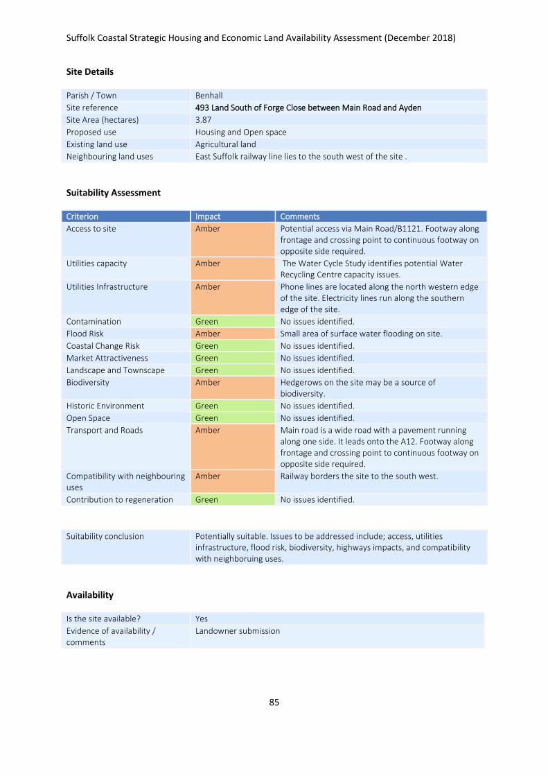
Suffolk Coastal Strategic Housing and Economic Land Availability Assessment (December 2018)
85
Site Details
Parish / Town Benhall
Site reference 493 Land South of Forge Close between Main Road and Ayden
Site Area (hectares) 3.87
Proposed use Housing and Open space
Existing land use Agricultural land
Neighbouring land uses East Suffolk railway line lies to the south west of the site .
Suitability Assessment
Criterion Impact Comments
Access to site Amber Potential access via Main Road/B1121. Footway along frontage and crossing point to continuous footway on opposite side required.
Utilities capacity Amber The Water Cycle Study identifies potential Water Recycling Centre capacity issues.
Utilities Infrastructure Amber Phone lines are located along the north western edge of the site. Electricity lines run along the southern edge of the site.
Contamination Green No issues identified.
Flood Risk Amber Small area of surface water flooding on site.
Coastal Change Risk Green No issues identified.
Market Attractiveness Green No issues identified.
Landscape and Townscape Green No issues identified.
Biodiversity Amber Hedgerows on the site may be a source of biodiversity.
Historic Environment Green No issues identified.
Open Space Green No issues identified.
Transport and Roads Amber Main road is a wide road with a pavement running along one side. It leads onto the A12. Footway along frontage and crossing point to continuous footway on opposite side required.
Compatibility with neighbouring uses
Amber Railway borders the site to the south west.
Contribution to regeneration Green No issues identified.
Suitability conclusion Potentially suitable. Issues to be addressed include; access, utilities infrastructure, flood risk, biodiversity, highways impacts, and compatibility with neighboruing uses.
Availability
Is the site available? Yes
Evidence of availability / comments
Landowner submission
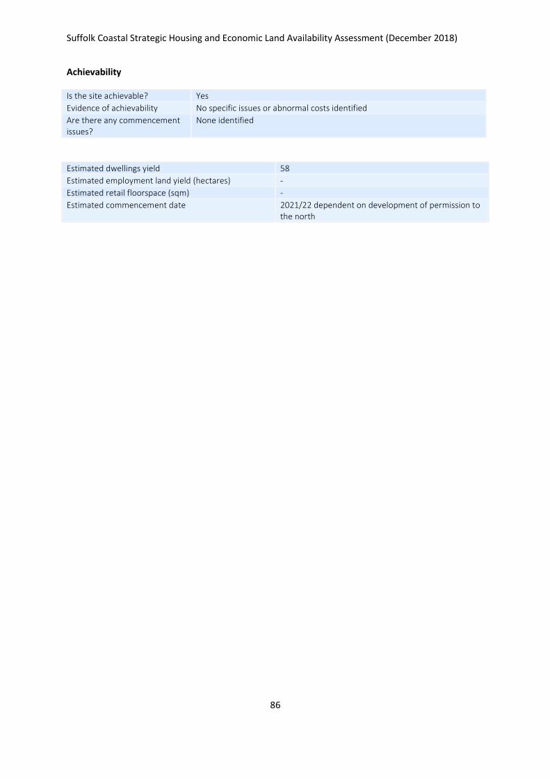
Suffolk Coastal Strategic Housing and Economic Land Availability Assessment (December 2018)
86
Achievability
Is the site achievable? Yes
Evidence of achievability No specific issues or abnormal costs identified
Are there any commencement issues?
None identified
Estimated dwellings yield 58
Estimated employment land yield (hectares) -
Estimated retail floorspace (sqm) -
Estimated commencement date 2021/22 dependent on development of permission to the north

Suffolk Coastal Strategic Housing and Economic Land Availability Assessment (December 2018)
87
Site Details
Parish / Town Benhall
Site reference 494 Land fronting Main Road between Grays Lane and Kiln Lane
Site Area (hectares) 13.90
Proposed use Housing
Existing land use Agricultural
Neighbouring land uses Railway line runs along the western edge of the site.
Suitability Assessment
Criterion Impact Comments
Access to site Amber Potential access via Main road, Kiln Lane, and Grays Lane. Potential impact upon Church Street signalised junction. Detailed analysis and potential mitigation required. Footway widening required on Main Rd. Assess in conjunction with adjacent site
Utilities capacity Amber The Water Cycle Study identifies potential Water Recycling Centre capacity issues.
Utilities Infrastructure Green No issues identified.
Contamination Green No issues identified.
Flood Risk Amber Surface water flooding runs through the middle of the site.
Coastal Change Risk Green No issues identified.
Market Attractiveness Green No issues identified.
Landscape and Townscape Amber A public footpath runs through the eastern part of the site.
Biodiversity Green No issues identified.
Historic Environment Amber Grade II Listed Buildings are located to the south and east of the site.
Open Space Green No issues identified.
Transport and Roads Amber Potential impact upon Church Street signalised junction. Detailed analysis and potential mitigation required. Footway widening required on Main Rd. Assess in conjunction with adjacent sites.
Compatibility with neighbouring uses
Amber Railway line runs along the western edge of the site.
Contribution to regeneration Green No issues identified.
Suitability conclusion Potentially suitable. Issues to be addressed include; access, flood risk, landscape, historic environment, highways impacts, and compatibility with neighbouring uses. Part development may be suitable.
Availability
Is the site available? Yes
Evidence of availability / comments
Landowner submission
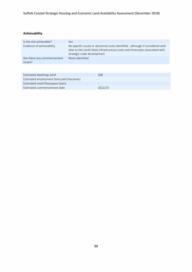
Suffolk Coastal Strategic Housing and Economic Land Availability Assessment (December 2018)
88
Achievability
Is the site achievable? Yes
Evidence of achievability No specific issues or abnormal costs identified , although if considered with sites to the north likely infrastructure costs and timescales associated with strategic scale development
Are there any commencement issues?
None identified
Estimated dwellings yield 208
Estimated employment land yield (hectares) -
Estimated retail floorspace (sqm) -
Estimated commencement date 2022/23
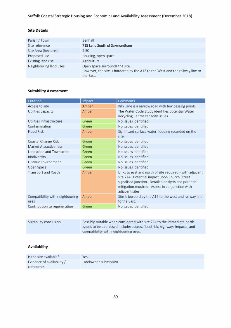
Suffolk Coastal Strategic Housing and Economic Land Availability Assessment (December 2018)
89
Site Details
Parish / Town Benhall
Site reference 715 Land South of Saxmundham
Site Area (hectares) 4.50
Proposed use Housing, open space
Existing land use Agriculture
Neighbouring land uses Open space surrounds the site. However, the site is bordered by the A12 to the West and the railway line to the East.
Suitability Assessment
Criterion Impact Comments
Access to site Amber Kiln Lane is a narrow road with few passing points.
Utilities capacity Amber The Water Cycle Study identifies potential Water Recycling Centre capacity issues.
Utilities Infrastructure Green No issues identified.
Contamination Green No issues identified.
Flood Risk Amber Significant surface water flooding recorded on the site.
Coastal Change Risk Green No issues identified.
Market Attractiveness Green No issues identified.
Landscape and Townscape Green No issues identified.
Biodiversity Green No issues identified.
Historic Environment Green No issues identified.
Open Space Green No issues identified.
Transport and Roads Amber Links to east and north of site required - with adjacent site 714. Potential impact upon Church Street signalised junction. Detailed analysis and potential mitigation required. Assess in conjunction with adjacent sites.
Compatibility with neighbouring uses
Amber Site is borderd by the A12 to the west and railway line to the East.
Contribution to regeneration Green No issues identified.
Suitability conclusion Possibly suitable when considered with site 714 to the immediate north. Issues to be addressed include; access, flood risk, highways impacts, and compatibility with neighbouring uses.
Availability
Is the site available? Yes
Evidence of availability / comments
Landowner submission
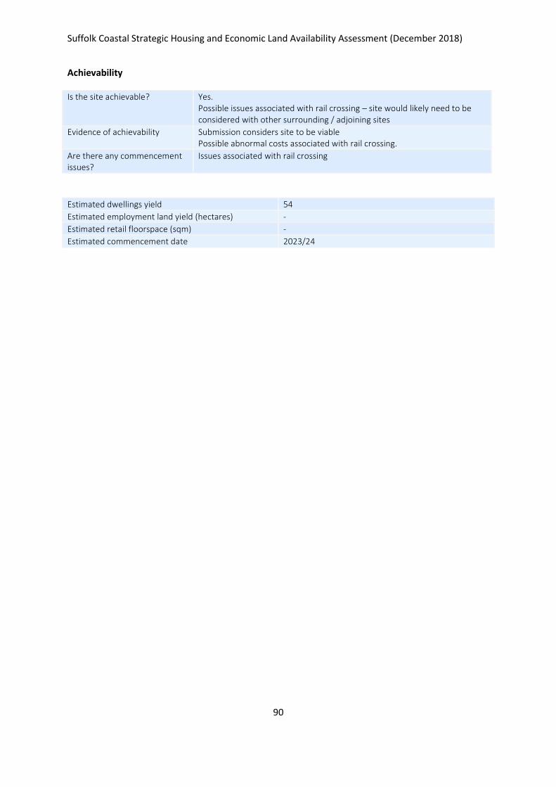
Suffolk Coastal Strategic Housing and Economic Land Availability Assessment (December 2018)
90
Achievability
Is the site achievable? Yes. Possible issues associated with rail crossing – site would likely need to be considered with other surrounding / adjoining sites
Evidence of achievability Submission considers site to be viable Possible abnormal costs associated with rail crossing.
Are there any commencement issues?
Issues associated with rail crossing
Estimated dwellings yield 54
Estimated employment land yield (hectares) -
Estimated retail floorspace (sqm) -
Estimated commencement date 2023/24
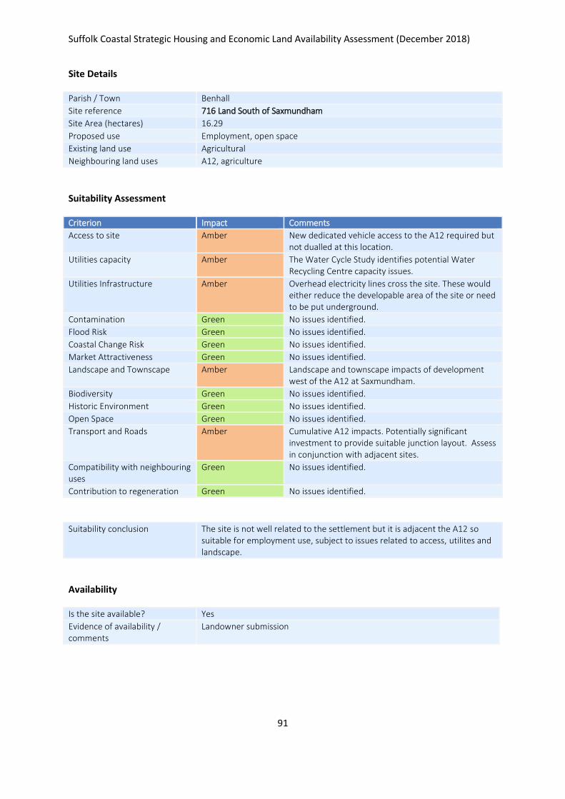
Suffolk Coastal Strategic Housing and Economic Land Availability Assessment (December 2018)
91
Site Details
Parish / Town Benhall
Site reference 716 Land South of Saxmundham
Site Area (hectares) 16.29
Proposed use Employment, open space
Existing land use Agricultural
Neighbouring land uses A12, agriculture
Suitability Assessment
Criterion Impact Comments
Access to site Amber New dedicated vehicle access to the A12 required but not dualled at this location.
Utilities capacity Amber The Water Cycle Study identifies potential Water Recycling Centre capacity issues.
Utilities Infrastructure Amber Overhead electricity lines cross the site. These would either reduce the developable area of the site or need to be put underground.
Contamination Green No issues identified.
Flood Risk Green No issues identified.
Coastal Change Risk Green No issues identified.
Market Attractiveness Green No issues identified.
Landscape and Townscape Amber Landscape and townscape impacts of development west of the A12 at Saxmundham.
Biodiversity Green No issues identified.
Historic Environment Green No issues identified.
Open Space Green No issues identified.
Transport and Roads Amber Cumulative A12 impacts. Potentially significant investment to provide suitable junction layout. Assess in conjunction with adjacent sites.
Compatibility with neighbouring uses
Green No issues identified.
Contribution to regeneration Green No issues identified.
Suitability conclusion The site is not well related to the settlement but it is adjacent the A12 so suitable for employment use, subject to issues related to access, utilites and landscape.
Availability
Is the site available? Yes
Evidence of availability / comments
Landowner submission

Suffolk Coastal Strategic Housing and Economic Land Availability Assessment (December 2018)
92
Achievability
Is the site achievable? Yes
Evidence of achievability Submission considers site to be viable.
Are there any commencement issues?
None identified
Estimated dwellings yield -
Estimated employment land yield (hectares) 16
Estimated retail floorspace (sqm) -
Estimated commencement date 2022/23
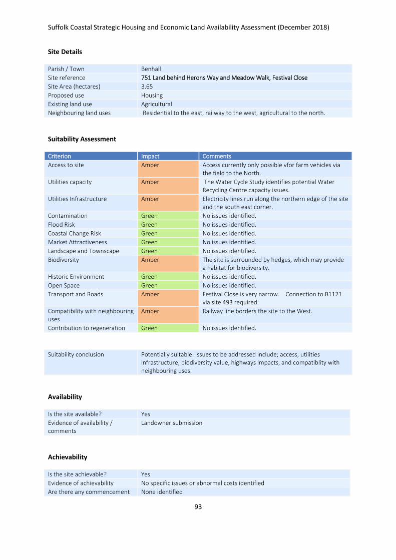
Suffolk Coastal Strategic Housing and Economic Land Availability Assessment (December 2018)
93
Site Details
Parish / Town Benhall
Site reference 751 Land behind Herons Way and Meadow Walk, Festival Close
Site Area (hectares) 3.65
Proposed use Housing
Existing land use Agricultural
Neighbouring land uses Residential to the east, railway to the west, agricultural to the north.
Suitability Assessment
Criterion Impact Comments
Access to site Amber Access currently only possible vfor farm vehicles via the field to the North.
Utilities capacity Amber The Water Cycle Study identifies potential Water Recycling Centre capacity issues.
Utilities Infrastructure Amber Electricity lines run along the northern edge of the site and the south east corner.
Contamination Green No issues identified.
Flood Risk Green No issues identified.
Coastal Change Risk Green No issues identified.
Market Attractiveness Green No issues identified.
Landscape and Townscape Green No issues identified.
Biodiversity Amber The site is surrounded by hedges, which may provide a habitat for biodiversity.
Historic Environment Green No issues identified.
Open Space Green No issues identified.
Transport and Roads Amber Festival Close is very narrow. Connection to B1121 via site 493 required.
Compatibility with neighbouring uses
Amber Railway line borders the site to the West.
Contribution to regeneration Green No issues identified.
Suitability conclusion Potentially suitable. Issues to be addressed include; access, utilities infrastructure, biodiversity value, highways impacts, and compatiblity with neighbouring uses.
Availability
Is the site available? Yes
Evidence of availability / comments
Landowner submission
Achievability
Is the site achievable? Yes
Evidence of achievability No specific issues or abnormal costs identified
Are there any commencement None identified

Suffolk Coastal Strategic Housing and Economic Land Availability Assessment (December 2018)
94
issues?
Estimated dwellings yield 55
Estimated employment land yield (hectares) -
Estimated retail floorspace (sqm) -
Estimated commencement date 2021/22
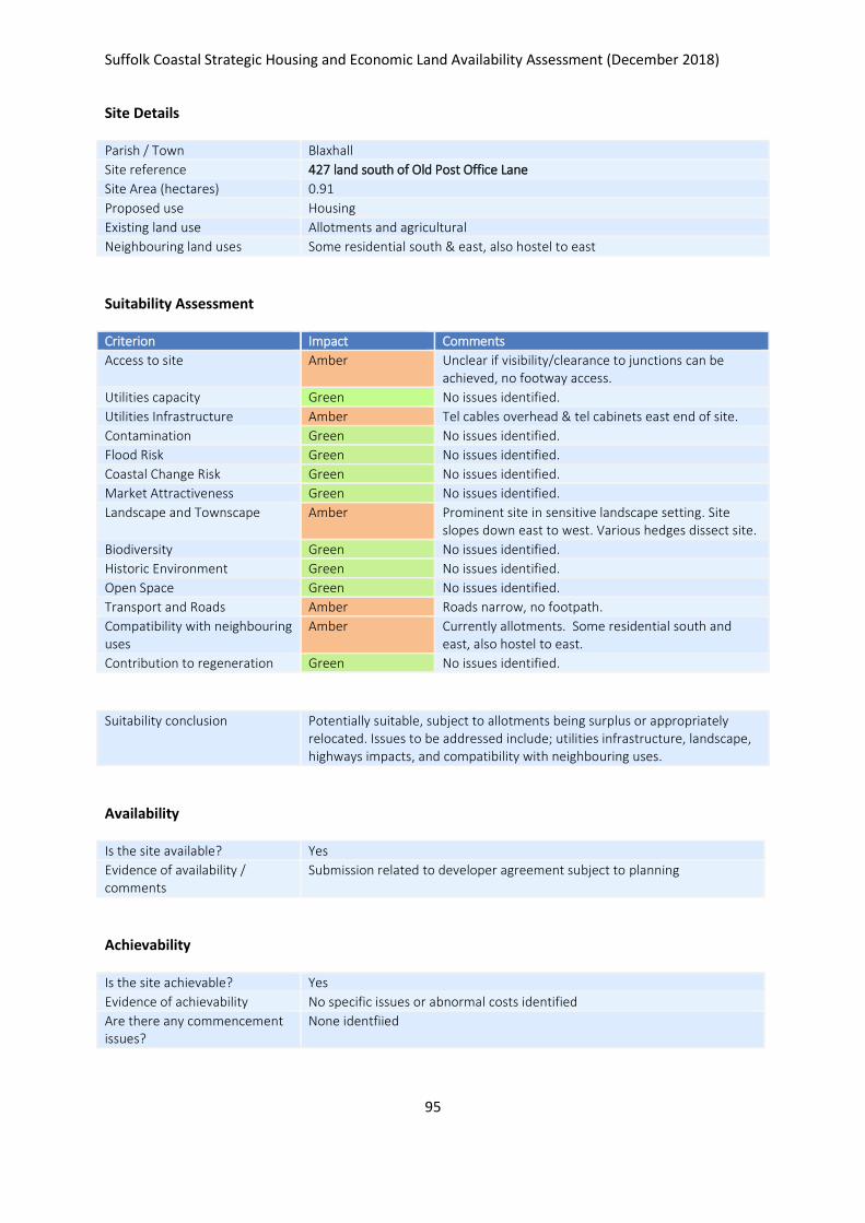
Suffolk Coastal Strategic Housing and Economic Land Availability Assessment (December 2018)
95
Site Details
Parish / Town Blaxhall
Site reference 427 land south of Old Post Office Lane
Site Area (hectares) 0.91
Proposed use Housing
Existing land use Allotments and agricultural
Neighbouring land uses Some residential south & east, also hostel to east
Suitability Assessment
Criterion Impact Comments
Access to site Amber Unclear if visibility/clearance to junctions can be achieved, no footway access.
Utilities capacity Green No issues identified.
Utilities Infrastructure Amber Tel cables overhead & tel cabinets east end of site.
Contamination Green No issues identified.
Flood Risk Green No issues identified.
Coastal Change Risk Green No issues identified.
Market Attractiveness Green No issues identified.
Landscape and Townscape Amber Prominent site in sensitive landscape setting. Site slopes down east to west. Various hedges dissect site.
Biodiversity Green No issues identified.
Historic Environment Green No issues identified.
Open Space Green No issues identified.
Transport and Roads Amber Roads narrow, no footpath.
Compatibility with neighbouring uses
Amber Currently allotments. Some residential south and east, also hostel to east.
Contribution to regeneration Green No issues identified.
Suitability conclusion Potentially suitable, subject to allotments being surplus or appropriately relocated. Issues to be addressed include; utilities infrastructure, landscape, highways impacts, and compatibility with neighbouring uses.
Availability
Is the site available? Yes
Evidence of availability / comments
Submission related to developer agreement subject to planning
Achievability
Is the site achievable? Yes
Evidence of achievability No specific issues or abnormal costs identified
Are there any commencement issues?
None identfiied

Suffolk Coastal Strategic Housing and Economic Land Availability Assessment (December 2018)
96
Estimated dwellings yield 14
Estimated employment land yield (hectares) -
Estimated retail floorspace (sqm) -
Estimated commencement date 2021/22
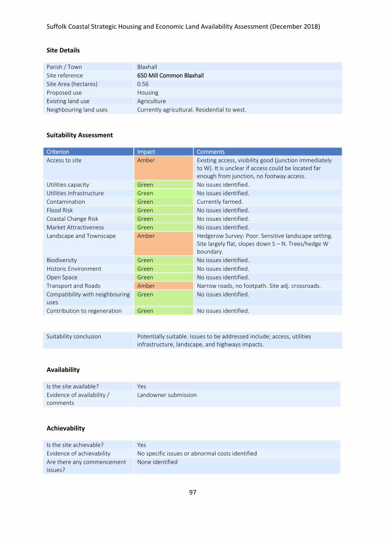
Suffolk Coastal Strategic Housing and Economic Land Availability Assessment (December 2018)
97
Site Details
Parish / Town Blaxhall
Site reference 650 Mill Common Blaxhall
Site Area (hectares) 0.56
Proposed use Housing
Existing land use Agriculture
Neighbouring land uses Currently agricultural. Residential to west.
Suitability Assessment
Criterion Impact Comments
Access to site Amber Existing access, visibility good (junction immediately to W). It is unclear if access could be located far enough from junction, no footway access.
Utilities capacity Green No issues identified.
Utilities Infrastructure Green No issues identified.
Contamination Green Currently farmed.
Flood Risk Green No issues identified.
Coastal Change Risk Green No issues identified.
Market Attractiveness Green No issues identified.
Landscape and Townscape Amber Hedgerow Survey: Poor. Sensitive landscape setting. Site largely flat, slopes down S – N. Trees/hedge W boundary.
Biodiversity Green No issues identified.
Historic Environment Green No issues identified.
Open Space Green No issues identified.
Transport and Roads Amber Narrow roads, no footpath. Site adj. crossroads.
Compatibility with neighbouring uses
Green No issues identified.
Contribution to regeneration Green No issues identified.
Suitability conclusion Potentially suitable. Issues to be addressed include; access, utilities infrastructure, landscape, and highways impacts.
Availability
Is the site available? Yes
Evidence of availability / comments
Landowner submission
Achievability
Is the site achievable? Yes
Evidence of achievability No specific issues or abnormal costs identified
Are there any commencement issues?
None identified

Suffolk Coastal Strategic Housing and Economic Land Availability Assessment (December 2018)
98
Estimated dwellings yield 8
Estimated employment land yield (hectares) -
Estimated retail floorspace (sqm) -
Estimated commencement date 2023/24
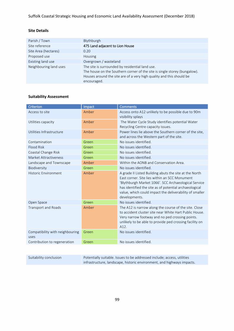
Suffolk Coastal Strategic Housing and Economic Land Availability Assessment (December 2018)
99
Site Details
Parish / Town Blythburgh
Site reference 475 Land adjacent to Lion House
Site Area (hectares) 0.20
Proposed use Housing
Existing land use Overgrown / wasteland
Neighbouring land uses The site is surrounded by residential land use. The house on the Southern corner of the site is single storey (bungalow). Houses around the site are of a very high quality and this should be encouraged.
Suitability Assessment
Criterion Impact Comments
Access to site Amber Access onto A12 unlikely to be possible due to 90m visibility splays
Utilities capacity Amber The Water Cycle Study identifies potential Water Recycling Centre capacity issues.
Utilities Infrastructure Amber Power lines lie above the Southern corner of the site, and across the Western part of the site.
Contamination Green No issues identified.
Flood Risk Green No issues identified.
Coastal Change Risk Green No issues identified.
Market Attractiveness Green No issues identified.
Landscape and Townscape Amber Within the AONB and Conservation Area.
Biodiversity Green No issues identified.
Historic Environment Amber A grade II Listed Building abuts the site at the North East corner. Site lies within an SCC Monument ‘Blythburgh Market 1066’. SCC Archaeological Service has identified the site as of potential archaeological value, which could impact the deliverability of smaller developments.
Open Space Green No issues identified.
Transport and Roads Amber The A12 is narrow along the course of the site. Close to accident cluster site near White Hart Public House. Very narrow footway and no ped crossing points. unlikely to be able to provide ped crossing facility on A12.
Compatibility with neighbouring uses
Green No issues identified.
Contribution to regeneration Green No issues identified.
Suitability conclusion Potentially suitable. Issues to be addressed include; access, utilities infrastructure, landscape, historic environment, and highways impacts.

Suffolk Coastal Strategic Housing and Economic Land Availability Assessment (December 2018)
100
Availability
Is the site available? Yes
Evidence of availability / comments
Submission by landowners
Achievability
Is the site achievable? Yes
Evidence of achievability No specific issues or abnormal costs identified
Are there any commencement issues?
None identified
Estimated dwellings yield 3
Estimated employment land yield (hectares) -
Estimated retail floorspace (sqm) -
Estimated commencement date 2021/22
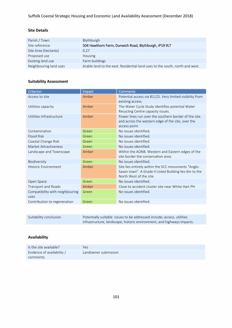
Suffolk Coastal Strategic Housing and Economic Land Availability Assessment (December 2018)
101
Site Details
Parish / Town Blythburgh
Site reference 504 Hawthorn Farm, Dunwich Road, Blythburgh, IP19 9LT
Site Area (hectares) 0.27
Proposed use Housing
Existing land use Farm buildings
Neighbouring land uses Arable land to the east. Residential land uses to the south, north and west.
Suitability Assessment
Criterion Impact Comments
Access to site Amber Potential access via B1125. Very limited visibility from existing access.
Utilities capacity Amber The Water Cycle Study identifies potential Water Recycling Centre capacity issues.
Utilities Infrastructure Amber Power lines run over the southern border of the site. and across the western edge of the site, over the access point.
Contamination Green No issues identified.
Flood Risk Green No issues identified.
Coastal Change Risk Green No issues identified.
Market Attractiveness Green No issues identified.
Landscape and Townscape Amber Within the AONB. Western and Eastern edges of the site border the conservation area.
Biodiversity Green No issues identified.
Historic Environment Amber Site lies entirely within the SCC monuments “Anglo-Saxon town”. A Grade II Listed Building lies 6m to the North West of the site.
Open Space Green No issues identified.
Transport and Roads Amber Close to accident cluster site near White Hart PH
Compatibility with neighbouring uses
Green No issues identified.
Contribution to regeneration Green No issues identified.
Suitability conclusion Potentially suitable. Issues to be addressed include; access, utilities infrastructure, landscape, historic environment, and highways impacts.
Availability
Is the site available? Yes
Evidence of availability / comments
Landowner submission
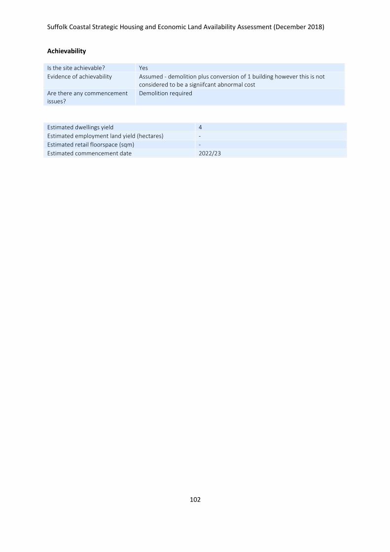
Suffolk Coastal Strategic Housing and Economic Land Availability Assessment (December 2018)
102
Achievability
Is the site achievable? Yes
Evidence of achievability Assumed - demolition plus conversion of 1 building however this is not considered to be a signiifcant abnormal cost
Are there any commencement issues?
Demolition required
Estimated dwellings yield 4
Estimated employment land yield (hectares) -
Estimated retail floorspace (sqm) -
Estimated commencement date 2022/23
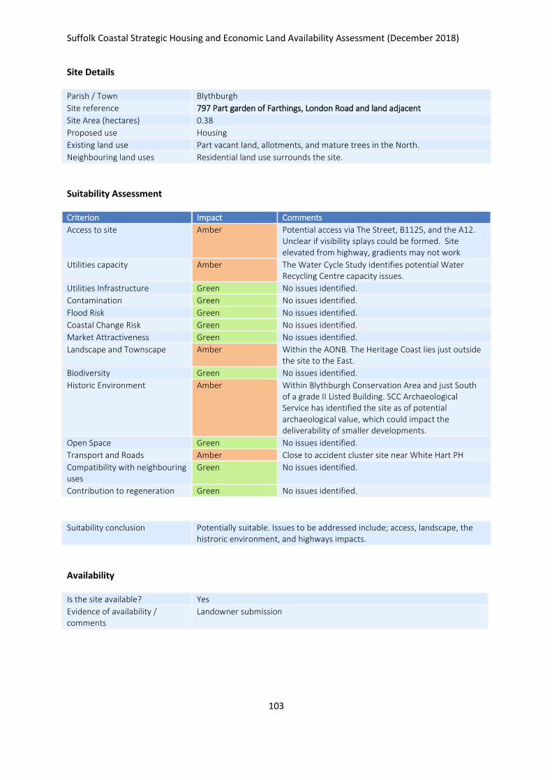
Suffolk Coastal Strategic Housing and Economic Land Availability Assessment (December 2018)
103
Site Details
Parish / Town Blythburgh
Site reference 797 Part garden of Farthings, London Road and land adjacent
Site Area (hectares) 0.38
Proposed use Housing
Existing land use Part vacant land, allotments, and mature trees in the North.
Neighbouring land uses Residential land use surrounds the site.
Suitability Assessment
Criterion Impact Comments
Access to site Amber Potential access via The Street, B1125, and the A12. Unclear if visibility splays could be formed. Site elevated from highway, gradients may not work
Utilities capacity Amber The Water Cycle Study identifies potential Water Recycling Centre capacity issues.
Utilities Infrastructure Green No issues identified.
Contamination Green No issues identified.
Flood Risk Green No issues identified.
Coastal Change Risk Green No issues identified.
Market Attractiveness Green No issues identified.
Landscape and Townscape Amber Within the AONB. The Heritage Coast lies just outside the site to the East.
Biodiversity Green No issues identified.
Historic Environment Amber Within Blythburgh Conservation Area and just South of a grade II Listed Building. SCC Archaeological Service has identified the site as of potential archaeological value, which could impact the deliverability of smaller developments.
Open Space Green No issues identified.
Transport and Roads Amber Close to accident cluster site near White Hart PH
Compatibility with neighbouring uses
Green No issues identified.
Contribution to regeneration Green No issues identified.
Suitability conclusion Potentially suitable. Issues to be addressed include; access, landscape, the histroric environment, and highways impacts.
Availability
Is the site available? Yes
Evidence of availability / comments
Landowner submission

Suffolk Coastal Strategic Housing and Economic Land Availability Assessment (December 2018)
104
Achievability
Is the site achievable? Yes
Evidence of achievability No specific issues or abnormal costs identified
Are there any commencement issues?
None identified
Estimated dwellings yield 6
Estimated employment land yield (hectares) -
Estimated retail floorspace (sqm) -
Estimated commencement date 2022/23
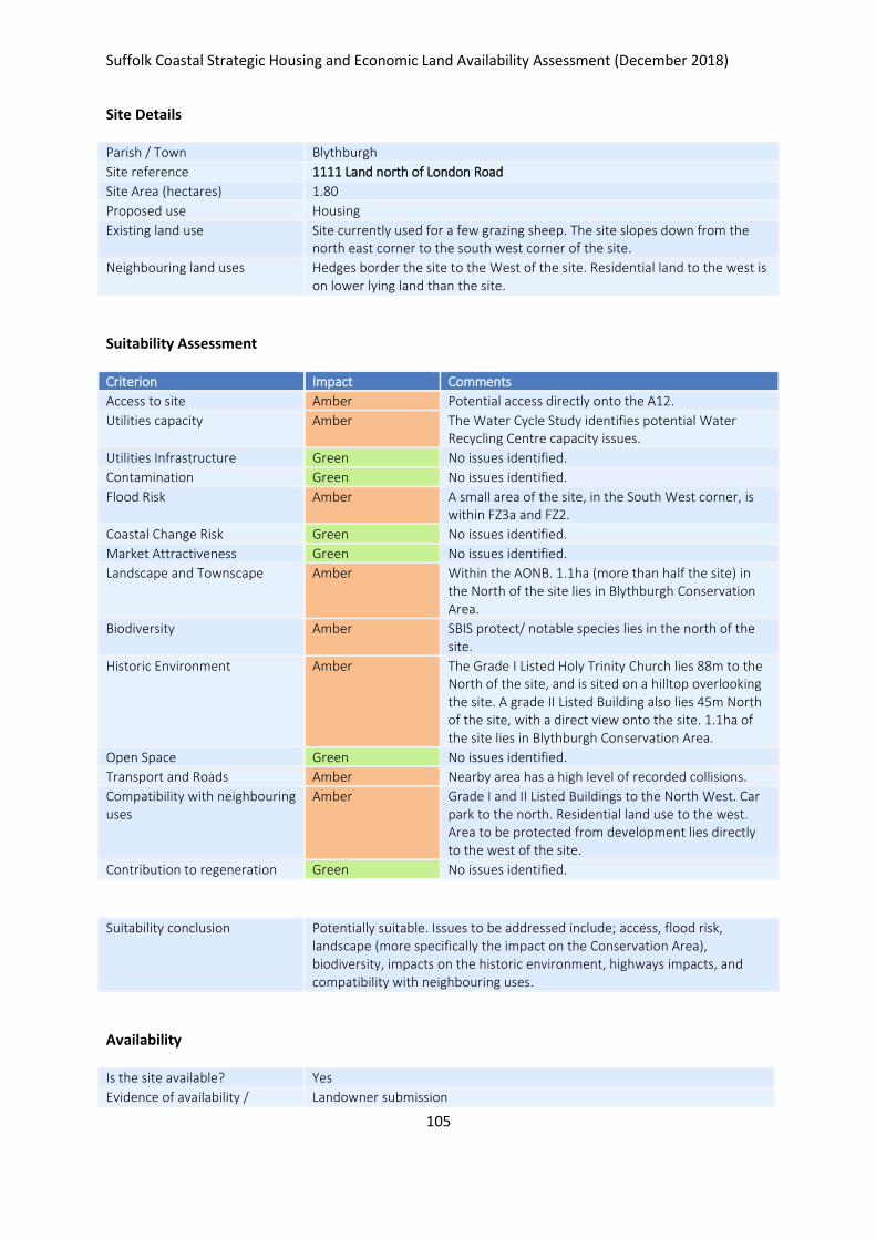
Suffolk Coastal Strategic Housing and Economic Land Availability Assessment (December 2018)
105
Site Details
Parish / Town Blythburgh
Site reference 1111 Land north of London Road
Site Area (hectares) 1.80
Proposed use Housing
Existing land use Site currently used for a few grazing sheep. The site slopes down from the north east corner to the south west corner of the site.
Neighbouring land uses Hedges border the site to the West of the site. Residential land to the west is on lower lying land than the site.
Suitability Assessment
Criterion Impact Comments
Access to site Amber Potential access directly onto the A12.
Utilities capacity Amber The Water Cycle Study identifies potential Water Recycling Centre capacity issues.
Utilities Infrastructure Green No issues identified.
Contamination Green No issues identified.
Flood Risk Amber A small area of the site, in the South West corner, is within FZ3a and FZ2.
Coastal Change Risk Green No issues identified.
Market Attractiveness Green No issues identified.
Landscape and Townscape Amber Within the AONB. 1.1ha (more than half the site) in the North of the site lies in Blythburgh Conservation Area.
Biodiversity Amber SBIS protect/ notable species lies in the north of the site.
Historic Environment Amber The Grade I Listed Holy Trinity Church lies 88m to the North of the site, and is sited on a hilltop overlooking the site. A grade II Listed Building also lies 45m North of the site, with a direct view onto the site. 1.1ha of the site lies in Blythburgh Conservation Area.
Open Space Green No issues identified.
Transport and Roads Amber Nearby area has a high level of recorded collisions.
Compatibility with neighbouring uses
Amber Grade I and II Listed Buildings to the North West. Car park to the north. Residential land use to the west. Area to be protected from development lies directly to the west of the site.
Contribution to regeneration Green No issues identified.
Suitability conclusion Potentially suitable. Issues to be addressed include; access, flood risk, landscape (more specifically the impact on the Conservation Area), biodiversity, impacts on the historic environment, highways impacts, and compatibility with neighbouring uses.
Availability
Is the site available? Yes
Evidence of availability / Landowner submission

Suffolk Coastal Strategic Housing and Economic Land Availability Assessment (December 2018)
106
comments
Achievability
Is the site achievable? Yes
Evidence of achievability No specific issues or abnormal costs identified
Are there any commencement issues?
None identifed
Estimated dwellings yield 27
Estimated employment land yield (hectares) -
Estimated retail floorspace (sqm) -
Estimated commencement date 2022/23
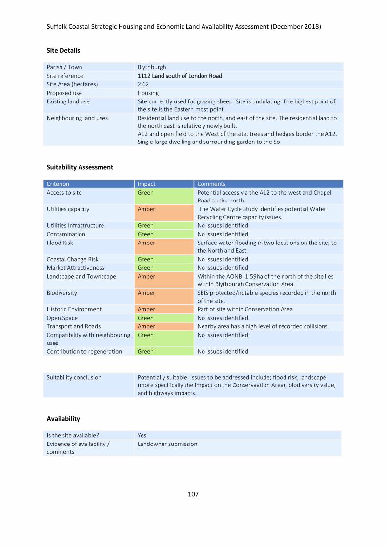
Suffolk Coastal Strategic Housing and Economic Land Availability Assessment (December 2018)
107
Site Details
Parish / Town Blythburgh
Site reference 1112 Land south of London Road
Site Area (hectares) 2.62
Proposed use Housing
Existing land use Site currently used for grazing sheep. Site is undulating. The highest point of the site is the Eastern most point.
Neighbouring land uses Residential land use to the north, and east of the site. The residential land to the north east is relatively newly built. A12 and open field to the West of the site, trees and hedges border the A12. Single large dwelling and surrounding garden to the So
Suitability Assessment
Criterion Impact Comments
Access to site Green Potential access via the A12 to the west and Chapel Road to the north.
Utilities capacity Amber The Water Cycle Study identifies potential Water Recycling Centre capacity issues.
Utilities Infrastructure Green No issues identified.
Contamination Green No issues identified.
Flood Risk Amber Surface water flooding in two locations on the site, to the North and East.
Coastal Change Risk Green No issues identified.
Market Attractiveness Green No issues identified.
Landscape and Townscape Amber Within the AONB. 1.59ha of the north of the site lies within Blythburgh Conservation Area.
Biodiversity Amber SBIS protected/notable species recorded in the north of the site.
Historic Environment Amber Part of site within Conservation Area
Open Space Green No issues identified.
Transport and Roads Amber Nearby area has a high level of recorded collisions.
Compatibility with neighbouring uses
Green No issues identified.
Contribution to regeneration Green No issues identified.
Suitability conclusion Potentially suitable. Issues to be addressed include; flood risk, landscape (more specifically the impact on the Conservaation Area), biodiversity value, and highways impacts.
Availability
Is the site available? Yes
Evidence of availability / comments
Landowner submission

Suffolk Coastal Strategic Housing and Economic Land Availability Assessment (December 2018)
108
Achievability
Is the site achievable? Yes
Evidence of achievability No specific issues or abnormal costs identified
Are there any commencement issues?
None identified
Estimated dwellings yield 39
Estimated employment land yield (hectares) -
Estimated retail floorspace (sqm) -
Estimated commencement date 2022/23

Suffolk Coastal Strategic Housing and Economic Land Availability Assessment (December 2018)
109
Site Details
Parish / Town Boyton
Site reference 762 Land South of Boyton Chapel, The Street
Site Area (hectares) 0.85
Proposed use Housing
Existing land use Agriculture
Neighbouring land uses Residential use to the north, west and south,Agricultural to the east.
Suitability Assessment
Criterion Impact Comments
Access to site Amber No existing access, but road frontage site. Site level higher than road level. Trees along frontage, no footway access
Utilities capacity Green No issues identified.
Utilities Infrastructure Green No issues identified.
Contamination Green No issues identified.
Flood Risk Green No issues identified.
Coastal Change Risk Green No issues identified.
Market Attractiveness Green No issues identified.
Landscape and Townscape Amber Hedgerow Survey: Poor. Site in AONB.
Biodiversity Amber BAP Species identified.
Historic Environment Green No issues identified.
Open Space Green No issues identified.
Transport and Roads Amber Roads narrow, no footpath.
Compatibility with neighbouring uses
Green Residential N, W, S, agricultural to E.
Contribution to regeneration Green No issues identified.
Suitability conclusion Potentially suitable. Issues to be addressed include; access, utilities capcaity, landscape, biodiversity value, and highways impacts.
Availability
Is the site available? Yes
Evidence of availability / comments
Landowner submission
Achievability
Is the site achievable? Yes
Evidence of achievability No specific issues or abnormal costs identified
Are there any commencement issues?
None identified

Suffolk Coastal Strategic Housing and Economic Land Availability Assessment (December 2018)
110
Estimated dwellings yield 13
Estimated employment land yield (hectares) -
Estimated retail floorspace (sqm) -
Estimated commencement date 2020/21
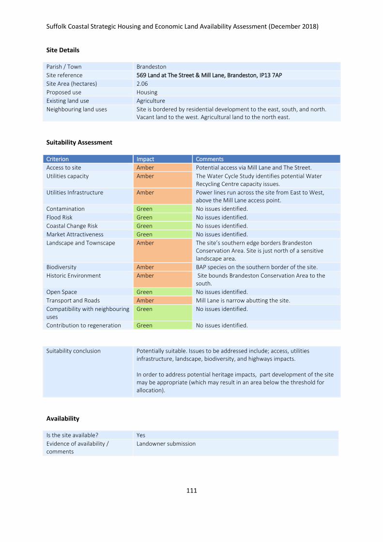
Suffolk Coastal Strategic Housing and Economic Land Availability Assessment (December 2018)
111
Site Details
Parish / Town Brandeston
Site reference 569 Land at The Street & Mill Lane, Brandeston, IP13 7AP
Site Area (hectares) 2.06
Proposed use Housing
Existing land use Agriculture
Neighbouring land uses Site is bordered by residential development to the east, south, and north. Vacant land to the west. Agricultural land to the north east.
Suitability Assessment
Criterion Impact Comments
Access to site Amber Potential access via Mill Lane and The Street.
Utilities capacity Amber The Water Cycle Study identifies potential Water Recycling Centre capacity issues.
Utilities Infrastructure Amber Power lines run across the site from East to West, above the Mill Lane access point.
Contamination Green No issues identified.
Flood Risk Green No issues identified.
Coastal Change Risk Green No issues identified.
Market Attractiveness Green No issues identified.
Landscape and Townscape Amber The site’s southern edge borders Brandeston Conservation Area. Site is just north of a sensitive landscape area.
Biodiversity Amber BAP species on the southern border of the site.
Historic Environment Amber Site bounds Brandeston Conservation Area to the south.
Open Space Green No issues identified.
Transport and Roads Amber Mill Lane is narrow abutting the site.
Compatibility with neighbouring uses
Green No issues identified.
Contribution to regeneration Green No issues identified.
Suitability conclusion Potentially suitable. Issues to be addressed include; access, utilities infrastructure, landscape, biodiversity, and highways impacts. In order to address potential heritage impacts, part development of the site may be appropriate (which may result in an area below the threshold for allocation).
Availability
Is the site available? Yes
Evidence of availability / comments
Landowner submission

Suffolk Coastal Strategic Housing and Economic Land Availability Assessment (December 2018)
112
Achievability
Is the site achievable? Yes
Evidence of achievability No specific issues or abnormal costs identified
Are there any commencement issues?
None identified
Estimated dwellings yield 31
Estimated employment land yield (hectares) -
Estimated retail floorspace (sqm) -
Estimated commencement date 2020/21
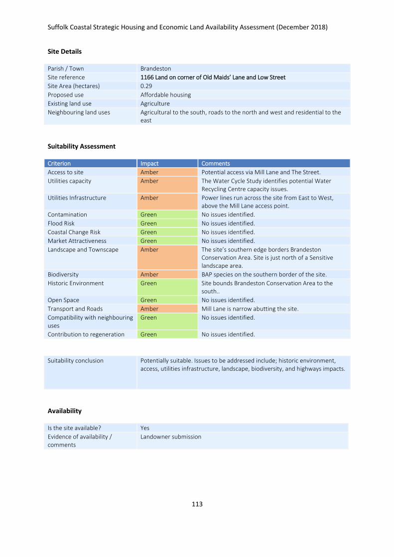
Suffolk Coastal Strategic Housing and Economic Land Availability Assessment (December 2018)
113
Site Details
Parish / Town Brandeston
Site reference 1166 Land on corner of Old Maids’ Lane and Low Street
Site Area (hectares) 0.29
Proposed use Affordable housing
Existing land use Agriculture
Neighbouring land uses Agricultural to the south, roads to the north and west and residential to the east
Suitability Assessment
Criterion Impact Comments
Access to site Amber Potential access via Mill Lane and The Street.
Utilities capacity Amber The Water Cycle Study identifies potential Water Recycling Centre capacity issues.
Utilities Infrastructure Amber Power lines run across the site from East to West, above the Mill Lane access point.
Contamination Green No issues identified.
Flood Risk Green No issues identified.
Coastal Change Risk Green No issues identified.
Market Attractiveness Green No issues identified.
Landscape and Townscape Amber The site’s southern edge borders Brandeston Conservation Area. Site is just north of a Sensitive landscape area.
Biodiversity Amber BAP species on the southern border of the site.
Historic Environment Green Site bounds Brandeston Conservation Area to the south..
Open Space Green No issues identified.
Transport and Roads Amber Mill Lane is narrow abutting the site.
Compatibility with neighbouring uses
Green No issues identified.
Contribution to regeneration Green No issues identified.
Suitability conclusion Potentially suitable. Issues to be addressed include; historic environment, access, utilities infrastructure, landscape, biodiversity, and highways impacts.
Availability
Is the site available? Yes
Evidence of availability / comments
Landowner submission

Suffolk Coastal Strategic Housing and Economic Land Availability Assessment (December 2018)
114
Achievability
Is the site achievable? Yes
Evidence of achievability No specific issues or abnormal costs identified
Are there any commencement issues?
None identified
Estimated dwellings yield 4
Estimated employment land yield (hectares) -
Estimated retail floorspace (sqm) -
Estimated commencement date 2020/21

Suffolk Coastal Strategic Housing and Economic Land Availability Assessment (December 2018)
115
Site Details
Parish / Town Brandeston
Site reference 1168 Land adjacent to 16 & 17 Low Street
Site Area (hectares) 0.50
Proposed use Affordable housing
Existing land use Agriculture
Neighbouring land uses Agriculture and woodland to the west, The Street to the east and north, some residential uses
Suitability Assessment
Criterion Impact Comments
Access to site Amber Potential access via either Low Street or Old Maids Lane, but heavly vegetated nature of all boundaries of site.
Utilities capacity Amber The Water Cycle Study identifies potential Water Recycling Centre capacity issues.
Utilities Infrastructure Amber Overhead cables run along the northern boundary.
Contamination Green No issues identified.
Flood Risk Green No issues identified.
Coastal Change Risk Green No issues identified.
Market Attractiveness Green No issues identified.
Landscape and Townscape Green Site is greenfield not in agricultural use. Heavily vegetated on all boundries.
Biodiversity Amber An SBIS Suffolk Rare Plant and Protected/Notable Species has been recorded in the middle of the site (Barberry). Heavily vegetated nature of all boundaries of the site, including mature hedgerows and trees.
Historic Environment Amber Site lies within Brandeston Conservation Area Appraisal. A Grade II Listed Building lies to the west of the site. However, tall trees lie along the heavily vegetated western site boundary.
Open Space Green No issues identified.
Transport and Roads Green No issues identified.
Compatibility with neighbouring uses
Green No issues identified.
Contribution to regeneration Green No issues identified.
Suitability conclusion Potentially suitable. Issues to be addressed include; access, utilities infrastructure, biodiversity value, and historic environment impact.
Availability
Is the site available? Yes
Evidence of availability / comments
Landowner submission

Suffolk Coastal Strategic Housing and Economic Land Availability Assessment (December 2018)
116
Achievability
Is the site achievable? Yes
Evidence of achievability No specific issues or abnormal costs identified
Are there any commencement issues?
None identified
Estimated dwellings yield 8
Estimated employment land yield (hectares) -
Estimated retail floorspace (sqm) -
Estimated commencement date 2020/21
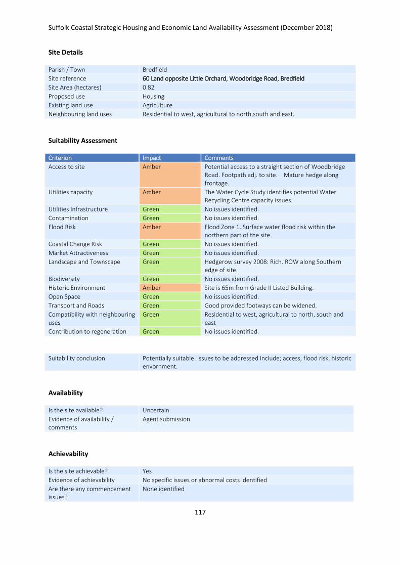
Suffolk Coastal Strategic Housing and Economic Land Availability Assessment (December 2018)
117
Site Details
Parish / Town Bredfield
Site reference 60 Land opposite Little Orchard, Woodbridge Road, Bredfield
Site Area (hectares) 0.82
Proposed use Housing
Existing land use Agriculture
Neighbouring land uses Residential to west, agricultural to north,south and east.
Suitability Assessment
Criterion Impact Comments
Access to site Amber Potential access to a straight section of Woodbridge Road. Footpath adj. to site. Mature hedge along frontage.
Utilities capacity Amber The Water Cycle Study identifies potential Water Recycling Centre capacity issues.
Utilities Infrastructure Green No issues identified.
Contamination Green No issues identified.
Flood Risk Amber Flood Zone 1. Surface water flood risk within the northern part of the site.
Coastal Change Risk Green No issues identified.
Market Attractiveness Green No issues identified.
Landscape and Townscape Green Hedgerow survey 2008: Rich. ROW along Southern edge of site.
Biodiversity Green No issues identified.
Historic Environment Amber Site is 65m from Grade II Listed Building.
Open Space Green No issues identified.
Transport and Roads Green Good provided footways can be widened.
Compatibility with neighbouring uses
Green Residential to west, agricultural to north, south and east
Contribution to regeneration Green No issues identified.
Suitability conclusion Potentially suitable. Issues to be addressed include; access, flood risk, historic envornment.
Availability
Is the site available? Uncertain
Evidence of availability / comments
Agent submission
Achievability
Is the site achievable? Yes
Evidence of achievability No specific issues or abnormal costs identified
Are there any commencement issues?
None identified

Suffolk Coastal Strategic Housing and Economic Land Availability Assessment (December 2018)
118
Estimated dwellings yield 0
Estimated employment land yield (hectares) -
Estimated retail floorspace (sqm) -
Estimated commencement date -
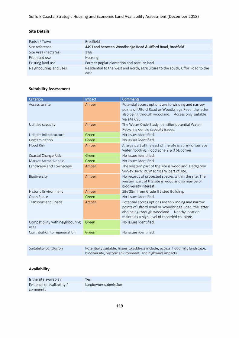
Suffolk Coastal Strategic Housing and Economic Land Availability Assessment (December 2018)
119
Site Details
Parish / Town Bredfield
Site reference 449 Land between Woodbridge Road & Ufford Road, Bredfield
Site Area (hectares) 1.88
Proposed use Housing
Existing land use Former poplar plantation and pasture land
Neighbouring land uses Residential to the west and north, agriculture to the south, Uffor Road to the east
Suitability Assessment
Criterion Impact Comments
Access to site Amber Potential access options are to winding and narrow points of Ufford Road or Woodbridge Road, the latter also being through woodland. Access only suitable via site 695.
Utilities capacity Amber The Water Cycle Study identifies potential Water Recycling Centre capacity issues.
Utilities Infrastructure Green No issues identified.
Contamination Green No issues identified.
Flood Risk Amber A large part of the east of the site is at risk of surface water flooding. Flood Zone 2 & 3 SE corner.
Coastal Change Risk Green No issues identified.
Market Attractiveness Green No issues identified.
Landscape and Townscape Amber The western part of the site is woodland. Hedgerow Survey: Rich. ROW across W part of site.
Biodiversity Amber No records of protected species within the site. The western part of the site is woodland so may be of biodiversity interest.
Historic Environment Amber Site 25m from Grade II Listed Building.
Open Space Green No issues identified.
Transport and Roads Amber Potential access options are to winding and narrow points of Ufford Road or Woodbridge Road, the latter also being through woodland. Nearby location maintains a high level of recorded collisions.
Compatibility with neighbouring uses
Green No issues identified.
Contribution to regeneration Green No issues identified.
Suitability conclusion Potentially suitable. Issues to address include; access, flood risk, landscape, biodiversity, historic environment, and highways impacts.
Availability
Is the site available? Yes
Evidence of availability / comments
Landowner submission

Suffolk Coastal Strategic Housing and Economic Land Availability Assessment (December 2018)
120
Achievability
Is the site achievable? Yes
Evidence of achievability No specific issues or abnormal costs identified
Are there any commencement issues?
None identified
Estimated dwellings yield 28
Estimated employment land yield (hectares) -
Estimated retail floorspace (sqm) -
Estimated commencement date 2021/22
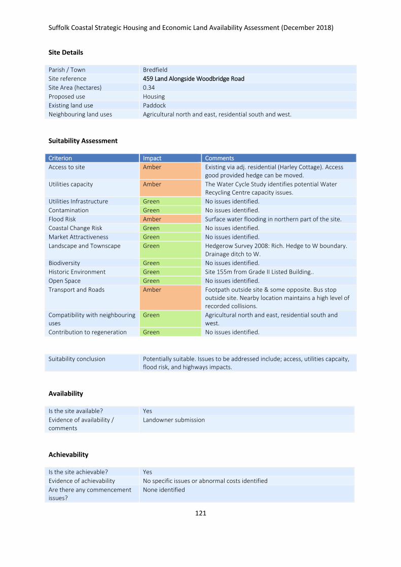
Suffolk Coastal Strategic Housing and Economic Land Availability Assessment (December 2018)
121
Site Details
Parish / Town Bredfield
Site reference 459 Land Alongside Woodbridge Road
Site Area (hectares) 0.34
Proposed use Housing
Existing land use Paddock
Neighbouring land uses Agricultural north and east, residential south and west.
Suitability Assessment
Criterion Impact Comments
Access to site Amber Existing via adj. residential (Harley Cottage). Access good provided hedge can be moved.
Utilities capacity Amber The Water Cycle Study identifies potential Water Recycling Centre capacity issues.
Utilities Infrastructure Green No issues identified.
Contamination Green No issues identified.
Flood Risk Amber Surface water flooding in northern part of the site.
Coastal Change Risk Green No issues identified.
Market Attractiveness Green No issues identified.
Landscape and Townscape Green Hedgerow Survey 2008: Rich. Hedge to W boundary. Drainage ditch to W.
Biodiversity Green No issues identified.
Historic Environment Green Site 155m from Grade II Listed Building..
Open Space Green No issues identified.
Transport and Roads Amber Footpath outside site & some opposite. Bus stop outside site. Nearby location maintains a high level of recorded collisions.
Compatibility with neighbouring uses
Green Agricultural north and east, residential south and west.
Contribution to regeneration Green No issues identified.
Suitability conclusion Potentially suitable. Issues to be addressed include; access, utilities capcaity, flood risk, and highways impacts.
Availability
Is the site available? Yes
Evidence of availability / comments
Landowner submission
Achievability
Is the site achievable? Yes
Evidence of achievability No specific issues or abnormal costs identified
Are there any commencement issues?
None identified

Suffolk Coastal Strategic Housing and Economic Land Availability Assessment (December 2018)
122
Estimated dwellings yield 5
Estimated employment land yield (hectares) -
Estimated retail floorspace (sqm) -
Estimated commencement date 2020/21
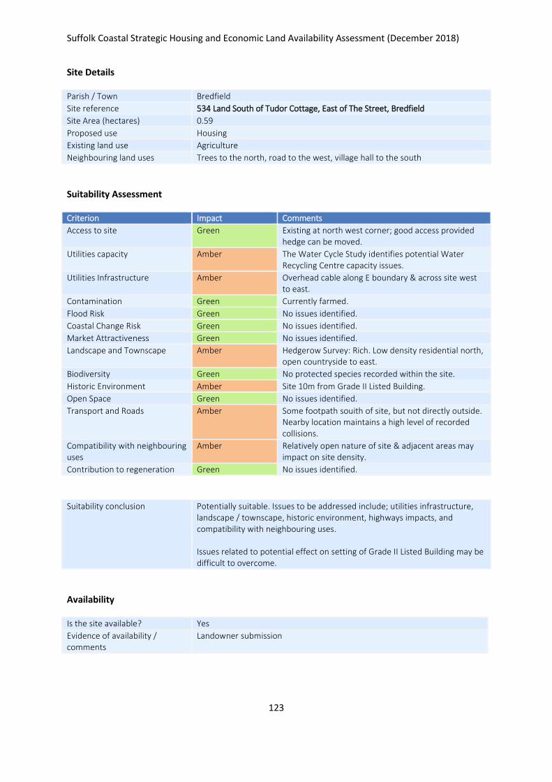
Suffolk Coastal Strategic Housing and Economic Land Availability Assessment (December 2018)
123
Site Details
Parish / Town Bredfield
Site reference 534 Land South of Tudor Cottage, East of The Street, Bredfield
Site Area (hectares) 0.59
Proposed use Housing
Existing land use Agriculture
Neighbouring land uses Trees to the north, road to the west, village hall to the south
Suitability Assessment
Criterion Impact Comments
Access to site Green Existing at north west corner; good access provided hedge can be moved.
Utilities capacity Amber The Water Cycle Study identifies potential Water Recycling Centre capacity issues.
Utilities Infrastructure Amber Overhead cable along E boundary & across site west to east.
Contamination Green Currently farmed.
Flood Risk Green No issues identified.
Coastal Change Risk Green No issues identified.
Market Attractiveness Green No issues identified.
Landscape and Townscape Amber Hedgerow Survey: Rich. Low density residential north, open countryside to east.
Biodiversity Green No protected species recorded within the site.
Historic Environment Amber Site 10m from Grade II Listed Building.
Open Space Green No issues identified.
Transport and Roads Amber Some footpath souith of site, but not directly outside. Nearby location maintains a high level of recorded collisions.
Compatibility with neighbouring uses
Amber Relatively open nature of site & adjacent areas may impact on site density.
Contribution to regeneration Green No issues identified.
Suitability conclusion Potentially suitable. Issues to be addressed include; utilities infrastructure, landscape / townscape, historic environment, highways impacts, and compatibility with neighbouring uses. Issues related to potential effect on setting of Grade II Listed Building may be difficult to overcome.
Availability
Is the site available? Yes
Evidence of availability / comments
Landowner submission

Suffolk Coastal Strategic Housing and Economic Land Availability Assessment (December 2018)
124
Achievability
Is the site achievable? Yes
Evidence of achievability No specific issues or abnormal costs identified
Are there any commencement issues?
None identified
Estimated dwellings yield 9
Estimated employment land yield (hectares) -
Estimated retail floorspace (sqm) -
Estimated commencement date 2020/21
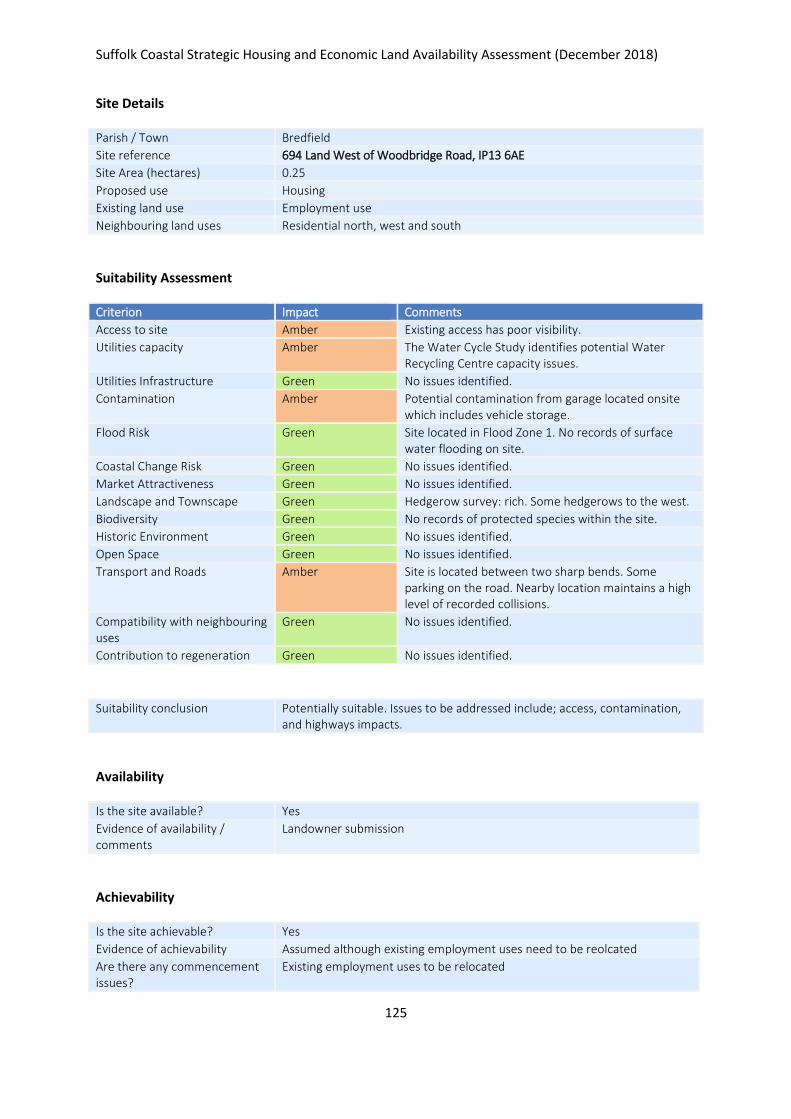
Suffolk Coastal Strategic Housing and Economic Land Availability Assessment (December 2018)
125
Site Details
Parish / Town Bredfield
Site reference 694 Land West of Woodbridge Road, IP13 6AE
Site Area (hectares) 0.25
Proposed use Housing
Existing land use Employment use
Neighbouring land uses Residential north, west and south
Suitability Assessment
Criterion Impact Comments
Access to site Amber Existing access has poor visibility.
Utilities capacity Amber The Water Cycle Study identifies potential Water Recycling Centre capacity issues.
Utilities Infrastructure Green No issues identified.
Contamination Amber Potential contamination from garage located onsite which includes vehicle storage.
Flood Risk Green Site located in Flood Zone 1. No records of surface water flooding on site.
Coastal Change Risk Green No issues identified.
Market Attractiveness Green No issues identified.
Landscape and Townscape Green Hedgerow survey: rich. Some hedgerows to the west.
Biodiversity Green No records of protected species within the site.
Historic Environment Green No issues identified.
Open Space Green No issues identified.
Transport and Roads Amber Site is located between two sharp bends. Some parking on the road. Nearby location maintains a high level of recorded collisions.
Compatibility with neighbouring uses
Green No issues identified.
Contribution to regeneration Green No issues identified.
Suitability conclusion Potentially suitable. Issues to be addressed include; access, contamination, and highways impacts.
Availability
Is the site available? Yes
Evidence of availability / comments
Landowner submission
Achievability
Is the site achievable? Yes
Evidence of achievability Assumed although existing employment uses need to be reolcated
Are there any commencement issues?
Existing employment uses to be relocated

Suffolk Coastal Strategic Housing and Economic Land Availability Assessment (December 2018)
126
Estimated dwellings yield 4
Estimated employment land yield (hectares) -
Estimated retail floorspace (sqm) -
Estimated commencement date 2023/24
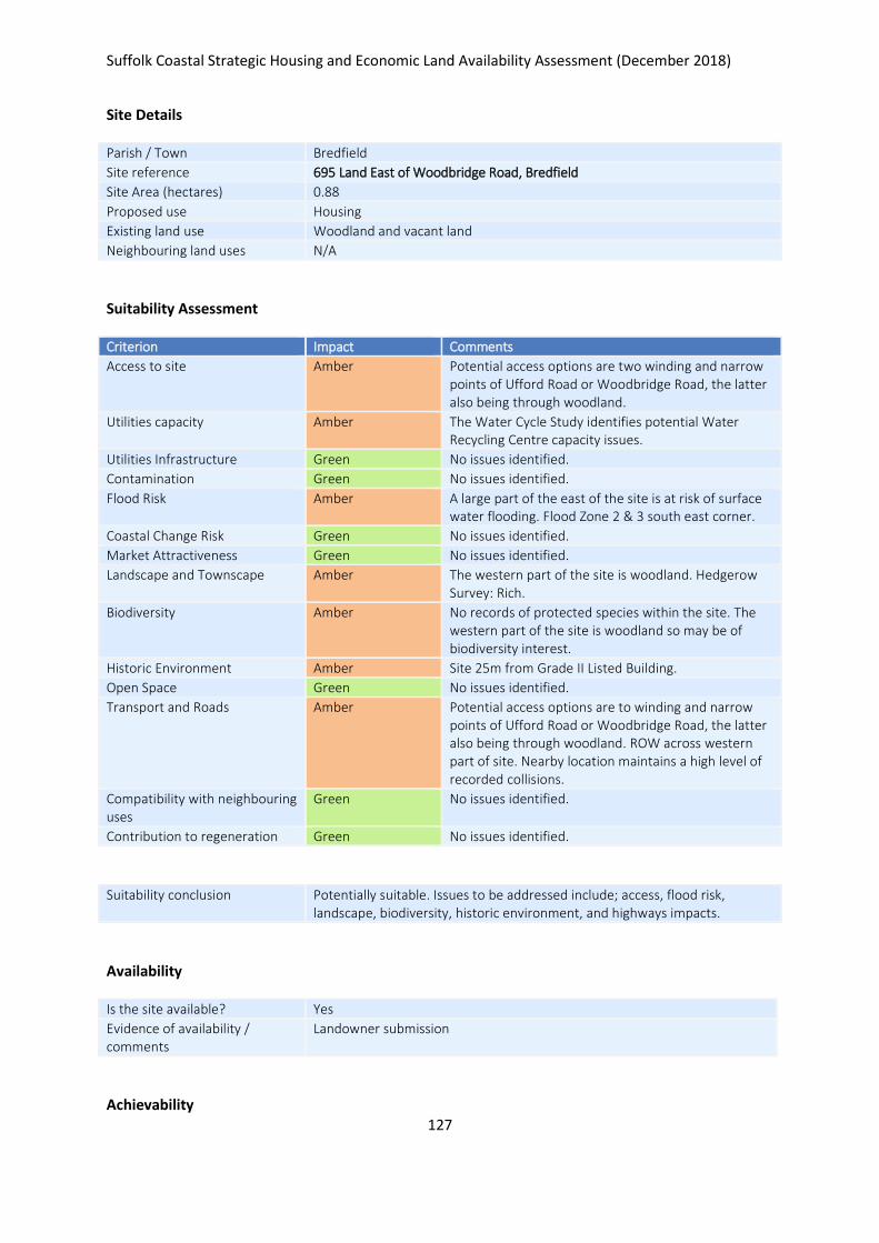
Suffolk Coastal Strategic Housing and Economic Land Availability Assessment (December 2018)
127
Site Details
Parish / Town Bredfield
Site reference 695 Land East of Woodbridge Road, Bredfield
Site Area (hectares) 0.88
Proposed use Housing
Existing land use Woodland and vacant land
Neighbouring land uses N/A
Suitability Assessment
Criterion Impact Comments
Access to site Amber Potential access options are two winding and narrow points of Ufford Road or Woodbridge Road, the latter also being through woodland.
Utilities capacity Amber The Water Cycle Study identifies potential Water Recycling Centre capacity issues.
Utilities Infrastructure Green No issues identified.
Contamination Green No issues identified.
Flood Risk Amber A large part of the east of the site is at risk of surface water flooding. Flood Zone 2 & 3 south east corner.
Coastal Change Risk Green No issues identified.
Market Attractiveness Green No issues identified.
Landscape and Townscape Amber The western part of the site is woodland. Hedgerow Survey: Rich.
Biodiversity Amber No records of protected species within the site. The western part of the site is woodland so may be of biodiversity interest.
Historic Environment Amber Site 25m from Grade II Listed Building.
Open Space Green No issues identified.
Transport and Roads Amber Potential access options are to winding and narrow points of Ufford Road or Woodbridge Road, the latter also being through woodland. ROW across western part of site. Nearby location maintains a high level of recorded collisions.
Compatibility with neighbouring uses
Green No issues identified.
Contribution to regeneration Green No issues identified.
Suitability conclusion Potentially suitable. Issues to be addressed include; access, flood risk, landscape, biodiversity, historic environment, and highways impacts.
Availability
Is the site available? Yes
Evidence of availability / comments
Landowner submission
Achievability

Suffolk Coastal Strategic Housing and Economic Land Availability Assessment (December 2018)
128
Is the site achievable? Yes
Evidence of achievability No specific issues or abnormal costs identified
Are there any commencement issues?
None identified
Estimated dwellings yield 13
Estimated employment land yield (hectares) -
Estimated retail floorspace (sqm) -
Estimated commencement date 2021/22
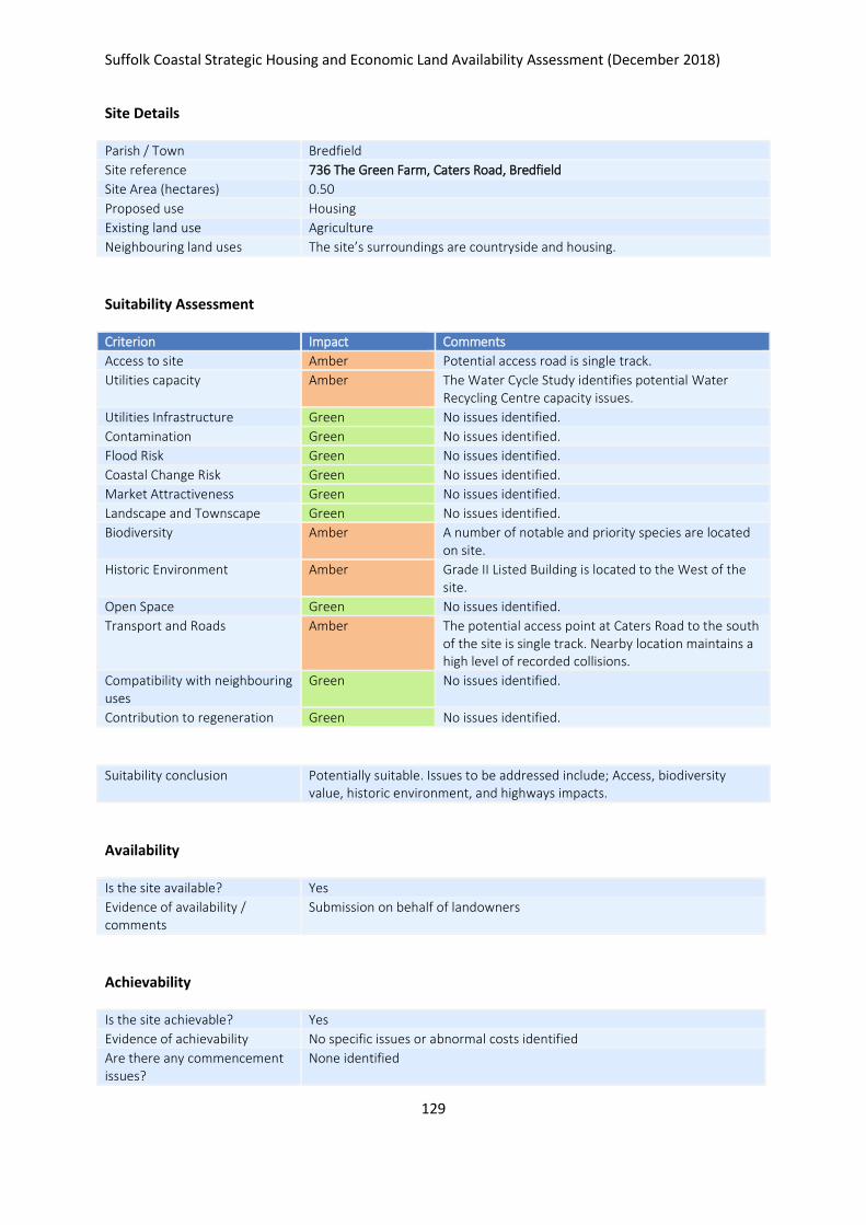
Suffolk Coastal Strategic Housing and Economic Land Availability Assessment (December 2018)
129
Site Details
Parish / Town Bredfield
Site reference 736 The Green Farm, Caters Road, Bredfield
Site Area (hectares) 0.50
Proposed use Housing
Existing land use Agriculture
Neighbouring land uses The site’s surroundings are countryside and housing.
Suitability Assessment
Criterion Impact Comments
Access to site Amber Potential access road is single track.
Utilities capacity Amber The Water Cycle Study identifies potential Water Recycling Centre capacity issues.
Utilities Infrastructure Green No issues identified.
Contamination Green No issues identified.
Flood Risk Green No issues identified.
Coastal Change Risk Green No issues identified.
Market Attractiveness Green No issues identified.
Landscape and Townscape Green No issues identified.
Biodiversity Amber A number of notable and priority species are located on site.
Historic Environment Amber Grade II Listed Building is located to the West of the site.
Open Space Green No issues identified.
Transport and Roads Amber The potential access point at Caters Road to the south of the site is single track. Nearby location maintains a high level of recorded collisions.
Compatibility with neighbouring uses
Green No issues identified.
Contribution to regeneration Green No issues identified.
Suitability conclusion Potentially suitable. Issues to be addressed include; Access, biodiversity value, historic environment, and highways impacts.
Availability
Is the site available? Yes
Evidence of availability / comments
Submission on behalf of landowners
Achievability
Is the site achievable? Yes
Evidence of achievability No specific issues or abnormal costs identified
Are there any commencement issues?
None identified

Suffolk Coastal Strategic Housing and Economic Land Availability Assessment (December 2018)
130
Estimated dwellings yield 7
Estimated employment land yield (hectares) -
Estimated retail floorspace (sqm) -
Estimated commencement date 2021/22
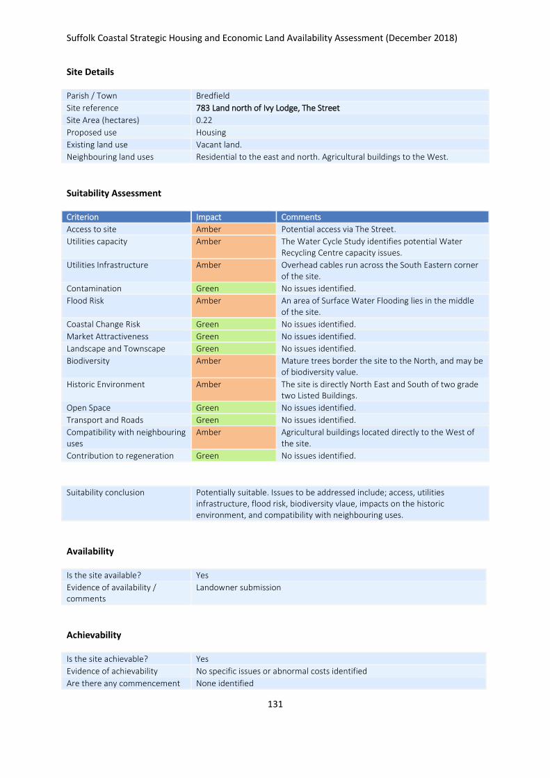
Suffolk Coastal Strategic Housing and Economic Land Availability Assessment (December 2018)
131
Site Details
Parish / Town Bredfield
Site reference 783 Land north of Ivy Lodge, The Street
Site Area (hectares) 0.22
Proposed use Housing
Existing land use Vacant land.
Neighbouring land uses Residential to the east and north. Agricultural buildings to the West.
Suitability Assessment
Criterion Impact Comments
Access to site Amber Potential access via The Street.
Utilities capacity Amber The Water Cycle Study identifies potential Water Recycling Centre capacity issues.
Utilities Infrastructure Amber Overhead cables run across the South Eastern corner of the site.
Contamination Green No issues identified.
Flood Risk Amber An area of Surface Water Flooding lies in the middle of the site.
Coastal Change Risk Green No issues identified.
Market Attractiveness Green No issues identified.
Landscape and Townscape Green No issues identified.
Biodiversity Amber Mature trees border the site to the North, and may be of biodiversity value.
Historic Environment Amber The site is directly North East and South of two grade two Listed Buildings.
Open Space Green No issues identified.
Transport and Roads Green No issues identified.
Compatibility with neighbouring uses
Amber Agricultural buildings located directly to the West of the site.
Contribution to regeneration Green No issues identified.
Suitability conclusion Potentially suitable. Issues to be addressed include; access, utilities infrastructure, flood risk, biodiversity vlaue, impacts on the historic environment, and compatibility with neighbouring uses.
Availability
Is the site available? Yes
Evidence of availability / comments
Landowner submission
Achievability
Is the site achievable? Yes
Evidence of achievability No specific issues or abnormal costs identified
Are there any commencement None identified

Suffolk Coastal Strategic Housing and Economic Land Availability Assessment (December 2018)
132
issues?
Estimated dwellings yield 3
Estimated employment land yield (hectares) -
Estimated retail floorspace (sqm) -
Estimated commencement date 2021/22
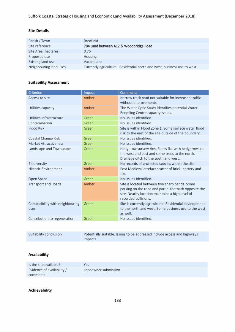
Suffolk Coastal Strategic Housing and Economic Land Availability Assessment (December 2018)
133
Site Details
Parish / Town Bredfield
Site reference 784 Land between A12 & Woodbridge Road
Site Area (hectares) 0.76
Proposed use Housing
Existing land use Vacant land
Neighbouring land uses Currently agricultural. Residential north and west, business use to west.
Suitability Assessment
Criterion Impact Comments
Access to site Amber Narrow track road not suitable for increased traffic without improvements.
Utilities capacity Amber The Water Cycle Study identifies potential Water Recycling Centre capacity issues.
Utilities Infrastructure Green No issues identified.
Contamination Green No issues identified.
Flood Risk Green Site is within Flood Zone 1. Some surface water flood risk to the east of the site outside of the boundary.
Coastal Change Risk Green No issues identified.
Market Attractiveness Green No issues identified.
Landscape and Townscape Green Hedgerow survey: rich. Site is flat with hedgerows to the west and east and some trees to the north. Drainage ditch to the south and west.
Biodiversity Green No records of protected species within the site.
Historic Environment Amber Post Medieval artefact scatter of brick, pottery and tile.
Open Space Green No issues identified.
Transport and Roads Amber Site is located between two sharp bends. Some parking on the road and partial footpath opposite the site. Nearby location maintains a high level of recorded collisions.
Compatibility with neighbouring uses
Green Site is currently agricultural. Residential devleopment to the north and west. Some business use to the west as well.
Contribution to regeneration Green No issues identified.
Suitability conclusion Potentially suitable. Issues to be addressed include access and highways impacts.
Availability
Is the site available? Yes
Evidence of availability / comments
Landowner submission
Achievability

Suffolk Coastal Strategic Housing and Economic Land Availability Assessment (December 2018)
134
Is the site achievable? Yes
Evidence of achievability No specific issues or abnormal costs identified
Are there any commencement issues?
None identified
Estimated dwellings yield 11
Estimated employment land yield (hectares) -
Estimated retail floorspace (sqm) -
Estimated commencement date 2021/22
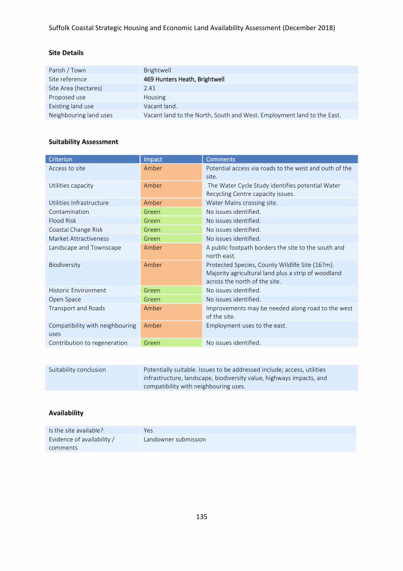
Suffolk Coastal Strategic Housing and Economic Land Availability Assessment (December 2018)
135
Site Details
Parish / Town Brightwell
Site reference 469 Hunters Heath, Brightwell
Site Area (hectares) 2.41
Proposed use Housing
Existing land use Vacant land.
Neighbouring land uses Vacant land to the North, South and West. Employment land to the East.
Suitability Assessment
Criterion Impact Comments
Access to site Amber Potential access via roads to the west and outh of the site.
Utilities capacity Amber The Water Cycle Study identifies potential Water Recycling Centre capacity issues.
Utilities Infrastructure Amber Water Mains crossing site.
Contamination Green No issues identified.
Flood Risk Green No issues identified.
Coastal Change Risk Green No issues identified.
Market Attractiveness Green No issues identified.
Landscape and Townscape Amber A public footpath borders the site to the south and north east.
Biodiversity Amber Protected Species, County Wildlife Site (167m). Majority agricultural land plus a strip of woodland across the north of the site.
Historic Environment Green No issues identified.
Open Space Green No issues identified.
Transport and Roads Amber Improvements may be needed along road to the west of the site.
Compatibility with neighbouring uses
Amber Employment uses to the east.
Contribution to regeneration Green No issues identified.
Suitability conclusion Potentially suitable. Issues to be addressed include; access, utilities infrastructure, landscape, biodiversity value, highways impacts, and compatibility with neighbouring uses.
Availability
Is the site available? Yes
Evidence of availability / comments
Landowner submission

Suffolk Coastal Strategic Housing and Economic Land Availability Assessment (December 2018)
136
Achievability
Is the site achievable? Yes
Evidence of achievability Demolition of existing building required but this is not considered to be a significant abnormal cost.
Are there any commencement issues?
Demolition of existing buildings required
Estimated dwellings yield 60
Estimated employment land yield (hectares) -
Estimated retail floorspace (sqm) -
Estimated commencement date 2021/22
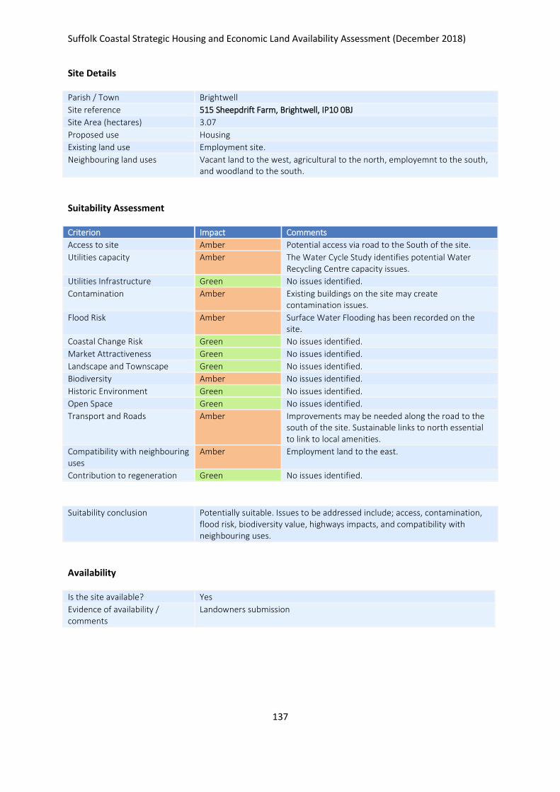
Suffolk Coastal Strategic Housing and Economic Land Availability Assessment (December 2018)
137
Site Details
Parish / Town Brightwell
Site reference 515 Sheepdrift Farm, Brightwell, IP10 0BJ
Site Area (hectares) 3.07
Proposed use Housing
Existing land use Employment site.
Neighbouring land uses Vacant land to the west, agricultural to the north, employemnt to the south, and woodland to the south.
Suitability Assessment
Criterion Impact Comments
Access to site Amber Potential access via road to the South of the site.
Utilities capacity Amber The Water Cycle Study identifies potential Water Recycling Centre capacity issues.
Utilities Infrastructure Green No issues identified.
Contamination Amber Existing buildings on the site may create contamination issues.
Flood Risk Amber Surface Water Flooding has been recorded on the site.
Coastal Change Risk Green No issues identified.
Market Attractiveness Green No issues identified.
Landscape and Townscape Green No issues identified.
Biodiversity Amber No issues identified.
Historic Environment Green No issues identified.
Open Space Green No issues identified.
Transport and Roads Amber Improvements may be needed along the road to the south of the site. Sustainable links to north essential to link to local amenities.
Compatibility with neighbouring uses
Amber Employment land to the east.
Contribution to regeneration Green No issues identified.
Suitability conclusion Potentially suitable. Issues to be addressed include; access, contamination, flood risk, biodiversity value, highways impacts, and compatibility with neighbouring uses.
Availability
Is the site available? Yes
Evidence of availability / comments
Landowners submission
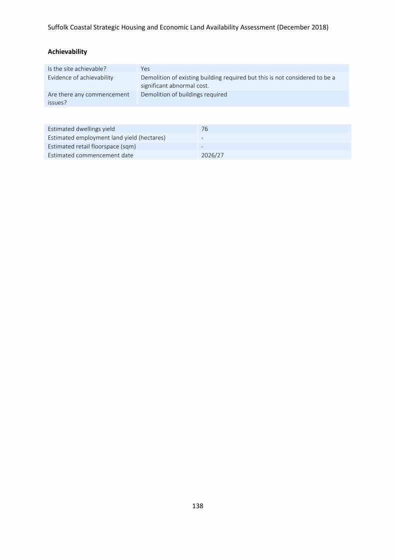
Suffolk Coastal Strategic Housing and Economic Land Availability Assessment (December 2018)
138
Achievability
Is the site achievable? Yes
Evidence of achievability Demolition of existing building required but this is not considered to be a significant abnormal cost.
Are there any commencement issues?
Demolition of buildings required
Estimated dwellings yield 76
Estimated employment land yield (hectares) -
Estimated retail floorspace (sqm) -
Estimated commencement date 2026/27
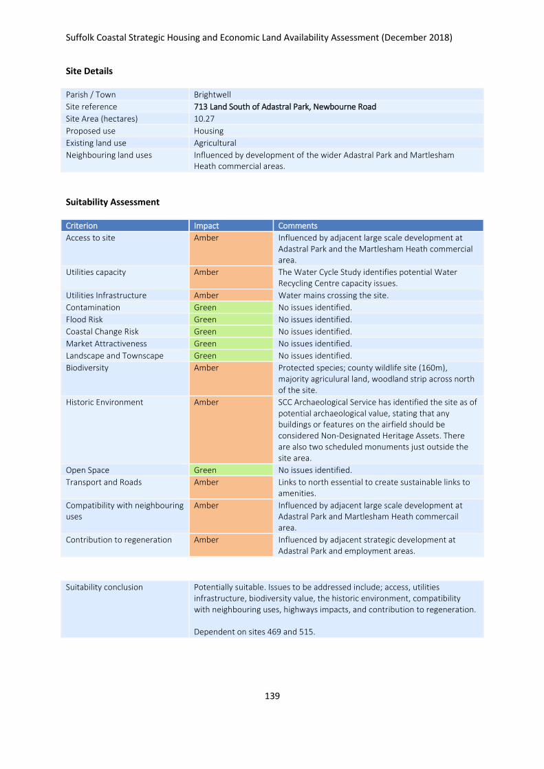
Suffolk Coastal Strategic Housing and Economic Land Availability Assessment (December 2018)
139
Site Details
Parish / Town Brightwell
Site reference 713 Land South of Adastral Park, Newbourne Road
Site Area (hectares) 10.27
Proposed use Housing
Existing land use Agricultural
Neighbouring land uses Influenced by development of the wider Adastral Park and Martlesham Heath commercial areas.
Suitability Assessment
Criterion Impact Comments
Access to site Amber Influenced by adjacent large scale development at Adastral Park and the Martlesham Heath commercial area.
Utilities capacity Amber The Water Cycle Study identifies potential Water Recycling Centre capacity issues.
Utilities Infrastructure Amber Water mains crossing the site.
Contamination Green No issues identified.
Flood Risk Green No issues identified.
Coastal Change Risk Green No issues identified.
Market Attractiveness Green No issues identified.
Landscape and Townscape Green No issues identified.
Biodiversity Amber Protected species; county wildlife site (160m), majority agriculural land, woodland strip across north of the site.
Historic Environment Amber SCC Archaeological Service has identified the site as of potential archaeological value, stating that any buildings or features on the airfield should be considered Non-Designated Heritage Assets. There are also two scheduled monuments just outside the site area.
Open Space Green No issues identified.
Transport and Roads Amber Links to north essential to create sustainable links to amenities.
Compatibility with neighbouring uses
Amber Influenced by adjacent large scale development at Adastral Park and Martlesham Heath commercail area.
Contribution to regeneration Amber Influenced by adjacent strategic development at Adastral Park and employment areas.
Suitability conclusion Potentially suitable. Issues to be addressed include; access, utilities infrastructure, biodiversity value, the historic environment, compatibility with neighbouring uses, highways impacts, and contribution to regeneration. Dependent on sites 469 and 515.
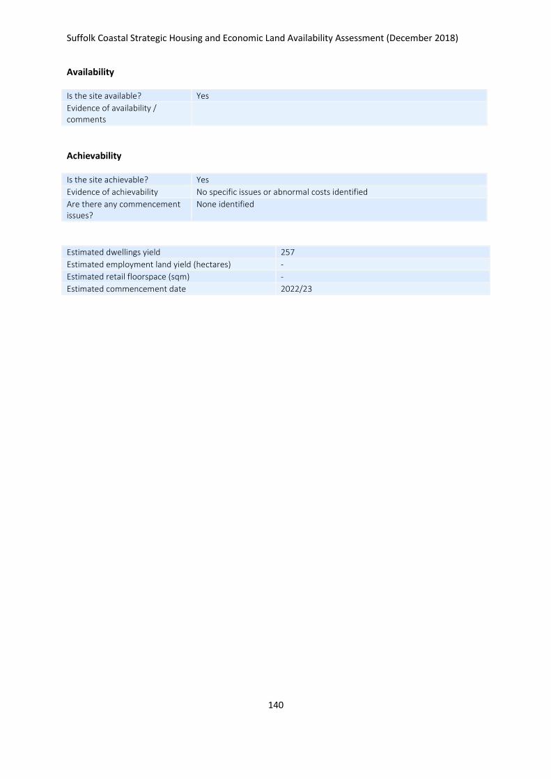
Suffolk Coastal Strategic Housing and Economic Land Availability Assessment (December 2018)
140
Availability
Is the site available? Yes
Evidence of availability / comments
Achievability
Is the site achievable? Yes
Evidence of achievability No specific issues or abnormal costs identified
Are there any commencement issues?
None identified
Estimated dwellings yield 257
Estimated employment land yield (hectares) -
Estimated retail floorspace (sqm) -
Estimated commencement date 2022/23
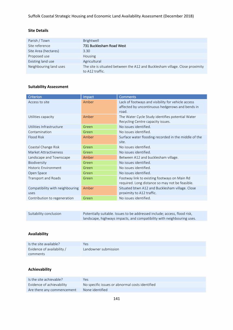
Suffolk Coastal Strategic Housing and Economic Land Availability Assessment (December 2018)
141
Site Details
Parish / Town Brightwell
Site reference 731 Bucklesham Road West
Site Area (hectares) 3.30
Proposed use Housing
Existing land use Agricultural
Neighbouring land uses The site is situated between the A12 and Bucklesham village. Close proximity to A12 traffic.
Suitability Assessment
Criterion Impact Comments
Access to site Amber Lack of footways and visibility for vehicle access affected by uncontinuous hedgerows and bends in road.
Utilities capacity Amber The Water Cycle Study identifies potential Water Recycling Centre capacity issues.
Utilities Infrastructure Green No issues identified.
Contamination Green No issues identified.
Flood Risk Amber Surface water flooding recorded in the middle of the site.
Coastal Change Risk Green No issues identified.
Market Attractiveness Green No issues identified.
Landscape and Townscape Amber Between A12 and bucklesham village.
Biodiversity Green No issues identified.
Historic Environment Green No issues identified.
Open Space Green No issues identified.
Transport and Roads Green Footway link to existing footways on Main Rd required. Long distance so may not be feasible.
Compatibility with neighbouring uses
Amber Situated btwn A12 and Bucklesham village. Close proximity to A12 traffic.
Contribution to regeneration Green No issues identified.
Suitability conclusion Potentially suitable. Issues to be addressed include; access, flood risk, landscape, highways impacts, and compatibility with neighbouring uses.
Availability
Is the site available? Yes
Evidence of availability / comments
Landowner submission
Achievability
Is the site achievable? Yes
Evidence of achievability No specific issues or abnormal costs identified
Are there any commencement None identified

Suffolk Coastal Strategic Housing and Economic Land Availability Assessment (December 2018)
142
issues?
Estimated dwellings yield 49
Estimated employment land yield (hectares) -
Estimated retail floorspace (sqm) -
Estimated commencement date 2021/22
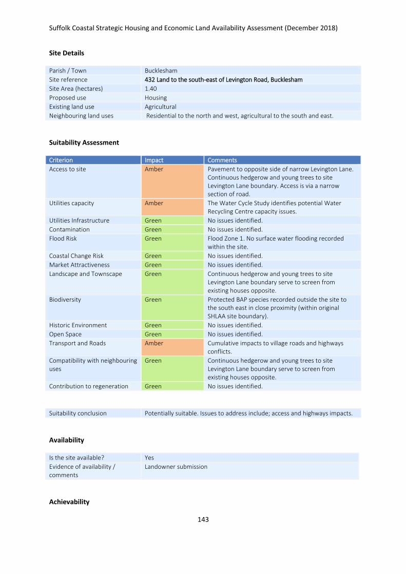
Suffolk Coastal Strategic Housing and Economic Land Availability Assessment (December 2018)
143
Site Details
Parish / Town Bucklesham
Site reference 432 Land to the south-east of Levington Road, Bucklesham
Site Area (hectares) 1.40
Proposed use Housing
Existing land use Agricultural
Neighbouring land uses Residential to the north and west, agricultural to the south and east.
Suitability Assessment
Criterion Impact Comments
Access to site Amber Pavement to opposite side of narrow Levington Lane. Continuous hedgerow and young trees to site Levington Lane boundary. Access is via a narrow section of road.
Utilities capacity Amber The Water Cycle Study identifies potential Water Recycling Centre capacity issues.
Utilities Infrastructure Green No issues identified.
Contamination Green No issues identified.
Flood Risk Green Flood Zone 1. No surface water flooding recorded within the site.
Coastal Change Risk Green No issues identified.
Market Attractiveness Green No issues identified.
Landscape and Townscape Green Continuous hedgerow and young trees to site Levington Lane boundary serve to screen from existing houses opposite.
Biodiversity Green Protected BAP species recorded outside the site to the south east in close proximity (within original SHLAA site boundary).
Historic Environment Green No issues identified.
Open Space Green No issues identified.
Transport and Roads Amber Cumulative impacts to village roads and highways conflicts.
Compatibility with neighbouring uses
Green Continuous hedgerow and young trees to site Levington Lane boundary serve to screen from existing houses opposite.
Contribution to regeneration Green No issues identified.
Suitability conclusion Potentially suitable. Issues to address include; access and highways impacts.
Availability
Is the site available? Yes
Evidence of availability / comments
Landowner submission
Achievability

Suffolk Coastal Strategic Housing and Economic Land Availability Assessment (December 2018)
144
Is the site achievable? Yes
Evidence of achievability No specific issues or abnormal costs identified
Are there any commencement issues?
None identified
Estimated dwellings yield 35
Estimated employment land yield (hectares) -
Estimated retail floorspace (sqm) -
Estimated commencement date 2021/22
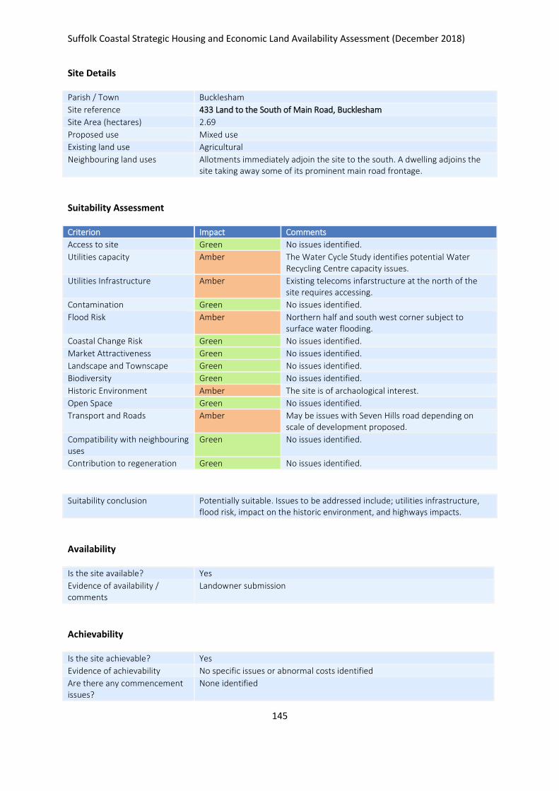
Suffolk Coastal Strategic Housing and Economic Land Availability Assessment (December 2018)
145
Site Details
Parish / Town Bucklesham
Site reference 433 Land to the South of Main Road, Bucklesham
Site Area (hectares) 2.69
Proposed use Mixed use
Existing land use Agricultural
Neighbouring land uses Allotments immediately adjoin the site to the south. A dwelling adjoins the site taking away some of its prominent main road frontage.
Suitability Assessment
Criterion Impact Comments
Access to site Green No issues identified.
Utilities capacity Amber The Water Cycle Study identifies potential Water Recycling Centre capacity issues.
Utilities Infrastructure Amber Existing telecoms infarstructure at the north of the site requires accessing.
Contamination Green No issues identified.
Flood Risk Amber Northern half and south west corner subject to surface water flooding.
Coastal Change Risk Green No issues identified.
Market Attractiveness Green No issues identified.
Landscape and Townscape Green No issues identified.
Biodiversity Green No issues identified.
Historic Environment Amber The site is of archaological interest.
Open Space Green No issues identified.
Transport and Roads Amber May be issues with Seven Hills road depending on scale of development proposed.
Compatibility with neighbouring uses
Green No issues identified.
Contribution to regeneration Green No issues identified.
Suitability conclusion Potentially suitable. Issues to be addressed include; utilities infrastructure, flood risk, impact on the historic environment, and highways impacts.
Availability
Is the site available? Yes
Evidence of availability / comments
Landowner submission
Achievability
Is the site achievable? Yes
Evidence of achievability No specific issues or abnormal costs identified
Are there any commencement issues?
None identified

Suffolk Coastal Strategic Housing and Economic Land Availability Assessment (December 2018)
146
Estimated dwellings yield 54
Estimated employment land yield (hectares) -
Estimated retail floorspace (sqm) -
Estimated commencement date 2022/23
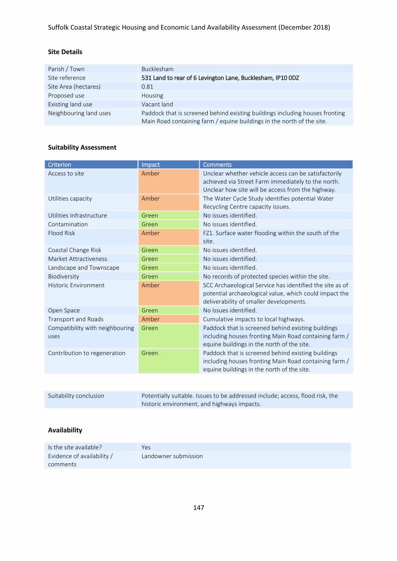
Suffolk Coastal Strategic Housing and Economic Land Availability Assessment (December 2018)
147
Site Details
Parish / Town Bucklesham
Site reference 531 Land to rear of 6 Levington Lane, Bucklesham, IP10 0DZ
Site Area (hectares) 0.81
Proposed use Housing
Existing land use Vacant land
Neighbouring land uses Paddock that is screened behind existing buildings including houses fronting Main Road containing farm / equine buildings in the north of the site.
Suitability Assessment
Criterion Impact Comments
Access to site Amber Unclear whether vehicle access can be satisfactorily achieved via Street Farm immediately to the north. Unclear how site will be access from the highway.
Utilities capacity Amber The Water Cycle Study identifies potential Water Recycling Centre capacity issues.
Utilities Infrastructure Green No issues identified.
Contamination Green No issues identified.
Flood Risk Amber FZ1. Surface water flooding within the south of the site.
Coastal Change Risk Green No issues identified.
Market Attractiveness Green No issues identified.
Landscape and Townscape Green No issues identified.
Biodiversity Green No records of protected species within the site.
Historic Environment Amber SCC Archaeological Service has identified the site as of potential archaeological value, which could impact the deliverability of smaller developments.
Open Space Green No issues identified.
Transport and Roads Amber Cumulative impacts to local highways.
Compatibility with neighbouring uses
Green Paddock that is screened behind existing buildings including houses fronting Main Road containing farm / equine buildings in the north of the site.
Contribution to regeneration Green Paddock that is screened behind existing buildings including houses fronting Main Road containing farm / equine buildings in the north of the site.
Suitability conclusion Potentially suitable. Issues to be addressed include; access, flood risk, the historic environment, and highways impacts.
Availability
Is the site available? Yes
Evidence of availability / comments
Landowner submission

Suffolk Coastal Strategic Housing and Economic Land Availability Assessment (December 2018)
148
Achievability
Is the site achievable? Yes
Evidence of achievability No specific issues or abnormal costs identified
Are there any commencement issues?
None identified
Estimated dwellings yield 12
Estimated employment land yield (hectares) -
Estimated retail floorspace (sqm) -
Estimated commencement date 2021/22
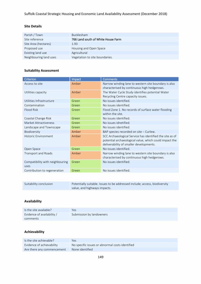
Suffolk Coastal Strategic Housing and Economic Land Availability Assessment (December 2018)
149
Site Details
Parish / Town Bucklesham
Site reference 766 Land south of White House Farm
Site Area (hectares) 1.93
Proposed use Housing and Open Space
Existing land use Agricultural
Neighbouring land uses Vegetation to site boundaries.
Suitability Assessment
Criterion Impact Comments
Access to site Amber Narrow winding lane to western site boundary is also characterised by continuous high hedgerows.
Utilities capacity Amber The Water Cycle Study identifies potential Water Recycling Centre capacity issues.
Utilities Infrastructure Green No issues identified.
Contamination Green No issues identified.
Flood Risk Green Flood Zone 1. No records of surface water flooding within the site.
Coastal Change Risk Green No issues identified.
Market Attractiveness Green No issues idnetified.
Landscape and Townscape Green No issues identified.
Biodiversity Amber BAP species recorded on site – Curlew.
Historic Environment Amber SCC Archaeological Service has identified the site as of potential archaeological value, which could impact the deliverability of smaller developments.
Open Space Green No issues identified.
Transport and Roads Amber Narrow winding lane to western site boundary is also characterised by continuous high hedgerows.
Compatibility with neighbouring uses
Green No issues identified.
Contribution to regeneration Green No issues identified.
Suitability conclusion Potentially suitable. Issues to be addressed include; access, biodiversity value, and highways impacts.
Availability
Is the site available? Yes
Evidence of availability / comments
Submission by landowners
Achievability
Is the site achievable? Yes
Evidence of achievability No specific issues or abnormal costs identified
Are there any commencement None identified

Suffolk Coastal Strategic Housing and Economic Land Availability Assessment (December 2018)
150
issues?
Estimated dwellings yield 23
Estimated employment land yield (hectares) -
Estimated retail floorspace (sqm) -
Estimated commencement date 2020/21
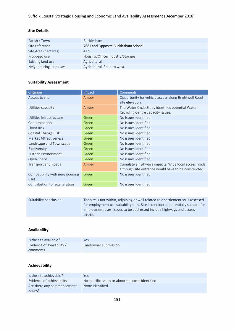
Suffolk Coastal Strategic Housing and Economic Land Availability Assessment (December 2018)
151
Site Details
Parish / Town Bucklesham
Site reference 768 Land Opposite Bucklesham School
Site Area (hectares) 4.09
Proposed use Housing/Office/Industry/Storage
Existing land use Agricultural
Neighbouring land uses Agricultural. Road to west.
Suitability Assessment
Criterion Impact Comments
Access to site Amber Opportunity for vehicle access along Brightwell Road site elevation.
Utilities capacity Amber The Water Cycle Study identifies potential Water Recycling Centre capacity issues.
Utilities Infrastructure Green No issues identified.
Contamination Green No issues identified.
Flood Risk Green No issues identified.
Coastal Change Risk Green No issues identified.
Market Attractiveness Green No issues identified.
Landscape and Townscape Green No issues identified.
Biodiversity Green No issues identified.
Historic Environment Green No issues identified.
Open Space Green No issues identified.
Transport and Roads Amber Cumulative highways impacts. Wide local access roads although site entrance would have to be constructed.
Compatibility with neighbouring uses
Green No issues identified.
Contribution to regeneration Green No issues identified.
Suitability conclusion The site is not within, adjoining or well related to a settlement so is assessed for employment use suitability only. Site is considered potentially suitable for employment uses, issues to be addressed include highways and access issues.
Availability
Is the site available? Yes
Evidence of availability / comments
Landowner submission
Achievability
Is the site achievable? Yes
Evidence of achievability No specific issues or abnormal costs identified
Are there any commencement issues?
None identified

Suffolk Coastal Strategic Housing and Economic Land Availability Assessment (December 2018)
152
Estimated dwellings yield -
Estimated employment land yield (hectares) 4
Estimated retail floorspace (sqm) -
Estimated commencement date 2020/21
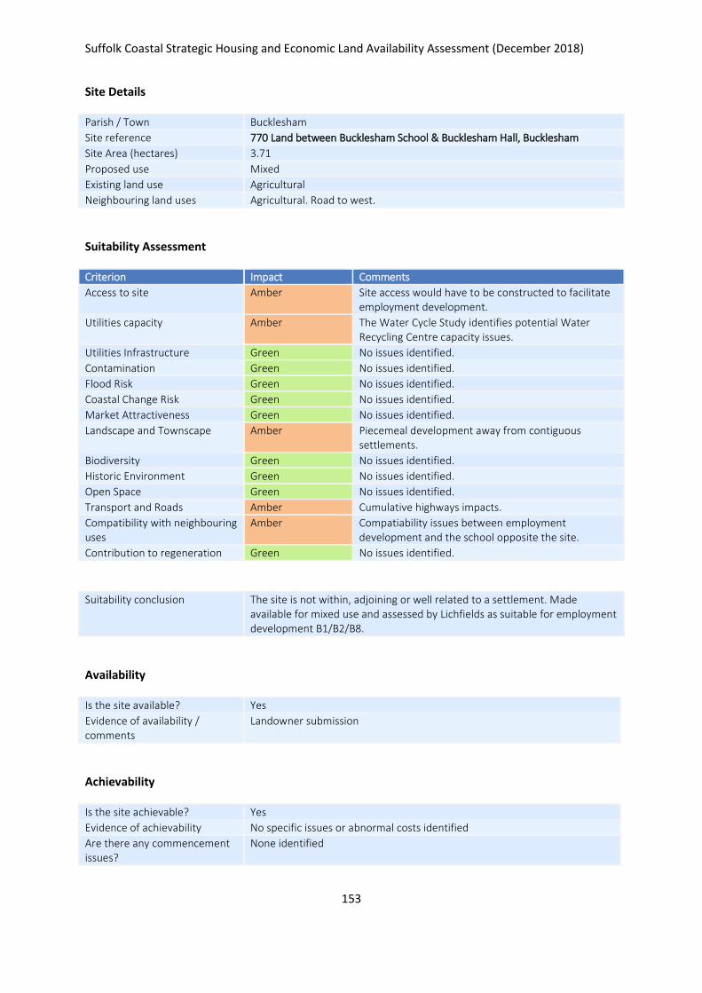
Suffolk Coastal Strategic Housing and Economic Land Availability Assessment (December 2018)
153
Site Details
Parish / Town Bucklesham
Site reference 770 Land between Bucklesham School & Bucklesham Hall, Bucklesham
Site Area (hectares) 3.71
Proposed use Mixed
Existing land use Agricultural
Neighbouring land uses Agricultural. Road to west.
Suitability Assessment
Criterion Impact Comments
Access to site Amber Site access would have to be constructed to facilitate employment development.
Utilities capacity Amber The Water Cycle Study identifies potential Water Recycling Centre capacity issues.
Utilities Infrastructure Green No issues identified.
Contamination Green No issues identified.
Flood Risk Green No issues identified.
Coastal Change Risk Green No issues identified.
Market Attractiveness Green No issues identified.
Landscape and Townscape Amber Piecemeal development away from contiguous settlements.
Biodiversity Green No issues identified.
Historic Environment Green No issues identified.
Open Space Green No issues identified.
Transport and Roads Amber Cumulative highways impacts.
Compatibility with neighbouring uses
Amber Compatiability issues between employment development and the school opposite the site.
Contribution to regeneration Green No issues identified.
Suitability conclusion The site is not within, adjoining or well related to a settlement. Made available for mixed use and assessed by Lichfields as suitable for employment development B1/B2/B8.
Availability
Is the site available? Yes
Evidence of availability / comments
Landowner submission
Achievability
Is the site achievable? Yes
Evidence of achievability No specific issues or abnormal costs identified
Are there any commencement issues?
None identified

Suffolk Coastal Strategic Housing and Economic Land Availability Assessment (December 2018)
154
Estimated dwellings yield -
Estimated employment land yield (hectares) 4
Estimated retail floorspace (sqm) -
Estimated commencement date 2021/22
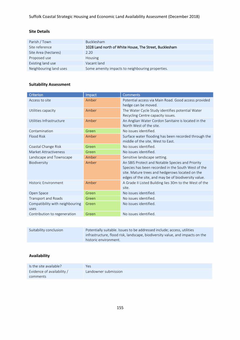
Suffolk Coastal Strategic Housing and Economic Land Availability Assessment (December 2018)
155
Site Details
Parish / Town Bucklesham
Site reference 1028 Land north of White House, The Street, Bucklesham
Site Area (hectares) 2.20
Proposed use Housing
Existing land use Vacant land
Neighbouring land uses Some amenity impacts to neighbouring properties.
Suitability Assessment
Criterion Impact Comments
Access to site Amber Potential access via Main Road. Good access provided hedge can be moved.
Utilities capacity Amber The Water Cycle Study identifies potential Water Recycling Centre capacity issues.
Utilities Infrastructure Amber An Anglian Water Cordon Sanitaire is located in the North West of the site.
Contamination Green No issues identified.
Flood Risk Amber Surface water flooding has been recorded through the middle of the site, West to East.
Coastal Change Risk Green No issues identified.
Market Attractiveness Green No issues identified.
Landscape and Townscape Amber Sensitive landscape setting.
Biodiversity Amber An SBIS Protect and Notable Species and Priority Species has been recorded in the South West of the site. Mature trees and hedgerows located on the edges of the site, and may be of biodiversity value.
Historic Environment Amber A Grade II Listed Building lies 30m to the West of the site.
Open Space Green No issues identified.
Transport and Roads Green No issues identified.
Compatibility with neighbouring uses
Green No issues identified.
Contribution to regeneration Green No issues identified.
Suitability conclusion Potentially suitable. Issues to be addressed include; access, utilities infrastructure, flood risk, landscape, biodiversity value, and impacts on the historic environment.
Availability
Is the site available? Yes
Evidence of availability / comments
Landowner submission

Suffolk Coastal Strategic Housing and Economic Land Availability Assessment (December 2018)
156
Achievability
Is the site achievable? Yes
Evidence of achievability No specific issues or abnormal costs identified
Are there any commencement issues?
None identified
Estimated dwellings yield 33
Estimated employment land yield (hectares) -
Estimated retail floorspace (sqm) -
Estimated commencement date 2021/22
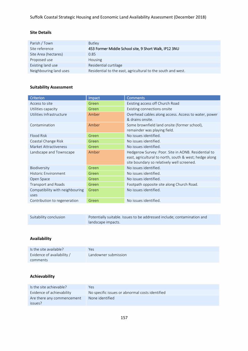
Suffolk Coastal Strategic Housing and Economic Land Availability Assessment (December 2018)
157
Site Details
Parish / Town Butley
Site reference 453 Former Middle School site, 9 Short Walk, IP12 3NU
Site Area (hectares) 0.85
Proposed use Housing
Existing land use Residential curtilage
Neighbouring land uses Residential to the east, agricultural to the south and west.
Suitability Assessment
Criterion Impact Comments
Access to site Green Existing access off Church Road
Utilities capacity Green Existing connections onsite
Utilities Infrastructure Amber Overhead cables along access. Access to water, power & drains onsite.
Contamination Amber Some brownfield land onsite (former school), remainder was playing field.
Flood Risk Green No issues identified.
Coastal Change Risk Green No issues identified.
Market Attractiveness Green No issues identified.
Landscape and Townscape Amber Hedgerow Survey: Poor. Site in AONB. Residential to east, agricultural to north, south & west; hedge along site boundary so relatively well screened.
Biodiversity Green No issues identified.
Historic Environment Green No issues identified.
Open Space Green No issues identified.
Transport and Roads Green Footpath opposite site along Church Road.
Compatibility with neighbouring uses
Green No issues identified.
Contribution to regeneration Green No issues identified.
Suitability conclusion Potentially suitable. Issues to be addressed include; contamination and landscape impacts.
Availability
Is the site available? Yes
Evidence of availability / comments
Landowner submission
Achievability
Is the site achievable? Yes
Evidence of achievability No specific issues or abnormal costs identified
Are there any commencement issues?
None identified

Suffolk Coastal Strategic Housing and Economic Land Availability Assessment (December 2018)
158
Estimated dwellings yield 13
Estimated employment land yield (hectares) -
Estimated retail floorspace (sqm) -
Estimated commencement date 2021/22
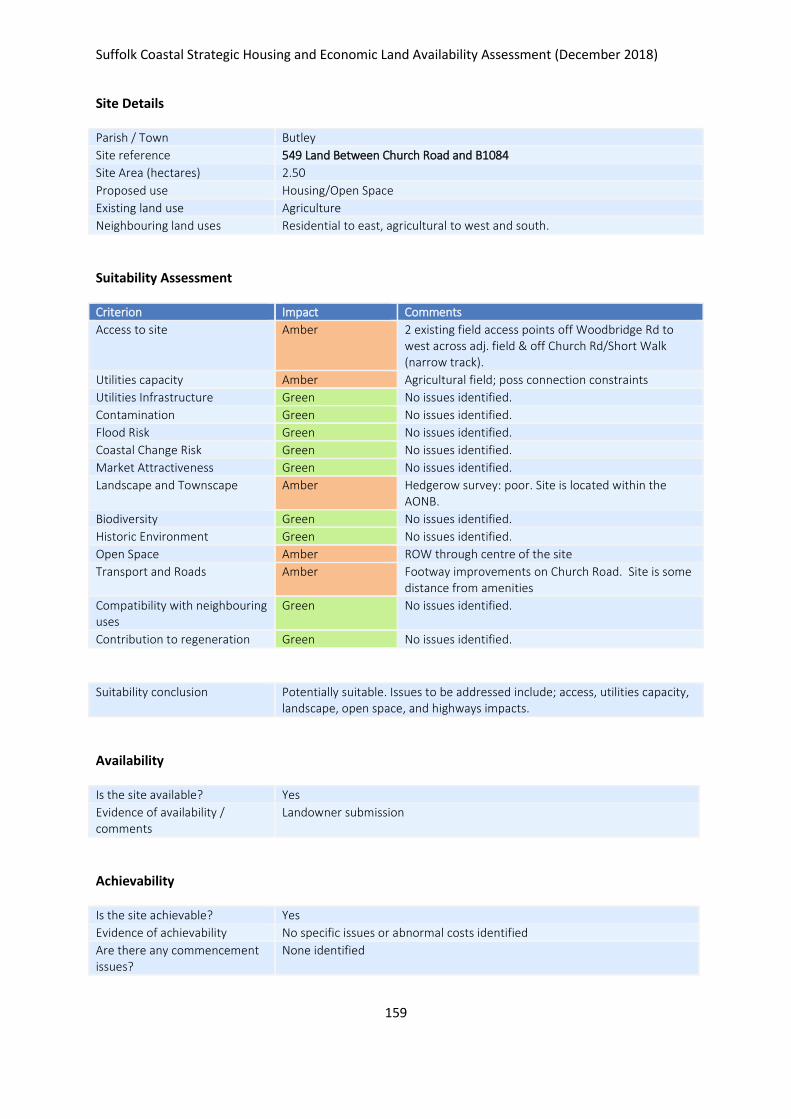
Suffolk Coastal Strategic Housing and Economic Land Availability Assessment (December 2018)
159
Site Details
Parish / Town Butley
Site reference 549 Land Between Church Road and B1084
Site Area (hectares) 2.50
Proposed use Housing/Open Space
Existing land use Agriculture
Neighbouring land uses Residential to east, agricultural to west and south.
Suitability Assessment
Criterion Impact Comments
Access to site Amber 2 existing field access points off Woodbridge Rd to west across adj. field & off Church Rd/Short Walk (narrow track).
Utilities capacity Amber Agricultural field; poss connection constraints
Utilities Infrastructure Green No issues identified.
Contamination Green No issues identified.
Flood Risk Green No issues identified.
Coastal Change Risk Green No issues identified.
Market Attractiveness Green No issues identified.
Landscape and Townscape Amber Hedgerow survey: poor. Site is located within the AONB.
Biodiversity Green No issues identified.
Historic Environment Green No issues identified.
Open Space Amber ROW through centre of the site
Transport and Roads Amber Footway improvements on Church Road. Site is some distance from amenities
Compatibility with neighbouring uses
Green No issues identified.
Contribution to regeneration Green No issues identified.
Suitability conclusion Potentially suitable. Issues to be addressed include; access, utilities capacity, landscape, open space, and highways impacts.
Availability
Is the site available? Yes
Evidence of availability / comments
Landowner submission
Achievability
Is the site achievable? Yes
Evidence of achievability No specific issues or abnormal costs identified
Are there any commencement issues?
None identified

Suffolk Coastal Strategic Housing and Economic Land Availability Assessment (December 2018)
160
Estimated dwellings yield 30
Estimated employment land yield (hectares) -
Estimated retail floorspace (sqm) -
Estimated commencement date 2020/21
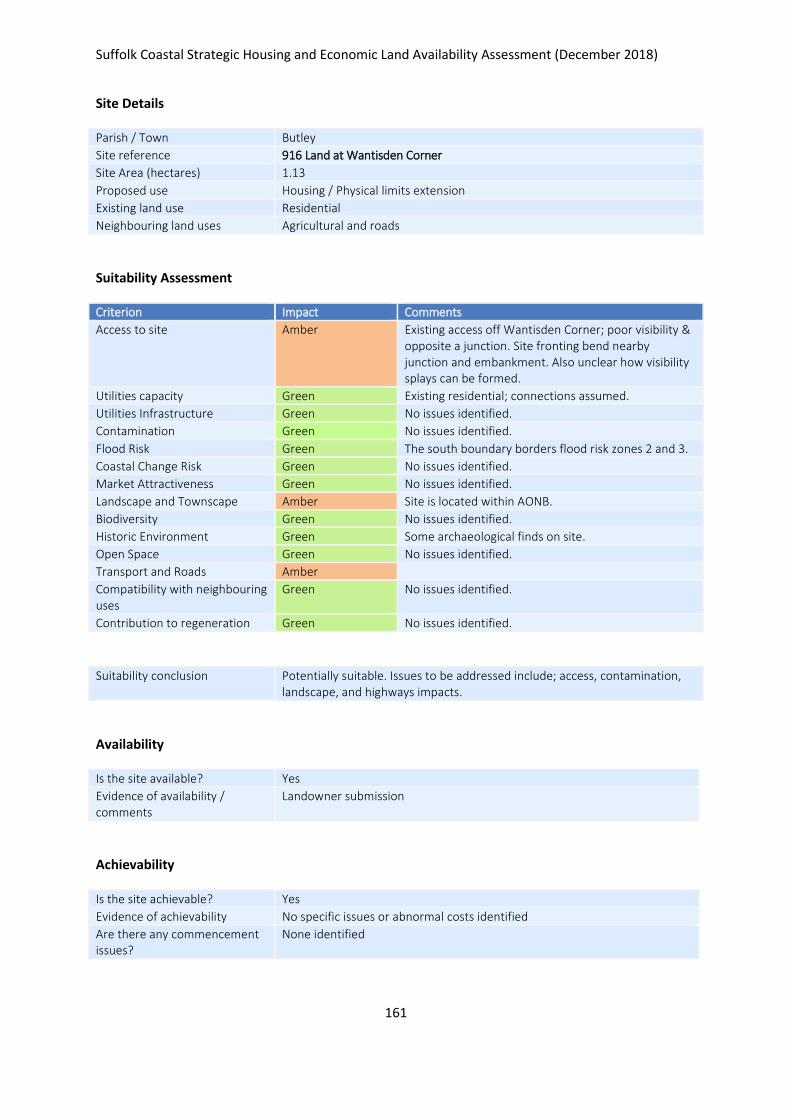
Suffolk Coastal Strategic Housing and Economic Land Availability Assessment (December 2018)
161
Site Details
Parish / Town Butley
Site reference 916 Land at Wantisden Corner
Site Area (hectares) 1.13
Proposed use Housing / Physical limits extension
Existing land use Residential
Neighbouring land uses Agricultural and roads
Suitability Assessment
Criterion Impact Comments
Access to site Amber Existing access off Wantisden Corner; poor visibility & opposite a junction. Site fronting bend nearby junction and embankment. Also unclear how visibility splays can be formed.
Utilities capacity Green Existing residential; connections assumed.
Utilities Infrastructure Green No issues identified.
Contamination Green No issues identified.
Flood Risk Green The south boundary borders flood risk zones 2 and 3.
Coastal Change Risk Green No issues identified.
Market Attractiveness Green No issues identified.
Landscape and Townscape Amber Site is located within AONB.
Biodiversity Green No issues identified.
Historic Environment Green Some archaeological finds on site.
Open Space Green No issues identified.
Transport and Roads Amber
Compatibility with neighbouring uses
Green No issues identified.
Contribution to regeneration Green No issues identified.
Suitability conclusion Potentially suitable. Issues to be addressed include; access, contamination, landscape, and highways impacts.
Availability
Is the site available? Yes
Evidence of availability / comments
Landowner submission
Achievability
Is the site achievable? Yes
Evidence of achievability No specific issues or abnormal costs identified
Are there any commencement issues?
None identified

Suffolk Coastal Strategic Housing and Economic Land Availability Assessment (December 2018)
162
Estimated dwellings yield 5
Estimated employment land yield (hectares) -
Estimated retail floorspace (sqm) -
Estimated commencement date 2021/22
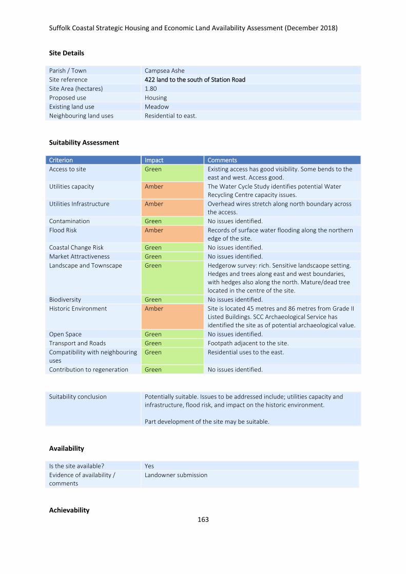
Suffolk Coastal Strategic Housing and Economic Land Availability Assessment (December 2018)
163
Site Details
Parish / Town Campsea Ashe
Site reference 422 land to the south of Station Road
Site Area (hectares) 1.80
Proposed use Housing
Existing land use Meadow
Neighbouring land uses Residential to east.
Suitability Assessment
Criterion Impact Comments
Access to site Green Existing access has good visibility. Some bends to the east and west. Access good.
Utilities capacity Amber The Water Cycle Study identifies potential Water Recycling Centre capacity issues.
Utilities Infrastructure Amber Overhead wires stretch along north boundary across the access.
Contamination Green No issues identified.
Flood Risk Amber Records of surface water flooding along the northern edge of the site.
Coastal Change Risk Green No issues identified.
Market Attractiveness Green No issues identified.
Landscape and Townscape Green Hedgerow survey: rich. Sensitive landscaope setting. Hedges and trees along east and west boundaries, with hedges also along the north. Mature/dead tree located in the centre of the site.
Biodiversity Green No issues identified.
Historic Environment Amber Site is located 45 metres and 86 metres from Grade II Listed Buildings. SCC Archaeological Service has identified the site as of potential archaeological value.
Open Space Green No issues identified.
Transport and Roads Green Footpath adjacent to the site.
Compatibility with neighbouring uses
Green Residential uses to the east.
Contribution to regeneration Green No issues identified.
Suitability conclusion Potentially suitable. Issues to be addressed include; utilities capacity and infrastructure, flood risk, and impact on the historic environment. Part development of the site may be suitable.
Availability
Is the site available? Yes
Evidence of availability / comments
Landowner submission
Achievability
Suffolk Coastal Strategic Housing and Economic Land Availability Assessment (December 2018)
164
Is the site achievable? Yes
Evidence of achievability No specific issues or abnormal costs identified
Are there any commencement issues?
None identifed
Estimated dwellings yield 15
Estimated employment land yield (hectares) -
Estimated retail floorspace (sqm) -
Estimated commencement date 2021/22
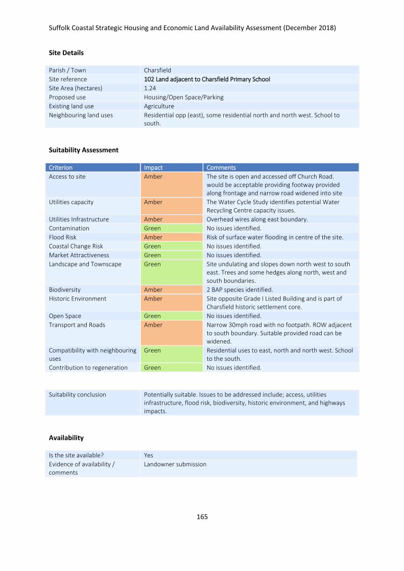
Suffolk Coastal Strategic Housing and Economic Land Availability Assessment (December 2018)
165
Site Details
Parish / Town Charsfield
Site reference 102 Land adjacent to Charsfield Primary School
Site Area (hectares) 1.24
Proposed use Housing/Open Space/Parking
Existing land use Agriculture
Neighbouring land uses Residential opp (east), some residential north and north west. School to south.
Suitability Assessment
Criterion Impact Comments
Access to site Amber The site is open and accessed off Church Road. would be acceptable providing footway provided along frontage and narrow road widened into site
Utilities capacity Amber The Water Cycle Study identifies potential Water Recycling Centre capacity issues.
Utilities Infrastructure Amber Overhead wires along east boundary.
Contamination Green No issues identified.
Flood Risk Amber Risk of surface water flooding in centre of the site.
Coastal Change Risk Green No issues identified.
Market Attractiveness Green No issues identified.
Landscape and Townscape Green Site undulating and slopes down north west to south east. Trees and some hedges along north, west and south boundaries.
Biodiversity Amber 2 BAP species identified.
Historic Environment Amber Site opposite Grade I Listed Building and is part of Charsfield historic settlement core.
Open Space Green No issues identified.
Transport and Roads Amber Narrow 30mph road with no footpath. ROW adjacent to south boundary. Suitable provided road can be widened.
Compatibility with neighbouring uses
Green Residential uses to east, north and north west. School to the south.
Contribution to regeneration Green No issues identified.
Suitability conclusion Potentially suitable. Issues to be addressed include; access, utilities infrastructure, flood risk, biodiversity, historic environment, and highways impacts.
Availability
Is the site available? Yes
Evidence of availability / comments
Landowner submission

Suffolk Coastal Strategic Housing and Economic Land Availability Assessment (December 2018)
166
Achievability
Is the site achievable? Yes
Evidence of achievability No specific issues or abnormal costs identified
Are there any commencement issues?
None identified
Estimated dwellings yield 15
Estimated employment land yield (hectares) -
Estimated retail floorspace (sqm) -
Estimated commencement date 2021/22
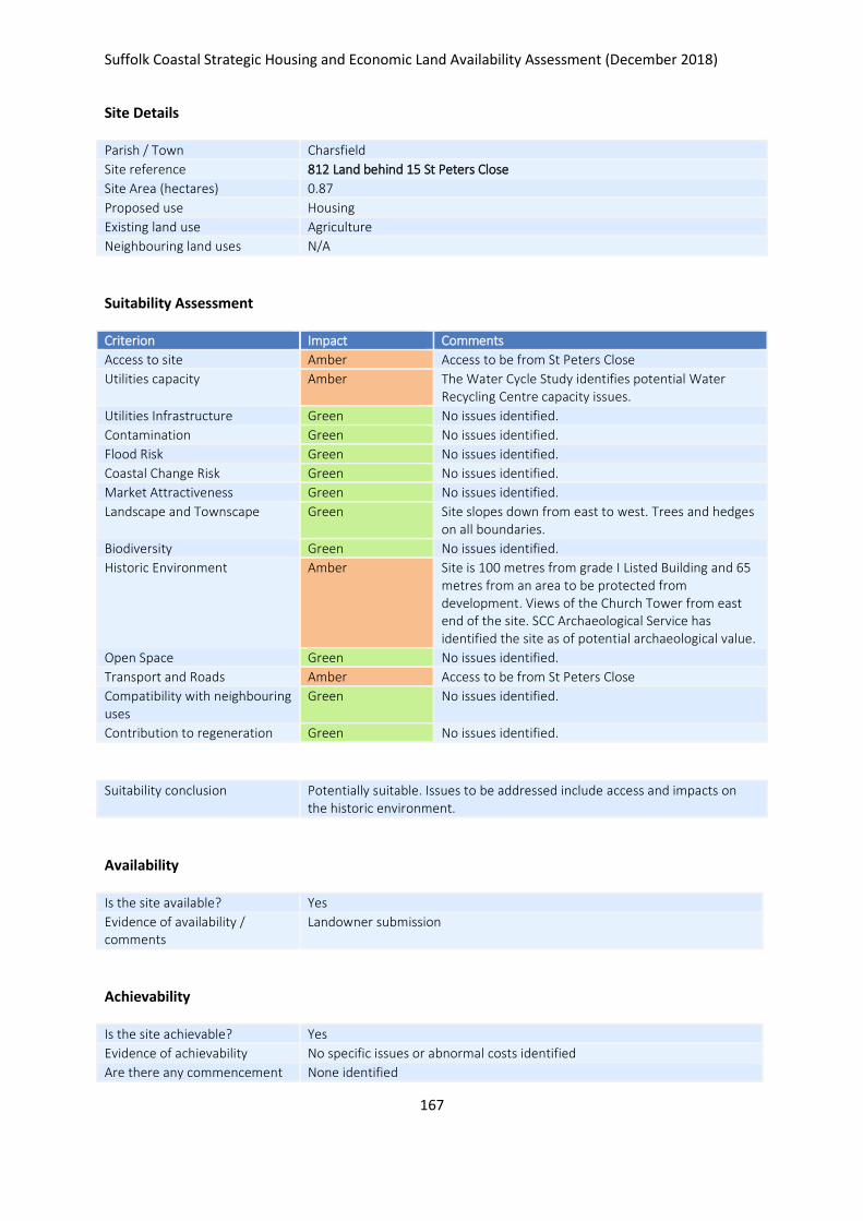
Suffolk Coastal Strategic Housing and Economic Land Availability Assessment (December 2018)
167
Site Details
Parish / Town Charsfield
Site reference 812 Land behind 15 St Peters Close
Site Area (hectares) 0.87
Proposed use Housing
Existing land use Agriculture
Neighbouring land uses N/A
Suitability Assessment
Criterion Impact Comments
Access to site Amber Access to be from St Peters Close
Utilities capacity Amber The Water Cycle Study identifies potential Water Recycling Centre capacity issues.
Utilities Infrastructure Green No issues identified.
Contamination Green No issues identified.
Flood Risk Green No issues identified.
Coastal Change Risk Green No issues identified.
Market Attractiveness Green No issues identified.
Landscape and Townscape Green Site slopes down from east to west. Trees and hedges on all boundaries.
Biodiversity Green No issues identified.
Historic Environment Amber Site is 100 metres from grade I Listed Building and 65 metres from an area to be protected from development. Views of the Church Tower from east end of the site. SCC Archaeological Service has identified the site as of potential archaeological value.
Open Space Green No issues identified.
Transport and Roads Amber Access to be from St Peters Close
Compatibility with neighbouring uses
Green No issues identified.
Contribution to regeneration Green No issues identified.
Suitability conclusion Potentially suitable. Issues to be addressed include access and impacts on the historic environment.
Availability
Is the site available? Yes
Evidence of availability / comments
Landowner submission
Achievability
Is the site achievable? Yes
Evidence of achievability No specific issues or abnormal costs identified
Are there any commencement None identified

Suffolk Coastal Strategic Housing and Economic Land Availability Assessment (December 2018)
168
issues?
Estimated dwellings yield 13
Estimated employment land yield (hectares) -
Estimated retail floorspace (sqm) -
Estimated commencement date 2021/22
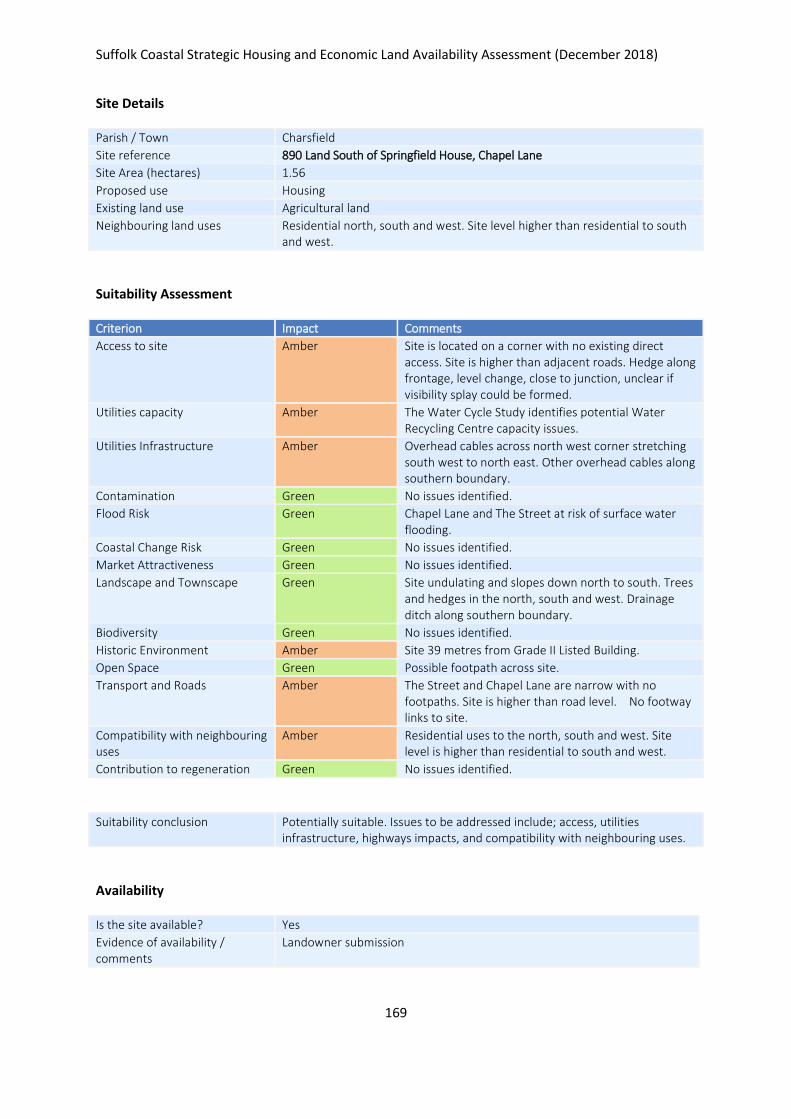
Suffolk Coastal Strategic Housing and Economic Land Availability Assessment (December 2018)
169
Site Details
Parish / Town Charsfield
Site reference 890 Land South of Springfield House, Chapel Lane
Site Area (hectares) 1.56
Proposed use Housing
Existing land use Agricultural land
Neighbouring land uses Residential north, south and west. Site level higher than residential to south and west.
Suitability Assessment
Criterion Impact Comments
Access to site Amber Site is located on a corner with no existing direct access. Site is higher than adjacent roads. Hedge along frontage, level change, close to junction, unclear if visibility splay could be formed.
Utilities capacity Amber The Water Cycle Study identifies potential Water Recycling Centre capacity issues.
Utilities Infrastructure Amber Overhead cables across north west corner stretching south west to north east. Other overhead cables along southern boundary.
Contamination Green No issues identified.
Flood Risk Green Chapel Lane and The Street at risk of surface water flooding.
Coastal Change Risk Green No issues identified.
Market Attractiveness Green No issues identified.
Landscape and Townscape Green Site undulating and slopes down north to south. Trees and hedges in the north, south and west. Drainage ditch along southern boundary.
Biodiversity Green No issues identified.
Historic Environment Amber Site 39 metres from Grade II Listed Building.
Open Space Green Possible footpath across site.
Transport and Roads Amber The Street and Chapel Lane are narrow with no footpaths. Site is higher than road level. No footway links to site.
Compatibility with neighbouring uses
Amber Residential uses to the north, south and west. Site level is higher than residential to south and west.
Contribution to regeneration Green No issues identified.
Suitability conclusion Potentially suitable. Issues to be addressed include; access, utilities infrastructure, highways impacts, and compatibility with neighbouring uses.
Availability
Is the site available? Yes
Evidence of availability / comments
Landowner submission

Suffolk Coastal Strategic Housing and Economic Land Availability Assessment (December 2018)
170
Achievability
Is the site achievable? Yes
Evidence of achievability No specific issues or abnormal costs identified
Are there any commencement issues?
None identified
Estimated dwellings yield 23
Estimated employment land yield (hectares) -
Estimated retail floorspace (sqm) -
Estimated commencement date 2023/24
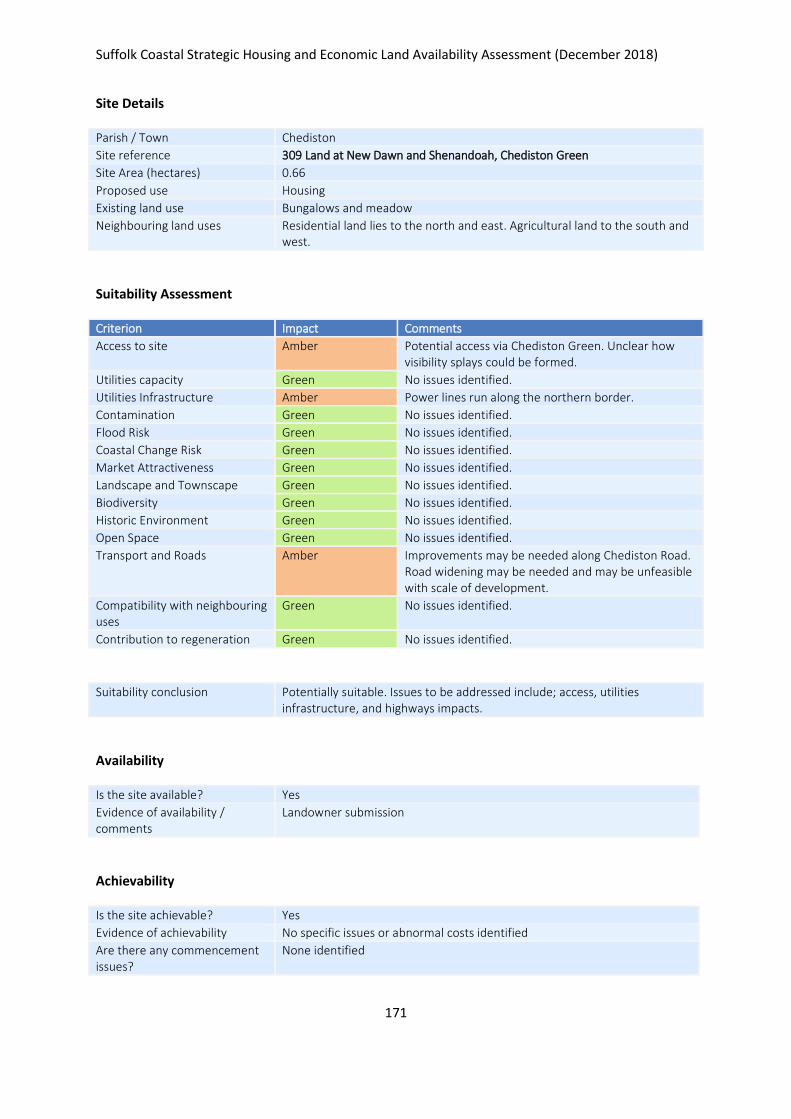
Suffolk Coastal Strategic Housing and Economic Land Availability Assessment (December 2018)
171
Site Details
Parish / Town Chediston
Site reference 309 Land at New Dawn and Shenandoah, Chediston Green
Site Area (hectares) 0.66
Proposed use Housing
Existing land use Bungalows and meadow
Neighbouring land uses Residential land lies to the north and east. Agricultural land to the south and west.
Suitability Assessment
Criterion Impact Comments
Access to site Amber Potential access via Chediston Green. Unclear how visibility splays could be formed.
Utilities capacity Green No issues identified.
Utilities Infrastructure Amber Power lines run along the northern border.
Contamination Green No issues identified.
Flood Risk Green No issues identified.
Coastal Change Risk Green No issues identified.
Market Attractiveness Green No issues identified.
Landscape and Townscape Green No issues identified.
Biodiversity Green No issues identified.
Historic Environment Green No issues identified.
Open Space Green No issues identified.
Transport and Roads Amber Improvements may be needed along Chediston Road. Road widening may be needed and may be unfeasible with scale of development.
Compatibility with neighbouring uses
Green No issues identified.
Contribution to regeneration Green No issues identified.
Suitability conclusion Potentially suitable. Issues to be addressed include; access, utilities infrastructure, and highways impacts.
Availability
Is the site available? Yes
Evidence of availability / comments
Landowner submission
Achievability
Is the site achievable? Yes
Evidence of achievability No specific issues or abnormal costs identified
Are there any commencement issues?
None identified

Suffolk Coastal Strategic Housing and Economic Land Availability Assessment (December 2018)
172
Estimated dwellings yield 10
Estimated employment land yield (hectares) -
Estimated retail floorspace (sqm) -
Estimated commencement date 2021/22
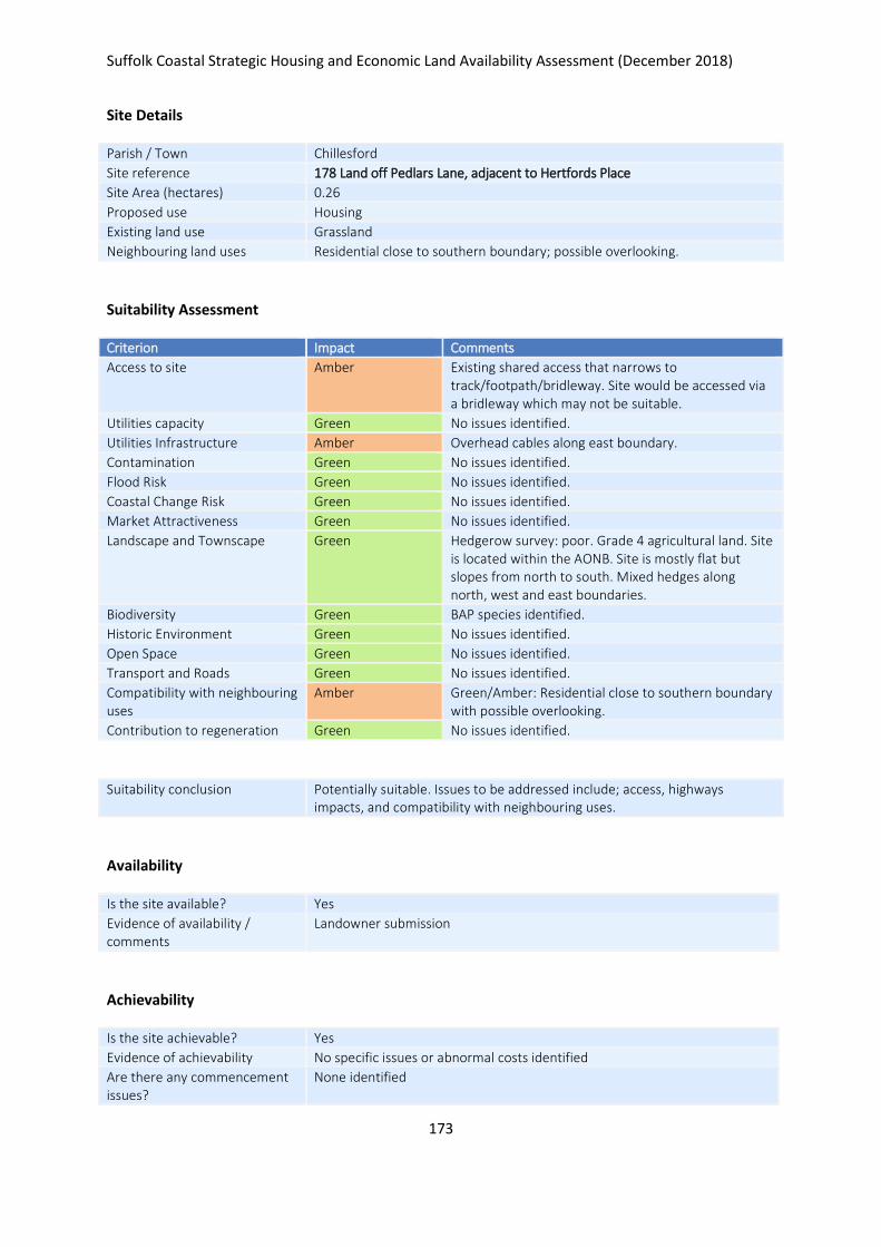
Suffolk Coastal Strategic Housing and Economic Land Availability Assessment (December 2018)
173
Site Details
Parish / Town Chillesford
Site reference 178 Land off Pedlars Lane, adjacent to Hertfords Place
Site Area (hectares) 0.26
Proposed use Housing
Existing land use Grassland
Neighbouring land uses Residential close to southern boundary; possible overlooking.
Suitability Assessment
Criterion Impact Comments
Access to site Amber Existing shared access that narrows to track/footpath/bridleway. Site would be accessed via a bridleway which may not be suitable.
Utilities capacity Green No issues identified.
Utilities Infrastructure Amber Overhead cables along east boundary.
Contamination Green No issues identified.
Flood Risk Green No issues identified.
Coastal Change Risk Green No issues identified.
Market Attractiveness Green No issues identified.
Landscape and Townscape Green Hedgerow survey: poor. Grade 4 agricultural land. Site is located within the AONB. Site is mostly flat but slopes from north to south. Mixed hedges along north, west and east boundaries.
Biodiversity Green BAP species identified.
Historic Environment Green No issues identified.
Open Space Green No issues identified.
Transport and Roads Green No issues identified.
Compatibility with neighbouring uses
Amber Green/Amber: Residential close to southern boundary with possible overlooking.
Contribution to regeneration Green No issues identified.
Suitability conclusion Potentially suitable. Issues to be addressed include; access, highways impacts, and compatibility with neighbouring uses.
Availability
Is the site available? Yes
Evidence of availability / comments
Landowner submission
Achievability
Is the site achievable? Yes
Evidence of achievability No specific issues or abnormal costs identified
Are there any commencement issues?
None identified

Suffolk Coastal Strategic Housing and Economic Land Availability Assessment (December 2018)
174
Estimated dwellings yield 4
Estimated employment land yield (hectares) -
Estimated retail floorspace (sqm) -
Estimated commencement date 2021/22
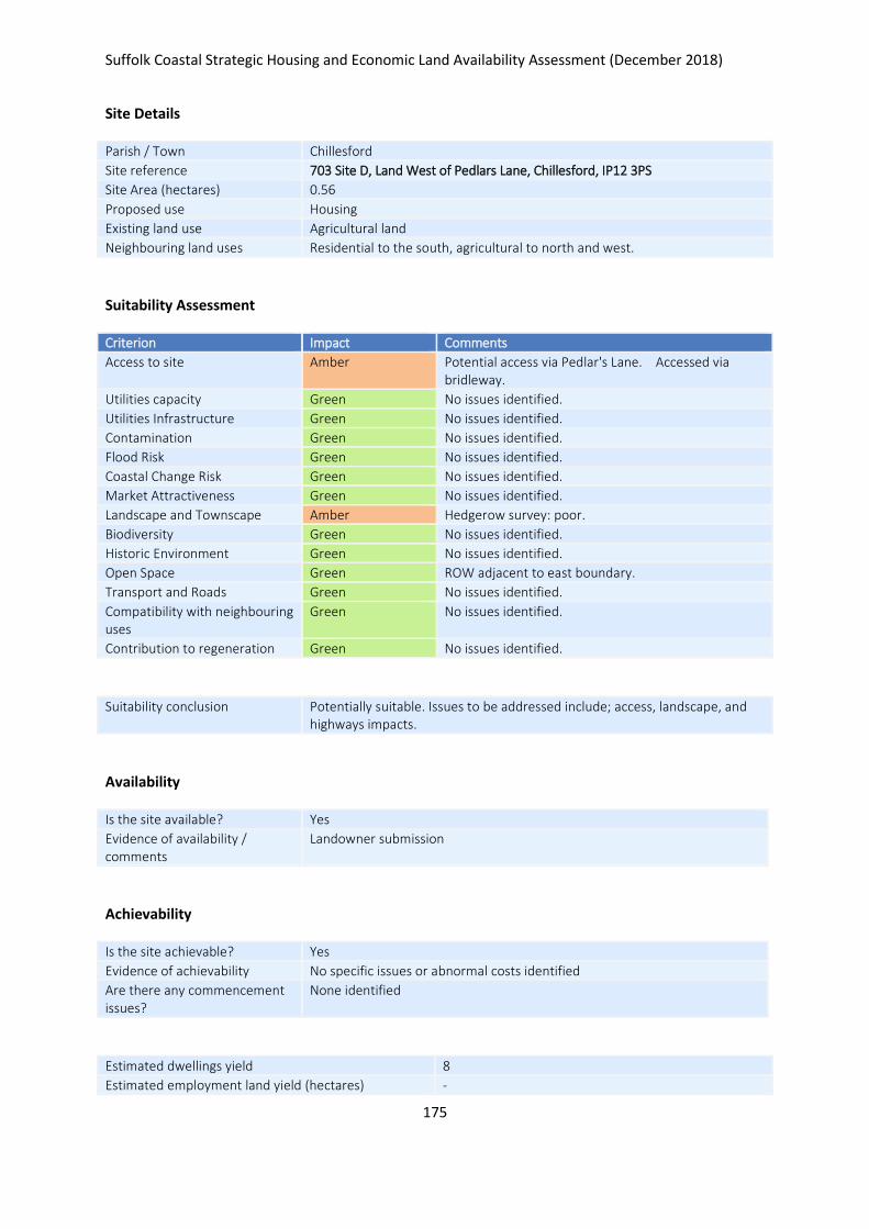
Suffolk Coastal Strategic Housing and Economic Land Availability Assessment (December 2018)
175
Site Details
Parish / Town Chillesford
Site reference 703 Site D, Land West of Pedlars Lane, Chillesford, IP12 3PS
Site Area (hectares) 0.56
Proposed use Housing
Existing land use Agricultural land
Neighbouring land uses Residential to the south, agricultural to north and west.
Suitability Assessment
Criterion Impact Comments
Access to site Amber Potential access via Pedlar's Lane. Accessed via bridleway.
Utilities capacity Green No issues identified.
Utilities Infrastructure Green No issues identified.
Contamination Green No issues identified.
Flood Risk Green No issues identified.
Coastal Change Risk Green No issues identified.
Market Attractiveness Green No issues identified.
Landscape and Townscape Amber Hedgerow survey: poor.
Biodiversity Green No issues identified.
Historic Environment Green No issues identified.
Open Space Green ROW adjacent to east boundary.
Transport and Roads Green No issues identified.
Compatibility with neighbouring uses
Green No issues identified.
Contribution to regeneration Green No issues identified.
Suitability conclusion Potentially suitable. Issues to be addressed include; access, landscape, and highways impacts.
Availability
Is the site available? Yes
Evidence of availability / comments
Landowner submission
Achievability
Is the site achievable? Yes
Evidence of achievability No specific issues or abnormal costs identified
Are there any commencement issues?
None identified
Estimated dwellings yield 8
Estimated employment land yield (hectares) -

Suffolk Coastal Strategic Housing and Economic Land Availability Assessment (December 2018)
176
Estimated retail floorspace (sqm) -
Estimated commencement date 2020/21
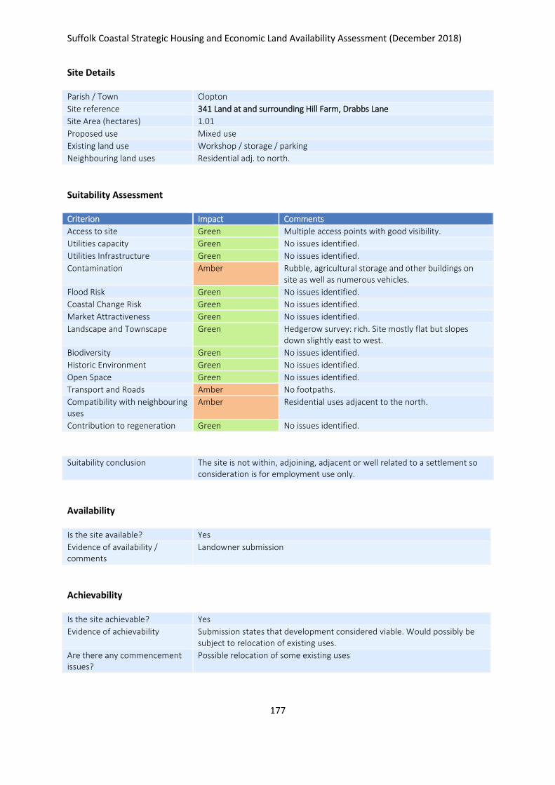
Suffolk Coastal Strategic Housing and Economic Land Availability Assessment (December 2018)
177
Site Details
Parish / Town Clopton
Site reference 341 Land at and surrounding Hill Farm, Drabbs Lane
Site Area (hectares) 1.01
Proposed use Mixed use
Existing land use Workshop / storage / parking
Neighbouring land uses Residential adj. to north.
Suitability Assessment
Criterion Impact Comments
Access to site Green Multiple access points with good visibility.
Utilities capacity Green No issues identified.
Utilities Infrastructure Green No issues identified.
Contamination Amber Rubble, agricultural storage and other buildings on site as well as numerous vehicles.
Flood Risk Green No issues identified.
Coastal Change Risk Green No issues identified.
Market Attractiveness Green No issues identified.
Landscape and Townscape Green Hedgerow survey: rich. Site mostly flat but slopes down slightly east to west.
Biodiversity Green No issues identified.
Historic Environment Green No issues identified.
Open Space Green No issues identified.
Transport and Roads Amber No footpaths.
Compatibility with neighbouring uses
Amber Residential uses adjacent to the north.
Contribution to regeneration Green No issues identified.
Suitability conclusion The site is not within, adjoining, adjacent or well related to a settlement so consideration is for employment use only.
Availability
Is the site available? Yes
Evidence of availability / comments
Landowner submission
Achievability
Is the site achievable? Yes
Evidence of achievability Submission states that development considered viable. Would possibly be subject to relocation of existing uses.
Are there any commencement issues?
Possible relocation of some existing uses

Suffolk Coastal Strategic Housing and Economic Land Availability Assessment (December 2018)
178
Estimated dwellings yield -
Estimated employment land yield (hectares) 1
Estimated retail floorspace (sqm) -
Estimated commencement date 2023/24
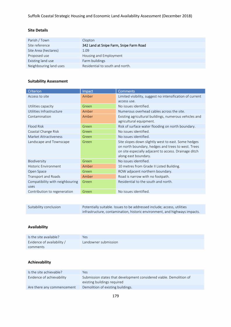
Suffolk Coastal Strategic Housing and Economic Land Availability Assessment (December 2018)
179
Site Details
Parish / Town Clopton
Site reference 342 Land at Snipe Farm, Snipe Farm Road
Site Area (hectares) 1.09
Proposed use Housing and Employment
Existing land use Farm buildings
Neighbouring land uses Residential to south and north.
Suitability Assessment
Criterion Impact Comments
Access to site Amber Limited visibility, suggest no intensification of current access use.
Utilities capacity Green No issues identified.
Utilities Infrastructure Amber Numerous overhead cables across the site.
Contamination Amber Existing agricultural buildings, numerous vehicles and agricultural equipment.
Flood Risk Green Risk of surface water flooding on north boundary.
Coastal Change Risk Green No issues identified.
Market Attractiveness Green No issues identified.
Landscape and Townscape Green Site slopes down slightly west to east. Some hedges on north boundary, hedges and trees to west. Trees on site especially adjacent to access. Drainage ditch along east boundary.
Biodiversity Green No issues identified.
Historic Environment Amber 10 metres from Grade II Listed Building.
Open Space Green ROW adjacent northern boundary.
Transport and Roads Amber Road is narrow with no footpath.
Compatibility with neighbouring uses
Green Residential to the south and north.
Contribution to regeneration Green No issues identified.
Suitability conclusion Potentially suitable. Issues to be addressed include; access, utilities infrastructure, contamination, historic environment, and highways impacts.
Availability
Is the site available? Yes
Evidence of availability / comments
Landowner submission
Achievability
Is the site achievable? Yes
Evidence of achievability Submission states that development considered viable. Demolition of existing buildings required
Are there any commencement Demolition of existing buildings.

Suffolk Coastal Strategic Housing and Economic Land Availability Assessment (December 2018)
180
issues?
Estimated dwellings yield 13
Estimated employment land yield (hectares) -
Estimated retail floorspace (sqm) -
Estimated commencement date 2022/23
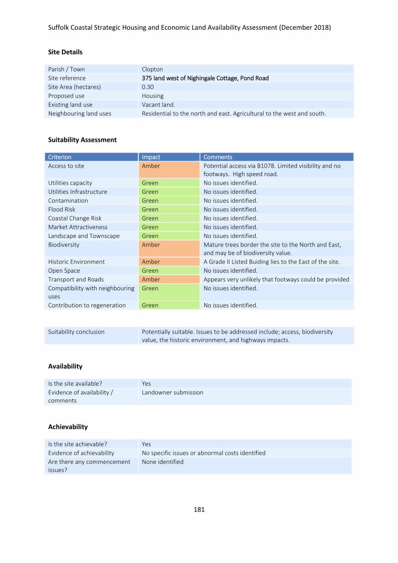
Suffolk Coastal Strategic Housing and Economic Land Availability Assessment (December 2018)
181
Site Details
Parish / Town Clopton
Site reference 375 land west of Nighingale Cottage, Pond Road
Site Area (hectares) 0.30
Proposed use Housing
Existing land use Vacant land.
Neighbouring land uses Residential to the north and east. Agricultural to the west and south.
Suitability Assessment
Criterion Impact Comments
Access to site Amber Potential access via B1078. Limited visibility and no footways. High speed road.
Utilities capacity Green No issues identified.
Utilities Infrastructure Green No issues identified.
Contamination Green No issues identified.
Flood Risk Green No issues identified.
Coastal Change Risk Green No issues identified.
Market Attractiveness Green No issues identified.
Landscape and Townscape Green No issues identified.
Biodiversity Amber Mature trees border the site to the North and East, and may be of biodiversity value.
Historic Environment Amber A Grade II Listed Buiding lies to the East of the site.
Open Space Green No issues identified.
Transport and Roads Amber Appears very unlikely that footways could be provided
Compatibility with neighbouring uses
Green No issues identified.
Contribution to regeneration Green No issues identified.
Suitability conclusion Potentially suitable. Issues to be addressed include; access, biodiversity value, the historic environment, and highways impacts.
Availability
Is the site available? Yes
Evidence of availability / comments
Landowner submission
Achievability
Is the site achievable? Yes
Evidence of achievability No specific issues or abnormal costs identified
Are there any commencement issues?
None identified

Suffolk Coastal Strategic Housing and Economic Land Availability Assessment (December 2018)
182
Estimated dwellings yield 4
Estimated employment land yield (hectares) -
Estimated retail floorspace (sqm) -
Estimated commencement date 2022/23
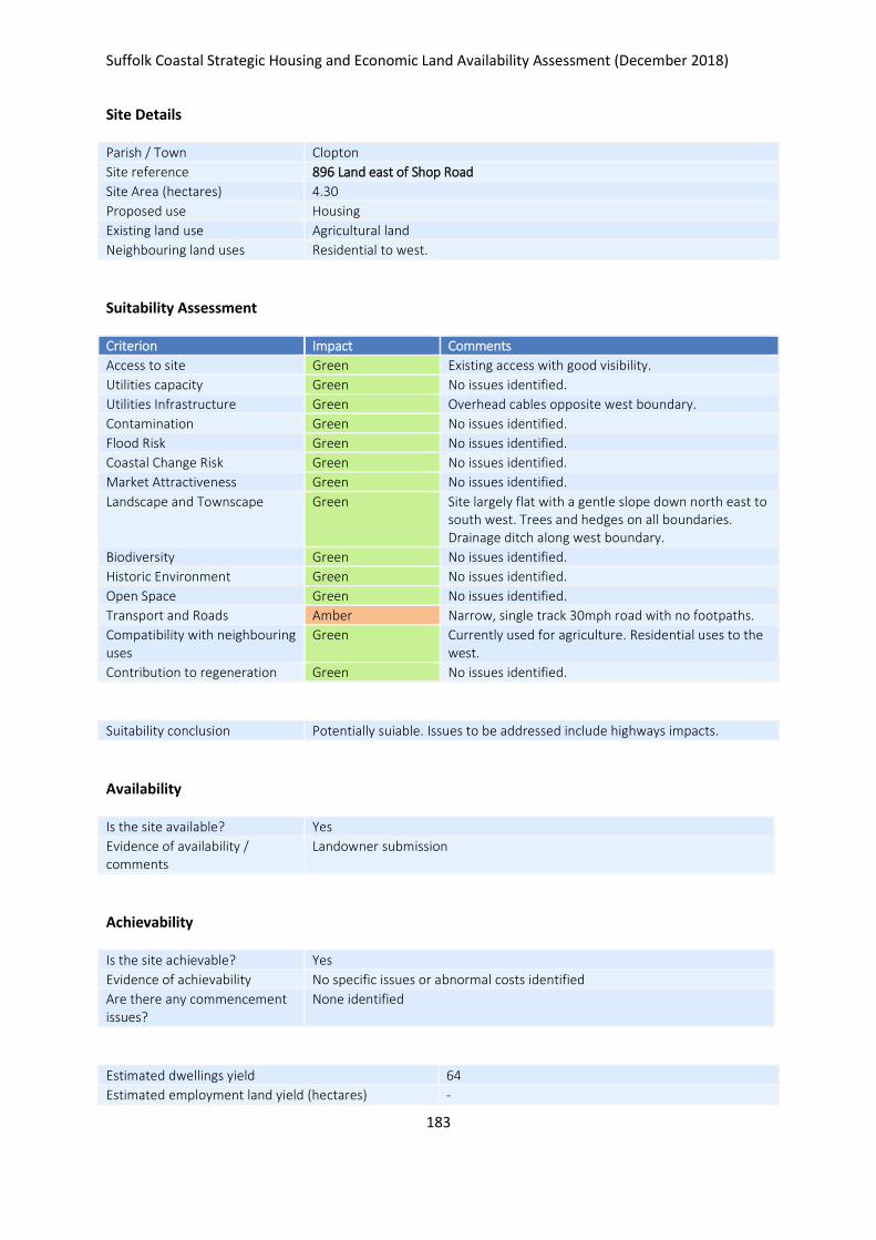
Suffolk Coastal Strategic Housing and Economic Land Availability Assessment (December 2018)
183
Site Details
Parish / Town Clopton
Site reference 896 Land east of Shop Road
Site Area (hectares) 4.30
Proposed use Housing
Existing land use Agricultural land
Neighbouring land uses Residential to west.
Suitability Assessment
Criterion Impact Comments
Access to site Green Existing access with good visibility.
Utilities capacity Green No issues identified.
Utilities Infrastructure Green Overhead cables opposite west boundary.
Contamination Green No issues identified.
Flood Risk Green No issues identified.
Coastal Change Risk Green No issues identified.
Market Attractiveness Green No issues identified.
Landscape and Townscape Green Site largely flat with a gentle slope down north east to south west. Trees and hedges on all boundaries. Drainage ditch along west boundary.
Biodiversity Green No issues identified.
Historic Environment Green No issues identified.
Open Space Green No issues identified.
Transport and Roads Amber Narrow, single track 30mph road with no footpaths.
Compatibility with neighbouring uses
Green Currently used for agriculture. Residential uses to the west.
Contribution to regeneration Green No issues identified.
Suitability conclusion Potentially suiable. Issues to be addressed include highways impacts.
Availability
Is the site available? Yes
Evidence of availability / comments
Landowner submission
Achievability
Is the site achievable? Yes
Evidence of achievability No specific issues or abnormal costs identified
Are there any commencement issues?
None identified
Estimated dwellings yield 64
Estimated employment land yield (hectares) -

Suffolk Coastal Strategic Housing and Economic Land Availability Assessment (December 2018)
184
Estimated retail floorspace (sqm) -
Estimated commencement date 2021/22
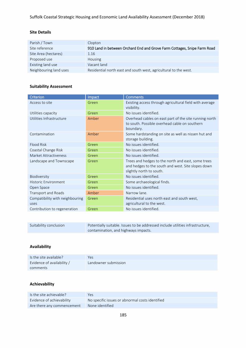
Suffolk Coastal Strategic Housing and Economic Land Availability Assessment (December 2018)
185
Site Details
Parish / Town Clopton
Site reference 910 Land in between Orchard End and Grove Farm Cottages, Snipe Farm Road
Site Area (hectares) 1.16
Proposed use Housing
Existing land use Vacant land
Neighbouring land uses Residential north east and south west, agricultural to the west.
Suitability Assessment
Criterion Impact Comments
Access to site Green Existing access through agricultural field with average visibility.
Utilities capacity Green No issues identified.
Utilities Infrastructure Amber Overhead cables on east part of the site running north to south. Possible overhead cable on southern boundary.
Contamination Amber Some hardstanding on site as well as nissen hut and storage building.
Flood Risk Green No issues identified.
Coastal Change Risk Green No issues identified.
Market Attractiveness Green No issues identified.
Landscape and Townscape Green Trees and hedges to the north and east, some trees and hedges to the south and west. Site slopes down slightly north to south.
Biodiversity Green No issues identified.
Historic Environment Green Some archaeological finds.
Open Space Green No issues identified.
Transport and Roads Amber Narrow lane.
Compatibility with neighbouring uses
Green Residential uses north east and south west, agricultural to the west.
Contribution to regeneration Green No issues identified.
Suitability conclusion Potentially suitable. Issues to be addressed include utilities infrastructure, contamination, and highways impacts.
Availability
Is the site available? Yes
Evidence of availability / comments
Landowner submission
Achievability
Is the site achievable? Yes
Evidence of achievability No specific issues or abnormal costs identified
Are there any commencement None identified

Suffolk Coastal Strategic Housing and Economic Land Availability Assessment (December 2018)
186
issues?
Estimated dwellings yield 17
Estimated employment land yield (hectares) -
Estimated retail floorspace (sqm) -
Estimated commencement date 2023/24
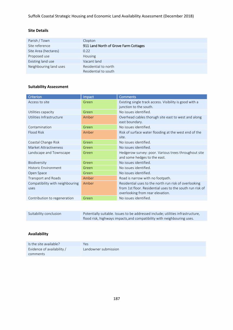
Suffolk Coastal Strategic Housing and Economic Land Availability Assessment (December 2018)
187
Site Details
Parish / Town Clopton
Site reference 911 Land North of Grove Farm Cottages
Site Area (hectares) 0.22
Proposed use Housing
Existing land use Vacant land
Neighbouring land uses Residential to north Residential to south
Suitability Assessment
Criterion Impact Comments
Access to site Green Existing single track access. Visibility is good with a junction to the south.
Utilities capacity Green No issues identified.
Utilities Infrastructure Amber Overhead cables thorugh site east to west and along east boundary.
Contamination Green No issues identified.
Flood Risk Amber Risk of surface water flooding at the west end of the site.
Coastal Change Risk Green No issues identified.
Market Attractiveness Green No issues identified.
Landscape and Townscape Green Hedgerow survey: poor. Various trees throughout site and some hedges to the east.
Biodiversity Green No issues identified.
Historic Environment Green No issues identified.
Open Space Green No issues identified.
Transport and Roads Amber Road is narrow with no footpath.
Compatibility with neighbouring uses
Amber Residential uses to the north run risk of overlooking from 1st floor. Residential uses to the south run risk of overlooking from rear elevation.
Contribution to regeneration Green No issues identified.
Suitability conclusion Potentially suitable. Issues to be addressed include; utilities infrastructure, flood risk, highways impacts,and compatibility with neighbouring uses.
Availability
Is the site available? Yes
Evidence of availability / comments
Landowner submission

Suffolk Coastal Strategic Housing and Economic Land Availability Assessment (December 2018)
188
Achievability
Is the site achievable? Yes
Evidence of achievability No specific issues or abnormal costs identified
Are there any commencement issues?
None identified
Estimated dwellings yield 3
Estimated employment land yield (hectares) -
Estimated retail floorspace (sqm) -
Estimated commencement date 2023/24

Suffolk Coastal Strategic Housing and Economic Land Availability Assessment (December 2018)
189
Site Details
Parish / Town Clopton
Site reference 1097 Debach Airfield, Clopton
Site Area (hectares) 20.37
Proposed use Business & office, general industrial, storage or distribution & renewable energy
Existing land use Employment
Neighbouring land uses Agriculture, some residential
Suitability Assessment
Criterion Impact Comments
Access to site Green Existing access suitale.
Utilities capacity Green No issues identified.
Utilities Infrastructure Green No issues identified.
Contamination Amber Potential land contamination due to previous use of the site – Grove Farm (NW of site) identified as low priority contaminated land
Flood Risk Amber Surface water flooding present in SE/NW/SW/centre of the site
Coastal Change Risk Green No issues identified.
Market Attractiveness Green No issues identified.
Landscape and Townscape Amber Site is situated in a large open area. Listed Building located SW of the site may have views affected.
Biodiversity Green No issues identified.
Historic Environment Amber Listed Building located SW of the site may have views affected – but this is unlikely
Open Space Green No issues identified.
Transport and Roads Amber Road at the entrance of site is adequate however road South and West of the site is narrow and unmarked. Development of this scale would impact upon A12 junctions.
Compatibility with neighbouring uses
Green No issues identified.
Contribution to regeneration Green No issues identified.
Suitability conclusion Site currently allocated for employment. Additional employment uses would be acceptable subject to issues of cumulative impact on roads & size/scale of proposed additional uses.
Availability
Is the site available? Yes
Evidence of availability / comments
Landowner submission

Suffolk Coastal Strategic Housing and Economic Land Availability Assessment (December 2018)
190
Achievability
Is the site achievable? Yes
Evidence of achievability No specific issues or abnormal costs identified
Are there any commencement issues?
None identified
Estimated dwellings yield -
Estimated employment land yield (hectares) 10
Estimated retail floorspace (sqm) -
Estimated commencement date 2024/25
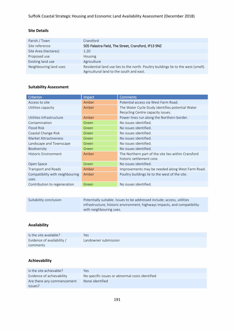
Suffolk Coastal Strategic Housing and Economic Land Availability Assessment (December 2018)
191
Site Details
Parish / Town Cransford
Site reference 505 Palastra Field, The Street, Cransford, IP13 9NZ
Site Area (hectares) 1.20
Proposed use Housing
Existing land use Agriculture
Neighbouring land uses Residential land use lies to the north. Poultry buildings lie to the west (smell). Agricultural land to the south and east.
Suitability Assessment
Criterion Impact Comments
Access to site Amber Potential access via West Farm Road.
Utilities capacity Amber The Water Cycle Study identifies potential Water Recycling Centre capacity issues.
Utilities Infrastructure Amber Power lines run along the Northern border.
Contamination Green No issues identified.
Flood Risk Green No issues identified.
Coastal Change Risk Green No issues identified.
Market Attractiveness Green No issues identified.
Landscape and Townscape Green No issues identified.
Biodiversity Green No issues identified.
Historic Environment Amber The Northern part of the site lies within Cransford historic settlement core.
Open Space Green No issues identified.
Transport and Roads Amber Improvements may be needed along West Farm Road.
Compatibility with neighbouring uses
Amber Poultry buildings lie to the west of the site.
Contribution to regeneration Green No issues identified.
Suitability conclusion Potentially suitable. Issues to be addressed include; access, utilities infrastructure, historic environment, highways impacts, and compatibility with neighbouring uses.
Availability
Is the site available? Yes
Evidence of availability / comments
Landowner submission
Achievability
Is the site achievable? Yes
Evidence of achievability No specific issues or abnormal costs identified
Are there any commencement issues?
None identified

Suffolk Coastal Strategic Housing and Economic Land Availability Assessment (December 2018)
192
Estimated dwellings yield 18
Estimated employment land yield (hectares) -
Estimated retail floorspace (sqm) -
Estimated commencement date 2020/21
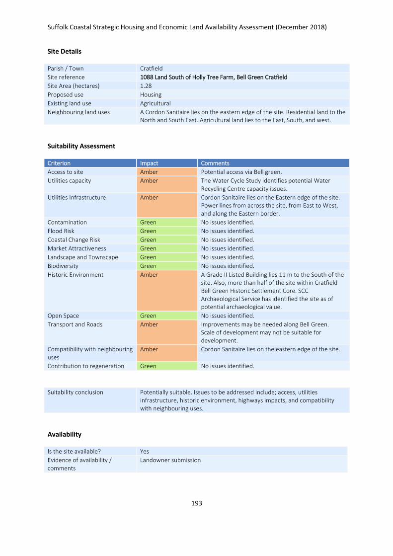
Suffolk Coastal Strategic Housing and Economic Land Availability Assessment (December 2018)
193
Site Details
Parish / Town Cratfield
Site reference 1088 Land South of Holly Tree Farm, Bell Green Cratfield
Site Area (hectares) 1.28
Proposed use Housing
Existing land use Agricultural
Neighbouring land uses A Cordon Sanitaire lies on the eastern edge of the site. Residential land to the North and South East. Agricultural land lies to the East, South, and west.
Suitability Assessment
Criterion Impact Comments
Access to site Amber Potential access via Bell green.
Utilities capacity Amber The Water Cycle Study identifies potential Water Recycling Centre capacity issues.
Utilities Infrastructure Amber Cordon Sanitaire lies on the Eastern edge of the site. Power lines from across the site, from East to West, and along the Eastern border.
Contamination Green No issues identified.
Flood Risk Green No issues identified.
Coastal Change Risk Green No issues identified.
Market Attractiveness Green No issues identified.
Landscape and Townscape Green No issues identified.
Biodiversity Green No issues identified.
Historic Environment Amber A Grade II Listed Building lies 11 m to the South of the site. Also, more than half of the site within Cratfield Bell Green Historic Settlement Core. SCC Archaeological Service has identified the site as of potential archaeological value.
Open Space Green No issues identified.
Transport and Roads Amber Improvements may be needed along Bell Green. Scale of development may not be suitable for development.
Compatibility with neighbouring uses
Amber Cordon Sanitaire lies on the eastern edge of the site.
Contribution to regeneration Green No issues identified.
Suitability conclusion Potentially suitable. Issues to be addressed include; access, utilities infrastructure, historic environment, highways impacts, and compatibility with neighbouring uses.
Availability
Is the site available? Yes
Evidence of availability / comments
Landowner submission

Suffolk Coastal Strategic Housing and Economic Land Availability Assessment (December 2018)
194
Achievability
Is the site achievable? Yes
Evidence of achievability No specific issues or abnormal costs identified
Are there any commencement issues?
None identified
Estimated dwellings yield 19
Estimated employment land yield (hectares) -
Estimated retail floorspace (sqm) -
Estimated commencement date 2023/24
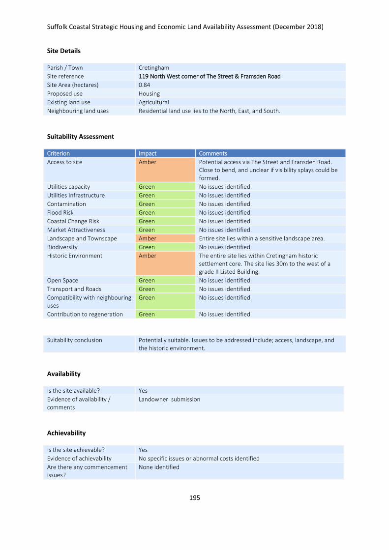
Suffolk Coastal Strategic Housing and Economic Land Availability Assessment (December 2018)
195
Site Details
Parish / Town Cretingham
Site reference 119 North West corner of The Street & Framsden Road
Site Area (hectares) 0.84
Proposed use Housing
Existing land use Agricultural
Neighbouring land uses Residential land use lies to the North, East, and South.
Suitability Assessment
Criterion Impact Comments
Access to site Amber Potential access via The Street and Fransden Road. Close to bend, and unclear if visibility splays could be formed.
Utilities capacity Green No issues identified.
Utilities Infrastructure Green No issues identified.
Contamination Green No issues identified.
Flood Risk Green No issues identified.
Coastal Change Risk Green No issues identified.
Market Attractiveness Green No issues identified.
Landscape and Townscape Amber Entire site lies within a sensitive landscape area.
Biodiversity Green No issues identified.
Historic Environment Amber The entire site lies within Cretingham historic settlement core. The site lies 30m to the west of a grade II Listed Building.
Open Space Green No issues identified.
Transport and Roads Green No issues identified.
Compatibility with neighbouring uses
Green No issues identified.
Contribution to regeneration Green No issues identified.
Suitability conclusion Potentially suitable. Issues to be addressed include; access, landscape, and the historic environment.
Availability
Is the site available? Yes
Evidence of availability / comments
Landowner submission
Achievability
Is the site achievable? Yes
Evidence of achievability No specific issues or abnormal costs identified
Are there any commencement issues?
None identified

Suffolk Coastal Strategic Housing and Economic Land Availability Assessment (December 2018)
196
Estimated dwellings yield 13
Estimated employment land yield (hectares) -
Estimated retail floorspace (sqm) -
Estimated commencement date 2023/24
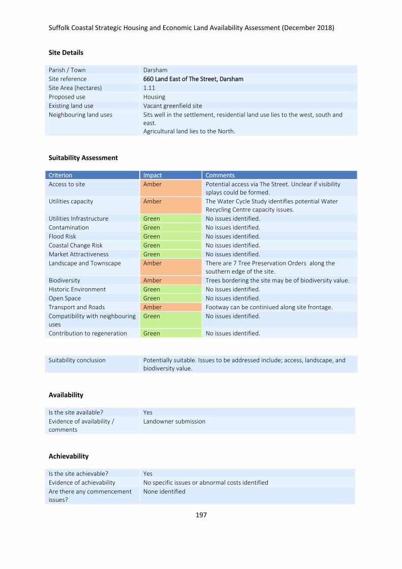
Suffolk Coastal Strategic Housing and Economic Land Availability Assessment (December 2018)
197
Site Details
Parish / Town Darsham
Site reference 660 Land East of The Street, Darsham
Site Area (hectares) 1.11
Proposed use Housing
Existing land use Vacant greenfield site
Neighbouring land uses Sits well in the settlement, residential land use lies to the west, south and east. Agricultural land lies to the North.
Suitability Assessment
Criterion Impact Comments
Access to site Amber Potential access via The Street. Unclear if visibility splays could be formed.
Utilities capacity Amber The Water Cycle Study identifies potential Water Recycling Centre capacity issues.
Utilities Infrastructure Green No issues identified.
Contamination Green No issues identified.
Flood Risk Green No issues identified.
Coastal Change Risk Green No issues identified.
Market Attractiveness Green No issues identified.
Landscape and Townscape Amber There are 7 Tree Preservation Orders along the southern edge of the site.
Biodiversity Amber Trees bordering the site may be of biodiversity value.
Historic Environment Green No issues identified.
Open Space Green No issues identified.
Transport and Roads Amber Footway can be continiued along site frontage.
Compatibility with neighbouring uses
Green No issues identified.
Contribution to regeneration Green No issues identified.
Suitability conclusion Potentially suitable. Issues to be addressed include; access, landscape, and biodiversity value.
Availability
Is the site available? Yes
Evidence of availability / comments
Landowner submission
Achievability
Is the site achievable? Yes
Evidence of achievability No specific issues or abnormal costs identified
Are there any commencement issues?
None identified

Suffolk Coastal Strategic Housing and Economic Land Availability Assessment (December 2018)
198
Estimated dwellings yield 17
Estimated employment land yield (hectares) -
Estimated retail floorspace (sqm) -
Estimated commencement date 2021/22
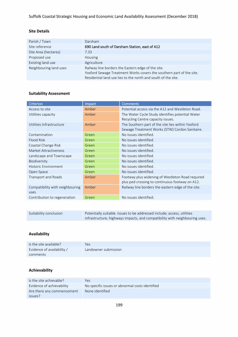
Suffolk Coastal Strategic Housing and Economic Land Availability Assessment (December 2018)
199
Site Details
Parish / Town Darsham
Site reference 690 Land south of Darsham Station, east of A12
Site Area (hectares) 7.33
Proposed use Housing
Existing land use Agriculture
Neighbouring land uses Railway line borders the Eastern edge of the site. Yoxford Sewage Treatment Works covers the southern part of the site. Residential land use lies to the north and south of the site.
Suitability Assessment
Criterion Impact Comments
Access to site Amber Potential access via the A12 and Westleton Road.
Utilities capacity Amber The Water Cycle Study identifies potential Water Recycling Centre capacity issues.
Utilities Infrastructure Amber The Southern part of the site lies within Yoxford Sewage Treatment Works (STW) Cordon Sanitaire.
Contamination Green No issues identified.
Flood Risk Green No issues identified.
Coastal Change Risk Green No issues identified.
Market Attractiveness Green No issues identified.
Landscape and Townscape Green No issues identified.
Biodiversity Green No issues identified.
Historic Environment Green No issues identified.
Open Space Green No issues identified.
Transport and Roads Amber Footway plus widening of Westleton Road required plus ped crossing to continuous footway on A12.
Compatibility with neighbouring uses
Amber Railway line borders the eastern edge of the site.
Contribution to regeneration Green No issues identified.
Suitability conclusion Potentially suitable. Issues to be addressed include; access, utilities infrastructure, highways impacts, and compatibility with neighbouring uses.
Availability
Is the site available? Yes
Evidence of availability / comments
Landowner submission
Achievability
Is the site achievable? Yes
Evidence of achievability No specific issues or abnormal costs identified
Are there any commencement issues?
None identified

Suffolk Coastal Strategic Housing and Economic Land Availability Assessment (December 2018)
200
Estimated dwellings yield 110
Estimated employment land yield (hectares) -
Estimated retail floorspace (sqm) -
Estimated commencement date 2020/21
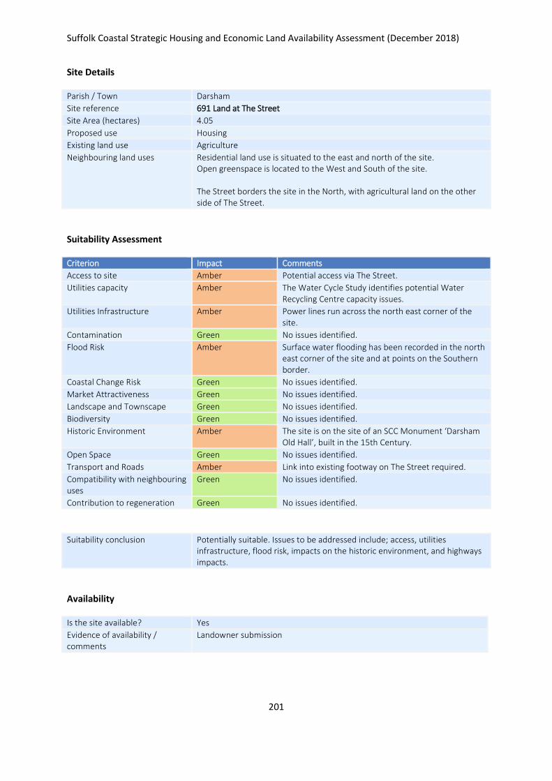
Suffolk Coastal Strategic Housing and Economic Land Availability Assessment (December 2018)
201
Site Details
Parish / Town Darsham
Site reference 691 Land at The Street
Site Area (hectares) 4.05
Proposed use Housing
Existing land use Agriculture
Neighbouring land uses Residential land use is situated to the east and north of the site. Open greenspace is located to the West and South of the site. The Street borders the site in the North, with agricultural land on the other side of The Street.
Suitability Assessment
Criterion Impact Comments
Access to site Amber Potential access via The Street.
Utilities capacity Amber The Water Cycle Study identifies potential Water Recycling Centre capacity issues.
Utilities Infrastructure Amber Power lines run across the north east corner of the site.
Contamination Green No issues identified.
Flood Risk Amber Surface water flooding has been recorded in the north east corner of the site and at points on the Southern border.
Coastal Change Risk Green No issues identified.
Market Attractiveness Green No issues identified.
Landscape and Townscape Green No issues identified.
Biodiversity Green No issues identified.
Historic Environment Amber The site is on the site of an SCC Monument ‘Darsham Old Hall’, built in the 15th Century.
Open Space Green No issues identified.
Transport and Roads Amber Link into existing footway on The Street required.
Compatibility with neighbouring uses
Green No issues identified.
Contribution to regeneration Green No issues identified.
Suitability conclusion Potentially suitable. Issues to be addressed include; access, utilities infrastructure, flood risk, impacts on the historic environment, and highways impacts.
Availability
Is the site available? Yes
Evidence of availability / comments
Landowner submission

Suffolk Coastal Strategic Housing and Economic Land Availability Assessment (December 2018)
202
Achievability
Is the site achievable? Yes
Evidence of achievability No specific issues or abnormal costs identified
Are there any commencement issues?
None identified
Estimated dwellings yield 61
Estimated employment land yield (hectares) -
Estimated retail floorspace (sqm) -
Estimated commencement date 2021/22
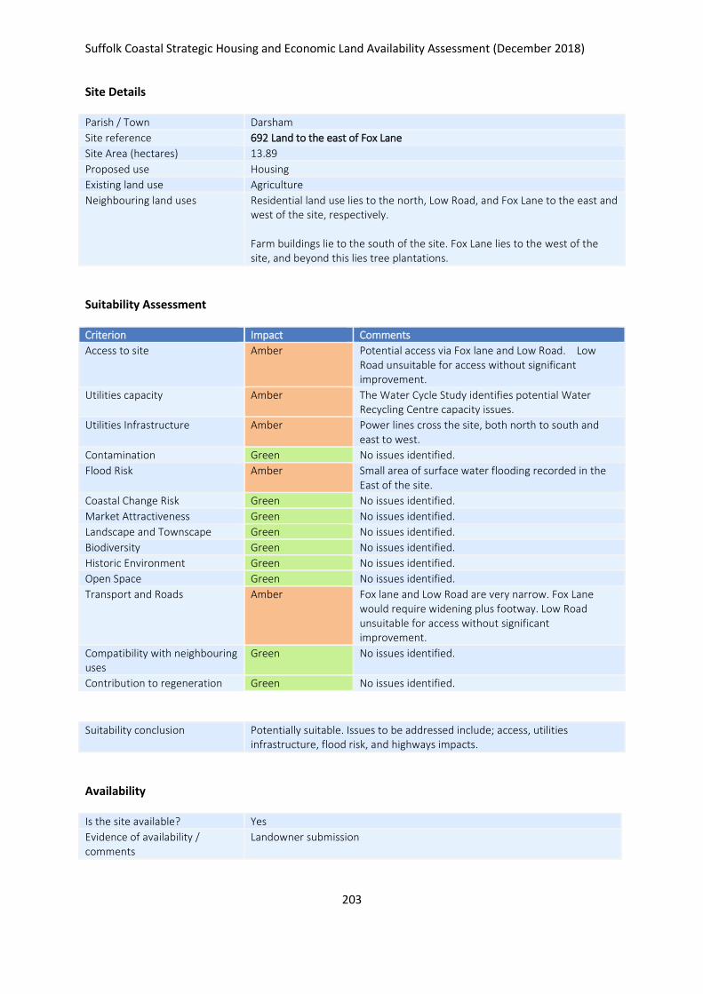
Suffolk Coastal Strategic Housing and Economic Land Availability Assessment (December 2018)
203
Site Details
Parish / Town Darsham
Site reference 692 Land to the east of Fox Lane
Site Area (hectares) 13.89
Proposed use Housing
Existing land use Agriculture
Neighbouring land uses Residential land use lies to the north, Low Road, and Fox Lane to the east and west of the site, respectively. Farm buildings lie to the south of the site. Fox Lane lies to the west of the site, and beyond this lies tree plantations.
Suitability Assessment
Criterion Impact Comments
Access to site Amber Potential access via Fox lane and Low Road. Low Road unsuitable for access without significant improvement.
Utilities capacity Amber The Water Cycle Study identifies potential Water Recycling Centre capacity issues.
Utilities Infrastructure Amber Power lines cross the site, both north to south and east to west.
Contamination Green No issues identified.
Flood Risk Amber Small area of surface water flooding recorded in the East of the site.
Coastal Change Risk Green No issues identified.
Market Attractiveness Green No issues identified.
Landscape and Townscape Green No issues identified.
Biodiversity Green No issues identified.
Historic Environment Green No issues identified.
Open Space Green No issues identified.
Transport and Roads Amber Fox lane and Low Road are very narrow. Fox Lane would require widening plus footway. Low Road unsuitable for access without significant improvement.
Compatibility with neighbouring uses
Green No issues identified.
Contribution to regeneration Green No issues identified.
Suitability conclusion Potentially suitable. Issues to be addressed include; access, utilities infrastructure, flood risk, and highways impacts.
Availability
Is the site available? Yes
Evidence of availability / comments
Landowner submission

Suffolk Coastal Strategic Housing and Economic Land Availability Assessment (December 2018)
204
Achievability
Is the site achievable? Yes
Evidence of achievability No specific issues or abnormal costs identified
Are there any commencement issues?
None identified
Estimated dwellings yield 208
Estimated employment land yield (hectares) -
Estimated retail floorspace (sqm) -
Estimated commencement date 2021/22
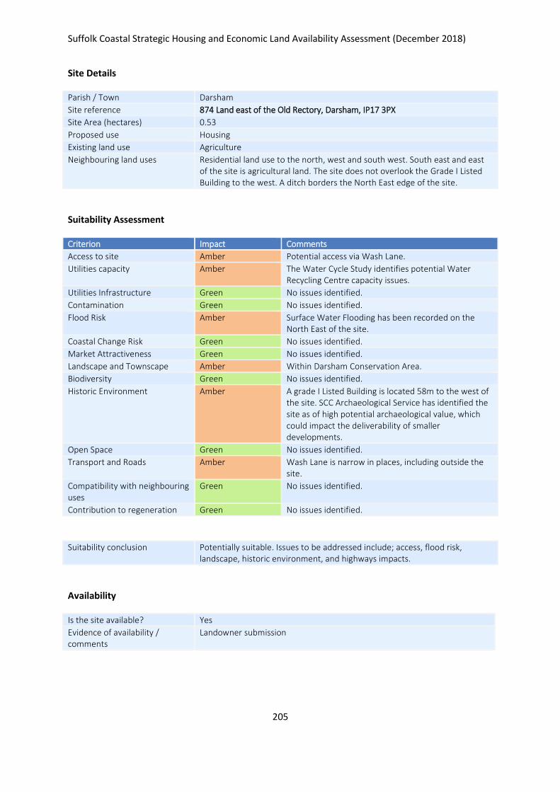
Suffolk Coastal Strategic Housing and Economic Land Availability Assessment (December 2018)
205
Site Details
Parish / Town Darsham
Site reference 874 Land east of the Old Rectory, Darsham, IP17 3PX
Site Area (hectares) 0.53
Proposed use Housing
Existing land use Agriculture
Neighbouring land uses Residential land use to the north, west and south west. South east and east of the site is agricultural land. The site does not overlook the Grade I Listed Building to the west. A ditch borders the North East edge of the site.
Suitability Assessment
Criterion Impact Comments
Access to site Amber Potential access via Wash Lane.
Utilities capacity Amber The Water Cycle Study identifies potential Water Recycling Centre capacity issues.
Utilities Infrastructure Green No issues identified.
Contamination Green No issues identified.
Flood Risk Amber Surface Water Flooding has been recorded on the North East of the site.
Coastal Change Risk Green No issues identified.
Market Attractiveness Green No issues identified.
Landscape and Townscape Amber Within Darsham Conservation Area.
Biodiversity Green No issues identified.
Historic Environment Amber A grade I Listed Building is located 58m to the west of the site. SCC Archaeological Service has identified the site as of high potential archaeological value, which could impact the deliverability of smaller developments.
Open Space Green No issues identified.
Transport and Roads Amber Wash Lane is narrow in places, including outside the site.
Compatibility with neighbouring uses
Green No issues identified.
Contribution to regeneration Green No issues identified.
Suitability conclusion Potentially suitable. Issues to be addressed include; access, flood risk, landscape, historic environment, and highways impacts.
Availability
Is the site available? Yes
Evidence of availability / comments
Landowner submission

Suffolk Coastal Strategic Housing and Economic Land Availability Assessment (December 2018)
206
Achievability
Is the site achievable? Yes
Evidence of achievability No specific issues or abnormal costs identified
Are there any commencement issues?
None identified
Estimated dwellings yield 8
Estimated employment land yield (hectares) -
Estimated retail floorspace (sqm) -
Estimated commencement date 2022/23
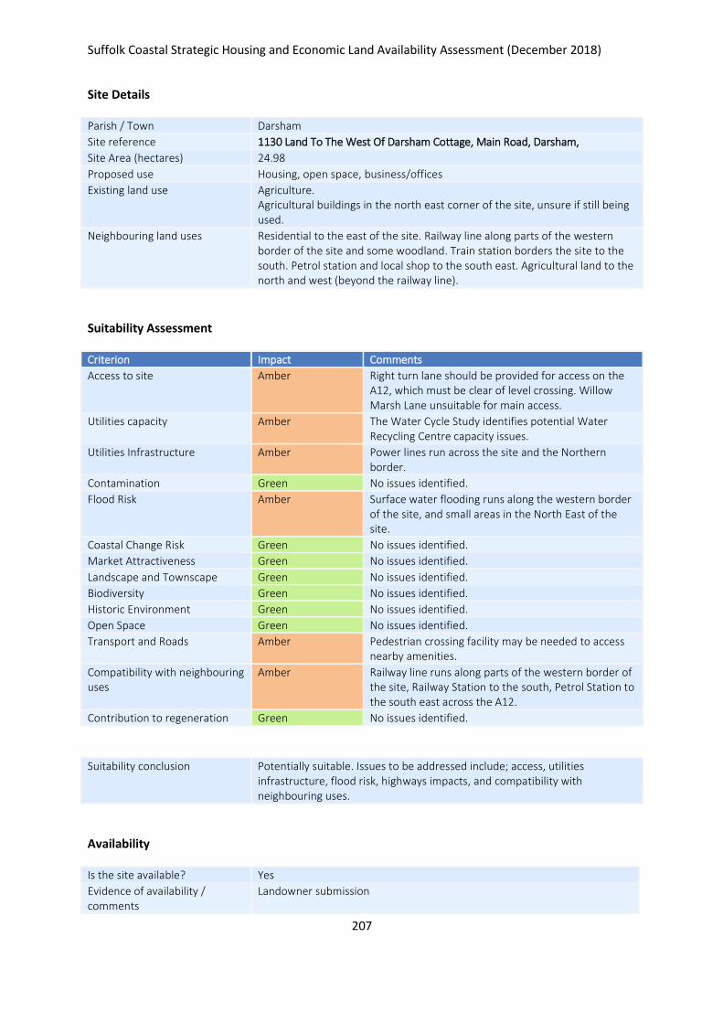
Suffolk Coastal Strategic Housing and Economic Land Availability Assessment (December 2018)
207
Site Details
Parish / Town Darsham
Site reference 1130 Land To The West Of Darsham Cottage, Main Road, Darsham,
Site Area (hectares) 24.98
Proposed use Housing, open space, business/offices
Existing land use Agriculture. Agricultural buildings in the north east corner of the site, unsure if still being used.
Neighbouring land uses Residential to the east of the site. Railway line along parts of the western border of the site and some woodland. Train station borders the site to the south. Petrol station and local shop to the south east. Agricultural land to the north and west (beyond the railway line).
Suitability Assessment
Criterion Impact Comments
Access to site Amber Right turn lane should be provided for access on the A12, which must be clear of level crossing. Willow Marsh Lane unsuitable for main access.
Utilities capacity Amber The Water Cycle Study identifies potential Water Recycling Centre capacity issues.
Utilities Infrastructure Amber Power lines run across the site and the Northern border.
Contamination Green No issues identified.
Flood Risk Amber Surface water flooding runs along the western border of the site, and small areas in the North East of the site.
Coastal Change Risk Green No issues identified.
Market Attractiveness Green No issues identified.
Landscape and Townscape Green No issues identified.
Biodiversity Green No issues identified.
Historic Environment Green No issues identified.
Open Space Green No issues identified.
Transport and Roads Amber Pedestrian crossing facility may be needed to access nearby amenities.
Compatibility with neighbouring uses
Amber Railway line runs along parts of the western border of the site, Railway Station to the south, Petrol Station to the south east across the A12.
Contribution to regeneration Green No issues identified.
Suitability conclusion Potentially suitable. Issues to be addressed include; access, utilities infrastructure, flood risk, highways impacts, and compatibility with neighbouring uses.
Availability
Is the site available? Yes
Evidence of availability / comments
Landowner submission

Suffolk Coastal Strategic Housing and Economic Land Availability Assessment (December 2018)
208
Achievability
Is the site achievable? Yes
Evidence of achievability No specific issues or abnormal costs identified
Are there any commencement issues?
None identified
Estimated dwellings yield 188
Estimated employment land yield (hectares) 12
Estimated retail floorspace (sqm) -
Estimated commencement date 2022/23
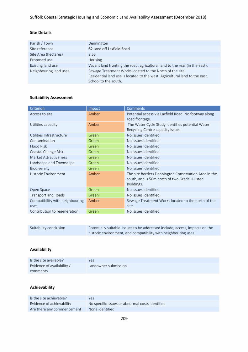
Suffolk Coastal Strategic Housing and Economic Land Availability Assessment (December 2018)
209
Site Details
Parish / Town Dennington
Site reference 62 Land off Laxfield Road
Site Area (hectares) 2.53
Proposed use Housing
Existing land use Vacant land fronting the road, agricultural land to the rear (in the east).
Neighbouring land uses Sewage Treatment Works located to the North of the site. Residential land use is located to the west. Agricultural land to the east. School to the south.
Suitability Assessment
Criterion Impact Comments
Access to site Amber Potential access via Laxfield Road. No footway along road frontage.
Utilities capacity Amber The Water Cycle Study identifies potential Water Recycling Centre capacity issues.
Utilities Infrastructure Green No issues identified.
Contamination Green No issues identified.
Flood Risk Green No issues identified.
Coastal Change Risk Green No issues identified.
Market Attractiveness Green No issues identified.
Landscape and Townscape Green No issues identified.
Biodiversity Green No issues identified.
Historic Environment Amber The site borders Dennington Conservation Area in the south, and is 50m north of two Grade II Listed Buildings.
Open Space Green No issues identified.
Transport and Roads Green No issues identified.
Compatibility with neighbouring uses
Amber Sewage Treatment Works located to the north of the site.
Contribution to regeneration Green No issues identified.
Suitability conclusion Potentially suitable. Issues to be addressed include; access, impacts on the historic environment, and compatibility with neighbouring uses.
Availability
Is the site available? Yes
Evidence of availability / comments
Landowner submission
Achievability
Is the site achievable? Yes
Evidence of achievability No specific issues or abnormal costs identified
Are there any commencement None identified

Suffolk Coastal Strategic Housing and Economic Land Availability Assessment (December 2018)
210
issues?
Estimated dwellings yield 38
Estimated employment land yield (hectares) -
Estimated retail floorspace (sqm) -
Estimated commencement date 2020/21
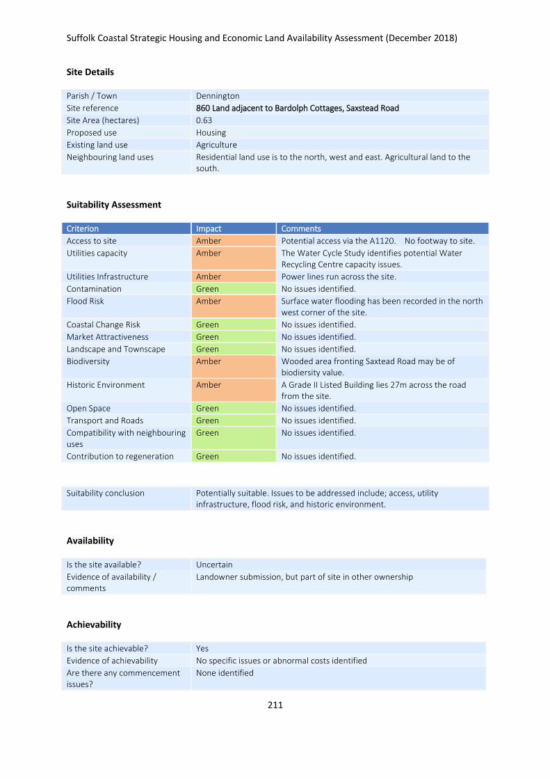
Suffolk Coastal Strategic Housing and Economic Land Availability Assessment (December 2018)
211
Site Details
Parish / Town Dennington
Site reference 860 Land adjacent to Bardolph Cottages, Saxstead Road
Site Area (hectares) 0.63
Proposed use Housing
Existing land use Agriculture
Neighbouring land uses Residential land use is to the north, west and east. Agricultural land to the south.
Suitability Assessment
Criterion Impact Comments
Access to site Amber Potential access via the A1120. No footway to site.
Utilities capacity Amber The Water Cycle Study identifies potential Water Recycling Centre capacity issues.
Utilities Infrastructure Amber Power lines run across the site.
Contamination Green No issues identified.
Flood Risk Amber Surface water flooding has been recorded in the north west corner of the site.
Coastal Change Risk Green No issues identified.
Market Attractiveness Green No issues identified.
Landscape and Townscape Green No issues identified.
Biodiversity Amber Wooded area fronting Saxtead Road may be of biodiersity value.
Historic Environment Amber A Grade II Listed Building lies 27m across the road from the site.
Open Space Green No issues identified.
Transport and Roads Green No issues identified.
Compatibility with neighbouring uses
Green No issues identified.
Contribution to regeneration Green No issues identified.
Suitability conclusion Potentially suitable. Issues to be addressed include; access, utility infrastructure, flood risk, and historic environment.
Availability
Is the site available? Uncertain
Evidence of availability / comments
Landowner submission, but part of site in other ownership
Achievability
Is the site achievable? Yes
Evidence of achievability No specific issues or abnormal costs identified
Are there any commencement issues?
None identified

Suffolk Coastal Strategic Housing and Economic Land Availability Assessment (December 2018)
212
Estimated dwellings yield 0
Estimated employment land yield (hectares) -
Estimated retail floorspace (sqm) -
Estimated commencement date -
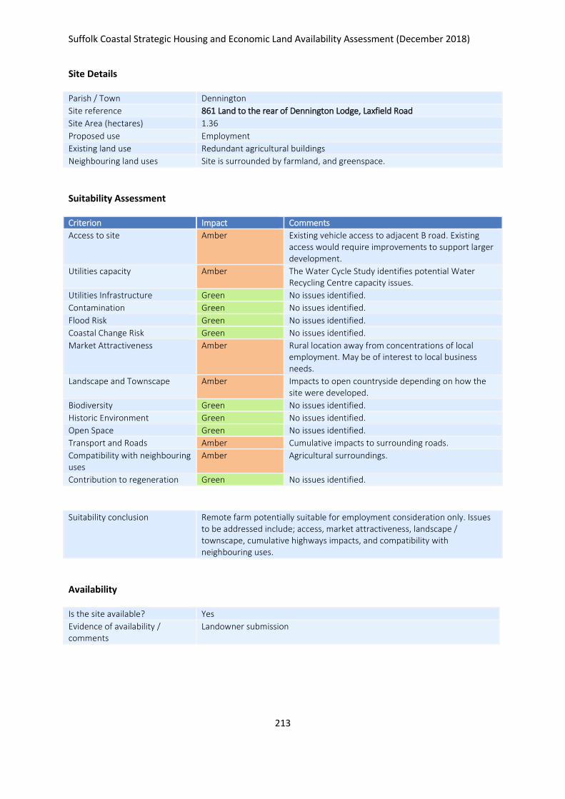
Suffolk Coastal Strategic Housing and Economic Land Availability Assessment (December 2018)
213
Site Details
Parish / Town Dennington
Site reference 861 Land to the rear of Dennington Lodge, Laxfield Road
Site Area (hectares) 1.36
Proposed use Employment
Existing land use Redundant agricultural buildings
Neighbouring land uses Site is surrounded by farmland, and greenspace.
Suitability Assessment
Criterion Impact Comments
Access to site Amber Existing vehicle access to adjacent B road. Existing access would require improvements to support larger development.
Utilities capacity Amber The Water Cycle Study identifies potential Water Recycling Centre capacity issues.
Utilities Infrastructure Green No issues identified.
Contamination Green No issues identified.
Flood Risk Green No issues identified.
Coastal Change Risk Green No issues identified.
Market Attractiveness Amber Rural location away from concentrations of local employment. May be of interest to local business needs.
Landscape and Townscape Amber Impacts to open countryside depending on how the site were developed.
Biodiversity Green No issues identified.
Historic Environment Green No issues identified.
Open Space Green No issues identified.
Transport and Roads Amber Cumulative impacts to surrounding roads.
Compatibility with neighbouring uses
Amber Agricultural surroundings.
Contribution to regeneration Green No issues identified.
Suitability conclusion Remote farm potentially suitable for employment consideration only. Issues to be addressed include; access, market attractiveness, landscape / townscape, cumulative highways impacts, and compatibility with neighbouring uses.
Availability
Is the site available? Yes
Evidence of availability / comments
Landowner submission

Suffolk Coastal Strategic Housing and Economic Land Availability Assessment (December 2018)
214
Achievability
Is the site achievable? Yes
Evidence of achievability No specific issues or abnormal costs identified
Are there any commencement issues?
None identified
Estimated dwellings yield -
Estimated employment land yield (hectares) 1
Estimated retail floorspace (sqm) -
Estimated commencement date 2021/22
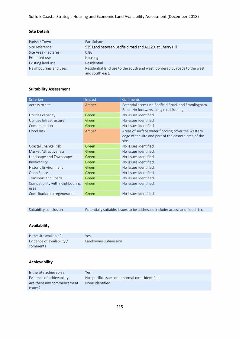
Suffolk Coastal Strategic Housing and Economic Land Availability Assessment (December 2018)
215
Site Details
Parish / Town Earl Soham
Site reference 535 Land between Bedfield road and A1120, at Cherry Hill
Site Area (hectares) 0.86
Proposed use Housing
Existing land use Residential
Neighbouring land uses Residential land use to the south and west, bordered by roads to the west and south east.
Suitability Assessment
Criterion Impact Comments
Access to site Amber Potential access via Bedfield Road, and Framlingham Road. No footways along road frontage.
Utilities capacity Green No issues identified.
Utilities Infrastructure Green No issues identified.
Contamination Green No issues identified.
Flood Risk Amber Areas of surface water flooding cover the western edge of the site and part of the eastern area of the site.
Coastal Change Risk Green No issues identified.
Market Attractiveness Green No issues identified.
Landscape and Townscape Green No issues identified.
Biodiversity Green No issues identified.
Historic Environment Green No issues identified.
Open Space Green No issues identified.
Transport and Roads Green No issues identified.
Compatibility with neighbouring uses
Green No issues identified.
Contribution to regeneration Green No issues identified.
Suitability conclusion Potentially suitable. Issues to be addressed include; access and flood risk.
Availability
Is the site available? Yes
Evidence of availability / comments
Landowner submission
Achievability
Is the site achievable? Yes
Evidence of achievability No specific issues or abnormal costs identified
Are there any commencement issues?
None identified

Suffolk Coastal Strategic Housing and Economic Land Availability Assessment (December 2018)
216
Estimated dwellings yield 13
Estimated employment land yield (hectares) -
Estimated retail floorspace (sqm) -
Estimated commencement date 2024/25
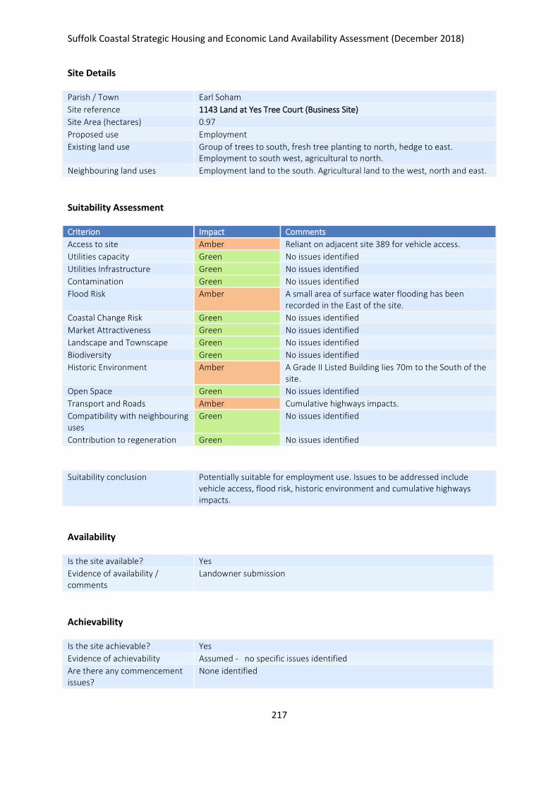
Suffolk Coastal Strategic Housing and Economic Land Availability Assessment (December 2018)
217
Site Details
Parish / Town Earl Soham
Site reference 1143 Land at Yes Tree Court (Business Site)
Site Area (hectares) 0.97
Proposed use Employment
Existing land use Group of trees to south, fresh tree planting to north, hedge to east. Employment to south west, agricultural to north.
Neighbouring land uses Employment land to the south. Agricultural land to the west, north and east.
Suitability Assessment
Criterion Impact Comments
Access to site Amber Reliant on adjacent site 389 for vehicle access.
Utilities capacity Green No issues identified
Utilities Infrastructure Green No issues identified
Contamination Green No issues identified
Flood Risk Amber A small area of surface water flooding has been recorded in the East of the site.
Coastal Change Risk Green No issues identified
Market Attractiveness Green No issues identified
Landscape and Townscape Green No issues identified
Biodiversity Green No issues identified
Historic Environment Amber A Grade II Listed Building lies 70m to the South of the site.
Open Space Green No issues identified
Transport and Roads Amber Cumulative highways impacts.
Compatibility with neighbouring uses
Green No issues identified
Contribution to regeneration Green No issues identified
Suitability conclusion Potentially suitable for employment use. Issues to be addressed include vehicle access, flood risk, historic environment and cumulative highways impacts.
Availability
Is the site available? Yes
Evidence of availability / comments
Landowner submission
Achievability
Is the site achievable? Yes
Evidence of achievability Assumed - no specific issues identified
Are there any commencement issues?
None identified

Suffolk Coastal Strategic Housing and Economic Land Availability Assessment (December 2018)
218
Estimated dwellings yield -
Estimated employment land yield (hectares) 1
Estimated retail floorspace (sqm) -
Estimated commencement date 2021/22
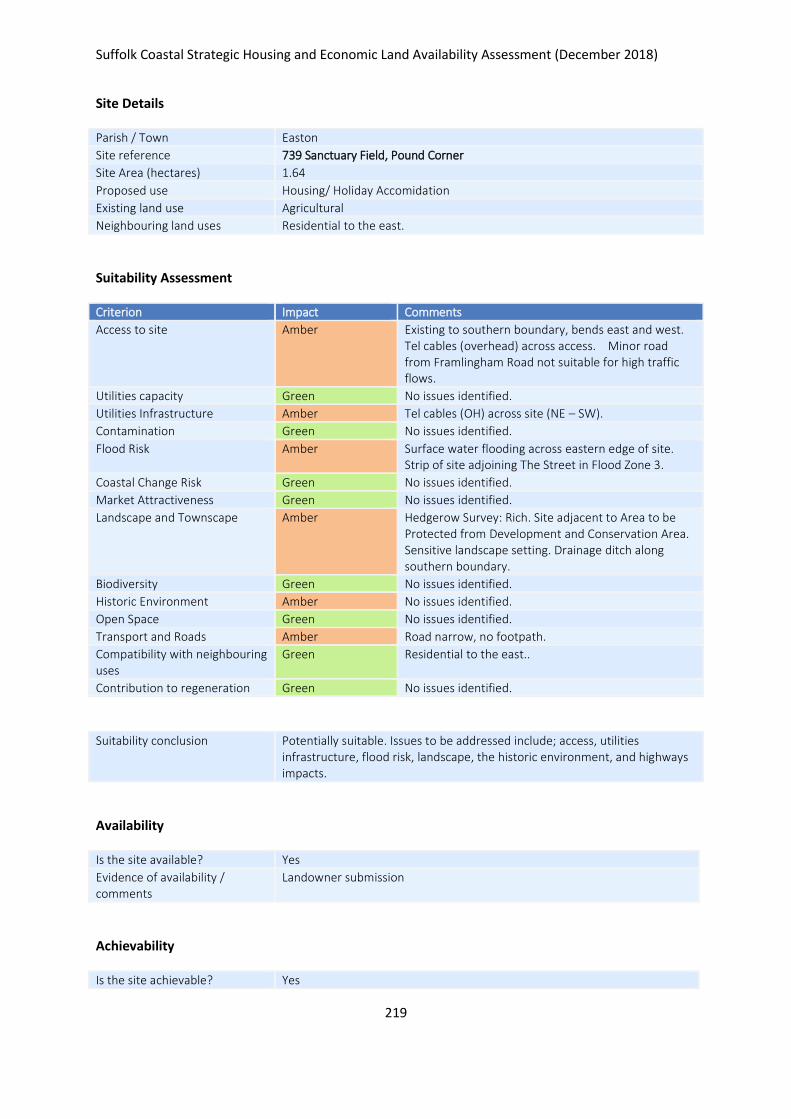
Suffolk Coastal Strategic Housing and Economic Land Availability Assessment (December 2018)
219
Site Details
Parish / Town Easton
Site reference 739 Sanctuary Field, Pound Corner
Site Area (hectares) 1.64
Proposed use Housing/ Holiday Accomidation
Existing land use Agricultural
Neighbouring land uses Residential to the east.
Suitability Assessment
Criterion Impact Comments
Access to site Amber Existing to southern boundary, bends east and west. Tel cables (overhead) across access. Minor road from Framlingham Road not suitable for high traffic flows.
Utilities capacity Green No issues identified.
Utilities Infrastructure Amber Tel cables (OH) across site (NE – SW).
Contamination Green No issues identified.
Flood Risk Amber Surface water flooding across eastern edge of site. Strip of site adjoining The Street in Flood Zone 3.
Coastal Change Risk Green No issues identified.
Market Attractiveness Green No issues identified.
Landscape and Townscape Amber Hedgerow Survey: Rich. Site adjacent to Area to be Protected from Development and Conservation Area. Sensitive landscape setting. Drainage ditch along southern boundary.
Biodiversity Green No issues identified.
Historic Environment Amber No issues identified.
Open Space Green No issues identified.
Transport and Roads Amber Road narrow, no footpath.
Compatibility with neighbouring uses
Green Residential to the east..
Contribution to regeneration Green No issues identified.
Suitability conclusion Potentially suitable. Issues to be addressed include; access, utilities infrastructure, flood risk, landscape, the historic environment, and highways impacts.
Availability
Is the site available? Yes
Evidence of availability / comments
Landowner submission
Achievability
Is the site achievable? Yes

Suffolk Coastal Strategic Housing and Economic Land Availability Assessment (December 2018)
220
Evidence of achievability No specific issues or abnormal costs identified
Are there any commencement issues?
None identified
Estimated dwellings yield 25
Estimated employment land yield (hectares) -
Estimated retail floorspace (sqm) -
Estimated commencement date 2021/22
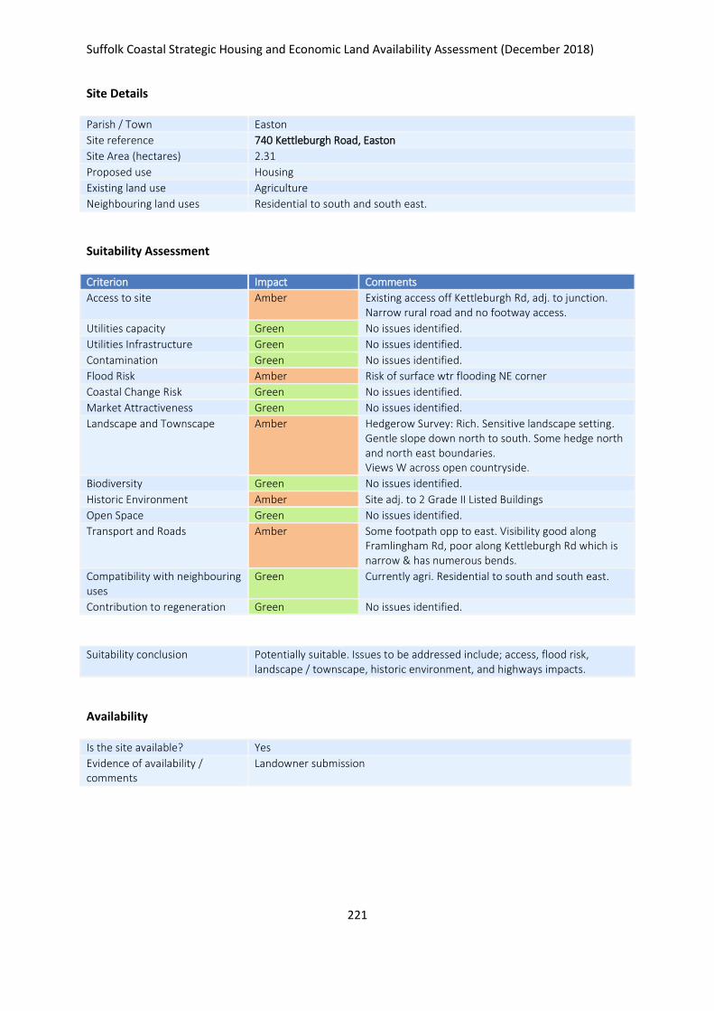
Suffolk Coastal Strategic Housing and Economic Land Availability Assessment (December 2018)
221
Site Details
Parish / Town Easton
Site reference 740 Kettleburgh Road, Easton
Site Area (hectares) 2.31
Proposed use Housing
Existing land use Agriculture
Neighbouring land uses Residential to south and south east.
Suitability Assessment
Criterion Impact Comments
Access to site Amber Existing access off Kettleburgh Rd, adj. to junction. Narrow rural road and no footway access.
Utilities capacity Green No issues identified.
Utilities Infrastructure Green No issues identified.
Contamination Green No issues identified.
Flood Risk Amber Risk of surface wtr flooding NE corner
Coastal Change Risk Green No issues identified.
Market Attractiveness Green No issues identified.
Landscape and Townscape Amber Hedgerow Survey: Rich. Sensitive landscape setting. Gentle slope down north to south. Some hedge north and north east boundaries. Views W across open countryside.
Biodiversity Green No issues identified.
Historic Environment Amber Site adj. to 2 Grade II Listed Buildings
Open Space Green No issues identified.
Transport and Roads Amber Some footpath opp to east. Visibility good along Framlingham Rd, poor along Kettleburgh Rd which is narrow & has numerous bends.
Compatibility with neighbouring uses
Green Currently agri. Residential to south and south east.
Contribution to regeneration Green No issues identified.
Suitability conclusion Potentially suitable. Issues to be addressed include; access, flood risk, landscape / townscape, historic environment, and highways impacts.
Availability
Is the site available? Yes
Evidence of availability / comments
Landowner submission

Suffolk Coastal Strategic Housing and Economic Land Availability Assessment (December 2018)
222
Achievability
Is the site achievable? Yes
Evidence of achievability No specific issues or abnormal costs identified
Are there any commencement issues?
None identified
Estimated dwellings yield 35
Estimated employment land yield (hectares) -
Estimated retail floorspace (sqm) -
Estimated commencement date 2021/22
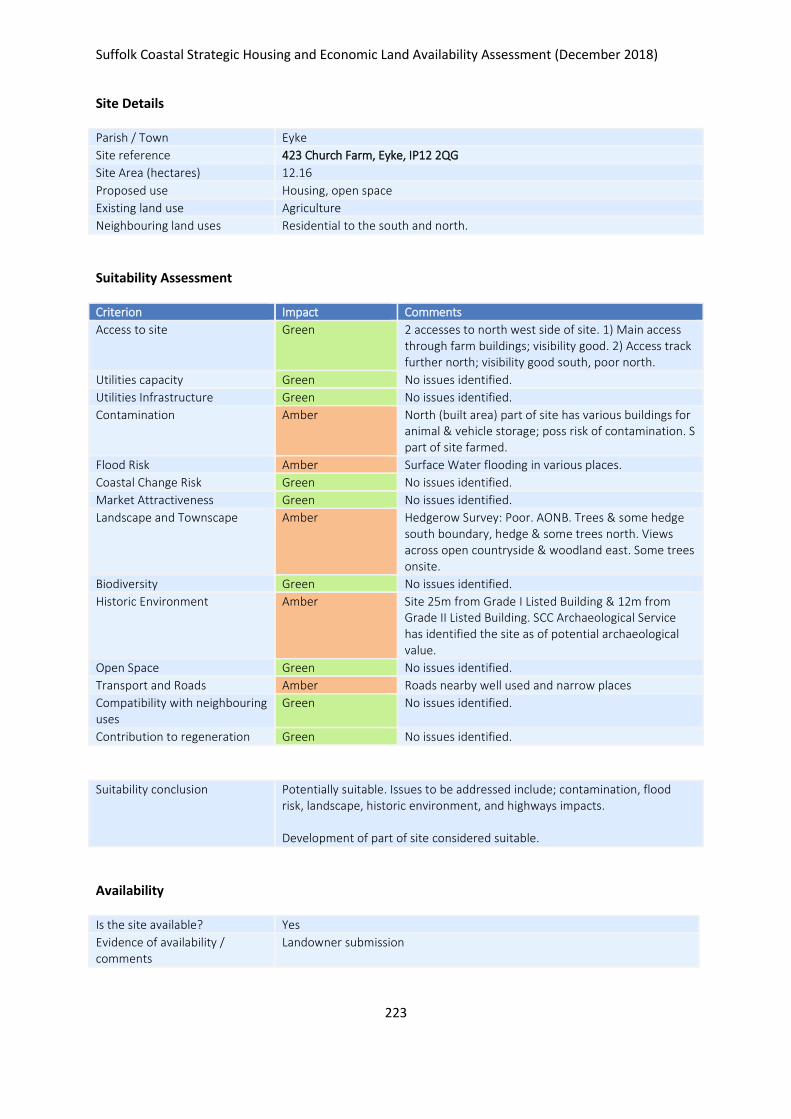
Suffolk Coastal Strategic Housing and Economic Land Availability Assessment (December 2018)
223
Site Details
Parish / Town Eyke
Site reference 423 Church Farm, Eyke, IP12 2QG
Site Area (hectares) 12.16
Proposed use Housing, open space
Existing land use Agriculture
Neighbouring land uses Residential to the south and north.
Suitability Assessment
Criterion Impact Comments
Access to site Green 2 accesses to north west side of site. 1) Main access through farm buildings; visibility good. 2) Access track further north; visibility good south, poor north.
Utilities capacity Green No issues identified.
Utilities Infrastructure Green No issues identified.
Contamination Amber North (built area) part of site has various buildings for animal & vehicle storage; poss risk of contamination. S part of site farmed.
Flood Risk Amber Surface Water flooding in various places.
Coastal Change Risk Green No issues identified.
Market Attractiveness Green No issues identified.
Landscape and Townscape Amber Hedgerow Survey: Poor. AONB. Trees & some hedge south boundary, hedge & some trees north. Views across open countryside & woodland east. Some trees onsite.
Biodiversity Green No issues identified.
Historic Environment Amber Site 25m from Grade I Listed Building & 12m from Grade II Listed Building. SCC Archaeological Service has identified the site as of potential archaeological value.
Open Space Green No issues identified.
Transport and Roads Amber Roads nearby well used and narrow places
Compatibility with neighbouring uses
Green No issues identified.
Contribution to regeneration Green No issues identified.
Suitability conclusion Potentially suitable. Issues to be addressed include; contamination, flood risk, landscape, historic environment, and highways impacts. Development of part of site considered suitable.
Availability
Is the site available? Yes
Evidence of availability / comments
Landowner submission

Suffolk Coastal Strategic Housing and Economic Land Availability Assessment (December 2018)
224
Achievability
Is the site achievable? Yes
Evidence of achievability No specific issues or abnormal costs identified
Are there any commencement issues?
None identified
Estimated dwellings yield 182
Estimated employment land yield (hectares) -
Estimated retail floorspace (sqm) -
Estimated commencement date 2022/23
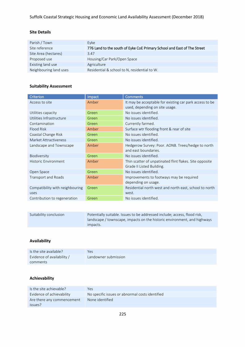
Suffolk Coastal Strategic Housing and Economic Land Availability Assessment (December 2018)
225
Site Details
Parish / Town Eyke
Site reference 776 Land to the south of Eyke CoE Primary School and East of The Street
Site Area (hectares) 3.47
Proposed use Housing/Car Park/Open Space
Existing land use Agriculture
Neighbouring land uses Residential & school to N, residential to W.
Suitability Assessment
Criterion Impact Comments
Access to site Amber It may be acceptable for existing car park access to be used, depending on site usage.
Utilities capacity Green No issues identified.
Utilities Infrastructure Green No issues identified.
Contamination Green Currently farmed.
Flood Risk Amber Surface wtr flooding front & rear of site
Coastal Change Risk Green No issues identified.
Market Attractiveness Green No issues identified.
Landscape and Townscape Amber Hedgerow Survey: Poor. AONB. Trees/hedge to north and east boundaries.
Biodiversity Green No issues identified.
Historic Environment Amber Thin scatter of unpatinated flint flakes. Site opposite Grade II Listed Building.
Open Space Green No issues identified.
Transport and Roads Amber Improvements to footways may be required depending on usage.
Compatibility with neighbouring uses
Green Residential north west and north east, school to north west.
Contribution to regeneration Green No issues identified.
Suitability conclusion Potentially suitable. Issues to be addressed include; access, flood risk, landscape / townscape, impacts on the historic environment, and highways impacts.
Availability
Is the site available? Yes
Evidence of availability / comments
Landowner submission
Achievability
Is the site achievable? Yes
Evidence of achievability No specific issues or abnormal costs identified
Are there any commencement issues?
None identified

Suffolk Coastal Strategic Housing and Economic Land Availability Assessment (December 2018)
226
Estimated dwellings yield 41
Estimated employment land yield (hectares) -
Estimated retail floorspace (sqm) -
Estimated commencement date 2020/21
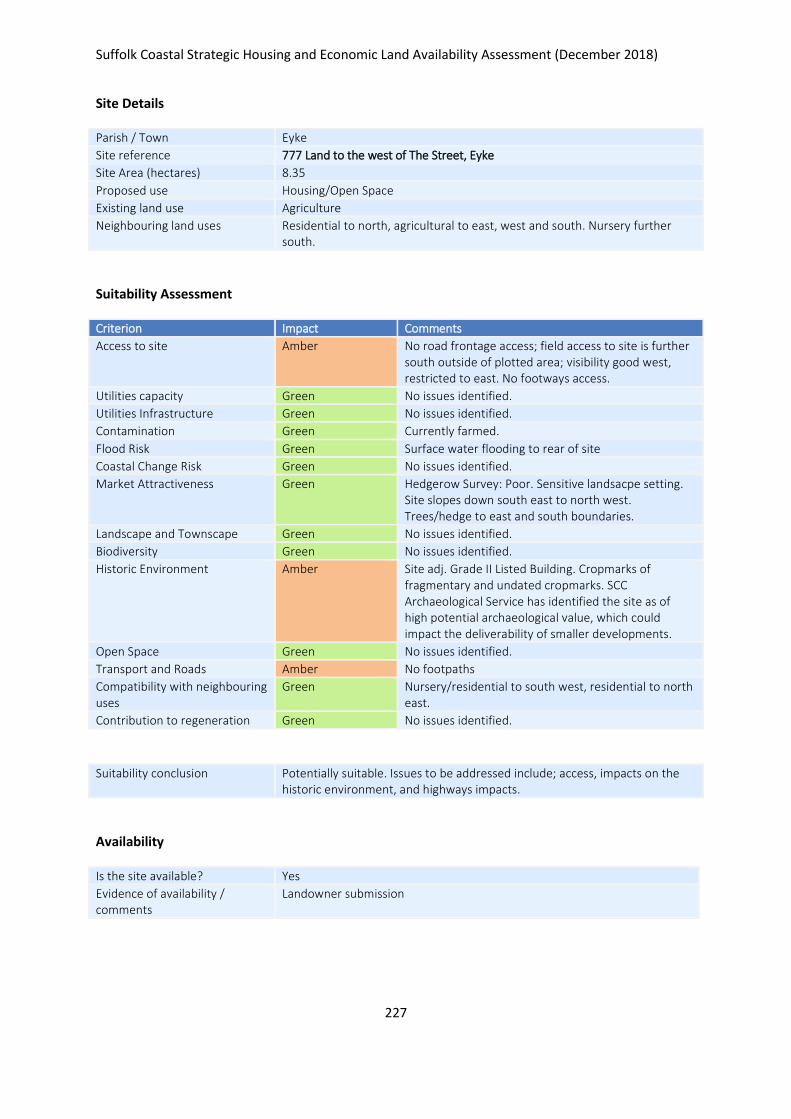
Suffolk Coastal Strategic Housing and Economic Land Availability Assessment (December 2018)
227
Site Details
Parish / Town Eyke
Site reference 777 Land to the west of The Street, Eyke
Site Area (hectares) 8.35
Proposed use Housing/Open Space
Existing land use Agriculture
Neighbouring land uses Residential to north, agricultural to east, west and south. Nursery further south.
Suitability Assessment
Criterion Impact Comments
Access to site Amber No road frontage access; field access to site is further south outside of plotted area; visibility good west, restricted to east. No footways access.
Utilities capacity Green No issues identified.
Utilities Infrastructure Green No issues identified.
Contamination Green Currently farmed.
Flood Risk Green Surface water flooding to rear of site
Coastal Change Risk Green No issues identified.
Market Attractiveness Green Hedgerow Survey: Poor. Sensitive landsacpe setting. Site slopes down south east to north west. Trees/hedge to east and south boundaries.
Landscape and Townscape Green No issues identified.
Biodiversity Green No issues identified.
Historic Environment Amber Site adj. Grade II Listed Building. Cropmarks of fragmentary and undated cropmarks. SCC Archaeological Service has identified the site as of high potential archaeological value, which could impact the deliverability of smaller developments.
Open Space Green No issues identified.
Transport and Roads Amber No footpaths
Compatibility with neighbouring uses
Green Nursery/residential to south west, residential to north east.
Contribution to regeneration Green No issues identified.
Suitability conclusion Potentially suitable. Issues to be addressed include; access, impacts on the historic environment, and highways impacts.
Availability
Is the site available? Yes
Evidence of availability / comments
Landowner submission

Suffolk Coastal Strategic Housing and Economic Land Availability Assessment (December 2018)
228
Achievability
Is the site achievable? Yes
Evidence of achievability No specific issues or abnormal costs identified
Are there any commencement issues?
None identified
Estimated dwellings yield 13
Estimated employment land yield (hectares) -
Estimated retail floorspace (sqm) -
Estimated commencement date 2020/21
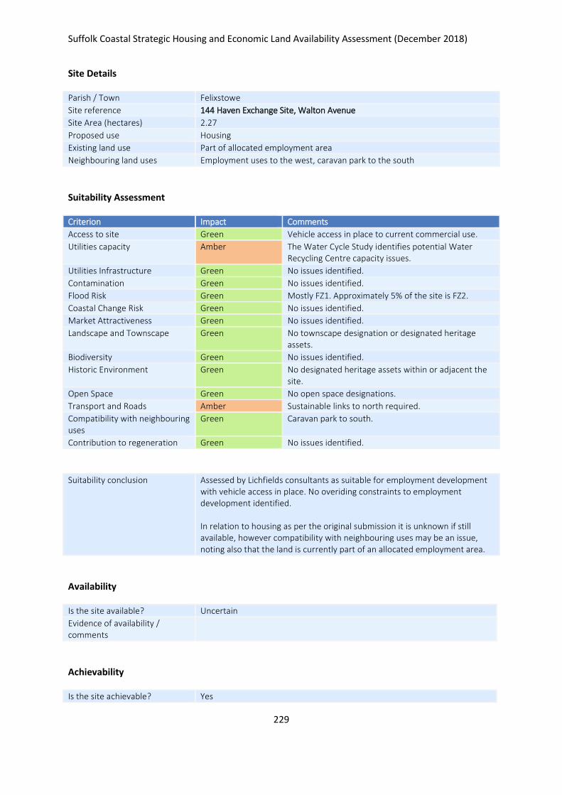
Suffolk Coastal Strategic Housing and Economic Land Availability Assessment (December 2018)
229
Site Details
Parish / Town Felixstowe
Site reference 144 Haven Exchange Site, Walton Avenue
Site Area (hectares) 2.27
Proposed use Housing
Existing land use Part of allocated employment area
Neighbouring land uses Employment uses to the west, caravan park to the south
Suitability Assessment
Criterion Impact Comments
Access to site Green Vehicle access in place to current commercial use.
Utilities capacity Amber The Water Cycle Study identifies potential Water Recycling Centre capacity issues.
Utilities Infrastructure Green No issues identified.
Contamination Green No issues identified.
Flood Risk Green Mostly FZ1. Approximately 5% of the site is FZ2.
Coastal Change Risk Green No issues identified.
Market Attractiveness Green No issues identified.
Landscape and Townscape Green No townscape designation or designated heritage assets.
Biodiversity Green No issues identified.
Historic Environment Green No designated heritage assets within or adjacent the site.
Open Space Green No open space designations.
Transport and Roads Amber Sustainable links to north required.
Compatibility with neighbouring uses
Green Caravan park to south.
Contribution to regeneration Green No issues identified.
Suitability conclusion Assessed by Lichfields consultants as suitable for employment development with vehicle access in place. No overiding constraints to employment development identified. In relation to housing as per the original submission it is unknown if still available, however compatibility with neighbouring uses may be an issue, noting also that the land is currently part of an allocated employment area.
Availability
Is the site available? Uncertain
Evidence of availability / comments
Achievability
Is the site achievable? Yes
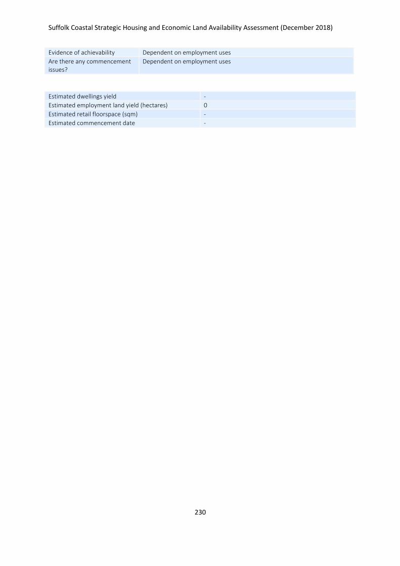
Suffolk Coastal Strategic Housing and Economic Land Availability Assessment (December 2018)
230
Evidence of achievability Dependent on employment uses
Are there any commencement issues?
Dependent on employment uses
Estimated dwellings yield -
Estimated employment land yield (hectares) 0
Estimated retail floorspace (sqm) -
Estimated commencement date -
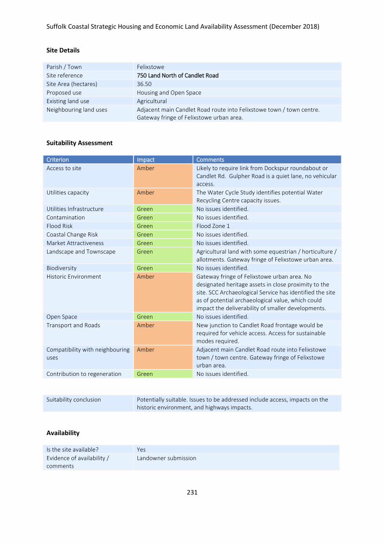
Suffolk Coastal Strategic Housing and Economic Land Availability Assessment (December 2018)
231
Site Details
Parish / Town Felixstowe
Site reference 750 Land North of Candlet Road
Site Area (hectares) 36.50
Proposed use Housing and Open Space
Existing land use Agricultural
Neighbouring land uses Adjacent main Candlet Road route into Felixstowe town / town centre. Gateway fringe of Felixstowe urban area.
Suitability Assessment
Criterion Impact Comments
Access to site Amber Likely to require link from Dockspur roundabout or Candlet Rd. Gulpher Road is a quiet lane, no vehicular access.
Utilities capacity Amber The Water Cycle Study identifies potential Water Recycling Centre capacity issues.
Utilities Infrastructure Green No issues identified.
Contamination Green No issues identified.
Flood Risk Green Flood Zone 1
Coastal Change Risk Green No issues identified.
Market Attractiveness Green No issues identified.
Landscape and Townscape Green Agricultural land with some equestrian / horticulture / allotments. Gateway fringe of Felixstowe urban area.
Biodiversity Green No issues identified.
Historic Environment Amber Gateway fringe of Felixstowe urban area. No designated heritage assets in close proximity to the site. SCC Archaeological Service has identified the site as of potential archaeological value, which could impact the deliverability of smaller developments.
Open Space Green No issues identified.
Transport and Roads Amber New junction to Candlet Road frontage would be required for vehicle access. Access for sustainable modes required.
Compatibility with neighbouring uses
Amber Adjacent main Candlet Road route into Felixstowe town / town centre. Gateway fringe of Felixstowe urban area.
Contribution to regeneration Green No issues identified.
Suitability conclusion Potentially suitable. Issues to be addressed include access, impacts on the historic environment, and highways impacts.
Availability
Is the site available? Yes
Evidence of availability / comments
Landowner submission

Suffolk Coastal Strategic Housing and Economic Land Availability Assessment (December 2018)
232
Achievability
Is the site achievable? Yes
Evidence of achievability No specific issues or abnormal costs identified
Are there any commencement issues?
None identified
Estimated dwellings yield 876
Estimated employment land yield (hectares) -
Estimated retail floorspace (sqm) -
Estimated commencement date 2022/23
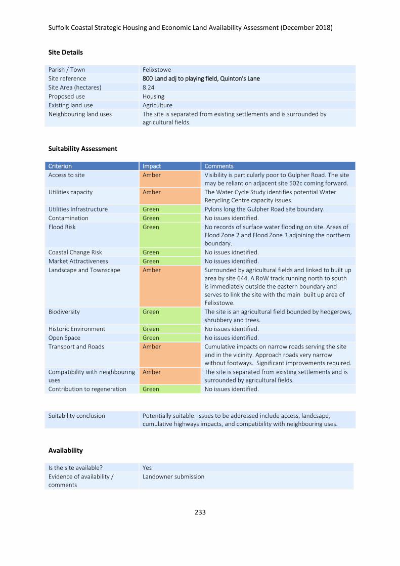
Suffolk Coastal Strategic Housing and Economic Land Availability Assessment (December 2018)
233
Site Details
Parish / Town Felixstowe
Site reference 800 Land adj to playing field, Quinton's Lane
Site Area (hectares) 8.24
Proposed use Housing
Existing land use Agriculture
Neighbouring land uses The site is separated from existing settlements and is surrounded by agricultural fields.
Suitability Assessment
Criterion Impact Comments
Access to site Amber Visibility is particularly poor to Gulpher Road. The site may be reliant on adjacent site 502c coming forward.
Utilities capacity Amber The Water Cycle Study identifies potential Water Recycling Centre capacity issues.
Utilities Infrastructure Green Pylons long the Gulpher Road site boundary.
Contamination Green No issues identified.
Flood Risk Green No records of surface water flooding on site. Areas of Flood Zone 2 and Flood Zone 3 adjoining the northern boundary.
Coastal Change Risk Green No issues idnetified.
Market Attractiveness Green No issues identified.
Landscape and Townscape Amber Surrounded by agricultural fields and linked to built up area by site 644. A RoW track running north to south is immediately outside the eastern boundary and serves to link the site with the main built up area of Felixstowe.
Biodiversity Green The site is an agricultural field bounded by hedgerows, shrubbery and trees.
Historic Environment Green No issues identified.
Open Space Green No issues identified.
Transport and Roads Amber Cumulative impacts on narrow roads serving the site and in the vicinity. Approach roads very narrow without footways. Significant improvements required.
Compatibility with neighbouring uses
Amber The site is separated from existing settlements and is surrounded by agricultural fields.
Contribution to regeneration Green No issues identified.
Suitability conclusion Potentially suitable. Issues to be addressed include access, landcsape, cumulative highways impacts, and compatibility with neighbouring uses.
Availability
Is the site available? Yes
Evidence of availability / comments
Landowner submission

Suffolk Coastal Strategic Housing and Economic Land Availability Assessment (December 2018)
234
Achievability
Is the site achievable? Yes
Evidence of achievability No specific issues or abnormal costs identified
Are there any commencement issues?
None identified
Estimated dwellings yield 247
Estimated employment land yield (hectares) -
Estimated retail floorspace (sqm) -
Estimated commencement date 2024/25
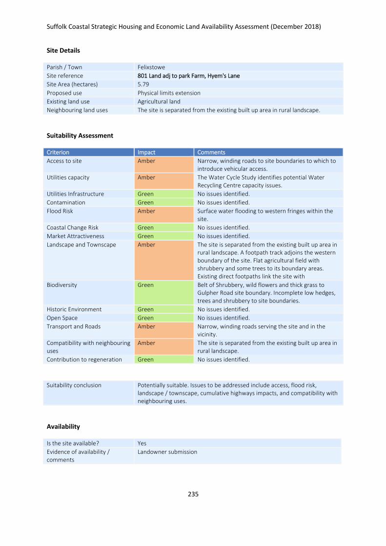
Suffolk Coastal Strategic Housing and Economic Land Availability Assessment (December 2018)
235
Site Details
Parish / Town Felixstowe
Site reference 801 Land adj to park Farm, Hyem's Lane
Site Area (hectares) 5.79
Proposed use Physical limits extension
Existing land use Agricultural land
Neighbouring land uses The site is separated from the existing built up area in rural landscape.
Suitability Assessment
Criterion Impact Comments
Access to site Amber Narrow, winding roads to site boundaries to which to introduce vehicular access.
Utilities capacity Amber The Water Cycle Study identifies potential Water Recycling Centre capacity issues.
Utilities Infrastructure Green No issues identified.
Contamination Green No issues identified.
Flood Risk Amber Surface water flooding to western fringes within the site.
Coastal Change Risk Green No issues identified.
Market Attractiveness Green No issues identified.
Landscape and Townscape Amber The site is separated from the existing built up area in rural landscape. A footpath track adjoins the western boundary of the site. Flat agricultural field with shrubbery and some trees to its boundary areas. Existing direct footpaths link the site with
Biodiversity Green Belt of Shrubbery, wild flowers and thick grass to Gulpher Road site boundary. Incomplete low hedges, trees and shrubbery to site boundaries.
Historic Environment Green No issues identified.
Open Space Green No issues identified.
Transport and Roads Amber Narrow, winding roads serving the site and in the vicinity.
Compatibility with neighbouring uses
Amber The site is separated from the existing built up area in rural landscape.
Contribution to regeneration Green No issues identified.
Suitability conclusion Potentially suitable. Issues to be addressed include access, flood risk, landscape / townscape, cumulative highways impacts, and compatibility with neighbouring uses.
Availability
Is the site available? Yes
Evidence of availability / comments
Landowner submission

Suffolk Coastal Strategic Housing and Economic Land Availability Assessment (December 2018)
236
Achievability
Is the site achievable? Yes
Evidence of achievability No specific issues or abnormal costs identified
Are there any commencement issues?
none identified
Estimated dwellings yield 174
Estimated employment land yield (hectares) -
Estimated retail floorspace (sqm) -
Estimated commencement date 2024/25
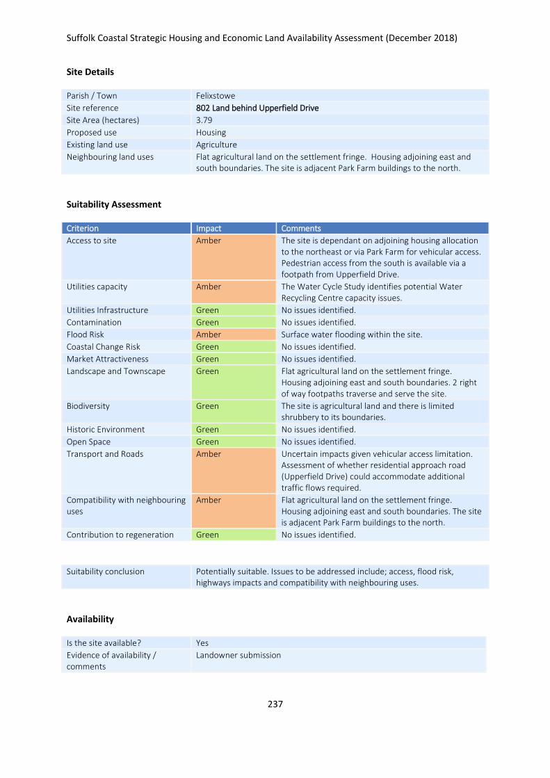
Suffolk Coastal Strategic Housing and Economic Land Availability Assessment (December 2018)
237
Site Details
Parish / Town Felixstowe
Site reference 802 Land behind Upperfield Drive
Site Area (hectares) 3.79
Proposed use Housing
Existing land use Agriculture
Neighbouring land uses Flat agricultural land on the settlement fringe. Housing adjoining east and south boundaries. The site is adjacent Park Farm buildings to the north.
Suitability Assessment
Criterion Impact Comments
Access to site Amber The site is dependant on adjoining housing allocation to the northeast or via Park Farm for vehicular access. Pedestrian access from the south is available via a footpath from Upperfield Drive.
Utilities capacity Amber The Water Cycle Study identifies potential Water Recycling Centre capacity issues.
Utilities Infrastructure Green No issues identified.
Contamination Green No issues identified.
Flood Risk Amber Surface water flooding within the site.
Coastal Change Risk Green No issues identified.
Market Attractiveness Green No issues identified.
Landscape and Townscape Green Flat agricultural land on the settlement fringe. Housing adjoining east and south boundaries. 2 right of way footpaths traverse and serve the site.
Biodiversity Green The site is agricultural land and there is limited shrubbery to its boundaries.
Historic Environment Green No issues identified.
Open Space Green No issues identified.
Transport and Roads Amber Uncertain impacts given vehicular access limitation. Assessment of whether residential approach road (Upperfield Drive) could accommodate additional traffic flows required.
Compatibility with neighbouring uses
Amber Flat agricultural land on the settlement fringe. Housing adjoining east and south boundaries. The site is adjacent Park Farm buildings to the north.
Contribution to regeneration Green No issues identified.
Suitability conclusion Potentially suitable. Issues to be addressed include; access, flood risk, highways impacts and compatibility with neighbouring uses.
Availability
Is the site available? Yes
Evidence of availability / comments
Landowner submission

Suffolk Coastal Strategic Housing and Economic Land Availability Assessment (December 2018)
238
Achievability
Is the site achievable? Yes
Evidence of achievability No specific issues or abnormal costs identified
Are there any commencement issues?
none identified
Estimated dwellings yield 114
Estimated employment land yield (hectares) -
Estimated retail floorspace (sqm) -
Estimated commencement date 2022/23
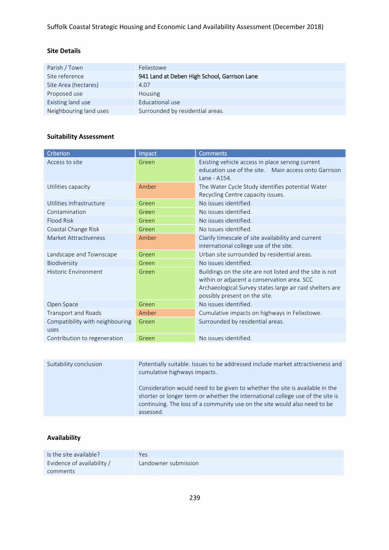
Suffolk Coastal Strategic Housing and Economic Land Availability Assessment (December 2018)
239
Site Details
Parish / Town Felixstowe
Site reference 941 Land at Deben High School, Garrison Lane
Site Area (hectares) 4.07
Proposed use Housing
Existing land use Educational use
Neighbouring land uses Surrounded by residential areas.
Suitability Assessment
Criterion Impact Comments
Access to site Green Existing vehicle access in place serving current education use of the site. Main access onto Garrison Lane - A154.
Utilities capacity Amber The Water Cycle Study identifies potential Water Recycling Centre capacity issues.
Utilities Infrastructure Green No issues identified.
Contamination Green No issues identified.
Flood Risk Green No issues identified.
Coastal Change Risk Green No issues identified.
Market Attractiveness Amber Clarify timescale of site availability and current international college use of the site.
Landscape and Townscape Green Urban site surrounded by residential areas.
Biodiversity Green No issues identified.
Historic Environment Green Buildings on the site are not listed and the site is not within or adjacent a conservation area. SCC Archaeological Survey states large air raid shelters are possibly present on the site.
Open Space Green No issues identified.
Transport and Roads Amber Cumulative impacts on highways in Felixstowe.
Compatibility with neighbouring uses
Green Surrounded by residential areas.
Contribution to regeneration Green No issues identified.
Suitability conclusion Potentially suitable. Issues to be addressed include market attractiveness and cumulative highways impacts. Consideration would need to be given to whether the site is available in the shorter or longer term or whether the international college use of the site is continuing. The loss of a community use on the site would also need to be assessed.
Availability
Is the site available? Yes
Evidence of availability / comments
Landowner submission

Suffolk Coastal Strategic Housing and Economic Land Availability Assessment (December 2018)
240
Achievability
Is the site achievable? Yes
Evidence of achievability Assumed - no specific issues identfiied
Are there any commencement issues?
Existing lease on site
Estimated dwellings yield 163
Estimated employment land yield (hectares) -
Estimated retail floorspace (sqm) -
Estimated commencement date 2023/24
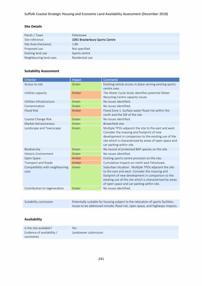
Suffolk Coastal Strategic Housing and Economic Land Availability Assessment (December 2018)
241
Site Details
Parish / Town Felixstowe
Site reference 1091 Brackenbury Sports Centre
Site Area (hectares) 1.80
Proposed use Not specified
Existing land use Sports centre
Neighbouring land uses Residential use
Suitability Assessment
Criterion Impact Comments
Access to site Green Exisiting vehcle access in place serving existing sports centre uses.
Utilities capacity Amber The Water Cycle Study identifies potential Water Recycling Centre capacity issues.
Utilities Infrastructure Green No issues identified.
Contamination Green No issues identified.
Flood Risk Amber Flood Zone 1. Surface water flood risk within the north and the SW of the site.
Coastal Change Risk Green No issues identified.
Market Attractiveness Green Brownfield site.
Landscape and Townscape Green Multiple TPOs adjacent the site to the east and west. Consider the massing and footprint of new development in comparison to the existing use of the site which is characterised by areas of open space and car parking within site.
Biodiversity Green No record of protected BAP species on the site.
Historic Environment Green No issues identified.
Open Space Amber Existing sports centre provision on the site.
Transport and Roads Amber Cumulative impacts on north east Felixstowe.
Compatibility with neighbouring uses
Green Suburban situation. Multiple TPOs adjacent the site to the east and west. Consider the massing and footprint of new development in comparison to the existing use of the site which is characterised by areas of open space and car parking within site.
Contribution to regeneration Green No issues identified.
Suitability conclusion Potentially suitable for housing subject to the relocation of sports facilities. Issues to be addressed include; flood risk, open space, and highways impacts.
Availability
Is the site available? Yes
Evidence of availability / comments
Landowner submission

Suffolk Coastal Strategic Housing and Economic Land Availability Assessment (December 2018)
242
Achievability
Is the site achievable? Yes
Evidence of achievability Dependent on relocation of leisure uses, this is being proposed through submission relating to site 1092
Are there any commencement issues?
Relocation of existing use
Estimated dwellings yield 72
Estimated employment land yield (hectares) -
Estimated retail floorspace (sqm) -
Estimated commencement date 2025/26
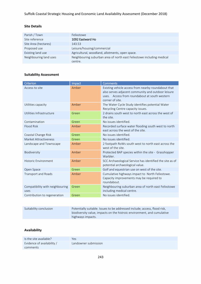
Suffolk Coastal Strategic Housing and Economic Land Availability Assessment (December 2018)
243
Site Details
Parish / Town Felixstowe
Site reference 1092 Eastward Ho
Site Area (hectares) 143.53
Proposed use Leisure/housing/commercial
Existing land use Agricultural, woodland, allotments, open space.
Neighbouring land uses Neighbouring suburban area of north east Felixstowe including medical centre.
Suitability Assessment
Criterion Impact Comments
Access to site Amber Existing vehicle access from nearby roundabout that also serves adjacent community and outdoor leisure uses. Access from roundabout at south western corner of site.
Utilities capacity Amber The Water Cycle Study identifies potential Water Recycling Centre capacity issues.
Utilities Infrastructure Green 2 drains south west to north east across the west of the site.
Contamination Green No issues identified.
Flood Risk Amber Recorded surface water flooding south west to north east across the west of the site.
Coastal Change Risk Green No issues identified.
Market Attractiveness Green No issues identified.
Landscape and Townscape Amber 2 footpath RoWs south west to north east across the west of the site.
Biodiversity Amber Protected BAP species within the site - Grasshopper Warbler.
Historic Environment Amber SCC Archaeological Service has identified the site as of potential archaeological value.
Open Space Green Golf and equestrian use on west of the site.
Transport and Roads Amber Cumulative highways impact to North Felixstowe. Capacity improvements may be required to roundabout.
Compatibility with neighbouring uses
Green Neighbouring suburban area of north east Felixstowe including medical centre.
Contribution to regeneration Green No issues identified.
Suitability conclusion Potentially suitable. Issues to be addressed include; access, flood risk, biodiversity value, impacts on the histroic environment, and cumulative highways impacts.
Availability
Is the site available? Yes
Evidence of availability / comments
Landowner submission

Suffolk Coastal Strategic Housing and Economic Land Availability Assessment (December 2018)
244
Achievability
Is the site achievable? Yes
Evidence of achievability Assumed, however stratgeic scale infrastructure considerations
Are there any commencement issues?
Strategic scale and multiple ownerships, requires masteplanning
Estimated dwellings yield 79215
Estimated employment land yield (hectares) -
Estimated retail floorspace (sqm) -
Estimated commencement date 2023/24
15
Also see sites 750, 800, 801 and 802 for full indicative yield for full site area
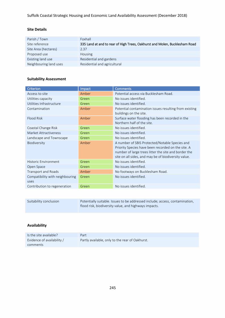
Suffolk Coastal Strategic Housing and Economic Land Availability Assessment (December 2018)
245
Site Details
Parish / Town Foxhall
Site reference 335 Land at and to rear of High Trees, Oakhurst and Molen, Bucklesham Road
Site Area (hectares) 2.37
Proposed use Housing
Existing land use Residential and gardens
Neighbouring land uses Residential and agricultural
Suitability Assessment
Criterion Impact Comments
Access to site Amber Potential access via Bucklesham Road.
Utilities capacity Green No issues identified.
Utilities Infrastructure Green No issues identified.
Contamination Amber Potential contamination issues resulting from existing buildings on the site.
Flood Risk Amber Surface water flooding has been recorded in the Northern half of the site.
Coastal Change Risk Green No issues identified.
Market Attractiveness Green No issues identified.
Landscape and Townscape Green No issues identified.
Biodiversity Amber A number of SBIS Protected/Notable Species and Priority Species have been recorded on the site. A number of large trees litter the site and border the site on all sides, and may be of biodiversity value.
Historic Environment Green No issues identified.
Open Space Green No issues identified.
Transport and Roads Amber No footways on Bucklesham Road.
Compatibility with neighbouring uses
Green No issues identified.
Contribution to regeneration Green No issues identified.
Suitability conclusion Potentially suitable. Issues to be addressed include; access, contamination, flood risk, biodiversity value, and highways impacts.
Availability
Is the site available? Part
Evidence of availability / comments
Partly available, only to the rear of Oakhurst.

Suffolk Coastal Strategic Housing and Economic Land Availability Assessment (December 2018)
246
Achievability
Is the site achievable? Yes
Evidence of achievability No specific issues or abnormal costs identified
Are there any commencement issues?
None identified
Estimated dwellings yield 11
Estimated employment land yield (hectares) -
Estimated retail floorspace (sqm) -
Estimated commencement date 2020/21
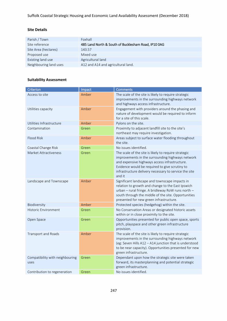
Suffolk Coastal Strategic Housing and Economic Land Availability Assessment (December 2018)
247
Site Details
Parish / Town Foxhall
Site reference 485 Land North & South of Bucklesham Road, IP10 0AG
Site Area (hectares) 143.57
Proposed use Mixed use
Existing land use Agricultural land
Neighbouring land uses A12 and A14 and agricultural land.
Suitability Assessment
Criterion Impact Comments
Access to site Amber The scale of the site is likely to require strategic improvements in the surrounding highways network and highways access infrastructure.
Utilities capacity Amber Engagement with providers around the phasing and nature of development would be required to inform for a site of this scale.
Utilities Infrastructure Amber Pylons on the site.
Contamination Green Proximity to adjacent landfill site to the site’s northeast may require investigation.
Flood Risk Amber Areas subject to surface water flooding throughout the site.
Coastal Change Risk Green No issues identified.
Market Attractiveness Green The scale of the site is likely to require strategic improvements in the surrounding highways network and expensive highways access infrastructure. Evidence would be required to give scrutiny to infrastructure delivery necessary to service the site and it
Landscape and Townscape Amber Significant landscape and townscape impacts in relation to growth and change to the East Ipswich urban – rural fringe. A bridleway RoW runs north – south through the middle of the site. Opportunities presented for new green infrastructure.
Biodiversity Amber Protected species (hedgehog) within the site.
Historic Environment Green No Conservation Areas or designated historic assets within or in close proximity to the site.
Open Space Green Opportunities presented for public open space, sports pitch, playspace and other green infrastructure provision.
Transport and Roads Amber The scale of the site is likely to require strategic improvements in the surrounding highways network (eg: Seven Hills A12 – A14 junction that is understood to be near capacity). Opportunities presented for new green infrastructure.
Compatibility with neighbouring uses
Green Dependant upon how the strategic site were taken forward, its masterplanning and potential strategic green infrastructure.
Contribution to regeneration Green No issues identified.
Suffolk Coastal Strategic Housing and Economic Land Availability Assessment (December 2018)
248
Suitability conclusion Potentially suitable. Issues to be addressed include; access, utilities capacity and infrastructure, flood risk, landscape, biodiversity, and highways impacts.
Availability
Is the site available? Yes
Evidence of availability / comments
Submission from landowner
Achievability
Is the site achievable? Yes
Evidence of achievability There is nothing specific to suggest development isnt viable, however it is a strategic scale scheme which would have numerous infrastructure and other costs associated. In particular highways improvements may have an impact upon viability. It is unlikely to be delivered in full in the Local Plan period.
Are there any commencement issues?
Strategic scale - requires resolution on infrastructure requirements, masterplanning, phasing.
Estimated dwellings yield 1700
Estimated employment land yield (hectares) 30
Estimated retail floorspace (sqm) -
Estimated commencement date 2023/24
Suffolk Coastal Strategic Housing and Economic Land Availability Assessment (December 2018)
249
Site Details
Parish / Town Foxhall
Site reference 765 Land North of Bucklesham Road
Site Area (hectares) 6.26
Proposed use B class employment uses
Existing land use Agricultural land
Neighbouring land uses Agricultural to the north and west. Residential to the south, A12 to the east.
Suitability Assessment
Criterion Impact Comments
Access to site Amber Potential use of existing access via Bucklesham Road.
Utilities capacity Green No issues identified.
Utilities Infrastructure Amber Overhead cables run along the Southern border.
Contamination Green No issues identified.
Flood Risk Amber Surface Water Flooding has been recorded in the North of the site.
Coastal Change Risk Green No issues identified.
Market Attractiveness Green No issues identified.
Landscape and Townscape Green No issues identified.
Biodiversity Amber Trees border the site to the West and may be of biodiversity value.
Historic Environment Amber SCC Archaeological Service has identified the site as of potential high archaeological value.
Open Space Green No issues identified.
Transport and Roads Amber Depending on scle of development, site may generate significant HGV traffic through Bucklehsam village.
Compatibility with neighbouring uses
Green No issues identified.
Contribution to regeneration Green No issues identified.
Suitability conclusion Potentially suitable. Issues to be addressed include; access, utilities infrastructure, flood risk, biodiversity value, impacts on the historic environment, and highways impacts. Lichfield employment use check finds site is located adjacent to the strategic road network and sits in an area that enjoys high market attractiveness for B2 and B8 employment use.

Suffolk Coastal Strategic Housing and Economic Land Availability Assessment (December 2018)
250
Availability
Is the site available? Yes
Evidence of availability / comments
Submission by landowners
Achievability
Is the site achievable? Yes
Evidence of achievability No specific issues or abnormal costs identified
Are there any commencement issues?
None identified
Estimated dwellings yield -
Estimated employment land yield (hectares) 6
Estimated retail floorspace (sqm) -
Estimated commencement date 2021/22
Suffolk Coastal Strategic Housing and Economic Land Availability Assessment (December 2018)
251
Site Details
Parish / Town Foxhall
Site reference 780 Land at Springbank Farm
Site Area (hectares) 1.89
Proposed use Housing
Existing land use Growing conifer trees.
Neighbouring land uses Employment uses and agricultural use
Suitability Assessment
Criterion Impact Comments
Access to site Amber Potential access via Purdis Road.
Utilities capacity Green No issues identified.
Utilities Infrastructure Amber High voltage overhead cables run along the Purdis Road frontage.
Contamination Green No issues identified.
Flood Risk Green No issues identified.
Coastal Change Risk Green No issues identified.
Market Attractiveness Green No issues identified.
Landscape and Townscape Amber Sensitive landscape setting.
Biodiversity Amber Site bounded by mature trees to the south, east and west. These may be of biodiversity value.
Historic Environment Green No issues identified.
Open Space Green No issues identified.
Transport and Roads Amber Purdis Road is narrow and would need improvements.
Compatibility with neighbouring uses
Green No issues identified.
Contribution to regeneration Green No issues identified.
Suitability conclusion Potentially suitable. Issues to be addressed include; access, utilities infrastructure, landscape, biodiversity value, and highways impacts.
Availability
Is the site available? Yes
Evidence of availability / comments
Landowner submission
Achievability
Is the site achievable? Yes
Evidence of achievability No specific issues or abnormal costs identified
Are there any commencement issues?
None identified
Suffolk Coastal Strategic Housing and Economic Land Availability Assessment (December 2018)
252
Estimated dwellings yield 47
Estimated employment land yield (hectares) -
Estimated retail floorspace (sqm) -
Estimated commencement date 2022/23
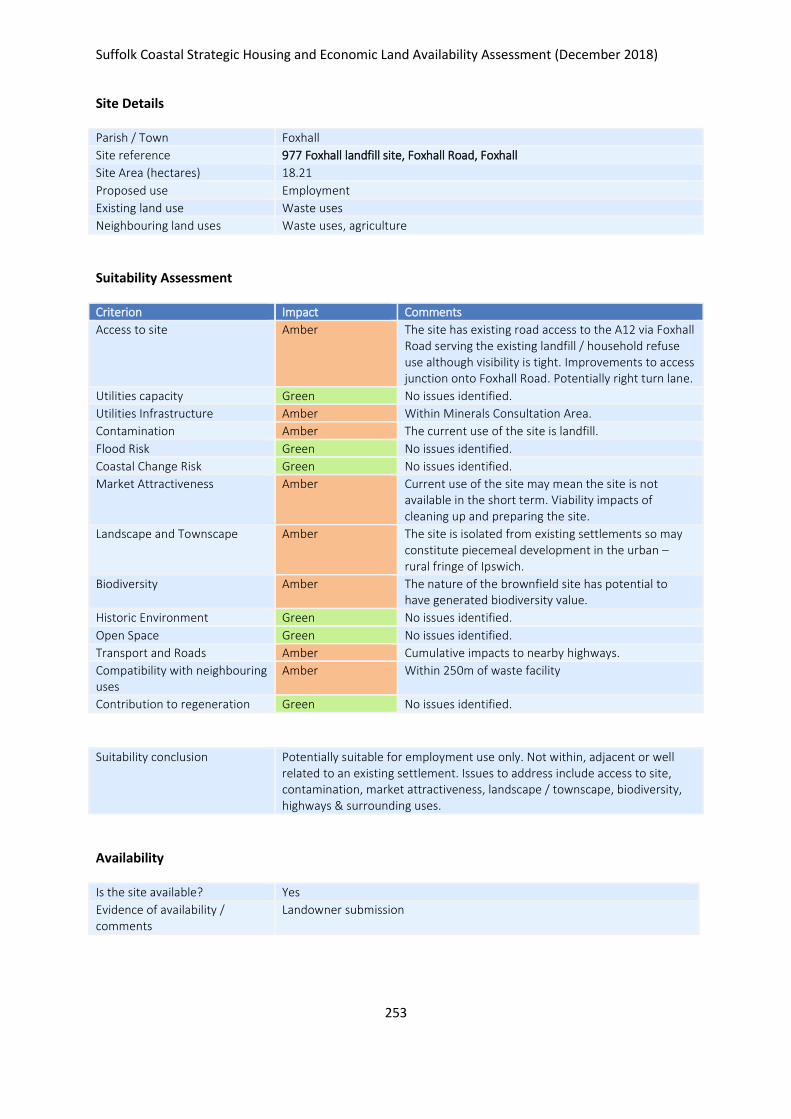
Suffolk Coastal Strategic Housing and Economic Land Availability Assessment (December 2018)
253
Site Details
Parish / Town Foxhall
Site reference 977 Foxhall landfill site, Foxhall Road, Foxhall
Site Area (hectares) 18.21
Proposed use Employment
Existing land use Waste uses
Neighbouring land uses Waste uses, agriculture
Suitability Assessment
Criterion Impact Comments
Access to site Amber The site has existing road access to the A12 via Foxhall Road serving the existing landfill / household refuse use although visibility is tight. Improvements to access junction onto Foxhall Road. Potentially right turn lane.
Utilities capacity Green No issues identified.
Utilities Infrastructure Amber Within Minerals Consultation Area.
Contamination Amber The current use of the site is landfill.
Flood Risk Green No issues identified.
Coastal Change Risk Green No issues identified.
Market Attractiveness Amber Current use of the site may mean the site is not available in the short term. Viability impacts of cleaning up and preparing the site.
Landscape and Townscape Amber The site is isolated from existing settlements so may constitute piecemeal development in the urban – rural fringe of Ipswich.
Biodiversity Amber The nature of the brownfield site has potential to have generated biodiversity value.
Historic Environment Green No issues identified.
Open Space Green No issues identified.
Transport and Roads Amber Cumulative impacts to nearby highways.
Compatibility with neighbouring uses
Amber Within 250m of waste facility
Contribution to regeneration Green No issues identified.
Suitability conclusion Potentially suitable for employment use only. Not within, adjacent or well related to an existing settlement. Issues to address include access to site, contamination, market attractiveness, landscape / townscape, biodiversity, highways & surrounding uses.
Availability
Is the site available? Yes
Evidence of availability / comments
Landowner submission

Suffolk Coastal Strategic Housing and Economic Land Availability Assessment (December 2018)
254
Achievability
Is the site achievable? Yes
Evidence of achievability Assumed, although likely costs related to contamination
Are there any commencement issues?
Contamination issues
Estimated dwellings yield -
Estimated employment land yield (hectares) 18
Estimated retail floorspace (sqm) -
Estimated commencement date 2028/29
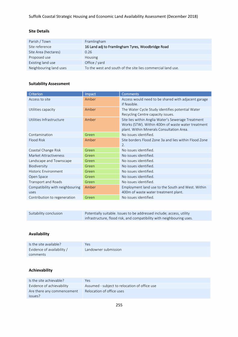
Suffolk Coastal Strategic Housing and Economic Land Availability Assessment (December 2018)
255
Site Details
Parish / Town Framlingham
Site reference 16 Land adj to Framlingham Tyres, Woodbridge Road
Site Area (hectares) 0.26
Proposed use Housing
Existing land use Office / yard
Neighbouring land uses To the west and south of the site lies commercial land use.
Suitability Assessment
Criterion Impact Comments
Access to site Amber Access would need to be shared with adjacent garage if feasible.
Utilities capacity Amber The Water Cycle Study identifies potential Water Recycling Centre capacity issues.
Utilities Infrastructure Amber Site lies within Anglia Water’s Sewerage Treatment Works (STW). Within 400m of waste water treatment plant. Within Minerals Consultation Area.
Contamination Green No issues identified.
Flood Risk Amber Site borders Flood Zone 3a and lies within Flood Zone 2.
Coastal Change Risk Green No issues identified.
Market Attractiveness Green No issues identified.
Landscape and Townscape Green No issues identified.
Biodiversity Green No issues identified.
Historic Environment Green No issues identified.
Open Space Green No issues identified.
Transport and Roads Green No issues identified.
Compatibility with neighbouring uses
Amber Employment land use to the South and West. Within 400m of waste water treatment plant.
Contribution to regeneration Green No issues identified.
Suitability conclusion Potentially suitable. Issues to be addressed include; access, utility infrastructure, flood risk, and compatibility with neighbouring uses.
Availability
Is the site available? Yes
Evidence of availability / comments
Landowner submission
Achievability
Is the site achievable? Yes
Evidence of achievability Assumed - subject to relocation of office use
Are there any commencement issues?
Relocation of office uses

Suffolk Coastal Strategic Housing and Economic Land Availability Assessment (December 2018)
256
Estimated dwellings yield 8
Estimated employment land yield (hectares) -
Estimated retail floorspace (sqm) -
Estimated commencement date 2028/29
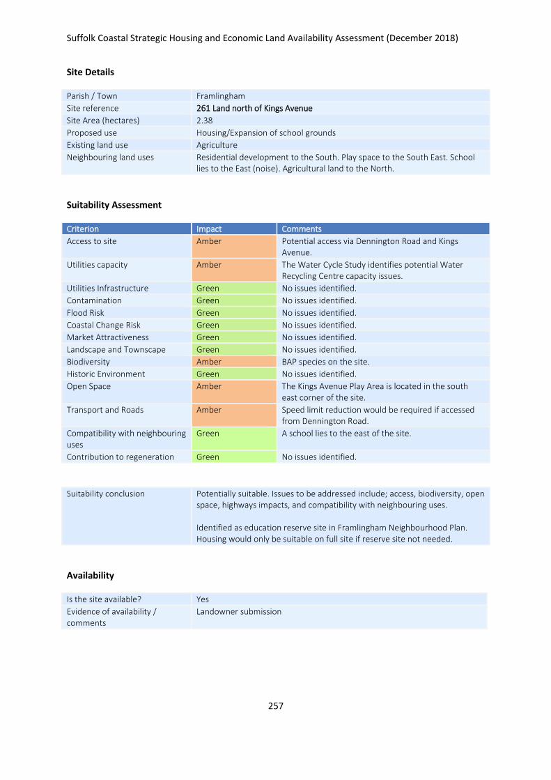
Suffolk Coastal Strategic Housing and Economic Land Availability Assessment (December 2018)
257
Site Details
Parish / Town Framlingham
Site reference 261 Land north of Kings Avenue
Site Area (hectares) 2.38
Proposed use Housing/Expansion of school grounds
Existing land use Agriculture
Neighbouring land uses Residential development to the South. Play space to the South East. School lies to the East (noise). Agricultural land to the North.
Suitability Assessment
Criterion Impact Comments
Access to site Amber Potential access via Dennington Road and Kings Avenue.
Utilities capacity Amber The Water Cycle Study identifies potential Water Recycling Centre capacity issues.
Utilities Infrastructure Green No issues identified.
Contamination Green No issues identified.
Flood Risk Green No issues identified.
Coastal Change Risk Green No issues identified.
Market Attractiveness Green No issues identified.
Landscape and Townscape Green No issues identified.
Biodiversity Amber BAP species on the site.
Historic Environment Green No issues identified.
Open Space Amber The Kings Avenue Play Area is located in the south east corner of the site.
Transport and Roads Amber Speed limit reduction would be required if accessed from Dennington Road.
Compatibility with neighbouring uses
Green A school lies to the east of the site.
Contribution to regeneration Green No issues identified.
Suitability conclusion Potentially suitable. Issues to be addressed include; access, biodiversity, open space, highways impacts, and compatibility with neighbouring uses. Identified as education reserve site in Framlingham Neighbourhood Plan. Housing would only be suitable on full site if reserve site not needed.
Availability
Is the site available? Yes
Evidence of availability / comments
Landowner submission

Suffolk Coastal Strategic Housing and Economic Land Availability Assessment (December 2018)
258
Achievability
Is the site achievable? Yes
Evidence of achievability No specific issues or abnormal costs identified
Are there any commencement issues?
None identified
Estimated dwellings yield 57
Estimated employment land yield (hectares) -
Estimated retail floorspace (sqm) -
Estimated commencement date 2021/22
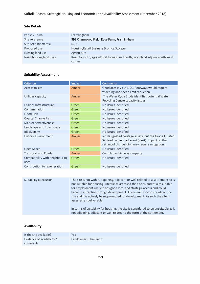
Suffolk Coastal Strategic Housing and Economic Land Availability Assessment (December 2018)
259
Site Details
Parish / Town Framlingham
Site reference 393 Charnwood Field, Rose Farm, Framlingham
Site Area (hectares) 6.67
Proposed use Housing,Retail,Business & office,Storage
Existing land use Agriculture
Neighbouring land uses Road to south, agricultural to west and north, woodland adjoins south west corner
Suitability Assessment
Criterion Impact Comments
Access to site Amber Good access via A1120. Footways would require widening and speed limit reduction.
Utilities capacity Amber The Water Cycle Study identifies potential Water Recycling Centre capacity issues.
Utilities Infrastructure Green No issues identified.
Contamination Green No issues identified.
Flood Risk Green No issues identified.
Coastal Change Risk Green No issues identified.
Market Attractiveness Green No issues identified.
Landscape and Townscape Green No issues identified.
Biodiversity Green No issues identified.
Historic Environment Amber No designated heritage assets, but the Grade II Listed Saxtead Lodge is adjacent (west). Impact on the setting of this building may require mitigation.
Open Space Green No issues identified.
Transport and Roads Amber Cumulative highways impacts.
Compatibility with neighbouring uses
Green No issues identified.
Contribution to regeneration Green No issues identified.
Suitability conclusion The site is not within, adjoining, adjacent or well related to a settlement so is not suitable for housing. Litchfields assessed the site as potentially suitable for employment use site has good local and strategic access and could become attractive through development. There are few constraints on the site and it is actively being promoted for development. As such the site is assessed as deliverable. In terms of suitability for housing, the site is considered to be unsuitable as is not adjoining, adjacent or well related to the form of the settlement.
Availability
Is the site available? Yes
Evidence of availability / comments
Landowner submission

Suffolk Coastal Strategic Housing and Economic Land Availability Assessment (December 2018)
260
Achievability
Is the site achievable? Yes
Evidence of achievability No specific issues or abnormal costs identified
Are there any commencement issues?
None identified
Estimated dwellings yield -
Estimated employment land yield (hectares) 7
Estimated retail floorspace (sqm) -
Estimated commencement date 2021/22
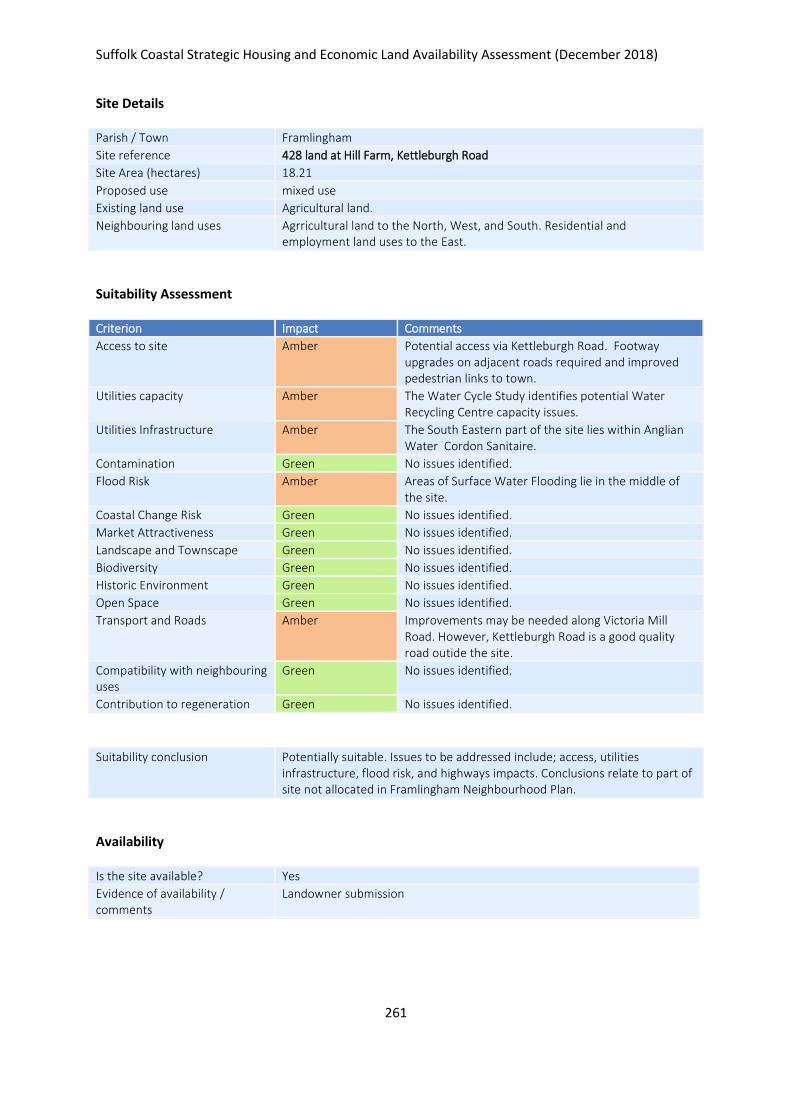
Suffolk Coastal Strategic Housing and Economic Land Availability Assessment (December 2018)
261
Site Details
Parish / Town Framlingham
Site reference 428 land at Hill Farm, Kettleburgh Road
Site Area (hectares) 18.21
Proposed use mixed use
Existing land use Agricultural land.
Neighbouring land uses Agrricultural land to the North, West, and South. Residential and employment land uses to the East.
Suitability Assessment
Criterion Impact Comments
Access to site Amber Potential access via Kettleburgh Road. Footway upgrades on adjacent roads required and improved pedestrian links to town.
Utilities capacity Amber The Water Cycle Study identifies potential Water Recycling Centre capacity issues.
Utilities Infrastructure Amber The South Eastern part of the site lies within Anglian Water Cordon Sanitaire.
Contamination Green No issues identified.
Flood Risk Amber Areas of Surface Water Flooding lie in the middle of the site.
Coastal Change Risk Green No issues identified.
Market Attractiveness Green No issues identified.
Landscape and Townscape Green No issues identified.
Biodiversity Green No issues identified.
Historic Environment Green No issues identified.
Open Space Green No issues identified.
Transport and Roads Amber Improvements may be needed along Victoria Mill Road. However, Kettleburgh Road is a good quality road outide the site.
Compatibility with neighbouring uses
Green No issues identified.
Contribution to regeneration Green No issues identified.
Suitability conclusion Potentially suitable. Issues to be addressed include; access, utilities infrastructure, flood risk, and highways impacts. Conclusions relate to part of site not allocated in Framlingham Neighbourhood Plan.
Availability
Is the site available? Yes
Evidence of availability / comments
Landowner submission

Suffolk Coastal Strategic Housing and Economic Land Availability Assessment (December 2018)
262
Achievability
Is the site achievable? Yes
Evidence of achievability No specific issues or abnormal costs identified
Are there any commencement issues?
None identified
Estimated dwellings yield 374
Estimated employment land yield (hectares) -
Estimated retail floorspace (sqm) -
Estimated commencement date 2022/23
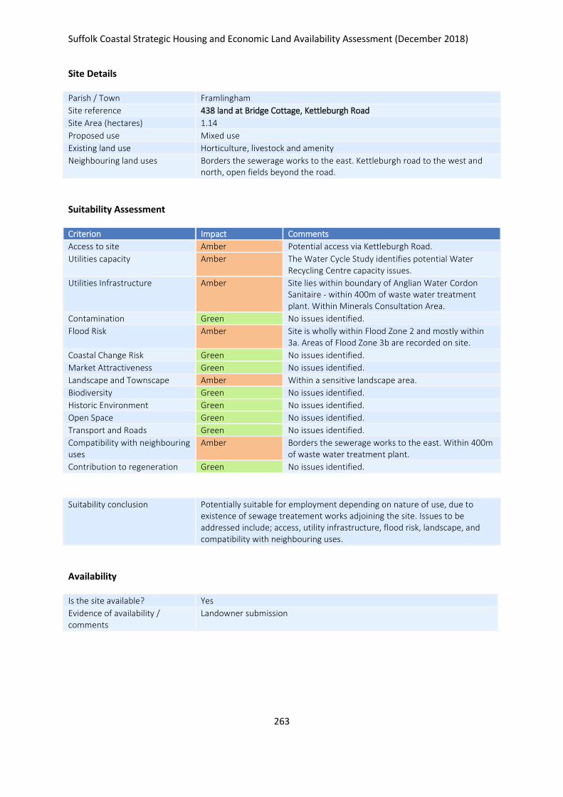
Suffolk Coastal Strategic Housing and Economic Land Availability Assessment (December 2018)
263
Site Details
Parish / Town Framlingham
Site reference 438 land at Bridge Cottage, Kettleburgh Road
Site Area (hectares) 1.14
Proposed use Mixed use
Existing land use Horticulture, livestock and amenity
Neighbouring land uses Borders the sewerage works to the east. Kettleburgh road to the west and north, open fields beyond the road.
Suitability Assessment
Criterion Impact Comments
Access to site Amber Potential access via Kettleburgh Road.
Utilities capacity Amber The Water Cycle Study identifies potential Water Recycling Centre capacity issues.
Utilities Infrastructure Amber Site lies within boundary of Anglian Water Cordon Sanitaire - within 400m of waste water treatment plant. Within Minerals Consultation Area.
Contamination Green No issues identified.
Flood Risk Amber Site is wholly within Flood Zone 2 and mostly within 3a. Areas of Flood Zone 3b are recorded on site.
Coastal Change Risk Green No issues identified.
Market Attractiveness Green No issues identified.
Landscape and Townscape Amber Within a sensitive landscape area.
Biodiversity Green No issues identified.
Historic Environment Green No issues identified.
Open Space Green No issues identified.
Transport and Roads Green No issues identified.
Compatibility with neighbouring uses
Amber Borders the sewerage works to the east. Within 400m of waste water treatment plant.
Contribution to regeneration Green No issues identified.
Suitability conclusion Potentially suitable for employment depending on nature of use, due to existence of sewage treatement works adjoining the site. Issues to be addressed include; access, utility infrastructure, flood risk, landscape, and compatibility with neighbouring uses.
Availability
Is the site available? Yes
Evidence of availability / comments
Landowner submission

Suffolk Coastal Strategic Housing and Economic Land Availability Assessment (December 2018)
264
Achievability
Is the site achievable? Yes
Evidence of achievability No specific issues or abnormal costs identified
Are there any commencement issues?
None identified
Estimated dwellings yield -
Estimated employment land yield (hectares) 1
Estimated retail floorspace (sqm) -
Estimated commencement date 2021/22
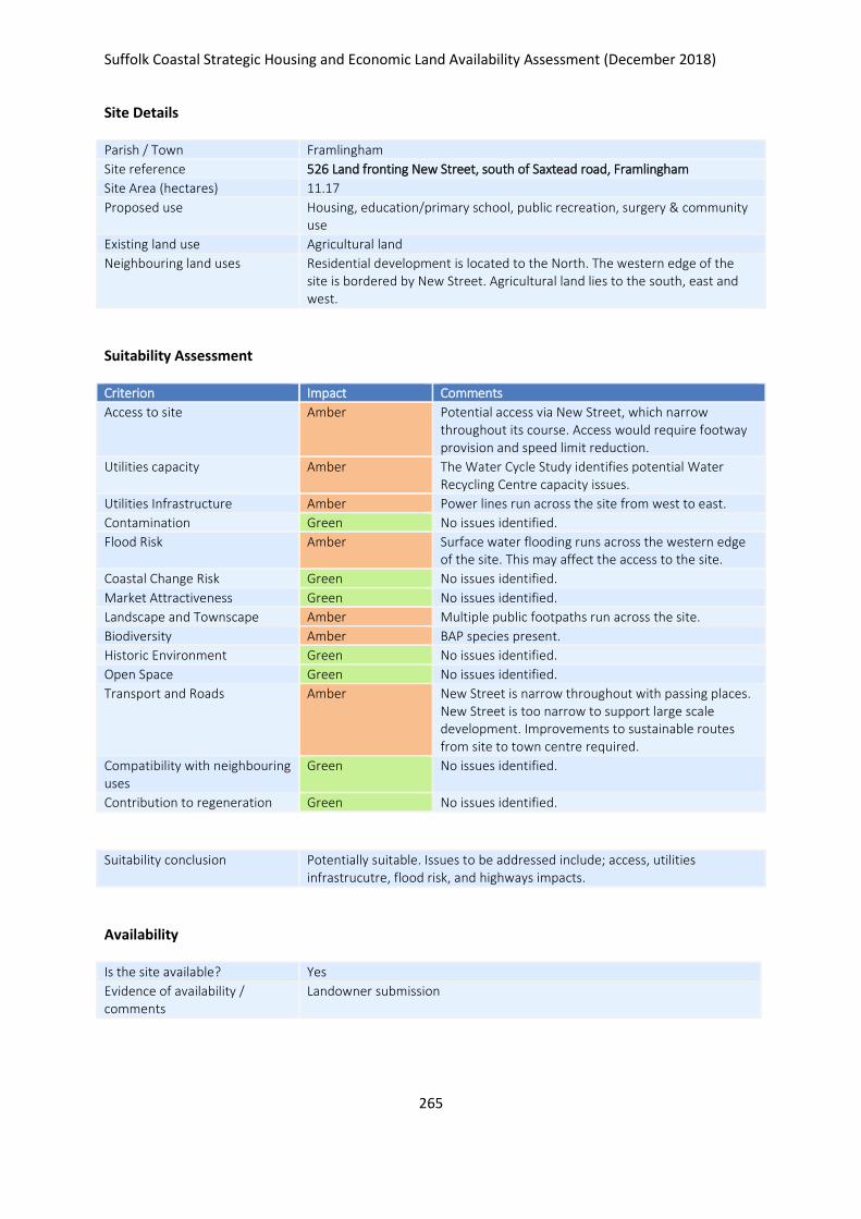
Suffolk Coastal Strategic Housing and Economic Land Availability Assessment (December 2018)
265
Site Details
Parish / Town Framlingham
Site reference 526 Land fronting New Street, south of Saxtead road, Framlingham
Site Area (hectares) 11.17
Proposed use Housing, education/primary school, public recreation, surgery & community use
Existing land use Agricultural land
Neighbouring land uses Residential development is located to the North. The western edge of the site is bordered by New Street. Agricultural land lies to the south, east and west.
Suitability Assessment
Criterion Impact Comments
Access to site Amber Potential access via New Street, which narrow throughout its course. Access would require footway provision and speed limit reduction.
Utilities capacity Amber The Water Cycle Study identifies potential Water Recycling Centre capacity issues.
Utilities Infrastructure Amber Power lines run across the site from west to east.
Contamination Green No issues identified.
Flood Risk Amber Surface water flooding runs across the western edge of the site. This may affect the access to the site.
Coastal Change Risk Green No issues identified.
Market Attractiveness Green No issues identified.
Landscape and Townscape Amber Multiple public footpaths run across the site.
Biodiversity Amber BAP species present.
Historic Environment Green No issues identified.
Open Space Green No issues identified.
Transport and Roads Amber New Street is narrow throughout with passing places. New Street is too narrow to support large scale development. Improvements to sustainable routes from site to town centre required.
Compatibility with neighbouring uses
Green No issues identified.
Contribution to regeneration Green No issues identified.
Suitability conclusion Potentially suitable. Issues to be addressed include; access, utilities infrastrucutre, flood risk, and highways impacts.
Availability
Is the site available? Yes
Evidence of availability / comments
Landowner submission

Suffolk Coastal Strategic Housing and Economic Land Availability Assessment (December 2018)
266
Achievability
Is the site achievable? Yes
Evidence of achievability No specific issues or abnormal costs identified
Are there any commencement issues?
None identified
Estimated dwellings yield 268
Estimated employment land yield (hectares) -
Estimated retail floorspace (sqm) -
Estimated commencement date 2022/23
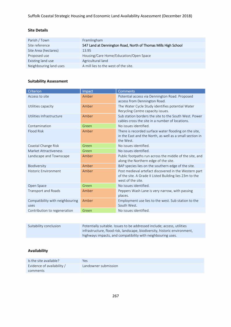
Suffolk Coastal Strategic Housing and Economic Land Availability Assessment (December 2018)
267
Site Details
Parish / Town Framlingham
Site reference 547 Land at Dennington Road, North of Thomas Mills High School
Site Area (hectares) 13.95
Proposed use Housing/Care Home/Education/Open Space
Existing land use Agricultural land
Neighbouring land uses A mill lies to the west of the site.
Suitability Assessment
Criterion Impact Comments
Access to site Amber Potential access via Dennington Road. Proposed access from Dennington Road.
Utilities capacity Amber The Water Cycle Study identifies potential Water Recycling Centre capacity issues.
Utilities Infrastructure Amber Sub station borders the site to the South West. Power cables cross the site in a number of locations.
Contamination Green No issues identified.
Flood Risk Amber There is recorded surface water flooding on the site, in the East and the North, as well as a small section in the West.
Coastal Change Risk Green No issues identified.
Market Attractiveness Green No issues identified.
Landscape and Townscape Amber Public footpaths run across the middle of the site, and along the Northern edge of the site.
Biodiversity Amber BAP species lies on the southern edge of the site.
Historic Environment Amber Post medieval artefact discovered in the Western part of the site. A Grade II Listed Building lies 23m to the west of the site.
Open Space Green No issues identified.
Transport and Roads Amber Peppers Wash Lane is very narrow, with passing places.
Compatibility with neighbouring uses
Amber Employment use lies to the west. Sub station to the South West.
Contribution to regeneration Green No issues identified.
Suitability conclusion Potentially suitable. Issues to be addressed include; access, utilities infrastructure, flood risk, landscape, biodiversity, historic environment, highways impacts, and compatibility with neighbouring uses.
Availability
Is the site available? Yes
Evidence of availability / comments
Landowner submission

Suffolk Coastal Strategic Housing and Economic Land Availability Assessment (December 2018)
268
Achievability
Is the site achievable? Yes
Evidence of achievability No specific issues or abnormal costs identified
Are there any commencement issues?
None identified
Estimated dwellings yield 335
Estimated employment land yield (hectares) -
Estimated retail floorspace (sqm) -
Estimated commencement date 2020/21
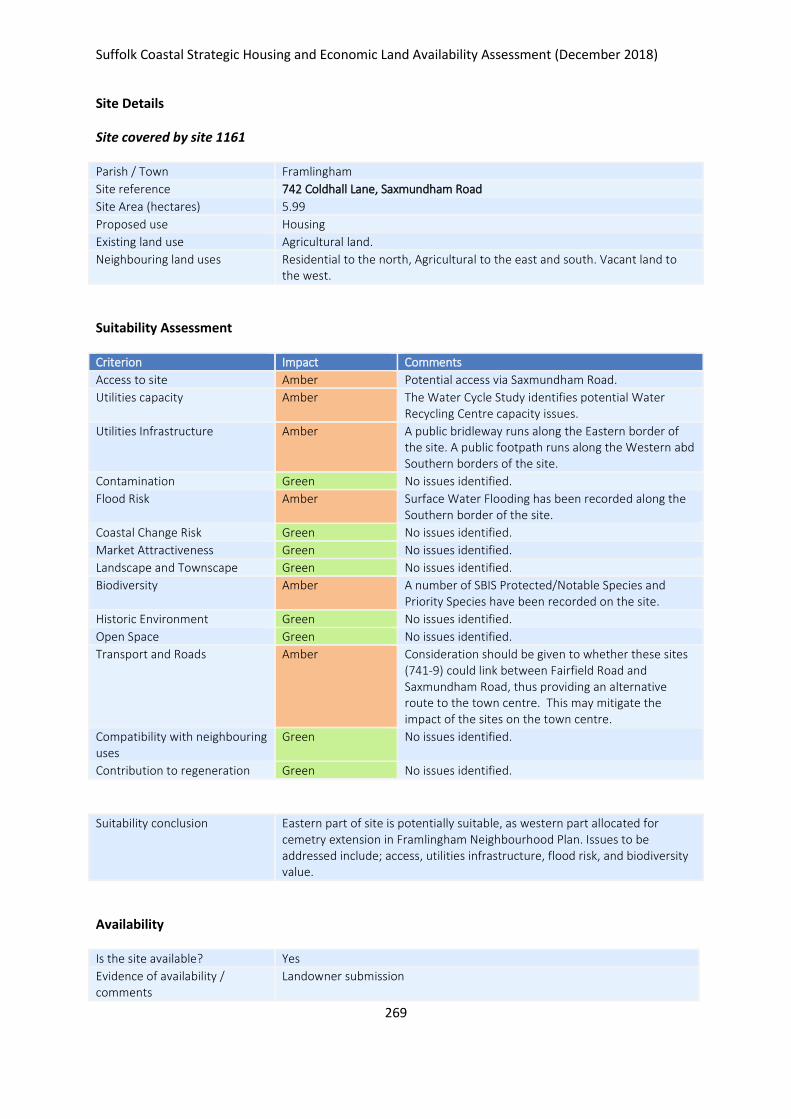
Suffolk Coastal Strategic Housing and Economic Land Availability Assessment (December 2018)
269
Site Details
Site covered by site 1161
Parish / Town Framlingham
Site reference 742 Coldhall Lane, Saxmundham Road
Site Area (hectares) 5.99
Proposed use Housing
Existing land use Agricultural land.
Neighbouring land uses Residential to the north, Agricultural to the east and south. Vacant land to the west.
Suitability Assessment
Criterion Impact Comments
Access to site Amber Potential access via Saxmundham Road.
Utilities capacity Amber The Water Cycle Study identifies potential Water Recycling Centre capacity issues.
Utilities Infrastructure Amber A public bridleway runs along the Eastern border of the site. A public footpath runs along the Western abd Southern borders of the site.
Contamination Green No issues identified.
Flood Risk Amber Surface Water Flooding has been recorded along the Southern border of the site.
Coastal Change Risk Green No issues identified.
Market Attractiveness Green No issues identified.
Landscape and Townscape Green No issues identified.
Biodiversity Amber A number of SBIS Protected/Notable Species and Priority Species have been recorded on the site.
Historic Environment Green No issues identified.
Open Space Green No issues identified.
Transport and Roads Amber Consideration should be given to whether these sites (741-9) could link between Fairfield Road and Saxmundham Road, thus providing an alternative route to the town centre. This may mitigate the impact of the sites on the town centre.
Compatibility with neighbouring uses
Green No issues identified.
Contribution to regeneration Green No issues identified.
Suitability conclusion Eastern part of site is potentially suitable, as western part allocated for cemetry extension in Framlingham Neighbourhood Plan. Issues to be addressed include; access, utilities infrastructure, flood risk, and biodiversity value.
Availability
Is the site available? Yes
Evidence of availability / comments
Landowner submission

Suffolk Coastal Strategic Housing and Economic Land Availability Assessment (December 2018)
270
Achievability
Is the site achievable? Yes
Evidence of achievability No specific issues or abnormal costs identified
Are there any commencement issues?
None identified
Estimated dwellings yield -16
Estimated employment land yield (hectares) -
Estimated retail floorspace (sqm) -
Estimated commencement date 2021/22
16
See assessment of site 1161 for dwelling numbers
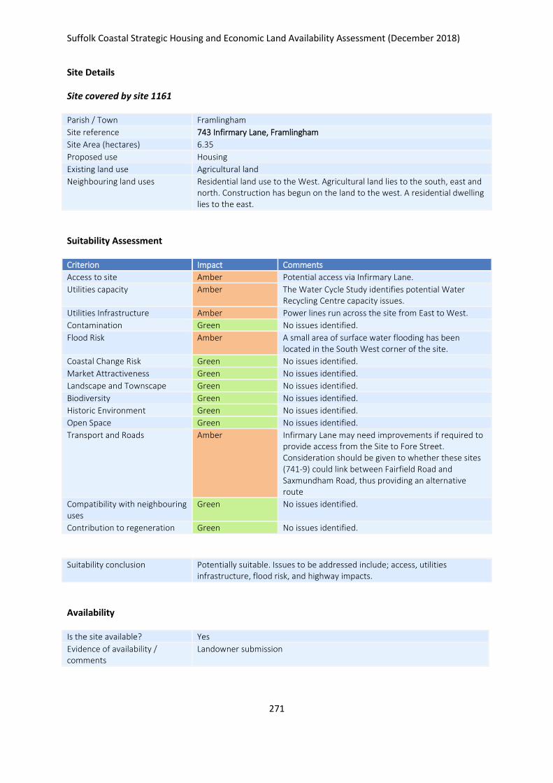
Suffolk Coastal Strategic Housing and Economic Land Availability Assessment (December 2018)
271
Site Details
Site covered by site 1161
Parish / Town Framlingham
Site reference 743 Infirmary Lane, Framlingham
Site Area (hectares) 6.35
Proposed use Housing
Existing land use Agricultural land
Neighbouring land uses Residential land use to the West. Agricultural land lies to the south, east and north. Construction has begun on the land to the west. A residential dwelling lies to the east.
Suitability Assessment
Criterion Impact Comments
Access to site Amber Potential access via Infirmary Lane.
Utilities capacity Amber The Water Cycle Study identifies potential Water Recycling Centre capacity issues.
Utilities Infrastructure Amber Power lines run across the site from East to West.
Contamination Green No issues identified.
Flood Risk Amber A small area of surface water flooding has been located in the South West corner of the site.
Coastal Change Risk Green No issues identified.
Market Attractiveness Green No issues identified.
Landscape and Townscape Green No issues identified.
Biodiversity Green No issues identified.
Historic Environment Green No issues identified.
Open Space Green No issues identified.
Transport and Roads Amber Infirmary Lane may need improvements if required to provide access from the Site to Fore Street. Consideration should be given to whether these sites (741-9) could link between Fairfield Road and Saxmundham Road, thus providing an alternative route
Compatibility with neighbouring uses
Green No issues identified.
Contribution to regeneration Green No issues identified.
Suitability conclusion Potentially suitable. Issues to be addressed include; access, utilities infrastructure, flood risk, and highway impacts.
Availability
Is the site available? Yes
Evidence of availability / comments
Landowner submission
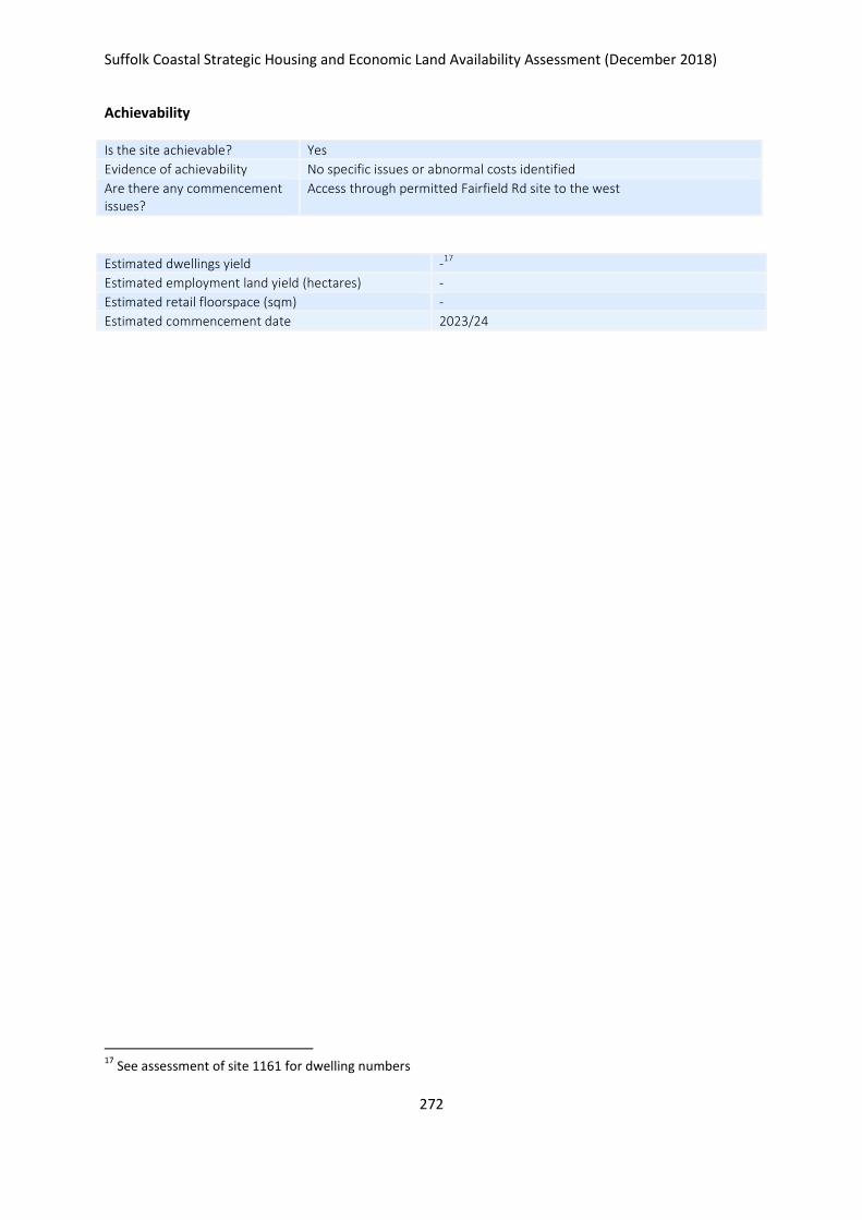
Suffolk Coastal Strategic Housing and Economic Land Availability Assessment (December 2018)
272
Achievability
Is the site achievable? Yes
Evidence of achievability No specific issues or abnormal costs identified
Are there any commencement issues?
Access through permitted Fairfield Rd site to the west
Estimated dwellings yield -17
Estimated employment land yield (hectares) -
Estimated retail floorspace (sqm) -
Estimated commencement date 2023/24
17
See assessment of site 1161 for dwelling numbers
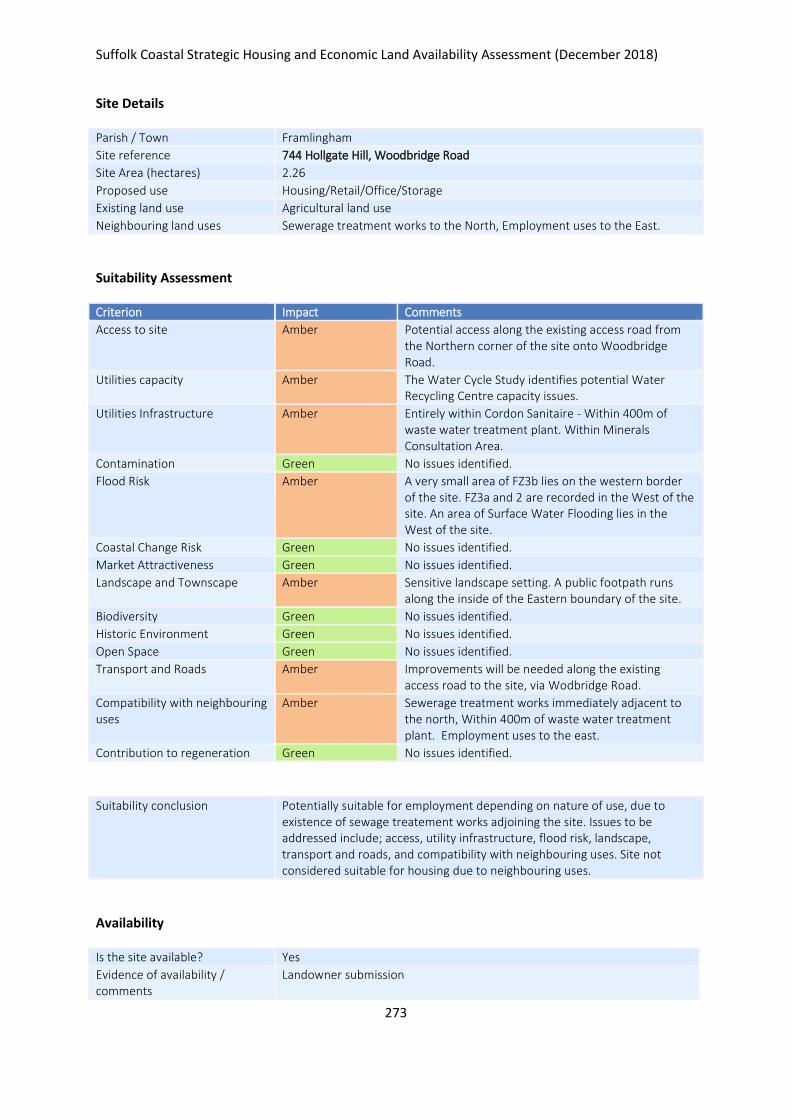
Suffolk Coastal Strategic Housing and Economic Land Availability Assessment (December 2018)
273
Site Details
Parish / Town Framlingham
Site reference 744 Hollgate Hill, Woodbridge Road
Site Area (hectares) 2.26
Proposed use Housing/Retail/Office/Storage
Existing land use Agricultural land use
Neighbouring land uses Sewerage treatment works to the North, Employment uses to the East.
Suitability Assessment
Criterion Impact Comments
Access to site Amber Potential access along the existing access road from the Northern corner of the site onto Woodbridge Road.
Utilities capacity Amber The Water Cycle Study identifies potential Water Recycling Centre capacity issues.
Utilities Infrastructure Amber Entirely within Cordon Sanitaire - Within 400m of waste water treatment plant. Within Minerals Consultation Area.
Contamination Green No issues identified.
Flood Risk Amber A very small area of FZ3b lies on the western border of the site. FZ3a and 2 are recorded in the West of the site. An area of Surface Water Flooding lies in the West of the site.
Coastal Change Risk Green No issues identified.
Market Attractiveness Green No issues identified.
Landscape and Townscape Amber Sensitive landscape setting. A public footpath runs along the inside of the Eastern boundary of the site.
Biodiversity Green No issues identified.
Historic Environment Green No issues identified.
Open Space Green No issues identified.
Transport and Roads Amber Improvements will be needed along the existing access road to the site, via Wodbridge Road.
Compatibility with neighbouring uses
Amber Sewerage treatment works immediately adjacent to the north, Within 400m of waste water treatment plant. Employment uses to the east.
Contribution to regeneration Green No issues identified.
Suitability conclusion Potentially suitable for employment depending on nature of use, due to existence of sewage treatement works adjoining the site. Issues to be addressed include; access, utility infrastructure, flood risk, landscape, transport and roads, and compatibility with neighbouring uses. Site not considered suitable for housing due to neighbouring uses.
Availability
Is the site available? Yes
Evidence of availability / comments
Landowner submission

Suffolk Coastal Strategic Housing and Economic Land Availability Assessment (December 2018)
274
Achievability
Is the site achievable? Yes
Evidence of achievability No specific issues or abnormal costs identified
Are there any commencement issues?
None identified
Estimated dwellings yield -
Estimated employment land yield (hectares) 2
Estimated retail floorspace (sqm) -
Estimated commencement date 2021/22
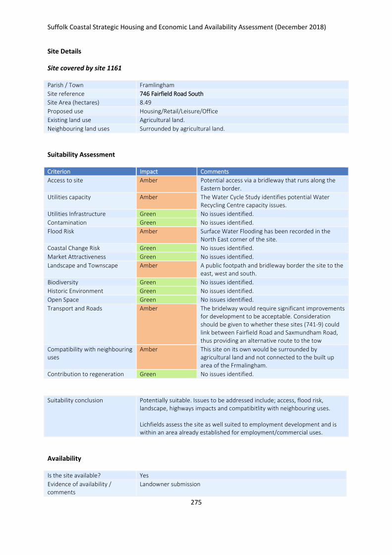
Suffolk Coastal Strategic Housing and Economic Land Availability Assessment (December 2018)
275
Site Details
Site covered by site 1161
Parish / Town Framlingham
Site reference 746 Fairfield Road South
Site Area (hectares) 8.49
Proposed use Housing/Retail/Leisure/Office
Existing land use Agricultural land.
Neighbouring land uses Surrounded by agricultural land.
Suitability Assessment
Criterion Impact Comments
Access to site Amber Potential access via a bridleway that runs along the Eastern border.
Utilities capacity Amber The Water Cycle Study identifies potential Water Recycling Centre capacity issues.
Utilities Infrastructure Green No issues identified.
Contamination Green No issues identified.
Flood Risk Amber Surface Water Flooding has been recorded in the North East corner of the site.
Coastal Change Risk Green No issues identified.
Market Attractiveness Green No issues identified.
Landscape and Townscape Amber A public footpath and bridleway border the site to the east, west and south.
Biodiversity Green No issues identified.
Historic Environment Green No issues identified.
Open Space Green No issues identified.
Transport and Roads Amber The bridelway would require significant improvements for development to be acceptable. Consideration should be given to whether these sites (741-9) could link between Fairfield Road and Saxmundham Road, thus providing an alternative route to the tow
Compatibility with neighbouring uses
Amber This site on its own would be surrounded by agricultural land and not connected to the built up area of the Frmalingham.
Contribution to regeneration Green No issues identified.
Suitability conclusion Potentially suitable. Issues to be addressed include; access, flood risk, landscape, highways impacts and compatibitlity with neighbouring uses. Lichfields assess the site as well suited to employment development and is within an area already established for employment/commercial uses.
Availability
Is the site available? Yes
Evidence of availability / comments
Landowner submission
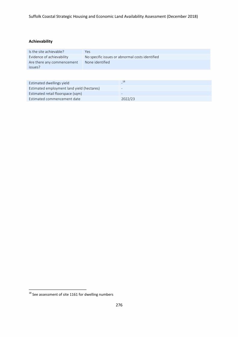
Suffolk Coastal Strategic Housing and Economic Land Availability Assessment (December 2018)
276
Achievability
Is the site achievable? Yes
Evidence of achievability No specific issues or abnormal costs identified
Are there any commencement issues?
None identified
Estimated dwellings yield -18
Estimated employment land yield (hectares) -
Estimated retail floorspace (sqm) -
Estimated commencement date 2022/23
18
See assessment of site 1161 for dwelling numbers
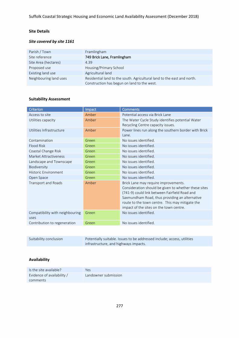
Suffolk Coastal Strategic Housing and Economic Land Availability Assessment (December 2018)
277
Site Details
Site covered by site 1161
Parish / Town Framlingham
Site reference 749 Brick Lane, Framlingham
Site Area (hectares) 4.39
Proposed use Housing/Primary School
Existing land use Agricultural land
Neighbouring land uses Residential land to the south. Agricultural land to the east and north. Construction has begun on land to the west.
Suitability Assessment
Criterion Impact Comments
Access to site Amber Potential access via Brick Lane
Utilities capacity Amber The Water Cycle Study identifies potential Water Recycling Centre capacity issues.
Utilities Infrastructure Amber Power lines run along the southern border with Brick Lane.
Contamination Green No issues identified.
Flood Risk Green No issues identified.
Coastal Change Risk Green No issues identified.
Market Attractiveness Green No issues identified.
Landscape and Townscape Green No issues identified.
Biodiversity Green No issues identified.
Historic Environment Green No issues identified.
Open Space Green No issues identified.
Transport and Roads Amber Brick Lane may require improvements. Consideration should be given to whether these sites (741-9) could link between Fairfield Road and Saxmundham Road, thus providing an alternative route to the town centre. This may mitigate the impact of the sites on the town centre.
Compatibility with neighbouring uses
Green No issues identified.
Contribution to regeneration Green No issues identified.
Suitability conclusion Potentially suitable. Issues to be addressed include; access, utilities infrastructure, and highways impacts.
Availability
Is the site available? Yes
Evidence of availability / comments
Landowner submission
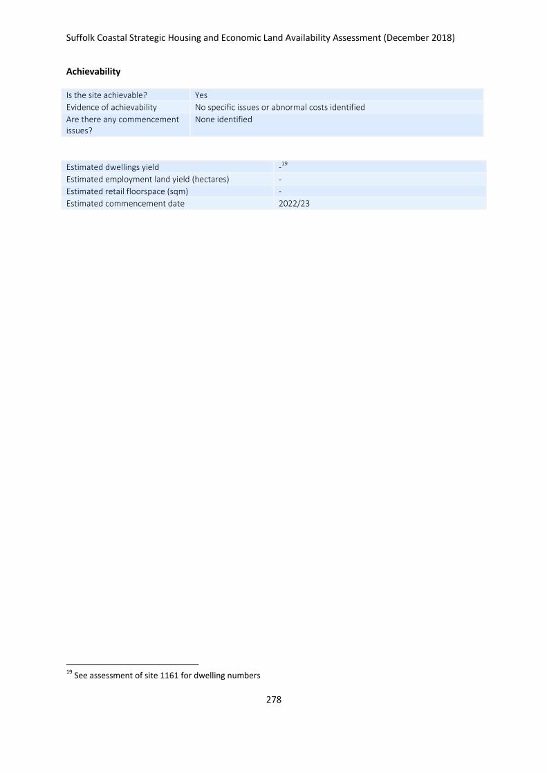
Suffolk Coastal Strategic Housing and Economic Land Availability Assessment (December 2018)
278
Achievability
Is the site achievable? Yes
Evidence of achievability No specific issues or abnormal costs identified
Are there any commencement issues?
None identified
Estimated dwellings yield -19
Estimated employment land yield (hectares) -
Estimated retail floorspace (sqm) -
Estimated commencement date 2022/23
19
See assessment of site 1161 for dwelling numbers
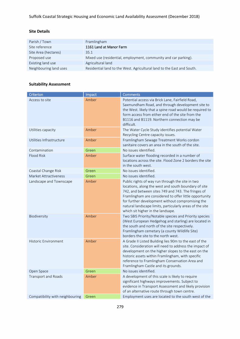
Suffolk Coastal Strategic Housing and Economic Land Availability Assessment (December 2018)
279
Site Details
Parish / Town Framlingham
Site reference 1161 Land at Manor Farm
Site Area (hectares) 35.1
Proposed use Mixed use (residential, employment, community and car parking).
Existing land use Agricultural land
Neighbouring land uses Residential land to the West. Agricultural land to the East and South.
Suitability Assessment
Criterion Impact Comments
Access to site Amber Potential access via Brick Lane, Fairfield Road, Saxmundham Road, and through development site to the West. likely that a spine road would be required to form access from either end of the site from the B1116 and B1119. Northern connection may be difficult.
Utilities capacity Amber The Water Cycle Study identifies potential Water Recycling Centre capacity issues.
Utilities Infrastructure Amber Framlingham Sewage Treatment Works cordon sanitaire covers an area in the south of the site.
Contamination Green No issues identified.
Flood Risk Amber Surface water flooding recorded in a number of locations across the site. Flood Zone 2 borders the site in the south west.
Coastal Change Risk Green No issues identified.
Market Attractiveness Green No issues identified.
Landscape and Townscape Amber Public rights of way run through the site in two locations, along the west and south boundary of site 742, and between sites 749 and 743. The fringes of Framlingham are considered to offer little opportunity for further development without compromising the natural landscape limits, particularly areas of the site which sit higher in the landsape.
Biodiversity Amber Two SBIS Priority/Notable species and Priority species (West European Hedgehog and starling) are located in the south and north of the site respectively. Framlingham cemetary (a county Wildlife Site) borders the site to the north west.
Historic Environment Amber A Grade II Listed Building lies 90m to the east of the site. Consideration will need to address the impact of development on the higher slopes to the east on the historic assets within Framlingham, with specific reference to Framlingham Conservation Area and Framlingham Castle and its grounds.
Open Space Green No issues identified.
Transport and Roads Amber A development of this scale is likely to require significant highways improvements. Subject to evidence in Transport Assessment and likely provision of an alternative route through town centre.
Compatibility with neighbouring Green Employment uses are located to the south west of the
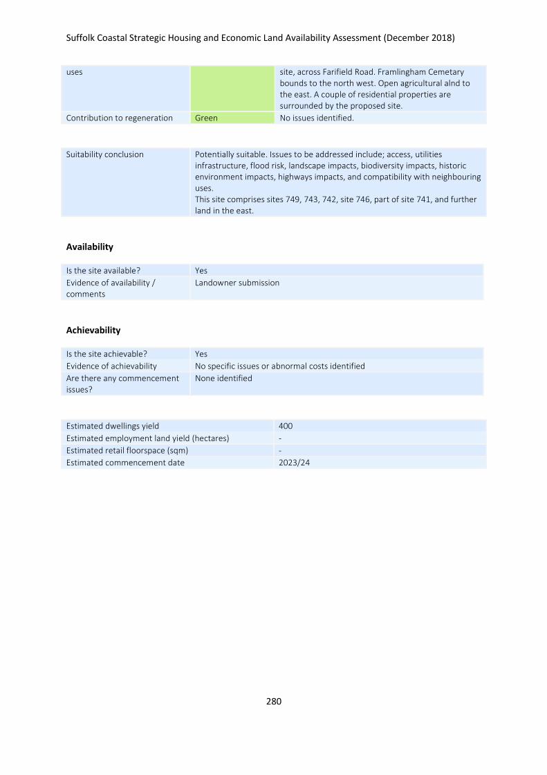
Suffolk Coastal Strategic Housing and Economic Land Availability Assessment (December 2018)
280
uses site, across Farifield Road. Framlingham Cemetary bounds to the north west. Open agricultural alnd to the east. A couple of residential properties are surrounded by the proposed site.
Contribution to regeneration Green No issues identified.
Suitability conclusion Potentially suitable. Issues to be addressed include; access, utilities infrastructure, flood risk, landscape impacts, biodiversity impacts, historic environment impacts, highways impacts, and compatibility with neighbouring uses. This site comprises sites 749, 743, 742, site 746, part of site 741, and further land in the east.
Availability
Is the site available? Yes
Evidence of availability / comments
Landowner submission
Achievability
Is the site achievable? Yes
Evidence of achievability No specific issues or abnormal costs identified
Are there any commencement issues?
None identified
Estimated dwellings yield 400
Estimated employment land yield (hectares) -
Estimated retail floorspace (sqm) -
Estimated commencement date 2023/24
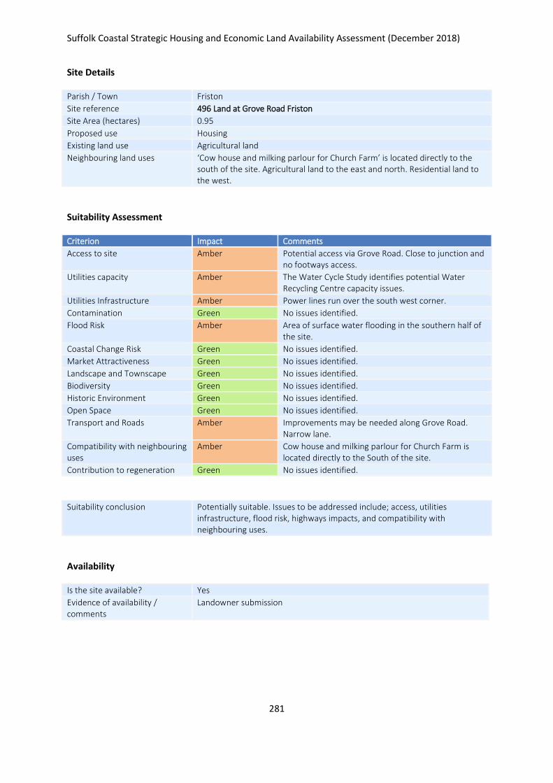
Suffolk Coastal Strategic Housing and Economic Land Availability Assessment (December 2018)
281
Site Details
Parish / Town Friston
Site reference 496 Land at Grove Road Friston
Site Area (hectares) 0.95
Proposed use Housing
Existing land use Agricultural land
Neighbouring land uses ‘Cow house and milking parlour for Church Farm’ is located directly to the south of the site. Agricultural land to the east and north. Residential land to the west.
Suitability Assessment
Criterion Impact Comments
Access to site Amber Potential access via Grove Road. Close to junction and no footways access.
Utilities capacity Amber The Water Cycle Study identifies potential Water Recycling Centre capacity issues.
Utilities Infrastructure Amber Power lines run over the south west corner.
Contamination Green No issues identified.
Flood Risk Amber Area of surface water flooding in the southern half of the site.
Coastal Change Risk Green No issues identified.
Market Attractiveness Green No issues identified.
Landscape and Townscape Green No issues identified.
Biodiversity Green No issues identified.
Historic Environment Green No issues identified.
Open Space Green No issues identified.
Transport and Roads Amber Improvements may be needed along Grove Road. Narrow lane.
Compatibility with neighbouring uses
Amber Cow house and milking parlour for Church Farm is located directly to the South of the site.
Contribution to regeneration Green No issues identified.
Suitability conclusion Potentially suitable. Issues to be addressed include; access, utilities infrastructure, flood risk, highways impacts, and compatibility with neighbouring uses.
Availability
Is the site available? Yes
Evidence of availability / comments
Landowner submission

Suffolk Coastal Strategic Housing and Economic Land Availability Assessment (December 2018)
282
Achievability
Is the site achievable? Yes
Evidence of achievability No specific issues or abnormal costs identified
Are there any commencement issues?
None identified
Estimated dwellings yield 14
Estimated employment land yield (hectares) -
Estimated retail floorspace (sqm) -
Estimated commencement date 2020/21
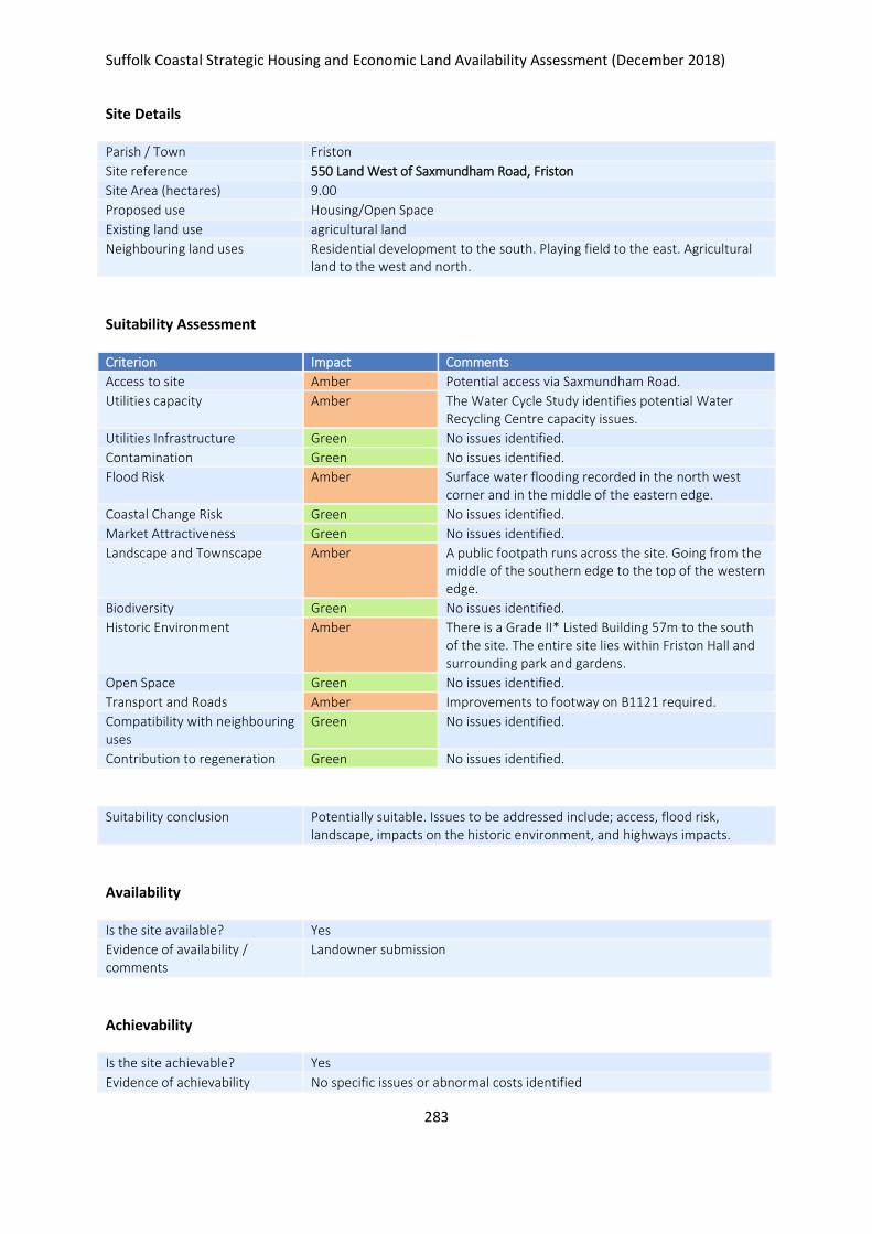
Suffolk Coastal Strategic Housing and Economic Land Availability Assessment (December 2018)
283
Site Details
Parish / Town Friston
Site reference 550 Land West of Saxmundham Road, Friston
Site Area (hectares) 9.00
Proposed use Housing/Open Space
Existing land use agricultural land
Neighbouring land uses Residential development to the south. Playing field to the east. Agricultural land to the west and north.
Suitability Assessment
Criterion Impact Comments
Access to site Amber Potential access via Saxmundham Road.
Utilities capacity Amber The Water Cycle Study identifies potential Water Recycling Centre capacity issues.
Utilities Infrastructure Green No issues identified.
Contamination Green No issues identified.
Flood Risk Amber Surface water flooding recorded in the north west corner and in the middle of the eastern edge.
Coastal Change Risk Green No issues identified.
Market Attractiveness Green No issues identified.
Landscape and Townscape Amber A public footpath runs across the site. Going from the middle of the southern edge to the top of the western edge.
Biodiversity Green No issues identified.
Historic Environment Amber There is a Grade II* Listed Building 57m to the south of the site. The entire site lies within Friston Hall and surrounding park and gardens.
Open Space Green No issues identified.
Transport and Roads Amber Improvements to footway on B1121 required.
Compatibility with neighbouring uses
Green No issues identified.
Contribution to regeneration Green No issues identified.
Suitability conclusion Potentially suitable. Issues to be addressed include; access, flood risk, landscape, impacts on the historic environment, and highways impacts.
Availability
Is the site available? Yes
Evidence of availability / comments
Landowner submission
Achievability
Is the site achievable? Yes
Evidence of achievability No specific issues or abnormal costs identified

Suffolk Coastal Strategic Housing and Economic Land Availability Assessment (December 2018)
284
Are there any commencement issues?
None identified
Estimated dwellings yield 108
Estimated employment land yield (hectares) -
Estimated retail floorspace (sqm) -
Estimated commencement date 2020/21
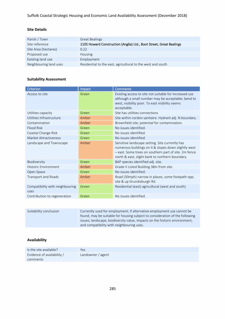
Suffolk Coastal Strategic Housing and Economic Land Availability Assessment (December 2018)
285
Site Details
Parish / Town Great Bealings
Site reference 1105 Howard Construction (Anglia) Ltd., Boot Street, Great Bealings
Site Area (hectares) 0.22
Proposed use Housing
Existing land use Employment
Neighbouring land uses Residential to the east, agricultural to the west and south
Suitability Assessment
Criterion Impact Comments
Access to site Green Existing access to site not suitable for increased use although a small number may be acceptable; bend to west, visibility poor. To east visibility seems acceptable.
Utilities capacity Green Site has utilities connections
Utilities Infrastructure Amber Site within cordon sanitaire. Hydrant adj. N boundary.
Contamination Amber Brownfield site; potential for contamination.
Flood Risk Green No issues identified.
Coastal Change Risk Green No issues identified.
Market Attractiveness Green No issues identified.
Landscape and Townscape Amber Sensitive landscape setting. Site currently has numerous buildings on it & slopes down slightly west – east. Some trees on southern part of site. 2m fence north & east, slight bank to northern boundary.
Biodiversity Green BAP species identified adj. site.
Historic Environment Amber Grade II Listed Building 38m from site.
Open Space Green No issues identified.
Transport and Roads Amber Road (30mph) narrow in places, some footpath opp. site & up Grundisburgh Rd.
Compatibility with neighbouring uses
Green Residential (east) agricultural (west and south)
Contribution to regeneration Green No issues identified.
Suitability conclusion Currently used for employment; if alternative employment use cannot be found, may be suitable for housing subject to consideration of the following issues; landscape, biodiversity value, impacts on the historic environment, and compatibility with neighbouring uses.
Availability
Is the site available? Yes
Evidence of availability / comments
Landowner / agent

Suffolk Coastal Strategic Housing and Economic Land Availability Assessment (December 2018)
286
Achievability
Is the site achievable? Yes
Evidence of achievability Assumed - relocation existing business required
Are there any commencement issues?
Subject to relocations of existing business
Estimated dwellings yield 3
Estimated employment land yield (hectares) -
Estimated retail floorspace (sqm) -
Estimated commencement date 2024/25
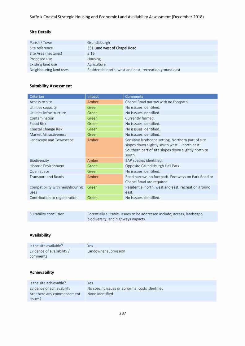
Suffolk Coastal Strategic Housing and Economic Land Availability Assessment (December 2018)
287
Site Details
Parish / Town Grundisburgh
Site reference 351 Land west of Chapel Road
Site Area (hectares) 5.16
Proposed use Housing
Existing land use Agriculture
Neighbouring land uses Residential north, west and east; recreation ground east
Suitability Assessment
Criterion Impact Comments
Access to site Amber Chapel Road narrow with no footpath.
Utilities capacity Green No isssues identified.
Utilities Infrastructure Green No isssues identified.
Contamination Green Currently farmed.
Flood Risk Green No isssues identified.
Coastal Change Risk Green No isssues identified.
Market Attractiveness Green No isssues identified.
Landscape and Townscape Amber Sensitive landscape setting. Northern part of site slopes down slightly south west – north east. Southern part of site slopes down slightly north to south.
Biodiversity Amber BAP species identified.
Historic Environment Green Opposite Grundisburgh Hall Park.
Open Space Green No isssues identified.
Transport and Roads Amber Road narrow, no footpath. Footways on Park Road or Chapel Road are required.
Compatibility with neighbouring uses
Green Residential north, west and east; recreation ground east.
Contribution to regeneration Green No isssues identified.
Suitability conclusion Potentially suitable. Issues to be addressed include; access, landscape, biodiversity, and highways impacts.
Availability
Is the site available? Yes
Evidence of availability / comments
Landowner submission
Achievability
Is the site achievable? Yes
Evidence of achievability No specific issues or abnormal costs identified
Are there any commencement issues?
None identified

Suffolk Coastal Strategic Housing and Economic Land Availability Assessment (December 2018)
288
Estimated dwellings yield 77
Estimated employment land yield (hectares) -
Estimated retail floorspace (sqm) -
Estimated commencement date 2023/24
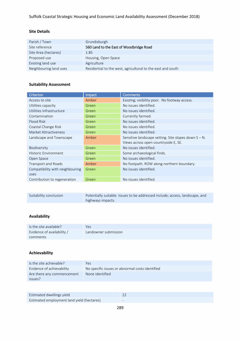
Suffolk Coastal Strategic Housing and Economic Land Availability Assessment (December 2018)
289
Site Details
Parish / Town Grundisburgh
Site reference 560 Land to the East of Woodbridge Road
Site Area (hectares) 1.85
Proposed use Housing, Open Space
Existing land use Agriculture
Neighbouring land uses Residential to the west, agricultural to the east and south
Suitability Assessment
Criterion Impact Comments
Access to site Amber Existing; visibility poor. No footway access.
Utilities capacity Green No issues identified.
Utilities Infrastructure Green No issues identified.
Contamination Green Currently farmed.
Flood Risk Green No issues identified.
Coastal Change Risk Green No issues identified.
Market Attractiveness Green No issues identified.
Landscape and Townscape Amber Sensitive landscape setting. Site slopes down S – N. Views across open countryside E, SE.
Biodiversity Green No issues identified.
Historic Environment Green Some archaeological finds.
Open Space Green No issues identified.
Transport and Roads Amber No footpath. ROW along northern boundary.
Compatibility with neighbouring uses
Green No issues identified.
Contribution to regeneration Green No issues identified.
Suitability conclusion Potentially suitable. Issues to be addressed include; access, landscape, and highways impacts.
Availability
Is the site available? Yes
Evidence of availability / comments
Landowner submission
Achievability
Is the site achievable? Yes
Evidence of achievability No specific issues or abnormal costs identified
Are there any commencement issues?
None identified
Estimated dwellings yield 22
Estimated employment land yield (hectares) -

Suffolk Coastal Strategic Housing and Economic Land Availability Assessment (December 2018)
290
Estimated retail floorspace (sqm) -
Estimated commencement date 2023/24
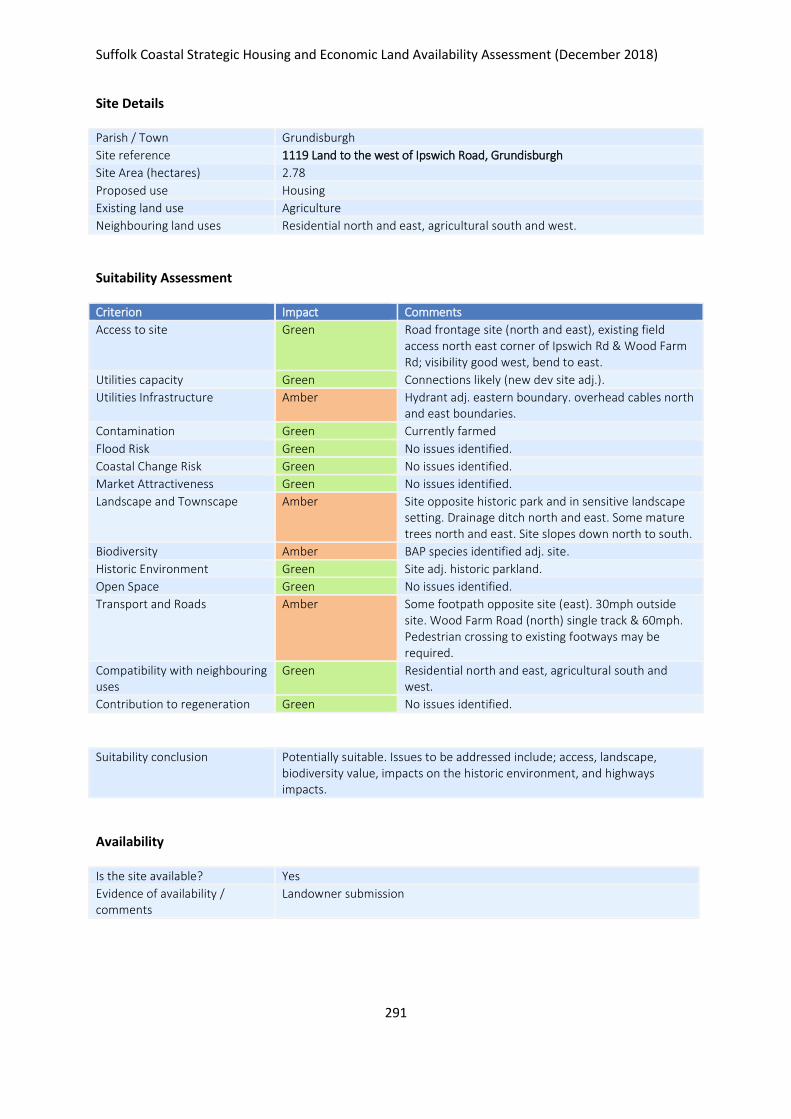
Suffolk Coastal Strategic Housing and Economic Land Availability Assessment (December 2018)
291
Site Details
Parish / Town Grundisburgh
Site reference 1119 Land to the west of Ipswich Road, Grundisburgh
Site Area (hectares) 2.78
Proposed use Housing
Existing land use Agriculture
Neighbouring land uses Residential north and east, agricultural south and west.
Suitability Assessment
Criterion Impact Comments
Access to site Green Road frontage site (north and east), existing field access north east corner of Ipswich Rd & Wood Farm Rd; visibility good west, bend to east.
Utilities capacity Green Connections likely (new dev site adj.).
Utilities Infrastructure Amber Hydrant adj. eastern boundary. overhead cables north and east boundaries.
Contamination Green Currently farmed
Flood Risk Green No issues identified.
Coastal Change Risk Green No issues identified.
Market Attractiveness Green No issues identified.
Landscape and Townscape Amber Site opposite historic park and in sensitive landscape setting. Drainage ditch north and east. Some mature trees north and east. Site slopes down north to south.
Biodiversity Amber BAP species identified adj. site.
Historic Environment Green Site adj. historic parkland.
Open Space Green No issues identified.
Transport and Roads Amber Some footpath opposite site (east). 30mph outside site. Wood Farm Road (north) single track & 60mph. Pedestrian crossing to existing footways may be required.
Compatibility with neighbouring uses
Green Residential north and east, agricultural south and west.
Contribution to regeneration Green No issues identified.
Suitability conclusion Potentially suitable. Issues to be addressed include; access, landscape, biodiversity value, impacts on the historic environment, and highways impacts.
Availability
Is the site available? Yes
Evidence of availability / comments
Landowner submission

Suffolk Coastal Strategic Housing and Economic Land Availability Assessment (December 2018)
292
Achievability
Is the site achievable? Yes
Evidence of achievability No specific issues or abnormal costs identified
Are there any commencement issues?
None identified
Estimated dwellings yield 42
Estimated employment land yield (hectares) -
Estimated retail floorspace (sqm) -
Estimated commencement date 2023/24
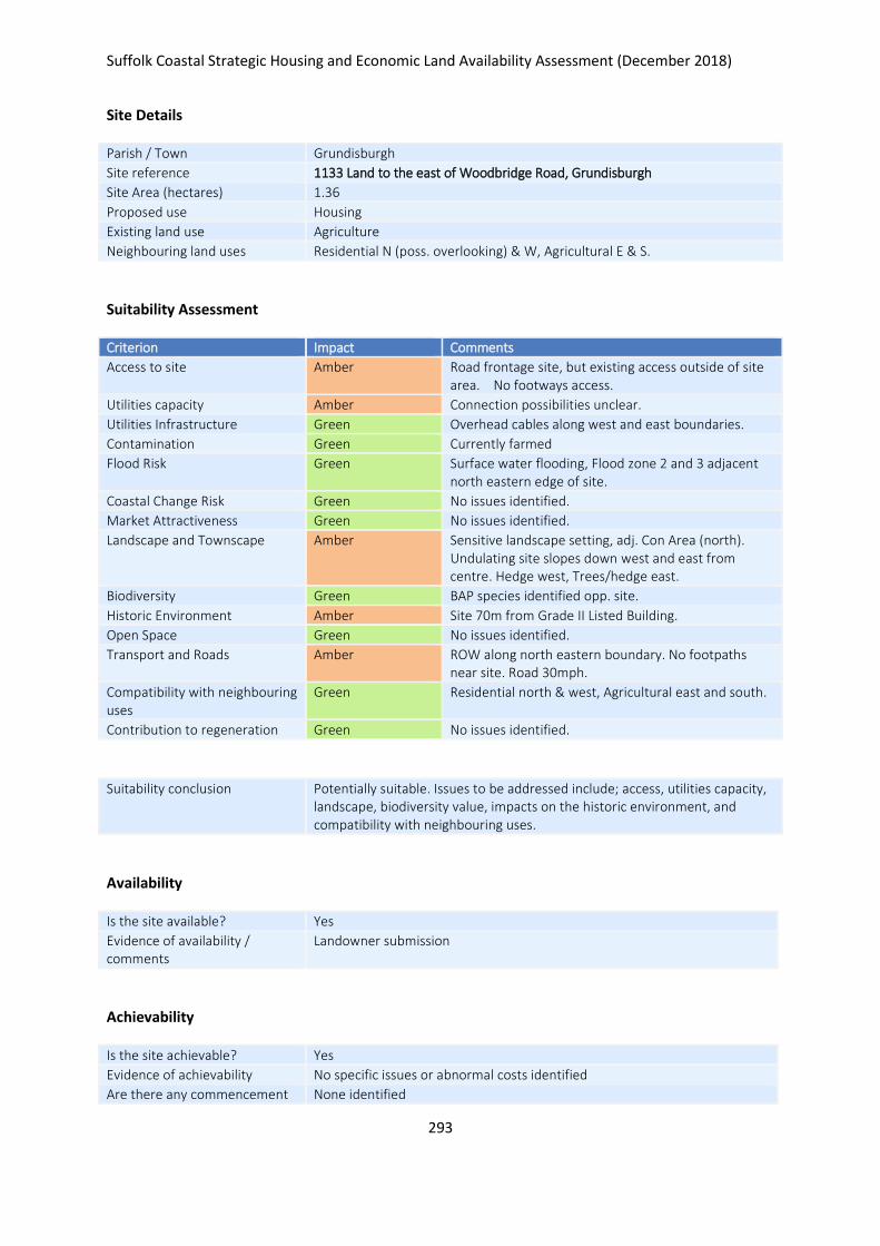
Suffolk Coastal Strategic Housing and Economic Land Availability Assessment (December 2018)
293
Site Details
Parish / Town Grundisburgh
Site reference 1133 Land to the east of Woodbridge Road, Grundisburgh
Site Area (hectares) 1.36
Proposed use Housing
Existing land use Agriculture
Neighbouring land uses Residential N (poss. overlooking) & W, Agricultural E & S.
Suitability Assessment
Criterion Impact Comments
Access to site Amber Road frontage site, but existing access outside of site area. No footways access.
Utilities capacity Amber Connection possibilities unclear.
Utilities Infrastructure Green Overhead cables along west and east boundaries.
Contamination Green Currently farmed
Flood Risk Green Surface water flooding, Flood zone 2 and 3 adjacent north eastern edge of site.
Coastal Change Risk Green No issues identified.
Market Attractiveness Green No issues identified.
Landscape and Townscape Amber Sensitive landscape setting, adj. Con Area (north). Undulating site slopes down west and east from centre. Hedge west, Trees/hedge east.
Biodiversity Green BAP species identified opp. site.
Historic Environment Amber Site 70m from Grade II Listed Building.
Open Space Green No issues identified.
Transport and Roads Amber ROW along north eastern boundary. No footpaths near site. Road 30mph.
Compatibility with neighbouring uses
Green Residential north & west, Agricultural east and south.
Contribution to regeneration Green No issues identified.
Suitability conclusion Potentially suitable. Issues to be addressed include; access, utilities capacity, landscape, biodiversity value, impacts on the historic environment, and compatibility with neighbouring uses.
Availability
Is the site available? Yes
Evidence of availability / comments
Landowner submission
Achievability
Is the site achievable? Yes
Evidence of achievability No specific issues or abnormal costs identified
Are there any commencement None identified

Suffolk Coastal Strategic Housing and Economic Land Availability Assessment (December 2018)
294
issues?
Estimated dwellings yield 20
Estimated employment land yield (hectares) -
Estimated retail floorspace (sqm) -
Estimated commencement date 2023/24
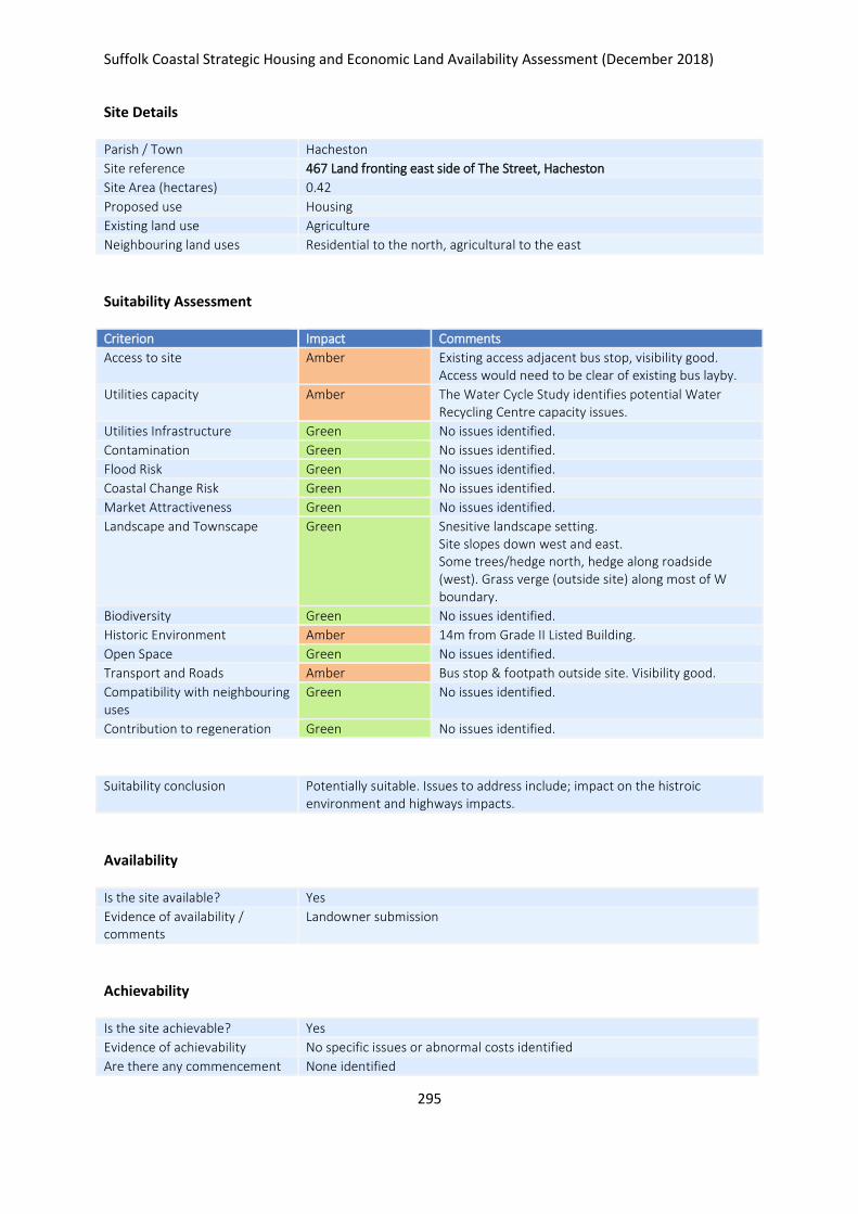
Suffolk Coastal Strategic Housing and Economic Land Availability Assessment (December 2018)
295
Site Details
Parish / Town Hacheston
Site reference 467 Land fronting east side of The Street, Hacheston
Site Area (hectares) 0.42
Proposed use Housing
Existing land use Agriculture
Neighbouring land uses Residential to the north, agricultural to the east
Suitability Assessment
Criterion Impact Comments
Access to site Amber Existing access adjacent bus stop, visibility good. Access would need to be clear of existing bus layby.
Utilities capacity Amber The Water Cycle Study identifies potential Water Recycling Centre capacity issues.
Utilities Infrastructure Green No issues identified.
Contamination Green No issues identified.
Flood Risk Green No issues identified.
Coastal Change Risk Green No issues identified.
Market Attractiveness Green No issues identified.
Landscape and Townscape Green Snesitive landscape setting. Site slopes down west and east. Some trees/hedge north, hedge along roadside (west). Grass verge (outside site) along most of W boundary.
Biodiversity Green No issues identified.
Historic Environment Amber 14m from Grade II Listed Building.
Open Space Green No issues identified.
Transport and Roads Amber Bus stop & footpath outside site. Visibility good.
Compatibility with neighbouring uses
Green No issues identified.
Contribution to regeneration Green No issues identified.
Suitability conclusion Potentially suitable. Issues to address include; impact on the histroic environment and highways impacts.
Availability
Is the site available? Yes
Evidence of availability / comments
Landowner submission
Achievability
Is the site achievable? Yes
Evidence of achievability No specific issues or abnormal costs identified
Are there any commencement None identified
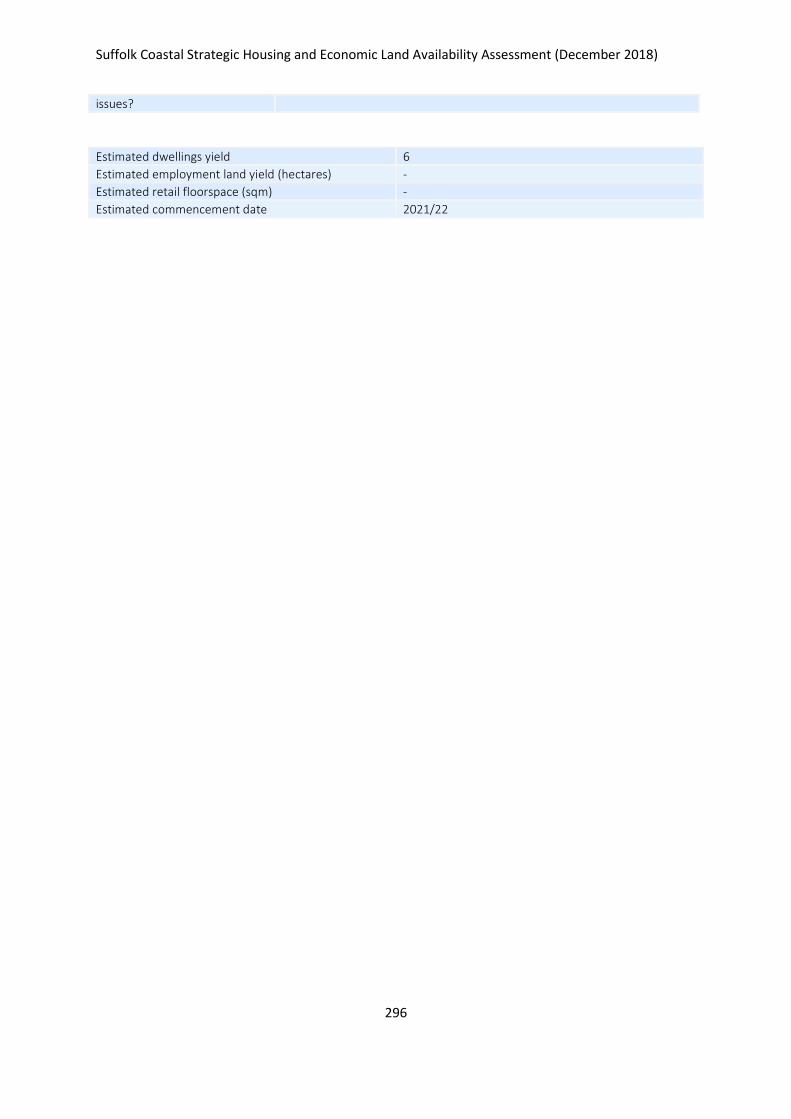
Suffolk Coastal Strategic Housing and Economic Land Availability Assessment (December 2018)
296
issues?
Estimated dwellings yield 6
Estimated employment land yield (hectares) -
Estimated retail floorspace (sqm) -
Estimated commencement date 2021/22
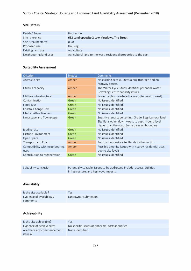
Suffolk Coastal Strategic Housing and Economic Land Availability Assessment (December 2018)
297
Site Details
Parish / Town Hacheston
Site reference 652 Land opposite 2 Low Meadows, The Street
Site Area (hectares) 0.50
Proposed use Housing
Existing land use Agriculture
Neighbouring land uses Agricultural land to the west, residential properties to the east
Suitability Assessment
Criterion Impact Comments
Access to site Amber No existing access. Trees along frontage and no footway access.
Utilities capacity Amber The Water Cycle Study identifies potential Water Recycling Centre capacity issues.
Utilities Infrastructure Amber Power cables (overhead) across site (east to west).
Contamination Green No issues identified.
Flood Risk Green No issues identified.
Coastal Change Risk Green No issues identified.
Market Attractiveness Green No issues identified.
Landscape and Townscape Green Snesitive landscape setting. Grade 2 agricultural land. Site flat sloping down –west to east; ground level higher than the road. Some trees on boundary.
Biodiversity Green No issues identified.
Historic Environment Green No issues identified.
Open Space Green No issues identified.
Transport and Roads Amber Footpath opposite site. Bends to the north. .
Compatibility with neighbouring uses
Amber Possible amenity issues with nearby residential uses due to site levels
Contribution to regeneration Green No issues identified.
Suitability conclusion Potentially suitable. Issues to be addressed include; access. Utilities infrastructure, and highways impacts.
Availability
Is the site available? Yes
Evidence of availability / comments
Landowner submission
Achievability
Is the site achievable? Yes
Evidence of achievability No specific issues or abnormal costs identified
Are there any commencement issues?
None identified

Suffolk Coastal Strategic Housing and Economic Land Availability Assessment (December 2018)
298
Estimated dwellings yield 7
Estimated employment land yield (hectares) -
Estimated retail floorspace (sqm) -
Estimated commencement date 2020/21
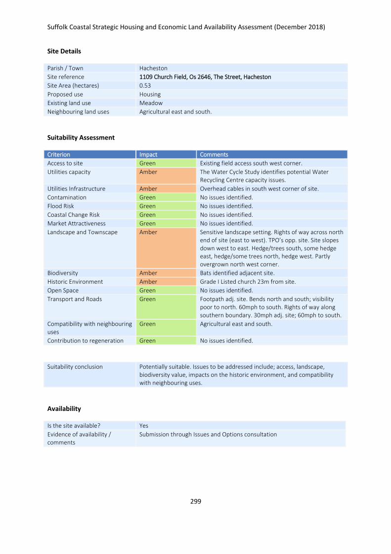
Suffolk Coastal Strategic Housing and Economic Land Availability Assessment (December 2018)
299
Site Details
Parish / Town Hacheston
Site reference 1109 Church Field, Os 2646, The Street, Hacheston
Site Area (hectares) 0.53
Proposed use Housing
Existing land use Meadow
Neighbouring land uses Agricultural east and south.
Suitability Assessment
Criterion Impact Comments
Access to site Green Existing field access south west corner.
Utilities capacity Amber The Water Cycle Study identifies potential Water Recycling Centre capacity issues.
Utilities Infrastructure Amber Overhead cables in south west corner of site.
Contamination Green No issues identified.
Flood Risk Green No issues identified.
Coastal Change Risk Green No issues identified.
Market Attractiveness Green No issues identified.
Landscape and Townscape Amber Sensitive landscape setting. Rights of way across north end of site (east to west). TPO’s opp. site. Site slopes down west to east. Hedge/trees south, some hedge east, hedge/some trees north, hedge west. Partly overgrown north west corner.
Biodiversity Amber Bats identified adjacent site.
Historic Environment Amber Grade I Listed church 23m from site.
Open Space Green No issues identified.
Transport and Roads Green Footpath adj. site. Bends north and south; visibility poor to north. 60mph to south. Rights of way along southern boundary. 30mph adj. site; 60mph to south.
Compatibility with neighbouring uses
Green Agricultural east and south.
Contribution to regeneration Green No issues identified.
Suitability conclusion Potentially suitable. Issues to be addressed include; access, landscape, biodiversity value, impacts on the historic environment, and compatibility with neighbouring uses.
Availability
Is the site available? Yes
Evidence of availability / comments
Submission through Issues and Options consultation

Suffolk Coastal Strategic Housing and Economic Land Availability Assessment (December 2018)
300
Achievability
Is the site achievable? Yes
Evidence of achievability No specific issues or abnormal costs identified
Are there any commencement issues?
None identified
Estimated dwellings yield 8
Estimated employment land yield (hectares) -
Estimated retail floorspace (sqm) -
Estimated commencement date 2021/22
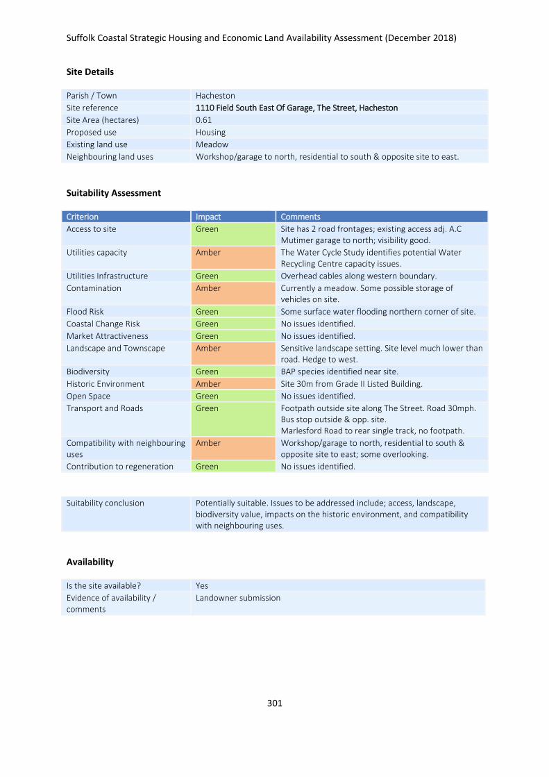
Suffolk Coastal Strategic Housing and Economic Land Availability Assessment (December 2018)
301
Site Details
Parish / Town Hacheston
Site reference 1110 Field South East Of Garage, The Street, Hacheston
Site Area (hectares) 0.61
Proposed use Housing
Existing land use Meadow
Neighbouring land uses Workshop/garage to north, residential to south & opposite site to east.
Suitability Assessment
Criterion Impact Comments
Access to site Green Site has 2 road frontages; existing access adj. A.C Mutimer garage to north; visibility good.
Utilities capacity Amber The Water Cycle Study identifies potential Water Recycling Centre capacity issues.
Utilities Infrastructure Green Overhead cables along western boundary.
Contamination Amber Currently a meadow. Some possible storage of vehicles on site.
Flood Risk Green Some surface water flooding northern corner of site.
Coastal Change Risk Green No issues identified.
Market Attractiveness Green No issues identified.
Landscape and Townscape Amber Sensitive landscape setting. Site level much lower than road. Hedge to west.
Biodiversity Green BAP species identified near site.
Historic Environment Amber Site 30m from Grade II Listed Building.
Open Space Green No issues identified.
Transport and Roads Green Footpath outside site along The Street. Road 30mph. Bus stop outside & opp. site. Marlesford Road to rear single track, no footpath.
Compatibility with neighbouring uses
Amber Workshop/garage to north, residential to south & opposite site to east; some overlooking.
Contribution to regeneration Green No issues identified.
Suitability conclusion Potentially suitable. Issues to be addressed include; access, landscape, biodiversity value, impacts on the historic environment, and compatibility with neighbouring uses.
Availability
Is the site available? Yes
Evidence of availability / comments
Landowner submission

Suffolk Coastal Strategic Housing and Economic Land Availability Assessment (December 2018)
302
Achievability
Is the site achievable? Yes
Evidence of achievability No specific issues or abnormal costs identified
Are there any commencement issues?
None identified
Estimated dwellings yield 9
Estimated employment land yield (hectares) -
Estimated retail floorspace (sqm) -
Estimated commencement date 2022/23
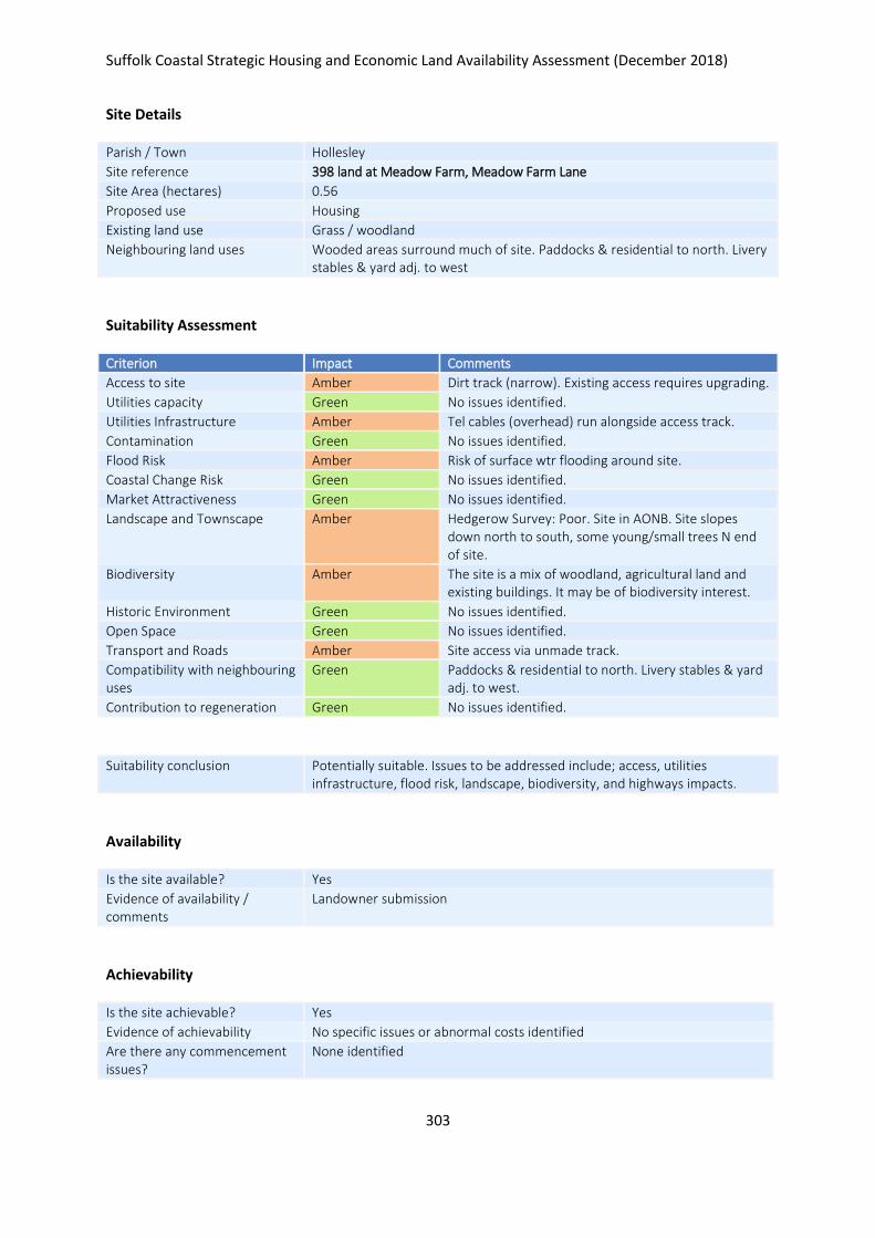
Suffolk Coastal Strategic Housing and Economic Land Availability Assessment (December 2018)
303
Site Details
Parish / Town Hollesley
Site reference 398 land at Meadow Farm, Meadow Farm Lane
Site Area (hectares) 0.56
Proposed use Housing
Existing land use Grass / woodland
Neighbouring land uses Wooded areas surround much of site. Paddocks & residential to north. Livery stables & yard adj. to west
Suitability Assessment
Criterion Impact Comments
Access to site Amber Dirt track (narrow). Existing access requires upgrading.
Utilities capacity Green No issues identified.
Utilities Infrastructure Amber Tel cables (overhead) run alongside access track.
Contamination Green No issues identified.
Flood Risk Amber Risk of surface wtr flooding around site.
Coastal Change Risk Green No issues identified.
Market Attractiveness Green No issues identified.
Landscape and Townscape Amber Hedgerow Survey: Poor. Site in AONB. Site slopes down north to south, some young/small trees N end of site.
Biodiversity Amber The site is a mix of woodland, agricultural land and existing buildings. It may be of biodiversity interest.
Historic Environment Green No issues identified.
Open Space Green No issues identified.
Transport and Roads Amber Site access via unmade track.
Compatibility with neighbouring uses
Green Paddocks & residential to north. Livery stables & yard adj. to west.
Contribution to regeneration Green No issues identified.
Suitability conclusion Potentially suitable. Issues to be addressed include; access, utilities infrastructure, flood risk, landscape, biodiversity, and highways impacts.
Availability
Is the site available? Yes
Evidence of availability / comments
Landowner submission
Achievability
Is the site achievable? Yes
Evidence of achievability No specific issues or abnormal costs identified
Are there any commencement issues?
None identified

Suffolk Coastal Strategic Housing and Economic Land Availability Assessment (December 2018)
304
Estimated dwellings yield 8
Estimated employment land yield (hectares) -
Estimated retail floorspace (sqm) -
Estimated commencement date 2021/22

Suffolk Coastal Strategic Housing and Economic Land Availability Assessment (December 2018)
305
Site Details
Parish / Town Hollesley
Site reference 477 Meadow Park Livery Stables, Alderton Road, IP12 3RQ
Site Area (hectares) 1.98
Proposed use Housing
Existing land use Stable block, livery, housing
Neighbouring land uses Paddocks & residential to northern end. Livery stables & yard to south.
Suitability Assessment
Criterion Impact Comments
Access to site Amber Dirt track (narrow). Existing access requires upgrading.
Utilities capacity Green No issues identified.
Utilities Infrastructure Green Tel cables (OH) run alongside access track.
Contamination Green No issues identified.
Flood Risk Amber Risk of surface water flooding around site.
Coastal Change Risk Green No issues identified.
Market Attractiveness Green No issues identified.
Landscape and Townscape Amber Hedgerow Survey: Poor. Site in AONB. Site slopes down north to south.
Biodiversity Green No issues identified.
Historic Environment Green No issues identified.
Open Space Green No issues identified.
Transport and Roads Amber Site access via unmade track.
Compatibility with neighbouring uses
Green No issues identified.
Contribution to regeneration Green No issues identified.
Suitability conclusion Potentially suitable. Issues to be addressed include; access, flood risk, landscape / townscape, and highways impacts.
Availability
Is the site available? Yes
Evidence of availability / comments
Landowner submission
Achievability
Is the site achievable? Yes
Evidence of achievability Assumed - requires relocation of livery service
Are there any commencement issues?
Relocation of livery service

Suffolk Coastal Strategic Housing and Economic Land Availability Assessment (December 2018)
306
Estimated dwellings yield 30
Estimated employment land yield (hectares) -
Estimated retail floorspace (sqm) -
Estimated commencement date 2023/24
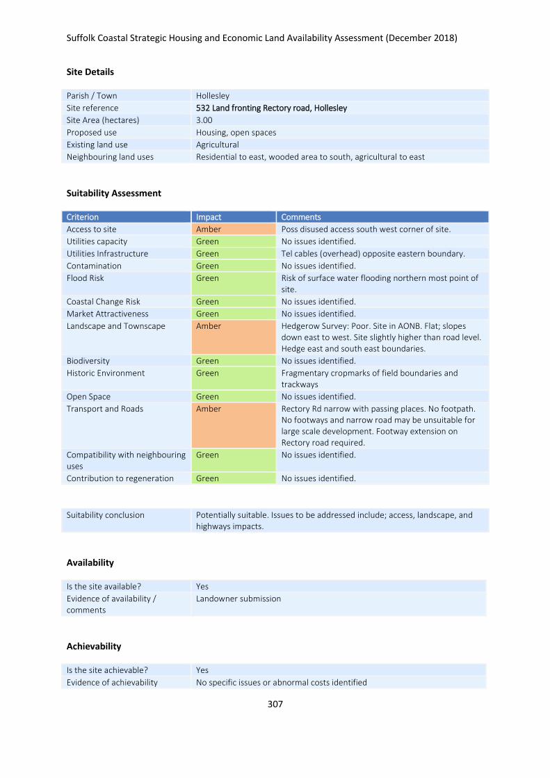
Suffolk Coastal Strategic Housing and Economic Land Availability Assessment (December 2018)
307
Site Details
Parish / Town Hollesley
Site reference 532 Land fronting Rectory road, Hollesley
Site Area (hectares) 3.00
Proposed use Housing, open spaces
Existing land use Agricultural
Neighbouring land uses Residential to east, wooded area to south, agricultural to east
Suitability Assessment
Criterion Impact Comments
Access to site Amber Poss disused access south west corner of site.
Utilities capacity Green No issues identified.
Utilities Infrastructure Green Tel cables (overhead) opposite eastern boundary.
Contamination Green No issues identified.
Flood Risk Green Risk of surface water flooding northern most point of site.
Coastal Change Risk Green No issues identified.
Market Attractiveness Green No issues identified.
Landscape and Townscape Amber Hedgerow Survey: Poor. Site in AONB. Flat; slopes down east to west. Site slightly higher than road level. Hedge east and south east boundaries.
Biodiversity Green No issues identified.
Historic Environment Green Fragmentary cropmarks of field boundaries and trackways
Open Space Green No issues identified.
Transport and Roads Amber Rectory Rd narrow with passing places. No footpath. No footways and narrow road may be unsuitable for large scale development. Footway extension on Rectory road required.
Compatibility with neighbouring uses
Green No issues identified.
Contribution to regeneration Green No issues identified.
Suitability conclusion Potentially suitable. Issues to be addressed include; access, landscape, and highways impacts.
Availability
Is the site available? Yes
Evidence of availability / comments
Landowner submission
Achievability
Is the site achievable? Yes
Evidence of achievability No specific issues or abnormal costs identified

Suffolk Coastal Strategic Housing and Economic Land Availability Assessment (December 2018)
308
Are there any commencement issues?
None identified
Estimated dwellings yield 45
Estimated employment land yield (hectares) -
Estimated retail floorspace (sqm) -
Estimated commencement date 2021/22
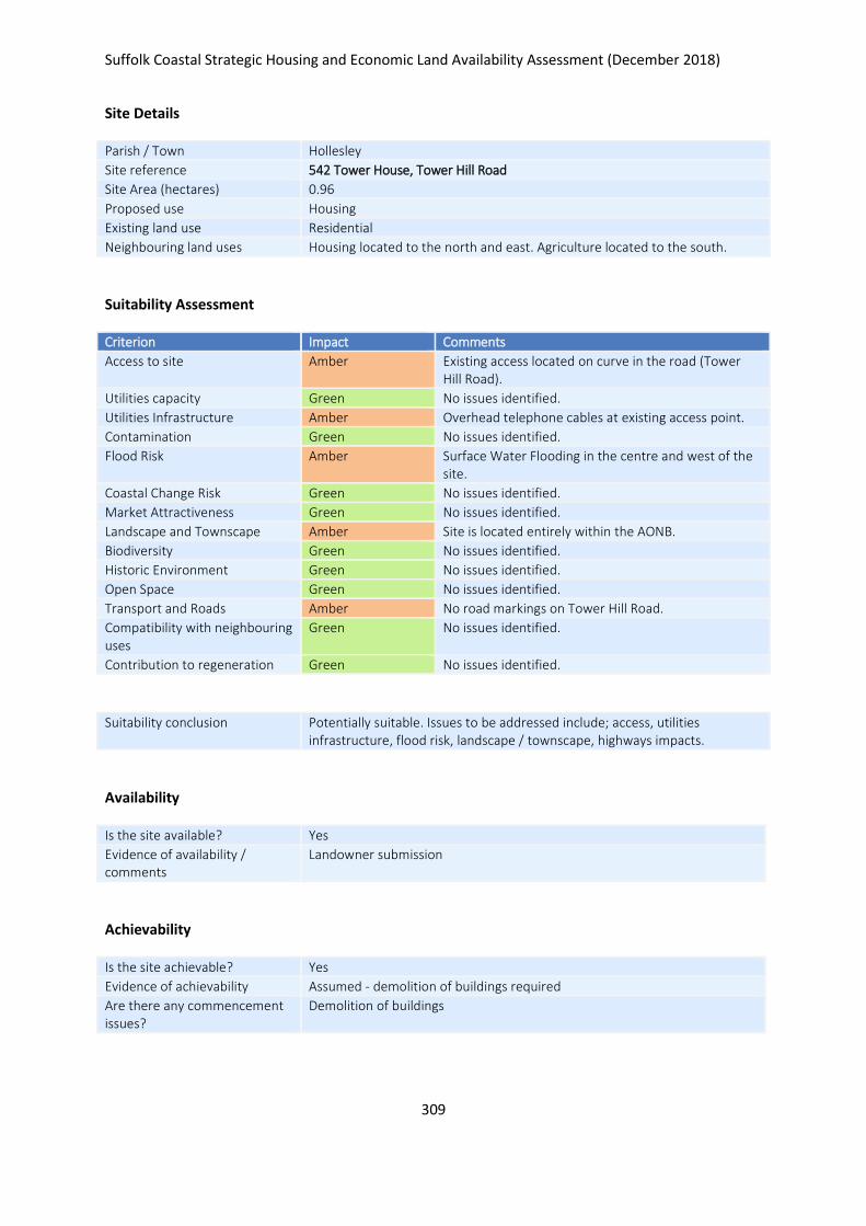
Suffolk Coastal Strategic Housing and Economic Land Availability Assessment (December 2018)
309
Site Details
Parish / Town Hollesley
Site reference 542 Tower House, Tower Hill Road
Site Area (hectares) 0.96
Proposed use Housing
Existing land use Residential
Neighbouring land uses Housing located to the north and east. Agriculture located to the south.
Suitability Assessment
Criterion Impact Comments
Access to site Amber Existing access located on curve in the road (Tower Hill Road).
Utilities capacity Green No issues identified.
Utilities Infrastructure Amber Overhead telephone cables at existing access point.
Contamination Green No issues identified.
Flood Risk Amber Surface Water Flooding in the centre and west of the site.
Coastal Change Risk Green No issues identified.
Market Attractiveness Green No issues identified.
Landscape and Townscape Amber Site is located entirely within the AONB.
Biodiversity Green No issues identified.
Historic Environment Green No issues identified.
Open Space Green No issues identified.
Transport and Roads Amber No road markings on Tower Hill Road.
Compatibility with neighbouring uses
Green No issues identified.
Contribution to regeneration Green No issues identified.
Suitability conclusion Potentially suitable. Issues to be addressed include; access, utilities infrastructure, flood risk, landscape / townscape, highways impacts.
Availability
Is the site available? Yes
Evidence of availability / comments
Landowner submission
Achievability
Is the site achievable? Yes
Evidence of achievability Assumed - demolition of buildings required
Are there any commencement issues?
Demolition of buildings

Suffolk Coastal Strategic Housing and Economic Land Availability Assessment (December 2018)
310
Estimated dwellings yield 14
Estimated employment land yield (hectares) -
Estimated retail floorspace (sqm) -
Estimated commencement date 2022/23
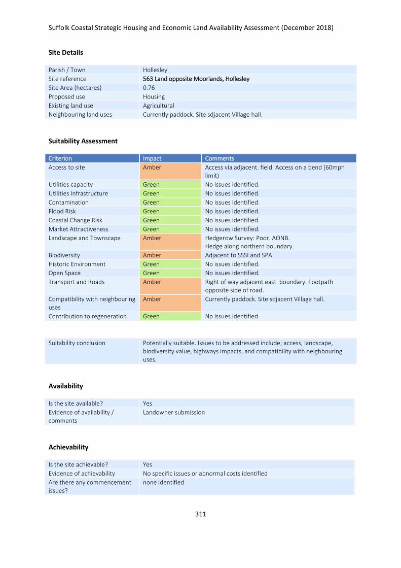
Suffolk Coastal Strategic Housing and Economic Land Availability Assessment (December 2018)
311
Site Details
Parish / Town Hollesley
Site reference 563 Land opposite Moorlands, Hollesley
Site Area (hectares) 0.76
Proposed use Housing
Existing land use Agricultural
Neighbouring land uses Currently paddock. Site sdjacent Village hall.
Suitability Assessment
Criterion Impact Comments
Access to site Amber Access via adjacent. field. Access on a bend (60mph limit)
Utilities capacity Green No issues identified.
Utilities Infrastructure Green No issues identified.
Contamination Green No issues identified.
Flood Risk Green No issues identified.
Coastal Change Risk Green No issues identified.
Market Attractiveness Green No issues identified.
Landscape and Townscape Amber Hedgerow Survey: Poor. AONB. Hedge along northern boundary.
Biodiversity Amber Adjacent to SSSI and SPA.
Historic Environment Green No issues identified.
Open Space Green No issues identified.
Transport and Roads Amber Right of way adjacent east boundary. Footpath opposite side of road.
Compatibility with neighbouring uses
Amber Currently paddock. Site sdjacent Village hall.
Contribution to regeneration Green No issues identified.
Suitability conclusion Potentially suitable. Issues to be addressed include; access, landscape, biodiversity value, highways impacts, and compatibility with neighbouring uses.
Availability
Is the site available? Yes
Evidence of availability / comments
Landowner submission
Achievability
Is the site achievable? Yes
Evidence of achievability No specific issues or abnormal costs identified
Are there any commencement issues?
none identified

Suffolk Coastal Strategic Housing and Economic Land Availability Assessment (December 2018)
312
Estimated dwellings yield 11
Estimated employment land yield (hectares) -
Estimated retail floorspace (sqm) -
Estimated commencement date 2020/21
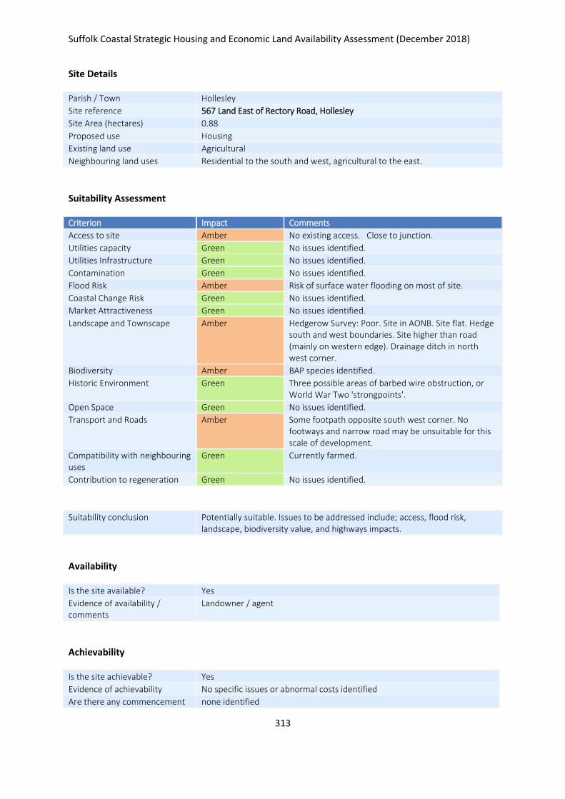
Suffolk Coastal Strategic Housing and Economic Land Availability Assessment (December 2018)
313
Site Details
Parish / Town Hollesley
Site reference 567 Land East of Rectory Road, Hollesley
Site Area (hectares) 0.88
Proposed use Housing
Existing land use Agricultural
Neighbouring land uses Residential to the south and west, agricultural to the east.
Suitability Assessment
Criterion Impact Comments
Access to site Amber No existing access. Close to junction.
Utilities capacity Green No issues identified.
Utilities Infrastructure Green No issues identified.
Contamination Green No issues identified.
Flood Risk Amber Risk of surface water flooding on most of site.
Coastal Change Risk Green No issues identified.
Market Attractiveness Green No issues identified.
Landscape and Townscape Amber Hedgerow Survey: Poor. Site in AONB. Site flat. Hedge south and west boundaries. Site higher than road (mainly on western edge). Drainage ditch in north west corner.
Biodiversity Amber BAP species identified.
Historic Environment Green Three possible areas of barbed wire obstruction, or World War Two 'strongpoints'.
Open Space Green No issues identified.
Transport and Roads Amber Some footpath opposite south west corner. No footways and narrow road may be unsuitable for this scale of development.
Compatibility with neighbouring uses
Green Currently farmed.
Contribution to regeneration Green No issues identified.
Suitability conclusion Potentially suitable. Issues to be addressed include; access, flood risk, landscape, biodiversity value, and highways impacts.
Availability
Is the site available? Yes
Evidence of availability / comments
Landowner / agent
Achievability
Is the site achievable? Yes
Evidence of achievability No specific issues or abnormal costs identified
Are there any commencement none identified

Suffolk Coastal Strategic Housing and Economic Land Availability Assessment (December 2018)
314
issues?
Estimated dwellings yield 13
Estimated employment land yield (hectares) -
Estimated retail floorspace (sqm) -
Estimated commencement date 2023/24
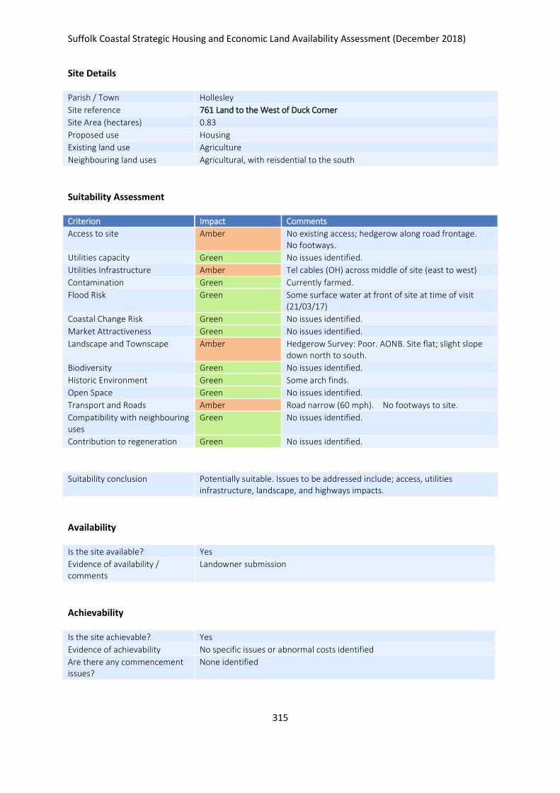
Suffolk Coastal Strategic Housing and Economic Land Availability Assessment (December 2018)
315
Site Details
Parish / Town Hollesley
Site reference 761 Land to the West of Duck Corner
Site Area (hectares) 0.83
Proposed use Housing
Existing land use Agriculture
Neighbouring land uses Agricultural, with reisdential to the south
Suitability Assessment
Criterion Impact Comments
Access to site Amber No existing access; hedgerow along road frontage. No footways.
Utilities capacity Green No issues identified.
Utilities Infrastructure Amber Tel cables (OH) across middle of site (east to west)
Contamination Green Currently farmed.
Flood Risk Green Some surface water at front of site at time of visit (21/03/17)
Coastal Change Risk Green No issues identified.
Market Attractiveness Green No issues identified.
Landscape and Townscape Amber Hedgerow Survey: Poor. AONB. Site flat; slight slope down north to south.
Biodiversity Green No issues identified.
Historic Environment Green Some arch finds.
Open Space Green No issues identified.
Transport and Roads Amber Road narrow (60 mph). No footways to site.
Compatibility with neighbouring uses
Green No issues identified.
Contribution to regeneration Green No issues identified.
Suitability conclusion Potentially suitable. Issues to be addressed include; access, utilities infrastructure, landscape, and highways impacts.
Availability
Is the site available? Yes
Evidence of availability / comments
Landowner submission
Achievability
Is the site achievable? Yes
Evidence of achievability No specific issues or abnormal costs identified
Are there any commencement issues?
None identified

Suffolk Coastal Strategic Housing and Economic Land Availability Assessment (December 2018)
316
Estimated dwellings yield 12
Estimated employment land yield (hectares) -
Estimated retail floorspace (sqm) -
Estimated commencement date 2020/21
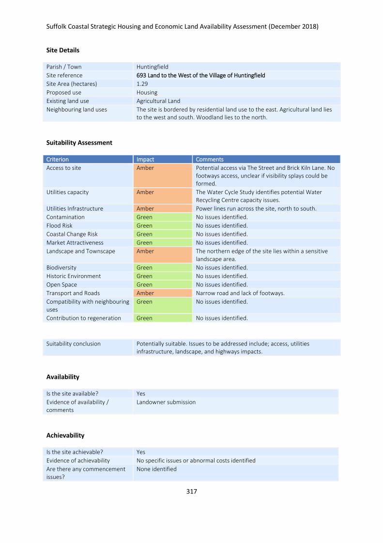
Suffolk Coastal Strategic Housing and Economic Land Availability Assessment (December 2018)
317
Site Details
Parish / Town Huntingfield
Site reference 693 Land to the West of the Village of Huntingfield
Site Area (hectares) 1.29
Proposed use Housing
Existing land use Agricultural Land
Neighbouring land uses The site is bordered by residential land use to the east. Agricultural land lies to the west and south. Woodland lies to the north.
Suitability Assessment
Criterion Impact Comments
Access to site Amber Potential access via The Street and Brick Kiln Lane. No footways access, unclear if visibility splays could be formed.
Utilities capacity Amber The Water Cycle Study identifies potential Water Recycling Centre capacity issues.
Utilities Infrastructure Amber Power lines run across the site, north to south.
Contamination Green No issues identified.
Flood Risk Green No issues identified.
Coastal Change Risk Green No issues identified.
Market Attractiveness Green No issues identified.
Landscape and Townscape Amber The northern edge of the site lies within a sensitive landscape area.
Biodiversity Green No issues identified.
Historic Environment Green No issues identified.
Open Space Green No issues identified.
Transport and Roads Amber Narrow road and lack of footways.
Compatibility with neighbouring uses
Green No issues identified.
Contribution to regeneration Green No issues identified.
Suitability conclusion Potentially suitable. Issues to be addressed include; access, utilities infrastructure, landscape, and highways impacts.
Availability
Is the site available? Yes
Evidence of availability / comments
Landowner submission
Achievability
Is the site achievable? Yes
Evidence of achievability No specific issues or abnormal costs identified
Are there any commencement issues?
None identified

Suffolk Coastal Strategic Housing and Economic Land Availability Assessment (December 2018)
318
Estimated dwellings yield 19
Estimated employment land yield (hectares) -
Estimated retail floorspace (sqm) -
Estimated commencement date 2020/21
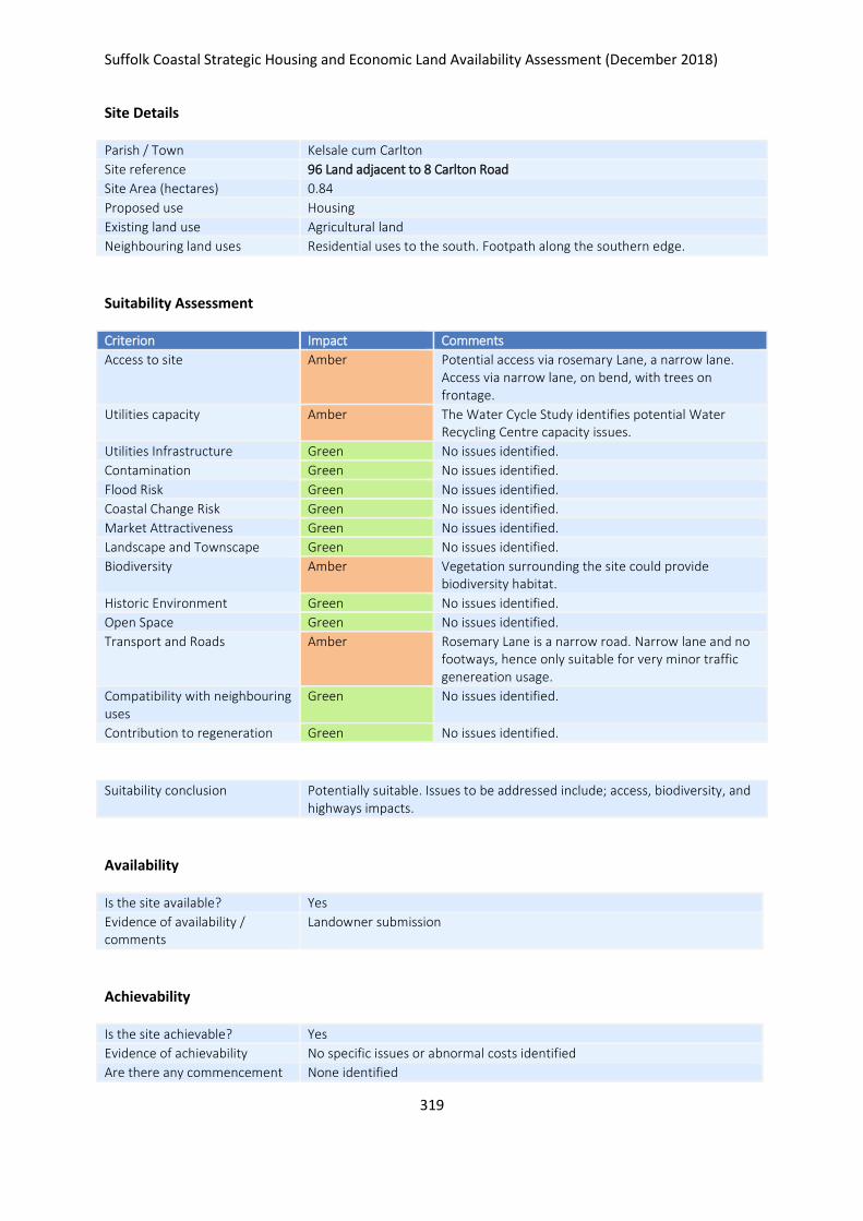
Suffolk Coastal Strategic Housing and Economic Land Availability Assessment (December 2018)
319
Site Details
Parish / Town Kelsale cum Carlton
Site reference 96 Land adjacent to 8 Carlton Road
Site Area (hectares) 0.84
Proposed use Housing
Existing land use Agricultural land
Neighbouring land uses Residential uses to the south. Footpath along the southern edge.
Suitability Assessment
Criterion Impact Comments
Access to site Amber Potential access via rosemary Lane, a narrow lane. Access via narrow lane, on bend, with trees on frontage.
Utilities capacity Amber The Water Cycle Study identifies potential Water Recycling Centre capacity issues.
Utilities Infrastructure Green No issues identified.
Contamination Green No issues identified.
Flood Risk Green No issues identified.
Coastal Change Risk Green No issues identified.
Market Attractiveness Green No issues identified.
Landscape and Townscape Green No issues identified.
Biodiversity Amber Vegetation surrounding the site could provide biodiversity habitat.
Historic Environment Green No issues identified.
Open Space Green No issues identified.
Transport and Roads Amber Rosemary Lane is a narrow road. Narrow lane and no footways, hence only suitable for very minor traffic genereation usage.
Compatibility with neighbouring uses
Green No issues identified.
Contribution to regeneration Green No issues identified.
Suitability conclusion Potentially suitable. Issues to be addressed include; access, biodiversity, and highways impacts.
Availability
Is the site available? Yes
Evidence of availability / comments
Landowner submission
Achievability
Is the site achievable? Yes
Evidence of achievability No specific issues or abnormal costs identified
Are there any commencement None identified

Suffolk Coastal Strategic Housing and Economic Land Availability Assessment (December 2018)
320
issues?
Estimated dwellings yield 13
Estimated employment land yield (hectares) -
Estimated retail floorspace (sqm) -
Estimated commencement date 2020/21
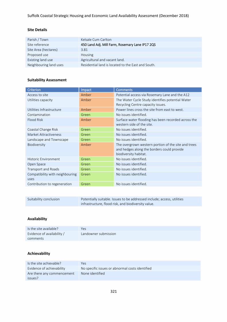
Suffolk Coastal Strategic Housing and Economic Land Availability Assessment (December 2018)
321
Site Details
Parish / Town Kelsale Cum Carlton
Site reference 450 Land Adj. Mill Farm, Rosemary Lane IP17 2QS
Site Area (hectares) 3.81
Proposed use Housing
Existing land use Agricultural and vacant land.
Neighbouring land uses Residential land is located to the East and South.
Suitability Assessment
Criterion Impact Comments
Access to site Amber Potential access via Rosemary Lane and the A12
Utilities capacity Amber The Water Cycle Study identifies potential Water Recycling Centre capacity issues.
Utilities Infrastructure Amber Power lines cross the site from east to west.
Contamination Green No issues identified.
Flood Risk Amber Surface water flooding has been recorded across the western side of the site.
Coastal Change Risk Green No issues identified.
Market Attractiveness Green No issues identified.
Landscape and Townscape Green No issues identified.
Biodiversity Amber The overgrown western portion of the site and trees and hedges along the borders could provide biodiversity habitat.
Historic Environment Green No issues identified.
Open Space Green No issues identified.
Transport and Roads Green No issues identified.
Compatibility with neighbouring uses
Green No issues identified.
Contribution to regeneration Green No issues identified.
Suitability conclusion Potentially suitable. Issues to be addressed include; access, utilities infrastructure, flood risk, and biodiversity value.
Availability
Is the site available? Yes
Evidence of availability / comments
Landowner submission
Achievability
Is the site achievable? Yes
Evidence of achievability No specific issues or abnormal costs identified
Are there any commencement issues?
None identified

Suffolk Coastal Strategic Housing and Economic Land Availability Assessment (December 2018)
322
Estimated dwellings yield 57
Estimated employment land yield (hectares) -
Estimated retail floorspace (sqm) -
Estimated commencement date 2021/22
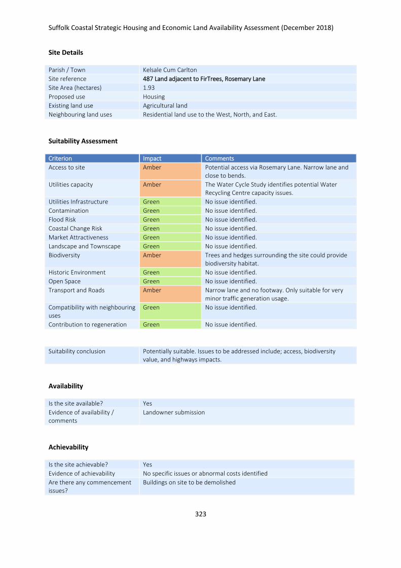
Suffolk Coastal Strategic Housing and Economic Land Availability Assessment (December 2018)
323
Site Details
Parish / Town Kelsale Cum Carlton
Site reference 487 Land adjacent to FirTrees, Rosemary Lane
Site Area (hectares) 1.93
Proposed use Housing
Existing land use Agricultural land
Neighbouring land uses Residential land use to the West, North, and East.
Suitability Assessment
Criterion Impact Comments
Access to site Amber Potential access via Rosemary Lane. Narrow lane and close to bends.
Utilities capacity Amber The Water Cycle Study identifies potential Water Recycling Centre capacity issues.
Utilities Infrastructure Green No issue identified.
Contamination Green No issue identified.
Flood Risk Green No issue identified.
Coastal Change Risk Green No issue identified.
Market Attractiveness Green No issue identified.
Landscape and Townscape Green No issue identified.
Biodiversity Amber Trees and hedges surrounding the site could provide biodiversity habitat.
Historic Environment Green No issue identified.
Open Space Green No issue identified.
Transport and Roads Amber Narrow lane and no footway. Only suitable for very minor traffic generation usage.
Compatibility with neighbouring uses
Green No issue identified.
Contribution to regeneration Green No issue identified.
Suitability conclusion Potentially suitable. Issues to be addressed include; access, biodiversity value, and highways impacts.
Availability
Is the site available? Yes
Evidence of availability / comments
Landowner submission
Achievability
Is the site achievable? Yes
Evidence of achievability No specific issues or abnormal costs identified
Are there any commencement issues?
Buildings on site to be demolished

Suffolk Coastal Strategic Housing and Economic Land Availability Assessment (December 2018)
324
Estimated dwellings yield 29
Estimated employment land yield (hectares) -
Estimated retail floorspace (sqm) -
Estimated commencement date 2020/21
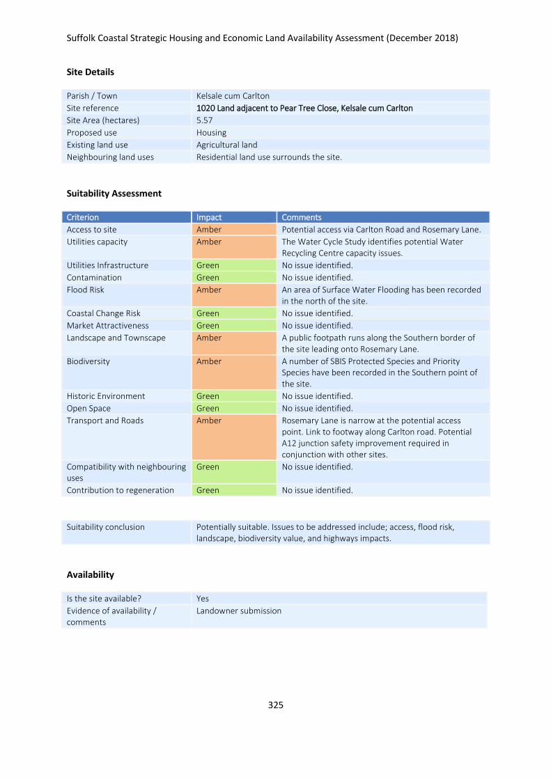
Suffolk Coastal Strategic Housing and Economic Land Availability Assessment (December 2018)
325
Site Details
Parish / Town Kelsale cum Carlton
Site reference 1020 Land adjacent to Pear Tree Close, Kelsale cum Carlton
Site Area (hectares) 5.57
Proposed use Housing
Existing land use Agricultural land
Neighbouring land uses Residential land use surrounds the site.
Suitability Assessment
Criterion Impact Comments
Access to site Amber Potential access via Carlton Road and Rosemary Lane.
Utilities capacity Amber The Water Cycle Study identifies potential Water Recycling Centre capacity issues.
Utilities Infrastructure Green No issue identified.
Contamination Green No issue identified.
Flood Risk Amber An area of Surface Water Flooding has been recorded in the north of the site.
Coastal Change Risk Green No issue identified.
Market Attractiveness Green No issue identified.
Landscape and Townscape Amber A public footpath runs along the Southern border of the site leading onto Rosemary Lane.
Biodiversity Amber A number of SBIS Protected Species and Priority Species have been recorded in the Southern point of the site.
Historic Environment Green No issue identified.
Open Space Green No issue identified.
Transport and Roads Amber Rosemary Lane is narrow at the potential access point. Link to footway along Carlton road. Potential A12 junction safety improvement required in conjunction with other sites.
Compatibility with neighbouring uses
Green No issue identified.
Contribution to regeneration Green No issue identified.
Suitability conclusion Potentially suitable. Issues to be addressed include; access, flood risk, landscape, biodiversity value, and highways impacts.
Availability
Is the site available? Yes
Evidence of availability / comments
Landowner submission

Suffolk Coastal Strategic Housing and Economic Land Availability Assessment (December 2018)
326
Achievability
Is the site achievable? Yes
Evidence of achievability No specific issues or abnormal costs identified
Are there any commencement issues?
None identified
Estimated dwellings yield 84
Estimated employment land yield (hectares) -
Estimated retail floorspace (sqm) -
Estimated commencement date 2020/21
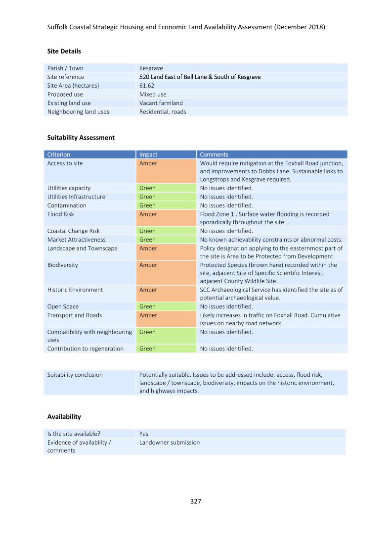
Suffolk Coastal Strategic Housing and Economic Land Availability Assessment (December 2018)
327
Site Details
Parish / Town Kesgrave
Site reference 520 Land East of Bell Lane & South of Kesgrave
Site Area (hectares) 61.62
Proposed use Mixed use
Existing land use Vacant farmland
Neighbouring land uses Residential, roads
Suitability Assessment
Criterion Impact Comments
Access to site Amber Would require mitigation at the Foxhall Road junction, and improvements to Dobbs Lane. Sustainable links to Longstrops and Kesgrave required.
Utilities capacity Green No issues identified.
Utilities Infrastructure Green No issues identified.
Contamination Green No issues identified.
Flood Risk Amber Flood Zone 1 . Surface water flooding is recorded sporadically throughout the site.
Coastal Change Risk Green No issues identified.
Market Attractiveness Green No known achievability constraints or abnormal costs.
Landscape and Townscape Amber Policy designation applying to the easternmost part of the site is Area to be Protected from Development.
Biodiversity Amber Protected Species (brown hare) recorded within the site, adjacent Site of Specific Scientific Interest, adjacent County Wildlife Site.
Historic Environment Amber SCC Archaeological Service has identified the site as of potential archaeological value.
Open Space Green No issues identified.
Transport and Roads Amber Likely increases in traffic on Foxhall Road. Cumulative issues on nearby road network.
Compatibility with neighbouring uses
Green No issues identified.
Contribution to regeneration Green No issues identified.
Suitability conclusion Potentially suitable. Issues to be addressed include; access, flood risk, landscape / townscape, biodiversity, impacts on the historic environment, and highways impacts.
Availability
Is the site available? Yes
Evidence of availability / comments
Landowner submission
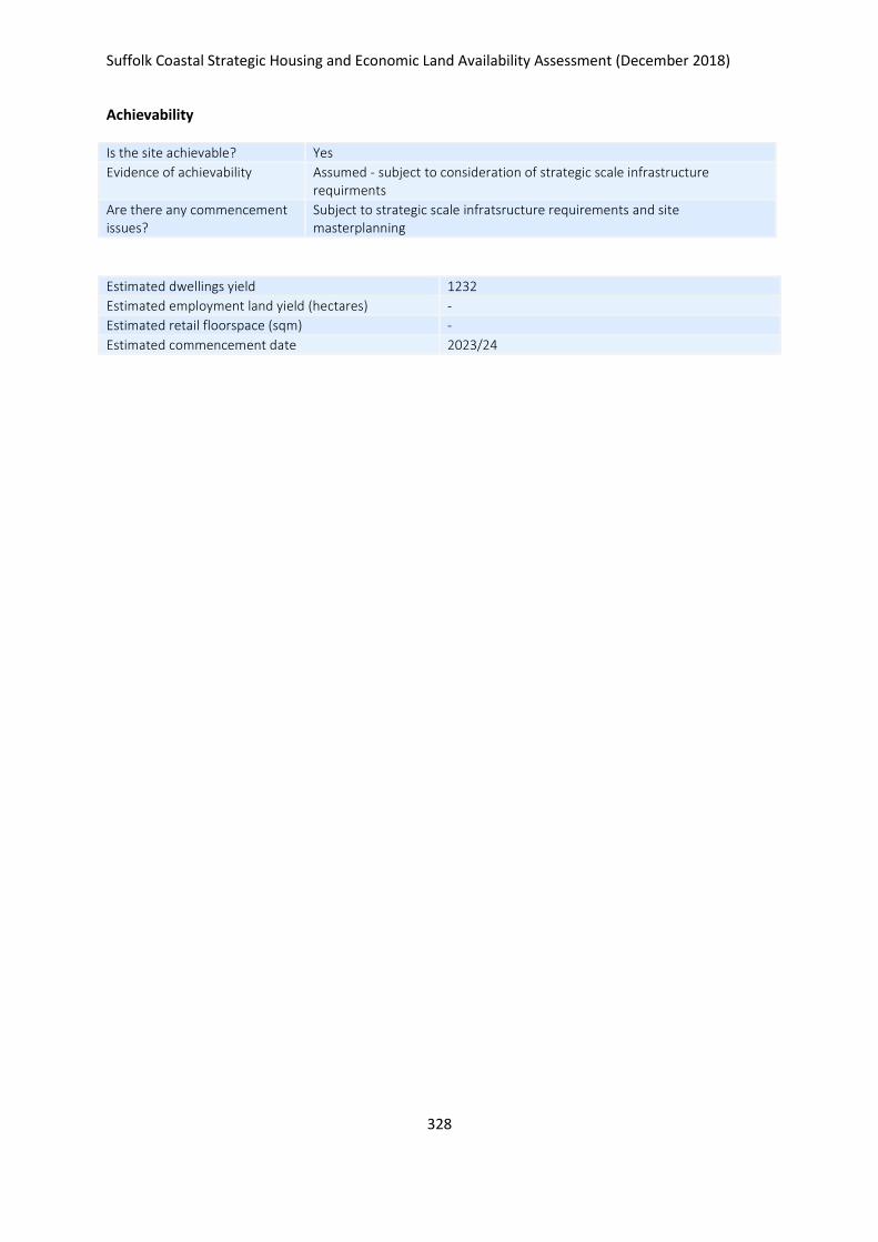
Suffolk Coastal Strategic Housing and Economic Land Availability Assessment (December 2018)
328
Achievability
Is the site achievable? Yes
Evidence of achievability Assumed - subject to consideration of strategic scale infrastructure requirments
Are there any commencement issues?
Subject to strategic scale infratsructure requirements and site masterplanning
Estimated dwellings yield 1232
Estimated employment land yield (hectares) -
Estimated retail floorspace (sqm) -
Estimated commencement date 2023/24
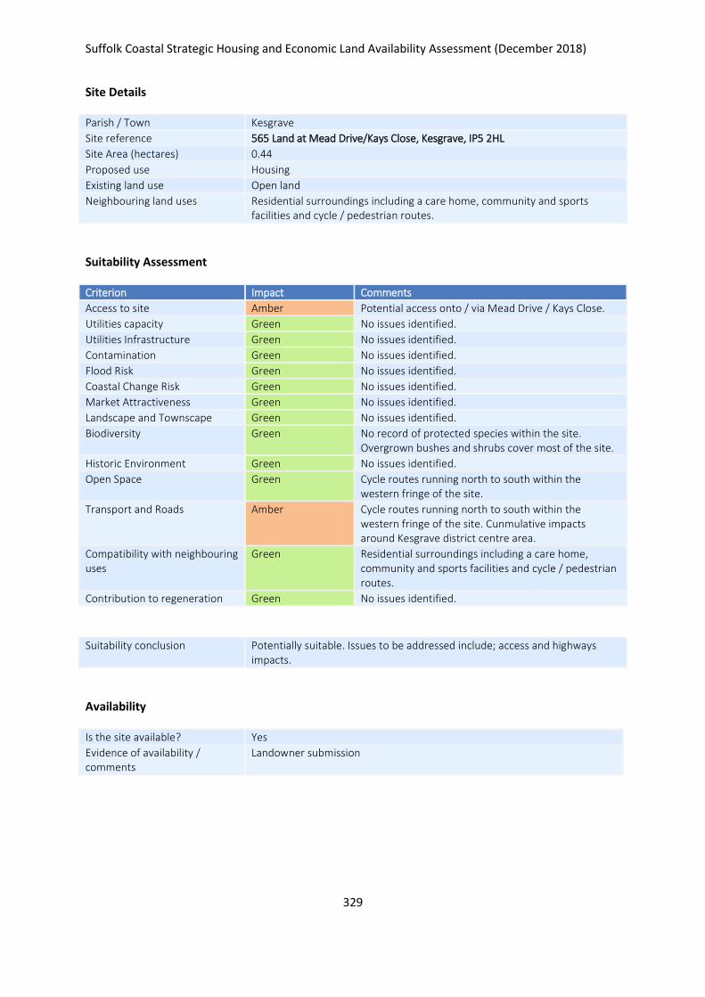
Suffolk Coastal Strategic Housing and Economic Land Availability Assessment (December 2018)
329
Site Details
Parish / Town Kesgrave
Site reference 565 Land at Mead Drive/Kays Close, Kesgrave, IP5 2HL
Site Area (hectares) 0.44
Proposed use Housing
Existing land use Open land
Neighbouring land uses Residential surroundings including a care home, community and sports facilities and cycle / pedestrian routes.
Suitability Assessment
Criterion Impact Comments
Access to site Amber Potential access onto / via Mead Drive / Kays Close.
Utilities capacity Green No issues identified.
Utilities Infrastructure Green No issues identified.
Contamination Green No issues identified.
Flood Risk Green No issues identified.
Coastal Change Risk Green No issues identified.
Market Attractiveness Green No issues identified.
Landscape and Townscape Green No issues identified.
Biodiversity Green No record of protected species within the site. Overgrown bushes and shrubs cover most of the site.
Historic Environment Green No issues identified.
Open Space Green Cycle routes running north to south within the western fringe of the site.
Transport and Roads Amber Cycle routes running north to south within the western fringe of the site. Cunmulative impacts around Kesgrave district centre area.
Compatibility with neighbouring uses
Green Residential surroundings including a care home, community and sports facilities and cycle / pedestrian routes.
Contribution to regeneration Green No issues identified.
Suitability conclusion Potentially suitable. Issues to be addressed include; access and highways impacts.
Availability
Is the site available? Yes
Evidence of availability / comments
Landowner submission

Suffolk Coastal Strategic Housing and Economic Land Availability Assessment (December 2018)
330
Achievability
Is the site achievable? Yes
Evidence of achievability No specific issues or abnormal costs identified
Are there any commencement issues?
None identified
Estimated dwellings yield 11
Estimated employment land yield (hectares) -
Estimated retail floorspace (sqm) -
Estimated commencement date 2020/21
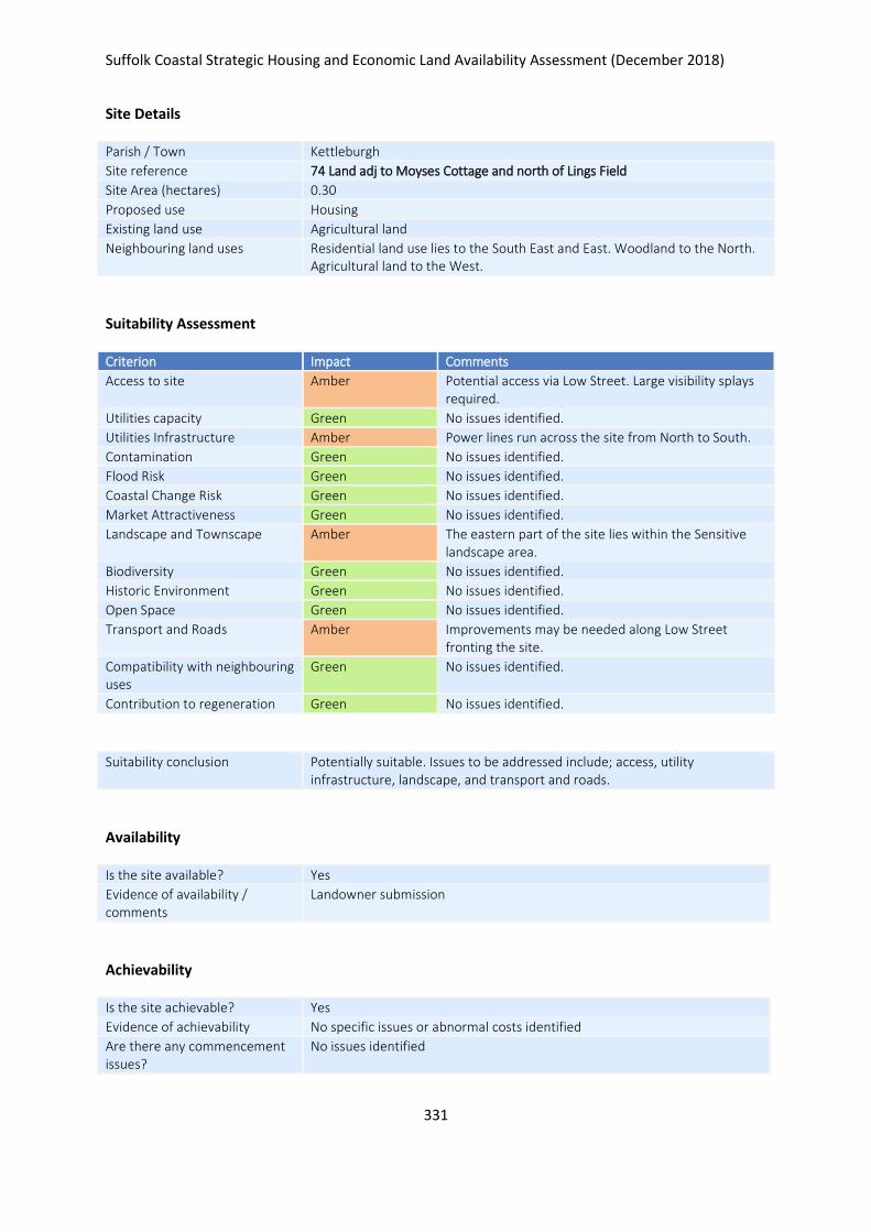
Suffolk Coastal Strategic Housing and Economic Land Availability Assessment (December 2018)
331
Site Details
Parish / Town Kettleburgh
Site reference 74 Land adj to Moyses Cottage and north of Lings Field
Site Area (hectares) 0.30
Proposed use Housing
Existing land use Agricultural land
Neighbouring land uses Residential land use lies to the South East and East. Woodland to the North. Agricultural land to the West.
Suitability Assessment
Criterion Impact Comments
Access to site Amber Potential access via Low Street. Large visibility splays required.
Utilities capacity Green No issues identified.
Utilities Infrastructure Amber Power lines run across the site from North to South.
Contamination Green No issues identified.
Flood Risk Green No issues identified.
Coastal Change Risk Green No issues identified.
Market Attractiveness Green No issues identified.
Landscape and Townscape Amber The eastern part of the site lies within the Sensitive landscape area.
Biodiversity Green No issues identified.
Historic Environment Green No issues identified.
Open Space Green No issues identified.
Transport and Roads Amber Improvements may be needed along Low Street fronting the site.
Compatibility with neighbouring uses
Green No issues identified.
Contribution to regeneration Green No issues identified.
Suitability conclusion Potentially suitable. Issues to be addressed include; access, utility infrastructure, landscape, and transport and roads.
Availability
Is the site available? Yes
Evidence of availability / comments
Landowner submission
Achievability
Is the site achievable? Yes
Evidence of achievability No specific issues or abnormal costs identified
Are there any commencement issues?
No issues identified

Suffolk Coastal Strategic Housing and Economic Land Availability Assessment (December 2018)
332
Estimated dwellings yield 5
Estimated employment land yield (hectares) -
Estimated retail floorspace (sqm) -
Estimated commencement date 2023/24
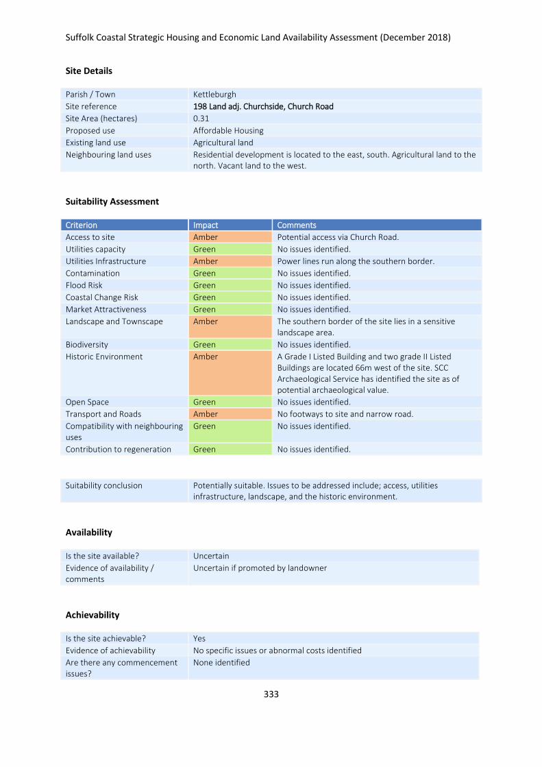
Suffolk Coastal Strategic Housing and Economic Land Availability Assessment (December 2018)
333
Site Details
Parish / Town Kettleburgh
Site reference 198 Land adj. Churchside, Church Road
Site Area (hectares) 0.31
Proposed use Affordable Housing
Existing land use Agricultural land
Neighbouring land uses Residential development is located to the east, south. Agricultural land to the north. Vacant land to the west.
Suitability Assessment
Criterion Impact Comments
Access to site Amber Potential access via Church Road.
Utilities capacity Green No issues identified.
Utilities Infrastructure Amber Power lines run along the southern border.
Contamination Green No issues identified.
Flood Risk Green No issues identified.
Coastal Change Risk Green No issues identified.
Market Attractiveness Green No issues identified.
Landscape and Townscape Amber The southern border of the site lies in a sensitive landscape area.
Biodiversity Green No issues identified.
Historic Environment Amber A Grade I Listed Building and two grade II Listed Buildings are located 66m west of the site. SCC Archaeological Service has identified the site as of potential archaeological value.
Open Space Green No issues identified.
Transport and Roads Amber No footways to site and narrow road.
Compatibility with neighbouring uses
Green No issues identified.
Contribution to regeneration Green No issues identified.
Suitability conclusion Potentially suitable. Issues to be addressed include; access, utilities infrastructure, landscape, and the historic environment.
Availability
Is the site available? Uncertain
Evidence of availability / comments
Uncertain if promoted by landowner
Achievability
Is the site achievable? Yes
Evidence of achievability No specific issues or abnormal costs identified
Are there any commencement issues?
None identified
Suffolk Coastal Strategic Housing and Economic Land Availability Assessment (December 2018)
334
Estimated dwellings yield 0
Estimated employment land yield (hectares) -
Estimated retail floorspace (sqm) -
Estimated commencement date -
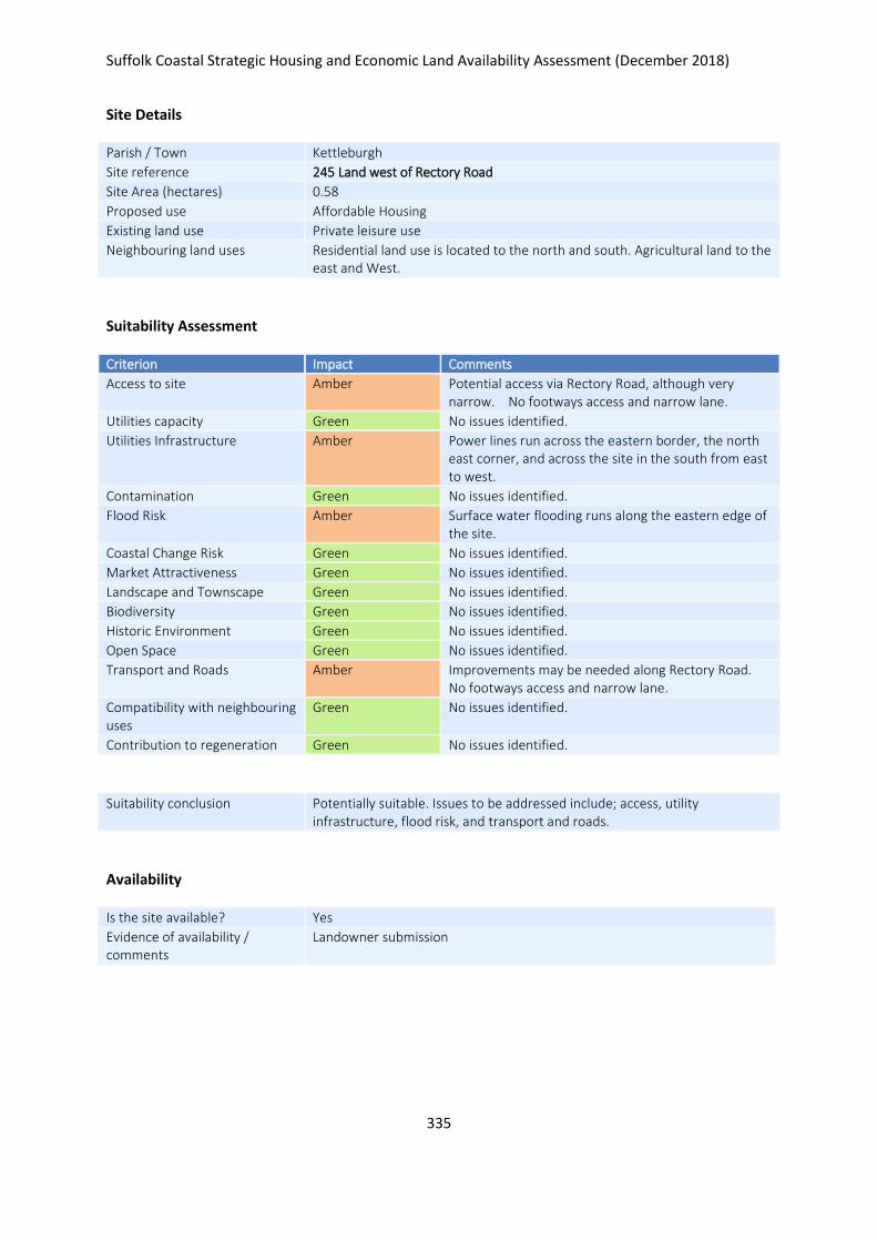
Suffolk Coastal Strategic Housing and Economic Land Availability Assessment (December 2018)
335
Site Details
Parish / Town Kettleburgh
Site reference 245 Land west of Rectory Road
Site Area (hectares) 0.58
Proposed use Affordable Housing
Existing land use Private leisure use
Neighbouring land uses Residential land use is located to the north and south. Agricultural land to the east and West.
Suitability Assessment
Criterion Impact Comments
Access to site Amber Potential access via Rectory Road, although very narrow. No footways access and narrow lane.
Utilities capacity Green No issues identified.
Utilities Infrastructure Amber Power lines run across the eastern border, the north east corner, and across the site in the south from east to west.
Contamination Green No issues identified.
Flood Risk Amber Surface water flooding runs along the eastern edge of the site.
Coastal Change Risk Green No issues identified.
Market Attractiveness Green No issues identified.
Landscape and Townscape Green No issues identified.
Biodiversity Green No issues identified.
Historic Environment Green No issues identified.
Open Space Green No issues identified.
Transport and Roads Amber Improvements may be needed along Rectory Road. No footways access and narrow lane.
Compatibility with neighbouring uses
Green No issues identified.
Contribution to regeneration Green No issues identified.
Suitability conclusion Potentially suitable. Issues to be addressed include; access, utility infrastructure, flood risk, and transport and roads.
Availability
Is the site available? Yes
Evidence of availability / comments
Landowner submission

Suffolk Coastal Strategic Housing and Economic Land Availability Assessment (December 2018)
336
Achievability
Is the site achievable? Yes
Evidence of achievability No specific issues or abnormal costs identified
Are there any commencement issues?
None identified
Estimated dwellings yield 9
Estimated employment land yield (hectares) -
Estimated retail floorspace (sqm) -
Estimated commencement date 2023/24
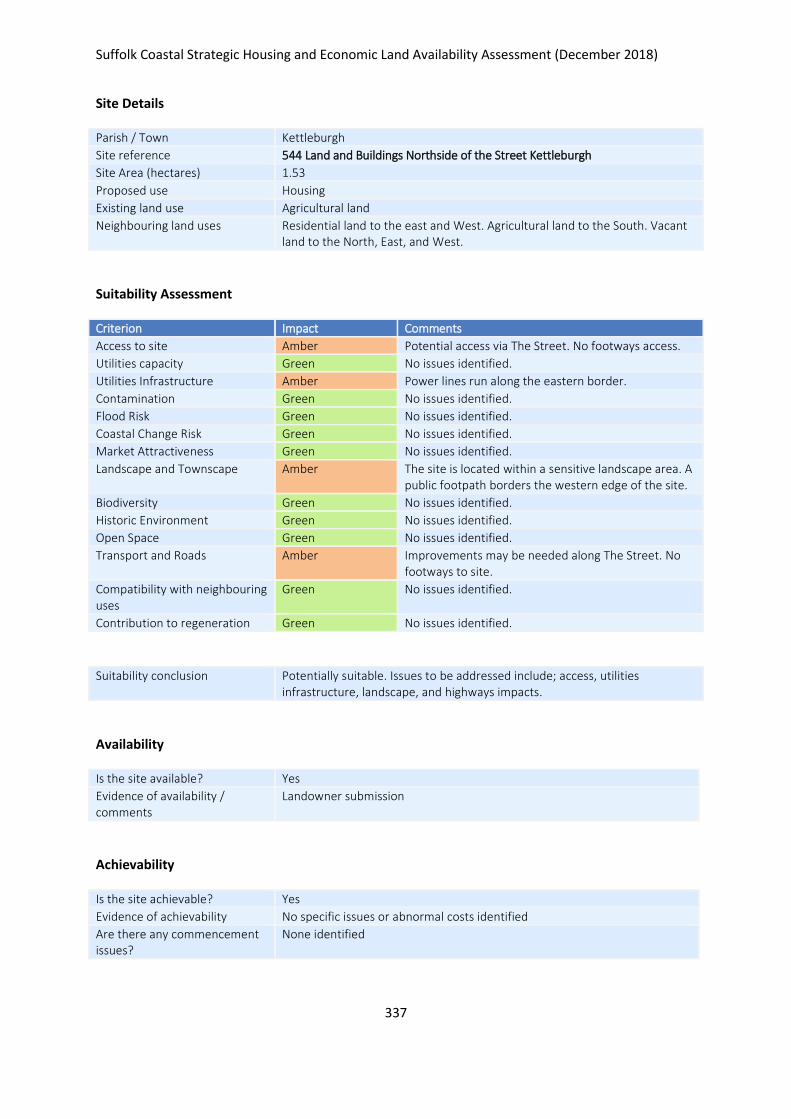
Suffolk Coastal Strategic Housing and Economic Land Availability Assessment (December 2018)
337
Site Details
Parish / Town Kettleburgh
Site reference 544 Land and Buildings Northside of the Street Kettleburgh
Site Area (hectares) 1.53
Proposed use Housing
Existing land use Agricultural land
Neighbouring land uses Residential land to the east and West. Agricultural land to the South. Vacant land to the North, East, and West.
Suitability Assessment
Criterion Impact Comments
Access to site Amber Potential access via The Street. No footways access.
Utilities capacity Green No issues identified.
Utilities Infrastructure Amber Power lines run along the eastern border.
Contamination Green No issues identified.
Flood Risk Green No issues identified.
Coastal Change Risk Green No issues identified.
Market Attractiveness Green No issues identified.
Landscape and Townscape Amber The site is located within a sensitive landscape area. A public footpath borders the western edge of the site.
Biodiversity Green No issues identified.
Historic Environment Green No issues identified.
Open Space Green No issues identified.
Transport and Roads Amber Improvements may be needed along The Street. No footways to site.
Compatibility with neighbouring uses
Green No issues identified.
Contribution to regeneration Green No issues identified.
Suitability conclusion Potentially suitable. Issues to be addressed include; access, utilities infrastructure, landscape, and highways impacts.
Availability
Is the site available? Yes
Evidence of availability / comments
Landowner submission
Achievability
Is the site achievable? Yes
Evidence of achievability No specific issues or abnormal costs identified
Are there any commencement issues?
None identified

Suffolk Coastal Strategic Housing and Economic Land Availability Assessment (December 2018)
338
Estimated dwellings yield 23
Estimated employment land yield (hectares) -
Estimated retail floorspace (sqm) -
Estimated commencement date 2020/21
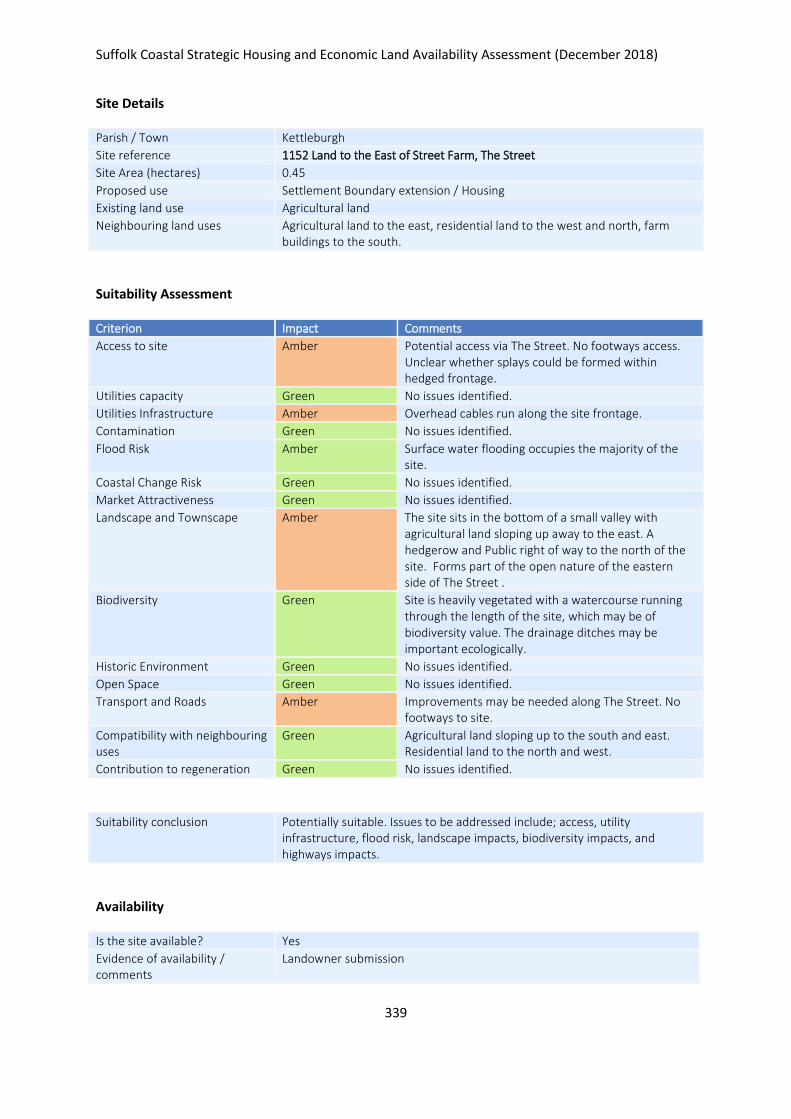
Suffolk Coastal Strategic Housing and Economic Land Availability Assessment (December 2018)
339
Site Details
Parish / Town Kettleburgh
Site reference 1152 Land to the East of Street Farm, The Street
Site Area (hectares) 0.45
Proposed use Settlement Boundary extension / Housing
Existing land use Agricultural land
Neighbouring land uses Agricultural land to the east, residential land to the west and north, farm buildings to the south.
Suitability Assessment
Criterion Impact Comments
Access to site Amber Potential access via The Street. No footways access. Unclear whether splays could be formed within hedged frontage.
Utilities capacity Green No issues identified.
Utilities Infrastructure Amber Overhead cables run along the site frontage.
Contamination Green No issues identified.
Flood Risk Amber Surface water flooding occupies the majority of the site.
Coastal Change Risk Green No issues identified.
Market Attractiveness Green No issues identified.
Landscape and Townscape Amber The site sits in the bottom of a small valley with agricultural land sloping up away to the east. A hedgerow and Public right of way to the north of the site. Forms part of the open nature of the eastern side of The Street .
Biodiversity Green Site is heavily vegetated with a watercourse running through the length of the site, which may be of biodiversity value. The drainage ditches may be important ecologically.
Historic Environment Green No issues identified.
Open Space Green No issues identified.
Transport and Roads Amber Improvements may be needed along The Street. No footways to site.
Compatibility with neighbouring uses
Green Agricultural land sloping up to the south and east. Residential land to the north and west.
Contribution to regeneration Green No issues identified.
Suitability conclusion Potentially suitable. Issues to be addressed include; access, utility infrastructure, flood risk, landscape impacts, biodiversity impacts, and highways impacts.
Availability
Is the site available? Yes
Evidence of availability / comments
Landowner submission

Suffolk Coastal Strategic Housing and Economic Land Availability Assessment (December 2018)
340
Achievability
Is the site achievable? Yes
Evidence of achievability No specific issues or abnormal costs identified
Are there any commencement issues?
None identified
Estimated dwellings yield 7
Estimated employment land yield (hectares) -
Estimated retail floorspace (sqm) -
Estimated commencement date 2023/24
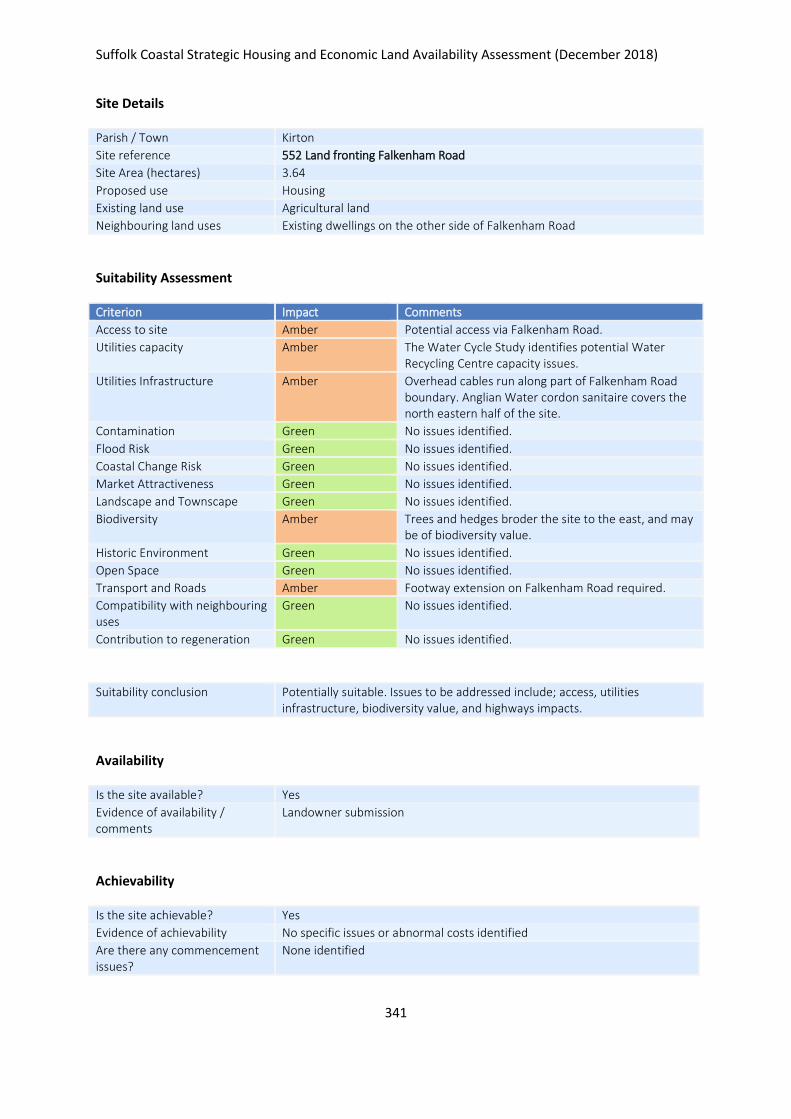
Suffolk Coastal Strategic Housing and Economic Land Availability Assessment (December 2018)
341
Site Details
Parish / Town Kirton
Site reference 552 Land fronting Falkenham Road
Site Area (hectares) 3.64
Proposed use Housing
Existing land use Agricultural land
Neighbouring land uses Existing dwellings on the other side of Falkenham Road
Suitability Assessment
Criterion Impact Comments
Access to site Amber Potential access via Falkenham Road.
Utilities capacity Amber The Water Cycle Study identifies potential Water Recycling Centre capacity issues.
Utilities Infrastructure Amber Overhead cables run along part of Falkenham Road boundary. Anglian Water cordon sanitaire covers the north eastern half of the site.
Contamination Green No issues identified.
Flood Risk Green No issues identified.
Coastal Change Risk Green No issues identified.
Market Attractiveness Green No issues identified.
Landscape and Townscape Green No issues identified.
Biodiversity Amber Trees and hedges broder the site to the east, and may be of biodiversity value.
Historic Environment Green No issues identified.
Open Space Green No issues identified.
Transport and Roads Amber Footway extension on Falkenham Road required.
Compatibility with neighbouring uses
Green No issues identified.
Contribution to regeneration Green No issues identified.
Suitability conclusion Potentially suitable. Issues to be addressed include; access, utilities infrastructure, biodiversity value, and highways impacts.
Availability
Is the site available? Yes
Evidence of availability / comments
Landowner submission
Achievability
Is the site achievable? Yes
Evidence of achievability No specific issues or abnormal costs identified
Are there any commencement issues?
None identified

Suffolk Coastal Strategic Housing and Economic Land Availability Assessment (December 2018)
342
Estimated dwellings yield 55
Estimated employment land yield (hectares) -
Estimated retail floorspace (sqm) -
Estimated commencement date 2021/22
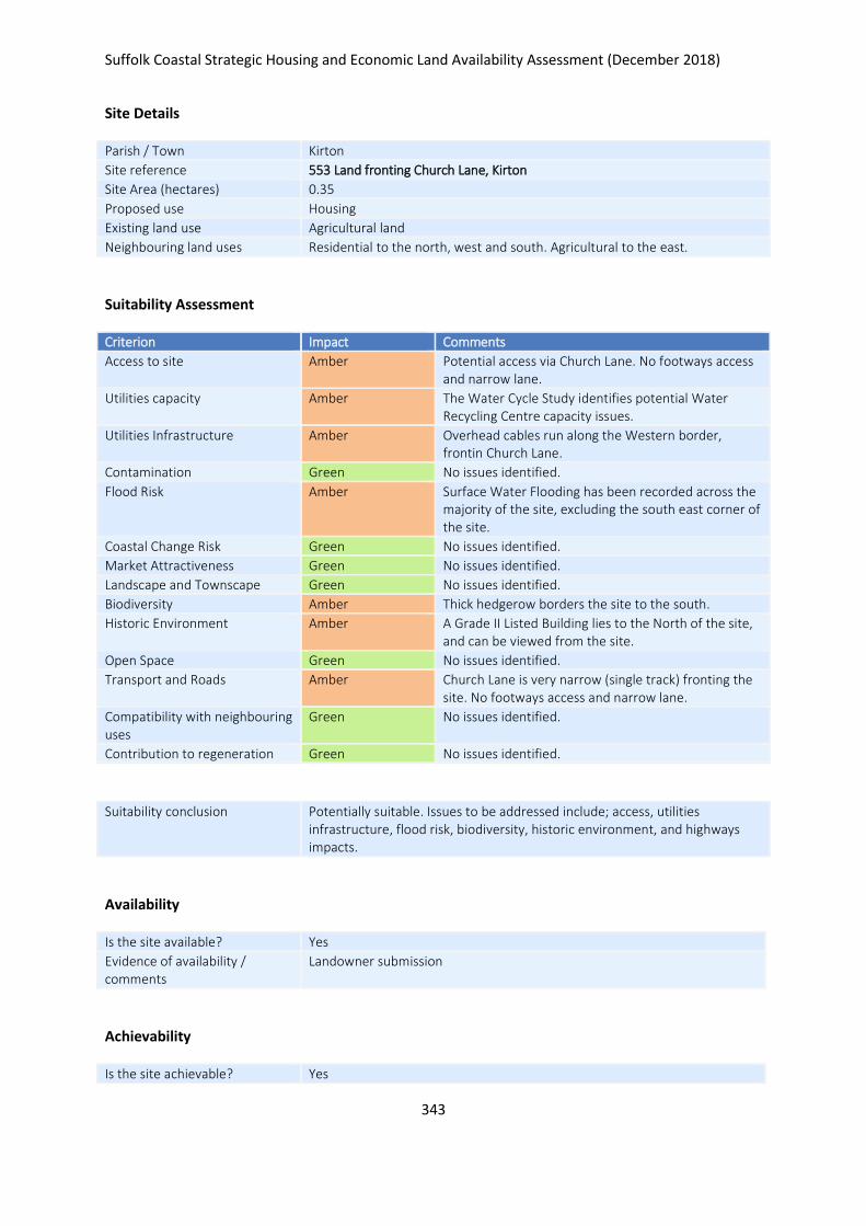
Suffolk Coastal Strategic Housing and Economic Land Availability Assessment (December 2018)
343
Site Details
Parish / Town Kirton
Site reference 553 Land fronting Church Lane, Kirton
Site Area (hectares) 0.35
Proposed use Housing
Existing land use Agricultural land
Neighbouring land uses Residential to the north, west and south. Agricultural to the east.
Suitability Assessment
Criterion Impact Comments
Access to site Amber Potential access via Church Lane. No footways access and narrow lane.
Utilities capacity Amber The Water Cycle Study identifies potential Water Recycling Centre capacity issues.
Utilities Infrastructure Amber Overhead cables run along the Western border, frontin Church Lane.
Contamination Green No issues identified.
Flood Risk Amber Surface Water Flooding has been recorded across the majority of the site, excluding the south east corner of the site.
Coastal Change Risk Green No issues identified.
Market Attractiveness Green No issues identified.
Landscape and Townscape Green No issues identified.
Biodiversity Amber Thick hedgerow borders the site to the south.
Historic Environment Amber A Grade II Listed Building lies to the North of the site, and can be viewed from the site.
Open Space Green No issues identified.
Transport and Roads Amber Church Lane is very narrow (single track) fronting the site. No footways access and narrow lane.
Compatibility with neighbouring uses
Green No issues identified.
Contribution to regeneration Green No issues identified.
Suitability conclusion Potentially suitable. Issues to be addressed include; access, utilities infrastructure, flood risk, biodiversity, historic environment, and highways impacts.
Availability
Is the site available? Yes
Evidence of availability / comments
Landowner submission
Achievability
Is the site achievable? Yes

Suffolk Coastal Strategic Housing and Economic Land Availability Assessment (December 2018)
344
Evidence of achievability No specific issues or abnormal costs identified
Are there any commencement issues?
None identified
Estimated dwellings yield 5
Estimated employment land yield (hectares) -
Estimated retail floorspace (sqm) -
Estimated commencement date 2020/21
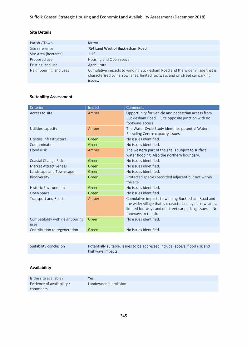
Suffolk Coastal Strategic Housing and Economic Land Availability Assessment (December 2018)
345
Site Details
Parish / Town Kirton
Site reference 754 Land West of Bucklesham Road
Site Area (hectares) 1.15
Proposed use Housing and Open Space
Existing land use Agriculture
Neighbouring land uses Cumulative impacts to winding Bucklesham Road and the wider village that is characterised by narrow lanes, limited footways and on street car parking issues.
Suitability Assessment
Criterion Impact Comments
Access to site Amber Opportunity for vehicle and pedestrian access from Bucklesham Road. Site opposite junction with no footways access.
Utilities capacity Amber The Water Cycle Study identifies potential Water Recycling Centre capacity issues.
Utilities Infrastructure Green No issues identified.
Contamination Green No issues identified.
Flood Risk Amber The western part of the site is subject to surface water flooding. Also the northern boundary.
Coastal Change Risk Green No issues identified.
Market Attractiveness Green No issues idnetified.
Landscape and Townscape Green No issues identified.
Biodiversity Green Protected species recorded adjacent but not within the site.
Historic Environment Green No issues identified.
Open Space Green No issues identified.
Transport and Roads Amber Cumulative impacts to winding Bucklesham Road and the wider village that is characterised by narrow lanes, limited footways and on street car parking issues. No footways to the site.
Compatibility with neighbouring uses
Green No issues identified.
Contribution to regeneration Green No issues identified.
Suitability conclusion Potentially suitable. Issues to be addressed include; access, flood risk and highways impacts.
Availability
Is the site available? Yes
Evidence of availability / comments
Landowner submission

Suffolk Coastal Strategic Housing and Economic Land Availability Assessment (December 2018)
346
Achievability
Is the site achievable? Yes
Evidence of achievability No specific issues or abnormal costs identified
Are there any commencement issues?
None identified
Estimated dwellings yield 17
Estimated employment land yield (hectares) -
Estimated retail floorspace (sqm) -
Estimated commencement date 2020/21
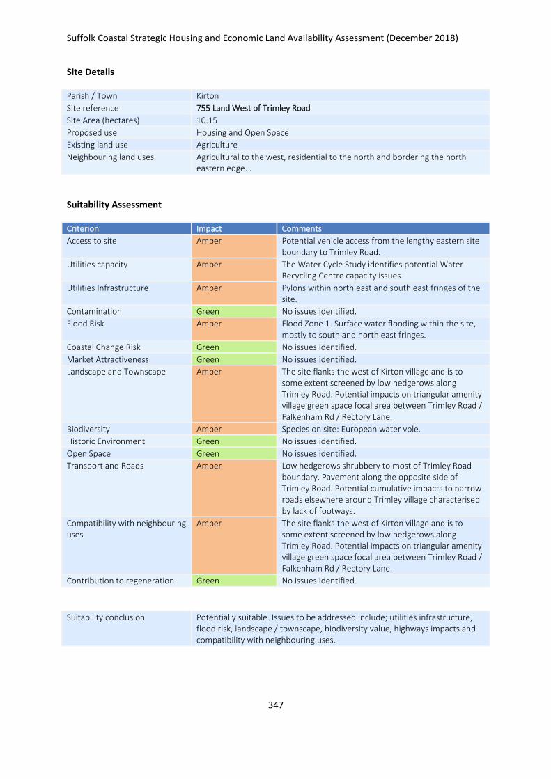
Suffolk Coastal Strategic Housing and Economic Land Availability Assessment (December 2018)
347
Site Details
Parish / Town Kirton
Site reference 755 Land West of Trimley Road
Site Area (hectares) 10.15
Proposed use Housing and Open Space
Existing land use Agriculture
Neighbouring land uses Agricultural to the west, residential to the north and bordering the north eastern edge. .
Suitability Assessment
Criterion Impact Comments
Access to site Amber Potential vehicle access from the lengthy eastern site boundary to Trimley Road.
Utilities capacity Amber The Water Cycle Study identifies potential Water Recycling Centre capacity issues.
Utilities Infrastructure Amber Pylons within north east and south east fringes of the site.
Contamination Green No issues identified.
Flood Risk Amber Flood Zone 1. Surface water flooding within the site, mostly to south and north east fringes.
Coastal Change Risk Green No issues identified.
Market Attractiveness Green No issues identified.
Landscape and Townscape Amber The site flanks the west of Kirton village and is to some extent screened by low hedgerows along Trimley Road. Potential impacts on triangular amenity village green space focal area between Trimley Road / Falkenham Rd / Rectory Lane.
Biodiversity Amber Species on site: European water vole.
Historic Environment Green No issues identified.
Open Space Green No issues identified.
Transport and Roads Amber Low hedgerows shrubbery to most of Trimley Road boundary. Pavement along the opposite side of Trimley Road. Potential cumulative impacts to narrow roads elsewhere around Trimley village characterised by lack of footways.
Compatibility with neighbouring uses
Amber The site flanks the west of Kirton village and is to some extent screened by low hedgerows along Trimley Road. Potential impacts on triangular amenity village green space focal area between Trimley Road / Falkenham Rd / Rectory Lane.
Contribution to regeneration Green No issues identified.
Suitability conclusion Potentially suitable. Issues to be addressed include; utilities infrastructure, flood risk, landscape / townscape, biodiversity value, highways impacts and compatibility with neighbouring uses.

Suffolk Coastal Strategic Housing and Economic Land Availability Assessment (December 2018)
348
Availability
Is the site available? Yes
Evidence of availability / comments
Landowner submission
Achievability
Is the site achievable? Yes
Evidence of achievability Assumed - although buildings need relocation
Are there any commencement issues?
Relocation of existing buildings
Estimated dwellings yield 152
Estimated employment land yield (hectares) -
Estimated retail floorspace (sqm) -
Estimated commencement date 2023/24
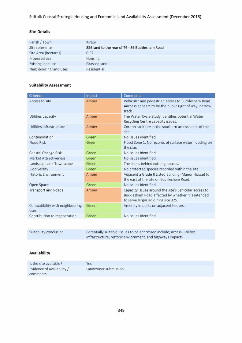
Suffolk Coastal Strategic Housing and Economic Land Availability Assessment (December 2018)
349
Site Details
Parish / Town Kirton
Site reference 856 land to the rear of 76 - 86 Bucklesham Road
Site Area (hectares) 0.57
Proposed use Housing
Existing land use Grassed land
Neighbouring land uses Residential
Suitability Assessment
Criterion Impact Comments
Access to site Amber Vehicular and pedestrian access to Bucklesham Road. Aaccess appears to be the public right of way, narrow track.
Utilities capacity Amber The Water Cycle Study identifies potential Water Recycling Centre capacity issues.
Utilities Infrastructure Amber Cordon sanitaire at the southern access point of the site.
Contamination Green No issues identified.
Flood Risk Green Flood Zone 1. No records of surface water flooding on the site.
Coastal Change Risk Green No issues identified.
Market Attractiveness Green No issues identified.
Landscape and Townscape Green The site is behind existing houses.
Biodiversity Green No protected species recorded within the site.
Historic Environment Amber Adjacent a Grade II Listed Building (Manor House) to the east of the site on Bucklesham Road.
Open Space Green No issues identified.
Transport and Roads Amber Capacity issues around the site’s vehicular access to Bucklesham Road affected by whether it is intended to serve larger adjoining site 325.
Compatibility with neighbouring uses
Green Amenity impacts on adjacent houses.
Contribution to regeneration Green No issues identified.
Suitability conclusion Potentially suitable. Issues to be addressed include; access, utilities infrastructure, historic enviornment, and highways impacts.
Availability
Is the site available? Yes
Evidence of availability / comments
Landowner submission

Suffolk Coastal Strategic Housing and Economic Land Availability Assessment (December 2018)
350
Achievability
Is the site achievable? Yes
Evidence of achievability No specific issues or abnormal costs identified
Are there any commencement issues?
None identified
Estimated dwellings yield 9
Estimated employment land yield (hectares) -
Estimated retail floorspace (sqm) -
Estimated commencement date 2021/22
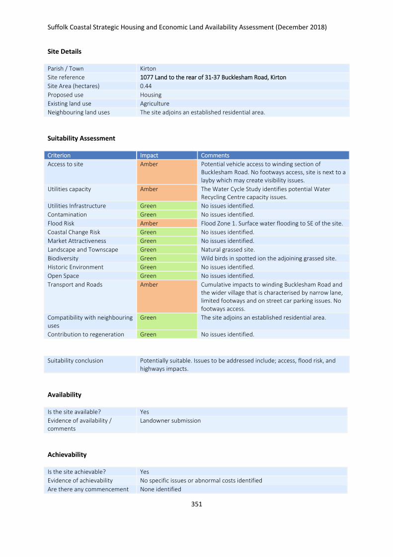
Suffolk Coastal Strategic Housing and Economic Land Availability Assessment (December 2018)
351
Site Details
Parish / Town Kirton
Site reference 1077 Land to the rear of 31-37 Bucklesham Road, Kirton
Site Area (hectares) 0.44
Proposed use Housing
Existing land use Agriculture
Neighbouring land uses The site adjoins an established residential area.
Suitability Assessment
Criterion Impact Comments
Access to site Amber Potential vehicle access to winding section of Bucklesham Road. No footways access, site is next to a layby which may create visibility issues.
Utilities capacity Amber The Water Cycle Study identifies potential Water Recycling Centre capacity issues.
Utilities Infrastructure Green No issues identified.
Contamination Green No issues identified.
Flood Risk Amber Flood Zone 1. Surface water flooding to SE of the site.
Coastal Change Risk Green No issues identified.
Market Attractiveness Green No issues identified.
Landscape and Townscape Green Natural grassed site.
Biodiversity Green Wild birds in spotted ion the adjoining grassed site.
Historic Environment Green No issues identified.
Open Space Green No issues identified.
Transport and Roads Amber Cumulative impacts to winding Bucklesham Road and the wider village that is characterised by narrow lane, limited footways and on street car parking issues. No footways access.
Compatibility with neighbouring uses
Green The site adjoins an established residential area.
Contribution to regeneration Green No issues identified.
Suitability conclusion Potentially suitable. Issues to be addressed include; access, flood risk, and highways impacts.
Availability
Is the site available? Yes
Evidence of availability / comments
Landowner submission
Achievability
Is the site achievable? Yes
Evidence of achievability No specific issues or abnormal costs identified
Are there any commencement None identified

Suffolk Coastal Strategic Housing and Economic Land Availability Assessment (December 2018)
352
issues?
Estimated dwellings yield 7
Estimated employment land yield (hectares) -
Estimated retail floorspace (sqm) -
Estimated commencement date 2021/22
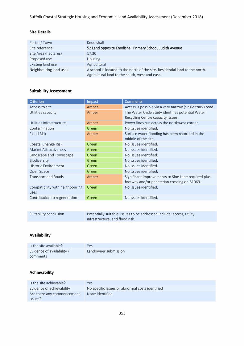
Suffolk Coastal Strategic Housing and Economic Land Availability Assessment (December 2018)
353
Site Details
Parish / Town Knodishall
Site reference 52 Land opposite Knodishall Primary School, Judith Avenue
Site Area (hectares) 17.30
Proposed use Housing
Existing land use Agricultural
Neighbouring land uses A school is located to the north of the site. Residential land to the north. Agricultural land to the south, west and east.
Suitability Assessment
Criterion Impact Comments
Access to site Amber Access is possible via a very narrow (single track) road.
Utilities capacity Amber The Water Cycle Study identifies potential Water Recycling Centre capacity issues.
Utilities Infrastructure Amber Power lines run across the northwest corner.
Contamination Green No issues identified.
Flood Risk Amber Surface water flooding has been recorded in the middle of the site.
Coastal Change Risk Green No issues identified.
Market Attractiveness Green No issues identified.
Landscape and Townscape Green No issues identified.
Biodiversity Green No issues identified.
Historic Environment Green No issues identified.
Open Space Green No issues identified.
Transport and Roads Amber Significant improvements to Sloe Lane required plus footway and/or pedestrian crossing on B1069.
Compatibility with neighbouring uses
Green No issues identified.
Contribution to regeneration Green No issues identified.
Suitability conclusion Potentially suitable. Issues to be addressed include; access, utility infrastructure, and flood risk.
Availability
Is the site available? Yes
Evidence of availability / comments
Landowner submission
Achievability
Is the site achievable? Yes
Evidence of achievability No specific issues or abnormal costs identified
Are there any commencement issues?
None identified

Suffolk Coastal Strategic Housing and Economic Land Availability Assessment (December 2018)
354
Estimated dwellings yield 260
Estimated employment land yield (hectares) -
Estimated retail floorspace (sqm) -
Estimated commencement date 2021/22
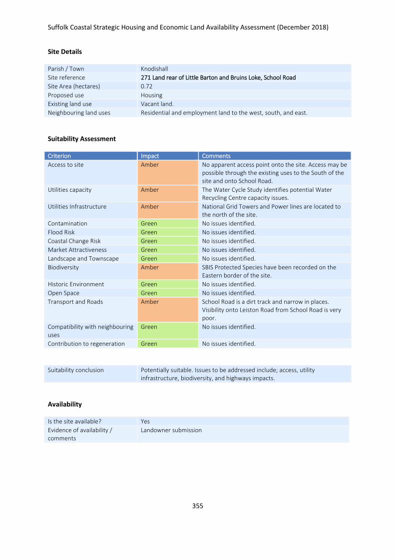
Suffolk Coastal Strategic Housing and Economic Land Availability Assessment (December 2018)
355
Site Details
Parish / Town Knodishall
Site reference 271 Land rear of Little Barton and Bruins Loke, School Road
Site Area (hectares) 0.72
Proposed use Housing
Existing land use Vacant land.
Neighbouring land uses Residential and employment land to the west, south, and east.
Suitability Assessment
Criterion Impact Comments
Access to site Amber No apparent access point onto the site. Access may be possible through the existing uses to the South of the site and onto School Road.
Utilities capacity Amber The Water Cycle Study identifies potential Water Recycling Centre capacity issues.
Utilities Infrastructure Amber National Grid Towers and Power lines are located to the north of the site.
Contamination Green No issues identified.
Flood Risk Green No issues identified.
Coastal Change Risk Green No issues identified.
Market Attractiveness Green No issues identified.
Landscape and Townscape Green No issues identified.
Biodiversity Amber SBIS Protected Species have been recorded on the Eastern border of the site.
Historic Environment Green No issues identified.
Open Space Green No issues identified.
Transport and Roads Amber School Road is a dirt track and narrow in places. Visibility onto Leiston Road from School Road is very poor.
Compatibility with neighbouring uses
Green No issues identified.
Contribution to regeneration Green No issues identified.
Suitability conclusion Potentially suitable. Issues to be addressed include; access, utility infrastructure, biodiversity, and highways impacts.
Availability
Is the site available? Yes
Evidence of availability / comments
Landowner submission

Suffolk Coastal Strategic Housing and Economic Land Availability Assessment (December 2018)
356
Achievability
Is the site achievable? Yes
Evidence of achievability Assumed - dependent on access between Broadacre and Crisps Garage
Are there any commencement issues?
Dependent on access through site 1100
Estimated dwellings yield 11
Estimated employment land yield (hectares) -
Estimated retail floorspace (sqm) -
Estimated commencement date 2024/25

Suffolk Coastal Strategic Housing and Economic Land Availability Assessment (December 2018)
357
Site Details
Parish / Town Knodishall
Site reference 1100 Land to the rear of Crisps Paramount Garage Ltd and Broadacres, Leiston Rd, Knodishall
Site Area (hectares) 1.05
Proposed use Housing
Existing land use Currently vacant land.
Neighbouring land uses Nursing home and garage directly south. Vacant land to the east. Agricultural land to the north. Gardens to the West. Pylons lie to the north. Power lines runs over the northern corner of the site.
Suitability Assessment
Criterion Impact Comments
Access to site Amber Potential access via the B1069. Unclear whether visibility splays could be formed.
Utilities capacity Amber The Water Cycle Study identifies potential Water Recycling Centre capacity issues.
Utilities Infrastructure Green No issues identified.
Contamination Green No issues identified.
Flood Risk Green No issues identified.
Coastal Change Risk Green No issues identified.
Market Attractiveness Green No issues identified.
Landscape and Townscape Amber National grid powerlines cross over the Nnorthern most corner of the site (in a west to east direction) and national grid towers lie 5m to the North of the site and significantly overlook the site
Biodiversity Amber A SBIS protected/notable species lies on the Western border of the site.
Historic Environment Amber A Grade II Listed Building lies 5m east of the access road.
Open Space Green No issues identified.
Transport and Roads Green No issues identified.
Compatibility with neighbouring uses
Amber Power towers lie to the north. Power lines runs over the northern corner of the site. Nursing home and garage directly south.
Contribution to regeneration Green No issues identified.
Suitability conclusion Potentially suitable. Issues to be addressed include; access, landscape, biodiversity value, impacts on the historic environment, and compatibility with neighbouring uses.
Availability
Is the site available? Yes
Evidence of availability / comments
Submission from part owner of site – would require clarity that whole site is available

Suffolk Coastal Strategic Housing and Economic Land Availability Assessment (December 2018)
358
Achievability
Is the site achievable? Yes
Evidence of achievability No specific issues or abnormal costs identified
Are there any commencement issues?
None identified
Estimated dwellings yield 16
Estimated employment land yield (hectares) -
Estimated retail floorspace (sqm) -
Estimated commencement date 2023/24
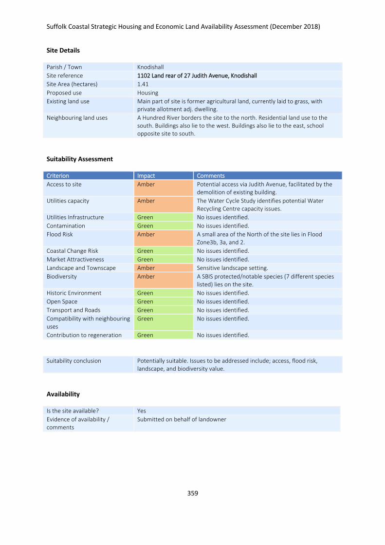
Suffolk Coastal Strategic Housing and Economic Land Availability Assessment (December 2018)
359
Site Details
Parish / Town Knodishall
Site reference 1102 Land rear of 27 Judith Avenue, Knodishall
Site Area (hectares) 1.41
Proposed use Housing
Existing land use Main part of site is former agricultural land, currently laid to grass, with private allotment adj. dwelling.
Neighbouring land uses A Hundred River borders the site to the north. Residential land use to the south. Buildings also lie to the west. Buildings also lie to the east, school opposite site to south.
Suitability Assessment
Criterion Impact Comments
Access to site Amber Potential access via Judith Avenue, facilitated by the demolition of existing building.
Utilities capacity Amber The Water Cycle Study identifies potential Water Recycling Centre capacity issues.
Utilities Infrastructure Green No issues identified.
Contamination Green No issues identified.
Flood Risk Amber A small area of the North of the site lies in Flood Zone3b, 3a, and 2.
Coastal Change Risk Green No issues identified.
Market Attractiveness Green No issues identified.
Landscape and Townscape Amber Sensitive landscape setting.
Biodiversity Amber A SBIS protected/notable species (7 different species listed) lies on the site.
Historic Environment Green No issues identified.
Open Space Green No issues identified.
Transport and Roads Green No issues identified.
Compatibility with neighbouring uses
Green No issues identified.
Contribution to regeneration Green No issues identified.
Suitability conclusion Potentially suitable. Issues to be addressed include; access, flood risk, landscape, and biodiversity value.
Availability
Is the site available? Yes
Evidence of availability / comments
Submitted on behalf of landowner

Suffolk Coastal Strategic Housing and Economic Land Availability Assessment (December 2018)
360
Achievability
Is the site achievable? Yes
Evidence of achievability No specific issues or abnormal costs identified
Are there any commencement issues?
None identified
Estimated dwellings yield 21
Estimated employment land yield (hectares) -
Estimated retail floorspace (sqm) -
Estimated commencement date 2023/24
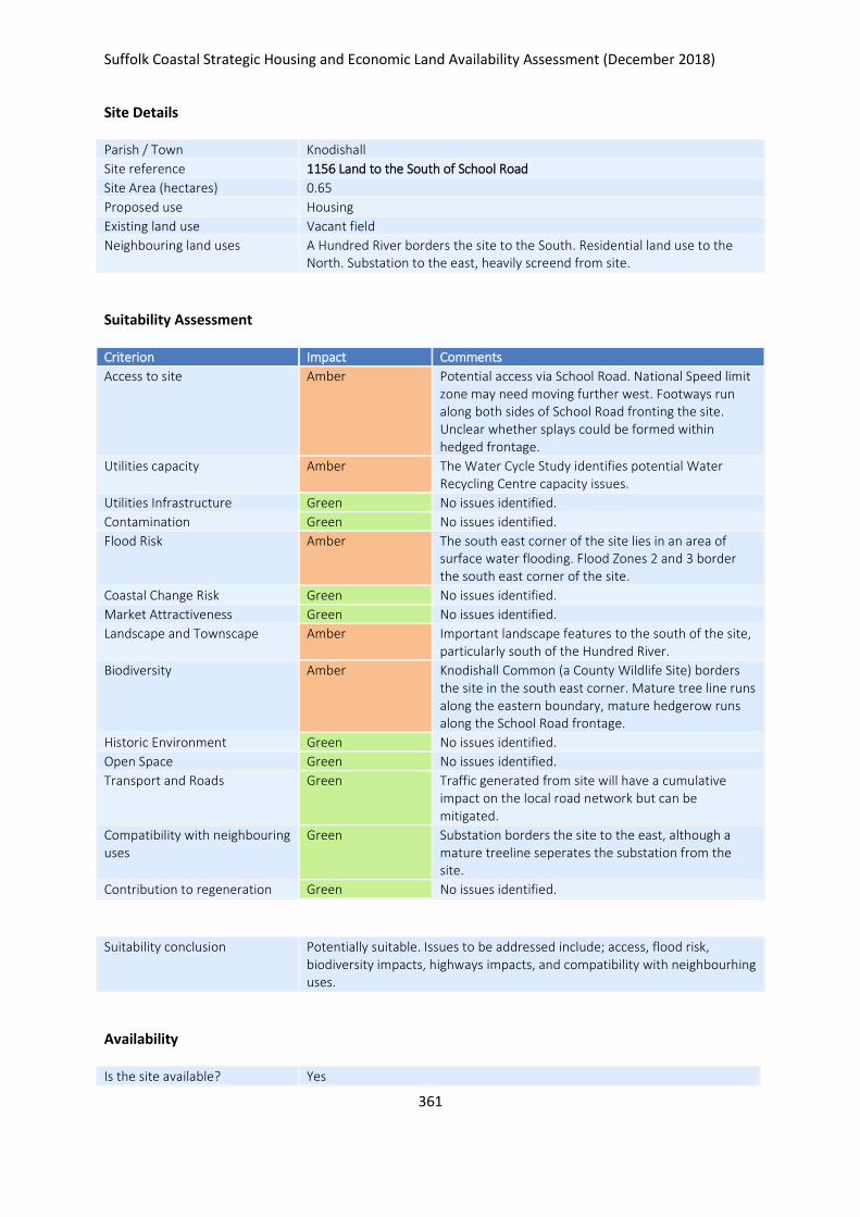
Suffolk Coastal Strategic Housing and Economic Land Availability Assessment (December 2018)
361
Site Details
Parish / Town Knodishall
Site reference 1156 Land to the South of School Road
Site Area (hectares) 0.65
Proposed use Housing
Existing land use Vacant field
Neighbouring land uses A Hundred River borders the site to the South. Residential land use to the North. Substation to the east, heavily screend from site.
Suitability Assessment
Criterion Impact Comments
Access to site Amber Potential access via School Road. National Speed limit zone may need moving further west. Footways run along both sides of School Road fronting the site. Unclear whether splays could be formed within hedged frontage.
Utilities capacity Amber The Water Cycle Study identifies potential Water Recycling Centre capacity issues.
Utilities Infrastructure Green No issues identified.
Contamination Green No issues identified.
Flood Risk Amber The south east corner of the site lies in an area of surface water flooding. Flood Zones 2 and 3 border the south east corner of the site.
Coastal Change Risk Green No issues identified.
Market Attractiveness Green No issues identified.
Landscape and Townscape Amber Important landscape features to the south of the site, particularly south of the Hundred River.
Biodiversity Amber Knodishall Common (a County Wildlife Site) borders the site in the south east corner. Mature tree line runs along the eastern boundary, mature hedgerow runs along the School Road frontage.
Historic Environment Green No issues identified.
Open Space Green No issues identified.
Transport and Roads Green Traffic generated from site will have a cumulative impact on the local road network but can be mitigated.
Compatibility with neighbouring uses
Green Substation borders the site to the east, although a mature treeline seperates the substation from the site.
Contribution to regeneration Green No issues identified.
Suitability conclusion Potentially suitable. Issues to be addressed include; access, flood risk, biodiversity impacts, highways impacts, and compatibility with neighbourhing uses.
Availability
Is the site available? Yes
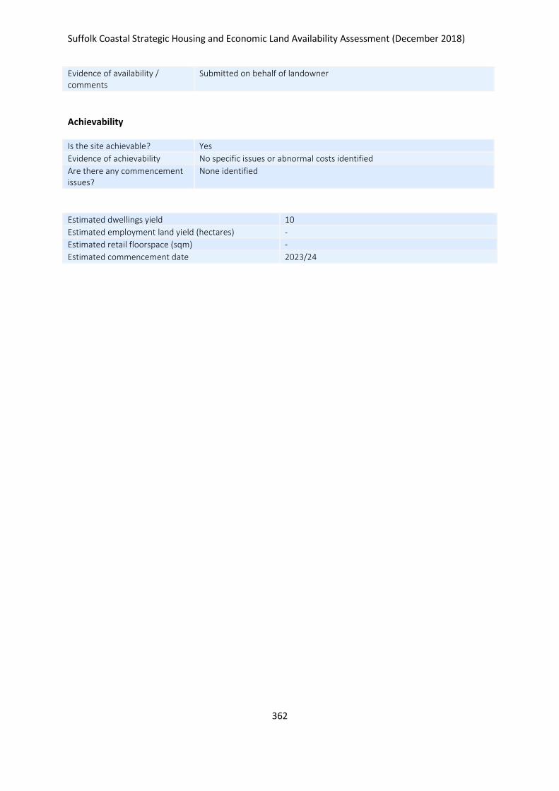
Suffolk Coastal Strategic Housing and Economic Land Availability Assessment (December 2018)
362
Evidence of availability / comments
Submitted on behalf of landowner
Achievability
Is the site achievable? Yes
Evidence of achievability No specific issues or abnormal costs identified
Are there any commencement issues?
None identified
Estimated dwellings yield 10
Estimated employment land yield (hectares) -
Estimated retail floorspace (sqm) -
Estimated commencement date 2023/24
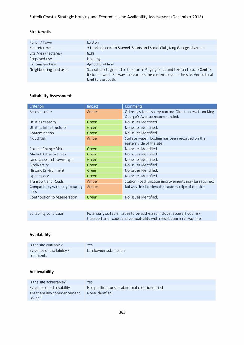
Suffolk Coastal Strategic Housing and Economic Land Availability Assessment (December 2018)
363
Site Details
Parish / Town Leiston
Site reference 3 Land adjacent to Sizewell Sports and Social Club, King Georges Avenue
Site Area (hectares) 8.38
Proposed use Housing
Existing land use Agricultural land
Neighbouring land uses School sports ground to the north. Playing fields and Leiston Leisure Centre lie to the west. Railway line borders the eastern edge of the site. Agricultural land to the south.
Suitability Assessment
Criterion Impact Comments
Access to site Amber Grimsey's Lane is very narrow. Direct access from King George’s Avenue recommended.
Utilities capacity Green No issues identified.
Utilities Infrastructure Green No issues identified.
Contamination Green No issues identified.
Flood Risk Amber Surface water flooding has been recorded on the eastern side of the site.
Coastal Change Risk Green No issues identified.
Market Attractiveness Green No issues identified.
Landscape and Townscape Green No issues identified.
Biodiversity Green No issues identified.
Historic Environment Green No issues identified.
Open Space Green No issues identified.
Transport and Roads Amber Station Road junction improvements may be required.
Compatibility with neighbouring uses
Amber Railway line borders the eastern edge of the site
Contribution to regeneration Green No issues identified.
Suitability conclusion Potentially suitable. Issues to be addressed include; access, flood risk, transport and roads, and compatibility with neighbouring railway line.
Availability
Is the site available? Yes
Evidence of availability / comments
Landowner submission
Achievability
Is the site achievable? Yes
Evidence of achievability No specific issues or abnormal costs identified
Are there any commencement issues?
None identfied

Suffolk Coastal Strategic Housing and Economic Land Availability Assessment (December 2018)
364
Estimated dwellings yield 251
Estimated employment land yield (hectares) -
Estimated retail floorspace (sqm) -
Estimated commencement date 2021/22
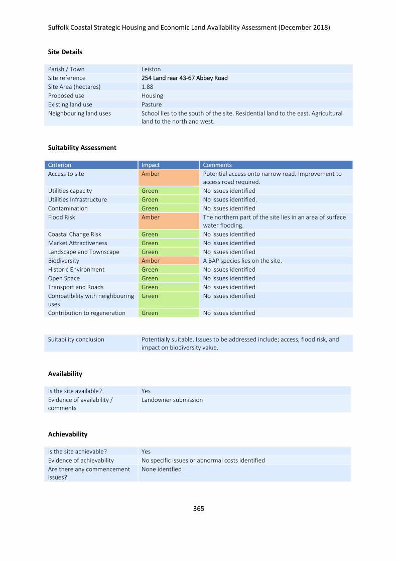
Suffolk Coastal Strategic Housing and Economic Land Availability Assessment (December 2018)
365
Site Details
Parish / Town Leiston
Site reference 254 Land rear 43-67 Abbey Road
Site Area (hectares) 1.88
Proposed use Housing
Existing land use Pasture
Neighbouring land uses School lies to the south of the site. Residential land to the east. Agricultural land to the north and west.
Suitability Assessment
Criterion Impact Comments
Access to site Amber Potential access onto narrow road. Improvement to access road required.
Utilities capacity Green No issues identified
Utilities Infrastructure Green No issues identified.
Contamination Green No issues identified
Flood Risk Amber The northern part of the site lies in an area of surface water flooding.
Coastal Change Risk Green No issues identified
Market Attractiveness Green No issues identified
Landscape and Townscape Green No issues identified
Biodiversity Amber A BAP species lies on the site.
Historic Environment Green No issues identified
Open Space Green No issues identified
Transport and Roads Green No issues identified
Compatibility with neighbouring uses
Green No issues identified
Contribution to regeneration Green No issues identified
Suitability conclusion Potentially suitable. Issues to be addressed include; access, flood risk, and impact on biodiversity value.
Availability
Is the site available? Yes
Evidence of availability / comments
Landowner submission
Achievability
Is the site achievable? Yes
Evidence of achievability No specific issues or abnormal costs identified
Are there any commencement issues?
None identfied

Suffolk Coastal Strategic Housing and Economic Land Availability Assessment (December 2018)
366
Estimated dwellings yield 56
Estimated employment land yield (hectares) -
Estimated retail floorspace (sqm) -
Estimated commencement date 2022/23
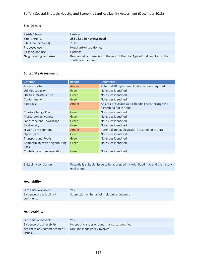
Suffolk Coastal Strategic Housing and Economic Land Availability Assessment (December 2018)
367
Site Details
Parish / Town Leiston
Site reference 255 132-136 Haylings Road
Site Area (hectares) 2.88
Proposed use Housing/Holiday Homes
Existing land use Gardens
Neighbouring land uses Residential land use lies to the east of the site. Agricultural land lies to the south, west and north.
Suitability Assessment
Criterion Impact Comments
Access to site Amber Potential 30 mph speed limit extension required.
Utilities capacity Green No issues identified
Utilities Infrastructure Green No issues identified
Contamination Green No issues identified
Flood Risk Amber An area of surface water flooding runs through the eastern half of the site.
Coastal Change Risk Green No issues identified
Market Attractiveness Green No issues identified
Landscape and Townscape Green No issues identified
Biodiversity Green No issues identified
Historic Environment Amber Potential archaeological site located on the site.
Open Space Green No issues identified
Transport and Roads Green No issues identified
Compatibility with neighbouring uses
Green No issues identified
Contribution to regeneration Green No issues identified
Suitability conclusion Potentially suitable. Issue to be addressed include; flood risk, and the historic environment.
Availability
Is the site available? Yes
Evidence of availability / comments
Submission on behalf of multiple landowners
Achievability
Is the site achievable? Yes
Evidence of achievability No specific issues or abnormal costs identified
Are there any commencement issues?
Multiple landowners involved

Suffolk Coastal Strategic Housing and Economic Land Availability Assessment (December 2018)
368
Estimated dwellings yield 69
Estimated employment land yield (hectares) -
Estimated retail floorspace (sqm) -
Estimated commencement date 2023/24
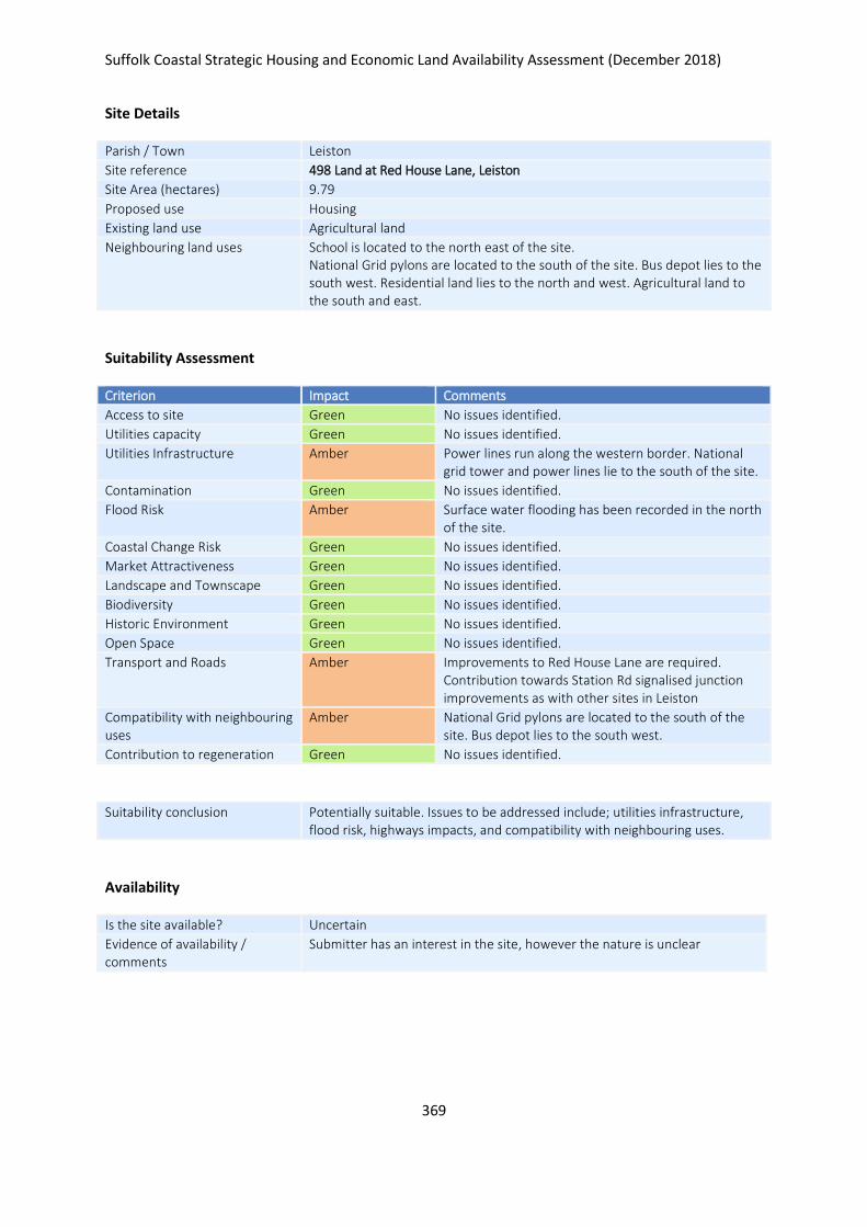
Suffolk Coastal Strategic Housing and Economic Land Availability Assessment (December 2018)
369
Site Details
Parish / Town Leiston
Site reference 498 Land at Red House Lane, Leiston
Site Area (hectares) 9.79
Proposed use Housing
Existing land use Agricultural land
Neighbouring land uses School is located to the north east of the site. National Grid pylons are located to the south of the site. Bus depot lies to the south west. Residential land lies to the north and west. Agricultural land to the south and east.
Suitability Assessment
Criterion Impact Comments
Access to site Green No issues identified.
Utilities capacity Green No issues identified.
Utilities Infrastructure Amber Power lines run along the western border. National grid tower and power lines lie to the south of the site.
Contamination Green No issues identified.
Flood Risk Amber Surface water flooding has been recorded in the north of the site.
Coastal Change Risk Green No issues identified.
Market Attractiveness Green No issues identified.
Landscape and Townscape Green No issues identified.
Biodiversity Green No issues identified.
Historic Environment Green No issues identified.
Open Space Green No issues identified.
Transport and Roads Amber Improvements to Red House Lane are required. Contribution towards Station Rd signalised junction improvements as with other sites in Leiston
Compatibility with neighbouring uses
Amber National Grid pylons are located to the south of the site. Bus depot lies to the south west.
Contribution to regeneration Green No issues identified.
Suitability conclusion Potentially suitable. Issues to be addressed include; utilities infrastructure, flood risk, highways impacts, and compatibility with neighbouring uses.
Availability
Is the site available? Uncertain
Evidence of availability / comments
Submitter has an interest in the site, however the nature is unclear
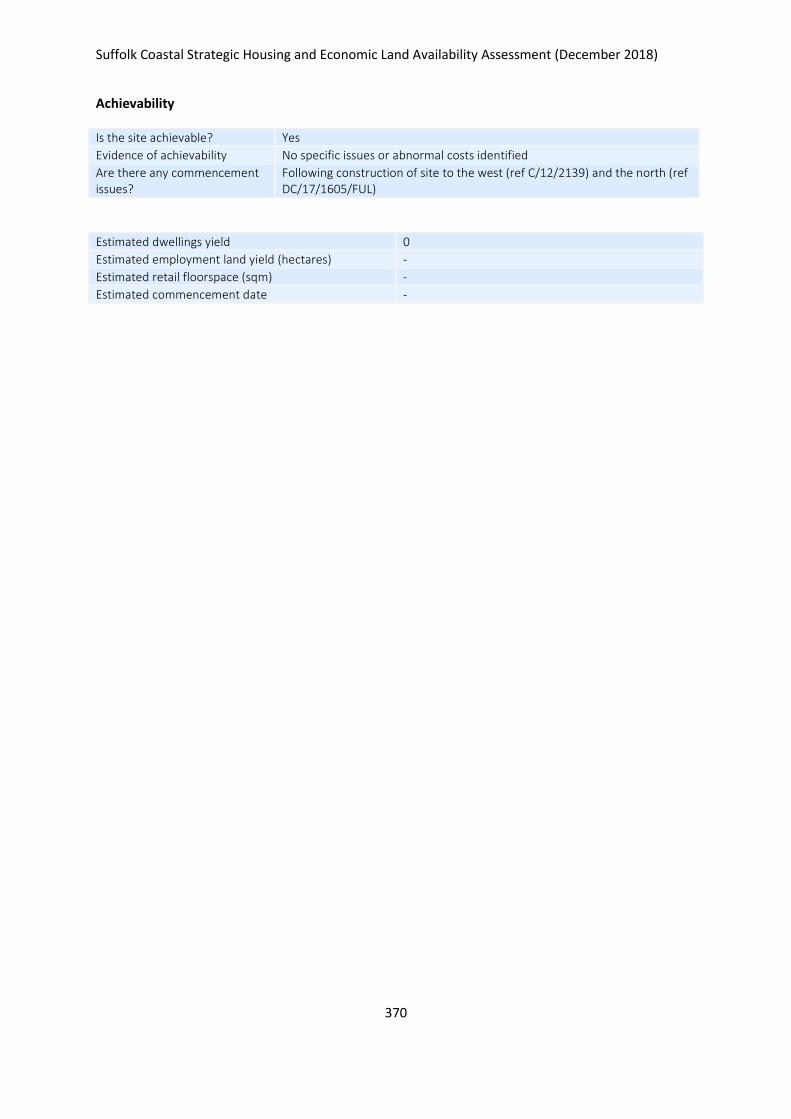
Suffolk Coastal Strategic Housing and Economic Land Availability Assessment (December 2018)
370
Achievability
Is the site achievable? Yes
Evidence of achievability No specific issues or abnormal costs identified
Are there any commencement issues?
Following construction of site to the west (ref C/12/2139) and the north (ref DC/17/1605/FUL)
Estimated dwellings yield 0
Estimated employment land yield (hectares) -
Estimated retail floorspace (sqm) -
Estimated commencement date -
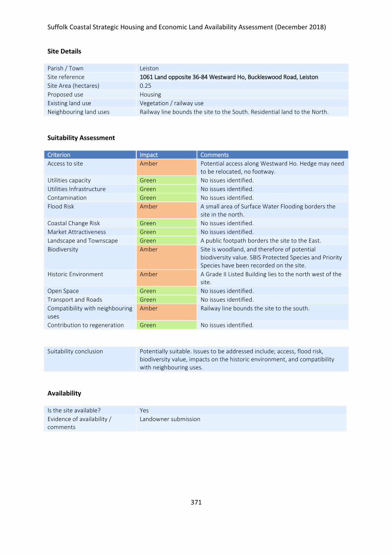
Suffolk Coastal Strategic Housing and Economic Land Availability Assessment (December 2018)
371
Site Details
Parish / Town Leiston
Site reference 1061 Land opposite 36-84 Westward Ho, Buckleswood Road, Leiston
Site Area (hectares) 0.25
Proposed use Housing
Existing land use Vegetation / railway use
Neighbouring land uses Railway line bounds the site to the South. Residential land to the North.
Suitability Assessment
Criterion Impact Comments
Access to site Amber Potential access along Westward Ho. Hedge may need to be relocated, no footway.
Utilities capacity Green No issues identified.
Utilities Infrastructure Green No issues identified.
Contamination Green No issues identified.
Flood Risk Amber A small area of Surface Water Flooding borders the site in the north.
Coastal Change Risk Green No issues identified.
Market Attractiveness Green No issues identified.
Landscape and Townscape Green A public footpath borders the site to the East.
Biodiversity Amber Site is woodland, and therefore of potential biodiversity value. SBIS Protected Species and Priority Species have been recorded on the site.
Historic Environment Amber A Grade II Listed Building lies to the north west of the site.
Open Space Green No issues identified.
Transport and Roads Green No issues identified.
Compatibility with neighbouring uses
Amber Railway line bounds the site to the south.
Contribution to regeneration Green No issues identified.
Suitability conclusion Potentially suitable. Issues to be addressed include; access, flood risk, biodiversity value, impacts on the historic environment, and compatibility with neighbouring uses.
Availability
Is the site available? Yes
Evidence of availability / comments
Landowner submission

Suffolk Coastal Strategic Housing and Economic Land Availability Assessment (December 2018)
372
Achievability
Is the site achievable? Yes
Evidence of achievability No specific issues or abnormal costs identified
Are there any commencement issues?
None identified
Estimated dwellings yield 7
Estimated employment land yield (hectares) -
Estimated retail floorspace (sqm) -
Estimated commencement date 2022/23
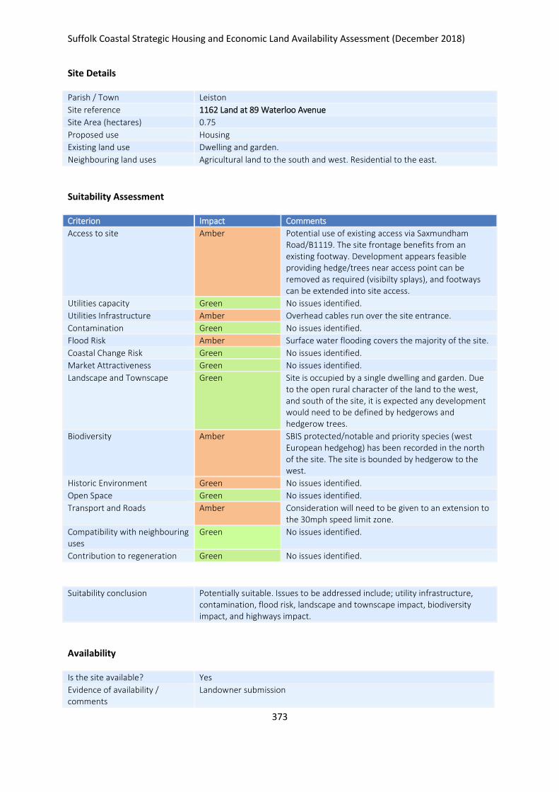
Suffolk Coastal Strategic Housing and Economic Land Availability Assessment (December 2018)
373
Site Details
Parish / Town Leiston
Site reference 1162 Land at 89 Waterloo Avenue
Site Area (hectares) 0.75
Proposed use Housing
Existing land use Dwelling and garden.
Neighbouring land uses Agricultural land to the south and west. Residential to the east.
Suitability Assessment
Criterion Impact Comments
Access to site Amber Potential use of existing access via Saxmundham Road/B1119. The site frontage benefits from an existing footway. Development appears feasible providing hedge/trees near access point can be removed as required (visibilty splays), and footways can be extended into site access.
Utilities capacity Green No issues identified.
Utilities Infrastructure Amber Overhead cables run over the site entrance.
Contamination Green No issues identified.
Flood Risk Amber Surface water flooding covers the majority of the site.
Coastal Change Risk Green No issues identified.
Market Attractiveness Green No issues identified.
Landscape and Townscape Green Site is occupied by a single dwelling and garden. Due to the open rural character of the land to the west, and south of the site, it is expected any development would need to be defined by hedgerows and hedgerow trees.
Biodiversity Amber SBIS protected/notable and priority species (west European hedgehog) has been recorded in the north of the site. The site is bounded by hedgerow to the west.
Historic Environment Green No issues identified.
Open Space Green No issues identified.
Transport and Roads Amber Consideration will need to be given to an extension to the 30mph speed limit zone.
Compatibility with neighbouring uses
Green No issues identified.
Contribution to regeneration Green No issues identified.
Suitability conclusion Potentially suitable. Issues to be addressed include; utility infrastructure, contamination, flood risk, landscape and townscape impact, biodiversity impact, and highways impact.
Availability
Is the site available? Yes
Evidence of availability / comments
Landowner submission
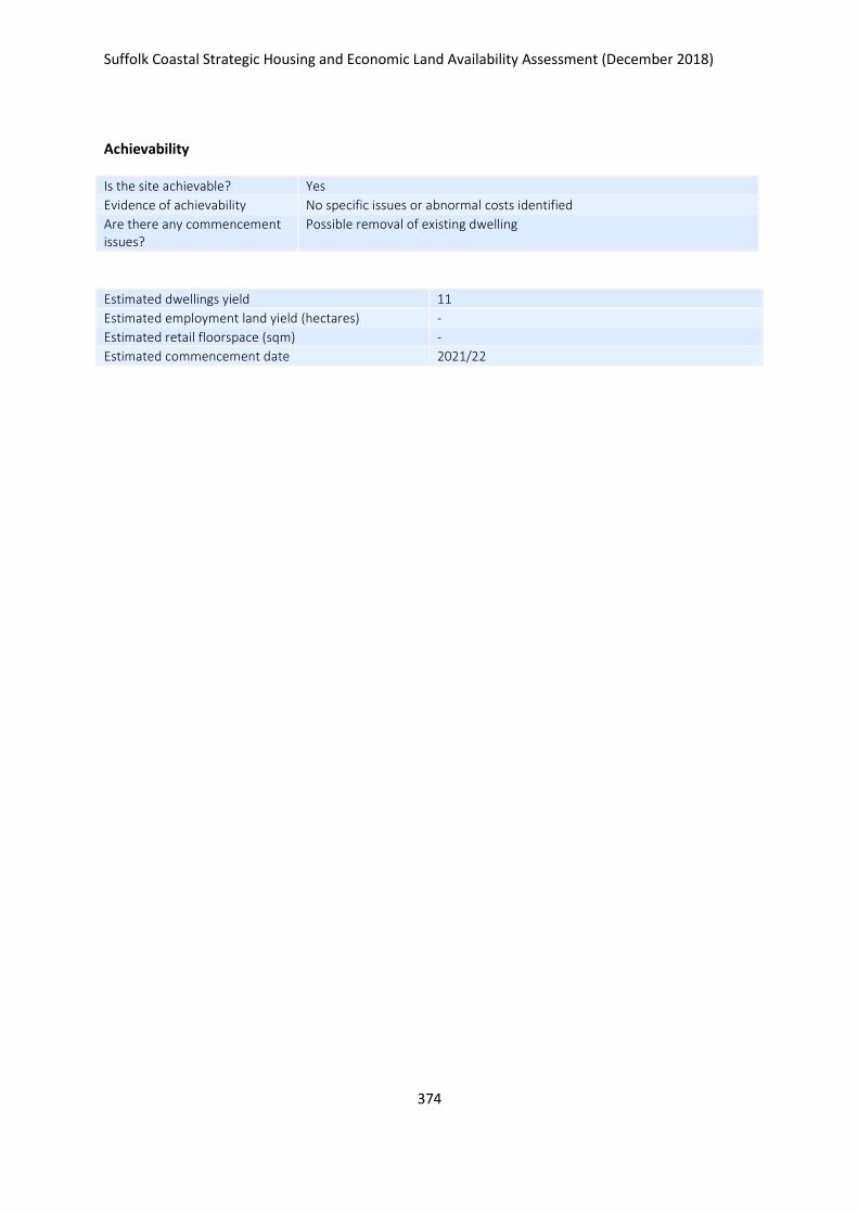
Suffolk Coastal Strategic Housing and Economic Land Availability Assessment (December 2018)
374
Achievability
Is the site achievable? Yes
Evidence of achievability No specific issues or abnormal costs identified
Are there any commencement issues?
Possible removal of existing dwelling
Estimated dwellings yield 11
Estimated employment land yield (hectares) -
Estimated retail floorspace (sqm) -
Estimated commencement date 2021/22
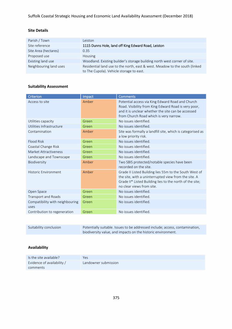
Suffolk Coastal Strategic Housing and Economic Land Availability Assessment (December 2018)
375
Site Details
Parish / Town Leiston
Site reference 1115 Dunns Hole, land off King Edward Road, Leiston
Site Area (hectares) 0.35
Proposed use Housing
Existing land use Woodland. Existing builder’s storage building north west corner of site.
Neighbouring land uses Residential land use to the north, east & west. Meadow to the south (linked to The Cupola). Vehicle storage to east.
Suitability Assessment
Criterion Impact Comments
Access to site Amber Potential access via King Edward Road and Church Road. Visibility from King Edward Road is very poor, and it is unclear whether the site can be accessed from Church Road which is very narrow.
Utilities capacity Green No issues identified.
Utilities Infrastructure Green No issues identified.
Contamination Amber Site was formally a landfill site, which is categorised as a low priority risk.
Flood Risk Green No issues identified.
Coastal Change Risk Green No issues identified.
Market Attractiveness Green No issues identified.
Landscape and Townscape Green No issues identified.
Biodiversity Amber Two SBIS protected/notable species have been recorded on the site.
Historic Environment Amber Grade II Listed Building lies 55m to the South West of the site, with a uninterrupted view from the site. A Grade II* Listed Building lies to the north of the site; no clear views from site.
Open Space Green No issues identified.
Transport and Roads Green No issues identified.
Compatibility with neighbouring uses
Green No issues identified.
Contribution to regeneration Green No issues identified.
Suitability conclusion Potentially suitable. Issues to be addressed include; access, contamination, biodiversity value, and impacts on the historic environment.
Availability
Is the site available? Yes
Evidence of availability / comments
Landowner submission

Suffolk Coastal Strategic Housing and Economic Land Availability Assessment (December 2018)
376
Achievability
Is the site achievable? Yes
Evidence of achievability Assumed, subject to possoble contamination issues
Are there any commencement issues?
Possible contamination
Estimated dwellings yield 11
Estimated employment land yield (hectares) -
Estimated retail floorspace (sqm) -
Estimated commencement date 2026/27
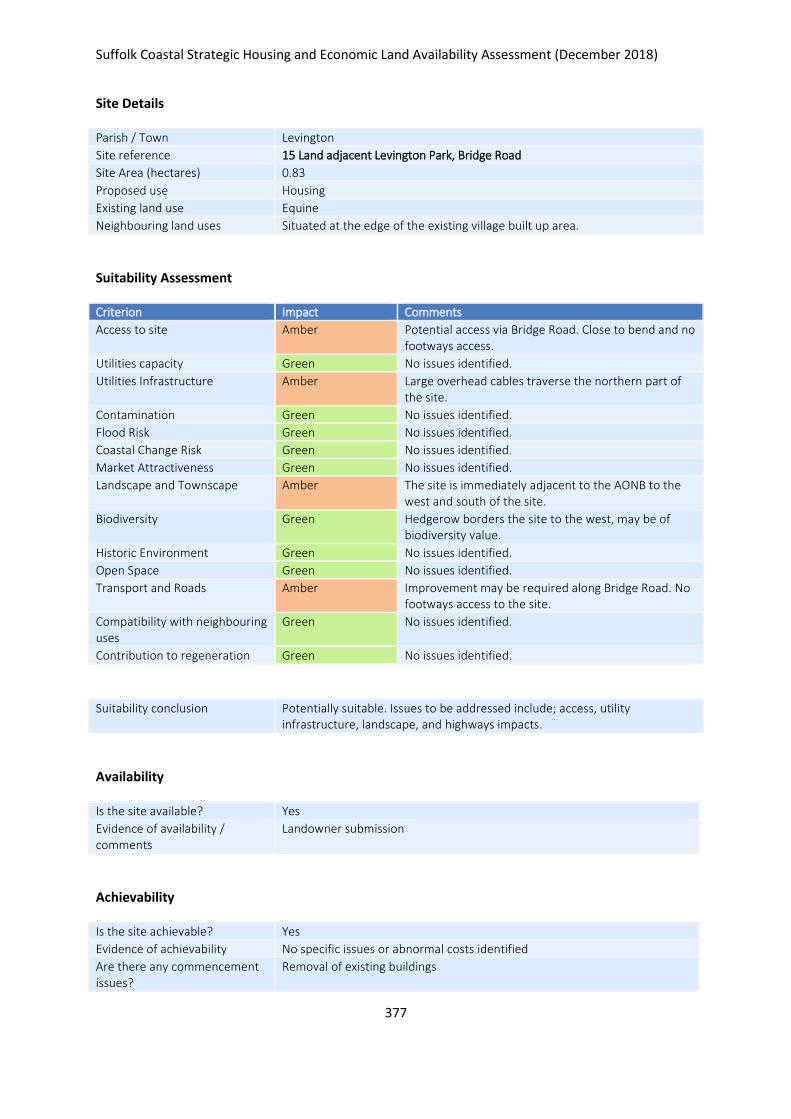
Suffolk Coastal Strategic Housing and Economic Land Availability Assessment (December 2018)
377
Site Details
Parish / Town Levington
Site reference 15 Land adjacent Levington Park, Bridge Road
Site Area (hectares) 0.83
Proposed use Housing
Existing land use Equine
Neighbouring land uses Situated at the edge of the existing village built up area.
Suitability Assessment
Criterion Impact Comments
Access to site Amber Potential access via Bridge Road. Close to bend and no footways access.
Utilities capacity Green No issues identified.
Utilities Infrastructure Amber Large overhead cables traverse the northern part of the site.
Contamination Green No issues identified.
Flood Risk Green No issues identified.
Coastal Change Risk Green No issues identified.
Market Attractiveness Green No issues identified.
Landscape and Townscape Amber The site is immediately adjacent to the AONB to the west and south of the site.
Biodiversity Green Hedgerow borders the site to the west, may be of biodiversity value.
Historic Environment Green No issues identified.
Open Space Green No issues identified.
Transport and Roads Amber Improvement may be required along Bridge Road. No footways access to the site.
Compatibility with neighbouring uses
Green No issues identified.
Contribution to regeneration Green No issues identified.
Suitability conclusion Potentially suitable. Issues to be addressed include; access, utility infrastructure, landscape, and highways impacts.
Availability
Is the site available? Yes
Evidence of availability / comments
Landowner submission
Achievability
Is the site achievable? Yes
Evidence of achievability No specific issues or abnormal costs identified
Are there any commencement issues?
Removal of existing buildings

Suffolk Coastal Strategic Housing and Economic Land Availability Assessment (December 2018)
378
Estimated dwellings yield 17
Estimated employment land yield (hectares) -
Estimated retail floorspace (sqm) -
Estimated commencement date 2023/24
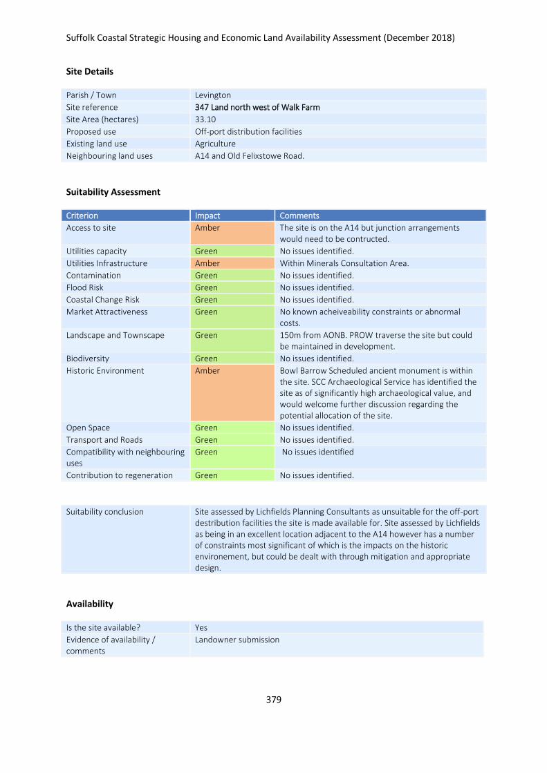
Suffolk Coastal Strategic Housing and Economic Land Availability Assessment (December 2018)
379
Site Details
Parish / Town Levington
Site reference 347 Land north west of Walk Farm
Site Area (hectares) 33.10
Proposed use Off-port distribution facilities
Existing land use Agriculture
Neighbouring land uses A14 and Old Felixstowe Road.
Suitability Assessment
Criterion Impact Comments
Access to site Amber The site is on the A14 but junction arrangements would need to be contructed.
Utilities capacity Green No issues identified.
Utilities Infrastructure Amber Within Minerals Consultation Area.
Contamination Green No issues identified.
Flood Risk Green No issues identified.
Coastal Change Risk Green No issues identified.
Market Attractiveness Green No known acheiveability constraints or abnormal costs.
Landscape and Townscape Green 150m from AONB. PROW traverse the site but could be maintained in development.
Biodiversity Green No issues identified.
Historic Environment Amber Bowl Barrow Scheduled ancient monument is within the site. SCC Archaeological Service has identified the site as of significantly high archaeological value, and would welcome further discussion regarding the potential allocation of the site.
Open Space Green No issues identified.
Transport and Roads Green No issues identified.
Compatibility with neighbouring uses
Green No issues identified
Contribution to regeneration Green No issues identified.
Suitability conclusion Site assessed by Lichfields Planning Consultants as unsuitable for the off-port destribution facilities the site is made available for. Site assessed by Lichfields as being in an excellent location adjacent to the A14 however has a number of constraints most significant of which is the impacts on the historic environement, but could be dealt with through mitigation and appropriate design.
Availability
Is the site available? Yes
Evidence of availability / comments
Landowner submission

Suffolk Coastal Strategic Housing and Economic Land Availability Assessment (December 2018)
380
Achievability
Is the site achievable? Yes
Evidence of achievability No specific issues or abnormal costs identified
Are there any commencement issues?
None identified
Estimated dwellings yield -
Estimated employment land yield (hectares) 33
Estimated retail floorspace (sqm) -
Estimated commencement date 2023/24
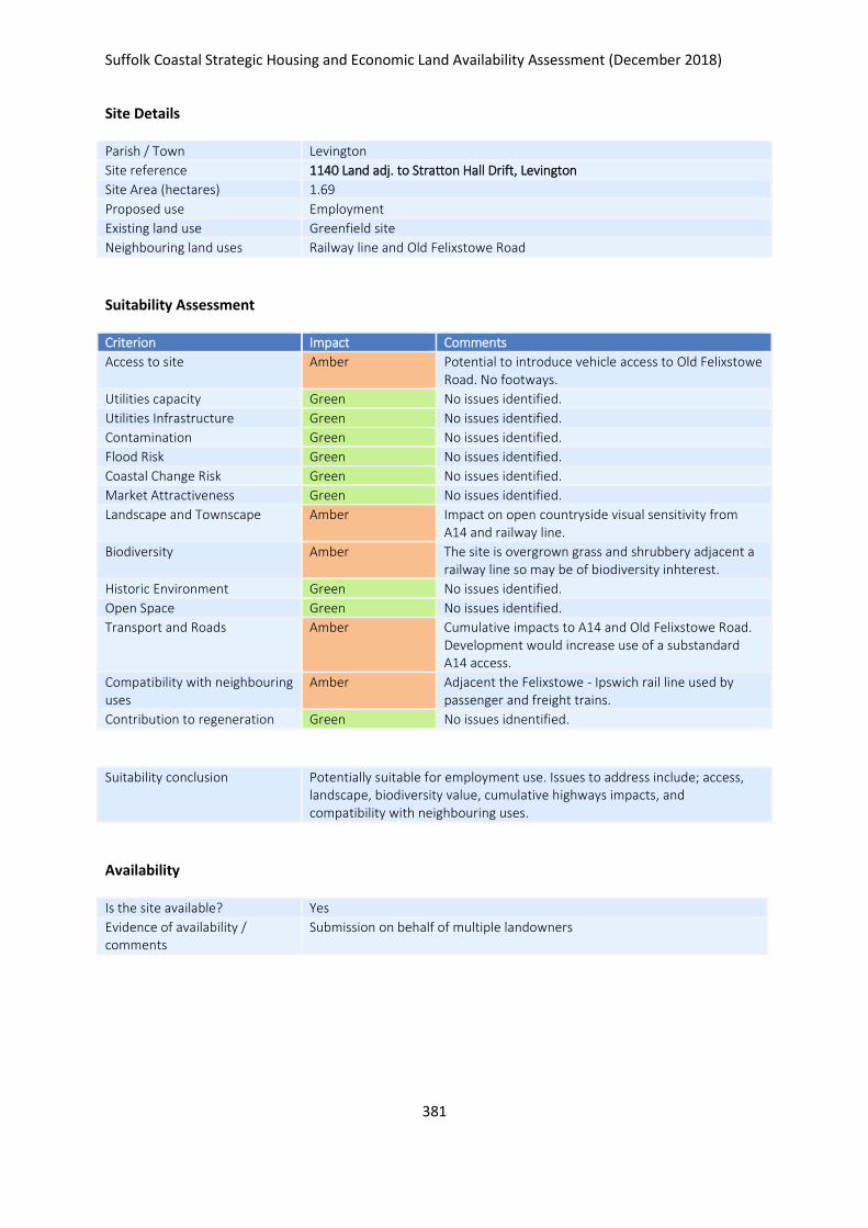
Suffolk Coastal Strategic Housing and Economic Land Availability Assessment (December 2018)
381
Site Details
Parish / Town Levington
Site reference 1140 Land adj. to Stratton Hall Drift, Levington
Site Area (hectares) 1.69
Proposed use Employment
Existing land use Greenfield site
Neighbouring land uses Railway line and Old Felixstowe Road
Suitability Assessment
Criterion Impact Comments
Access to site Amber Potential to introduce vehicle access to Old Felixstowe Road. No footways.
Utilities capacity Green No issues identified.
Utilities Infrastructure Green No issues identified.
Contamination Green No issues identified.
Flood Risk Green No issues identified.
Coastal Change Risk Green No issues identified.
Market Attractiveness Green No issues identified.
Landscape and Townscape Amber Impact on open countryside visual sensitivity from A14 and railway line.
Biodiversity Amber The site is overgrown grass and shrubbery adjacent a railway line so may be of biodiversity inhterest.
Historic Environment Green No issues identified.
Open Space Green No issues identified.
Transport and Roads Amber Cumulative impacts to A14 and Old Felixstowe Road. Development would increase use of a substandard A14 access.
Compatibility with neighbouring uses
Amber Adjacent the Felixstowe - Ipswich rail line used by passenger and freight trains.
Contribution to regeneration Green No issues idnentified.
Suitability conclusion Potentially suitable for employment use. Issues to address include; access, landscape, biodiversity value, cumulative highways impacts, and compatibility with neighbouring uses.
Availability
Is the site available? Yes
Evidence of availability / comments
Submission on behalf of multiple landowners

Suffolk Coastal Strategic Housing and Economic Land Availability Assessment (December 2018)
382
Achievability
Is the site achievable? Yes
Evidence of achievability No specific issues or abnormal costs identified
Are there any commencement issues?
None identified
Estimated dwellings yield -
Estimated employment land yield (hectares) 2
Estimated retail floorspace (sqm) -
Estimated commencement date 2023/24
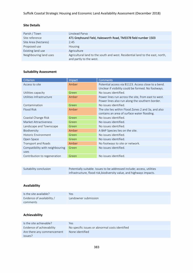
Suffolk Coastal Strategic Housing and Economic Land Availability Assessment (December 2018)
383
Site Details
Parish / Town Linstead Parva
Site reference 471 Greyhound Field, Halesworth Road, TM3378 field number 1503
Site Area (hectares) 2.45
Proposed use Housing
Existing land use Agriculture
Neighbouring land uses Agricultural land to the south and west. Residential land to the east, north, and partly to the west.
Suitability Assessment
Criterion Impact Comments
Access to site Amber Potential access via B1123. Access close to a bend. Unclear if visibility could be formed. No footways.
Utilities capacity Green No issues identified.
Utilities Infrastructure Amber Power lines run across the site, from east to west. Power lines also run along the southern border.
Contamination Green No issues identified.
Flood Risk Amber The site lies within Flood Zones 2 and 3a, and also contains an area of surface water flooding.
Coastal Change Risk Green No issues identified.
Market Attractiveness Green No issues identified.
Landscape and Townscape Green No issues identified.
Biodiversity Amber A BAP Species lies on the site.
Historic Environment Green No issues identified.
Open Space Green No issues identified.
Transport and Roads Amber No footways to site or network.
Compatibility with neighbouring uses
Green No issues identified.
Contribution to regeneration Green No issues identified.
Suitability conclusion Potentially suitable. Issues to be addressed include; access, utilities infrastructure, flood risk,biodiversity value, and highways impacts.
Availability
Is the site available? Yes
Evidence of availability / comments
Landowner submission
Achievability
Is the site achievable? Yes
Evidence of achievability No specific issues or abnormal costs identified
Are there any commencement issues?
None identified

Suffolk Coastal Strategic Housing and Economic Land Availability Assessment (December 2018)
384
Estimated dwellings yield 37
Estimated employment land yield (hectares) -
Estimated retail floorspace (sqm) -
Estimated commencement date 2021/22
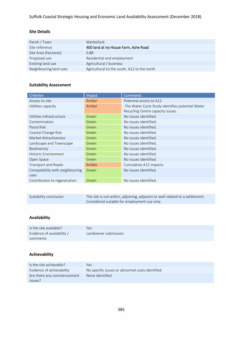
Suffolk Coastal Strategic Housing and Economic Land Availability Assessment (December 2018)
385
Site Details
Parish / Town Marlesford
Site reference 400 land at Ivy House Farm, Ashe Road
Site Area (hectares) 0.88
Proposed use Residential and employment
Existing land use Agricultural / business
Neighbouring land uses Agricultural to the south, A12 to the north
Suitability Assessment
Criterion Impact Comments
Access to site Amber Potential access to A12.
Utilities capacity Amber The Water Cycle Study identifies potential Water Recycling Centre capacity issues.
Utilities Infrastructure Green No issues identified.
Contamination Green No issues identified.
Flood Risk Green No issues identified.
Coastal Change Risk Green No issues identified.
Market Attractiveness Green No issues identified.
Landscape and Townscape Green No issues identified.
Biodiversity Green No issues identified.
Historic Environment Green No issues identified.
Open Space Green No issues identified.
Transport and Roads Amber Cumulative A12 impacts.
Compatibility with neighbouring uses
Green No issues identified.
Contribution to regeneration Green No issues identified.
Suitability conclusion The site is not within, adjoining, adjacent or well related to a settlement. Considered suitable for employment use only.
Availability
Is the site available? Yes
Evidence of availability / comments
Landowner submission
Achievability
Is the site achievable? Yes
Evidence of achievability No specific issues or abnormal costs identified
Are there any commencement issues?
None identified

Suffolk Coastal Strategic Housing and Economic Land Availability Assessment (December 2018)
386
Estimated dwellings yield -
Estimated employment land yield (hectares) 1
Estimated retail floorspace (sqm) -
Estimated commencement date 2020/21
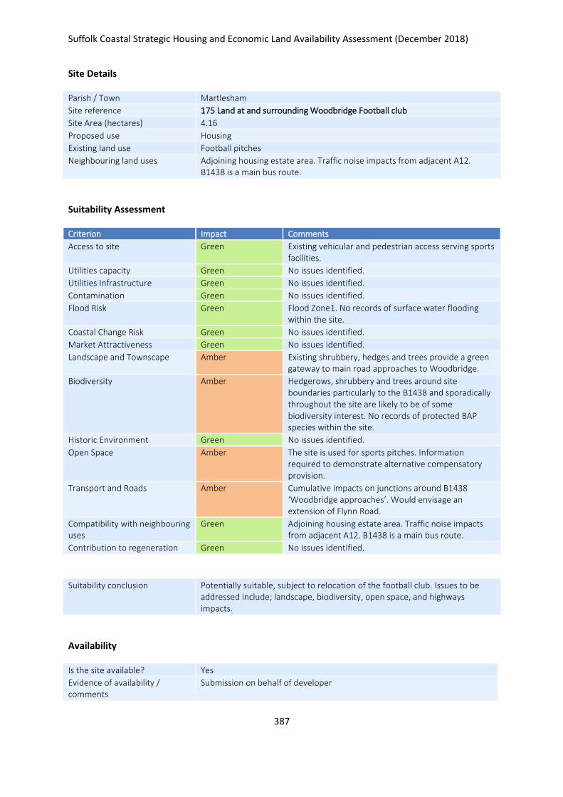
Suffolk Coastal Strategic Housing and Economic Land Availability Assessment (December 2018)
387
Site Details
Parish / Town Martlesham
Site reference 175 Land at and surrounding Woodbridge Football club
Site Area (hectares) 4.16
Proposed use Housing
Existing land use Football pitches
Neighbouring land uses Adjoining housing estate area. Traffic noise impacts from adjacent A12. B1438 is a main bus route.
Suitability Assessment
Criterion Impact Comments
Access to site Green Existing vehicular and pedestrian access serving sports facilities.
Utilities capacity Green No issues identified.
Utilities Infrastructure Green No issues identified.
Contamination Green No issues identified.
Flood Risk Green Flood Zone1. No records of surface water flooding within the site.
Coastal Change Risk Green No issues identified.
Market Attractiveness Green No issues identified.
Landscape and Townscape Amber Existing shrubbery, hedges and trees provide a green gateway to main road approaches to Woodbridge.
Biodiversity Amber Hedgerows, shrubbery and trees around site boundaries particularly to the B1438 and sporadically throughout the site are likely to be of some biodiversity interest. No records of protected BAP species within the site.
Historic Environment Green No issues identified.
Open Space Amber The site is used for sports pitches. Information required to demonstrate alternative compensatory provision.
Transport and Roads Amber Cumulative impacts on junctions around B1438 ‘Woodbridge approaches’. Would envisage an extension of Flynn Road.
Compatibility with neighbouring uses
Green Adjoining housing estate area. Traffic noise impacts from adjacent A12. B1438 is a main bus route.
Contribution to regeneration Green No issues identified.
Suitability conclusion Potentially suitable, subject to relocation of the football club. Issues to be addressed include; landscape, biodiversity, open space, and highways impacts.
Availability
Is the site available? Yes
Evidence of availability / comments
Submission on behalf of developer

Suffolk Coastal Strategic Housing and Economic Land Availability Assessment (December 2018)
388
Achievability
Is the site achievable? Yes
Evidence of achievability Assumed - would involve relocation of football club
Are there any commencement issues?
Relocation of football club
Estimated dwellings yield 125
Estimated employment land yield (hectares) -
Estimated retail floorspace (sqm) -
Estimated commencement date 2024/25
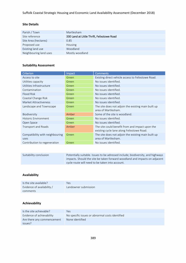
Suffolk Coastal Strategic Housing and Economic Land Availability Assessment (December 2018)
389
Site Details
Parish / Town Martlesham
Site reference 330 Land at Little Thrift, Felixstowe Road
Site Area (hectares) 0.85
Proposed use Housing
Existing land use Woodland
Neighbouring land uses Mostly woodland
Suitability Assessment
Criterion Impact Comments
Access to site Green Existing direct vehicle access to Felixstowe Road.
Utilities capacity Green No issues identified.
Utilities Infrastructure Green No issues identified.
Contamination Green No issues identified.
Flood Risk Green No issues identified.
Coastal Change Risk Green No issues identified.
Market Attractiveness Green No issues identified.
Landscape and Townscape Green The site does not adjoin the existing main built up area of Martlesham.
Biodiversity Amber Some of the site is woodland.
Historic Environment Green No issues identified.
Open Space Green No issues identified.
Transport and Roads Amber The site could benefit from and impact upon the existing cycle lane along Felixstowe Road.
Compatibility with neighbouring uses
Green The site does not adjoin the existing main built up area of Martlesham.
Contribution to regeneration Green No issues identified.
Suitability conclusion Potentially suitable. Issues to be adressed include; biodiversity, and highways impacts. Should the site be taken forward woodland and impacts on adjacent cycle route will need to be taken into account.
Availability
Is the site available? Yes
Evidence of availability / comments
Landowner submission
Achievability
Is the site achievable? Yes
Evidence of achievability No specific issues or abnormal costs identified
Are there any commencement issues?
None identified

Suffolk Coastal Strategic Housing and Economic Land Availability Assessment (December 2018)
390
Estimated dwellings yield 21
Estimated employment land yield (hectares) -
Estimated retail floorspace (sqm) -
Estimated commencement date 2023/24
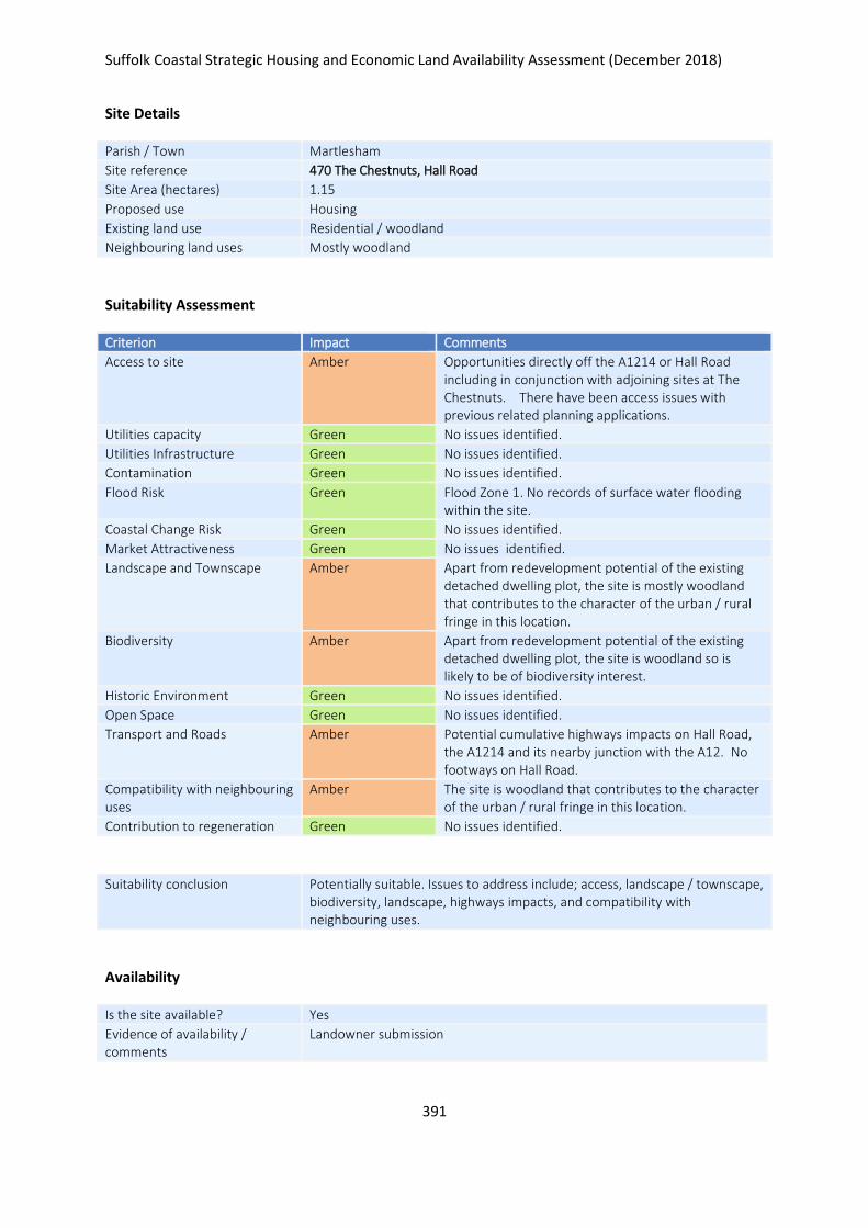
Suffolk Coastal Strategic Housing and Economic Land Availability Assessment (December 2018)
391
Site Details
Parish / Town Martlesham
Site reference 470 The Chestnuts, Hall Road
Site Area (hectares) 1.15
Proposed use Housing
Existing land use Residential / woodland
Neighbouring land uses Mostly woodland
Suitability Assessment
Criterion Impact Comments
Access to site Amber Opportunities directly off the A1214 or Hall Road including in conjunction with adjoining sites at The Chestnuts. There have been access issues with previous related planning applications.
Utilities capacity Green No issues identified.
Utilities Infrastructure Green No issues identified.
Contamination Green No issues identified.
Flood Risk Green Flood Zone 1. No records of surface water flooding within the site.
Coastal Change Risk Green No issues identified.
Market Attractiveness Green No issues identified.
Landscape and Townscape Amber Apart from redevelopment potential of the existing detached dwelling plot, the site is mostly woodland that contributes to the character of the urban / rural fringe in this location.
Biodiversity Amber Apart from redevelopment potential of the existing detached dwelling plot, the site is woodland so is likely to be of biodiversity interest.
Historic Environment Green No issues identified.
Open Space Green No issues identified.
Transport and Roads Amber Potential cumulative highways impacts on Hall Road, the A1214 and its nearby junction with the A12. No footways on Hall Road.
Compatibility with neighbouring uses
Amber The site is woodland that contributes to the character of the urban / rural fringe in this location.
Contribution to regeneration Green No issues identified.
Suitability conclusion Potentially suitable. Issues to address include; access, landscape / townscape, biodiversity, landscape, highways impacts, and compatibility with neighbouring uses.
Availability
Is the site available? Yes
Evidence of availability / comments
Landowner submission

Suffolk Coastal Strategic Housing and Economic Land Availability Assessment (December 2018)
392
Achievability
Is the site achievable? Yes
Evidence of achievability No specific issues or abnormal costs identified
Are there any commencement issues?
None identified
Estimated dwellings yield 29
Estimated employment land yield (hectares) -
Estimated retail floorspace (sqm) -
Estimated commencement date 2021/22

Suffolk Coastal Strategic Housing and Economic Land Availability Assessment (December 2018)
393
Site Details
Parish / Town Martlesham
Site reference 533 Land East of Felixstowe road, Martlesham
Site Area (hectares) 16.66
Proposed use Housing
Existing land use Agriculture
Neighbouring land uses Urban – rural fringe
Suitability Assessment
Criterion Impact Comments
Access to site Amber Potential for vehicle access from Felixstowe Road, Waldringfield Road and narrow Three Stiles Lane that all bound the site.
Utilities capacity Green No issues identified.
Utilities Infrastructure Green No issues identified.
Contamination Green No issues identified.
Flood Risk Green No issues identified.
Coastal Change Risk Green No issues identified.
Market Attractiveness Green No issues identified.
Landscape and Townscape Amber Urban – rural fringe situation in relation to extending the Martlesham urban area towards protected estuaries. Hedgerows traverse the site as field boundaries.
Biodiversity Green Agricultural fields bounded by hedges, trees and shrubbery. Hedgerows traverse the site as field boundaries.
Historic Environment Green No issues identified.
Open Space Green No issues identified.
Transport and Roads Amber Cumulative impacts to local highways including the cycle route along Felixstowe Road. Footways and potentially widening of Felixstowe road required.
Compatibility with neighbouring uses
Amber Urban – rural fringe situation in relation to extending the Martlesham urban area towards protected estuaries.
Contribution to regeneration Green No issues identified.
Suitability conclusion Potentially suitable. Issues to be addressed include; access, landscape / townscape, and highways impacts.
Availability
Is the site available? Yes
Evidence of availability / comments
Landowner submission

Suffolk Coastal Strategic Housing and Economic Land Availability Assessment (December 2018)
394
Achievability
Is the site achievable? Yes
Evidence of achievability No specific issues or abnormal costs identified
Are there any commencement issues?
None identified
Estimated dwellings yield 416
Estimated employment land yield (hectares) -
Estimated retail floorspace (sqm) -
Estimated commencement date 2022/23
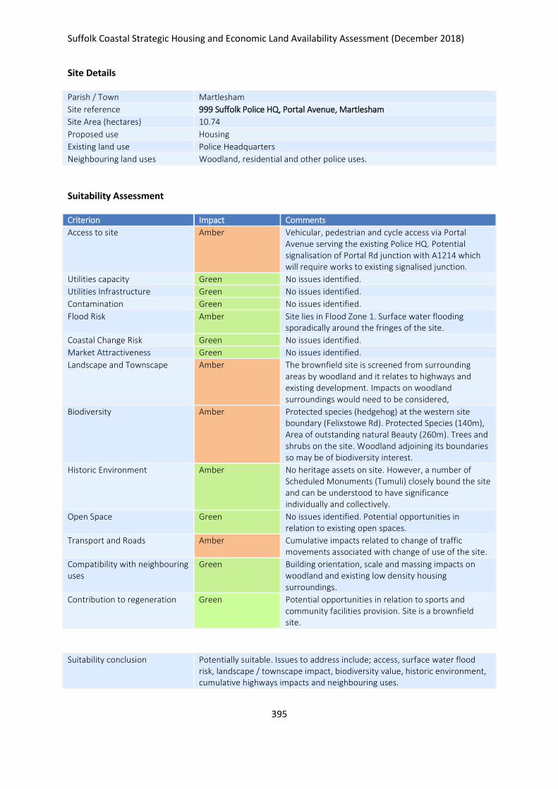
Suffolk Coastal Strategic Housing and Economic Land Availability Assessment (December 2018)
395
Site Details
Parish / Town Martlesham
Site reference 999 Suffolk Police HQ, Portal Avenue, Martlesham
Site Area (hectares) 10.74
Proposed use Housing
Existing land use Police Headquarters
Neighbouring land uses Woodland, residential and other police uses.
Suitability Assessment
Criterion Impact Comments
Access to site Amber Vehicular, pedestrian and cycle access via Portal Avenue serving the existing Police HQ. Potential signalisation of Portal Rd junction with A1214 which will require works to existing signalised junction.
Utilities capacity Green No issues identified.
Utilities Infrastructure Green No issues identified.
Contamination Green No issues identified.
Flood Risk Amber Site lies in Flood Zone 1. Surface water flooding sporadically around the fringes of the site.
Coastal Change Risk Green No issues identified.
Market Attractiveness Green No issues identified.
Landscape and Townscape Amber The brownfield site is screened from surrounding areas by woodland and it relates to highways and existing development. Impacts on woodland surroundings would need to be considered,
Biodiversity Amber Protected species (hedgehog) at the western site boundary (Felixstowe Rd). Protected Species (140m), Area of outstanding natural Beauty (260m). Trees and shrubs on the site. Woodland adjoining its boundaries so may be of biodiversity interest.
Historic Environment Amber No heritage assets on site. However, a number of Scheduled Monuments (Tumuli) closely bound the site and can be understood to have significance individually and collectively.
Open Space Green No issues identified. Potential opportunities in relation to existing open spaces.
Transport and Roads Amber Cumulative impacts related to change of traffic movements associated with change of use of the site.
Compatibility with neighbouring uses
Green Building orientation, scale and massing impacts on woodland and existing low density housing surroundings.
Contribution to regeneration Green Potential opportunities in relation to sports and community facilities provision. Site is a brownfield site.
Suitability conclusion Potentially suitable. Issues to address include; access, surface water flood risk, landscape / townscape impact, biodiversity value, historic environment, cumulative highways impacts and neighbouring uses.

Suffolk Coastal Strategic Housing and Economic Land Availability Assessment (December 2018)
396
Availability
Is the site available? Yes
Evidence of availability / comments
Landowner submission.
Achievability
Is the site achievable? Yes
Evidence of achievability Costs related to removal of existing buildings and structures
Are there any commencement issues?
Relocation of police uses and removal of buildings / structures on site.
Estimated dwellings yield 268
Estimated employment land yield (hectares) -
Estimated retail floorspace (sqm) -
Estimated commencement date 2024/25
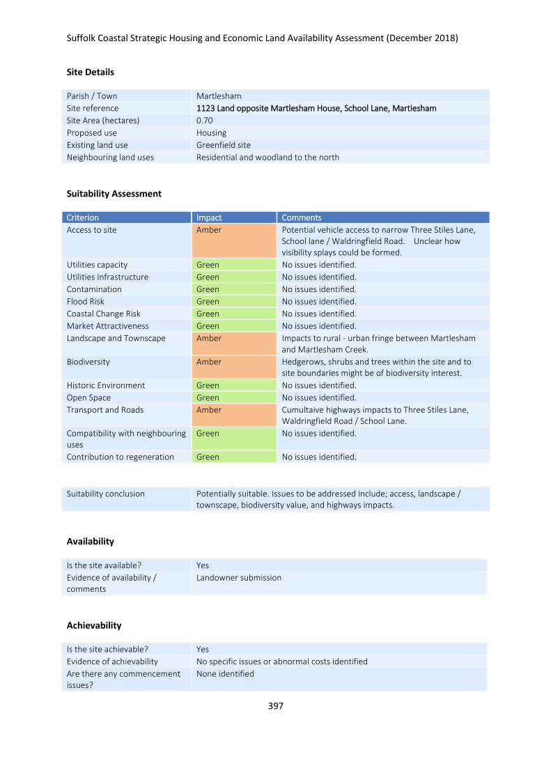
Suffolk Coastal Strategic Housing and Economic Land Availability Assessment (December 2018)
397
Site Details
Parish / Town Martlesham
Site reference 1123 Land opposite Martlesham House, School Lane, Martlesham
Site Area (hectares) 0.70
Proposed use Housing
Existing land use Greenfield site
Neighbouring land uses Residential and woodland to the north
Suitability Assessment
Criterion Impact Comments
Access to site Amber Potential vehicle access to narrow Three Stiles Lane, School lane / Waldringfield Road. Unclear how visibility splays could be formed.
Utilities capacity Green No issues identified.
Utilities Infrastructure Green No issues identified.
Contamination Green No issues identified.
Flood Risk Green No issues identified.
Coastal Change Risk Green No issues identified.
Market Attractiveness Green No issues identified.
Landscape and Townscape Amber Impacts to rural - urban fringe between Martlesham and Martlesham Creek.
Biodiversity Amber Hedgerows, shrubs and trees within the site and to site boundaries might be of biodiversity interest.
Historic Environment Green No issues identified.
Open Space Green No issues identified.
Transport and Roads Amber Cumultaive highways impacts to Three Stiles Lane, Waldringfield Road / School Lane.
Compatibility with neighbouring uses
Green No issues identified.
Contribution to regeneration Green No issues identified.
Suitability conclusion Potentially suitable. Issues to be addressed include; access, landscape / townscape, biodiversity value, and highways impacts.
Availability
Is the site available? Yes
Evidence of availability / comments
Landowner submission
Achievability
Is the site achievable? Yes
Evidence of achievability No specific issues or abnormal costs identified
Are there any commencement issues?
None identified

Suffolk Coastal Strategic Housing and Economic Land Availability Assessment (December 2018)
398
Estimated dwellings yield 18
Estimated employment land yield (hectares) -
Estimated retail floorspace (sqm) -
Estimated commencement date 2023/24
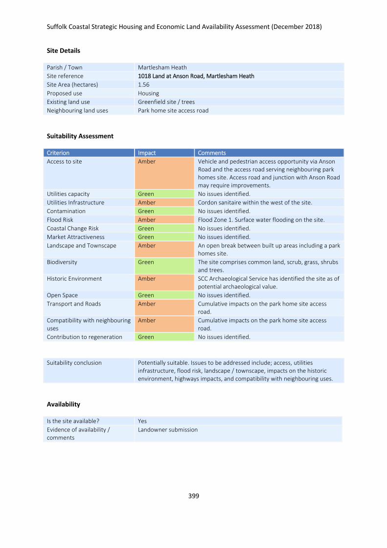
Suffolk Coastal Strategic Housing and Economic Land Availability Assessment (December 2018)
399
Site Details
Parish / Town Martlesham Heath
Site reference 1018 Land at Anson Road, Martlesham Heath
Site Area (hectares) 1.56
Proposed use Housing
Existing land use Greenfield site / trees
Neighbouring land uses Park home site access road
Suitability Assessment
Criterion Impact Comments
Access to site Amber Vehicle and pedestrian access opportunity via Anson Road and the access road serving neighbouring park homes site. Access road and junction with Anson Road may require improvements.
Utilities capacity Green No issues identified.
Utilities Infrastructure Amber Cordon sanitaire within the west of the site.
Contamination Green No issues identified.
Flood Risk Amber Flood Zone 1. Surface water flooding on the site.
Coastal Change Risk Green No issues identified.
Market Attractiveness Green No issues identified.
Landscape and Townscape Amber An open break between built up areas including a park homes site.
Biodiversity Green The site comprises common land, scrub, grass, shrubs and trees.
Historic Environment Amber SCC Archaeological Service has identified the site as of potential archaeological value.
Open Space Green No issues identified.
Transport and Roads Amber Cumulative impacts on the park home site access road.
Compatibility with neighbouring uses
Amber Cumulative impacts on the park home site access road.
Contribution to regeneration Green No issues identified.
Suitability conclusion Potentially suitable. Issues to be addressed include; access, utilities infrastructure, flood risk, landscape / townscape, impacts on the historic environment, highways impacts, and compatibility with neighbouring uses.
Availability
Is the site available? Yes
Evidence of availability / comments
Landowner submission

Suffolk Coastal Strategic Housing and Economic Land Availability Assessment (December 2018)
400
Achievability
Is the site achievable? Yes
Evidence of achievability No specific issues or abnormal costs identified
Are there any commencement issues?
None identified
Estimated dwellings yield 39
Estimated employment land yield (hectares) -
Estimated retail floorspace (sqm) -
Estimated commencement date 2023/24
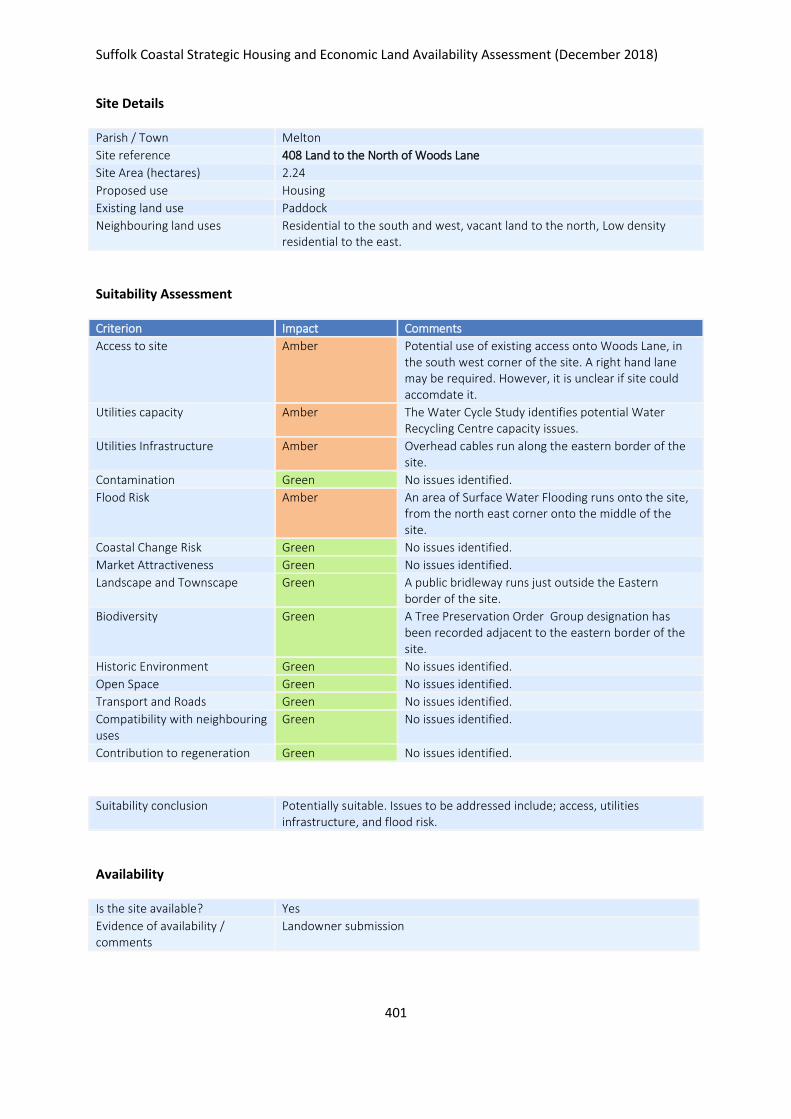
Suffolk Coastal Strategic Housing and Economic Land Availability Assessment (December 2018)
401
Site Details
Parish / Town Melton
Site reference 408 Land to the North of Woods Lane
Site Area (hectares) 2.24
Proposed use Housing
Existing land use Paddock
Neighbouring land uses Residential to the south and west, vacant land to the north, Low density residential to the east.
Suitability Assessment
Criterion Impact Comments
Access to site Amber Potential use of existing access onto Woods Lane, in the south west corner of the site. A right hand lane may be required. However, it is unclear if site could accomdate it.
Utilities capacity Amber The Water Cycle Study identifies potential Water Recycling Centre capacity issues.
Utilities Infrastructure Amber Overhead cables run along the eastern border of the site.
Contamination Green No issues identified.
Flood Risk Amber An area of Surface Water Flooding runs onto the site, from the north east corner onto the middle of the site.
Coastal Change Risk Green No issues identified.
Market Attractiveness Green No issues identified.
Landscape and Townscape Green A public bridleway runs just outside the Eastern border of the site.
Biodiversity Green A Tree Preservation Order Group designation has been recorded adjacent to the eastern border of the site.
Historic Environment Green No issues identified.
Open Space Green No issues identified.
Transport and Roads Green No issues identified.
Compatibility with neighbouring uses
Green No issues identified.
Contribution to regeneration Green No issues identified.
Suitability conclusion Potentially suitable. Issues to be addressed include; access, utilities infrastructure, and flood risk.
Availability
Is the site available? Yes
Evidence of availability / comments
Landowner submission
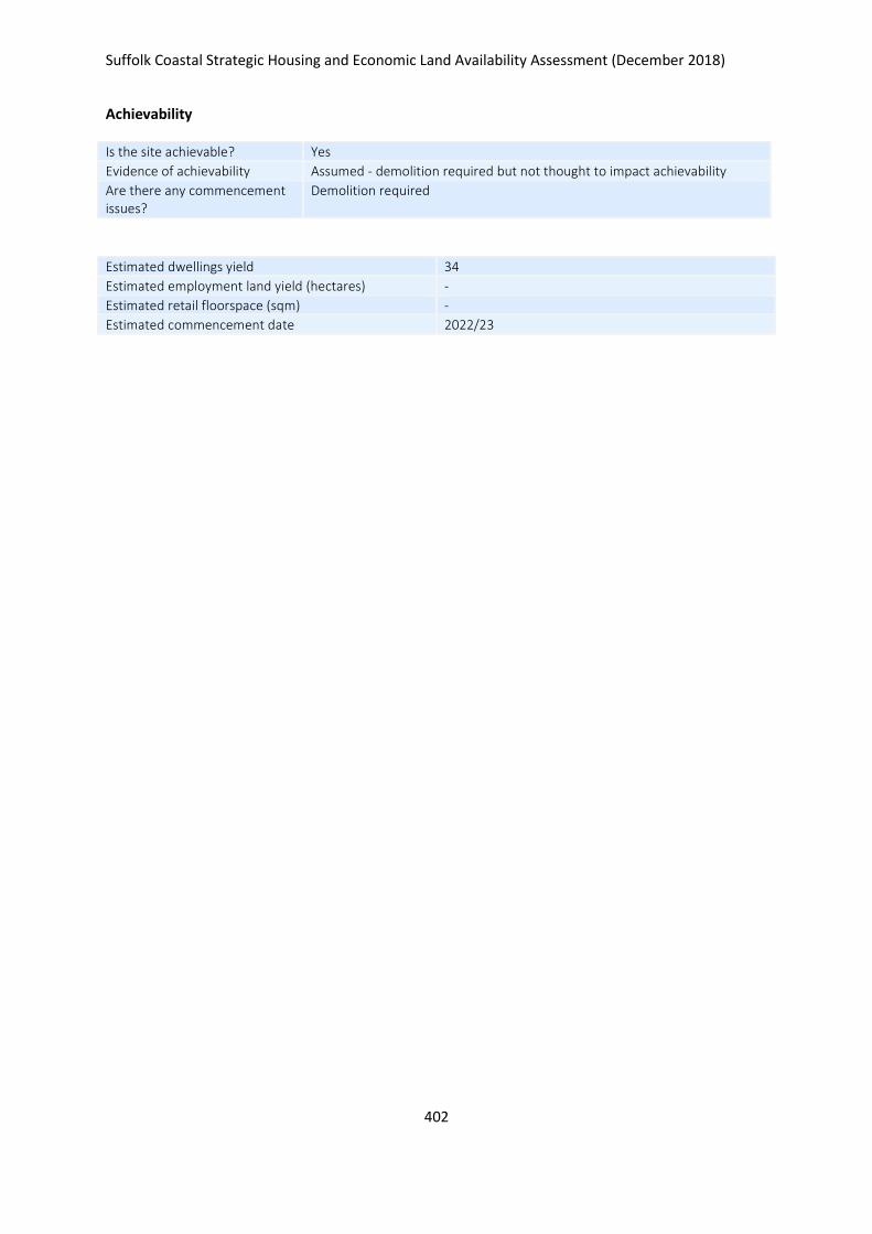
Suffolk Coastal Strategic Housing and Economic Land Availability Assessment (December 2018)
402
Achievability
Is the site achievable? Yes
Evidence of achievability Assumed - demolition required but not thought to impact achievability
Are there any commencement issues?
Demolition required
Estimated dwellings yield 34
Estimated employment land yield (hectares) -
Estimated retail floorspace (sqm) -
Estimated commencement date 2022/23
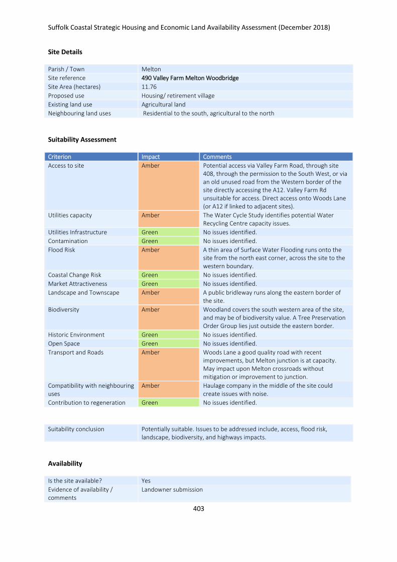
Suffolk Coastal Strategic Housing and Economic Land Availability Assessment (December 2018)
403
Site Details
Parish / Town Melton
Site reference 490 Valley Farm Melton Woodbridge
Site Area (hectares) 11.76
Proposed use Housing/ retirement village
Existing land use Agricultural land
Neighbouring land uses Residential to the south, agricultural to the north
Suitability Assessment
Criterion Impact Comments
Access to site Amber Potential access via Valley Farm Road, through site 408, through the permission to the South West, or via an old unused road from the Western border of the site directly accessing the A12. Valley Farm Rd unsuitable for access. Direct access onto Woods Lane (or A12 if linked to adjacent sites).
Utilities capacity Amber The Water Cycle Study identifies potential Water Recycling Centre capacity issues.
Utilities Infrastructure Green No issues identified.
Contamination Green No issues identified.
Flood Risk Amber A thin area of Surface Water Flooding runs onto the site from the north east corner, across the site to the western boundary.
Coastal Change Risk Green No issues identified.
Market Attractiveness Green No issues identified.
Landscape and Townscape Amber A public bridleway runs along the eastern border of the site.
Biodiversity Amber Woodland covers the south western area of the site, and may be of biodiversity value. A Tree Preservation Order Group lies just outside the eastern border.
Historic Environment Green No issues identified.
Open Space Green No issues identified.
Transport and Roads Amber Woods Lane a good quality road with recent improvements, but Melton junction is at capacity. May impact upon Melton crossroads without mitigation or improvement to junction.
Compatibility with neighbouring uses
Amber Haulage company in the middle of the site could create issues with noise.
Contribution to regeneration Green No issues identified.
Suitability conclusion Potentially suitable. Issues to be addressed include, access, flood risk, landscape, biodiversity, and highways impacts.
Availability
Is the site available? Yes
Evidence of availability / comments
Landowner submission
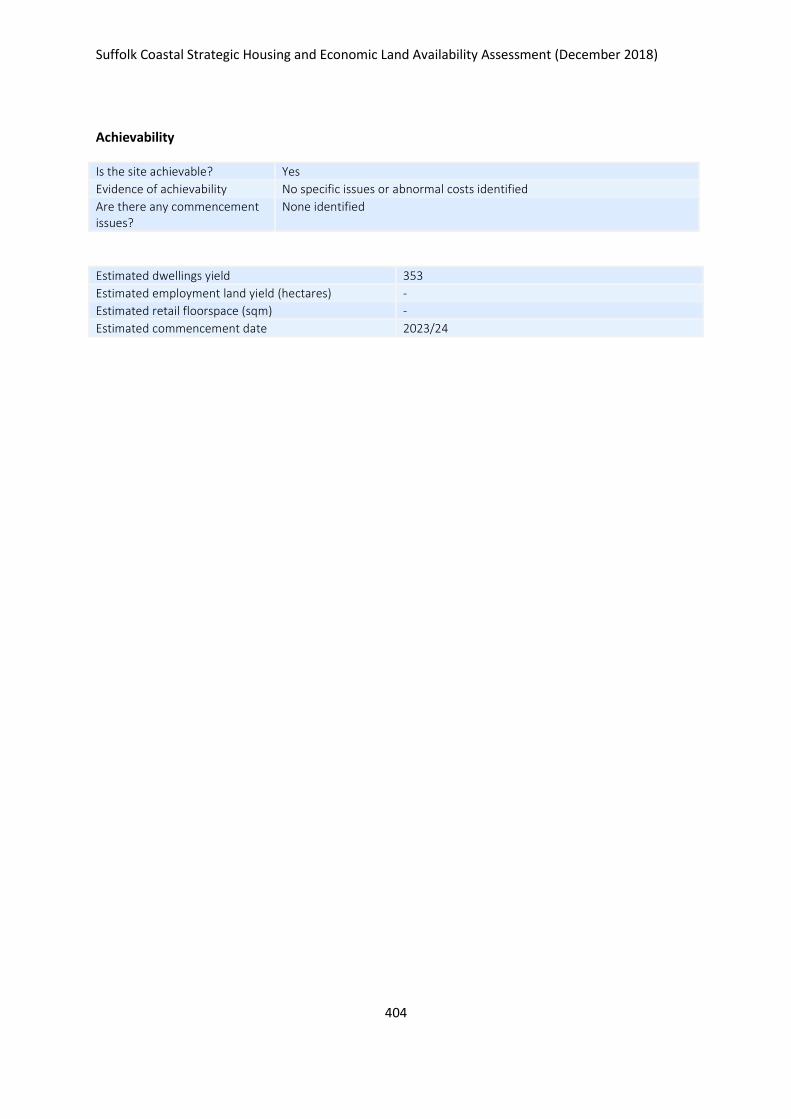
Suffolk Coastal Strategic Housing and Economic Land Availability Assessment (December 2018)
404
Achievability
Is the site achievable? Yes
Evidence of achievability No specific issues or abnormal costs identified
Are there any commencement issues?
None identified
Estimated dwellings yield 353
Estimated employment land yield (hectares) -
Estimated retail floorspace (sqm) -
Estimated commencement date 2023/24
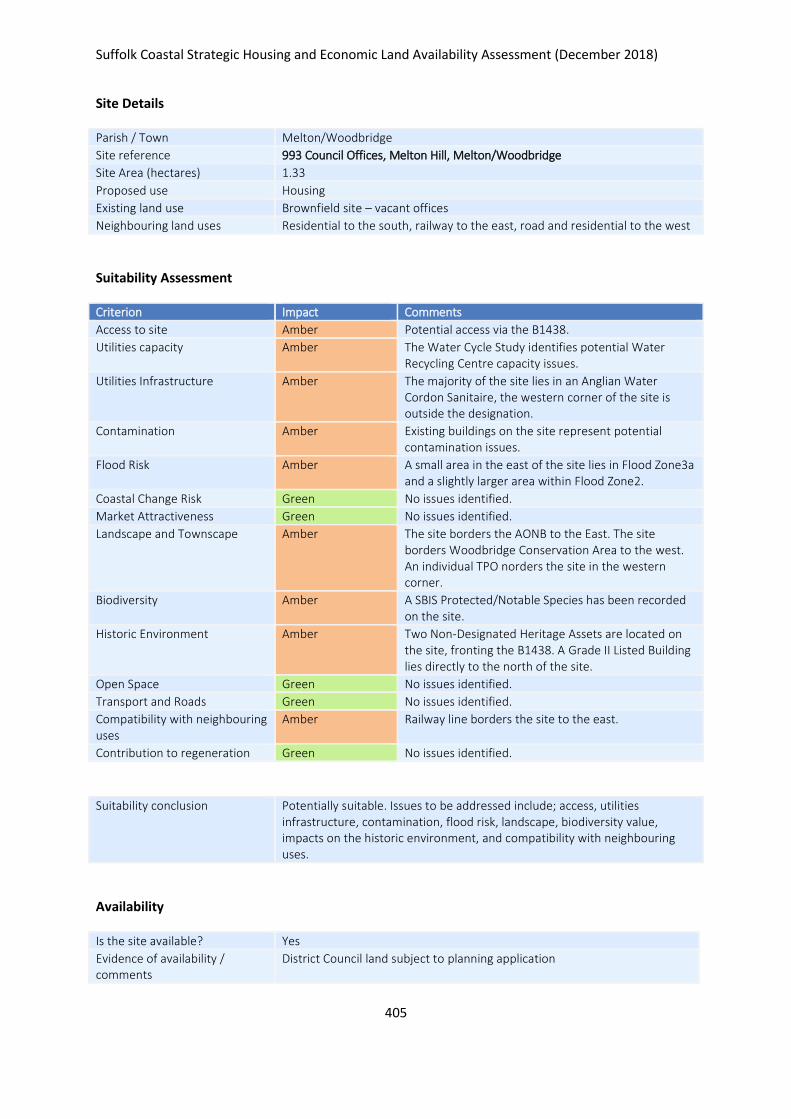
Suffolk Coastal Strategic Housing and Economic Land Availability Assessment (December 2018)
405
Site Details
Parish / Town Melton/Woodbridge
Site reference 993 Council Offices, Melton Hill, Melton/Woodbridge
Site Area (hectares) 1.33
Proposed use Housing
Existing land use Brownfield site – vacant offices
Neighbouring land uses Residential to the south, railway to the east, road and residential to the west
Suitability Assessment
Criterion Impact Comments
Access to site Amber Potential access via the B1438.
Utilities capacity Amber The Water Cycle Study identifies potential Water Recycling Centre capacity issues.
Utilities Infrastructure Amber The majority of the site lies in an Anglian Water Cordon Sanitaire, the western corner of the site is outside the designation.
Contamination Amber Existing buildings on the site represent potential contamination issues.
Flood Risk Amber A small area in the east of the site lies in Flood Zone3a and a slightly larger area within Flood Zone2.
Coastal Change Risk Green No issues identified.
Market Attractiveness Green No issues identified.
Landscape and Townscape Amber The site borders the AONB to the East. The site borders Woodbridge Conservation Area to the west. An individual TPO norders the site in the western corner.
Biodiversity Amber A SBIS Protected/Notable Species has been recorded on the site.
Historic Environment Amber Two Non-Designated Heritage Assets are located on the site, fronting the B1438. A Grade II Listed Building lies directly to the north of the site.
Open Space Green No issues identified.
Transport and Roads Green No issues identified.
Compatibility with neighbouring uses
Amber Railway line borders the site to the east.
Contribution to regeneration Green No issues identified.
Suitability conclusion Potentially suitable. Issues to be addressed include; access, utilities infrastructure, contamination, flood risk, landscape, biodiversity value, impacts on the historic environment, and compatibility with neighbouring uses.
Availability
Is the site available? Yes
Evidence of availability / comments
District Council land subject to planning application

Suffolk Coastal Strategic Housing and Economic Land Availability Assessment (December 2018)
406
Achievability
Is the site achievable? Yes
Evidence of achievability Assumed - demolition of existing buildings required
Are there any commencement issues?
Demolition of existing buildings
Estimated dwellings yield 40
Estimated employment land yield (hectares) -
Estimated retail floorspace (sqm) -
Estimated commencement date 2022/23
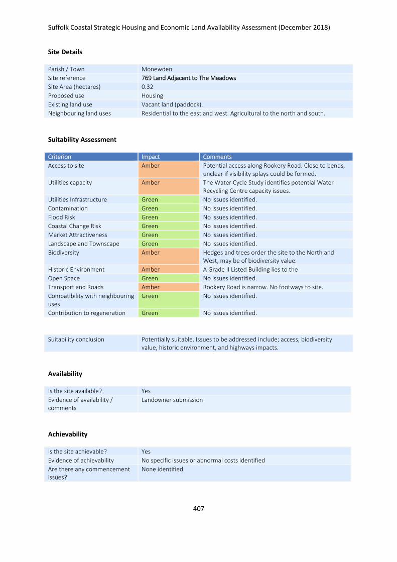
Suffolk Coastal Strategic Housing and Economic Land Availability Assessment (December 2018)
407
Site Details
Parish / Town Monewden
Site reference 769 Land Adjacent to The Meadows
Site Area (hectares) 0.32
Proposed use Housing
Existing land use Vacant land (paddock).
Neighbouring land uses Residential to the east and west. Agricultural to the north and south.
Suitability Assessment
Criterion Impact Comments
Access to site Amber Potential access along Rookery Road. Close to bends, unclear if visibility splays could be formed.
Utilities capacity Amber The Water Cycle Study identifies potential Water Recycling Centre capacity issues.
Utilities Infrastructure Green No issues identified.
Contamination Green No issues identified.
Flood Risk Green No issues identified.
Coastal Change Risk Green No issues identified.
Market Attractiveness Green No issues identified.
Landscape and Townscape Green No issues identified.
Biodiversity Amber Hedges and trees order the site to the North and West, may be of biodiversity value.
Historic Environment Amber A Grade II Listed Building lies to the
Open Space Green No issues identified.
Transport and Roads Amber Rookery Road is narrow. No footways to site.
Compatibility with neighbouring uses
Green No issues identified.
Contribution to regeneration Green No issues identified.
Suitability conclusion Potentially suitable. Issues to be addressed include; access, biodiversity value, historic environment, and highways impacts.
Availability
Is the site available? Yes
Evidence of availability / comments
Landowner submission
Achievability
Is the site achievable? Yes
Evidence of achievability No specific issues or abnormal costs identified
Are there any commencement issues?
None identified

Suffolk Coastal Strategic Housing and Economic Land Availability Assessment (December 2018)
408
Estimated dwellings yield 5
Estimated employment land yield (hectares) -
Estimated retail floorspace (sqm) -
Estimated commencement date 2020/21
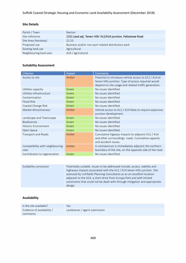
Suffolk Coastal Strategic Housing and Economic Land Availability Assessment (December 2018)
409
Site Details
Parish / Town Nacton
Site reference 1151 Land adj. 'Seven Hills' A12/A14 junction, Felixstowe Road
Site Area (hectares) 22.53
Proposed use Business and/or non-port related distribution park
Existing land use Agricultural
Neighbouring land uses A14 / agricultural
Suitability Assessment
Criterion Impact Comments
Access to site Amber Potential to introduce vehicle access to A12 / A14 at Seven Hills junction. Type of access required would depend on site usage and related traffic generation.
Utilities capacity Green No issues identified.
Utilities Infrastructure Green No issues identified.
Contamination Green No issues identified.
Flood Risk Green No issues identified.
Coastal Change Risk Green No issues identified.
Market Attractiveness Amber Vehicle access to A12 / A14 likely to require expensive junction development.
Landscape and Townscape Green No issues identified.
Biodiversity Green No issues identified.
Historic Environment Green No issues identified.
Open Space Green No issues identified.
Transport and Roads Amber Cumulative higways impacts to adjacent A12 / A14 and other surroundings roads. Cumulative capacity and accident issues.
Compatibility with neighbouring uses
Amber A crematorium is immediately adjacent the northern boundary of the site, on the opposite side of the road.
Contribution to regeneration Green No issues identified.
Suitability conclusion Potentially suitable. Issues to be addressed include; access, viability and highways impacts associated with the A12 / A14 Seven Hills junction. Site assessed by Lichfields Planning Consultants as an an excellent location adjacent to the A14, a short drive from Europa Park and with limited constraints that could not be dealt with through mitigation and appropriate design.
Availability
Is the site available? Yes
Evidence of availability / comments
Landowner / agent submission

Suffolk Coastal Strategic Housing and Economic Land Availability Assessment (December 2018)
410
Achievability
Is the site achievable? Yes
Evidence of achievability Road access may require junction reconfiguration at Seven Hills.
Are there any commencement issues?
None identified
Estimated dwellings yield -
Estimated employment land yield (hectares) 23
Estimated retail floorspace (sqm) -
Estimated commencement date 2023/24
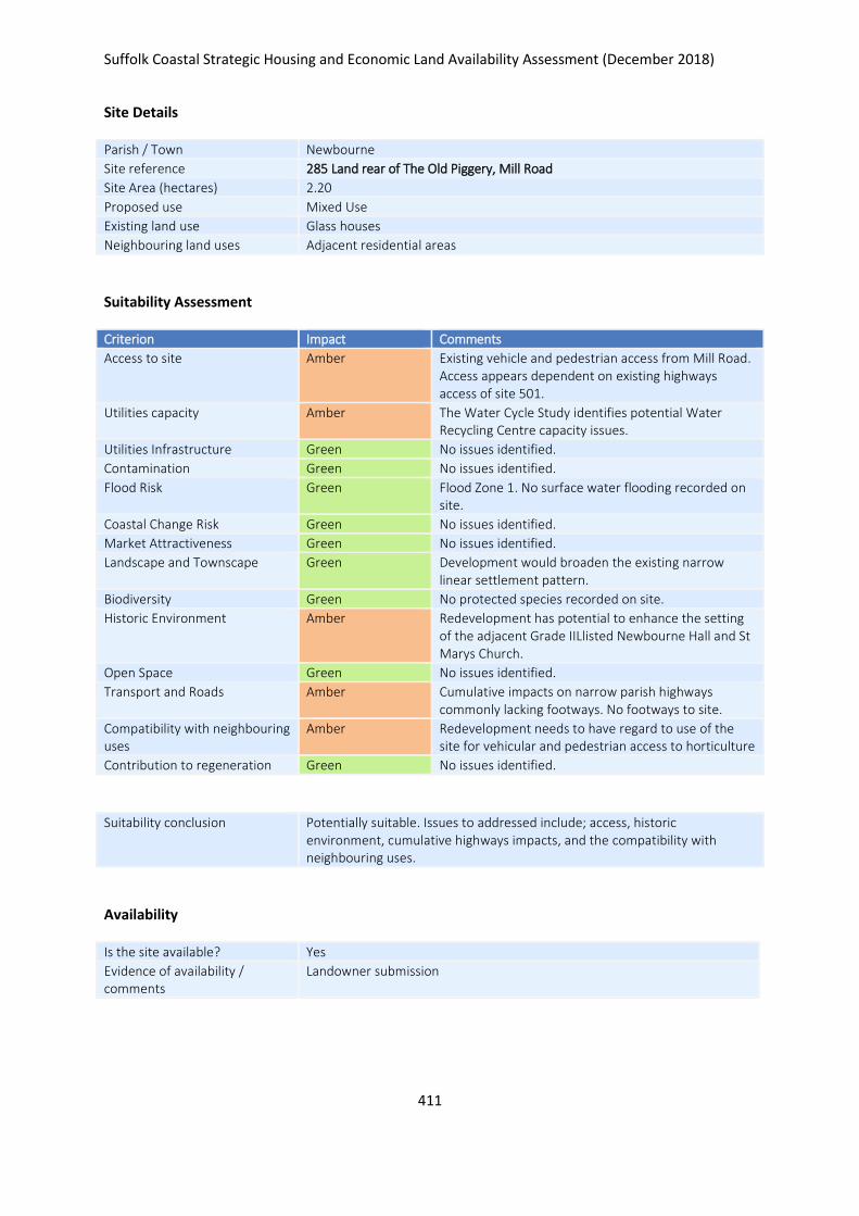
Suffolk Coastal Strategic Housing and Economic Land Availability Assessment (December 2018)
411
Site Details
Parish / Town Newbourne
Site reference 285 Land rear of The Old Piggery, Mill Road
Site Area (hectares) 2.20
Proposed use Mixed Use
Existing land use Glass houses
Neighbouring land uses Adjacent residential areas
Suitability Assessment
Criterion Impact Comments
Access to site Amber Existing vehicle and pedestrian access from Mill Road. Access appears dependent on existing highways access of site 501.
Utilities capacity Amber The Water Cycle Study identifies potential Water Recycling Centre capacity issues.
Utilities Infrastructure Green No issues identified.
Contamination Green No issues identified.
Flood Risk Green Flood Zone 1. No surface water flooding recorded on site.
Coastal Change Risk Green No issues identified.
Market Attractiveness Green No issues identified.
Landscape and Townscape Green Development would broaden the existing narrow linear settlement pattern.
Biodiversity Green No protected species recorded on site.
Historic Environment Amber Redevelopment has potential to enhance the setting of the adjacent Grade IILlisted Newbourne Hall and St Marys Church.
Open Space Green No issues identified.
Transport and Roads Amber Cumulative impacts on narrow parish highways commonly lacking footways. No footways to site.
Compatibility with neighbouring uses
Amber Redevelopment needs to have regard to use of the site for vehicular and pedestrian access to horticulture
Contribution to regeneration Green No issues identified.
Suitability conclusion Potentially suitable. Issues to addressed include; access, historic environment, cumulative highways impacts, and the compatibility with neighbouring uses.
Availability
Is the site available? Yes
Evidence of availability / comments
Landowner submission
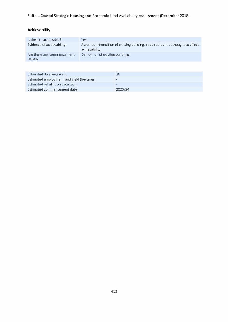
Suffolk Coastal Strategic Housing and Economic Land Availability Assessment (December 2018)
412
Achievability
Is the site achievable? Yes
Evidence of achievability Assumed - demoltion of exitsing buildings required but not thought to affect achievability
Are there any commencement issues?
Demolition of existing buildings
Estimated dwellings yield 26
Estimated employment land yield (hectares) -
Estimated retail floorspace (sqm) -
Estimated commencement date 2023/24
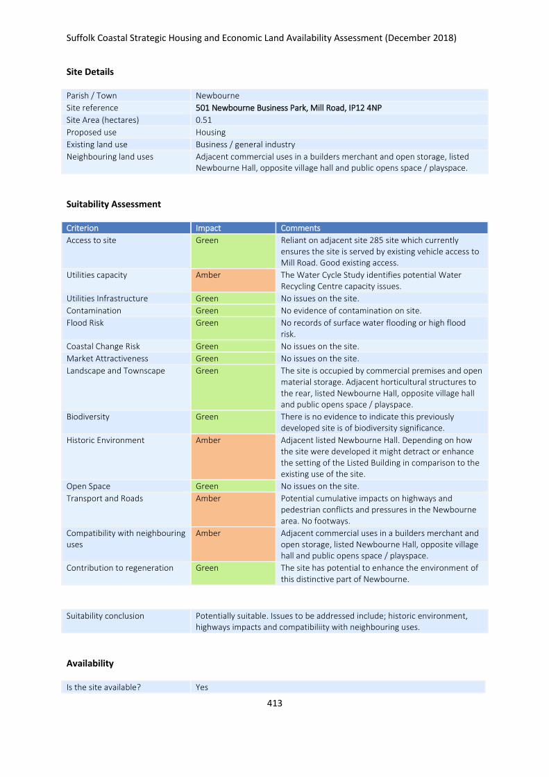
Suffolk Coastal Strategic Housing and Economic Land Availability Assessment (December 2018)
413
Site Details
Parish / Town Newbourne
Site reference 501 Newbourne Business Park, Mill Road, IP12 4NP
Site Area (hectares) 0.51
Proposed use Housing
Existing land use Business / general industry
Neighbouring land uses Adjacent commercial uses in a builders merchant and open storage, listed Newbourne Hall, opposite village hall and public opens space / playspace.
Suitability Assessment
Criterion Impact Comments
Access to site Green Reliant on adjacent site 285 site which currently ensures the site is served by existing vehicle access to Mill Road. Good existing access.
Utilities capacity Amber The Water Cycle Study identifies potential Water Recycling Centre capacity issues.
Utilities Infrastructure Green No issues on the site.
Contamination Green No evidence of contamination on site.
Flood Risk Green No records of surface water flooding or high flood risk.
Coastal Change Risk Green No issues on the site.
Market Attractiveness Green No issues on the site.
Landscape and Townscape Green The site is occupied by commercial premises and open material storage. Adjacent horticultural structures to the rear, listed Newbourne Hall, opposite village hall and public opens space / playspace.
Biodiversity Green There is no evidence to indicate this previously developed site is of biodiversity significance.
Historic Environment Amber Adjacent listed Newbourne Hall. Depending on how the site were developed it might detract or enhance the setting of the Listed Building in comparison to the existing use of the site.
Open Space Green No issues on the site.
Transport and Roads Amber Potential cumulative impacts on highways and pedestrian conflicts and pressures in the Newbourne area. No footways.
Compatibility with neighbouring uses
Amber Adjacent commercial uses in a builders merchant and open storage, listed Newbourne Hall, opposite village hall and public opens space / playspace.
Contribution to regeneration Green The site has potential to enhance the environment of this distinctive part of Newbourne.
Suitability conclusion Potentially suitable. Issues to be addressed include; historic environment, highways impacts and compatibiliity with neighbouring uses.
Availability
Is the site available? Yes
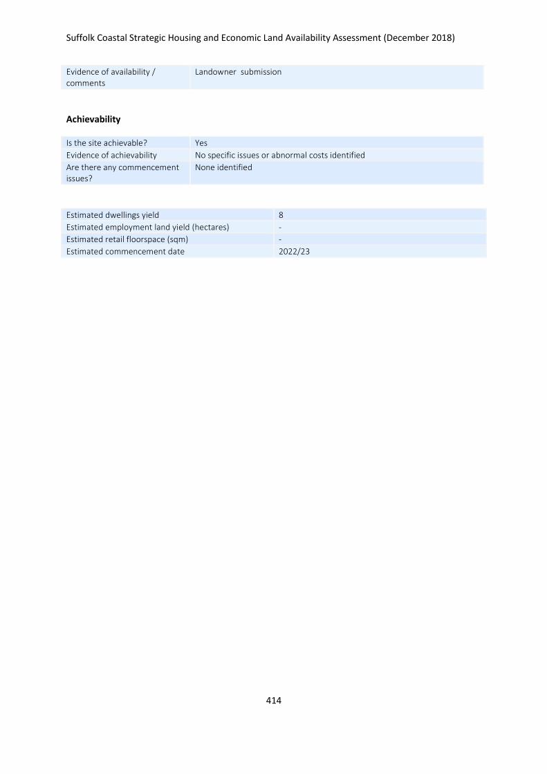
Suffolk Coastal Strategic Housing and Economic Land Availability Assessment (December 2018)
414
Evidence of availability / comments
Landowner submission
Achievability
Is the site achievable? Yes
Evidence of achievability No specific issues or abnormal costs identified
Are there any commencement issues?
None identified
Estimated dwellings yield 8
Estimated employment land yield (hectares) -
Estimated retail floorspace (sqm) -
Estimated commencement date 2022/23
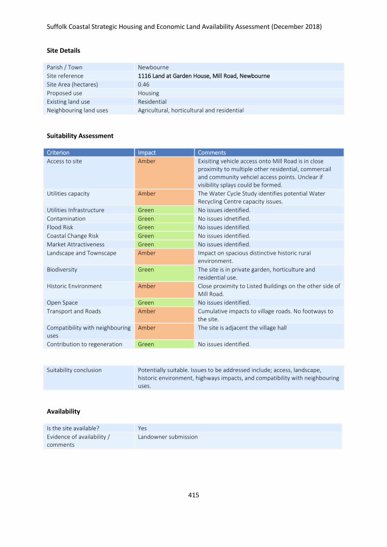
Suffolk Coastal Strategic Housing and Economic Land Availability Assessment (December 2018)
415
Site Details
Parish / Town Newbourne
Site reference 1116 Land at Garden House, Mill Road, Newbourne
Site Area (hectares) 0.46
Proposed use Housing
Existing land use Residential
Neighbouring land uses Agricultural, horticultural and residential
Suitability Assessment
Criterion Impact Comments
Access to site Amber Exisiting vehicle access onto Mill Road is in close proximity to multiple other residential, commercail and community vehciel access points. Unclear if visibility splays could be formed.
Utilities capacity Amber The Water Cycle Study identifies potential Water Recycling Centre capacity issues.
Utilities Infrastructure Green No issues identified.
Contamination Green No issues idnetified.
Flood Risk Green No issues identified.
Coastal Change Risk Green No issues identified.
Market Attractiveness Green No issues identified.
Landscape and Townscape Amber Impact on spacious distinctive historic rural environment.
Biodiversity Green The site is in private garden, horticulture and residential use.
Historic Environment Amber Close proximity to Listed Buildings on the other side of Mill Road.
Open Space Green No issues identified.
Transport and Roads Amber Cumulative impacts to village roads. No footways to the site.
Compatibility with neighbouring uses
Amber The site is adjacent the village hall
Contribution to regeneration Green No issues identified.
Suitability conclusion Potentially suitable. Issues to be addressed include; access, landscape, historic environment, highways impacts, and compatibility with neighbouring uses.
Availability
Is the site available? Yes
Evidence of availability / comments
Landowner submission

Suffolk Coastal Strategic Housing and Economic Land Availability Assessment (December 2018)
416
Achievability
Is the site achievable? Yes
Evidence of achievability No specific issues or abnormal costs identified
Are there any commencement issues?
None identified
Estimated dwellings yield 6
Estimated employment land yield (hectares) -
Estimated retail floorspace (sqm) -
Estimated commencement date 2021/22
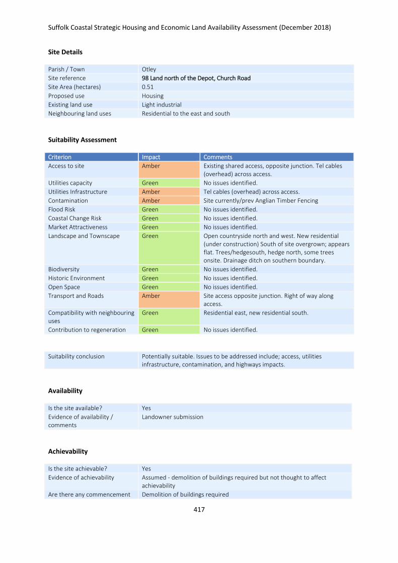
Suffolk Coastal Strategic Housing and Economic Land Availability Assessment (December 2018)
417
Site Details
Parish / Town Otley
Site reference 98 Land north of the Depot, Church Road
Site Area (hectares) 0.51
Proposed use Housing
Existing land use Light industrial
Neighbouring land uses Residential to the east and south
Suitability Assessment
Criterion Impact Comments
Access to site Amber Existing shared access, opposite junction. Tel cables (overhead) across access.
Utilities capacity Green No issues identified.
Utilities Infrastructure Amber Tel cables (overhead) across access.
Contamination Amber Site currently/prev Anglian Timber Fencing
Flood Risk Green No issues identified.
Coastal Change Risk Green No issues identified.
Market Attractiveness Green No issues identified.
Landscape and Townscape Green Open countryside north and west. New residential (under construction) South of site overgrown; appears flat. Trees/hedgesouth, hedge north, some trees onsite. Drainage ditch on southern boundary.
Biodiversity Green No issues identified.
Historic Environment Green No issues identified.
Open Space Green No issues identified.
Transport and Roads Amber Site access opposite junction. Right of way along access.
Compatibility with neighbouring uses
Green Residential east, new residential south.
Contribution to regeneration Green No issues identified.
Suitability conclusion Potentially suitable. Issues to be addressed include; access, utilities infrastructure, contamination, and highways impacts.
Availability
Is the site available? Yes
Evidence of availability / comments
Landowner submission
Achievability
Is the site achievable? Yes
Evidence of achievability Assumed - demolition of buildings required but not thought to affect achievability
Are there any commencement Demolition of buildings required

Suffolk Coastal Strategic Housing and Economic Land Availability Assessment (December 2018)
418
issues?
Estimated dwellings yield 8
Estimated employment land yield (hectares) -
Estimated retail floorspace (sqm) -
Estimated commencement date 2022/23
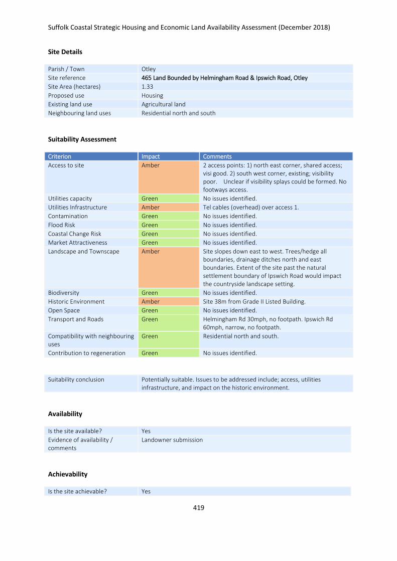
Suffolk Coastal Strategic Housing and Economic Land Availability Assessment (December 2018)
419
Site Details
Parish / Town Otley
Site reference 465 Land Bounded by Helmingham Road & Ipswich Road, Otley
Site Area (hectares) 1.33
Proposed use Housing
Existing land use Agricultural land
Neighbouring land uses Residential north and south
Suitability Assessment
Criterion Impact Comments
Access to site Amber 2 access points: 1) north east corner, shared access; visi good. 2) south west corner, existing; visibility poor. Unclear if visibility splays could be formed. No footways access.
Utilities capacity Green No issues identified.
Utilities Infrastructure Amber Tel cables (overhead) over access 1.
Contamination Green No issues identified.
Flood Risk Green No issues identified.
Coastal Change Risk Green No issues identified.
Market Attractiveness Green No issues identified.
Landscape and Townscape Amber Site slopes down east to west. Trees/hedge all boundaries, drainage ditches north and east boundaries. Extent of the site past the natural settlement boundary of Ipswich Road would impact the countryside landscape setting.
Biodiversity Green No issues identified.
Historic Environment Amber Site 38m from Grade II Listed Building.
Open Space Green No issues identified.
Transport and Roads Green Helmingham Rd 30mph, no footpath. Ipswich Rd 60mph, narrow, no footpath.
Compatibility with neighbouring uses
Green Residential north and south.
Contribution to regeneration Green No issues identified.
Suitability conclusion Potentially suitable. Issues to be addressed include; access, utilities infrastructure, and impact on the historic environment.
Availability
Is the site available? Yes
Evidence of availability / comments
Landowner submission
Achievability
Is the site achievable? Yes

Suffolk Coastal Strategic Housing and Economic Land Availability Assessment (December 2018)
420
Evidence of achievability No specific issues or abnormal costs identified
Are there any commencement issues?
None identified
Estimated dwellings yield 20
Estimated employment land yield (hectares) -
Estimated retail floorspace (sqm) -
Estimated commencement date 2021/22
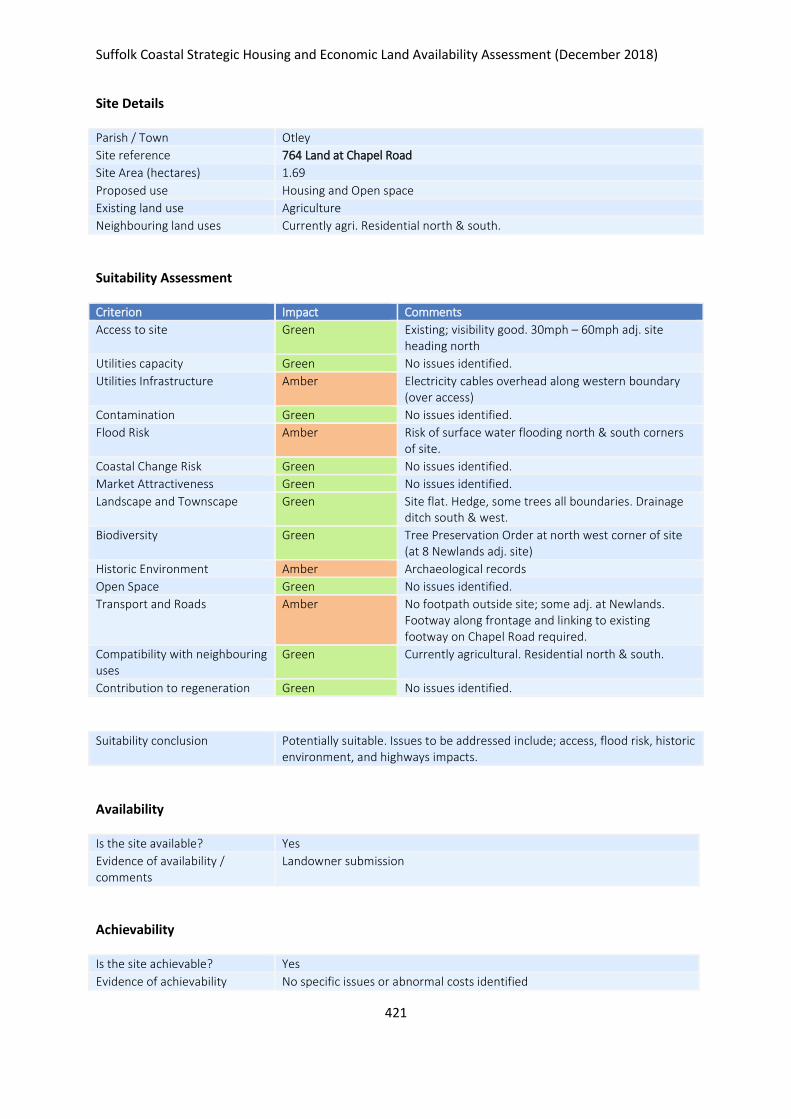
Suffolk Coastal Strategic Housing and Economic Land Availability Assessment (December 2018)
421
Site Details
Parish / Town Otley
Site reference 764 Land at Chapel Road
Site Area (hectares) 1.69
Proposed use Housing and Open space
Existing land use Agriculture
Neighbouring land uses Currently agri. Residential north & south.
Suitability Assessment
Criterion Impact Comments
Access to site Green Existing; visibility good. 30mph – 60mph adj. site heading north
Utilities capacity Green No issues identified.
Utilities Infrastructure Amber Electricity cables overhead along western boundary (over access)
Contamination Green No issues identified.
Flood Risk Amber Risk of surface water flooding north & south corners of site.
Coastal Change Risk Green No issues identified.
Market Attractiveness Green No issues identified.
Landscape and Townscape Green Site flat. Hedge, some trees all boundaries. Drainage ditch south & west.
Biodiversity Green Tree Preservation Order at north west corner of site (at 8 Newlands adj. site)
Historic Environment Amber Archaeological records
Open Space Green No issues identified.
Transport and Roads Amber No footpath outside site; some adj. at Newlands. Footway along frontage and linking to existing footway on Chapel Road required.
Compatibility with neighbouring uses
Green Currently agricultural. Residential north & south.
Contribution to regeneration Green No issues identified.
Suitability conclusion Potentially suitable. Issues to be addressed include; access, flood risk, historic environment, and highways impacts.
Availability
Is the site available? Yes
Evidence of availability / comments
Landowner submission
Achievability
Is the site achievable? Yes
Evidence of achievability No specific issues or abnormal costs identified
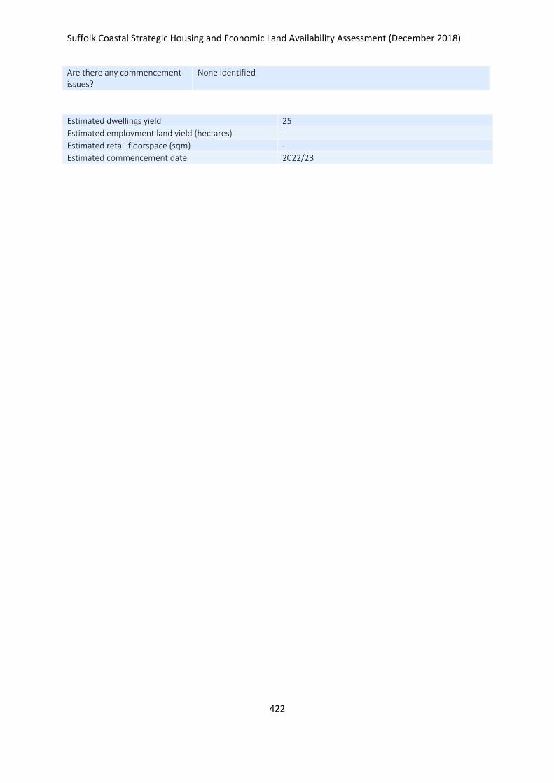
Suffolk Coastal Strategic Housing and Economic Land Availability Assessment (December 2018)
422
Are there any commencement issues?
None identified
Estimated dwellings yield 25
Estimated employment land yield (hectares) -
Estimated retail floorspace (sqm) -
Estimated commencement date 2022/23
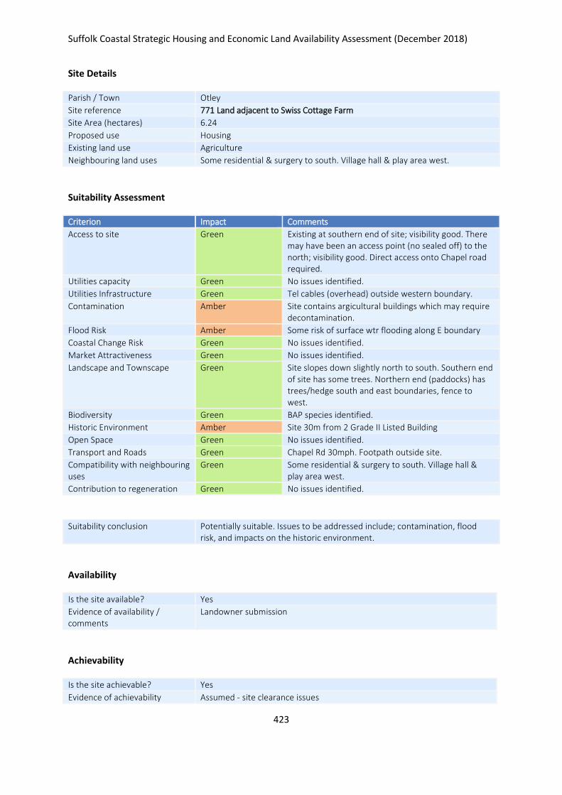
Suffolk Coastal Strategic Housing and Economic Land Availability Assessment (December 2018)
423
Site Details
Parish / Town Otley
Site reference 771 Land adjacent to Swiss Cottage Farm
Site Area (hectares) 6.24
Proposed use Housing
Existing land use Agriculture
Neighbouring land uses Some residential & surgery to south. Village hall & play area west.
Suitability Assessment
Criterion Impact Comments
Access to site Green Existing at southern end of site; visibility good. There may have been an access point (no sealed off) to the north; visibility good. Direct access onto Chapel road required.
Utilities capacity Green No issues identified.
Utilities Infrastructure Green Tel cables (overhead) outside western boundary.
Contamination Amber Site contains argicultural buildings which may require decontamination.
Flood Risk Amber Some risk of surface wtr flooding along E boundary
Coastal Change Risk Green No issues identified.
Market Attractiveness Green No issues identified.
Landscape and Townscape Green Site slopes down slightly north to south. Southern end of site has some trees. Northern end (paddocks) has trees/hedge south and east boundaries, fence to west.
Biodiversity Green BAP species identified.
Historic Environment Amber Site 30m from 2 Grade II Listed Building
Open Space Green No issues identified.
Transport and Roads Green Chapel Rd 30mph. Footpath outside site.
Compatibility with neighbouring uses
Green Some residential & surgery to south. Village hall & play area west.
Contribution to regeneration Green No issues identified.
Suitability conclusion Potentially suitable. Issues to be addressed include; contamination, flood risk, and impacts on the historic environment.
Availability
Is the site available? Yes
Evidence of availability / comments
Landowner submission
Achievability
Is the site achievable? Yes
Evidence of achievability Assumed - site clearance issues
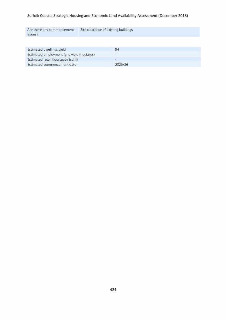
Suffolk Coastal Strategic Housing and Economic Land Availability Assessment (December 2018)
424
Are there any commencement issues?
Site clearance of existing buildings
Estimated dwellings yield 94
Estimated employment land yield (hectares) -
Estimated retail floorspace (sqm) -
Estimated commencement date 2025/26
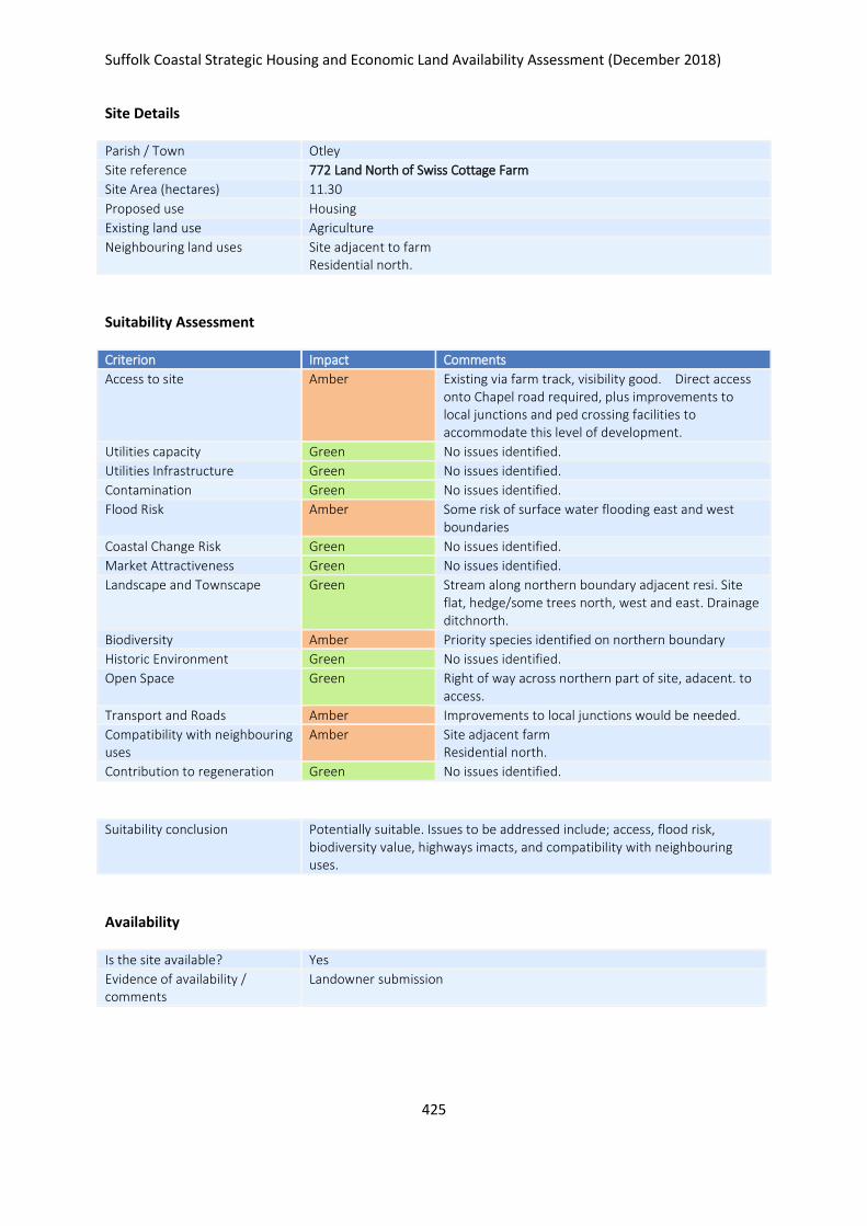
Suffolk Coastal Strategic Housing and Economic Land Availability Assessment (December 2018)
425
Site Details
Parish / Town Otley
Site reference 772 Land North of Swiss Cottage Farm
Site Area (hectares) 11.30
Proposed use Housing
Existing land use Agriculture
Neighbouring land uses Site adjacent to farm Residential north.
Suitability Assessment
Criterion Impact Comments
Access to site Amber Existing via farm track, visibility good. Direct access onto Chapel road required, plus improvements to local junctions and ped crossing facilities to accommodate this level of development.
Utilities capacity Green No issues identified.
Utilities Infrastructure Green No issues identified.
Contamination Green No issues identified.
Flood Risk Amber Some risk of surface water flooding east and west boundaries
Coastal Change Risk Green No issues identified.
Market Attractiveness Green No issues identified.
Landscape and Townscape Green Stream along northern boundary adjacent resi. Site flat, hedge/some trees north, west and east. Drainage ditchnorth.
Biodiversity Amber Priority species identified on northern boundary
Historic Environment Green No issues identified.
Open Space Green Right of way across northern part of site, adacent. to access.
Transport and Roads Amber Improvements to local junctions would be needed.
Compatibility with neighbouring uses
Amber Site adjacent farm Residential north.
Contribution to regeneration Green No issues identified.
Suitability conclusion Potentially suitable. Issues to be addressed include; access, flood risk, biodiversity value, highways imacts, and compatibility with neighbouring uses.
Availability
Is the site available? Yes
Evidence of availability / comments
Landowner submission
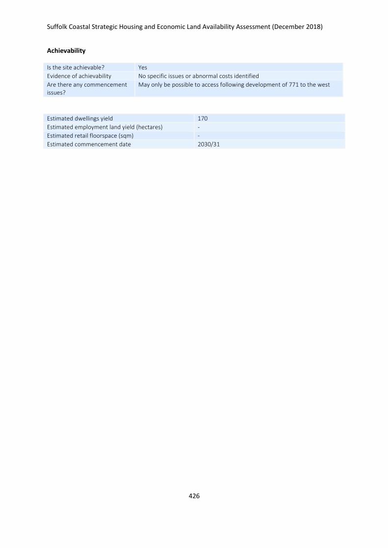
Suffolk Coastal Strategic Housing and Economic Land Availability Assessment (December 2018)
426
Achievability
Is the site achievable? Yes
Evidence of achievability No specific issues or abnormal costs identified
Are there any commencement issues?
May only be possible to access following development of 771 to the west
Estimated dwellings yield 170
Estimated employment land yield (hectares) -
Estimated retail floorspace (sqm) -
Estimated commencement date 2030/31
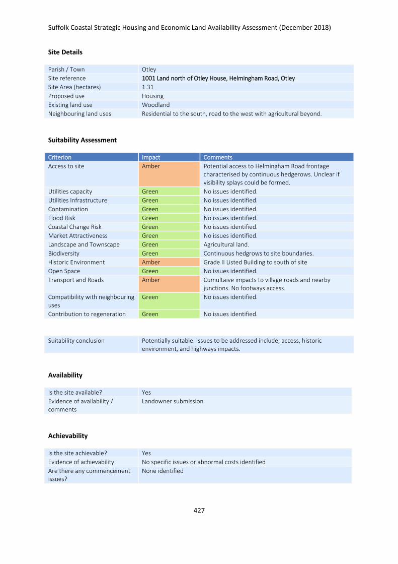
Suffolk Coastal Strategic Housing and Economic Land Availability Assessment (December 2018)
427
Site Details
Parish / Town Otley
Site reference 1001 Land north of Otley House, Helmingham Road, Otley
Site Area (hectares) 1.31
Proposed use Housing
Existing land use Woodland
Neighbouring land uses Residential to the south, road to the west with agricultural beyond.
Suitability Assessment
Criterion Impact Comments
Access to site Amber Potential access to Helmingham Road frontage characterised by continuous hedgerows. Unclear if visibility splays could be formed.
Utilities capacity Green No issues identified.
Utilities Infrastructure Green No issues identified.
Contamination Green No issues identified.
Flood Risk Green No issues identified.
Coastal Change Risk Green No issues identified.
Market Attractiveness Green No issues identified.
Landscape and Townscape Green Agricultural land.
Biodiversity Green Continuous hedgrows to site boundaries.
Historic Environment Amber Grade II Listed Building to south of site
Open Space Green No issues identified.
Transport and Roads Amber Cumultaive impacts to village roads and nearby junctions. No footways access.
Compatibility with neighbouring uses
Green No issues identified.
Contribution to regeneration Green No issues identified.
Suitability conclusion Potentially suitable. Issues to be addressed include; access, historic environment, and highways impacts.
Availability
Is the site available? Yes
Evidence of availability / comments
Landowner submission
Achievability
Is the site achievable? Yes
Evidence of achievability No specific issues or abnormal costs identified
Are there any commencement issues?
None identified

Suffolk Coastal Strategic Housing and Economic Land Availability Assessment (December 2018)
428
Estimated dwellings yield 20
Estimated employment land yield (hectares) -
Estimated retail floorspace (sqm) -
Estimated commencement date 2021/22
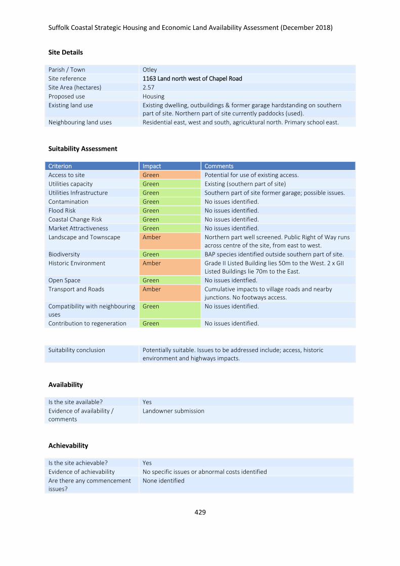
Suffolk Coastal Strategic Housing and Economic Land Availability Assessment (December 2018)
429
Site Details
Parish / Town Otley
Site reference 1163 Land north west of Chapel Road
Site Area (hectares) 2.57
Proposed use Housing
Existing land use Existing dwelling, outbuildings & former garage hardstanding on southern part of site. Northern part of site currently paddocks (used).
Neighbouring land uses Residential east, west and south, agricuktural north. Primary school east.
Suitability Assessment
Criterion Impact Comments
Access to site Green Potential for use of existing access.
Utilities capacity Green Existing (southern part of site)
Utilities Infrastructure Green Southern part of site former garage; possible issues.
Contamination Green No issues identified.
Flood Risk Green No issues identified.
Coastal Change Risk Green No issues identified.
Market Attractiveness Green No issues identified.
Landscape and Townscape Amber Northern part well screened. Public Right of Way runs across centre of the site, from east to west.
Biodiversity Green BAP species identified outside southern part of site.
Historic Environment Amber Grade II Listed Building lies 50m to the West. 2 x GII Listed Buildings lie 70m to the East.
Open Space Green No issues identfied.
Transport and Roads Amber Cumulative impacts to village roads and nearby junctions. No footways access.
Compatibility with neighbouring uses
Green No issues identified.
Contribution to regeneration Green No issues identified.
Suitability conclusion Potentially suitable. Issues to be addressed include; access, historic environment and highways impacts.
Availability
Is the site available? Yes
Evidence of availability / comments
Landowner submission
Achievability
Is the site achievable? Yes
Evidence of achievability No specific issues or abnormal costs identified
Are there any commencement issues?
None identified

Suffolk Coastal Strategic Housing and Economic Land Availability Assessment (December 2018)
430
Estimated dwellings yield 39
Estimated employment land yield (hectares) -
Estimated retail floorspace (sqm) -
Estimated commencement date 2023/24
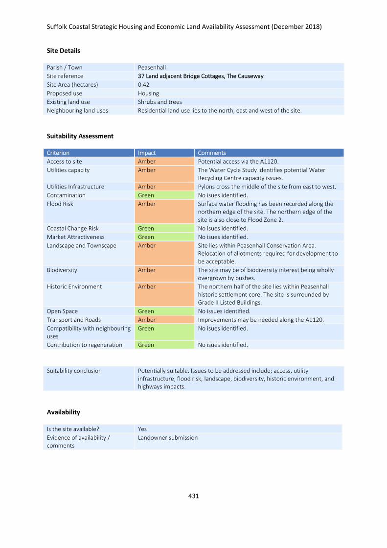
Suffolk Coastal Strategic Housing and Economic Land Availability Assessment (December 2018)
431
Site Details
Parish / Town Peasenhall
Site reference 37 Land adjacent Bridge Cottages, The Causeway
Site Area (hectares) 0.42
Proposed use Housing
Existing land use Shrubs and trees
Neighbouring land uses Residential land use lies to the north, east and west of the site.
Suitability Assessment
Criterion Impact Comments
Access to site Amber Potential access via the A1120.
Utilities capacity Amber The Water Cycle Study identifies potential Water Recycling Centre capacity issues.
Utilities Infrastructure Amber Pylons cross the middle of the site from east to west.
Contamination Green No isues identified.
Flood Risk Amber Surface water flooding has been recorded along the northern edge of the site. The northern edge of the site is also close to Flood Zone 2.
Coastal Change Risk Green No isues identified.
Market Attractiveness Green No isues identified.
Landscape and Townscape Amber Site lies within Peasenhall Conservation Area. Relocation of allotments required for development to be acceptable.
Biodiversity Amber The site may be of biodiversity interest being wholly overgrown by bushes.
Historic Environment Amber The northern half of the site lies within Peasenhall historic settlement core. The site is surrounded by Grade II Listed Buildings.
Open Space Green No issues identified.
Transport and Roads Amber Improvements may be needed along the A1120.
Compatibility with neighbouring uses
Green No isues identified.
Contribution to regeneration Green No isues identified.
Suitability conclusion Potentially suitable. Issues to be addressed include; access, utility infrastructure, flood risk, landscape, biodiversity, historic environment, and highways impacts.
Availability
Is the site available? Yes
Evidence of availability / comments
Landowner submission

Suffolk Coastal Strategic Housing and Economic Land Availability Assessment (December 2018)
432
Achievability
Is the site achievable? Yes
Evidence of achievability No specific issues or abnormal costs identified
Are there any commencement issues?
None identified
Estimated dwellings yield 6
Estimated employment land yield (hectares) -
Estimated retail floorspace (sqm) -
Estimated commencement date 2023/24
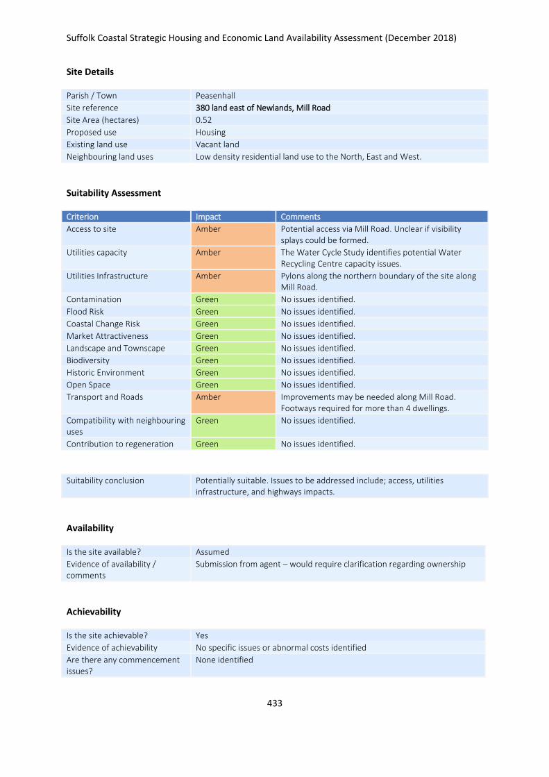
Suffolk Coastal Strategic Housing and Economic Land Availability Assessment (December 2018)
433
Site Details
Parish / Town Peasenhall
Site reference 380 land east of Newlands, Mill Road
Site Area (hectares) 0.52
Proposed use Housing
Existing land use Vacant land
Neighbouring land uses Low density residential land use to the North, East and West.
Suitability Assessment
Criterion Impact Comments
Access to site Amber Potential access via Mill Road. Unclear if visibility splays could be formed.
Utilities capacity Amber The Water Cycle Study identifies potential Water Recycling Centre capacity issues.
Utilities Infrastructure Amber Pylons along the northern boundary of the site along Mill Road.
Contamination Green No issues identified.
Flood Risk Green No issues identified.
Coastal Change Risk Green No issues identified.
Market Attractiveness Green No issues identified.
Landscape and Townscape Green No issues identified.
Biodiversity Green No issues identified.
Historic Environment Green No issues identified.
Open Space Green No issues identified.
Transport and Roads Amber Improvements may be needed along Mill Road. Footways required for more than 4 dwellings.
Compatibility with neighbouring uses
Green No issues identified.
Contribution to regeneration Green No issues identified.
Suitability conclusion Potentially suitable. Issues to be addressed include; access, utilities infrastructure, and highways impacts.
Availability
Is the site available? Assumed
Evidence of availability / comments
Submission from agent – would require clarification regarding ownership
Achievability
Is the site achievable? Yes
Evidence of achievability No specific issues or abnormal costs identified
Are there any commencement issues?
None identified

Suffolk Coastal Strategic Housing and Economic Land Availability Assessment (December 2018)
434
Estimated dwellings yield 8
Estimated employment land yield (hectares) -
Estimated retail floorspace (sqm) -
Estimated commencement date 2021/22
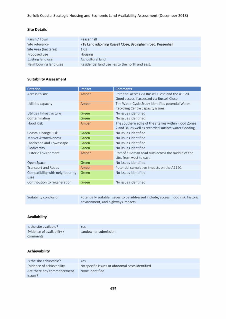
Suffolk Coastal Strategic Housing and Economic Land Availability Assessment (December 2018)
435
Site Details
Parish / Town Peasenhall
Site reference 718 Land adjoining Russell Close, Badingham road, Peasenhall
Site Area (hectares) 1.03
Proposed use Housing
Existing land use Agricultural land
Neighbouring land uses Residential land use lies to the north and east.
Suitability Assessment
Criterion Impact Comments
Access to site Amber Potential access via Russell Close and the A1120. Good access if accessed via Russell Close.
Utilities capacity Amber The Water Cycle Study identifies potential Water Recycling Centre capacity issues.
Utilities Infrastructure Green No issues identified.
Contamination Green No issues identified.
Flood Risk Amber The southern edge of the site lies within Flood Zones 2 and 3a, as well as recorded surface water flooding.
Coastal Change Risk Green No issues identified.
Market Attractiveness Green No issues identified.
Landscape and Townscape Green No issues identified.
Biodiversity Green No issues identified.
Historic Environment Amber Part of a Roman road runs across the middle of the site, from west to east.
Open Space Green No issues identified.
Transport and Roads Amber Potential cumulative impacts on the A1120.
Compatibility with neighbouring uses
Green No issues identified.
Contribution to regeneration Green No issues identified.
Suitability conclusion Potentially suitable. Issues to be addressed include; access, flood risk, historic environment, and highways impacts.
Availability
Is the site available? Yes
Evidence of availability / comments
Landowner submission
Achievability
Is the site achievable? Yes
Evidence of achievability No specific issues or abnormal costs identified
Are there any commencement issues?
None identified

Suffolk Coastal Strategic Housing and Economic Land Availability Assessment (December 2018)
436
Estimated dwellings yield 15
Estimated employment land yield (hectares) -
Estimated retail floorspace (sqm) -
Estimated commencement date 2021/22
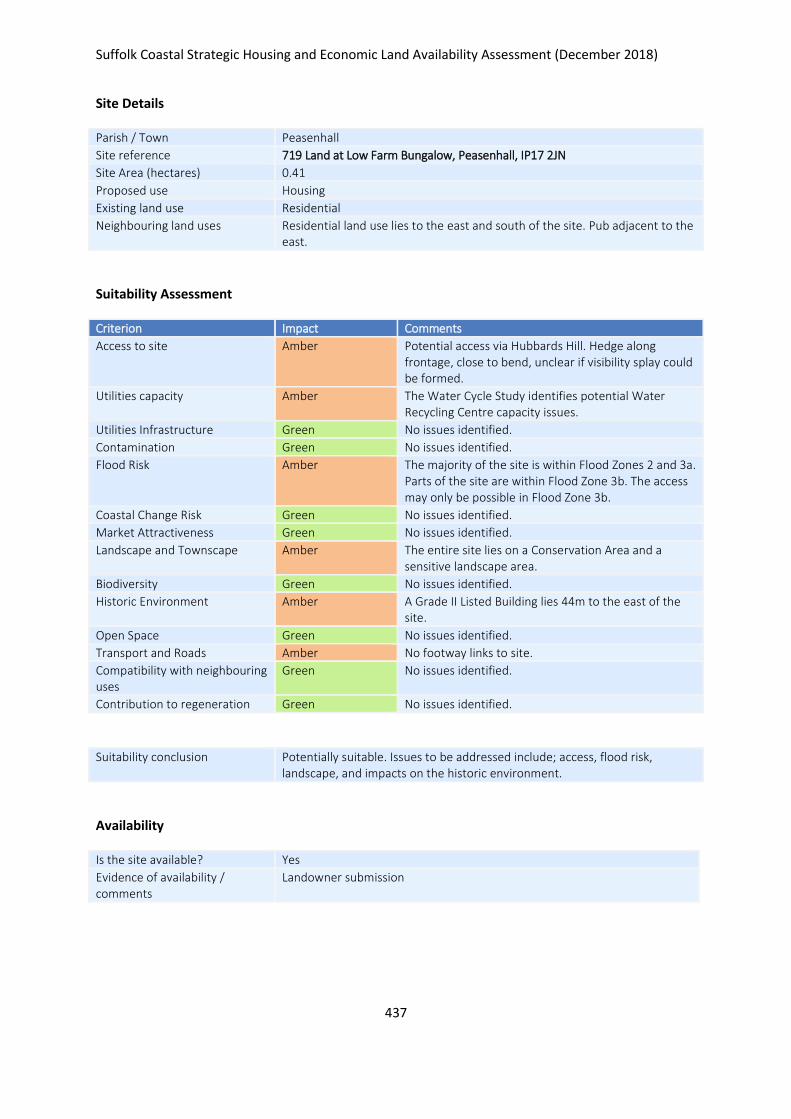
Suffolk Coastal Strategic Housing and Economic Land Availability Assessment (December 2018)
437
Site Details
Parish / Town Peasenhall
Site reference 719 Land at Low Farm Bungalow, Peasenhall, IP17 2JN
Site Area (hectares) 0.41
Proposed use Housing
Existing land use Residential
Neighbouring land uses Residential land use lies to the east and south of the site. Pub adjacent to the east.
Suitability Assessment
Criterion Impact Comments
Access to site Amber Potential access via Hubbards Hill. Hedge along frontage, close to bend, unclear if visibility splay could be formed.
Utilities capacity Amber The Water Cycle Study identifies potential Water Recycling Centre capacity issues.
Utilities Infrastructure Green No issues identified.
Contamination Green No issues identified.
Flood Risk Amber The majority of the site is within Flood Zones 2 and 3a. Parts of the site are within Flood Zone 3b. The access may only be possible in Flood Zone 3b.
Coastal Change Risk Green No issues identified.
Market Attractiveness Green No issues identified.
Landscape and Townscape Amber The entire site lies on a Conservation Area and a sensitive landscape area.
Biodiversity Green No issues identified.
Historic Environment Amber A Grade II Listed Building lies 44m to the east of the site.
Open Space Green No issues identified.
Transport and Roads Amber No footway links to site.
Compatibility with neighbouring uses
Green No issues identified.
Contribution to regeneration Green No issues identified.
Suitability conclusion Potentially suitable. Issues to be addressed include; access, flood risk, landscape, and impacts on the historic environment.
Availability
Is the site available? Yes
Evidence of availability / comments
Landowner submission

Suffolk Coastal Strategic Housing and Economic Land Availability Assessment (December 2018)
438
Achievability
Is the site achievable? Yes
Evidence of achievability No specific issues or abnormal costs identified
Are there any commencement issues?
None identified
Estimated dwellings yield 6
Estimated employment land yield (hectares) -
Estimated retail floorspace (sqm) -
Estimated commencement date 2020/21
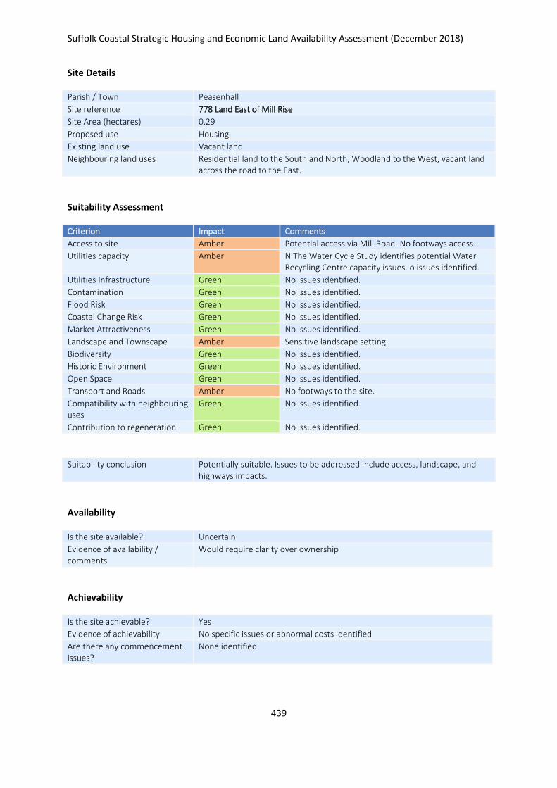
Suffolk Coastal Strategic Housing and Economic Land Availability Assessment (December 2018)
439
Site Details
Parish / Town Peasenhall
Site reference 778 Land East of Mill Rise
Site Area (hectares) 0.29
Proposed use Housing
Existing land use Vacant land
Neighbouring land uses Residential land to the South and North, Woodland to the West, vacant land across the road to the East.
Suitability Assessment
Criterion Impact Comments
Access to site Amber Potential access via Mill Road. No footways access.
Utilities capacity Amber N The Water Cycle Study identifies potential Water Recycling Centre capacity issues. o issues identified.
Utilities Infrastructure Green No issues identified.
Contamination Green No issues identified.
Flood Risk Green No issues identified.
Coastal Change Risk Green No issues identified.
Market Attractiveness Green No issues identified.
Landscape and Townscape Amber Sensitive landscape setting.
Biodiversity Green No issues identified.
Historic Environment Green No issues identified.
Open Space Green No issues identified.
Transport and Roads Amber No footways to the site.
Compatibility with neighbouring uses
Green No issues identified.
Contribution to regeneration Green No issues identified.
Suitability conclusion Potentially suitable. Issues to be addressed include access, landscape, and highways impacts.
Availability
Is the site available? Uncertain
Evidence of availability / comments
Would require clarity over ownership
Achievability
Is the site achievable? Yes
Evidence of achievability No specific issues or abnormal costs identified
Are there any commencement issues?
None identified

Suffolk Coastal Strategic Housing and Economic Land Availability Assessment (December 2018)
440
Estimated dwellings yield 0
Estimated employment land yield (hectares) -
Estimated retail floorspace (sqm) -
Estimated commencement date -
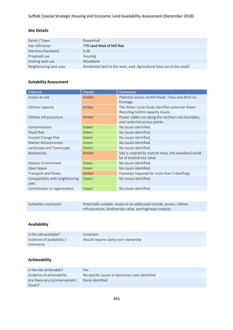
Suffolk Coastal Strategic Housing and Economic Land Availability Assessment (December 2018)
441
Site Details
Parish / Town Peasenhall
Site reference 779 Land West of Mill Rise
Site Area (hectares) 0.36
Proposed use Housing
Existing land use Woodland
Neighbouring land uses Residential land to the west, east. Agricultural land use to the south.
Suitability Assessment
Criterion Impact Comments
Access to site Amber Potential access via Mill Road. Trees and ditch on frontage.
Utilities capacity Amber The Water Cycle Study identifies potential Water Recycling Centre capacity issues.
Utilities Infrastructure Amber Power cables run along the northern site boundary, over potential access points.
Contamination Green No issues identified.
Flood Risk Green No issues identified.
Coastal Change Risk Green No issues identified.
Market Attractiveness Green No issues identified.
Landscape and Townscape Green No issues identified.
Biodiversity Amber Site is covered by mature trees, the woodland could be of biodiveristy value.
Historic Environment Green No issues identified.
Open Space Green No issues identified.
Transport and Roads Amber Footways required for more than 5 dwellings.
Compatibility with neighbouring uses
Green No issues identified.
Contribution to regeneration Green No issues identified.
Suitability conclusion Potentially suitable. Issues to be addressed include; access, utilities infrastructure, biodiversity value, and highways impacts.
Availability
Is the site available? Uncertain
Evidence of availability / comments
Would require clarity over ownership
Achievability
Is the site achievable? Yes
Evidence of achievability No specific issues or abnormal costs identified
Are there any commencement issues?
None identified
Suffolk Coastal Strategic Housing and Economic Land Availability Assessment (December 2018)
442
Estimated dwellings yield 0
Estimated employment land yield (hectares) -
Estimated retail floorspace (sqm) -
Estimated commencement date -
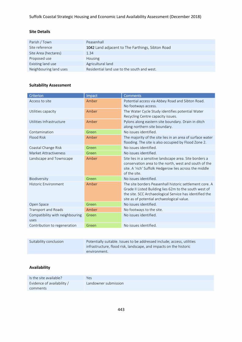
Suffolk Coastal Strategic Housing and Economic Land Availability Assessment (December 2018)
443
Site Details
Parish / Town Peasenhall
Site reference 1042 Land adjacent to The Farthings, Sibton Road
Site Area (hectares) 1.34
Proposed use Housing
Existing land use Agricultural land
Neighbouring land uses Residential land use to the south and west.
Suitability Assessment
Criterion Impact Comments
Access to site Amber Potential access via Abbey Road and Sibton Road. No footways access.
Utilities capacity Amber The Water Cycle Study identifies potential Water Recycling Centre capacity issues.
Utilities Infrastructure Amber Pylons along eastern site boundary. Drain in ditch along northern site boundary.
Contamination Green No issues identified.
Flood Risk Amber The majority of the site lies in an area of surface water flooding. The site is also occupied by Flood Zone 2.
Coastal Change Risk Green No issues identified.
Market Attractiveness Green No issues identified.
Landscape and Townscape Amber Site lies in a sensitive landscape area. Site borders a conservation area to the north, west and south of the site. A ‘rich’ Suffolk Hedgerow lies across the middle of the site.
Biodiversity Green No issues identified.
Historic Environment Amber The site borders Peasenhall historic settlement core. A Grade II Listed Building lies 62m to the south west of the site. SCC Archaeological Service has identified the site as of potential archaeological value.
Open Space Green No issues identified.
Transport and Roads Amber No footways to the site.
Compatibility with neighbouring uses
Green No issues identified.
Contribution to regeneration Green No issues identified.
Suitability conclusion Potentially suitable. Issues to be addressed include; access, utilities infrastructure, flood risk, landscape, and impacts on the historic environment.
Availability
Is the site available? Yes
Evidence of availability / comments
Landowner submission

Suffolk Coastal Strategic Housing and Economic Land Availability Assessment (December 2018)
444
Achievability
Is the site achievable? Yes
Evidence of achievability No specific issues or abnormal costs identified
Are there any commencement issues?
None identified
Estimated dwellings yield 20
Estimated employment land yield (hectares) -
Estimated retail floorspace (sqm) -
Estimated commencement date 2023/24
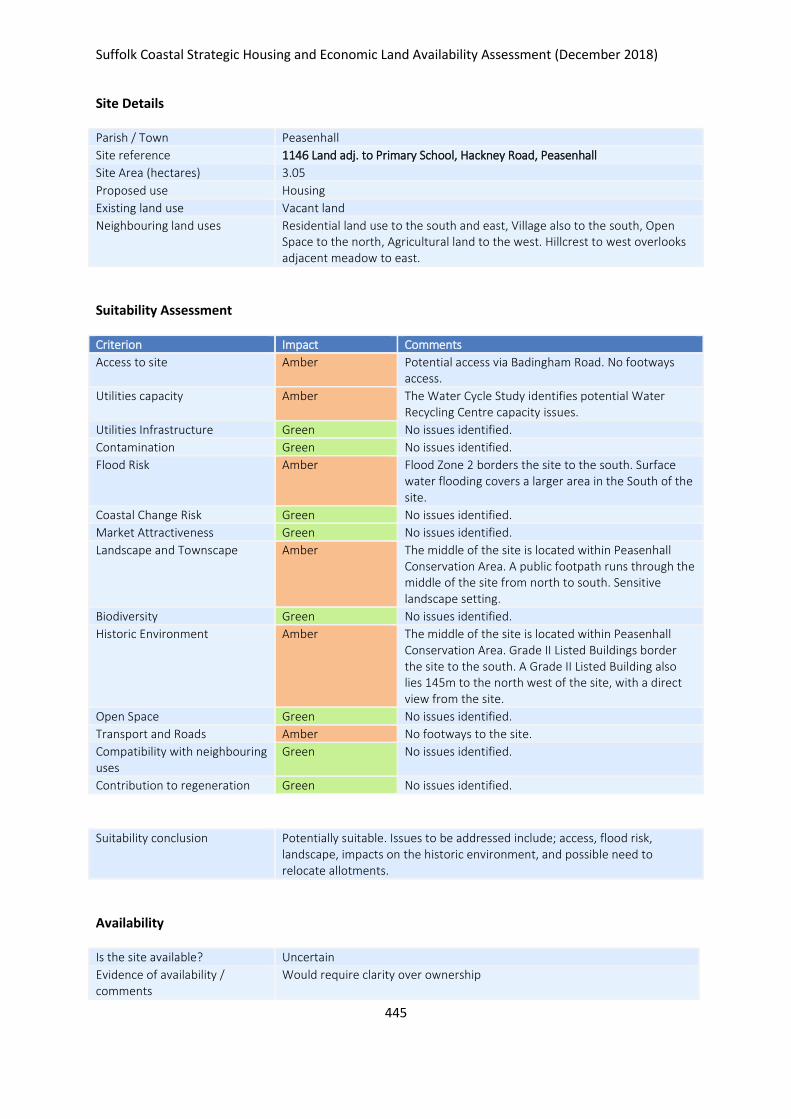
Suffolk Coastal Strategic Housing and Economic Land Availability Assessment (December 2018)
445
Site Details
Parish / Town Peasenhall
Site reference 1146 Land adj. to Primary School, Hackney Road, Peasenhall
Site Area (hectares) 3.05
Proposed use Housing
Existing land use Vacant land
Neighbouring land uses Residential land use to the south and east, Village also to the south, Open Space to the north, Agricultural land to the west. Hillcrest to west overlooks adjacent meadow to east.
Suitability Assessment
Criterion Impact Comments
Access to site Amber Potential access via Badingham Road. No footways access.
Utilities capacity Amber The Water Cycle Study identifies potential Water Recycling Centre capacity issues.
Utilities Infrastructure Green No issues identified.
Contamination Green No issues identified.
Flood Risk Amber Flood Zone 2 borders the site to the south. Surface water flooding covers a larger area in the South of the site.
Coastal Change Risk Green No issues identified.
Market Attractiveness Green No issues identified.
Landscape and Townscape Amber The middle of the site is located within Peasenhall Conservation Area. A public footpath runs through the middle of the site from north to south. Sensitive landscape setting.
Biodiversity Green No issues identified.
Historic Environment Amber The middle of the site is located within Peasenhall Conservation Area. Grade II Listed Buildings border the site to the south. A Grade II Listed Building also lies 145m to the north west of the site, with a direct view from the site.
Open Space Green No issues identified.
Transport and Roads Amber No footways to the site.
Compatibility with neighbouring uses
Green No issues identified.
Contribution to regeneration Green No issues identified.
Suitability conclusion Potentially suitable. Issues to be addressed include; access, flood risk, landscape, impacts on the historic environment, and possible need to relocate allotments.
Availability
Is the site available? Uncertain
Evidence of availability / comments
Would require clarity over ownership
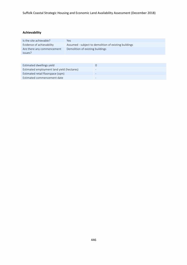
Suffolk Coastal Strategic Housing and Economic Land Availability Assessment (December 2018)
446
Achievability
Is the site achievable? Yes
Evidence of achievability Assumed - subject to demolition of existing buildings
Are there any commencement issues?
Demolition of existing buildings
Estimated dwellings yield 0
Estimated employment land yield (hectares) -
Estimated retail floorspace (sqm) -
Estimated commencement date -
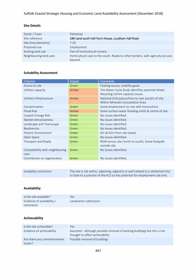
Suffolk Coastal Strategic Housing and Economic Land Availability Assessment (December 2018)
447
Site Details
Parish / Town Pettistree
Site reference 284 Land south Hall Farm House, Loudham Hall Road
Site Area (hectares) 7.20
Proposed use Employment
Existing land use Part of horticultural nursery
Neighbouring land uses Horticultural uses to the south. Roads to other borders, with agricultural uses beyond.
Suitability Assessment
Criterion Impact Comments
Access to site Green Existing access, visibility good.
Utilities capacity Amber The Water Cycle Study identifies potential Water Recycling Centre capacity issues.
Utilities Infrastructure Amber National Grid pylons/lines to rear (south) of site. Within Minerals Consultation Area.
Contamination Green Some employment on site with horticulture.
Flood Risk Amber Some surface water flooding north & centre of site.
Coastal Change Risk Green No issues identified.
Market Attractiveness Green No issues identified.
Landscape and Townscape Green No issues identified.
Biodiversity Green No issues identified.
Historic Environment Green GII LB 42m from site (west)
Open Space Green No issues identified.
Transport and Roads Green ROW across site (north to south). Some footpath outside site.
Compatibility with neighbouring uses
Green No issues identified.
Contribution to regeneration Green No issues identified.
Suitability conclusion The site is not within, adjoining, adjacent or well related to a settlement but is close to a junction of the A12 so has potential for employment use only.
Availability
Is the site available? Yes
Evidence of availability / comments
Landowner submission
Achievability
Is the site achievable? Yes
Evidence of achievability Assumed - although possible removal of existing buildings but this is not thought to affect achievability
Are there any commencement issues?
Possible removal of buildings

Suffolk Coastal Strategic Housing and Economic Land Availability Assessment (December 2018)
448
Estimated dwellings yield -
Estimated employment land yield (hectares) 7
Estimated retail floorspace (sqm) -
Estimated commencement date 2022/23
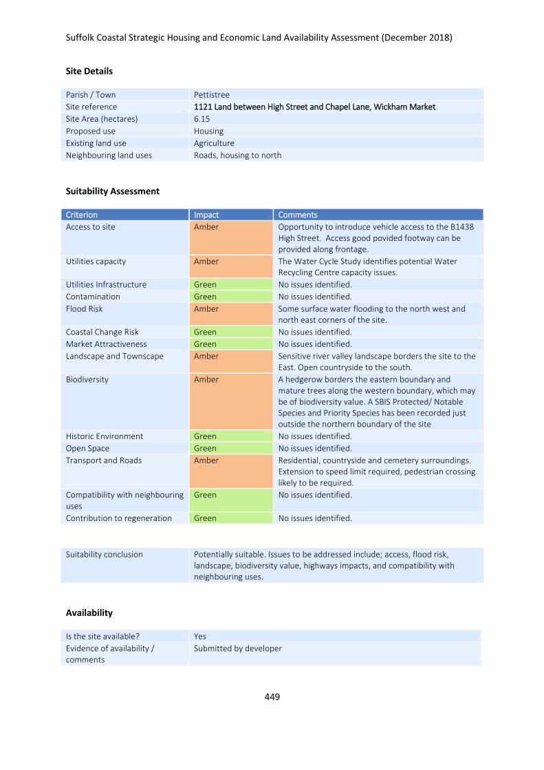
Suffolk Coastal Strategic Housing and Economic Land Availability Assessment (December 2018)
449
Site Details
Parish / Town Pettistree
Site reference 1121 Land between High Street and Chapel Lane, Wickham Market
Site Area (hectares) 6.15
Proposed use Housing
Existing land use Agriculture
Neighbouring land uses Roads, housing to north
Suitability Assessment
Criterion Impact Comments
Access to site Amber Opportunity to introduce vehicle access to the B1438 High Street. Access good povided footway can be provided along frontage.
Utilities capacity Amber The Water Cycle Study identifies potential Water Recycling Centre capacity issues.
Utilities Infrastructure Green No issues identified.
Contamination Green No issues identified.
Flood Risk Amber Some surface water flooding to the north west and north east corners of the site.
Coastal Change Risk Green No issues identified.
Market Attractiveness Green No issues identified.
Landscape and Townscape Amber Sensitive river valley landscape borders the site to the East. Open countryside to the south.
Biodiversity Amber A hedgerow borders the eastern boundary and mature trees along the western boundary, which may be of biodiversity value. A SBIS Protected/ Notable Species and Priority Species has been recorded just outside the northern boundary of the site
Historic Environment Green No issues identified.
Open Space Green No issues identified.
Transport and Roads Amber Residential, countryside and cemetery surroundings. Extension to speed limit required, pedestrian crossing likely to be required.
Compatibility with neighbouring uses
Green No issues identified.
Contribution to regeneration Green No issues identified.
Suitability conclusion Potentially suitable. Issues to be addressed include; access, flood risk, landscape, biodiversity value, highways impacts, and compatibility with neighbouring uses.
Availability
Is the site available? Yes
Evidence of availability / comments
Submitted by developer

Suffolk Coastal Strategic Housing and Economic Land Availability Assessment (December 2018)
450
Achievability
Is the site achievable? Yes
Evidence of achievability No specific issues or abnormal costs identified
Are there any commencement issues?
None identified
Estimated dwellings yield 92
Estimated employment land yield (hectares) -
Estimated retail floorspace (sqm) -
Estimated commencement date 2023/24
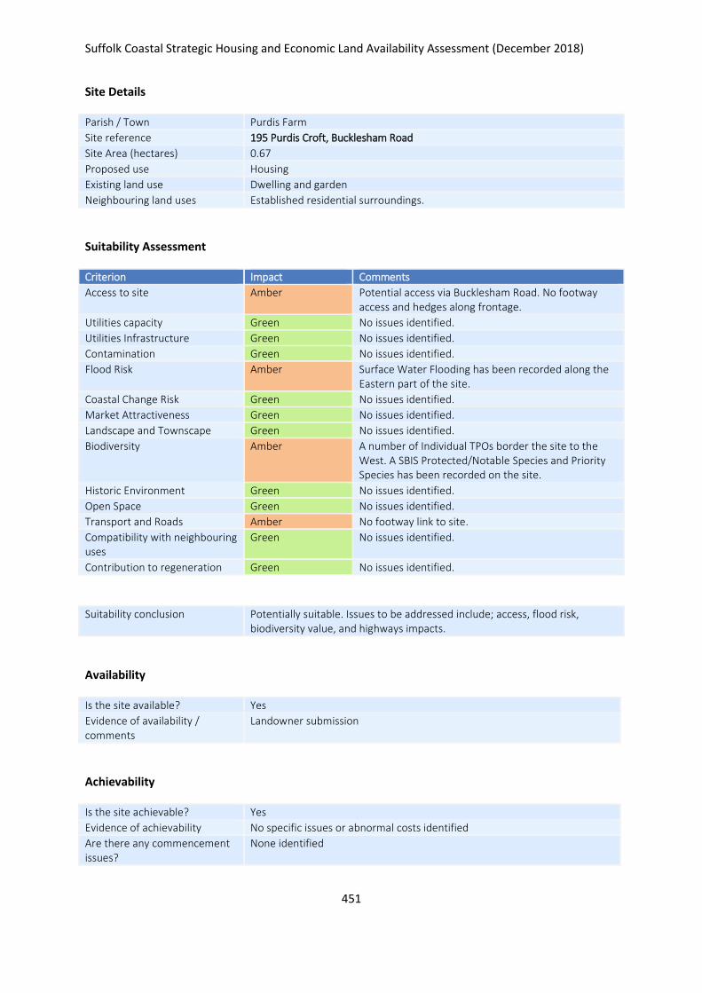
Suffolk Coastal Strategic Housing and Economic Land Availability Assessment (December 2018)
451
Site Details
Parish / Town Purdis Farm
Site reference 195 Purdis Croft, Bucklesham Road
Site Area (hectares) 0.67
Proposed use Housing
Existing land use Dwelling and garden
Neighbouring land uses Established residential surroundings.
Suitability Assessment
Criterion Impact Comments
Access to site Amber Potential access via Bucklesham Road. No footway access and hedges along frontage.
Utilities capacity Green No issues identified.
Utilities Infrastructure Green No issues identified.
Contamination Green No issues identified.
Flood Risk Amber Surface Water Flooding has been recorded along the Eastern part of the site.
Coastal Change Risk Green No issues identified.
Market Attractiveness Green No issues identified.
Landscape and Townscape Green No issues identified.
Biodiversity Amber A number of Individual TPOs border the site to the West. A SBIS Protected/Notable Species and Priority Species has been recorded on the site.
Historic Environment Green No issues identified.
Open Space Green No issues identified.
Transport and Roads Amber No footway link to site.
Compatibility with neighbouring uses
Green No issues identified.
Contribution to regeneration Green No issues identified.
Suitability conclusion Potentially suitable. Issues to be addressed include; access, flood risk, biodiversity value, and highways impacts.
Availability
Is the site available? Yes
Evidence of availability / comments
Landowner submission
Achievability
Is the site achievable? Yes
Evidence of achievability No specific issues or abnormal costs identified
Are there any commencement issues?
None identified

Suffolk Coastal Strategic Housing and Economic Land Availability Assessment (December 2018)
452
Estimated dwellings yield 17
Estimated employment land yield (hectares) -
Estimated retail floorspace (sqm) -
Estimated commencement date 2022/23
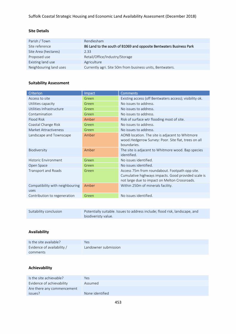
Suffolk Coastal Strategic Housing and Economic Land Availability Assessment (December 2018)
453
Site Details
Parish / Town Rendlesham
Site reference 86 Land to the south of B1069 and opposite Bentwaters Business Park
Site Area (hectares) 2.33
Proposed use Retail/Office/Industry/Storage
Existing land use Agriculture
Neighbouring land uses Currently agri. Site 50m from business units, Bentwaters.
Suitability Assessment
Criterion Impact Comments
Access to site Green Existing access (off Bentwaters access); visibility ok.
Utilities capacity Green No issues to address.
Utilities Infrastructure Green No issues to address.
Contamination Green No issues to address.
Flood Risk Amber Risk of surface wtr flooding most of site.
Coastal Change Risk Green No issues to address.
Market Attractiveness Green No issues to address.
Landscape and Townscape Amber AONB location. The site is adjacent to Whitmore wood.Hedgerow Survey: Poor. Site flat, trees on all boundaries.
Biodiversity Amber The site is adjacent to Whitmore wood. Bap species identified.
Historic Environment Green No issues identified.
Open Space Green No issues identified.
Transport and Roads Green Access 75m from roundabout. Footpath opp site. Cumulative highways impacts. Good provided scale is not large due to impact on Melton Crossroads.
Compatibility with neighbouring uses
Amber Within 250m of minerals facility.
Contribution to regeneration Green No issues identified.
Suitability conclusion Potentially suitable. Issues to address include; flood risk, landscape, and biodiveristy value.
Availability
Is the site available? Yes
Evidence of availability / comments
Landowner submission
Achievability
Is the site achievable? Yes
Evidence of achievability Assumed
Are there any commencement issues?
None identified

Suffolk Coastal Strategic Housing and Economic Land Availability Assessment (December 2018)
454
Estimated dwellings yield -
Estimated employment land yield (hectares) 2
Estimated retail floorspace (sqm) -
Estimated commencement date 2022/23
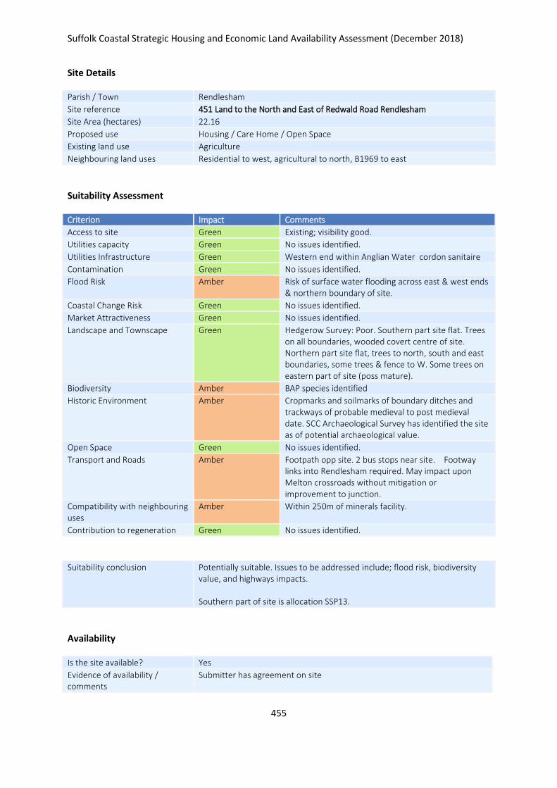
Suffolk Coastal Strategic Housing and Economic Land Availability Assessment (December 2018)
455
Site Details
Parish / Town Rendlesham
Site reference 451 Land to the North and East of Redwald Road Rendlesham
Site Area (hectares) 22.16
Proposed use Housing / Care Home / Open Space
Existing land use Agriculture
Neighbouring land uses Residential to west, agricultural to north, B1969 to east
Suitability Assessment
Criterion Impact Comments
Access to site Green Existing; visibility good.
Utilities capacity Green No issues identified.
Utilities Infrastructure Green Western end within Anglian Water cordon sanitaire
Contamination Green No issues identified.
Flood Risk Amber Risk of surface water flooding across east & west ends & northern boundary of site.
Coastal Change Risk Green No issues identified.
Market Attractiveness Green No issues identified.
Landscape and Townscape Green Hedgerow Survey: Poor. Southern part site flat. Trees on all boundaries, wooded covert centre of site. Northern part site flat, trees to north, south and east boundaries, some trees & fence to W. Some trees on eastern part of site (poss mature).
Biodiversity Amber BAP species identified
Historic Environment Amber Cropmarks and soilmarks of boundary ditches and trackways of probable medieval to post medieval date. SCC Archaeological Survey has identified the site as of potential archaeological value.
Open Space Green No issues identified.
Transport and Roads Amber Footpath opp site. 2 bus stops near site. Footway links into Rendlesham required. May impact upon Melton crossroads without mitigation or improvement to junction.
Compatibility with neighbouring uses
Amber Within 250m of minerals facility.
Contribution to regeneration Green No issues identified.
Suitability conclusion Potentially suitable. Issues to be addressed include; flood risk, biodiversity value, and highways impacts. Southern part of site is allocation SSP13.
Availability
Is the site available? Yes
Evidence of availability / comments
Submitter has agreement on site

Suffolk Coastal Strategic Housing and Economic Land Availability Assessment (December 2018)
456
Achievability
Is the site achievable? Yes
Evidence of achievability No specific issues or abnormal costs identified
Are there any commencement issues?
None identified
Estimated dwellings yield 268
Estimated employment land yield (hectares) -
Estimated retail floorspace (sqm) -
Estimated commencement date 2022/23
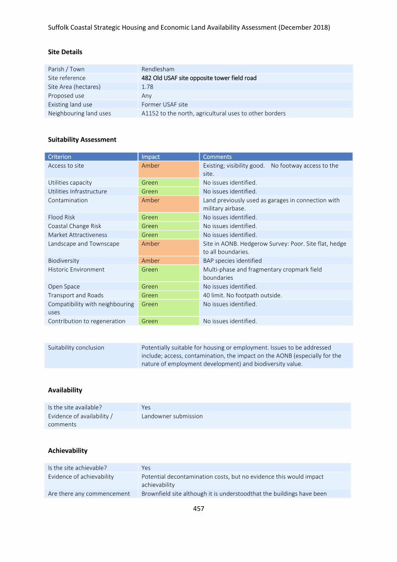
Suffolk Coastal Strategic Housing and Economic Land Availability Assessment (December 2018)
457
Site Details
Parish / Town Rendlesham
Site reference 482 Old USAF site opposite tower field road
Site Area (hectares) 1.78
Proposed use Any
Existing land use Former USAF site
Neighbouring land uses A1152 to the north, agricultural uses to other borders
Suitability Assessment
Criterion Impact Comments
Access to site Amber Existing; visibility good. No footway access to the site.
Utilities capacity Green No issues identified.
Utilities Infrastructure Green No issues identified.
Contamination Amber Land previously used as garages in connection with military airbase.
Flood Risk Green No issues identified.
Coastal Change Risk Green No issues identified.
Market Attractiveness Green No issues identified.
Landscape and Townscape Amber Site in AONB. Hedgerow Survey: Poor. Site flat, hedge to all boundaries.
Biodiversity Amber BAP species identified
Historic Environment Green Multi-phase and fragmentary cropmark field boundaries
Open Space Green No issues identified.
Transport and Roads Green 40 limit. No footpath outside.
Compatibility with neighbouring uses
Green No issues identified.
Contribution to regeneration Green No issues identified.
Suitability conclusion Potentially suitable for housing or employment. Issues to be addressed include; access, contamination, the impact on the AONB (especially for the nature of employment development) and biodiversity value.
Availability
Is the site available? Yes
Evidence of availability / comments
Landowner submission
Achievability
Is the site achievable? Yes
Evidence of achievability Potential decontamination costs, but no evidence this would impact achievability
Are there any commencement Brownfield site although it is understoodthat the buildings have been

Suffolk Coastal Strategic Housing and Economic Land Availability Assessment (December 2018)
458
issues? removed. Possible decontamination costs.
Estimated dwellings yield 21
Estimated employment land yield (hectares) 1
Estimated retail floorspace (sqm) -
Estimated commencement date 2023/24
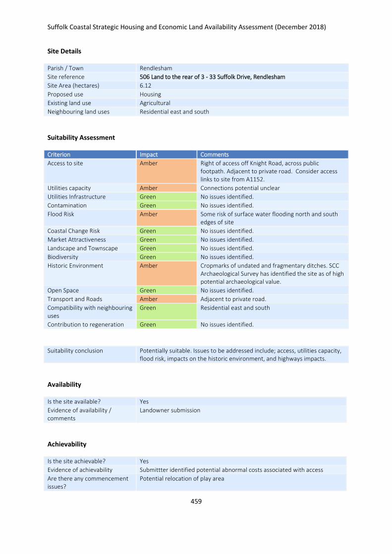
Suffolk Coastal Strategic Housing and Economic Land Availability Assessment (December 2018)
459
Site Details
Parish / Town Rendlesham
Site reference 506 Land to the rear of 3 - 33 Suffolk Drive, Rendlesham
Site Area (hectares) 6.12
Proposed use Housing
Existing land use Agricultural
Neighbouring land uses Residential east and south
Suitability Assessment
Criterion Impact Comments
Access to site Amber Right of access off Knight Road, across public footpath. Adjacent to private road. Consider access links to site from A1152.
Utilities capacity Amber Connections potential unclear
Utilities Infrastructure Green No issues identified.
Contamination Green No issues identified.
Flood Risk Amber Some risk of surface water flooding north and south edges of site
Coastal Change Risk Green No issues identified.
Market Attractiveness Green No issues identified.
Landscape and Townscape Green No issues identified.
Biodiversity Green No issues identified.
Historic Environment Amber Cropmarks of undated and fragmentary ditches. SCC Archaeological Survey has identified the site as of high potential archaeological value.
Open Space Green No issues identified.
Transport and Roads Amber Adjacent to private road.
Compatibility with neighbouring uses
Green Residential east and south
Contribution to regeneration Green No issues identified.
Suitability conclusion Potentially suitable. Issues to be addressed include; access, utilities capacity, flood risk, impacts on the historic environment, and highways impacts.
Availability
Is the site available? Yes
Evidence of availability / comments
Landowner submission
Achievability
Is the site achievable? Yes
Evidence of achievability Submittter identified potential abnormal costs associated with access
Are there any commencement issues?
Potential relocation of play area

Suffolk Coastal Strategic Housing and Economic Land Availability Assessment (December 2018)
460
Estimated dwellings yield 92
Estimated employment land yield (hectares) -
Estimated retail floorspace (sqm) -
Estimated commencement date 2025/26
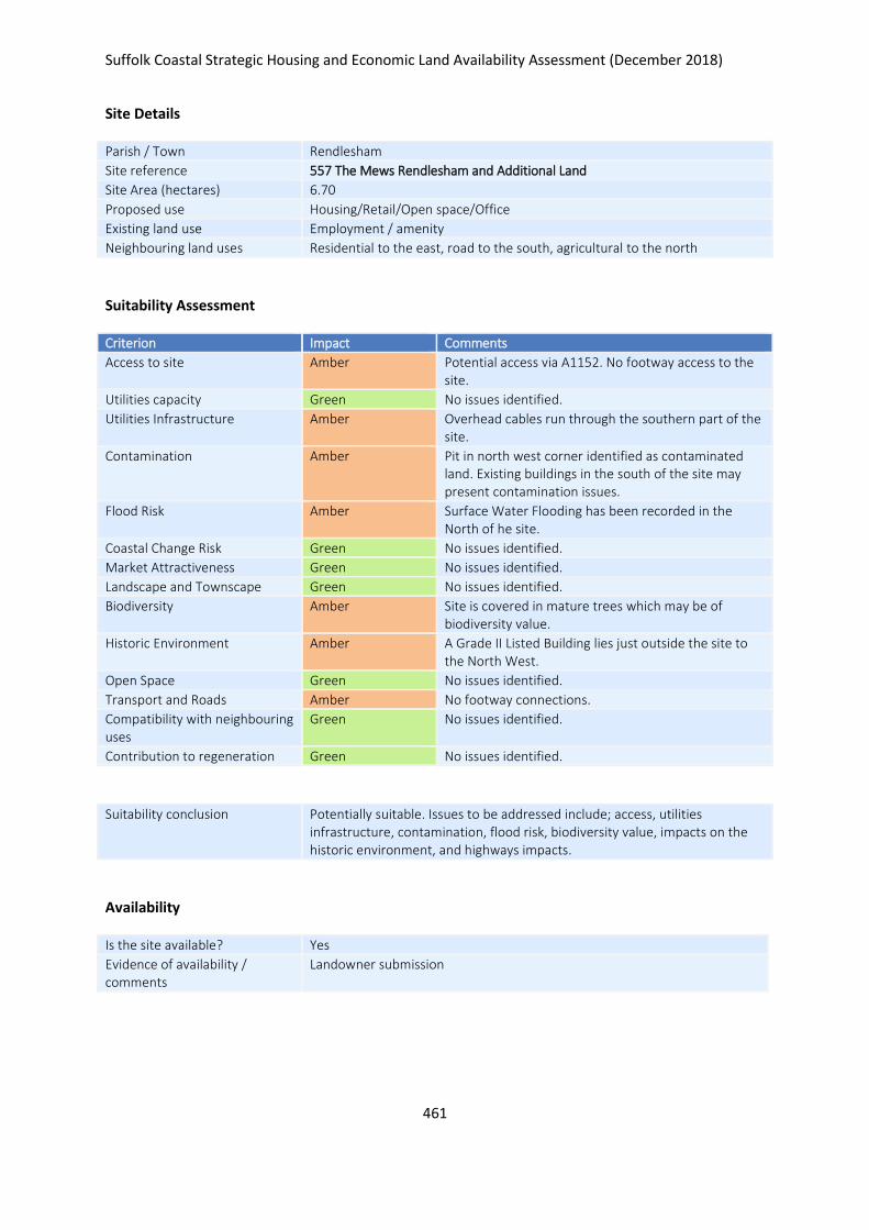
Suffolk Coastal Strategic Housing and Economic Land Availability Assessment (December 2018)
461
Site Details
Parish / Town Rendlesham
Site reference 557 The Mews Rendlesham and Additional Land
Site Area (hectares) 6.70
Proposed use Housing/Retail/Open space/Office
Existing land use Employment / amenity
Neighbouring land uses Residential to the east, road to the south, agricultural to the north
Suitability Assessment
Criterion Impact Comments
Access to site Amber Potential access via A1152. No footway access to the site.
Utilities capacity Green No issues identified.
Utilities Infrastructure Amber Overhead cables run through the southern part of the site.
Contamination Amber Pit in north west corner identified as contaminated land. Existing buildings in the south of the site may present contamination issues.
Flood Risk Amber Surface Water Flooding has been recorded in the North of he site.
Coastal Change Risk Green No issues identified.
Market Attractiveness Green No issues identified.
Landscape and Townscape Green No issues identified.
Biodiversity Amber Site is covered in mature trees which may be of biodiversity value.
Historic Environment Amber A Grade II Listed Building lies just outside the site to the North West.
Open Space Green No issues identified.
Transport and Roads Amber No footway connections.
Compatibility with neighbouring uses
Green No issues identified.
Contribution to regeneration Green No issues identified.
Suitability conclusion Potentially suitable. Issues to be addressed include; access, utilities infrastructure, contamination, flood risk, biodiversity value, impacts on the historic environment, and highways impacts.
Availability
Is the site available? Yes
Evidence of availability / comments
Landowner submission

Suffolk Coastal Strategic Housing and Economic Land Availability Assessment (December 2018)
462
Achievability
Is the site achievable? Yes
Evidence of achievability No specific issues or abnormal costs identified
Are there any commencement issues?
None identified
Estimated dwellings yield 30
Estimated employment land yield (hectares) -
Estimated retail floorspace (sqm) 1000
Estimated commencement date 2021/22
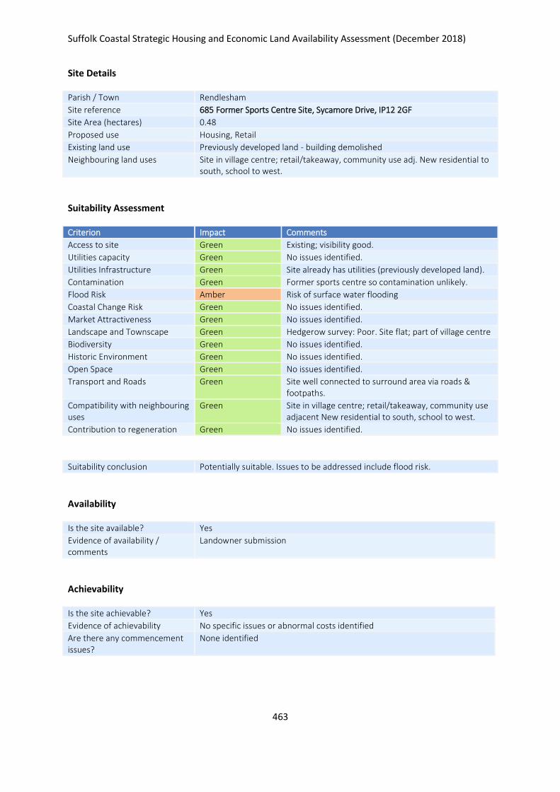
Suffolk Coastal Strategic Housing and Economic Land Availability Assessment (December 2018)
463
Site Details
Parish / Town Rendlesham
Site reference 685 Former Sports Centre Site, Sycamore Drive, IP12 2GF
Site Area (hectares) 0.48
Proposed use Housing, Retail
Existing land use Previously developed land - building demolished
Neighbouring land uses Site in village centre; retail/takeaway, community use adj. New residential to south, school to west.
Suitability Assessment
Criterion Impact Comments
Access to site Green Existing; visibility good.
Utilities capacity Green No issues identified.
Utilities Infrastructure Green Site already has utilities (previously developed land).
Contamination Green Former sports centre so contamination unlikely.
Flood Risk Amber Risk of surface water flooding
Coastal Change Risk Green No issues identified.
Market Attractiveness Green No issues identified.
Landscape and Townscape Green Hedgerow survey: Poor. Site flat; part of village centre
Biodiversity Green No issues identified.
Historic Environment Green No issues identified.
Open Space Green No issues identified.
Transport and Roads Green Site well connected to surround area via roads & footpaths.
Compatibility with neighbouring uses
Green Site in village centre; retail/takeaway, community use adjacent New residential to south, school to west.
Contribution to regeneration Green No issues identified.
Suitability conclusion Potentially suitable. Issues to be addressed include flood risk.
Availability
Is the site available? Yes
Evidence of availability / comments
Landowner submission
Achievability
Is the site achievable? Yes
Evidence of achievability No specific issues or abnormal costs identified
Are there any commencement issues?
None identified

Suffolk Coastal Strategic Housing and Economic Land Availability Assessment (December 2018)
464
Estimated dwellings yield 6
Estimated employment land yield (hectares) -
Estimated retail floorspace (sqm) 400
Estimated commencement date 2021/22
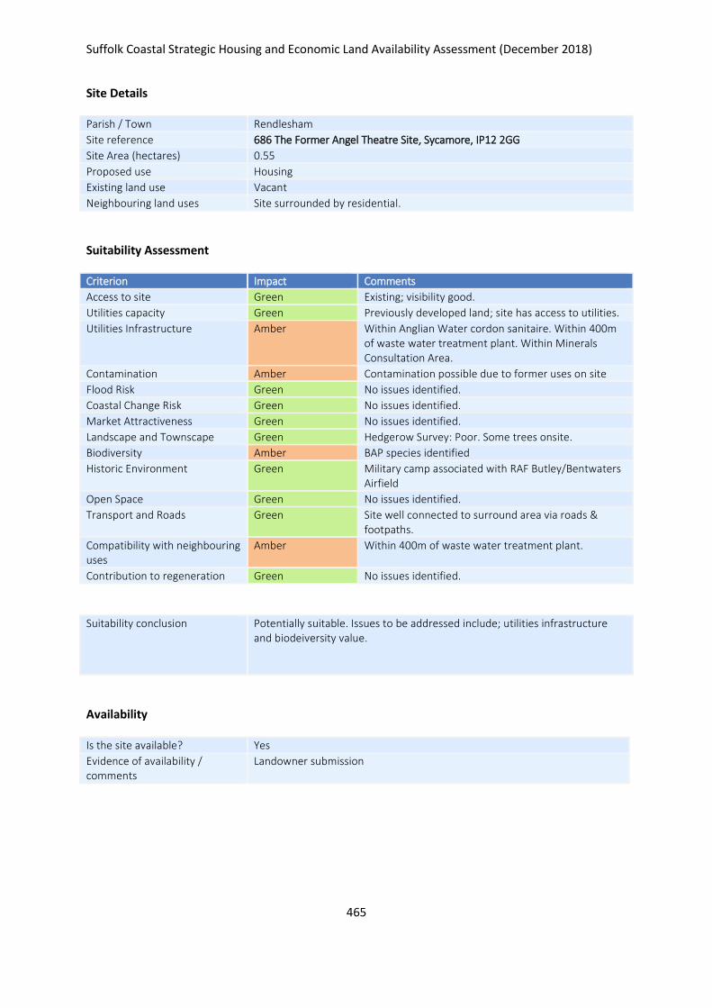
Suffolk Coastal Strategic Housing and Economic Land Availability Assessment (December 2018)
465
Site Details
Parish / Town Rendlesham
Site reference 686 The Former Angel Theatre Site, Sycamore, IP12 2GG
Site Area (hectares) 0.55
Proposed use Housing
Existing land use Vacant
Neighbouring land uses Site surrounded by residential.
Suitability Assessment
Criterion Impact Comments
Access to site Green Existing; visibility good.
Utilities capacity Green Previously developed land; site has access to utilities.
Utilities Infrastructure Amber Within Anglian Water cordon sanitaire. Within 400m of waste water treatment plant. Within Minerals Consultation Area.
Contamination Amber Contamination possible due to former uses on site
Flood Risk Green No issues identified.
Coastal Change Risk Green No issues identified.
Market Attractiveness Green No issues identified.
Landscape and Townscape Green Hedgerow Survey: Poor. Some trees onsite.
Biodiversity Amber BAP species identified
Historic Environment Green Military camp associated with RAF Butley/Bentwaters Airfield
Open Space Green No issues identified.
Transport and Roads Green Site well connected to surround area via roads & footpaths.
Compatibility with neighbouring uses
Amber Within 400m of waste water treatment plant.
Contribution to regeneration Green No issues identified.
Suitability conclusion Potentially suitable. Issues to be addressed include; utilities infrastructure and biodeiversity value.
Availability
Is the site available? Yes
Evidence of availability / comments
Landowner submission

Suffolk Coastal Strategic Housing and Economic Land Availability Assessment (December 2018)
466
Achievability
Is the site achievable? Yes
Evidence of achievability No specific issues or abnormal costs identified
Are there any commencement issues?
None identified
Estimated dwellings yield 8
Estimated employment land yield (hectares) -
Estimated retail floorspace (sqm) -
Estimated commencement date 2021/22
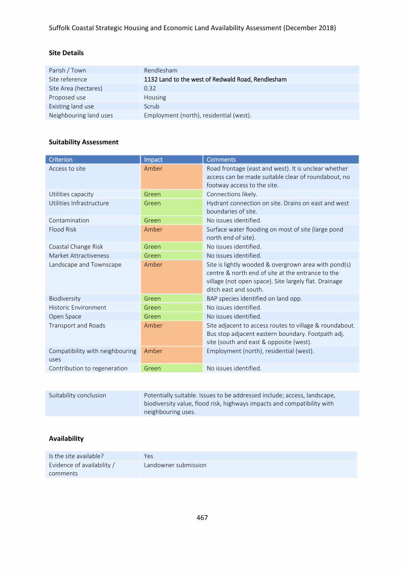
Suffolk Coastal Strategic Housing and Economic Land Availability Assessment (December 2018)
467
Site Details
Parish / Town Rendlesham
Site reference 1132 Land to the west of Redwald Road, Rendlesham
Site Area (hectares) 0.32
Proposed use Housing
Existing land use Scrub
Neighbouring land uses Employment (north), residential (west).
Suitability Assessment
Criterion Impact Comments
Access to site Amber Road frontage (east and west). It is unclear whether access can be made suitable clear of roundabout, no footway access to the site.
Utilities capacity Green Connections likely.
Utilities Infrastructure Green Hydrant connection on site. Drains on east and west boundaries of site.
Contamination Green No issues identified.
Flood Risk Amber Surface water flooding on most of site (large pond north end of site).
Coastal Change Risk Green No issues identified.
Market Attractiveness Green No issues identified.
Landscape and Townscape Amber Site is lightly wooded & overgrown area with pond(s) centre & north end of site at the entrance to the village (not open space). Site largely flat. Drainage ditch east and south.
Biodiversity Green BAP species identified on land opp.
Historic Environment Green No issues identified.
Open Space Green No issues identified.
Transport and Roads Amber Site adjacent to access routes to village & roundabout. Bus stop adjacent eastern boundary. Footpath adj. site (south and east & opposite (west).
Compatibility with neighbouring uses
Amber Employment (north), residential (west).
Contribution to regeneration Green No issues identified.
Suitability conclusion Potentially suitable. Issues to be addressed include; access, landscape, biodiversity value, flood risk, highways impacts and compatibility with neighbouring uses.
Availability
Is the site available? Yes
Evidence of availability / comments
Landowner submission

Suffolk Coastal Strategic Housing and Economic Land Availability Assessment (December 2018)
468
Achievability
Is the site achievable? Yes
Evidence of achievability No specific issues or abnormal costs identified
Are there any commencement issues?
None identified
Estimated dwellings yield 5
Estimated employment land yield (hectares) -
Estimated retail floorspace (sqm) -
Estimated commencement date 2021/22
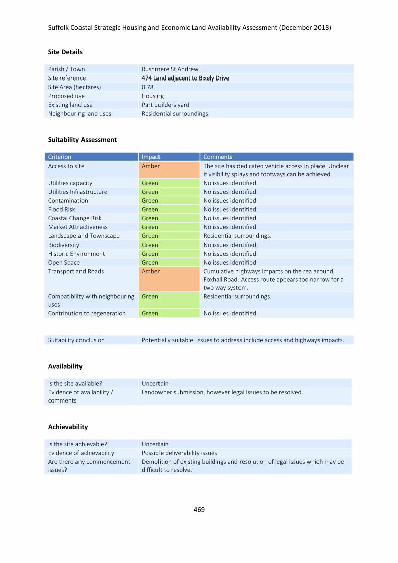
Suffolk Coastal Strategic Housing and Economic Land Availability Assessment (December 2018)
469
Site Details
Parish / Town Rushmere St Andrew
Site reference 474 Land adjacent to Bixely Drive
Site Area (hectares) 0.78
Proposed use Housing
Existing land use Part builders yard
Neighbouring land uses Residential surroundings.
Suitability Assessment
Criterion Impact Comments
Access to site Amber The site has dedicated vehicle access in place. Unclear if visibility splays and footways can be achieved.
Utilities capacity Green No issues identified.
Utilities Infrastructure Green No issues identified.
Contamination Green No issues identified.
Flood Risk Green No issues identified.
Coastal Change Risk Green No issues identified.
Market Attractiveness Green No issues identified.
Landscape and Townscape Green Residential surroundings.
Biodiversity Green No issues identified.
Historic Environment Green No issues identified.
Open Space Green No issues identified.
Transport and Roads Amber Cumulative highways impacts on the rea around Foxhall Road. Access route appears too narrow for a two way system.
Compatibility with neighbouring uses
Green Residential surroundings.
Contribution to regeneration Green No issues identified.
Suitability conclusion Potentially suitable. Issues to address include access and highways impacts.
Availability
Is the site available? Uncertain
Evidence of availability / comments
Landowner submission, however legal issues to be resolved.
Achievability
Is the site achievable? Uncertain
Evidence of achievability Possible deliverability issues
Are there any commencement issues?
Demolition of existing buildings and resolution of legal issues which may be difficult to resolve.

Suffolk Coastal Strategic Housing and Economic Land Availability Assessment (December 2018)
470
Estimated dwellings yield 0
Estimated employment land yield (hectares) -
Estimated retail floorspace (sqm) -
Estimated commencement date -
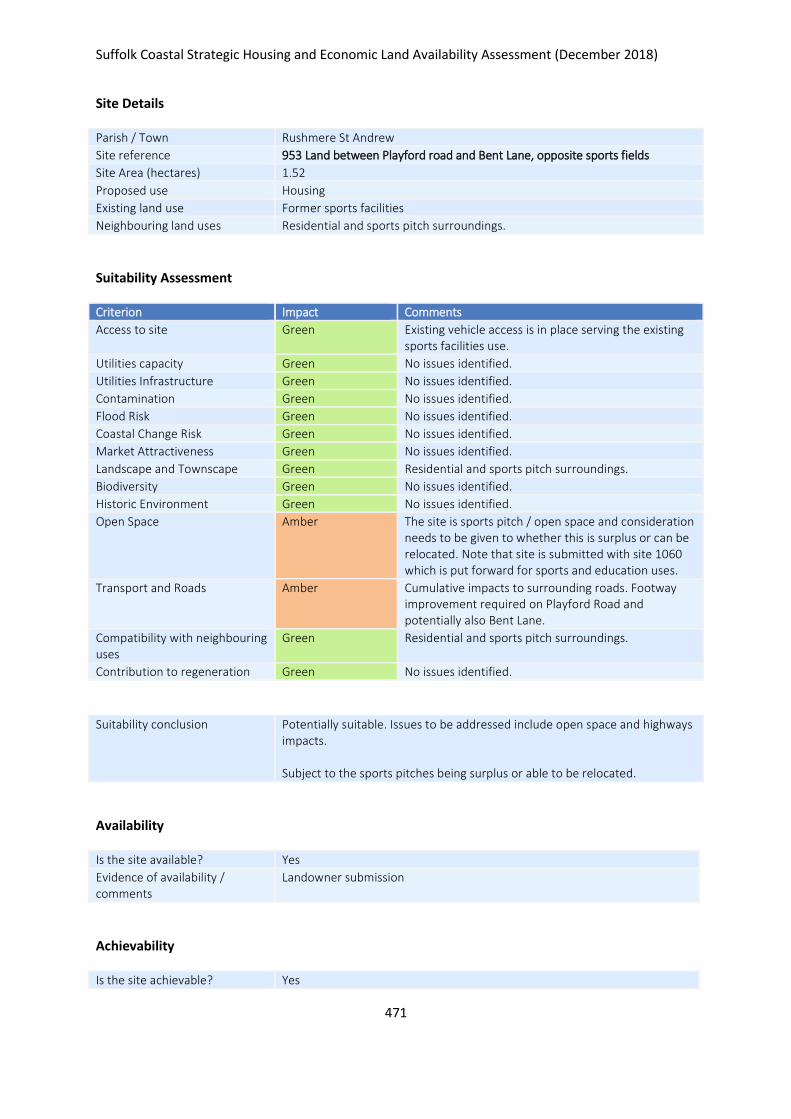
Suffolk Coastal Strategic Housing and Economic Land Availability Assessment (December 2018)
471
Site Details
Parish / Town Rushmere St Andrew
Site reference 953 Land between Playford road and Bent Lane, opposite sports fields
Site Area (hectares) 1.52
Proposed use Housing
Existing land use Former sports facilities
Neighbouring land uses Residential and sports pitch surroundings.
Suitability Assessment
Criterion Impact Comments
Access to site Green Existing vehicle access is in place serving the existing sports facilities use.
Utilities capacity Green No issues identified.
Utilities Infrastructure Green No issues identified.
Contamination Green No issues identified.
Flood Risk Green No issues identified.
Coastal Change Risk Green No issues identified.
Market Attractiveness Green No issues identified.
Landscape and Townscape Green Residential and sports pitch surroundings.
Biodiversity Green No issues identified.
Historic Environment Green No issues identified.
Open Space Amber The site is sports pitch / open space and consideration needs to be given to whether this is surplus or can be relocated. Note that site is submitted with site 1060 which is put forward for sports and education uses.
Transport and Roads Amber Cumulative impacts to surrounding roads. Footway improvement required on Playford Road and potentially also Bent Lane.
Compatibility with neighbouring uses
Green Residential and sports pitch surroundings.
Contribution to regeneration Green No issues identified.
Suitability conclusion Potentially suitable. Issues to be addressed include open space and highways impacts. Subject to the sports pitches being surplus or able to be relocated.
Availability
Is the site available? Yes
Evidence of availability / comments
Landowner submission
Achievability
Is the site achievable? Yes
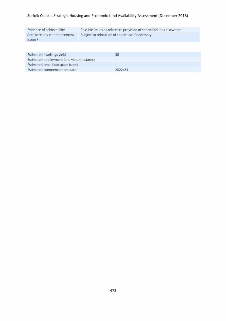
Suffolk Coastal Strategic Housing and Economic Land Availability Assessment (December 2018)
472
Evidence of achievability Possible issues as relates to provision of sports facilities elsewhere
Are there any commencement issues?
Subject to relocation of sports use if necessary
Estimated dwellings yield 38
Estimated employment land yield (hectares) -
Estimated retail floorspace (sqm) -
Estimated commencement date 2022/23
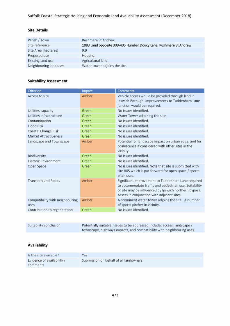
Suffolk Coastal Strategic Housing and Economic Land Availability Assessment (December 2018)
473
Site Details
Parish / Town Rushmere St Andrew
Site reference 1083 Land opposite 309-405 Humber Doucy Lane, Rushmere St Andrew
Site Area (hectares) 9.9
Proposed use Housing
Existing land use Agricultural land
Neighbouring land uses Water tower adjoins the site.
Suitability Assessment
Criterion Impact Comments
Access to site Amber Vehicle access would be provided through land in Ipswich Borough. Improvements to Tuddenham Lane junction would be required.
Utilities capacity Green No issues identified.
Utilities Infrastructure Green Water Tower adjoining the site.
Contamination Green No issues identified.
Flood Risk Green No issues identified.
Coastal Change Risk Green No issues identified.
Market Attractiveness Green No issues identified.
Landscape and Townscape Amber Potential for landscape impact on urban edge, and for coalescence if considered with other sites in the vicinity.
Biodiversity Green No issues identified.
Historic Environment Green No issues identified.
Open Space Green No issues identified. Note that site is submitted with site 805 which is put forward for open space / sports pitch uses.
Transport and Roads Amber Significant improvement to Tuddenham Lane required to accommodate traffic and pedestrian use. Suitability of site may be influenced by Ipswich northern bypass. Assess in conjunction with adjacent sites.
Compatibility with neighbouring uses
Amber A prominent water tower adjoins the site. A number of sports pitches in vicinity.
Contribution to regeneration Green No issues identified.
Suitability conclusion Potentially suitable. Issues to be addressed include; access, landscape / townscape, highways impacts, and compatibility with neighbouring uses.
Availability
Is the site available? Yes
Evidence of availability / comments
Submission on behalf of all landowners

Suffolk Coastal Strategic Housing and Economic Land Availability Assessment (December 2018)
474
Achievability
Is the site achievable? Yes
Evidence of achievability No specific issues or abnormal costs identified
Are there any commencement issues?
None identified
Estimated dwellings yield 247
Estimated employment land yield (hectares) -
Estimated retail floorspace (sqm) -
Estimated commencement date 2023/24
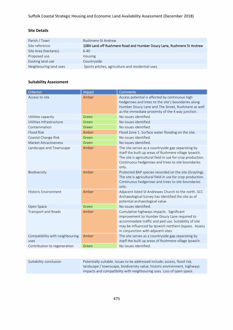
Suffolk Coastal Strategic Housing and Economic Land Availability Assessment (December 2018)
475
Site Details
Parish / Town Rushmere St Andrew
Site reference 1084 Land off Rushmere Road and Humber Doucy Lane, Rushmere St Andrew
Site Area (hectares) 6.40
Proposed use Housing
Existing land use Countryside
Neighbouring land uses Sports pitches, agriculture and residential uses.
Suitability Assessment
Criterion Impact Comments
Access to site Amber Access potential is affected by continuous high hedgerows and trees to the site’s boundaries along Humber Doucy Lane and The Street, Rushmere as well as the immediate proximity of the 4 way junction.
Utilities capacity Green No issues identified.
Utilities Infrastructure Green No issues identified.
Contamination Green No issues identified.
Flood Risk Amber Flood Zone 1. Surface water flooding on the site.
Coastal Change Risk Green No issues identified.
Market Attractiveness Green No issues identified.
Landscape and Townscape Amber The site serves as a countryside gap separating by itself the built up areas of Rushmere village Ipswich. The site is agricultural field in use for crop production. Continuous hedgerows and trees to site boundaries only.
Biodiversity Amber Protected BAP species recorded on the site (Grayling). The site is agricultural field in use for crop production. Continuous hedgerows and trees to site boundaries only.
Historic Environment Amber Adjacent listed St Andrewes Church to the north. SCC Archaeological Survey has identified the site as of potential archaeological value.
Open Space Green No issues identified.
Transport and Roads Amber Cumulative highways impacts. Significant improvement to Humber Doucy Lane required to accommodate traffic and ped use. Suitability of site may be influenced by Ipswich northern bypass. Assess in conjunction with adjacent sites.
Compatibility with neighbouring uses
Amber The site serves as a countryside gap separating by itself the built up areas of Rushmere village Ipswich.
Contribution to regeneration Green No issues identified.
Suitability conclusion Potentially suitable. Issues to be addressed include; access, flood risk, landscape / townscape, biodiversity value, historic environment, highways impacts and compatibility with neighbouring uses. Loss of open space.
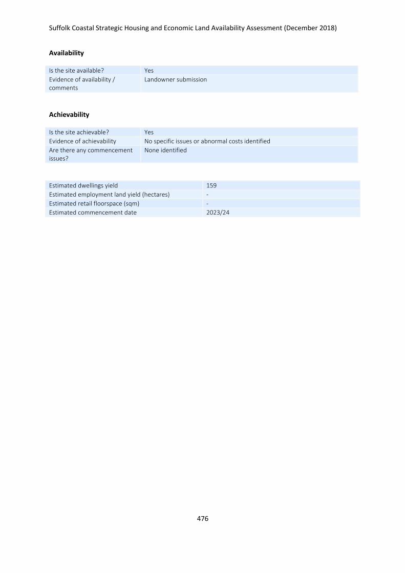
Suffolk Coastal Strategic Housing and Economic Land Availability Assessment (December 2018)
476
Availability
Is the site available? Yes
Evidence of availability / comments
Landowner submission
Achievability
Is the site achievable? Yes
Evidence of achievability No specific issues or abnormal costs identified
Are there any commencement issues?
None identified
Estimated dwellings yield 159
Estimated employment land yield (hectares) -
Estimated retail floorspace (sqm) -
Estimated commencement date 2023/24
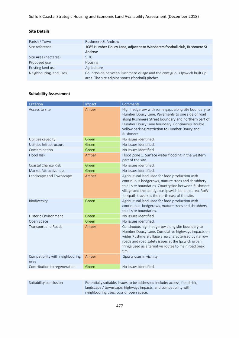
Suffolk Coastal Strategic Housing and Economic Land Availability Assessment (December 2018)
477
Site Details
Parish / Town Rushmere St Andrew
Site reference 1085 Humber Doucy Lane, adjacent to Wanderers football club, Rushmere St Andrew
Site Area (hectares) 5.70
Proposed use Housing
Existing land use Agriculture
Neighbouring land uses Countryside between Rushmere village and the contiguous Ipswich built up area. The site adjoins sports (football) pitches.
Suitability Assessment
Criterion Impact Comments
Access to site Amber High hedgerow with some gaps along site boundary to Humber Doucy Lane. Pavements to one side of road along Rushmere Street boundary and northern part of Humber Doucy Lane boundary. Continuous Double yellow parking restriction to Humber Doucy and Rushmere
Utilities capacity Green No issues identified.
Utilities Infrastructure Green No issues identified.
Contamination Green No issues identified.
Flood Risk Amber Flood Zone 1. Surface water flooding in the western part of the site.
Coastal Change Risk Green No issues identified.
Market Attractiveness Green No issues identified.
Landscape and Townscape Amber Agricultural land used for food production with continuous hedgerows, mature trees and shrubbery to all site boundaries. Countryside between Rushmere village and the contiguous Ipswich built up area. RoW footpath traverses the north east of the site.
Biodiversity Green Agricultural land used for food production with continuous hedgerows, mature trees and shrubbery to all site boundaries.
Historic Environment Green No issues identified.
Open Space Green No issues identified.
Transport and Roads Amber Continuous high hedgerow along site boundary to Humber Doucy Lane. Cumulative highways impacts on wider Rushmere village area characterised by narrow roads and road safety issues at the Ipswich urban fringe used as alternative routes to main road peak tim
Compatibility with neighbouring uses
Amber Sports uses in vicinity.
Contribution to regeneration Green No issues identified.
Suitability conclusion Potentially suitable. Issues to be addressed include; access, flood risk, landscape / townscape, highways impacts, and compatibility with neighbouring uses. Loss of open space.

Suffolk Coastal Strategic Housing and Economic Land Availability Assessment (December 2018)
478
Availability
Is the site available? Yes
Evidence of availability / comments
Landowner submission
Achievability
Is the site achievable? Yes
Evidence of achievability No specific issues or abnormal costs identified
Are there any commencement issues?
None identified
Estimated dwellings yield 143
Estimated employment land yield (hectares) -
Estimated retail floorspace (sqm) -
Estimated commencement date 2021/22

Suffolk Coastal Strategic Housing and Economic Land Availability Assessment (December 2018)
479
Site Details
Parish / Town Rushmere St Andrew
Site reference 1087 Land at and surrounding Hill Farm, Lamberts Lane, Rushmere St Andrew
Site Area (hectares) 109.39
Proposed use Housing
Existing land use Agriculture
Neighbouring land uses The site adjoins sports pitches to the south west. The northern site boundary adjoins the East Suffolk Railway Line. Surrounded by countryside and residential / agricultural uses.
Suitability Assessment
Criterion Impact Comments
Access to site Amber Access difficult with railway bordering the site to the north. Strategic highways infrastructure delivery potential for a site of this size.
Utilities capacity Amber Phasing and local plan strategy to reflect engagement with utility companies.
Utilities Infrastructure Amber Pylons on the site at various locations.
Contamination Green No issues identified.
Flood Risk Amber FZ1. Surface water run off sporadically around the site.
Coastal Change Risk Green No issues identified.
Market Attractiveness Green No issues identified.
Landscape and Townscape Amber Continuous Tree Preservation Order along the SE boundary with the adjoining built up area of Rushmere village. The scale of the site has implications for the setting of the Fynn Valley landscape to the north and settlement patterns in the East Ipswich urban – rural fringe.
Biodiversity Amber Some areas of thick natural grass adjacent Lamberts Lane may be of biodiversity interest. Protected BAP species recorded on the site.
Historic Environment Amber The site would have significant impacts on the setting and character of adjoining Rushmere village to the south. SCC Archaeological Survey has identified the site as of potential archaeological value.
Open Space Amber The site adjoins sports pitches to the SW. Part of the northern part of the site is used as a motorcross site adjacent the railway line.
Transport and Roads Amber Lambert Lane traverses the site but in its current state could not support vehicle, pedestrian and cycle access for a site of this scale. Improvements required to Humber Doucy Lane and junctions with Tuddenham Road and Rushmere Road.
Compatibility with neighbouring uses
Amber The site adjoins sports pitches to the south west. The northern site boundary adjoins the East Suffolk Railway Line.
Contribution to regeneration Green No issues identified.
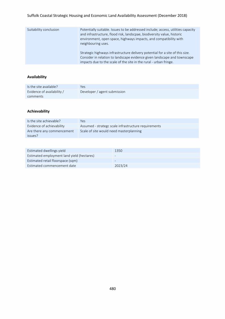
Suffolk Coastal Strategic Housing and Economic Land Availability Assessment (December 2018)
480
Suitability conclusion Potentially suitable. Issues to be addressed include; access, utilities capacity and infrastructure, flood risk, landscpae, biodiversity value, historic environment, open space, highways impacts, and compatibility with neighbouring uses. Strategic highways infrastructure delivery potential for a site of this size. Consider in relation to landscape evidence given landscape and townscape impacts due to the scale of the site in the rural - urban fringe.
Availability
Is the site available? Yes
Evidence of availability / comments
Developer / agent submission
Achievability
Is the site achievable? Yes
Evidence of achievability Assumed - strategc scale infrastructure requirements
Are there any commencement issues?
Scale of site would need masterplanning
Estimated dwellings yield 1350
Estimated employment land yield (hectares) -
Estimated retail floorspace (sqm) -
Estimated commencement date 2023/24
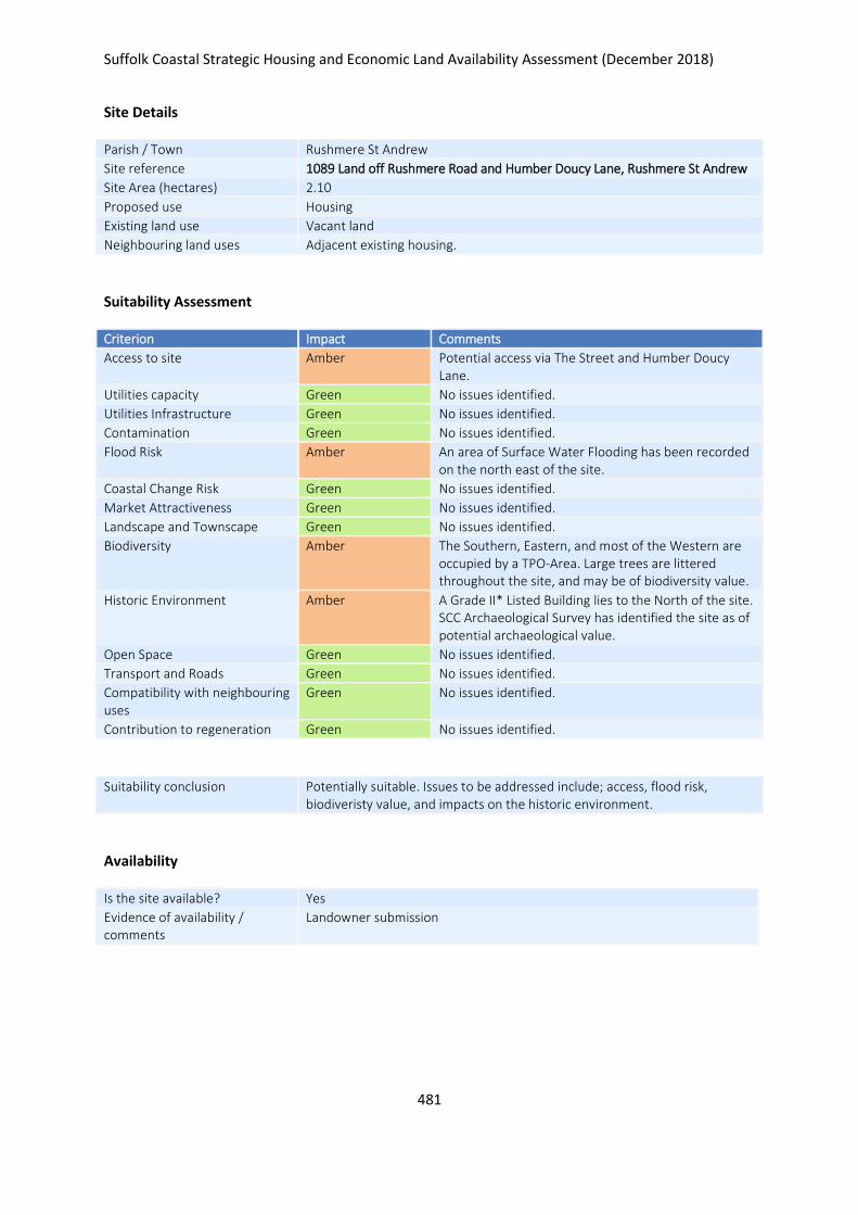
Suffolk Coastal Strategic Housing and Economic Land Availability Assessment (December 2018)
481
Site Details
Parish / Town Rushmere St Andrew
Site reference 1089 Land off Rushmere Road and Humber Doucy Lane, Rushmere St Andrew
Site Area (hectares) 2.10
Proposed use Housing
Existing land use Vacant land
Neighbouring land uses Adjacent existing housing.
Suitability Assessment
Criterion Impact Comments
Access to site Amber Potential access via The Street and Humber Doucy Lane.
Utilities capacity Green No issues identified.
Utilities Infrastructure Green No issues identified.
Contamination Green No issues identified.
Flood Risk Amber An area of Surface Water Flooding has been recorded on the north east of the site.
Coastal Change Risk Green No issues identified.
Market Attractiveness Green No issues identified.
Landscape and Townscape Green No issues identified.
Biodiversity Amber The Southern, Eastern, and most of the Western are occupied by a TPO-Area. Large trees are littered throughout the site, and may be of biodiversity value.
Historic Environment Amber A Grade II* Listed Building lies to the North of the site. SCC Archaeological Survey has identified the site as of potential archaeological value.
Open Space Green No issues identified.
Transport and Roads Green No issues identified.
Compatibility with neighbouring uses
Green No issues identified.
Contribution to regeneration Green No issues identified.
Suitability conclusion Potentially suitable. Issues to be addressed include; access, flood risk, biodiveristy value, and impacts on the historic environment.
Availability
Is the site available? Yes
Evidence of availability / comments
Landowner submission
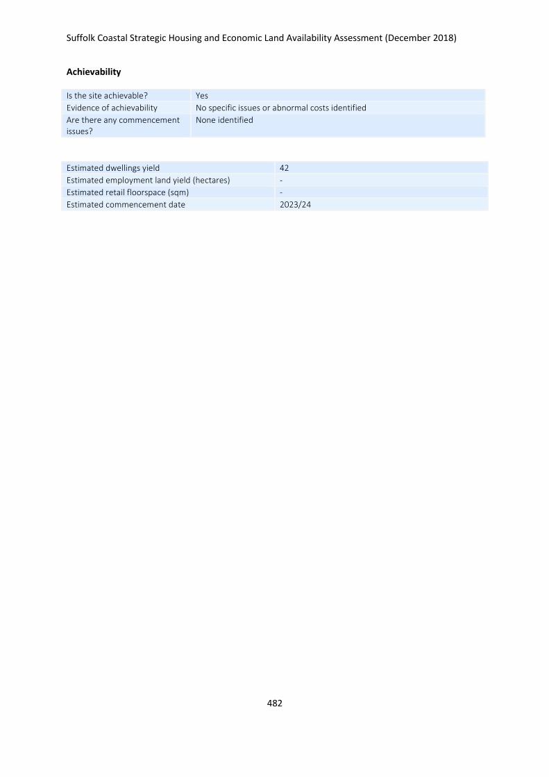
Suffolk Coastal Strategic Housing and Economic Land Availability Assessment (December 2018)
482
Achievability
Is the site achievable? Yes
Evidence of achievability No specific issues or abnormal costs identified
Are there any commencement issues?
None identified
Estimated dwellings yield 42
Estimated employment land yield (hectares) -
Estimated retail floorspace (sqm) -
Estimated commencement date 2023/24
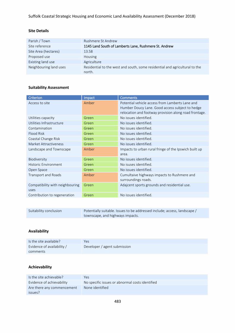
Suffolk Coastal Strategic Housing and Economic Land Availability Assessment (December 2018)
483
Site Details
Parish / Town Rushmere St Andrew
Site reference 1145 Land South of Lamberts Lane, Rushmere St. Andrew
Site Area (hectares) 13.58
Proposed use Housing
Existing land use Agriculture
Neighbouring land uses Residential to the west and south, some residential and agricultural to the north.
Suitability Assessment
Criterion Impact Comments
Access to site Amber Potential vehicle access from Lamberts Lane and Humber Doucy Lane. Good access subject to hedge relocation and footway provision along road frontage.
Utilities capacity Green No issues identified.
Utilities Infrastructure Green No issues identified.
Contamination Green No issues identified.
Flood Risk Green No issues identified.
Coastal Change Risk Green No issues identified.
Market Attractiveness Green No issues identified.
Landscape and Townscape Amber Impacts to urban rural fringe of the Ipswich built up area.
Biodiversity Green No issues identified.
Historic Environment Green No isuses identified.
Open Space Green No issues identified.
Transport and Roads Amber Cumultaive highways impacts to Rushmere and surroundings roads.
Compatibility with neighbouring uses
Green Adajcent sports grounds and residential use.
Contribution to regeneration Green No issues identified.
Suitability conclusion Potentially suitable. Issues to be addressed include; access, landscape / townscape, and highways impacts.
Availability
Is the site available? Yes
Evidence of availability / comments
Developer / agent submission
Achievability
Is the site achievable? Yes
Evidence of achievability No specific issues or abnormal costs identified
Are there any commencement issues?
None identified

Suffolk Coastal Strategic Housing and Economic Land Availability Assessment (December 2018)
484
Estimated dwellings yield 340
Estimated employment land yield (hectares) -
Estimated retail floorspace (sqm) -
Estimated commencement date 2023/24
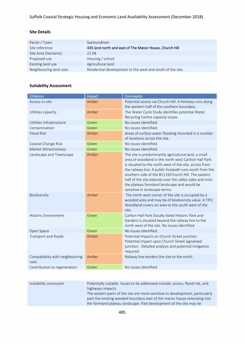
Suffolk Coastal Strategic Housing and Economic Land Availability Assessment (December 2018)
485
Site Details
Parish / Town Saxmundham
Site reference 435 land north and east of The Manor House, Church Hill
Site Area (hectares) 21.94
Proposed use Housing / school
Existing land use Agricultural land
Neighbouring land uses Residential development to the west and south of the site.
Suitability Assessment
Criterion Impact Comments
Access to site Amber Potential access via Church Hill. A footway runs along the western half of the southern boundary.
Utilities capacity Amber The Water Cycle Study identifies potential Water Recycling Centre capacity issues.
Utilities Infrastructure Green No issues identified.
Contamination Green No issues identified.
Flood Risk Amber Areas of surface water flooding recorded in a number of locations across the site.
Coastal Change Risk Green No issues identified.
Market Attractiveness Green No issues identified.
Landscape and Townscape Amber The site is predominantly agricultural land, a small area of woodland in the north west Carlton Hall Park is situated to the north west of the site, across from the railway line. A public footpath runs south from the southern side of the B1119/Church Hill. The eastern half of the site extends over the valley sides and onto the plateau farmland landscape and would be sensitive in landscape terms.
Biodiversity Amber The north west corner of the site is occupied by a wooded area and may be of biodiversity value. A TPO Woodland covers an area to the south west of the site.
Historic Environment Green Carlton Hall Park (locally listed Historic Park and Garden) is situated beyond the railway line to the north west of the site. No issues identified
Open Space Green No issues identified.
Transport and Roads Amber Potential impacts on Church Street junction. Potential impact upon Church Street signalised junction. Detailed analysis and potential mitigation required.
Compatibility with neighbouring uses
Amber Railway line borders the site to the north.
Contribution to regeneration Green No issues identified.
Suitability conclusion Potentially suitable. Issues to be addressed include; access, flood risk, and highways impacts. The eastern parts of the site are more sensitive to development, particularly past the existing wooded boundary east of the manor house extending into the farmland plateau landscape. Part development of the site may be
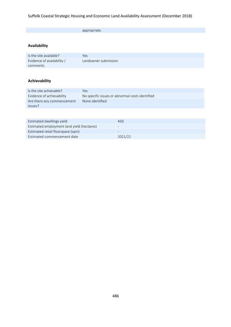
Suffolk Coastal Strategic Housing and Economic Land Availability Assessment (December 2018)
486
appropriate.
Availability
Is the site available? Yes
Evidence of availability / comments
Landowner submission
Achievability
Is the site achievable? Yes
Evidence of achievability No specific issues or abnormal costs identified
Are there any commencement issues?
None identified
Estimated dwellings yield 450
Estimated employment land yield (hectares) -
Estimated retail floorspace (sqm) -
Estimated commencement date 2021/22
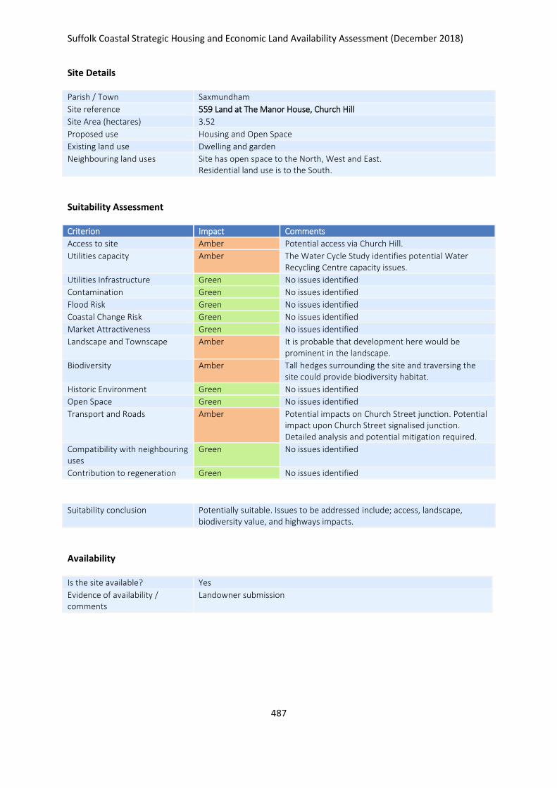
Suffolk Coastal Strategic Housing and Economic Land Availability Assessment (December 2018)
487
Site Details
Parish / Town Saxmundham
Site reference 559 Land at The Manor House, Church Hill
Site Area (hectares) 3.52
Proposed use Housing and Open Space
Existing land use Dwelling and garden
Neighbouring land uses Site has open space to the North, West and East. Residential land use is to the South.
Suitability Assessment
Criterion Impact Comments
Access to site Amber Potential access via Church Hill.
Utilities capacity Amber The Water Cycle Study identifies potential Water Recycling Centre capacity issues.
Utilities Infrastructure Green No issues identified
Contamination Green No issues identified
Flood Risk Green No issues identified
Coastal Change Risk Green No issues identified
Market Attractiveness Green No issues identified
Landscape and Townscape Amber It is probable that development here would be prominent in the landscape.
Biodiversity Amber Tall hedges surrounding the site and traversing the site could provide biodiversity habitat.
Historic Environment Green No issues identified
Open Space Green No issues identified
Transport and Roads Amber Potential impacts on Church Street junction. Potential impact upon Church Street signalised junction. Detailed analysis and potential mitigation required.
Compatibility with neighbouring uses
Green No issues identified
Contribution to regeneration Green No issues identified
Suitability conclusion Potentially suitable. Issues to be addressed include; access, landscape, biodiversity value, and highways impacts.
Availability
Is the site available? Yes
Evidence of availability / comments
Landowner submission

Suffolk Coastal Strategic Housing and Economic Land Availability Assessment (December 2018)
488
Achievability
Is the site achievable? Yes
Evidence of achievability Assumed - demolition of existing buildings required but not thought to affect achievability
Are there any commencement issues?
Demolition of existing buildings
Estimated dwellings yield 84
Estimated employment land yield (hectares) -
Estimated retail floorspace (sqm) -
Estimated commencement date 2022/23
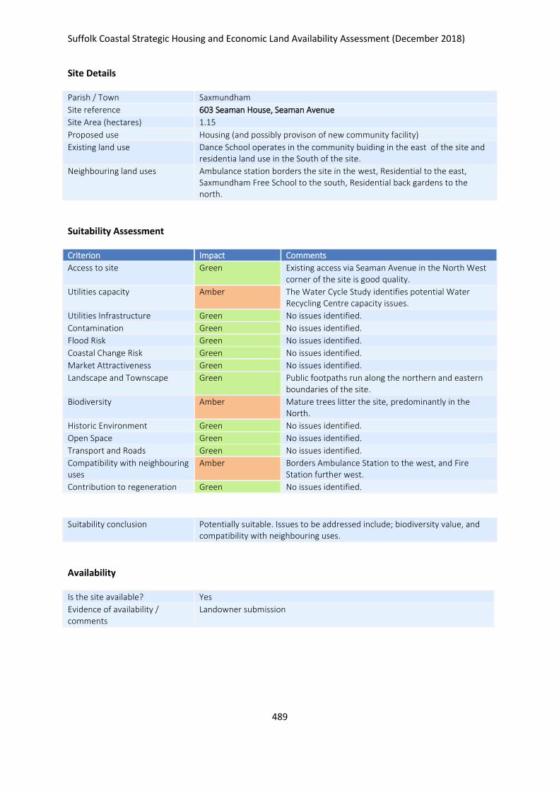
Suffolk Coastal Strategic Housing and Economic Land Availability Assessment (December 2018)
489
Site Details
Parish / Town Saxmundham
Site reference 603 Seaman House, Seaman Avenue
Site Area (hectares) 1.15
Proposed use Housing (and possibly provison of new community facility)
Existing land use Dance School operates in the community buiding in the east of the site and residentia land use in the South of the site.
Neighbouring land uses Ambulance station borders the site in the west, Residential to the east, Saxmundham Free School to the south, Residential back gardens to the north.
Suitability Assessment
Criterion Impact Comments
Access to site Green Existing access via Seaman Avenue in the North West corner of the site is good quality.
Utilities capacity Amber The Water Cycle Study identifies potential Water Recycling Centre capacity issues.
Utilities Infrastructure Green No issues identified.
Contamination Green No issues identified.
Flood Risk Green No issues identified.
Coastal Change Risk Green No issues identified.
Market Attractiveness Green No issues identified.
Landscape and Townscape Green Public footpaths run along the northern and eastern boundaries of the site.
Biodiversity Amber Mature trees litter the site, predominantly in the North.
Historic Environment Green No issues identified.
Open Space Green No issues identified.
Transport and Roads Green No issues identified.
Compatibility with neighbouring uses
Amber Borders Ambulance Station to the west, and Fire Station further west.
Contribution to regeneration Green No issues identified.
Suitability conclusion Potentially suitable. Issues to be addressed include; biodiversity value, and compatibility with neighbouring uses.
Availability
Is the site available? Yes
Evidence of availability / comments
Landowner submission

Suffolk Coastal Strategic Housing and Economic Land Availability Assessment (December 2018)
490
Achievability
Is the site achievable? Yes
Evidence of achievability Assumed - relocation of existing uses required
Are there any commencement issues?
Relocation of existing uses
Estimated dwellings yield 34
Estimated employment land yield (hectares) -
Estimated retail floorspace (sqm) -
Estimated commencement date 2023/24
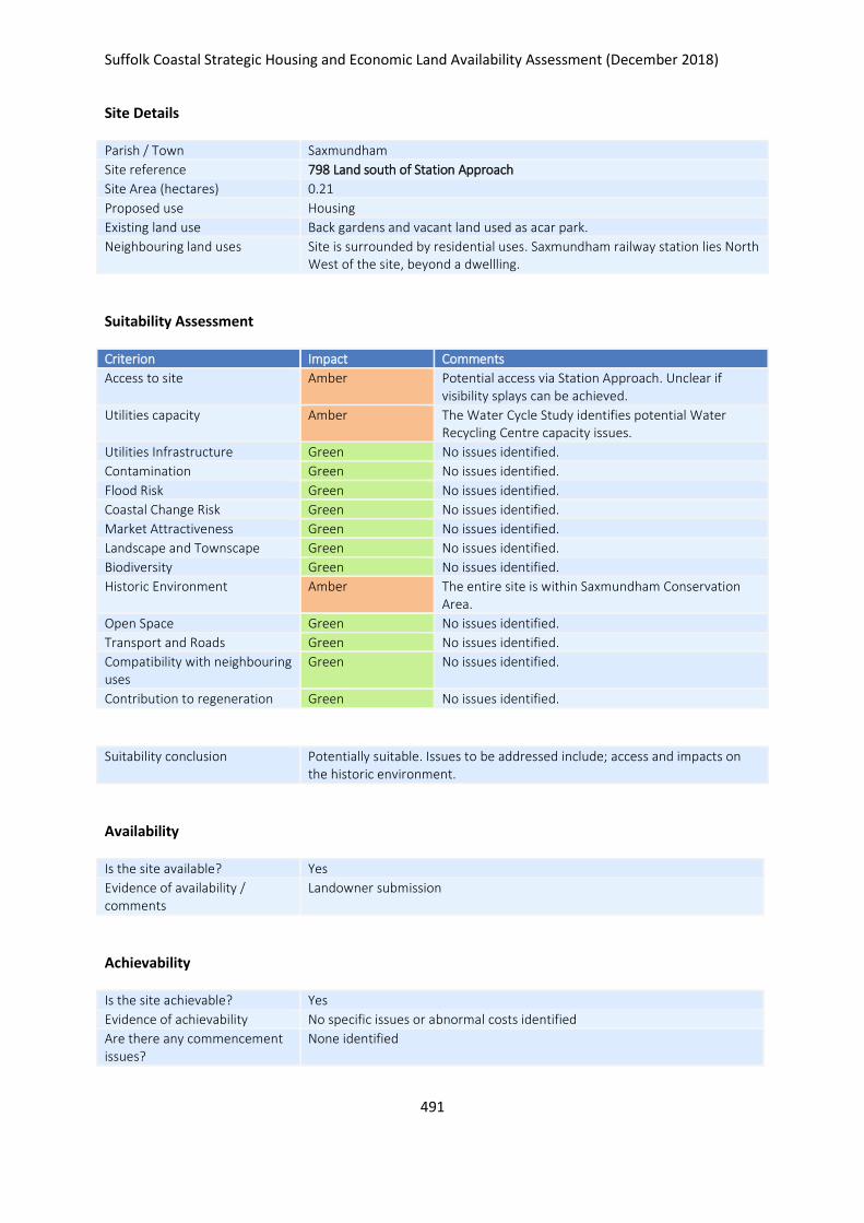
Suffolk Coastal Strategic Housing and Economic Land Availability Assessment (December 2018)
491
Site Details
Parish / Town Saxmundham
Site reference 798 Land south of Station Approach
Site Area (hectares) 0.21
Proposed use Housing
Existing land use Back gardens and vacant land used as acar park.
Neighbouring land uses Site is surrounded by residential uses. Saxmundham railway station lies North West of the site, beyond a dwellling.
Suitability Assessment
Criterion Impact Comments
Access to site Amber Potential access via Station Approach. Unclear if visibility splays can be achieved.
Utilities capacity Amber The Water Cycle Study identifies potential Water Recycling Centre capacity issues.
Utilities Infrastructure Green No issues identified.
Contamination Green No issues identified.
Flood Risk Green No issues identified.
Coastal Change Risk Green No issues identified.
Market Attractiveness Green No issues identified.
Landscape and Townscape Green No issues identified.
Biodiversity Green No issues identified.
Historic Environment Amber The entire site is within Saxmundham Conservation Area.
Open Space Green No issues identified.
Transport and Roads Green No issues identified.
Compatibility with neighbouring uses
Green No issues identified.
Contribution to regeneration Green No issues identified.
Suitability conclusion Potentially suitable. Issues to be addressed include; access and impacts on the historic environment.
Availability
Is the site available? Yes
Evidence of availability / comments
Landowner submission
Achievability
Is the site achievable? Yes
Evidence of achievability No specific issues or abnormal costs identified
Are there any commencement issues?
None identified

Suffolk Coastal Strategic Housing and Economic Land Availability Assessment (December 2018)
492
Estimated dwellings yield 6
Estimated employment land yield (hectares) -
Estimated retail floorspace (sqm) -
Estimated commencement date 2023/24
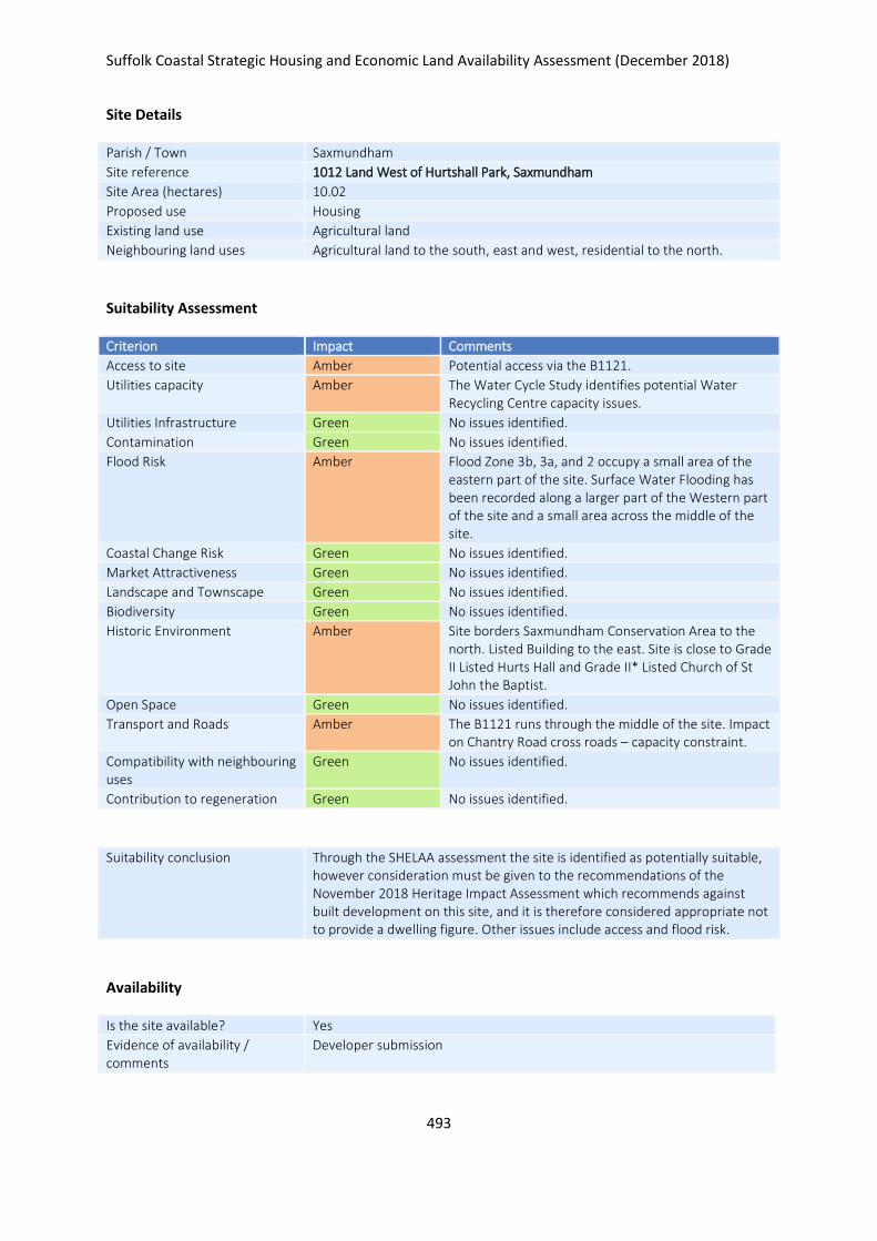
Suffolk Coastal Strategic Housing and Economic Land Availability Assessment (December 2018)
493
Site Details
Parish / Town Saxmundham
Site reference 1012 Land West of Hurtshall Park, Saxmundham
Site Area (hectares) 10.02
Proposed use Housing
Existing land use Agricultural land
Neighbouring land uses Agricultural land to the south, east and west, residential to the north.
Suitability Assessment
Criterion Impact Comments
Access to site Amber Potential access via the B1121.
Utilities capacity Amber The Water Cycle Study identifies potential Water Recycling Centre capacity issues.
Utilities Infrastructure Green No issues identified.
Contamination Green No issues identified.
Flood Risk Amber Flood Zone 3b, 3a, and 2 occupy a small area of the eastern part of the site. Surface Water Flooding has been recorded along a larger part of the Western part of the site and a small area across the middle of the site.
Coastal Change Risk Green No issues identified.
Market Attractiveness Green No issues identified.
Landscape and Townscape Green No issues identified.
Biodiversity Green No issues identified.
Historic Environment Amber Site borders Saxmundham Conservation Area to the north. Listed Building to the east. Site is close to Grade II Listed Hurts Hall and Grade II* Listed Church of St John the Baptist.
Open Space Green No issues identified.
Transport and Roads Amber The B1121 runs through the middle of the site. Impact on Chantry Road cross roads – capacity constraint.
Compatibility with neighbouring uses
Green No issues identified.
Contribution to regeneration Green No issues identified.
Suitability conclusion Through the SHELAA assessment the site is identified as potentially suitable, however consideration must be given to the recommendations of the November 2018 Heritage Impact Assessment which recommends against built development on this site, and it is therefore considered appropriate not to provide a dwelling figure. Other issues include access and flood risk.
Availability
Is the site available? Yes
Evidence of availability / comments
Developer submission

Suffolk Coastal Strategic Housing and Economic Land Availability Assessment (December 2018)
494
Achievability
Is the site achievable? Yes
Evidence of achievability No specific issues or abnormal costs identified
Are there any commencement issues?
None identified
Estimated dwellings yield -
Estimated employment land yield (hectares) -
Estimated retail floorspace (sqm) -
Estimated commencement date 2022/23
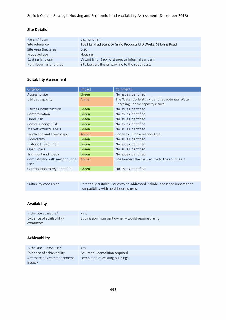
Suffolk Coastal Strategic Housing and Economic Land Availability Assessment (December 2018)
495
Site Details
Parish / Town Saxmundham
Site reference 1062 Land adjacent to Grafo Products LTD Works, St Johns Road
Site Area (hectares) 0.20
Proposed use Housing
Existing land use Vacant land. Back yard used as informal car park.
Neighbouring land uses Site borders the railway line to the south east.
Suitability Assessment
Criterion Impact Comments
Access to site Green No issues identified.
Utilities capacity Amber The Water Cycle Study identifies potential Water Recycling Centre capacity issues.
Utilities Infrastructure Green No issues identified.
Contamination Green No issues identified.
Flood Risk Green No issues identified.
Coastal Change Risk Green No issues identified.
Market Attractiveness Green No issues identified.
Landscape and Townscape Amber Site within Conservation Area.
Biodiversity Green No issues identified.
Historic Environment Green No issues identified.
Open Space Green No issues identified.
Transport and Roads Green No issues identified.
Compatibility with neighbouring uses
Amber Site borders the railway line to the south east.
Contribution to regeneration Green No issues identified.
Suitability conclusion Potentially suitable. Issues to be addressed include landscape impacts and compatibility with neighbouring uses.
Availability
Is the site available? Part
Evidence of availability / comments
Submission from part owner – would require clarity
Achievability
Is the site achievable? Yes
Evidence of achievability Assumed - demolition required
Are there any commencement issues?
Demolition of existing buildings

Suffolk Coastal Strategic Housing and Economic Land Availability Assessment (December 2018)
496
Estimated dwellings yield 6
Estimated employment land yield (hectares) -
Estimated retail floorspace (sqm) -
Estimated commencement date 2022/23
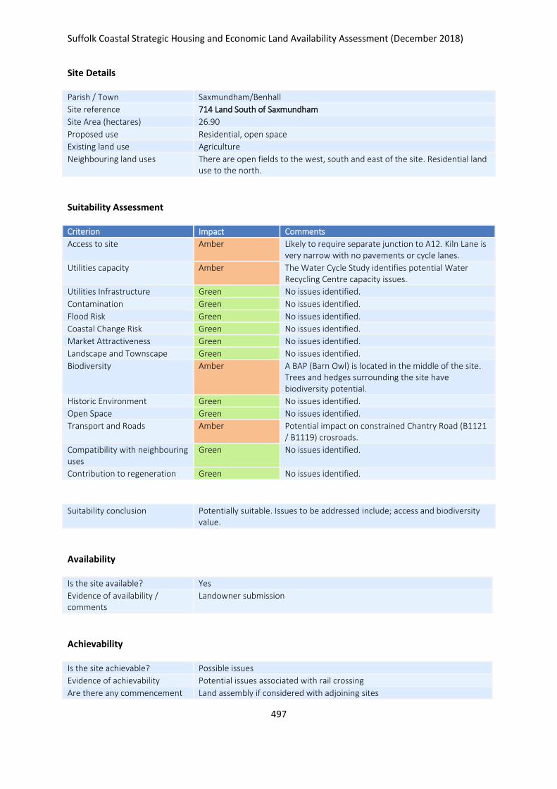
Suffolk Coastal Strategic Housing and Economic Land Availability Assessment (December 2018)
497
Site Details
Parish / Town Saxmundham/Benhall
Site reference 714 Land South of Saxmundham
Site Area (hectares) 26.90
Proposed use Residential, open space
Existing land use Agriculture
Neighbouring land uses There are open fields to the west, south and east of the site. Residential land use to the north.
Suitability Assessment
Criterion Impact Comments
Access to site Amber Likely to require separate junction to A12. Kiln Lane is very narrow with no pavements or cycle lanes.
Utilities capacity Amber The Water Cycle Study identifies potential Water Recycling Centre capacity issues.
Utilities Infrastructure Green No issues identified.
Contamination Green No issues identified.
Flood Risk Green No issues identified.
Coastal Change Risk Green No issues identified.
Market Attractiveness Green No issues identified.
Landscape and Townscape Green No issues identified.
Biodiversity Amber A BAP (Barn Owl) is located in the middle of the site. Trees and hedges surrounding the site have biodiversity potential.
Historic Environment Green No issues identified.
Open Space Green No issues identified.
Transport and Roads Amber Potential impact on constrained Chantry Road (B1121 / B1119) crosroads.
Compatibility with neighbouring uses
Green No issues identified.
Contribution to regeneration Green No issues identified.
Suitability conclusion Potentially suitable. Issues to be addressed include; access and biodiversity value.
Availability
Is the site available? Yes
Evidence of availability / comments
Landowner submission
Achievability
Is the site achievable? Possible issues
Evidence of achievability Potential issues associated with rail crossing
Are there any commencement Land assembly if considered with adjoining sites

Suffolk Coastal Strategic Housing and Economic Land Availability Assessment (December 2018)
498
issues?
Estimated dwellings yield 495
Estimated employment land yield (hectares) -
Estimated retail floorspace (sqm) -
Estimated commencement date 2023/24
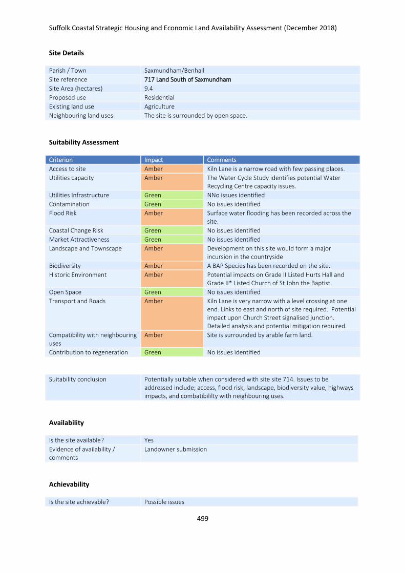
Suffolk Coastal Strategic Housing and Economic Land Availability Assessment (December 2018)
499
Site Details
Parish / Town Saxmundham/Benhall
Site reference 717 Land South of Saxmundham
Site Area (hectares) 9.4
Proposed use Residential
Existing land use Agriculture
Neighbouring land uses The site is surrounded by open space.
Suitability Assessment
Criterion Impact Comments
Access to site Amber Kiln Lane is a narrow road with few passing places.
Utilities capacity Amber The Water Cycle Study identifies potential Water Recycling Centre capacity issues.
Utilities Infrastructure Green NNo issues identified
Contamination Green No issues identified
Flood Risk Amber Surface water flooding has been recorded across the site.
Coastal Change Risk Green No issues identified
Market Attractiveness Green No issues identified
Landscape and Townscape Amber Development on this site would form a major incursion in the countryside
Biodiversity Amber A BAP Species has been recorded on the site.
Historic Environment Amber Potential impacts on Grade II Listed Hurts Hall and Grade II* Listed Church of St John the Baptist.
Open Space Green No issues identified
Transport and Roads Amber Kiln Lane is very narrow with a level crossing at one end. Links to east and north of site required. Potential impact upon Church Street signalised junction. Detailed analysis and potential mitigation required.
Compatibility with neighbouring uses
Amber Site is surrounded by arable farm land.
Contribution to regeneration Green No issues identified
Suitability conclusion Potentially suitable when considered with site site 714. Issues to be addressed include; access, flood risk, landscape, biodiversity value, highways impacts, and combatibililty with neighbouring uses.
Availability
Is the site available? Yes
Evidence of availability / comments
Landowner submission
Achievability
Is the site achievable? Possible issues
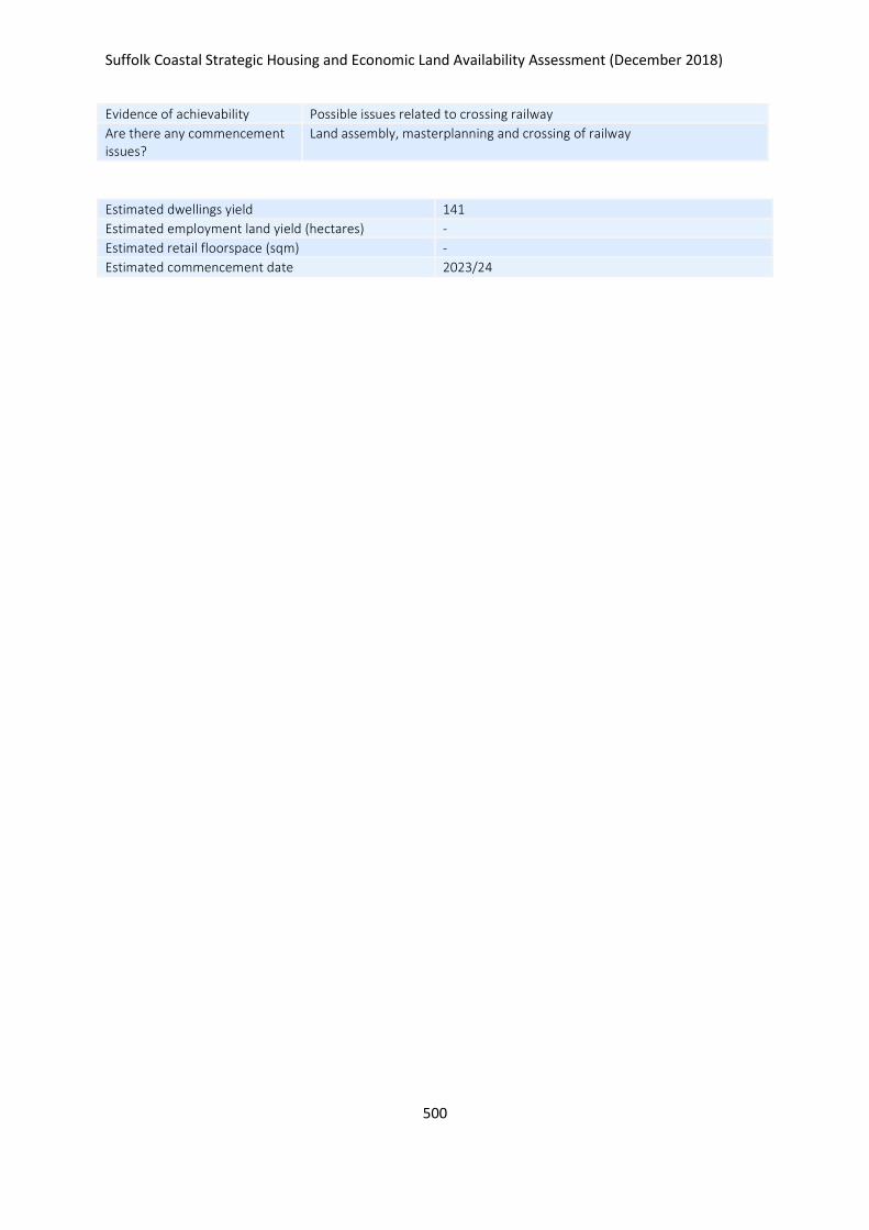
Suffolk Coastal Strategic Housing and Economic Land Availability Assessment (December 2018)
500
Evidence of achievability Possible issues related to crossing railway
Are there any commencement issues?
Land assembly, masterplanning and crossing of railway
Estimated dwellings yield 141
Estimated employment land yield (hectares) -
Estimated retail floorspace (sqm) -
Estimated commencement date 2023/24
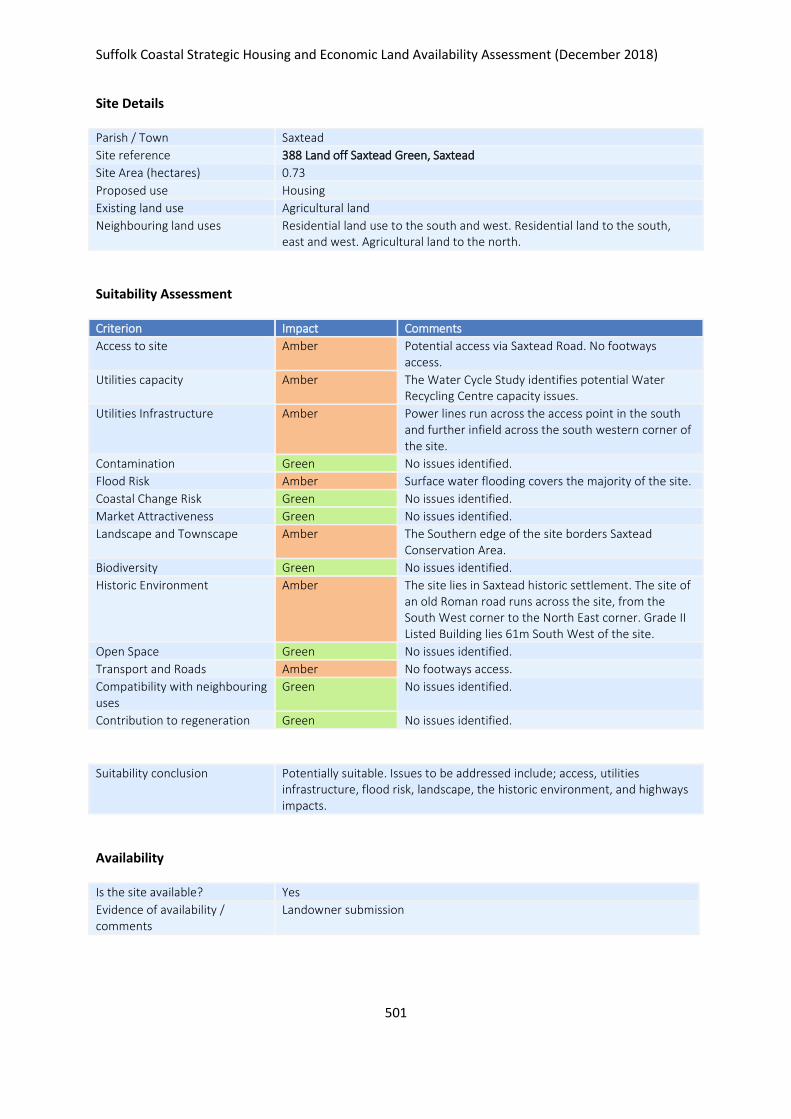
Suffolk Coastal Strategic Housing and Economic Land Availability Assessment (December 2018)
501
Site Details
Parish / Town Saxtead
Site reference 388 Land off Saxtead Green, Saxtead
Site Area (hectares) 0.73
Proposed use Housing
Existing land use Agricultural land
Neighbouring land uses Residential land use to the south and west. Residential land to the south, east and west. Agricultural land to the north.
Suitability Assessment
Criterion Impact Comments
Access to site Amber Potential access via Saxtead Road. No footways access.
Utilities capacity Amber The Water Cycle Study identifies potential Water Recycling Centre capacity issues.
Utilities Infrastructure Amber Power lines run across the access point in the south and further infield across the south western corner of the site.
Contamination Green No issues identified.
Flood Risk Amber Surface water flooding covers the majority of the site.
Coastal Change Risk Green No issues identified.
Market Attractiveness Green No issues identified.
Landscape and Townscape Amber The Southern edge of the site borders Saxtead Conservation Area.
Biodiversity Green No issues identified.
Historic Environment Amber The site lies in Saxtead historic settlement. The site of an old Roman road runs across the site, from the South West corner to the North East corner. Grade II Listed Building lies 61m South West of the site.
Open Space Green No issues identified.
Transport and Roads Amber No footways access.
Compatibility with neighbouring uses
Green No issues identified.
Contribution to regeneration Green No issues identified.
Suitability conclusion Potentially suitable. Issues to be addressed include; access, utilities infrastructure, flood risk, landscape, the historic environment, and highways impacts.
Availability
Is the site available? Yes
Evidence of availability / comments
Landowner submission

Suffolk Coastal Strategic Housing and Economic Land Availability Assessment (December 2018)
502
Achievability
Is the site achievable? Yes
Evidence of achievability No specific issues or abnormal costs identified
Are there any commencement issues?
None identified
Estimated dwellings yield 11
Estimated employment land yield (hectares) -
Estimated retail floorspace (sqm) -
Estimated commencement date 2021/22
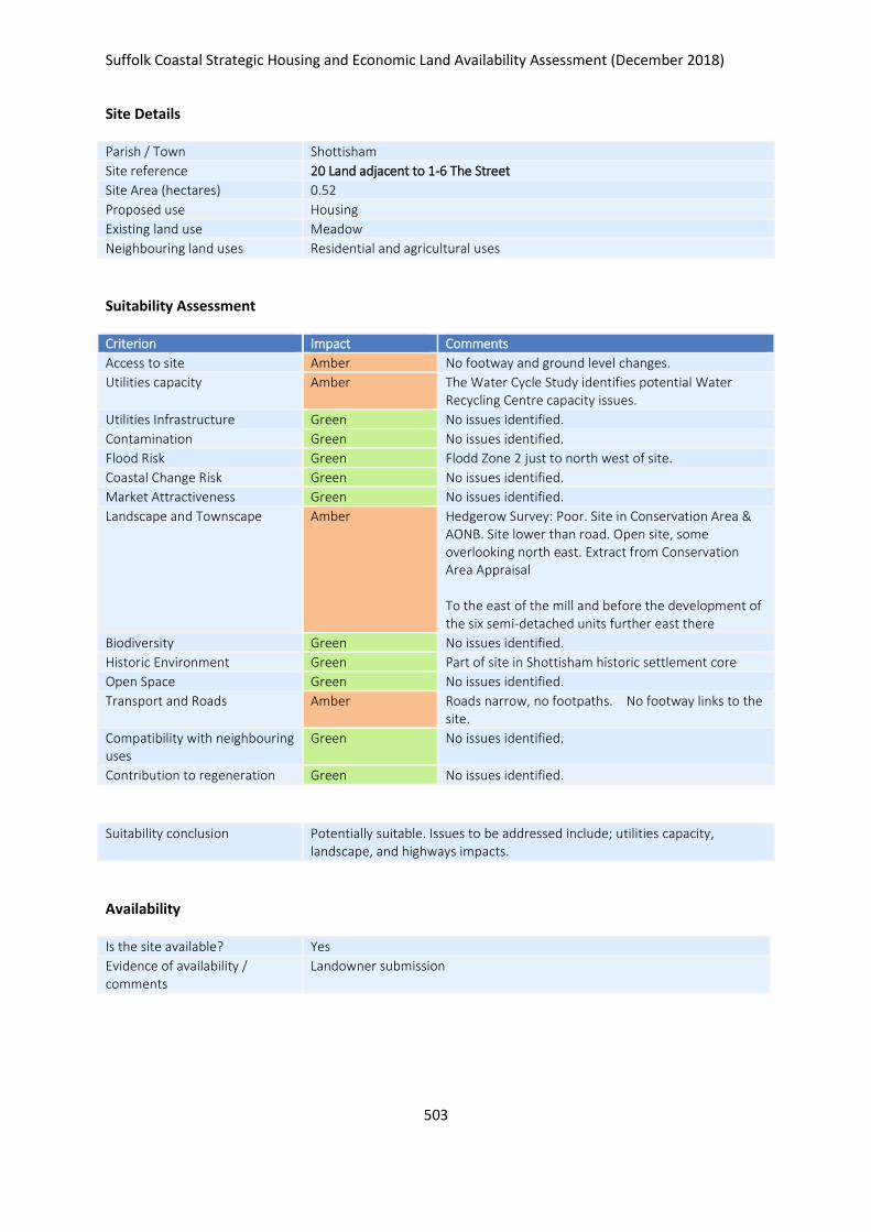
Suffolk Coastal Strategic Housing and Economic Land Availability Assessment (December 2018)
503
Site Details
Parish / Town Shottisham
Site reference 20 Land adjacent to 1-6 The Street
Site Area (hectares) 0.52
Proposed use Housing
Existing land use Meadow
Neighbouring land uses Residential and agricultural uses
Suitability Assessment
Criterion Impact Comments
Access to site Amber No footway and ground level changes.
Utilities capacity Amber The Water Cycle Study identifies potential Water Recycling Centre capacity issues.
Utilities Infrastructure Green No issues identified.
Contamination Green No issues identified.
Flood Risk Green Flodd Zone 2 just to north west of site.
Coastal Change Risk Green No issues identified.
Market Attractiveness Green No issues identified.
Landscape and Townscape Amber Hedgerow Survey: Poor. Site in Conservation Area & AONB. Site lower than road. Open site, some overlooking north east. Extract from Conservation Area Appraisal To the east of the mill and before the development of the six semi-detached units further east there
Biodiversity Green No issues identified.
Historic Environment Green Part of site in Shottisham historic settlement core
Open Space Green No issues identified.
Transport and Roads Amber Roads narrow, no footpaths. No footway links to the site.
Compatibility with neighbouring uses
Green No issues identified.
Contribution to regeneration Green No issues identified.
Suitability conclusion Potentially suitable. Issues to be addressed include; utilities capacity, landscape, and highways impacts.
Availability
Is the site available? Yes
Evidence of availability / comments
Landowner submission

Suffolk Coastal Strategic Housing and Economic Land Availability Assessment (December 2018)
504
Achievability
Is the site achievable? Yes
Evidence of achievability No specific issues or abnormal costs identified
Are there any commencement issues?
None identified
Estimated dwellings yield 8
Estimated employment land yield (hectares) -
Estimated retail floorspace (sqm) -
Estimated commencement date 2023/24
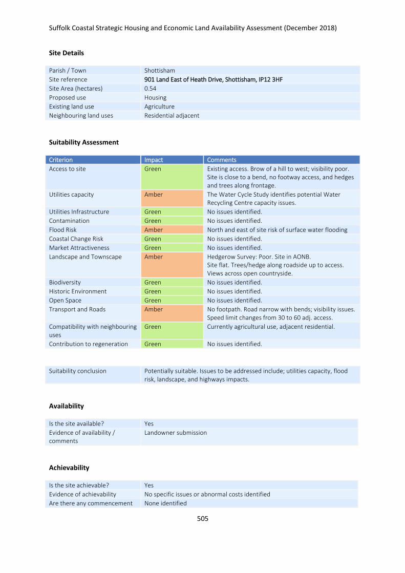
Suffolk Coastal Strategic Housing and Economic Land Availability Assessment (December 2018)
505
Site Details
Parish / Town Shottisham
Site reference 901 Land East of Heath Drive, Shottisham, IP12 3HF
Site Area (hectares) 0.54
Proposed use Housing
Existing land use Agriculture
Neighbouring land uses Residential adjacent
Suitability Assessment
Criterion Impact Comments
Access to site Green Existing access. Brow of a hill to west; visibility poor. Site is close to a bend, no footway access, and hedges and trees along frontage.
Utilities capacity Amber The Water Cycle Study identifies potential Water Recycling Centre capacity issues.
Utilities Infrastructure Green No issues identified.
Contamination Green No issues identified.
Flood Risk Amber North and east of site risk of surface water flooding
Coastal Change Risk Green No issues identified.
Market Attractiveness Green No issues identified.
Landscape and Townscape Amber Hedgerow Survey: Poor. Site in AONB. Site flat. Trees/hedge along roadside up to access. Views across open countryside.
Biodiversity Green No issues identified.
Historic Environment Green No issues identified.
Open Space Green No issues identified.
Transport and Roads Amber No footpath. Road narrow with bends; visibility issues. Speed limit changes from 30 to 60 adj. access.
Compatibility with neighbouring uses
Green Currently agricultural use, adjacent residential.
Contribution to regeneration Green No issues identified.
Suitability conclusion Potentially suitable. Issues to be addressed include; utilities capacity, flood risk, landscape, and highways impacts.
Availability
Is the site available? Yes
Evidence of availability / comments
Landowner submission
Achievability
Is the site achievable? Yes
Evidence of achievability No specific issues or abnormal costs identified
Are there any commencement None identified

Suffolk Coastal Strategic Housing and Economic Land Availability Assessment (December 2018)
506
issues?
Estimated dwellings yield 8
Estimated employment land yield (hectares) -
Estimated retail floorspace (sqm) -
Estimated commencement date 2023/24
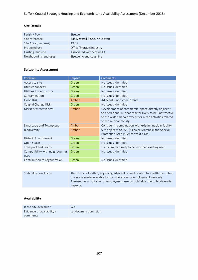
Suffolk Coastal Strategic Housing and Economic Land Availability Assessment (December 2018)
507
Site Details
Parish / Town Sizewell
Site reference 545 Sizewell A Site, Nr Leiston
Site Area (hectares) 19.57
Proposed use Office/Storage/Industry
Existing land use Associated with Sizewell A
Neighbouring land uses Sizewell A and coastline
Suitability Assessment
Criterion Impact Comments
Access to site Green No issues identified.
Utilities capacity Green No issues identified.
Utilities Infrastructure Green No issues identified.
Contamination Green No issues identified.
Flood Risk Amber Adjacent Flood Zone 3 land.
Coastal Change Risk Green No issues identified.
Market Attractiveness Amber Development of commercial space directly adjacent to operational nuclear reactor likely to be unattractive to the wider market except for niche activities related to the nuclear facility.
Landscape and Townscape Amber Consider in combination with existing nuclear facility.
Biodiversity Amber Site adjacent to SSSI (Sizewell Marshes) and Special Protection Area (SPA) for wild birds.
Historic Environment Green No issues identified.
Open Space Green No issues identified.
Transport and Roads Green Traffic impact likely to be less than existing use.
Compatibility with neighbouring uses
Green No issues identified.
Contribution to regeneration Green No issues identified.
Suitability conclusion The site is not within, adjoining, adjacent or well related to a settlement, but the site is made available for consideration for employment use only. Assessed as unsuitable for employment use by Lichfields due to biodiversity impacts.
Availability
Is the site available? Yes
Evidence of availability / comments
Landowner submission

Suffolk Coastal Strategic Housing and Economic Land Availability Assessment (December 2018)
508
Achievability
Is the site achievable? Yes
Evidence of achievability Assumed - costs associated with decomissioning but submission states wil not affect viability
Are there any commencement issues?
Decommissioning
Estimated dwellings yield -
Estimated employment land yield (hectares) 20
Estimated retail floorspace (sqm) -
Estimated commencement date 2023/24
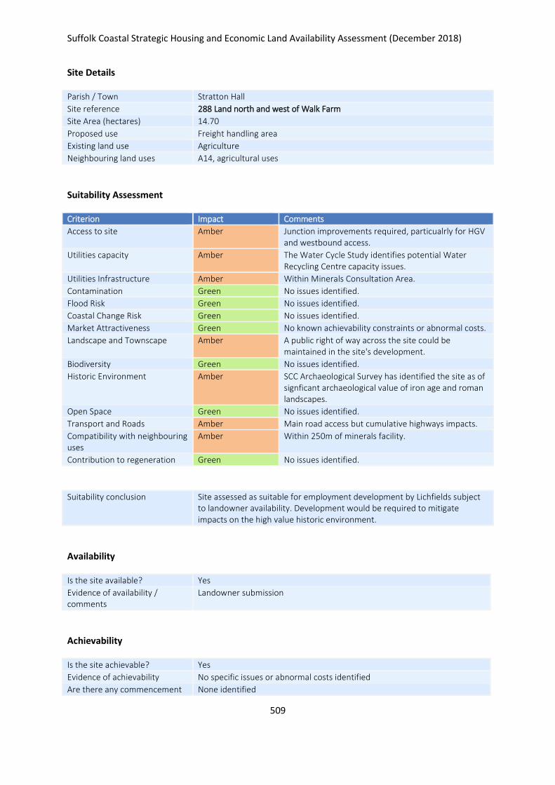
Suffolk Coastal Strategic Housing and Economic Land Availability Assessment (December 2018)
509
Site Details
Parish / Town Stratton Hall
Site reference 288 Land north and west of Walk Farm
Site Area (hectares) 14.70
Proposed use Freight handling area
Existing land use Agriculture
Neighbouring land uses A14, agricultural uses
Suitability Assessment
Criterion Impact Comments
Access to site Amber Junction improvements required, particualrly for HGV and westbound access.
Utilities capacity Amber The Water Cycle Study identifies potential Water Recycling Centre capacity issues.
Utilities Infrastructure Amber Within Minerals Consultation Area.
Contamination Green No issues identified.
Flood Risk Green No issues identified.
Coastal Change Risk Green No issues identified.
Market Attractiveness Green No known achievability constraints or abnormal costs.
Landscape and Townscape Amber A public right of way across the site could be maintained in the site's development.
Biodiversity Green No issues identified.
Historic Environment Amber SCC Archaeological Survey has identified the site as of signficant archaeological value of iron age and roman landscapes.
Open Space Green No issues identified.
Transport and Roads Amber Main road access but cumulative highways impacts.
Compatibility with neighbouring uses
Amber Within 250m of minerals facility.
Contribution to regeneration Green No issues identified.
Suitability conclusion Site assessed as suitable for employment development by Lichfields subject to landowner availability. Development would be required to mitigate impacts on the high value historic environment.
Availability
Is the site available? Yes
Evidence of availability / comments
Landowner submission
Achievability
Is the site achievable? Yes
Evidence of achievability No specific issues or abnormal costs identified
Are there any commencement None identified

Suffolk Coastal Strategic Housing and Economic Land Availability Assessment (December 2018)
510
issues?
Estimated dwellings yield -
Estimated employment land yield (hectares) 15
Estimated retail floorspace (sqm) -
Estimated commencement date 2024/25
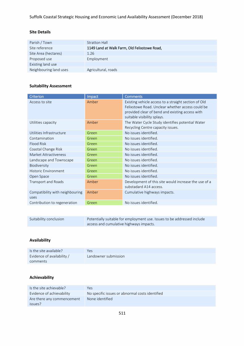
Suffolk Coastal Strategic Housing and Economic Land Availability Assessment (December 2018)
511
Site Details
Parish / Town Stratton Hall
Site reference 1149 Land at Walk Farm, Old Felixstowe Road,
Site Area (hectares) 1.26
Proposed use Employment
Existing land use
Neighbouring land uses Agricultural, roads
Suitability Assessment
Criterion Impact Comments
Access to site Amber Existing vehicle access to a straight section of Old Felixstowe Road. Unclear whether access could be provided clear of bend and existing access with suitable visibility splays.
Utilities capacity Amber The Water Cycle Study identifies potential Water Recycling Centre capacity issues.
Utilities Infrastructure Green No issues identified.
Contamination Green No issues identified.
Flood Risk Green No issues identified.
Coastal Change Risk Green No issues identified.
Market Attractiveness Green No issues identified.
Landscape and Townscape Green No issues identified.
Biodiversity Green No issues identified.
Historic Environment Green No issues identified.
Open Space Green No issues identified.
Transport and Roads Amber Development of this site would increase the use of a substadard A14 access.
Compatibility with neighbouring uses
Amber Cumulative highways impacts.
Contribution to regeneration Green No issues identified.
Suitability conclusion Potentially suitable for employment use. Issues to be addressed include access and cumulative highways impacts.
Availability
Is the site available? Yes
Evidence of availability / comments
Landowner submission
Achievability
Is the site achievable? Yes
Evidence of achievability No specific issues or abnormal costs identified
Are there any commencement issues?
None identified

Suffolk Coastal Strategic Housing and Economic Land Availability Assessment (December 2018)
512
Estimated dwellings yield -
Estimated employment land yield (hectares) 1
Estimated retail floorspace (sqm) -
Estimated commencement date 2022/23

Suffolk Coastal Strategic Housing and Economic Land Availability Assessment (December 2018)
513
Site Details
Parish / Town Stratton Hall
Site reference 1150 Land adj. Walk Farm, Old Felixstowe Road, Stratton Hall
Site Area (hectares) 2.44
Proposed use Employment
Existing land use Agricultural
Neighbouring land uses A14 /roads, agricultural uses
Suitability Assessment
Criterion Impact Comments
Access to site Amber Road layout is chellenging to introducing vehicle access to bends in access roads to A14.
Utilities capacity Amber The Water Cycle Study identifies potential Water Recycling Centre capacity issues.
Utilities Infrastructure Green No issues identified.
Contamination Green No issues identified.
Flood Risk Green No issues identified.
Coastal Change Risk Green No issues identified.
Market Attractiveness Green No issues identified.
Landscape and Townscape Amber Visual impacts to open countryside from A14 depending on how the site were taken forward.
Biodiversity Green No issues identified.
Historic Environment Green No issues identified.
Open Space Green No issues identified.
Transport and Roads Amber Cumulative highways impacts.
Compatibility with neighbouring uses
Green No issues identified.
Contribution to regeneration Green No issues identified.
Suitability conclusion Potentially suitable for employment use. Issues to be addressed include; access, landscape / townscape and highways impacts.
Availability
Is the site available? Yes
Evidence of availability / comments
Landowner submission
Achievability
Is the site achievable? Yes
Evidence of achievability No specific issues or abnormal costs identified
Are there any commencement issues?
None identified

Suffolk Coastal Strategic Housing and Economic Land Availability Assessment (December 2018)
514
Estimated dwellings yield -
Estimated employment land yield (hectares) 2
Estimated retail floorspace (sqm) -
Estimated commencement date 2022/23
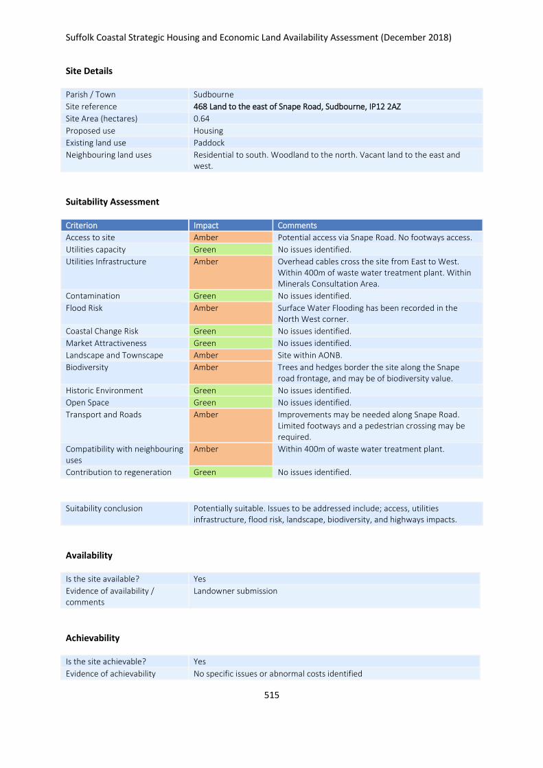
Suffolk Coastal Strategic Housing and Economic Land Availability Assessment (December 2018)
515
Site Details
Parish / Town Sudbourne
Site reference 468 Land to the east of Snape Road, Sudbourne, IP12 2AZ
Site Area (hectares) 0.64
Proposed use Housing
Existing land use Paddock
Neighbouring land uses Residential to south. Woodland to the north. Vacant land to the east and west.
Suitability Assessment
Criterion Impact Comments
Access to site Amber Potential access via Snape Road. No footways access.
Utilities capacity Green No issues identified.
Utilities Infrastructure Amber Overhead cables cross the site from East to West. Within 400m of waste water treatment plant. Within Minerals Consultation Area.
Contamination Green No issues identified.
Flood Risk Amber Surface Water Flooding has been recorded in the North West corner.
Coastal Change Risk Green No issues identified.
Market Attractiveness Green No issues identified.
Landscape and Townscape Amber Site within AONB.
Biodiversity Amber Trees and hedges border the site along the Snape road frontage, and may be of biodiversity value.
Historic Environment Green No issues identified.
Open Space Green No issues identified.
Transport and Roads Amber Improvements may be needed along Snape Road. Limited footways and a pedestrian crossing may be required.
Compatibility with neighbouring uses
Amber Within 400m of waste water treatment plant.
Contribution to regeneration Green No issues identified.
Suitability conclusion Potentially suitable. Issues to be addressed include; access, utilities infrastructure, flood risk, landscape, biodiversity, and highways impacts.
Availability
Is the site available? Yes
Evidence of availability / comments
Landowner submission
Achievability
Is the site achievable? Yes
Evidence of achievability No specific issues or abnormal costs identified
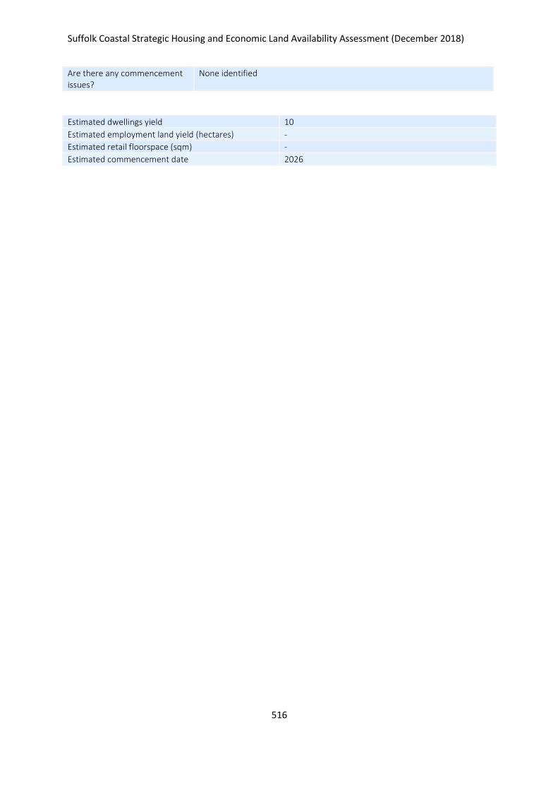
Suffolk Coastal Strategic Housing and Economic Land Availability Assessment (December 2018)
516
Are there any commencement issues?
None identified
Estimated dwellings yield 10
Estimated employment land yield (hectares) -
Estimated retail floorspace (sqm) -
Estimated commencement date 2026
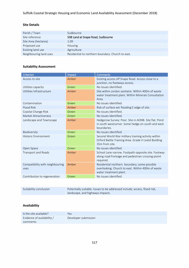
Suffolk Coastal Strategic Housing and Economic Land Availability Assessment (December 2018)
517
Site Details
Parish / Town Sudbourne
Site reference 508 Land at Snape Road, Sudbourne
Site Area (hectares) 1.09
Proposed use Housing
Existing land use Agriculture
Neighbouring land uses Residential to northern boundary. Church to east.
Suitability Assessment
Criterion Impact Comments
Access to site Amber Existing access off Snape Road. Access close to a junction, no footways access.
Utilities capacity Green No issues identified.
Utilities Infrastructure Amber Site within cordon sanitaire. Within 400m of waste water treatment plant. Within Minerals Consultation Area.
Contamination Green No issues identified.
Flood Risk Amber Risk of surface wtr flooding E edge of site.
Coastal Change Risk Green No issues identified.
Market Attractiveness Green No issues identified.
Landscape and Townscape Amber Hedgerow Survey: Poor. Site in AONB. Site flat. Pond in south westcorner. Some hedge on south and west boundaries.
Biodiversity Green No issues identified.
Historic Environment Green Second World War military training activity within Orford Battle Training Area. Grade II Lisetd Building 35m from site.
Open Space Green No issues identified.
Transport and Roads Amber School Lane narrow. Footpath opposite site. Footway along road frontage and pedestrian crossing poiint required.
Compatibility with neighbouring uses
Amber Residential northern boundary; some possible overlooking. Church to east. Within 400m of waste water treatment plant.
Contribution to regeneration Green No issues identified.
Suitability conclusion Potentially suitable. Issues to be addressed include; access, flood risk, landscape, and highways impacts.
Availability
Is the site available? Yes
Evidence of availability / comments
Developer submission

Suffolk Coastal Strategic Housing and Economic Land Availability Assessment (December 2018)
518
Achievability
Is the site achievable? Yes
Evidence of achievability No specific issues or abnormal costs identified
Are there any commencement issues?
None identified
Estimated dwellings yield 16
Estimated employment land yield (hectares) -
Estimated retail floorspace (sqm) -
Estimated commencement date 2021/22
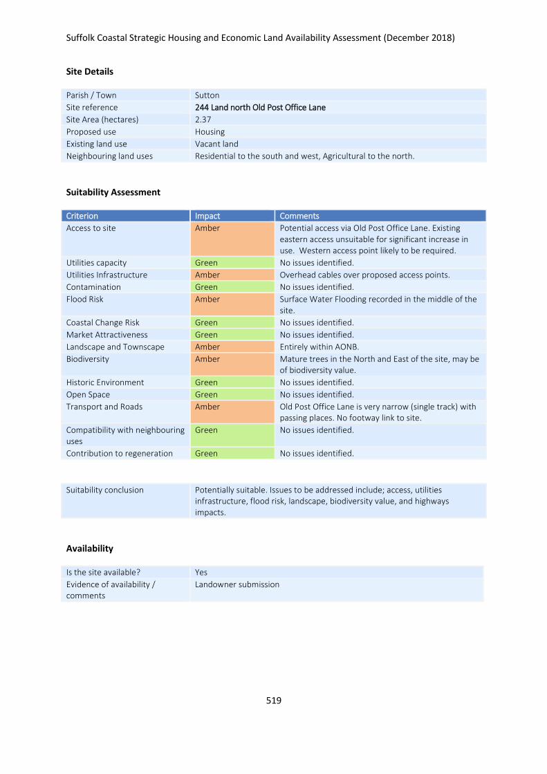
Suffolk Coastal Strategic Housing and Economic Land Availability Assessment (December 2018)
519
Site Details
Parish / Town Sutton
Site reference 244 Land north Old Post Office Lane
Site Area (hectares) 2.37
Proposed use Housing
Existing land use Vacant land
Neighbouring land uses Residential to the south and west, Agricultural to the north.
Suitability Assessment
Criterion Impact Comments
Access to site Amber Potential access via Old Post Office Lane. Existing eastern access unsuitable for significant increase in use. Western access point likely to be required.
Utilities capacity Green No issues identified.
Utilities Infrastructure Amber Overhead cables over proposed access points.
Contamination Green No issues identified.
Flood Risk Amber Surface Water Flooding recorded in the middle of the site.
Coastal Change Risk Green No issues identified.
Market Attractiveness Green No issues identified.
Landscape and Townscape Amber Entirely within AONB.
Biodiversity Amber Mature trees in the North and East of the site, may be of biodiversity value.
Historic Environment Green No issues identified.
Open Space Green No issues identified.
Transport and Roads Amber Old Post Office Lane is very narrow (single track) with passing places. No footway link to site.
Compatibility with neighbouring uses
Green No issues identified.
Contribution to regeneration Green No issues identified.
Suitability conclusion Potentially suitable. Issues to be addressed include; access, utilities infrastructure, flood risk, landscape, biodiversity value, and highways impacts.
Availability
Is the site available? Yes
Evidence of availability / comments
Landowner submission

Suffolk Coastal Strategic Housing and Economic Land Availability Assessment (December 2018)
520
Achievability
Is the site achievable? Yes
Evidence of achievability No specific issues or abnormal costs identified
Are there any commencement issues?
None identified
Estimated dwellings yield 36
Estimated employment land yield (hectares) -
Estimated retail floorspace (sqm) -
Estimated commencement date 2023/24
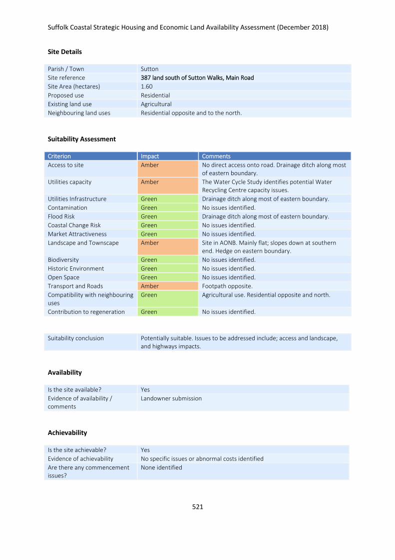
Suffolk Coastal Strategic Housing and Economic Land Availability Assessment (December 2018)
521
Site Details
Parish / Town Sutton
Site reference 387 land south of Sutton Walks, Main Road
Site Area (hectares) 1.60
Proposed use Residential
Existing land use Agricultural
Neighbouring land uses Residential opposite and to the north.
Suitability Assessment
Criterion Impact Comments
Access to site Amber No direct access onto road. Drainage ditch along most of eastern boundary.
Utilities capacity Amber The Water Cycle Study identifies potential Water Recycling Centre capacity issues.
Utilities Infrastructure Green Drainage ditch along most of eastern boundary.
Contamination Green No issues identified.
Flood Risk Green Drainage ditch along most of eastern boundary.
Coastal Change Risk Green No issues identified.
Market Attractiveness Green No issues identified.
Landscape and Townscape Amber Site in AONB. Mainly flat; slopes down at southern end. Hedge on eastern boundary.
Biodiversity Green No issues identified.
Historic Environment Green No issues identified.
Open Space Green No issues identified.
Transport and Roads Amber Footpath opposite.
Compatibility with neighbouring uses
Green Agricultural use. Residential opposite and north.
Contribution to regeneration Green No issues identified.
Suitability conclusion Potentially suitable. Issues to be addressed include; access and landscape, and highways impacts.
Availability
Is the site available? Yes
Evidence of availability / comments
Landowner submission
Achievability
Is the site achievable? Yes
Evidence of achievability No specific issues or abnormal costs identified
Are there any commencement issues?
None identified
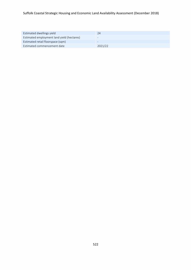
Suffolk Coastal Strategic Housing and Economic Land Availability Assessment (December 2018)
522
Estimated dwellings yield 24
Estimated employment land yield (hectares) -
Estimated retail floorspace (sqm) -
Estimated commencement date 2021/22
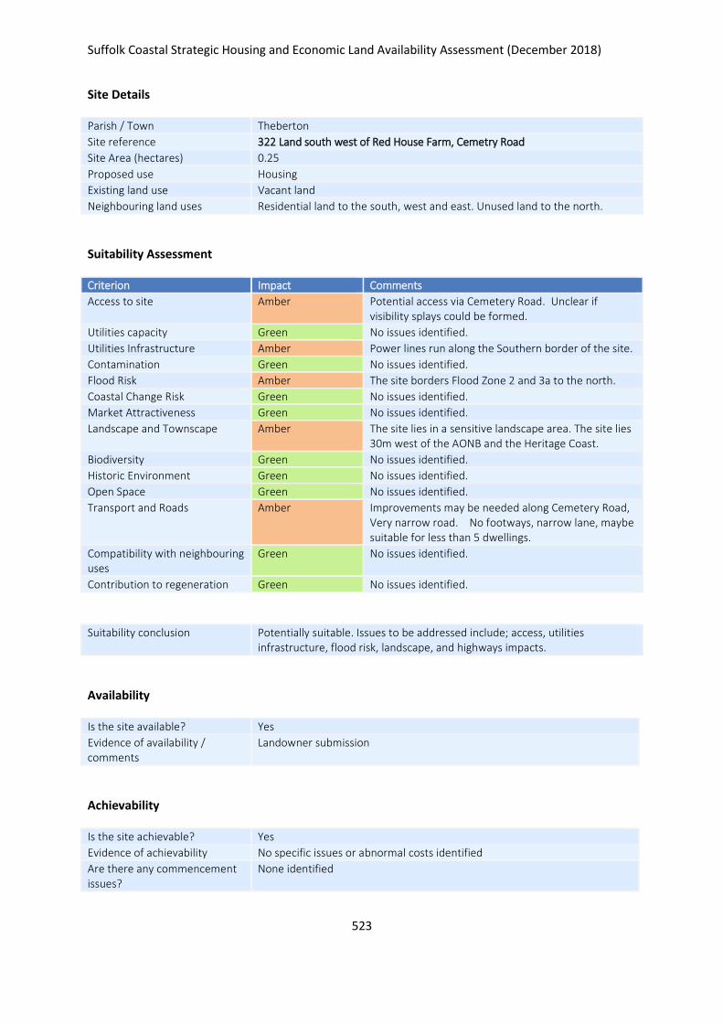
Suffolk Coastal Strategic Housing and Economic Land Availability Assessment (December 2018)
523
Site Details
Parish / Town Theberton
Site reference 322 Land south west of Red House Farm, Cemetry Road
Site Area (hectares) 0.25
Proposed use Housing
Existing land use Vacant land
Neighbouring land uses Residential land to the south, west and east. Unused land to the north.
Suitability Assessment
Criterion Impact Comments
Access to site Amber Potential access via Cemetery Road. Unclear if visibility splays could be formed.
Utilities capacity Green No issues identified.
Utilities Infrastructure Amber Power lines run along the Southern border of the site.
Contamination Green No issues identified.
Flood Risk Amber The site borders Flood Zone 2 and 3a to the north.
Coastal Change Risk Green No issues identified.
Market Attractiveness Green No issues identified.
Landscape and Townscape Amber The site lies in a sensitive landscape area. The site lies 30m west of the AONB and the Heritage Coast.
Biodiversity Green No issues identified.
Historic Environment Green No issues identified.
Open Space Green No issues identified.
Transport and Roads Amber Improvements may be needed along Cemetery Road, Very narrow road. No footways, narrow lane, maybe suitable for less than 5 dwellings.
Compatibility with neighbouring uses
Green No issues identified.
Contribution to regeneration Green No issues identified.
Suitability conclusion Potentially suitable. Issues to be addressed include; access, utilities infrastructure, flood risk, landscape, and highways impacts.
Availability
Is the site available? Yes
Evidence of availability / comments
Landowner submission
Achievability
Is the site achievable? Yes
Evidence of achievability No specific issues or abnormal costs identified
Are there any commencement issues?
None identified

Suffolk Coastal Strategic Housing and Economic Land Availability Assessment (December 2018)
524
Estimated dwellings yield 4
Estimated employment land yield (hectares) -
Estimated retail floorspace (sqm) -
Estimated commencement date 2021/22
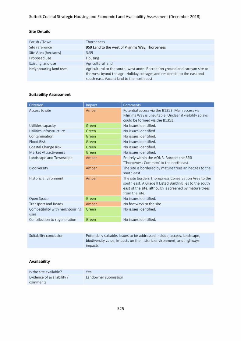
Suffolk Coastal Strategic Housing and Economic Land Availability Assessment (December 2018)
525
Site Details
Parish / Town Thorpeness
Site reference 959 Land to the west of Pilgrims Way, Thorpeness
Site Area (hectares) 3.39
Proposed use Housing
Existing land use Agricultural land.
Neighbouring land uses Agricultural to the south, west andn. Recreation ground and caravan site to the west byond the agri. Holiday cottages and residential to the east and south east. Vacant land to the north east.
Suitability Assessment
Criterion Impact Comments
Access to site Amber Potential access via the B1353. Main access via Pilgrims Way is unsuitable. Unclear if visibility splays could be formed via the B1353.
Utilities capacity Green No issues identified.
Utilities Infrastructure Green No issues identified.
Contamination Green No issues identified.
Flood Risk Green No issues identified.
Coastal Change Risk Green No issues identified.
Market Attractiveness Green No issues identified.
Landscape and Townscape Amber Entirely within the AONB. Borders the SSSI 'Thorpeness Common' to the north east.
Biodiversity Amber The site is bordered by mature trees an hedges to the south east.
Historic Environment Amber The site borders Thorepness Conservation Area to the south east. A Grade II Listed Building lies to the south east of the site, although is screened by mature trees from the site.
Open Space Green No issues identified.
Transport and Roads Amber No footways to the site.
Compatibility with neighbouring uses
Green No issues identified.
Contribution to regeneration Green No issues identified.
Suitability conclusion Potentially suitable. Issues to be addressed include; access, landscape, biodiversity value, impacts on the historic environment, and highways impacts.
Availability
Is the site available? Yes
Evidence of availability / comments
Landowner submission

Suffolk Coastal Strategic Housing and Economic Land Availability Assessment (December 2018)
526
Achievability
Is the site achievable? Yes
Evidence of achievability No specific issues or abnormal costs identified
Are there any commencement issues?
None identified
Estimated dwellings yield 31
Estimated employment land yield (hectares) -
Estimated retail floorspace (sqm) -
Estimated commencement date 2021/22
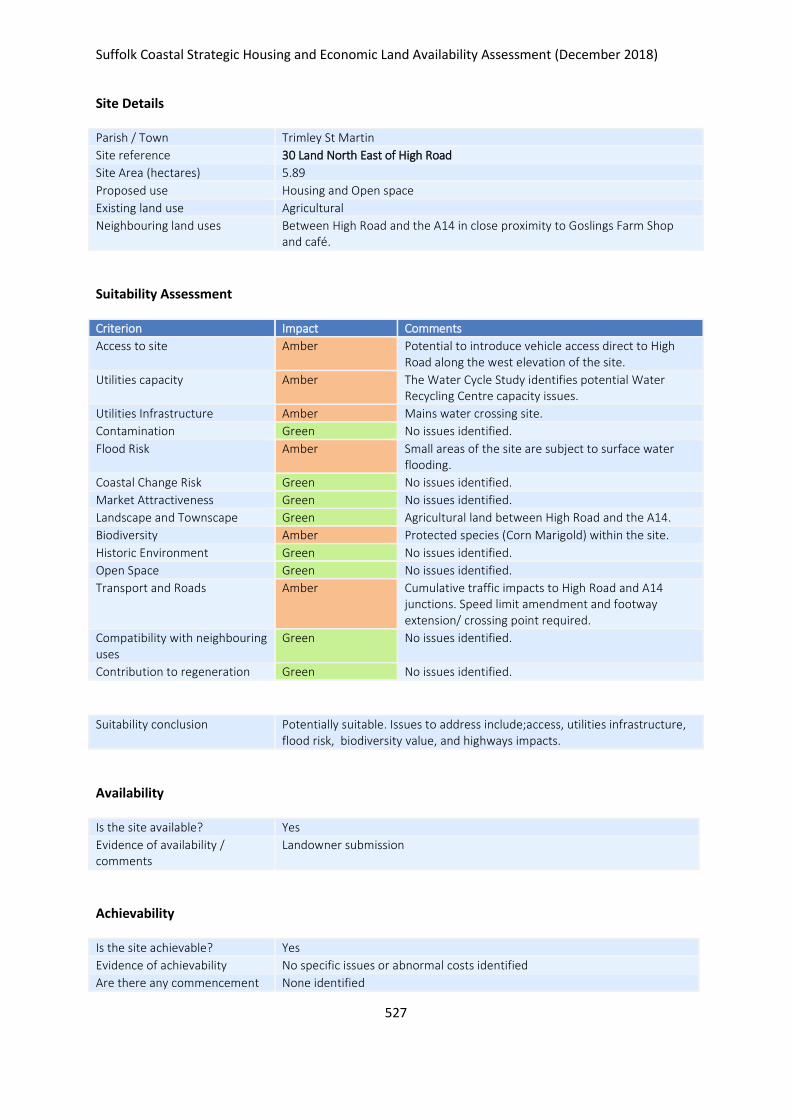
Suffolk Coastal Strategic Housing and Economic Land Availability Assessment (December 2018)
527
Site Details
Parish / Town Trimley St Martin
Site reference 30 Land North East of High Road
Site Area (hectares) 5.89
Proposed use Housing and Open space
Existing land use Agricultural
Neighbouring land uses Between High Road and the A14 in close proximity to Goslings Farm Shop and café.
Suitability Assessment
Criterion Impact Comments
Access to site Amber Potential to introduce vehicle access direct to High Road along the west elevation of the site.
Utilities capacity Amber The Water Cycle Study identifies potential Water Recycling Centre capacity issues.
Utilities Infrastructure Amber Mains water crossing site.
Contamination Green No issues identified.
Flood Risk Amber Small areas of the site are subject to surface water flooding.
Coastal Change Risk Green No issues identified.
Market Attractiveness Green No issues identified.
Landscape and Townscape Green Agricultural land between High Road and the A14.
Biodiversity Amber Protected species (Corn Marigold) within the site.
Historic Environment Green No issues identified.
Open Space Green No issues identified.
Transport and Roads Amber Cumulative traffic impacts to High Road and A14 junctions. Speed limit amendment and footway extension/ crossing point required.
Compatibility with neighbouring uses
Green No issues identified.
Contribution to regeneration Green No issues identified.
Suitability conclusion Potentially suitable. Issues to address include;access, utilities infrastructure, flood risk, biodiversity value, and highways impacts.
Availability
Is the site available? Yes
Evidence of availability / comments
Landowner submission
Achievability
Is the site achievable? Yes
Evidence of achievability No specific issues or abnormal costs identified
Are there any commencement None identified

Suffolk Coastal Strategic Housing and Economic Land Availability Assessment (December 2018)
528
issues?
Estimated dwellings yield 71
Estimated employment land yield (hectares) -
Estimated retail floorspace (sqm) -
Estimated commencement date 2020/21
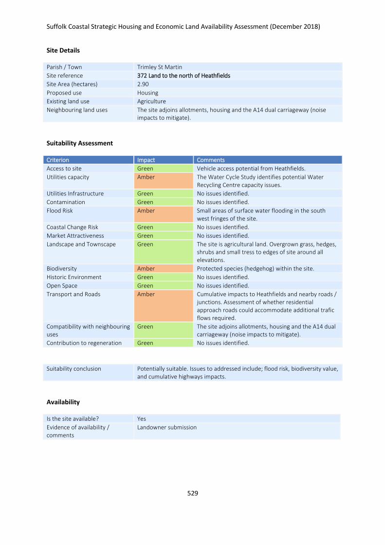
Suffolk Coastal Strategic Housing and Economic Land Availability Assessment (December 2018)
529
Site Details
Parish / Town Trimley St Martin
Site reference 372 Land to the north of Heathfields
Site Area (hectares) 2.90
Proposed use Housing
Existing land use Agriculture
Neighbouring land uses The site adjoins allotments, housing and the A14 dual carriageway (noise impacts to mitigate).
Suitability Assessment
Criterion Impact Comments
Access to site Green Vehicle access potential from Heathfields.
Utilities capacity Amber The Water Cycle Study identifies potential Water Recycling Centre capacity issues.
Utilities Infrastructure Green No issues identified.
Contamination Green No issues identified.
Flood Risk Amber Small areas of surface water flooding in the south west fringes of the site.
Coastal Change Risk Green No issues identified.
Market Attractiveness Green No issues identified.
Landscape and Townscape Green The site is agricultural land. Overgrown grass, hedges, shrubs and small tress to edges of site around all elevations.
Biodiversity Amber Protected species (hedgehog) within the site.
Historic Environment Green No issues identified.
Open Space Green No issues identified.
Transport and Roads Amber Cumulative impacts to Heathfields and nearby roads / junctions. Assessment of whether residential approach roads could accommodate additional trafic flows required.
Compatibility with neighbouring uses
Green The site adjoins allotments, housing and the A14 dual carriageway (noise impacts to mitigate).
Contribution to regeneration Green No issues identified.
Suitability conclusion Potentially suitable. Issues to addressed include; flood risk, biodiversity value, and cumulative highways impacts.
Availability
Is the site available? Yes
Evidence of availability / comments
Landowner submission

Suffolk Coastal Strategic Housing and Economic Land Availability Assessment (December 2018)
530
Achievability
Is the site achievable? Yes
Evidence of achievability No specific issues or abnormal costs identified
Are there any commencement issues?
None identified
Estimated dwellings yield 43
Estimated employment land yield (hectares) -
Estimated retail floorspace (sqm) -
Estimated commencement date 2023/24
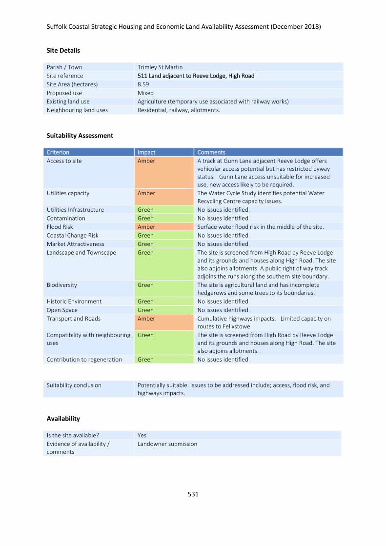
Suffolk Coastal Strategic Housing and Economic Land Availability Assessment (December 2018)
531
Site Details
Parish / Town Trimley St Martin
Site reference 511 Land adjacent to Reeve Lodge, High Road
Site Area (hectares) 8.59
Proposed use Mixed
Existing land use Agriculture (temporary use associated with railway works)
Neighbouring land uses Residential, railway, allotments.
Suitability Assessment
Criterion Impact Comments
Access to site Amber A track at Gunn Lane adjacent Reeve Lodge offers vehicular access potential but has restricted byway status. Gunn Lane access unsuitable for increased use, new access likely to be required.
Utilities capacity Amber The Water Cycle Study identifies potential Water Recycling Centre capacity issues.
Utilities Infrastructure Green No issues identified.
Contamination Green No issues identified.
Flood Risk Amber Surface water flood risk in the middle of the site.
Coastal Change Risk Green No issues identified.
Market Attractiveness Green No issues identified.
Landscape and Townscape Green The site is screened from High Road by Reeve Lodge and its grounds and houses along High Road. The site also adjoins allotments. A public right of way track adjoins the runs along the southern site boundary.
Biodiversity Green The site is agricultural land and has incomplete hedgerows and some trees to its boundaries.
Historic Environment Green No issues identified.
Open Space Green No issues identified.
Transport and Roads Amber Cumulative highways impacts. Limited capacity on routes to Felixstowe.
Compatibility with neighbouring uses
Green The site is screened from High Road by Reeve Lodge and its grounds and houses along High Road. The site also adjoins allotments.
Contribution to regeneration Green No issues identified.
Suitability conclusion Potentially suitable. Issues to be addressed include; access, flood risk, and highways impacts.
Availability
Is the site available? Yes
Evidence of availability / comments
Landowner submission

Suffolk Coastal Strategic Housing and Economic Land Availability Assessment (December 2018)
532
Achievability
Is the site achievable? Yes
Evidence of achievability No specific issues or abnormal costs identified
Are there any commencement issues?
Upon completion of Network Rail works
Estimated dwellings yield 117
Estimated employment land yield (hectares) -
Estimated retail floorspace (sqm) -
Estimated commencement date 2023/24
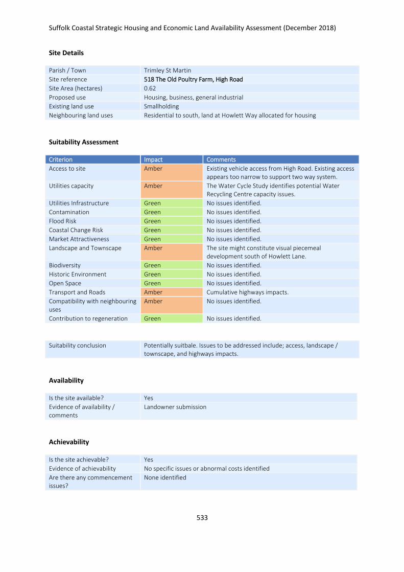
Suffolk Coastal Strategic Housing and Economic Land Availability Assessment (December 2018)
533
Site Details
Parish / Town Trimley St Martin
Site reference 518 The Old Poultry Farm, High Road
Site Area (hectares) 0.62
Proposed use Housing, business, general industrial
Existing land use Smallholding
Neighbouring land uses Residential to south, land at Howlett Way allocated for housing
Suitability Assessment
Criterion Impact Comments
Access to site Amber Existing vehicle access from High Road. Existing access appears too narrow to support two way system.
Utilities capacity Amber The Water Cycle Study identifies potential Water Recycling Centre capacity issues.
Utilities Infrastructure Green No issues identified.
Contamination Green No issues identified.
Flood Risk Green No issues identified.
Coastal Change Risk Green No issues identified.
Market Attractiveness Green No issues identified.
Landscape and Townscape Amber The site might constitute visual piecemeal development south of Howlett Lane.
Biodiversity Green No issues identified.
Historic Environment Green No issues identified.
Open Space Green No issues identified.
Transport and Roads Amber Cumulative highways impacts.
Compatibility with neighbouring uses
Amber No issues identified.
Contribution to regeneration Green No issues identified.
Suitability conclusion Potentially suitbale. Issues to be addressed include; access, landscape / townscape, and highways impacts.
Availability
Is the site available? Yes
Evidence of availability / comments
Landowner submission
Achievability
Is the site achievable? Yes
Evidence of achievability No specific issues or abnormal costs identified
Are there any commencement issues?
None identified

Suffolk Coastal Strategic Housing and Economic Land Availability Assessment (December 2018)
534
Estimated dwellings yield 7
Estimated employment land yield (hectares) -
Estimated retail floorspace (sqm) -
Estimated commencement date 2020/21
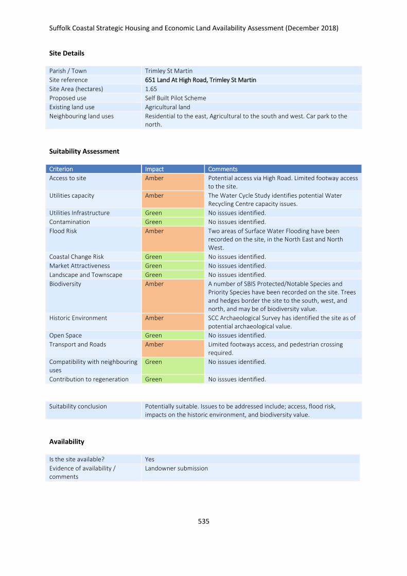
Suffolk Coastal Strategic Housing and Economic Land Availability Assessment (December 2018)
535
Site Details
Parish / Town Trimley St Martin
Site reference 651 Land At High Road, Trimley St Martin
Site Area (hectares) 1.65
Proposed use Self Built Pilot Scheme
Existing land use Agricultural land
Neighbouring land uses Residential to the east, Agricultural to the south and west. Car park to the north.
Suitability Assessment
Criterion Impact Comments
Access to site Amber Potential access via High Road. Limited footway access to the site.
Utilities capacity Amber The Water Cycle Study identifies potential Water Recycling Centre capacity issues.
Utilities Infrastructure Green No isssues identified.
Contamination Green No isssues identified.
Flood Risk Amber Two areas of Surface Water Flooding have been recorded on the site, in the North East and North West.
Coastal Change Risk Green No isssues identified.
Market Attractiveness Green No isssues identified.
Landscape and Townscape Green No isssues identified.
Biodiversity Amber A number of SBIS Protected/Notable Species and Priority Species have been recorded on the site. Trees and hedges border the site to the south, west, and north, and may be of biodiversity value.
Historic Environment Amber SCC Archaeological Survey has identified the site as of potential archaeological value.
Open Space Green No isssues identified.
Transport and Roads Amber Limited footways access, and pedestrian crossing required.
Compatibility with neighbouring uses
Green No isssues identified.
Contribution to regeneration Green No isssues identified.
Suitability conclusion Potentially suitable. Issues to be addressed include; access, flood risk, impacts on the historic environment, and biodiversity value.
Availability
Is the site available? Yes
Evidence of availability / comments
Landowner submission

Suffolk Coastal Strategic Housing and Economic Land Availability Assessment (December 2018)
536
Achievability
Is the site achievable? Yes
Evidence of achievability No specific issues or abnormal costs identified
Are there any commencement issues?
None identified
Estimated dwellings yield 25
Estimated employment land yield (hectares) -
Estimated retail floorspace (sqm) -
Estimated commencement date 2022/23
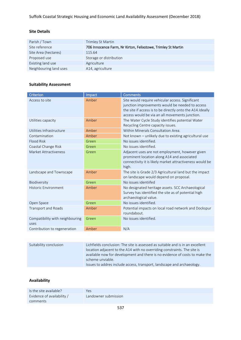
Suffolk Coastal Strategic Housing and Economic Land Availability Assessment (December 2018)
537
Site Details
Parish / Town Trimley St Martin
Site reference 706 Innocence Farm, Nr Kirton, Felixstowe, Trimley St Martin
Site Area (hectares) 115.64
Proposed use Storage or distribution
Existing land use Agriculture
Neighbouring land uses A14, agriculture
Suitability Assessment
Criterion Impact Comments
Access to site Amber Site would require vehicular access. Significant junction improvements would be needed to access the site if access is to be directly onto the A14.Ideally access would be via an all movements junction.
Utilities capacity Amber The Water Cycle Study identifies potential Water Recycling Centre capacity issues.
Utilities Infrastructure Amber Within Minerals Consultation Area.
Contamination Amber Not known – unlikely due to existing agricultural use
Flood Risk Green No issues identified.
Coastal Change Risk Green No issues identified.
Market Attractiveness Green Adjacent uses are not employment, however given prominent location along A14 and associated connectivity it is likely market attractiveness would be high.
Landscape and Townscape Amber The site is Grade 2/3 Agricultural land but the impact on landscape would depend on proposal.
Biodiversity Green No issues identiifed
Historic Environment Amber No designated heritage assets. SCC Archaeological Survey has identified the site as of potential high archaeological value.
Open Space Green No issues identified.
Transport and Roads Amber Potential impacts on local road network and Dockspur roundabout.
Compatibility with neighbouring uses
Green No issues identified.
Contribution to regeneration Amber N/A
Suitability conclusion Lichfields conclusion: The site is assessed as suitable and is in an excellent location adjacent to the A14 with no overriding constraints. The site is available now for development and there is no evidence of costs to make the scheme unviable. Issues to addres include access, transport, landscape and archaeology.
Availability
Is the site available? Yes
Evidence of availability / comments
Landowner submission
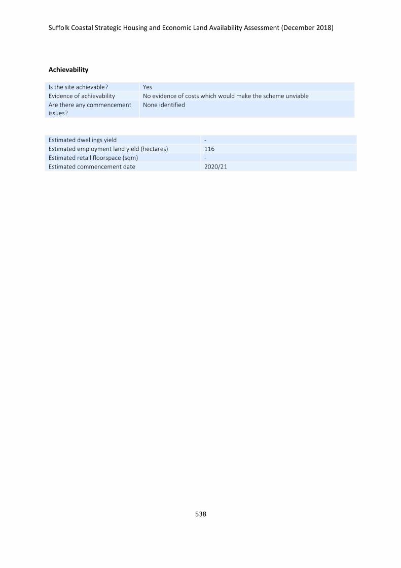
Suffolk Coastal Strategic Housing and Economic Land Availability Assessment (December 2018)
538
Achievability
Is the site achievable? Yes
Evidence of achievability No evidence of costs which would make the scheme unviable
Are there any commencement issues?
None identified
Estimated dwellings yield -
Estimated employment land yield (hectares) 116
Estimated retail floorspace (sqm) -
Estimated commencement date 2020/21
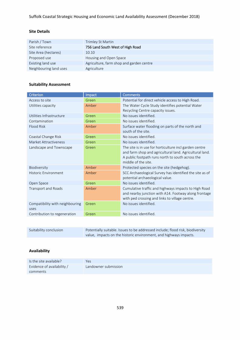
Suffolk Coastal Strategic Housing and Economic Land Availability Assessment (December 2018)
539
Site Details
Parish / Town Trimley St Martin
Site reference 756 Land South West of High Road
Site Area (hectares) 10.10
Proposed use Housing and Open Space
Existing land use Agriculture, farm shop and garden centre
Neighbouring land uses Agriculture
Suitability Assessment
Criterion Impact Comments
Access to site Green Potential for direct vehicle access to High Road.
Utilities capacity Amber The Water Cycle Study identifies potential Water Recycling Centre capacity issues.
Utilities Infrastructure Green No issues identified.
Contamination Green No issues identified.
Flood Risk Amber Surface water flooding on parts of the north and south of the site.
Coastal Change Risk Green No issues identified.
Market Attractiveness Green No issues identified.
Landscape and Townscape Green The site is in use for horticulture incl garden centre and farm shop and agricultural land. Agricultural land. A public footpath runs north to south across the middle of the site.
Biodiversity Amber Protected species on the site (hedgehog).
Historic Environment Amber SCC Archaeological Survey has identified the site as of potential archaeological value.
Open Space Green No issues identified.
Transport and Roads Amber Cumulative traffic and highways impacts to High Road and nearby junction with A14. Footway along frontage with ped crossing and links to village centre.
Compatibility with neighbouring uses
Green No issues identified.
Contribution to regeneration Green No issues identified.
Suitability conclusion Potentially suitable. Issues to be addressed include; flood risk, biodiversity value, impacts on the historic environment, and highways impacts.
Availability
Is the site available? Yes
Evidence of availability / comments
Landowner submission
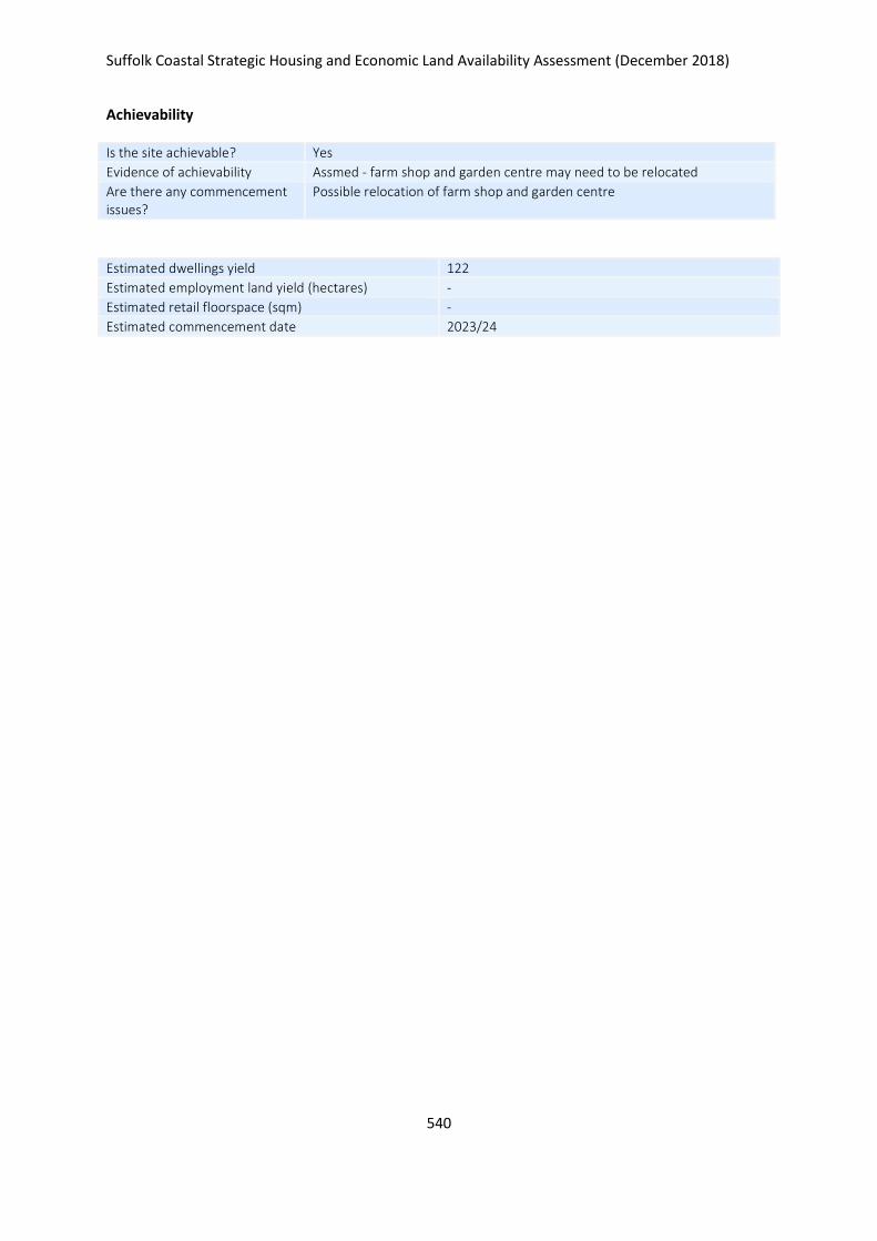
Suffolk Coastal Strategic Housing and Economic Land Availability Assessment (December 2018)
540
Achievability
Is the site achievable? Yes
Evidence of achievability Assmed - farm shop and garden centre may need to be relocated
Are there any commencement issues?
Possible relocation of farm shop and garden centre
Estimated dwellings yield 122
Estimated employment land yield (hectares) -
Estimated retail floorspace (sqm) -
Estimated commencement date 2023/24
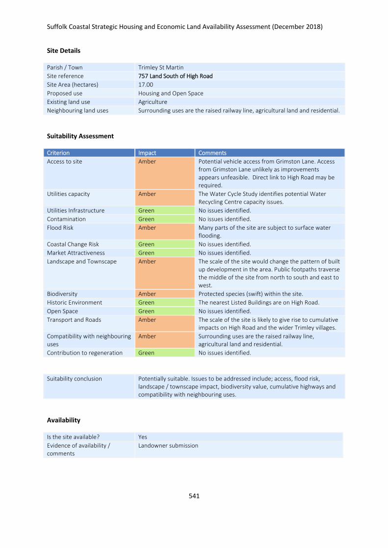
Suffolk Coastal Strategic Housing and Economic Land Availability Assessment (December 2018)
541
Site Details
Parish / Town Trimley St Martin
Site reference 757 Land South of High Road
Site Area (hectares) 17.00
Proposed use Housing and Open Space
Existing land use Agriculture
Neighbouring land uses Surrounding uses are the raised railway line, agricultural land and residential.
Suitability Assessment
Criterion Impact Comments
Access to site Amber Potential vehicle access from Grimston Lane. Access from Grimston Lane unlikely as improvements appears unfeasible. Direct link to High Road may be required.
Utilities capacity Amber The Water Cycle Study identifies potential Water Recycling Centre capacity issues.
Utilities Infrastructure Green No issues identified.
Contamination Green No issues identified.
Flood Risk Amber Many parts of the site are subject to surface water flooding.
Coastal Change Risk Green No issues identified.
Market Attractiveness Green No issues identified.
Landscape and Townscape Amber The scale of the site would change the pattern of built up development in the area. Public footpaths traverse the middle of the site from north to south and east to west.
Biodiversity Amber Protected species (swift) within the site.
Historic Environment Green The nearest Listed Buildings are on High Road.
Open Space Green No issues identified.
Transport and Roads Amber The scale of the site is likely to give rise to cumulative impacts on High Road and the wider Trimley villages.
Compatibility with neighbouring uses
Amber Surrounding uses are the raised railway line, agricultural land and residential.
Contribution to regeneration Green No issues identified.
Suitability conclusion Potentially suitable. Issues to be addressed include; access, flood risk, landscape / townscape impact, biodiversity value, cumulative highways and compatibility with neighbouring uses.
Availability
Is the site available? Yes
Evidence of availability / comments
Landowner submission

Suffolk Coastal Strategic Housing and Economic Land Availability Assessment (December 2018)
542
Achievability
Is the site achievable? Yes
Evidence of achievability Assumed - no specific issues identified
Are there any commencement issues?
None identified
Estimated dwellings yield 204
Estimated employment land yield (hectares) -
Estimated retail floorspace (sqm) -
Estimated commencement date 2021/22
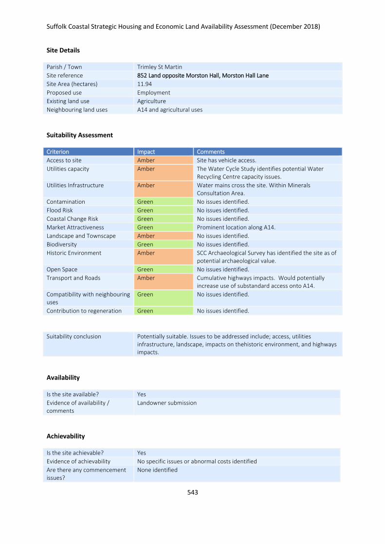
Suffolk Coastal Strategic Housing and Economic Land Availability Assessment (December 2018)
543
Site Details
Parish / Town Trimley St Martin
Site reference 852 Land opposite Morston Hall, Morston Hall Lane
Site Area (hectares) 11.94
Proposed use Employment
Existing land use Agriculture
Neighbouring land uses A14 and agricultural uses
Suitability Assessment
Criterion Impact Comments
Access to site Amber Site has vehicle access.
Utilities capacity Amber The Water Cycle Study identifies potential Water Recycling Centre capacity issues.
Utilities Infrastructure Amber Water mains cross the site. Within Minerals Consultation Area.
Contamination Green No issues identified.
Flood Risk Green No issues identified.
Coastal Change Risk Green No issues identified.
Market Attractiveness Green Prominent location along A14.
Landscape and Townscape Amber No issues identified.
Biodiversity Green No issues identified.
Historic Environment Amber SCC Archaeological Survey has identified the site as of potential archaeological value.
Open Space Green No issues identified.
Transport and Roads Amber Cumulative highways impacts. Would potentially increase use of substandard access onto A14.
Compatibility with neighbouring uses
Green No issues identified.
Contribution to regeneration Green No issues identified.
Suitability conclusion Potentially suitable. Issues to be addressed include; access, utilities infrastructure, landscape, impacts on thehistoric environment, and highways impacts.
Availability
Is the site available? Yes
Evidence of availability / comments
Landowner submission
Achievability
Is the site achievable? Yes
Evidence of achievability No specific issues or abnormal costs identified
Are there any commencement issues?
None identified

Suffolk Coastal Strategic Housing and Economic Land Availability Assessment (December 2018)
544
Estimated dwellings yield -
Estimated employment land yield (hectares) 12
Estimated retail floorspace (sqm) -
Estimated commencement date 2023/24
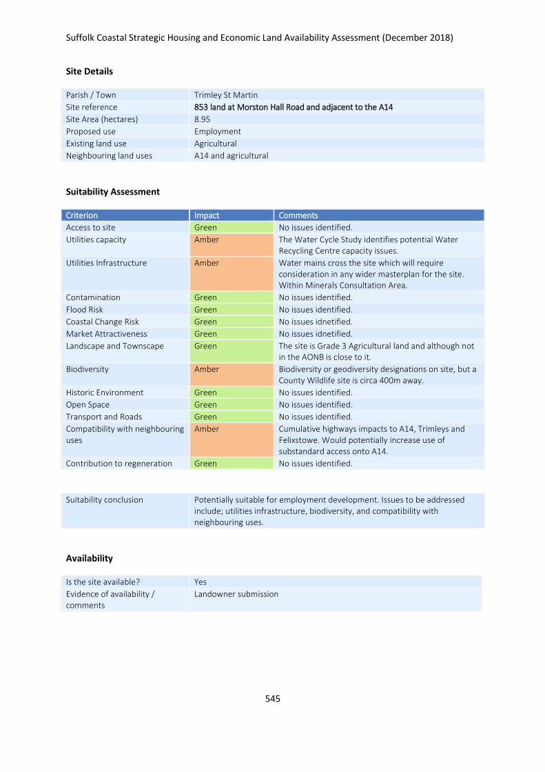
Suffolk Coastal Strategic Housing and Economic Land Availability Assessment (December 2018)
545
Site Details
Parish / Town Trimley St Martin
Site reference 853 land at Morston Hall Road and adjacent to the A14
Site Area (hectares) 8.95
Proposed use Employment
Existing land use Agricultural
Neighbouring land uses A14 and agricultural
Suitability Assessment
Criterion Impact Comments
Access to site Green No issues identified.
Utilities capacity Amber The Water Cycle Study identifies potential Water Recycling Centre capacity issues.
Utilities Infrastructure Amber Water mains cross the site which will require consideration in any wider masterplan for the site. Within Minerals Consultation Area.
Contamination Green No issues identified.
Flood Risk Green No issues identified.
Coastal Change Risk Green No issues idnetified.
Market Attractiveness Green No issues idnetified.
Landscape and Townscape Green The site is Grade 3 Agricultural land and although not in the AONB is close to it.
Biodiversity Amber Biodiversity or geodiversity designations on site, but a County Wildlife site is circa 400m away.
Historic Environment Green No issues identified.
Open Space Green No issues identified.
Transport and Roads Green No issues identified.
Compatibility with neighbouring uses
Amber Cumulative highways impacts to A14, Trimleys and Felixstowe. Would potentially increase use of substandard access onto A14.
Contribution to regeneration Green No issues identified.
Suitability conclusion Potentially suitable for employment development. Issues to be addressed include; utilities infrastructure, biodiversity, and compatibility with neighbouring uses.
Availability
Is the site available? Yes
Evidence of availability / comments
Landowner submission

Suffolk Coastal Strategic Housing and Economic Land Availability Assessment (December 2018)
546
Achievability
Is the site achievable? Yes
Evidence of achievability No specific issues or abnormal costs identified
Are there any commencement issues?
None identified
Estimated dwellings yield -
Estimated employment land yield (hectares) 9
Estimated retail floorspace (sqm) -
Estimated commencement date 2023/24
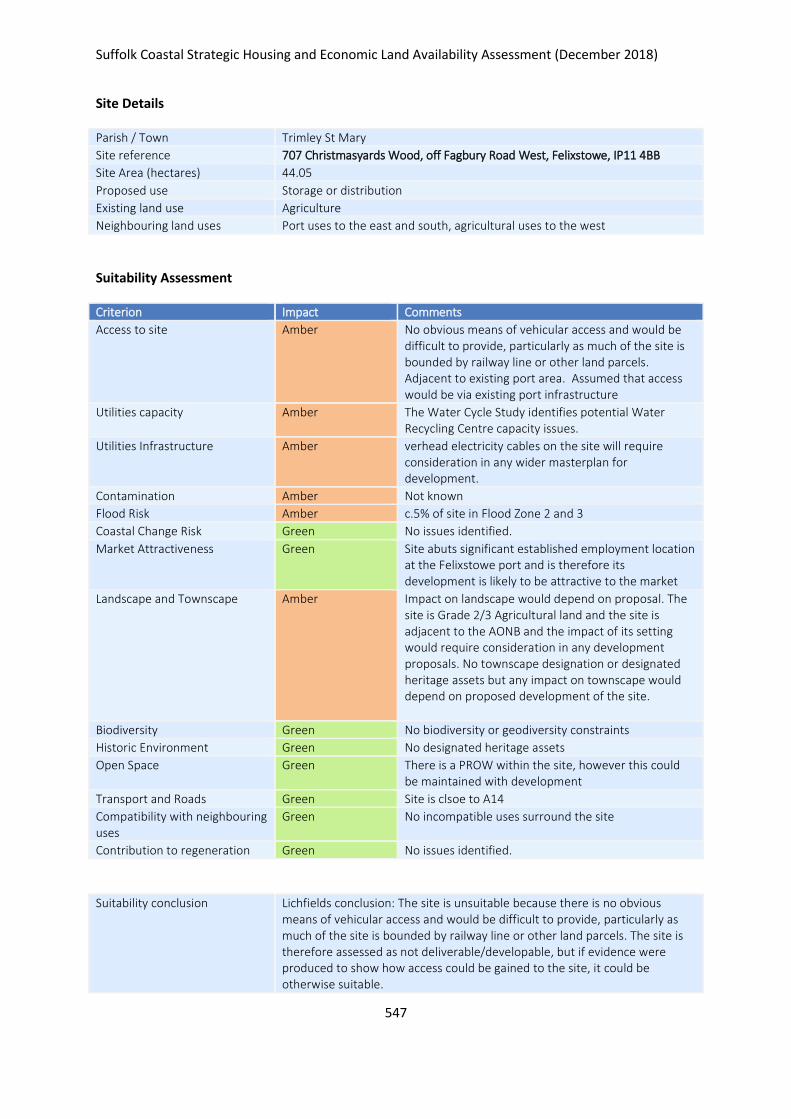
Suffolk Coastal Strategic Housing and Economic Land Availability Assessment (December 2018)
547
Site Details
Parish / Town Trimley St Mary
Site reference 707 Christmasyards Wood, off Fagbury Road West, Felixstowe, IP11 4BB
Site Area (hectares) 44.05
Proposed use Storage or distribution
Existing land use Agriculture
Neighbouring land uses Port uses to the east and south, agricultural uses to the west
Suitability Assessment
Criterion Impact Comments
Access to site Amber No obvious means of vehicular access and would be difficult to provide, particularly as much of the site is bounded by railway line or other land parcels. Adjacent to existing port area. Assumed that access would be via existing port infrastructure
Utilities capacity Amber The Water Cycle Study identifies potential Water Recycling Centre capacity issues.
Utilities Infrastructure Amber verhead electricity cables on the site will require consideration in any wider masterplan for development.
Contamination Amber Not known
Flood Risk Amber c.5% of site in Flood Zone 2 and 3
Coastal Change Risk Green No issues identified.
Market Attractiveness Green Site abuts significant established employment location at the Felixstowe port and is therefore its development is likely to be attractive to the market
Landscape and Townscape Amber Impact on landscape would depend on proposal. The site is Grade 2/3 Agricultural land and the site is adjacent to the AONB and the impact of its setting would require consideration in any development proposals. No townscape designation or designated heritage assets but any impact on townscape would depend on proposed development of the site.
Biodiversity Green No biodiversity or geodiversity constraints
Historic Environment Green No designated heritage assets
Open Space Green There is a PROW within the site, however this could be maintained with development
Transport and Roads Green Site is clsoe to A14
Compatibility with neighbouring uses
Green No incompatible uses surround the site
Contribution to regeneration Green No issues identified.
Suitability conclusion Lichfields conclusion: The site is unsuitable because there is no obvious means of vehicular access and would be difficult to provide, particularly as much of the site is bounded by railway line or other land parcels. The site is therefore assessed as not deliverable/developable, but if evidence were produced to show how access could be gained to the site, it could be otherwise suitable.
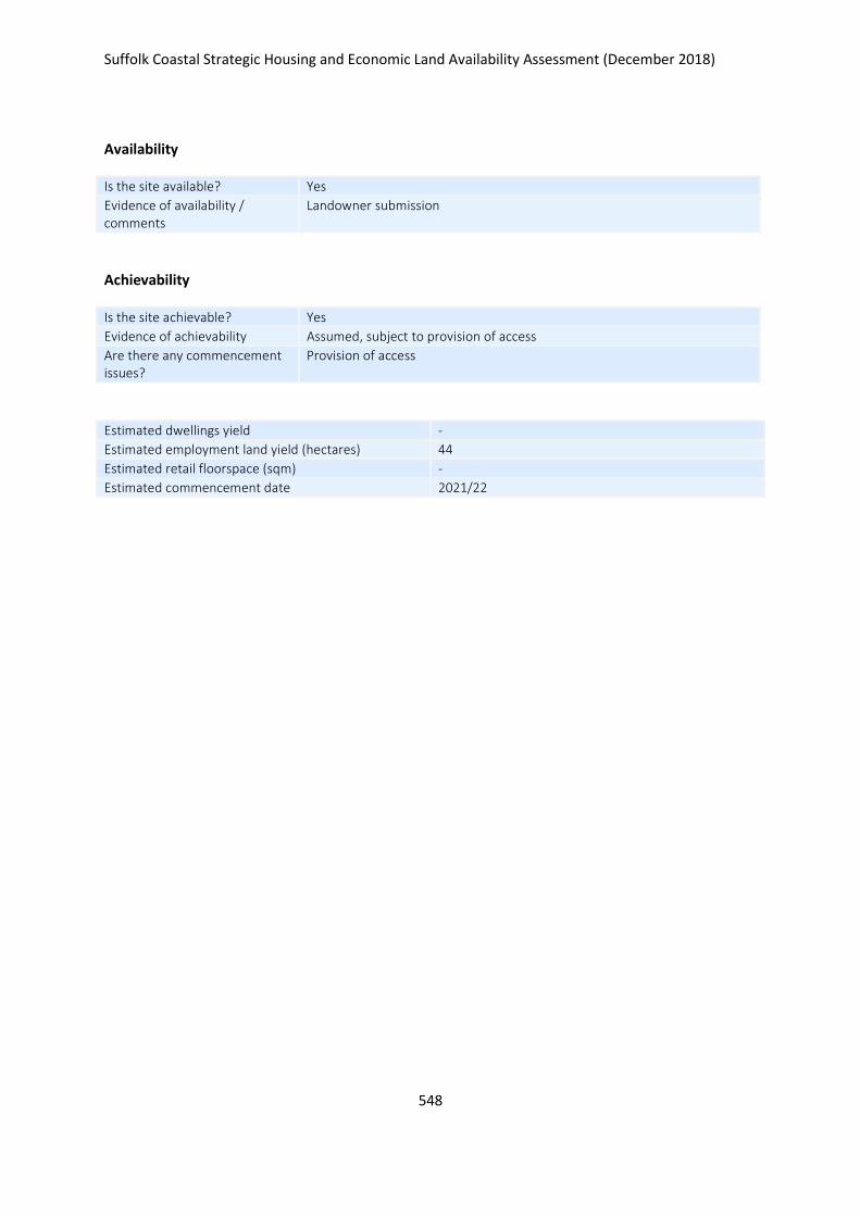
Suffolk Coastal Strategic Housing and Economic Land Availability Assessment (December 2018)
548
Availability
Is the site available? Yes
Evidence of availability / comments
Landowner submission
Achievability
Is the site achievable? Yes
Evidence of achievability Assumed, subject to provision of access
Are there any commencement issues?
Provision of access
Estimated dwellings yield -
Estimated employment land yield (hectares) 44
Estimated retail floorspace (sqm) -
Estimated commencement date 2021/22
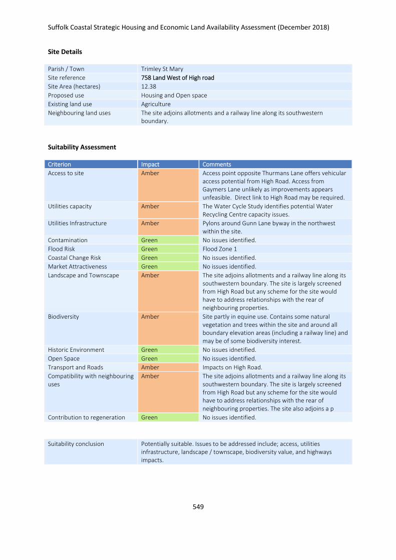
Suffolk Coastal Strategic Housing and Economic Land Availability Assessment (December 2018)
549
Site Details
Parish / Town Trimley St Mary
Site reference 758 Land West of High road
Site Area (hectares) 12.38
Proposed use Housing and Open space
Existing land use Agriculture
Neighbouring land uses The site adjoins allotments and a railway line along its southwestern boundary.
Suitability Assessment
Criterion Impact Comments
Access to site Amber Access point opposite Thurmans Lane offers vehicular access potential from High Road. Access from Gaymers Lane unlikely as improvements appears unfeasible. Direct link to High Road may be required.
Utilities capacity Amber The Water Cycle Study identifies potential Water Recycling Centre capacity issues.
Utilities Infrastructure Amber Pylons around Gunn Lane byway in the northwest within the site.
Contamination Green No issues identified.
Flood Risk Green Flood Zone 1
Coastal Change Risk Green No issues identified.
Market Attractiveness Green No issues identified.
Landscape and Townscape Amber The site adjoins allotments and a railway line along its southwestern boundary. The site is largely screened from High Road but any scheme for the site would have to address relationships with the rear of neighbouring properties.
Biodiversity Amber Site partly in equine use. Contains some natural vegetation and trees within the site and around all boundary elevation areas (including a railway line) and may be of some biodiversity interest.
Historic Environment Green No issues idnetified.
Open Space Green No issues identified.
Transport and Roads Amber Impacts on High Road.
Compatibility with neighbouring uses
Amber The site adjoins allotments and a railway line along its southwestern boundary. The site is largely screened from High Road but any scheme for the site would have to address relationships with the rear of neighbouring properties. The site also adjoins a p
Contribution to regeneration Green No issues identified.
Suitability conclusion Potentially suitable. Issues to be addressed include; access, utilities infrastructure, landscape / townscape, biodiversity value, and highways impacts.
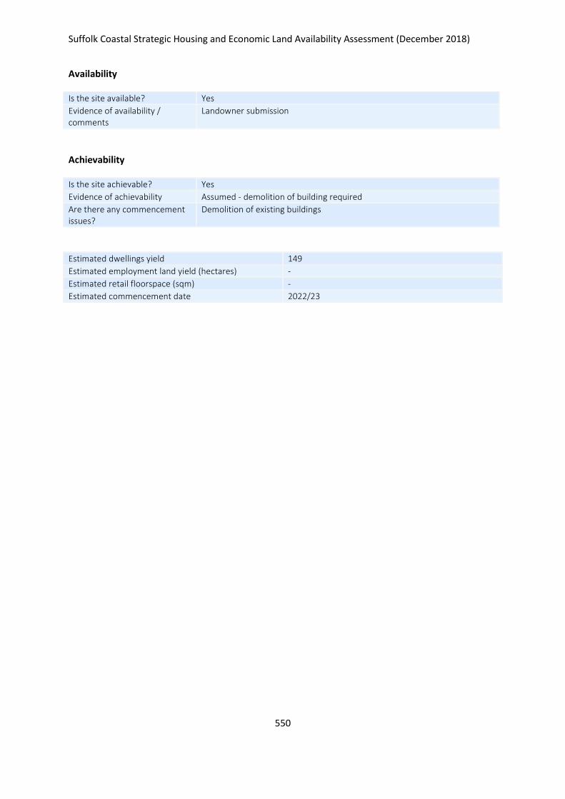
Suffolk Coastal Strategic Housing and Economic Land Availability Assessment (December 2018)
550
Availability
Is the site available? Yes
Evidence of availability / comments
Landowner submission
Achievability
Is the site achievable? Yes
Evidence of achievability Assumed - demolition of building required
Are there any commencement issues?
Demolition of existing buildings
Estimated dwellings yield 149
Estimated employment land yield (hectares) -
Estimated retail floorspace (sqm) -
Estimated commencement date 2022/23
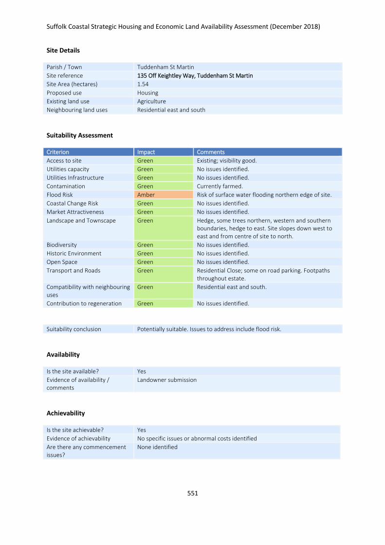
Suffolk Coastal Strategic Housing and Economic Land Availability Assessment (December 2018)
551
Site Details
Parish / Town Tuddenham St Martin
Site reference 135 Off Keightley Way, Tuddenham St Martin
Site Area (hectares) 1.54
Proposed use Housing
Existing land use Agriculture
Neighbouring land uses Residential east and south
Suitability Assessment
Criterion Impact Comments
Access to site Green Existing; visibility good.
Utilities capacity Green No issues identified.
Utilities Infrastructure Green No issues identified.
Contamination Green Currently farmed.
Flood Risk Amber Risk of surface water flooding northern edge of site.
Coastal Change Risk Green No issues identified.
Market Attractiveness Green No issues identified.
Landscape and Townscape Green Hedge, some trees northern, western and southern boundaries, hedge to east. Site slopes down west to east and from centre of site to north.
Biodiversity Green No issues identified.
Historic Environment Green No issues identified.
Open Space Green No issues identified.
Transport and Roads Green Residential Close; some on road parking. Footpaths throughout estate.
Compatibility with neighbouring uses
Green Residential east and south.
Contribution to regeneration Green No issues identified.
Suitability conclusion Potentially suitable. Issues to address include flood risk.
Availability
Is the site available? Yes
Evidence of availability / comments
Landowner submission
Achievability
Is the site achievable? Yes
Evidence of achievability No specific issues or abnormal costs identified
Are there any commencement issues?
None identified

Suffolk Coastal Strategic Housing and Economic Land Availability Assessment (December 2018)
552
Estimated dwellings yield 23
Estimated employment land yield (hectares) -
Estimated retail floorspace (sqm) -
Estimated commencement date 2022/23
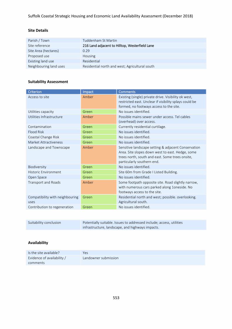
Suffolk Coastal Strategic Housing and Economic Land Availability Assessment (December 2018)
553
Site Details
Parish / Town Tuddenham St Martin
Site reference 216 Land adjacent to Hilltop, Westerfield Lane
Site Area (hectares) 0.29
Proposed use Housing
Existing land use Residential
Neighbouring land uses Residential north and west; Agricultural south
Suitability Assessment
Criterion Impact Comments
Access to site Amber Existing (single) private drive. Visibility ok west, restricted east. Unclear if visibility splays could be formed, no footways access to the site.
Utilities capacity Green No issues identified.
Utilities Infrastructure Amber Possible mains sewer under access. Tel cables (overhead) over access.
Contamination Green Currently residential curtilage.
Flood Risk Green No issues identified.
Coastal Change Risk Green No issues identified.
Market Attractiveness Green No issues identified.
Landscape and Townscape Amber Sensitive landscape setting & adjacent Conservation Area. Site slopes down west to east. Hedge, some trees north, south and east. Some trees onsite, particularly southern end.
Biodiversity Green No issues identified.
Historic Environment Green Site 60m from Grade I Listed Building.
Open Space Green No issues identified.
Transport and Roads Amber Some footpath opposite site. Road slightly narrow, with numerous cars parked along 1oneside. No footways access to the site.
Compatibility with neighbouring uses
Green Residential north and west; possible. overlooking. Agricultural south.
Contribution to regeneration Green No issues identified.
Suitability conclusion Potentially suitable. Issues to addressed include; access, utilities infrastructure, landscape, and highways impacts.
Availability
Is the site available? Yes
Evidence of availability / comments
Landowner submission

Suffolk Coastal Strategic Housing and Economic Land Availability Assessment (December 2018)
554
Achievability
Is the site achievable? Yes
Evidence of achievability No specific issues or abnormal costs identified
Are there any commencement issues?
None identified
Estimated dwellings yield 4
Estimated employment land yield (hectares) -
Estimated retail floorspace (sqm) -
Estimated commencement date 2023/24
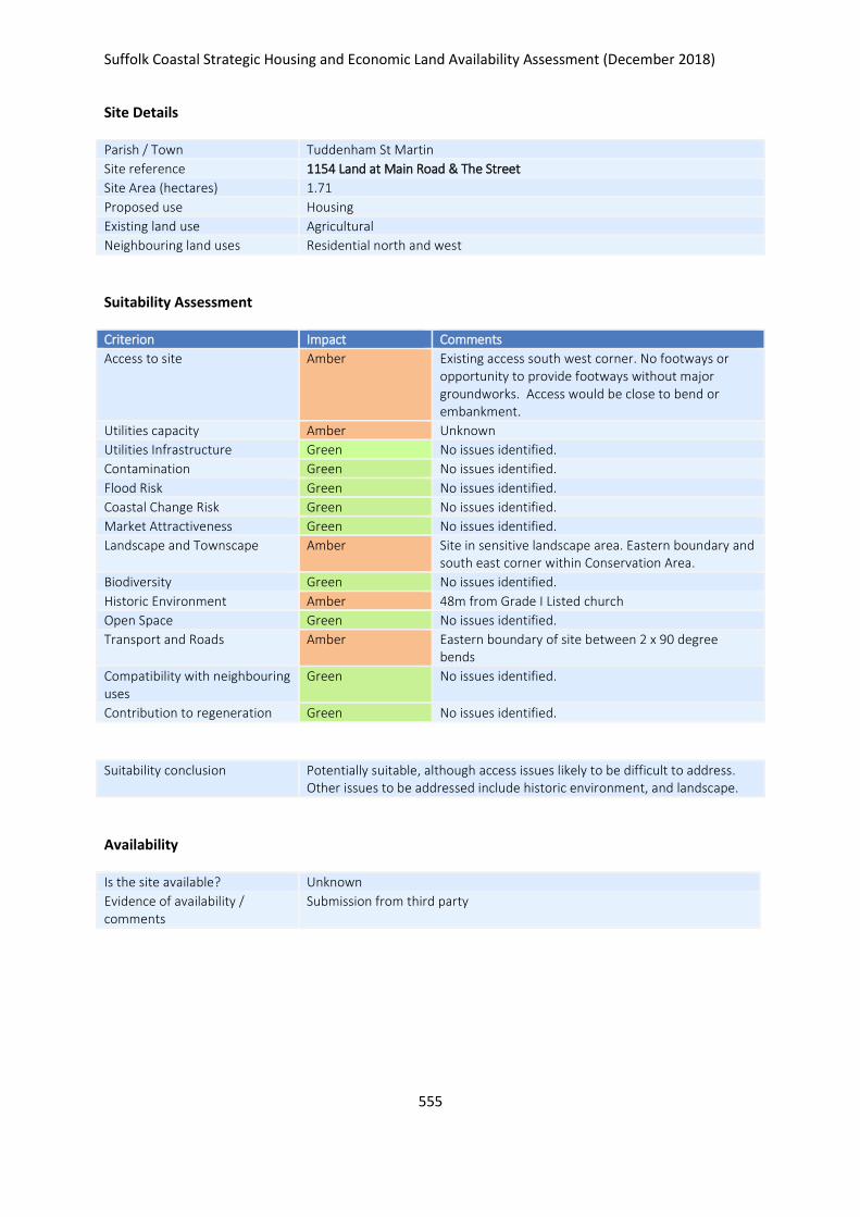
Suffolk Coastal Strategic Housing and Economic Land Availability Assessment (December 2018)
555
Site Details
Parish / Town Tuddenham St Martin
Site reference 1154 Land at Main Road & The Street
Site Area (hectares) 1.71
Proposed use Housing
Existing land use Agricultural
Neighbouring land uses Residential north and west
Suitability Assessment
Criterion Impact Comments
Access to site Amber Existing access south west corner. No footways or opportunity to provide footways without major groundworks. Access would be close to bend or embankment.
Utilities capacity Amber Unknown
Utilities Infrastructure Green No issues identified.
Contamination Green No issues identified.
Flood Risk Green No issues identified.
Coastal Change Risk Green No issues identified.
Market Attractiveness Green No issues identified.
Landscape and Townscape Amber Site in sensitive landscape area. Eastern boundary and south east corner within Conservation Area.
Biodiversity Green No issues identified.
Historic Environment Amber 48m from Grade I Listed church
Open Space Green No issues identified.
Transport and Roads Amber Eastern boundary of site between 2 x 90 degree bends
Compatibility with neighbouring uses
Green No issues identified.
Contribution to regeneration Green No issues identified.
Suitability conclusion Potentially suitable, although access issues likely to be difficult to address. Other issues to be addressed include historic environment, and landscape.
Availability
Is the site available? Unknown
Evidence of availability / comments
Submission from third party

Suffolk Coastal Strategic Housing and Economic Land Availability Assessment (December 2018)
556
Achievability
Is the site achievable? Yes
Evidence of achievability No specific issues or abnormal costs identified
Are there any commencement issues?
None identified
Estimated dwellings yield 0
Estimated employment land yield (hectares) -
Estimated retail floorspace (sqm) -
Estimated commencement date -
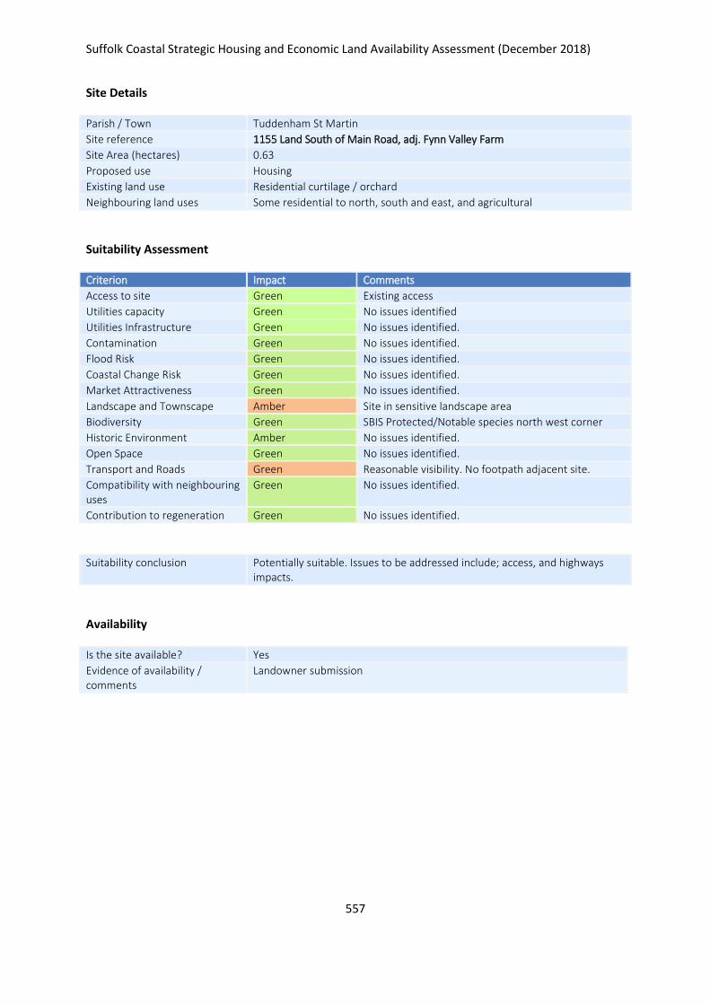
Suffolk Coastal Strategic Housing and Economic Land Availability Assessment (December 2018)
557
Site Details
Parish / Town Tuddenham St Martin
Site reference 1155 Land South of Main Road, adj. Fynn Valley Farm
Site Area (hectares) 0.63
Proposed use Housing
Existing land use Residential curtilage / orchard
Neighbouring land uses Some residential to north, south and east, and agricultural
Suitability Assessment
Criterion Impact Comments
Access to site Green Existing access
Utilities capacity Green No issues identified
Utilities Infrastructure Green No issues identified.
Contamination Green No issues identified.
Flood Risk Green No issues identified.
Coastal Change Risk Green No issues identified.
Market Attractiveness Green No issues identified.
Landscape and Townscape Amber Site in sensitive landscape area
Biodiversity Green SBIS Protected/Notable species north west corner
Historic Environment Amber No issues identified.
Open Space Green No issues identified.
Transport and Roads Green Reasonable visibility. No footpath adjacent site.
Compatibility with neighbouring uses
Green No issues identified.
Contribution to regeneration Green No issues identified.
Suitability conclusion Potentially suitable. Issues to be addressed include; access, and highways impacts.
Availability
Is the site available? Yes
Evidence of availability / comments
Landowner submission

Suffolk Coastal Strategic Housing and Economic Land Availability Assessment (December 2018)
558
Achievability
Is the site achievable? Yes
Evidence of achievability No specific issues or abnormal costs identified
Are there any commencement issues?
None identified
Estimated dwellings yield 10
Estimated employment land yield (hectares) -
Estimated retail floorspace (sqm) -
Estimated commencement date 2020/21
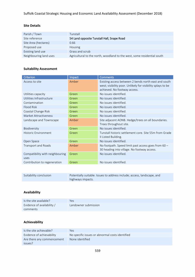
Suffolk Coastal Strategic Housing and Economic Land Availability Assessment (December 2018)
559
Site Details
Parish / Town Tunstall
Site reference 54 Land opposite Tunstall Hall, Snape Road
Site Area (hectares) 0.66
Proposed use Housing
Existing land use Grass and scrub
Neighbouring land uses Agricultural to the north, woodland to the west, some residential south
Suitability Assessment
Criterion Impact Comments
Access to site Amber Existing access between 2 bends north east and south west; visibility poor. Unlikely for visibility splays to be achieved. No footway access.
Utilities capacity Green No issues identified.
Utilities Infrastructure Green No issues identified.
Contamination Green No issues identified.
Flood Risk Green No issues identified.
Coastal Change Risk Green No issues identified.
Market Attractiveness Green No issues identified.
Landscape and Townscape Amber Site adjacent AONB. Hedge/trees on all boundaries. Trees throughout site.
Biodiversity Green No issues identified.
Historic Environment Green Tunstall historic settlement core. Site 55m from Grade II Listed Building.
Open Space Green No issues identified.
Transport and Roads Amber No footpath. Speed limit past access goes from 60 – 30 heading into village. No footway access.
Compatibility with neighbouring uses
Green No issues identified.
Contribution to regeneration Green No issues identified.
Suitability conclusion Potentially suitable. Issues to address include; access, landscape, and highways impacts.
Availability
Is the site available? Yes
Evidence of availability / comments
Landowner submission
Achievability
Is the site achievable? Yes
Evidence of achievability No specific issues or abnormal costs identified
Are there any commencement issues?
None identified

Suffolk Coastal Strategic Housing and Economic Land Availability Assessment (December 2018)
560
Estimated dwellings yield 10
Estimated employment land yield (hectares) -
Estimated retail floorspace (sqm) -
Estimated commencement date 2021/22
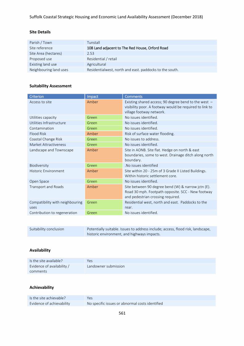
Suffolk Coastal Strategic Housing and Economic Land Availability Assessment (December 2018)
561
Site Details
Parish / Town Tunstall
Site reference 108 Land adjacent to The Red House, Orford Road
Site Area (hectares) 2.53
Proposed use Residential / retail
Existing land use Agricultural
Neighbouring land uses Residentialwest, north and east. paddocks to the south.
Suitability Assessment
Criterion Impact Comments
Access to site Amber Existing shared access; 90 degree bend to the west – visibility poor. A footway would be required to link to village footway network.
Utilities capacity Green No issues identified.
Utilities Infrastructure Green No issues identified.
Contamination Green No issues identified.
Flood Risk Amber Risk of surface water flooding.
Coastal Change Risk Green No issues to address.
Market Attractiveness Green No issues identified.
Landscape and Townscape Amber Site in AONB. Site flat. Hedge on north & east boundaries, some to west. Drainage ditch along north boundary.
Biodiversity Green .No issues identified
Historic Environment Amber Site within 20 - 25m of 3 Grade II Listed Buildings. Within historic settlement core.
Open Space Green No issues identified.
Transport and Roads Amber Site between 90 degree bend (W) & narrow jctn (E). Road 30 mph. Footpath opposite. SCC - New footway and pedestrian crossing required.
Compatibility with neighbouring uses
Green Residential west, north and east. Paddocks to the rear.
Contribution to regeneration Green No issues identified.
Suitability conclusion Potentially suitable. Issues to address include; access, flood risk, landscape, historic environment, and highways impacts.
Availability
Is the site available? Yes
Evidence of availability / comments
Landowner submission
Achievability
Is the site achievable? Yes
Evidence of achievability No specific issues or abnormal costs identified

Suffolk Coastal Strategic Housing and Economic Land Availability Assessment (December 2018)
562
Are there any commencement issues?
None identified
Estimated dwellings yield 38
Estimated employment land yield (hectares) -
Estimated retail floorspace (sqm) -
Estimated commencement date 2023/24
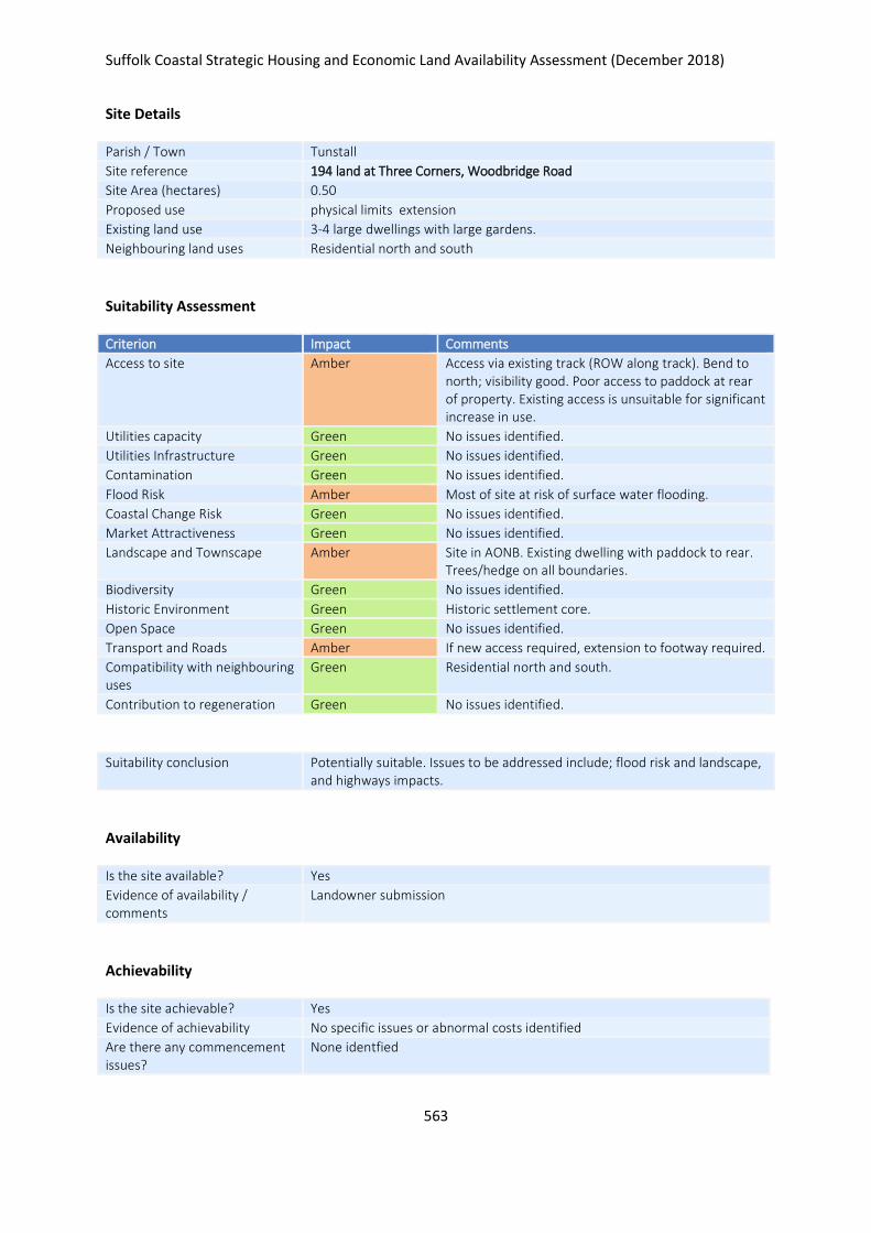
Suffolk Coastal Strategic Housing and Economic Land Availability Assessment (December 2018)
563
Site Details
Parish / Town Tunstall
Site reference 194 land at Three Corners, Woodbridge Road
Site Area (hectares) 0.50
Proposed use physical limits extension
Existing land use 3-4 large dwellings with large gardens.
Neighbouring land uses Residential north and south
Suitability Assessment
Criterion Impact Comments
Access to site Amber Access via existing track (ROW along track). Bend to north; visibility good. Poor access to paddock at rear of property. Existing access is unsuitable for significant increase in use.
Utilities capacity Green No issues identified.
Utilities Infrastructure Green No issues identified.
Contamination Green No issues identified.
Flood Risk Amber Most of site at risk of surface water flooding.
Coastal Change Risk Green No issues identified.
Market Attractiveness Green No issues identified.
Landscape and Townscape Amber Site in AONB. Existing dwelling with paddock to rear. Trees/hedge on all boundaries.
Biodiversity Green No issues identified.
Historic Environment Green Historic settlement core.
Open Space Green No issues identified.
Transport and Roads Amber If new access required, extension to footway required.
Compatibility with neighbouring uses
Green Residential north and south.
Contribution to regeneration Green No issues identified.
Suitability conclusion Potentially suitable. Issues to be addressed include; flood risk and landscape, and highways impacts.
Availability
Is the site available? Yes
Evidence of availability / comments
Landowner submission
Achievability
Is the site achievable? Yes
Evidence of achievability No specific issues or abnormal costs identified
Are there any commencement issues?
None identfied

Suffolk Coastal Strategic Housing and Economic Land Availability Assessment (December 2018)
564
Estimated dwellings yield 8
Estimated employment land yield (hectares) -
Estimated retail floorspace (sqm) -
Estimated commencement date 2021/22
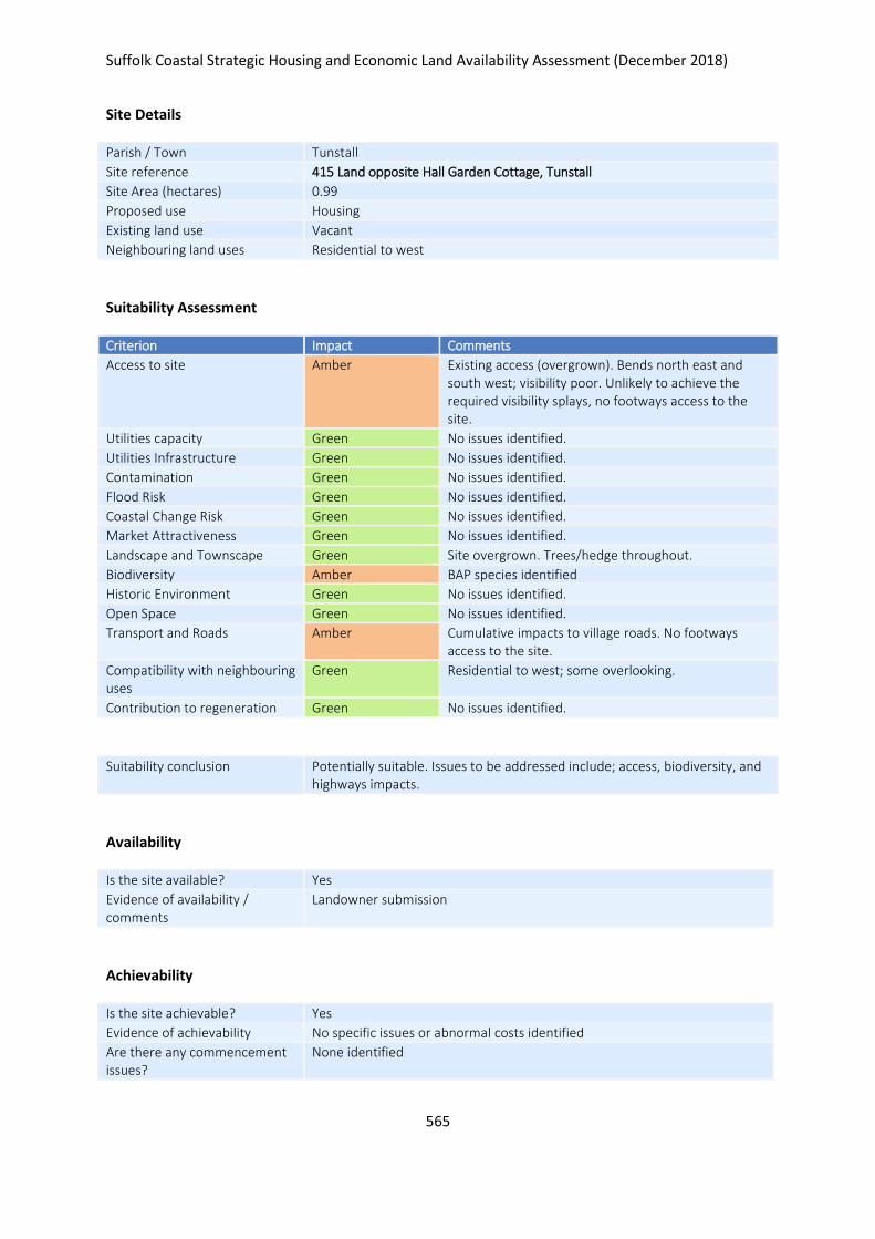
Suffolk Coastal Strategic Housing and Economic Land Availability Assessment (December 2018)
565
Site Details
Parish / Town Tunstall
Site reference 415 Land opposite Hall Garden Cottage, Tunstall
Site Area (hectares) 0.99
Proposed use Housing
Existing land use Vacant
Neighbouring land uses Residential to west
Suitability Assessment
Criterion Impact Comments
Access to site Amber Existing access (overgrown). Bends north east and south west; visibility poor. Unlikely to achieve the required visibility splays, no footways access to the site.
Utilities capacity Green No issues identified.
Utilities Infrastructure Green No issues identified.
Contamination Green No issues identified.
Flood Risk Green No issues identified.
Coastal Change Risk Green No issues identified.
Market Attractiveness Green No issues identified.
Landscape and Townscape Green Site overgrown. Trees/hedge throughout.
Biodiversity Amber BAP species identified
Historic Environment Green No issues identified.
Open Space Green No issues identified.
Transport and Roads Amber Cumulative impacts to village roads. No footways access to the site.
Compatibility with neighbouring uses
Green Residential to west; some overlooking.
Contribution to regeneration Green No issues identified.
Suitability conclusion Potentially suitable. Issues to be addressed include; access, biodiversity, and highways impacts.
Availability
Is the site available? Yes
Evidence of availability / comments
Landowner submission
Achievability
Is the site achievable? Yes
Evidence of achievability No specific issues or abnormal costs identified
Are there any commencement issues?
None identified

Suffolk Coastal Strategic Housing and Economic Land Availability Assessment (December 2018)
566
Estimated dwellings yield 15
Estimated employment land yield (hectares) -
Estimated retail floorspace (sqm) -
Estimated commencement date 2022/23
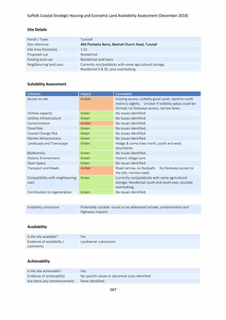
Suffolk Coastal Strategic Housing and Economic Land Availability Assessment (December 2018)
567
Site Details
Parish / Town Tunstall
Site reference 464 Plunketts Barns, Blaxhall Church Road, Tunstall
Site Area (hectares) 1.52
Proposed use Residential
Existing land use Residential and livery
Neighbouring land uses Currently resi/paddocks with some agricultural storage. Residential S & SE; poss overlooking.
Suitability Assessment
Criterion Impact Comments
Access to site Amber Existing access; visibility good south, bend to north restricts slightly. Unclear if visibility splays could be formed, no footways access, narrow lanes.
Utilities capacity Green No issues identified.
Utilities Infrastructure Green No issues identified.
Contamination Amber No issues identified.
Flood Risk Green No issues identified.
Coastal Change Risk Green No issues identified.
Market Attractiveness Green No issues identified.
Landscape and Townscape Green Hedge & some trees north, south and west boundaries.
Biodiversity Green No issues identified.
Historic Environment Green Historic village core.
Open Space Green No issues identified.
Transport and Roads Amber Road narrow, no footpath. No footways access to the site, narrow roads.
Compatibility with neighbouring uses
Green Currently resi/paddocks with some agricultural storage. Residential south and south east; possible overlooking.
Contribution to regeneration Green No issues identified.
Suitability conclusion Potentially suitable. Issues to be addressed include; contamination and highways impacts.
Availability
Is the site available? Yes
Evidence of availability / comments
Landowner submission
Achievability
Is the site achievable? Yes
Evidence of achievability No specific issues or abnormal costs identified
Are there any commencement None identified

Suffolk Coastal Strategic Housing and Economic Land Availability Assessment (December 2018)
568
issues?
Estimated dwellings yield 23
Estimated employment land yield (hectares) -
Estimated retail floorspace (sqm) -
Estimated commencement date 2021/22
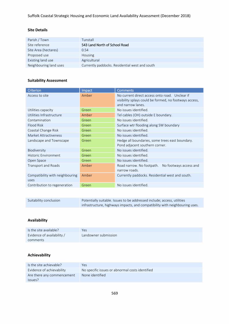
Suffolk Coastal Strategic Housing and Economic Land Availability Assessment (December 2018)
569
Site Details
Parish / Town Tunstall
Site reference 543 Land North of School Road
Site Area (hectares) 0.54
Proposed use Housing
Existing land use Agricultural
Neighbouring land uses Currently paddocks. Residential west and south
Suitability Assessment
Criterion Impact Comments
Access to site Amber No current direct access onto road. Unclear if visibility splays could be formed, no footways access, and narrow lanes.
Utilities capacity Green No issues identified.
Utilities Infrastructure Amber Tel cables (OH) outside E boundary.
Contamination Green No issues identified.
Flood Risk Green Surface wtr flooding along SW boundary
Coastal Change Risk Green No issues identified.
Market Attractiveness Green No issues identified.
Landscape and Townscape Green Hedge all boundaries, some trees east boundary. Pond adjacent southern corner.
Biodiversity Green No issues identified.
Historic Environment Green No issues identified.
Open Space Green No issues identified.
Transport and Roads Amber Road narrow. No footpath. No footways access and narrow roads.
Compatibility with neighbouring uses
Amber Currently paddocks. Residential west and south.
Contribution to regeneration Green No issues identified.
Suitability conclusion Potentially suitable. Issues to be addressed include; access, utilities infrastructure, highways impacts, and compatibility with neighbouring uses.
Availability
Is the site available? Yes
Evidence of availability / comments
Landowner submission
Achievability
Is the site achievable? Yes
Evidence of achievability No specific issues or abnormal costs identified
Are there any commencement issues?
None identified

Suffolk Coastal Strategic Housing and Economic Land Availability Assessment (December 2018)
570
Estimated dwellings yield 8
Estimated employment land yield (hectares) -
Estimated retail floorspace (sqm) -
Estimated commencement date 2022/23
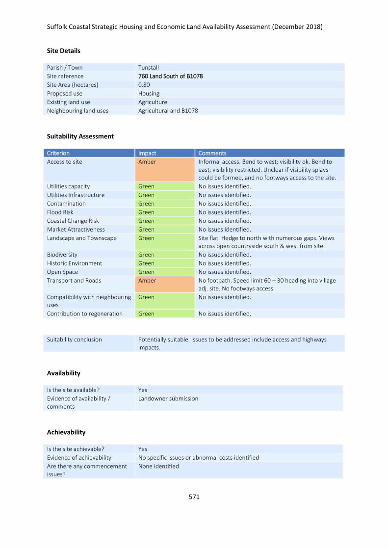
Suffolk Coastal Strategic Housing and Economic Land Availability Assessment (December 2018)
571
Site Details
Parish / Town Tunstall
Site reference 760 Land South of B1078
Site Area (hectares) 0.80
Proposed use Housing
Existing land use Agriculture
Neighbouring land uses Agricultural and B1078
Suitability Assessment
Criterion Impact Comments
Access to site Amber Informal access. Bend to west; visibility ok. Bend to east; visibility restricted. Unclear if visibility splays could be formed, and no footways access to the site.
Utilities capacity Green No issues identified.
Utilities Infrastructure Green No issues identified.
Contamination Green No issues identified.
Flood Risk Green No issues identified.
Coastal Change Risk Green No issues identified.
Market Attractiveness Green No issues identified.
Landscape and Townscape Green Site flat. Hedge to north with numerous gaps. Views across open countryside south & west from site.
Biodiversity Green No issues identified.
Historic Environment Green No issues identified.
Open Space Green No issues identified.
Transport and Roads Amber No footpath. Speed limit 60 – 30 heading into village adj. site. No footways access.
Compatibility with neighbouring uses
Green No issues identified.
Contribution to regeneration Green No issues identified.
Suitability conclusion Potentially suitable. Issues to be addressed include access and highways impacts.
Availability
Is the site available? Yes
Evidence of availability / comments
Landowner submission
Achievability
Is the site achievable? Yes
Evidence of achievability No specific issues or abnormal costs identified
Are there any commencement issues?
None identified

Suffolk Coastal Strategic Housing and Economic Land Availability Assessment (December 2018)
572
Estimated dwellings yield 12
Estimated employment land yield (hectares) -
Estimated retail floorspace (sqm) -
Estimated commencement date 2020/21
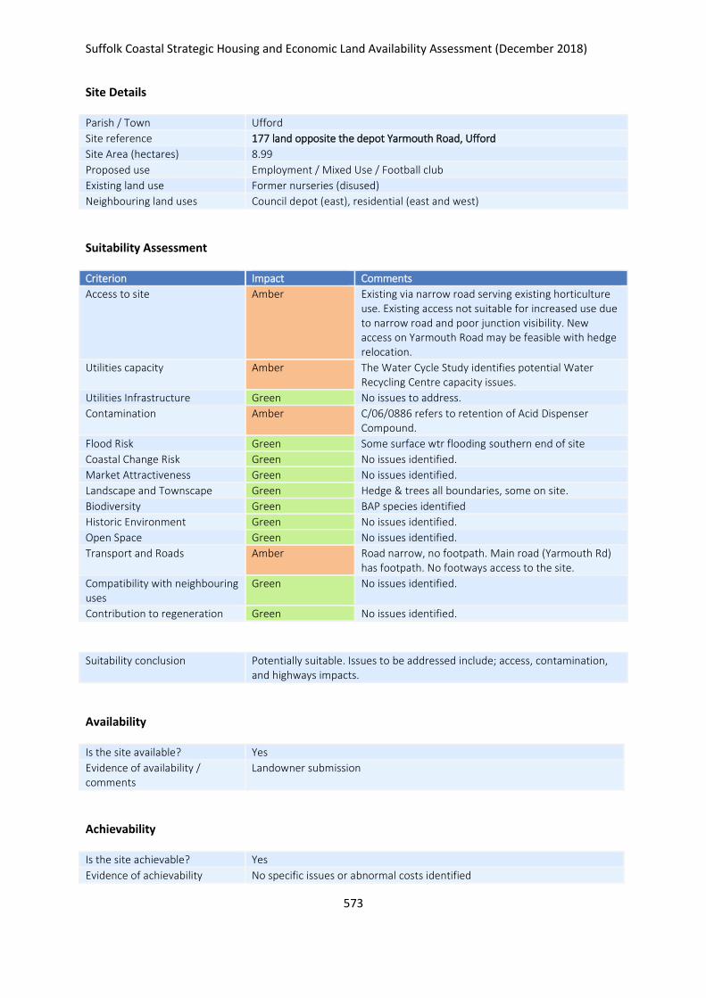
Suffolk Coastal Strategic Housing and Economic Land Availability Assessment (December 2018)
573
Site Details
Parish / Town Ufford
Site reference 177 land opposite the depot Yarmouth Road, Ufford
Site Area (hectares) 8.99
Proposed use Employment / Mixed Use / Football club
Existing land use Former nurseries (disused)
Neighbouring land uses Council depot (east), residential (east and west)
Suitability Assessment
Criterion Impact Comments
Access to site Amber Existing via narrow road serving existing horticulture use. Existing access not suitable for increased use due to narrow road and poor junction visibility. New access on Yarmouth Road may be feasible with hedge relocation.
Utilities capacity Amber The Water Cycle Study identifies potential Water Recycling Centre capacity issues.
Utilities Infrastructure Green No issues to address.
Contamination Amber C/06/0886 refers to retention of Acid Dispenser Compound.
Flood Risk Green Some surface wtr flooding southern end of site
Coastal Change Risk Green No issues identified.
Market Attractiveness Green No issues identified.
Landscape and Townscape Green Hedge & trees all boundaries, some on site.
Biodiversity Green BAP species identified
Historic Environment Green No issues identified.
Open Space Green No issues identified.
Transport and Roads Amber Road narrow, no footpath. Main road (Yarmouth Rd) has footpath. No footways access to the site.
Compatibility with neighbouring uses
Green No issues identified.
Contribution to regeneration Green No issues identified.
Suitability conclusion Potentially suitable. Issues to be addressed include; access, contamination, and highways impacts.
Availability
Is the site available? Yes
Evidence of availability / comments
Landowner submission
Achievability
Is the site achievable? Yes
Evidence of achievability No specific issues or abnormal costs identified

Suffolk Coastal Strategic Housing and Economic Land Availability Assessment (December 2018)
574
Are there any commencement issues?
None identified
Estimated dwellings yield 68
Estimated employment land yield (hectares) 4.5
Estimated retail floorspace (sqm) -
Estimated commencement date 2021/22
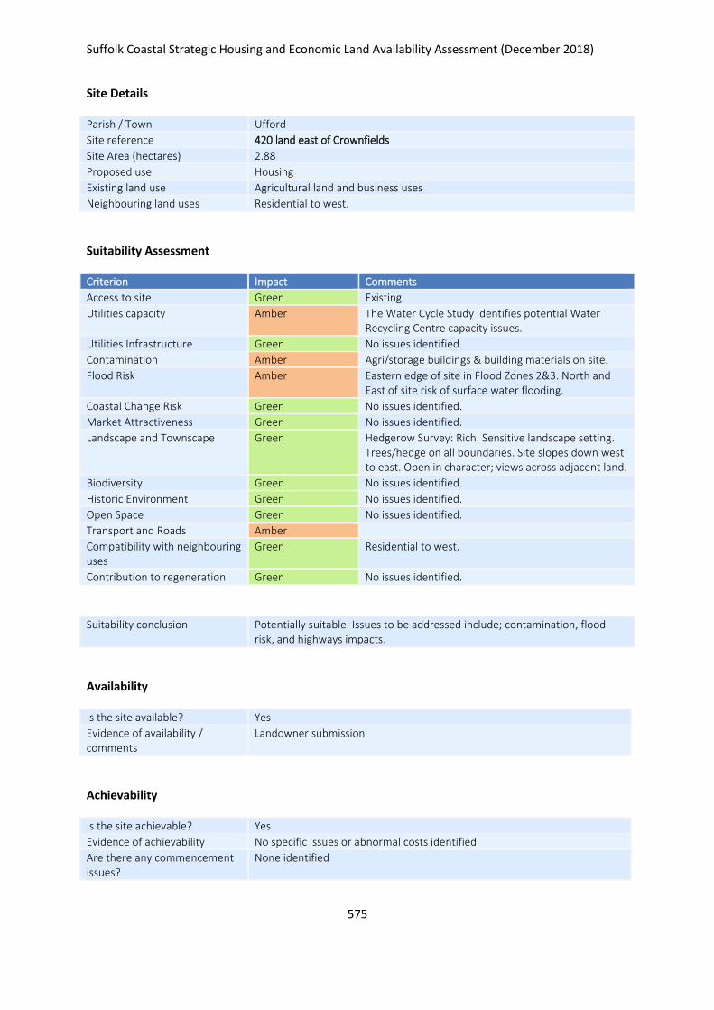
Suffolk Coastal Strategic Housing and Economic Land Availability Assessment (December 2018)
575
Site Details
Parish / Town Ufford
Site reference 420 land east of Crownfields
Site Area (hectares) 2.88
Proposed use Housing
Existing land use Agricultural land and business uses
Neighbouring land uses Residential to west.
Suitability Assessment
Criterion Impact Comments
Access to site Green Existing.
Utilities capacity Amber The Water Cycle Study identifies potential Water Recycling Centre capacity issues.
Utilities Infrastructure Green No issues identified.
Contamination Amber Agri/storage buildings & building materials on site.
Flood Risk Amber Eastern edge of site in Flood Zones 2&3. North and East of site risk of surface water flooding.
Coastal Change Risk Green No issues identified.
Market Attractiveness Green No issues identified.
Landscape and Townscape Green Hedgerow Survey: Rich. Sensitive landscape setting. Trees/hedge on all boundaries. Site slopes down west to east. Open in character; views across adjacent land.
Biodiversity Green No issues identified.
Historic Environment Green No issues identified.
Open Space Green No issues identified.
Transport and Roads Amber
Compatibility with neighbouring uses
Green Residential to west.
Contribution to regeneration Green No issues identified.
Suitability conclusion Potentially suitable. Issues to be addressed include; contamination, flood risk, and highways impacts.
Availability
Is the site available? Yes
Evidence of availability / comments
Landowner submission
Achievability
Is the site achievable? Yes
Evidence of achievability No specific issues or abnormal costs identified
Are there any commencement issues?
None identified

Suffolk Coastal Strategic Housing and Economic Land Availability Assessment (December 2018)
576
Estimated dwellings yield 43
Estimated employment land yield (hectares) -
Estimated retail floorspace (sqm) -
Estimated commencement date 2023/24
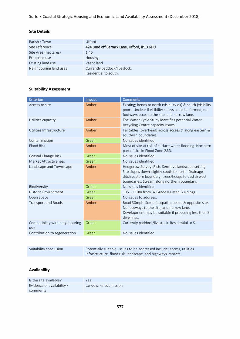
Suffolk Coastal Strategic Housing and Economic Land Availability Assessment (December 2018)
577
Site Details
Parish / Town Ufford
Site reference 424 Land off Barrack Lane, Ufford, IP13 6DU
Site Area (hectares) 1.46
Proposed use Housing
Existing land use Vaant land
Neighbouring land uses Currently paddock/livestock. Residential to south.
Suitability Assessment
Criterion Impact Comments
Access to site Amber Existing; bends to north (visibility ok) & south (visibility poor). Unclear if visibility splays could be formed, no footways acces to the site, and narrow lane.
Utilities capacity Amber The Water Cycle Study identifies potential Water Recycling Centre capacity issues.
Utilities Infrastructure Amber Tel cables (overhead) across access & along eastern & southern boundaries.
Contamination Green No issues identified.
Flood Risk Amber Most of site at risk of surface water flooding. Northern part of site in Flood Zone 2&3.
Coastal Change Risk Green No issues identified.
Market Attractiveness Green No issues identified.
Landscape and Townscape Amber Hedgerow Survey: Rich. Sensitive landscape setting. Site slopes down slightly south to north. Drainage ditch eastern boundary, trees/hedge to east & west boundaries. Stream along northern boundary.
Biodiversity Green No issues identified.
Historic Environment Green 105 – 110m from 3x Grade II Listed Buildings.
Open Space Green No issues to address.
Transport and Roads Amber Road 30mph. Some footpath outside & opposite site. No footways to the site, and narrow lane. Development may be suitable if proposing less than 5 dwellings.
Compatibility with neighbouring uses
Green Currently paddock/livestock. Residential to S.
Contribution to regeneration Green No issues identified.
Suitability conclusion Potentially suitable. Issues to be addressed include; access, utilities infrastructure, flood risk, landscape, and highways impacts.
Availability
Is the site available? Yes
Evidence of availability / comments
Landowner submission

Suffolk Coastal Strategic Housing and Economic Land Availability Assessment (December 2018)
578
Achievability
Is the site achievable? Yes
Evidence of achievability No specific issues or abnormal costs identified
Are there any commencement issues?
None identified
Estimated dwellings yield 22
Estimated employment land yield (hectares) -
Estimated retail floorspace (sqm) -
Estimated commencement date 2020/21
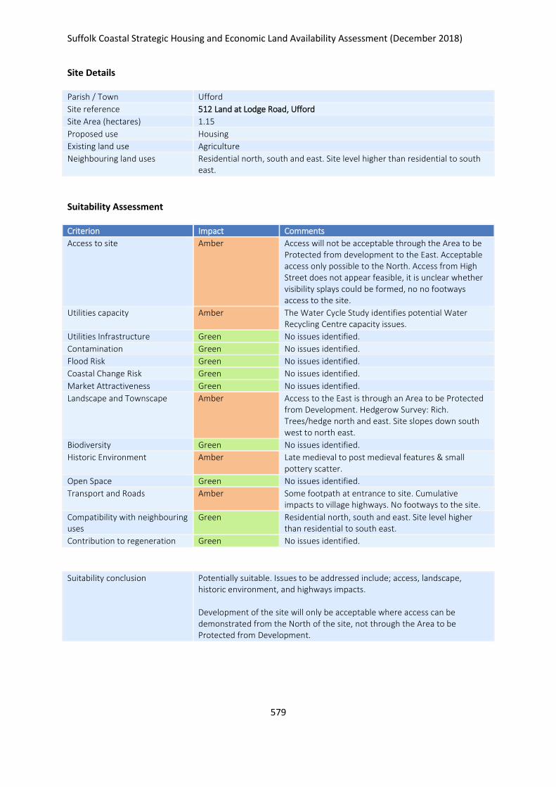
Suffolk Coastal Strategic Housing and Economic Land Availability Assessment (December 2018)
579
Site Details
Parish / Town Ufford
Site reference 512 Land at Lodge Road, Ufford
Site Area (hectares) 1.15
Proposed use Housing
Existing land use Agriculture
Neighbouring land uses Residential north, south and east. Site level higher than residential to south east.
Suitability Assessment
Criterion Impact Comments
Access to site Amber Access will not be acceptable through the Area to be Protected from development to the East. Acceptable access only possible to the North. Access from High Street does not appear feasible, it is unclear whether visibility splays could be formed, no no footways access to the site.
Utilities capacity Amber The Water Cycle Study identifies potential Water Recycling Centre capacity issues.
Utilities Infrastructure Green No issues identified.
Contamination Green No issues identified.
Flood Risk Green No issues identified.
Coastal Change Risk Green No issues identified.
Market Attractiveness Green No issues identified.
Landscape and Townscape Amber Access to the East is through an Area to be Protected from Development. Hedgerow Survey: Rich. Trees/hedge north and east. Site slopes down south west to north east.
Biodiversity Green No issues identified.
Historic Environment Amber Late medieval to post medieval features & small pottery scatter.
Open Space Green No issues identified.
Transport and Roads Amber Some footpath at entrance to site. Cumulative impacts to village highways. No footways to the site.
Compatibility with neighbouring uses
Green Residential north, south and east. Site level higher than residential to south east.
Contribution to regeneration Green No issues identified.
Suitability conclusion Potentially suitable. Issues to be addressed include; access, landscape, historic environment, and highways impacts. Development of the site will only be acceptable where access can be demonstrated from the North of the site, not through the Area to be Protected from Development.
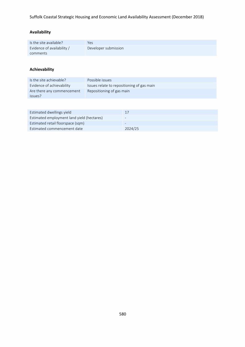
Suffolk Coastal Strategic Housing and Economic Land Availability Assessment (December 2018)
580
Availability
Is the site available? Yes
Evidence of availability / comments
Developer submission
Achievability
Is the site achievable? Possible issues
Evidence of achievability Issues relate to repositioning of gas main
Are there any commencement issues?
Repositioning of gas main
Estimated dwellings yield 17
Estimated employment land yield (hectares) -
Estimated retail floorspace (sqm) -
Estimated commencement date 2024/25
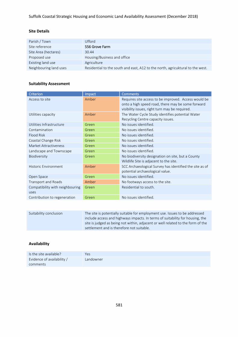
Suffolk Coastal Strategic Housing and Economic Land Availability Assessment (December 2018)
581
Site Details
Parish / Town Ufford
Site reference 556 Grove Farm
Site Area (hectares) 30.44
Proposed use Housing/Business and office
Existing land use Agriculture
Neighbouring land uses Residential to the south and east, A12 to the north, agricuktural to the west.
Suitability Assessment
Criterion Impact Comments
Access to site Amber Requires site access to be improved. Access would be onto a high speed road, there may be some forward visibility issues, right turn may be required.
Utilities capacity Amber The Water Cycle Study identifies potential Water Recycling Centre capacity issues.
Utilities Infrastructure Green No issues identified.
Contamination Green No issues identified.
Flood Risk Green No issues identified.
Coastal Change Risk Green No issues identified.
Market Attractiveness Green No issues identified.
Landscape and Townscape Green No issues identified.
Biodiversity Green No biodiversity designation on site, but a County Wildlife Site is adjacent to the site.
Historic Environment Amber SCC Archaeological Survey has identified the site as of potential archaeological value.
Open Space Green No issues identified.
Transport and Roads Amber No footways access to the site.
Compatibility with neighbouring uses
Green Residential to south.
Contribution to regeneration Green No issues identified.
Suitability conclusion The site is potentially suitable for employment use. Issues to be addressed include access and highways impacts. In terms of suitability for housing, the site is judged as being not within, adjacent or well related to the form of the settlement and is therefore not suitable.
Availability
Is the site available? Yes
Evidence of availability / comments
Landowner

Suffolk Coastal Strategic Housing and Economic Land Availability Assessment (December 2018)
582
Achievability
Is the site achievable? Yes
Evidence of achievability Assumed - although mix of uses including school proposed
Are there any commencement issues?
None identified
Estimated dwellings yield -
Estimated employment land yield (hectares) 30
Estimated retail floorspace (sqm) -
Estimated commencement date 2023/24
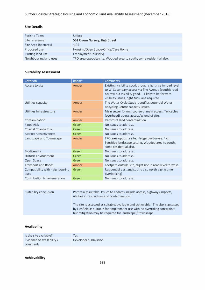
Suffolk Coastal Strategic Housing and Economic Land Availability Assessment (December 2018)
583
Site Details
Parish / Town Ufford
Site reference 561 Crown Nursery, High Street
Site Area (hectares) 4.95
Proposed use Housing/Open Space/Office/Care Home
Existing land use Employment (nursery)
Neighbouring land uses TPO area opposite site. Wooded area to south, some residential also.
Suitability Assessment
Criterion Impact Comments
Access to site Amber Existing; visibility good, though slight rise in road level to W. Secondary access via The Avenue (south); road narrow but visibility good. Likely to be forward visibility issues, right turn lane required.
Utilities capacity Amber The Water Cycle Study identifies potential Water Recycling Centre capacity issues.
Utilities Infrastructure Amber Main sewer follows course of main access. Tel cables (overhead) across access/W end of site.
Contamination Amber Record of land contamination.
Flood Risk Green No issues to address.
Coastal Change Risk Green No issues to address.
Market Attractiveness Green No issues to address.
Landscape and Townscape Amber TPO area opposite site. Hedgerow Survey: Rich. Sensitive landscape setting. Wooded area to south, some residential also.
Biodiversity Green No issues to address.
Historic Environment Green No issues to address.
Open Space Green No issues to address.
Transport and Roads Amber Footpath outside site, slight rise in road level to west.
Compatibility with neighbouring uses
Green Residential east and south; also north east (some overlooking)
Contribution to regeneration Green No issues to address.
Suitability conclusion Potentially suitable. Issues to address include access, highways impacts, utilities infrastructure and contamination. The site is assessed as suitable, available and achievable. The site is assessed by Lichfield as suitable for employment use with no overriding constraints but mitigation may be required for landscape / townscape.
Availability
Is the site available? Yes
Evidence of availability / comments
Developer submission
Achievability
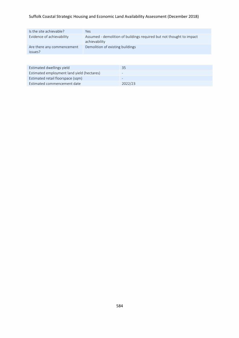
Suffolk Coastal Strategic Housing and Economic Land Availability Assessment (December 2018)
584
Is the site achievable? Yes
Evidence of achievability Assumed - demolition of buildings required but not thought to impact achievability
Are there any commencement issues?
Demolition of existing buildings
Estimated dwellings yield 35
Estimated employment land yield (hectares) -
Estimated retail floorspace (sqm) -
Estimated commencement date 2022/23
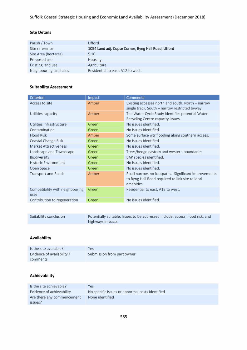
Suffolk Coastal Strategic Housing and Economic Land Availability Assessment (December 2018)
585
Site Details
Parish / Town Ufford
Site reference 1054 Land adj. Copse Corner, Byng Hall Road, Ufford
Site Area (hectares) 5.10
Proposed use Housing
Existing land use Agriculture
Neighbouring land uses Residential to east, A12 to west.
Suitability Assessment
Criterion Impact Comments
Access to site Amber Existing accesses north and south. North – narrow single track, South – narrow restricted byway
Utilities capacity Amber The Water Cycle Study identifies potential Water Recycling Centre capacity issues.
Utilities Infrastructure Green No issues identified.
Contamination Green No issues identified.
Flood Risk Amber Some surface wtr flooding along southern access.
Coastal Change Risk Green No issues identified.
Market Attractiveness Green No issues identified.
Landscape and Townscape Green Trees/hedge eastern and western boundaries
Biodiversity Green BAP species identified.
Historic Environment Green No issues identified.
Open Space Green No issues identified.
Transport and Roads Amber Road narrow, no footpaths. Significant improvements to Byng Hall Road required to link site to local amenities.
Compatibility with neighbouring uses
Green Residential to east, A12 to west.
Contribution to regeneration Green No issues identified.
Suitability conclusion Potentially suitable. Issues to be addressed include; access, flood risk, and highways impacts.
Availability
Is the site available? Yes
Evidence of availability / comments
Submission from part owner
Achievability
Is the site achievable? Yes
Evidence of achievability No specific issues or abnormal costs identified
Are there any commencement issues?
None identified

Suffolk Coastal Strategic Housing and Economic Land Availability Assessment (December 2018)
586
Estimated dwellings yield 77
Estimated employment land yield (hectares) -
Estimated retail floorspace (sqm) -
Estimated commencement date 2021/22
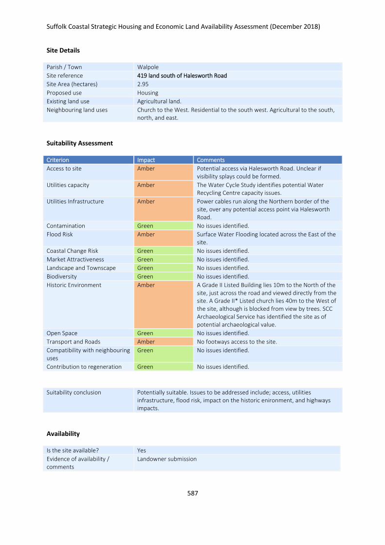
Suffolk Coastal Strategic Housing and Economic Land Availability Assessment (December 2018)
587
Site Details
Parish / Town Walpole
Site reference 419 land south of Halesworth Road
Site Area (hectares) 2.95
Proposed use Housing
Existing land use Agricultural land.
Neighbouring land uses Church to the West. Residential to the south west. Agricultural to the south, north, and east.
Suitability Assessment
Criterion Impact Comments
Access to site Amber Potential access via Halesworth Road. Unclear if visibility splays could be formed.
Utilities capacity Amber The Water Cycle Study identifies potential Water Recycling Centre capacity issues.
Utilities Infrastructure Amber Power cables run along the Northern border of the site, over any potential access point via Halesworth Road.
Contamination Green No issues identified.
Flood Risk Amber Surface Water Flooding located across the East of the site.
Coastal Change Risk Green No issues identified.
Market Attractiveness Green No issues identified.
Landscape and Townscape Green No issues identified.
Biodiversity Green No issues identified.
Historic Environment Amber A Grade II Listed Building lies 10m to the North of the site, just across the road and viewed directly from the site. A Grade II* Listed church lies 40m to the West of the site, although is blocked from view by trees. SCC Archaeological Service has identified the site as of potential archaeological value.
Open Space Green No issues identified.
Transport and Roads Amber No footways access to the site.
Compatibility with neighbouring uses
Green No issues identified.
Contribution to regeneration Green No issues identified.
Suitability conclusion Potentially suitable. Issues to be addressed include; access, utilities infrastructure, flood risk, impact on the historic enironment, and highways impacts.
Availability
Is the site available? Yes
Evidence of availability / comments
Landowner submission

Suffolk Coastal Strategic Housing and Economic Land Availability Assessment (December 2018)
588
Achievability
Is the site achievable? Yes
Evidence of achievability No specific issues or abnormal costs identified
Are there any commencement issues?
None identfied
Estimated dwellings yield 44
Estimated employment land yield (hectares) -
Estimated retail floorspace (sqm) -
Estimated commencement date 2021/22
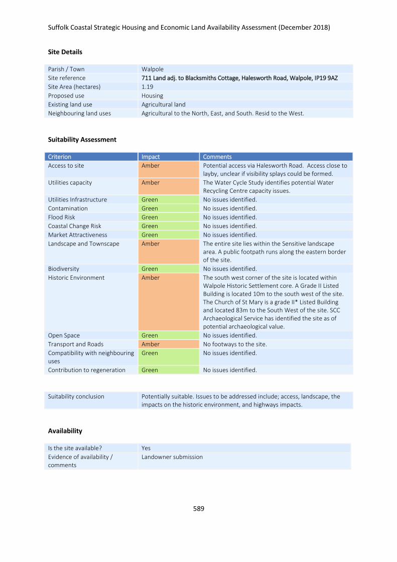
Suffolk Coastal Strategic Housing and Economic Land Availability Assessment (December 2018)
589
Site Details
Parish / Town Walpole
Site reference 711 Land adj. to Blacksmiths Cottage, Halesworth Road, Walpole, IP19 9AZ
Site Area (hectares) 1.19
Proposed use Housing
Existing land use Agricultural land
Neighbouring land uses Agricultural to the North, East, and South. Resid to the West.
Suitability Assessment
Criterion Impact Comments
Access to site Amber Potential access via Halesworth Road. Access close to layby, unclear if visibility splays could be formed.
Utilities capacity Amber The Water Cycle Study identifies potential Water Recycling Centre capacity issues.
Utilities Infrastructure Green No issues identified.
Contamination Green No issues identified.
Flood Risk Green No issues identified.
Coastal Change Risk Green No issues identified.
Market Attractiveness Green No issues identified.
Landscape and Townscape Amber The entire site lies within the Sensitive landscape area. A public footpath runs along the eastern border of the site.
Biodiversity Green No issues identified.
Historic Environment Amber The south west corner of the site is located within Walpole Historic Settlement core. A Grade II Listed Building is located 10m to the south west of the site. The Church of St Mary is a grade II* Listed Building and located 83m to the South West of the site. SCC Archaeological Service has identified the site as of potential archaeological value.
Open Space Green No issues identified.
Transport and Roads Amber No footways to the site.
Compatibility with neighbouring uses
Green No issues identified.
Contribution to regeneration Green No issues identified.
Suitability conclusion Potentially suitable. Issues to be addressed include; access, landscape, the impacts on the historic environment, and highways impacts.
Availability
Is the site available? Yes
Evidence of availability / comments
Landowner submission

Suffolk Coastal Strategic Housing and Economic Land Availability Assessment (December 2018)
590
Achievability
Is the site achievable? Yes
Evidence of achievability No specific issues or abnormal costs identified
Are there any commencement issues?
None identfied
Estimated dwellings yield 18
Estimated employment land yield (hectares) -
Estimated retail floorspace (sqm) -
Estimated commencement date 2023/24
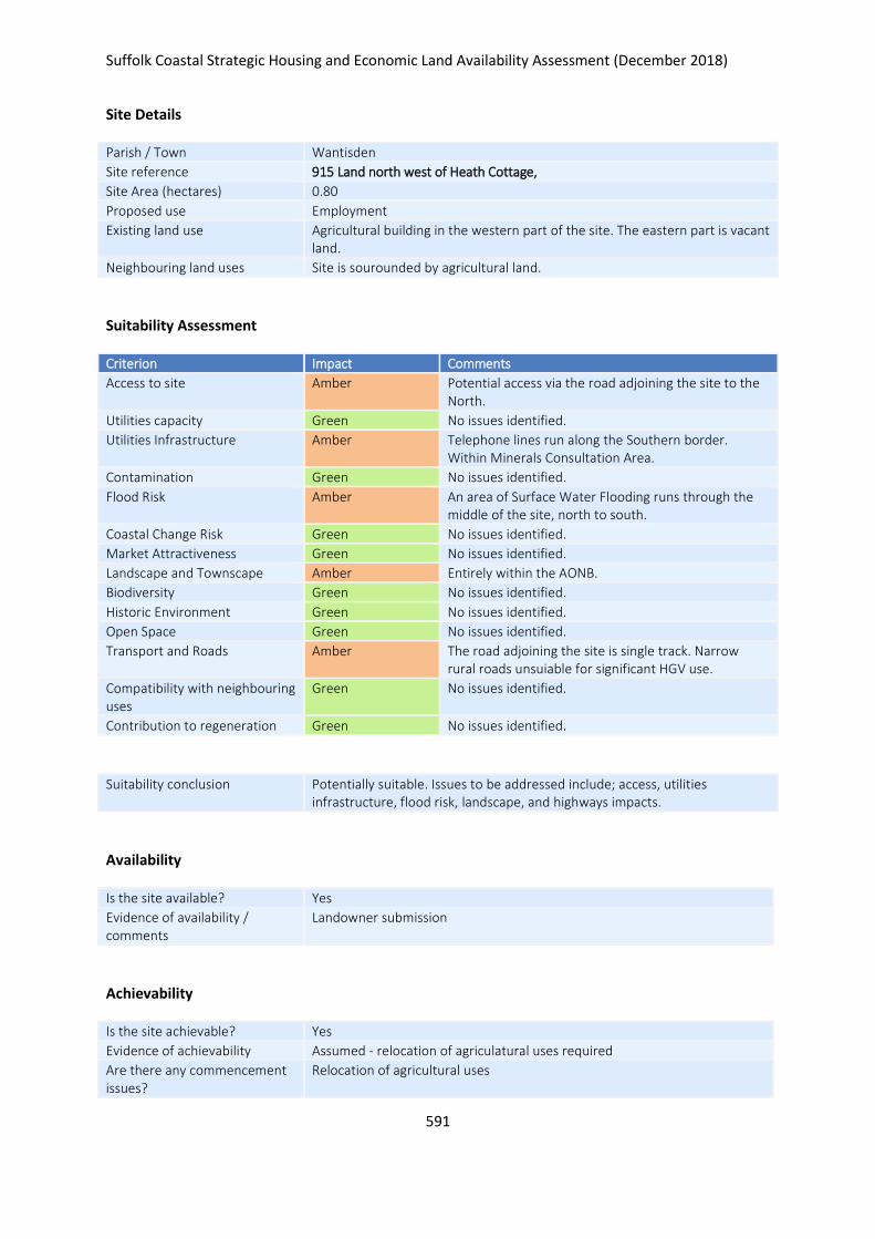
Suffolk Coastal Strategic Housing and Economic Land Availability Assessment (December 2018)
591
Site Details
Parish / Town Wantisden
Site reference 915 Land north west of Heath Cottage,
Site Area (hectares) 0.80
Proposed use Employment
Existing land use Agricultural building in the western part of the site. The eastern part is vacant land.
Neighbouring land uses Site is sourounded by agricultural land.
Suitability Assessment
Criterion Impact Comments
Access to site Amber Potential access via the road adjoining the site to the North.
Utilities capacity Green No issues identified.
Utilities Infrastructure Amber Telephone lines run along the Southern border. Within Minerals Consultation Area.
Contamination Green No issues identified.
Flood Risk Amber An area of Surface Water Flooding runs through the middle of the site, north to south.
Coastal Change Risk Green No issues identified.
Market Attractiveness Green No issues identified.
Landscape and Townscape Amber Entirely within the AONB.
Biodiversity Green No issues identified.
Historic Environment Green No issues identified.
Open Space Green No issues identified.
Transport and Roads Amber The road adjoining the site is single track. Narrow rural roads unsuiable for significant HGV use.
Compatibility with neighbouring uses
Green No issues identified.
Contribution to regeneration Green No issues identified.
Suitability conclusion Potentially suitable. Issues to be addressed include; access, utilities infrastructure, flood risk, landscape, and highways impacts.
Availability
Is the site available? Yes
Evidence of availability / comments
Landowner submission
Achievability
Is the site achievable? Yes
Evidence of achievability Assumed - relocation of agriculatural uses required
Are there any commencement issues?
Relocation of agricultural uses

Suffolk Coastal Strategic Housing and Economic Land Availability Assessment (December 2018)
592
Estimated dwellings yield -
Estimated employment land yield (hectares) 1
Estimated retail floorspace (sqm) -
Estimated commencement date 2022/23
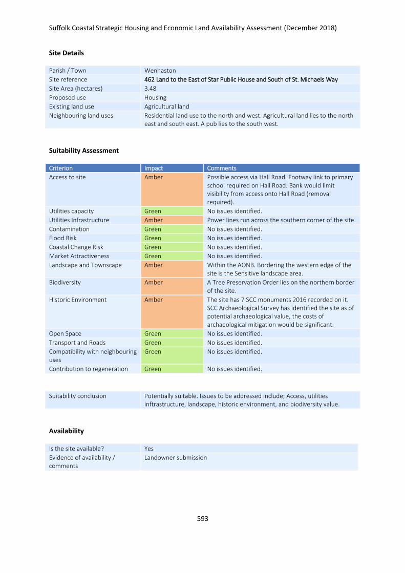
Suffolk Coastal Strategic Housing and Economic Land Availability Assessment (December 2018)
593
Site Details
Parish / Town Wenhaston
Site reference 462 Land to the East of Star Public House and South of St. Michaels Way
Site Area (hectares) 3.48
Proposed use Housing
Existing land use Agricultural land
Neighbouring land uses Residential land use to the north and west. Agricultural land lies to the north east and south east. A pub lies to the south west.
Suitability Assessment
Criterion Impact Comments
Access to site Amber Possible access via Hall Road. Footway link to primary school required on Hall Road. Bank would limit visibility from access onto Hall Road (removal required).
Utilities capacity Green No issues identified.
Utilities Infrastructure Amber Power lines run across the southern corner of the site.
Contamination Green No issues identified.
Flood Risk Green No issues identified.
Coastal Change Risk Green No issues identified.
Market Attractiveness Green No issues identified.
Landscape and Townscape Amber Within the AONB. Bordering the western edge of the site is the Sensitive landscape area.
Biodiversity Amber A Tree Preservation Order lies on the northern border of the site.
Historic Environment Amber The site has 7 SCC monuments 2016 recorded on it. SCC Archaeological Survey has identified the site as of potential archaeological value, the costs of archaeological mitigation would be significant.
Open Space Green No issues identified.
Transport and Roads Green No issues identified.
Compatibility with neighbouring uses
Green No issues identified.
Contribution to regeneration Green No issues identified.
Suitability conclusion Potentially suitable. Issues to be addressed include; Access, utilities inftrastructure, landscape, historic environment, and biodiversity value.
Availability
Is the site available? Yes
Evidence of availability / comments
Landowner submission

Suffolk Coastal Strategic Housing and Economic Land Availability Assessment (December 2018)
594
Achievability
Is the site achievable? Yes
Evidence of achievability No specific issues or abnormal costs identified
Are there any commencement issues?
None identified
Estimated dwellings yield 52
Estimated employment land yield (hectares) -
Estimated retail floorspace (sqm) -
Estimated commencement date 2022/23
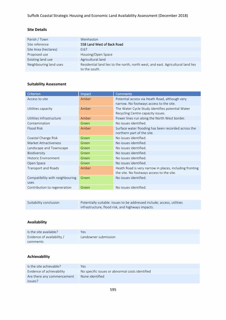
Suffolk Coastal Strategic Housing and Economic Land Availability Assessment (December 2018)
595
Site Details
Parish / Town Wenhaston
Site reference 558 Land West of Back Road
Site Area (hectares) 0.67
Proposed use Housing/Open Space
Existing land use Agricultural land
Neighbouring land uses Residential land lies to the north, north west, and east. Agricultural land lies to the south.
Suitability Assessment
Criterion Impact Comments
Access to site Amber Potential access via Heath Road, although very narrow. No footways access to the site.
Utilities capacity Amber The Water Cycle Study identifies potential Water Recycling Centre capacity issues.
Utilities Infrastructure Amber Power lines run along the North West border.
Contamination Green No issues identified.
Flood Risk Amber Surface water flooding has been recorded across the northern part of the site.
Coastal Change Risk Green No issues identified.
Market Attractiveness Green No issues identified.
Landscape and Townscape Green No issues identified.
Biodiversity Green No issues identified.
Historic Environment Green No issues identified.
Open Space Green No issues identified.
Transport and Roads Amber Heath Road is very narrow in places, including fronting the site. No footways access to the site.
Compatibility with neighbouring uses
Green No issues identified.
Contribution to regeneration Green No issues identified.
Suitability conclusion Potentially suitable. Issues to be addressed include; access, utilities infrastructure, flood risk, and highways impacts.
Availability
Is the site available? Yes
Evidence of availability / comments
Landowner submission
Achievability
Is the site achievable? Yes
Evidence of achievability No specific issues or abnormal costs identified
Are there any commencement issues?
None identified

Suffolk Coastal Strategic Housing and Economic Land Availability Assessment (December 2018)
596
Estimated dwellings yield 8
Estimated employment land yield (hectares) -
Estimated retail floorspace (sqm) -
Estimated commencement date 2020/21
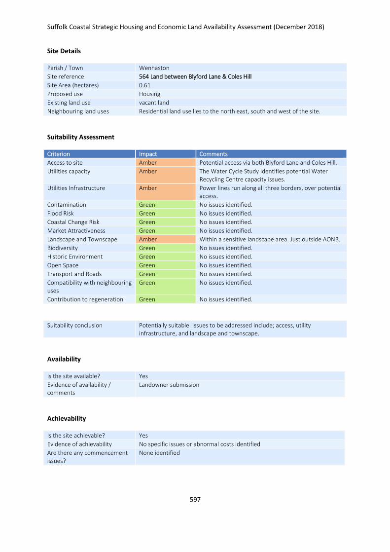
Suffolk Coastal Strategic Housing and Economic Land Availability Assessment (December 2018)
597
Site Details
Parish / Town Wenhaston
Site reference 564 Land between Blyford Lane & Coles Hill
Site Area (hectares) 0.61
Proposed use Housing
Existing land use vacant land
Neighbouring land uses Residential land use lies to the north east, south and west of the site.
Suitability Assessment
Criterion Impact Comments
Access to site Amber Potential access via both Blyford Lane and Coles Hill.
Utilities capacity Amber The Water Cycle Study identifies potential Water Recycling Centre capacity issues.
Utilities Infrastructure Amber Power lines run along all three borders, over potential access.
Contamination Green No issues identified.
Flood Risk Green No issues identified.
Coastal Change Risk Green No issues identified.
Market Attractiveness Green No issues identified.
Landscape and Townscape Amber Within a sensitive landscape area. Just outside AONB.
Biodiversity Green No issues identified.
Historic Environment Green No issues identified.
Open Space Green No issues identified.
Transport and Roads Green No issues identified.
Compatibility with neighbouring uses
Green No issues identified.
Contribution to regeneration Green No issues identified.
Suitability conclusion Potentially suitable. Issues to be addressed include; access, utility infrastructure, and landscape and townscape.
Availability
Is the site available? Yes
Evidence of availability / comments
Landowner submission
Achievability
Is the site achievable? Yes
Evidence of achievability No specific issues or abnormal costs identified
Are there any commencement issues?
None identified

Suffolk Coastal Strategic Housing and Economic Land Availability Assessment (December 2018)
598
Estimated dwellings yield 9
Estimated employment land yield (hectares) -
Estimated retail floorspace (sqm) -
Estimated commencement date 2023/24
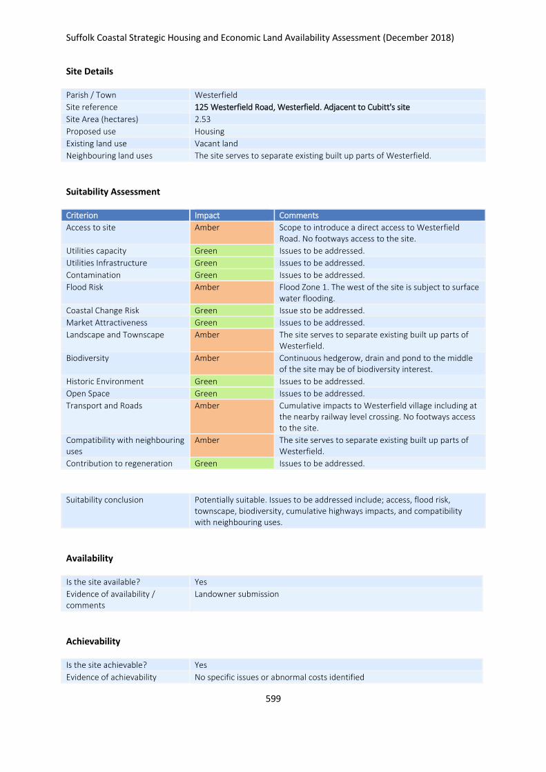
Suffolk Coastal Strategic Housing and Economic Land Availability Assessment (December 2018)
599
Site Details
Parish / Town Westerfield
Site reference 125 Westerfield Road, Westerfield. Adjacent to Cubitt's site
Site Area (hectares) 2.53
Proposed use Housing
Existing land use Vacant land
Neighbouring land uses The site serves to separate existing built up parts of Westerfield.
Suitability Assessment
Criterion Impact Comments
Access to site Amber Scope to introduce a direct access to Westerfield Road. No footways access to the site.
Utilities capacity Green Issues to be addressed.
Utilities Infrastructure Green Issues to be addressed.
Contamination Green Issues to be addressed.
Flood Risk Amber Flood Zone 1. The west of the site is subject to surface water flooding.
Coastal Change Risk Green Issue sto be addressed.
Market Attractiveness Green Issues to be addressed.
Landscape and Townscape Amber The site serves to separate existing built up parts of Westerfield.
Biodiversity Amber Continuous hedgerow, drain and pond to the middle of the site may be of biodiversity interest.
Historic Environment Green Issues to be addressed.
Open Space Green Issues to be addressed.
Transport and Roads Amber Cumulative impacts to Westerfield village including at the nearby railway level crossing. No footways access to the site.
Compatibility with neighbouring uses
Amber The site serves to separate existing built up parts of Westerfield.
Contribution to regeneration Green Issues to be addressed.
Suitability conclusion Potentially suitable. Issues to be addressed include; access, flood risk, townscape, biodiversity, cumulative highways impacts, and compatibility with neighbouring uses.
Availability
Is the site available? Yes
Evidence of availability / comments
Landowner submission
Achievability
Is the site achievable? Yes
Evidence of achievability No specific issues or abnormal costs identified

Suffolk Coastal Strategic Housing and Economic Land Availability Assessment (December 2018)
600
Are there any commencement issues?
None identified
Estimated dwellings yield 63
Estimated employment land yield (hectares) -
Estimated retail floorspace (sqm) -
Estimated commencement date 2022/23
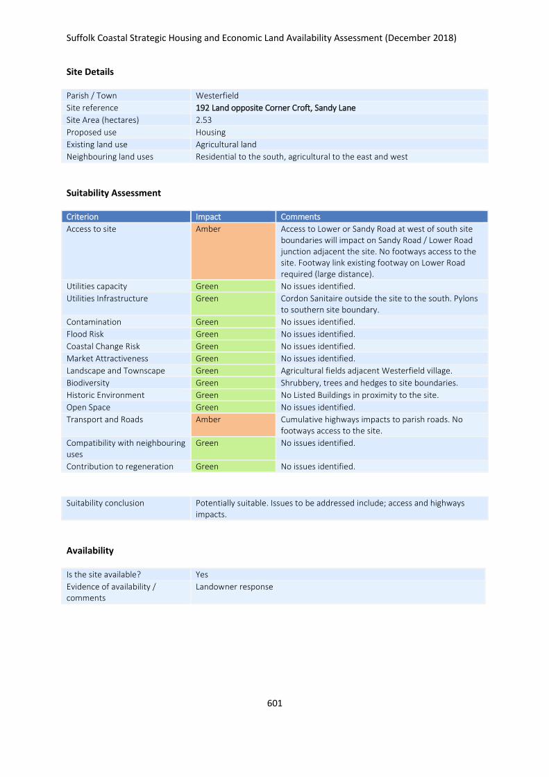
Suffolk Coastal Strategic Housing and Economic Land Availability Assessment (December 2018)
601
Site Details
Parish / Town Westerfield
Site reference 192 Land opposite Corner Croft, Sandy Lane
Site Area (hectares) 2.53
Proposed use Housing
Existing land use Agricultural land
Neighbouring land uses Residential to the south, agricultural to the east and west
Suitability Assessment
Criterion Impact Comments
Access to site Amber Access to Lower or Sandy Road at west of south site boundaries will impact on Sandy Road / Lower Road junction adjacent the site. No footways access to the site. Footway link existing footway on Lower Road required (large distance).
Utilities capacity Green No issues identified.
Utilities Infrastructure Green Cordon Sanitaire outside the site to the south. Pylons to southern site boundary.
Contamination Green No issues identified.
Flood Risk Green No issues identified.
Coastal Change Risk Green No issues identified.
Market Attractiveness Green No issues identified.
Landscape and Townscape Green Agricultural fields adjacent Westerfield village.
Biodiversity Green Shrubbery, trees and hedges to site boundaries.
Historic Environment Green No Listed Buildings in proximity to the site.
Open Space Green No issues identified.
Transport and Roads Amber Cumulative highways impacts to parish roads. No footways access to the site.
Compatibility with neighbouring uses
Green No issues identified.
Contribution to regeneration Green No issues identified.
Suitability conclusion Potentially suitable. Issues to be addressed include; access and highways impacts.
Availability
Is the site available? Yes
Evidence of availability / comments
Landowner response

Suffolk Coastal Strategic Housing and Economic Land Availability Assessment (December 2018)
602
Achievability
Is the site achievable? Yes
Evidence of achievability No specific issues or abnormal costs identified
Are there any commencement issues?
None identified
Estimated dwellings yield 63
Estimated employment land yield (hectares) -
Estimated retail floorspace (sqm) -
Estimated commencement date 2020/21
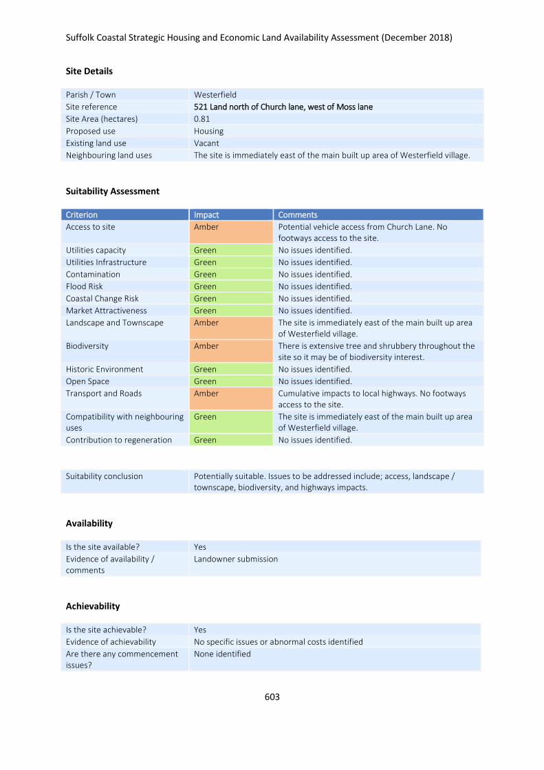
Suffolk Coastal Strategic Housing and Economic Land Availability Assessment (December 2018)
603
Site Details
Parish / Town Westerfield
Site reference 521 Land north of Church lane, west of Moss lane
Site Area (hectares) 0.81
Proposed use Housing
Existing land use Vacant
Neighbouring land uses The site is immediately east of the main built up area of Westerfield village.
Suitability Assessment
Criterion Impact Comments
Access to site Amber Potential vehicle access from Church Lane. No footways access to the site.
Utilities capacity Green No issues identified.
Utilities Infrastructure Green No issues identified.
Contamination Green No issues identified.
Flood Risk Green No issues identified.
Coastal Change Risk Green No issues identified.
Market Attractiveness Green No issues identified.
Landscape and Townscape Amber The site is immediately east of the main built up area of Westerfield village.
Biodiversity Amber There is extensive tree and shrubbery throughout the site so it may be of biodiversity interest.
Historic Environment Green No issues identified.
Open Space Green No issues identified.
Transport and Roads Amber Cumulative impacts to local highways. No footways access to the site.
Compatibility with neighbouring uses
Green The site is immediately east of the main built up area of Westerfield village.
Contribution to regeneration Green No issues identified.
Suitability conclusion Potentially suitable. Issues to be addressed include; access, landscape / townscape, biodiversity, and highways impacts.
Availability
Is the site available? Yes
Evidence of availability / comments
Landowner submission
Achievability
Is the site achievable? Yes
Evidence of achievability No specific issues or abnormal costs identified
Are there any commencement issues?
None identified

Suffolk Coastal Strategic Housing and Economic Land Availability Assessment (December 2018)
604
Estimated dwellings yield 32
Estimated employment land yield (hectares) -
Estimated retail floorspace (sqm) -
Estimated commencement date 2020/21
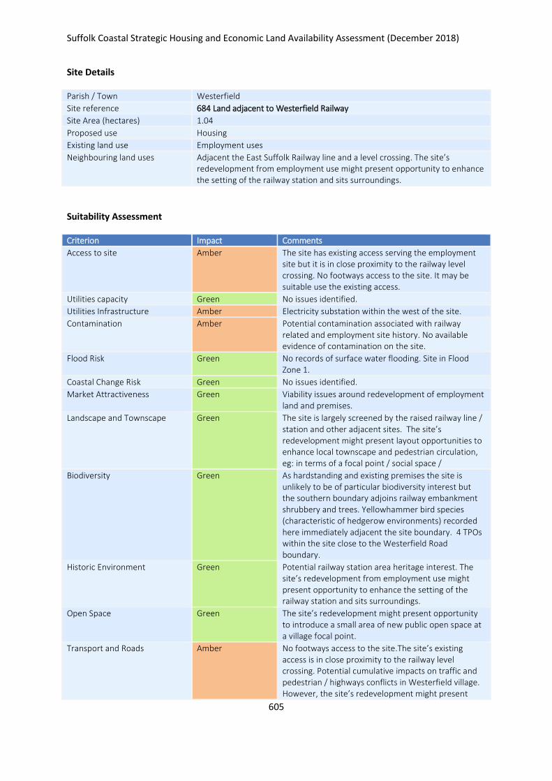
Suffolk Coastal Strategic Housing and Economic Land Availability Assessment (December 2018)
605
Site Details
Parish / Town Westerfield
Site reference 684 Land adjacent to Westerfield Railway
Site Area (hectares) 1.04
Proposed use Housing
Existing land use Employment uses
Neighbouring land uses Adjacent the East Suffolk Railway line and a level crossing. The site’s redevelopment from employment use might present opportunity to enhance the setting of the railway station and sits surroundings.
Suitability Assessment
Criterion Impact Comments
Access to site Amber The site has existing access serving the employment site but it is in close proximity to the railway level crossing. No footways access to the site. It may be suitable use the existing access.
Utilities capacity Green No issues identified.
Utilities Infrastructure Amber Electricity substation within the west of the site.
Contamination Amber Potential contamination associated with railway related and employment site history. No available evidence of contamination on the site.
Flood Risk Green No records of surface water flooding. Site in Flood Zone 1.
Coastal Change Risk Green No issues identified.
Market Attractiveness Green Viability issues around redevelopment of employment land and premises.
Landscape and Townscape Green The site is largely screened by the raised railway line / station and other adjacent sites. The site’s redevelopment might present layout opportunities to enhance local townscape and pedestrian circulation, eg: in terms of a focal point / social space /
Biodiversity Green As hardstanding and existing premises the site is unlikely to be of particular biodiversity interest but the southern boundary adjoins railway embankment shrubbery and trees. Yellowhammer bird species (characteristic of hedgerow environments) recorded here immediately adjacent the site boundary. 4 TPOs within the site close to the Westerfield Road boundary.
Historic Environment Green Potential railway station area heritage interest. The site’s redevelopment from employment use might present opportunity to enhance the setting of the railway station and sits surroundings.
Open Space Green The site’s redevelopment might present opportunity to introduce a small area of new public open space at a village focal point.
Transport and Roads Amber No footways access to the site.The site’s existing access is in close proximity to the railway level crossing. Potential cumulative impacts on traffic and pedestrian / highways conflicts in Westerfield village. However, the site’s redevelopment might present
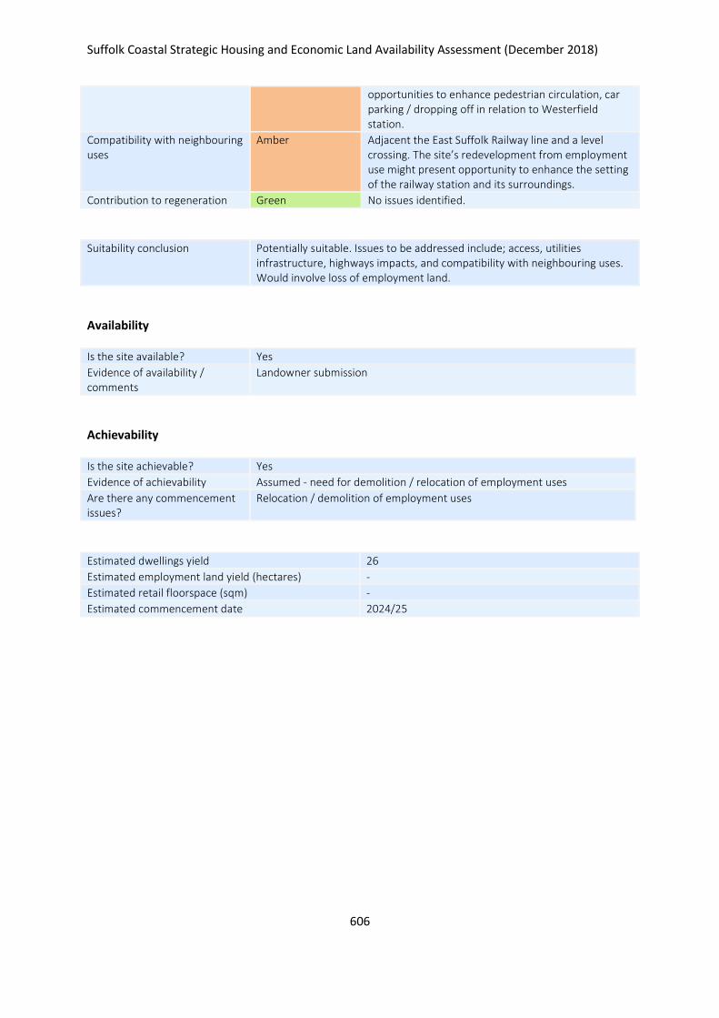
Suffolk Coastal Strategic Housing and Economic Land Availability Assessment (December 2018)
606
opportunities to enhance pedestrian circulation, car parking / dropping off in relation to Westerfield station.
Compatibility with neighbouring uses
Amber Adjacent the East Suffolk Railway line and a level crossing. The site’s redevelopment from employment use might present opportunity to enhance the setting of the railway station and its surroundings.
Contribution to regeneration Green No issues identified.
Suitability conclusion Potentially suitable. Issues to be addressed include; access, utilities infrastructure, highways impacts, and compatibility with neighbouring uses. Would involve loss of employment land.
Availability
Is the site available? Yes
Evidence of availability / comments
Landowner submission
Achievability
Is the site achievable? Yes
Evidence of achievability Assumed - need for demolition / relocation of employment uses
Are there any commencement issues?
Relocation / demolition of employment uses
Estimated dwellings yield 26
Estimated employment land yield (hectares) -
Estimated retail floorspace (sqm) -
Estimated commencement date 2024/25
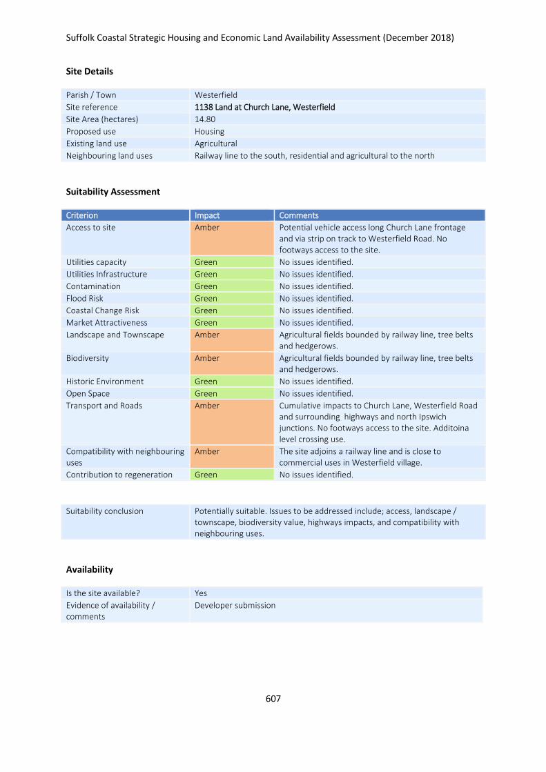
Suffolk Coastal Strategic Housing and Economic Land Availability Assessment (December 2018)
607
Site Details
Parish / Town Westerfield
Site reference 1138 Land at Church Lane, Westerfield
Site Area (hectares) 14.80
Proposed use Housing
Existing land use Agricultural
Neighbouring land uses Railway line to the south, residential and agricultural to the north
Suitability Assessment
Criterion Impact Comments
Access to site Amber Potential vehicle access long Church Lane frontage and via strip on track to Westerfield Road. No footways access to the site.
Utilities capacity Green No issues identified.
Utilities Infrastructure Green No issues identified.
Contamination Green No issues identified.
Flood Risk Green No issues identified.
Coastal Change Risk Green No issues identified.
Market Attractiveness Green No issues identified.
Landscape and Townscape Amber Agricultural fields bounded by railway line, tree belts and hedgerows.
Biodiversity Amber Agricultural fields bounded by railway line, tree belts and hedgerows.
Historic Environment Green No issues identified.
Open Space Green No issues identified.
Transport and Roads Amber Cumulative impacts to Church Lane, Westerfield Road and surrounding highways and north Ipswich junctions. No footways access to the site. Additoina level crossing use.
Compatibility with neighbouring uses
Amber The site adjoins a railway line and is close to commercial uses in Westerfield village.
Contribution to regeneration Green No issues identified.
Suitability conclusion Potentially suitable. Issues to be addressed include; access, landscape / townscape, biodiversity value, highways impacts, and compatibility with neighbouring uses.
Availability
Is the site available? Yes
Evidence of availability / comments
Developer submission

Suffolk Coastal Strategic Housing and Economic Land Availability Assessment (December 2018)
608
Achievability
Is the site achievable? Yes
Evidence of achievability Assumed - no specific issues idnetified
Are there any commencement issues?
None identiifed
Estimated dwellings yield 370
Estimated employment land yield (hectares) -
Estimated retail floorspace (sqm) -
Estimated commencement date 2023/24
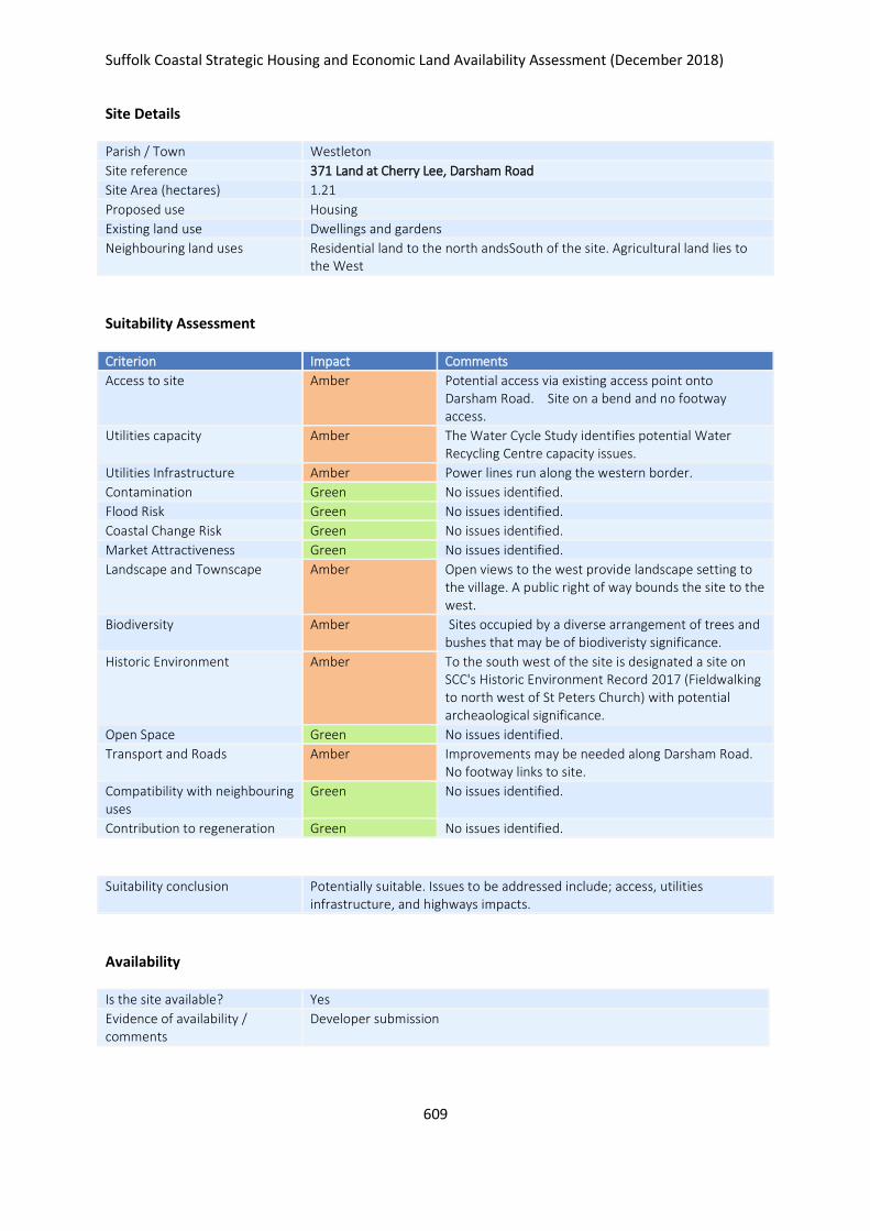
Suffolk Coastal Strategic Housing and Economic Land Availability Assessment (December 2018)
609
Site Details
Parish / Town Westleton
Site reference 371 Land at Cherry Lee, Darsham Road
Site Area (hectares) 1.21
Proposed use Housing
Existing land use Dwellings and gardens
Neighbouring land uses Residential land to the north andsSouth of the site. Agricultural land lies to the West
Suitability Assessment
Criterion Impact Comments
Access to site Amber Potential access via existing access point onto Darsham Road. Site on a bend and no footway access.
Utilities capacity Amber The Water Cycle Study identifies potential Water Recycling Centre capacity issues.
Utilities Infrastructure Amber Power lines run along the western border.
Contamination Green No issues identified.
Flood Risk Green No issues identified.
Coastal Change Risk Green No issues identified.
Market Attractiveness Green No issues identified.
Landscape and Townscape Amber Open views to the west provide landscape setting to the village. A public right of way bounds the site to the west.
Biodiversity Amber Sites occupied by a diverse arrangement of trees and bushes that may be of biodiveristy significance.
Historic Environment Amber To the south west of the site is designated a site on SCC's Historic Environment Record 2017 (Fieldwalking to north west of St Peters Church) with potential archeaological significance.
Open Space Green No issues identified.
Transport and Roads Amber Improvements may be needed along Darsham Road. No footway links to site.
Compatibility with neighbouring uses
Green No issues identified.
Contribution to regeneration Green No issues identified.
Suitability conclusion Potentially suitable. Issues to be addressed include; access, utilities infrastructure, and highways impacts.
Availability
Is the site available? Yes
Evidence of availability / comments
Developer submission
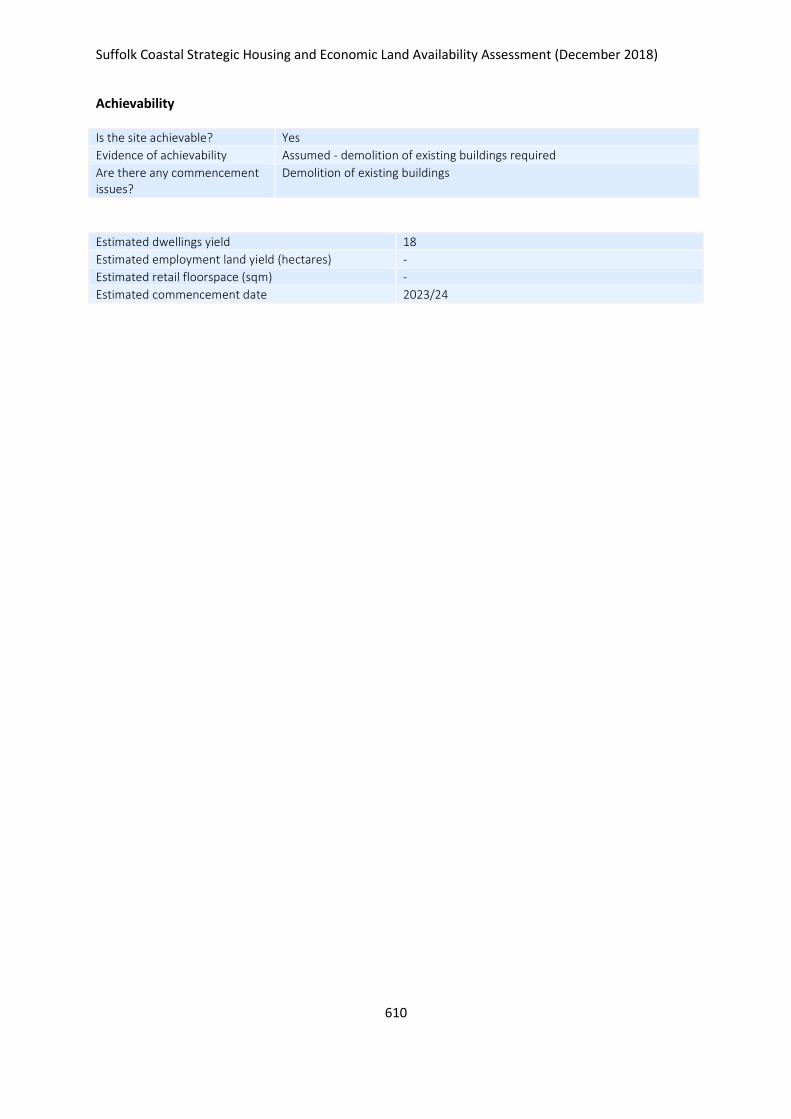
Suffolk Coastal Strategic Housing and Economic Land Availability Assessment (December 2018)
610
Achievability
Is the site achievable? Yes
Evidence of achievability Assumed - demolition of existing buildings required
Are there any commencement issues?
Demolition of existing buildings
Estimated dwellings yield 18
Estimated employment land yield (hectares) -
Estimated retail floorspace (sqm) -
Estimated commencement date 2023/24
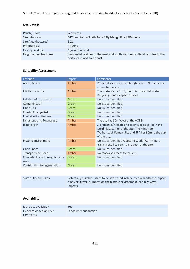
Suffolk Coastal Strategic Housing and Economic Land Availability Assessment (December 2018)
611
Site Details
Parish / Town Westleton
Site reference 447 Land to the South East of Blythburgh Road, Westleton
Site Area (hectares) 1.21
Proposed use Housing
Existing land use Agricultural land
Neighbouring land uses Residential land lies to the west and south west. Agricultural land lies to the north, east, and south east.
Suitability Assessment
Criterion Impact Comments
Access to site Amber Potential access via Blythburgh Road. No footways access to the site.
Utilities capacity Amber The Water Cycle Study identifies potential Water Recycling Centre capacity issues.
Utilities Infrastructure Green No issues identified.
Contamination Green No issues identified.
Flood Risk Green No issues identified.
Coastal Change Risk Green No issues identified.
Market Attractiveness Green No issues identified.
Landscape and Townscape Amber The site lies 60m West of the AONB.
Biodiversity Amber A protected/notable and priority species lies in the North East corner of the site. The Minsmere-Walberswick Ramsar Site and SPA lies 90m to the east of the site.
Historic Environment Amber No issues identified A Second World War military training site lies 65m to the east of the site.
Open Space Green No issues identified.
Transport and Roads Amber No footways access to the site.
Compatibility with neighbouring uses
Green No issues identified.
Contribution to regeneration Green No issues identified.
Suitability conclusion Potentially suitable. Issues to be addressed include access, landscape impact, biodiversity value, impact on the histroic environment, and highways impacts.
Availability
Is the site available? Yes
Evidence of availability / comments
Landowner submission

Suffolk Coastal Strategic Housing and Economic Land Availability Assessment (December 2018)
612
Achievability
Is the site achievable? Yes
Evidence of achievability No specific issues or abnormal costs identified
Are there any commencement issues?
None identified
Estimated dwellings yield 18
Estimated employment land yield (hectares) -
Estimated retail floorspace (sqm) -
Estimated commencement date 2020/21
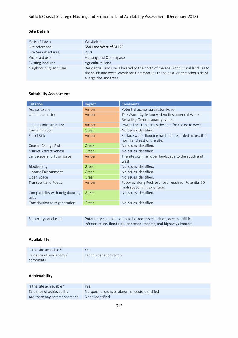
Suffolk Coastal Strategic Housing and Economic Land Availability Assessment (December 2018)
613
Site Details
Parish / Town Westleton
Site reference 554 Land West of B1125
Site Area (hectares) 2.10
Proposed use Housing and Open Space
Existing land use Agricultural land
Neighbouring land uses Residential land use is located to the north of the site. Agricultural land lies to the south and west. Westleton Common lies to the east, on the other side of a large rise and trees.
Suitability Assessment
Criterion Impact Comments
Access to site Amber Potential access via Leiston Road.
Utilities capacity Amber The Water Cycle Study identifies potential Water Recycling Centre capacity issues.
Utilities Infrastructure Amber Power lines run across the site, from east to west.
Contamination Green No issues identified.
Flood Risk Amber Surface water flooding has been recorded across the north and east of the site.
Coastal Change Risk Green No issues identified.
Market Attractiveness Green No issues identified.
Landscape and Townscape Amber The site sits in an open landscape to the south and west.
Biodiversity Green No issues identified.
Historic Environment Green No issues identified.
Open Space Green No issues identified.
Transport and Roads Amber Footway along Reckford road required. Potential 30 mph speed limit extension.
Compatibility with neighbouring uses
Green No issues identified.
Contribution to regeneration Green No issues identified.
Suitability conclusion Potentially suitable. Issues to be addressed include; access, utilities infrastructure, flood risk, landscape impacts, and highways impacts.
Availability
Is the site available? Yes
Evidence of availability / comments
Landowner submission
Achievability
Is the site achievable? Yes
Evidence of achievability No specific issues or abnormal costs identified
Are there any commencement None identified

Suffolk Coastal Strategic Housing and Economic Land Availability Assessment (December 2018)
614
issues?
Estimated dwellings yield 25
Estimated employment land yield (hectares) -
Estimated retail floorspace (sqm) -
Estimated commencement date 2020/21
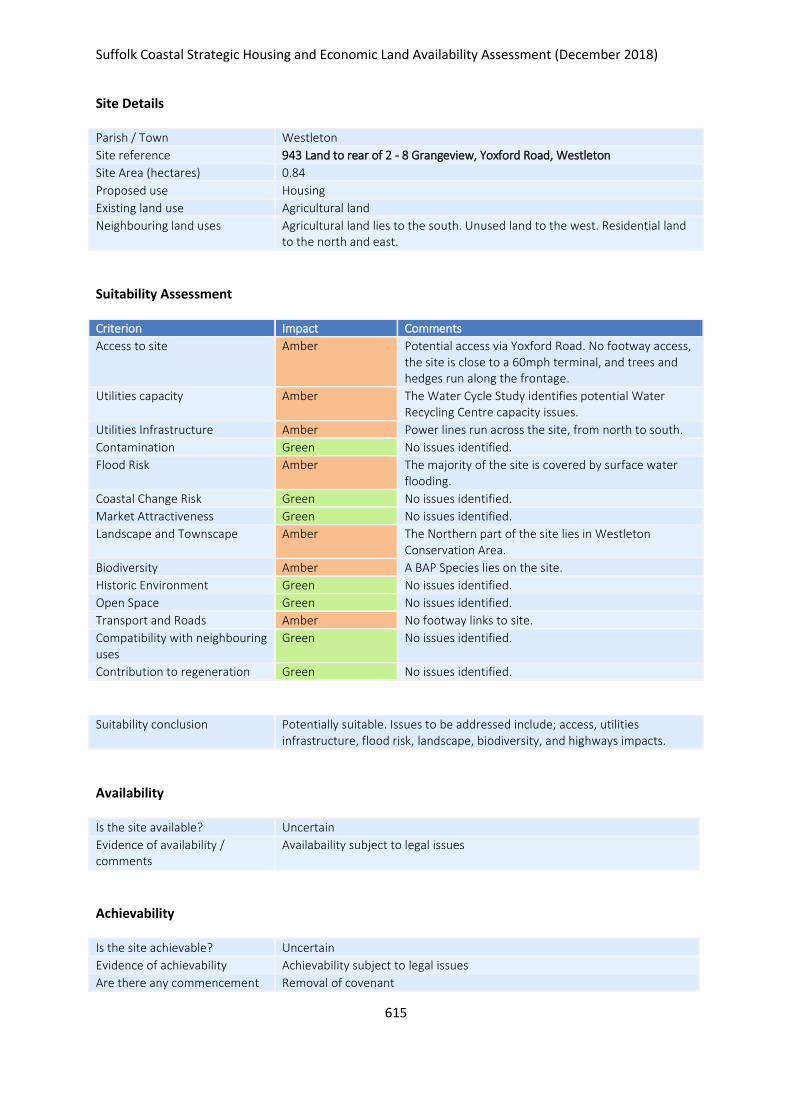
Suffolk Coastal Strategic Housing and Economic Land Availability Assessment (December 2018)
615
Site Details
Parish / Town Westleton
Site reference 943 Land to rear of 2 - 8 Grangeview, Yoxford Road, Westleton
Site Area (hectares) 0.84
Proposed use Housing
Existing land use Agricultural land
Neighbouring land uses Agricultural land lies to the south. Unused land to the west. Residential land to the north and east.
Suitability Assessment
Criterion Impact Comments
Access to site Amber Potential access via Yoxford Road. No footway access, the site is close to a 60mph terminal, and trees and hedges run along the frontage.
Utilities capacity Amber The Water Cycle Study identifies potential Water Recycling Centre capacity issues.
Utilities Infrastructure Amber Power lines run across the site, from north to south.
Contamination Green No issues identified.
Flood Risk Amber The majority of the site is covered by surface water flooding.
Coastal Change Risk Green No issues identified.
Market Attractiveness Green No issues identified.
Landscape and Townscape Amber The Northern part of the site lies in Westleton Conservation Area.
Biodiversity Amber A BAP Species lies on the site.
Historic Environment Green No issues identified.
Open Space Green No issues identified.
Transport and Roads Amber No footway links to site.
Compatibility with neighbouring uses
Green No issues identified.
Contribution to regeneration Green No issues identified.
Suitability conclusion Potentially suitable. Issues to be addressed include; access, utilities infrastructure, flood risk, landscape, biodiversity, and highways impacts.
Availability
Is the site available? Uncertain
Evidence of availability / comments
Availabaility subject to legal issues
Achievability
Is the site achievable? Uncertain
Evidence of achievability Achievability subject to legal issues
Are there any commencement Removal of covenant

Suffolk Coastal Strategic Housing and Economic Land Availability Assessment (December 2018)
616
issues?
Estimated dwellings yield 0
Estimated employment land yield (hectares) -
Estimated retail floorspace (sqm) -
Estimated commencement date -
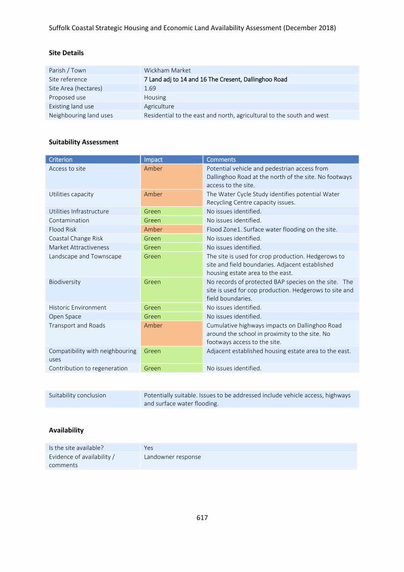
Suffolk Coastal Strategic Housing and Economic Land Availability Assessment (December 2018)
617
Site Details
Parish / Town Wickham Market
Site reference 7 Land adj to 14 and 16 The Cresent, Dallinghoo Road
Site Area (hectares) 1.69
Proposed use Housing
Existing land use Agriculture
Neighbouring land uses Residential to the east and north, agricultural to the south and west
Suitability Assessment
Criterion Impact Comments
Access to site Amber Potential vehicle and pedestrian access from Dallinghoo Road at the north of the site. No footways access to the site.
Utilities capacity Amber The Water Cycle Study identifies potential Water Recycling Centre capacity issues.
Utilities Infrastructure Green No issues identified.
Contamination Green No issues identified.
Flood Risk Amber Flood Zone1. Surface water flooding on the site.
Coastal Change Risk Green No issues identified.
Market Attractiveness Green No issues identified.
Landscape and Townscape Green The site is used for crop production. Hedgerows to site and field boundaries. Adjacent established housing estate area to the east.
Biodiversity Green No records of protected BAP species on the site. The site is used for cop production. Hedgerows to site and field boundaries.
Historic Environment Green No issues identified.
Open Space Green No issues identified.
Transport and Roads Amber Cumulative highways impacts on Dallinghoo Road around the school in proximity to the site. No footways access to the site.
Compatibility with neighbouring uses
Green Adjacent established housing estate area to the east.
Contribution to regeneration Green No issues identified.
Suitability conclusion Potentially suitable. Issues to be addressed include vehicle access, highways and surface water flooding.
Availability
Is the site available? Yes
Evidence of availability / comments
Landowner response

Suffolk Coastal Strategic Housing and Economic Land Availability Assessment (December 2018)
618
Achievability
Is the site achievable? Yes
Evidence of achievability No specific issues or abnormal costs identified
Are there any commencement issues?
None identified
Estimated dwellings yield 25
Estimated employment land yield (hectares) -
Estimated retail floorspace (sqm) -
Estimated commencement date 2021/22
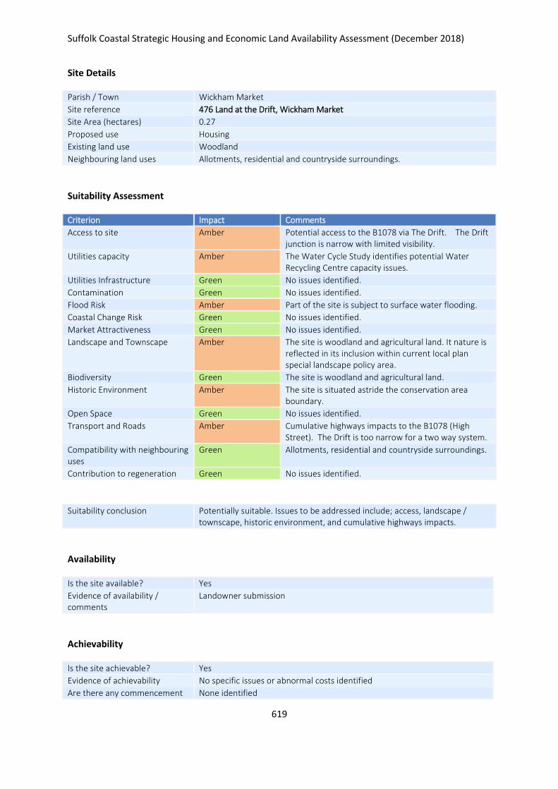
Suffolk Coastal Strategic Housing and Economic Land Availability Assessment (December 2018)
619
Site Details
Parish / Town Wickham Market
Site reference 476 Land at the Drift, Wickham Market
Site Area (hectares) 0.27
Proposed use Housing
Existing land use Woodland
Neighbouring land uses Allotments, residential and countryside surroundings.
Suitability Assessment
Criterion Impact Comments
Access to site Amber Potential access to the B1078 via The Drift. The Drift junction is narrow with limited visibility.
Utilities capacity Amber The Water Cycle Study identifies potential Water Recycling Centre capacity issues.
Utilities Infrastructure Green No issues identified.
Contamination Green No issues identified.
Flood Risk Amber Part of the site is subject to surface water flooding.
Coastal Change Risk Green No issues identified.
Market Attractiveness Green No issues identified.
Landscape and Townscape Amber The site is woodland and agricultural land. It nature is reflected in its inclusion within current local plan special landscape policy area.
Biodiversity Green The site is woodland and agricultural land.
Historic Environment Amber The site is situated astride the conservation area boundary.
Open Space Green No issues identified.
Transport and Roads Amber Cumulative highways impacts to the B1078 (High Street). The Drift is too narrow for a two way system.
Compatibility with neighbouring uses
Green Allotments, residential and countryside surroundings.
Contribution to regeneration Green No issues identified.
Suitability conclusion Potentially suitable. Issues to be addressed include; access, landscape / townscape, historic environment, and cumulative highways impacts.
Availability
Is the site available? Yes
Evidence of availability / comments
Landowner submission
Achievability
Is the site achievable? Yes
Evidence of achievability No specific issues or abnormal costs identified
Are there any commencement None identified

Suffolk Coastal Strategic Housing and Economic Land Availability Assessment (December 2018)
620
issues?
Estimated dwellings yield 4
Estimated employment land yield (hectares) -
Estimated retail floorspace (sqm) -
Estimated commencement date 2023/24
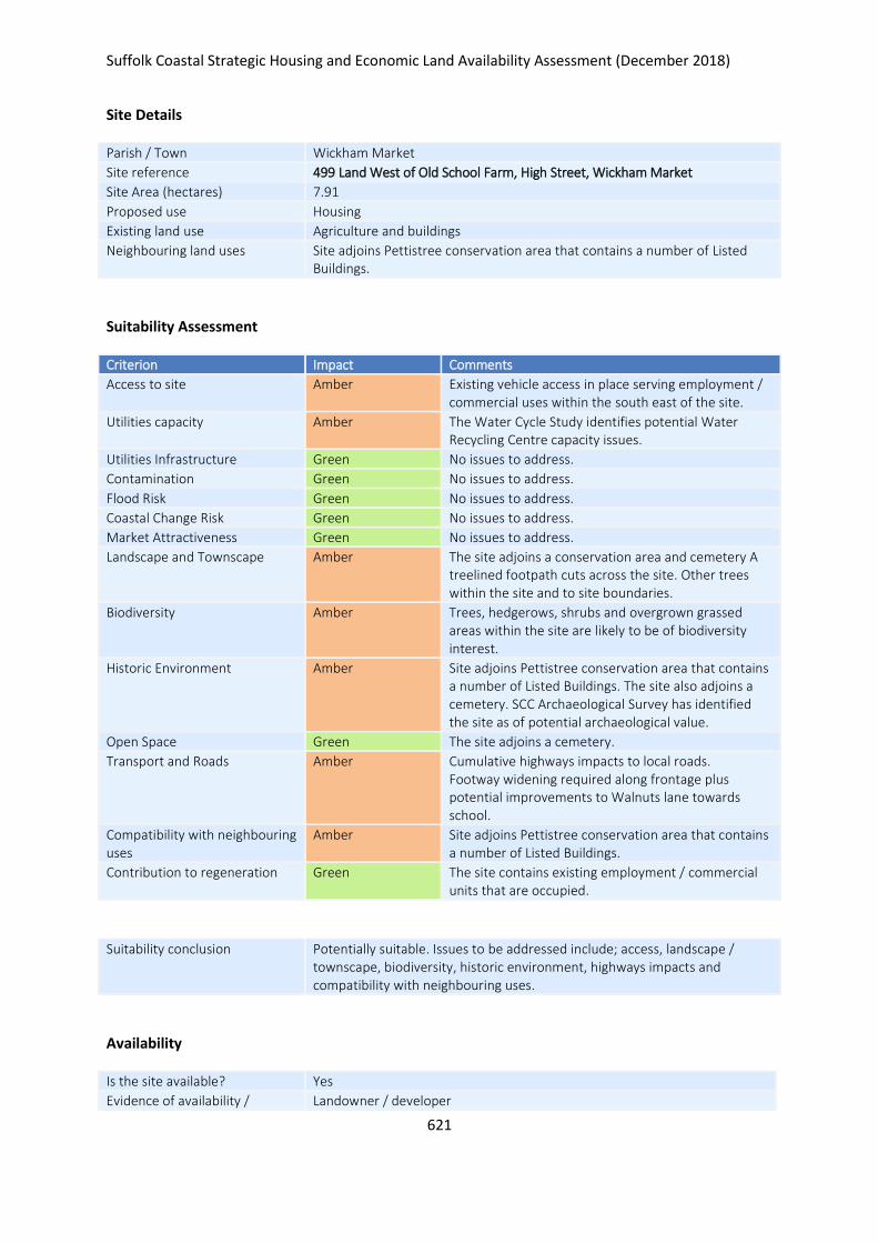
Suffolk Coastal Strategic Housing and Economic Land Availability Assessment (December 2018)
621
Site Details
Parish / Town Wickham Market
Site reference 499 Land West of Old School Farm, High Street, Wickham Market
Site Area (hectares) 7.91
Proposed use Housing
Existing land use Agriculture and buildings
Neighbouring land uses Site adjoins Pettistree conservation area that contains a number of Listed Buildings.
Suitability Assessment
Criterion Impact Comments
Access to site Amber Existing vehicle access in place serving employment / commercial uses within the south east of the site.
Utilities capacity Amber The Water Cycle Study identifies potential Water Recycling Centre capacity issues.
Utilities Infrastructure Green No issues to address.
Contamination Green No issues to address.
Flood Risk Green No issues to address.
Coastal Change Risk Green No issues to address.
Market Attractiveness Green No issues to address.
Landscape and Townscape Amber The site adjoins a conservation area and cemetery A treelined footpath cuts across the site. Other trees within the site and to site boundaries.
Biodiversity Amber Trees, hedgerows, shrubs and overgrown grassed areas within the site are likely to be of biodiversity interest.
Historic Environment Amber Site adjoins Pettistree conservation area that contains a number of Listed Buildings. The site also adjoins a cemetery. SCC Archaeological Survey has identified the site as of potential archaeological value.
Open Space Green The site adjoins a cemetery.
Transport and Roads Amber Cumulative highways impacts to local roads. Footway widening required along frontage plus potential improvements to Walnuts lane towards school.
Compatibility with neighbouring uses
Amber Site adjoins Pettistree conservation area that contains a number of Listed Buildings.
Contribution to regeneration Green The site contains existing employment / commercial units that are occupied.
Suitability conclusion Potentially suitable. Issues to be addressed include; access, landscape / townscape, biodiversity, historic environment, highways impacts and compatibility with neighbouring uses.
Availability
Is the site available? Yes
Evidence of availability / Landowner / developer
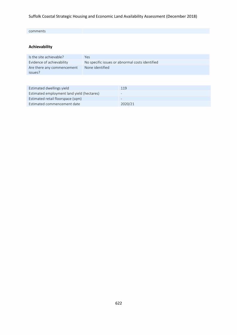
Suffolk Coastal Strategic Housing and Economic Land Availability Assessment (December 2018)
622
comments
Achievability
Is the site achievable? Yes
Evidence of achievability No specific issues or abnormal costs identified
Are there any commencement issues?
None identified
Estimated dwellings yield 119
Estimated employment land yield (hectares) -
Estimated retail floorspace (sqm) -
Estimated commencement date 2020/21
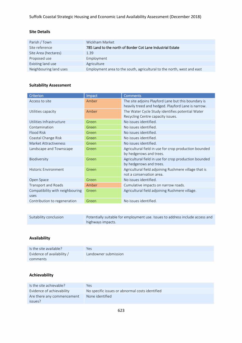
Suffolk Coastal Strategic Housing and Economic Land Availability Assessment (December 2018)
623
Site Details
Parish / Town Wickham Market
Site reference 785 Land to the north of Border Cot Lane Industrial Estate
Site Area (hectares) 1.39
Proposed use Employment
Existing land use Agriculture
Neighbouring land uses Employment area to the south, agricultural to the north, west and east
Suitability Assessment
Criterion Impact Comments
Access to site Amber The site adjoins Playford Lane but this boundary is heavily treed and hedged. Playford Lane is narrow.
Utilities capacity Amber The Water Cycle Study identifies potential Water Recycling Centre capacity issues.
Utilities Infrastructure Green No issues identified.
Contamination Green No issues identified.
Flood Risk Green No issues identified.
Coastal Change Risk Green No issues identified.
Market Attractiveness Green No issues identified.
Landscape and Townscape Green Agricultural field in use for crop production bounded by hedgerows and trees.
Biodiversity Green Agricultural field in use for crop production bounded by hedgerows and trees.
Historic Environment Green Agricultural field adjoining Rushmere village that is not a conservation area.
Open Space Green No issues identified.
Transport and Roads Amber Cumulative impacts on narrow roads.
Compatibility with neighbouring uses
Green Agricultural field adjoining Rushmere village.
Contribution to regeneration Green No issues identified.
Suitability conclusion Potentially suitable for employment use. Issues to address include access and highways impacts.
Availability
Is the site available? Yes
Evidence of availability / comments
Landowner submission
Achievability
Is the site achievable? Yes
Evidence of achievability No specific issues or abnormal costs identified
Are there any commencement issues?
None identified

Suffolk Coastal Strategic Housing and Economic Land Availability Assessment (December 2018)
624
Estimated dwellings yield -
Estimated employment land yield (hectares) 1
Estimated retail floorspace (sqm) -
Estimated commencement date 2021/22
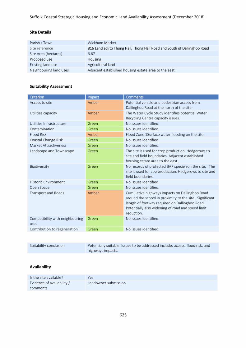
Suffolk Coastal Strategic Housing and Economic Land Availability Assessment (December 2018)
625
Site Details
Parish / Town Wickham Market
Site reference 816 Land adj to Thong Hall, Thong Hall Road and South of Dallinghoo Road
Site Area (hectares) 6.67
Proposed use Housing
Existing land use Agricultural land
Neighbouring land uses Adjacent established housing estate area to the east.
Suitability Assessment
Criterion Impact Comments
Access to site Amber Potential vehicle and pedestrian access from Dallinghoo Road at the north of the site.
Utilities capacity Amber The Water Cycle Study identifies potential Water Recycling Centre capacity issues.
Utilities Infrastructure Green No issues identified.
Contamination Green No issues identified.
Flood Risk Amber Flood Zone 1Surface water flooding on the site.
Coastal Change Risk Green No issues identified.
Market Attractiveness Green No issues identified.
Landscape and Townscape Green The site is used for crop production. Hedgerows to site and field boundaries. Adjacent established housing estate area to the east.
Biodiversity Green No records of protected BAP specie son the site. The site is used for cop production. Hedgerows to site and field boundaries.
Historic Environment Green No issues identified.
Open Space Green No issues identified.
Transport and Roads Amber Cumulative highways impacts on Dallinghoo Road around the school in proximity to the site. Significant length of footway required on Dallinghoo Road. Potentially also widening of road and speed limit reduction.
Compatibility with neighbouring uses
Green No issues identified.
Contribution to regeneration Green No issues identified.
Suitability conclusion Potentially suitable. Issues to be addressed include; access, flood risk, and highways impacts.
Availability
Is the site available? Yes
Evidence of availability / comments
Landowner submission

Suffolk Coastal Strategic Housing and Economic Land Availability Assessment (December 2018)
626
Achievability
Is the site achievable? Yes
Evidence of achievability No specific issues or abnormal costs identified
Are there any commencement issues?
None identified
Estimated dwellings yield 100
Estimated employment land yield (hectares) -
Estimated retail floorspace (sqm) -
Estimated commencement date 2021/22
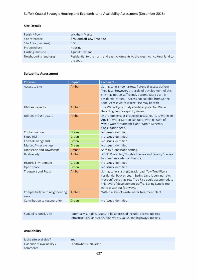
Suffolk Coastal Strategic Housing and Economic Land Availability Assessment (December 2018)
627
Site Details
Parish / Town Wickham Market
Site reference 878 Land off Yew Tree Rise
Site Area (hectares) 5.33
Proposed use Housing
Existing land use Agricultural land
Neighbouring land uses Residential to the north and east. Allotments to the west. Agricultural land to the south.
Suitability Assessment
Criterion Impact Comments
Access to site Amber Spring Lane is too narrow. Potential access via Yew Tree Rise. However, the scale of development of this site may not be sufficiently accomodated via this residential street. Access not suitable from Spring Lane. Access via Yew Tree Rise may be with
Utilities capacity Amber The Water Cycle Study identifies potential Water Recycling Centre capacity issues.
Utilities Infrastructure Amber Entire site, except proposed access route, is within an Anglian Water Cordon Sanitaire. Within 400m of waste water treatment plant. Within Minerals Consultation Area.
Contamination Green No issues identified.
Flood Risk Green No issues identified.
Coastal Change Risk Green No issues identified.
Market Attractiveness Green No issues identified.
Landscape and Townscape Amber Sensitive landscape setting.
Biodiversity Amber A SBIS Protected/Notable Species and Priority Species has been recorded on the site.
Historic Environment Green No issues identified.
Open Space Green No issues identified.
Transport and Roads Amber Spring Lane is a single track road. Yew Tree Rise is residential back street. Spring Lane is very narrow. Not confident that Yew Tree Rise could accommodate this level of development traffic. Spring Lane is too narrow without footways.
Compatibility with neighbouring uses
Amber Within 400m of waste water treatment plant.
Contribution to regeneration Green No issues identified.
Suitability conclusion Potentially suitable. Issues to be addressed include; access, utilities infrastructure, landscape, biodiveristy value, and highways impacts.
Availability
Is the site available? Yes
Evidence of availability / comments
Landowner submission
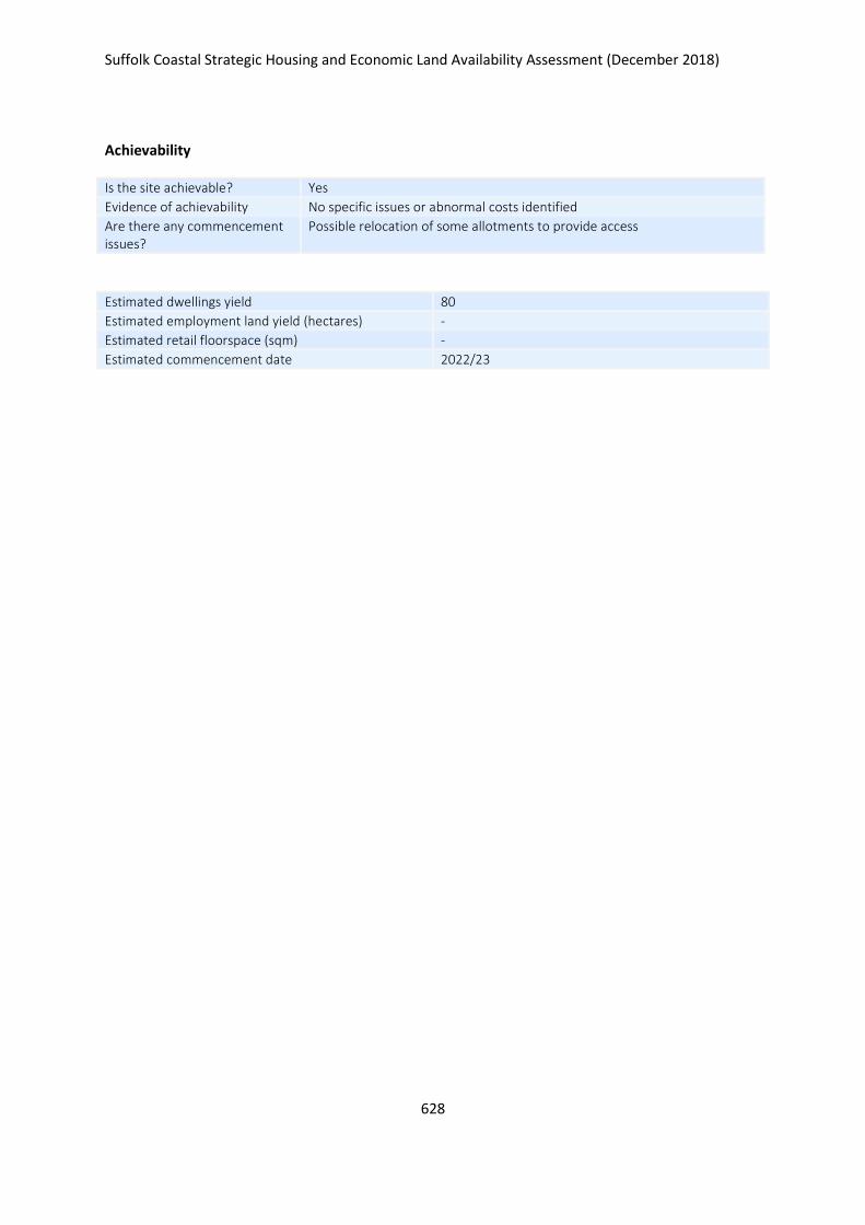
Suffolk Coastal Strategic Housing and Economic Land Availability Assessment (December 2018)
628
Achievability
Is the site achievable? Yes
Evidence of achievability No specific issues or abnormal costs identified
Are there any commencement issues?
Possible relocation of some allotments to provide access
Estimated dwellings yield 80
Estimated employment land yield (hectares) -
Estimated retail floorspace (sqm) -
Estimated commencement date 2022/23
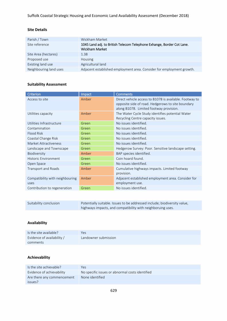
Suffolk Coastal Strategic Housing and Economic Land Availability Assessment (December 2018)
629
Site Details
Parish / Town Wickham Market
Site reference 1045 Land adj. to British Telecom Telephone Exhange, Border Cot Lane. Wickham Market
Site Area (hectares) 1.38
Proposed use Housing
Existing land use Agricultural land
Neighbouring land uses Adjacent established employment area. Consider for employment growth.
Suitability Assessment
Criterion Impact Comments
Access to site Amber Direct vehicle access to B1078 is available. Footway to opposite side of road. Hedgerows to site boundary along B1078. Limited footway provision.
Utilities capacity Amber The Water Cycle Study identifies potential Water Recycling Centre capacity issues.
Utilities Infrastructure Green No issues identified.
Contamination Green No issues identified.
Flood Risk Green No issues identified.
Coastal Change Risk Green No issues identified.
Market Attractiveness Green No issues identified.
Landscape and Townscape Green Hedgerow Survey: Poor. Sensitive landscape setting.
Biodiversity Amber BAP species identified.
Historic Environment Green Coin hoard found.
Open Space Green No issues identified.
Transport and Roads Amber Cumulative highways impacts. Limited footway provision.
Compatibility with neighbouring uses
Amber Adjacent established employment area. Consider for employment use.
Contribution to regeneration Green No issues identified.
Suitability conclusion Potentially suitable. Issues to be addressed include; biodiversity value, highways impacts, and compatibility with neighboruing uses.
Availability
Is the site available? Yes
Evidence of availability / comments
Landowner submission
Achievability
Is the site achievable? Yes
Evidence of achievability No specific issues or abnormal costs identified
Are there any commencement issues?
None identified
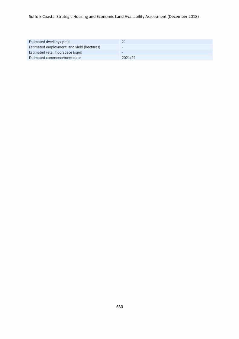
Suffolk Coastal Strategic Housing and Economic Land Availability Assessment (December 2018)
630
Estimated dwellings yield 21
Estimated employment land yield (hectares) -
Estimated retail floorspace (sqm) -
Estimated commencement date 2021/22
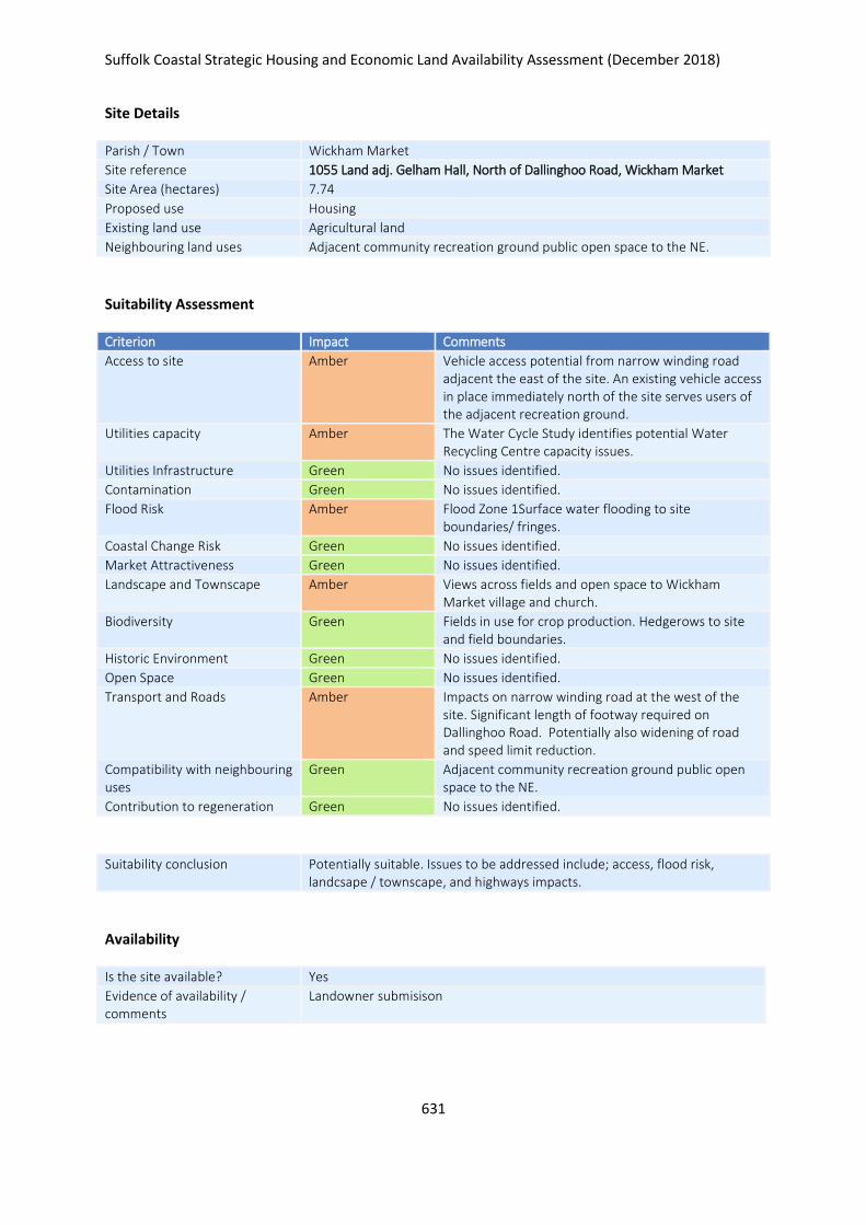
Suffolk Coastal Strategic Housing and Economic Land Availability Assessment (December 2018)
631
Site Details
Parish / Town Wickham Market
Site reference 1055 Land adj. Gelham Hall, North of Dallinghoo Road, Wickham Market
Site Area (hectares) 7.74
Proposed use Housing
Existing land use Agricultural land
Neighbouring land uses Adjacent community recreation ground public open space to the NE.
Suitability Assessment
Criterion Impact Comments
Access to site Amber Vehicle access potential from narrow winding road adjacent the east of the site. An existing vehicle access in place immediately north of the site serves users of the adjacent recreation ground.
Utilities capacity Amber The Water Cycle Study identifies potential Water Recycling Centre capacity issues.
Utilities Infrastructure Green No issues identified.
Contamination Green No issues identified.
Flood Risk Amber Flood Zone 1Surface water flooding to site boundaries/ fringes.
Coastal Change Risk Green No issues identified.
Market Attractiveness Green No issues identified.
Landscape and Townscape Amber Views across fields and open space to Wickham Market village and church.
Biodiversity Green Fields in use for crop production. Hedgerows to site and field boundaries.
Historic Environment Green No issues identified.
Open Space Green No issues identified.
Transport and Roads Amber Impacts on narrow winding road at the west of the site. Significant length of footway required on Dallinghoo Road. Potentially also widening of road and speed limit reduction.
Compatibility with neighbouring uses
Green Adjacent community recreation ground public open space to the NE.
Contribution to regeneration Green No issues identified.
Suitability conclusion Potentially suitable. Issues to be addressed include; access, flood risk, landcsape / townscape, and highways impacts.
Availability
Is the site available? Yes
Evidence of availability / comments
Landowner submisison

Suffolk Coastal Strategic Housing and Economic Land Availability Assessment (December 2018)
632
Achievability
Is the site achievable? Yes
Evidence of achievability No specific issues or abnormal costs identified
Are there any commencement issues?
None identfiied
Estimated dwellings yield 116
Estimated employment land yield (hectares) -
Estimated retail floorspace (sqm) -
Estimated commencement date 2021/22
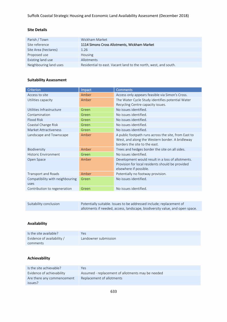
Suffolk Coastal Strategic Housing and Economic Land Availability Assessment (December 2018)
633
Site Details
Parish / Town Wickham Market
Site reference 1114 Simons Cross Allotments, Wickham Market
Site Area (hectares) 1.26
Proposed use Housing
Existing land use Allotments
Neighbouring land uses Residential to east. Vacant land to the north, west, and south.
Suitability Assessment
Criterion Impact Comments
Access to site Amber Access only appears feasible via Simon's Cross.
Utilities capacity Amber The Water Cycle Study identifies potential Water Recycling Centre capacity issues.
Utilities Infrastructure Green No issues identified.
Contamination Green No issues identified.
Flood Risk Green No issues identified.
Coastal Change Risk Green No issues identified.
Market Attractiveness Green No issues identified.
Landscape and Townscape Amber A public footpath runs across the site, from East to West, and along the Western border. A bridleway borders the site to the east.
Biodiversity Amber Trees and hedges border the site on all sides.
Historic Environment Green No issues identified.
Open Space Amber Development would result in a loss of allotments. Provision for local residents should be provided elsewhere if possible.
Transport and Roads Amber Potentially no footway provision.
Compatibility with neighbouring uses
Green No issues identified.
Contribution to regeneration Green No issues identified.
Suitability conclusion Potentially suitable. Issues to be addressed include; replacement of allotments if needed, access, landscape, biodiversity value, and open space.
Availability
Is the site available? Yes
Evidence of availability / comments
Landowner submission
Achievability
Is the site achievable? Yes
Evidence of achievability Assumed - replacement of allotments may be needed
Are there any commencement issues?
Replacement of allotments

Suffolk Coastal Strategic Housing and Economic Land Availability Assessment (December 2018)
634
Estimated dwellings yield 19
Estimated employment land yield (hectares) -
Estimated retail floorspace (sqm) -
Estimated commencement date 2024/25
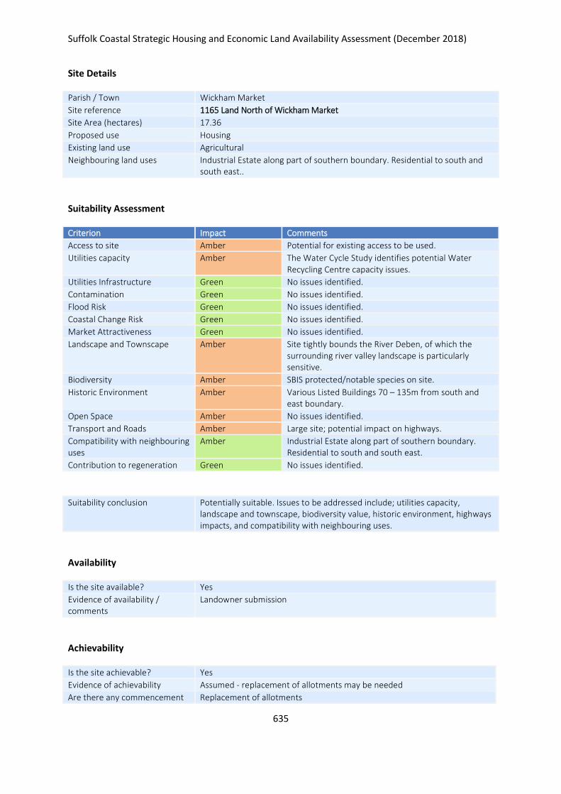
Suffolk Coastal Strategic Housing and Economic Land Availability Assessment (December 2018)
635
Site Details
Parish / Town Wickham Market
Site reference 1165 Land North of Wickham Market
Site Area (hectares) 17.36
Proposed use Housing
Existing land use Agricultural
Neighbouring land uses Industrial Estate along part of southern boundary. Residential to south and south east..
Suitability Assessment
Criterion Impact Comments
Access to site Amber Potential for existing access to be used.
Utilities capacity Amber The Water Cycle Study identifies potential Water Recycling Centre capacity issues.
Utilities Infrastructure Green No issues identified.
Contamination Green No issues identified.
Flood Risk Green No issues identified.
Coastal Change Risk Green No issues identified.
Market Attractiveness Green No issues identified.
Landscape and Townscape Amber Site tightly bounds the River Deben, of which the surrounding river valley landscape is particularly sensitive.
Biodiversity Amber SBIS protected/notable species on site.
Historic Environment Amber Various Listed Buildings 70 – 135m from south and east boundary.
Open Space Amber No issues identified.
Transport and Roads Amber Large site; potential impact on highways.
Compatibility with neighbouring uses
Amber Industrial Estate along part of southern boundary. Residential to south and south east.
Contribution to regeneration Green No issues identified.
Suitability conclusion Potentially suitable. Issues to be addressed include; utilities capacity, landscape and townscape, biodiversity value, historic environment, highways impacts, and compatibility with neighbouring uses.
Availability
Is the site available? Yes
Evidence of availability / comments
Landowner submission
Achievability
Is the site achievable? Yes
Evidence of achievability Assumed - replacement of allotments may be needed
Are there any commencement Replacement of allotments

Suffolk Coastal Strategic Housing and Economic Land Availability Assessment (December 2018)
636
issues?
Estimated dwellings yield 260
Estimated employment land yield (hectares) -
Estimated retail floorspace (sqm) -
Estimated commencement date 2022/23
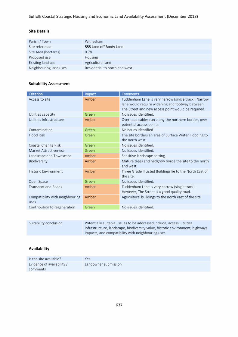
Suffolk Coastal Strategic Housing and Economic Land Availability Assessment (December 2018)
637
Site Details
Parish / Town Witnesham
Site reference 555 Land off Sandy Lane
Site Area (hectares) 0.78
Proposed use Housing
Existing land use Agricultural land.
Neighbouring land uses Residential to north and west.
Suitability Assessment
Criterion Impact Comments
Access to site Amber Tuddenham Lane is very narrow (single track). Narrow lane would require widening and footway between The Street and new access point would be required.
Utilities capacity Green No issues identified.
Utilities Infrastructure Amber Overhead cables run along the northern border, over potential access points.
Contamination Green No issues identified.
Flood Risk Green The site borders an area of Surface Water Flooding to the north west.
Coastal Change Risk Green No issues identified.
Market Attractiveness Green No issues identified.
Landscape and Townscape Amber Sensitive landscape setting.
Biodiversity Amber Mature trees and hedgrow borde the site to the north and west.
Historic Environment Amber Three Grade II Listed Buildings lie to the North East of the site.
Open Space Green No issues identified.
Transport and Roads Amber Tuddenham Lane is very narrow (single track). However, The Street is a good quality road.
Compatibility with neighbouring uses
Amber Agricultural buildings to the north east of the site.
Contribution to regeneration Green No issues identified.
Suitability conclusion Potentially suitable. Issues to be addressed include; access, utilities infrastructure, landscape, biodiversity value, historic environment, highways impacts, and compatibility with neighbouring uses.
Availability
Is the site available? Yes
Evidence of availability / comments
Landowner submission

Suffolk Coastal Strategic Housing and Economic Land Availability Assessment (December 2018)
638
Achievability
Is the site achievable? Yes
Evidence of achievability No specific issues or abnormal costs identified
Are there any commencement issues?
None identified
Estimated dwellings yield 12
Estimated employment land yield (hectares) -
Estimated retail floorspace (sqm) -
Estimated commencement date 2023/24
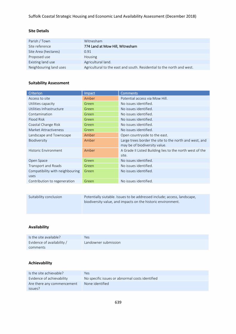
Suffolk Coastal Strategic Housing and Economic Land Availability Assessment (December 2018)
639
Site Details
Parish / Town Witnesham
Site reference 774 Land at Mow Hill, Witnesham
Site Area (hectares) 0.91
Proposed use Housing
Existing land use Agricultural land.
Neighbouring land uses Agricultural to the east and south. Residential to the north and west.
Suitability Assessment
Criterion Impact Comments
Access to site Amber Potential access via Mow Hill.
Utilities capacity Green No issues identified.
Utilities Infrastructure Green No issues identified.
Contamination Green No issues identified.
Flood Risk Green No issues identified.
Coastal Change Risk Green No issues identified.
Market Attractiveness Green No issues identified.
Landscape and Townscape Amber Open countryside to the east.
Biodiversity Amber Large trees border the site to the north and west, and may be of biodiversity value.
Historic Environment Amber A Grade II Listed Building lies to the north west of the site.
Open Space Green No issues identified.
Transport and Roads Green No issues identified.
Compatibility with neighbouring uses
Green No issues identified.
Contribution to regeneration Green No issues identified.
Suitability conclusion Potentially siutable. Issues to be addressed include; access, landscape, biodiversity value, and impacts on the historic environment.
Availability
Is the site available? Yes
Evidence of availability / comments
Landowner submission
Achievability
Is the site achievable? Yes
Evidence of achievability No specific issues or abnormal costs identified
Are there any commencement issues?
None identified

Suffolk Coastal Strategic Housing and Economic Land Availability Assessment (December 2018)
640
Estimated dwellings yield 23
Estimated employment land yield (hectares) -
Estimated retail floorspace (sqm) -
Estimated commencement date 2023/24
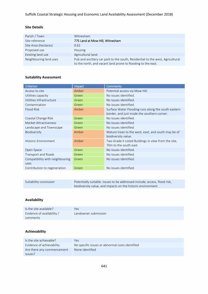
Suffolk Coastal Strategic Housing and Economic Land Availability Assessment (December 2018)
641
Site Details
Parish / Town Witnesham
Site reference 775 Land at Mow Hill, Witnesham
Site Area (hectares) 0.62
Proposed use Housing
Existing land use Agricultural land.
Neighbouring land uses Pub and ancillary car park to the south, Residential to the west, Agricultural to the north, and vacant land prone to flooding to the east.
Suitability Assessment
Criterion Impact Comments
Access to site Amber Potential access via Mow Hill.
Utilities capacity Green No issues identified.
Utilities Infrastructure Green No issues identified.
Contamination Green No issues identified.
Flood Risk Amber Surface Water Flooding runs along the south eastern border, and just inside the southern corner.
Coastal Change Risk Green No issues identified.
Market Attractiveness Green No issues identified.
Landscape and Townscape Green No issues identified.
Biodiversity Amber Mature trees to the west, east, and south may be of biodiversity value.
Historic Environment Amber Two Grade II Listed Buildings in view from the site, 70m to the south east.
Open Space Green No issues identified.
Transport and Roads Green No issues identified.
Compatibility with neighbouring uses
Green No issues identified.
Contribution to regeneration Green No issues identified.
Suitability conclusion Potentially suitable. Issues to be addressed include; access, flood risk, biodiversity value, and impacts on the historic environment.
Availability
Is the site available? Yes
Evidence of availability / comments
Landowner submission
Achievability
Is the site achievable? Yes
Evidence of achievability No specific issues or abnormal costs identified
Are there any commencement issues?
None identified

Suffolk Coastal Strategic Housing and Economic Land Availability Assessment (December 2018)
642
Estimated dwellings yield 9
Estimated employment land yield (hectares) -
Estimated retail floorspace (sqm) -
Estimated commencement date 2023/24
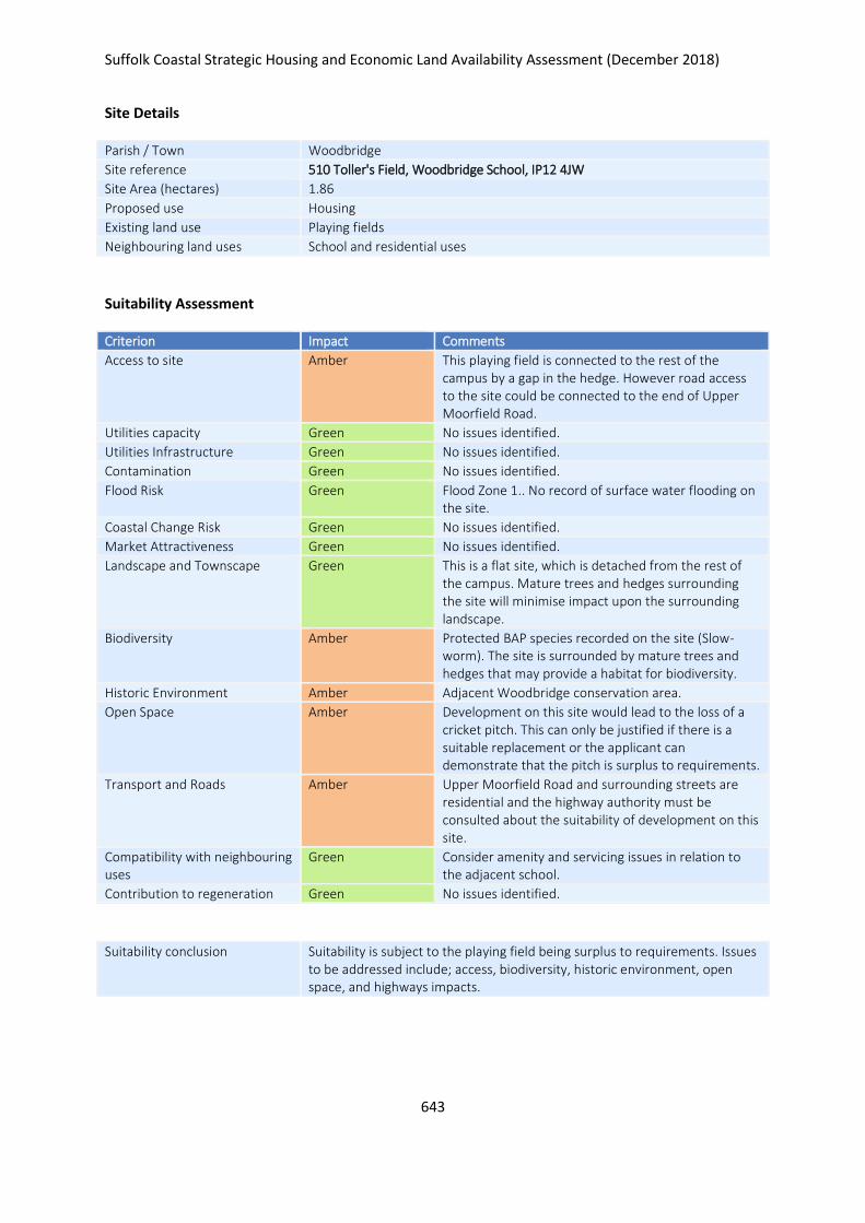
Suffolk Coastal Strategic Housing and Economic Land Availability Assessment (December 2018)
643
Site Details
Parish / Town Woodbridge
Site reference 510 Toller's Field, Woodbridge School, IP12 4JW
Site Area (hectares) 1.86
Proposed use Housing
Existing land use Playing fields
Neighbouring land uses School and residential uses
Suitability Assessment
Criterion Impact Comments
Access to site Amber This playing field is connected to the rest of the campus by a gap in the hedge. However road access to the site could be connected to the end of Upper Moorfield Road.
Utilities capacity Green No issues identified.
Utilities Infrastructure Green No issues identified.
Contamination Green No issues identified.
Flood Risk Green Flood Zone 1.. No record of surface water flooding on the site.
Coastal Change Risk Green No issues identified.
Market Attractiveness Green No issues identified.
Landscape and Townscape Green This is a flat site, which is detached from the rest of the campus. Mature trees and hedges surrounding the site will minimise impact upon the surrounding landscape.
Biodiversity Amber
Protected BAP species recorded on the site (Slow-worm). The site is surrounded by mature trees and hedges that may provide a habitat for biodiversity.
Historic Environment Amber Adjacent Woodbridge conservation area.
Open Space Amber Development on this site would lead to the loss of a cricket pitch. This can only be justified if there is a suitable replacement or the applicant can demonstrate that the pitch is surplus to requirements.
Transport and Roads Amber Upper Moorfield Road and surrounding streets are residential and the highway authority must be consulted about the suitability of development on this site.
Compatibility with neighbouring uses
Green Consider amenity and servicing issues in relation to the adjacent school.
Contribution to regeneration Green No issues identified.
Suitability conclusion Suitability is subject to the playing field being surplus to requirements. Issues to be addressed include; access, biodiversity, historic environment, open space, and highways impacts.

Suffolk Coastal Strategic Housing and Economic Land Availability Assessment (December 2018)
644
Availability
Is the site available? Yes
Evidence of availability / comments
Landowner submission
Achievability
Is the site achievable? Yes
Evidence of achievability Submission states viable, subject to access costs
Are there any commencement issues?
None identified
Estimated dwellings yield 56
Estimated employment land yield (hectares) -
Estimated retail floorspace (sqm) -
Estimated commencement date 2023/24
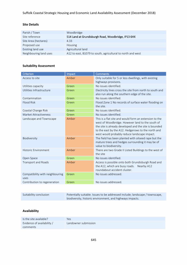
Suffolk Coastal Strategic Housing and Economic Land Availability Assessment (December 2018)
645
Site Details
Parish / Town Woodbridge
Site reference 514 Land at Grundisburgh Road, Woodbridge, IP13 6HX
Site Area (hectares) 4.33
Proposed use Housing
Existing land use Agricultural land
Neighbouring land uses A12 to east, B1079 to south, agricultural to north and west
Suitability Assessment
Criterion Impact Comments
Access to site Amber Only suitable for 5 or less dwellings, with existing highways provisons.
Utilities capacity Green No issues identified.
Utilities Infrastructure Green Electricity lines cross the site from north to south and also run along the southern edge of the site.
Contamination Green No issues identified.
Flood Risk Green Flood Zone 1 No records of surface water flooding on the site.
Coastal Change Risk Green No issues identified.
Market Attractiveness Green No issues identified.
Landscape and Townscape Amber This is a flat site and would form an extension to the west of Woodbridge. However land to the south of the site is already developed and the site is bounded to the east by the A12. Hedgerows to the north and west would probably reduce landscape impact.
Biodiversity Amber The field has been planted with oilseed rape but the mature trees and hedges surrounding it may be of value to biodiversity.
Historic Environment Amber There are two Grade II Listed Buildings to the west of the site
Open Space Green No issues identified.
Transport and Roads Amber Access is possible onto both Grundisburgh Road and the A12, which are busy roads. Nearby A12 roundabout accident cluster.
Compatibility with neighbouring uses
Green No issues addressed.
Contribution to regeneration Green No issues addressed.
Suitability conclusion Potentially suitable. Issues to be addressed include; landscape / townscape, biodiversity, historic environment, and highways impacts.
Availability
Is the site available? Yes
Evidence of availability / comments
Landowner submission

Suffolk Coastal Strategic Housing and Economic Land Availability Assessment (December 2018)
646
Achievability
Is the site achievable? Yes
Evidence of achievability No specific issues or abnormal costs identified
Are there any commencement issues?
None identified
Estimated dwellings yield 104
Estimated employment land yield (hectares) -
Estimated retail floorspace (sqm) -
Estimated commencement date 2020/21
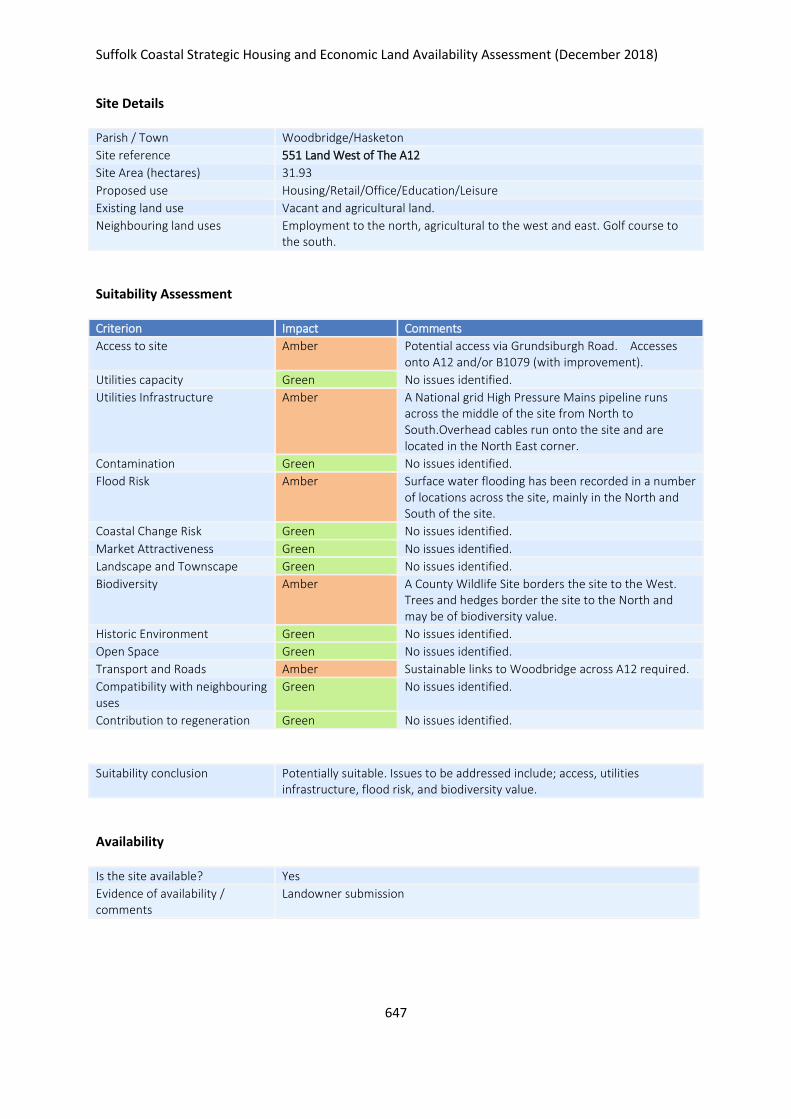
Suffolk Coastal Strategic Housing and Economic Land Availability Assessment (December 2018)
647
Site Details
Parish / Town Woodbridge/Hasketon
Site reference 551 Land West of The A12
Site Area (hectares) 31.93
Proposed use Housing/Retail/Office/Education/Leisure
Existing land use Vacant and agricultural land.
Neighbouring land uses Employment to the north, agricultural to the west and east. Golf course to the south.
Suitability Assessment
Criterion Impact Comments
Access to site Amber Potential access via Grundsiburgh Road. Accesses onto A12 and/or B1079 (with improvement).
Utilities capacity Green No issues identified.
Utilities Infrastructure Amber A National grid High Pressure Mains pipeline runs across the middle of the site from North to South.Overhead cables run onto the site and are located in the North East corner.
Contamination Green No issues identified.
Flood Risk Amber Surface water flooding has been recorded in a number of locations across the site, mainly in the North and South of the site.
Coastal Change Risk Green No issues identified.
Market Attractiveness Green No issues identified.
Landscape and Townscape Green No issues identified.
Biodiversity Amber A County Wildlife Site borders the site to the West. Trees and hedges border the site to the North and may be of biodiversity value.
Historic Environment Green No issues identified.
Open Space Green No issues identified.
Transport and Roads Amber Sustainable links to Woodbridge across A12 required.
Compatibility with neighbouring uses
Green No issues identified.
Contribution to regeneration Green No issues identified.
Suitability conclusion Potentially suitable. Issues to be addressed include; access, utilities infrastructure, flood risk, and biodiversity value.
Availability
Is the site available? Yes
Evidence of availability / comments
Landowner submission

Suffolk Coastal Strategic Housing and Economic Land Availability Assessment (December 2018)
648
Achievability
Is the site achievable? Yes
Evidence of achievability No specific issues or abnormal costs identified
Are there any commencement issues?
Promoted by consortium of landowners
Estimated dwellings yield 383
Estimated employment land yield (hectares) -
Estimated retail floorspace (sqm) -
Estimated commencement date 2023/24
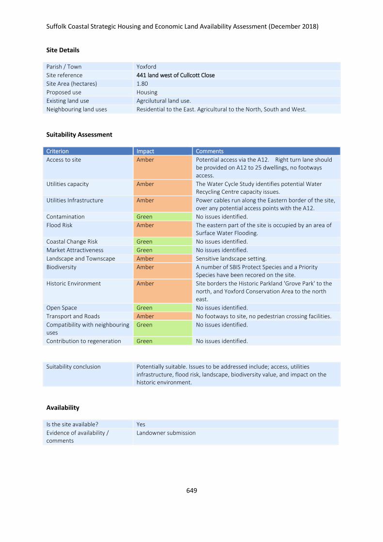
Suffolk Coastal Strategic Housing and Economic Land Availability Assessment (December 2018)
649
Site Details
Parish / Town Yoxford
Site reference 441 land west of Cullcott Close
Site Area (hectares) 1.80
Proposed use Housing
Existing land use Agrcilutural land use.
Neighbouring land uses Residential to the East. Agricultural to the North, South and West.
Suitability Assessment
Criterion Impact Comments
Access to site Amber Potential access via the A12. Right turn lane should be provided on A12 to 25 dwellings, no footways access.
Utilities capacity Amber The Water Cycle Study identifies potential Water Recycling Centre capacity issues.
Utilities Infrastructure Amber Power cables run along the Eastern border of the site, over any potential access points with the A12.
Contamination Green No issues identified.
Flood Risk Amber The eastern part of the site is occupied by an area of Surface Water Flooding.
Coastal Change Risk Green No issues identified.
Market Attractiveness Green No issues identified.
Landscape and Townscape Amber Sensitive landscape setting.
Biodiversity Amber A number of SBIS Protect Species and a Priority Species have been recored on the site.
Historic Environment Amber Site borders the Historic Parkland 'Grove Park' to the north, and Yoxford Conservation Area to the north east.
Open Space Green No issues identified.
Transport and Roads Amber No footways to site, no pedestrian crossing facilities.
Compatibility with neighbouring uses
Green No issues identified.
Contribution to regeneration Green No issues identified.
Suitability conclusion Potentially suitable. Issues to be addressed include; access, utilities infrastructure, flood risk, landscape, biodiversity value, and impact on the historic environment.
Availability
Is the site available? Yes
Evidence of availability / comments
Landowner submission

Suffolk Coastal Strategic Housing and Economic Land Availability Assessment (December 2018)
650
Achievability
Is the site achievable? Yes
Evidence of achievability No specific issues or abnormal costs identified
Are there any commencement issues?
None identified
Estimated dwellings yield 27
Estimated employment land yield (hectares) -
Estimated retail floorspace (sqm) -
Estimated commencement date 2021/22
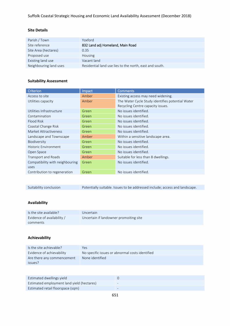
Suffolk Coastal Strategic Housing and Economic Land Availability Assessment (December 2018)
651
Site Details
Parish / Town Yoxford
Site reference 832 Land adj Homeland, Main Road
Site Area (hectares) 0.35
Proposed use Housing
Existing land use Vacant land
Neighbouring land uses Residential land use lies to the north, east and south.
Suitability Assessment
Criterion Impact Comments
Access to site Amber Existing access may need widening.
Utilities capacity Amber The Water Cycle Study identifies potential Water Recycling Centre capacity issues.
Utilities Infrastructure Green No issues identified.
Contamination Green No issues identified.
Flood Risk Green No issues identified.
Coastal Change Risk Green No issues identified.
Market Attractiveness Green No issues identified.
Landscape and Townscape Amber Within a sensitive landscape area.
Biodiversity Green No issues identified.
Historic Environment Green No issues identified.
Open Space Green No issues identified.
Transport and Roads Amber Suitable for less than 8 dwellings.
Compatibility with neighbouring uses
Green No issues identified.
Contribution to regeneration Green No issues identified.
Suitability conclusion Potentially suitable. Issues to be addressed include; access and landscape.
Availability
Is the site available? Uncertain
Evidence of availability / comments
Uncertain if landowner promoiting site
Achievability
Is the site achievable? Yes
Evidence of achievability No specific issues or abnormal costs identified
Are there any commencement issues?
None identified
Estimated dwellings yield 0
Estimated employment land yield (hectares) -
Estimated retail floorspace (sqm) -

Suffolk Coastal Strategic Housing and Economic Land Availability Assessment (December 2018)
652
Estimated commencement date -
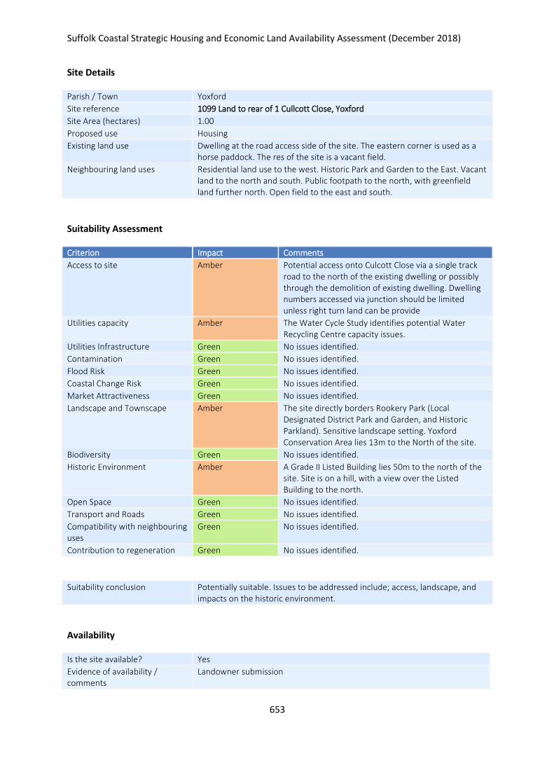
Suffolk Coastal Strategic Housing and Economic Land Availability Assessment (December 2018)
653
Site Details
Parish / Town Yoxford
Site reference 1099 Land to rear of 1 Cullcott Close, Yoxford
Site Area (hectares) 1.00
Proposed use Housing
Existing land use Dwelling at the road access side of the site. The eastern corner is used as a horse paddock. The res of the site is a vacant field.
Neighbouring land uses Residential land use to the west. Historic Park and Garden to the East. Vacant land to the north and south. Public footpath to the north, with greenfield land further north. Open field to the east and south.
Suitability Assessment
Criterion Impact Comments
Access to site Amber Potential access onto Culcott Close via a single track road to the north of the existing dwelling or possibly through the demolition of existing dwelling. Dwelling numbers accessed via junction should be limited unless right turn land can be provide
Utilities capacity Amber The Water Cycle Study identifies potential Water Recycling Centre capacity issues.
Utilities Infrastructure Green No issues identified.
Contamination Green No issues identified.
Flood Risk Green No issues identified.
Coastal Change Risk Green No issues identified.
Market Attractiveness Green No issues identified.
Landscape and Townscape Amber The site directly borders Rookery Park (Local Designated District Park and Garden, and Historic Parkland). Sensitive landscape setting. Yoxford Conservation Area lies 13m to the North of the site.
Biodiversity Green No issues identified.
Historic Environment Amber A Grade II Listed Building lies 50m to the north of the site. Site is on a hill, with a view over the Listed Building to the north.
Open Space Green No issues identified.
Transport and Roads Green No issues identified.
Compatibility with neighbouring uses
Green No issues identified.
Contribution to regeneration Green No issues identified.
Suitability conclusion Potentially suitable. Issues to be addressed include; access, landscape, and impacts on the historic environment.
Availability
Is the site available? Yes
Evidence of availability / comments
Landowner submission

Suffolk Coastal Strategic Housing and Economic Land Availability Assessment (December 2018)
654
Achievability
Is the site achievable? Yes
Evidence of achievability No specific issues or abnormal costs identified
Are there any commencement issues?
None identified
Estimated dwellings yield 15
Estimated employment land yield (hectares) -
Estimated retail floorspace (sqm) -
Estimated commencement date 2023/24
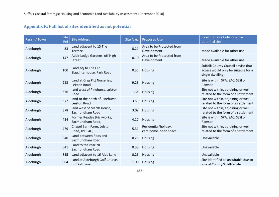
Suffolk Coastal Strategic Housing and Economic Land Availability Assessment (December 2018)
655
Appendix K: Full list of sites identified as not potential
Parish / Town Site Ref
Site Address Site Area Proposed Use Reason site not identified as potential site
Aldeburgh 83 Land adjacent to 15 The Terrace
0.21 Area to be Protected from Development Made available for other use
Aldeburgh 147 Adair Lodge Gardens, off High Street
0.10 Area to be Protected from Development Made available for other use
Aldeburgh 100 Land adj to The Old Slaughterhouse, Park Road
0.35 Housing Suffolk County Council advise that access would only be suitable for a single dwelling.
Aldeburgh 223 Land at Crag Pitt Nurseries, Leiston Road
9.23 Housing Site is within SPA, SAC, SSSI or Ramsar
Aldeburgh 376 land west of Pinehurst, Leiston Road
1.34 Housing Site not within, adjoining or well related to the form of a settlement
Aldeburgh 377 land to the north of Pinehurst, Leiston Road
3.53 Housing Site not within, adjoining or well related to the form of a settlement
Aldeburgh 378 land west of Marsh House, Saxmundham Road
3.09 Housing Site not within, adjoining or well related to the form of a settlement
Aldeburgh 414 Former Reades Brickworks, Saxmundham Road,
4.27 Housing Site is within SPA, SAC, SSSI or Ramsar
Aldeburgh 479 Chapel Barn Farm, Leiston Road, IP15 4QE
5.31 Residential/holiday, care home, open space
Site not within, adjoining or well related to the form of a settlement
Aldeburgh 640 Land between Roos and Saxmundham Road
0.25 Housing Unavailable
Aldeburgh 641 Land to the rear 70 Saxmundham Road
0.38 Housing Unavailable
Aldeburgh 815 Land adjacent to 16 Alde Lane 0.26 Housing Unavailable
Aldeburgh 904 Land at Aldeburgh Golf Course, off Golf Lane
1.00 Housing Site identified as unsuitable due to loss of County Wildlife Site.
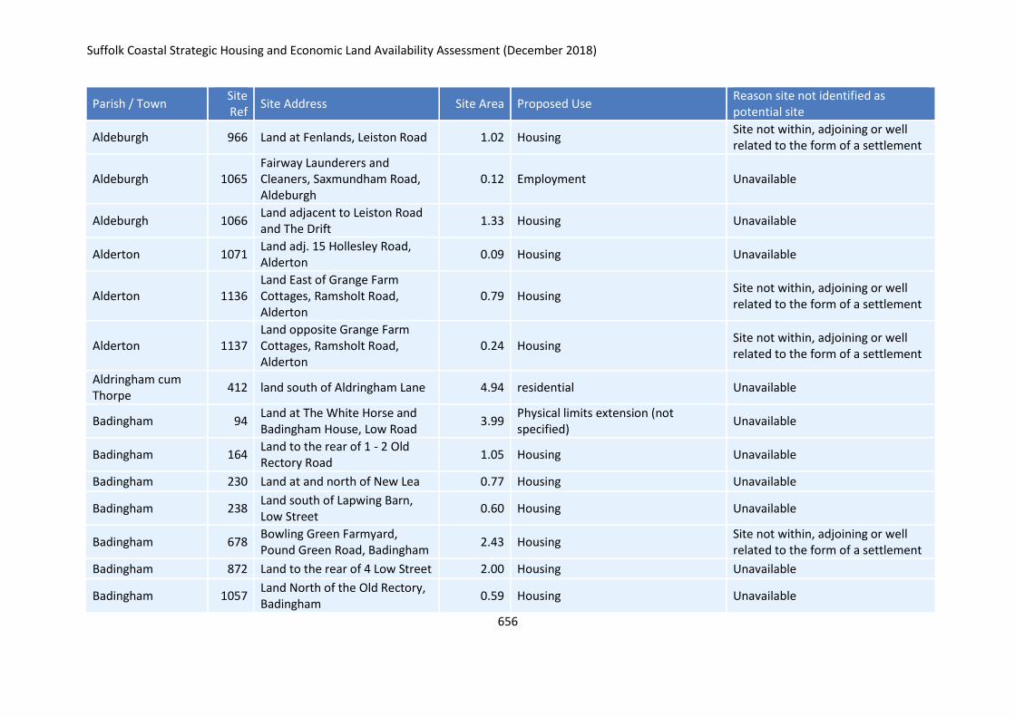
Suffolk Coastal Strategic Housing and Economic Land Availability Assessment (December 2018)
656
Parish / Town Site Ref
Site Address Site Area Proposed Use Reason site not identified as potential site
Aldeburgh 966 Land at Fenlands, Leiston Road 1.02 Housing Site not within, adjoining or well related to the form of a settlement
Aldeburgh 1065 Fairway Launderers and Cleaners, Saxmundham Road, Aldeburgh
0.12 Employment Unavailable
Aldeburgh 1066 Land adjacent to Leiston Road and The Drift
1.33 Housing Unavailable
Alderton 1071 Land adj. 15 Hollesley Road, Alderton
0.09 Housing Unavailable
Alderton 1136 Land East of Grange Farm Cottages, Ramsholt Road, Alderton
0.79 Housing Site not within, adjoining or well related to the form of a settlement
Alderton 1137 Land opposite Grange Farm Cottages, Ramsholt Road, Alderton
0.24 Housing Site not within, adjoining or well related to the form of a settlement
Aldringham cum Thorpe
412 land south of Aldringham Lane 4.94 residential Unavailable
Badingham 94 Land at The White Horse and Badingham House, Low Road
3.99 Physical limits extension (not specified)
Unavailable
Badingham 164 Land to the rear of 1 - 2 Old Rectory Road
1.05 Housing Unavailable
Badingham 230 Land at and north of New Lea 0.77 Housing Unavailable
Badingham 238 Land south of Lapwing Barn, Low Street
0.60 Housing Unavailable
Badingham 678 Bowling Green Farmyard, Pound Green Road, Badingham
2.43 Housing Site not within, adjoining or well related to the form of a settlement
Badingham 872 Land to the rear of 4 Low Street 2.00 Housing Unavailable
Badingham 1057 Land North of the Old Rectory, Badingham
0.59 Housing Unavailable
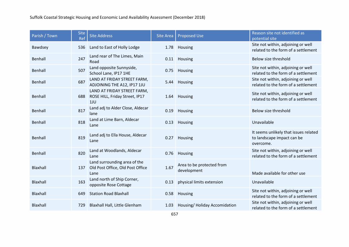
Suffolk Coastal Strategic Housing and Economic Land Availability Assessment (December 2018)
657
Parish / Town Site Ref
Site Address Site Area Proposed Use Reason site not identified as potential site
Bawdsey 536 Land to East of Holly Lodge 1.78 Housing Site not within, adjoining or well related to the form of a settlement
Benhall 247 Land rear of The Limes, Main Road
0.11 Housing Below size threshold
Benhall 507 Land opposite Sunnyside, School Lane, IP17 1HE
0.75 Housing Site not within, adjoining or well related to the form of a settlement
Benhall 687 LAND AT FRIDAY STREET FARM, ADJOINING THE A12, IP17 1JU
5.44 Housing Site not within, adjoining or well related to the form of a settlement
Benhall 688 LAND AT FRIDAY STREET FARM, ROSE HILL, Friday Street, IP17 1JU
1.64 Housing Site not within, adjoining or well related to the form of a settlement
Benhall 817 Land adj to Alder Close, Aldecar lane
0.19 Housing Below size threshold
Benhall 818 Land at Lime Barn, Aldecar Lane
0.13 Housing Unavailable
Benhall 819 Land adj to Ella House, Aldecar Lane
0.27 Housing It seems unlikely that issues related to landscape impact can be overcome.
Benhall 820 Land at Woodlands, Aldecar Lane
0.76 Housing Site not within, adjoining or well related to the form of a settlement
Blaxhall 137 Land surrounding area of the Old Post Office, Old Post Office Lane
1.67 Area to be protected from development
Made available for other use
Blaxhall 163 Land north of Ship Corner, opposite Rose Cottage
0.13 physical limits extension Unavailable
Blaxhall 649 Station Road Blaxhall 0.58 Housing Site not within, adjoining or well related to the form of a settlement
Blaxhall 729 Blaxhall Hall, Little Glenham 1.03 Housing/ Holiday Accomidation Site not within, adjoining or well related to the form of a settlement
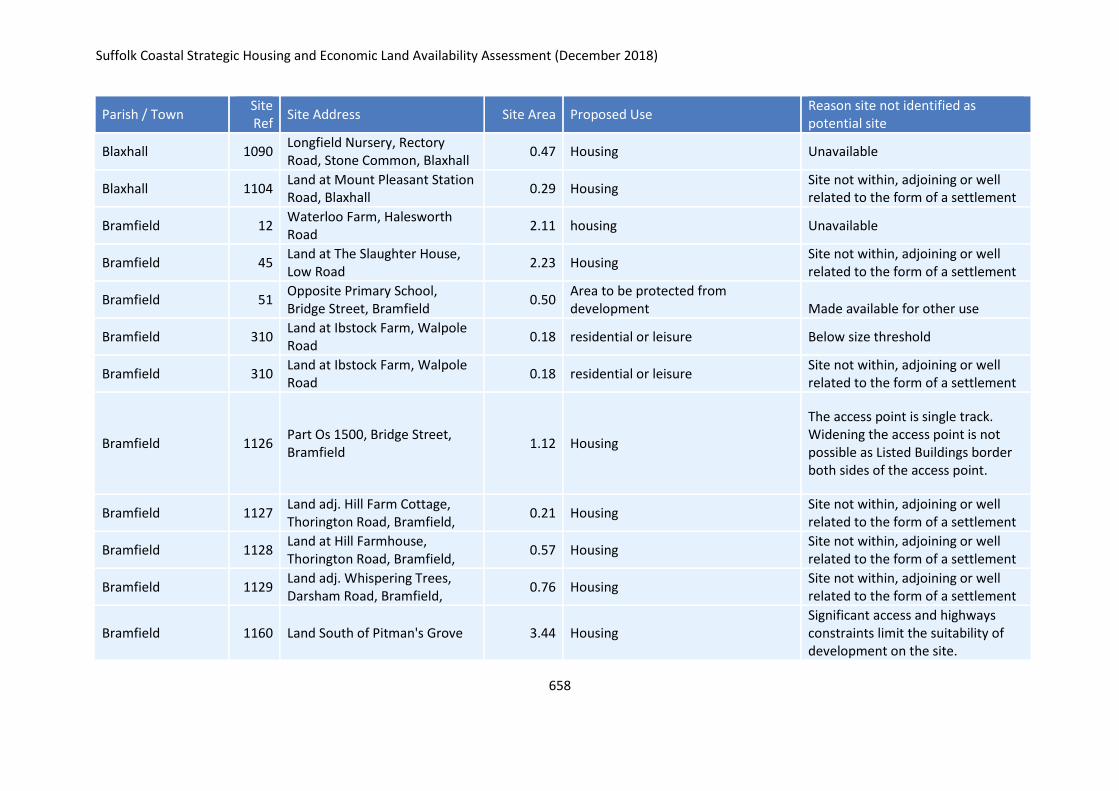
Suffolk Coastal Strategic Housing and Economic Land Availability Assessment (December 2018)
658
Parish / Town Site Ref
Site Address Site Area Proposed Use Reason site not identified as potential site
Blaxhall 1090 Longfield Nursery, Rectory Road, Stone Common, Blaxhall
0.47 Housing Unavailable
Blaxhall 1104 Land at Mount Pleasant Station Road, Blaxhall
0.29 Housing Site not within, adjoining or well related to the form of a settlement
Bramfield 12 Waterloo Farm, Halesworth Road
2.11 housing Unavailable
Bramfield 45 Land at The Slaughter House, Low Road
2.23 Housing Site not within, adjoining or well related to the form of a settlement
Bramfield 51 Opposite Primary School, Bridge Street, Bramfield
0.50 Area to be protected from development Made available for other use
Bramfield 310 Land at Ibstock Farm, Walpole Road
0.18 residential or leisure Below size threshold
Bramfield 310 Land at Ibstock Farm, Walpole Road
0.18 residential or leisure Site not within, adjoining or well related to the form of a settlement
Bramfield 1126 Part Os 1500, Bridge Street, Bramfield
1.12 Housing
The access point is single track. Widening the access point is not possible as Listed Buildings border both sides of the access point.
Bramfield 1127 Land adj. Hill Farm Cottage, Thorington Road, Bramfield,
0.21 Housing Site not within, adjoining or well related to the form of a settlement
Bramfield 1128 Land at Hill Farmhouse, Thorington Road, Bramfield,
0.57 Housing Site not within, adjoining or well related to the form of a settlement
Bramfield 1129 Land adj. Whispering Trees, Darsham Road, Bramfield,
0.76 Housing Site not within, adjoining or well related to the form of a settlement
Bramfield 1160 Land South of Pitman's Grove 3.44 Housing Significant access and highways constraints limit the suitability of development on the site.
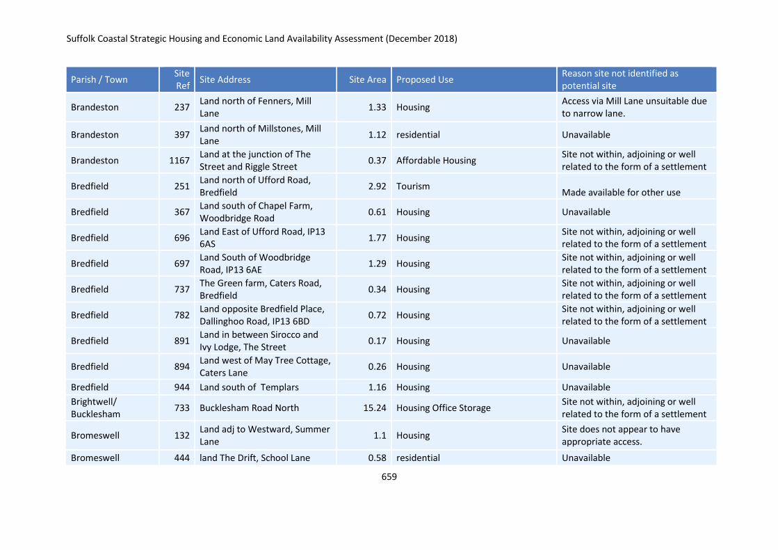
Suffolk Coastal Strategic Housing and Economic Land Availability Assessment (December 2018)
659
Parish / Town Site Ref
Site Address Site Area Proposed Use Reason site not identified as potential site
Brandeston 237 Land north of Fenners, Mill Lane
1.33 Housing Access via Mill Lane unsuitable due to narrow lane.
Brandeston 397 Land north of Millstones, Mill Lane
1.12 residential Unavailable
Brandeston 1167 Land at the junction of The Street and Riggle Street
0.37 Affordable Housing Site not within, adjoining or well related to the form of a settlement
Bredfield 251 Land north of Ufford Road, Bredfield
2.92 Tourism Made available for other use
Bredfield 367 Land south of Chapel Farm, Woodbridge Road
0.61 Housing Unavailable
Bredfield 696 Land East of Ufford Road, IP13 6AS
1.77 Housing Site not within, adjoining or well related to the form of a settlement
Bredfield 697 Land South of Woodbridge Road, IP13 6AE
1.29 Housing Site not within, adjoining or well related to the form of a settlement
Bredfield 737 The Green farm, Caters Road, Bredfield
0.34 Housing Site not within, adjoining or well related to the form of a settlement
Bredfield 782 Land opposite Bredfield Place, Dallinghoo Road, IP13 6BD
0.72 Housing Site not within, adjoining or well related to the form of a settlement
Bredfield 891 Land in between Sirocco and Ivy Lodge, The Street
0.17 Housing Unavailable
Bredfield 894 Land west of May Tree Cottage, Caters Lane
0.26 Housing Unavailable
Bredfield 944 Land south of Templars 1.16 Housing Unavailable
Brightwell/ Bucklesham
733 Bucklesham Road North 15.24 Housing Office Storage Site not within, adjoining or well related to the form of a settlement
Bromeswell 132 Land adj to Westward, Summer Lane
1.1 Housing Site does not appear to have appropriate access.
Bromeswell 444 land The Drift, School Lane 0.58 residential Unavailable
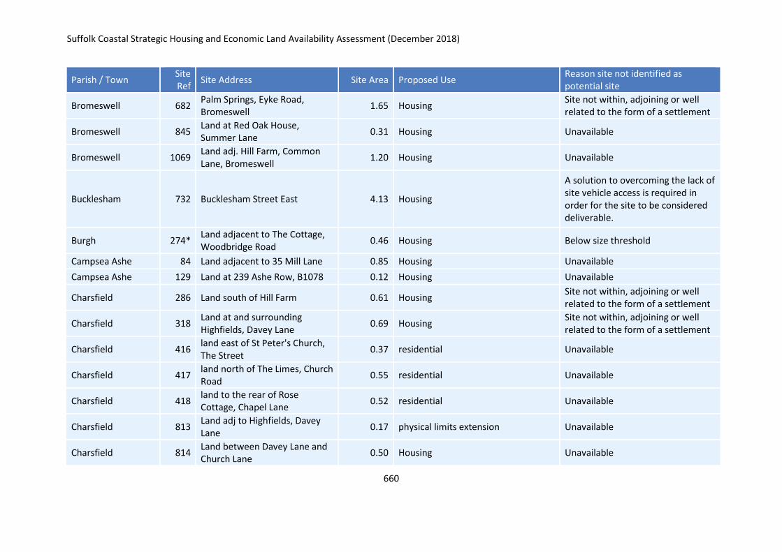
Suffolk Coastal Strategic Housing and Economic Land Availability Assessment (December 2018)
660
Parish / Town Site Ref
Site Address Site Area Proposed Use Reason site not identified as potential site
Bromeswell 682 Palm Springs, Eyke Road, Bromeswell
1.65 Housing Site not within, adjoining or well related to the form of a settlement
Bromeswell 845 Land at Red Oak House, Summer Lane
0.31 Housing Unavailable
Bromeswell 1069 Land adj. Hill Farm, Common Lane, Bromeswell
1.20 Housing Unavailable
Bucklesham 732 Bucklesham Street East 4.13 Housing
A solution to overcoming the lack of site vehicle access is required in order for the site to be considered deliverable.
Burgh 274* Land adjacent to The Cottage, Woodbridge Road
0.46 Housing Below size threshold
Campsea Ashe 84 Land adjacent to 35 Mill Lane 0.85 Housing Unavailable
Campsea Ashe 129 Land at 239 Ashe Row, B1078 0.12 Housing Unavailable
Charsfield 286 Land south of Hill Farm 0.61 Housing Site not within, adjoining or well related to the form of a settlement
Charsfield 318 Land at and surrounding Highfields, Davey Lane
0.69 Housing Site not within, adjoining or well related to the form of a settlement
Charsfield 416 land east of St Peter's Church, The Street
0.37 residential Unavailable
Charsfield 417 land north of The Limes, Church Road
0.55 residential Unavailable
Charsfield 418 land to the rear of Rose Cottage, Chapel Lane
0.52 residential Unavailable
Charsfield 813 Land adj to Highfields, Davey Lane
0.17 physical limits extension Unavailable
Charsfield 814 Land between Davey Lane and Church Lane
0.50 Housing Unavailable
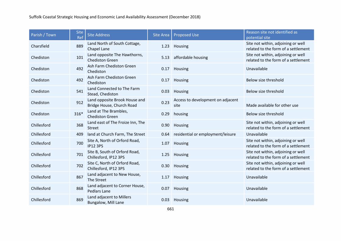
Suffolk Coastal Strategic Housing and Economic Land Availability Assessment (December 2018)
661
Parish / Town Site Ref
Site Address Site Area Proposed Use Reason site not identified as potential site
Charsfield 889 Land North of South Cottage, Chapel Lane
1.23 Housing Site not within, adjoining or well related to the form of a settlement
Chediston 101 Land opposite The Hawthorns, Chediston Green
5.13 affordable housing Site not within, adjoining or well related to the form of a settlement
Chediston 492 Ash Farm Chediston Green Chediston
0.17 Housing Unavailable
Chediston 492 Ash Farm Chediston Green Chediston
0.17 Housing Below size threshold
Chediston 541 Land Connected to The Farm Stead, Chediston
0.03 Housing Below size threshold
Chediston 912 Land opposite Brook House and Bridge House, Church Road
0.23 Access to development on adjacent site Made available for other use
Chediston 316* Land at The Brambles, Chediston Green
0.29 housing Below size threshold
Chillesford 368 Land east of The Froize Inn, The Street
0.90 Housing Site not within, adjoining or well related to the form of a settlement
Chillesford 409 land at Church Farm, The Street 0.64 residential or employment/leisure Unavailable
Chillesford 700 Site A, North of Orford Road, IP12 3PS
1.07 Housing Site not within, adjoining or well related to the form of a settlement
Chillesford 701 Site B, South of Orford Road, Chillesford, IP12 3PS
1.25 Housing Site not within, adjoining or well related to the form of a settlement
Chillesford 702 Site C, North of Orford Road, Chillesford, IP12 3PS
0.30 Housing Site not within, adjoining or well related to the form of a settlement
Chillesford 867 Land adjacent to New House, The Street
1.17 Housing Unavailable
Chillesford 868 Land adjacent to Corner House, Pedlars Lane
0.07 Housing Unavailable
Chillesford 869 Land adjacent to Millers Bungalow, Mill Lane
0.03 Housing Unavailable
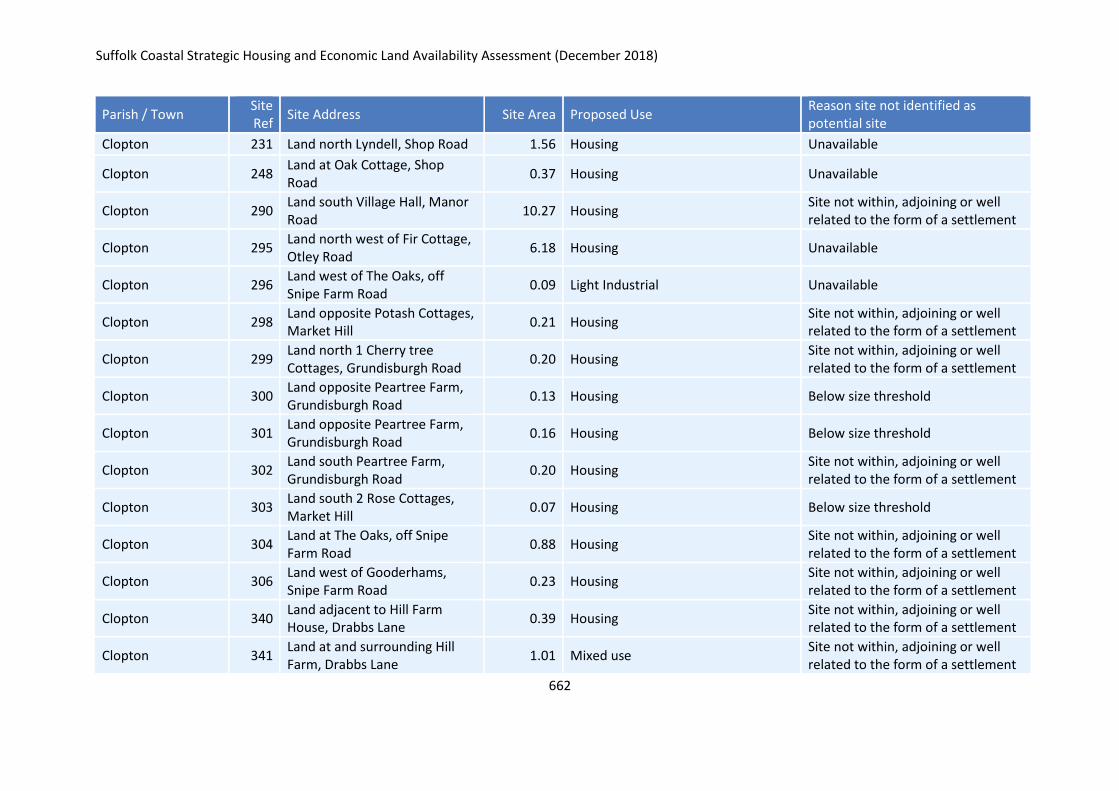
Suffolk Coastal Strategic Housing and Economic Land Availability Assessment (December 2018)
662
Parish / Town Site Ref
Site Address Site Area Proposed Use Reason site not identified as potential site
Clopton 231 Land north Lyndell, Shop Road 1.56 Housing Unavailable
Clopton 248 Land at Oak Cottage, Shop Road
0.37 Housing Unavailable
Clopton 290 Land south Village Hall, Manor Road
10.27 Housing Site not within, adjoining or well related to the form of a settlement
Clopton 295 Land north west of Fir Cottage, Otley Road
6.18 Housing Unavailable
Clopton 296 Land west of The Oaks, off Snipe Farm Road
0.09 Light Industrial Unavailable
Clopton 298 Land opposite Potash Cottages, Market Hill
0.21 Housing Site not within, adjoining or well related to the form of a settlement
Clopton 299 Land north 1 Cherry tree Cottages, Grundisburgh Road
0.20 Housing Site not within, adjoining or well related to the form of a settlement
Clopton 300 Land opposite Peartree Farm, Grundisburgh Road
0.13 Housing Below size threshold
Clopton 301 Land opposite Peartree Farm, Grundisburgh Road
0.16 Housing Below size threshold
Clopton 302 Land south Peartree Farm, Grundisburgh Road
0.20 Housing Site not within, adjoining or well related to the form of a settlement
Clopton 303 Land south 2 Rose Cottages, Market Hill
0.07 Housing Below size threshold
Clopton 304 Land at The Oaks, off Snipe Farm Road
0.88 Housing Site not within, adjoining or well related to the form of a settlement
Clopton 306 Land west of Gooderhams, Snipe Farm Road
0.23 Housing Site not within, adjoining or well related to the form of a settlement
Clopton 340 Land adjacent to Hill Farm House, Drabbs Lane
0.39 Housing Site not within, adjoining or well related to the form of a settlement
Clopton 341 Land at and surrounding Hill Farm, Drabbs Lane
1.01 Mixed use Site not within, adjoining or well related to the form of a settlement
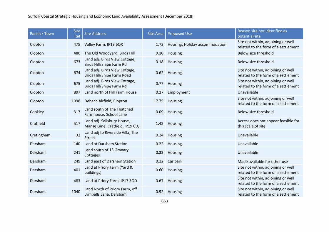
Suffolk Coastal Strategic Housing and Economic Land Availability Assessment (December 2018)
663
Parish / Town Site Ref
Site Address Site Area Proposed Use Reason site not identified as potential site
Clopton 478 Valley Farm, IP13 6QX 1.73 Housing, Holiday accommodation Site not within, adjoining or well related to the form of a settlement
Clopton 480 The Old Woodyard, Birds Hill 0.10 Housing Below size threshold
Clopton 673 Land adj. Birds View Cottage, Birds Hill/Snipe Farm Rd
0.18 Housing Below size threshold
Clopton 674 Land adj. Birds View Cottage, Birds Hill/Snipe Farm Road
0.62 Housing Site not within, adjoining or well related to the form of a settlement
Clopton 675 Land adj. Birds View Cottage, Birds Hill/Snipe Farm Rd
0.77 Housing Site not within, adjoining or well related to the form of a settlement
Clopton 897 Land north of Hill Farm House 0.27 Employment Unavailable
Clopton 1098 Debach Airfield, Clopton 17.75 Housing Site not within, adjoining or well related to the form of a settlement
Cookley 317 Land south of The Thatched Farmhouse, School Lane
0.09 Housing Below size threshold
Cratfield 517 Land adj. Salisbury House, Manse Lane, Cratfield, IP19 0DJ
1.42 Housing Access does not appear feasible for this scale of site.
Cretingham 32 Land adj to Riverside Villa, The Street
0.24 Housing Unavailable
Darsham 140 Land at Darsham Station 0.22 Housing Unavailable
Darsham 241 Land south of 13 Granary Cottages
0.33 Housing Unavailable
Darsham 249 Land east of Darsham Station 0.12 Car park Made available for other use
Darsham 401 Land at Priory Farm (Yard & buildings)
0.60 Housing Site not within, adjoining or well related to the form of a settlement
Darsham 483 Land at Priory Farm, IP17 3QD 0.67 Housing Site not within, adjoining or well related to the form of a settlement
Darsham 1040 Land North of Priory Farm, off Lymballs Lane, Darsham
0.92 Housing Site not within, adjoining or well related to the form of a settlement
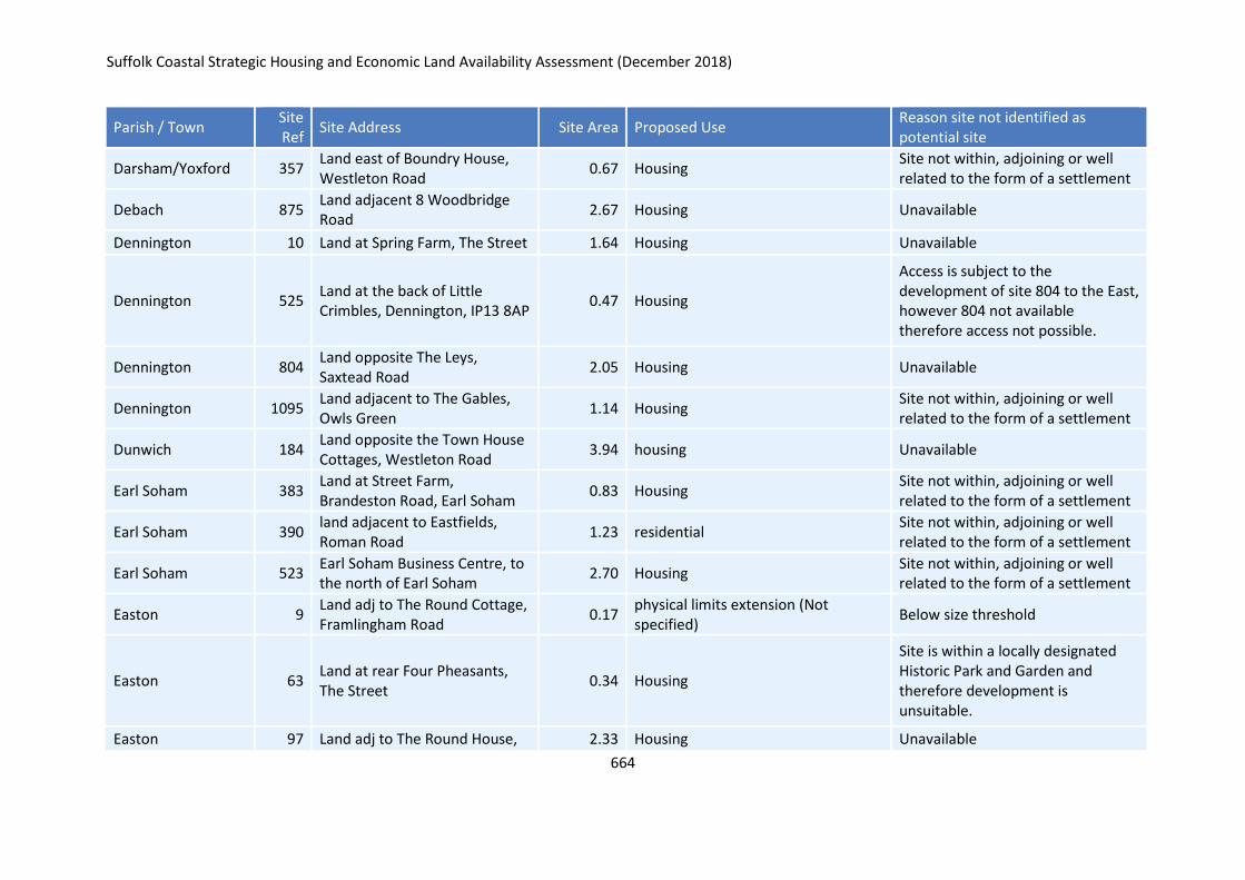
Suffolk Coastal Strategic Housing and Economic Land Availability Assessment (December 2018)
664
Parish / Town Site Ref
Site Address Site Area Proposed Use Reason site not identified as potential site
Darsham/Yoxford 357 Land east of Boundry House, Westleton Road
0.67 Housing Site not within, adjoining or well related to the form of a settlement
Debach 875 Land adjacent 8 Woodbridge Road
2.67 Housing Unavailable
Dennington 10 Land at Spring Farm, The Street 1.64 Housing Unavailable
Dennington 525 Land at the back of Little Crimbles, Dennington, IP13 8AP
0.47 Housing
Access is subject to the development of site 804 to the East, however 804 not available therefore access not possible.
Dennington 804 Land opposite The Leys, Saxtead Road
2.05 Housing Unavailable
Dennington 1095 Land adjacent to The Gables, Owls Green
1.14 Housing Site not within, adjoining or well related to the form of a settlement
Dunwich 184 Land opposite the Town House Cottages, Westleton Road
3.94 housing Unavailable
Earl Soham 383 Land at Street Farm, Brandeston Road, Earl Soham
0.83 Housing Site not within, adjoining or well related to the form of a settlement
Earl Soham 390 land adjacent to Eastfields, Roman Road
1.23 residential Site not within, adjoining or well related to the form of a settlement
Earl Soham 523 Earl Soham Business Centre, to the north of Earl Soham
2.70 Housing Site not within, adjoining or well related to the form of a settlement
Easton 9 Land adj to The Round Cottage, Framlingham Road
0.17 physical limits extension (Not specified)
Below size threshold
Easton 63 Land at rear Four Pheasants, The Street
0.34 Housing
Site is within a locally designated Historic Park and Garden and therefore development is unsuitable.
Easton 97 Land adj to The Round House, 2.33 Housing Unavailable
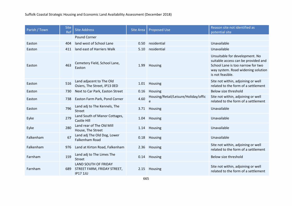
Suffolk Coastal Strategic Housing and Economic Land Availability Assessment (December 2018)
665
Parish / Town Site Ref
Site Address Site Area Proposed Use Reason site not identified as potential site
Pound Corner
Easton 404 land west of School Lane 0.50 residential Unavailable
Easton 411 land east of Harriers Walk 5.10 residential Unavailable
Easton 463 Cemetery Field, School Lane, Easton
1.99 Housing
Unsuitable for development. No suitable access can be provided and School Lane is too narrow for two way system. Road widening solution is not feasible.
Easton 516 Land adjacent to The Old Osiers, The Street, IP13 0ED
1.01 Housing Site not within, adjoining or well related to the form of a settlement
Easton 730 Next to Car Park, Easton Street 0.16 Housing Below size threshold
Easton 738 Easton Farm Park, Pond Corner 4.60 Housing/Retail/Leisure/Holiday/office
Site not within, adjoining or well related to the form of a settlement
Easton 796 Land adj to The Kennels, The Street
3.71 Housing Unavailable
Eyke 279 Land South of Manor Cottages, Castle Hill
1.04 Housing Unavailable
Eyke 280 Land rear of The Old Mill House, The Street
1.14 Housing Unavailable
Falkenham 67 Land adj The Old Dog, Lower Falkenham Road
0.18 Housing Unavailable
Falkenham 976 Land at Kirton Road, Falkenham 2.36 Housing Site not within, adjoining or well related to the form of a settlement
Farnham 159 Land adj to The Limes The Street
0.14 Housing Below size threshold
Farnham 689 LAND SOUTH OF FRIDAY STREET FARM, FRIDAY STREET, IP17 1JU
2.15 Housing Site not within, adjoining or well related to the form of a settlement
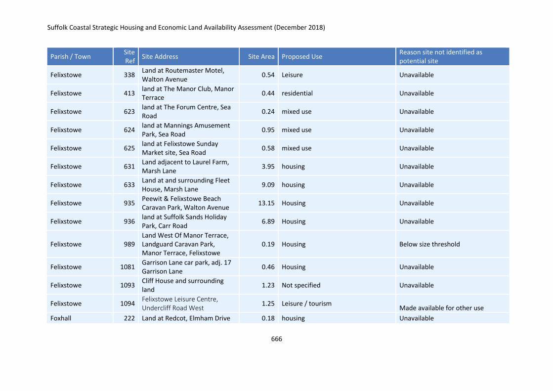
Suffolk Coastal Strategic Housing and Economic Land Availability Assessment (December 2018)
666
Parish / Town Site Ref
Site Address Site Area Proposed Use Reason site not identified as potential site
Felixstowe 338 Land at Routemaster Motel, Walton Avenue
0.54 Leisure Unavailable
Felixstowe 413 land at The Manor Club, Manor Terrace
0.44 residential Unavailable
Felixstowe 623 land at The Forum Centre, Sea Road
0.24 mixed use Unavailable
Felixstowe 624 land at Mannings Amusement Park, Sea Road
0.95 mixed use Unavailable
Felixstowe 625 land at Felixstowe Sunday Market site, Sea Road
0.58 mixed use Unavailable
Felixstowe 631 Land adjacent to Laurel Farm, Marsh Lane
3.95 housing Unavailable
Felixstowe 633 Land at and surrounding Fleet House, Marsh Lane
9.09 housing Unavailable
Felixstowe 935 Peewit & Felixstowe Beach Caravan Park, Walton Avenue
13.15 Housing Unavailable
Felixstowe 936 land at Suffolk Sands Holiday Park, Carr Road
6.89 Housing Unavailable
Felixstowe 989 Land West Of Manor Terrace, Landguard Caravan Park, Manor Terrace, Felixstowe
0.19 Housing Below size threshold
Felixstowe 1081 Garrison Lane car park, adj. 17 Garrison Lane
0.46 Housing Unavailable
Felixstowe 1093 Cliff House and surrounding land
1.23 Not specified Unavailable
Felixstowe 1094 Felixstowe Leisure Centre, Undercliff Road West
1.25 Leisure / tourism Made available for other use
Foxhall 222 Land at Redcot, Elmham Drive 0.18 housing Unavailable
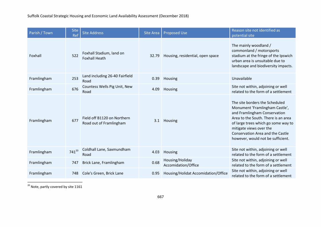
Suffolk Coastal Strategic Housing and Economic Land Availability Assessment (December 2018)
667
Parish / Town Site Ref
Site Address Site Area Proposed Use Reason site not identified as potential site
Foxhall 522 Foxhall Stadium, land on Foxhall Heath
32.79 Housing, residential, open space
The mainly woodland / commonland / motorsports stadium at the fringe of the Ipswich urban area is unsuitable due to landscape and biodiversity impacts.
Framlingham 253 Land including 26-40 Fairfield Road
0.39 Housing Unavailable
Framlingham 676 Countess Wells Pig Unit, New Road
4.09 Housing Site not within, adjoining or well related to the form of a settlement
Framlingham 677 Field off B1120 on Northern Road out of Framlingham
3.1 Housing
The site borders the Scheduled Monument 'Framlingham Castle', and Framlingham Conservation Area to the South. There is an area of large trees which go some way to mitigate views over the Conservation Area and the Castle however, would not be sufficient.
Framlingham 74120 Coldhall Lane, Saxmundham Road
4.03 Housing Site not within, adjoining or well related to the form of a settlement
Framlingham 747 Brick Lane, Framlingham 0.68 Housing/Holiday Accomidation/Office
Site not within, adjoining or well related to the form of a settlement
Framlingham 748 Cole's Green, Brick Lane 0.95 Housing/Holidat Accomidation/Office Site not within, adjoining or well related to the form of a settlement
20
Note, partly covered by site 1161
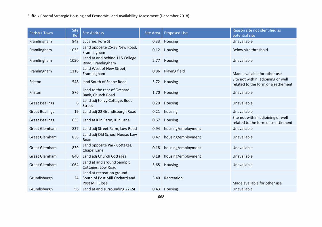
Suffolk Coastal Strategic Housing and Economic Land Availability Assessment (December 2018)
668
Parish / Town Site Ref
Site Address Site Area Proposed Use Reason site not identified as potential site
Framlingham 942 Lucarne, Fore St 0.33 Housing Unavailable
Framlingham 1033 Land opposite 25-33 New Road, Framlingham
0.12 Housing Below size threshold
Framlingham 1050 Land at and behind 115 College Road, Framlingham
2.77 Housing Unavailable
Framlingham 1118 Land West of New Street, Framlingham
0.86 Playing field Made available for other use
Friston 548 land South of Snape Road 5.72 Housing Site not within, adjoining or well related to the form of a settlement
Friston 876 Land to the rear of Orchard Bank, Church Road
1.70 Housing Unavailable
Great Bealings 6 Land adj to Ivy Cottage, Boot Street
0.20 Housing Unavailable
Great Bealings 19 Land adj 22 Grundisburgh Road 0.21 housing Unavailable
Great Bealings 635 Land at Kiln Farm, Kiln Lane 0.67 Housing Site not within, adjoining or well related to the form of a settlement
Great Glemham 837 Land adj Street Farm, Low Road 0.94 housing/employment Unavailable
Great Glemham 838 Land adj Old School House, Low Road
0.47 housing/employment Unavailable
Great Glemham 839 Land opposite Park Cottages, Chapel Lane
0.18 housing/employment Unavailable
Great Glemham 840 Land adj Church Cottages 0.18 housing/employment Unavailable
Great Glemham 1064 Land at and around Sandpit Cottages, Low Road
3.65 Housing Unavailable
Grundisburgh 24 Land at recreation ground South of Post Mill Orchard and Post Mill Close
5.40 Recreation Made available for other use
Grundisburgh 56 Land at and surrounding 22-24 0.43 Housing Unavailable
Suffolk Coastal Strategic Housing and Economic Land Availability Assessment (December 2018)
669
Parish / Town Site Ref
Site Address Site Area Proposed Use Reason site not identified as potential site
Stoney Road
Grundisburgh 57 Land at and surrounding 26 Stoney Road
0.19 Housing Unavailable
Grundisburgh 127 land between the Street and Meeting Lane
0.89 housing Unavailable
Grundisburgh 268 Land south of Half Moon Lane 10.65 Housing Unavailable
Grundisburgh 283 Land rear of The Gables, The Green, Grundisburgh, IP13 6TA
0.28 Housing Access off narrow private road.
Grundisburgh 643 The Bungalow, Meeting Lane 0.24 Housing Unavailable
Grundisburgh 786 Land between the Old Police House and Park View, Park Road
0.13 Housing Unavailable
Hacheston 207 Land opposite Hacheston Lodge, The Street
0.85 housing Site not within, adjoining or well related to the form of a settlement
Hacheston 266 Land in between 12 and 14 Main Road
0.23 Housing Site not within, adjoining or well related to the form of a settlement
Hasketon 646 Land South of Grundisburgh Road, Hasketon
2.35 Housing Site not within, adjoining or well related to the form of a settlement
Heveningham 294 Land at and surrounding Gothic Farm new House, Halesworth Road
1.57 Housing Unavailable
Hollesley 35 Land adj. to Beechview, Rectory Road
1.44 Housing Narrow road unsuitable for the scale of development.
Hollesley 264 Land at Lyndhurst, Rectory Road
0.32 Housing Unavailable
Hollesley 323 Land west of Manor Farm 5.94 Camp site Made available for other use
Hollesley 443 land east of Fourways, Alderton Road
0.37 residential Site not within, adjoining or well related to the form of a settlement
Suffolk Coastal Strategic Housing and Economic Land Availability Assessment (December 2018)
670
Parish / Town Site Ref
Site Address Site Area Proposed Use Reason site not identified as potential site
Hollesley 466 The Orchard, School lane Hollesley. (off Hollesley school drive)
1.36 Housing Access issues - school pupils use narrow road
Hollesley 917 Cliff Cottage, Fox Hill and Highfield, Fox Hill
0.36 Housing Unavailable
Hollesley 939 Orchard Cottage, Stebbings Lane
0.36 Housing Unavailable
Hollesley 1025 Land north of Stebbing's Lane, Hollesley
7.30 Housing Unavailable
Hollesley 1026 Land north of Bushey Lane, Hollesley
4.01 Housing Unavailable
Iken 149 east of hill farm, iken 0.18 housing Unavailable
Iken 150 Swallows Corner, Blacksmiths Lane
0.81 affordable housing Unavailable
Iken 151 land South East of Hill Farm 0.79 Holiday units Made available for other use
Iken 153 Land at Sandy Lane, East of 10 Sandy Lane
0.23 housing Site not within, adjoining or well related to the form of a settlement
Iken 1067 Yarn Hill, North of Hill Farm, Iken
0.90 Tourism Made available for other use
Kelsale cum Carlton 65 Land north of White Gables, Main Road
1.68 Housing
The site itself would only be considered to be well related to the settlement if considered with 239, however 239 is not available.
Kelsale Cum Carlton 105 Land adj to The Oaks, Carlton Road
0.40 Housing Unavailable
Kelsale Cum Carlton 116 Land adj to Alderlee, Main Road
0.52 Housing Unavailable
Suffolk Coastal Strategic Housing and Economic Land Availability Assessment (December 2018)
671
Parish / Town Site Ref
Site Address Site Area Proposed Use Reason site not identified as potential site
Kelsale Cum Carlton 120 Main Road 1.24 Housing Site not within, adjoining or well related to the form of a settlement
Kelsale cum Carlton 188 Land adj to Sandpit Cottage, Low Road
0.26 Housing Unavailable
Kelsale cum Carlton 239 Land north of Belvedere Close 2.00 Housing Unavailable
Kelsale cum Carlton 242 Land east Mill Farm, Rosemary Lane
0.67 Leisure Made available for other use
Kelsale Cum carlton 287 Land east of Benstead, Main Road
0.40 Housing or Holiday lets Site not within, adjoining or well related to the form of a settlement
Kelsale cum Carlton 326 Land south of Bankside, Dorleys Corner
0.30 Housing Unavailable
Kelsale cum Carlton 363 Land north of Park Farm House 0.61 Housing Unavailable
Kelsale cum Carlton 458 Land South & East Cherry Tree Cottage, Curlew Green
1.82 Housing
The site itself would only be considered to be well related to the settlement if considered with 239, however 239 is not available.
Kelsale cum Carlton 495 The Conifers, Carlton Road, Kelsale, Saxmundham, IP17 2NP
0.58 Housing Site entirely within the historic parkland.
Kelsale Cum Carlton 570 Land at Main Road, Kelsale 1.87 Housing/community use Site not within, adjoining or well related to the form of a settlement
Kelsale cum Carlton 873 Land to the rear of Home Port, Carlton Road
0.64 Housing Unavailable
Kelsale cum Carlton 1103 Glenside, Main Road, Kelsale 0.80 Housing Site not within, adjoining or well related to the form of a settlement
Kelsale cum Carlton 1117 Farm View, Curlew Green, Kelsale
0.51 Housing / holiday accommodation / employment
Site not within, adjoining or well related to the form of a settlement
Suffolk Coastal Strategic Housing and Economic Land Availability Assessment (December 2018)
672
Parish / Town Site Ref
Site Address Site Area Proposed Use Reason site not identified as potential site
Kesgrave 64 Bracken Hall, Main Road 1.15 Housing Unavailable
Kesgrave 174 land off Main Road, opposite Bracken Avenue
8.39 Housing Unavailable
Kesgrave 339 Land at and surrounding 306 Main Road
0.57 Housing Development would result in the loss of a County Wildlife Site.
Kesgrave 618 Area FF and Fentons Wood, Wilkinson Drive
3.75 Housing Part of site permitted and development of remaining area would result in loss of open space.
Kesgrave 725 Land to the north of the Tesco Store, Ropes Drive, Kesgrave, IP5 2FU
0.18 Housing Below size threshold
Kesgrave 726 Land to the south of the Tesco Store, Ropes Drive, Kesgrave, IP5 2FU
0.17 Housing Below size threshold
Kettleburgh 538 Rectory Farm, Kettleburgh 1.05 Housing Site not within, adjoining or well related to the form of a settlement
Kettleburgh 1153 Land to the West of Street Farm, The Street
0.15 Housing Below size threshold
Kirton 225 Little Acre, Church Lane 0.32 Housing Unavailable
Kirton 327 Land north of A14, east of Walk Farm
64.95 Housing with Employment Unavailable
Kirton 362 Land at Innocence Cottage, Innocence Lane
0.48 Housing Unavailable
Kirton 654 Land to the rear of 101-137 Bucklesham Road
5.41 physical limits extension Unavailable
Kirton 857 land to the rear of 31-37 Bucklesham Road
0.18 Housing Below size threshold
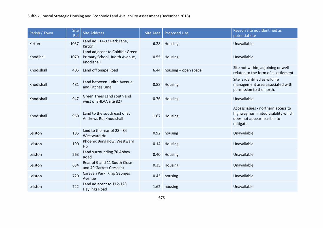
Suffolk Coastal Strategic Housing and Economic Land Availability Assessment (December 2018)
673
Parish / Town Site Ref
Site Address Site Area Proposed Use Reason site not identified as potential site
Kirton 1037 Land adj. 14-32 Park Lane, Kirton
6.28 Housing Unavailable
Knodihall 1079 Land adjacent to Coldfair Green Primary School, Judith Avenue, Knodishall
0.55 Housing Unavailable
Knodishall 405 Land off Snape Road 6.44 housing + open space Site not within, adjoining or well related to the form of a settlement
Knodishall 481 Land between Judith Avenue and Fitches Lane
0.88 Housing Site is identified as wildlife management area associated with permission to the north.
Knodishall 947 Green Trees Land south and west of SHLAA site 827
0.76 Housing Unavailable
Knodishall 960 Land to the south east of St Andrews Rd, Knodishall
1.67 Housing
Access issues - northern access to highway has limited visibility which does not appear feasible to mitigate.
Leiston 185 land to the rear of 28 - 84 Westward Ho
0.92 housing Unavailable
Leiston 190 Phoenix Bungalow, Westward Ho
0.14 Housing Unavailable
Leiston 263 Land surrounding 70 Abbey Road
0.40 Housing Unavailable
Leiston 634 Rear of 9 and 11 South Close and 49 Garrett Crescent
0.35 Housing Unavailable
Leiston 720 Caravan Park, King Georges Avenue
0.43 housing Unavailable
Leiston 722 Land adjacent to 112-128 Haylings Road
1.62 housing Unavailable
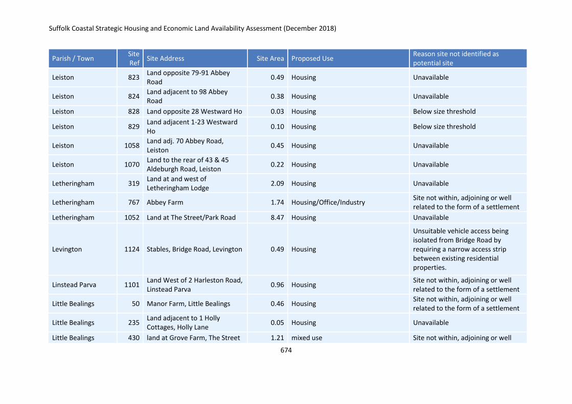
Suffolk Coastal Strategic Housing and Economic Land Availability Assessment (December 2018)
674
Parish / Town Site Ref
Site Address Site Area Proposed Use Reason site not identified as potential site
Leiston 823 Land opposite 79-91 Abbey Road
0.49 Housing Unavailable
Leiston 824 Land adjacent to 98 Abbey Road
0.38 Housing Unavailable
Leiston 828 Land opposite 28 Westward Ho 0.03 Housing Below size threshold
Leiston 829 Land adjacent 1-23 Westward Ho
0.10 Housing Below size threshold
Leiston 1058 Land adj. 70 Abbey Road, Leiston
0.45 Housing Unavailable
Leiston 1070 Land to the rear of 43 & 45 Aldeburgh Road, Leiston
0.22 Housing Unavailable
Letheringham 319 Land at and west of Letheringham Lodge
2.09 Housing Unavailable
Letheringham 767 Abbey Farm 1.74 Housing/Office/Industry Site not within, adjoining or well related to the form of a settlement
Letheringham 1052 Land at The Street/Park Road 8.47 Housing Unavailable
Levington 1124 Stables, Bridge Road, Levington 0.49 Housing
Unsuitable vehicle access being isolated from Bridge Road by requiring a narrow access strip between existing residential properties.
Linstead Parva 1101 Land West of 2 Harleston Road, Linstead Parva
0.96 Housing Site not within, adjoining or well related to the form of a settlement
Little Bealings 50 Manor Farm, Little Bealings 0.46 Housing Site not within, adjoining or well related to the form of a settlement
Little Bealings 235 Land adjacent to 1 Holly Cottages, Holly Lane
0.05 Housing Unavailable
Little Bealings 430 land at Grove Farm, The Street 1.21 mixed use Site not within, adjoining or well
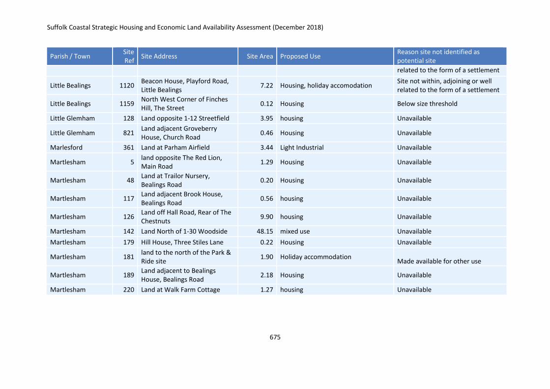
Suffolk Coastal Strategic Housing and Economic Land Availability Assessment (December 2018)
675
Parish / Town Site Ref
Site Address Site Area Proposed Use Reason site not identified as potential site
related to the form of a settlement
Little Bealings 1120 Beacon House, Playford Road, Little Bealings
7.22 Housing, holiday accomodation Site not within, adjoining or well related to the form of a settlement
Little Bealings 1159 North West Corner of Finches Hill, The Street
0.12 Housing Below size threshold
Little Glemham 128 Land opposite 1-12 Streetfield 3.95 housing Unavailable
Little Glemham 821 Land adjacent Groveberry House, Church Road
0.46 Housing Unavailable
Marlesford 361 Land at Parham Airfield 3.44 Light Industrial Unavailable
Martlesham 5 land opposite The Red Lion, Main Road
1.29 Housing Unavailable
Martlesham 48 Land at Trailor Nursery, Bealings Road
0.20 Housing Unavailable
Martlesham 117 Land adjacent Brook House, Bealings Road
0.56 housing Unavailable
Martlesham 126 Land off Hall Road, Rear of The Chestnuts
9.90 housing Unavailable
Martlesham 142 Land North of 1-30 Woodside 48.15 mixed use Unavailable
Martlesham 179 Hill House, Three Stiles Lane 0.22 Housing Unavailable
Martlesham 181 land to the north of the Park & Ride site
1.90 Holiday accommodation Made available for other use
Martlesham 189 Land adjacent to Bealings House, Bealings Road
2.18 Housing Unavailable
Martlesham 220 Land at Walk Farm Cottage 1.27 housing Unavailable

Suffolk Coastal Strategic Housing and Economic Land Availability Assessment (December 2018)
676
Parish / Town Site Ref
Site Address Site Area Proposed Use Reason site not identified as potential site
Martlesham 221 Gibraltar Farm, Private Road, Martlesham
4.49 Housing
The site itself would only be considered to be well related to the settlement if considered with sites 940, 1076, 117 and 189. However these are identified as not suitable.
Martlesham 329 Land at Collies, 3 Stiles Lane 0.32 Physical limits extension Unavailable
Martlesham 333 Land at and surrounding Woodbridge Town FC, A12
3.28 Recreation facility Made available for other use
Martlesham 344 Land immediately south of railway line, Top Street
0.96 Housing (assumed) Unavailable
Martlesham 355 Land south of The Chestnuts, Hall Road
0.73 Housing Unavailable
Martlesham 683 Land at Bealings Road 3.32 Housing Site not within, adjoining or well related to the form of a settlement
Martlesham 734 Bloomfield's Farm, Black Tiles Lane, Martlesham
0.65 Housing
The access track between the site and Black Tiles Lane could accommodate cycle and pedestrian access but not vehicular access.
Martlesham 781 Land Fronting Top Street and Sandy Lane
3.38 Residential/Care home/Office/Industry
Site not within, adjoining or well related to the form of a settlement
Martlesham 918 9-12 Felixstowe Road 0.24 Housing Unavailable
Martlesham 920 Land south of Ipswich Road 1.57 Mixed Use Unavailable
Martlesham 940 Shawfields and Little Shaws, Shaw Valley Road
0.28 Housing Unavailable
Martlesham 952 land at Bealings Road 0.89 Housing Site not within, adjoining or well

Suffolk Coastal Strategic Housing and Economic Land Availability Assessment (December 2018)
677
Parish / Town Site Ref
Site Address Site Area Proposed Use Reason site not identified as potential site
related to the form of a settlement
Martlesham 1072 Land inc. superstore, parish rooms & Beardmore Retail Park, Martlesham
11.83 District Centre Made available for other use
Martlesham 1076 land to the rear of Willow Brook House, Bealings Road
4.54 Housing Unavailable
Martlesham 1106 Land adj. Shawfields, Shaw Valley Road, Martlesham
0.43 Housing
The site does not have vehicle access and is entirely woodland so is likely to be of biodiversity interest.
Martlesham 1122
* Martlesham House, School Lane
0.41 Housing Below size threshold
Martlesham Heath 1131 Land at Eagle Way, Martlesham Heath,
0.72 Housing and car parking The developable area of the site lies in an Area to be Protected from Development.
Melton 42 The Coalyard, Wilford Bridge Road
0.31 Housing Unavailable
Melton 136 Land adjacent to 6 Deben Way 0.05 employment Below size threshold
Melton 210 land at Long Springs, Woods Lane
6.26 housing Unavailable
Melton 276 Land West of Brick Kiln Lane 2.98 Mixed Use Site is in flood zone 3b
Melton 281 Land at and surrounding Witchpit Farm
3.08 Housing and Employment Unavailable
Melton 292 Land South of Saddlemaker's Lane, Melton
1.33 Housing and Open Space Site not within, adjoining or well related to the form of a settlement
Melton 539 Land North of Woods Lane Melton Woodbridge
9.55 Housing/ Care Home/ Open Space/ Office
Site not within, adjoining or well related to the form of a settlement
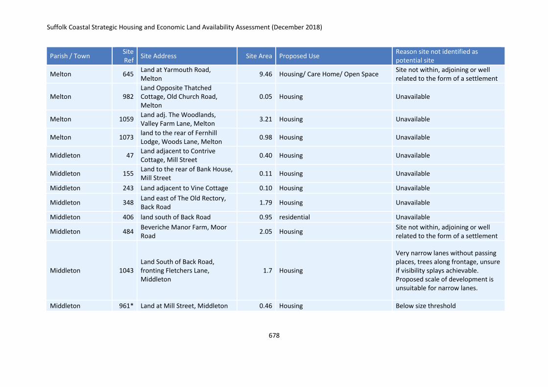
Suffolk Coastal Strategic Housing and Economic Land Availability Assessment (December 2018)
678
Parish / Town Site Ref
Site Address Site Area Proposed Use Reason site not identified as potential site
Melton 645 Land at Yarmouth Road, Melton
9.46 Housing/ Care Home/ Open Space Site not within, adjoining or well related to the form of a settlement
Melton 982 Land Opposite Thatched Cottage, Old Church Road, Melton
0.05 Housing Unavailable
Melton 1059 Land adj. The Woodlands, Valley Farm Lane, Melton
3.21 Housing Unavailable
Melton 1073 land to the rear of Fernhill Lodge, Woods Lane, Melton
0.98 Housing Unavailable
Middleton 47 Land adjacent to Contrive Cottage, Mill Street
0.40 Housing Unavailable
Middleton 155 Land to the rear of Bank House, Mill Street
0.11 Housing Unavailable
Middleton 243 Land adjacent to Vine Cottage 0.10 Housing Unavailable
Middleton 348 Land east of The Old Rectory, Back Road
1.79 Housing Unavailable
Middleton 406 land south of Back Road 0.95 residential Unavailable
Middleton 484 Beveriche Manor Farm, Moor Road
2.05 Housing Site not within, adjoining or well related to the form of a settlement
Middleton 1043 Land South of Back Road, fronting Fletchers Lane, Middleton
1.7 Housing
Very narrow lanes without passing places, trees along frontage, unsure if visibility splays achievable. Proposed scale of development is unsuitable for narrow lanes.
Middleton 961* Land at Mill Street, Middleton 0.46 Housing Below size threshold
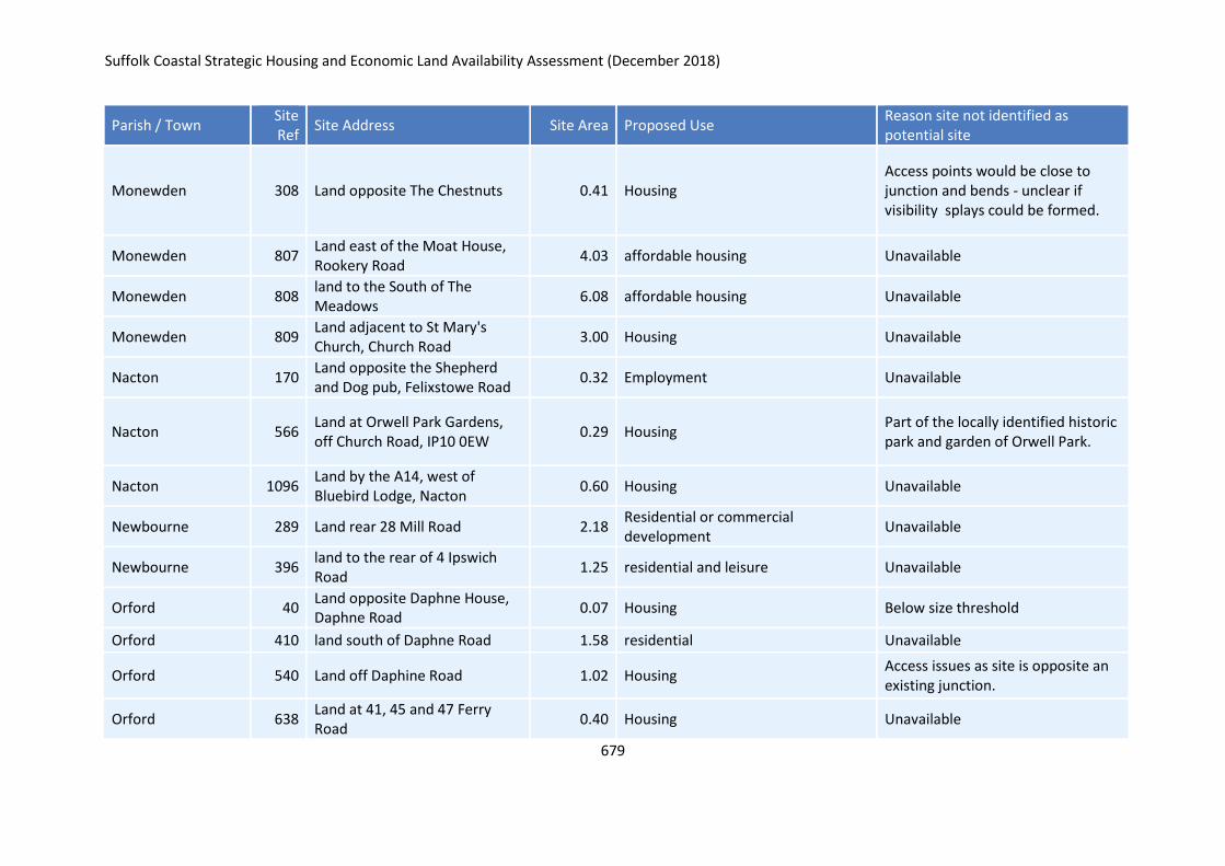
Suffolk Coastal Strategic Housing and Economic Land Availability Assessment (December 2018)
679
Parish / Town Site Ref
Site Address Site Area Proposed Use Reason site not identified as potential site
Monewden 308 Land opposite The Chestnuts 0.41 Housing Access points would be close to junction and bends - unclear if visibility splays could be formed.
Monewden 807 Land east of the Moat House, Rookery Road
4.03 affordable housing Unavailable
Monewden 808 land to the South of The Meadows
6.08 affordable housing Unavailable
Monewden 809 Land adjacent to St Mary's Church, Church Road
3.00 Housing Unavailable
Nacton 170 Land opposite the Shepherd and Dog pub, Felixstowe Road
0.32 Employment Unavailable
Nacton 566 Land at Orwell Park Gardens, off Church Road, IP10 0EW
0.29 Housing Part of the locally identified historic park and garden of Orwell Park.
Nacton 1096 Land by the A14, west of Bluebird Lodge, Nacton
0.60 Housing Unavailable
Newbourne 289 Land rear 28 Mill Road 2.18 Residential or commercial development
Unavailable
Newbourne 396 land to the rear of 4 Ipswich Road
1.25 residential and leisure Unavailable
Orford 40 Land opposite Daphne House, Daphne Road
0.07 Housing Below size threshold
Orford 410 land south of Daphne Road 1.58 residential Unavailable
Orford 540 Land off Daphine Road 1.02 Housing Access issues as site is opposite an existing junction.
Orford 638 Land at 41, 45 and 47 Ferry Road
0.40 Housing Unavailable
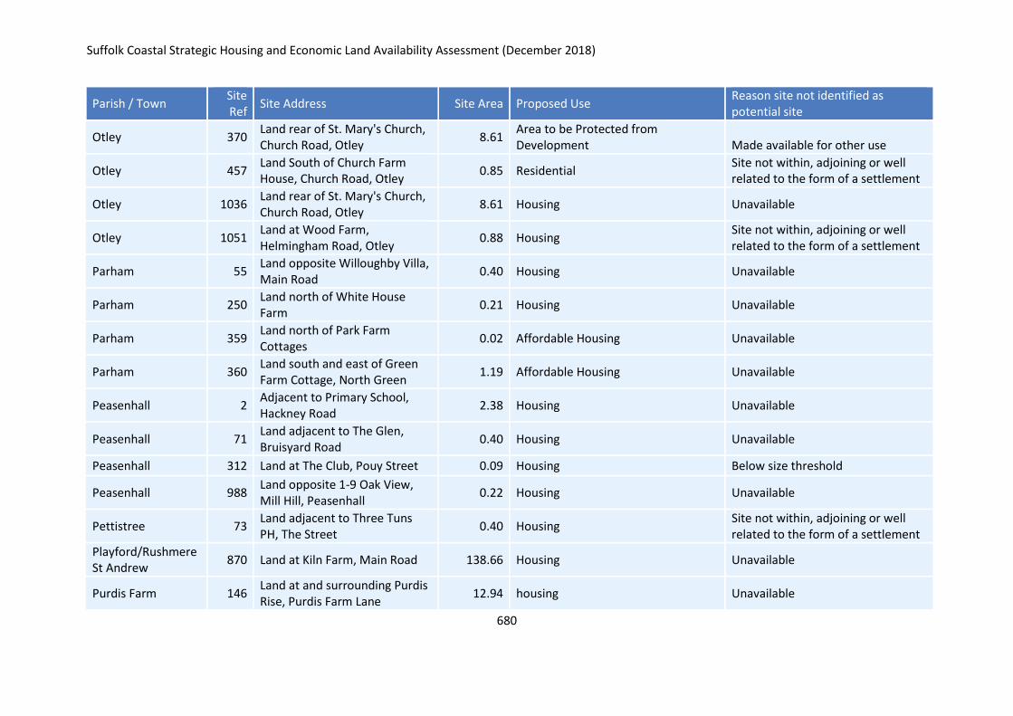
Suffolk Coastal Strategic Housing and Economic Land Availability Assessment (December 2018)
680
Parish / Town Site Ref
Site Address Site Area Proposed Use Reason site not identified as potential site
Otley 370 Land rear of St. Mary's Church, Church Road, Otley
8.61 Area to be Protected from Development Made available for other use
Otley 457 Land South of Church Farm House, Church Road, Otley
0.85 Residential Site not within, adjoining or well related to the form of a settlement
Otley 1036 Land rear of St. Mary's Church, Church Road, Otley
8.61 Housing Unavailable
Otley 1051 Land at Wood Farm, Helmingham Road, Otley
0.88 Housing Site not within, adjoining or well related to the form of a settlement
Parham 55 Land opposite Willoughby Villa, Main Road
0.40 Housing Unavailable
Parham 250 Land north of White House Farm
0.21 Housing Unavailable
Parham 359 Land north of Park Farm Cottages
0.02 Affordable Housing Unavailable
Parham 360 Land south and east of Green Farm Cottage, North Green
1.19 Affordable Housing Unavailable
Peasenhall 2 Adjacent to Primary School, Hackney Road
2.38 Housing Unavailable
Peasenhall 71 Land adjacent to The Glen, Bruisyard Road
0.40 Housing Unavailable
Peasenhall 312 Land at The Club, Pouy Street 0.09 Housing Below size threshold
Peasenhall 988 Land opposite 1-9 Oak View, Mill Hill, Peasenhall
0.22 Housing Unavailable
Pettistree 73 Land adjacent to Three Tuns PH, The Street
0.40 Housing Site not within, adjoining or well related to the form of a settlement
Playford/Rushmere St Andrew
870 Land at Kiln Farm, Main Road 138.66 Housing Unavailable
Purdis Farm 146 Land at and surrounding Purdis Rise, Purdis Farm Lane
12.94 housing Unavailable
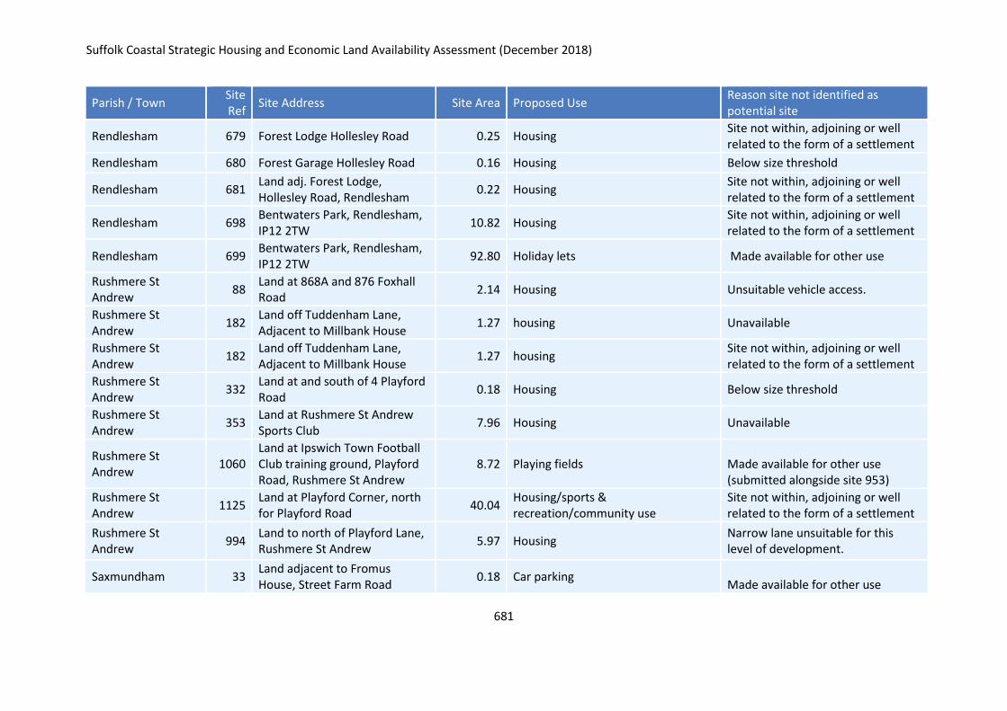
Suffolk Coastal Strategic Housing and Economic Land Availability Assessment (December 2018)
681
Parish / Town Site Ref
Site Address Site Area Proposed Use Reason site not identified as potential site
Rendlesham 679 Forest Lodge Hollesley Road 0.25 Housing Site not within, adjoining or well related to the form of a settlement
Rendlesham 680 Forest Garage Hollesley Road 0.16 Housing Below size threshold
Rendlesham 681 Land adj. Forest Lodge, Hollesley Road, Rendlesham
0.22 Housing Site not within, adjoining or well related to the form of a settlement
Rendlesham 698 Bentwaters Park, Rendlesham, IP12 2TW
10.82 Housing Site not within, adjoining or well related to the form of a settlement
Rendlesham 699 Bentwaters Park, Rendlesham, IP12 2TW
92.80 Holiday lets Made available for other use
Rushmere St Andrew
88 Land at 868A and 876 Foxhall Road
2.14 Housing Unsuitable vehicle access.
Rushmere St Andrew
182 Land off Tuddenham Lane, Adjacent to Millbank House
1.27 housing Unavailable
Rushmere St Andrew
182 Land off Tuddenham Lane, Adjacent to Millbank House
1.27 housing Site not within, adjoining or well related to the form of a settlement
Rushmere St Andrew
332 Land at and south of 4 Playford Road
0.18 Housing Below size threshold
Rushmere St Andrew
353 Land at Rushmere St Andrew Sports Club
7.96 Housing Unavailable
Rushmere St Andrew
1060 Land at Ipswich Town Football Club training ground, Playford Road, Rushmere St Andrew
8.72 Playing fields Made available for other use (submitted alongside site 953)
Rushmere St Andrew
1125 Land at Playford Corner, north for Playford Road
40.04 Housing/sports & recreation/community use
Site not within, adjoining or well related to the form of a settlement
Rushmere St Andrew
994 Land to north of Playford Lane, Rushmere St Andrew
5.97 Housing Narrow lane unsuitable for this level of development.
Saxmundham 33 Land adjacent to Fromus House, Street Farm Road
0.18 Car parking Made available for other use
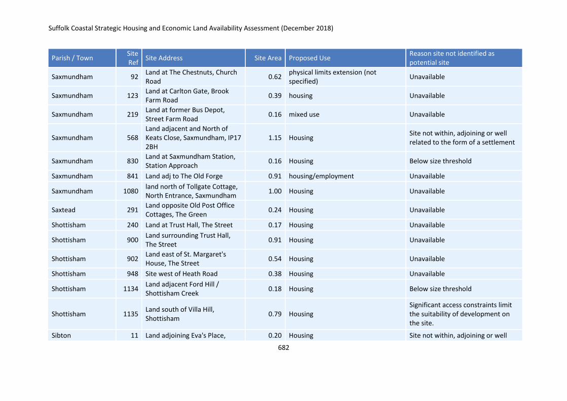
Suffolk Coastal Strategic Housing and Economic Land Availability Assessment (December 2018)
682
Parish / Town Site Ref
Site Address Site Area Proposed Use Reason site not identified as potential site
Saxmundham 92 Land at The Chestnuts, Church Road
0.62 physical limits extension (not specified)
Unavailable
Saxmundham 123 Land at Carlton Gate, Brook Farm Road
0.39 housing Unavailable
Saxmundham 219 Land at former Bus Depot, Street Farm Road
0.16 mixed use Unavailable
Saxmundham 568 Land adjacent and North of Keats Close, Saxmundham, IP17 2BH
1.15 Housing Site not within, adjoining or well related to the form of a settlement
Saxmundham 830 Land at Saxmundham Station, Station Approach
0.16 Housing Below size threshold
Saxmundham 841 Land adj to The Old Forge 0.91 housing/employment Unavailable
Saxmundham 1080 land north of Tollgate Cottage, North Entrance, Saxmundham
1.00 Housing Unavailable
Saxtead 291 Land opposite Old Post Office Cottages, The Green
0.24 Housing Unavailable
Shottisham 240 Land at Trust Hall, The Street 0.17 Housing Unavailable
Shottisham 900 Land surrounding Trust Hall, The Street
0.91 Housing Unavailable
Shottisham 902 Land east of St. Margaret's House, The Street
0.54 Housing Unavailable
Shottisham 948 Site west of Heath Road 0.38 Housing Unavailable
Shottisham 1134 Land adjacent Ford Hill / Shottisham Creek
0.18 Housing Below size threshold
Shottisham 1135 Land south of Villa Hill, Shottisham
0.79 Housing Significant access constraints limit the suitability of development on the site.
Sibton 11 Land adjoining Eva's Place, 0.20 Housing Site not within, adjoining or well
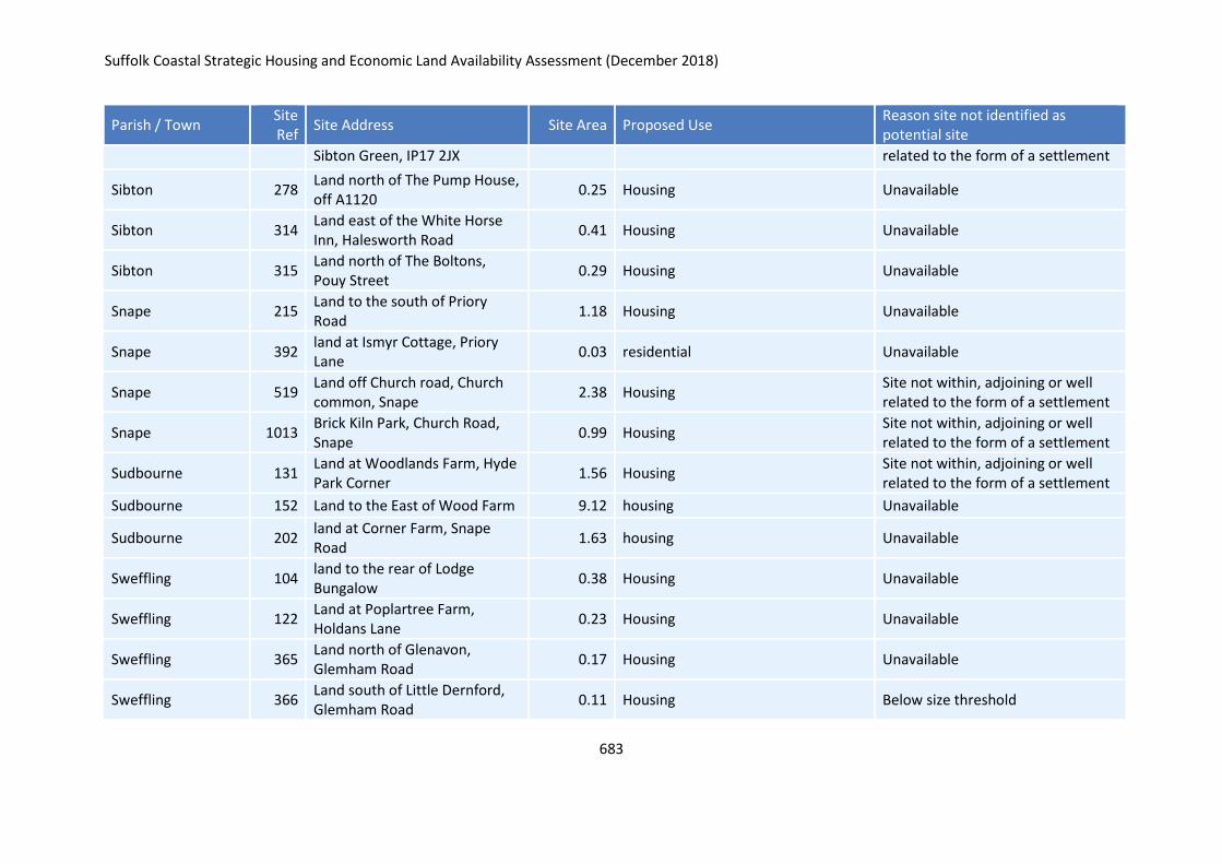
Suffolk Coastal Strategic Housing and Economic Land Availability Assessment (December 2018)
683
Parish / Town Site Ref
Site Address Site Area Proposed Use Reason site not identified as potential site
Sibton Green, IP17 2JX related to the form of a settlement
Sibton 278 Land north of The Pump House, off A1120
0.25 Housing Unavailable
Sibton 314 Land east of the White Horse Inn, Halesworth Road
0.41 Housing Unavailable
Sibton 315 Land north of The Boltons, Pouy Street
0.29 Housing Unavailable
Snape 215 Land to the south of Priory Road
1.18 Housing Unavailable
Snape 392 land at Ismyr Cottage, Priory Lane
0.03 residential Unavailable
Snape 519 Land off Church road, Church common, Snape
2.38 Housing Site not within, adjoining or well related to the form of a settlement
Snape 1013 Brick Kiln Park, Church Road, Snape
0.99 Housing Site not within, adjoining or well related to the form of a settlement
Sudbourne 131 Land at Woodlands Farm, Hyde Park Corner
1.56 Housing Site not within, adjoining or well related to the form of a settlement
Sudbourne 152 Land to the East of Wood Farm 9.12 housing Unavailable
Sudbourne 202 land at Corner Farm, Snape Road
1.63 housing Unavailable
Sweffling 104 land to the rear of Lodge Bungalow
0.38 Housing Unavailable
Sweffling 122 Land at Poplartree Farm, Holdans Lane
0.23 Housing Unavailable
Sweffling 365 Land north of Glenavon, Glemham Road
0.17 Housing Unavailable
Sweffling 366 Land south of Little Dernford, Glemham Road
0.11 Housing Below size threshold
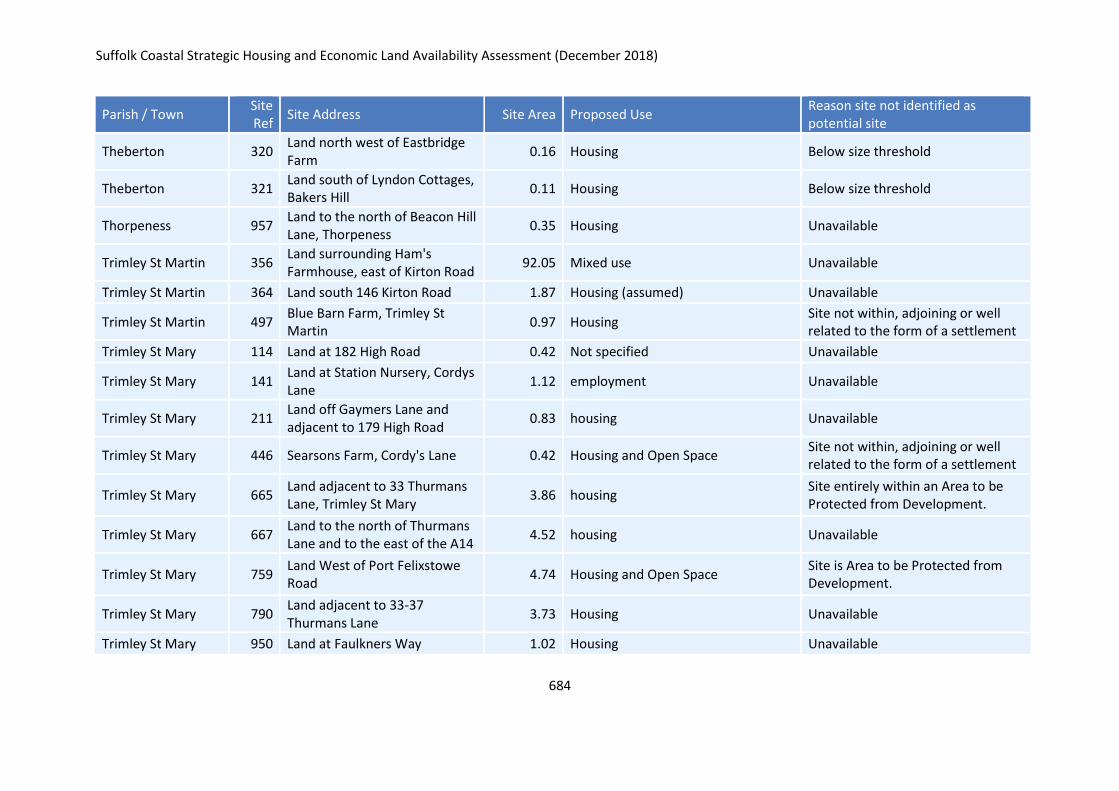
Suffolk Coastal Strategic Housing and Economic Land Availability Assessment (December 2018)
684
Parish / Town Site Ref
Site Address Site Area Proposed Use Reason site not identified as potential site
Theberton 320 Land north west of Eastbridge Farm
0.16 Housing Below size threshold
Theberton 321 Land south of Lyndon Cottages, Bakers Hill
0.11 Housing Below size threshold
Thorpeness 957 Land to the north of Beacon Hill Lane, Thorpeness
0.35 Housing Unavailable
Trimley St Martin 356 Land surrounding Ham's Farmhouse, east of Kirton Road
92.05 Mixed use Unavailable
Trimley St Martin 364 Land south 146 Kirton Road 1.87 Housing (assumed) Unavailable
Trimley St Martin 497 Blue Barn Farm, Trimley St Martin
0.97 Housing Site not within, adjoining or well related to the form of a settlement
Trimley St Mary 114 Land at 182 High Road 0.42 Not specified Unavailable
Trimley St Mary 141 Land at Station Nursery, Cordys Lane
1.12 employment Unavailable
Trimley St Mary 211 Land off Gaymers Lane and adjacent to 179 High Road
0.83 housing Unavailable
Trimley St Mary 446 Searsons Farm, Cordy's Lane 0.42 Housing and Open Space Site not within, adjoining or well related to the form of a settlement
Trimley St Mary 665 Land adjacent to 33 Thurmans Lane, Trimley St Mary
3.86 housing Site entirely within an Area to be Protected from Development.
Trimley St Mary 667 Land to the north of Thurmans Lane and to the east of the A14
4.52 housing Unavailable
Trimley St Mary 759 Land West of Port Felixstowe Road
4.74 Housing and Open Space Site is Area to be Protected from Development.
Trimley St Mary 790 Land adjacent to 33-37 Thurmans Lane
3.73 Housing Unavailable
Trimley St Mary 950 Land at Faulkners Way 1.02 Housing Unavailable
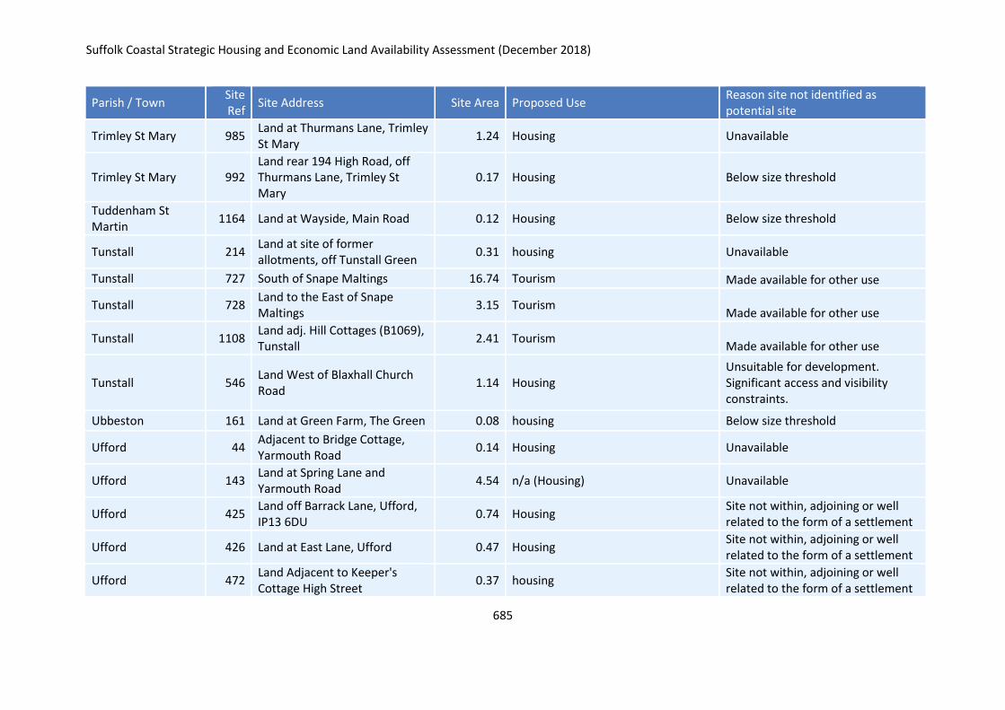
Suffolk Coastal Strategic Housing and Economic Land Availability Assessment (December 2018)
685
Parish / Town Site Ref
Site Address Site Area Proposed Use Reason site not identified as potential site
Trimley St Mary 985 Land at Thurmans Lane, Trimley St Mary
1.24 Housing Unavailable
Trimley St Mary 992 Land rear 194 High Road, off Thurmans Lane, Trimley St Mary
0.17 Housing Below size threshold
Tuddenham St Martin
1164 Land at Wayside, Main Road 0.12 Housing Below size threshold
Tunstall 214 Land at site of former allotments, off Tunstall Green
0.31 housing Unavailable
Tunstall 727 South of Snape Maltings 16.74 Tourism Made available for other use
Tunstall 728 Land to the East of Snape Maltings
3.15 Tourism Made available for other use
Tunstall 1108 Land adj. Hill Cottages (B1069), Tunstall
2.41 Tourism Made available for other use
Tunstall 546 Land West of Blaxhall Church Road
1.14 Housing Unsuitable for development. Significant access and visibility constraints.
Ubbeston 161 Land at Green Farm, The Green 0.08 housing Below size threshold
Ufford 44 Adjacent to Bridge Cottage, Yarmouth Road
0.14 Housing Unavailable
Ufford 143 Land at Spring Lane and Yarmouth Road
4.54 n/a (Housing) Unavailable
Ufford 425 Land off Barrack Lane, Ufford, IP13 6DU
0.74 Housing Site not within, adjoining or well related to the form of a settlement
Ufford 426 Land at East Lane, Ufford 0.47 Housing Site not within, adjoining or well related to the form of a settlement
Ufford 472 Land Adjacent to Keeper's Cottage High Street
0.37 housing Site not within, adjoining or well related to the form of a settlement
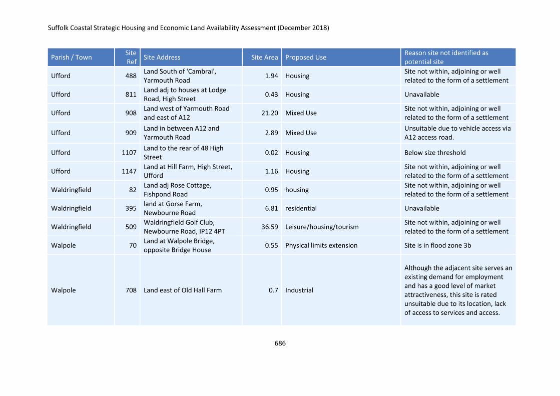
Suffolk Coastal Strategic Housing and Economic Land Availability Assessment (December 2018)
686
Parish / Town Site Ref
Site Address Site Area Proposed Use Reason site not identified as potential site
Ufford 488 Land South of 'Cambrai', Yarmouth Road
1.94 Housing Site not within, adjoining or well related to the form of a settlement
Ufford 811 Land adj to houses at Lodge Road, High Street
0.43 Housing Unavailable
Ufford 908 Land west of Yarmouth Road and east of A12
21.20 Mixed Use Site not within, adjoining or well related to the form of a settlement
Ufford 909 Land in between A12 and Yarmouth Road
2.89 Mixed Use Unsuitable due to vehicle access via A12 access road.
Ufford 1107 Land to the rear of 48 High Street
0.02 Housing Below size threshold
Ufford 1147 Land at Hill Farm, High Street, Ufford
1.16 Housing Site not within, adjoining or well related to the form of a settlement
Waldringfield 82 Land adj Rose Cottage, Fishpond Road
0.95 housing Site not within, adjoining or well related to the form of a settlement
Waldringfield 395 land at Gorse Farm, Newbourne Road
6.81 residential Unavailable
Waldringfield 509 Waldringfield Golf Club, Newbourne Road, IP12 4PT
36.59 Leisure/housing/tourism Site not within, adjoining or well related to the form of a settlement
Walpole 70 Land at Walpole Bridge, opposite Bridge House
0.55 Physical limits extension Site is in flood zone 3b
Walpole 708 Land east of Old Hall Farm 0.7 Industrial
Although the adjacent site serves an existing demand for employment and has a good level of market attractiveness, this site is rated unsuitable due to its location, lack of access to services and access.
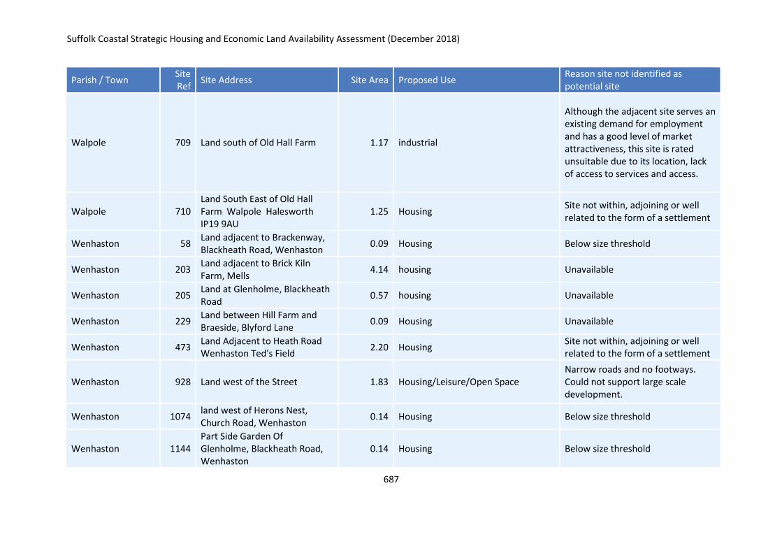
Suffolk Coastal Strategic Housing and Economic Land Availability Assessment (December 2018)
687
Parish / Town Site Ref
Site Address Site Area Proposed Use Reason site not identified as potential site
Walpole 709 Land south of Old Hall Farm 1.17 industrial
Although the adjacent site serves an existing demand for employment and has a good level of market attractiveness, this site is rated unsuitable due to its location, lack of access to services and access.
Walpole 710 Land South East of Old Hall Farm Walpole Halesworth IP19 9AU
1.25 Housing Site not within, adjoining or well related to the form of a settlement
Wenhaston 58 Land adjacent to Brackenway, Blackheath Road, Wenhaston
0.09 Housing Below size threshold
Wenhaston 203 Land adjacent to Brick Kiln Farm, Mells
4.14 housing Unavailable
Wenhaston 205 Land at Glenholme, Blackheath Road
0.57 housing Unavailable
Wenhaston 229 Land between Hill Farm and Braeside, Blyford Lane
0.09 Housing Unavailable
Wenhaston 473 Land Adjacent to Heath Road Wenhaston Ted's Field
2.20 Housing Site not within, adjoining or well related to the form of a settlement
Wenhaston 928 Land west of the Street 1.83 Housing/Leisure/Open Space Narrow roads and no footways. Could not support large scale development.
Wenhaston 1074 land west of Herons Nest, Church Road, Wenhaston
0.14 Housing Below size threshold
Wenhaston 1144 Part Side Garden Of Glenholme, Blackheath Road, Wenhaston
0.14 Housing Below size threshold
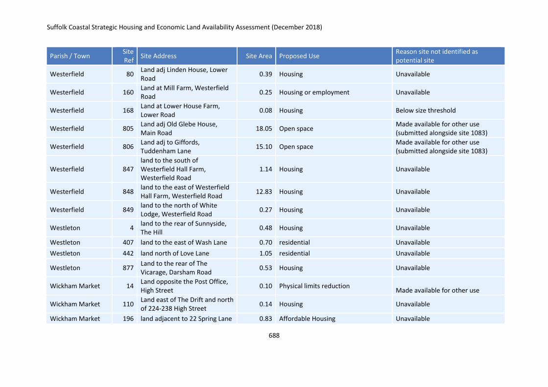
Suffolk Coastal Strategic Housing and Economic Land Availability Assessment (December 2018)
688
Parish / Town Site Ref
Site Address Site Area Proposed Use Reason site not identified as potential site
Westerfield 80 Land adj Linden House, Lower Road
0.39 Housing Unavailable
Westerfield 160 Land at Mill Farm, Westerfield Road
0.25 Housing or employment Unavailable
Westerfield 168 Land at Lower House Farm, Lower Road
0.08 Housing Below size threshold
Westerfield 805 Land adj Old Glebe House, Main Road
18.05 Open space Made available for other use (submitted alongside site 1083)
Westerfield 806 Land adj to Giffords, Tuddenham Lane
15.10 Open space Made available for other use (submitted alongside site 1083)
Westerfield 847 land to the south of Westerfield Hall Farm, Westerfield Road
1.14 Housing Unavailable
Westerfield 848 land to the east of Westerfield Hall Farm, Westerfield Road
12.83 Housing Unavailable
Westerfield 849 land to the north of White Lodge, Westerfield Road
0.27 Housing Unavailable
Westleton 4 land to the rear of Sunnyside, The Hill
0.48 Housing Unavailable
Westleton 407 land to the east of Wash Lane 0.70 residential Unavailable
Westleton 442 land north of Love Lane 1.05 residential Unavailable
Westleton 877 Land to the rear of The Vicarage, Darsham Road
0.53 Housing Unavailable
Wickham Market 14 Land opposite the Post Office, High Street
0.10 Physical limits reduction Made available for other use
Wickham Market 110 Land east of The Drift and north of 224-238 High Street
0.14 Housing Unavailable
Wickham Market 196 land adjacent to 22 Spring Lane 0.83 Affordable Housing Unavailable
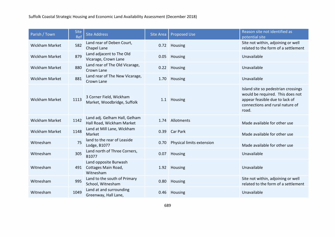
Suffolk Coastal Strategic Housing and Economic Land Availability Assessment (December 2018)
689
Parish / Town Site Ref
Site Address Site Area Proposed Use Reason site not identified as potential site
Wickham Market 582 Land rear of Deben Court, Chapel Lane
0.72 Housing Site not within, adjoining or well related to the form of a settlement
Wickham Market 879 Land adjacent to The Old Vicarage, Crown Lane
0.05 Housing Unavailable
Wickham Market 880 Land rear of The Old Vicarage, Crown Lane
0.22 Housing Unavailable
Wickham Market 881 Land rear of The New Vicarage, Crown Lane
1.70 Housing Unavailable
Wickham Market 1113 3 Corner Field, Wickham Market, Woodbridge, Suffolk
1.1 Housing
Island site so pedestrian crossings would be required. This does not appear feasible due to lack of connections and rural nature of road.
Wickham Market 1142 Land adj. Gelham Hall, Gelham Hall Road, Wickham Market
1.74 Allotments Made available for other use
Wickham Market 1148 Land at Mill Lane, Wickham Market
0.39 Car Park Made available for other use
Witnesham 75 land to the rear of Leaside Lodge, B1077
0.70 Physical limits extension Made available for other use
Witnesham 305 Land north of Three Corners, B1077
0.07 Housing Unavailable
Witnesham 491 Land opposite Burwash Cottages Main Road, Witnesham
1.92 Housing Unavailable
Witnesham 995 Land to the south of Primary School, Witnesham
0.80 Housing Site not within, adjoining or well related to the form of a settlement
Witnesham 1049 Land at and surrounding Greenway, Hall Lane,
0.46 Housing Unavailable
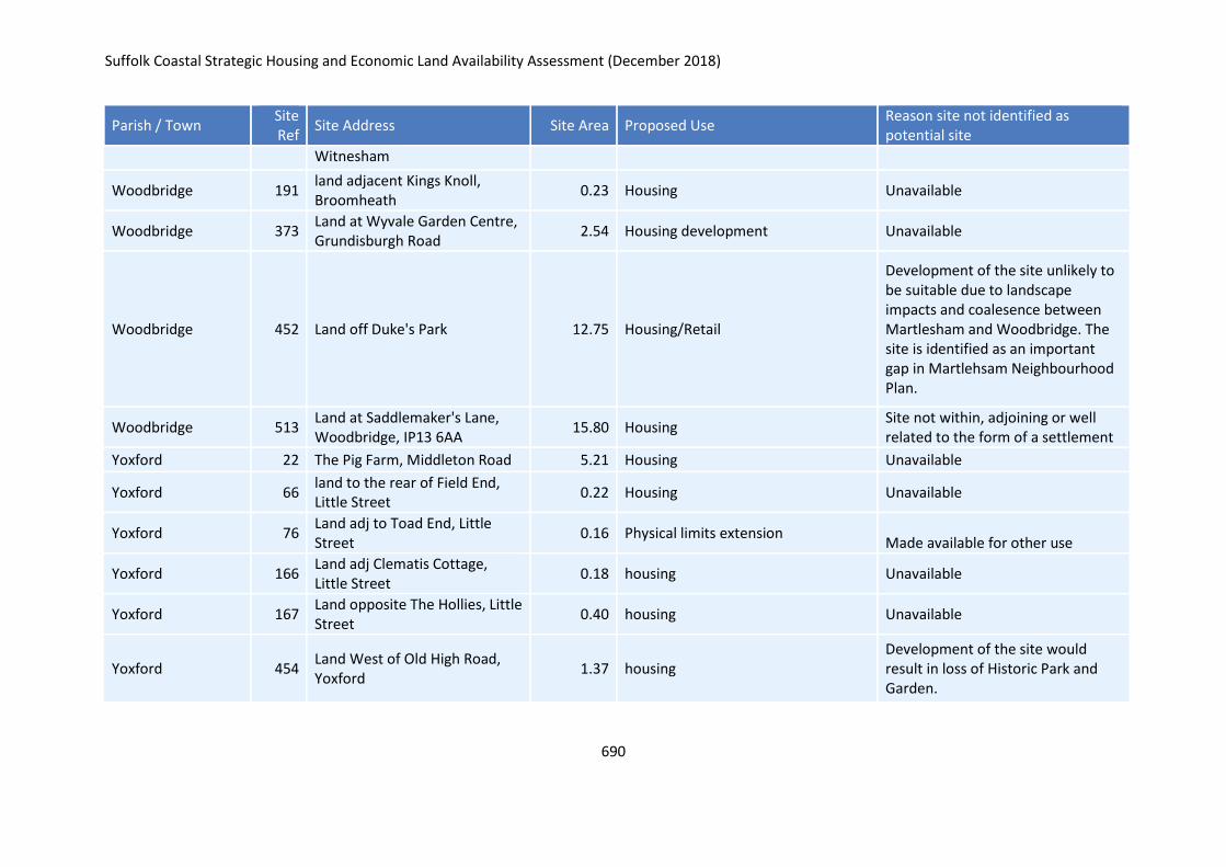
Suffolk Coastal Strategic Housing and Economic Land Availability Assessment (December 2018)
690
Parish / Town Site Ref
Site Address Site Area Proposed Use Reason site not identified as potential site
Witnesham
Woodbridge 191 land adjacent Kings Knoll, Broomheath
0.23 Housing Unavailable
Woodbridge 373 Land at Wyvale Garden Centre, Grundisburgh Road
2.54 Housing development Unavailable
Woodbridge 452 Land off Duke's Park 12.75 Housing/Retail
Development of the site unlikely to be suitable due to landscape impacts and coalesence between Martlesham and Woodbridge. The site is identified as an important gap in Martlehsam Neighbourhood Plan.
Woodbridge 513 Land at Saddlemaker's Lane, Woodbridge, IP13 6AA
15.80 Housing Site not within, adjoining or well related to the form of a settlement
Yoxford 22 The Pig Farm, Middleton Road 5.21 Housing Unavailable
Yoxford 66 land to the rear of Field End, Little Street
0.22 Housing Unavailable
Yoxford 76 Land adj to Toad End, Little Street
0.16 Physical limits extension Made available for other use
Yoxford 166 Land adj Clematis Cottage, Little Street
0.18 housing Unavailable
Yoxford 167 Land opposite The Hollies, Little Street
0.40 housing Unavailable
Yoxford 454 Land West of Old High Road, Yoxford
1.37 housing Development of the site would result in loss of Historic Park and Garden.
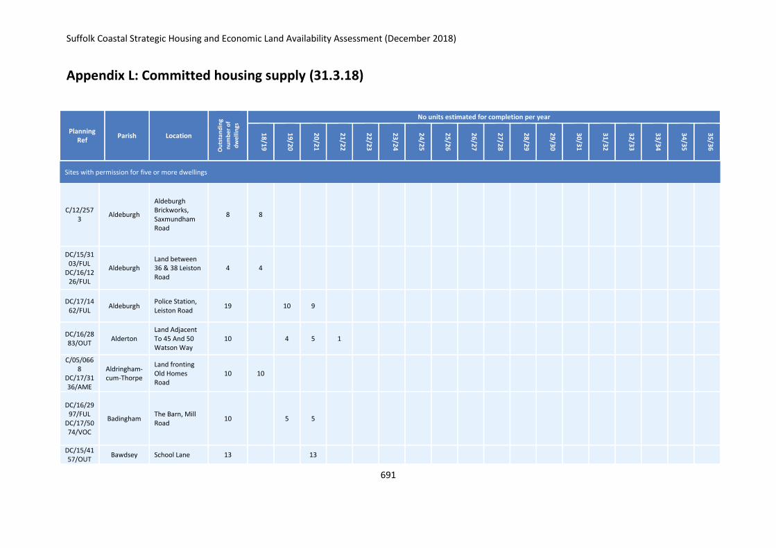
Suffolk Coastal Strategic Housing and Economic Land Availability Assessment (December 2018)
691
Appendix L: Committed housing supply (31.3.18)
Planning Ref
Parish Location
Ou
tsta
nd
ing
nu
mb
er o
f
dw
elli
ngs
No units estimated for completion per year
18
/19
19
/20
20
/21
21
/22
22
/23
23
/24
24
/25
25
/26
26
/27
27
/28
28
/29
29
/30
30
/31
31
/32
32
/33
33
/34
34
/35
35
/36
Sites with permission for five or more dwellings
C/12/2573
Aldeburgh
Aldeburgh Brickworks, Saxmundham Road
8 8
DC/15/3103/FUL
DC/16/1226/FUL
Aldeburgh Land between 36 & 38 Leiston Road
4 4
DC/17/1462/FUL
Aldeburgh Police Station, Leiston Road
19 10 9
DC/16/2883/OUT
Alderton Land Adjacent To 45 And 50 Watson Way
10 4 5 1
C/05/0668
DC/17/3136/AME
Aldringham-cum-Thorpe
Land fronting Old Homes Road
10 10
DC/16/2997/FUL
DC/17/5074/VOC
Badingham The Barn, Mill Road
10 5 5
DC/15/4157/OUT
Bawdsey School Lane 13 13
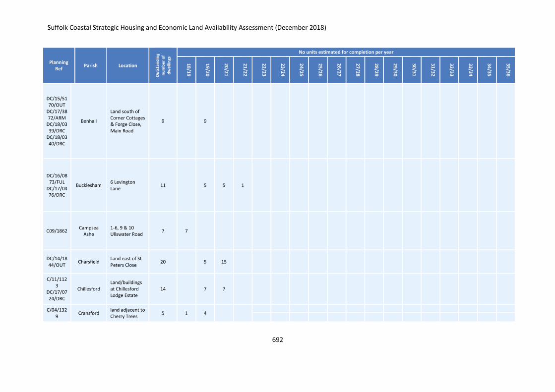
Suffolk Coastal Strategic Housing and Economic Land Availability Assessment (December 2018)
692
Planning Ref
Parish Location
Ou
tsta
nd
ing
nu
mb
er o
f
dw
elli
ngs
No units estimated for completion per year
18
/19
19
/20
20
/21
21
/22
22
/23
23
/24
24
/25
25
/26
26
/27
27
/28
28
/29
29
/30
30
/31
31
/32
32
/33
33
/34
34
/35
35
/36
DC/15/5170/OUT
DC/17/3872/ARM
DC/18/0339/DRC
DC/18/0340/DRC
Benhall
Land south of Corner Cottages & Forge Close, Main Road
9 9
DC/16/0873/FUL
DC/17/0476/DRC
Bucklesham 6 Levington Lane
11 5 5 1
C09/1862 Campsea
Ashe 1-6, 9 & 10 Ullswater Road
7 7
DC/14/1844/OUT
Charsfield Land east of St Peters Close
20 5 15
C/11/1123
DC/17/0724/DRC
Chillesford Land/buildings at Chillesford Lodge Estate
14 7 7
C/04/1329
Cransford land adjacent to Cherry Trees
5 1 4
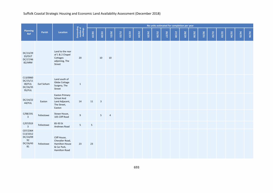
Suffolk Coastal Strategic Housing and Economic Land Availability Assessment (December 2018)
693
Planning Ref
Parish Location
Ou
tsta
nd
ing
nu
mb
er o
f
dw
elli
ngs
No units estimated for completion per year
18
/19
19
/20
20
/21
21
/22
22
/23
23
/24
24
/25
25
/26
26
/27
27
/28
28
/29
29
/30
30
/31
31
/32
32
/33
33
/34
34
/35
35
/36
DC/13/2933/OUT
DC/17/4682/ARM
Land to the rear of 1 & 2 Chapel Cottages adjoining, The Street
20 10 10
C13/0060 DC/15/11
00/FUL DC/16/35
95/FUL
Earl Soham
Land south of Glebe Cottage Surgery, The Street
1
DC/14/2244/FUL
Easton
Easton Primary School And Land Adjacent, The Street, Easton
14 11 3
C/08/1913
Felixstowe Stowe House, 105 Cliff Road
9 5 4
C/07/0193
Felixstowe 85-93 St Andrews Road
5 5
C07/2364 C13/1012 DC/14/09
92 DC/16/43
81 Felixstowe
Cliff House, Chevalier Road, Hamilton House & Car Park, Hamilton Road
23 23
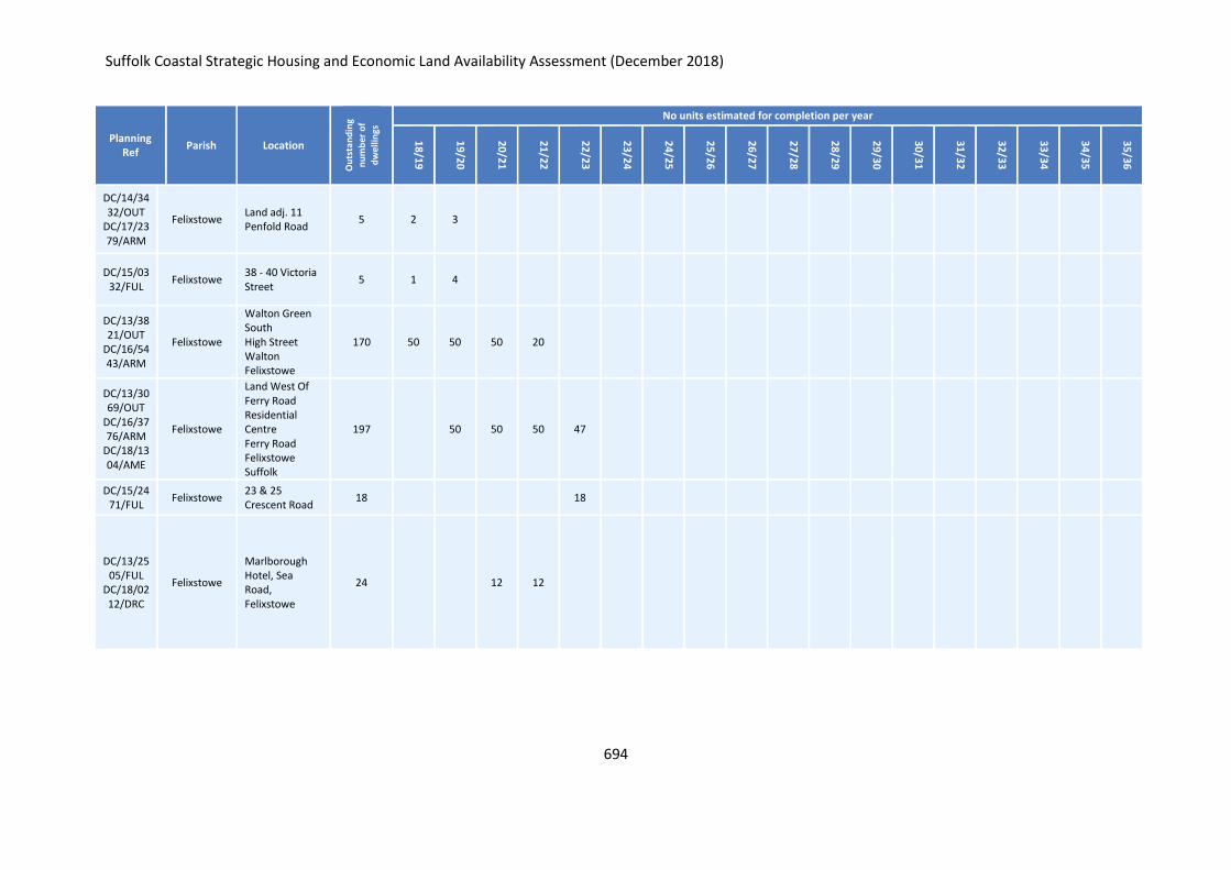
Suffolk Coastal Strategic Housing and Economic Land Availability Assessment (December 2018)
694
Planning Ref
Parish Location
Ou
tsta
nd
ing
nu
mb
er o
f
dw
elli
ngs
No units estimated for completion per year
18
/19
19
/20
20
/21
21
/22
22
/23
23
/24
24
/25
25
/26
26
/27
27
/28
28
/29
29
/30
30
/31
31
/32
32
/33
33
/34
34
/35
35
/36
DC/14/3432/OUT
DC/17/2379/ARM
Felixstowe Land adj. 11 Penfold Road
5 2 3
DC/15/0332/FUL
Felixstowe 38 - 40 Victoria Street
5 1 4
DC/13/3821/OUT
DC/16/5443/ARM
Felixstowe
Walton Green South High Street Walton Felixstowe
170 50 50 50 20
DC/13/3069/OUT
DC/16/3776/ARM
DC/18/1304/AME
Felixstowe
Land West Of Ferry Road Residential Centre Ferry Road Felixstowe Suffolk
197 50 50 50 47
DC/15/2471/FUL
Felixstowe 23 & 25 Crescent Road
18 18
DC/13/2505/FUL
DC/18/0212/DRC
Felixstowe
Marlborough Hotel, Sea Road, Felixstowe
24 12 12
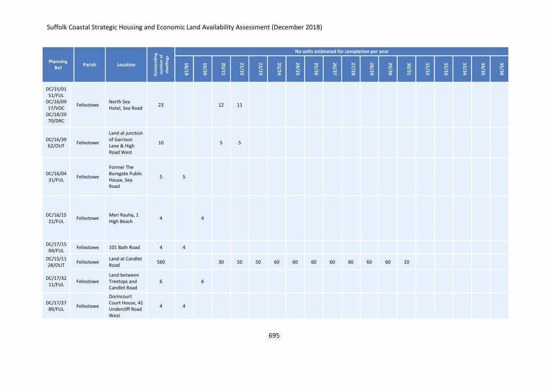
Suffolk Coastal Strategic Housing and Economic Land Availability Assessment (December 2018)
695
Planning Ref
Parish Location
Ou
tsta
nd
ing
nu
mb
er o
f
dw
elli
ngs
No units estimated for completion per year
18
/19
19
/20
20
/21
21
/22
22
/23
23
/24
24
/25
25
/26
26
/27
27
/28
28
/29
29
/30
30
/31
31
/32
32
/33
33
/34
34
/35
35
/36
DC/15/0151/FUL
DC/16/0917/VOC
DC/18/2070/DRC
Felixstowe North Sea Hotel, Sea Road
23 12 11
DC/16/3962/OUT
Felixstowe
Land at junction of Garrison Lane & High Road West
10 5 5
DC/16/0431/FUL
Felixstowe
Former The Buregate Public House, Sea Road
5 5
DC/16/1521/FUL
Felixstowe Meri Rauha, 1 High Beach
4 4
DC/17/1504/FUL
Felixstowe 101 Bath Road 4 4
DC/15/1128/OUT
Felixstowe Land at Candlet Road
560 30 50 50 60 60 60 60 60 60 60 10
DC/17/3211/FUL
Felixstowe Land between Treetops and Candlet Road
6 6
DC/17/2789/FUL
Felixstowe
Dorincourt Court House, 41 Undercliff Road West
4 4
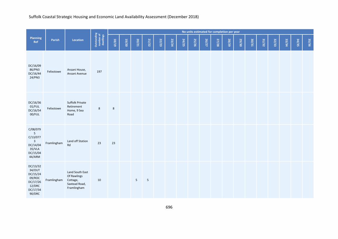
Suffolk Coastal Strategic Housing and Economic Land Availability Assessment (December 2018)
696
Planning Ref
Parish Location
Ou
tsta
nd
ing
nu
mb
er o
f
dw
elli
ngs
No units estimated for completion per year
18
/19
19
/20
20
/21
21
/22
22
/23
23
/24
24
/25
25
/26
26
/27
27
/28
28
/29
29
/30
30
/31
31
/32
32
/33
33
/34
34
/35
35
/36
DC/16/0986/PN3
DC/16/4424/PN3
Felixstowe Anzani House, Anzani Avenue
197
DC/16/3601/FUL
DC/16/5400/FUL
Felixstowe
Suffolk Private Retirement Home, 9 Sea Road
8 8
C/08/0795
C/13/0773
DC/14/0435/VLA
DC/15/0444/ARM
Framlingham Land off Station Rd
23 23
DC/13/3234/OUT
DC/15/2409/ROC
DC/17/2612/DRC
DC/17/3490/DRC
Framlingham
Land South East Of Rawlings Cottage, Saxtead Road, Framlingham
10 5 5
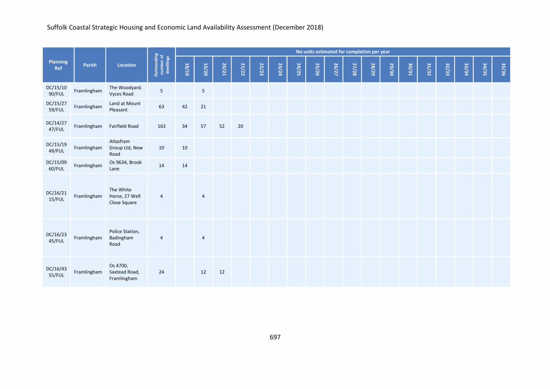
Suffolk Coastal Strategic Housing and Economic Land Availability Assessment (December 2018)
697
Planning Ref
Parish Location
Ou
tsta
nd
ing
nu
mb
er o
f
dw
elli
ngs
No units estimated for completion per year
18
/19
19
/20
20
/21
21
/22
22
/23
23
/24
24
/25
25
/26
26
/27
27
/28
28
/29
29
/30
30
/31
31
/32
32
/33
33
/34
34
/35
35
/36
DC/15/1090/FUL
Framlingham The Woodyard. Vyces Road
5 5
DC/15/2759/FUL
Framlingham Land at Mount Pleasant
63 42 21
DC/14/2747/FUL
Framlingham Fairfield Road 163 34 57 52 20
DC/15/1949/FUL
Framlingham Atlasfram Group Ltd, New Road
10 10
DC/15/0960/FUL
Framlingham Os 9634, Brook Lane
14 14
DC/16/2115/FUL
Framlingham The White Horse, 27 Well Close Square
4 4
DC/16/2345/FUL
Framlingham Police Station, Badingham Road
4 4
DC/16/4355/FUL
Framlingham Os 4700, Saxtead Road, Framlingham
24 12 12
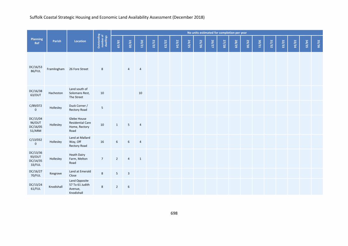
Suffolk Coastal Strategic Housing and Economic Land Availability Assessment (December 2018)
698
Planning Ref
Parish Location
Ou
tsta
nd
ing
nu
mb
er o
f
dw
elli
ngs
No units estimated for completion per year
18
/19
19
/20
20
/21
21
/22
22
/23
23
/24
24
/25
25
/26
26
/27
27
/28
28
/29
29
/30
30
/31
31
/32
32
/33
33
/34
34
/35
35
/36
DC/16/5386/FUL
Framlingham 26 Fore Street 8 4 4
DC/16/3863/OUT
Hacheston Land south of Solomans Rest, The Street
10 10
C/89/0720
Hollesley Duck Corner / Rectory Road
5
DC/15/0496/OUT
DC/16/0551/ARM
Hollesley
Glebe House Residential Care Home, Rectory Road
10 1 5 4
C/13/0320
Hollesley Land at Mallard Way, Off Rectory Road
16 6 6 4
DC/13/3693/OUT
DC/14/3533/FUL
Hollesley Heath Dairy Farm, Melton Road
7 2 4 1
DC/16/2770/FUL
Kesgrave Land at Emerald Close
8 5 3
DC/13/2461/FUL
Knodishall
Land Opposite 57 To 61 Judith Avenue, Knodishall
8 2 6
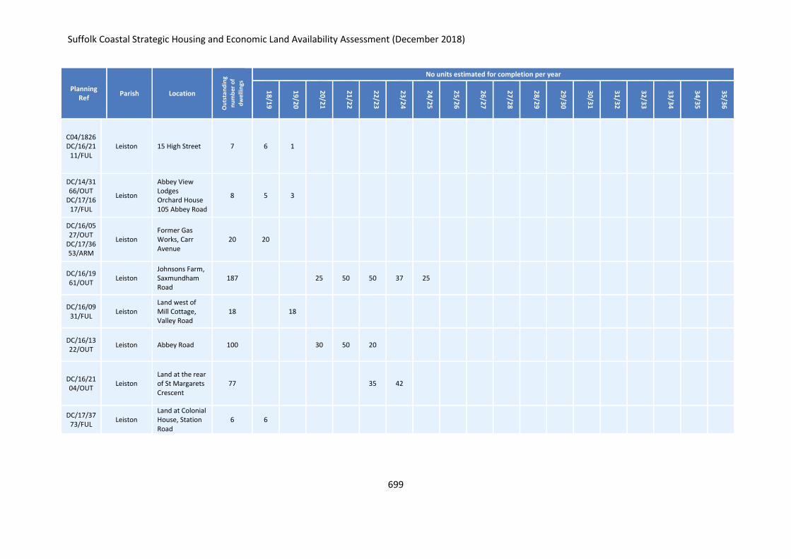
Suffolk Coastal Strategic Housing and Economic Land Availability Assessment (December 2018)
699
Planning Ref
Parish Location
Ou
tsta
nd
ing
nu
mb
er o
f
dw
elli
ngs
No units estimated for completion per year
18
/19
19
/20
20
/21
21
/22
22
/23
23
/24
24
/25
25
/26
26
/27
27
/28
28
/29
29
/30
30
/31
31
/32
32
/33
33
/34
34
/35
35
/36
C04/1826 DC/16/21
11/FUL Leiston 15 High Street 7 6 1
DC/14/3166/OUT
DC/17/1617/FUL
Leiston
Abbey View Lodges Orchard House 105 Abbey Road
8 5 3
DC/16/0527/OUT
DC/17/3653/ARM
Leiston Former Gas Works, Carr Avenue
20 20
DC/16/1961/OUT
Leiston Johnsons Farm, Saxmundham Road
187 25 50 50 37 25
DC/16/0931/FUL
Leiston Land west of Mill Cottage, Valley Road
18 18
DC/16/1322/OUT
Leiston Abbey Road 100 30 50 20
DC/16/2104/OUT
Leiston Land at the rear of St Margarets Crescent
77 35 42
DC/17/3773/FUL
Leiston Land at Colonial House, Station Road
6 6
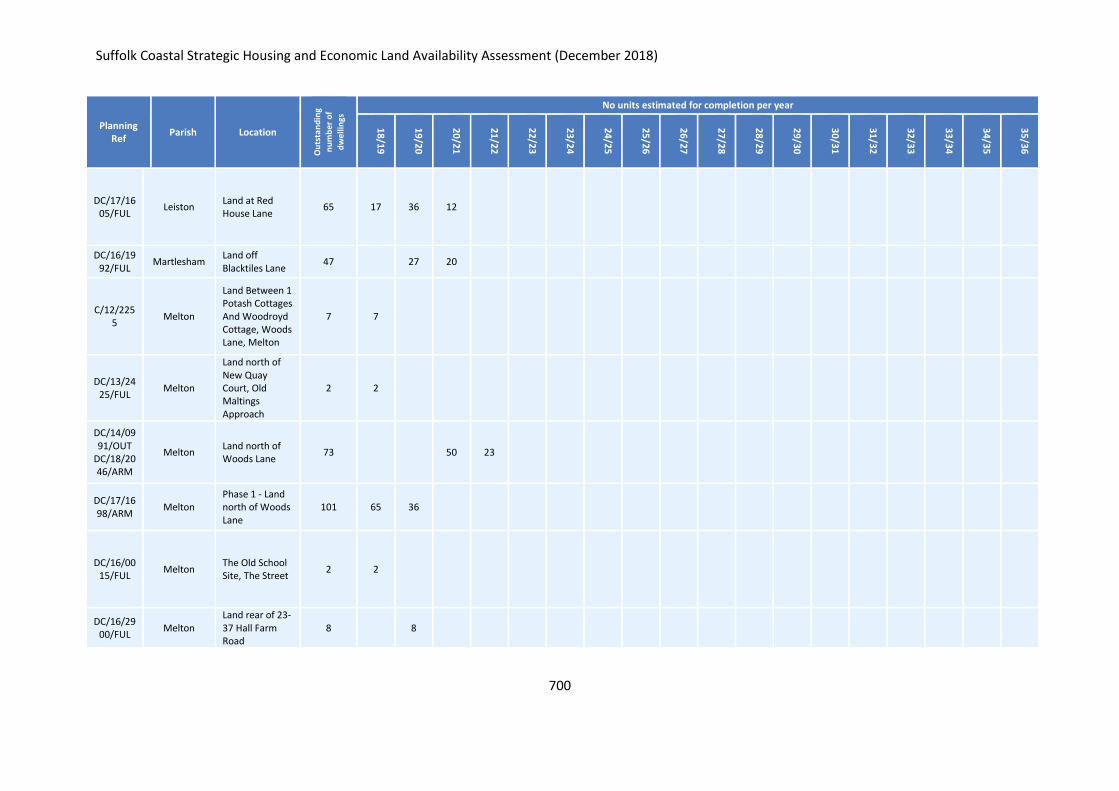
Suffolk Coastal Strategic Housing and Economic Land Availability Assessment (December 2018)
700
Planning Ref
Parish Location
Ou
tsta
nd
ing
nu
mb
er o
f
dw
elli
ngs
No units estimated for completion per year
18
/19
19
/20
20
/21
21
/22
22
/23
23
/24
24
/25
25
/26
26
/27
27
/28
28
/29
29
/30
30
/31
31
/32
32
/33
33
/34
34
/35
35
/36
DC/17/1605/FUL
Leiston Land at Red House Lane
65 17 36 12
DC/16/1992/FUL
Martlesham Land off Blacktiles Lane
47 27 20
C/12/2255
Melton
Land Between 1 Potash Cottages And Woodroyd Cottage, Woods Lane, Melton
7 7
DC/13/2425/FUL
Melton
Land north of New Quay Court, Old Maltings Approach
2 2
DC/14/0991/OUT
DC/18/2046/ARM
Melton Land north of Woods Lane
73 50 23
DC/17/1698/ARM
Melton Phase 1 - Land north of Woods Lane
101 65 36
DC/16/0015/FUL
Melton The Old School Site, The Street
2 2
DC/16/2900/FUL
Melton Land rear of 23-37 Hall Farm Road
8 8
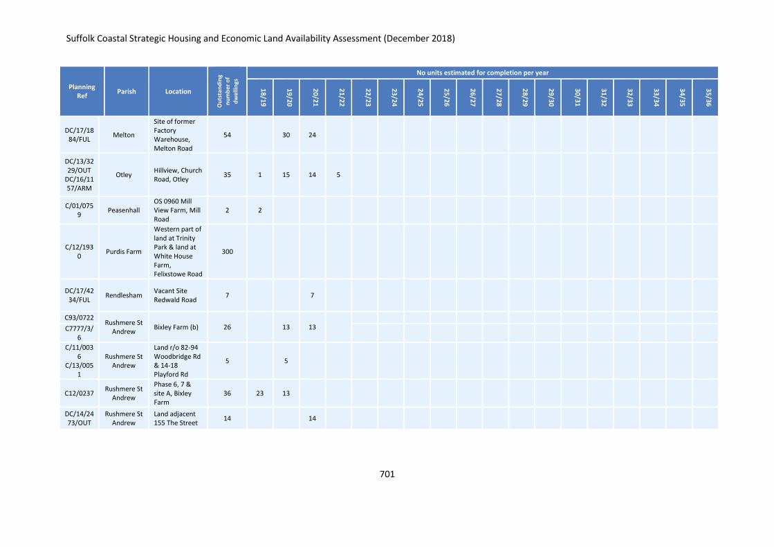
Suffolk Coastal Strategic Housing and Economic Land Availability Assessment (December 2018)
701
Planning Ref
Parish Location
Ou
tsta
nd
ing
nu
mb
er o
f
dw
elli
ngs
No units estimated for completion per year
18
/19
19
/20
20
/21
21
/22
22
/23
23
/24
24
/25
25
/26
26
/27
27
/28
28
/29
29
/30
30
/31
31
/32
32
/33
33
/34
34
/35
35
/36
DC/17/1884/FUL
Melton
Site of former Factory Warehouse, Melton Road
54 30 24
DC/13/3229/OUT
DC/16/1157/ARM
Otley Hillview, Church Road, Otley
35 1 15 14 5
C/01/0759
Peasenhall OS 0960 Mill View Farm, Mill Road
2 2
C/12/1930
Purdis Farm
Western part of land at Trinity Park & land at White House Farm, Felixstowe Road
300
DC/17/4234/FUL
Rendlesham Vacant Site Redwald Road
7 7
C93/0722 Rushmere St
Andrew Bixley Farm (b) 26 13 13
C7777/3/6
C/11/0036
C/13/0051
Rushmere St Andrew
Land r/o 82-94 Woodbridge Rd & 14-18 Playford Rd
5 5
C12/0237 Rushmere St
Andrew
Phase 6, 7 & site A, Bixley Farm
36 23 13
DC/14/2473/OUT
Rushmere St Andrew
Land adjacent 155 The Street
14 14
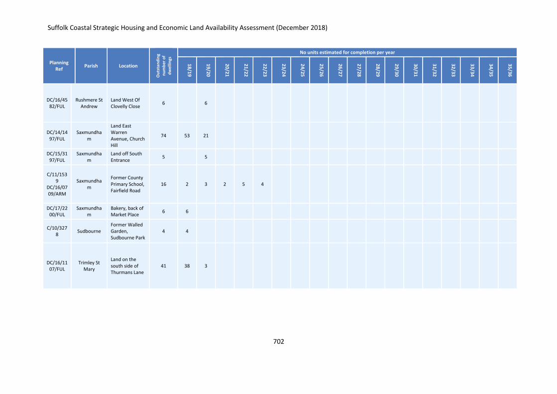
Suffolk Coastal Strategic Housing and Economic Land Availability Assessment (December 2018)
702
Planning Ref
Parish Location
Ou
tsta
nd
ing
nu
mb
er o
f
dw
elli
ngs
No units estimated for completion per year
18
/19
19
/20
20
/21
21
/22
22
/23
23
/24
24
/25
25
/26
26
/27
27
/28
28
/29
29
/30
30
/31
31
/32
32
/33
33
/34
34
/35
35
/36
DC/16/4582/FUL
Rushmere St Andrew
Land West Of Clovelly Close
6 6
DC/14/1497/FUL
Saxmundham
Land East Warren Avenue, Church Hill
74 53 21
DC/15/3197/FUL
Saxmundham
Land off South Entrance
5 5
C/11/1539
DC/16/0709/ARM
Saxmundham
Former County Primary School, Fairfield Road
16 2 3 2 5 4
DC/17/2200/FUL
Saxmundham
Bakery, back of Market Place
6 6
C/10/3278
Sudbourne Former Walled Garden, Sudbourne Park
4 4
DC/16/1107/FUL
Trimley St Mary
Land on the south side of Thurmans Lane
41 38 3
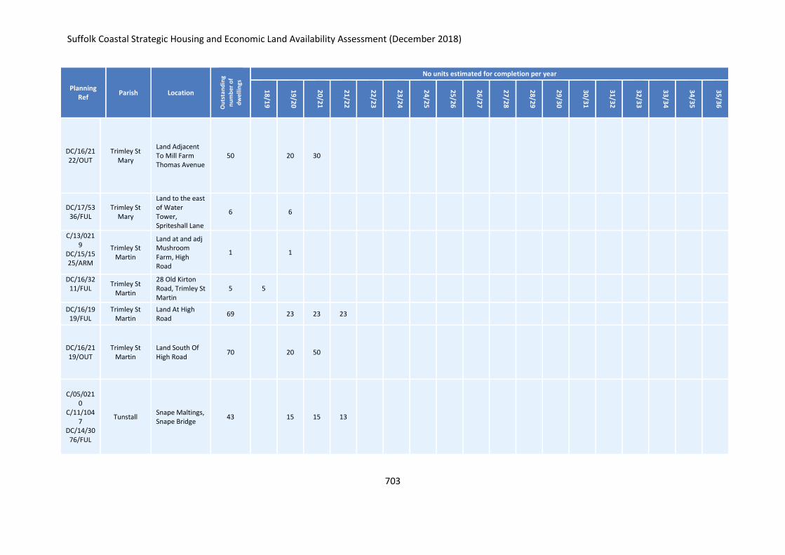
Suffolk Coastal Strategic Housing and Economic Land Availability Assessment (December 2018)
703
Planning Ref
Parish Location
Ou
tsta
nd
ing
nu
mb
er o
f
dw
elli
ngs
No units estimated for completion per year
18
/19
19
/20
20
/21
21
/22
22
/23
23
/24
24
/25
25
/26
26
/27
27
/28
28
/29
29
/30
30
/31
31
/32
32
/33
33
/34
34
/35
35
/36
DC/16/2122/OUT
Trimley St Mary
Land Adjacent To Mill Farm Thomas Avenue
50 20 30
DC/17/5336/FUL
Trimley St Mary
Land to the east of Water Tower, Spriteshall Lane
6 6
C/13/0219
DC/15/1525/ARM
Trimley St Martin
Land at and adj Mushroom Farm, High Road
1 1
DC/16/3211/FUL
Trimley St Martin
28 Old Kirton Road, Trimley St Martin
5 5
DC/16/1919/FUL
Trimley St Martin
Land At High Road
69 23 23 23
DC/16/2119/OUT
Trimley St Martin
Land South Of High Road
70 20 50
C/05/0210
C/11/1047
DC/14/3076/FUL
Tunstall Snape Maltings, Snape Bridge
43 15 15 13
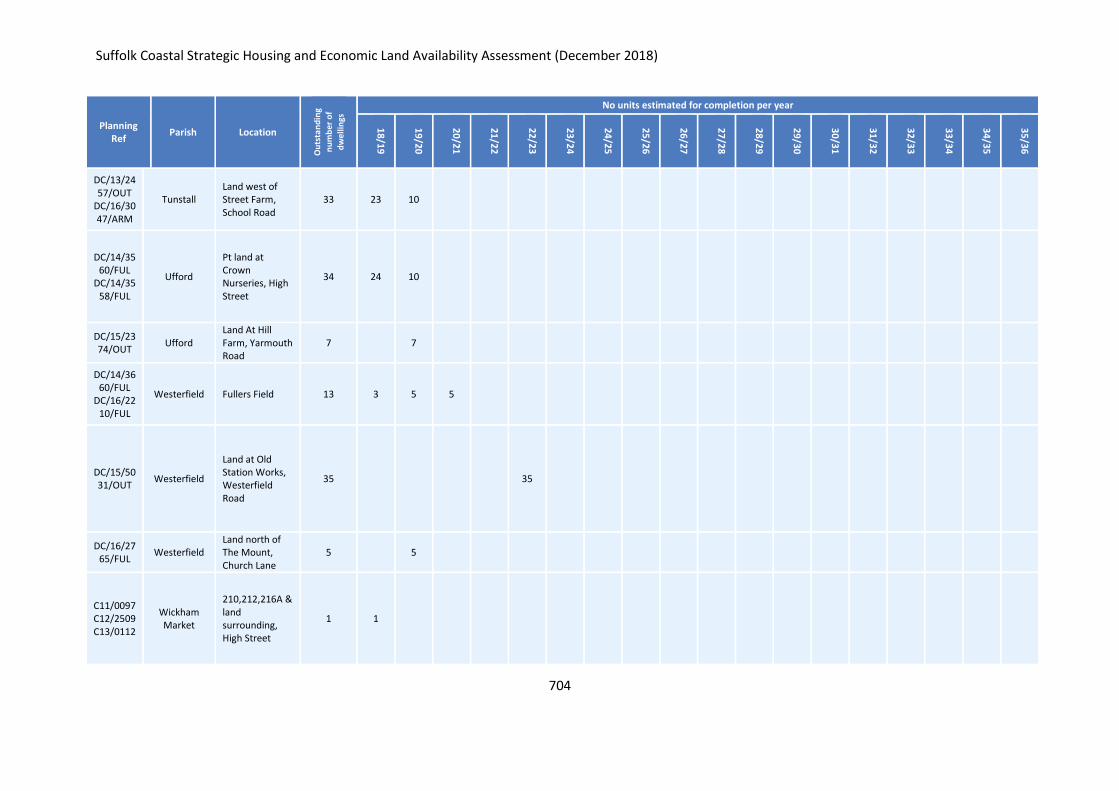
Suffolk Coastal Strategic Housing and Economic Land Availability Assessment (December 2018)
704
Planning Ref
Parish Location
Ou
tsta
nd
ing
nu
mb
er o
f
dw
elli
ngs
No units estimated for completion per year
18
/19
19
/20
20
/21
21
/22
22
/23
23
/24
24
/25
25
/26
26
/27
27
/28
28
/29
29
/30
30
/31
31
/32
32
/33
33
/34
34
/35
35
/36
DC/13/2457/OUT
DC/16/3047/ARM
Tunstall Land west of Street Farm, School Road
33 23 10
DC/14/3560/FUL
DC/14/3558/FUL
Ufford
Pt land at Crown Nurseries, High Street
34 24 10
DC/15/2374/OUT
Ufford Land At Hill Farm, Yarmouth Road
7 7
DC/14/3660/FUL
DC/16/2210/FUL
Westerfield Fullers Field 13 3 5 5
DC/15/5031/OUT
Westerfield
Land at Old Station Works, Westerfield Road
35 35
DC/16/2765/FUL
Westerfield Land north of The Mount, Church Lane
5 5
C11/0097 C12/2509 C13/0112
Wickham Market
210,212,216A & land surrounding, High Street
1 1
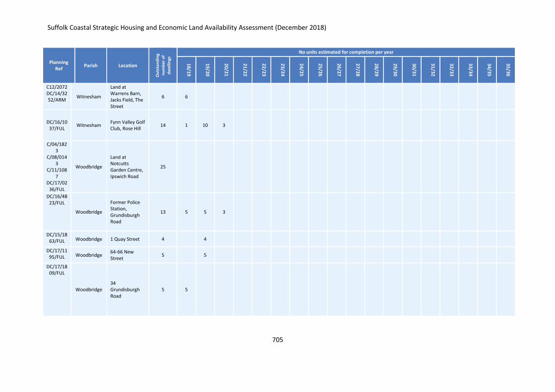
Suffolk Coastal Strategic Housing and Economic Land Availability Assessment (December 2018)
705
Planning Ref
Parish Location
Ou
tsta
nd
ing
nu
mb
er o
f
dw
elli
ngs
No units estimated for completion per year
18
/19
19
/20
20
/21
21
/22
22
/23
23
/24
24
/25
25
/26
26
/27
27
/28
28
/29
29
/30
30
/31
31
/32
32
/33
33
/34
34
/35
35
/36
C12/2072 DC/14/3252/ARM
Witnesham
Land at Warrens Barn, Jacks Field, The Street
6 6
DC/16/1037/FUL
Witnesham Fynn Valley Golf Club, Rose Hill
14 1 10 3
C/04/1823
C/08/0143
C/11/1087
DC/17/0236/FUL
Woodbridge
Land at Notcutts Garden Centre, Ipswich Road
25
DC/16/4823/FUL
Woodbridge
Former Police Station, Grundisburgh Road
13 5 5 3
DC/15/1863/FUL Woodbridge 1 Quay Street 4 4
DC/17/1195/FUL Woodbridge
64-66 New Street
5 5
DC/17/1809/FUL
Woodbridge 34 Grundisburgh Road
5 5
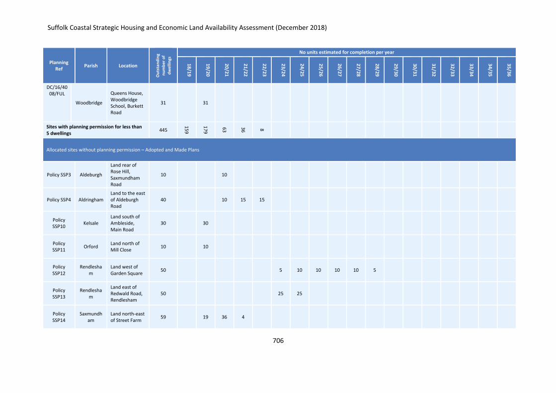
Suffolk Coastal Strategic Housing and Economic Land Availability Assessment (December 2018)
706
Planning Ref
Parish Location
Ou
tsta
nd
ing
nu
mb
er o
f
dw
elli
ngs
No units estimated for completion per year
18
/19
19
/20
20
/21
21
/22
22
/23
23
/24
24
/25
25
/26
26
/27
27
/28
28
/29
29
/30
30
/31
31
/32
32
/33
33
/34
34
/35
35
/36
DC/16/4008/FUL
Woodbridge
Queens House, Woodbridge School, Burkett Road
31 31
Sites with planning permission for less than 5 dwellings
445
15
9
17
9
63
36
8
Allocated sites without planning permission – Adopted and Made Plans
Policy SSP3 Aldeburgh
Land rear of Rose Hill, Saxmundham Road
10 10
Policy SSP4 Aldringham Land to the east of Aldeburgh Road
40 10 15 15
Policy SSP10
Kelsale Land south of Ambleside, Main Road
30 30
Policy SSP11
Orford Land north of Mill Close
10 10
Policy SSP12
Rendlesham
Land west of Garden Square
50 5 10 10 10 10 5
Policy SSP13
Rendlesham
Land east of Redwald Road, Rendlesham
50 25 25
Policy SSP14
Saxmundham
Land north-east of Street Farm
59 19 36 4
Suffolk Coastal Strategic Housing and Economic Land Availability Assessment (December 2018)
707
Planning Ref
Parish Location
Ou
tsta
nd
ing
nu
mb
er o
f
dw
elli
ngs
No units estimated for completion per year
18
/19
19
/20
20
/21
21
/22
22
/23
23
/24
24
/25
25
/26
26
/27
27
/28
28
/29
29
/30
30
/31
31
/32
32
/33
33
/34
34
/35
35
/36
Policy SSP15
Shottisham Land opposite the Sorrel Horse
10
10
Policy SSP17
Westerfield
Land south of Lower Road
20 20
Policy SSP19
Witnesham Land at Street Farm
20 5 5 5 5
Policy FPP5 Felixstowe Land north of Conway Close
150 50 50 50
Policy FPP7 Trimley St
Martin Land off Howlett Way
360 50 50 50 50 50 50 60
Policy FRAM25
Framlingham
Land off Victoria Mill Road
30 15 15
Policy FRAM28
Framlingham
The Old Gas Works site, College Road
7 7
MEL20 Melton Land off Wilford Bridge Road
55 15 20 20
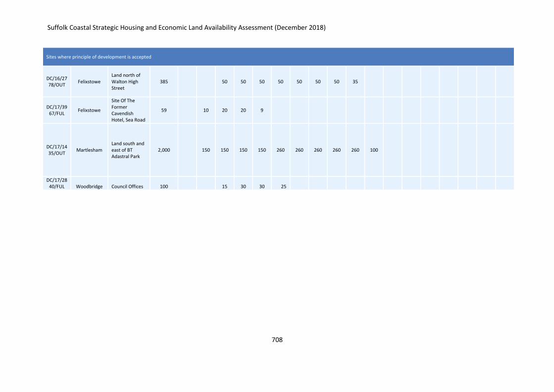
Suffolk Coastal Strategic Housing and Economic Land Availability Assessment (December 2018)
708
Sites where principle of development is accepted
DC/16/2778/OUT
Felixstowe Land north of Walton High Street
385 50 50 50 50 50 50 50 35
DC/17/3967/FUL
Felixstowe
Site Of The Former Cavendish Hotel, Sea Road
59 10 20 20 9
DC/17/1435/OUT
Martlesham Land south and east of BT Adastral Park
2,000 150 150 150 150 260 260 260 260 260 100
DC/17/2840/FUL Woodbridge Council Offices 100 15 30 30 25
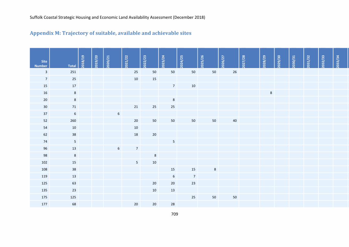
Suffolk Coastal Strategic Housing and Economic Land Availability Assessment (December 2018)
709
Appendix M: Trajectory of suitable, available and achievable sites
Site Number Total 2
01
8/1
9
20
19
/20
20
20
/21
20
21
/22
20
22
/23
20
23
/24
20
24
/25
20
25
/26
20
26
/27
20
27
/28
20
28
/29
20
29
/30
20
30
/31
20
31
/32
20
32
/33
20
33
/34
20
34
/35
20
35
/36
Po
st 2
036
3 251 25 50 50 50 50 26
7 25 10 15
15 17 7 10
16 8 8
20 8 8
30 71 21 25 25
37 6 6
52 260 20 50 50 50 50 40
54 10 10
62 38 18 20
74 5 5
96 13 6 7
98 8 8
102 15 5 10
108 38 15 15 8
119 13 6 7
125 63 20 20 23
135 23 10 13
175 125 25 50 50
177 68 20 20 28
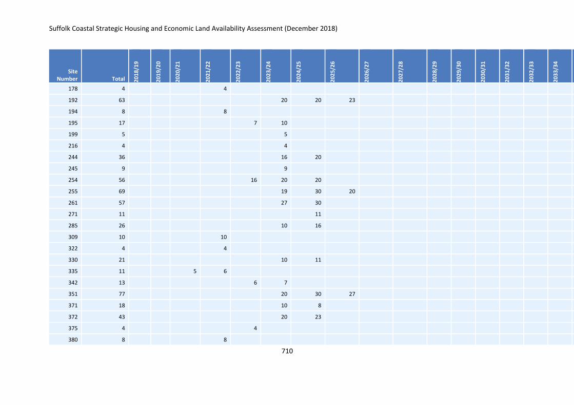
Suffolk Coastal Strategic Housing and Economic Land Availability Assessment (December 2018)
710
Site Number Total 2
01
8/1
9
20
19
/20
20
20
/21
20
21
/22
20
22
/23
20
23
/24
20
24
/25
20
25
/26
20
26
/27
20
27
/28
20
28
/29
20
29
/30
20
30
/31
20
31
/32
20
32
/33
20
33
/34
20
34
/35
20
35
/36
Po
st 2
036
178 4 4
192 63 20 20 23
194 8 8
195 17 7 10
199 5 5
216 4 4
244 36 16 20
245 9 9
254 56 16 20 20
255 69 19 30 20
261 57 27 30
271 11 11
285 26 10 16
309 10 10
322 4 4
330 21 10 11
335 11 5 6
342 13 6 7
351 77 20 30 27
371 18 10 8
372 43 20 23
375 4 4
380 8 8

Suffolk Coastal Strategic Housing and Economic Land Availability Assessment (December 2018)
711
Site Number Total 2
01
8/1
9
20
19
/20
20
20
/21
20
21
/22
20
22
/23
20
23
/24
20
24
/25
20
25
/26
20
26
/27
20
27
/28
20
28
/29
20
29
/30
20
30
/31
20
31
/32
20
32
/33
20
33
/34
20
34
/35
20
35
/36
Po
st 2
036
387 24 10 14
388 11 11
398 8 8
402 22 5
408 34 14 20
415 15 7 8
419 44 20 24
420 43 20 23
422 15 10 5
423 182 32 50 50 50
424 22 10 12
427 14 10 4
428 274 24 50 50 50 50 50
432 35 15 20
433 54 20 20 14
435 450 50 100 100 100 100
441 27 10 17
447 18 8 10
449 28 10 18
450 57 17 20 20
451 268 50 75 75 68
453 13 6 7
455 6 6

Suffolk Coastal Strategic Housing and Economic Land Availability Assessment (December 2018)
712
Site Number Total 2
01
8/1
9
20
19
/20
20
20
/21
20
21
/22
20
22
/23
20
23
/24
20
24
/25
20
25
/26
20
26
/27
20
27
/28
20
28
/29
20
29
/30
20
30
/31
20
31
/32
20
32
/33
20
33
/34
20
34
/35
20
35
/36
Po
st 2
036
459 5 5
462 52 25 27
464 23 10 13
465 20 10 10
467 6 6
468 10 10
469 60 20 20 20
470 29 14 15
471 37 17 20
475 3 3
476 4 4
477 30 15 15
482 21 10 11
485 2620 50 100 100 100 100 100 100 100 100 150 150 150 150 1170
487 29 10 19
490 353 50 100 100 103
493 58 18 20 20
494 208 50 50 50 58
496 14 7 7
499 119 20 50 49
501 8 8
503 17 7 10
504 4 4
Suffolk Coastal Strategic Housing and Economic Land Availability Assessment (December 2018)
713
Site Number Total 2
01
8/1
9
20
19
/20
20
20
/21
20
21
/22
20
22
/23
20
23
/24
20
24
/25
20
25
/26
20
26
/27
20
27
/28
20
28
/29
20
29
/30
20
30
/31
20
31
/32
20
32
/33
20
33
/34
20
34
/35
20
35
/36
Po
st 2
036
505 18 8 10
506 92 30 30 32
508 16 6 10
510 56 16 20 20
511 117 20 50 47
512 17 7 10
514 104 30 30 44
515 76 25 25 26
518 7 7
520 1232 32 100 100 100 100 100 100 100 100 100 100 100 100
521 32 12 20
526 268 40 75 75 50 28
531 12 6 6
532 45 20 25
533 466 50 100 100 100 100 16
534 9 9
535 13 6 7
542 14 7 7
543 8 8
544 23 10 13
547 335 30 50 50 75 75 55
549 30 15 15
550 108 20 40 48

Suffolk Coastal Strategic Housing and Economic Land Availability Assessment (December 2018)
714
Site Number Total 2
01
8/1
9
20
19
/20
20
20
/21
20
21
/22
20
22
/23
20
23
/24
20
24
/25
20
25
/26
20
26
/27
20
27
/28
20
28
/29
20
29
/30
20
30
/31
20
31
/32
20
32
/33
20
33
/34
20
34
/35
20
35
/36
Po
st 2
036
551 383 50 75 100 100 50 8
552 55 25 30
553 5 5
554 25 10 15
555 12 6 6
557 30 15 15
558 8 8
559 84 24 30 30
560 22 10 12
561 35 15 20
563 11 5 6
564 9 9
565 11 5 6
567 13 6 7
569 31 15 16
603 34 14 20
642 9 9
650 8 8
651 25 5 5 5 5 5
652 7 7
660 17 7 10
684 26 10 16
685 6 6

Suffolk Coastal Strategic Housing and Economic Land Availability Assessment (December 2018)
715
Site Number Total 2
01
8/1
9
20
19
/20
20
20
/21
20
21
/22
20
22
/23
20
23
/24
20
24
/25
20
25
/26
20
26
/27
20
27
/28
20
28
/29
20
29
/30
20
30
/31
20
31
/32
20
32
/33
20
33
/34
20
34
/35
20
35
/36
Po
st 2
036
686 8 8
690 110 30 30 30 20
691 61 30 31
692 208 30 50 50 50 28
693 19 9 10
694 4 4
695 13 6 7
703 8 8
711 18 8 10
713 257 30 50 50 50 50 27
714 495 50 75 75 100 100 50 45
715 54 24 30
717 141 40 50 51
718 15 5 10
719 6 6
731 49 20 29
736 7 7
739 25 10 15
740 35 15 20
750 876 50 100 100 100 100 100 100 100 100 26
751 55 20 35
754 17 7 10
755 152 50 50 52
Suffolk Coastal Strategic Housing and Economic Land Availability Assessment (December 2018)
716
Site Number Total 2
01
8/1
9
20
19
/20
20
20
/21
20
21
/22
20
22
/23
20
23
/24
20
24
/25
20
25
/26
20
26
/27
20
27
/28
20
28
/29
20
29
/30
20
30
/31
20
31
/32
20
32
/33
20
33
/34
20
34
/35
20
35
/36
Po
st 2
036
756 122 22 50 50
757 204 20 50 50 50 34
758 149 20 50 50 29
760 12 6 6
761 12 6 6
762 13 6 7
764 25 10 15
766 23 10 13
769 5 5
771 94 30 30 34
772 170 20 50 50 50
774 23 10 13
775 9 9
776 41 20 21
777 13 6 7
780 47 20 27
783 3 3
784 11 5 6
797 6 6
798 6 6
800 247 30 50 50 50 50 17
801 174 24 50 50 50
802 114 20 50 44

Suffolk Coastal Strategic Housing and Economic Land Availability Assessment (December 2018)
717
Site Number Total 2
01
8/1
9
20
19
/20
20
20
/21
20
21
/22
20
22
/23
20
23
/24
20
24
/25
20
25
/26
20
26
/27
20
27
/28
20
28
/29
20
29
/30
20
30
/31
20
31
/32
20
32
/33
20
33
/34
20
34
/35
20
35
/36
Po
st 2
036
812 13 6 7
816 100 20 50 30
855 5 5
856 9 9
874 8 8
878 80 20 30 30
890 23 10 13
896 64 30 34
901 8 8
910 17 7 10
911 3 3
916 5 5
941 163 30 50 50 33
953 38 18 20
959 31 11 20
981 56 20 20 16
997 9 9
999 268 50 100 100 18
1001 20 10 10
1018 39 19 20
1020 84 20 34 30
1028 33 13 20
1035 4 4
Suffolk Coastal Strategic Housing and Economic Land Availability Assessment (December 2018)
718
Site Number Total 2
01
8/1
9
20
19
/20
20
20
/21
20
21
/22
20
22
/23
20
23
/24
20
24
/25
20
25
/26
20
26
/27
20
27
/28
20
28
/29
20
29
/30
20
30
/31
20
31
/32
20
32
/33
20
33
/34
20
34
/35
20
35
/36
Po
st 2
036
1042 20 10 10
1045 21 10 11
1054 77 25 25 27
1055 116 20 50 46
1061 7 7
1062 6 6
1077 7 7
1083 247 47 75 75 50
1084 159 30 50 50 29
1085 143 20 50 50 23
1087 2585 50 100 100 100 100 150 150 150 150 150 150 150 150 935
1088 19 9 10
1089 42 20 22
1091 72 20 20 32
1092 792 92 100 100 100 100 100 100 100
1099 15 5 10
1100 16 6 10
1102 21 10 11
1105 3 3
1109 8 8
1110 9 9
1111 27 10 17
1112 39 19 20
Suffolk Coastal Strategic Housing and Economic Land Availability Assessment (December 2018)
719
Site Number Total 2
01
8/1
9
20
19
/20
20
20
/21
20
21
/22
20
22
/23
20
23
/24
20
24
/25
20
25
/26
20
26
/27
20
27
/28
20
28
/29
20
29
/30
20
30
/31
20
31
/32
20
32
/33
20
33
/34
20
34
/35
20
35
/36
Po
st 2
036
1114 19 9 10
1115 11 5 6
1116 6 6
1119 42 20 22
1121 92 22 30 30 10
1123 18 8 10
1130 300 50 100 100 50
1132 5 5
1133 20 10 10
1138 375 50 75 100 100 50
1139 128 30 50 48
1145 340 40 50 100 100 50
1152 7 7
1155 10 10
1156 10 10
1161 400 50 100 100 100 50
1162 11 11
1163 39 20 19
1165 260 50 75 75 60
1166 4 4
1168 8 8
22,704 0 0 404 1443 2218 3234 3438 2878 1844 1140 692 612 570 426 450 450 400 400 2105
Recommended