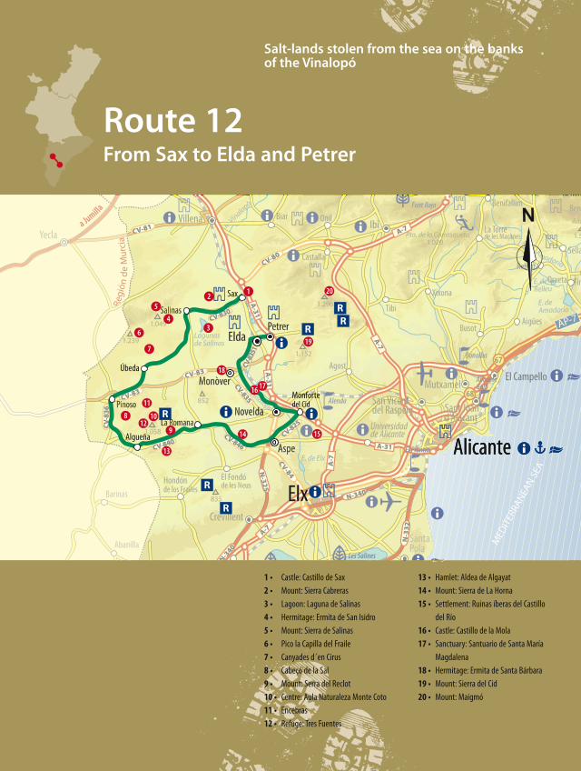
Route 12From Sax to Elda and Petrer
Salt-lands stolen from the sea on the banksof the Vinalopó
1 • Castle: Castillo de Sax
2 • Mount: Sierra Cabreras
3 • Lagoon: Laguna de Salinas
4 • Hermitage: Ermita de San Isidro
5 • Mount: Sierra de Salinas
6 • Pico la Capilla del Fraile
7 • Canyades d´en Cirus
8 • Cabeçó de la Sal
9 • Mount: Serra del Reclot
10 • Centre: Aula Naturaleza Monte Coto
11 • Encebras
12 • Refuge: Tres Fuentes
13 • Hamlet: Aldea de Algayat
14 • Mount: Sierra de La Horna
15 • Settlement: Ruinas íberas del Castillo
del Río
16 • Castle: Castillo de la Mola
17 • Sanctuary: Santuario de Santa María
Magdalena
18 • Hermitage: Ermita de Santa Bárbara
19 • Mount: Sierra del Cid
20 • Mount: Maigmó
RUTA12_124a131_da OK ingles.qxp:rutas 12/07/10 12:51 Página 124
- 125
We start a circular route through one of the least known
territories of the Region of Valencia: the regions of L’Alt
Vinalopó and Vinalopó Mitjà. We will travel through
areas marked by the production of salt, lands that were
once below the sea, forming part of former lagoons, or
where the outcropping of salt deposits formed in extinct
seas from over two hundred million years ago. So, we
find ourselves in a land with names marked by “sal”
indicating the presence of this white substance so
important throughout human history: Sierra de Salinas,
Pueblo de Salinas, Laguna de Salinas, Saladares de
Villena and the Cabeçó de la Sal de Pinoso. We will
journey through these regions that owe their name to
the river Vinalopó, where we will find fields of vineyards
belonging to a Denominación de Origen [D.O. -
denomination of origin, equivalent to the French
appellation d’origene] and some mountains and isolated
sierras that guard, practically in secret, marvellous places
and natural treasures unknown for most people. We will
discover peaceful, beautiful towns. A land, too, of castles,
this having been, throughout history, an area between
the borders of the kingdoms of Murcia, Castille, Aragon
and Valencia. In addition, we will be discovering a rich
architectural heritage in the most populous towns, fruit
of the wealth generated by the powerful footwear
industry. Our journey will end at the Sierra del Cid,
where we will get to know the green lungs of these
regions and some marvellous views taking in our entire
route.
From Sax to a world of salt
Our route starts at Sax. As we have mentioned, this
whole area was, in its day, a territory disputed by the
kingdoms of Castille, Aragon and Murcia, so in the
different towns we find Christian castles built, in most
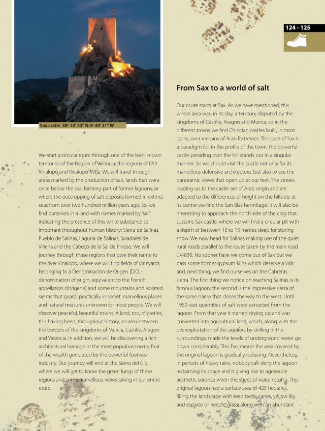
cases, over remains of Arab fortresses. The case of Sax is
a paradigm for, in the profile of the town, the powerful
castle presiding over the hill stands out in a singular
manner. So we should visit the castle not only for its
marvellous defensive architecture, but also to see the
panoramic views that open up at our feet. The streets
leading up to the castle are of Arab origin and are
adapted to the differences of height on the hillside; at
its centre we find the San Blas hermitage. It will also be
interesting to approach the north side of the crag that
sustains Sax castle, where we will find a circular pit with
a depth of between 10 to 15 metres deep for storing
snow. We now head for Salinas making use of the quiet
rural roads parallel to the route taken by the main road
CV-830. No sooner have we come out of Sax but we
pass some former gypsum kilns which deserve a visit
and, next thing, we find ourselves on the Cabreras
sierra. The first thing we notice on reaching Salinas is its
famous lagoon; the second is the impressive sierra of
the same name that closes the way to the west. Until
1950 vast quantities of salt were extracted from the
lagoon. From that year it started drying up and was
converted into agricultural land, which, along with the
overexploitation of the aquifers by drilling in the
surroundings, made the levels of underground water go
down considerably. This has meant the area covered by
the original lagoon is gradually reducing. Nevertheless,
in periods of heavy rains, nobody can deny the lagoon
reclaiming its space and it giving rise to agreeable
aesthetic surprise when the sheet of water returns. The
original lagoon had a surface area of 425 hectares,
filling the landscape with reed-beds, canes, yellow lily,
and esparto or needle grass, along with an abundant
Sax castle 38º 32' 33'' N 0º 49' 21'' W
124
RUTA12_124a131_da.qxp:rutas 29/06/10 8:39 Página 125
we can undertake an incursion through the Salinas
sierra. Its highest standing peak, at 1,237 metres above
sea level, is named Capilla del Fraile, although to reach
it we have to start our walk from the farm tracks that set
out from the south of the sierra. This mountainous
formation extends for nearly seven thousand hectares.
The presence of abundant mist creates moist
microclimates in enclosed gullies with the consequent
influence on the vegetation. Regarding wildlife, the
presence of rabbits, wild boar, dormice, foxes, badgers
are notable, and birds of prey such as the golden eagle
and Bonelli’s eagle. Being one of the least known
mountains of the Region of Valencia, nature remains in
a wilderness state to the surprise of visitors. From the
sierra, on days with good visibility, one can see as far as
the Mediterranean. We continue our route in a
southerly direction in search of the town of Pinoso. The
way leads us through a mosaic of fields with vineyards,
almond and carob trees. We will come across two
hamlets, Canyades d’en Cirus and Ubeda, models of
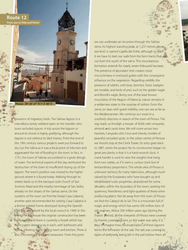
peaceful secluded spots. In the urban centre of Penoso
we should stop at the Clock Tower. Its story goes back
to 1887, when the project for its construction began. Its
great peculiarity is that it is a hand wound clock. A
crank handle is used to raise the weights that hang
from two cables, as if it were a cuckoo clock but of
extraordinary proportions. This whole area of Pinoso is
unknown territory for many Valencians, although much
valued by the Europeans who have bought up and
rehabilitated rustic properties, abandoned for some
decades, within the boundary of this town, seeking the
quietness, friendliness and light-qualities of these wine-
producing plains. Not far away from the town of Pinoso
we find the Cabeçó de la Sal. This is a mountain full of
magic and energy which has some 500 million tons of
salt reserves. About 200 million years ago (during the
Triassic period), all the vineyards of Pinoso were covered
by marine coastal lagoons, so the water was salty. It is
easy to imagine how the evaporation of these lagoons
led to the formation of the salt. The salt was covered by
layers of sediment, being left in the part below them all
Route 12From Sax to Elda and Petrer
Pinoso 38º 24' 27'' N 1º 2' 46'' E
presence of migratory birds. The Salinas lagoon is a
marvellous lonely wetland open to the traveller who
loves secluded spaces. A trip across the lagoon or
around its shores is highly gratifying, although the
lagoon is not without its dark history. From the end of
the 19th century various projects were put forward to
dry out the Salina as it was a focal point of infection and
aggravated the risk of flooding in the town. In fact, in
1751, the town of Salinas succumbed to a great deluge
of water. The technical experts of the day attributed the
destruction of the town to insufficient drying up of the
lagoon. The town’s position was moved to the higher
ground where it is found today. Walking through its
streets leads us to the baroque style church of San
Antonio Abad and the nearby hermitage of San Isidro,
already on the slopes of the Salinas sierra. On the
outskirts of the town we find the Paraje Casa Calpena,
another spot recommended for visiting. Casa Calpena is
a former palatial home destroyed during the Spanish
Civil War and rebuilt by the local council in 1999. In the
interior of the house the original construction has been
reproduced and there is currently a hostel which has
eight rooms sleeping six in each, with bathroom and
toilets, meeting room, dining room and kitchen. There is
also a recreational area and restaurant. From this point
RUTA12_124a131_da.qxp:rutas 29/06/10 8:39 Página 126
- 127126
more humid atmospheres of the past. Along the way
we can observe various examples of this oak inherited
from former climatic conditions. In the vicinity of Monte
Coto is the town of Encebras and the municipal refuge
of Las Tres Fuentes [three waterspouts], which offers
modern facilities for those keen to immerse themselves
in nature.
From Pinoso to the banks of theVinalopó
Our route continues in the direction of Algueña.
Without any doubt what most attracts our attention as
we approach this town is the enormous opencast
marble quarry on the neighbouring Reclot sierra. It
makes a disquieting impression, but at the same time
hypnotic, the profile of the Sierra with its straight lines
silhouetted on the mountainous horizon. Algueña was
part of Pinoso until 1934 when, due to the population
numbers in the town, it was granted municipal
independence. Within the urban centre we will visit the
19th century parish church of San José, with its twin
towers, one housing the bells the other a clock, spotted
from practically any point within the municipal
boundary. From Algueña we head for La Romana.
Along the way, in search of peace and quiet, we can
visit the simple and pretty village of Algayat. On the
right hand side lies the Algayat sierra, which also
deserves a look around to discover the delightful spots
of Peña de la Mina, where we will find la Cova Negra
[black cove], of large proportions. We arrive at the
municipality of La Romana, which was dependent on
Novelda until 1929. Up until 1930 it was owned by the
Marquis of La Romana, who finally sold off the lands to
the inhabitants and the tenant farmers who cultivated
them. La Romana has an environment characterised by
wide streets with gardens and is flanked by two large
stands of pine, which contributes to increasing its
beauty. It will also be interesting to pass by La Carrasca,
a Holm oak of large dimensions situated in a beautiful
Salinas lagoon 38º 30' 36'' N 0º 52' 98'' W
until differing pressures from the earth’s crust made it
come out due to its greater plasticity, thus creating the
salt dome diapir formation which the Cabeçó de la Sal
de Pinoso shows today. Here, the salt was exploited in
the past by means of underground mining, based on
digging out galleries until the rock salt was reached.
This “conventional” mining has nowadays been
substituted by the practice of dissolving the salt by
means of deep boreholes. This is a method that is used
for massive halite (rock salt) deposits. The system is
based on forcing the salt to dissolve by the injection of
water from the surface through tubing, directly onto
the rock salt. The brine (salt water) is sent through a
series of pipes to the Torrevieja salting factories where it
functions as a big crystallisation pool. The work dates
from 1972, motivated by the increased demand for salt
from the domestic market. A visit to the Cabeçó de la
Sal will enable us to discover the extraction holes, the
different streams with high concentrations of salt and
the Cueva del Gigante [giant’s cave], a mine dug to
extract an inaccessible concentration of rock salt. There
are also different micro-reserves of flora. And at the
summit, the most spectacular spots can be seen, with
potholes and dolines resulting from the salt extraction
processes. We leave the Cabeçó de la Sal and, but still
within the municipal boundary of Pinoso, we visit
Monte Coto, on the Reclot sierra, where there is a
“nature classroom” teaching and information centre,
from where various different footpaths set out that
enable us to get to know these natural spots that have
escaped the hand of humans, omnipresent in area. One
of these footpaths is known as the Senda dels Gal‧lers.
The route bears the common name in the local dialect
for the Valencian oak, a botanical gem that still survives
in these Mediterranean woods, as vestiges from the
RUTA12_124a131_da.qxp:rutas 29/06/10 8:39 Página 127
Nuestra Señora de los Nieves [Our Lady of the Snows], a
baroque style church from the 15th to 18th centuries
which proudly shows off its thirty-metre-tall bell tower,
the former minaret of the mosque. At Monforte del Cid
we must try the Anís Paloma [an aniseed liqueur],
included in the Specific Denomination of Traditional
Spirit Beverages of Allicante, a similar official
denomination to that of wine.
We leave the town of Monforte del Cid and now head
for the neighbouring Novelda. The architecture of
Novelda is notable for the modernist buildings. So, we
can find three of the best examples of this style in
Valencian territory, the Modernist Museum-House, the
Gómez-Tortosa Cultural Centre and Mira House. These
works were sponsored by the powerful Novelda
bourgeoisie of the early 20th century, who had become
wealthy from the benefits obtained by the
development of agriculture, commerce and financial
activities.
Now in the direction of Monòver, just three kilometres
outside Novelda, a relevant artistic-historic group is
located on a slope of La Mola hill. We refer to La Mola
castle, declared a Place of Cultural Interest. La Mola
castle is of Almohad origin, built in the 12th century
over a former Roman fortification and was the the town
of Novelda’s first building. It is an irregularly shaped site
enclosed by thick defensive walls.
The most outstanding element of the fortress is its
triangular tower, situated at the end of the courtyard
and a much later construction than the castle, given
that it dates from the 14th century. This tower is one of
the first examples of Catalan-style civic-military building
in Valencian territory. It is known by the name of the
Torre de los Tres Picos [tower of the three peaks] and is
the only one of its kind in the whole of Europe. At the
natural environment and which is over a thousand
years old. We can reach our next destination, Aspe,
through relatively unspoilt traditional rural scenery, at
the foot of the Horna sierra. As we get closer to this
town we see the characteristic vineyards growing “uva
embolsada” [dessert grapes that are prepackaged],
which we will also come across in the surrounding
towns, a very high quality product and with the
Denomination of Origin “Uva Embolsada del Vinalopó”.
Aspe has an interesting artistic-historic heritage
reflected in its old quarter, which retains the flavour of
its Arab roots. With winding streets that come out onto
tiny plazas, Aspe’s old quarter can be divided into two
parts: the early part, which had to be walled and is
centred around the Plaza Mayor, and the expansion,
which is found centred around the Plaza de San Juan.
Around the Plaza Mayor we can enjoy two great
architectural gems: the Town Hall, with a Renaissance
style façade, and the baroque style Basilica de Nuestra
Señora del Socorro. In the vicinity of Aspe we must visit
the Iberian Age ruins of Castillo del Río, incredibly well
preserved and in an abandoned rural environment of
great beauty.
Through the places that inspiredAzorín, with liqueurs, footwear andnature parks
From Aspe we approach Monforte del Cid along the
CV-825, crossing the now exhausted river Vinalopó. We
reach this town and allow ourselves to wander round its
streets, also with clearly Arabic reminiscences, and
narrow streets in the Moorish neighbourhood. We find,
build over the remains of an Arab fortress, the church of
Route 12From Sax to Elda and Petrer
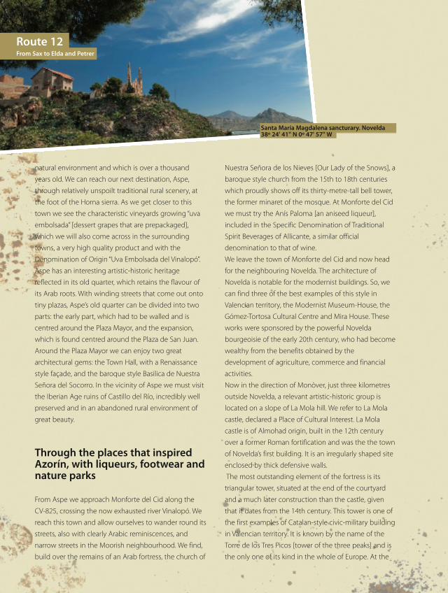
Santa María Magdalena sancturary. Novelda38º 24' 41'' N 0º 47' 57'' W
RUTA12_124a131_da.qxp:rutas 29/06/10 8:39 Página 128
- 129
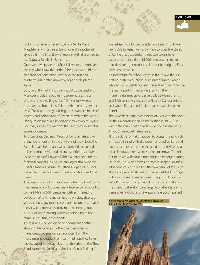
foot of the castle is the sanctuary of Santa María
Magdalena, with a daring building in the modernist
style built in 1918 entirely of marble, with similarities to
the Sagrada Familia in Barcelona.
Once we have passed La Mola hill, we reach Monòver,
the city which saw the birth of the great writer of the
so-called ’98 generation, José Augusto Trinidad
Martínez Ruiz, better known by his nom de plume,
Azorín.
So, one of the first things we should do on reaching
Monòver is visit the Azorín museum-house. It is a
characteristic dwelling of the 19th century which
recreates the home in which the Alicante prose writer
lived. The three-storey building houses an exhibition of
objects and belongings of Azorín, as well as the writer’s
library, made up of a bibliographic collection of 14,000
volumes, some of them from the 16th century, and his
correspondence.
Two buildings declared Places of Cultural Interest will
attract our attention in the environs of the village: the
Santa Bárbara hermitage, with a bold Valencian and
Italian baroque style, and the ruins of the castle. We
leave the beautiful town of Monòver and head for the
footwear capital: Elda. So, on arriving at this place, we
visit the footwear museum. Officially opened in 1999,
the museum has four permanent exhibitions and one
travelling.
The permanent collections show us items related to the
mechanisation of footwear manufacture corresponding
to the 19th and 20th centuries, with an interesting
collection of sewing machines and window displays.
We can also enjoy other collections like one that makes
a review of footwear used by humans throughout
history, or one showing footwear belonging to the
famous in culture, art or sports.
There is also a collection of local footwear, another
showing the footwear of the great designers or
miniatures. Two awards are promoted from the
museum, and despite their scant tradition, they have
already acquired social relevance: the prize for the “Best
Shod Woman in Spain” and the “Luis García Berlanga”
journalism prize for best article on women’s footwear.
From Elda to Petrer we hardly have to cross the street,
since the great expansion these two towns have
experienced since the mid-20th century, has meant
that they are right next to each other forming the Elda-
Petrer conurbation.
An interesting fact about Petrer is that it was the last
bastion of the Republican government under Negrín,
who set up his residence and the seat of government in
the municipality. In Petrer we shall visit the
monumental mediaeval castle built between the 12th
and 14th centuries, declared a Place of Cultural Interest
and where Roman and Arab remains have also been
found.
Their excellent state of conservation is due to the works
for their reconstruction being finished in 1982. Also
within the municipal boundary we find the Arenal del
Amorxó municipal nature area.
This is a dune formation proper to coastal areas, which
is situated inland, with the presence of solids, flora and
fauna characteristic of the coastal dune ecosystems: a
natural extravagance worthy of being known. To end
our route we will make a tour around the neighbouring
Sierra del Cid, which forms a crescent-shaped massif, at
either end of which we find the two peaks of the sierra.
There are various different footpaths that lead us to get
to know the sierra. We propose going round it on the
PR.V-36. The first thing that will catch our attention on
this stretch is the abundant vegetation there is on this
sierra: a leafy woodland of Aleppo pine, accompanied
128
Santa María Magdalena sanctuary. Novelda 38º 24' 47'' N 0º 47' 52'' W
RUTA12_124a131_da.qxp:rutas 29/06/10 8:39 Página 129
by Holm oak and the typical low scrubland of the
Mediterranean. Without doubt we are in the midst of
the great green lungs of the area, which presents fertile
lands to a large extent but with an arid appearance.
Although modest, the animal presence is active, with
the peregrine falcon, golden eagle, Eurasian sparrow
hawk and goshawk, or else the wild boar, green snake,
foxes and mouflons [wild mountain sheep]. As we
approach the summit, the edge of the footpath drops
down the hillside towards the bottom of the gully.
People who cannot stand heights should stay hard by
the other side of the path well away from the precipice.
The summit is reached after the way has been steep
and difficult, but the recompense of the views that the
summit offers makes the obstacles seem few. Practically
the entire group of sierras of southern Valencia is in
sight, although our attention will be particularly caught
to the east by the impressive Maigmó at 1,296 metres
which, together with the line of the coast silhouetted
against a shimmering sea, will leave the viewer in
ecstasy before such visual beauty. In the immediate
vicinity of the Sierra del Cid we can enjoy surprising and
thrilling spots of nature if we head for the Rambla de la
Rabosa, the Racó Xolí, or the Catí-Foradà Bronze Age
(15th century B.C.) site. We end the route barely six
kilometres from Sax, where we set out on this route that
has allowed us to get to know a special and surprising
area, marked by winegrowing and salt extraction.
Practical information
Fiestas, food and craftsThe cuisine of these inland regions of L’Alt Vinalopó and
Vinalopó Mitjà combine traditional country produce.
Among the most representative dishes found are:
gazpacho [a chunky tomato soup served chilled], rice with
rabbit and snails, gachamiga [flour and garlic puree],
fassegures [dumplings], giraboix [cod, tomato and potato]
or ajotonto [cod, garlic and potato], which may be
accompanied with the famous wines of the area, amongst
those that stand out the aromatic Fondillón. The dessert
grape, Uva Embolsada, with its Denominación de Origen,
is an unusual product of the area where dry aniseed
liqueurs are also produced - the Anís Paloma of Monforte
del Cid being particularly noteworthy. Saffron is also
produced and sold locally. To finish, we have cakes and
sweet pastries, the Mistela wine [produced from a must of
mixed grape varieties and fortified with wine alcohol] and
the excellent white and red wines of the area. With regard
to fiestas, in the lands of Vinalapó the splendour of the
Fiestas de Moros y Cristianos [Moors and Christians] is a
reference not to miss on the area’s festive calendar. But
there are also the festivities of San Antón, the countless
romerías [religious processions and local pilgrimages] to
the sanctuaries and hermitages in the area, the carnivals in
February [marking the beginning of Lent], with Novelda’s
forty-hour carnival procession standing out, and the
festivals of the patron saints of every town and city. In
handcrafts we find leather goods; woven chair seats and
other furniture in cane, rush and fibre; festive embroidery;
esparto or needle-grass craftwork, pottery, bobbin lace,
and marble work.
Route 12From Sax to Elda and Petrer
Sierra Salinas 38º 30' 58'' N 0º 53' 97'' W
RUTA12_124a131_da.qxp:rutas 29/06/10 8:39 Página 130
- 131
Recommended time of yearAny time of year is good, although preferably spring and
autumn. In summer it is important to avoid the hours
around midday when the sun is hottest. Lovely landscapes
are made by the fields of vineyards with the autumn
colours, as well as the almond tree blossom between
January and February. The Laguna of La Salinas shows its
sheet of rainwater before the start of winter.
Public transportRegional trains stop at Sax for the start of the route. For
the return, the regional trains also stop at Elda-Petrer.
Bicycles are transported free of charge on the railways.
RecommendationsIn case you want to do the route just as it is proposed,
by bike or on foot, a word of advice: a mountain bike is
better or, as a minimum, one of the hybrid types. We do
not come across waterspouts for quenching thirst and
refreshing ourselves away from the urban centres, so
we should fill up whenever we get the chance. The best
times of the day to travel are very early morning and in
the evening as the temperature is agreeable and the
light is especially good. If anyone wants to use a car on
the tracks where it is permitted to drive, the main track
must never be left, since it is much better and more
respectful to the environment. To get to know in more
detail each area of nature that we propose, leave the
vehicle parked at a suitable safe spot and make shorter
trips on foot.
RECOMMENDED MAPS TO FOLLOW THE ROUTE CORRECTLY:
National Geographic Institute: Scale 1:25,000, sheet numbers: 845-II and IV; 846-III; 870-II, III and IV; and 871-I and III.Further information: www.comunitatvalenciana.comInformation on regional and local trains: Renfe 902 24 02 02. www.renfe.es
TOURIST INFO OFFICES FOR THE ROUTE:
Tourist Info EldaC/ Nueva,14. 03600 EldaTel. 966 98 03 [email protected]
Tourist Info Elda-MuseoAv. Chapí, 32. 03600 [email protected]
Tourist Info Elda-SagastaPl. Sagasta, s/n. 03600 [email protected]
Tourist Info Monforte del CidPl. del Parador, 10 03670 Monforte Del CidTel. 965 62 11 90 [email protected]
Tourist Info NoveldaC/ Mayor, 6 03660 NoveldaTel. 965 60 92 28 [email protected]
Tourist Info PetrerC/ Cura Bartolomé Muñoz, 203610 PetrerTel. 966 98 94 00
Tourist Info VillenaPI. de Santiago, 5 03400 VillenaTel. 966 15 02 36 [email protected]
Petrer castle 38º 29' 34'' N 0º 45' 75'' W
130
RUTA12_124a131_da.qxp:rutas 29/06/10 8:39 Página 131
Recommended