RIVER HYDROMORPHIC ASSESSMENT,
TYPING AND RECONNAISANCE AND THE
SCIENTIFIC CHALLENGE OF RIVER SCALE
AND HETEROGENEITY
David Gilvear, University of Stirling
(Co-authors - Martin Thoms and Victoria Milner)
River Science Workshop – 18th April 2011
1. The context
2. The evolution: 4 phases
3. Case studies from the River Science phase
4. Future challenges: scale and heterogeneity
5. Conclusion
PRESENTATION STRUCTURE
CONTEXT
River appraisal, typologies and reconnaissance
involve the mapping, classifying and auditing of
rivers to determine their hydromorphological or
eco-morphological condition and human induced
changes in morphology and fluvial processes that
cause physical habitat degradation.
Definition
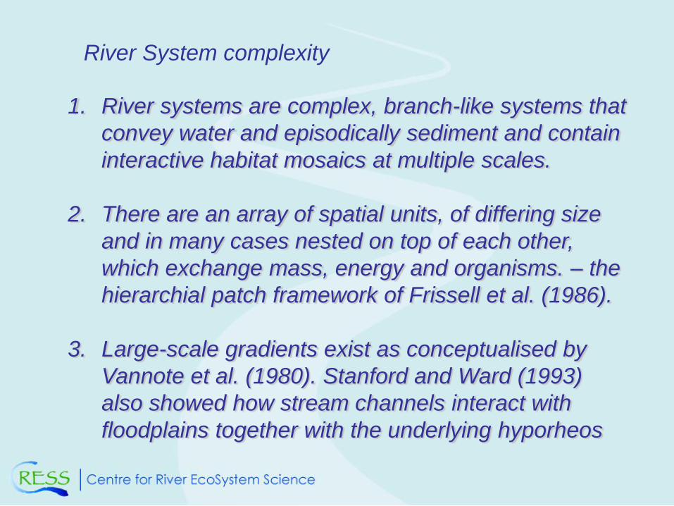
1. River systems are complex, branch-like systems that
convey water and episodically sediment and contain
interactive habitat mosaics at multiple scales.
2. There are an array of spatial units, of differing size
and in many cases nested on top of each other,
which exchange mass, energy and organisms. – the
hierarchial patch framework of Frissell et al. (1986).
3. Large-scale gradients exist as conceptualised by
Vannote et al. (1980). Stanford and Ward (1993)
also showed how stream channels interact with
floodplains together with the underlying hyporheos
River System complexity
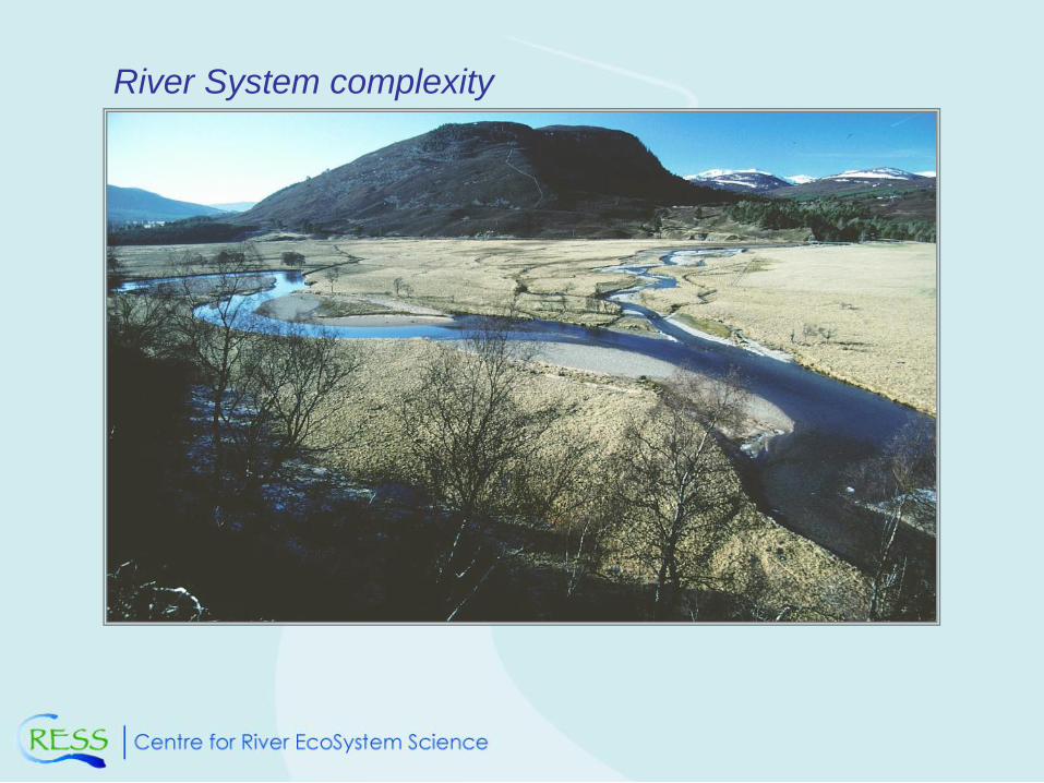
River System complexity
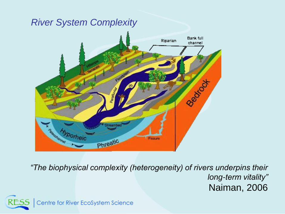
River System Complexity
“The biophysical complexity (heterogeneity) of rivers underpins their
long-term vitality”
Naiman, 2006
THE EVOLUTION: 4 PHASES
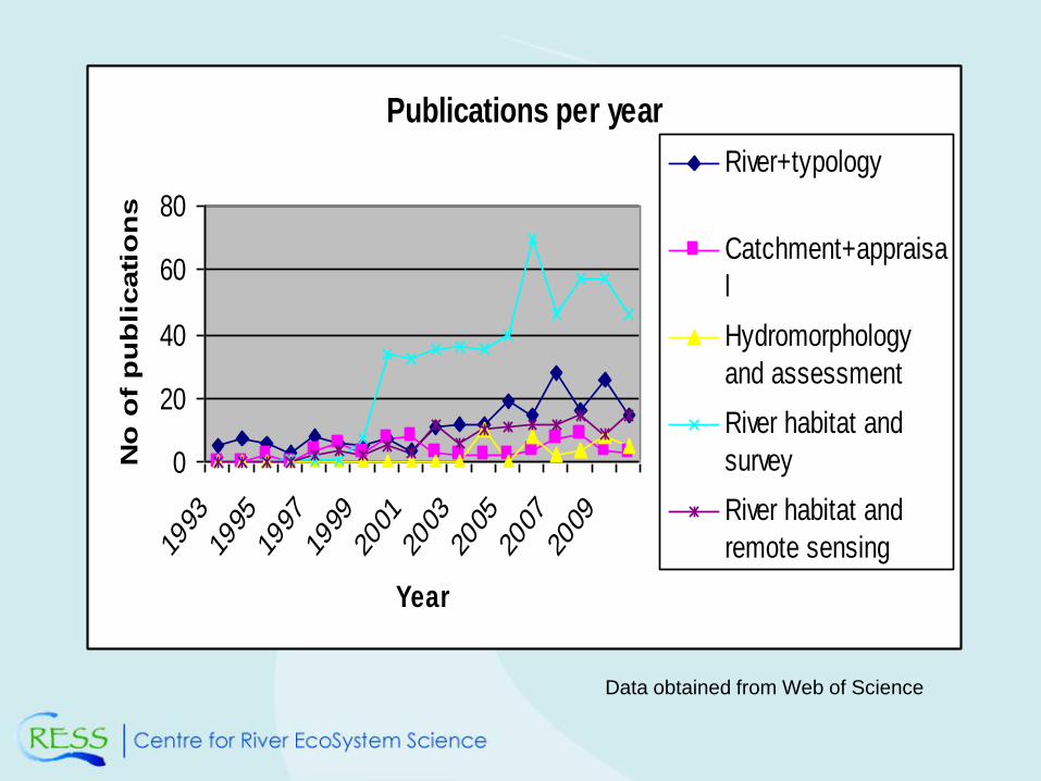
Publications per year
0
20
40
60
80
1993
1995
1997
1999
2001
2003
2005
2007
2009
Year
No
of
pu
bli
cati
on
s
River+typology
Catchment+appraisa
l
Hydromorphology
and assessment
River habitat and
survey
River habitat and
remote sensing
Data obtained from Web of Science
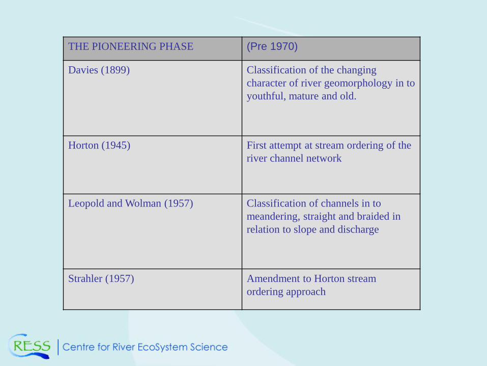
THE PIONEERING PHASE (Pre 1970)
Davies (1899) Classification of the changing
character of river geomorphology in to
youthful, mature and old.
Horton (1945) First attempt at stream ordering of the
river channel network
Leopold and Wolman (1957) Classification of channels in to
meandering, straight and braided in
relation to slope and discharge
Strahler (1957) Amendment to Horton stream
ordering approach
THE ESTABLISHMENT/
THEORETICAL PHASE
1970 - 1990
Kellerhals et al. (1976) Classification of channels according to
patterns and lateral instability
Stocker and Williams (1972) Freeze coring substrates
Rust (1978) A classification of alluvial channels
Smith and Smith (1980) Classification including anastomosing
channels
Church (1990) Ratio of flow depth to grain size; step-pool
cascade; pool-riffle; meandering/braided
Frissell (1982) Origin of the nested habitat hierarchy
approach from micro-habitat, through meso-
scale to stream system
Nanson and Cloke (1992) Classification of floodplains in to 3 class
system: High-energy non-cohesive;
medium-energy non-cohesive and low-
energy cohesive; 13 derivative orders and
sub-orders.
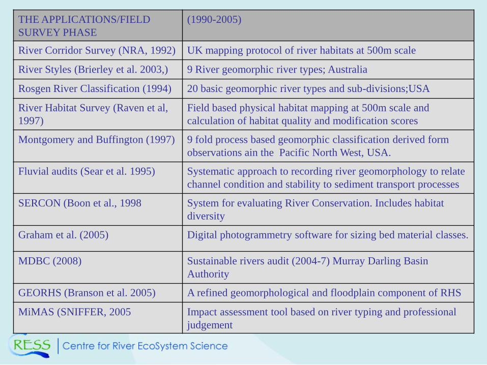
THE APPLICATIONS/FIELD
SURVEY PHASE
(1990-2005)
River Corridor Survey (NRA, 1992) UK mapping protocol of river habitats at 500m scale
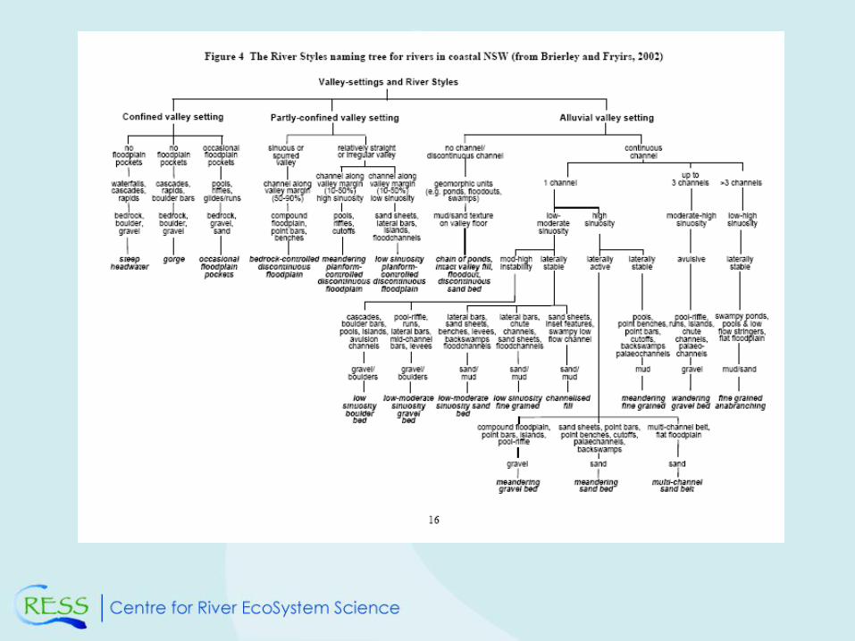
River Styles (Brierley et al. 2003,) 9 River geomorphic river types; Australia
Rosgen River Classification (1994) 20 basic geomorphic river types and sub-divisions;USA
River Habitat Survey (Raven et al,
1997)
Field based physical habitat mapping at 500m scale and
calculation of habitat quality and modification scores
Montgomery and Buffington (1997) 9 fold process based geomorphic classification derived form
observations ain the Pacific North West, USA.
Fluvial audits (Sear et al. 1995) Systematic approach to recording river geomorphology to relate
channel condition and stability to sediment transport processes
SERCON (Boon et al., 1998 System for evaluating River Conservation. Includes habitat
diversity
Graham et al. (2005) Digital photogrammetry software for sizing bed material classes.
MDBC (2008) Sustainable rivers audit (2004-7) Murray Darling Basin
Authority
GEORHS (Branson et al. 2005) A refined geomorphological and floodplain component of RHS
MiMAS (SNIFFER, 2005 Impact assessment tool based on river typing and professional
judgement
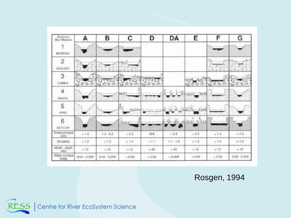
Rosgen, 1994
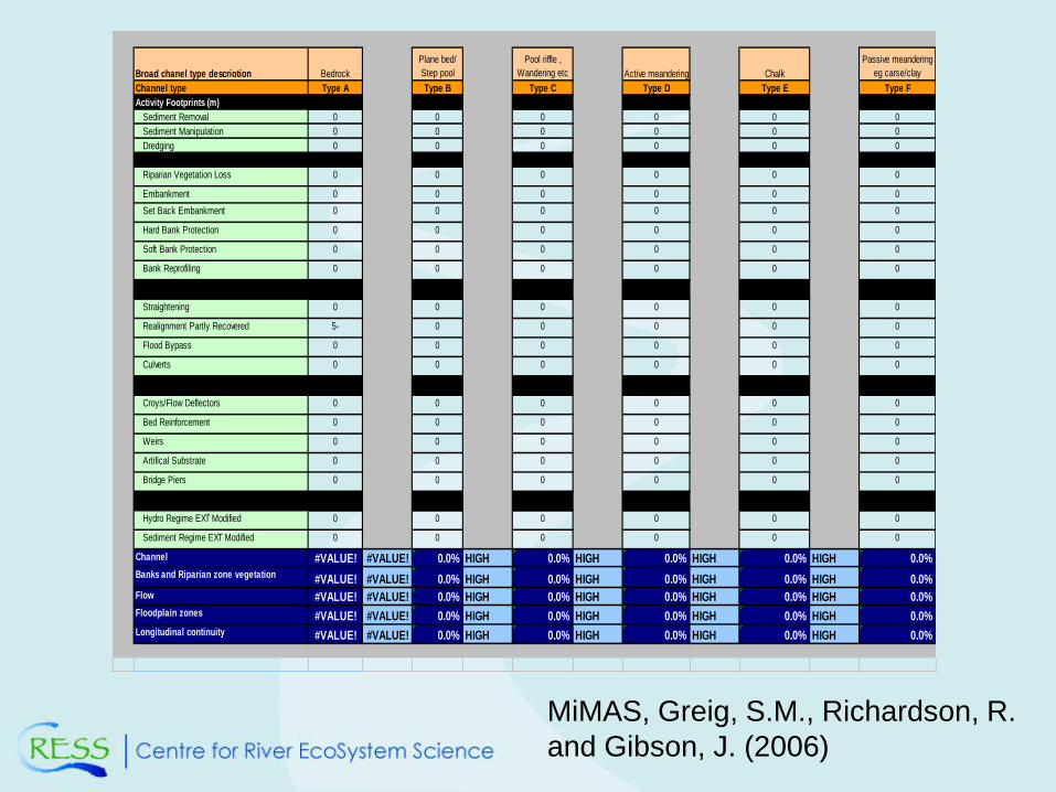
Broad chanel type descriotion Bedrock
Plane bed/
Step pool
Pool riffle ,
Wandering etc Active meandering Chalk
Passive meandering
eg carse/clay
Channel type Type A Type B Type C Type D Type E Type F
Activity Footprints (m)
Sediment Removal 0 0 0 0 0 0
Sediment Manipulation 0 0 0 0 0 0
Dredging 0 0 0 0 0 0
Riparian Vegetation Loss 0 0 0 0 0 0
Embankment 0 0 0 0 0 0
Set Back Embankment 0 0 0 0 0 0
Hard Bank Protection 0 0 0 0 0 0
Soft Bank Protection 0 0 0 0 0 0
Bank Reprofiling 0 0 0 0 0 0
Straightening 0 0 0 0 0 0
Realignment Partly Recovered 5- 0 0 0 0 0
Flood Bypass 0 0 0 0 0 0
Culverts 0 0 0 0 0 0
Croys/Flow Deflectors 0 0 0 0 0 0
Bed Reinforcement 0 0 0 0 0 0
Weirs 0 0 0 0 0 0
Artifical Substrate 0 0 0 0 0 0
Bridge Piers 0 0 0 0 0 0
Hydro Regime EXT Modified 0 0 0 0 0 0
Sediment Regime EXT Modified 0 0 0 0 0 0
Channel #VALUE! #VALUE! 0.0% HIGH 0.0% HIGH 0.0% HIGH 0.0% HIGH 0.0%
Banks and Riparian zone vegetation #VALUE! #VALUE! 0.0% HIGH 0.0% HIGH 0.0% HIGH 0.0% HIGH 0.0%
Flow #VALUE! #VALUE! 0.0% HIGH 0.0% HIGH 0.0% HIGH 0.0% HIGH 0.0%
Floodplain zones #VALUE! #VALUE! 0.0% HIGH 0.0% HIGH 0.0% HIGH 0.0% HIGH 0.0%
Longitudinal continuity #VALUE! #VALUE! 0.0% HIGH 0.0% HIGH 0.0% HIGH 0.0% HIGH 0.0%
MiMAS, Greig, S.M., Richardson, R.
and Gibson, J. (2006)
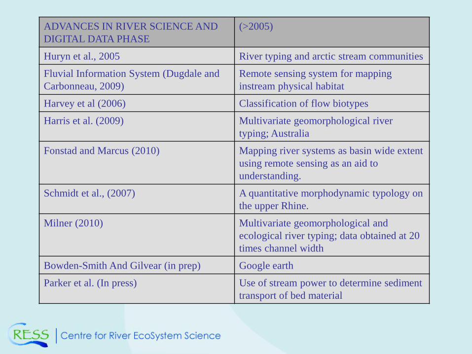
ADVANCES IN RIVER SCIENCE AND
DIGITAL DATA PHASE
(>2005)
Huryn et al., 2005 River typing and arctic stream communities
Fluvial Information System (Dugdale and
Carbonneau, 2009)
Remote sensing system for mapping
instream physical habitat
Harvey et al (2006) Classification of flow biotypes
Harris et al. (2009) Multivariate geomorphological river
typing; Australia
Fonstad and Marcus (2010) Mapping river systems as basin wide extent
using remote sensing as an aid to
understanding.
Schmidt et al., (2007) A quantitative morphodynamic typology on
the upper Rhine.
Milner (2010) Multivariate geomorphological and
ecological river typing; data obtained at 20
times channel width
Bowden-Smith And Gilvear (in prep) Google earth
Parker et al. (In press) Use of stream power to determine sediment
transport of bed material
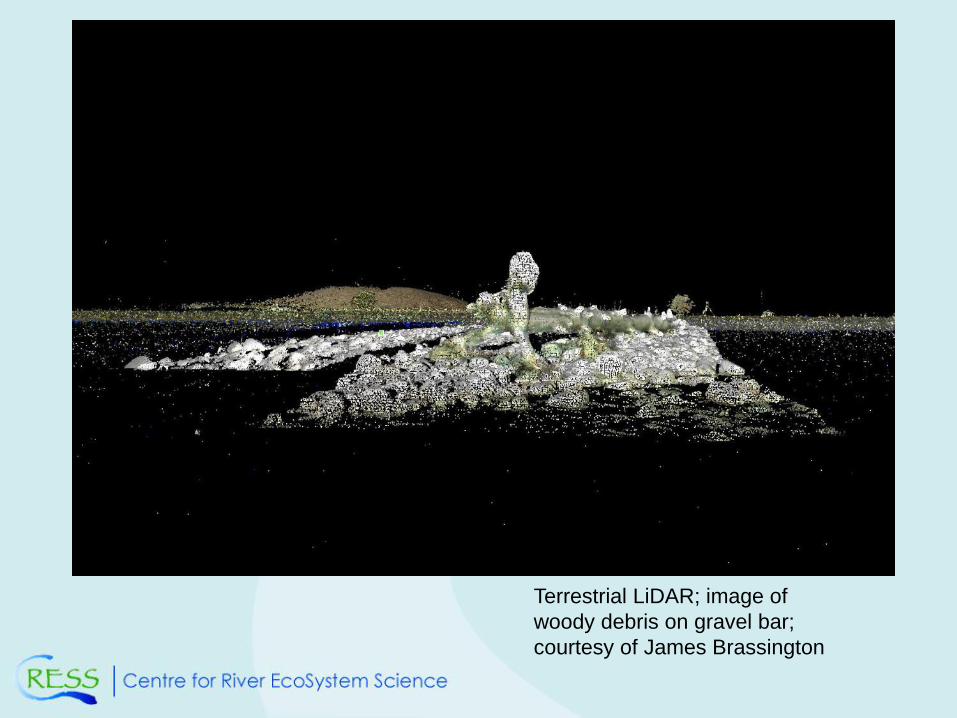
Terrestrial LiDAR; image of
woody debris on gravel bar;
courtesy of James Brassington

Googleearth and RHS
scores
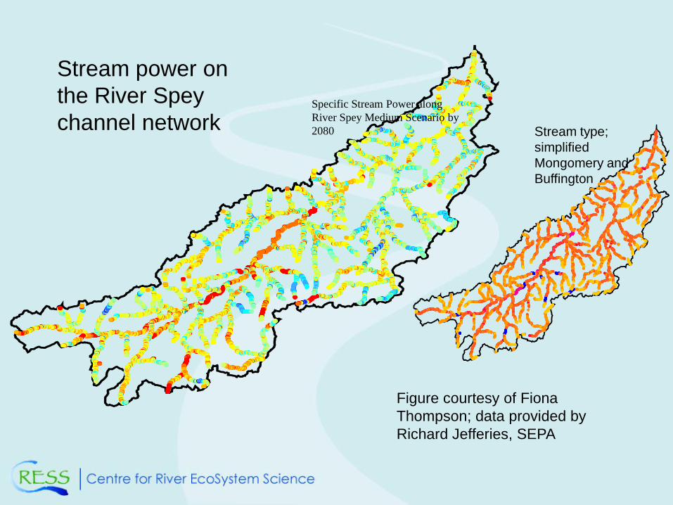
Figure courtesy of Fiona
Thompson; data provided by
Richard Jefferies, SEPA
Stream power on
the River Spey
channel networkSpecific Stream Power along
River Spey Medium Scenario by
2080 Stream type;
simplified
Mongomery and
Buffington
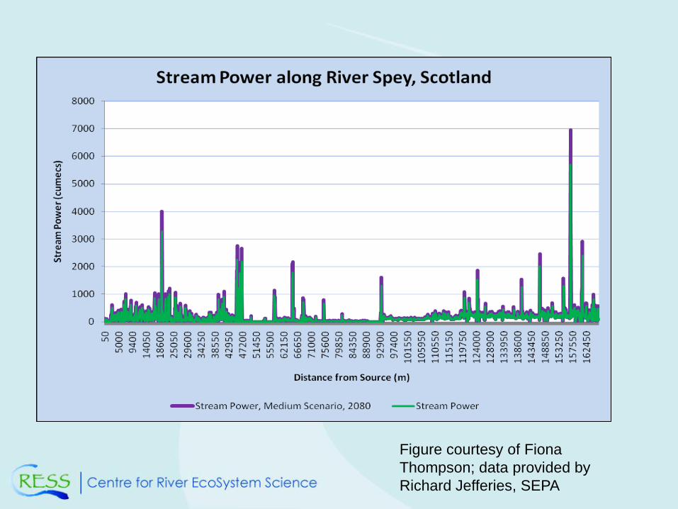
Figure courtesy of Fiona
Thompson; data provided by
Richard Jefferies, SEPA
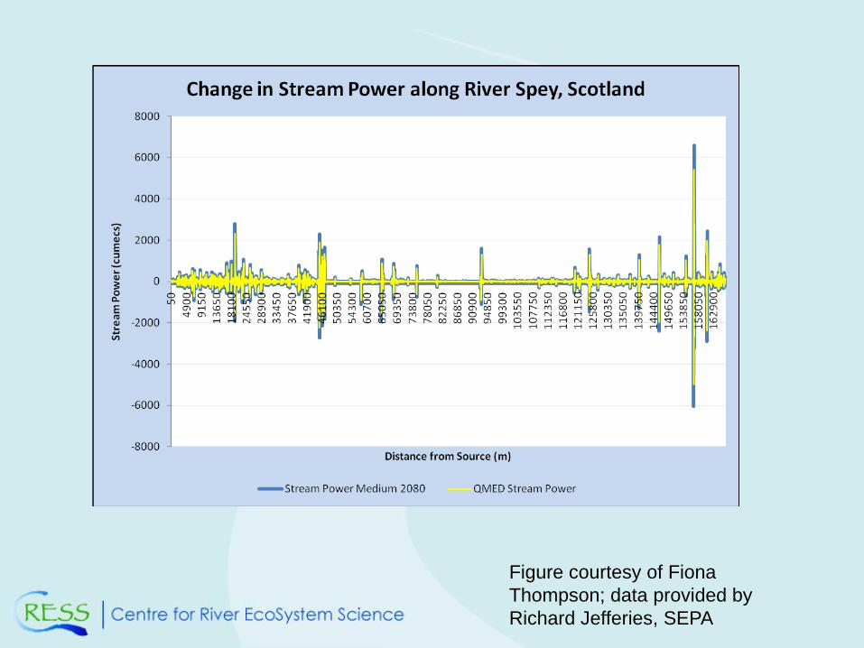
Figure courtesy of Fiona
Thompson; data provided by
Richard Jefferies, SEPA
CASE STUDIES FROM THE RIVER SCIENCE
PHASE
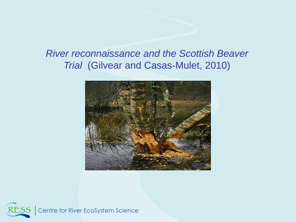
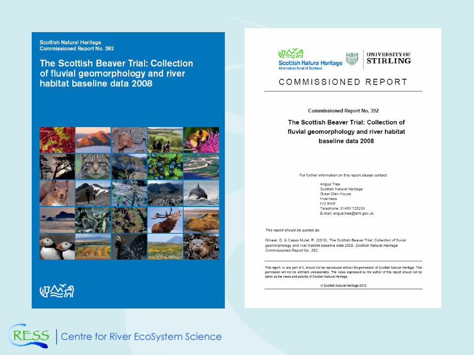
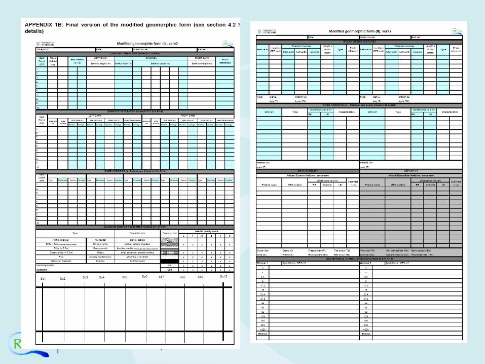
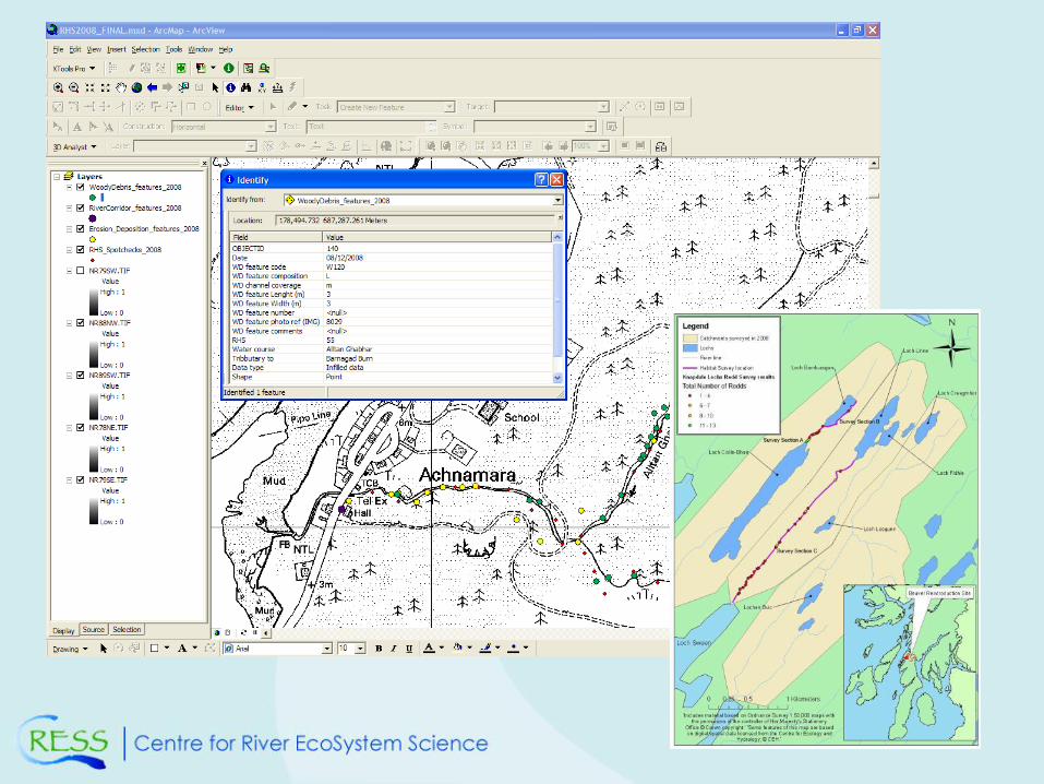
River reconnaissance and the Scottish Beaver
Trial (Gilvear and Casas-Mulet, 2010)
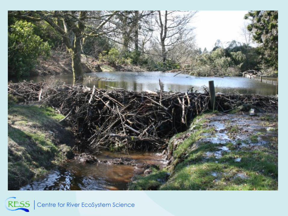
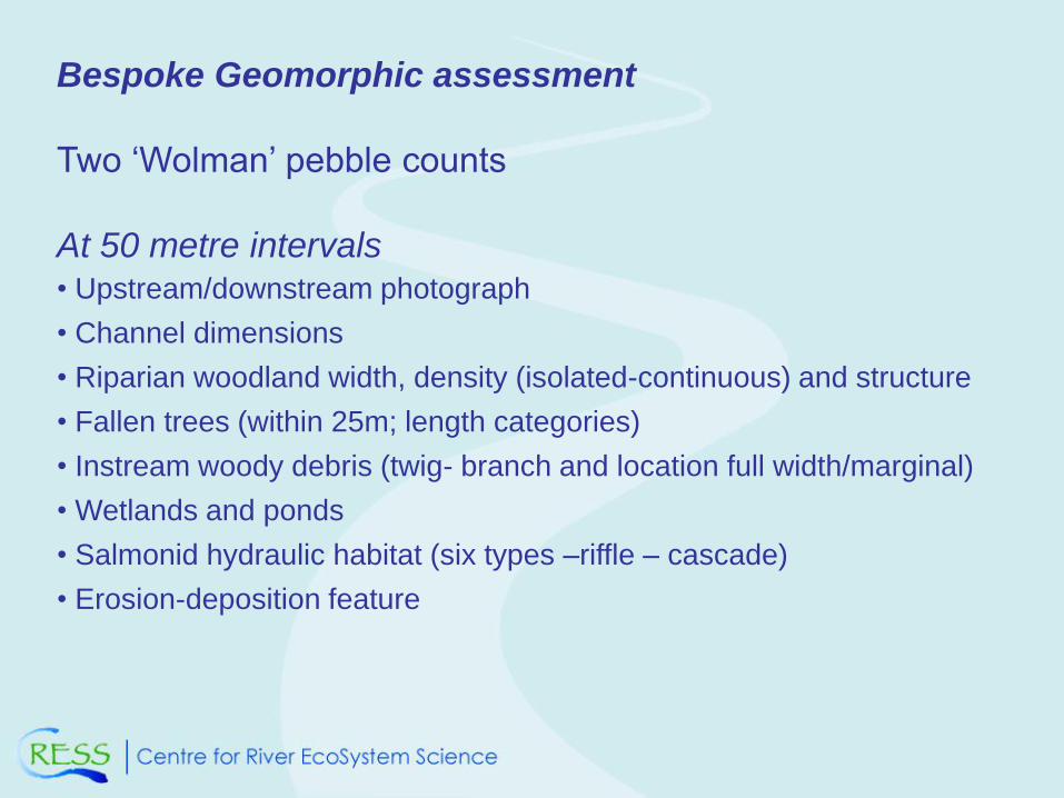
Bespoke Geomorphic assessment
Two ‘Wolman’ pebble counts
At 50 metre intervals• Upstream/downstream photograph
• Channel dimensions
• Riparian woodland width, density (isolated-continuous) and structure
• Fallen trees (within 25m; length categories)
• Instream woody debris (twig- branch and location full width/marginal)
• Wetlands and ponds
• Salmonid hydraulic habitat (six types –riffle – cascade)
• Erosion-deposition feature
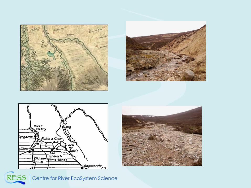
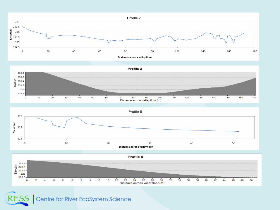
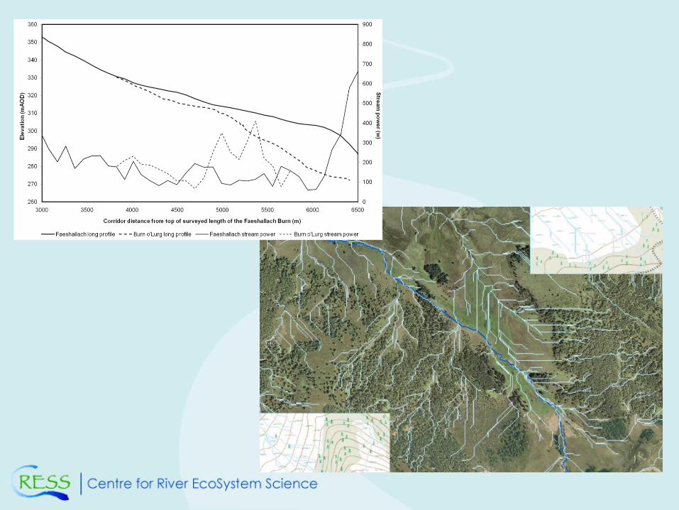
River reconnaissance and appraisal on the
Faeshallach Burn for restoration options
(Gilvear and Perfect, 2010)
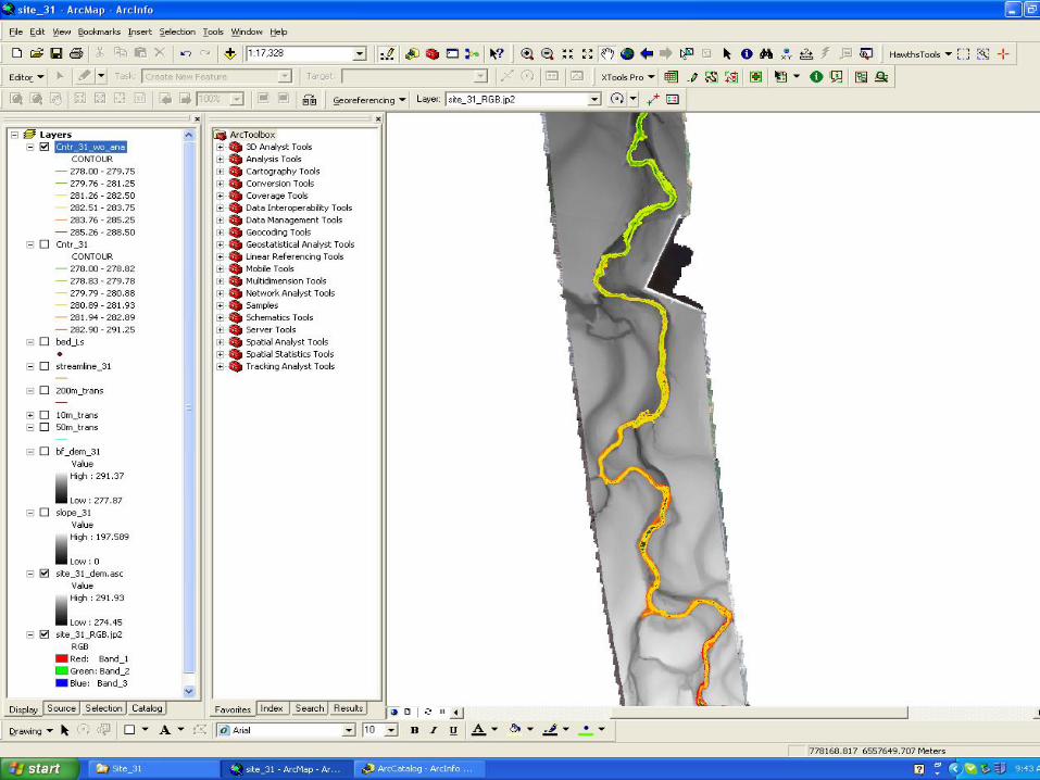
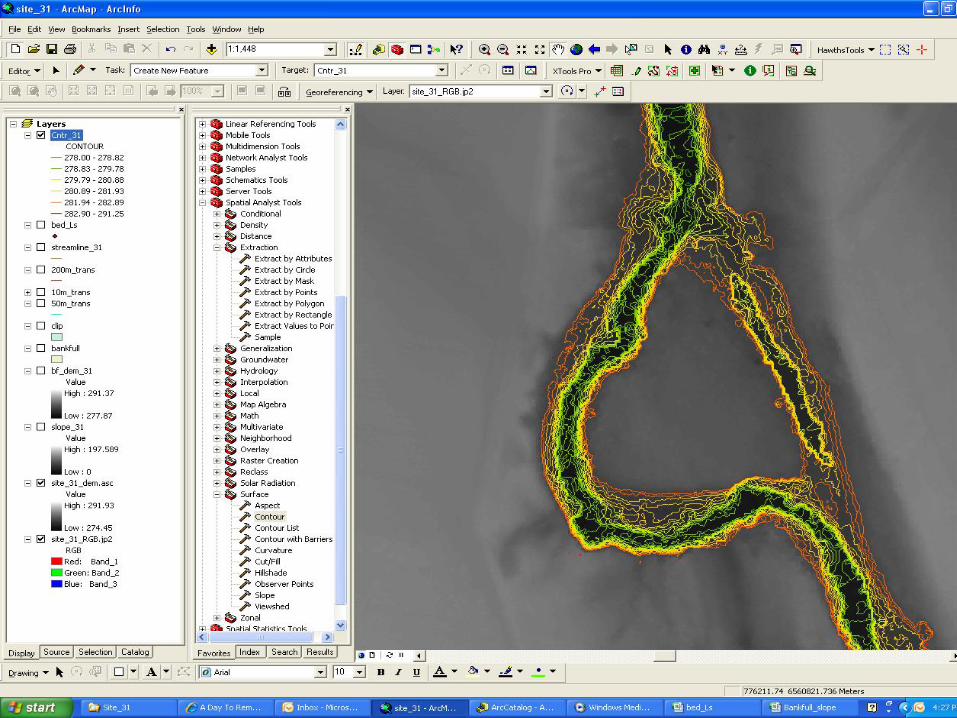
Reach-scale river typing on the River Dee
(Milner, 2010)
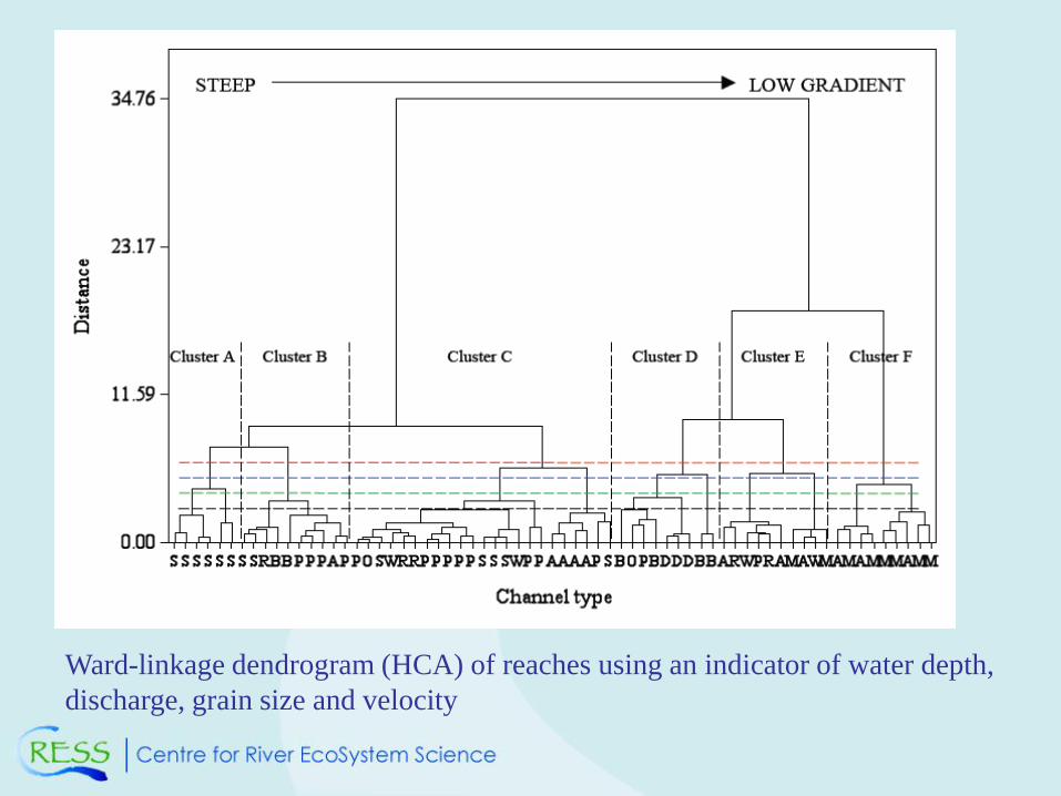
Ward-linkage dendrogram (HCA) of reaches using an indicator of water depth,
discharge, grain size and velocity
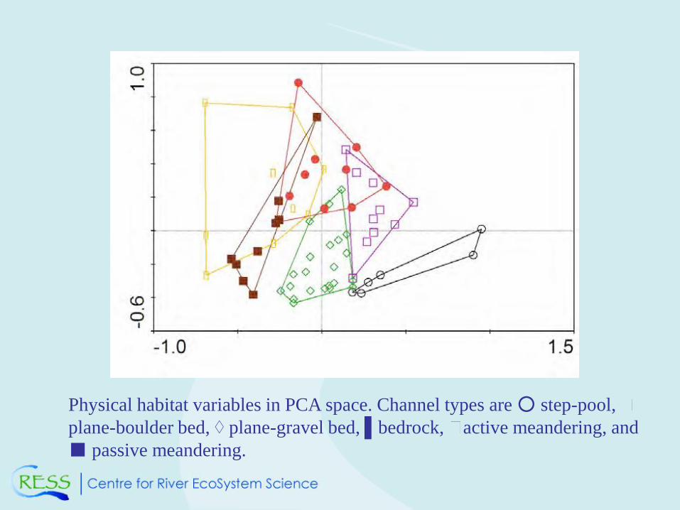
Physical habitat variables in PCA space. Channel types are ○ step-pool,
plane-boulder bed, ◊ plane-gravel bed, ▌bedrock, active meandering, and
■ passive meandering.
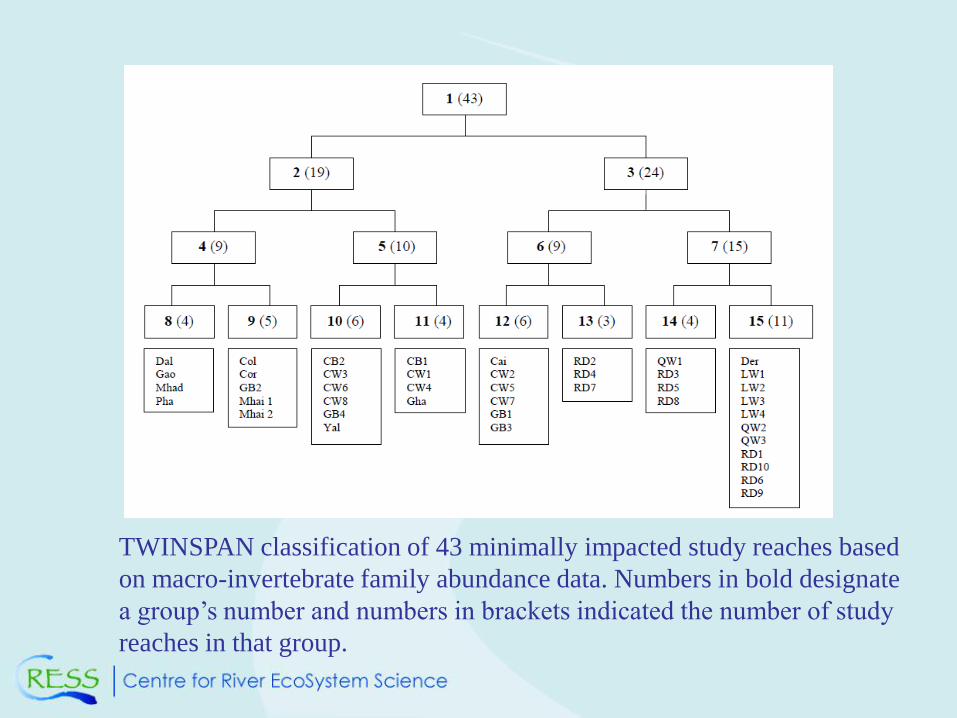
TWINSPAN classification of 43 minimally impacted study reaches based
on macro-invertebrate family abundance data. Numbers in bold designate
a group’s number and numbers in brackets indicated the number of study
reaches in that group.
FUTURE CHALLENGES: SCALE AND
HETEROGENEITY
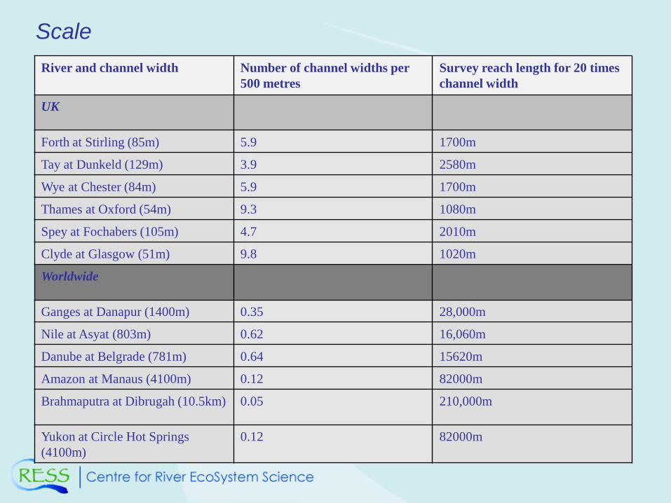
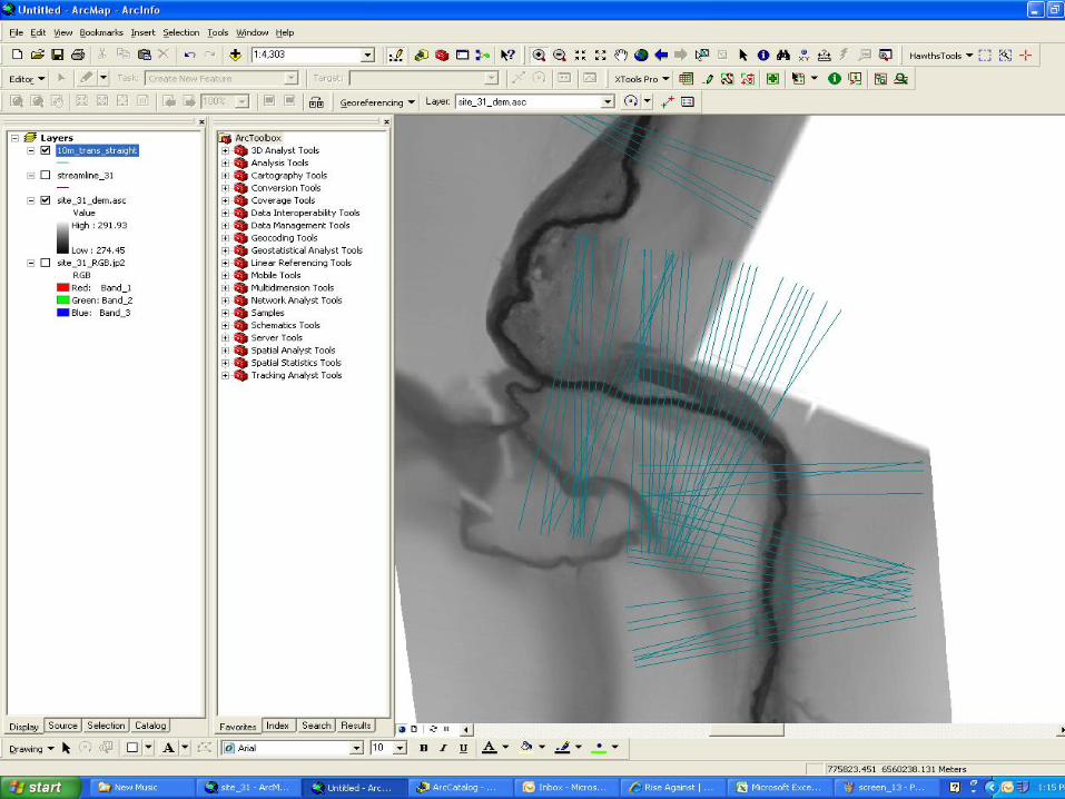
River and channel width Number of channel widths per
500 metres
Survey reach length for 20 times
channel width
UK
Forth at Stirling (85m) 5.9 1700m
Tay at Dunkeld (129m) 3.9 2580m
Wye at Chester (84m) 5.9 1700m
Thames at Oxford (54m) 9.3 1080m
Spey at Fochabers (105m) 4.7 2010m
Clyde at Glasgow (51m) 9.8 1020m
Worldwide
Ganges at Danapur (1400m) 0.35 28,000m
Nile at Asyat (803m) 0.62 16,060m
Danube at Belgrade (781m) 0.64 15620m
Amazon at Manaus (4100m) 0.12 82000m
Brahmaputra at Dibrugah (10.5km) 0.05 210,000m
Yukon at Circle Hot Springs
(4100m)
0.12 82000m
Scale
Need to turn to downstream hydraulic geometry for
the answer
Using the Montgomery and Gran (2001) hydraulic
geometry relationship for Stasop River in Pacific
North West of States
Survey lengths at twenty channel widths would be
60m, 147m, 480m, 875m, 1640m at catchment
areas of 1km2, 25km2, 100km2, and 250km2
respectively.
Surveying at appropriate scales
Multiple scales – going beyond meso-habitat mapping
Baxter and Hauer (2000) have shown of redds of the
fall-spawning bull charr (Salvelinus confluentus) is
centred on low-gradient alluvial valley segments which
has regional upwelling creating the thermal conditions
conducive to egg incubation but that local siting is in
well oxygenated downwelling water.
Only multi-scalar analysis could reveal this relationship
between pattern and process.
The challenge is to integrate gradients, reaches, and
patches.
Embrace heterogeneity
•Heterogenity is likely to be a measure of stream health but
at what scale?
•As Fausch et al., (2002) state “the gap we must bridge is at
an intermediate scale in both space and time. Biologists
have always sampled at the small scale even when over
basin extents”.
•Jahnig et al. (2010) suggests that place centred restoration
for macroinvertebrates has not worked due to it focussing on
the micro and meso-scale.
The key is to understand where differing levels of
heterogeneity and homogeneity impinge on river ecosystem
function and at what scale and then measure appropriately.
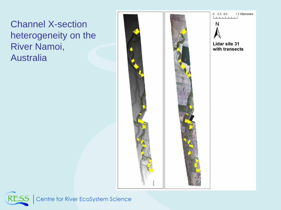
Channel X-section
heterogeneity on the
River Namoi,
Australia
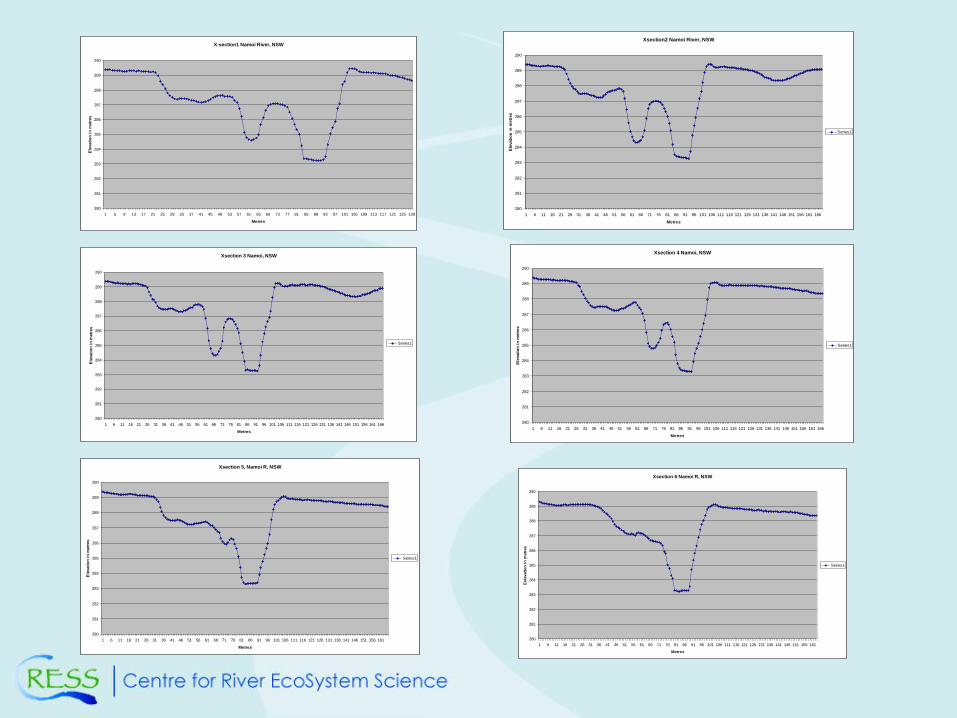
X-section1 Namoi River, NSW
280
281
282
283
284
285
286
287
288
289
290
1 5 9 13 17 21 25 29 33 37 41 45 49 53 57 61 65 69 73 77 81 85 89 93 97 101 105 109 113 117 121 125 129
Metres
Ele
vati
on
in
metr
es
Xsection2 Namoi River, NSW
280
281
282
283
284
285
286
287
288
289
290
1 6 11 16 21 26 31 36 41 46 51 56 61 66 71 76 81 86 91 96 101 106 111 116 121 126 131 136 141 146 151 156 161 166
Metres
Ele
vati
on
in
metr
es
Series1
Xsection 3 Namoi, NSW
280
281
282
283
284
285
286
287
288
289
290
1 6 11 16 21 26 31 36 41 46 51 56 61 66 71 76 81 86 91 96 101 106 111 116 121 126 131 136 141 146 151 156 161 166
Metres
Ele
vati
on
in
metr
es
Series1
Xsection 4 Namoi, NSW
280
281
282
283
284
285
286
287
288
289
290
1 6 11 16 21 26 31 36 41 46 51 56 61 66 71 76 81 86 91 96 101 106 111 116 121 126 131 136 141 146 151 156 161 166
Metres
Ele
vati
on
in
metr
es
Series1
Xsection 5, Namoi R, NSW
280
281
282
283
284
285
286
287
288
289
290
1 6 11 16 21 26 31 36 41 46 51 56 61 66 71 76 81 86 91 96 101 106 111 116 121 126 131 136 141 146 151 156 161
Metres
Ele
vati
on
in
metr
es
Series1
Xsection 6 Namoi R, NSW
280
281
282
283
284
285
286
287
288
289
290
1 6 11 16 21 26 31 36 41 46 51 56 61 66 71 76 81 86 91 96 101 106 111 116 121 126 131 136 141 146 151 156 161
Metres
Eele
vati
on
in
metr
es
Series1
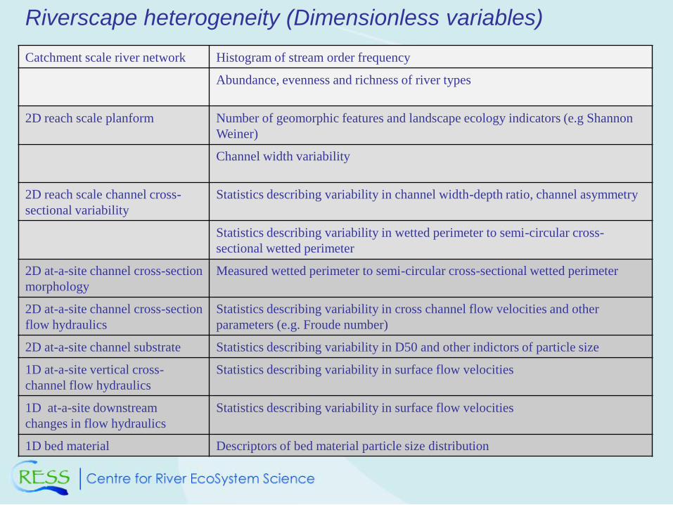
Riverscape heterogeneity (Dimensionless variables)
Catchment scale river network Histogram of stream order frequency
Abundance, evenness and richness of river types
2D reach scale planform Number of geomorphic features and landscape ecology indicators (e.g Shannon
Weiner)
Channel width variability
2D reach scale channel cross-
sectional variability
Statistics describing variability in channel width-depth ratio, channel asymmetry
Statistics describing variability in wetted perimeter to semi-circular cross-
sectional wetted perimeter
2D at-a-site channel cross-section
morphology
Measured wetted perimeter to semi-circular cross-sectional wetted perimeter
2D at-a-site channel cross-section
flow hydraulics
Statistics describing variability in cross channel flow velocities and other
parameters (e.g. Froude number)
2D at-a-site channel substrate Statistics describing variability in D50 and other indictors of particle size
1D at-a-site vertical cross-
channel flow hydraulics
Statistics describing variability in surface flow velocities
1D at-a-site downstream
changes in flow hydraulics
Statistics describing variability in surface flow velocities
1D bed material Descriptors of bed material particle size distribution
CONCLUSION
•Catchment appraisal, river typing and reconnaissance is now
mainstream and truly integrated in to river management.
•Despite the complexity of river systems approaches and methodologies
have been developed that cope with the challenge of fluvial systems
•The emergence of river science as a discipline has provided an solid
foundation for understanding eco-geomorphological and hydro-
geomorphological processes.
•Need to me more sophisticated and clever in our appraisals to maximise
the new armoury of weapons we have at our disposal. Potential for new
insights in to theoretical understanding
•A greater focus on the implications of scale of analysis and
measurement of heterogeneity at multiple scales.
Recommended