PANKAJ BECHARBHAI PATEL
1
PROJECT DETAILS FOR SAND MINING
Sr. No. Details Particulars1 Name of Lease Holder Pankaj Becharbhai Patel
2 Location addressBlock No. C, Lagu Sur. No. 541, Vatrak River
Village: Virol, Tal: MehmedabadDist: Kheda
3 Applicability of the CRZNotification, 2011 Not Applicable
4 Lease Area (Hectares) 2.00 hectare
5 Co-ordinates of the lease area22˚ 48’ 49.12" N 72˚ 43’ 7.99” E22˚ 48’ 51.55" N 72˚ 43’ 6.51” E22˚ 48’ 47.58" N 72˚ 42’ 58.27” E22˚ 48’ 45.22" N 72˚ 42’ 59.35” E
6 Ownership of Land(Govt. / Private Land) Government Land
7 Status of Operation (New Project orExisting project operating since___) New Project
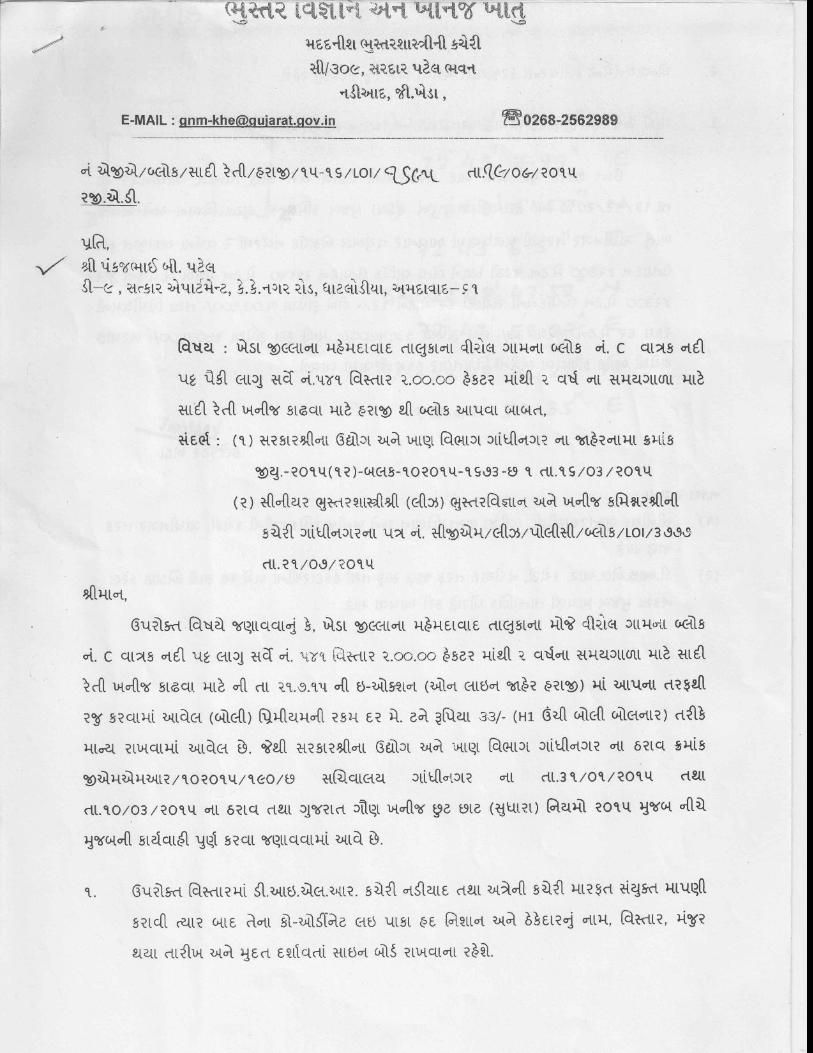
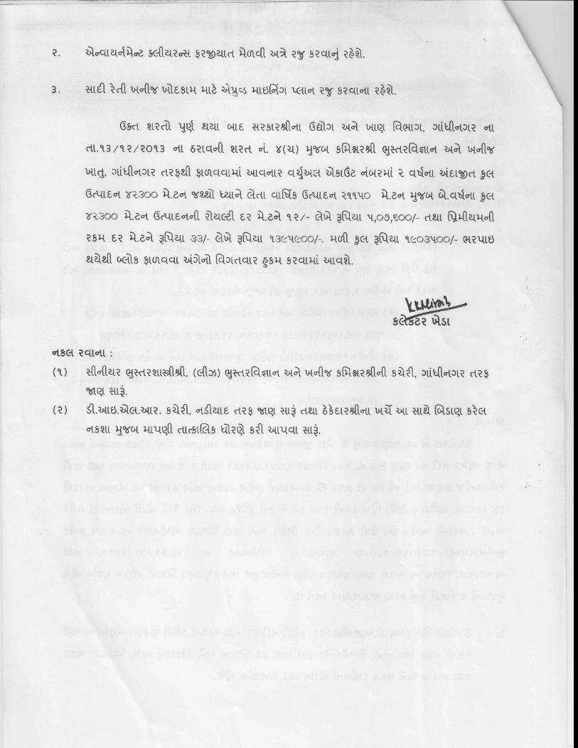
8
Status of Lease (Lease no., date ofissues / renewal, lease period, dateof application for lease renewal,etc.)
Lease No. AGK/Block/OrdinarySand/Auction/15-16/LOI/1695 dtd: 19
September 2015 for 2 years.Letter is enclosed
9 Sand Reserve (MT) 138000 MT10 Rate of Mining of Sand (MT/Month) 40000 MT/Year
ENVIRONMENTAL SETTING
11If located within 15 km, aerialdistance of the lease area from thenearest:
--
i. National Park / WildlifeSanctuary / BiosphereReserve
None
ii. Reserve Forest / ProtectedForest: None
iii. Human Habitation: Virol @ 0.71 kmiv. Railway Line: Mehmedabad @ 3.0 kmv. Road: SH60 @ 2.31 kmvi. Notified / Protected
Archaeological sites: None
vii. Social infrastructures, e.g.School, hospital, historic /cultural / religious placesetc.:
School (Virol – 1.05 km)Temple (Virol – 1.0 km)
12 Width of riverbed (meters) 305 m13 Average depth of water at lease 8.0 m avg. depth
PANKAJ BECHARBHAI PATEL
2
area (meters)
14 Average thickness of sand depositat lease area (meters) 3.5 – 4.0 m sand deposit thickness
15Details on riparian vegetation,endemic / endangered species offlora / fauna in the area
No riparian vegetation in the lease area. Noendemic / endangered species of flora / faunain the area.
16 Geo-hydrological of the river, flow (perennial, seasonal, etc.), replenishmentpotential, etc.
Vatrak is Seasonal RiverPhysiography and geomorphology of the area:The Kheda district is bounded by the districts Sabarkantha and Gandhinagar to the north,Panchmahals to the east, Ahmedabad to the west, and Anand and Vadodara to the south.Kheda district is a part of Gujarat plain and is categories into five sub micro regions based ontopography, climate, geology, soils and natural vegetation. The categories are Sabarmati-Vatrak plain, Nadiad plain, Aravalli Forested Rock-outcrops and Mahi plain. The whole Khedadistrict falls under two main parts.1. Small undulating hilly area in northern parts of Kapadvanj and Balasinor Taluka.2. Plain sloping gently from the North East towards the South West.The northern parts of Kapadvanj and Balasinor Taluka covered with udulating hills with rockyterrain and slop height vary between 150 to73 m above mean sea level. The other parts areplain and traversed by the rivers. The project location is situated at a height of about 29 mabove mean sea level. However, there is not much remark able variation in topology of thestudy area above MSL.
Drainage Pattern:There are 3 major rivers flowing from the study area. Meshwo River, Vatrak River and portion ofSabarmati River, there flows are from NE to SW direction for Meshwo and Vatrak River andfrom N to S direction for Sabarmati River. Meshwo and Vatrak lies 7 km SE direction fromproject site and Meshwo merging with Vatrak at the same point in the study area. Finally, thenatural drainage is through river Vatrak towards southwest made up of natural nallas generallyflowing from northeast to southwest leading to Arabian Sea near Gulf of Khambhat. Multitudesof ponds present in almost every village in the area are used for domestic purpose. Thegeneral topography of the study area is almost flat with about 1° gradient due South or SSWtowards Gulf of Khambhat. For the storm water system for the park has been planned utilizingthe natural slopes to design an economical system. However, the area is under the influenceof the rivers Meshwo and Vatrak and its tributaries being the main recharging source&controlling the drainage pattern.
Geologically the area is comprised of Quaternary Alluvium (clay &sand). The whole KhedaDistrict forms a Part of Cambay Basin. The rock formation exposed is composed of thickAlluvium. This alluvium is formed of alternative bends of sandy and clays layers. Sandy layersare composed of fine, medium & coarse sand while clayey layers are impervious and devoidof porosity, Swelling & pintching of strata is general phenomena in Alluvium area. In talukas likeKheda, Nadiad, Mehmedabad, Mahuda Kathlal, Thasara & Kapadvanj alluvium formation isseen which consists mainly of clay, sand, kankars & gravels.
17 Width and condition of accessroad (kutcha / pucca) t the lease 4.0 to 5.0 m access (Kutcha / pucca )road
PANKAJ BECHARBHAI PATEL
3
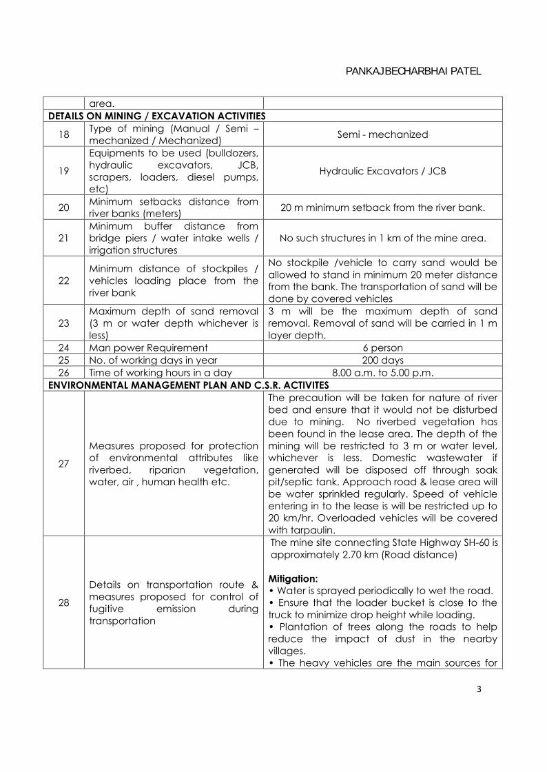
area.DETAILS ON MINING / EXCAVATION ACTIVITIES
18 Type of mining (Manual / Semi –mechanized / Mechanized) Semi - mechanized
19
Equipments to be used (bulldozers,hydraulic excavators, JCB,scrapers, loaders, diesel pumps,etc)
Hydraulic Excavators / JCB
20 Minimum setbacks distance fromriver banks (meters) 20 m minimum setback from the river bank.
21Minimum buffer distance frombridge piers / water intake wells /irrigation structures
No such structures in 1 km of the mine area.
22Minimum distance of stockpiles /vehicles loading place from theriver bank
No stockpile /vehicle to carry sand would beallowed to stand in minimum 20 meter distancefrom the bank. The transportation of sand will bedone by covered vehicles
23Maximum depth of sand removal(3 m or water depth whichever isless)
3 m will be the maximum depth of sandremoval. Removal of sand will be carried in 1 mlayer depth.
24 Man power Requirement 6 person25 No. of working days in year 200 days26 Time of working hours in a day 8.00 a.m. to 5.00 p.m.
ENVIRONMENTAL MANAGEMENT PLAN AND C.S.R. ACTIVITES
27
Measures proposed for protectionof environmental attributes likeriverbed, riparian vegetation,water, air , human health etc.
The precaution will be taken for nature of riverbed and ensure that it would not be disturbeddue to mining. No riverbed vegetation hasbeen found in the lease area. The depth of themining will be restricted to 3 m or water level,whichever is less. Domestic wastewater ifgenerated will be disposed off through soakpit/septic tank. Approach road & lease area willbe water sprinkled regularly. Speed of vehicleentering in to the lease is will be restricted up to20 km/hr. Overloaded vehicles will be coveredwith tarpaulin.
28
Details on transportation route &measures proposed for control offugitive emission duringtransportation
The mine site connecting State Highway SH-60 isapproximately 2.70 km (Road distance)
Mitigation:• Water is sprayed periodically to wet the road.• Ensure that the loader bucket is close to thetruck to minimize drop height while loading.• Plantation of trees along the roads to helpreduce the impact of dust in the nearbyvillages.• The heavy vehicles are the main sources for
PANKAJ BECHARBHAI PATEL
4
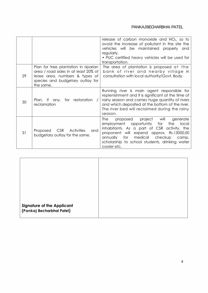
release of carbon monoxide and NOx, so toavoid the increase of pollutant in the site thevehicles will be maintained properly andregularly.• PUC certified heavy vehicles will be used fortransportation.
29
Plan for tree plantation in riparianarea / road sides in at least 20% oflease area, numbers & types ofspecies and budgetary outlay forthe same.
The area of plantation is proposed a t t h eb a n k o f r i v e r a n d n e a r b y v i l l a g e inconsultation with local authority/Govt. Body.
30 Plan, if any, for restoration /reclamation
Running river is main agent responsible forreplenishment and it is significant at the time ofrainy season and carries huge quantity of riversand which deposited at the bottom of the river.The river bed will reclaimed during the rainyseason.
31 Proposed CSR Activities andbudgetary outlay for the same.
The proposed project will generateemployment opportunity for the localinhabitants. As a part of CSR activity, theproponent will expend approx. Rs.15000.00annually for medical checkup camp,scholarship to school students, drinking watercooler etc.
Signature of the Applicant(Pankaj Becharbhai Patel)
Recommended