Pre-flightchecklist:
Data Scribe: Read this checklist aloud, asking for the confirm / data from Spotter & Pilot.
Spotter/Safety Lead: ❏ Weather conditions of flying area:
(Cloud Cover (%), Temperature, wind direction, speed, variability, humidity (optional))
❏ Hazards present? (yes/no/describe)❏ Takeoff/landing area established?
Investigator Lead: science focused checklist: TBD by the investigation
Pilot:❏ Drone checks:
Spin your props - secured? Check for loose parts. Battery is charged & connected. (opt) Payload secured?
❏ Transmitter checks: Battery is charged, Joy-sticks work.
❏ Instrument checks: Camera: Connected to power? SD card inserted? Sufficient storage available? Other sensors & equipment: Power on? memory card inserted? Sensor working? Secured to drone? Meter-circle in place?
Everyone:❏ Step back 5x5 for safety
beforeeveryflight
❏ STOP ❏ Put your drone down.
❏ Take 5 steps back. ❏ Look around for 5
seconds. ❏ Look behind you too! ❏ IDENTIFY & ASSESS
hazards, ❏ MAKE CHANGES if
needed , SAFELY – complete your flight
Instructor: Data scribe - see anything? Spotter- see anything? Pilot - See anything?
Stop to address anything you see. Instructor: Team, start your flight!
BeforeyouflySafety-StepBack5x5forSafety
Timetofly!Pilot (s):
1. Announce out loud – “CLEAR PROPS”. 2. Make sure the throttle (left stick) is all the way
down then turn on the transmitter. 3. Back away 3 or 4 steps (or to a safe distance). 4. Bind & calibrate drone & take test photo and
video 5. Announce out loud – “TAKE OFF”. 6. Launch drone 7. Keep facing the quadcopter the entire time. 8. Follow the data scribe’s route directions
– Maintain a safe altitude when flying over buildings / obstacles
– Keep a direct line of sight at all times when flying
Datascribe:1. Start a stopwatch (app) 2. Call out the route using the
investigation plan. 3. If using FPV, take photos 4. Record data 5. Keep an eye on the drone too
Spo@er:1. Move around so you can
always see the drone. 2. Continually scan the flight and
ground areas for potential hazards.
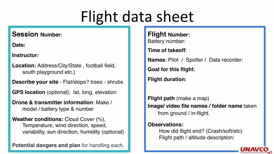
FlightdatasheetSession Number:
Date:
Instructor:
Location: Address/City/State , football field, south playground etc.)
Describe your site - Flat/slope? trees - shrubs
GPS location (optional): lat, long, elevation
Drone & transmitter information: Make / model / battery type & number
Weather conditions: Cloud Cover (%), Temperature, wind direction, speed, variability, sun direction, humidity (optional)
Potential dangers and plan for handling each.
Flight Number: Battery number:Time of takeoff:Names: Pilot / Spotter / Data recorder:Goal for this flight:
Flight duration:
Flight path (make a map)Image/ video file names / folder name taken
from ground / in-flight.
Observations:How did flight end? (Crash/soft/etc)Flight path / altitude description:
Recommended


![Evolution of flight in animals · 2 Evolution of insect flight Several theories have been suggested for the origin of flight in insects (summarized in Thomas and Norberg [1])](https://img.pdfslide.us/doc/110x75/5f0850067e708231d4216393/evolution-of-iight-in-animals-2-evolution-of-insect-iight-several-theories-have.jpg)