1
Permanent Program Finding
Results of Review
Permanent Program Permit Application No. 461
Vigo Coal Operating Company, LLC.
Friendsville Mine
TABLE OF CONTENTS
Introduction
I. Summary of Permit Application No. 461
II. Summary of the Public Participation Process
III. Summary of the Department's Findings
A. Findings Required by 62 Ill. Adm. Code 1773.15
B. Findings Required by 62 Ill. Adm. Code 1785
C. Compliance with 62 Ill. Adm. Code 1773.19
IV. Permit Conditions
V. Conclusions
VI. Appendices
A. Required Modifications
B. Consideration of Comments and Objections
C. Assessment and Findings of Probable Cumulative Hydrologic Impacts
D. Decision on Proposed Post-Mining Land Use/Capability of Permit Area
E. Threatened and Endangered Species
F. Finding on the Operator's Technological Capability to Restore Prime
Farmland
2
The Illinois Department of Natural Resources, Office of Mines and Minerals, Land Reclamation
Division (Department), the Regulatory Authority in Illinois under the Surface Mining Control and
Reclamation Act of 1977 (Federal Act), 30 U.S.C. Section 1201 et seq., has reviewed Permit
Application No. 461 in accordance with the Surface Coal Mining Land Conservation and
Reclamation Act (State Act), 225 ILCS 720, and the Department’s regulations at 62 Ill. Adm. Code
1700-1850.
The applicant has submitted in writing the modifications required by the Department’s letter dated
February 24, 2020 (Appendix A). These modifications have been reviewed and approved by the
Department. Pursuant to 62 Ill. Adm. Code 1773.19, the Department is approving the application
as modified. The Department’s decision is based upon a review of the record as a whole, and is
supported and documented by the record. The findings and reasons for the Department’s decision
are set forth below. The period for administrative review under 62 Ill. Adm. Code 1847.3
commences as of the date of this decision.
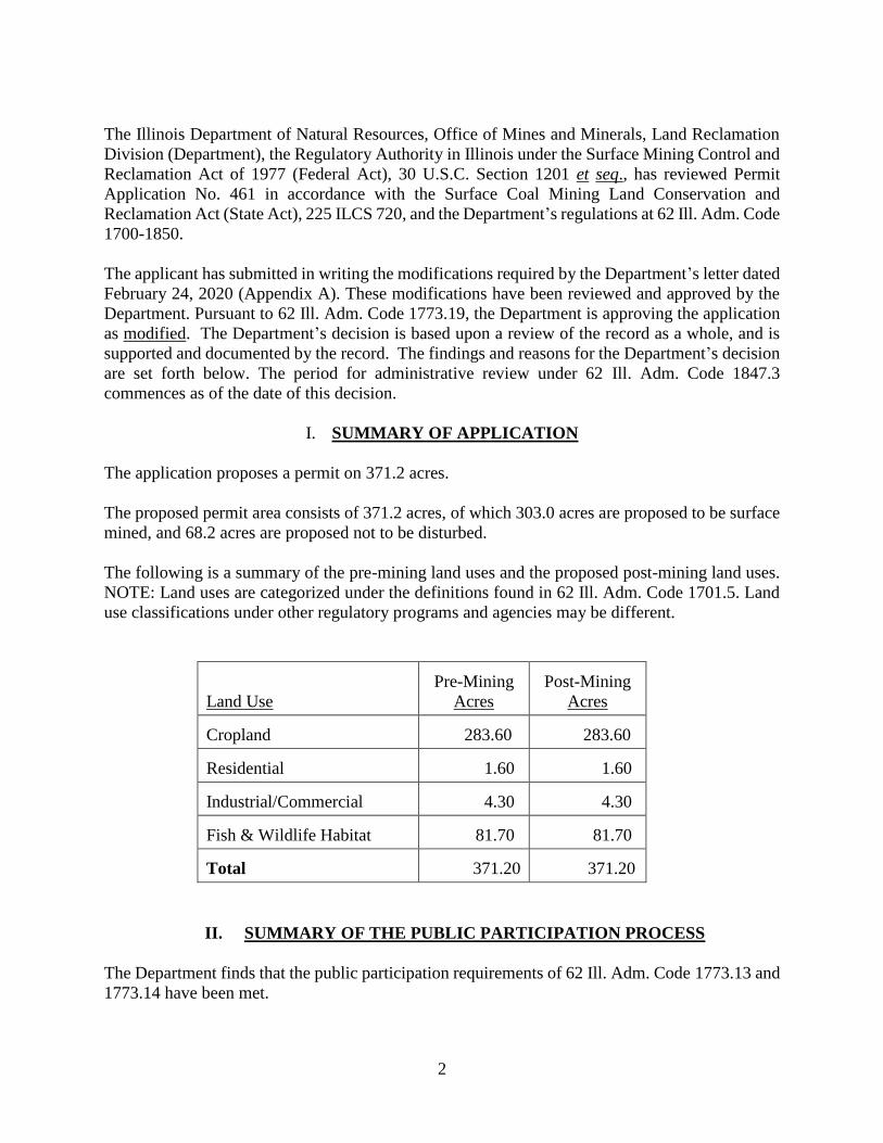
I. SUMMARY OF APPLICATION
The application proposes a permit on 371.2 acres.
The proposed permit area consists of 371.2 acres, of which 303.0 acres are proposed to be surface
mined, and 68.2 acres are proposed not to be disturbed.
The following is a summary of the pre-mining land uses and the proposed post-mining land uses.
NOTE: Land uses are categorized under the definitions found in 62 Ill. Adm. Code 1701.5. Land
use classifications under other regulatory programs and agencies may be different.
Land Use
Pre-Mining
Acres
Post-Mining
Acres
Cropland 283.60 283.60
Residential 1.60 1.60
Industrial/Commercial 4.30 4.30
Fish & Wildlife Habitat 81.70 81.70
Total 371.20 371.20
II. SUMMARY OF THE PUBLIC PARTICIPATION PROCESS
The Department finds that the public participation requirements of 62 Ill. Adm. Code 1773.13 and
1773.14 have been met.

3
The application was filed with the Department on July 23, 2019 and was deemed complete on
November 20, 2019. The applicant placed a newspaper advertisement of the proposed operation
in the Mt. Carmel Register, a newspaper of general circulation in the area affected, once a week
for four consecutive weeks, beginning on November 22, 2019. The applicant filed two copies of
the application with the County Clerk of Wabash County, in accordance with 62 Ill. Adm. Code
1773.13(a)(2), on November 21, 2019. Copies of the application were sent to the following
Agencies: Illinois Department of Agriculture (IDOA), and Illinois Environmental Protection
Agency (IEPA), and the United States Department of Agriculture, Natural Resources Conservation
Service (NRCS), and the United States Fish and Wildlife Service (USFWS) on November 26,
2019, for review and comment. In addition, copies were circulated with the appropriate Offices
within the Illinois Department of Natural Resources (Department). Written notification of the
application was given to those governmental agencies and entities required to receive notice under
62 Ill. Adm. Code 1773.13(a)(3).
State Agency comments on this application have been received by the Department, with the source
and date of comments as follows: IDOA (December 6, 2019) and IEPA (January 10, 2020).
Comments on this application were also received from the NRCS dated January 8, 2020 and
USFWS dated January 17, 2020.
No requests for an informal conference or public hearing were received by the Department.
All comments received in writing have been considered by the Department in reviewing this
application. The Department’s responses to these comments are set forth in Appendix B.
All comments received on this application have been furnished to the applicant, and have been
filed for public inspection at the office of the County Clerk of the county in which the application
is located.
III. SUMMARY OF THE DEPARTMENT'S FINDINGS
The Department, upon completing its review of the information set forth in the application, the
required modifications submitted, and information otherwise available, and made available to the
applicant, and after considering the comments of State Agencies, and all other comments received,
makes the following findings:
A. Findings Required by 62 Ill. Adm. Code 1773.15
REVIEW OF VIOLATIONS
(Sections 1773.15(b) and (e))
Section 1773.15(b)(1): Based on a review of all reasonably available information concerning
violation notices and ownership or control links involving the applicant, including information
obtained pursuant to Sections 1773.22, 1773.23, 1778.13 and 1778.14, the Department has
determined that the applicant or a person who owns or controls the applicant is not currently in
4
violation of the State Act, Federal Act or other law or regulation referred to in Section
1773.15(b)(1).
Section 1773.15(e): The Department requested updated compliance information in its fee and bond
request letter dated April 27, 2020. Based on the compliance review required by Section
1773.15(b)(1), a review of the OSM Applicant Violator System for outstanding violations, and in
light of no new information submitted pursuant to Sections 1778.13(i) and 1778.14(e), the
Department reconsidered its decision to approve the application and found that no change in its
decision to issue the permit is necessary.
SECTION 1773.15(c)(1) FINDINGS
Section 1773.15(c)(1): The application as modified is accurate and complete and all requirements
of the Federal and State Acts and the regulatory program have been met.
PERMANENT IMPOUNDMENT FINDING
Section 1816.49: The applicant has proposed the creation of a permanent impoundment. Pursuant
to Section 1816.49, the Department finds the following:
a. The size and configuration of the impoundment is adequate for its intended
purposes.
b. The quality of impounded water will be suitable on a permanent basis for its
intended use and, after reclamation, will meet the water quality standards set forth
in Section 1816.42, and discharges from the impoundment will meet applicable
effluent limitations and will not degrade the quality of receiving water below water
quality standards set forth in Section 1816.42.
c. The water level will be sufficiently stable and capable of supporting the intended
use.
d. Final grading will provide for adequate safety and access for proposed water users.
e. The impoundment will not result in the diminution of the quality and quantity
utilized by adjacent or surrounding landowners for agricultural, industrial,
recreational, or domestic uses.
f. The impoundment will be suitable for the approved post-mining land use.
g. The impoundment meets the applicable construction and design standards of
1816.49(b)(9).
h. Additional information may be found in Appendices C and D.
5
TOPSOIL SUBSTITUTION FINDING
Section 1816.22(b): The applicant has proposed the use of selected overburden materials as a
substitution for, and a supplement to, topsoil as delineated in the application. In accordance with
Section 1816.22(b), the Department finds that the applicant has adequately demonstrated that the
resulting soil medium is equal to, or more suitable for, sustaining vegetation than existing topsoil,
and the resulting soil medium is the best available in the permit area to support vegetation.
Permission is hereby granted to use the selected overburden as requested.
STREAM BUFFER ZONE VARIANCE
Section 1816.57(a)(1): The applicant has requested a stream buffer zone variance for an area as
delineated in the application. In accordance with Section 1816.57(a)(1), the Department finds that:
a. The original stream channel and its associated riparian vegetation will be restored;
and
b. Surface mining activities will not cause or contribute to a violation of Section
1816.42 and will not adversely affect the water quantity and quality or other
environmental resources of the stream.
Therefore, the Department authorizes surface mining activities closer than one hundred
(100) feet of the top of the bank of the normal channel of the perennial or intermittent
stream or through the stream.
The applicant has proposed a permanent stream diversion as delineated in the application.
In accordance with Section 1816.57(a)(2), the Department finds that the proposed diversion
will comply with Section 1816.43. Therefore, the Department authorizes surface mining
activities closer than one hundred (100) feet of the top of the bank of the normal channel
of the perennial or intermittent stream or through the stream.
ANCILLARY vs PRIMARY MINE ROADS
Section 1816.150: The applicant has proposed the creation of a road in the permit area. Pursuant
to Section 1816.150(a)(2)&(3), the Department has determined that the road is a primary road.
Pursuant to Section 1816.151(a) the construction or reconstruction of the road shall be certified in
a report submitted to the Department by a qualified registered professional engineer within thirty
(30) days after completion of construction. The report shall indicate that the primary road has been
constructed or reconstructed as designed and in accordance with the approved plan.
SECTION 1773.15(c)(2) – (c)(13) FINDINGS
Section 1773.15(c)(2); The applicant has demonstrated that reclamation as required by the Federal
and State Acts and the regulatory program can be accomplished under the reclamation plan
contained in the application, as modified.
6
Section 1773.15(c)(3)(A): The proposed area is not within an area under study or administrative
proceedings under a petition, filed pursuant to Section 1764, to have an area designated as
unsuitable for surface coal mining operations.
Section 1773.15(c)(3)(B): The proposed area is not within an area designated as unsuitable for
mining pursuant to Sections 1762 and 1764, or subject to the prohibitions or limitations of
Section 1761.11, except as delineated below:
Section 1761.11(a): The proposed area does not include any lands within the boundaries of
the National Park System, the National Wildlife Refuge System, the National System of
Trails, the National Wilderness Preservation System, the Wild and Scenic Rivers System,
or National Recreation Areas designated by Act of Congress.
Section 1761.11(b): The proposed area is not on any Federal lands within the boundaries
of any national forest.
Section 1761.11(c): The proposed surface coal mining and reclamation operations will not
adversely affect any publicly owned park or any privately owned or publicly owned places
included on the National Register of Historic Places.
Section 1761.11(d): The proposed area is within one hundred (100) feet measured
horizontally of the outside right-of-way line of public roads in Wabash County, described
as follows:
The proposed area includes the right-of-way of Maud Road (County Road 700 East)
and Wabash 12 Avenue. The proposed activities in the application area include the
removal of overburden, construction of safety berms, and soil storage.
The application proposes to close Maud Road (County Road 700 East).
The permit has been conditioned, pursuant to Section 1761.14(b)(2), to require the
applicant to obtain the required road closure or relocation agreements from the
authority with jurisdiction over Maud Road (County Road 700 East) prior to closing
or relocating the road. (See Part IV. Permit Conditions, Condition K.)
The applicant provided proper public notice and opportunity for a public hearing.
No hearing was requested and no written comments were submitted to the
Department concerning these roads.
The Department finds the interests of the public and affected landowners will be
protected from the proposed mining operations as a result of the measures to be
taken by the applicant as described in the mining operations plan concerning these
roads. In addition, Maud Road (County Road 700 East) may not be closed or
relocated until required road closure agreement from the authority with jurisdiction
over the road is submitted to the Department. (See Part IV. Permit Conditions,
Condition K.)
7
Section 1761.11(e): The proposed area is within three hundred (300) feet measured
horizontally of an occupied dwelling.
* The applicant shall establish a three hundred (300) foot buffer around the
dwelling, not disturb within the buffer zone and shall install and maintain
buffer zone markers to prevent disturbance within the buffer zone. (See Part
IV. Permit Conditions, Condition O.)
Section 1761.11(f): The proposed area is not within three hundred (300) feet measured
horizontally of any public building, school, church, community or institutional building, or
public park from which the applicant will be required to maintain a three hundred
(300) foot buffer zone.
Section 1761.11(g): The proposed area is not within one hundred (100) feet measured
horizontally of a cemetery.
Section 1773.15(c)(4): The private mineral estate to be mined has been severed from the private
surface estate. The applicant has provided the Department with the proper documentation required
under Section 1778.15(b).
Section 1773.15(c)(5): The Department has assessed the probable cumulative impacts of all
anticipated coal mining on the hydrologic balance in the cumulative impact area, in accordance
with Part 1780 and finds that the operations proposed under the application have been designed to
prevent material damage to the hydrologic balance outside the proposed area (see Appendix C).
Section 1773.15(c)(6): The applicant has not proposed the use of any existing structures in the
application requiring compliance with Section 1700.11(d).
Section 1773.15(c)(7): The applicant will submit fees required by these regulations before the
permit is issued. The fee required is $39,580.00 for the term of the permit, which may be paid in
annual increments. The Department finds that the applicant has paid all reclamation fees from
previous and existing operations as required by 30 CFR 870.
Section 1773.15(c)(8): See Part III – Subpart B.
Section 1773.15(c)(9): The applicant has satisfied the requirements for a long-term, intensive
agricultural post-mining land use, in accordance with the requirements of Section 1816.111(d).
Section 1773.15(c)(10): The operation as approved will not affect the continued existence of
endangered or threatened species or result in destruction or adverse modification of their critical
habitats, as determined under the Endangered Species Act of 1973 (16 USC 1531 et seq., see
Appendix E).
Section 1773.15(c)(11): The requirements of this section are not applicable as there are no
proposed remining operations.
8
Section 1773.15(c)(12): The effect of the proposed permitting action on properties listed on or
eligible for listing on the National Register of Historic Places has been taken into account by the
Department.
Section 1773.15(c)(13): The requirements of this section are not applicable as there are no
proposed remining operations.
B. Findings Required by 62 Ill. Adm. Code 1785 (Applicable Sections)
PRIME FARMLANDS
(Section 1785.17)
A soil survey was submitted by the applicant that shows prime farmland soils identified in this
application which have been historically used as cropland. The soil survey prepared by the USDA
provides the required soil information.
The applicant has, with respect to prime farmland, satisfied the requirements of Section 1785.17.
(See Part B, below, and Appendices D and F.)
Section 1785.17(e)(1): The Department finds that the approved post-mining land use of the prime
farmlands is cropland.
Section 1785.17(e)(2): The Department finds that the permit incorporates as specific conditions
the contents of the plan submitted under Section 1785.17(c), after consideration of any revisions
to that plan suggested by the State Conservationist under Section 1785.17(d).
Section 1785.17(e)(3): The Department finds that the applicant has the technological capability to
restore the prime farmland, within a reasonable time, to equivalent or higher levels of yield as non-
mined prime farmland in the surrounding area under equivalent levels of management.
Section 1785.17(e)(4): The Department finds that the proposed operations will be conducted in
compliance with the requirements of Section 1823 and other environmental protection
performance and reclamation standards for mining and reclamation of prime farmland of the
regulatory program.
Section 1785.17(e)(5): The Department finds that the aggregate total prime farmland acreage has
not been decreased from that which existed prior to mining. Water bodies, if any, are located
within the post-reclamation non-prime farmland portions of the permit area and the consent of all
affected property owners has been obtained.
AUGER MINING
(Section 1785.20)
Section 1785.20: The requirements of this section are not applicable to this application.
9
C. Compliance with 62 Ill. Adm. Code 1773.19
Section 1773.19(a)(1): The Department has based its decision to approve, as modified, the
application, based on public participation as provided by Sections 1773.13 and 1773.14,
compliance with all applicable provisions of Section 1785, and the processing and complete review
of the application.
Section 1773.19(a)(3): The Department is providing written notification of its final permit decision
to the following persons and entities:
A. The applicant, each person who filed comments or objections to the application;
and,
B. The County Board of Wabash County in which the application is located; and,
C. The Office of Surface Mining.
All materials supporting these findings are a part of the public record and are hereby incorporated
by reference.
IV. PERMIT CONDITIONS
A. The permittee shall conduct surface coal mining and reclamation operations only on those
lands specifically designated as the permit area on the maps submitted with the application
and authorized for the term of the permit and that are subject to the performance bond or
other equivalent guarantee in effect pursuant to 62 Ill. Adm. Code 1800. Operations shall
be contained within the area identified as bonded increment no. 1 and the area shall be
clearly marked and identified in the field with methods outlined in Part 3.3.1. The
permittee shall file additional required bond for all successive areas or increments prior to
expanding operations and identify and mark these areas as appropriate.
B. The permittee shall conduct all surface coal mining and reclamation operations as
described in the approved application, except to the extent that the Department otherwise
directs in the permit.
C. The permittee shall comply with the terms and conditions of the permit, all applicable
performance standards of the Federal and State Acts, and the requirements of the regulatory
program.
D. Without advance notice, delay, or a search warrant, upon presentation of appropriate
credentials, the permittee shall allow the authorized representatives of the Department and
Secretary of the United States Department of the Interior to:
1. Have the right of entry provided for in 62 Ill. Adm. Code 1840.12; and,
10
2. Be accompanied by private persons for the purpose of conducting an inspection in
accordance with 62 Ill. Adm. Code 1840, when the inspection is in response to an
alleged violation reported to the Department by the private person.
E. The permittee shall take all possible steps to minimize any adverse impacts to the
environment or public health and safety resulting from noncompliance with any term or
condition of this permit, including, but not limited to:
1. Accelerated or additional monitoring necessary to determine the nature and extent
of noncompliance and the results of the noncompliance;
2. Immediate implementation of measures necessary to comply; and,
3. Warning, as soon as possible after learning of such noncompliance, any person
whose health and safety is in imminent danger due to the noncompliance.
F. As applicable, the permittee shall comply with 62 Ill. Adm. Code 1700.11(d) for
compliance, modification, or abandonment of existing structures.
G. The permittee shall pay all reclamation fees required by 30 CFR 870 for coal produced
under this permit for sale, transfer, or use.
H. Within thirty (30) days after a cessation order is issued under 62 Ill. Adm. Code 1843.11,
for operations conducted under the permit, except where a stay of the cessation order is
granted and remains in effect, the permittee shall either submit to the Department the
following information, current to the date the cessation order was issued, or notify the
Department in writing that there has been no change since the immediately preceding
submittal of such information:
1. Any new information needed to correct or update the information previously
submitted to the Department by the permittee under 62 Ill. Adm. Code 1778.13(c);
or
2. If not previously submitted, the information required from a permit application by
62 Ill. Adm. Code 1778.13(c).
I. Species Protection:
1. Issuance of this permit under the Surface Coal Mining Land Conservation and
Reclamation Act does not in any way authorize any take of any listed species in
violation of the Illinois Endangered Species Protection Act, 520 ILCS 10/1 et
seq. With respect to the Indiana bat, an Incidental Take authorization has been
approved as part of this permitting action consistent with and in compliance with
the Endangered Species Act of 1973, 16 USC 1531 et seq. The Department has
determined that this project may affect the northern long-eared bat, but that any
resulting Incidental Take is not prohibited by the Final 4(d) rule and is consistent
11
with the U.S. Fish and Wildlife Service Jan 2016 Programmatic Biological Opinion
on the Final 4(d) rule. The Department and the applicant are in compliance with
Section 7 of the Endangered Species Act of 1973, 16 USC 1531 et seq. If any other
"take" as defined by these Acts is anticipated to result from permitted activities, it
is recommended that the permittee apply for an Incidental Take permit from the
Illinois Department of Natural Resources, Office of Resource Conservation for
state listed species.
2. Issuance of this permit under the Surface Coal Mining Land Conservation and
Reclamation Act does not in any way authorize any take of a bald or golden eagle,
including nests or eggs, in violation of the Bald Eagle Protection Act (16 U.S.C.
668 et seq.). If "take" as defined by the Bald Eagle Protection Act is anticipated to
result from permitted activities, it is recommended that the permittee should apply
for an Incidental Take (non-purposeful take) permit from the U.S. Fish and Wildlife
Service. The Department and the U.S. Fish and Wildlife Service shall be notified
if a bald or golden eagle nest is observed in the permit area or in the vicinity of the
permit area.
3. The permittee has committed to installation of one barn owl (Tyto alba) box as the
protection and enhancement plan for the state listed avian species. The permittee
shall submit a plan to the Department regarding timing and location of the barn owl
box upon commencement of re-vegetation activities.
4. If the reclamation plan for stream and wetland mitigation changes based upon U.S.
Army Corps of Engineers on-site mitigation requirements, then the Department
shall be notified to establish appropriate permitting actions under SMCRA.
J. If the permit is conditionally issued under 62 Ill. Adm. Code Section 1773.15(b)(2) on the
basis of (1) a presumption supported by certification under 62 Ill. Adm. Code Section
1778.14 that the violation is in the process of being corrected; (2) proof submitted under
62 Ill. Adm. Code Section 1773.15(b)(1)(A) that the violation is in the process of being
corrected; or (3) pending the outcome of an appeal described in 62 Ill. Adm. Code Section
1773.15(b)(1)(B), issuance is conditioned as follows:
1. If subsequent to permit issuance the applicant is issued a failure-to-abate cessation
order, the permit shall be suspended and/or rescinded in accordance with the
procedures for 62 Ill. Adm. Code Section 1773.20(c) Improvidently Issued Permits
within 30 days of the issuance of the failure-to-abate cessation order.
2. If subsequent to permit issuance the Department is notified by the agency that has
jurisdiction over the violation that the violation is no longer in the process of being
corrected to the satisfaction of said agency, the permit shall be suspended and/or
rescinded in accordance with the procedures for 62 Ill. Adm. Code Section
1773.20(c) Improvidently Issued Permits within 30 days of such notification.
12
3. If subsequent to permit issuance the circuit or district court reviewing the violation
either denies a stay applied for in the appeal or affirms the violation, then the
applicant shall submit the proof required under 62 Ill. Adm. Code Sections
1773.15(b)(1)(A) within thirty (30) days after the court's decision or the permit
shall be suspended and/or rescinded in accordance with the procedures for 62 Ill.
Adm. Code Section 1773.20(c) Improvidently Issued Permits within 30 days of
such failure to submit required proof.
K. The permittee proposed to close Maud Road (County Road 700 East). Pursuant to 62 Ill.
Adm. Code 1761.14(b)(2), the permittee shall obtain necessary approvals from the
authority with jurisdiction over the public road. A copy of the approval shall be submitted
to the Department prior to the road closure.
L. Pursuant to Section 1778.15, the permittee shall possess all necessary legal rights to enter
and conduct surface coal mining and reclamation operations within the permit area until
final bond release is obtained.
M. Map ID No. 10, as indicated in Table 1.5.1 and located on Map 2 - Property Ownership
Map, is uncontrolled. Pursuant to Section 1778.15(a), the applicant is required to provide
a description of the documents upon which the applicant bases his or her legal right to enter
and begin surface coal mining and reclamation operations in the permit area and shall state
whether that right is subject to pending litigation. In addition, the description shall identify
the documents upon which the affidavit is based by type and date of execution, identify
specific lands to which the document pertains, and explain the legal rights claimed by the
applicant. Alternatively, the Department may accept a statement pursuant to the
requirements of 62 Ill. Adm. Code 1778.15(d), notarized and attested to the truth of the
statement, signed by an attorney licensed to practice law in the State of Illinois. Such
information shall be provided to the Department, prior to commencing operations.
The permittee shall install and maintain markers around the uncontrolled tract to prevent
disturbance within the uncontrolled tract until control of the area is established and
approved, as discussed above.
Any modification to the operations or reclamation plan resulting from the inability to affect
the uncontrolled property shall be approved by permit revision prior to such changes being
implemented.
N. The permittee shall commence all groundwater and surface water monitoring approved by
this permit upon initial disturbance of lands within the permit area. Monitoring shall be in
accordance with the approved permit and/or as outlined in Appendix C of this finding
document.
1. Proposed monitoring well GW37 shall be installed at the approximate proposed
location and depth within sixty (60) days of permit issuance. The applicant shall
submit a boring log and well construction diagram for monitoring well GW37
within sixty (60) days of permit issuance. GW37 shall be surveyed for ground
13
elevation and top of casing elevation and this information shall be submitted with
the boring log and well construction diagram.
2. The applicant shall properly establish background on monitoring well GW37 by
sampling the well on a bi-monthly basis (every other month) for the first 12 months.
a. Background sampling shall include the following parameters:
pH, TDS, Hardness, Alkalinity, Acidity, Sulfate, Iron (total), Iron
(dissolved), Manganese (total), Manganese (dissolved), Aluminum,
Antimony, Arsenic, Barium, Beryllium, Boron, Cadmium, Chloride,
Chromium, Cobalt, Copper, Cyanide, Lead, Mercury, Molybdenum,
Nickel, Selenium, Silver, Thallium, Vanadium, Phenols, Zinc, and Water
Elevation (reported as true elevation and not depth to water).
b. Once background has been properly established for monitoring well GW37,
monitoring shall continue a quarterly basis.
3. The applicant shall properly establish background on surface water monitoring
point SW37 by sampling the location on a bi-monthly basis (every other month)
for the first 12 months.
a. Background sampling shall include the following parameters:
pH, Alkalinity, Acidity, Chloride, Sulfate, Iron (total), Manganese (total),
Total Suspended Solids (TSS), and Flow Rate.
b. Once background has been properly established at SW37, sampling shall
continue on a quarterly basis.
4. The applicant shall provide slug test results from monitoring well GW33 within
sixty (60) days of permit activation.
5. The applicant shall limit all refuse placement to a maximum of five (5) feet or one
(1) dump truck load above the active pit floor.
6. The applicant shall install a four (4) foot compacted clay liner below all ditches and
sedimentation basins that convey or store pit pumpage. The clay liner shall be
compacted to a hydraulic conductivity of 1x10‾⁷ cm/sec or less.
7. The applicant shall submit an updated Hydrogeologic or Operation Map depicting
the location of the new monitoring well and surface water monitoring point within
sixty (60) days of permit issuance.
8. The applicant shall continue monitoring all existing groundwater wells and
surface water monitoring points on a quarterly basis throughout the life of the
mine or until final bond release.
0. Pursuant to 62 Ill. Adm. Code 1761.15(b), where the proposed operation would beconducted within 300 feet, measured horizontally, of any occupied dwelling, the permittee
must obtain a written waiver by lease, deed, or other conveyance from the owner of the
dwelling. The waiver must clarify that the owner and signator had the legal right to deny
mining and knowingly waived that right. The waiver will act as consent to surface coal
mining operations within a closer distance of the dwelling, as specified. The waivers shallbe submitted to the Department prior to any surface mining operations within 300 feet of
the occupied dwellings. The permittee shall also mark the buffer zone around the dwellingprior to other disturbance within the permit area.
V. CONCLUSIONS
Based upon the information contained in the application, information otherwise available and made available to the applicant, the comments of State Agencies, the foregoing analysis of the probable impact of the proposed operations, all findings and information contained herein and conditions set forth in Part IV, the Department finds that there is a reasonable basis on which to issue a permit for the application, as modified.
Enter on behalf of the Illinois Department of Natural Resources, Office of Mines and Minerals, Land Reclamation Division as Regulatory Authority.
Illinois Department of Natural Resources
Colleen Callahan, Director
Dated: June 24, 2020
05041337.docx
14

App A -
APPENDIX A
REQUIRED MODIFICATIONS
ILLINO!S
Illinois Department of Natural Resources One Natural Resources Way Springfield, Illinois 62702-1271
'NATURAL ""'�v.dnr.illinois.gov RESOURCES,
Alex Messamore Vigo Coal Operating Company, LLC 250 Cross Point Blvd Evansville, IN 4 7715
February 24, 2020
Via Certified Mail 7017 1000 0001 0939 0336
Re: Modification to Pennit No. 461 Friendsville Mine
.TB l'ri1zkcr, Governor Colleen Callahan, Director
The Department, after reviewing the infonnation contained in the Pennit No. 461 application and infonnation otherwise available to the applicant, and after considering all c01mnents received, has detennined that modification of the above-referenced application is necessary. The modifications to the application shall comply with the requirements of 62 Ill. Adm. Code 1777 .11. The modifications required by the Department are enclosed here. If the applicant does not desire to modify the pennit application as described below, it may, by filing a written statement with the Department, deem the permit application denied, and such denial shall constitute final action.
Pursuant to 62 Ill. Adm. Code l 773.15(a)(l)(B)(i), modifications required by the Department shall be received within one (1) year from the date of this letter. Absent the modifications required by the Department, the application will not comply with the requirements of the Illinois Surface Coal Mining Land Conservation and Reclamation Act, regulations and the Illinois regulatory program. Failure to submit the required modifications will result in the Depaiiment issuing a written finding denying the application.
The period for administrative review (62 Ill. Adm. Code 1847.3) shall c01mnence upon:
• receipt by the applicant of a written decision from the Department, approving theapplication as modified, or
• if the applicai1t's modifications are insufficient, or if the applicant fails to submit therequired modifications in accordance with 62 Ill. Adm. Code 1773. l 5(a)(l )(B)(i), receiptby the applicant of a written decision from the Department denying the pennit application,or
• receipt by the Department of the applicant's denial statement.
App A - 1
App A - 2
App A - 3
App A - 4
App A - 5
App A - 6
App A - 7
App B - 1
APPENDIX B
CONSIDERATION OF COMMENTS AND OBJECTIONS
62 Ill. Adm. Code 1773.13(b) allows submission of written comments on applications. The
following are comments received from the State Agencies, County Board and other members of
the public and the Department's response to those comments.
Illinois Department of Agriculture
Comment: The Soils Information Chart (Table 2.2.9) appears to have several errors under
capability class and optimum productivity indexes. Belknap (3382A) should be
changed from 2w to 3w as shown in the USDA NRCS database. Map units 3C2
(Hoyleton), 8C, 8D, and 8D2 (Hickory) and 214C3 (Hosmer) appear to have the
wrong calculated Optimum Productivity Index, based on data from Bulletin 811
and should be changed.
Response: The applicant was required to correct these discrepancies. Please see Appendix A,
Modification No. 28 and applicant response.
Comment: The mining company has indicated a negative determination request for 3.5 acres
in various wildlife uses (Table 8.1, Total Post-mining Land Use Capability
Summary). This negative determination acres should be combined with the
subtotal High Capability Lands (HCL) to reflect 87.4 acres of HCL and reclaimed
as part of the HCL acres.
Response: The acreage represented as described above is unaffected acreage, therefore there
will be no reclamation obligations for the area in question. Should the applicant
later decide to affect the area, they will be required to reclaim them to high
capability standards.
Comment: Mixing of the B and C horizons is proposed for root media to reclaim both prime
and high capability lands with the required 48 inches of root media plus topsoil.
However, the non-cropland capable soils are proposed to only have 8 inches of
topsoil over graded spoil. With the amount of root media being removed and
mixed, we request that non-cropland capable soils areas also have 48 inches of
topsoil and root media (Section 9.2.1, p. 3 of 33). The distance to bedrock is greater
than 4 feet.
Response: The applicant addressed this comment in response to a modification question.
Please see Appendix A, Modification No. 26 and applicant response.
App B - 2
Illinois Environmental Protection Agency
Comment: 1. Table 4.4.1 and the Hydrogeology Map identify a water well that provides
domestic uses for the Randolph property, which is identified as a dug well. Dug
wells are typically shallow and would utilize the unconsolidated and/or the upper
portions of the consolidated materials. The applicant shall construct one
additional monitoring well; to the south of the Randolph residential area, within
Permit 461 at the edge of the buffer area, such that the monitoring well will not
be mined through.
a. The depth and construction shall be based on site specific conditions
encountered during drilling, but the screen shall intercept the upper most
water bearing zone.
b. The monitoring well shall be capable of yielding groundwater samples in all
quarters of the year under normal hydrologic conditions.
c. The monitoring well shall be constructed in compliance with the Illinois
Water Well Construction Code (77 Ill. Adm. Code 920.170).
d. The monitoring well shall be monitored for the same parameters and at the
same frequency as the existing and proposed monitoring wells for this
Permit.
e. A statistical representation of existing groundwater quality (background)
shall be calculated for the monitoring well using the same method and
constituents used for the already existing and proposed monitoring wells for
this Permit.
f. Upon well completion, the well log and construction diagram shall be
provided to the Illinois Department of Natural Resources and the Illinois
EPA Mine Program in Marion.
2. Part III, Page 16: The applicant shall continue sampling all monitoring wells for
this permit until the Illinois Department of Natural Resources allows monitoring
to cease. Abandonment which would also serve as the basin's emergency
spillway. This outfall configuration does not permit accurate measurement of
flowrates as required by the NPDES permit. Provide a revised design for each
sedimentation basin's outfall structure that will facilitate proper flow
measurements during sampling events in accordance with USEPA's official
guidebook "Performing Quality Flow Measurements at Mine Sites", EPA/600R-
0l /043 March 2001.
Response: Please see Appendix A, Modification No. 17 and applicant response.
App B - 3
U.S. Department of Agriculture, Natural Resource Conservation Service
Comment: Prime farmland should be reclaimed according to state laws, rules, regulations and
administrative codes. These soils all have potential for high sodium content in some
sub horizons and care should be used when re-applying the substratum (materials
below 40 inches). A quick pH test could be used to identify materials with sodium
generally identified with a pH above 8.0. Sodium substratum materials would make
subsoils unfavorable, which leads to low permeability and water infiltration,
dispersed clay, re-vegetation concerns, and erosion.
Response: The Department notes the potential sodium issue outlined above, forwarded the
comment to the applicant and will monitor reclamation to ensure proper vegetation
is reestablished and erosion is prevented. Should steps be required to establish
proper vegetation, soil tests may be required to ascertain the cause of the issue, if
necessary. Department review of the subsoil information provided indicated that
samples collected for the permit had a pH of 7.3 or less.
Comment: The soils in the middle of the area are identified as frequently flooded. Flooding is
a concern. Riparian areas along the stream should be restored or improved.
Response: Riparian areas along the intermittent stream that will be affected by operations will
be restored or improved in accordance with 62 Ill. Adm. Code 1816.43 and
1816.57, and the approved stream relocation/restoration plan found in Part 6 and
Part 10 of the application.
Comment: The reclamation of mined soils on some of the identified soils mapped should
improve them from natural conditions in that fragipans and dense layers will have
opportunity to be broken up.
Response: The Department concurs with the comment and has forwarded it to the applicant.
Comment: There are no rules that govern the removal of old terrace systems, however if
terraces were installed, it would indicate that the erodibility and slope length and
slope percent in combination, required a conservation structure to minimize
erosion. In re-shaping the land, at least one of these factors could be reduced to
alleviate the need for terraces, otherwise some type of erosion planning or
prevention should be considered.
Response: The applicant, in Parts 8.1.4 and 8.4.4, has committed to using NRCS erosion
control structures, as necessary.
App B - 4
Comment: It is stated in section 3.1 that Belknap subsoil is silt loam. It can include clay loam
or loam. Belknap has a mantle of loess over a sandy silt loam or loam of mixed
loess and often glacio-fluvial sediments. It would still be good material for
restoration as long as fertility is dealt with.
Response: Table 3.0 provides data for the Belknap series on site. Within the proposed permit
area, the textures are silt loam and silty clay loam. Table 3.1 on a mine wide basis
indicates the Belknap series tested has a predominately silt loam subsoil texture.
The applicant has recognized the need to fertilize such material (see Attachment
2.2.0.B Part 3.1). In Parts 8.1.8 and 8.4.3 the applicant commits to fertilization of
the reclaimed soils.
Comment: In section 3 there is a statement that pH low is 4.3. On page 3 of the tables, there is
also a pH 4.0 in one sub-surface horizon identified as a Bt. This is uncharacteristic
for the soils that are mapped. 4.6 or 4.7 is about as low as data typically shows in
Illinois without the presence of sulfurous parent material or extreme leaching.
Response: The applicant was required to correct the discrepancy in regards to the pH
information. Please see Appendix A, Modification No. 29 and applicant response.
The information reported was the pH of actual samples collected in the field and
tested for this permit application. Should toxic materials be encountered, the
applicant has committed to mix it into the spoil profile to prevent oxidation (see
Part 3.4.2). Mining at this site to date has not demonstrated the presence of pyritic
materials within the soil profile.
Comment: Belknap has a B horizon.
Response: The Department concurs with the comment and has forwarded it to the applicant.
Comment: In review of the lab data, the loess and Roxanna silt thickness appears to be thicker
than typical for these mapped soils-indicated by silt loam C horizons and low clay
contents.
Response: The information presented was from actual samples collected in the field and tested
for this permit application. The comment and has forwarded it to the applicant.
Comment: The USDA-Natural Resources Conservation Service is in agreement with IDOA
comments concerning Prime Farmland restoration, number of acres to be restored,
and specification of the location of additional acres to be restored at another
App B - 5
location, for the purpose of tracking related to the Farmland Protection Policy Act
(FPPA).
Response: The Department’s jurisdiction is governed by 62 Ill. Adm. Code 1700-1850 which
spells out the regulatory responsibilities and authority provided for as it concerns
prime farmland reclamation. The Department found that the applicant proposed to
restore all the pre-mine prime farmland within the proposed permit area.
U.S. Department of the Interior, Fish and Wildlife Service
Comment: Applicants should be directed to our Information, Planning, and Conservation
System (IPaC) at the link below to determine whether any federally threatened and
endangered species, designated critical habitat, or other natural resources of
concern may be affected by a proposed project and to obtain a preliminary or
official U.S. Fish and Wildlife species list. For projects that require FWS review,
request an official species list from the Regulatory Documents page.
https://ecos.fws.gov/ipac/
Response: The applicant has provided information obtained from the Service’s IPaC website
in Part 7.2 and has addressed those species that were determined likely to occur
within the permit area in the corresponding application attachment.
Comment: The PEP is sufficient and based on the information provided in the permit
application; the Service has determined that the take of 78.6 acres of potential
habitat is not likely to jeopardize the continued existence of the Indiana bat.
Response: Comment noted and forwarded to applicant.
The Department would also like to take this opportunity to clarify that the
application lists 72.7 acres of potential suitable Indiana bat habitat and the
Protection and Enhancement Plan and Incidental Take Authorization is based on
that number.
Comment: The applicant has chosen to rely upon the finding of the programmatic biological
opinion for the northern long-eared bat final 4(d) rule and streamlined section 7
consultation framework to fulfill their project-specific section 7 responsibilities for
the northern long-eared bat. A verification document was provided for the permit,
thus concluding consultation for the northern long-eared bat.
Response: Comment noted and forwarded to applicant.
App B - 6
Comment: Information in the permit application indicates that 2.2 acres of wetlands and
23,179 linear feet of streams will be impacted by the proposed action. It is unclear
what mitigation is being proposed for wetland and stream impacts and if the
mitigation is sufficient. The applicant should develop a mitigation plan for the
entire permit area. Additional coordination with the Service, US Army Corps of
Engineers, and IDNR is requested to ensure that stream impacts are being
sufficiently mitigated.
Response: Although the stream and wetland delineation report quantified 2.2 acres of wetland
habitat, the definition of “land use” found at 62 Ill. Adm. Code 1701.5 Appendix A
states that pre and post mining land uses are determined by the management of the
acreage and not the particular vegetation assemblage. The applicant did not report
those 2.2 acres within the Fish and Wildlife Wetland category because those acres
are defined as other land uses based on management. No change in acreage for any
land use is proposed by the operations and reclamation plan. The applicant has
stated in Part 7.1.2 and Part 7.1.2.1 that the 2.2 acres of jurisdictional wetland will
be mitigated through coordination with the U.S. Army Corps of Engineers (Corps)
and an approved 404 Permit.
The applicant has provided information in Part 6 of the application regarding the
classification of streams located within the permit boundary and of streams within
100 feet of the permit boundary where operations are proposed. The applicant
proposes to mine through one stream classified as intermittent according the
Department definitions, 1MSIA, and has provided a plan to relocate and restore the
stream. The Department has no jurisdiction regarding mitigation for ephemeral
streams that are affected by surface mining operations. The applicant is
coordinating with the Corps to obtain the necessary 404 permits that may approve
both onsite and offsite mitigation of streams.
The Department has determined that the reclamation plan submitted by the
applicant meets all applicable Department regulations and policies. The permit
approval has also been conditioned to state that if the reclamation plan for stream
and wetland mitigation changes based upon Corp requirements, then the
Department shall be notified to establish appropriate permitting actions under
SMCRA.
Comment: The Service concurs with the use of native plant species and recommends that the
planting of non-native, exotic, and invasive species be avoided. The Service
recommends that the seed mix for grassland restoration include native forbs, which
will provide greater benefits to native pollinators and the monarch butterfly.
Response: The regulations found at Section 1816.111(a)(2) and (c) allow non-native species
if they are necessary to achieve the desired post-mining land use or are necessary
App B - 7
for erosion control. The recommendation to include native forbs has been
forwarded to the applicant.
Comment: The Service recommends that the applicant include an invasive species control plan
in the reclamation plan.
Response: The applicant has indicated in Part 10 that periodic measurements of vegetation
will be conducted. In addition, should the Department require management
measures to achieve the approved vegetation and reclamation plan, including but
not limited to invasive species control, those activities will be conducted at that
time.
App C - 1
APPENDIX C
Vigo Coal Operating Company, Inc. – Friendsville Mine
Application for Permit No. 461
And Permit Nos. 330, 395, 443, and 458
Assessment and Findings of Probable Cumulative Hydrologic Impacts
TABLE OF CONTENTS
I. General Information
A. Historical Coal Mines
1. Black Diamond Mine (1923-1929)
2. Wallace Mine (1934-1935)
3. Lancaster Mine (1936-1942)
4. Other Mines
B. Active Coal Mines
1. Conservancy Resources, LLC – Wabash Mine (1983-current)
a. Permit No. 39 (issued 1983)
b. Permit No. 158 (issued 1985)
c. Permit No. 276 (issued 1994)
d. Permit No. 290 (issued 1995)
2. Vigo Coal Operating Company, Inc.– Friendsville Mine (2000-current)
a. Permit No. 330 (issued 2000)
b. Permit No. 395 (issued 2008)
c. Permit No. 458 (issued 2018)
d. Permit No. 443 (issued 2019)
e. Application for Permit No. 461
f. Application for Significant Revision No. 1 to Permit No. 458
II. Probable Cumulative Hydrologic Impact Assessment (CHIA) of Application No. 461
A. Cumulative Impact Area (CIA) Evaluation
1. Office of Surface Mining (OSM) Guidance
2. CIA Determination
B. Assessment of the Probable Hydrologic Consequences (PHC) for the Permit Area
1. Permit Area
App C - 2
a. Regional Hydrologic Area
b. Permit Area Surface Waters Assessment Area
c. Permit Area Groundwater Assessment Area
2. Geologic Information Required by 62 Ill. Adm. Code 1780.22
a. Baseline Geologic Information
b. Geologic Information Findings
3. Hydrologic Information Required by 62 Ill. Adm. Code 1780.14
a. Baseline Information
i. Surface Water Quantity
ii. Surface Water Quality
iii. Groundwater Quantity
iv. Groundwater Quality
v. Existing and Proposed Coal Processing Waste Disposal
b. Findings
i. Surface Water Quantity
ii. Surface Water Quality
iii. Groundwater Quantity
iv. Groundwater Quality
c. Findings Related to Existing and Proposed Coal Processing Waste
Disposal
III. Conclusion
IV. References and Attachments
Map No. 1 – Assessment Map for Groundwater and Surface Water
Map No. 2 – Monitoring Location Map
App C - 3
APPENDIX C
Vigo Coal Operating Company, Inc. – Friendsville Mine
Application for Permit No. 461
And Permit Nos. 330, 395, 443, and 458
Assessment and Findings of Probable Cumulative Hydrologic Impacts
Vigo Coal Operating Company, Inc. (hereinafter referred to as “permittee” or “applicant” as
applicable) was required to submit a determination of probable hydrologic consequences of the
proposed mining and reclamation operations, both on and off the permit area, pursuant to 62 Ill.
Adm. Code 1780.14(e) for surface mines.
Pursuant to 62 Ill. Adm. Code 1773.15(c) (5), the Department must make an assessment of the
probable cumulative impacts of all anticipated coal mining on the hydrologic balance in the
cumulative impact area, in accordance with 62 Ill. Adm. Code 1780.14(f), and find in writing that
the proposed operation has been designed to prevent material damage to the hydrologic balance
outside the permit area.
The following assessment and findings are intended to fulfill the above requirements.
I. GENERAL INFORMATION
A. Historical Coal Mines (ISGS)
Numerous coal mines have operated in the general vicinity of the Vigo Friendsville Mine. Both
surface and underground mines operated in the area, with some operations dating back to the
1800’s. Many of these mining operations existed pre-law when no reclamation requirements were
in place. A few of the historical mines in close proximity to the proposed permit area are described
below.
1. Black Diamond Mine (1923-1929)
This former room and pillar underground mine is located approximately ½ mile to the east of the
existing Permit No. 330 area and extracted the Friendsville Coal Seam.
2. Wallace Mine (1934-1935)
This former room and pillar underground mine is located less than one (1) mile to the east of the
existing Permit No. 330 area and extracted the Friendsville Coal Seam.
3. Lancaster Mine (1936-1942)
This former room and pillar underground mine is located less than one (1) mile to the south of the
existing Permit No. 330 area. The Lancaster Mine utilized a shaft entry and extracted the
Friendsville Coal Seam.
App C - 4
4. Other Mines
Numerous other surface and underground mines previously existed in the general vicinity of the
existing and proposed Vigo Friendsville Mine. These operations were active from the late 1800’s
through the mid 1900’s. Additional information regarding these mines can be found in the
Directory of Coal Mines in Illinois – Wabash County.
B. Active Coal Mines -
1. Wabash Mine (1971-2007)
The Wabash Mine is a room and pillar underground mine located approximately 5 miles to the
south of the existing and proposed Friendsville Mine permit area. The Wabash Mine was operated
by AMAX Coal Company from 1971-1997 and then Wabash Mine Holding Company from 1998-
2007. The mine went into temporary cessation in 2007, but was bought by Conservancy
Resources, LLC in late 2017. The Wabash Mine has remained in temporary cessation to date. The
No. 5 coal seam was extracted while the mine was active.
a. Permit No. 39 (issued 1983)
Permit No. 39 was issued in 1983 for a 475-acre surface support area and refuse disposal area for
the associated underground mining operation. The underground mining operation at the Wabash
Mine extracts the Springfield No. 5 coal seam. To date, approximately 420 acres have been
affected by mining operations.
b. Permit No. 158 (issued 1985)
Permit No. 158 was issued in 1985 for a 7.2-acre minor underground support facility that
functioned as a rock dust holding facility during active operations. To date, all 7.2 acres have
been affected by mining operations.
c. Permit No. 276 (issued 1994)
Permit No. 276 was issued in 1994 for a 51.40-acre surface support area and refuse disposal area
for the associated underground mining operation. To date, all 51.40 acres have been affected by
mining operations.
d. Permit No. 290 (issued 1995)
Permit No. 290 was issued in 1995 for a 90.5-acre minor underground support facility. To date,
approximately 54 acres have been affected by mining operations.
App C - 5
2. Friendsville Mine (2000- current)
a. Permit No. 330 (issued 2000)
The original Friendsville Mine Permit No. 330 was issued on June 12, 2000 for a 2,402.10-acre
surface coal mining operation in Wabash County. Vigo Coal Permit No. 330 utilized traditional
truck and shovel operations to extract the Upper and Lower Friendsville Coal Seams. The
applicant reports a total of 2,100 acres have been affected by mining operations over the life of the
permit.
b. Permit No. 395 (issued 2008)
Permit No. 395 was issued on January 14, 2008 for a 252.70-acre surface coal mining operation in
Wabash County. Vigo Coal Permit No. 395 utilized traditional truck and shovel operations to
extract the Upper and Lower Friendsville Coal Seams. The applicant reports a total of 236.0 acres
have been affected by mining operations over the life of the permit.
c. Permit No. 458 (issued 2018)
Permit No. 458 was issued on October 4, 2018 for a 1,065-acre surface coal mining operation in
Wabash County. Vigo Coal Permit No. 458 utilizes traditional truck and shovel operations to
extract the Upper and Lower Friendsville Coal Seams. The applicant reports approximately 110
acres have been affected by mining operations since permit issuance.
d. Permit No. 443 (issued 2019)
Permit No. 443 was issued on July 10, 2019 for a 687.3-acre surface coal mining operation in
Wabash County. Vigo Coal Permit No. 443 has not been activated to date but will utilize
traditional truck and shovel operations to extract the Upper and Lower Friendsville Coal Seams.
No acres of permit area have been affected by mining operations.
e. Application for Permit No. 461
Application for Permit No. 461 requests to add approximately 371 acres to the existing permit area
of the Friendsville Mine. The Upper and Lower Friendsville Coal Seams are proposed to be mined
using traditional truck and shovel operations.
The proposed permit area is located within parts of Sections 3, 4, 9, and 10 of Township 1 South,
Range 13 West of Wabash County, Illinois.
App C - 6
f. Application for Significant Revision No. 1 to Permit No. 458
Application for Significant Revision No. 1 to Permit No. 458 proposes to construct a 23-acre fine
coal refuse impoundment within the southern portion of Permit No. 458. This application is
currently under review and has not been issued, to date.
II. PROBABLE CUMULATIVE HYDROLOGIC IMPACT ASSESSMENT (CHIA)
OF APPLICATION FOR PERMIT NO. 461
A. Cumulative Impact Area (CIA) Evaluation
For purposes of a Cumulative Hydrologic Impact Assessment (CHIA), the Cumulative Impact
Area (CIA) is defined as follows:
The area, including the permit area, within which impacts resulting from the proposed
operation may interact with the impacts of all anticipated mining on surface and
groundwater systems. Anticipated mining shall include, at a minimum, the entire projected
lives through bond release of:
the proposed operation;
all existing operations;
any operation for which a permit application has been submitted to the Department.
This is based upon baseline geologic and hydrologic information. See 62 Ill. Adm. Code
Sections 1701.Appendix A and 1780.21
1. Office of Surface Mining Guidance
The Federal Office of Surface Mining Mid-Continent Region (OSM-MCR) developed a document
in June 2007 entitled Hydrologic Considerations for Permitting and Liability Release, a Technical
Reference for the Mid-Continent Region. In determining whether a CHIA is required, OSM-MCR
states that “the operative word in the CHIA concept is cumulative which seemingly necessitates
the potential interaction of two or more anticipated mining operations.” (p. 17)
2. CIA Determination
The Cumulative Impact Area (CIA) is that area, including the permit area, within which impacts
resulting from the operation may interact with the hydrologic impacts of all other current and
anticipated coal mining on the surface and groundwater systems.
Originally, for this mine (Permit No. 330), the Department assessed the watersheds of Bonpas
Creek and Coffee Creek above their convergence with the Wabash River. A U.S.G.S. gaging
App C - 7
station, Station No. 03378000, is located on Bonpas Creek at Browns, Illinois, which is
approximately seven (7) miles downstream of the Permit No. 330 area. The drainage area of
Bonpas Creek at this location measured approximately 146,000 acres (Zuehls, E.E., 1987). A
U.S.G.S. gaging station is also located on Coffee Creek at Keensburg, Illinois, which is
approximately three (3) miles downstream of the Permit No. 330 area. The drainage area of Coffee
Creek at this location, Station No. 03377600, is approximately 11,000 acres. The CIA for the
Friendsville Mine was defined as the watersheds of Bonpas Creek at Browns and Coffee Creek at
Keensburg. Therefore, the Permit No. 330 permit area comprised approximately 1.5% of the CIA
for the Friendsville Mine. This determination was maintained during the Permit No. 395
permitting process.
During the Permit No. 458 permitting process, the Department reviewed the originally defined
CIA and determined that it was too large to properly assess potential impacts from the existing and
proposed permit areas. The Department then reviewed the Hydrologic Unit Code (HUC) HUC-
12 watershed areas that the proposed and existing permit areas are located within. Permit No. 330
and Permit No. 395 are located within two (2) HUC-12 watersheds. These watershed areas are
defined as 051201130404 – Fordice Creek, and 051201130303 – Coffee Creek, which are
approximately 17,324 and 14,313 acres in size, respectively. The Permit No. 458 and, at the time,
proposed Application for Permit No. 443 permit areas were also located in the same two (2) HUC-
12 watersheds. However, the Department determined that this area encompassed within the HUC-
12 watersheds was also too large to properly assess potential surface water impacts from mining
operations. The Department then excluded portions of the HUC-12 watersheds that were not
related to the mining operations due to their distance or relation to the proposed and existing permit
areas. The revised Surface Water CIA was defined as the approximately 19,258-acre area that
encompasses portions of both the Fordice Creek and Coffee Creek HUC-12 watershed. The
Groundwater CIA was defined as the existing and proposed permit areas and the area within 1,000
feet from all existing and proposed permit areas. The 1,000-foot buffer was included because past
studies have shown that effects on groundwater aquifers should be limited to within 1,000 feet of
surface mining extents (Oertel, 1980; Cartwright and Hunt, 1981).
The Department’s CIA determinations were maintained during the Permit No. 443 permitting
process, as the Permit No. 443 permit area was included as proposed permit area during the
Department’s CIA determinations for Permit No. 458.
For the Application for Permit No. 461, the Department concluded that, because the proposed
permit area was also included in previous CIA determinations, and no significant changes to
mining operations are being proposed, the CIA determinations maintained during the Permit No.
443 permitting process are appropriate and will be maintained for the proposed permit area.
Therefore, the Surface water CIA for the Application for Permit No. 461 remains defined as the
19,258-acre area within the HUC-12 watersheds of 051201130404 – Fordice Creek and
051201130303 – Coffee Creek. The combined existing and proposed permit areas of the
Friendsville Mine totals approximately 5,150 acres in size, which is approximately 27% of the
defined Surface Water CIA. The Groundwater CIA will remain defined as the existing and
proposed permit areas and a 1,000-foot buffer around these areas. The CIA determinations are
depicted on Map No. 1. As shown on Map No. 1, the Surface Water CIA encompasses all portions
App C - 8
of the Groundwater CIA. Consequently, the total CIA acreage will be equal to the Surface Water
CIA for the Friendsville Mine. The portions of the currently permitted Wabash Mine that are
located within the same watershed as the existing and proposed permit areas of the Friendsville
Mine are also included in the Surface Water CIA.
As noted above, historical mining has occurred within the above-identified Surface Water and
Groundwater CIA’s. Historical mining is not included in the defined CIA’s because, per the
definition of a CIA, the Department shall only consider current and anticipated mining operations
on the cumulative effects of the proposed mining operation. Also, affects from past mining are
already reflected in the hydrogeologic data collected for the existing and proposed operations.
B. Assessment of the Probable Hydrologic Consequences (PHC) for the Permit
Area
1. Permit Area
For purposes of this CHIA, the Department will discuss the Application for Permit No. 461 permit
area. Previously, the Department conducted the required hydrologic assessment on the original
Permit Nos. 330, 395, 443, and 458 permit areas and their respective adjacent areas.
Per 62 Ill. Adm. Code Section 1701.Appendix A, the following terms are defined:
The “permit area” is defined as:
[T]he area of land and water within the boundaries of the permit which are designated on
the permit application maps, as approved by the Department. This area shall include all
areas which are or will be affected by the surface coal mining and reclamation operations
during the term of the permit indicated on the approved map which the operator submitted
with the operator's application and which is required to be bonded under 62 Ill. Adm. Code
1800 and where the operator proposes to conduct surface coal mining and reclamation
operations under the permit, including all disturbed areas; provided, that areas adequately
bonded under another valid permit may be excluded from a permit area.
The “shadow area” is defined as:
[A]ny area beyond the limits of the permit area in which underground mine workings are
located. This area includes all resources above and below the coal that are protected by
the State Act that may be adversely impacted by underground mining operations including
impacts of subsidence.
The “adjacent area” is defined as:
[T]he area located outside the permit area, or shadow area, where a resource or resources,
determined according to the context in which adjacent area is used, are or reasonably could
be expected to be adversely impacted by proposed mining operations.
App C - 9
As described in Section I.B.2.e above, Permit No. 461 proposes to add approximately 371.2 acres
to the existing permit area of the Friendsville Mine as a continuation of surface mining operations.
The proposed operations consist of approximately 303 acres to be surface mined and
approximately 68.2 acres to remain unaffected. Coal will continue to be processed in the existing
Permit No. 330 area.
a. Regional Hydrologic Area
The existing and proposed permit areas are located in the upland terrain west of the Wabash River
floodplain in Wabash County. Per the Illinois State Geologic Survey (ISGS), potential sources of
groundwater are located within unconsolidated sand and gravel deposits in the thin valley fill areas
of the Wabash River and tributary outwash areas, and Pennsylvanian aged sandstones and
limestones. The Pennsylvanian aged Mt. Carmel Sandstone is located approximately 200-300 feet
in depth and is noted as being the only known aquifer in the region.
b. Permit Area Surface Waters Assessment Area
Specifically, for the Application for Permit No. 461, the applicant identified zero (0) acres of pre-
mining developed water resources. The post-mining conditions plan to leave zero (0) acres of
developed water resources, as no final cut impoundments are proposed and all sedimentation
basins within the proposed permit area will be backfilled and restored. However, due to the on-
going mining development at this facility, the post-mining developed water resources is subject to
change based upon the final configuration of the mining operations.
The Surface Water CIA is defined as the approximately 19,258-acre area depicted on Map No. 1.
c. Permit Area Groundwater Assessment Area
Groundwater conditions within the permit and adjacent areas have been described by several
sources. Pryor (1956) described the groundwater geology of southern Illinois on a county by
county basis. For Wabash County, Pryor stated that “glacial deposits are thin” and “not suitable
for sand and gravel wells”. However, in the Wabash River Valley south of Mt. Carmel,
groundwater possibilities are reported to be excellent with thick sand and gravel deposits present.
Pryor also states that thin scattered deposits of sand and gravel are present in the valley of Bonpas
Creek. Pennsylvanian aged sandstones commonly found at depths of 100 feet or greater were
found to be water yielding throughout most of Wabash County.
The proposed permit area is located in an area of Wabash County where unconsolidated sand and
gravel aquifers are thin and discontinuous in nature and deeper Pennsylvanian aged aquifers are
located a significant distance vertically below the lowest coal seam to be mined. To date, the
applicant has not observed adverse impacts to unconsolidated or consolidated aquifers as a result
of mining operations. However, past studies have shown that groundwater impacts from surface
mining are typically limited to 1,000 feet from the active pit. Therefore, a 1,000-foot buffer around
the existing and proposed permit areas was included in the defined Groundwater CIA.
App C - 10
The Groundwater CIA is defined as the approximately 7,222-acre area depicted on Map No. 1.
2. Geologic Information Required by 62 Ill. Adm. Code 1780.22
a. Baseline Geologic Information
Regional bedrock of the area consists of Pennsylvanian system formations. The Pennsylvanian-
aged formations typically consist of shales, limestones, coal, and sandstones. Regionally, bedrock
strata dips gently to the southwest toward the center of the Illinois Basin.
The applicant notes the absence of geologic structures such as faults in the existing and proposed
permit area and adjacent areas. However, numerous fault systems are known to exist to the south
and east of the existing and proposed permit area and adjacent areas. Boring log data from within
the proposed permit area depicts a small structural low feature that extends through the middle of
the proposed permit area. Overall, the eastern portion of the proposed permit area appears to be
slightly structurally higher than areas in the western portion of the proposed permit area.
The unconsolidated materials in the region are typically glacially derived and Pleistocene in age.
These deposits include glacial till, outwash, loess and other fine-grained sediments. The applicant
describes the unconsolidated materials within the proposed permit area as mostly silty or sandy
clays. Boring logs provided in the Application for Permit No. 461 show the unconsolidated
materials ranging from approximately 7 to 27 feet in thickness within the proposed permit area.
The bedrock in the region consists of strata typical of cyclothem sequences and includes shales,
sandstones, coals, and minor amounts of limestone in scattered borings. The consolidated
overburden above the Lower Friendsville Coal Seam ranges in thickness from approximately 11
to 41 feet in thickness. The inter-burden thickness between the Lower Friendsville and Upper
Friendsville Coal Seams, when the Upper Friendsville Coal Seam is present, generally ranges from
30-50 feet. In total, the overburden thickness above the Lower Friendsville Coal Seam is
approximately 18-68 feet within the proposed permit area.
The applicant has mined and proposes to continue mining the Upper Friendsville and Lower
Friendsville Coal Seams. The Upper Friendsville Coal Seam averages between 0.5-1.6 feet in
thickness and the Lower Friendsville Coal Seam ranges from 0.1-4.6 feet in thickness within the
existing and proposed permit areas. The typical interburden materials between the Lower
Friendsville and Upper Friendsville seams consist of shales, sandstones, and minor amounts of
limestone. The Friendsville Coal Seam is underlain by claystones, shales, and sandy shales that
are generally between 0.5-5 feet thick. The Upper Friendsville Coal Seam is typically underlain
by a thin shale unit that ranges from 1-4 feet in thickness. Occasionally a coal seam labeled the
Upper Friendsville Leader Horizon will be present below the Upper Friendsville Coal Seam.
However, the Leader Horizon Seam is limited by areal extent and coal thickness, making it
uneconomical to recover.
Site-specific geology indicates the presence of a sandstone unit located above the Lower
Friendsville Coal Seam in the proposed permit area. This sandstone unit is characterized by
numerous facies changes over short lateral distances with sandstone thickness varying from zero
App C - 11
(0) to over thirty (30) feet. Borings logs provided in Attachment 4.2.2 for the Application for
Permit No. 461 describe this sandstone unit as being “limey”, which appears to indicate this unit
may be a low permeability sandstone.
The applicant reports that the only known aquifer in the vicinity of the proposed and existing
permit areas is the Mt. Carmel Sandstone. The Mt. Carmel Sandstone is approximately 150-200
feet below the lowest coal seam to be mined and is highly unlikely to be affected by the proposed
operations. The applicant reports the potential aquifers in the region to include the unconsolidated
sand and gravel deposits, which are discontinuous in nature, and Pennsylvanian sandstones, which
can be limited by variable facies changes or typically found at depths below the lowest coal seam
proposed to be mined. Regardless of the factors, the applicant has committed to protecting these
potential aquifers and replacing private water sources in the event that groundwater resources are
impacted by the proposed operations.
b. Geologic Information Findings
Bedrock in southern Illinois consists of layered beds of shale, sandstone, limestone and coal.
Laboratory analysis of the overburden from Overburden Sampling Point FV-19-01 indicates that
several units associated with the Upper Friendsville Coal Seam are potentially acid-forming. From
the acid-base account, potentially toxic material is defined as any rock or earthen material having
a net neutralizing potential deficiency of 5.0 tons of calcium carbonate equivalent per 1,000 tons
of material. Regardless of the acid-base account determination, any material which has a pH of
less than 4.0 in a pulverized rock slurry in distilled water is defined as being acid-toxic (West
Virginia, 1978). The overburden analysis report indicates there to be an overall positive net
neutralization potential for the material overlying the coal seams to be mined, despite the
potentially acid forming units associated with the Upper-Friendsville Coal Seam. The Net
Neutralization Potential (NNP) is approximately 1,360 tons of calcium carbonate per 1,000 tons
of material at Overburden Sampling Point FV-19-01. An approximate two (2) foot section of core
from Overburden Sampling Point FV-19-01 was inadvertently lost and no information was
available. The applicant correlated this missing section to a sandstone unit logged in the
Overburden Sampling Point FV-17-52 within the Application for Permit No. 458. The correlated
sandstone unit from FV-17-52 was included in the NNP calculations for FV-19-01.
The results of the acid-base accounting data indicate that the geology within the existing and
proposed permit areas is not anticipated to create adverse impacts to the hydrologic balance as a
result of the proposed operations. Lab analysis from Overburden Sampling Point FV-19-01 reports
alkalinity far exceeding acidity in the material overlying the Lower Friendsville Coal Seam. The
units that do exhibit an alkalinity deficiency are limited to the strata immediately above or below
the Upper Friendsville Coal Seam. These units are relatively thin and make up only a small
percentage of the total overburden. Therefore, the geology of the existing and proposed permit
areas, when disturbed by mining operations, should not result in negative impacts to the hydrologic
balance, when the minor amounts of acid-forming materials are properly handled.
App C - 12
3. Hydrologic Information required by 62 Ill. Adm. Code 1780.14
a. Baseline Information
i. Surface Water Quantity Baseline Information
The Application for Permit No. 461 reports that no acres of developed water resources exist in pre-
mining conditions within the proposed permit area. The proposed reclamation plan will result in
no acres of developed water resources remaining in place post-mining, as no final cut
impoundments are proposed and all sedimentation basins are proposed to be removed.
Surface water runoff/drainage within the proposed and existing permit area is naturally drained by
unnamed tributaries to Fordice Creek and Coffee Creek and in places Fordice Creek itself.
However, the surface water has been altered by previous mining operations, with the majority of
the permit area runoff being directed to the existing drainage control structures. The presence of
these structures may act to lower peak flows coming off the permitted areas due to an increased
retention or holding time. The existing sediment ponds tend to increase base flow to the local
streams that may have runoff during other parts of the year. According to Corbett (1965), these
effects are normal and expected from heavily mined areas. Fordice Creek and Coffee Creek are
not included on the Illinois Environmental Protection Agency’s (IEPA) Draft 2018 303(d) List.
The 303(d) List was developed to fulfill the requirements set forth in Section 303(d) of the Federal
Clean Water Act and the Water Quality Planning and Management regulation at 40 CFR Part 130.
The 303(d) process focuses on identifying existing water quality problems and developing
restorative measures.
The applicant will utilize existing stream sampling locations to monitor surface water quantity data
upstream and downstream of the proposed permit area. In particular, the applicant will monitor
surface water upstream of the proposed permit area from existing stream sampling locations
SW#21, SW#25, SW30, SW31, SW32, and SW36. Stream sampling locations SW#21 and SW#25
are associated with Permit No. 330 and will monitor surface water from two (2) small unnamed
tributaries to Fordice Creek while stream sampling locations SW30, SW31, SW32, and SW36,
which are associated with Permit No. 458, will also monitor surface water from small unnamed
tributaries to Fordice Creek. The applicant will monitor surface water downstream of the proposed
permit area from existing stream sampling location SW#29 and proposed stream sampling location
SW37. Stream sampling location SW#29 is associated with Permit No. 443 and will monitor
surface water from Fordice Creek while proposed stream sampling location SW37 will monitor
surface water from an unnamed tributary to Fordice Creek that receives drainage from upstream
stream sampling locations SW#21, SW#25, SW31, SW32, and SW36. The stream sampling data
referenced in the Application for Permit No. 461 reports wide-ranging flow rates between
sampling events from the existing stream sampling locations along unnamed tributaries, which
appears to indicate stream flow is heavily influenced by precipitation events. Surface water
quantity data from stream sampling location SW#29, which is along Fordice Creek, reports
continuous flows between sampling events, as Fordice Creek is classified as a perennial stream.
In total, the applicant will be monitoring nineteen (19) stream sampling locations, with the addition
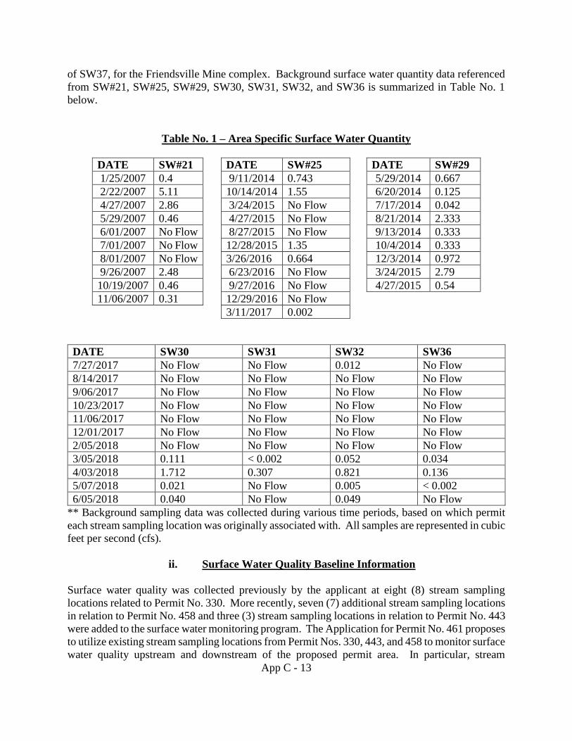
App C - 13
of SW37, for the Friendsville Mine complex. Background surface water quantity data referenced
from SW#21, SW#25, SW#29, SW30, SW31, SW32, and SW36 is summarized in Table No. 1
below.
Table No. 1 – Area Specific Surface Water Quantity
DATE SW#21 DATE SW#25 DATE SW#29
1/25/2007 0.4 9/11/2014 0.743 5/29/2014 0.667
2/22/2007 5.11 10/14/2014 1.55 6/20/2014 0.125
4/27/2007 2.86 3/24/2015 No Flow 7/17/2014 0.042
5/29/2007 0.46 4/27/2015 No Flow 8/21/2014 2.333
6/01/2007 No Flow 8/27/2015 No Flow 9/13/2014 0.333
7/01/2007 No Flow 12/28/2015 1.35 10/4/2014 0.333
8/01/2007 No Flow 3/26/2016 0.664 12/3/2014 0.972
9/26/2007 2.48 6/23/2016 No Flow 3/24/2015 2.79
10/19/2007 0.46 9/27/2016 No Flow 4/27/2015 0.54
11/06/2007 0.31 12/29/2016 No Flow
3/11/2017 0.002
DATE SW30 SW31 SW32 SW36
7/27/2017 No Flow No Flow 0.012 No Flow
8/14/2017 No Flow No Flow No Flow No Flow
9/06/2017 No Flow No Flow No Flow No Flow
10/23/2017 No Flow No Flow No Flow No Flow
11/06/2017 No Flow No Flow No Flow No Flow
12/01/2017 No Flow No Flow No Flow No Flow
2/05/2018 No Flow No Flow No Flow No Flow
3/05/2018 0.111 < 0.002 0.052 0.034
4/03/2018 1.712 0.307 0.821 0.136
5/07/2018 0.021 No Flow 0.005 < 0.002
6/05/2018 0.040 No Flow 0.049 No Flow
** Background sampling data was collected during various time periods, based on which permit
each stream sampling location was originally associated with. All samples are represented in cubic
feet per second (cfs).
ii. Surface Water Quality Baseline Information
Surface water quality was collected previously by the applicant at eight (8) stream sampling
locations related to Permit No. 330. More recently, seven (7) additional stream sampling locations
in relation to Permit No. 458 and three (3) stream sampling locations in relation to Permit No. 443
were added to the surface water monitoring program. The Application for Permit No. 461 proposes
to utilize existing stream sampling locations from Permit Nos. 330, 443, and 458 to monitor surface
water quality upstream and downstream of the proposed permit area. In particular, stream
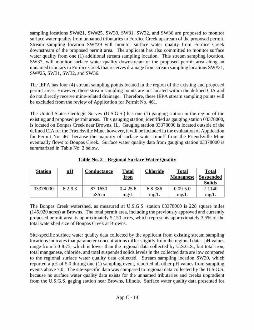
App C - 14
sampling locations SW#21, SW#25, SW30, SW31, SW32, and SW36 are proposed to monitor
surface water quality from unnamed tributaries to Fordice Creek upstream of the proposed permit.
Stream sampling location SW#29 will monitor surface water quality from Fordice Creek
downstream of the proposed permit area. The applicant has also committed to monitor surface
water quality from one (1) additional stream sampling location. This stream sampling location,
SW37, will monitor surface water quality downstream of the proposed permit area along an
unnamed tributary to Fordice Creek that receives drainage from stream sampling locations SW#21,
SW#25, SW31, SW32, and SW36.
The IEPA has four (4) stream sampling points located in the region of the existing and proposed
permit areas. However, these stream sampling points are not located within the defined CIA and
do not directly receive mine-related drainage. Therefore, these IEPA stream sampling points will
be excluded from the review of Application for Permit No. 461.
The United States Geologic Survey (U.S.G.S.) has one (1) gauging station in the region of the
existing and proposed permit areas. This gauging station, identified as gauging station 03378000,
is located on Bonpas Creek near Browns, IL. Gauging station 03378000 is located outside of the
defined CIA for the Friendsville Mine, however, it will be included in the evaluation of Application
for Permit No. 461 because the majority of surface water runoff from the Friendsville Mine
eventually flows to Bonpas Creek. Surface water quality data from gauging station 03378000 is
summarized in Table No. 2 below.
Table No. 2 – Regional Surface Water Quality
Station pH Conductance Total
Iron
Chloride Total
Managnese
Total
Suspended
Solids
03378000 6.2-9.3 87-1650
uS/cm
0.4-25.6
mg/L
6.8-386
mg/L
0.09-5.0
mg/L
2-1140
mg/L
The Bonpas Creek watershed, as measured at U.S.G.S. station 03378000 is 228 square miles
(145,920 acres) at Browns. The total permit area, including the previously approved and currently
proposed permit area, is approximately 5,150 acres, which represents approximately 3.5% of the
total watershed size of Bonpas Creek at Browns.
Site-specific surface water quality data collected by the applicant from existing stream sampling
locations indicates that parameter concentrations differ slightly from the regional data. pH values
range from 5.0-8.75, which is lower than the regional data collected by U.S.G.S., but total iron,
total manganese, chloride, and total suspended solids levels in the collected data are low compared
to the regional surface water quality data collected. Stream sampling location SW30, which
reported a pH of 5.0 during one (1) sampling event, reported all other pH values from sampling
events above 7.0. The site-specific data was compared to regional data collected by the U.S.G.S.
because no surface water quality data exists for the unnamed tributaries and creeks upgradient
from the U.S.G.S. gaging station near Browns, Illinois. Surface water quality data presented for
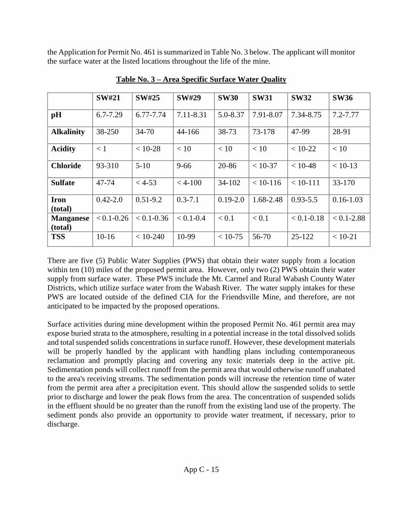
App C - 15
the Application for Permit No. 461 is summarized in Table No. 3 below. The applicant will monitor
the surface water at the listed locations throughout the life of the mine.
Table No. 3 – Area Specific Surface Water Quality
SW#21 SW#25 SW#29 SW30 SW31 SW32 SW36
pH 6.7-7.29 6.77-7.74 7.11-8.31 5.0-8.37 7.91-8.07 7.34-8.75 7.2-7.77
Alkalinity 38-250 34-70 44-166 38-73 73-178 47-99 28-91
Acidity < 1 < 10-28 < 10 < 10 < 10 < 10-22 < 10
Chloride 93-310 5-10 9-66 20-86 < 10-37 < 10-48 < 10-13
Sulfate 47-74 < 4-53 < 4-100 34-102 < 10-116 < 10-111 33-170
Iron
(total)
0.42-2.0 0.51-9.2 0.3-7.1 0.19-2.0 1.68-2.48 0.93-5.5 0.16-1.03
Manganese
(total)
< 0.1-0.26 < 0.1-0.36 < 0.1-0.4 < 0.1 < 0.1 < 0.1-0.18 < 0.1-2.88
TSS 10-16 < 10-240 10-99 < 10-75 56-70 25-122 < 10-21
There are five (5) Public Water Supplies (PWS) that obtain their water supply from a location
within ten (10) miles of the proposed permit area. However, only two (2) PWS obtain their water
supply from surface water. These PWS include the Mt. Carmel and Rural Wabash County Water
Districts, which utilize surface water from the Wabash River. The water supply intakes for these
PWS are located outside of the defined CIA for the Friendsville Mine, and therefore, are not
anticipated to be impacted by the proposed operations.
Surface activities during mine development within the proposed Permit No. 461 permit area may
expose buried strata to the atmosphere, resulting in a potential increase in the total dissolved solids
and total suspended solids concentrations in surface runoff. However, these development materials
will be properly handled by the applicant with handling plans including contemporaneous
reclamation and promptly placing and covering any toxic materials deep in the active pit.
Sedimentation ponds will collect runoff from the permit area that would otherwise runoff unabated
to the area's receiving streams. The sedimentation ponds will increase the retention time of water
from the permit area after a precipitation event. This should allow the suspended solids to settle
prior to discharge and lower the peak flows from the area. The concentration of suspended solids
in the effluent should be no greater than the runoff from the existing land use of the property. The
sediment ponds also provide an opportunity to provide water treatment, if necessary, prior to
discharge.
App C - 16
The Department will condition the permit to install a four (4) foot compacted clay liner in all
ditches and sediment ponds that convey or store pit pumpage. The clay liner will be compacted to
a hydraulic conductivity of 1x10‾⁷ cm/sec or less.
No surface water will be discharged off-site without first passing through a sedimentation pond
and/or an NPDES discharge point (outfall). The quality of the water that the applicant proposes to
discharge from the NPDES discharge points is within all applicable State and Federal effluent
limits.
iii. Groundwater Quantity Baseline Information
Groundwater use in and around the existing and proposed permit area is primarily from deep
private wells and shallow cisterns. The applicant reports that the private wells and cisterns
currently being used in the vicinity of the proposed permit area are being utilized as primary and
secondary water sources. The cisterns being used are generally shallow and completed in
unconsolidated material while the private wells are reportedly completed in bedrock at depths
greater than 300 feet. The applicant reports that the wells/cisterns completed in unconsolidated
material generally have very low yields and in many cases are not used as a primary water source
because of the availability of rural water supplies. Pryor reports that tills, loess, and outwash
deposits provide only limited quantities of water and are considered to be generally poor aquifers.
The deeper groundwater source, identified at depths up to 300 feet, is likely the Mt. Carmel
Sandstone. The Mt. Carmel Sandstone is the only known aquifer below the Friendsville Coal
Seam in central Wabash County. The Mt. Carmel Sandstone is found approximately 150-200 feet
below the Lower Friendsville Coal Seam, which is the lowest coal seam proposed to be mined.
The applicant does not anticipate any contamination, diminution or interruption of any usable
water supply, but Vigo Coal Operating Company, Inc. has committed to supplying an alternative
replacement water supply in the event the proposed operations impact any domestic water supplies.
The applicant utilized previous water user’s surveys to report eight (8) residential wells/cisterns
are located within the proposed permit area or adjacent areas. Of these eight (8) wells/cisterns,
only one (1) well/cistern is reported to be completed at depths above the lowest coal seam proposed
to be mined. This well, identified as “9-1” on Map 5 within the Application for Permit No. 461,
is reported to be completed at a depth of 60 feet and will be subsequently mined through when
operations progress. The seven (7) remaining wells/cisterns noted in the water user’s survey are
all located in the adjacent areas of the proposed permit area and are reported to be completed at
depths greater than 300 feet.
The applicant reports the unconsolidated material within the proposed permit area to be primarily
composed of silts, clays, and discontinuous sand and gravel lenses. Fetter reports that general
hydraulic conductivities of silty sands/fine sands range from 10-5 to 10-3 cm/sec, while hydraulic
conductivities of silts range from 10-6 to 10-4 cm/sec, and values for clays range from 10-9 to 10-6
cm/sec. Groundwater monitoring wells GW27, GW31, GW32, and GW33, which were previously
installed in relation with Permit Nos. 443 and 458, will be utilized to monitor the groundwater in
the vicinity of the proposed permit area. Hydraulic conductivities of these monitoring wells, with
the exception of GW33, were determined via rising-head and falling-head slug tests and were
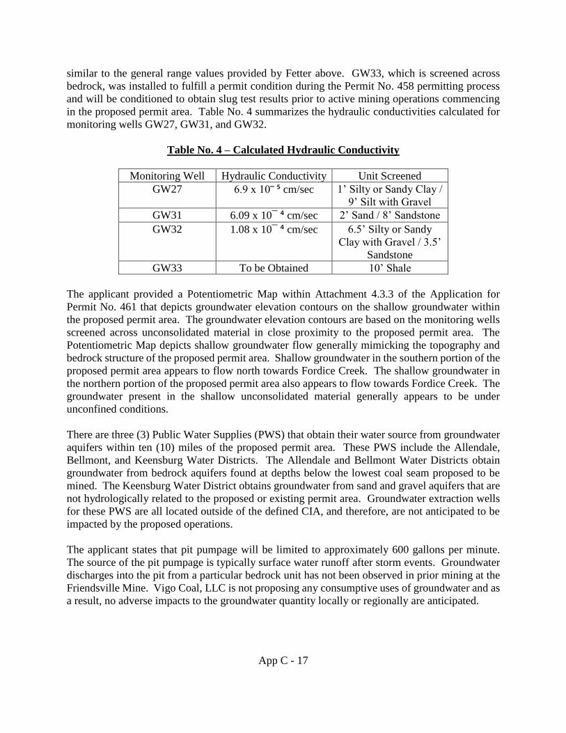
App C - 17
similar to the general range values provided by Fetter above. GW33, which is screened across
bedrock, was installed to fulfill a permit condition during the Permit No. 458 permitting process
and will be conditioned to obtain slug test results prior to active mining operations commencing
in the proposed permit area. Table No. 4 summarizes the hydraulic conductivities calculated for
monitoring wells GW27, GW31, and GW32.
Table No. 4 – Calculated Hydraulic Conductivity
Monitoring Well Hydraulic Conductivity Unit Screened
GW27 6.9 x 10‾ ⁵ cm/sec 1’ Silty or Sandy Clay /
9’ Silt with Gravel
GW31 6.09 x 10¯ ⁴ cm/sec 2’ Sand / 8’ Sandstone
GW32 1.08 x 10¯ ⁴ cm/sec 6.5’ Silty or Sandy
Clay with Gravel / 3.5’
Sandstone
GW33 To be Obtained 10’ Shale
The applicant provided a Potentiometric Map within Attachment 4.3.3 of the Application for
Permit No. 461 that depicts groundwater elevation contours on the shallow groundwater within
the proposed permit area. The groundwater elevation contours are based on the monitoring wells
screened across unconsolidated material in close proximity to the proposed permit area. The
Potentiometric Map depicts shallow groundwater flow generally mimicking the topography and
bedrock structure of the proposed permit area. Shallow groundwater in the southern portion of the
proposed permit area appears to flow north towards Fordice Creek. The shallow groundwater in
the northern portion of the proposed permit area also appears to flow towards Fordice Creek. The
groundwater present in the shallow unconsolidated material generally appears to be under
unconfined conditions.
There are three (3) Public Water Supplies (PWS) that obtain their water source from groundwater
aquifers within ten (10) miles of the proposed permit area. These PWS include the Allendale,
Bellmont, and Keensburg Water Districts. The Allendale and Bellmont Water Districts obtain
groundwater from bedrock aquifers found at depths below the lowest coal seam proposed to be
mined. The Keensburg Water District obtains groundwater from sand and gravel aquifers that are
not hydrologically related to the proposed or existing permit area. Groundwater extraction wells
for these PWS are all located outside of the defined CIA, and therefore, are not anticipated to be
impacted by the proposed operations.
The applicant states that pit pumpage will be limited to approximately 600 gallons per minute.
The source of the pit pumpage is typically surface water runoff after storm events. Groundwater
discharges into the pit from a particular bedrock unit has not been observed in prior mining at the
Friendsville Mine. Vigo Coal, LLC is not proposing any consumptive uses of groundwater and as
a result, no adverse impacts to the groundwater quantity locally or regionally are anticipated.
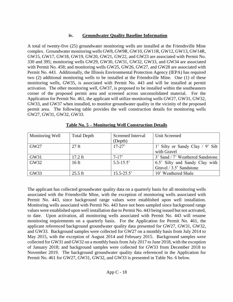
App C - 18
iv. Groundwater Quality Baseline Information
A total of twenty-five (25) groundwater monitoring wells are installed at the Friendsville Mine
complex. Groundwater monitoring wells GW8, GW9R, GW10, GW11R, GW12, GW13, GW14R,
GW15, GW17, GW18, GW19, GW20, GW21, GW22, and GW23 are associated with Permit No.
330 and 395; monitoring wells GW29, GW30, GW31, GW32, GW33, and GW34 are associated
with Permit No. 458; and monitoring wells GW25, GW26, GW27, and GW28 are associated with
Permit No. 443. Additionally, the Illinois Environmental Protection Agency (IEPA) has required
two (2) additional monitoring wells to be installed at the Friendsville Mine. One (1) of these
monitoring wells, GW35, is associated with Permit No. 443 and will be installed at permit
activation. The other monitoring well, GW37, is proposed to be installed within the southeastern
corner of the proposed permit area and screened across unconsolidated material. For the
Application for Permit No. 461, the applicant will utilize monitoring wells GW27, GW31, GW32,
GW33, and GW37 when installed, to monitor groundwater quality in the vicinity of the proposed
permit area. The following table provides the well construction details for monitoring wells
GW27, GW31, GW32, GW33.
Table No. 5 – Monitoring Well Construction Details
Monitoring Well Total Depth Screened Interval
(Depth)
Unit Screened
GW27 27 ft 17-27’ 1’ Silty or Sandy Clay / 9’ Silt
with Gravel
GW31 17.2 ft 7-17’ 3’ Sand / 7’ Weathered Sandstone
GW32 16 ft 5.5-15.5’ 6.5’ Silty and Sandy Clay with
Gravel / 3.5’ Sandstone
GW33 25.5 ft 15.5-25.5’ 10’ Weathered Shale
The applicant has collected groundwater quality data on a quarterly basis for all monitoring wells
associated with the Friendsville Mine, with the exception of monitoring wells associated with
Permit No. 443, since background range values were established upon well installation.
Monitoring wells associated with Permit No. 443 have not been sampled since background range
values were established upon well installation due to Permit No. 443 being issued but not activated,
to date. Upon activation, all monitoring wells associated with Permit No. 443 will resume
monitoring requirements on a quarterly basis. For the Application for Permit No. 461, the
applicant referenced background groundwater quality data presented for GW27, GW31, GW32,
and GW33. Background samples were collected for GW27 on a monthly basis from July 2014 to
May 2015, with the exception of August 2014 and February 2015. Background samples were
collected for GW31 and GW32 on a monthly basis from July 2017 to June 2018, with the exception
of January 2018; and background samples were collected for GW33 from December 2018 to
November 2019. The background groundwater quality data referenced in the Application for
Permit No. 461 for GW27, GW31, GW32, and GW33 is presented in Table No. 6 below.
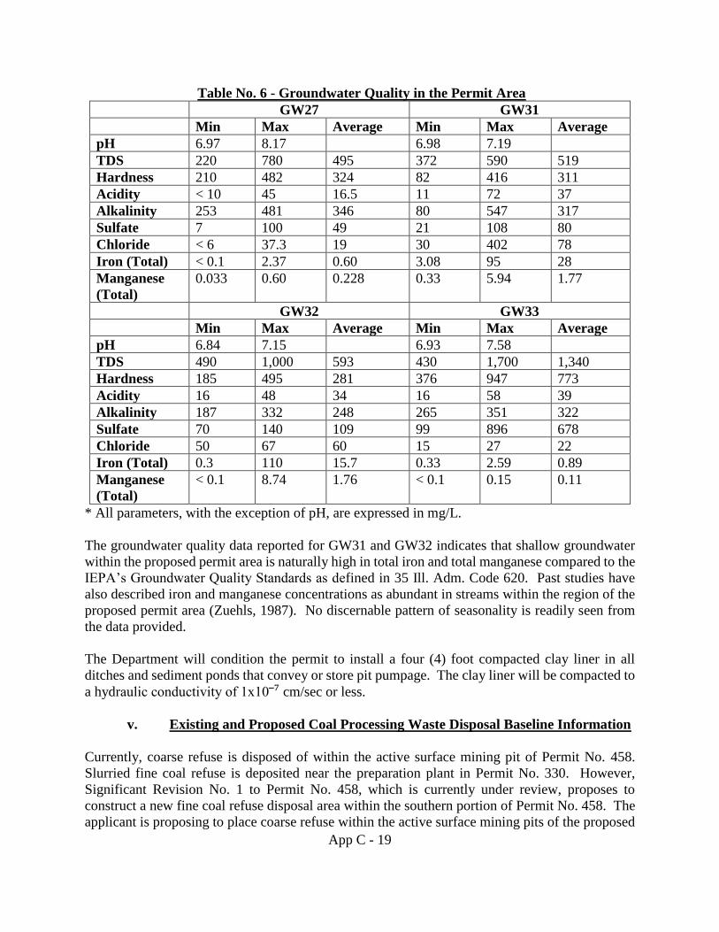
App C - 19
Table No. 6 - Groundwater Quality in the Permit Area
GW27 GW31
Min Max Average Min Max Average
pH 6.97 8.17 6.98 7.19
TDS 220 780 495 372 590 519
Hardness 210 482 324 82 416 311
Acidity < 10 45 16.5 11 72 37
Alkalinity 253 481 346 80 547 317
Sulfate 7 100 49 21 108 80
Chloride < 6 37.3 19 30 402 78
Iron (Total) < 0.1 2.37 0.60 3.08 95 28
Manganese
(Total)
0.033 0.60 0.228 0.33 5.94 1.77
GW32 GW33
Min Max Average Min Max Average
pH 6.84 7.15 6.93 7.58
TDS 490 1,000 593 430 1,700 1,340
Hardness 185 495 281 376 947 773
Acidity 16 48 34 16 58 39
Alkalinity 187 332 248 265 351 322
Sulfate 70 140 109 99 896 678
Chloride 50 67 60 15 27 22
Iron (Total) 0.3 110 15.7 0.33 2.59 0.89
Manganese
(Total)
< 0.1 8.74 1.76 < 0.1 0.15 0.11
* All parameters, with the exception of pH, are expressed in mg/L.
The groundwater quality data reported for GW31 and GW32 indicates that shallow groundwater
within the proposed permit area is naturally high in total iron and total manganese compared to the
IEPA’s Groundwater Quality Standards as defined in 35 Ill. Adm. Code 620. Past studies have
also described iron and manganese concentrations as abundant in streams within the region of the
proposed permit area (Zuehls, 1987). No discernable pattern of seasonality is readily seen from
the data provided.
The Department will condition the permit to install a four (4) foot compacted clay liner in all
ditches and sediment ponds that convey or store pit pumpage. The clay liner will be compacted to
a hydraulic conductivity of 1x10‾⁷ cm/sec or less.
v. Existing and Proposed Coal Processing Waste Disposal Baseline Information
Currently, coarse refuse is disposed of within the active surface mining pit of Permit No. 458.
Slurried fine coal refuse is deposited near the preparation plant in Permit No. 330. However,
Significant Revision No. 1 to Permit No. 458, which is currently under review, proposes to
construct a new fine coal refuse disposal area within the southern portion of Permit No. 458. The
applicant is proposing to place coarse refuse within the active surface mining pits of the proposed
App C - 20
Application for Permit No. 461 permit area in a similar fashion as the coarse refuse placed in the
Permit No. 458 permit area. The applicant has committed to continue placing any materials that
are potentially acid-forming low in the spoil profile (near the bottom of the pit) to isolate the
materials and prevent oxidation from occurring. The maximum height of refuse placement in the
proposed permit area will be limited to five (5) feet. Slurried fine coal refuse will continue to be
deposited within the Permit No. 330 boundaries near the preparation plant, at this time.
CCW/CCB – The Application for Permit No. 461 will not utilize or dispose of any coal
combustion waste (CCW) or coal combustion by-products (CCB) within the proposed permit area.
The applicant had originally proposed to utilize CCB material within the proposed permit area but
this request was withdrawn by the applicant during the permitting process.
b. Findings
i. Surface Water Quantity Findings
The proposed permit area of approximately 371.2 acres will only discharge mining-related affected
drainage/runoff through a permitted NPDES outfall. The applicant has proposed the addition of
two (2) new NDPES Outfalls for the proposed permit area. The combined acreage for the existing
and proposed permit areas of the Friendsville Mine totals approximately 5,150 acres. The Surface
Water CIA for the Friendsville Mine is approximately 19,258 acres. Therefore, the existing and
proposed permit area comprises approximately 27% of the defined CIA for the Friendsville Mine.
There has been previous mining in the Coffee Creek watershed downstream of the Friendsville
complex at the Wabash Mine. However, no surface water runoff from the proposed Application
for Permit No. 461 area will be discharged into the Coffee Creek watershed.
During active mining operations, surface water runoff will be directed to sedimentation ponds and
discharged through permitted NPDES Outfalls. These sedimentation ponds will retain rainfall
which previously ran unabated to the receiving stream. This added detention time could result in
decreases to peak flows to the streams from storm events and increased base flows of the receiving
streams due to the slow release of water after rainfall events.
There are two (2) public water supplies (PWS), the Mount Carmel and Rural Wabash County
Water Districts, that obtain their water supplies from surface water sources within ten (10) miles
of the proposed permit area. The supply intakes for these PWS are located on the Wabash River
and outside of the defined CIA for the Friendsville Mine. Therefore, these PWS are highly unlikely
to experience any surface water quantity effects due to the proposed operations.
The effects of this operation should be negligible on the hydrologic balance in regard to surface
water quantity.
ii. Surface Water Quality Findings
Surface water quality of the receiving stream, Fordice Creek, has been documented by the
applicant. In addition, the applicant will monitor an additional stream sampling location along an
App C - 21
unnamed tributary to Fordice Creek that is downstream of the proposed permit area. Some minor
changes to the surface water quality may be expected within the existing and proposed permit
areas, such as increases in total dissolved solids, suspended solids, and iron. The alkaline nature
of the overburden should neutralize any resultant acid from the operation and result in no free
acidity being generated. TDS values may increase during active mining operations due to the
oxidation of pyrite, but these values are anticipated to decrease after reclamation. Evident from
previous mining at the Friendsville Mine, even in areas where parameters have increased, the
elevated levels have not precluded the use of the water to support post-mining land uses.
A four (4) foot compacted clay liner will be conditioned to be installed in all ditches and sediment
ponds that convey or store pit pumpage. The clay liner will be compacted to a hydraulic
conductivity of 1x10‾⁷ cm/sec or less.
Effluent from the NPDES discharge points is proposed to meet all applicable State and Federal
water quality standards and is comparable to that of the receiving streams. Adherence to these
limits will ensure that adverse impacts will not occur to the surface water quality of the receiving
streams as a result of the proposed operations. Additionally, the existing uses of the receiving
streams, as defined by the IEPA, will not be adversely impacted by this operation.
The applicant has committed to long-term surface water monitoring at an additional stream
sampling location, SW37, for the Application for Permit No. 461. The applicant has also
previously committed to long-term surface water monitoring at eighteen (18) stream sampling
locations related to Permit Nos. 330, 443, and 458. The surface water monitoring locations, with
the exception of SW37, will be sampled/analyzed for pH, TDS, TSS, acidity, alkalinity, sulfates,
iron (total), manganese (total), and flow rate on a quarterly basis for the duration of the mine or
until final bond release. SW37 will be required to properly establish background before
implementing quarterly sampling for the parameters stated above.
Public Water Supplies within ten (10) miles of the proposed permit area that obtain their water
supply from surface water are located a substantial distance from the proposed permit area and are
not within the defined CIA for the proposed operations.
Therefore, the effects of this operation should be negligible on the hydrologic balance in regard to
surface water quality.
iii. Groundwater Quantity Findings
The combined acreage of the existing and proposed permit areas of the Friendsville Mine totals
approximately 5,150 acres. The Groundwater CIA for the Friendsville Mine is approximately
7,222 acres. The existing and proposed permit area comprises approximately 71% of the defined
Groundwater CIA for the Friendsville Mine. Any potential impacts to groundwater quantity from
the mining operations should be able to be detected and contained within the defined Groundwater
CIA.
App C - 22
Available groundwater information indicates that shallow groundwater supplies in and adjacent to
the existing and proposed permit areas appear to be limited. A search of the Illinois State
Geological Survey (ISGS) online water well database failed to document the shallow well/cistern
documented by the applicant to be located within the proposed permit area. However, this well,
identified as “9-1” will be subsequently mined through and removed during active operations.
According to the applicant, most residents that utilize wells/cisterns as a primary water source
obtain water from deeper bedrock sources like the Mt. Carmel Sandstone. The Mt. Carmel
Sandstone is the only known aquifer in the vicinity of the proposed permit area and is found at
depths considerably below the lowest coal seam proposed to be mined.
Groundwater conditions in and adjacent to the original permit areas were previously documented
by the applicant. Groundwater quantity impacts to water wells adjacent to the proposed permit
area are not anticipated. However, should impacts to groundwater quantities occur, these changes
are anticipated to be temporary and water levels should reestablish to approximate pre-mining
levels once mining and reclamation activities have been completed. To date, the Department has
yet to receive report of negative impacts occurring to groundwater quantities in the vicinity of the
original permit areas.
Private water wells completed at depths below the lowest coal seam proposed to be mined are
highly unlikely to experience impacts to groundwater quantity, due to the low permeability strata
that separates these aquifers from the coal seam. However, during active mining, it is possible that
shallow groundwater above the lowest coal seam proposed to be mined will flow from un-mined
areas toward the active pit. This would create a cone of depression in the aquifer around the active
pit that extends out into the un-mined areas. Past studies have shown that the distance to which
this depression may extend was limited to less than 1,000 feet. Previous studies by Oertel (1980)
have demonstrated a limited extent for water table depressions. Cartwright and Hunt (1981) have
also suggested a limited extent of impacts due to surface mining. The minor dewatering of shallow
aquifers in the adjacent areas of the proposed permit area is not anticipated to occur, as previous
mining at the Friendsville Mine has not resulted in significant infiltration of groundwater into the
active pit. However, out of caution, the defined Groundwater CIA for the Friendsville Mine
includes a 1,000-foot buffer area around the existing and proposed permit areas. No private water
wells/cisterns completed at depth above the lowest coal seam to be mined were documented within
this 1,000-foot buffer area. However, in the unlikely event that minor dewatering of aquifers in
the adjacent areas occurs, the water table is expected to recover and stabilize at, or near, pre-mining
levels once the active pit progresses forward. To assure that these operations do not adversely
impact adjacent water users, the applicant has installed groundwater monitoring wells and
committed to providing a suitable alternative water supply in the event that water quantity is
impacted by mining operations. As noted previously, slug tests have been conducted on the
previously installed monitoring wells utilized for the Application for Permit No. 461. The slug
test results for GW27, GW31, and GW32 report hydraulic conductivity values ranging from
1x10¯⁴ to 1x10‾⁵ cm/s. Groundwater elevation data from these wells show that the water table
within the proposed permit area fluctuates under what appears to be unconfined conditions.
Public water supplies (PWS) located within ten (10) miles of the proposed permit area are highly
unlikely to experience changes in groundwater quantity. These PWS obtain groundwater from
App C - 23
aquifers either at depths below the lowest coal seam proposed to be mined or aquifers not
hydrologically connected to the proposed permit area. Furthermore, the location of the supply
wells for these PWS are not within the defined CIA for the Friendsville Mine.
The applicant is not proposing any consumptive uses of groundwater during mining operations.
Therefore, since no consumptive uses are proposed, nor is significant infiltration into the active pit
anticipated, there should be no adverse impacts to the hydrologic balance in regard to groundwater
quantity.
iv. Groundwater Quality Findings
The overall effects of the proposed operation, aside from some temporary minor changes on the
existing groundwater quality, should remain balanced with the current system. Impacts to shallow
groundwater quality should be similar to those seen in surface water, with mainly increases in total
dissolved solids and iron. These impacts are anticipated to be short-term and are expected to
decrease and stabilize at levels at or below the applicable groundwater quality standards beyond
the proposed permit boundaries. In certain areas within the existing permit areas, the applicant is
disposing of coarse and fine processing refuse material. Typically, coarse and fine refuse has the
potential to be acid-forming. However, studies by Infanger and Hood (1980) and Hoving and
Hood (1984) have demonstrated that even for very acidic material, so long as it is covered in a
timely manner with alkaline material, acid generation can be mitigated. Analysis of overburden
by the permittee has shown it to be very alkaline, which will aid in the control of acid generation.
Additionally, the applicant will limit refuse placement to a height of five (5) feet or one (1) dump
truck load above the pit floor, which will also minimize the potential for acid generation.
Groundwater quality below the lowest coal seam to be mined should not be affected by the
proposed mining operations. The Pennsylvanian aged Mt. Carmel Sandstone is the only known
bedrock aquifer that exists in the region. The Mt. Carmel Sandstone is typically found at depths
ranging from 200-300 feet, which is considerably below the lowest coal seam proposed to be
mined. All private water wells documented to be within the proposed permit area or adjacent
areas, and that are to remain in post-mining conditions, were completed in the Mt. Carmel
Sandstone. The low permeability of interburden material between the Lower Friendsville Coal
Seam and Pennsylvanian aged bedrock should restrict the downward movement of water from the
mine pit into the underlying strata. Therefore, the proposed operations appear highly unlikely of
impacting these private water wells completed in the Mt. Carmel Sandstone. Shallow aquifers
also appear unlikely of being impacted by the proposed operations, as the Department will
condition the applicant to install a four (4) foot compacted clay liner in all ditches and sediment
ponds that convey or store pit pumpage. The clay liner will be compacted to a hydraulic
conductivity of 1x10‾⁷ cm/sec or less.
The expected post-mining groundwater quality is proposed to meet the applicable groundwater
quality standards at the proposed permit boundaries. Overall, groundwater quality is not likely to
experience serious adverse effects. However, to ensure this, the applicant has included an
approved groundwater monitoring program for the permit area, as required by 62 Ill. Adm. Code
Part 1780.21(j). Furthermore, IEPA requested and the applicant agreed to install one (1) additional
App C - 24
groundwater monitoring well to ensure all groundwater resources are being monitored during and
after mining operations.
c. Findings Related to Existing and Proposed Coal Processing Waste Disposal
A potential source of groundwater impacts could come from the disposal of refuse/spoil/gob
materials in the mine pit. Information has been supplied concerning handling of toxic material in
the overburden and the net neutralization of waste material. To prevent the possibility of
potentially toxic water from leaching out of the spoils and moving to adjacent surface and
subsurface waters, the applicant will bury any acid or toxic forming materials at the pit bottom.
This disposal method will prevent oxidation and thereby, minimize acid production.
Coal processing waste has previously been disposed of within the existing permit areas of Permit
Nos. 330, 395, and 458. All coarse refuse will continue to be disposed of within the open pit areas
of the existing and proposed permit areas. The coal waste will be adequately covered with non-
toxic earthen materials and the area(s) will be reclaimed. At this time, slurried coal refuse will
continue to be deposited near the preparation plant in Permit No. 330. Application for Significant
Revision No. 1 to Permit No. 458 proposes to construct a new fine coal refuse disposal area within
the southern portion of Permit No. 458. However, this application is currently under review and
has not been issued, to date.
The coal will be processed on-site via a preparation plant system. This system will use water to
wash, screen, size, and process the coal. Coarse reject material will be hauled to the active mining
pit for disposal. The coarse reject material produced will primarily consist of shales, coal seam
partings, and pyritic materials separated from the coal. All refuse materials will be placed in the
mining pit, low in the spoil profile to avoid oxidation of any potentially acidic materials. All refuse
materials will then be adequately covered to further prevent oxidation from occurring. Refuse
placement will be limited to a maximum height of five (5) feet from the pit bottom.
CCW/CCB – The Application for Permit No. 461 will not utilize or dispose of any coal
combustion waste (CCW) or coal combustion by-products (CCB) within the proposed permit area.
III. CONCLUSION
The Department has now conducted a hydrogeologic assessment on the proposed additional
mining operations within the existing and proposed permit areas. As noted in the discussions
throughout this document, the Department has concluded that the additional operations proposed
in the Application for Permit No. 461 will not have a negative impact on either the surface water
or groundwater regimes. To date, the Department has not received any reports or complaints of
surface water or groundwater quality or quantity impacts, which appears to support the above
assessment that the proposed permit area will not negatively impact the hydrologic balance in the
vicinity of the existing and proposed mine.
The surface water and groundwater monitoring programs have been designed to provide sufficient
lead time for notification of any potential impacts, as well as to provide ample time for
App C - 25
investigation and mitigation prior to any impacts reaching off-site. Both the groundwater and
surface water monitoring programs are dynamic and as such, the Department reserves the right to
add monitoring parameters or monitoring locations should the need arise. The applicant is required
to monitor the surface water and groundwater throughout the life of the mine, until a determination
is made by the Department that the monitoring is no longer necessary.
Neither groundwater nor surface water would be materially damaged unless the quantity and/or
quality of water is degraded, on a long-term or permanent basis beyond applicable standards or a
long-term or permanent loss of use is reported. Material damage occurs when the impact is
immitigable. Neither the applicant nor the Department anticipates that this will occur.
In summary, the assessment and findings of the probable cumulative impact of all anticipated
mining in the area on the hydrologic balance finds that this operation has been designed to prevent
material damage to the hydrologic balance outside the permit areas.
App C - 26
V. REFERENCES AND ATTACHMENTS
References
Cartwright, K., Hunt, C.S., 1981, Hydrogeologic aspects of coal mining in Illinois: An Overview.
Illinois State Geological Survey, Environmental Geology Notes #90.
Corbett, D.M., 1965, Runoff contributions to streams from cast over-burden of surface mining
operations for coal, Pike County, Indiana. Indiana Univ., Water Resources Research
Center, Report of Investigation #1, 67 p.
Fetter, C.W., 1988, Applied Hydrogeology, Second Edition.
Hoving, S.J., and W.C. Hood, 1984, The Effect of Different Thicknesses of Limestone and Soil
Over Pyritic Material on Leachate Quality. Symposium on Surface Mining Hydrology,
Sedimentology, and Reclamation. Univ. of Kentucky, Lexington, Kentucky, p. 251-257
Illinois Environmental Protection Agency, Draft 2018, Illinois Integrated Water Quality Report
and Section 303(d) List.
Illinois Sate Geological Survey, Directory of Coal Mines in Illinois – Wabash County, August
2018. (http://www.isgs.illinois.edu/sites/isgs/files/maps/coal-maps/mines-series/mines-
directories/pdf-files/mines-directory-wabash.pdf)
Illinois State Geological Survey, Illinois Water Well Interactive Map (ILWATER)
(http://maps.isgs.illinois.edu/ILWATER/ )
Infanger, M.K., and W.C. Hood, 1980, Positioning Acid-Producing Over-burden for Minimal
Pollution. Symposium on Surface Mining Hydrology, Sedimentology, and Reclamation.
Univ. of Kentucky, Dec. 1-3.
Oertel, A.O., 1980, Effects of surface coal mining on shallow ground water quality and quantity,
southwest Perry County, Illinois: Unpublished Masters’ Thesis, Southern Illinois Univ. at
Carbondale.
Office of Surface Mining Mid-Continent Region, 2007, Hydrologic Considerations for Permitting
and Liability Release, a Technical Reference for the Mid-Continent Region
Pryor, W.A., 1956, Groundwater geology in southern Illinois: A preliminary report. Illinois State
Geological Survey, Circular 212.
West Virginia Surface Mine Drainage Task Force, 1978, Suggested guidelines for methods of
operations in surface mining of areas with potentially acid-producing materials. Coal
Conference and Expo V, West Virginia Dept.of Natural Resources.

App C - 27
Zuehls, E.E., et al., 1987, Hydrology of Area 31, Eastern Region, Interior Coal Province, Illinois
and Kentucky. United States Geologic Survey, Water Resources Investigations Open-File
Report 81-403.
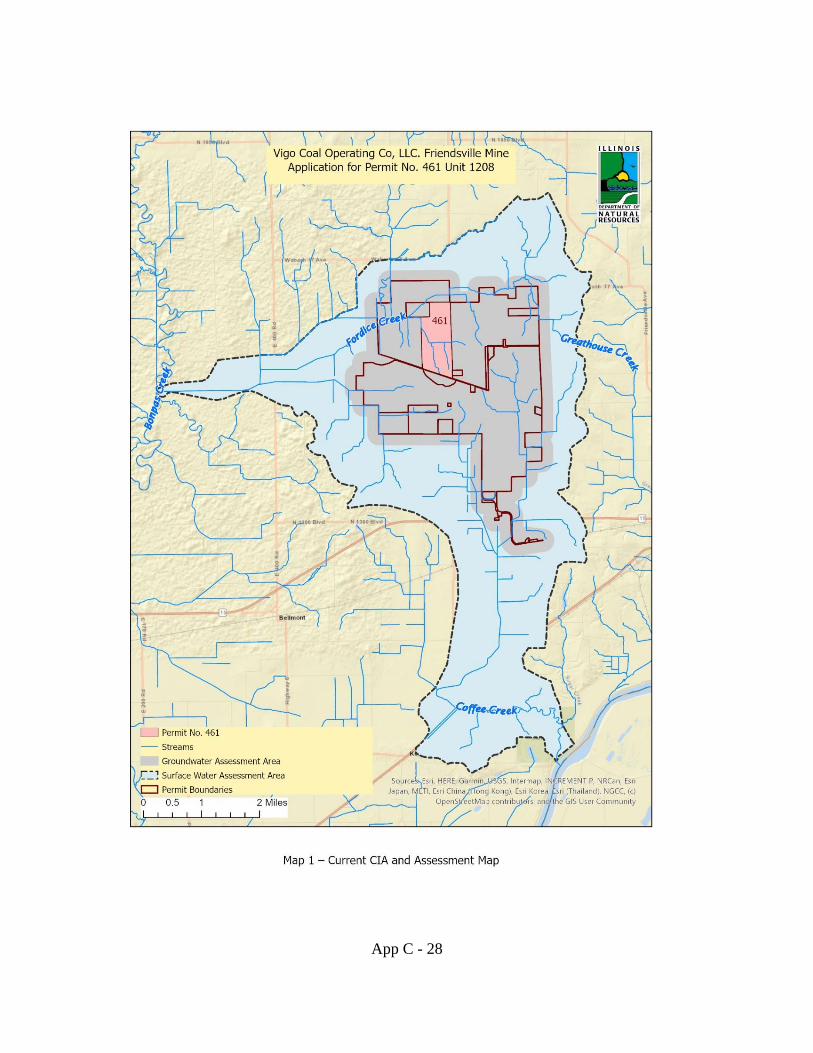
App C - 28
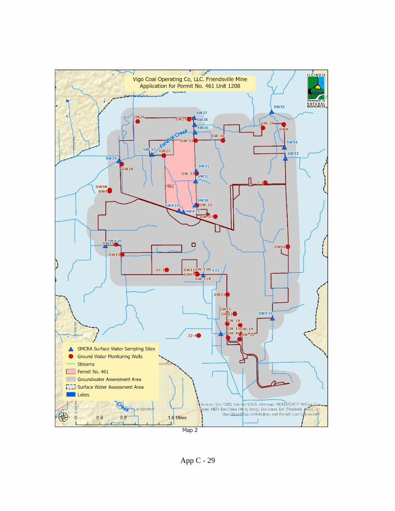
App C - 29
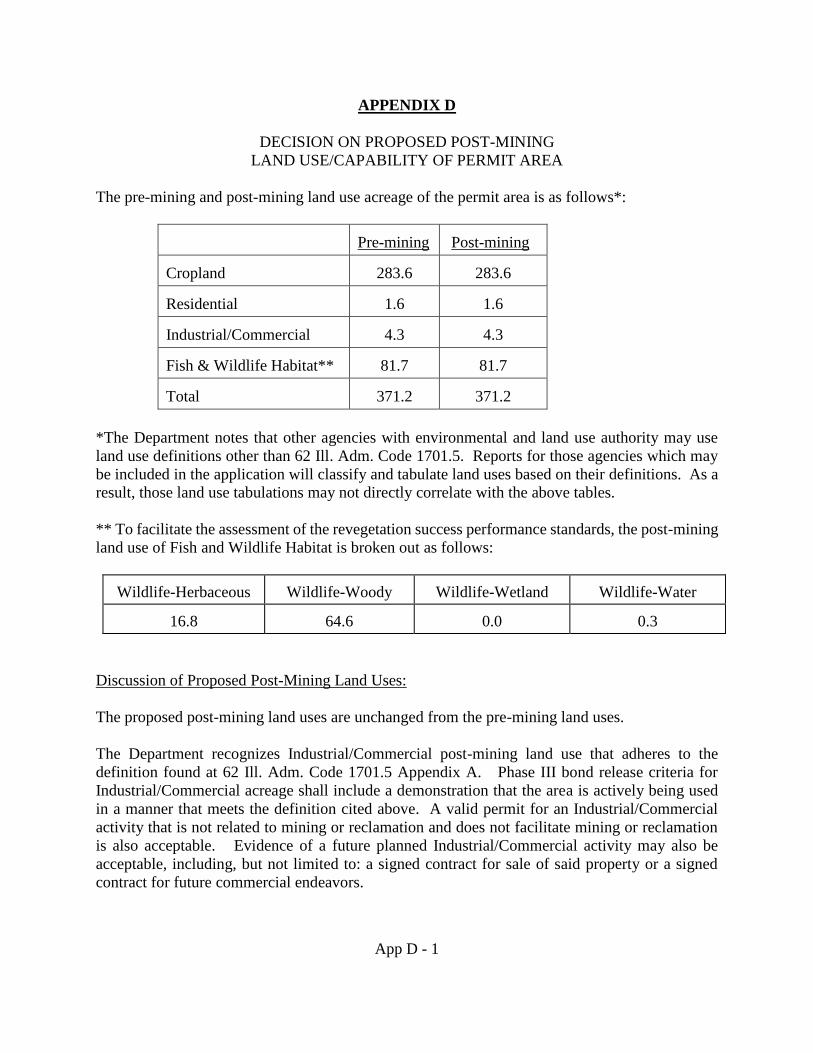
App D - 1
APPENDIX D
DECISION ON PROPOSED POST-MINING
LAND USE/CAPABILITY OF PERMIT AREA
The pre-mining and post-mining land use acreage of the permit area is as follows*:
Pre-mining Post-mining
Cropland 283.6 283.6
Residential 1.6 1.6
Industrial/Commercial 4.3 4.3
Fish & Wildlife Habitat** 81.7 81.7
Total 371.2 371.2
*The Department notes that other agencies with environmental and land use authority may use
land use definitions other than 62 Ill. Adm. Code 1701.5. Reports for those agencies which may
be included in the application will classify and tabulate land uses based on their definitions. As a
result, those land use tabulations may not directly correlate with the above tables.
** To facilitate the assessment of the revegetation success performance standards, the post-mining
land use of Fish and Wildlife Habitat is broken out as follows:
Wildlife-Herbaceous Wildlife-Woody Wildlife-Wetland Wildlife-Water
16.8 64.6 0.0 0.3
Discussion of Proposed Post-Mining Land Uses:
The proposed post-mining land uses are unchanged from the pre-mining land uses.
The Department recognizes Industrial/Commercial post-mining land use that adheres to the
definition found at 62 Ill. Adm. Code 1701.5 Appendix A. Phase III bond release criteria for
Industrial/Commercial acreage shall include a demonstration that the area is actively being used
in a manner that meets the definition cited above. A valid permit for an Industrial/Commercial
activity that is not related to mining or reclamation and does not facilitate mining or reclamation
is also acceptable. Evidence of a future planned Industrial/Commercial activity may also be
acceptable, including, but not limited to: a signed contract for sale of said property or a signed
contract for future commercial endeavors.
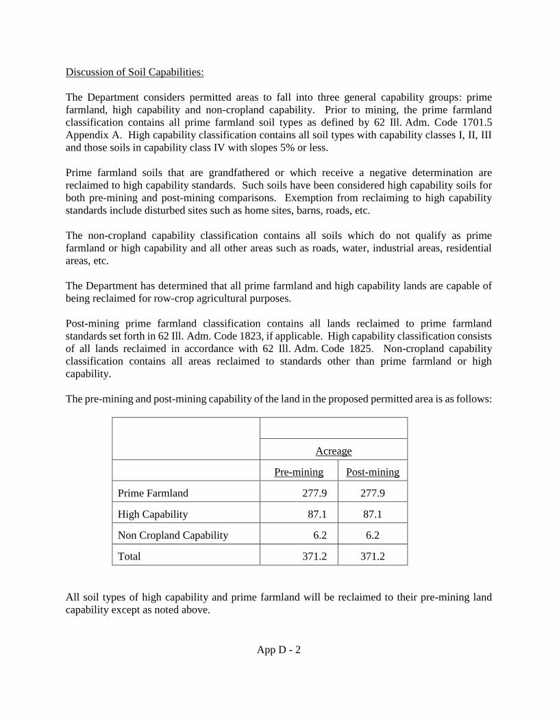
App D - 2
Discussion of Soil Capabilities:
The Department considers permitted areas to fall into three general capability groups: prime
farmland, high capability and non-cropland capability. Prior to mining, the prime farmland
classification contains all prime farmland soil types as defined by 62 Ill. Adm. Code 1701.5
Appendix A. High capability classification contains all soil types with capability classes I, II, III
and those soils in capability class IV with slopes 5% or less.
Prime farmland soils that are grandfathered or which receive a negative determination are
reclaimed to high capability standards. Such soils have been considered high capability soils for
both pre-mining and post-mining comparisons. Exemption from reclaiming to high capability
standards include disturbed sites such as home sites, barns, roads, etc.
The non-cropland capability classification contains all soils which do not qualify as prime
farmland or high capability and all other areas such as roads, water, industrial areas, residential
areas, etc.
The Department has determined that all prime farmland and high capability lands are capable of
being reclaimed for row-crop agricultural purposes.
Post-mining prime farmland classification contains all lands reclaimed to prime farmland
standards set forth in 62 Ill. Adm. Code 1823, if applicable. High capability classification consists
of all lands reclaimed in accordance with 62 Ill. Adm. Code 1825. Non-cropland capability
classification contains all areas reclaimed to standards other than prime farmland or high
capability.
The pre-mining and post-mining capability of the land in the proposed permitted area is as follows:
Acreage
Pre-mining Post-mining
Prime Farmland 277.9 277.9
High Capability 87.1 87.1
Non Cropland Capability 6.2 6.2
Total 371.2 371.2
All soil types of high capability and prime farmland will be reclaimed to their pre-mining land
capability except as noted above.
App D - 3
The Department has determined that the post-mining land use/capability is in accordance with the
requirements of 62 Ill. Adm. Code 1816.133.
The Department finds the areas affected by surface coal mining activities will be restored in a
timely manner to conditions that are capable of supporting the use which they were capable of
supporting before mining or to higher or better use achievable under the criteria and procedures of
62 Ill. Adm. Code 1816.133. The reclamation plan does not present any actual or probable hazard
to public health or safety, nor does it pose any actual threat of water diminution or pollution as
indicated in Appendix C, and the proposed land uses following mining are not impractical or
unreasonable as all the post-mining land uses existed prior to mining and are compatible with
surrounding areas. The land uses are consistent with applicable land use policies and plans known
to the Department and no objections were received from any governmental agency with such
authority. The plan does not involve unreasonable delay in implementation and is not in violation
of any other applicable law known to the Department.
The Department also finds that all soils with a capability class of I, II, III and capability class IV
with slopes 5% or less are capable of being reclaimed for row-crop agricultural purposes based on
NRCS soil survey classifications of the affected land prior to mining as set out in the application.
The Department further finds that the optimum future use of these soils is row-crop agriculture
purposes, and all of these soils will be reclaimed to prime or high capability standards. All lands
reclaimed to high capability standards may not necessarily be reclaimed to a post-mining land use
of cropland. This may be due to its pre-mining land use being other than cropland, or being
considered highly erodible by the NRCS and thus eligible to conversion to other land uses for soil
conservation purposes. The retention of row crop capability, however, ensures that the land may
support row crop land use after bond release should the need arise to use this land for actual crop
production.
App E - 1
APPENDIX E
THREATENED AND ENDANGERED SPECIES
Endangered Species Act of 1973, 16 USC 1531, et seq.
62 Ill. Adm. Code 1773.15(c)(10)
The Department reviewed permit application no. 461 for potential effects of surface coal mining
operations and related activity on state and federally listed threatened and endangered species. The
following factors were considered for all species that could potentially be adversely affected: status
of species in the proposed permit area and adjacent area, site specific resource information, direct
and indirect effects, and cumulative effects.
Five primary sources were utilized to identify federally listed threatened and endangered species
that could potentially be affected by the proposed coal mining operations and related activities.
These sources include threatened and endangered species review information submitted by the
applicant, public comments, the U.S. Fish and Wildlife Service (USFWS), the Illinois Department
of Natural Resources/Division of Real Estate Services and Consultation/Office of Realty and
Capital Planning (ORCP), and Department records.
Information Submitted by the Applicant
The threatened and endangered species review submitted by the applicant as a requirement of the
Department’s electronic application addressed state listed species known to occur in Wabash
county and applicable adjacent area using records obtained from the Illinois Natural Heritage
Database. Three state threatened species, the blue jasmine (Clematis crispa), the loggerhead shrike
(Lanius ludovicianus) and barn owl (Tyto alba), were deemed by the applicant as likely to occur
on the proposed project area, Protection and Enhancement Plans (PEP) have been supplied by the
applicant. None of these species are currently listed as federally threatened or endangered.
Information within the application indicates that a total of 72.7 acres of potential suitable summer
habitat for the federally endangered Indiana bat (Myotis sodalis) and the federally threatened
northern long-eared bat (M. septentrionalis) is located within the permit boundary. Presence of
the Indiana bat was assumed and a PEP following the USFWS revised 2013 edition of the “2009
Range-wide Indiana Bat Protection and Enhancement Plan Guidelines” (Guidelines) was prepared.
The project will not impact known northern long-eared bat hibernacula or disturb known northern
long-eared bat maternity roost trees or trees within a quarter mile of a known maternity roost tree.
Therefore, the project is consistent with the northern long-eared bat Final 4(d) rule (Federal
Register, January 2016) and subsequent “no critical habitat” determination (Federal Register, April
2016) issued by the USFWS. Although the project is consistent with the 4(d) rule, the applicant
chose to include the northern long-eared bat in the PEP because the species will also benefit from
the outlined protection and enhancement measures.
App E - 2
Public Comments
No public comments regarding threatened or endangered species were received regarding this
application.
U.S. Fish and Wildlife Service Comments
The USFWS provided written comments on this application in a letter dated January 17, 2020.
The USFWS identified eight federally listed species for the proposed permit area, the endangered
fat pocketbook mussel (Potamilus capax), endangered Indiana bat, endangered least tern (Sterna
antillarum), endangered sheepnose mussel (Plethobasus cyphus), endangered spectaclecase
mussel (Cumberlandia monodonata), threatened eastern prairie fringed orchid (Platanthera
leucophea), threatened rabbitsfoot mussel (Quadrula cylindrica cylindrica), and threatened
northern long-eared bat. The USFWS concluded that there is “no designated critical habitat in the
project area at this time.”
The USFWS stated that “information in the permit application indicates that the fat pocketbook,
least tern, rabbitsfoot, sheepnose, spectaclecase and the eastern prairie fringed orchid are not likely
to occur on or adjacent to the permit area. Based on the location of the permit area and description
of the proposed permit area, the Service concurs that the proposed actions are not likely to
adversely affect the fat pocketbook, rabbitsfoot, sheepnose, and spectaclecase mussels, the least
tern, and eastern prairie fringed orchid.”
The USFWS reviewed the PEP for the Indiana bat and indicated that “that the take of [72.7] acres
of potential habitat is not likely to jeopardize the continued existence of the Indiana bat.” The
USFWS also acknowledged the verification letter received October 30, 2019 indicating that the
proposed project is consistent with the Programmatic Biological Opinion for the northern long-
eared bat and consultation responsibilities regarding this species have been fulfilled.
Illinois Office of Realty and Capital Planning
Pursuant 17 Ill. Adm. Code Section 1075 the Department consulted with ORCP (previously the
Office of Realty and Environmental Planning) via the online EcoCAT (Ecological Compliance
Assessment Tool) system regarding state listed species within the permit boundary and adjacent
area. A termination letter was provided on August 29, 2019 indicating that the Illinois Natural
Heritage Database contains no records of state listed threatened or endangered species, Illinois
Natural Area Inventory Sites, or nature preserves/reserves located within the vicinity of the site.
Although the consultation was terminated, the permittee provided PEPs for the blue jasmine, the
loggerhead shrike, and the barn owl. Taking into account the consultation termination issued by
ORCP and the state listed species PEPs supplied by the applicant, the Department concurs that the
operations as approved are unlikely to adversely affect any species protected under the Illinois
Endangered Species Protection Act (520 ILCS 10/1 et seq.).
App E - 3
Department Records and Determination
The Department utilized the Illinois Department of Natural Resources DIRT (Detailed Impact
Review Tool) mapping system to review whether or not the project lies within the buffer zone of
documented occurrences of any state or federally listed threatened or endangered species. No such
protective buffer zones overlay or intersect the permit boundary.
The applicant submitted the required information to the Department regarding the Indiana bat and
the northern long-eared bat including a suitable habitat determination, assuming presence, and an
Indiana bat and northern long-eared bat PEP. The Department has determined that the applicant
correctly and diligently followed the protocol specified in the Guidelines (USFWS, 2013); by
following these guidelines the applicant is in compliance with the USFWS and Office of Surface
Mining Reclamation and Enforcement (OSMRE) 1996 Biological Opinion on the implementation
of the Surface Mining Control and Reclamation Act of 1977 (PL 98-87) with regard to assuring
compliance with the Endangered Species Act. The Department determined that a PEP was
necessary for this application because suitable summer habitat for the Indiana bat is present in the
proposed operations area. The applicant assumed presence of the Indiana bat and followed the
Guidelines (USFWS, 2013) to develop the PEP. The applicant utilized the key to the northern
long-eared bat 4(d) rule for federal actions to conclude that proposed actions are not prohibited,
therefore a PEP for this species was not required, however the applicant chose to include the
northern long-eared bat in the PEP.
The Department considered site specific resource information, information provided by the
applicant, concurrence by the USFWS that adverse effects to federally listed species are not likely,
termination of the ORCP Section 1075 consultation, and Department records. The Department
has determined the proposed mining operations and related activities will not affect the continued
existence of threatened or endangered species or result in destruction or adverse modification of
their critical habitats, as determined under the Endangered Species Act of 1973 (16 USC 1531 et
seq.).
Status of Potentially Adversely Affected Species
Indiana bat
The Guidelines (USFWS, 2013) specify the necessity to consider whether known or suitable winter
habitat (hibernacula) and/or suitable summer habitat (maternity roosting/feeding) and/or swarming
habitat (mating behavior/assessment of hibernacula suitability (Van Schaik, 2015)) of the
endangered Indiana bat are located within the proposed permit area. Winter hibernation habitat
for the species includes caves, abandoned underground mine workings, and railroad tunnels.
Summer maternity roosting habitat includes trees or snags greater than or equal to 5 inches
diameter at breast height (dbh) with exfoliating bark (USFWS, 2013) under which female bats,
usually numbering less than 100 individuals, roost (Menzel, et al 2001). Suitable swarming habitat
consists of forested areas with the described trees that are located within a 10 mile radius of any
potential hibernacula (USFWS, 2013).
App E - 4
A major cause of the decline of the Indiana bat is associated with impediments to functioning
hibernacula including blocked cave entrances, improper bat gate designs which may impede bat
flight into caves or impede proper air flow through caves (USFWS, 1999 and Federal Register,
2007). Arousal following human disturbance to hibernating bats can lead to premature emergence
from hibernacula, decreased body condition, and decreased survival (Menzel, et al 2001).
Additional causes of decline in the species can be attributed to disturbances or removal of active
maternity roost trees and loss of critical habitat. More recently, White Nose Syndrome (WNS) has
been identified as having a negative effect on Indiana bat populations.
The range of the Indiana bat covers most of the eastern half of the United States with the majority
of roosting colonies in Indiana, Kentucky, and Missouri (USFWS, 2014). For the Indiana bat,
recent population data comparing 1997 estimates with historic levels indicate that the range wide
population is less than half of historical levels. Indiana bats have declined significantly in some
states including Kentucky and Missouri, but have increased in some states, most notably Indiana.
Population estimates show an increase of about 30% in Illinois from historical levels to the present
(Clawson 2002, Clawson 2004). In 2012 the Service reported an increase in Indiana bats in Illinois
from 21,677 in 2001 to 55,956 in 2011.
Northern long-eared bat
Suitable winter habitat for this species includes caves and underground mines with high humidity,
no air currents, and a constant temperature range (USFWS, 2015). The USFWS indicated in the
Federal Register (April 2016) that a critical habitat designation is not necessary for this species,
however Appendix H (USFWS, 2014) does define suitable summer roosting habitat as any forested
area or isolated live tree or snag that is “≥ 3 inches dbh with exfoliating bark, cracks, crevices,
and/or cavities”. Suitable swarming habitat is typically within five (5) miles of a known or
potential hibernaculum and can include linear features such as fence rows, riparian buffers, or
other travel corridors (USFWS, 2014).
The USFWS indicates that because the above described roosting habitat for the northern long-
eared bat is not limited, habitat loss is not a significant threat to the species. The Final 4(d) Rule
(Federal Register, January 2016) prevents “take” during sensitive life stages and prohibits
incidental take where WNS occurs under these circumstances: if the take occurs within a
hibernaculum, if the take occurs from tree removal within 0.25 miles of a known hibernaculum, or
if the take occurs from the removal of a known/occupied maternity roost tree or tree within 150
foot radius of the maternity tree between June 1st and July 31st.
The range of the northern long-eared bat in the United States extends across 37 states in the eastern
and north-central areas of the country, including Illinois (Federal Register, 2015 and USFWS,
2015). A contributing factor to the overall decline of the species is WNS, a fungal disease affecting
hibernating bats with widespread mortality (USGS, 2015). First observed in New York in 2006,
WNS has rapidly spread throughout the Northeast and Midwest; northern long-eared bat
populations have been reduced by 99% in parts of its range (USFWS, 2015). The first documented
observance of WNS in Illinois affecting a northern long-eared bat occurred in LaSalle County in
App E - 5
2013; WNS has since been documented in at least ten additional Illinois counties (IDNR, 2015).
The Federal Register Final Rule (2015) listing the species as federally threatened indicates that
“overall, summer surveys from Illinois have not documented a decline due to WNS to date”.
Site Specific Resource Information
A qualified wildlife biologist representing the applicant determined that potential suitable
summer habitat for the Indiana bat exists on site, all areas supporting trees of 5 inches dbh or
greater were considered potentially suitable. These areas are also potentially suitable summer
habitat for the northern long-eared bat. No known caves or underground openings where Indiana
bats or northern long-eared bats hibernate or could potentially hibernate exist within the permit
area. No known/occupied maternity roost tree data is known near the project area for the
northern long-eared bat. The applicant utilized the key to the northern long-eared bat 4(d) rule
for federal actions to conclude that proposed actions are not prohibited. The applicant chose to
assume presence of the Indiana bat in lieu of conducting field surveys. It is assumed that the
Indiana bat is present in the proposed permit area and will be adversely affected and possibly
“taken” as defined in the Endangered Species Act; assuming presence is allowed under the
federal guidelines but requires the applicant to obtain Incidental Take authorization.
Direct and Indirect Effects
Take of an Indiana bat and/or a northern long-eared bat is a possible consequence of the proposed
mining operations and associated activities. Take could result from killing or injuring bats if roost
trees were knocked down while occupied by vulnerable females and/or young; the applicant has
committed to honor a “no cut” period during the time of year bats could be present in trees to
minimize the likelihood of such take. Removal of feeding habitat, even if done when the bats are
not present, could have indirect effects on the species until this feeding habitat can be restored.
The applicant has proposed to replace the required 70% of pre-mine tree habitat that is removed
during the course of proposed mining operation and associated activities. Emphasis will be placed
on planting tree species that are recommended in the Guidelines (USFWS, 2013) for the benefits
they provide to threatened and endangered bat species. Habitat modifications resulting from
clearing trees in general could also be interpreted as take under the Endangered Species Act
(Romanik, 2010); the applicant has requested an Incidental Take authorization to account for this
broader definition of take. Incidental Take authorization for the Indiana bat is hereby granted under
the authority of the 1996 Biological Opinion issued by the USFWS to OSMRE (USFWS 1996).
In addition, the Department has determined that this project may affect the northern long-eared
bat, but that any resulting Incidental Take is not prohibited by the Final 4(d) rule. Therefore this
project is consistent with the USFWS January 2016 Programmatic Biological Opinion on the Final
4(d) rule. The Department and the applicant are in compliance with Section 7 of the Endangered
Species Act of 1973, as amended (16 U.S.C. 1531 et seq).
The applicant has committed to the following measures which should serve to minimize
disturbances and adverse impacts to Indiana bats and northern long-eared bats:
App E - 6
1. The applicant will limit tree clearing to October 15 through March 31 of any calendar year to
avoid take of a female and/ or young Indiana bat or northern long-eared bat.
2. The applicant will restore woody vegetation as described in the reclamation plan and the Indiana
bat and northern long-eared bat PEP using tree species known to be beneficial to threatened and
endangered bat species.
3. The applicant will utilize herbaceous ground cover species as described in the Indiana bat PEP
that will provide cover and resources for wildlife, reduce competition for tree seedlings/saplings,
and provide soil stability and erosion control.
Cumulative Effects
Cumulative effects under the Endangered Species Act are defined at 50 CFR Section 402.02 which
states “Cumulative effects are those effects of future state, or private activities, not involving
federal activities, that are reasonably certain to occur within the action area of the federal action
subject to consultation”. In the case of a mining permit being issued by the State of Illinois to a
private company to develop a privately owned coal reserve, there is no federal action subject to
consultation. Therefore, there are no cumulative effects to consider as that term is defined under
Section 402.02. The Department nevertheless has considered other future state, county, township
and private activities that are reasonably certain to occur within the adjacent land area. Adjacent
and nearby land consists of active coal mining operations, agricultural crop land, historically
surface mined lands, scattered residential areas, county roads, streams, and forested areas. Most
of the adjacent acreage is owned and managed by private entities other than the active surface and
underground mining operations which are currently owned by permittee. In regards to adjacent
and nearby land holdings, the Department has no reason to believe that detrimental cumulative
effects to any threatened or endangered bat species would result from state, county, township,
and/or private land management practices or activities. If the applicant chooses to submit a new
application to the Department for surface effects on nearby lands that contain streams or forested
acres, then new threatened and endangered species reviews and PEPs will be required. The
Department is not aware of any state, county, township or private activities that would reasonably
be certain to occur in the area adjacent or close to the proposed permit area that would adversely
affect any threatened or endangered bat species.
Summary
The Department considered the status of the federally endangered Indiana bat and the federally
threatened northern long-eared bat, both with the potential to be adversely impacted by the
proposed mining operations and associated activities. Although overall populations continue to
decline, the Indiana bat population in Illinois is stable or increasing (Clawson, 2004 and USFWS,
2011). Northern long-eared bat population data in the Midwest is limited, however estimates
indicate possibly as many as four million northern long-eared bats in 6 states of the Midwest; 21
hibernacula have been documented in Illinois, mostly from the southern region (Federal Register,
2015).
App E - 7
The Department has considered site specific resource information; the proposed permit area is
within the range of the Indiana bat and the northern long-eared bat but not considered known
habitat by the standards outlined by the USFWS (2013) Guidelines or as defined by the Final 4(d)
Rule. The proposed permit area does have suitable potential summer roosting habitat for both bat
species as outlined in those Guidelines for the Indiana bat and Appendix H of the 2014 Interim
Guidelines for the northern long-eared bat. No critical habitat was identified by the USFWS during
consultations for these two protected species.
The Department considered direct and indirect effects of proposed operations on the Indiana bat
and northern long-eared bat; the most significant threat to these species from mining operations
and associated activities is take due to disturbance of an occupied maternity roost tree. The
applicant has committed to honor a “no-cut” restriction period to prevent the possibility of this
type of take. Removal of trees may also affect feeding habitat; the best technology currently
available for replacement of feeding habitat includes planting trees during reclamation. The
applicant has committed to this post-mining reclamation activity along with other provision set
forth in the Indiana bat PEP.
The Department has considered cumulative effects as defined under 50 CFR 402.02 and has
considered future state and private activities reasonably certain to occur in the adjacent area and is
not aware of any such activities which could adversely affect the Indiana bat or the northern long-
eared bat.
Conclusion
Pursuant to 62 Ill. Adm. Code 1816.97(a), the applicant has proposed to minimize disturbances
and adverse impacts to the Indiana bat and the northern long-eared bat by implementing measures
described above, while using the best technology currently available. Following these measures
will minimize and appropriately mitigate adverse impacts to the Indiana bat and northern long-
eared bat. Incidental Take for the Indiana bat is authorized by the Department via this permitting
action and the Department has determined that any Incidental Take of the northern long-eared bat
is not prohibited by the Final 4(d) Rule.
The Incidental Take as authorized is a take provided for by the Endangered Species Act of 1973
(16 USC 1531 et seq.) and is not a violation of this Act. Except as specifically authorized, no other
take of a federally listed species is allowed; the applicant remains subject to the prohibitions found
at Section 1816.97(d) of taking a federally listed species protected under the Endangered Species
Act. Unauthorized take is a violation of Section 1816.97(d); in addition, failure of the applicant
to implement the measures specified in the approved plan as part of this permit will subject the
applicant to enforcement measures under Sections 1773.17(b), 1816.97(a), and in the case of a
take in violation of the Endangered Species Act, Section 1816.97(d).
After having considered the status of the Indiana bat and northern long-eared bat, site specific
resource information, direct and indirect effects, and cumulative effects, and in the context of the
applicant’s commitments for measures to minimize and mitigate disturbances and adverse impacts
to the Indiana bat and northern long-eared bat and conditions imposed by the Department, the
App E - 8
Department finds that the operation will not affect the continued existence of endangered or
threatened species or result in destruction or adverse modification of their critical habitats, as
determined under the Endangered Species Act of 1973 (16 USC 1531 et seq.).
Literature Cited
Clawson, Richard L. (2002). Trends in population size and current status. Pp. 7-13 In The
Indiana bat: biology and conservation of an endangered species. Missouri Dept. of
Conservation, Columbia, Missouri.
Clawson, R. (2004). National status of the Indiana bat. pp. 1-6. In Vories, K.C. and A.
Harrington. (eds.). 2004. Proceedings of Indiana Bat and Coal Mining: A Technical
Interactive Forum. November 16-18, 2004. Louisville, KY. USDOI Office of Surface
Mining and Coal Research Center, Southern Illinois University at Carbondale Illinois.
Federal Register. (2007). 50 CFR Part 17 – Endangered and Threatened Wildlife and Plants; 90
Day and 12 Month Findings on a Petition to Revise Critical Habitat for the Indiana Bat.
FR/Vol. 72, No.43/Tuesday, March 6, 2007/Proposed Rules. Pp. 9913-9917.
Federal Register. (2015). 50 CFR Part 17 – Endangered and threatened wildlife and plants;
Threatened species status for the Northern long-eared bat with 4(d) rule. FR/Vol. 80, No.
63/Thursday April 2, 2015/Rules and Regulations. Pp. 17974- 18033.
Federal Register. (January 2016). 50 CFR Part 17 – Endangered and threatened wildlife and
plants; 4(d) rule for the Northern long-eared bat. FR/Vol. 81, No. 9/Thursday January
14, 2016/Rules and Regulations. Pp. 1900-1922.
Federal Register. (April 2016). 50 CFR Part 17 – Endangered and threatened wildlife and
plants; Determination that designation of critical habitat is not prudent for the Northern
long-eared bat. FR/Vol. 81, No. 81/Wednesday April 27, 2016/Rules and Regulations.
Pp. 24707-24714
Illinois Department of Natural Resources. (2015). Press release: White-nose syndrome found in
three additional Illinois counties. http://www.dnr.illinois.gov/news/Pages/White-
NoseSyndromeFoundinThreeAdditionalIllinoisCounties.aspx. Accessed October 13,
2015.
Menzel, M. A., Menzel, J. M., Carter, T. C., Ford, W. M., & Edwards, J. W. (2001). Review of
the forest habitat relationships of the Indiana bat (Myotis sodalis) (Vol. 284). US
Department of Agriculture, Forest Service, Northeastern Research Station.
Romanik, P. (2010). Everything you wanted to know about “take” in the Endangered Species
Act. pp 45-48. In Vories, K.C., A.H. Caswell, and T.M. Price (eds.) 2010. Proceedings
of Protecting Threatened Bats at Coal Mines: A Technical Interactive Forum August 31 –
September 3, 2010 Charleston, WV.
App E - 9
Van Schaik, J., Janssen, R., Bosch, T., Haarsma, A.-J., Dekker, J. J. A., & Kranstauber, B.
(2015). Bats Swarm Where They Hibernate: Compositional Similarity between Autumn
Swarming and Winter Hibernation Assemblages at Five Underground Sites. PLoS ONE,
10(7), e0130850. http://doi.org/10.1371/journal.pone.0130850
U.S. Fish and Wildlife Service. (1996). Endangered Species Act – Section 7 Consultation
Biological Opinion and Conference Report, U.S. Dept. Interior, Office of Surface Mining
Reclamation and Enforcement (OSM); Surface Coal Mining Regulatory Programs Under
the Surface Mining Control and Reclamation Act of 1977, PL 95-87 issued Sept 24,
1996. 15 pp.
U.S. Fish and Wildlife Service. (1999). Agency draft. Indiana bat revised recovery plan. U.S.
Fish and Wildlife Service, Fort Snelling, Minnesota. 53 pp.
U.S. Fish and Wildlife Service. (2012). (2009 and 2011 revised) Rangewide population Estimate
for the Indiana Bat (Myotis sodalis) by Recovery Unit
(http://www.fws.gov/midwest/Endangered/mammals/inba/pdf/2009inbaRangewidePopJu
ly2011.pdf revised 7-14-2011). 5 pp.
U.S. Fish and Wildlife Service. (2013). (2009 revised) Range-wide Indiana bat protection and
enhancement plan guidelines.
U.S. Fish and Wildlife Service. (2014). Agency directive, USFWS Regions 2, 3, 4, 5 & 6.
Northern Long-Eared Bat Interim Conference and Planning Guidance. U.S. Fish and
Wildlife Service, Fort Snelling, Minnesota. 67 pp.
U. S. Fish and Wildlife Service. (2015). Northern long-eared bat (Myotis septentrionalis) fact
sheet.
http://www.fws.gov/midwest/endangered/mammals/nleb/pdf/NLEBFactSheet01April201
5.pdf
U. S. Fish and Wildlife Service. (2016). Northern long-eared bat (Myotis septentrionalis) status:
Threatened with 4(d) Rule.
https://www.fws.gov/Midwest/endangered/mammals/nleb/index.html
U.S. Fish and Wildlife Service. (2016). Programmatic biological opinion on the final 4(d) rule
for the northern long-eared bat and activities excepted from take prohibitions, USFWS
Regions 2, 3, 4, 5 & 6. Midwest Regional Office, Bloomington Minnesota. 109 pp.
U. S. Geological Survey. (2015). National wildlife health center: White – nose syndrome
(WNS). http://www.nwhc.usgs.gov/disease_information/white-nose_syndrome/.
Accessed October 13, 2015.
App F - 1
APPENDIX F
FINDING OF THE OPERATOR’S TECHNOLOGICAL
CAPABILITY TO RESTORE PRIME FARMLAND
The original permit application and subsequent modification of the application addressed the
requirements of Section 1785.17. Pursuant to Section 1785.17(c), the applicant submitted detailed
plans for the mining and restoration of the prime farmlands affected by surface mining
activities.
1785.17(c)(l): The applicant has submitted a soil survey of the permit area which meets the
standards of the National Cooperative Soil Survey. The results of test borings which showed
representative soil profiles for the prime farmland soil were also submitted. Itemized prime
farmland soil map units and soil descriptions can be obtained from the Custom Soil Survey Report
provided in the application. Additional reference documents include the NRCS Web Soil Survey
and the University of Illinois Agricultural Experiment Station - Bulletin 811, which were used as
references to evaluate the pre-mining data.
1785.17(c)(2): The proposed method and type of equipment to be used for removal, storage, and
replacement of the soils were described pursuant to Sections 1823.12 and 1823.14. The A, B and
C horizons will be removed by a loader and truck fleet and/or with scrapers. Replacement will be
with the same equipment, or dozers.
1785.17(c)(2): Stockpile locations were shown on the Mining Operations Map; plans for
identifying the prime soils and plans for soil stabilization before redistribution were submitted in
conformance with 1823.13. Stockpile stabilization will occur by establishment of a vegetative
cover and mulch; these measures will minimize erosion.
1785.17(c)(3): Documents were reviewed supporting the use of B/C horizon mixtures in place of
the original B horizon. The applicant submitted references of available agriculture studies
conducted by universities and company research. This information supported the applicant’s belief
that the proposed methods of reclamation will achieve, within a reasonable time, equivalent or
higher levels of yield than those of non-mined prime farmland in the surrounding area.
McCormack, Donald, 1974, "Soil Reconstruction: For the Best Results After Mining" Proc.
Second Res. and Appl. Tech. Symp. on Mined Land Recl., NCA, Louisville, KY, October
22-24, l974.
Snarski, R. R., J. B. Fehrenbacher, I. Jansen, l981, "Physical and Chemical Characteristics
of Pre-mine Soils and Post-mine Soil Mixtures in Illinois", SSSA Jour., V45:806-812.
McSweeney, I. Jansen and W. S. Dancer, l981, "Subsurface Horizon Blending: An
Alternative Strategy to B Horizon Replacement for Construction of Post-Mine Soils",
SSSA, Jour., V45:784-799.
App F - 2
Jansen, Ivan, 1981, "Reconstruction Soils After Surface Mining of Prime Agricultural
Land", Mining Eng., March SME Rpt.78-F-375.
McSweeney, I. Jansen, 1984, "Soil Structure and Associated Rooting Behavior in
Minesoils", SSSA Jour 48:607-612.
Christ, Richard, 1980, "The Effect of Soil from B and C Horizons on Yield Potential of
Soybeans", Unpublished Thesis, Dept. of Plant and Soil Sci., Southern Ill. Univ.
Carbondale, Il.
Spindler, D. and J. Bauer, 1986, Prime Farmland Restoration Plans - Planning and
Information Needs" Proc. Nat. Assoc. State Land Recl., Sept 1986, Columbia, S.C.
In addition to relying on the above data, the Department has relied on the expertise of its Land
Reclamation Division and the fact that thousands of acres of prime farmland and high capability
land have met the cropland productivity performance standards using a B/C soil horizon mix.
Based on this evidence, the Department considers it quite probable that the applicant will meet
bond release requirements on the prime farmland areas which will be mined and reclaimed.
1785.17(c)(4): Yield data was limited for the fields within the permit area. However, fertility
levels of the topsoil showed that the fields were being managed at a medium level of management.
The operator will lime and fertilize the reclaimed prime farmland fields to bring them to levels
required under an optimum level of management. In addition, to satisfy the requirements of
Section 1785.17(c)(4), the Department consulted the productivity indexes for each of the soil types
on the permit area in "Optimum Crop Productivity Ratings for Illinois Soil", University of Illinois,
Bulletin 811.
The Department has determined the soil productivity after mining will be returned to equivalent
levels of yield as non-mined prime farmlands of the same soil type in the surrounding area under
equivalent management practices, as discussed hereafter.
The Federal Act specifically requires in Section 5l0(d)(1) that two findings be made by the
Regulatory Authority in granting a permit to mine on prime farmland; the Department regulations
at Section 1785.17 also require a prime farmland finding. Section 510(d)(1) states:
"In addition to finding the application in compliance with subsection (6) of this section, if
the area proposed to be mined contains prime farmland pursuant to Section 507(b)(16), the
Regulatory Authority shall, after consultation with the Secretary of Agriculture, and
pursuant to regulations issued hereunder by the Secretary of Interior with the concurrence
of the Secretary of Agriculture, grant a permit to mine on prime farmland if the Regulatory
Authority finds in writing that the operator has the technological capability to restore such
mined area, within a reasonable time, to equivalent or higher levels of yield as non-mined
prime farmland in the surrounding area under equivalent levels of management and can
App F - 3
meet the soil reconstruction standards in Section 515(b)(7). Except for compliance with
subsection (b), requirements of this paragraph (1) shall apply to all permits issued after the
date of enactment of this Act."
The first requirement concerns the operator's technological capability to restore the mined area,
within a reasonable time, to equivalent or higher levels of yield as non-mined farmland in the
surrounding area under equivalent levels of management. The Department, or the Regulatory
Authority has reviewed other data not submitted by the operator which supports the Regulatory
Authority's finding:
Dancer, W. S. and I. Jansen, 1981, "Greenhouse evaluation of solum and substratum
materials in the southern Illinois coal field: I Forage crops", Jour. Environ. Qual.
10:396-400.
Powell, J., et al., 1985, "Reclamation of Prime Farmland in Kentucky", Pres Nat. Mtg. of
Am. Soc. Surf. Min. and Recl. Oct, Denver, Co.
Spindler, Dean, 1981, "Three Case Studies on Rowcrop Production on Mined Land"
prepared for the Symposium on Surface Mining Hydrology, Sedimentation and
Reclamation, University of Kentucky, Lexington, KY, December 7-11.
The Regulatory Authority has also reviewed the information submitted by the applicant in support
of its proposed restoration plan and evaluated the fact that thousands of acres of prime farmland
and high capability land have met the cropland productivity performance standards. These
documents are available for inspection at the Land Reclamation Division Office in Springfield.
The second requirement of Section 510(d)(1) concerns soil reconstruction standards in Section
515(b)(7). The Regulatory Authority has reviewed the application concerning the operator's plan
to comply with these requirements and find it complies with Section 515(b)(7) of the Federal Act
and Sections 1785.17 and 1823 of the Department's regulations. In addition, the Regulatory
Authority has considered the method and equipment to be utilized and has found that the planned
method is appropriate to successfully comply with the requirements of 510(d)(1) and Section 1823
of the Department's regulations.
1785.17(d): The Regulatory Authority has consulted with the USDA, Natural Resource
Conservation Service (NRCS), designated representative of the Secretary of Agriculture. The
Department's consideration of the NRCS comments are addressed in Appendix B.
1785.17(e)(1): The approved post-mine land use of the reclaimed prime farmlands will be
cropland.
1785.17(e)(2): The Department has considered the comments of the representative of the U.S.
Secretary of Agriculture (NRCS).
App F - 4
1785.17(e)(3): As previously discussed, the Department believes the applicant has the
technological capability to restore prime farmland, within a reasonable time, to equivalent or
higher levels of yields as non-mined prime farmland.
1785.17(e)(4): The special requirements for prime farmland restoration of Section 1823 have been
addressed below in accordance with Section 1785.17(e)(4). Some of the subsections in Section
1823 have been previously addressed by Section 1785.17 discussions. Only those items not
previously discussed will be below.
1823.14(a)(1): The minimum depth of the reconstructed prime farmland soil will be 48 inches.
However, in all areas the root zone will be greater than the minimum specified by Section
1823.14(a)(1), as indicated by the operations plan submitted by the applicant.
1823.14(a)(2): This section is applicable to the Hosmer series. The proposed B/C mix for root
media will meet or exceed high capability standards.
1823.14(b): Topsoil will be replaced to its premining thickness after the root medium replacement
and the area is returned to final grade.
1823.14(c): Compaction will be minimized by handling the soil during dry weather and/or the
Department will require a compaction alleviation plan if it is determined that excessive compaction
is causing low yields.
1823.14 (d): Rooting media used for reclamation will consist of a B/C horizon mix excavated to a
maximum depth of 12 feet on the upland ridges. The applicant has shown that the blend of 3 feet
of subsoil and 9 feet of loess/till for the rooting medium has a comparable texture (silt loam), pH
and fertility level as the existing subsoil. Another source for rooting media material is the alluvium
to a depth of 12 feet from the bottomland soils. Data show that the alluvium blend would have an
average texture of silt loam. The subsoil will be returned to its required thickness.
1823.14 (e): The operator has proposed to use two sources of supplemental topsoil material for
forested steep slope (>10%) areas. One source is the BA or B1 horizon transition soil found
between the topsoil and the B2 horizon of the upland soils. The maximum depth of borrow would
be 13 inches. The average texture of the upland BA or B1 horizon is silt loam which is the same
texture as the existing A horizon of the steep slope soils. The pH, phosphorus, and potassium of
the borrow materials are somewhat lower than those same parameters of the A horizon materials,
so fertility levels will be adjusted to levels needed as determined by soil testing. The second source
of supplemental topsoil materials is bottomland alluvium. That material, like the BA or B1
horizons, is of similar texture and will need supplemental lime and fertilizer as well. Topsoil will
be returned to the required thickness and suitably protected from erosion.
1823.14(f): The applicant has made a commitment for fertilization based on soil tests.
1823.15: The applicant will comply with the seeding and mulching requirements pursuant to
Sections 1823.15, 1816.113 and 1816.114.
App F - 5
In making this finding, the Regulatory Authority has relied on available data and opinions of
experts, as found relevant to this application. In addition, the Regulatory Authority has relied on
the expert technical opinion of its staff. Such reliance was intended by Congress as is apparent in
the legislative history of the Federal Act. At page 105 of the House Conference Report No. 95-493,
the Conferees state:
"It is the intention of the Conferees that the written finding that the regulatory authority is
required to make before a permit is granted to mine on prime farmland can be based in part
on the expert opinion of the regulatory authority, the operator has the technological
capability to perform the soil reconstruction standards of Section 515(b)(7) and the
performance of those standards will result in the restoration of the mined area to equivalent
or higher levels of agricultural yield as non-mined prime farmland in the surrounding area
under equivalent levels of management. This does not mean that mining and restoration
must have taken place in the surrounding area, but simply that the operator can show by
agricultural school studies, or other data for comparable areas that equivalent yields can be
obtained after mining."
This finding is based on significant and substantial evidence and is in keeping with the standards
for prime farmland review approved by the Office of Surface Mining. (See letter from Acting
Director Reeves to Illinois Director Evilsizer, dated April 7, l980, which is incorporated by
reference.)
This finding is based solely upon characteristics peculiar to this particular operator and the prime
farmland soil types involved.
All materials supporting this finding are a part of the public record and are hereby incorporated by
reference.
Based upon the foregoing analysis of the probable impact of the proposed operations and a review
of the application and Interagency and public comments thereon, the Department finds that there
is a reasonable basis on which to issue the permit as requested by the applicant.
Enter on behalf of the Illinois Department of Natural Resources, Office of Mines and Minerals,
Land Reclamation Division, as the Regulatory Authority.
Recommended