Orange County
Strategic Deployment Plan 2013 UPDATE
FINAL REPORT
Intelligent Transportation Systems (ITS)
Prepared by
Prepared for
Orange County
Strategic Deployment Plan 2013 UPDATE
FINAL REPORT
Intelligent Transportation Systems (ITS)

TABLE OF CONTENTS
August 22, 2013 i
EXECUTIVE SUMMARY .....................................................................................................................1
1. INTRODUCTION ...................................................................................................................... 14
1.1 ITS Strategic Deployment Plan Overview ................................................................................ 161.2 Alignment with OCTA’s Strategic Plan and Goals..................................................................... 161.3 Plan Use and Objectives ........................................................................................................ 181.4 Process to Update the ITS Strategic Deployment Plan ............................................................. 181.5 Timeframe ............................................................................................................................. 191.6 Federal Requirements ............................................................................................................ 191.7 Report Organization ............................................................................................................... 20
2. ORANGE COUNTY AREA AND EXISTING CONDITIONS ....................................................................... 22
2.1 Geographic Area .................................................................................................................... 222.2 Institutional Framework ......................................................................................................... 242.3 Existing Conditions and Inventory ........................................................................................... 25
2.3.1 Transit Management and Multi-modal .................................................................................... 252.3.2 Traffic Management................................................................................................................ 272.3.3 Incident Management and Emergency Response .................................................................. 312.3.4 Traveler Information ............................................................................................................... 312.3.5 Performance Monitoring/ Data Management ......................................................................... 322.3.6 Safety ..................................................................................................................................... 332.3.7 Communications and Connectivity ......................................................................................... 33
3. USER AND REGIONAL NEEDS .................................................................................................... 34
4. EXISTING AND PLANNED SERVICE PACKAGES ................................................................................ 37
5. STRATEGIES ......................................................................................................................... 40
5.1 Transit Management and Multi-Modal .................................................................................... 505.1.1 Integrated Transit Management (MM1) .................................................................................. 505.1.2 Bus Rapid Transit (MM2) ....................................................................................................... 515.1.3 Rail Operations and Enhancements (MM3)............................................................................ 525.1.4 Integrated Payment (MM4) .................................................................................................... 535.1.5 Support for Pedestrian and Bicycle Travel (MM5).................................................................. 535.1.6 Support to Commercial Vehicle Operations (MM6) ............................................................... 54
5.2 Traffic Management ............................................................................................................... 555.2.1 Multi-Jurisdictional Arterial Traffic Management (TM1) ......................................................... 555.2.2 Continued Freeway Traffic Management (TM2) ...................................................................... 565.2.3 Migration to Grid-based Traffic Signal Synchronization(TM3) ................................................ 565.2.4 Corridor Management (TM4).................................................................................................. 585.2.5 Regional Coordination of Managed Lanes (TM5) ................................................................... 59
5.3 Incident Traffic Management and Emergency Response .......................................................... 595.3.1 Freeway Service Patrol Management (IM1) ........................................................................... 595.3.2 Emergency Vehicle Preemption Migration (IM2) ................................................................... 60

TABLE OF CONTENTS
August 22, 2013 ii
5.3.3 Arterial-based Incident Traffic Management (IM3) ................................................................. 615.4 Traveler Information .............................................................................................................. 62
5.4.1 Continued Expansion of the Southern California 511 Program (TI1) ...................................... 625.4.2 Integrated and Localized Parking Guidance (TI2) ................................................................... 63
5.5 Performance Monitoring ........................................................................................................ 645.5.1 Countywide Performance Monitoring (PM1) .......................................................................... 64
5.6 Communications and Connectivity .......................................................................................... 655.6.1 Countywide Communications Master Plan (CC1) .................................................................. 655.6.2 Countywide Connectivity Master Plan (CC2) ......................................................................... 665.6.3 Provide a Connected Vehicles Platform (CC3) ...................................................................... 66
5.7 Safety.................................................................................................................................... 675.7.1 Bicycle Detection (SF1) ......................................................................................................... 675.7.2 Pedestrian Detection (SF2) .................................................................................................... 685.7.3 Transit Security (SF3) ............................................................................................................. 69
5.8 Institutional ........................................................................................................................... 695.8.1 Continuously Improve Staffing Levels and Skillsets (IN1) ...................................................... 695.8.2 Formalize Sub-regional Partnerships (IN2) ............................................................................ 70
6. PLANNED AND RECOMMENDED PROJECTS.................................................................................... 72
6.1 Project Sequencing ................................................................................................................ 726.2 Strategic ITS Projects ............................................................................................................ 81
6.2.1 Transit Management and Multi-Modal .................................................................................... 816.2.2 Traffic Management................................................................................................................ 816.2.3 Incident Management and Emergency Response .................................................................. 826.2.4 Traveler Information ............................................................................................................... 826.2.5 Performance Monitoring ........................................................................................................ 836.2.6 Communications and Connectivity ......................................................................................... 836.2.7 Safety ..................................................................................................................................... 836.2.8 Institutional ............................................................................................................................. 83
7. REGIONAL COMMUNICATIONS AND INTEGRATION ........................................................................... 85
7.1 Communication Infrastructure Review .................................................................................... 857.2 Opportunities and Challenges to Countywide Integration ......................................................... 87
7.2.1 System Architectures ............................................................................................................. 877.2.2 Controller Compatibility .......................................................................................................... 887.2.3 IP/Ethernet Communications.................................................................................................. 897.2.4 National Transportation Communications for ITS Protocol (NTCIP) ....................................... 907.2.5 Caltrans Fiber ......................................................................................................................... 91
8. PERFORMANCE MONITORING AND REPORTING PLAN ...................................................................... 93
8.1 State of the Practice .............................................................................................................. 938.2 Applicability to Orange County................................................................................................ 938.3 Proposed Performance Measures ........................................................................................... 968.4 Data Needs ............................................................................................................................ 97

TABLE OF CONTENTS
August 22, 2013 iii
8.5 Program Implementation........................................................................................................ 98
9. PHASED DEPLOYMENT PLAN .................................................................................................. 100
LIST OF TABLES
Table 1 – Local Agency Traffic Signal Controller, System and Communications Inventory ........................... 30Table 2 – Existing and Planned Service Packages .................................................................................... 37Table 3 – Strategy to Needs Mapping ..................................................................................................... 41Table 4 – ITS Strategies ........................................................................................................................ 44Table 5 – Currently Planned/Programmed Projects .................................................................................. 73Table 6 – Central System Compatibility Comparison ................................................................................ 88Table 7 – Controller Integration Options .................................................................................................. 89Table 8 – Performance Monitoring Phased Approach ............................................................................... 95Table 9 – Proposed Performance Measures ............................................................................................ 96Table 10 – Data Needs .......................................................................................................................... 97Table 11 – Performance Monitoring Program Deployment ........................................................................ 99
LIST OF FIGURES
Figure 1 – Orange County Map ............................................................................................................... 23Figure 2 – Strategy Overview ................................................................................................................. 40Figure 3 – Signal Communications on the MPAH Network ........................................................................ 86Figure 4 – Caltrans Fiber Network ........................................................................................................... 92Figure 5 – ITS SDP Deployment Schedule ............................................................................................. 101
LIST OF APPENDICES
APPENDIX A: REGIONAL ITS ARCHITECTURE – STAKEHOLDERS
APPENDIX B: REGIONAL ITS ARCHITECTURE – STAKEHOLDER AGREEMENTS
APPENDIX C: REGIONAL ITS ARCHITECTURE – FUNCTIONAL REQUIREMENTS
APPENDIX D: REGIONAL ITS ARCHITECTURE – SERVICE PACKAGE DIAGRAMS
APPENDIX E: REGIONAL ITS ARCHITECTURE – STANDARDS
APPENDIX F: LOCAL COMMUNICATIONS INVENTORY MAPS
August 22, 2013 iv
REVISION HISTORY
Filename Version Date Author/QC CommentOC ITS SDP 011513 (draft_final).docx 1.0 01/04/12 DW/MAH 1st draftOC ITS SDP 030613 (final).docx 1.1 03/0513 DW/MAH Revised per commentsOC ITS SDP 041013 (final).docx 1.2 04/10/13 DW Response to final commentsOC ITS SDP 043013 (final).docx 1.3 04/30/13 DW Final ReportOC ITS SDP 071113 (final).docx 1.4 07/11/13 DW Final Report – response to
final commentsOC ITS SDP 082213 (final).docx 1.5 08/22/13 DW Revised Inventory
August 22, 2013 v
LIST OF ACRONYMS
Advanced Traffic Management Systems (ATMS)
Automatic Train Stop (ATS)
Automatic Vehicle Location (AVL)
Bus Rapid Transit (BRT)
California Highway Patrol (CHP)
California Toll Operators Committee (CTOC)
Caltrans Performance Measurement System (PeMS)
Closed-Circuit Television (CCTV)
Comprehensive Transportation Funding Programs (CTFP)
Computer Aided Dispatch (CAD)
Congestion Management Program (CMP)
Corridor Synchronization Performance Index (CSPI)
Department of Transportation (USDOT)
Digital Subscriber Lines (DSL)
Electronic Toll Collection (ETC)
Emergency Vehicle Preemption (EVP)
Federal Highway Administration (FHWA)
Federal Transit Administration (FTA)
Freeway Service Patrol (FSP)
General Packet Radio Service (GPRS)
Geographic Information Systems (GIS)
Global Positioning System (GPS)
High-Occupancy Vehicle (HOV)
Intelligent Transit Management System (ITMS)
Internet Protocol (IP)
Long Range Transportation Plan (LRTP)
Los Angeles-San Diego-San Luis Obispo Rail Corridor Agency (LOSSAN)
Memorandum of Understanding (MOU)

August 22, 2013 vi
National Electrical Manufacturers Association (NEMA)
National Transportation Communications for ITS Protocol (NTCIP)
Orange County Fire Authority (OCFA)
Orange County Transportation Authority (OCTA)
Parking Guidance Systems (PGS)
Positive Train Control (PTC)
Real-Time Passenger Information System (RTPIS)
Regional Transportation Plan (RTP)
Renewed Measure M (M2)
Return on Investment (ROI)
Riverside County Transportation Commission (RCTC)
Service Authority for Freeway Emergencies (SAFE)
Southern California Association of Governments (SCAG)
Southern California Regional Rail Authority (SCRRA)
Strategic Deployment Plan (SDP)
Transmission Control Protocol/Internet Protocol (TCP/IP)
Technical Advisory Committee (TAC)
Technical Steering Committee (TSC)
Traffic Management Center (TMC)
Traffic management center (TMC)
Transit Signal Priority (TSP)
Transportation Corridor Agencies (TCA)
Transportation System Demand/Transportation Demand Management (TSM/TDM)
Vehicle Miles Traveled (VMT)
August 22, 2013 1
EXECUTIVE SUMMARY
Intelligent Transportation System (ITS) refers to the use of communication technologies to improvetransportation safety, operations, and efficiency. This definition encompasses a broad range of technologiesand has created many opportunities for transportation professionals to respond proactively to increasingdemand for effective transportation services. Many of these opportunities are predicated upon effectivecoordination between organizations, at both the institutional and technical level.
Over the past 20 years, agencies in Orange County have embraced ITS applications as a critical component ofits regional transportation management system focus and multi-agency operations strategy. In doing so, theagencies have demonstrated benefits in terms of improved customer service and satisfaction, better on-timeperformance, and reduced capital and operating costs through technology implementation. The benefits of ITSare wide ranging and powerful—creating systems that are fully connected, information-rich, and able toaddress safety, mobility, and efficiency. Some of the county’s deployments have not only enhanced traffic andtransit operations within the county, but have also had far reaching impacts by improving the overall regionalsystems.
Because the Orange County Transportation Authority (OCTA) has supported advances in transportationtechnology applications and integration over the years, great strides were made in the use of ITS solutions tomanage congestion and make for a safer travel experience within the county’s multimodal transportationnetwork. With this strong base of ITS commitment, this update of the Orange County ITS Strategic DeploymentPlan (SDP) is a next step in the continued advancement of technology deployment in the county. With thecurrent dynamic, fast-paced deployment environment that Renewed Measure M (M2) supports, this importantupdate to the SDP provides a summary of the direction of operations and the role that technology will play inthe coming decade in line with the objectives of the Orange County transportation agencies.
Plan Use and Objectives
The ITS SDP, last updated in 2007, was drafted to establish, program and communicate strategies for ITSdeployment within Orange County. The 2007 Plan was meant to replace the 1998 Orange County ITS MasterPlan and provide viable, cost-effective strategies and projects over a 10-year horizon. The Plan defined avision for Orange County’s ITS and included identification of issues and challenges with the existing ITSinfrastructure within Orange County.
This 2012 update to the Orange County ITS SDP identifies new and modified needs and objectives anddevelops a revised, streamlined list of potential ITS strategies to meet these needs over the next ten years. ThePlan is intended to provide a framework and guidance to agencies to support the coordinated planning anddeployment of these strategies and subsequent projects. It is also intended to bring the region into compliancewith federal requirements for keeping the regional ITS architecture (a blueprint for how different ITS systemsconnect with one another) current while providing an updated basis for compliance for federally-fundedprojects. This Plan fulfills a critical need for arterial, freeway, transit, and multi-modal ITS projects.

August 22, 2013 2
Plan Use and Objectives
The objective of this SDP update is to provide a useful tool for agencies to achieve three primary objectives, asthey relate to deployment and use of technologies for the transportation system in Orange County:
1. Continue to build a local foundation for strongfuture transportation service;
2. Develop regional, multi-modal transportationservices, in partnership across the county and intoadjacent counties; and
3. Recognize and allow for private sectoradvancements in appropriate market sectors.
This update has been developed with the intention ofproviding the stakeholders with the tools to continue todevelop the physical and operational foundation to addressneeds and fill in gaps at a local level. In addition, the updatewill build on that foundation to further develop regionalprograms enabling multi-modal and multi-agency system and demand management while enabling privatesector innovations where appropriate.
Existing Countywide ITS Programs
OCTA and its partners have deployed technology extensively to improve efficiency and safety across a multi-modal transportation system. Transit, arterial, and freeway management involve the use of ITS applications tosupport enhanced operations, data sharing, performance monitoring, and traveler information services.
Transit represents a mission-critical function for OCTA, and is akey component of the region’s transportation operations andnetwork. OCTA’s bus service is supported by several technologiesto improve efficiency, service, and security. The bus fleet isoutfitted with global positioning system (GPS) based automaticvehicle location (AVL) and fare collection systems to track on-timeperformance and schedule adherence.
The 34 cities, County of Orange, and the California Department ofTransportation (Caltrans) operate a number of traffic signals andadvanced traffic management systems (ATMS) within Orange
County. A very active and coordinated arterial management programs exists, supported by regularcoordination among agencies, OCTA staff support, and a regular funding stream through Project P of M2.
Caltrans District 12 operates their freeway management system from a traffic management center that iscollocated with the California Highway Patrol (CHP). The system has the capability to detect and verifyincidents, coordinate responses in terms of response and traffic management between CHP and Caltrans.
August 22, 2013 3
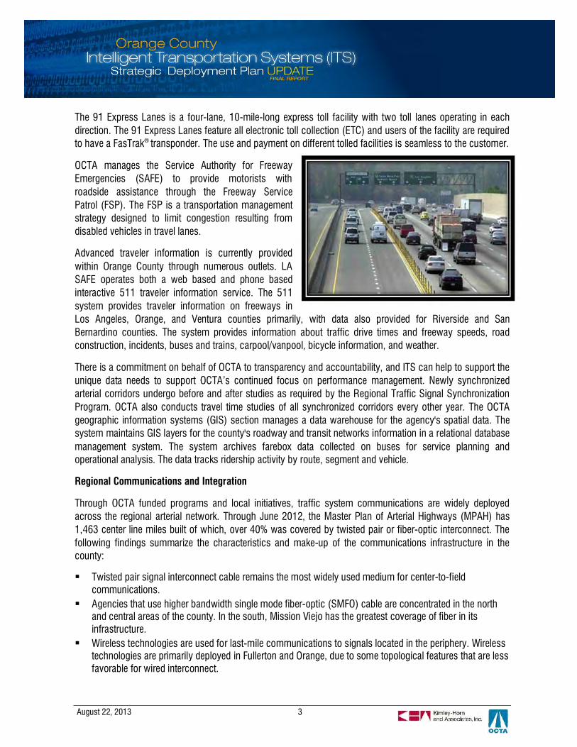
The 91 Express Lanes is a four-lane, 10-mile-long express toll facility with two toll lanes operating in eachdirection. The 91 Express Lanes feature all electronic toll collection (ETC) and users of the facility are requiredto have a FasTrak® transponder. The use and payment on different tolled facilities is seamless to the customer.
OCTA manages the Service Authority for FreewayEmergencies (SAFE) to provide motorists withroadside assistance through the Freeway ServicePatrol (FSP). The FSP is a transportation managementstrategy designed to limit congestion resulting fromdisabled vehicles in travel lanes.
Advanced traveler information is currently providedwithin Orange County through numerous outlets. LASAFE operates both a web based and phone basedinteractive 511 traveler information service. The 511system provides traveler information on freeways inLos Angeles, Orange, and Ventura counties primarily, with data also provided for Riverside and SanBernardino counties. The system provides information about traffic drive times and freeway speeds, roadconstruction, incidents, buses and trains, carpool/vanpool, bicycle information, and weather.
There is a commitment on behalf of OCTA to transparency and accountability, and ITS can help to support theunique data needs to support OCTA’s continued focus on performance management. Newly synchronizedarterial corridors undergo before and after studies as required by the Regional Traffic Signal SynchronizationProgram. OCTA also conducts travel time studies of all synchronized corridors every other year. The OCTAgeographic information systems (GIS) section manages a data warehouse for the agency's spatial data. Thesystem maintains GIS layers for the county's roadway and transit networks information in a relational databasemanagement system. The system archives farebox data collected on buses for service planning andoperational analysis. The data tracks ridership activity by route, segment and vehicle.
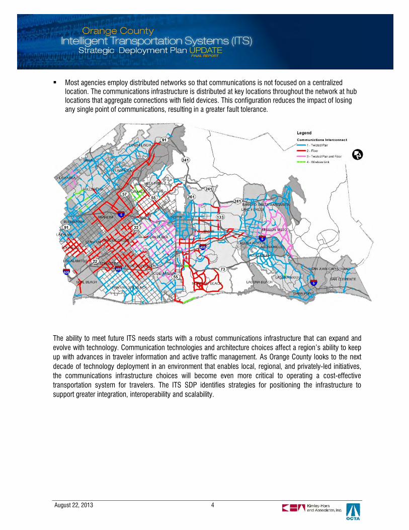
Regional Communications and Integration
Through OCTA funded programs and local initiatives, traffic system communications are widely deployedacross the regional arterial network. Through June 2012, the Master Plan of Arterial Highways (MPAH) has1,463 center line miles built of which, over 40% was covered by twisted pair or fiber-optic interconnect. Thefollowing findings summarize the characteristics and make-up of the communications infrastructure in thecounty:
§ Twisted pair signal interconnect cable remains the most widely used medium for center-to-fieldcommunications.
§ Agencies that use higher bandwidth single mode fiber-optic (SMFO) cable are concentrated in the northand central areas of the county. In the south, Mission Viejo has the greatest coverage of fiber in itsinfrastructure.
§ Wireless technologies are used for last-mile communications to signals located in the periphery. Wirelesstechnologies are primarily deployed in Fullerton and Orange, due to some topological features that are lessfavorable for wired interconnect.
August 22, 2013 4
§ Most agencies employ distributed networks so that communications is not focused on a centralizedlocation. The communications infrastructure is distributed at key locations throughout the network at hublocations that aggregate connections with field devices. This configuration reduces the impact of losingany single point of communications, resulting in a greater fault tolerance.
The ability to meet future ITS needs starts with a robust communications infrastructure that can expand andevolve with technology. Communication technologies and architecture choices affect a region’s ability to keepup with advances in traveler information and active traffic management. As Orange County looks to the nextdecade of technology deployment in an environment that enables local, regional, and privately-led initiatives,the communications infrastructure choices will become even more critical to operating a cost-effectivetransportation system for travelers. The ITS SDP identifies strategies for positioning the infrastructure tosupport greater integration, interoperability and scalability.
August 22, 2013 5
ITS Strategies
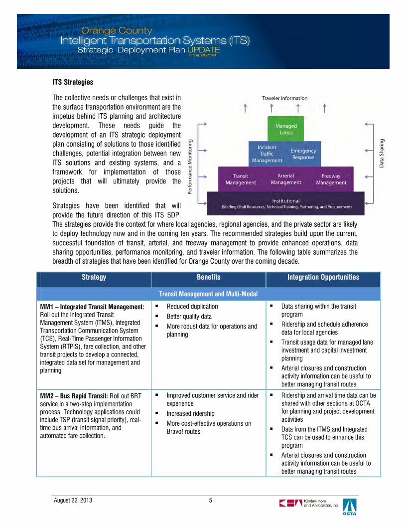
The collective needs or challenges that exist inthe surface transportation environment are theimpetus behind ITS planning and architecturedevelopment. These needs guide thedevelopment of an ITS strategic deploymentplan consisting of solutions to those identifiedchallenges, potential integration between newITS solutions and existing systems, and aframework for implementation of thoseprojects that will ultimately provide thesolutions.
Strategies have been identified that willprovide the future direction of this ITS SDP.The strategies provide the context for where local agencies, regional agencies, and the private sector are likelyto deploy technology now and in the coming ten years. The recommended strategies build upon the current,successful foundation of transit, arterial, and freeway management to provide enhanced operations, datasharing opportunities, performance monitoring, and traveler information. The following table summarizes thebreadth of strategies that have been identified for Orange County over the coming decade.
Strategy Benefits Integration Opportunities
Transit Management and Multi-Modal
MM1 – Integrated Transit Management:Roll out the Integrated TransitManagement System (ITMS), integratedTransportation Communication System(TCS), Real-Time Passenger InformationSystem (RTPIS), fare collection, and othertransit projects to develop a connected,integrated data set for management andplanning
§ Reduced duplication
§ Better quality data§ More robust data for operations and
planning
§ Data sharing within the transitprogram
§ Ridership and schedule adherencedata for local agencies
§ Transit usage data for managed laneinvestment and capital investmentplanning
§ Arterial closures and constructionactivity information can be useful tobetter managing transit routes
MM2 – Bus Rapid Transit: Roll out BRTservice in a two-step implementationprocess. Technology applications couldinclude TSP (transit signal priority), real-time bus arrival information, andautomated fare collection.
§ Improved customer service and riderexperience
§ Increased ridership§ More cost-effective operations on
Bravo! routes
§ Ridership and arrival time data can beshared with other sections at OCTAfor planning and project developmentactivities
§ Data from the ITMS and IntegratedTCS can be used to enhance thisprogram
§ Arterial closures and constructionactivity information can be useful tobetter managing transit routes

August 22, 2013 6
Strategy Benefits Integration Opportunities
MM3 – Rail Operations andEnhancements: Continued rail operationssupported by technologies for safety, suchas for positive train control, intersectionsafety, and operations
§ Increased safety
§ Improved operations§ Increased ridership and multi-modal
options for travelers
§ Construction or traffic conditions(especially during incidents) providedto rail operations
§ Rail arrival times provided to trafficmanagement agencies, travelerinformation, and relatedstrategies/programs
MM4 – Integrated Payment: Currentlybeing examined in Orange County incoordination with other Southern Californiaagencies, an integrated payment methodthat would initially allow for transitpayment
§ Increased ridership and multi-modaloptions for travelers
§ Reduced congestion
§ More cost-effective operations
§ Integration and streamliningopportunities among transit projects,parking access and revenue controlsystems, multi-modal centers,FasTrak® operations, and others
MM5 – Support for Pedestrian andBicycle Travel: local deployments ofpedestrian and bicycle safety, bike-sharingand information technologies
§ Promote non-motorized travel
§ Increase safety
§ Reduce congestion
§ Traveler information services tailoredto cyclists and pedestrians
MM6 – Support to Commercial VehicleOperations (CVO): Primarily privatelyled, CVO activities will be supported asneeded in terms of technology
§ Improved environment forcommercial vehicle operations
§ Improved safety
§ Share traffic data with truck dispatchoperations to improve trip routing
Traffic Management
TM1 – Multi-Jurisdictional ArterialTraffic Management:Continue to manage arterials across thecounty and across jurisdictions; provide afoundation for advanced management andstrategies; provide access to more datafor operations and planning
§ Improved mobility
§ Reduced travel costs
§ Better data for investment choices
§ Arterial data can be shared withtransit operators, emergency serviceproviders and freeway/managed lanesoperators for improved multi-modaloperations
§ Transit routes, ridership, andschedule changes can be useful toarterial management
TM2 – Continued Freeway TrafficManagement: Continue to managefreeway traffic through existing and futuretechnology and operational procedures.
§ Improved mobility
§ Reduced travel costs
§ Freeway data is useful to other trafficmanagement strategies and travelerinformation
§ Providing access to arterial, transit,and corridor data (including cameraimages) can add value to freewaymanagement
§ Physical communicationsinfrastructure has capacity forsupporting other strategies
TM3 – Migration to Grid-based TrafficSignal Synchronization:Optimize multiple crossing arterials
§ Improved progression on arterials
§ Improved coordination among
§ Could provide data for transitoperations where applicable
§ Supplement corridor-based MOEs
August 22, 2013 7
Strategy Benefits Integration Opportunities
through signal synchronization within agrid; upgrade equipment to support grid-based synchronization
crossing arterials§ Reduced staff time and cost in
accommodating crossing arterials forcoordination
with network-based MOEs forperformance monitoring
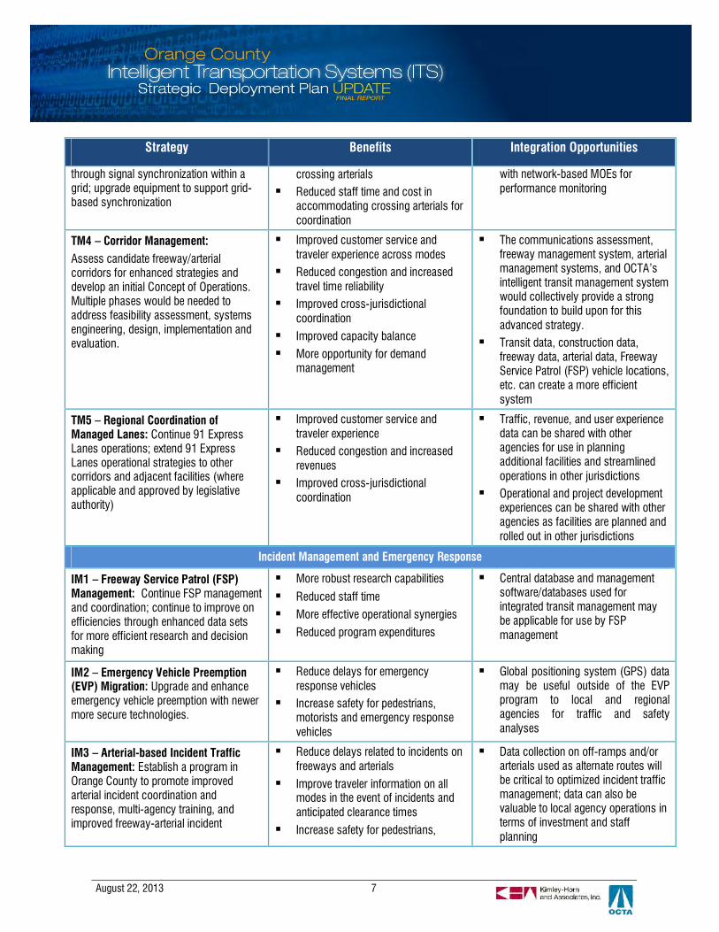
TM4 – Corridor Management:Assess candidate freeway/arterialcorridors for enhanced strategies anddevelop an initial Concept of Operations.Multiple phases would be needed toaddress feasibility assessment, systemsengineering, design, implementation andevaluation.
§ Improved customer service andtraveler experience across modes
§ Reduced congestion and increasedtravel time reliability
§ Improved cross-jurisdictionalcoordination
§ Improved capacity balance
§ More opportunity for demandmanagement
§ The communications assessment,freeway management system, arterialmanagement systems, and OCTA’sintelligent transit management systemwould collectively provide a strongfoundation to build upon for thisadvanced strategy.
§ Transit data, construction data,freeway data, arterial data, FreewayService Patrol (FSP) vehicle locations,etc. can create a more efficientsystem
TM5 – Regional Coordination ofManaged Lanes: Continue 91 ExpressLanes operations; extend 91 ExpressLanes operational strategies to othercorridors and adjacent facilities (whereapplicable and approved by legislativeauthority)
§ Improved customer service andtraveler experience
§ Reduced congestion and increasedrevenues
§ Improved cross-jurisdictionalcoordination
§ Traffic, revenue, and user experiencedata can be shared with otheragencies for use in planningadditional facilities and streamlinedoperations in other jurisdictions
§ Operational and project developmentexperiences can be shared with otheragencies as facilities are planned androlled out in other jurisdictions
Incident Management and Emergency Response
IM1 – Freeway Service Patrol (FSP)Management: Continue FSP managementand coordination; continue to improve onefficiencies through enhanced data setsfor more efficient research and decisionmaking
§ More robust research capabilities
§ Reduced staff time
§ More effective operational synergies
§ Reduced program expenditures
§ Central database and managementsoftware/databases used forintegrated transit management maybe applicable for use by FSPmanagement
IM2 – Emergency Vehicle Preemption(EVP) Migration: Upgrade and enhanceemergency vehicle preemption with newermore secure technologies.
§ Reduce delays for emergencyresponse vehicles
§ Increase safety for pedestrians,motorists and emergency responsevehicles
§ Global positioning system (GPS) datamay be useful outside of the EVPprogram to local and regionalagencies for traffic and safetyanalyses
IM3 – Arterial-based Incident TrafficManagement: Establish a program inOrange County to promote improvedarterial incident coordination andresponse, multi-agency training, andimproved freeway-arterial incident
§ Reduce delays related to incidents onfreeways and arterials
§ Improve traveler information on allmodes in the event of incidents andanticipated clearance times
§ Increase safety for pedestrians,
§ Data collection on off-ramps and/orarterials used as alternate routes willbe critical to optimized incident trafficmanagement; data can also bevaluable to local agency operations interms of investment and staffplanning

August 22, 2013 8
Strategy Benefits Integration Opportunities
management motorists and emergency responsevehicles
§ Communication infrastructure onhighways and arterials can provide afoundation for data sharing within thisprogram (communications masterplan can assess this)
§ Data sharing among agencies, acapability that can be supportedthrough expansion of the performancemonitoring program will be highlyvaluable to building this program
Traveler Information
TI1 – Continued Expansion of theSouthern California 511 Program:Provide enhanced real-time and up-to-dateinformation for Orange County arterials;expand transit trip planner with real-timeinformation, enhance the mobile call boxmodule; integrate private sector sources ofdata
§ Encouragement of mode shift totransit
§ Increased support of transportationprogram investment
§ Increased throughput andcapacity/demand balance
§ Data collected through the 511program can be provided to alltransportation agencies for planning,operational analysis and investmentdecisions.
§ Local construction data, real-timetransit data, and others can bedisseminated through these channels
§ More integration among existingpublic and private information serviceproviders can provide greater value totravelers and support enhanced trafficand transit management goals
§ A rich source of crowd-sourced datais available from private sectorservice providers that can providepredictive area-wide or corridorspecific travel times and travel speedinformation
§ The private sector Goods Movementindustry as a source of truck routingand container tracking data
§ Connected Vehicles as a real-timetravel data gathered from vehicle-to-vehicle or vehicle-to-roadsidecommunications
TI2 – Integrated and Localized ParkingGuidance: Seek out additionalopportunities for parking guidancesystems (PGS) with an emphasis on aregional, integrated parking guidance andinformation system for park and ridefacilities.
§ Encouragement of mode shift totransit
§ Increased support of transportationprogram investment
§ Increased throughput andcapacity/demand balance
§ Locally deployed PGS can integratewith local arterial managementsystems
§ Regional PGS would benefit fromreal-time and schedules for train andbus arrivals and pricing informationon express lanes within southern
August 22, 2013 9
Strategy Benefits Integration Opportunities
California
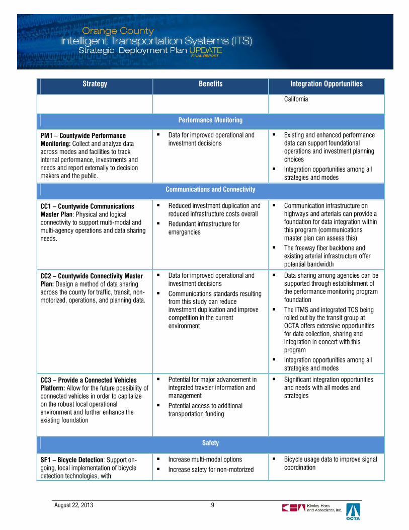
Performance Monitoring
PM1 – Countywide PerformanceMonitoring: Collect and analyze dataacross modes and facilities to trackinternal performance, investments andneeds and report externally to decisionmakers and the public.
§ Data for improved operational andinvestment decisions
§ Existing and enhanced performancedata can support foundationaloperations and investment planningchoices
§ Integration opportunities among allstrategies and modes
Communications and Connectivity
CC1 – Countywide CommunicationsMaster Plan: Physical and logicalconnectivity to support multi-modal andmulti-agency operations and data sharingneeds.
§ Reduced investment duplication andreduced infrastructure costs overall
§ Redundant infrastructure foremergencies
§ Communication infrastructure onhighways and arterials can provide afoundation for data integration withinthis program (communicationsmaster plan can assess this)
§ The freeway fiber backbone andexisting arterial infrastructure offerpotential bandwidth
CC2 – Countywide Connectivity MasterPlan: Design a method of data sharingacross the county for traffic, transit, non-motorized, operations, and planning data.
§ Data for improved operational andinvestment decisions
§ Communications standards resultingfrom this study can reduceinvestment duplication and improvecompetition in the currentenvironment
§ Data sharing among agencies can besupported through establishment ofthe performance monitoring programfoundation
§ The ITMS and integrated TCS beingrolled out by the transit group atOCTA offers extensive opportunitiesfor data collection, sharing andintegration in concert with thisprogram
§ Integration opportunities among allstrategies and modes
CC3 – Provide a Connected VehiclesPlatform: Allow for the future possibility ofconnected vehicles in order to capitalizeon the robust local operationalenvironment and further enhance theexisting foundation
§ Potential for major advancement inintegrated traveler information andmanagement
§ Potential access to additionaltransportation funding
§ Significant integration opportunitiesand needs with all modes andstrategies
Safety
SF1 – Bicycle Detection: Support on-going, local implementation of bicycledetection technologies, with
§ Increase multi-modal options
§ Increase safety for non-motorized
§ Bicycle usage data to improve signalcoordination

August 22, 2013 10
Strategy Benefits Integration Opportunities
implementation focused on bike andtransit hubs
travelers
§ Reduce congestion
§ Reduce greenhouse gas emissions
§ Telematics to provide in-vehicle alertto drivers
SF2 – Pedestrian Detection: Support on-going local implementation of pedestriandetection technologies; futuretechnologies might include telematics
§ Increase multi-modal options§ Increase safety for non-motorized
travelers
§ Reduce congestion
§ Reduce greenhouse gas emissions
§ Pedestrian usage data to improvesignal coordination
§ Telematics to provide in-vehicle alertto drivers
SF3 – Transit Security: Support datasharing between transit agencies and lawenforcement to ensure passenger safetyand security
§ Increase safety for non-motorizedtravelers
§ Promote transit adoption
§ Share video fields and transit vehiclelocation data using the ITMSinfrastructure
Institutional
IN1 – Continuously Improve StaffingLevels and Skillsets: Establish acountywide training program recognizingthe fast paced, dynamic technologyenvironment
§ Increased skillsets
§ Reduced training expense
§ Potential for shared resources(reduced costs)
§ N/A
IN2 – Formalize Sub-regionalPartnerships: Establish northern andsouthern county partnership groups forsharing information and best practices
§ Increased skillsets and informationsharing
§ Improved operations§ Reduced duplication of effort and
investment
§ Potential for shared resources
§ N/A
Performance Monitoring and Reporting Plan
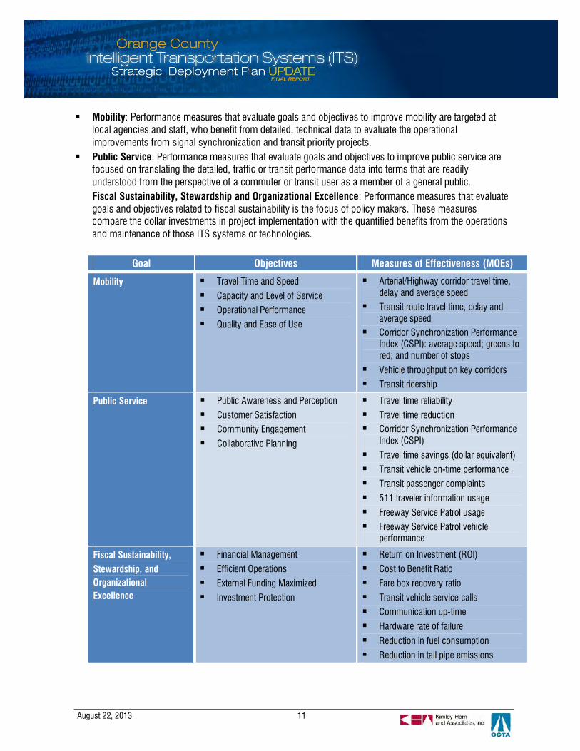
Performance measurement helps to ensure that the benefits of ITS investments are quantified and operationsare optimized to the greatest extent possible. Agencies that monitor performance can demonstrate totaxpayers that their dollars are being spent wisely. OCTA is interested in implementing a countywideperformance monitoring program that establishes a baseline understanding of how well the transportationsystem performs, from which performance data can drive decisions on how operations and ITS investmentscan be strategically leveraged to maximize efficiency.
The table below maps OCTA’s strategic goals and objectives achievable through investment in ITS andperformance measures to evaluate the effectiveness of those investments. The performance measures aretargeted at different audiences who process and utilize the information in the following ways:
August 22, 2013 11
§ Mobility: Performance measures that evaluate goals and objectives to improve mobility are targeted atlocal agencies and staff, who benefit from detailed, technical data to evaluate the operationalimprovements from signal synchronization and transit priority projects.
§ Public Service: Performance measures that evaluate goals and objectives to improve public service arefocused on translating the detailed, traffic or transit performance data into terms that are readilyunderstood from the perspective of a commuter or transit user as a member of a general public.Fiscal Sustainability, Stewardship and Organizational Excellence: Performance measures that evaluategoals and objectives related to fiscal sustainability is the focus of policy makers. These measurescompare the dollar investments in project implementation with the quantified benefits from the operationsand maintenance of those ITS systems or technologies.
Goal Objectives Measures of Effectiveness (MOEs)
Mobility § Travel Time and Speed
§ Capacity and Level of Service
§ Operational Performance
§ Quality and Ease of Use
§ Arterial/Highway corridor travel time,delay and average speed
§ Transit route travel time, delay andaverage speed
§ Corridor Synchronization PerformanceIndex (CSPI): average speed; greens tored; and number of stops
§ Vehicle throughput on key corridors
§ Transit ridership
Public Service § Public Awareness and Perception
§ Customer Satisfaction
§ Community Engagement
§ Collaborative Planning
§ Travel time reliability
§ Travel time reduction§ Corridor Synchronization Performance
Index (CSPI)
§ Travel time savings (dollar equivalent)
§ Transit vehicle on-time performance
§ Transit passenger complaints
§ 511 traveler information usage
§ Freeway Service Patrol usage
§ Freeway Service Patrol vehicleperformance
Fiscal Sustainability,Stewardship, andOrganizationalExcellence
§ Financial Management
§ Efficient Operations
§ External Funding Maximized
§ Investment Protection
§ Return on Investment (ROI)
§ Cost to Benefit Ratio
§ Fare box recovery ratio
§ Transit vehicle service calls
§ Communication up-time
§ Hardware rate of failure
§ Reduction in fuel consumption
§ Reduction in tail pipe emissions

August 22, 2013 12
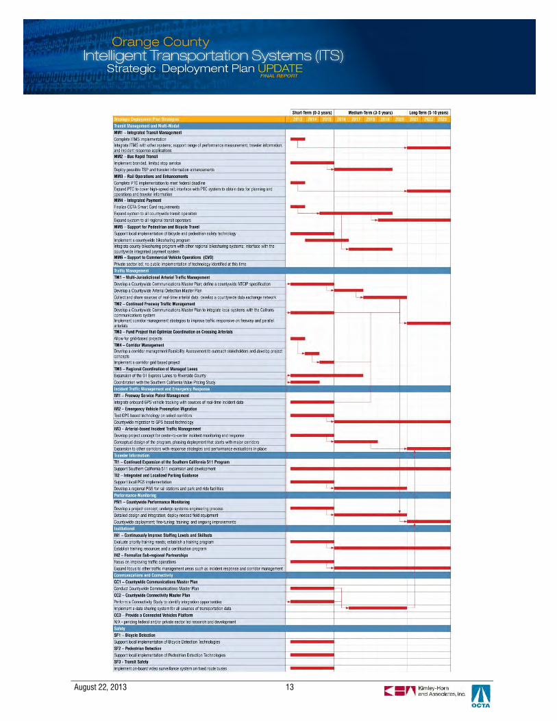
Phased Deployment Plan
OCTA, in partnership with the cities, County of Orange and Caltrans, has embraced ITS in achieving advancesin multi-jurisdictional arterial traffic management, development of a robust freeway management infrastructureand effective use of technology in transit operations. These advances have set the foundation for advancingtowards integrated transportation management and multi-agency coordination that have a regional focus. ThisITS SDP have identified strategies and projects to realize OCTA’s vision and position the region foropportunities to deploy emerging technologies that have the potential to improve mobility, safety and efficiencyon a multi-modal transportation system.
The ITS strategies constitute critical actions to guide project development and implementation efforts in thenext decade to support OCTA’s mission in its Long Range Transportation Plan to deliver an effectivetransportation system. This section outlines a roadmap for implementing the strategies over a ten-yeartimeline in an approach that phases these actions in logical order by identifying the interconnections betweenstrategies that may take place in sequential order or in parallel. For example, regional arterial trafficmanagement requires communications master planning and arterial detection deployment before integratedsystems can provide data sharing capabilities to support coordinated traffic operations and performancemonitoring at the regional level.
The figure below illustrates the deployment plan for implementing the strategies proposed in this ITS SDP. Thetimeline is organizes the deployment of the twenty-two ITS strategies described in Section 5 into three distincttime frames.
§ Short-term: these strategies and projects are taking place now or within three years;§ Medium-term: these strategies and projects would take place between 3 to 5 years from now; and§ Long-term: these strategies and projects would take place between 5 to 10 years from now.
August 22, 2013 13
August 22, 2013 14
This page left intentionally blank
August 22, 2013 15
1. INTRODUCTION
Intelligent Transportation System (ITS) refers to the use of communication technologies to improvetransportation safety, operations, and efficiency. This definition encompasses a broad range of technologiesand has created many opportunities for transportation professionals to respond proactively to increasingdemand for effective transportation services. Many of these opportunities are predicated upon effectivecoordination between organizations, at both the institutional and technical level.
Over the past 20 years, Orange County agencies have embraced Intelligent Transportation System (ITS)applications as a critical component of its regional transportation management system focus and multi-agencyoperations strategy. In doing so, they have demonstrated benefits in terms of improved customer service andsatisfaction, better on-time performance, and reduced capital and operating costs through technologyimplementation. The benefits of ITS are wide ranging and powerful—creating systems that are fullyconnected, information-rich, and able to address safety, mobility, and efficiency. Some of the county’sdeployments have not only enhanced traffic and transit operations within the county, but have also had farreaching impacts by improving the overall regional systems, including projects such as the 91 Express Lanes(the first express lane facility in the nation); Smart Streets introduced in the 1990s (e.g., Beach Boulevard);decades of highly advanced transit operations; and a robust, well-funded traffic signal synchronizationprogram.
Because OCTA has supported advances in transportation technology applications and integration over theyears, great strides were made in the use of ITS solutions to manage congestion and make for a safer travelexperience within the county’s multimodal transportation network. In the past decade, Orange County hasfocused heavily on building strong foundations, including:
§ The traffic signal synchronization program has resulted in significant improvements in mobility on keyarterials;
§ OCTA’s transit program has continued to advance through technology applications;§ Caltrans District 12 has improved the freeway management infrastructure to over 90% of freeway vehicle
detectors reporting;§ Many cities have established traffic management centers and actively monitor arterial traffic conditions;
and§ A strong progression of institutional partnership has flourished.
With this strong base of ITS commitment, this update of the Orange County ITS Strategic Deployment Plan(SDP) is a next step in the continued advancement of technology deployment in the county. With the currentdynamic, fast-paced deployment environment that Renewed Measure M (M2) supports, this important updateto the SDP provides a summary of the direction of operations and the role that technology will play in thecoming decade in line with the objectives of the Orange County transportation agencies. By recognizing thesystem operation advances and the various options to continue to incorporate ITS strategies in the future, thepartners will continue to build upon the comprehensive approach that has been a hallmark of their focus onstrategic, forward thinking ITS planning efforts that will have positive impacts throughout the region.
August 22, 2013 16
1.1 ITS Strategic Deployment Plan Overview
The ITS SDP, last updated in 2007, was drafted to establish, program and communicate strategies forITS deployment within Orange County. This Plan was meant to replace the 1998 Orange County ITSMaster Plan and provide viable, cost-effective strategies and projects over a 10-year horizon. The 2007Plan defined a vision for Orange County’s ITS and included identification of issues and challenges withthe existing ITS infrastructure within Orange County.
This 2012 update to the Orange County ITS SDP identifies new and modified needs and objectives anddevelops a revised, streamlined list of potential ITS strategies to meet these needs over the next tenyears. The Plan is intended to provide a framework and guidance to agencies to support thecoordinated planning and deployment of these strategies and subsequent projects. It is also intended tobring the region into compliance with federal requirements for keeping the regional ITS architecture (ablueprint for how different ITS systems connect with one another) current while providing an updatedbasis for compliance for federally-funded projects. This Plan fulfills a critical need for arterial, freeway,transit, and multi-modal ITS projects.
1.2 Alignment with OCTA’s Strategic Plan and Goals
The timing of this update also provides OCTA with an opportunity to align this ITS SDP and hence,Orange County’s ITS program, with the 2011 OCTA Strategic Plan. The vision articulated in that plan is:“An integrated and balanced transportation system that supports the diverse travel needs and reflectsthe character of Orange County”. The ITS program, and OCTA’s commitment to cost-effective andcreative uses of technology to support mobility and safety on the County’s transportation network willdirectly support this countywide vision.
The 2011 OCTA Strategic Plan identified five key goals that will guide priorities and investments for theAuthority. The ITS SDP, and the ITS priorities in Orange County directly link to each of these fiveimportant goals:

August 22, 2013 17
Deliver programs,projects and servicesto improve themovement of peopleand goods throughoutOrange County andthe region.
OBJECTIVES:§ Travel Time and
Speed§ Capacity and Level of
Service§ Operational
Performance§ Quality and Ease of
Use
Enhance customersatisfaction byunderstanding,connecting with andserving our diversecommunities andpartners.
OBJECTIVES:§ Public Awareness
and Perception§ Customer
Satisfaction§ Community
Engagement§ Collaborative
Planning
Ensure fiscal healththrough prudentfinancial managementand by protecting andleveraging availablerevenue sources.
OBJECTIVES:§ Financial
Management§ Efficient Operations§ External Funding
Maximized§ Investment
Protection
Embrace responsiblepolicies and practicesdesigned to promoteenvironmentalsustainability andenhance the safetyand quality of life inOrange County.
OBJECTIVES:§ Project Delivery§ Environmental
Sustainability§ Safety
Continue the traditionof being a high-performingorganization throughemployeedevelopment andefficient businesspractices.
OBJECTIVES:§ People Development§ Processes
Improvements§ Systems Efficiencies
ITS SDP Alignment
§ Expand corridor andnetwork managementfocus to improvetravel countywide
§ Promote multi-modaland crossjurisdictionaloperationalintegration
§ Foster transportationsystem partnershipsamong state, regionaland local operatingagencies
§ Support improvedmobility and safetyfor goods movement
§ Demonstrate aprogressive andcohesive countywideapproach to systemoperations andimprovements
§ Provide enhancedOrange Countytransportationsystem data to theSouthern California511 system tobenefit many users
§ Collaborate withpartners on planningfor high-impactoperational strategies
§ Leveragecommunicationsinfrastructure tominimize duplicateinvestments
§ Maximize availablefederal and localfunds by prioritizinghigh impact projectsthat align withstrategic objectives
§ Establish economiesof scale fortechnologyinvestments throughcollaboration
§ Promote innovativepartnerships fortransportationsystem operations,maintenance andmanagement
§ Improve safety for allusers of themultimodaltransportationsystem
§ Establishes realisticphasing andimplementationscenarios for ITSprojects in OrangeCountySupportenvironmentalsustainabilityobjectives byreducing delay andvehicle trips, andusing technology
§ Provide requiredtechnical training tostaff for operationsand management oftechnologyinvestments
§ Improve staff andsystem efficiencythrough technologyand automatingprocesses
§ Forecast ITSinfrastructure andtechnicalrequirements toinform future staffingand technical skillneeds

August 22, 2013 18
1.3 Plan Use and Objectives
The objective of this SDP update is to provide a useful tool for agencies to achieve three primaryobjectives, as they relate to deployment and use of technologies for the transportation system inOrange County:
1. Continue to build a local foundation for strongfuture transportation service;
2. Develop regional, multi-modal transportationservices, in partnership across the county andinto adjacent counties; and
3. Recognize and allow for private sectoradvancements in appropriate market sectors.
This update has been developed with the intention ofproviding the stakeholders with the tools to continueto develop the physical and operational foundation toaddress needs and fill in gaps at a local level. In addition, the update will build on that foundation tofurther develop regional programs enabling multi-modal and multi-agency system and demandmanagement while enabling private sector innovations where appropriate. Furthermore, the SDPincludes guidance for moving forward with project implementation, and providing technology andcommunications infrastructure that improves safety and mobility within Orange County.
1.4 Process to Update the ITS Strategic Deployment Plan
This strategic planning process was based on input froma wide range of stakeholders in the county and reflects theresults of a six month process to update the Planpreviously prepared in 2007. Based on the stakeholderinput and a review of existing documentation for longrange planning and specific projects and programs, thecurrent state of technology in support of transportationwas outlined. Following this existing conditionsdescription as the starting point, a needs assessment wasconducted and a resulting list of strategies was defined toreflect the full breadth of ITS potential in the county. Thestrategies are a combination of current efforts,enhancements to those efforts, and recommendations for additional focus areas.
In addition, the ITS SDP includes the following elements to position the program to pursue integrationopportunities, measure performance and adopt future technologies:
August 22, 2013 19
1. Each strategy was then described in terms of the current status and future plans, integrationopportunities and phasing. The phased deployment anticipated for each strategy in turn defines the“projects” that comprise the deployment plan.
2. Performance measures are based on the initial needs in order that after strategies and projects aredeployed, the performance can be measured against the original expectations.
3. A high level communications assessment supports future, more detailed study into a cost effectivemethod of establishing the infrastructure needed to enable the roll-out of the program, especiallyfor those aspects that are regional and wide reaching in nature.
4. The regional ITS architecture was also updated as a part of this effort to encompass the potentialtechnologies that may be deployed in the next ten years. Since technology advances at such arapid pace, it is realistic to assume that there may be technologies or projects that were notincluded in this plan (especially in the longer term). These projects can be appended to thearchitecture at the time of deployment or the architecture can be updated to reflect the project(s).The latter is recommended in cases where the project has significant integration and relationshipswith other existing technologies.
1.5 Timeframe
According to federal guidelines, the regional ITS architecture (and in the case of Orange County, thisrelated Plan) should look far enough into the future so that the efficient integration of ITS services canbe guided over time. The OCTA Long Range Transportation Plan, Destination 2035, is intended to guideinvestments with a long-term planning horizon. The Orange County ITS SDP’s planning horizon is 10years, which should leverage most of the system integration opportunities as anticipated by thestakeholders, yet represents a reasonable planning horizon for technologies, given the fast-evolvingnature of this industry.
1.6 Federal Requirements
Federal regulations require that ITS projects funded with Highway Trust Funds to conform to theNational ITS Architecture and approved ITS standards; be guided by a regional architecture forgeographic boundaries and defined by stakeholder needs; and utilize a system engineering analysis thatconsiders the total project life-cycle. These requirements are documented in Federal HighwayAdministration (FHWA) Rule 940 and the associated Federal Transit Administration (FTA) Policy, andapply to all projects using funds made available from the Highway Trust Fund to ensure conformancewith the National ITS Architecture and applicable ITS standards. OCTA’s ITS SDP (including thecomponent ITS architecture) support these requirements and conformance.
Refer to Appendix A to Appendix E for components of the regional ITS architecture.
August 22, 2013 20
1.7 Report Organization
This report is organized into the following key sections:
§ Section 1 – Introduction, project overview and objectives, and brief discussion on previous ITSplans in Orange County
§ Section 2 – Background on the Orange County area, key stakeholders participating in the ITS SDP,institutional framework for project planning and implementation, and inventory of existing systemsand programs in Orange County, including freeway and arterial networks, transit operations, andcurrent approaches to data sharing and management
§ Section 3 – User needs, including local as well as regional needs, which form the basis forstrategies and integration recommendations in later sections of the SDP
§ Section 4 – Existing and planned service packages, which identifies the existing and plannedsystems in Orange County in the context of the service packages of the National ITS Architecture
§ Section 5 – Summary of recommended strategies to address the county’s priority ITS needs
§ Section 6 – Planned and recommended ITS projects
§ Section 7 – Communications and connectivity needs to support the envisioned agency-to-agencydata sharing relationships and other regional programs
§ Section 8 – Phased deployment plan outlining the key implementation steps, dependencies andimplementation timeline over a 10-year horizon
§ Section 9 – Recommended plan to implement a countywide performance monitoring program tobetter inform the region’s ITS investment strategy
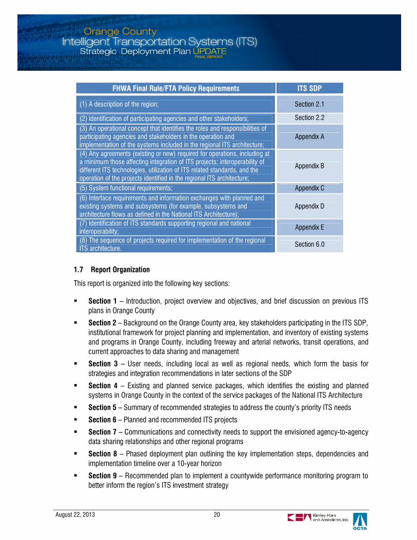
FHWA Final Rule/FTA Policy Requirements ITS SDP
(1) A description of the region; Section 2.1
(2) Identification of participating agencies and other stakeholders; Section 2.2
(3) An operational concept that identifies the roles and responsibilities ofparticipating agencies and stakeholders in the operation andimplementation of the systems included in the regional ITS architecture;
Appendix A
(4) Any agreements (existing or new) required for operations, including ata minimum those affecting integration of ITS projects; interoperability ofdifferent ITS technologies, utilization of ITS related standards, and theoperation of the projects identified in the regional ITS architecture;
Appendix B
(5) System functional requirements; Appendix C(6) Interface requirements and information exchanges with planned andexisting systems and subsystems (for example, subsystems andarchitecture flows as defined in the National ITS Architecture);
Appendix D
(7) Identification of ITS standards supporting regional and nationalinteroperability; Appendix E
(8) The sequence of projects required for implementation of the regionalITS architecture. Section 6.0
August 22, 2013 21
§ Appendix A – Regional ITS Architecture – Stakeholders
§ Appendix B – Regional ITS Architecture – Agreements
§ Appendix C – Regional ITS Architecture – Functional Requirements
§ Appendix D – Regional ITS Architecture – Service Package Diagrams
§ Appendix E – Regional ITS Architecture – Standards
§ Appendix F – Local Communications Inventory Maps
August 22, 2013 22
2. ORANGE COUNTY AREA AND EXISTING CONDITIONS
This section describes the geographic area covered by this ITS SDP, as well as key stakeholders and agencypartners that have been involved in this effort and who will play key roles in advancing the priorities andinitiatives identified in this plan. With limited opportunities for physical expansion of the transportationnetworks within the Orange County area, technology, institutional partnerships and innovative operationalstrategies are key to successfully managing today’s transportation demand, as well as planning for futuretransportation system operations.
2.1 Geographic Area
Orange County has a total of 789 square miles of land area and the county currently includes 34incorporated cities. Geographically, the Orange County ITS SDP encompasses the surfacetransportation network within Orange County. Figure 1 provides an overview of Orange County. As thethird most populated county in California, Orange County is a crucial contributor to the regionaleconomy, home to major employment centers, universities and world-class entertainment venues.Supporting this vital economic engine is an extensive transportation system, featuring over 1,600 lane-miles of freeways, high-occupancy vehicle (HOV) lanes and toll roads. The Master Plan of ArterialHighways (MPAH) is the blueprint for the county’s streets and roads with over 1,450 miles of arterialsproviding local and cross-county access. Air travel and cargo is served by John Wayne Airport, one ofthe busiest airports in the region serving nearly 9 million passengers in 2011.
Transit users have a wide choice of rail and bus service in Orange County. OCTA is a member of thejoint powers authority that operates Metrolink commuter rail service across five counties in SouthernCalifornia. Metrolink stations in the county are also served by the Amtrak Surfliner, extending inter-cityrail to San Luis Obispo and San Diego. OCTA operates nearly 80 bus routes providing local and expressbus service, as well as a paratransit shuttle service. OCTA is currently working with local agencies toexpand local transit through the Go Local Program that will implement feeder service to Metrolink andcommunity circulators in several cities. Anchoring this expansion of transit service is the futureAnaheim Regional Transportation Intermodal Center (ARTIC), which will serve as the principle multi-modal transportation hub in Orange County.
Orange County is an important gateway for Goods Movement, supporting the movement of freight fromthe Ports of Long Beach and Los Angeles to warehouses and distribution centers further inland. A largevolume of freight is transported by train, with about 75 trains passing through the county on a dailybasis. A portion of the goods from the ports are transported by trucks on the freeway system and truckroutes on arterials.
The Long Range Transportation Plan (LRTP) is the county’s long-term vision and strategy foraddressing transportation needs and challenges in the county over a 25-year horizon. The LRTPprojects the population to increase by 14% in the next 25 years, employment to increase by 10% andvehicle miles traveled (VMT) by 30%. Demographic change and a recovering economy point toincreased demands on a transportation system that is already experiencing high-levels of congestion.

August 22, 2013 23
To manage growing congestion, the LRTP identifies Transportation System Demand/TransportationDemand Management (TSM/TDM) as a key strategy that employs technology to move people andgoods more efficiently. Orange County has a strong history of innovation in implementing advancedarterial and freeway management systems. The local agencies have shown leadership in active trafficmanagement by synchronizing signals on key arterials corridors and investing in trafficcommunications infrastructure and traffic management centers. This ITS Strategic Plan supports theLRTP objectives, providing a framework for coordinating ITS projects in a manner that greatly enhancesthe functionality and reach of any one project by promoting data sharing and integration acrosssystems.
Figure 1 – Orange County Map

August 22, 2013 24
2.2 Institutional Framework
OCTA, as a multimodal transportation agency, has broad-ranging responsibilities for planning,implementing and overseeing a robust multimodal transportation system in Orange County. It alsoserves as a key forum for bringing state, local and private partners together to collaborate on highpriority transportation needs and issues. The success of the Orange County ITS SDP is directly linked toparticipation by a diverse set of stakeholders. In the context of this project, stakeholders are defined asthe public agencies with transportation-related oversight, responsibility, and/or duties within OrangeCounty. This Plan was developed based on input from these agencies and/or reference to the projectsand programs planned by them. The stakeholders include:
§ 34 incorporated cities;§ OCTA (including multiple departments to provide input on behalf of various modal programs);§ County of Orange;§ Caltrans District 12;§ Orange County Fire Authority (OCFA);§ Southern California Association of Governments (SCAG);§ Federal Highway Administration (FHWA); and§ Transportation Corridor Agencies (TCA).
This Plan was based on an assessment of the technology-related needs (short-term and long-term) ofthese stakeholders within Orange County. In order to obtain input from the stakeholders, a series ofworkshops were held. These workshops provided the primary input for the needs assessment, existingconditions understanding, and the strategy development ideas. The workshops are summarized asfollows:
§ ITS Roundtable meeting held on June 7, 2012 – attended by local agencies, County of Orange,OCTA, and Caltrans. The purpose of this meeting was to introduce this Plan update and collectpreliminary input on the needs and strategic direction of the Plan, primarily from a localperspective.
§ Three (3) sub-regional workshops held in July 2012 – attended by small groups of local agencies,OCTA, County of Orange, and Caltrans. The purpose of these meetings was to review a subset ofthe needs assessment results and discuss potential strategies primarily from a local perspective.
§ Individual meetings held in July through September 2012 – the purpose was to reach out todifferent modal program representatives to ensure that the full breadth of the surfacetransportation system was being considered and addressed in this Plan.
§ ITS Roundtable meeting held on October 17, 2012 – attended by local agencies, County ofOrange, OCTA, and Caltrans. The purpose of this meeting was to provide a status update to thelocal stakeholders and present the draft results of the needs and strategies.
§ The Technical Steering Committee (TSC) and Technical Advisory Committee (TAC) advised theconsultant team as the details of the Plan were being finalized to assure that the plan would meetthe local agency needs.

August 22, 2013 25
In addition to the identification of stakeholders, the guidelines for applying the National ITS Architectureto a regional ITS architecture (and SDP) recommends the identification of an ITS champion: one ormore key agencies leading the regional ITS architecture development and maintaining it over time. Thechampion is recommended by federal guidelines to be a stakeholder that is proactive in the field of ITSin the region. The champion must understand the subject at hand, have knowledge of local ITS systemsand projects, and have a vision for interconnectivity, partnership, and regional integration. OCTA’s roleas administrator of the ITS SDP and the ITS Roundtable provides the leadership and forums for OCTAto be the “champion” or steward for the development and monitoring of the regional ITS architecture.
2.3 Existing Conditions and Inventory
The existing ITS programs and projects in the county provide a foundation for the identification of needsand new or continued strategies to meet those needs into the future. This section provides a summaryof the existing ITS deployments in Orange County. Information regarding the existing programs thatinclude ITS components was collected based on:
§ Input from stakeholder agencies in Orange County;§ Technical reports and documentation describing the design and interconnectivity of existing
systems;§ The 2010 Long Range Transportation Plan; and§ The 2007 ITS Strategic Deployment Plan
A geographic representation of the high level communications infrastructure data gathered has beenconsolidated into a geographic information systems (GIS) database to illustrate the types ofcommunications infrastructure deployed by local agencies and Caltrans. Maps depicting this inventoryare provided in Appendix F. The following sections provide an overview of the existing and plannedcountywide ITS programs organized by the following categories:
§ Transit Management and Multi-modal§ Traffic Management (both arterial and highways, including managed lanes)§ Incident Management and Emergency Response§ Traveler Information§ Performance Monitoring/Data Management§ Safety§ Connectivity
2.3.1 Transit Management and Multi-modal
Transit represents a mission-critical function for OCTA, and is a key component of the region’stransportation operations and network. Effective mobility within Orange County (as well as cross-jurisdictional travel to areas adjacent to Orange County) relies on a robust and connected transitsystem. OCTA is the primary transit provider in Orange County, operating a fixed route system
August 22, 2013 26
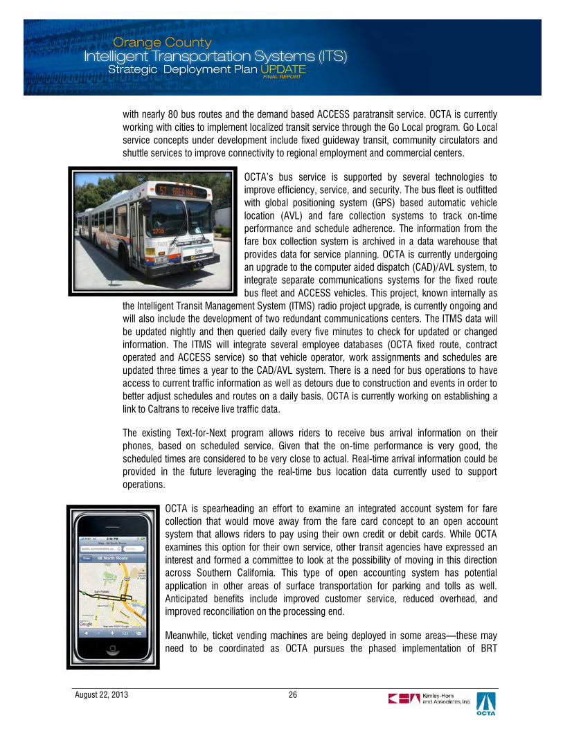
with nearly 80 bus routes and the demand based ACCESS paratransit service. OCTA is currentlyworking with cities to implement localized transit service through the Go Local program. Go Localservice concepts under development include fixed guideway transit, community circulators andshuttle services to improve connectivity to regional employment and commercial centers.
OCTA’s bus service is supported by several technologies toimprove efficiency, service, and security. The bus fleet is outfittedwith global positioning system (GPS) based automatic vehiclelocation (AVL) and fare collection systems to track on-timeperformance and schedule adherence. The information from thefare box collection system is archived in a data warehouse thatprovides data for service planning. OCTA is currently undergoingan upgrade to the computer aided dispatch (CAD)/AVL system, tointegrate separate communications systems for the fixed routebus fleet and ACCESS vehicles. This project, known internally as
the Intelligent Transit Management System (ITMS) radio project upgrade, is currently ongoing andwill also include the development of two redundant communications centers. The ITMS data willbe updated nightly and then queried daily every five minutes to check for updated or changedinformation. The ITMS will integrate several employee databases (OCTA fixed route, contractoperated and ACCESS service) so that vehicle operator, work assignments and schedules areupdated three times a year to the CAD/AVL system. There is a need for bus operations to haveaccess to current traffic information as well as detours due to construction and events in order tobetter adjust schedules and routes on a daily basis. OCTA is currently working on establishing alink to Caltrans to receive live traffic data.
The existing Text-for-Next program allows riders to receive bus arrival information on theirphones, based on scheduled service. Given that the on-time performance is very good, thescheduled times are considered to be very close to actual. Real-time arrival information could beprovided in the future leveraging the real-time bus location data currently used to supportoperations.
OCTA is spearheading an effort to examine an integrated account system for farecollection that would move away from the fare card concept to an open accountsystem that allows riders to pay using their own credit or debit cards. While OCTAexamines this option for their own service, other transit agencies have expressed aninterest and formed a committee to look at the possibility of moving in this directionacross Southern California. This type of open accounting system has potentialapplication in other areas of surface transportation for parking and tolls as well.Anticipated benefits include improved customer service, reduced overhead, andimproved reconciliation on the processing end.
Meanwhile, ticket vending machines are being deployed in some areas—these mayneed to be coordinated as OCTA pursues the phased implementation of BRT
August 22, 2013 27
improvements in the future: first on a select set of corridors with limited stop service, new buses,and service branding, followed later with the potential to include additional routes, transit signalpriority, and/or other enhanced options.
Recently, a demonstration of a web-based dashboard to display customer feedback was rolledout. If successful, this may be extended to include other performance measures for OCTA. Onboard video surveillance systems are currently used to deter crime and recordings have in somecases been used by law enforcement to later identify activities or persons involved in crimes. Ifbandwidth were available, the video could be streamed to the operations center for access to livevideo when situations warrant for even further enhanced safety and security on buses.
Rail transit services are also available to Orange County commuters through Metrolink andAmtrak. OCTA is overseeing the expansion of Metrolink service on the Orange County Line,implementing track improvements and grade separations to increase service frequency. OCTA isa member of the Los Angeles-San Diego-San Luis Obispo Rail Corridor Agency (LOSSAN), a jointpowers authority responsible for infrastructure improvements to the rail corridor between SanLuis Obispo and San Diego on which the Amtrak Pacific Surfliner operates. OCTA is a member ofthe Southern California Regional Rail Authority (SCRRA) joint-powers authority that funds andoperates Metrolink service. SCRRA is currently developing a federally mandated positive traincontrol (PTC) system expected to be in place by 2013. The PTC system would use GPS trackingto prevent train-on-train collisions and intrusions into work zone areas.
Orange County features an extensive network of bicycle facilities with about 1,000 miles ofbikeways and another 700 miles planned in the Commuter Bikeways Strategic Plan. OCTA, localagencies, the County of Orange and Caltrans participate in the Regional Bikeways PlanningInitiative to plan and construct bikeway facilities and to improve regional connectivity and bike-to-transit access. To improve last-mile connectivity to Metrolink stations, OCTA is implementing abike-share pilot project at the Fullerton Transportation Center. While there is movement towardcomplete streets and interest in promoting and improving safety for bicyclists and pedestrians,the technology applications available in the industry for non-motorized transportation are stillevolving. There are trials in Orange County for bicycle detection and there is potential for futuretechnologies and application of technology to further support these goals.
2.3.2 Traffic Management
The 34 cities, County of Orange, and Caltrans operate traffic signals and advanced trafficmanagement systems (ATMS) within Orange County. A very active and coordinated arterialmanagement programs exists, supported by regular coordination among agencies, OCTA staffsupport, and a regular funding stream through Project P of M2.
Table 1 summarizes the current technologies, both from a central system perspective as well asfield equipment. There is a variety of signal controller types deployed in the county, with amajority of agencies using National Electrical Manufacturers Association (NEMA) type controllers

August 22, 2013 28
comprised of Econolite ASC/2 or ASC/3 controllers (64% of agencies) and Multisonics 820/820A(25%) controllers. The next most widely deployed controllers are Type 2070 (deployed by 25% ofagencies.) A small number of agencies use Type 170 controllers (11%), namely Caltrans, DanaPoint, Huntington Beach, Seal Beach, and Brea.
The most commonly deployed signal systems in the county are Econolite Centracs (33% ofagencies), Econolite Aries (31%), followed by Siemens ACTRA or I2 systems (19%). McCainQuicNet4 (14%), Siemens TACTICS (3%), and Telvent MIST (3%) comprise the remainder ofdeployed systems. There are spot deployments of CTNET and ACS-LITE, deployed exclusively byCaltrans and Anaheim, respectively.
In the county, most agencies are using twisted pair signal interconnect cable (81%) for trafficsignal communications. Nineteen agencies (53%) have fiber interconnect in addition to twistedpair, and 19% of agencies have wireless communications installed.
Caltrans District 12 operates their freeway management system from a traffic managementcenter that is collocated with the California Highway Patrol (CHP). The system has the capabilityto detect and verify incidents, coordinate responses in terms of response and traffic managementbetween CHP and Caltrans through verbal/manual communications as well as through somesystem connectivity. This system also has some capability to monitor traffic within work zonesthrough temporary/portable detection provided by field contractors. Caltrans owns a robustfreeway communications network throughout the county. There is potential to share some of thisbandwidth for other transportation uses within the county. Traffic signals at Caltrans-ownedintersections and ramps are also managed from the District 12 traffic management center (TMC)in Irvine.
There are over 300 lane-miles of high-occupancy vehicle (HOV) lanes in Orange County. There isa countywide minimum occupancy requirement of two passengers per vehicle. The HOVrequirements are in effect 24 hours per day. The facilities are operated and maintained byCaltrans while occupancy requirements are enforced by CHP during peak and off peak travelperiods. Facilities in the county feature both barrier separated and continuous access.
The 91 Express Lanes is a four-lane, 10-mile-long express toll facility located entirely withinthe median of SR 91 in Orange County. Withtwo toll lanes operating in each direction, the91 Express Lanes extend from the CostaMesa Freeway (State Route 55) interchangein Anaheim to the Riverside County line. Thefacility is owned by OCTA and operated by acontractor. The 91 Express Lanes TMC islocated in the City of Anaheim. The RiversideCounty Transportation Commission (RCTC)
August 22, 2013 29
is currently developing express lane facilities in Riverside County, which will extend the 91Express Lanes from the Orange County line to I-15. There are also four toll road facilities (SR-73,SR-133, SR-261 and SR-241) that are Caltrans owned, but operated separately by theTransportation Corridor Agencies (TCA).
The 91 Express Lanes feature all electronic toll collection (ETC) and users of the facility arerequired to have a FasTrak® transponder in the vehicle and a registered customer account. TheTCA toll roads are in the process of converting to an entirely ETC system and will phase out cashbooths. The FasTrak® transponder meets the current statewide communication standard, knownas Title 21. Title 21 defines communication and equipment specifications for toll readers andtransponders to identify and validate users on toll or express lane facilities in the state. Thespecification maintains technical interoperability that allows the use of one transponder and useraccount versus obtaining separate transponders and accounts with each express lane and/or tolloperator. The use and payment on different tolled facilities is seamless to the customer; expresslane agencies belong to the California Toll Operators Committee (CTOC) and coordinate backoffice operations manually to reconcile account transactions. CTOC and Caltrans are consideringrevisions to Title 21 to allow for a more robust communication standard capable of two-waycommunications between transponders and roadside readers.
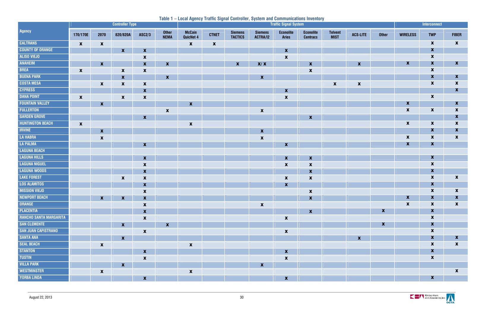
August 22, 2013 30
Table 1 – Local Agency Traffic Signal Controller, System and Communications Inventory
Agency
Controller Type Traffic Signal System Interconnect
170/170E 2070 820/820A ASC2/3 OtherNEMA
McCainQuicNet 4 CTNET Siemens
TACTICSSiemensACTRA/I2
EconoliteAries
EconoliteCentracs
TelventMIST ACS-LITE Other WIRELESS TWP FIBER
CALTRANS X X X X X X
COUNTY OF ORANGE X X X X
ALISO VIEJO X X X
ANAHEIM X X X X X/ X X X X X X
BREA X X X X X
BUENA PARK X X X X X
COSTA MESA X X X X X X X
CYPRESS X X X
DANA POINT X X X X X
FOUNTAIN VALLEY X X X X
FULLERTON X X X X X
GARDEN GROVE X X X
HUNTINGTON BEACH X X X X X
IRVINE X X X X
LA HABRA X X X X X
LA PALMA X X X X
LAGUNA BEACH
LAGUNA HILLS X X X X
LAGUNA NIGUEL X X X X
LAGUNA WOODS X X X
LAKE FOREST X X X X X X
LOS ALAMITOS X X X
MISSION VIEJO X X X X
NEWPORT BEACH X X X X X X X
ORANGE X X X X X
PLACENTIA X X X X
RANCHO SANTA MARGARITA X X X
SAN CLEMENTE X X X X
SAN JUAN CAPISTRANO X X X
SANTA ANA X X X X
SEAL BEACH X X X X
STANTON X X X
TUSTIN X X X
VILLA PARK X XWESTMINSTER X X X
YORBA LINDA X X X
August 22, 2013 31
2.3.3 Incident Management and Emergency Response
OCTA manages the Service Authority for Freeway Emergencies (SAFE) to provide motorists withroadside assistance through the Freeway Service Patrol (FSP). The FSP is a transportationmanagement strategy designed to limit congestion resulting from disabled vehicles in travellanes. Orange County SAFE manages a network of 621 call boxes on most freeways, toll roadsand state highways throughout the county. Motorists can request an FSP tow truck using thefreeway call box or by calling 511 with their cell phone. Calls to 511 are directed to theappropriate call center in any part of the region based on location of the caller. The calls arehandled by the dispatcher at the call center who can dispatch tow trucks or CHP officers to thescene.
FSP beats and contracts are managed by OCTA. Data for evaluation and redistribution of beats isanalyzed after manual collection and aggregation of data, roughly on an annual basis. Thisanalysis process can be enhanced if vehicle and response data were automatically collected andprovided on a real-time or near real-time basis.
2.3.4 Traveler Information
Advanced traveler information is currently provided within Orange County through numerousoutlets. LA SAFE operates both a web based and phone based interactive 511 travelerinformation service. Private service providers also offer traveler information services primarilythrough the web – these services are independent of the publically funded programs. Efforts areongoing to provide integrated transit information to travelers to promote transit use and improvecustomer service. Currently static schedules are provided with the intent to migrate to real-timearrival information at some point in the future.
The 511 system provides traveler information on freeways in Los Angeles, Orange, and Venturacounties primarily, with data also provided for Riverside and San Bernardino counties. Thesystem provides information about traffic drive times and freeway speeds, road construction,incidents, buses and trains, carpool/vanpool, bicycle information, and weather. Sources for real-time data include the Regional Integration of Intelligent Transportation Systems (District 7 data iscollected from this LA Metro operated data exchange service), Caltrans TMCs (District 8 andDistrict 12), Caltrans Lane Closure System portal, California Highway Patrol CAD and NextTrip(transit vehicle status). Transit information includes an integrated trip planner, and NextTripinformation also is available for many transit providers. Users can use the phone or website toobtain average freeway speeds, average travel times, and average rail travel times.
Orange County data is provided by Caltrans District 12. OCTA staff represents the county inregular 511 program expansion discussions. Future upgrades to the 511 service also include amulti-lingual module to support Spanish (currently services are offered in English). Arterialinformation is not currently provided on the publicly offered 511 system.

August 22, 2013 32
2.3.5 Performance Monitoring/ Data Management
OCTA is a progressive organization when it comes to implementing and actively reporting on keyperformance measures and indicators. There is a commitment on behalf of OCTA to transparencyand accountability, and ITS can help to support the unique data needs to support OCTA’scontinued focus on performance management.
Destination 2035 identified several key performance measures that represent a multi-modal andintegrated approach to achieving system improvements. These are:
Monitoring, measuring and enhancing strategies based on outcomes will require a robustperformance management program, underpinned by a multi-agency approach to datamanagement and archiving.
Caltrans District 12 collects traffic data for freeway, HOV lane, and ramp facilities throughout thecounty primarily using inductive loop detectors. The data is transmitted from the field to theDistrict 12 TMC over Caltrans fiber and historic data is made available through the CaltransPerformance Measurement System (PeMS) website. Users can download raw traffic data fromover 2,300 vehicle detection stations covering nearly 1,500 lanes miles of freeway in the county.The website also has reporting tools and performance dashboards that aggregate the traffic datainto performance measures that identify bottleneck congestion, travel reliability and delay.Caltrans also manually collects data annually for additional evaluation and cross-checking.Caltrans has made significant progress in recent years in detection maintenance andtroubleshooting, bringing the district’s detection up to over 90% reporting, which means thatenough raw data is available to make the resulting aggregates valuable for use in performancereporting and traveler information.
Newly synchronized arterial corridors undergo before and after studies as a part of thecountywide program. Data is collected through various methods and then quantified manually.OCTA also conducts travel time studies of all synchronized corridors every other year. This datacan show valuable impacts of corridor synchronization as well as the benefit of ongoinginvestment in arterial management technologies and strategies.
Performance Measure 2035 Baseline 2035 Preferred PlanDaily vehicle hours traveled 3.4 million Reduced by 24 percentDaily hours of delay due to congestion 1.5 million Reduced by 56 percentAverage peak period freeway speed(AM)
29 miles per hour Increased by 22 percent
Average peak period high-occupancyvehicle speed (AM)
35 miles per hour Increased by 24 percent
Average peak period roadway speed(AM)
13 miles per hour Increased by 82 percent
Daily transit trips 144,000 Increased by 11 percent
August 22, 2013 33
The OCTA GIS section manages a data warehouse for the agency's spatial data. The systemmaintains GIS layers for the county's roadway and transit networks information in a relationaldatabase management system. The system archives farebox data collected on buses for serviceplanning and operational analysis. The data tracks ridership activity by route, segment andvehicle. The data can also provide a sampling of trip origins and destinations by tracking theanonymous IDs from magnetic fare media.
2.3.6 Safety
A portion of the OCTA bus fleet is currently equipped with cameras to monitor passenger activityand record incidents; new fixed-route buss and paratransit vehicles added to the fleet areequipped with the cameras. The implementation of the ITMS project will extend the videosurveillance capability by enabling law enforcement vehicles to access the on-board vehicle feedover wireless communications. In addition, Metrolink trains operating in the Orange County areequipped with inward-facing cameras to monitor train operator activity. SCRRA has alsoimplemented Automatic Train Stop (ATS) technology throughout the Metrolink system. ATSutilizes track sensors that trigger alerts to the cab operator of upcoming curves and speedchanges. Breaking is automatically applied if the warning is ignored. SCRRA is currently workingon implementing the next generation of train safety technology with PTC, which will implement aninteroperable system among the different commuter and freight rail operators in SouthernCalifornia.
2.3.7 Communications and Connectivity
Communication interties between the local agencies and Caltrans District 12 support center-to-center data sharing and coordinated traffic management. Interties between the local agencyTMCs include the City of Laguna Hills, which shares access to its ATMS server with the City ofLake Forest. The intertie allows Lake Forest to utilize some of the unused capacity on the server;the agencies may view each other signals on the server, but are restricted from acquiringoperational control. Several of the local agencies TMCs have an intertie with the District 12 TMCutilizing TCP/IP communications over fiber optics to share data feeds from ITS field elements.Along key freeway corridors such I-405 and SR-22, interties between the District 12 TMC andlocal agencies TMCs allow for the sharing of video feeds to coordinate congestion monitoringand incident verification.
August 22, 2013 34
3. USER AND REGIONAL NEEDS
The collective needs or challenges that exist in the surface transportation environment are the impetus behindITS planning and architecture development. These needs guide the development of an ITS strategicdeployment plan consisting of solutions to those identified challenges, potential integration between new ITSsolutions and existing systems, and a framework for implementation of those projects that will ultimatelyprovide the solutions. Through consultation with stakeholders, the local and regional needs were identified.
The stakeholder needs were compiled from the 2007 Orange County ITS Strategic Deployment Plan andupdated based on extensive outreach activities with transportation agencies and staff across a broad spectrumof service areas. Needs correspond to the existing conditions categories presented in Section 2, with theaddition of categories to capture safety, institutional and connectivity needs of the county’s future ITSprogram.
Transit Management and Multi-Modal
§ Fine grained data regarding transit service and operations for regular use in planning and scheduling§ Increased accuracy, availability, and cost-effective collection of transit data: passenger counts/ridership,
stop arrival times, payments, and other§ Improved efficiency and reliability of transit systems§ Improved and coordinated parking management and information at rail/transit stations throughout the
county§ Improved transit schedule, services, and arrival information§ Improved transit service and trip coordination (between modes and between different providers)§ Improved first and last mile connections to transit with bike-sharing
Traffic Management
§ Countywide understanding of the current operations of arterial progression§ Professional skillset development at municipal and County levels for arterial operations and maintenance
activities§ Improved detection on arterials§ Improved incident and emergency response times§ Improved signal coordination especially for crossing arterials§ Reduced congestion and improved travel time reliability, including ramp meter coordination with surface
streets to avoid additive congestion§ Reduce rail grade crossing delays§ Reduced emissions§ Interoperability of transportation payments: bus, rail, parking, tolls, and other fees§ Coordination of toll systems with surrounding inter-county and intra-county facilities
August 22, 2013 35
Incident Management and Emergency Response
§ Better and recent data for managing and planning for the freeway service patrol program, including betterand more frequent integration of temporary work zone detection
§ Improved incident and emergency response times§ Improved transportation system management during disasters and/or evacuations§ Reduced congestion and improved travel time reliability§ Reduced emissions
Traveler Information
§ Improved quality and timeliness of information to travelers§ Parking information§ Real-time traffic and transit information, especially in and through construction zones§ Multilingual traffic and transit information (English and Spanish at a minimum)§ Real-time transit information§ Rideshare information§ Reliable road and lane closure information§ Increased promotion of alternate modes of transportation§ Multi-modal traveler information for transit and non-motorized trips
Performance Monitoring/Data Management
§ Improved data sharing and archiving for arterial, highway, transit, FSP, and other multi-modal data§ Improved collection of data for transportation planning§ Bike and pedestrian usage data for planning purposes§ Increased accuracy, availability, and cost-effective collection of transit data: passenger counts/ridership,
stop arrival times, and payments
Safety
§ Improved traveler safety§ Improved bicycle/ pedestrian safety on roadways§ Reduce rail and transit accidents
Communications and Connectivity
§ Communications infrastructure to support regional programs§ Improved inter-agency communications§ Open standards to enable countywide center-to-center and center-to-field communications, data sharing
and interoperability
Institutional
§ Improved staffing levels for arterial and freeway operations
August 22, 2013 36
§ Improve transportation system operation and maintenance skill sets for local agencies (staff and orcontracted services)
§ Promotion of open procurement and marketplace competition§ Economies of scale for bulk purchasing within the county (considering the transportation equipment being
purchased for multiple agencies and projects around the county)

August 22, 2013 37
4. EXISTING AND PLANNED SERVICE PACKAGES
The services provided by ITS projects, (i.e. traveler information, emergency vehicle preemption or real-timetransit arrival information) are organized into service packages—a term used by FHWA and the National ITSArchitecture to describe a category of ITS projects or services. The table below contains a summary of ITSproject categories (service packages) that are existing or planned in Orange County, and as such areaddressed in this Plan and its component Regional ITS Architecture. The table shows the entire listing ofmarket packages from the National ITS Architecture and their respective status in the region. These ITScategories (service packages) are classified as: Existing, Planned, or Not Planned. The planned designationincludes those strategies that are planned or recommended for future consideration within this document.
Table 2 summarizes the breadth of this Plan and the component Architecture.
Table 2 – Existing and Planned Service Packages
Project Categories (Service Packages) Existing (E) Planned (P)/Future (F)
PrivateSector Led
(PR)ARCHIVED DATA MANAGEMENTAD1 ITS Data Mart EAD2 ITS Data Warehouse EAD3 ITS Virtual Data Warehouse FPUBLIC TRANSPORTATION SYSTEMSAPTS01 Transit Vehicle Tracking EAPTS02 Transit Fixed-Route Operations EAPTS03 Demand Response Transit Operations EAPTS04 Transit Fare Collection Management EAPTS05 Transit Security EAPTS06 Transit Fleet Management EAPTS07 Multi-modal Coordination PAPTS08 Transit Traveler Information EAPTS09 Transit Signal Priority PAPTS10 Transit Passenger Counting EAPTS11 Multimodal Connection Protection ETRAVELER INFORMATIONATIS01 Broadcast Traveler Information EATIS02 Interactive Traveler Information EATIS03 Autonomous Route Guidance PRATIS04 Dynamic Route Guidance PRATIS05 ISP Based Trip Planning and Route Guidance EATIS06 Transportation Operations Data Sharing FATIS07 Travel Services Information and Reservation EATIS08 Dynamic Ridesharing FATIS09 In Vehicle Signing PRATIS10 Short Range Communications Traveler Information FTRAFFIC MANAGEMENTATMS01 Network Surveillance EATMS02 Traffic Probe Surveillance EATMS03 Traffic Signal Control E
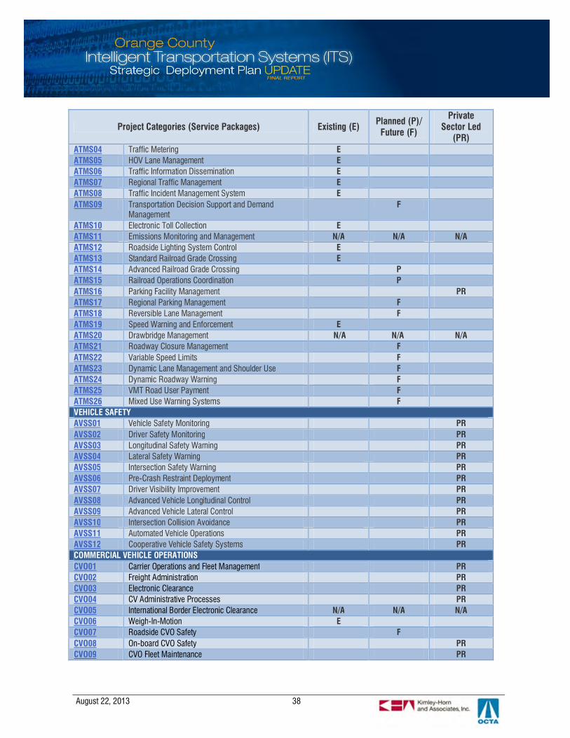
August 22, 2013 38
Project Categories (Service Packages) Existing (E) Planned (P)/Future (F)
PrivateSector Led
(PR)ATMS04 Traffic Metering EATMS05 HOV Lane Management EATMS06 Traffic Information Dissemination EATMS07 Regional Traffic Management EATMS08 Traffic Incident Management System EATMS09 Transportation Decision Support and Demand
ManagementF
ATMS10 Electronic Toll Collection EATMS11 Emissions Monitoring and Management N/A N/A N/AATMS12 Roadside Lighting System Control EATMS13 Standard Railroad Grade Crossing EATMS14 Advanced Railroad Grade Crossing PATMS15 Railroad Operations Coordination PATMS16 Parking Facility Management PRATMS17 Regional Parking Management FATMS18 Reversible Lane Management FATMS19 Speed Warning and Enforcement EATMS20 Drawbridge Management N/A N/A N/AATMS21 Roadway Closure Management FATMS22 Variable Speed Limits FATMS23 Dynamic Lane Management and Shoulder Use FATMS24 Dynamic Roadway Warning FATMS25 VMT Road User Payment FATMS26 Mixed Use Warning Systems FVEHICLE SAFETYAVSS01 Vehicle Safety Monitoring PRAVSS02 Driver Safety Monitoring PRAVSS03 Longitudinal Safety Warning PRAVSS04 Lateral Safety Warning PRAVSS05 Intersection Safety Warning PRAVSS06 Pre-Crash Restraint Deployment PRAVSS07 Driver Visibility Improvement PRAVSS08 Advanced Vehicle Longitudinal Control PRAVSS09 Advanced Vehicle Lateral Control PRAVSS10 Intersection Collision Avoidance PRAVSS11 Automated Vehicle Operations PRAVSS12 Cooperative Vehicle Safety Systems PRCOMMERCIAL VEHICLE OPERATIONSCVO01 Carrier Operations and Fleet Management PRCVO02 Freight Administration PRCVO03 Electronic Clearance PRCVO04 CV Administrative Processes PRCVO05 International Border Electronic Clearance N/A N/A N/ACVO06 Weigh-In-Motion ECVO07 Roadside CVO Safety FCVO08 On-board CVO Safety PRCVO09 CVO Fleet Maintenance PR
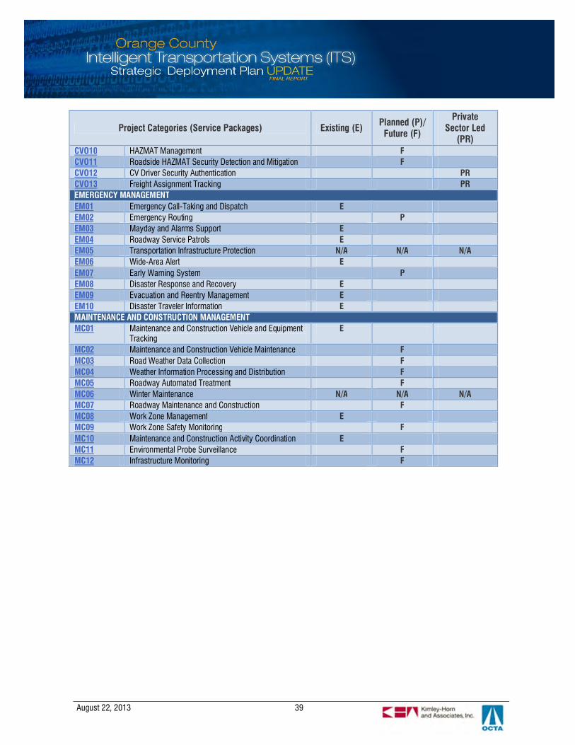
August 22, 2013 39
Project Categories (Service Packages) Existing (E) Planned (P)/Future (F)
PrivateSector Led
(PR)CVO10 HAZMAT Management FCVO11 Roadside HAZMAT Security Detection and Mitigation FCVO12 CV Driver Security Authentication PRCVO13 Freight Assignment Tracking PREMERGENCY MANAGEMENTEM01 Emergency Call-Taking and Dispatch EEM02 Emergency Routing PEM03 Mayday and Alarms Support EEM04 Roadway Service Patrols EEM05 Transportation Infrastructure Protection N/A N/A N/AEM06 Wide-Area Alert EEM07 Early Warning System PEM08 Disaster Response and Recovery EEM09 Evacuation and Reentry Management EEM10 Disaster Traveler Information EMAINTENANCE AND CONSTRUCTION MANAGEMENTMC01 Maintenance and Construction Vehicle and Equipment
TrackingE
MC02 Maintenance and Construction Vehicle Maintenance FMC03 Road Weather Data Collection FMC04 Weather Information Processing and Distribution FMC05 Roadway Automated Treatment FMC06 Winter Maintenance N/A N/A N/AMC07 Roadway Maintenance and Construction FMC08 Work Zone Management EMC09 Work Zone Safety Monitoring FMC10 Maintenance and Construction Activity Coordination EMC11 Environmental Probe Surveillance FMC12 Infrastructure Monitoring F
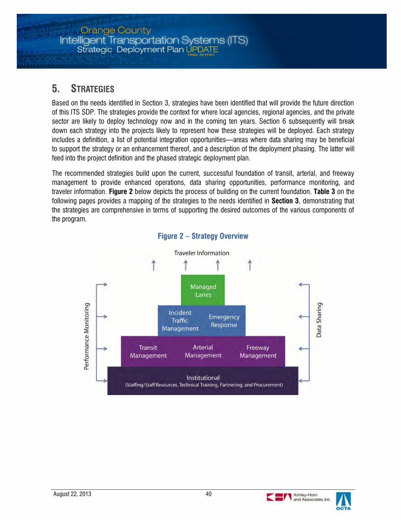
August 22, 2013 40
5. STRATEGIES
Based on the needs identified in Section 3, strategies have been identified that will provide the future directionof this ITS SDP. The strategies provide the context for where local agencies, regional agencies, and the privatesector are likely to deploy technology now and in the coming ten years. Section 6 subsequently will breakdown each strategy into the projects likely to represent how these strategies will be deployed. Each strategyincludes a definition, a list of potential integration opportunities—areas where data sharing may be beneficialto support the strategy or an enhancement thereof, and a description of the deployment phasing. The latter willfeed into the project definition and the phased strategic deployment plan.
The recommended strategies build upon the current, successful foundation of transit, arterial, and freewaymanagement to provide enhanced operations, data sharing opportunities, performance monitoring, andtraveler information. Figure 2 below depicts the process of building on the current foundation. Table 3 on thefollowing pages provides a mapping of the strategies to the needs identified in Section 3, demonstrating thatthe strategies are comprehensive in terms of supporting the desired outcomes of the various components ofthe program.
Figure 2 – Strategy Overview
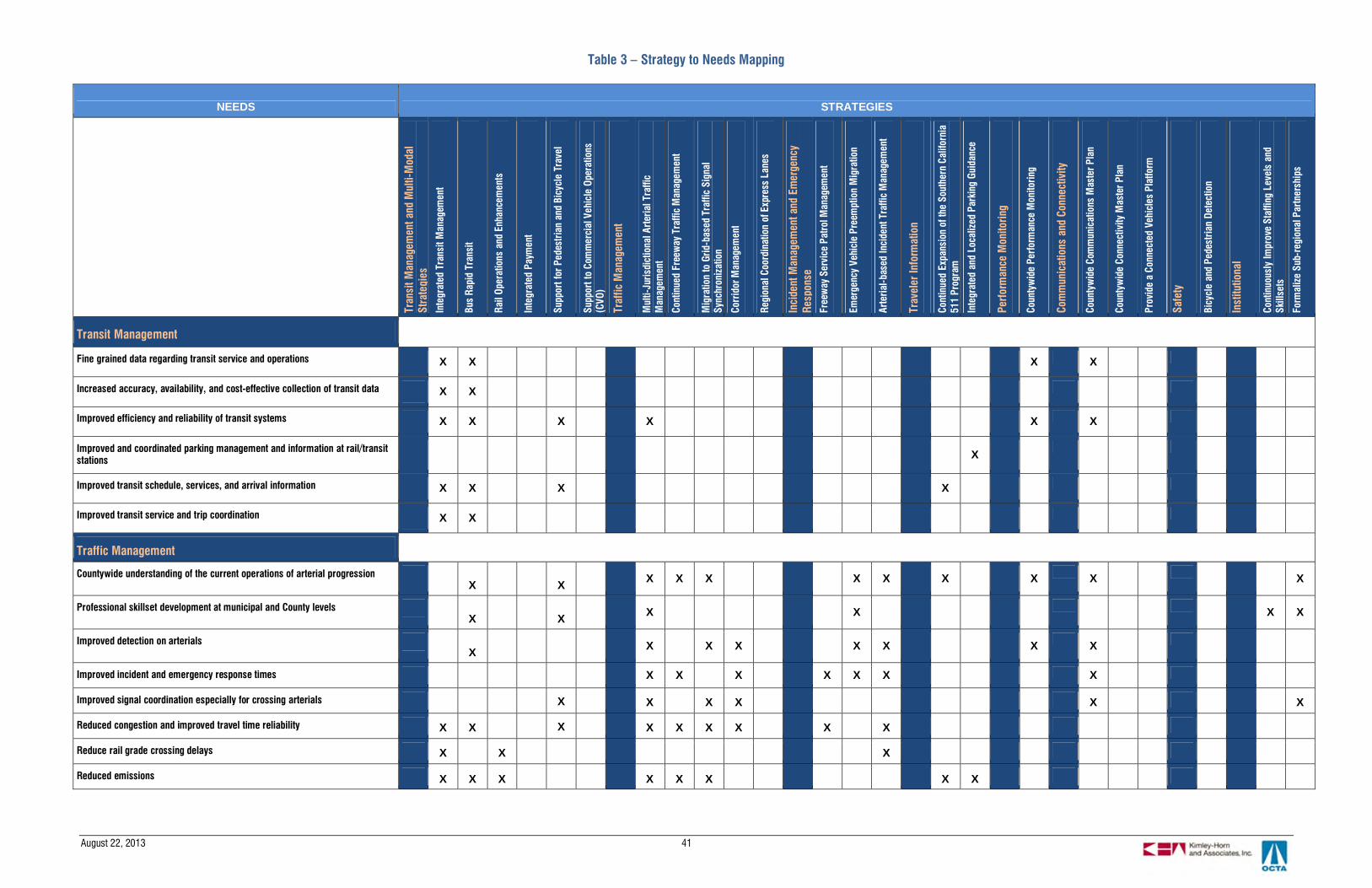
August 22, 2013 41
Table 3 – Strategy to Needs Mapping
NEEDS STRATEGIES
Tran
sitM
anag
emen
tand
Mul
ti-M
odal
Stra
tegi
esIn
tegr
ated
Tran
sitM
anag
emen
t
Bus
Rapi
dTr
ansi
t
Rail
Oper
atio
nsan
dEn
hanc
emen
ts
Inte
grat
edPa
ymen
t
Supp
ortf
orPe
dest
rian
and
Bicy
cle
Trav
el
Supp
ortt
oCo
mm
erci
alVe
hicl
eOp
erat
ions
(CVO
)
Traf
ficM
anag
emen
t
Mul
ti-Ju
risdi
ctio
nalA
rter
ialT
raffi
cM
anag
emen
t
Cont
inue
dFr
eew
ayTr
affic
Man
agem
ent
Mig
ratio
nto
Grid
-bas
edTr
affic
Sign
alSy
nchr
oniz
atio
n
Corr
idor
Man
agem
ent
Regi
onal
Coor
dina
tion
ofEx
pres
sLa
nes
Inci
dent
Man
agem
enta
ndEm
erge
ncy
Resp
onse
Free
way
Serv
ice
Patr
olM
anag
emen
t
Emer
genc
yVe
hicl
ePr
eem
ptio
nM
igra
tion
Arte
rial-b
ased
Inci
dent
Traf
ficM
anag
emen
t
Trav
eler
Info
rmat
ion
Cont
inue
dEx
pans
ion
ofth
eSo
uthe
rnCa
lifor
nia
511
Prog
ram
Inte
grat
edan
dLo
caliz
edPa
rkin
gGu
idan
ce
Perf
orm
ance
Mon
itorin
g
Coun
tyw
ide
Perf
orm
ance
Mon
itorin
g
Com
mun
icat
ions
and
Conn
ectiv
ity
Coun
tyw
ide
Com
mun
icat
ions
Mas
terP
lan
Coun
tyw
ide
Conn
ectiv
ityM
aste
rPla
n
Prov
ide
aCo
nnec
ted
Vehi
cles
Plat
form
Safe
ty
Bicy
cle
and
Pede
stria
nDe
tect
ion
Inst
itutio
nal
Cont
inuo
usly
Impr
ove
Staf
fing
Leve
lsan
dSk
illse
ts
Form
aliz
eSu
b-re
gion
alPa
rtne
rshi
ps
Transit Management
Fine grained data regarding transit service and operations X X X X
Increased accuracy, availability, and cost-effective collection of transit data X X
Improved efficiency and reliability of transit systems X X X X X X
Improved and coordinated parking management and information at rail/transitstations X
Improved transit schedule, services, and arrival information X X X X
Improved transit service and trip coordination X X
Traffic Management
Countywide understanding of the current operations of arterial progressionX X X X X X X X X X X
Professional skillset development at municipal and County levelsX X X X X X
Improved detection on arterialsX X X X X X X X
Improved incident and emergency response times X X X X X X X
Improved signal coordination especially for crossing arterials X X X X X X
Reduced congestion and improved travel time reliability X X X X X X X X X
Reduce rail grade crossing delays X X X
Reduced emissions X X X X X X X X

August 22, 2013 42
NEEDS STRATEGIES
Tran
sitM
anag
emen
tand
Mul
ti-M
odal
Stra
tegi
esIn
tegr
ated
Tran
sitM
anag
emen
t
Bus
Rapi
dTr
ansi
t
Rail
Oper
atio
nsan
dEn
hanc
emen
ts
Inte
grat
edPa
ymen
t
Supp
ortf
orPe
dest
rian
and
Bicy
cle
Trav
el
Supp
ortt
oCo
mm
erci
alVe
hicl
eOp
erat
ions
(CVO
)
Traf
ficM
anag
emen
t
Mul
ti-Ju
risdi
ctio
nalA
rter
ialT
raffi
cM
anag
emen
t
Cont
inue
dFr
eew
ayTr
affic
Man
agem
ent
Mig
ratio
nto
Grid
-bas
edTr
affic
Sign
alSy
nchr
oniz
atio
n
Corr
idor
Man
agem
ent
Regi
onal
Coor
dina
tion
ofEx
pres
sLa
nes
Inci
dent
Man
agem
enta
ndEm
erge
ncy
Resp
onse
Free
way
Serv
ice
Patr
olM
anag
emen
t
Emer
genc
yVe
hicl
ePr
eem
ptio
nM
igra
tion
Arte
rial-b
ased
Inci
dent
Traf
ficM
anag
emen
t
Trav
eler
Info
rmat
ion
Cont
inue
dEx
pans
ion
ofth
eSo
uthe
rnCa
lifor
nia
511
Prog
ram
Inte
grat
edan
dLo
caliz
edPa
rkin
gGu
idan
ce
Perf
orm
ance
Mon
itorin
g
Coun
tyw
ide
Perf
orm
ance
Mon
itorin
g
Com
mun
icat
ions
and
Conn
ectiv
ity
Coun
tyw
ide
Com
mun
icat
ions
Mas
terP
lan
Coun
tyw
ide
Conn
ectiv
ityM
aste
rPla
n
Prov
ide
aCo
nnec
ted
Vehi
cles
Plat
form
Safe
ty
Bicy
cle
and
Pede
stria
nDe
tect
ion
Inst
itutio
nal
Cont
inuo
usly
Impr
ove
Staf
fing
Leve
lsan
dSk
illse
ts
Form
aliz
eSu
b-re
gion
alPa
rtne
rshi
ps
Interoperability of transportation payments: bus, rail, parking, tolls, and otherfees X X X X
Coordination of toll systems with surrounding inter-county and intra-countyfacilities
X
Incident Management and Emergency Response
Better and recent data for managing and planning for the freeway service patrolprogram
X X X X
Improved incident and emergency response times X X X X X X
Improved transportation system management during disasters and/orevacuations
X X X X
Reduced congestion and improved travel time reliability X X X X X X X X X
Reduced emissions X X
Traveler Information
Improved quality and timeliness of information to travelers X X X X X X
Parking information X X
Real-time traffic and transit information, especially in and through constructionzones
X X X X X
Multilingual traffic and transit information (English and Spanish at a minimum) X X
Real-time transit information X X
Rideshare information X
Reliable road and lane closure information X X X
Increased promotion of alternate modes of transportation X X X X X

August 22, 2013 43
NEEDS STRATEGIES
Tran
sitM
anag
emen
tand
Mul
ti-M
odal
Stra
tegi
esIn
tegr
ated
Tran
sitM
anag
emen
t
Bus
Rapi
dTr
ansi
t
Rail
Oper
atio
nsan
dEn
hanc
emen
ts
Inte
grat
edPa
ymen
t
Supp
ortf
orPe
dest
rian
and
Bicy
cle
Trav
el
Supp
ortt
oCo
mm
erci
alVe
hicl
eOp
erat
ions
(CVO
)
Traf
ficM
anag
emen
t
Mul
ti-Ju
risdi
ctio
nalA
rter
ialT
raffi
cM
anag
emen
t
Cont
inue
dFr
eew
ayTr
affic
Man
agem
ent
Mig
ratio
nto
Grid
-bas
edTr
affic
Sign
alSy
nchr
oniz
atio
n
Corr
idor
Man
agem
ent
Regi
onal
Coor
dina
tion
ofEx
pres
sLa
nes
Inci
dent
Man
agem
enta
ndEm
erge
ncy
Resp
onse
Free
way
Serv
ice
Patr
olM
anag
emen
t
Emer
genc
yVe
hicl
ePr
eem
ptio
nM
igra
tion
Arte
rial-b
ased
Inci
dent
Traf
ficM
anag
emen
t
Trav
eler
Info
rmat
ion
Cont
inue
dEx
pans
ion
ofth
eSo
uthe
rnCa
lifor
nia
511
Prog
ram
Inte
grat
edan
dLo
caliz
edPa
rkin
gGu
idan
ce
Perf
orm
ance
Mon
itorin
g
Coun
tyw
ide
Perf
orm
ance
Mon
itorin
g
Com
mun
icat
ions
and
Conn
ectiv
ity
Coun
tyw
ide
Com
mun
icat
ions
Mas
terP
lan
Coun
tyw
ide
Conn
ectiv
ityM
aste
rPla
n
Prov
ide
aCo
nnec
ted
Vehi
cles
Plat
form
Safe
ty
Bicy
cle
and
Pede
stria
nDe
tect
ion
Inst
itutio
nal
Cont
inuo
usly
Impr
ove
Staf
fing
Leve
lsan
dSk
illse
ts
Form
aliz
eSu
b-re
gion
alPa
rtne
rshi
ps
Performance Monitoring/Archived Data Management
Improved data sharing and Archiving for arterial, highway, transit, FSP, andother multi-modal data
X X X X X X X X X X X X X
Improved collection of data for transportation planning X X X X X X X X X
Bike and pedestrian usage data for planning purposes X X X X
Increased accuracy, availability, and cost-effective collection of transit data X X
Safety
Improved traveler safety X X X X
Improved bicycle/pedestrian safety on roadways X X X X
Reduce rail and light rail transit accidents X
Communications and Connectivity
Communications infrastructure to support regional programs X X X X X X X
Improved inter-agency communications X X X X X X X
Open standards X X X X
Institutional Needs
Improved staffing levels for arterial and freeway operations X X X X X X X X X
Improve transportation system operation and maintenance skill sets for localagencies (staff and/or contract services) X X X X X X X X X X
Promotion of open procurement and marketplace competition X X X
Economies of scale for bulk purchasing within the county X X X X

August 22, 2013 44
The strategies that comprise the Orange County ITS SDP are summarized in Table 4 below. The sections thatfollow describe each in more detail.
Table 4 – ITS StrategiesStrategy Benefits Integration Opportunities
Transit Management and Multi-Modal
MM1 – Integrated Transit Management:Roll out the Integrated TransitManagement System (ITMS), integratedTransportation Communication System(TCS), Real-Time Passenger InformationSystem (RTPIS), fare collection, and othertransit projects to develop a connected,integrated data set for management andplanning
§ Reduced duplication
§ Better quality data§ More robust data for operations and
planning
§ Data sharing within the transitprogram
§ Ridership and schedule adherencedata for local agencies
§ Transit usage data for managed laneinvestment and capital investmentplanning
§ Arterial closures and constructionactivity information can be useful tobetter managing transit routes
MM2 – Bus Rapid Transit: Roll out BRTservice in a two-step implementationprocess. Technology applications couldinclude TSP (transit signal priority), real-time bus arrival information, andautomated fare collection.
§ Improved customer service and riderexperience
§ Increased ridership§ More cost-effective operations on
Bravo! routes
§ Ridership and arrival time data can beshared with other sections at OCTAfor planning and project developmentactivities
§ Data from the ITMS and IntegratedTCS can be used to enhance thisprogram
§ Arterial closures and constructionactivity information can be useful tobetter managing transit routes
MM3 – Rail Operations andEnhancements: Continued rail operationssupported by technologies for safety, suchas for positive train control, intersectionsafety, and operations
§ Increased safety
§ Improved operations§ Increased ridership and multi-modal
options for travelers
§ Construction or traffic conditions(especially during incidents) providedto rail operations
§ Rail arrival times provided to trafficmanagement agencies, travelerinformation, and relatedstrategies/programs
MM4 – Integrated Payment: Currentlybeing examined in Orange County incoordination with other Southern Californiaagencies, an integrated payment methodthat would initially allow for transitpayment
§ Increased ridership and multi-modaloptions for travelers
§ Reduced congestion
§ More cost-effective operations
§ Integration and streamliningopportunities among transit projects,parking access and revenue controlsystems, multi-modal centers,FasTrak® operations, and others
MM5 – Support for Pedestrian andBicycle Travel: local deployments ofpedestrian and bicycle safety, bike-sharingand information technologies
§ Promote non-motorized travel
§ Increase safety
§ Reduce congestion
§ Traveler information services tailoredto cyclists and pedestrians

August 22, 2013 45
Strategy Benefits Integration Opportunities
MM6 – Support to Commercial VehicleOperations (CVO): Primarily privatelyled, CVO activities will be supported asneeded in terms of technology
§ Improved environment forcommercial vehicle operations
§ Improved safety
§ Share traffic data with truck dispatchoperations to improve trip routing
Traffic Management
TM1 – Multi-Jurisdictional ArterialTraffic Management:Continue to manage arterials across thecounty and across jurisdictions; provide afoundation for advanced management andstrategies; provide access to more datafor operations and planning
§ Improved mobility
§ Reduced travel costs
§ Better data for investment choices
§ Arterial data can be shared withtransit operators, emergency serviceproviders and freeway/managed lanesoperators for improved multi-modaloperations
§ Transit routes, ridership, andschedule changes can be useful toarterial management
TM2 – Continued Freeway TrafficManagement: Continue to managefreeway traffic through existing and futuretechnology and operational procedures.
§ Improved mobility
§ Reduced travel costs
§ Freeway data is useful to other trafficmanagement strategies and travelerinformation
§ Providing access to arterial, transit,and corridor data (including cameraimages) can add value to freewaymanagement
§ Physical communicationsinfrastructure has capacity forsupporting other strategies
TM3 – Migration to Grid-based TrafficSignal Synchronization:Optimize multiple crossing arterialsthrough signal synchronization within agrid; upgrade equipment to support grid-based synchronization
§ Improved progression on arterials§ Improved coordination among
crossing arterials§ Reduced staff time and cost in
accommodating crossing arterials forcoordination
§ Could provide data for transitoperations where applicable
§ Supplement corridor-based MOEswith network-based MOEs forperformance monitoring
TM4 – Corridor Management:Assess candidate freeway/arterialcorridors for enhanced strategies anddevelop an initial Concept of Operations.Multiple phases would be needed toaddress feasibility assessment, systemsengineering, design, implementation andevaluation.
§ Improved customer service andtraveler experience across modes
§ Reduced congestion and increasedtravel time reliability
§ Improved cross-jurisdictionalcoordination
§ Improved capacity balance§ More opportunity for demand
management
§ The communications assessment,freeway management system, arterialmanagement systems, and OCTA’sintelligent transit management systemwould collectively provide a strongfoundation to build upon for thisadvanced strategy.
§ Transit data, construction data,freeway data, arterial data, FreewayService Patrol (FSP) vehicle locations,etc. can create a more efficientsystem
TM5 – Regional Coordination ofManaged Lanes: Continue 91 Express
§ Improved customer service andtraveler experience
§ Traffic, revenue, and user experiencedata can be shared with other
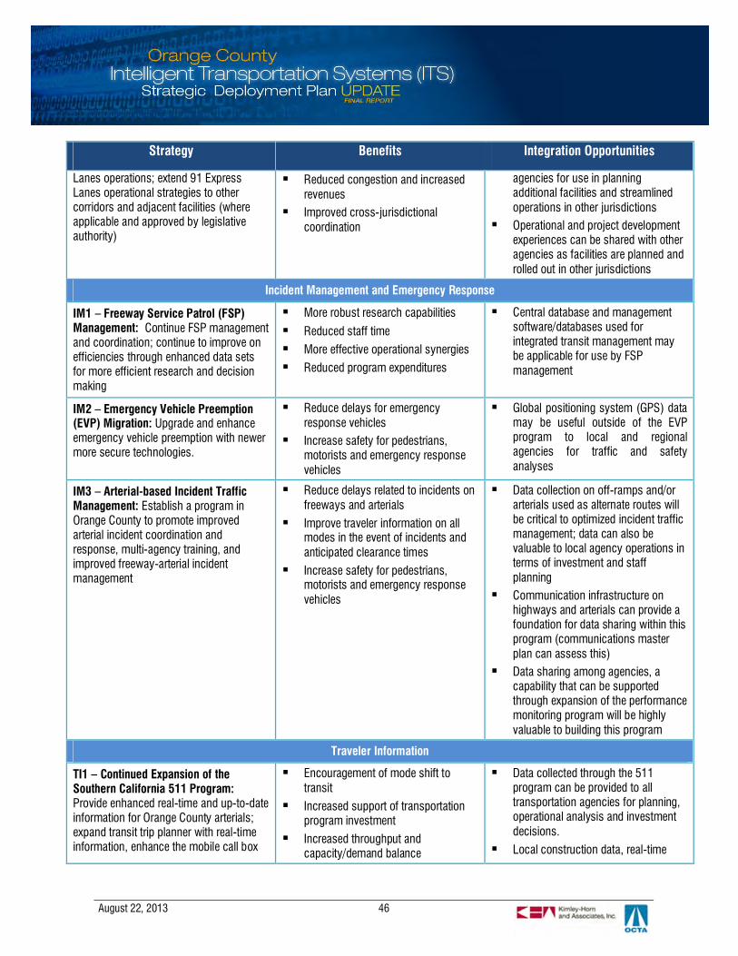
August 22, 2013 46
Strategy Benefits Integration Opportunities
Lanes operations; extend 91 ExpressLanes operational strategies to othercorridors and adjacent facilities (whereapplicable and approved by legislativeauthority)
§ Reduced congestion and increasedrevenues
§ Improved cross-jurisdictionalcoordination
agencies for use in planningadditional facilities and streamlinedoperations in other jurisdictions
§ Operational and project developmentexperiences can be shared with otheragencies as facilities are planned androlled out in other jurisdictions
Incident Management and Emergency Response
IM1 – Freeway Service Patrol (FSP)Management: Continue FSP managementand coordination; continue to improve onefficiencies through enhanced data setsfor more efficient research and decisionmaking
§ More robust research capabilities
§ Reduced staff time
§ More effective operational synergies
§ Reduced program expenditures
§ Central database and managementsoftware/databases used forintegrated transit management maybe applicable for use by FSPmanagement
IM2 – Emergency Vehicle Preemption(EVP) Migration: Upgrade and enhanceemergency vehicle preemption with newermore secure technologies.
§ Reduce delays for emergencyresponse vehicles
§ Increase safety for pedestrians,motorists and emergency responsevehicles
§ Global positioning system (GPS) datamay be useful outside of the EVPprogram to local and regionalagencies for traffic and safetyanalyses
IM3 – Arterial-based Incident TrafficManagement: Establish a program inOrange County to promote improvedarterial incident coordination andresponse, multi-agency training, andimproved freeway-arterial incidentmanagement
§ Reduce delays related to incidents onfreeways and arterials
§ Improve traveler information on allmodes in the event of incidents andanticipated clearance times
§ Increase safety for pedestrians,motorists and emergency responsevehicles
§ Data collection on off-ramps and/orarterials used as alternate routes willbe critical to optimized incident trafficmanagement; data can also bevaluable to local agency operations interms of investment and staffplanning
§ Communication infrastructure onhighways and arterials can provide afoundation for data sharing within thisprogram (communications masterplan can assess this)
§ Data sharing among agencies, acapability that can be supportedthrough expansion of the performancemonitoring program will be highlyvaluable to building this program
Traveler Information
TI1 – Continued Expansion of theSouthern California 511 Program:Provide enhanced real-time and up-to-dateinformation for Orange County arterials;expand transit trip planner with real-timeinformation, enhance the mobile call box
§ Encouragement of mode shift totransit
§ Increased support of transportationprogram investment
§ Increased throughput andcapacity/demand balance
§ Data collected through the 511program can be provided to alltransportation agencies for planning,operational analysis and investmentdecisions.
§ Local construction data, real-time

August 22, 2013 47
Strategy Benefits Integration Opportunities
module; integrate private sector sources ofdata
transit data, and others can bedisseminated through these channels
§ More integration among existingpublic and private information serviceproviders can provide greater value totravelers and support enhanced trafficand transit management goals
§ A rich source of crowd-sourced datais available from private sectorservice providers that can providepredictive area-wide or corridorspecific travel times and travel speedinformation
§ The private sector Goods Movementindustry as a source of truck routingand container tracking data
§ Connected Vehicles as a real-timetravel data gathered from vehicle-to-vehicle or vehicle-to-roadsidecommunications
TI2 – Integrated and Localized ParkingGuidance: Seek out additionalopportunities for parking guidancesystems (PGS) with an emphasis on aregional, integrated parking guidance andinformation system for park and ridefacilities.
§ Encouragement of mode shift totransit
§ Increased support of transportationprogram investment
§ Increased throughput andcapacity/demand balance
§ Locally deployed PGS can integratewith local arterial managementsystems
§ Regional PGS would benefit fromreal-time and schedules for train andbus arrivals and pricing informationon express lanes within southernCalifornia
Performance Monitoring
PM1 – Countywide PerformanceMonitoring: Collect and analyze dataacross modes and facilities to trackinternal performance, investments andneeds and report externally to decisionmakers and the public.
§ Data for improved operational andinvestment decisions
§ Existing and enhanced performancedata can support foundationaloperations and investment planningchoices
§ Integration opportunities among allstrategies and modes
Communications and Connectivity
CC1 – Countywide CommunicationsMaster Plan: Physical and logicalconnectivity to support multi-modal andmulti-agency operations and data sharingneeds.
§ Reduced investment duplication andreduced infrastructure costs overall
§ Redundant infrastructure foremergencies
§ Communication infrastructure onhighways and arterials can provide afoundation for data integration withinthis program (communicationsmaster plan can assess this)
§ The freeway fiber backbone and

August 22, 2013 48
Strategy Benefits Integration Opportunities
existing arterial infrastructure offerpotential bandwidth
CC2 – Countywide Connectivity MasterPlan: Design a method of data sharingacross the county for traffic, transit, non-motorized, operations, and planning data.
§ Data for improved operational andinvestment decisions
§ Communications standards resultingfrom this study can reduceinvestment duplication and improvecompetition in the currentenvironment
§ Data sharing among agencies can besupported through establishment ofthe performance monitoring programfoundation
§ The ITMS and integrated TCS beingrolled out by the transit group atOCTA offers extensive opportunitiesfor data collection, sharing andintegration in concert with thisprogram
§ Integration opportunities among allstrategies and modes
CC3 – Provide a Connected VehiclesPlatform: Allow for the future possibility ofconnected vehicles in order to capitalizeon the robust local operationalenvironment and further enhance theexisting foundation
§ Potential for major advancement inintegrated traveler information andmanagement
§ Potential access to additionaltransportation funding
§ Significant integration opportunitiesand needs with all modes andstrategies
Safety
SF1 – Bicycle Detection: Support on-going, local implementation of bicycledetection technologies, withimplementation focused on bike andtransit hubs
§ Increase multi-modal options§ Increase safety for non-motorized
travelers
§ Reduce congestion
§ Reduce greenhouse gas emissions
§ Bicycle usage data to improve signalcoordination
§ Telematics to provide in-vehicle alertto drivers
SF2 – Pedestrian Detection: Support on-going local implementation of pedestriandetection technologies; futuretechnologies might include telematics
§ Increase multi-modal options§ Increase safety for non-motorized
travelers
§ Reduce congestion
§ Reduce greenhouse gas emissions
§ Pedestrian usage data to improvesignal coordination
§ Telematics to provide in-vehicle alertto drivers
SF3 – Transit Security: Support datasharing between transit agencies and lawenforcement to ensure passenger safetyand security
§ Increase safety for non-motorizedtravelers
§ Promote transit adoption
§ Share video fields and transit vehiclelocation data using the ITMSinfrastructure
Institutional
IN1 – Continuously Improve StaffingLevels and Skillsets: Establish acountywide training program recognizingthe fast paced, dynamic technology
§ Increased skillsets
§ Reduced training expense§ Potential for shared resources
§ N/A

August 22, 2013 49
Strategy Benefits Integration Opportunities
environment (reduced costs)
IN2 – Formalize Sub-regionalPartnerships: Establish northern andsouthern county partnership groups forsharing information and best practices
§ Increased skillsets and informationsharing
§ Improved operations§ Reduced duplication of effort and
investment
§ Potential for shared resources
§ N/A

August 22, 2013 50
5.1 Transit Management and Multi-Modal
5.1.1 Integrated Transit Management (MM1)
Description
Integrated transit management represents a number of projects designed to integrate static andreal-time sources of transit data for system planning. The system fuses multiple sources oftransit related data – transit schedules, geospatial data, fleet vehicle tracking, personnel records,fare collection and ridership. The integrated system could warehouse the data for operationalanalysis and disseminate to partner agencies and the public using transit data feeds.
OCTA is currently implementing the ITMS project and will integrate two separate AVL/CADsystems – dispatch and scheduling for fixed route bus service and ACCESS paratransit services.The project is moving two separate radio frequencies to 800 MHz digital radio. The back endsystems for OCTA and contract operators are being integrated to provide single login access topersonnel records and route assignments. With a single login, any operator can access variousvehicle subsystems – dispatch, farebox, vehicle message sign and in-vehicle voice annunciation.The ITMS has the potential to support a regional CAD/AVL system for emergency dispatch anddata sharing.
Benefits
§ Reduced duplication§ Better quality data§ More robust data for operations and planning
Integration Opportunities
§ Data sharing within the transit program§ Ridership and schedule adherence data for local agencies§ Transit usage data for managed lane investment and capital investment planning§ Arterial closures and construction activity information can be useful to better managing
transit routes
Implementation Schedule
§ Short-term (0-3 years): Complete ITMS implementation§ Long-term (5-10 years): Provide real-time bus arrival information to the public; integrate
ITMS with OCTA data warehousing system; integrate CAD/AVL systems for Go-Localoperators; serve as a regional CAD/AVL system to include local and county fire and policeagencies; coordinate regional emergency response and disaster preparedness

August 22, 2013 51
5.1.2 Bus Rapid Transit (MM2)
Description
Bus Rapid Transit (BRT) is a tool that can be used to help make transit service more reliable,faster, and more cost effective. BRT can take many forms, ranging from low- or no-technologydeployments that alter schedules and headways to provide limited stop and improved customerservice to full-deployments that might additionally include better vehicles, transit signal priority,and real-time arrival information. BRT, in its many forms, has great potential to make transit morecompetitive with the automobile, increasing ridership and mitigating congestion as result of modeshifts.
Transit Signal Priority (TSP), one component strategy under the BRT umbrella, gives transitvehicles extra green time or less red time at traffic signals to assist with keeping on schedule.There are multiple ways of deploying TSP, including allowance of signal timing priority only whenvehicles are behind schedule, based on rider occupancy of the bus, or limiting the frequency ofpriority calls on a per intersection basis. TSP can be a cost-effective method to enhance regionalmobility by improving transit travel times and reliability, but it is recognized that there are alsoconcerns by some stakeholders related to the impact to local traffic progression.
The strategy for BRT in Orange County is to roll out the Bravo! Program, previously brandedunder the trial that was examined in recent years, in two primary phases. The first phase will be alimited stop service on several key routes, that will focus on reducing the number of stops on aroute (to approximately ¾ of a mile from ½-mile between stops), provide more frequent serviceon those routes (reduced headways), and market the service under the Bravo! brand. A futurephase, still being analyzed and considered by OCTA staff, might include TSP, real-time arrivalinformation for buses (likely to be provided through an internet-based application rather thaninstalling variable message signs at the stops), and/or off-vehicle fare collection. Additionalroutes would also be examined. The Bravo! BRT program is currently evaluated by OCTA staffand will be further defined as a result of those analyses and discussions with stakeholders in theshort-term.
Benefits
§ Improved customer service and rider experience§ Increased ridership§ More cost-effective operations on Bravo! Routes
Integration Opportunities
§ Ridership and arrival time data can be shared with other sections at OCTA for planning andproject development activities
§ Data from the ITMS and Integrated TCS can be used to enhance this program§ Mobile applications to disseminate predictive bus arrival times
August 22, 2013 52
Implementation Schedule
§ Short-term (0-3 years): Limited stop service on several key routes, reduce number of stopsto approximately ¾ of a mile between stops, reduce headways, market the service under theBravo! brand.
§ Medium-term (3-5 years): Still being examined, might include TSP, web-based real-timearrival information for buses, and/or off-vehicle fare collection; additional routes will beexamined.
5.1.3 Rail Operations and Enhancements (MM3)
Description
Technologies are being deployed to enhance the safety and performance of rail operationsutilizing communications and detection to track train movements in real-time, monitor gradecrossings and work zones and provide real-time train departure information to the public. Effortsare underway to implement a PTC system to improve passenger and freight rail safety inSouthern California. In a typical PTC system, onboard equipment on the train uses GPS satellitesto transmit speed and location data over wireless or hard line communications links to anoperations center. A back office system at the operations center analyzes the data using softwarethat determine the likelihood of a collision or derailment. An advance alert is sent by the dispatchcenter to the locomotive and brakes are automatically engaged if the warnings are not acted onby the train engineer.
Federal regulations do not prescribe the type of technology a PTC system uses as long as it canaccomplish the functions of preventing: train-to-train collisions, derailment from over speeding,incursions into designated work zone areas and train movements caused by switches left in thewrong position. The PTC system in Southern California will be interoperable using a commonspectrum for radio communications. Back office systems for Southern California Regional RailAuthority (SCRRA), Burlington Northern Santa Fe (BNSF), Union Pacific (UP), Amtrak and theNorth County Transit District (NCTD) in San Diego are being integrated and standards are beingdeveloped for on-board and wayside devices – allowing trains to be monitored seamlesslyacross various operating territories in the region.
Benefits
§ Increased safety§ Improved operations§ Increased ridership and multi-modal options for travelers
Integration Opportunities
§ Construction or traffic conditions (especially during incidents) provided to rail operations§ Rail arrival times provided to traffic management agencies, traveler information, and related
strategies/programs
August 22, 2013 53
Implementation Schedule
§ Short-term (0-3 years): Complete PTC implementation ahead of the federal deadline in 2013§ Long-term (5-10 years): Expand PTC system to include the California High Speed Rail;
gather data on train movements for operations planning and traveler information
5.1.4 Integrated Payment (MM4)
Description
OCTA is coordinating with twenty other transit operators in a Southern California to implement aregional fare collection system. The fare integration study has been completed and systemrequirements for a smart card system are being defined to augment OCTA’s existing fare boxsystem to accept cashless fares from other transit operators. Working with other agencies in aregional users group, OCTA is looking towards an open, account based system that utilizesinnovative payment methods such as contactless credit/debit cards, mobile devices and near-field communications. A pilot project to test the technology would be followed by the full roll outof the program. Future phases may include expansion to other modes and agencies.
Benefits
§ Increased ridership and multi-modal options for travelers§ Reduced congestion§ More cost-effective operations
Integration Opportunities
§ Integration and streamlining opportunities among transit projects, parking access andrevenue control systems, multi-modal centers, FasTrak® operations, and others
Implementation Schedule
§ Short-term (0-3 years): Finalize system requirements for the OCTA smart card system;integrate fare collection with other systems within the county such as Go-Local
§ Medium-term (3-5 years): Conduct pilot project and/or full implementation§ Long-term (5-10 years): Potential expansion to other modes/agencies across the region
5.1.5 Support for Pedestrian and Bicycle Travel (MM5)
Description
OCTA and local agencies have planned and built a countywide bicycle transportation network.The network consists of off road (Class I) and on road (Class II and Class III) facilities thatinterface with transit routes and employment and pedestrian activity centers. OCTA is alsoinvolved with planning for future bikeways, facility improvements and policies to accommodatethe needs of cyclists and pedestrians. Technologies can play a supporting role in these projectsto foster pedestrian and/or bicycle travel primarily through safety enhancements. Technologies
August 22, 2013 54
may include such applications as bicycle detection, pedestrian detection, bicycle signals, andother safety applications.
As part of the planned expansion of Metrolink service on the Orange County Line, OCTA isincluding non-motorized improvements to increase bicycle and pedestrian linkages at stationareas. A bike-share pilot project is being implemented in Fullerton and could expand to otherMetrolink stations, transit hubs, and colleges and universities to improve first and last mileconnections to rail. A bike-sharing service provides short-term rentals for short trips between 3-5miles of the station area, increasing transit accessibility and promoting travel alternatives andpublic health. Customers will be able to setup a membership account to rent a bike at a dockingstation, which automatically records usage for billing. The rental bikes are equipped with GPS fortracking and locating.
Benefits
§ Promote non-motorized travel§ Increase rail transit ridership§ Increase safety§ Reduce congestion§ Reduce greenhouse gas emissions
Integration Opportunities
§ Traveler information services tailored to cyclists and pedestrians§ Integrate the bike-share program with other regional programs for a seamless rental
experience§ Provide bike rental status and availability information through the 511 traveler information
system§ Accept transit smart cards for bike-sharing account verification and payment
Implementation Schedule
§ Short-term (0-3 years): Locally led technology projects to that support pedestrian andbicycle travel will be deployed as needed
§ Medium-term (3-5 years): Implement a countywide bike sharing program§ Long-term (5-10 years): Integrate the bike sharing program with other programs in Southern
California; integrate bicycle payment into the countywide or regional fare collection system
5.1.6 Support to Commercial Vehicle Operations (MM6)
Description
Significant freight and truck traffic passes through Orange County, bound for distribution centersin the Inland Empire. Truck lanes and grade separation projects are planned or underway in thecounty to increase system capacity and reduce impacts on communities. Most commercial

August 22, 2013 55
vehicle operations technologies will be led by the private sector, though it is important that theenvironment in the county allows for these private, market-driven programs to emerge and thrive.
Benefits
§ Improved environment for commercial vehicle operations§ Improved safety
Integration Opportunities
§ Share traffic data with truck dispatch operations to improve trip routing
Implementation Schedule
§ No technologies in public sector projects are identified at this time.
5.2 Traffic Management
5.2.1 Multi-Jurisdictional Arterial Traffic Management (TM1)
Description
The county has a well-funded traffic signal synchronization program that has supported theimplementation of advanced arterial traffic management systems in local cities. Theseimprovements have laid the foundation to support advanced technologies for arterial trafficmanagement—corridor and grid-based traffic signal synchronization, adaptive traffic control,corridor based management, performance monitoring and interagency operational coordination.Taking arterial traffic management to the countywide level will depend on greater systemintegration and interoperability to facilitate data sharing among the regional and local agencies.Standards and interfaces will need to be defined for collecting and sharing traffic data and aninstitutional framework to coordinate performance monitoring and reporting.
Benefits
§ Improved mobility§ Reduced travel costs§ Better data for operations and planning§ Reduced greenhouse gas emissions
Integration Opportunities
§ Arterial data shared with transit operators, emergency service providers andfreeway/managed lanes operators for improved multi-modal operations
§ Real-time arterial traffic data accessed through the 511 traveler information services§ Transit routes, ridership, and schedule changes can be useful to arterial management
August 22, 2013 56
§ Arterial traffic data warehoused for performance monitoring and cross-jurisdictionaloperations
Implementation Schedule
§ Short-term (0-3 years): Develop a Countywide Communications Master Plan; define acountywide National Transportation Communications for ITS Protocol (NTCIP) specificationto standardize ITS technologies
§ Long-term (5-10 years): Develop a Countywide Arterial Detection System Master Plan;collect and report real-time sources of arterial traffic data; develop a data exchange networkto capture and traffic data from local traffic systems
5.2.2 Continued Freeway Traffic Management (TM2)
Description
The existing program that manages freeway traffic incorporates different operating elements andprograms to monitor traffic conditions, increase operational efficiencies and reduce non-recurrentcongestion. A robust freeway management program is already in place that has Caltrans District12, CHP and OCTA coordinating closely to clear incidents and respond to emergencies. One ofthe tools available is an extensive fiber infrastructure throughout the county for collecting real-time traffic data (flow and speed), including a network of closed-circuit television (CCTV)cameras to confirm travel conditions. Technologies can be deployed to future support these vitalfunctions. These projects may include enhancements, infill or replacement of existingtechnologies, additional communications infrastructure, introduction of new technologies,ongoing operations and maintenance and performance monitoring.
Benefits
§ Improved mobility§ Improved travel safety§ Reduced travel costs
Integration Opportunities
§ Freeway data is useful to other traffic management strategies and traveler information§ Providing access to arterial, transit, and corridor data can add value to freeway management§ Physical communications infrastructure has capacity for supporting other strategies
Implementation Schedule
§ Short-term (0-3 years): Countywide Communications Master Plan to integrate local systemswith the Caltrans communications systems
§ Long-term (5-10 years)– Integrated corridor management that involves traffic responsivestrategies to improve travel progression on the freeway and parallel arterials
5.2.3 Migration to Grid-based Traffic Signal Synchronization(TM3)
August 22, 2013 57
Description
Currently, there is an extensive program, funded by M2 that is synchronizing corridors based on apriority based competitive program. This program procures projects for synchronizing individualcorridors and updating equipment needed to facilitate the synchronization, across Orange County.Annually, agencies submit applications for corridors to be synchronized and applications areapproved by OCTA. Before and after studies are showing significant mobility improvements on acorridor by corridor basis in support of program continuation. However, there is minimalconsideration of the effects on crossing corridors.
An additional enhancement to this strong foundation is to begin a migration to a grid-basedapproach to synchronization, in geographically appropriate and contiguous sectors of the county.Control points are used to determine when particular travel directions should be green, andcombined with standard cycle lengths, this strategy can optimize timing for crossing arterials ona grid network. A grid-based approach enables multiple crossing arterials to be synchronizedsimultaneously, allowing for a more robust optimization within that grid, and creating a morecost-effective approach overall for the county and the program. It is important to note that thismigration would be better suited to north Orange County and would be initiated by local agenciesthrough the same planning, coordination, and application process that are currently defined withinthe program.
Benefits
§ Improved progression on all arterials within a geographic sector§ Improved coordination among crossing arterials§ Reduced staff time and cost in accommodating crossing arterials for coordination
Integration Opportunities
§ Could provide data for transit operations where applicable§ Supplement corridor-based MOEs with network-based MOEs for performance monitoring
Implementation Schedule
§ Short-term (0-3 years): Allow for grid-based projects to be submitted for future funding§ Short-term (0-3 years): Implement corridor pilot project to demonstrate sector control
August 22, 2013 58
5.2.4 Corridor Management (TM4)
Description
Corridor management consists of multiple traffic operations systems and strategies, workingcollectively, to manage traffic congestion along corridors that include highway, arterial, and/ortransit services. Depending on the design for a particular program or facility, corridormanagement can include active monitoring of all modes and facilities within the corridor,management techniques such as ramp metering (traffic responsive, time of day, or adaptive),arterial traffic signal coordination, incident traffic management, coordinated highway, arterial, andtransit management, and other advanced technologies and techniques to manage and balancedemand throughout the corridor.
In Orange County, corridor management is recommended for further study and stakeholderengagement to assess the feasibility of building on the existing foundation of advanced arterialand freeway management to establish full multi-modal corridor coordination. The feasibilityassessment would assess candidate corridors as alternatives for an initial deployment andengage a breadth of stakeholders to conceptually design the first deployment corridor in acooperative fashion. Such aspects as staffing, operations, and necessary agreements would beassessed and vetted in terms of cost-benefit trade-offs. Similar systems around the countryprovide a wealth of experience from which to draw lessons learned in developing a program inOrange County.
Benefits
§ Improved customer service and traveler experience across modes§ Reduced congestion§ Increased travel time reliability§ Improved cross-jurisdictional coordination
Integration Opportunities
§ The communications assessment, freeway management system, arterial managementsystems, and OCTA’s intelligent transit management system would collectively provide astrong foundation to build upon for this advanced strategy.
Implementation Schedule
§ Short-term (0-3 years): Feasibility assessment, stakeholder outreach, project conceptdevelopment
§ Mid-term (3-5 years): Select corridor segment to test the concept, including the process ofworking through the details of the operational concept and memorandum of understanding(MOU) and any related agreements.
August 22, 2013 59
5.2.5 Regional Coordination of Managed Lanes (TM5)
Description
The 91 Express Lanes have been operational for over twenty years, providing enhanced servicefor high occupancy vehicles and for single occupant vehicles for a fee based on congestion (ascalculated on a time of day basis). The 91 Express Lanes will continue to operate and will beginto coordinate operations with adjacent and related facilities within southern California. The firstsuch coordination will be with RCTC on the extension of the Express Lanes into Riverside County.Such aspects as pricing methods, technology choices, and account reconciliation are beingexamined between the two agencies. Additionally, as the Southern California Express LaneNetwork is being defined in terms of facilities, operations, pricing options, technology, physicalcharacteristics and marketing/outreach, OCTA, as owner of the 91 Express Lanes, will beworking with the policy and technical committee(s) to develop the most advantageouscoordination methods for all parties involved.
Benefits
§ Improved customer service and traveler experience§ Reduced congestion§ Increased revenues§ Improved cross-jurisdictional coordination
Integration Opportunities
§ Traffic, revenue, and user experience data can be shared with other agencies for use inplanning additional facilities and streamlined operations in other jurisdictions
§ Operational and project development experiences can be shared with other agencies asfacilities are planned and rolled out in other jurisdictions
Implementation Schedule
§ Short-term/mid-term (0-3/3-5 years): Expansion of the 91 Express Lanes into RiversideCounty; continued operations of the 91 Express Lanes in Orange County
§ Short-term (0-3 years): Continued coordination with the Southern California Value PricingStudy and future facility developments on adjacent and related facilities (only as vetted withand approved by the Board)
5.3 Incident Traffic Management and Emergency Response
5.3.1 Freeway Service Patrol Management (IM1)
Description
Continue FSP management and coordination; continue to improve on efficiencies throughenhanced data sets for more efficient research and decision making
August 22, 2013 60
Benefits
§ More robust research capabilities§ Reduced staff time§ More effective operational synergies§ Reduced program expenditures
Integration Opportunities
§ Central database and management software/databases used for integrated transitmanagement may be applicable for use by FSP management
Implementation Schedule
§ Short-term (0-3 years): Examine expansion opportunities for access to real-time dataintegration with on-vehicle GPS data
5.3.2 Emergency Vehicle Preemption Migration (IM2)
Description
The countywide emergency vehicle preemption program owned by OCFA in cooperation withmany cities around the county has been in place for many years. Emergency vehicle preemptionallows for emergency response vehicles (in this case OCFA equipped vehicles) to pass throughintersections with little delay during emergency situations. A vehicle equipped with an emittersends a request to the signal controller for a green movement in the directions that the vehicle istraveling. Newer technologies that are more robust and allow for greater functionality at lowercosts have since emerged in the market. This strategy is to provide a cost-effective migrationpath to allow for those newer technologies (GPS-based) and continue to grow the programgeographically.
Benefits
§ Reduce delay for emergency response vehicles§ Increase safety for pedestrians, motorists and emergency response vehicles§ Reduce the need for emergency response vehicles to enter the opposite flow of traffic
Integration Opportunities
§ GPS data may be useful outside of the emergency vehicle preemption (EVP) program to localand regional agencies for traffic and safety analyses
Implementation Schedule
§ Short-term (0-3 years): Begin testing GPS-technology applications in select corridors;continue to expand the program geographically with additional cities and/or corridorsthroughout the county.

August 22, 2013 61
§ Long-term (5-10 years): Full migration to GPS-technology as telemetry will requirereplacement and as future funding opportunities are identified.
5.3.3 Arterial-based Incident Traffic Management (IM3)
Description
Traffic incidents, such as stalled vehicles, crashes, spilled loads, hazardous material incidents, ornatural disasters, account for approximately 50 to 60 percent of traffic congestion in largemetropolitan areas. Although these are non-recurring, unplanned events, advance planning andcoordination can significantly reduce the impact to the system and delays in travel time to thepublic. National statistics indicate that for every minute of impact to the travel lanes, there are fiveto six minutes of residual delay to traffic on the facility. Efficient traffic incident management canimprove system operations by addressing 50 to 60 percent of traffic congestion and providing afive-fold reduction in delay for every minute saved in response and clearance. With this level ofreturn on operational improvement to the system, preplanning traffic incident response andmanagement is a powerful component of system management.
Effective traffic incident management is based on strong, multidisciplinary cooperation. Itincludes preplans, or plans developed in advance of an incident, and multi-agency agreementsfor incident response, traffic management, scene management, and resource management.While incident management is currently conducted on Orange County freeways and expresslanes in a robust, coordinated fashion, there is an interest in examining more coordination withlocal agencies on arterials to address natural diversion due to incidents that occur on freeways aswell as arterial-located incidents that affect major multi-agency, cross-county corridors.
Incident management programs compel cooperative action from traffic operations, lawenforcement, fire and emergency medical response personnel in compiling information anddeveloping procedures in advance of an incident. Typical areas addressed in the preplanninginclude: agency roles and responsibilities, alternate routes for major facilities, communicationprotocols and contact information, scene management guidelines, traffic managementprocedures, resource inventories and ordering procedures, and traveler information. Preplanningprovides input into the needs and application of various ITS technologies to support incidentmanagement plans and operations. Incident management programs are built on shared goals forsafety, reduced congestion, and enhanced efficiencies. Successful programs include trainingand exercises, shared control of signal systems, pre-defined traffic flush plans on majorcorridors, after action reviews of major incidents, and ongoing performance evaluation.
Benefits
§ Reduce delays related to incidents on freeways and arterials§ Improve traveler information on all modes in the event of incidents and anticipated clearance
times§ Increase safety for pedestrians, motorists and emergency response vehicles
August 22, 2013 62
Integration Opportunities
§ Data collection on off-ramps and/or arterials used as alternate routes will be critical tooptimized incident traffic management; data can also be valuable to local agency operationsin terms of investment and staff planning
§ Communication infrastructure on highways and arterials can provide a foundation for datasharing within this program (communications master plan can assess this)
§ Data sharing among agencies – a capability that can be supported through expansion of theperformance monitoring program will be highly valuable to building this program
Implementation Schedule
§ Short-term (0-3 years): Further evaluation and discussion of the project concept or approachto implementing this strategy: approaches to be considered include center-to-center basedreal-time coordinated response by multiple agencies (requires staffed TMCs/systems at eachparticipating agency); pre-agreed-upon strategies that a single agency deploys; or alternateapproaches.
§ Mid-term (3-5 years): Conceptual design of the program including geographic phasing. It isrecommended to begin with a major corridor and later expand to additional corridors.Agreements among all involved parties will be crafted and executed at this stage prior tosystem start-up.
§ Long-term (5-10 years): Deployment on a corridor-by-corridor basis along with furtherrefinement and fine-tuning of response strategies and ongoing performance evaluations.
5.4 Traveler Information
5.4.1 Continued Expansion of the Southern California 511 Program (TI1)
Description
The Southern California 511 program is comprised of three primary components: LA SAFE’sdeployment of 511 (web and phone based that provides coverage in Orange, LA, and VenturaCounties), Inland Empire 511, and private marketplace offerings for web and smart phoneapplications. OCTA has been an active participant in the development and ongoing expansion ofthe LA SAFE program on behalf of the Orange County stakeholders. This strategy is to continue toparticipate in the expansion of the LA SAFE 511 program encouraging the development anddeployment of those modules most needed for Orange County operations and information:
§ Construction zone information including real-time traffic and congestion data§ Spanish language option§ Expansion of the transit trip planner to include real-time arrivals/schedules (currently being
rolled out based on static schedules) for ATN, iShuttle, Laguna Beach, OCTA, and Go Localprograms
§ Continued improvement of the mobile call box module that allows for call transfers to providemotorist assistance and/or call transfers to 911 (for example, call transfers to 911 will not

August 22, 2013 63
allow 911 dispatch to triangulate vehicle location; this is currently only possible when calls to911 originate from the vehicle directly)
Benefits
§ Encouragement of mode shift to transit§ Increased support of transportation program investment§ Increased throughput and capacity/demand balance
Integration Opportunities
§ Data collected through the 511 program can be provided to all transportation agencies forplanning, operational analysis and investment decisions.
§ Private sector information providers that provides a source of crowd-sourced data forpredictive, area-wide or corridor travel times and travel speed information
§ Goods Movement industry that provides a source of truck routing and container tracking data§ Connected Vehicles platform that provides real-time travel data gathered from vehicle-to-
vehicle or vehicle-to-roadside communications
Implementation Schedule
§ Short-term (0-3 years): Continued support of Southern California 511 expansion; Continuedprogress toward providing real-time transit information through Southern California 511 andother web-based methods; Continued support of improved integration and coordinationbetween Inland Empire 511 and Southern California 511; Continued support of private markettraveler information offerings
5.4.2 Integrated and Localized Parking Guidance (TI2)
Description
Parking Guidance Systems (PGS) provide travelers with space availability, location, and/orpricing information related to parking within an individual structure, lot or on-street (whetherpublic, private or a combination of the two) or for a network of parking locations within a CBD oracross a region. PGS can be very effective at reducing local arterial congestion due tounnecessary circulation (vehicles looking for available spaces) and have been shown to increaserevenue in associated facilities, which in turn can be used for additional transportationimprovements in the area. Within Orange County, there are several existing systems and othersthat are being planned for particular facilities. Additional assessment of opportunities for PGSapplication is encouraged. Additionally, a region-wide integrated system is recommended for railand park-and-ride lots.
A regional, integrated parking guidance and information system applied to park and ride facilitiesaround the county can be provided via a web-based application allowing carpools to form withease as park and ride facility parking is encouraged, which can have direct impacts on reducingregional (highway) congestion and increasing usage of the 91 Express Lanes as well. Likewise,

August 22, 2013 64
a similar program applied to the network of parking lots associated with Metrolink and intermodalcenters can further encourage transit ridership.
Benefits
§ Encouragement of mode shift to transit§ Increased support of transportation program investment§ Increased throughput and capacity/demand balance
Integration Opportunities
§ Locally deployed PGS can integrate with local arterial management systems§ Regional PGS would benefit from real-time and schedules for train and bus arrivals and
pricing information on express lanes within Southern California
Implementation Schedule
§ Short-term (0-3 years): Support of locally-led PGS§ Mid-term (3-5 years): Define and develop a regional PGS for rail and park-and-ride facilities
5.5 Performance Monitoring
5.5.1 Countywide Performance Monitoring (PM1)
Description
Performance monitoring is a powerful tool that will enable agencies to measure the return oninvestment in technology (equipment), operations, and related strategies. Performancemonitoring is currently conducted on freeways (both automatically and manually), on the 91Express Lanes (through annual traffic and revenue reporting and daily data processing), onarterials through a biannual process, for transit services, and for other programs including 511,FSP, and to some extent, incident management. There is a need across all modes and in manyagencies to build upon these existing programs to improve efficiencies, reduce costs, andimprove the end data and access to that data to allow for better evaluations on a daily basis. Acountywide performance monitoring program is recommended to provide this service and data toall agencies for multiple purposes: for operations fine-tuning, program decision making,investment considerations, for reporting to the public and in some cases even for potentialinvestments and partnerships. The primary challenge in current performance reporting efforts hasbeen the cost of collecting enough data with enough frequency to make analysis effective andcost-effective.
A performance monitoring program is recommended that will collect and analyze data on acontinuous basis across multiple modes and facilities. The development of robust performancereporting should be carried out in a series of short-term and long-term actions. Each phase canbe described as follows:
August 22, 2013 65
Benefits
§ Data for improved operational and investment decisions
Integration Opportunities
§ Communication infrastructure on highways and arterials can provide a foundation for dataintegration within this program (communications master plan can assess this)
§ Data sharing among agencies can be supported through establishment of the performancemonitoring program foundation
§ The ITMS and integrated TCS being rolled out by the transit group at OCTA offers extensiveopportunities for data collection, sharing and integration in concert with this program
Implementation Schedule
§ Short-term (0-3 years): Project concept definition and systems engineering; should be donein parallel with the countywide communications master plan
§ Mid-term (3-5 years): Detailed design, development, and integration;construction/deployment of needed field equipment
§ Long-term (5-10 years): Deployment, operations fine-tuning, training, and ongoingimprovements
5.6 Communications and Connectivity
5.6.1 Countywide Communications Master Plan (CC1)
Description
Many of the programs being pursued in the transportation market sector in Orange County atlocal and regional levels, including those defined in this Plan require communications as afoundation to the active operations that is needed now and into the future. A detailedcommunications master plan performed on a countywide basis will provide a cost-effectiveapproach to deploying needed infrastructure and accessing existing infrastructure already inplace for additional data uses. The communications master plan should examine in detail theshort-term and future needs, gaps, and opportunities for transit, arterials, highways, constructionzones, parking, incident and emergency response, motorist services, bike/pedestrian data, andother related data and facilities. Planning ahead based on a countywide master plan can result insignificant construction/procurement savings and enhanced functionality over time.
Benefits
§ Data for improved operational and investment decisions
Integration Opportunities
§ Communication infrastructure on highways and arterials can provide a foundation for dataintegration within this program (communications master plan can assess this)
August 22, 2013 66
§ Data sharing among agencies can be supported through establishment of the performancemonitoring program foundation
§ The ITMS and integrated TCS being rolled out by the transit group at OCTA offers extensiveopportunities for data collection, sharing and integration in concert with this program
Implementation Schedule
§ Short-term (0-3 years): Conduct a Countywide Communications Master Plan
5.6.2 Countywide Connectivity Master Plan (CC2)
Description
Design a method of data sharing across the county for traffic, transit, non-motorized, operations,and planning data. Methods and technology for data sharing have made significant changes andimprovements in recent years. The connectivity study should closely examine the integrationopportunities, specific data needs of each stakeholder, and technology options for collecting, anddisseminating the data (web data feeds, cloud-based, etc.).
Benefits
§ Data for improved operational and investment decisions§ Communications standards resulting from this study can reduce investment duplication and
improve competition in the current environment
Integration Opportunities
§ Data sharing among agencies can be supported through establishment of the performancemonitoring program foundation
§ The ITMS and integrated TCS being rolled out by the transit group at OCTA offers extensiveopportunities for data collection, sharing and integration in concert with this program
§ Integration opportunities among all strategies and modes
Implementation Schedule
§ Short-term (0-3 years): Conduct countywide Connectivity Study§ Mid-term (3-5 years): Implement data sharing system
5.6.3 Provide a Connected Vehicles Platform (CC3)
Description
Allow for the future possibility of connected vehicles in order to capitalize on the robust localoperational environment and further enhance the existing foundation. Connected vehicles trialsmay be supported by local public sector agencies alone or in partnership with the Department ofTransportation (USDOT) and/or private entities. While no specific plans are currently known inOrange County, allowing for the potential will enable the region to capitalize on additional federalfunds in the future and to provide local residents, businesses, and travelers with the most

August 22, 2013 67
advanced travel options. It is anticipated that introduction of Connected Vehicles in OrangeCounty will be spearheaded by the private sector.
Benefits
§ Potential for major advancement in integrated traveler information and management§ Potential access to additional transportation funding
Integration Opportunities
§ Significant integration opportunities and needs with all modes and strategies
Implementation Schedule
§ Not applicable – private sector led
5.7 Safety
5.7.1 Bicycle Detection (SF1)
Signalized intersections equipped with inductive loops and video detection systems can detectbicycles and actuate signals. These technologies reduce wait times for bicycles and enhancesafety. Standard inductive loop detectors installed in the pavement can detect bicycles,depending on the positioning of the bicycle wheels over the magnetic field of the loop. The TypeD loop configuration in Caltrans Standard Plan ES5B is effective for detecting narrow bodyvehicles such as bicycles and motorcycles. Some cities include a Bicycle Detector Symbolmarking (Caltrans, Standard Plan A24C) on the pavement to direct bicycles to the right location totrigger the detector.
Some signalized intersections are equipped with bicycle push buttons that function in a similarmanner to pedestrian push buttons that trigger a crossing phase. The push button is located nearthe sidewalk edge for easier access for bicycles. An intersection could also be equipped with abicycle signal head that are similar to a standard traffic signal head, except that a bicycle icon isshown to alert bicycles when bicycles are detected or bicycle push buttons activated, providingan exclusive signal phasing for bicycles. Bicycle signal heads have been in use in the City ofDavis for several years and approved for use statewide after the California Vehicle Code wasamended.
Assembly Bill 1581 requires bicycle detection at all new and replaced signals. This will take affectonce Caltrans adopts standards and specifications and guidelines for detection and timing.
Benefits
§ Increase multi-modal options for travelers§ Increase safety§ Reduce congestion
August 22, 2013 68
§ Reduce greenhouse gas emissions
Integration Opportunities
§ Bicycle usage data to improve signal coordination
Implementation Schedule
§ Ongoing: Local implementation of bicycle detection systems§ Mid-term (3-5 years): Implementation of bicycle detection systems at bike share and transit
hubs§ Long-term (10+years): Implementation of telematics on the Connected Vehicles platform
that detect could detect pedestrians and bicycles to alert drivers
5.7.2 Pedestrian Detection (SF2)
Passive pedestrian sensors are deployed at select locations throughout the U.S. to evaluate theaccuracy and reliability of the technology. The safety effectiveness remains unknown with alimited deployment. The high cost of installing passive pedestrian sensors compared to buttonactivated detection and the lack of a leading technology may hinder the use of this technology inthe short-term. Passive pedestrian sensors do not require pedestrians to push a button to activatethe crosswalk signal. A number of commercial products are available that use microwave,infrared or weight detecting technology to sense pedestrian activity. Even when pedestrians donot use the call buttons to activate crosswalk signals, the passive sensors ensure thatpedestrians are detected at the intersection at all times. Passive pedestrian sensors can also beutilized for data collection applications to measure pedestrian volumes at crosswalks.
A High-Intensity Activated Crosswalk (HAWK) is a traffic signal that stops road traffic and allowspedestrians to cross. A typical HAWK beacon has a signal head consisting of two red lensesmounted above a single yellow lens. A pedestrian crossing would have two of the HAWKbeacons mounted on a mast arm that are activated only when a pedestrian push button orpassive sensor is activated. The lights on the beacon will first flash yellow, and then become asteady red signal telling vehicles to stop and yield to pedestrians. When all traffic has stopped forthe steady red signals, pedestrian signals display a WALK indication until the time to cross iscomplete.
Benefits
§ Increase multi-modal options for travelers§ Increase safety§ Reduce congestion§ Reduce greenhouse gas emissions
Integration Opportunities
§ Pedestrian usage data to improve signal coordination
August 22, 2013 69
Implementation Schedule
§ Ongoing: Local implementation of pedestrian detection systems§ Long-term (10+years): Implementation of telematics on the Connected Vehicles platform
that alerts drivers of pedestrians and bicycles
5.7.3 Transit Security (SF3)
The ITMS project promotes passenger safety by extending connectivity to the on-board videosurveillance system on OCTA fixed-route buses. Each bus is equipped with GPS and Wi-Fiantennas, which could enable law enforcement vehicles to monitor and view a remote video feedshowing activity inside a moving bus vehicle. The ITMS project also has the capability to supporta regional CAD/AVL system using the ITMS’ integrated, digital radio communicationsinfrastructure. In the event a transit system emergency that affects communications, the ITMS isfully redundant, with two control centers and a mobile trailer to ensure uninterrupted emergencydispatch operations.
Benefits
§ Increase safety for transit passengers§ Interagency data sharing and coordination
Integration Opportunities
§ Support a regional CAD/AVL system§ Share data feeds and transit vehicle status and location with law enforcement agencies and
first responders
Implementation Schedule
§ Ongoing/Short-term (0-3 years): ITMS implementation
5.8 Institutional
5.8.1 Continuously Improve Staffing Levels and Skillsets (IN1)
Description
With evolving technologies and systems, increased reliance on system network management andconfiguration management, and unique maintenance requirements of individual devices, there willneed to be an emphasis on providing a mechanism for consistent, timely, enhanced, andadvanced training for staff responsible for operations and maintenance (O&M) of ITSinvestments. Training staff in O&M and cross-training staff on different facets of the ITS programwill help to maximize available staff resources, build technical capacity among multiple staffgroups, and ensure that key technical competencies are established, achieved, and improved toBest Practice levels. Training can be addressed in a variety of ways, from vendor-provided
August 22, 2013 70
training on device operations, troubleshooting and maintenance, to more formal training throughcustomized courses on specific topics. A countywide approach would provide for a level ofconsistency in the content, curriculum, availability and delivery of specific training, and wouldprovide for an economy of scale that would help to support training needs of the agencies in thecounty.
Training needs should be evaluated on a periodic basis, given the dynamic technologyenvironment. Upgrading to newer technologies (such as migrating to wireless communications ormore advanced surveillance and detection systems) could warrant a review and enhancement totraining curricula. Unique network or operating system upgrades or replacements may requirespecialized technical support to develop or provide training.
Benefits
§ Supports cross-training of technical staff to maximize available resources in the county§ Expands technical skill sets of staff resources§ Reduces training expense if coordinated at the county level§ May allow for resource sharing among agencies to support technical needs§ Provides for a sustainable and consistent training approach
Integration Opportunities
§ Not applicable
Implementation Schedule
§ Short-term (0-3 years): Evaluate priority technical training needs and available mechanismsto develop and deliver. Establish a training plan that outlines potential resources to develop orsupport training, and work to establish training as a specific project or program that couldpotentially be eligible for funding.
§ Long-term (5-10 years): Continue to build out training resources and strategies, and maintaina resource where training materials can be made available to County partners. Establish acertification program which helps to ensure that staff has achieved certain skill sets andtechnical competencies.
5.8.2 Formalize Sub-regional Partnerships (IN2)
Description
There is tremendous value in establishing a forum and partnership that promotes sharing ofinformation, best practices, and lessons learned. Orange County, with the number of localagencies active in ITS, could benefit from a sub-regional approach that would build on thecurrent, high degree of partnership and further foster coordination and collaboration in specificgeographic areas of the county. This could allow for important discussions on operationalstrategies for cross-jurisdictional corridors, freeway/arterial coordination on specific freeway
August 22, 2013 71
corridors and interchanges, and improved coordination between arterial operations and transitoperations for regional routes.
A north Orange County and south Orange County approach could keep discussions focused,while keeping partnership group sizes manageable and focused on those agencies that wouldneed to coordinate on a regular basis. Some agencies such as the county, Caltrans, and localagencies that overlap both regions would participate in both groups. Regularly scheduledmeetings (monthly, bi-monthly or quarterly) could serve as an important forum for specificgroups, such as technical/communications, TMC operators, incident management, or otherfocused working groups deemed relevant by stakeholders. Champions would be needed tospearhead coordination and facilitation of these partnerships and forums. OCTA is the appropriateagency to take a leadership role in providing a framework and helping to establish charters andagreements for these partnerships.
Benefits
§ Increased skillsets and information sharing through regularly scheduled interactions onspecific topics
§ Improved operations and consistent approaches to operations on cross-jurisdictionalcorridors
§ Reduced duplication of effort and investment§ Potential for shared resources (reduced costs) through collaboration and common objectives
Integration Opportunities
§ Not applicable
Implementation Schedule
§ Short-term (0-3 years): Establish partnerships, framework, and priority needs forcollaboration. Identify champions that will help to spearhead coordination. A near-termpriority should focus on traffic operations/management.
§ Long-term (5-10 years): Evaluate effectiveness and benefits of this collaborative partnership,and seek to expand to include additional focus areas (such as incident management).

August 22, 2013 72
6. PLANNED AND RECOMMENDED PROJECTS
Currently planned/programmed ITS projects as well as additional projects and strategies to meet the needsidentified through the course of this project are listed in this section. Currently planned/programmed projectswere identified by reviewing the Regional Transportation Plan (RTP) and LRTP. Additional projects weredeveloped based on the strategies identified above in order to fill gaps to provide a well-rounded program thatresponds to the full list of needs and to allow for flexibility in project deployment especially in the further outyears of the plan where projects may not yet be defined in detail.
6.1 Project Sequencing
Project sequencing in the ITS Architecture is used to maximize the benefits of ITS projects by buildingon existing infrastructure and projects to enhance and expand systems. Projects are sequenced interms of increasing information exchange with a foundation of base infrastructure. The sequencing canbe divided into tiers, with each tier building upon the next to propagate information exchangethroughout the region. The project sequencing tiers are:
§ Tier 1 – Base infrastructure (e.g., communications, controllers)§ Tier 2 – Centralized systems (e.g., traffic operations system)§ Tier 3 – Multi-modal, multi-jurisdictional systems (e.g., transit priority systems, Smart Corridors)§ Tier 4 – Center to Center, Regional systems (e.g., 511, center-to-center data exchange)
The tiers build upon each other to form regional systems. For instance, in order to have an advancedsignal system (Tier 2) the communications infrastructure must be in place first (Tier 1). Multi-jurisdictional signal coordination (Tier 3) requires both base infrastructure (Tier 1) and individualjurisdiction signal systems (Tier 2). The larger regional programs (Tier 4) compile the information fromsystems all over the region and disseminate it to a wider audience.
The sequencing of the planned and programmed ITS projects are shown in Table 5.

August 22, 2013 73
Table 5 – Currently Planned/Programmed ProjectsFunding List Category Project Description Project
Sequencing
LRTP 2035Baseline
Transit Capital
Commuter RailMonitoringEquipment Upgrade/Installation
Commuter rail crossing monitors upgrade and/orinstall monitoring equipment at rail crossings inOrange County to provide notification in the event ofdamage or malfunction.
Tier 1
LRTP 2035Baseline
Transit CapitalVideo SurveillanceSystem for IrvineStation
Implement a video surveillance system at the IrvineTransportation Center.
Tier 2
LRTP 2035Baseline
Transit CapitalVideo SurveillanceSystem for BaseFacilities
Install video surveillance equipment at four OCTAbase facilities: Anaheim, Garden Grove, Irvine (SandCanyon and Construction Circle).
Tier 1
LRTP 2035Baseline
Transit CapitalOn-Board Bus VideoSurveillance System
Equip 67 buses with on board video surveillancesystem equipment, of which 36 are 40-foot busesand 31 are 30- foot mid-size buses.
Tier 1
LRTP 2035Baseline Transit Capital
Key Card AccessSystem for BaseFacilities
Install key card access system at five OCTA basefacilities: Anaheim, Garden Grove, Irvine (SandCanyon and Construction Circle) and Santa Ana.
Tier 1
LRTP 2035Baseline
Transit CapitalImplement PositiveTrain Control (PTC)
Implement PTC, a system of monitoring andcontrolling train movements to provide increasedsafety.
Tier 4
LRTP 2035Baseline
Transit Capital
Orange CountyMetrolink FiberOptics InstallationProject
Replacement and upgrade of the existing SCRRAcommunications system with fiber optics.
Tier 1
LRTP 2035Baseline
Transit CapitalSecurity-relatedEquipment forTransit
Security surveillance and monitoring equipment fortransit.
Tier 1
LRTP 2035Baseline
Transit CapitalRadioCommunicationSystem Upgrade
Radio Communication System Upgrade. Tier 2
LRTP 2035Baseline
Transit Capital Capital Maintenanceon Metrolink System
Rehabilitation of track, signal, communications,structures, facilities, and rolling stock.
Tier 1
LRTP 2035Baseline
Other EmergencyResponse Projects
Emergency response projects in various locations(Countywide).
Tier 3
LRTP 2035Baseline
TransportationDemandManagement
Orange CountySignal ImprovementProgram
This project will target 158 miles and 533 signalizedintersections along 10 high-volume regional trafficcorridors across the County of Orange forcoordinated signal synchronization.
Tier 3
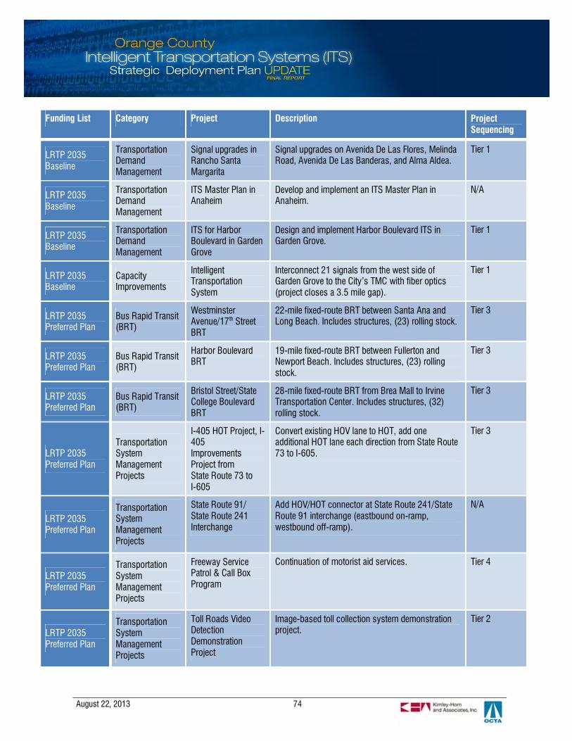
August 22, 2013 74
Funding List Category Project Description ProjectSequencing
LRTP 2035Baseline
TransportationDemandManagement
Signal upgrades inRancho SantaMargarita
Signal upgrades on Avenida De Las Flores, MelindaRoad, Avenida De Las Banderas, and Alma Aldea.
Tier 1
LRTP 2035Baseline
TransportationDemandManagement
ITS Master Plan inAnaheim
Develop and implement an ITS Master Plan inAnaheim.
N/A
LRTP 2035Baseline
TransportationDemandManagement
ITS for HarborBoulevard in GardenGrove
Design and implement Harbor Boulevard ITS inGarden Grove.
Tier 1
LRTP 2035Baseline
CapacityImprovements
IntelligentTransportationSystem
Interconnect 21 signals from the west side ofGarden Grove to the City’s TMC with fiber optics(project closes a 3.5 mile gap).
Tier 1
LRTP 2035Preferred Plan
Bus Rapid Transit(BRT)
WestminsterAvenue/17th StreetBRT
22-mile fixed-route BRT between Santa Ana andLong Beach. Includes structures, (23) rolling stock.
Tier 3
LRTP 2035Preferred Plan
Bus Rapid Transit(BRT)
Harbor BoulevardBRT
19-mile fixed-route BRT between Fullerton andNewport Beach. Includes structures, (23) rollingstock.
Tier 3
LRTP 2035Preferred Plan
Bus Rapid Transit(BRT)
Bristol Street/StateCollege BoulevardBRT
28-mile fixed-route BRT from Brea Mall to IrvineTransportation Center. Includes structures, (32)rolling stock.
Tier 3
LRTP 2035Preferred Plan
TransportationSystemManagementProjects
I-405 HOT Project, I-405ImprovementsProject fromState Route 73 toI-605
Convert existing HOV lane to HOT, add oneadditional HOT lane each direction from State Route73 to I-605.
Tier 3
LRTP 2035Preferred Plan
TransportationSystemManagementProjects
State Route 91/State Route 241Interchange
Add HOV/HOT connector at State Route 241/StateRoute 91 interchange (eastbound on-ramp,westbound off-ramp).
N/A
LRTP 2035Preferred Plan
TransportationSystemManagementProjects
Freeway ServicePatrol & Call BoxProgram
Continuation of motorist aid services. Tier 4
LRTP 2035Preferred Plan
TransportationSystemManagementProjects
Toll Roads VideoDetectionDemonstrationProject
Image-based toll collection system demonstrationproject.
Tier 2

August 22, 2013 75
Funding List Category Project Description ProjectSequencing
LRTP 2035Preferred Plan
TransportationDemandManagement
SignalSynchronizationProgram
Coordinate traffic signals in key corridors – 750-mile network with 2000 signals (includes localshare).
Tier 3
LRTP 2035Unconstrained
Bus Rapid Transit(BRT)
Katella Avenue BRT New BRT service between Long Beach and Orange. Tier 3
LRTP 2035Unconstrained
Bus Rapid Transit(BRT)
Edinger Avenue BRT New BRT service between Huntington Beach andTustin.
Tier 3
LRTP 2035Unconstrained
Bus Rapid Transit(BRT)
Beach BoulevardBRT
New BRT service between Huntington Beach and LaHabra.
Tier 3
LRTP 2035Unconstrained
Bus Rapid Transit(BRT)
La Palma AvenueBRT
New BRT service between Buena Park andAnaheim.
Tier 3
LRTP 2035Unconstrained
Bus Rapid Transit(BRT)
South County BRT New BRT service between Central Orange Countyand South Orange County (via Irvine CenterDrive/Moulton Parkway/ Golden Lantern).
Tier 3
LRTP 2035Unconstrained
Bus Rapid Transit(BRT)
Enhance BRTRoutes
Implement by pass lanes at intersections real-timepassenger information, transit signal priority, andstation improvements.
Tier 3
LRTP 2035Unconstrained
TransportationSystemManagementProjects
Toll CorridorsImprovements
Transportation Corridor Agencies - build-out of tollcorridors.
Tier 3
LRTP 2035Unconstrained
Capacity andSystems
Additional Arterialand IntersectionOptimization
Additional turn lanes, advanced traffic managementsystems, communications, improved lighting andsafety treatments on 9 arterials and at 60intersections identified in Central County MIS.
Tier 3
SCAG 2012 RTPPROJECT LIST Transit ORA 110632 and
ORA110634
1% transit enhancements – bicycle and pedestrianfacilities countywide (Mission Viejo) projects areconsistent with 40 CFR part 93.126 exempt Tables2 and Table 3 categories – bicycle and pedestrianfacilities (both motorized and non-motorized).
Tier 1
SCAG 2012 RTPPROJECT LIST Transit ORA080917
1% transit security projects (Mission Viejo). Transitdevelopment credits in FY09/10 for $21 & FY10/11for $21, FY11/12.
Tier 1
SCAG 2012 RTPPROJECT LIST Transit ORA080907
1% transit security projects (OCTA). Transitdevelopment credits in FY10/11 $96,747, inFY11/12 $94,245.
Tier 1
SCAG 2012 RTPPROJECT LIST Transit ORA080909 A project study for the City of Santa Ana – fixed
guideway system linking the Santa Ana regionalN/A

August 22, 2013 76
Funding List Category Project Description ProjectSequencing
transportation intermodal center to Harbor Blvd. inthe City of Garden Grove. Preliminary engineeringand environmental.
SCAG 2012 RTPPROJECT LIST
Transit ORA080908
A transit corridor for the City of Anaheim – AnaheimRapid Connection (ARC) fixed guideway systemlinking the Anaheim Regional TransportationIntermodal Center (ARTIC) to the platinum triangleto the Anaheim resort.Alternatives analysis, EIR/EIS, LPA and conceptualand advanced engineering, project developmentactivities and preliminary engineering.
N/A
SCAG 2012 RTPPROJECT LIST Transit VARIOUS
Various projects - Purchase of buses and relatedequipment, radios, computers, and/or ITSequipment on or supporting vehicles and relatedtransit programs.
Tier 1
SCAG 2012 RTPPROJECT LIST Transit VARIOUS
Various projects - purchase and upgrade of trains,tracks, platforms, safety equipment, and associatedequipment and/or ITS for Metrolink, ARTIC, ARC,and other local and regional rail and commuter railservices.
Tier 1
SCAG 2012 RTPPROJECT LIST
Transit ORA020812
Commuter rail crossing monitors upgrade and orinstall monitoring equipment at rail crossings inOrange County to provide notification in the event ofdamage or malfunction.
Tier 1
SCAG 2012 RTPPROJECT LIST
Transit ORA080903
Environmental clearance and advanced conceptualdesign of the California High Speed Rail Authority,high speed rail project from San Francisco to LosAngeles.
N/A
SCAG 2012 RTPPROJECT LIST
Transit ORA020113 Fullerton Train Station – parking structure, phase Iand II. Total of 800 spaces (PPNO 2026).
N/A
SCAG 2012 RTPPROJECT LIST Transit ORA081623
Fullerton Transportation Center – initial planning andconceptual engineering of the expansion for theFullerton transportation center.
N/A
SCAG 2012 RTPPROJECT LIST
Transit ORA112005 Implement bike stations and bike sharing programin Orange County.
Tier 3
SCAG 2012 RTPPROJECT LIST
Transit ORA110621 Intermodal park and ride facility at DiscoveryScience Center in Santa Ana.
N/A
SCAG 2012 RTPPROJECT LIST Transit ORA081622
Irvine Transit Station – expansion of the IrvineTransit Center (ITC). Initial planning and conceptualengineering phase.
N/A
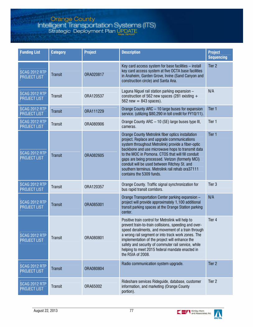
August 22, 2013 77
Funding List Category Project Description ProjectSequencing
SCAG 2012 RTPPROJECT LIST
Transit ORA020817
Key card access system for base facilities – installkey card access system at five OCTA base facilitiesin Anaheim, Garden Grove, Irvine (Sand Canyon andconstruction circle) and Santa Ana.
Tier 2
SCAG 2012 RTPPROJECT LIST Transit ORA120537
Laguna Niguel rail station parking expansion –construction of 562 new spaces (281 existing +562 new = 843 spaces).
N/A
SCAG 2012 RTPPROJECT LIST Transit ORA111229 Orange County ARC – 10 large buses for expansion
service. (utilizing $80,290 in toll credit for FY10/11).Tier 1
SCAG 2012 RTPPROJECT LIST Transit ORA080906 Orange County ARC – 10 (SE) large buses type III,
cameras.Tier 1
SCAG 2012 RTPPROJECT LIST
Transit ORA082605
Orange County Metrolink fiber optics installationproject. Replace and upgrade communicationssystem throughout Metrolink) provide a fiber-opticbackbone and use microwave hops to transmit datato the MOC in Pomona. CTOS that will fill conduitgaps are being processed. Verizon (formerly MCI)conduit will be used between Ritchey St. andsouthern terminus. Metrolink rail rehab ora37111contains the 5309 funds.
Tier 1
SCAG 2012 RTPPROJECT LIST
Transit ORA120357 Orange County. Traffic signal synchronization forbus rapid transit corridors.
Tier 3
SCAG 2012 RTPPROJECT LIST
Transit ORA085001
Orange Transportation Center parking expansion –project will provide approximately 1,100 additionaltransit parking spaces at the Orange Station parkingcenter.
N/A
SCAG 2012 RTPPROJECT LIST
Transit ORA080801
Positive train control for Metrolink will help toprevent train-to-train collisions, speeding and over-speed derailments, and movement of a train througha wrong rail segment or into track work zones. Theimplementation of the project will enhance thesafety and security of commuter rail service, whilehelping to meet 2015 federal mandate enacted inthe RSIA of 2008.
Tier 4
SCAG 2012 RTPPROJECT LIST
Transit ORA080804Radio communication system upgrade. Tier 2
SCAG 2012 RTPPROJECT LIST
Transit ORA65002Rideshare services Rideguide, database, customerinformation, and marketing (Orange Countyportion).
Tier 2

August 22, 2013 78
Funding List Category Project Description ProjectSequencing
SCAG 2012 RTPPROJECT LIST Transit ORA110613 Security surveillance and monitoring equipment for
transit.Tier 1
SCAG 2012 RTPPROJECT LIST
Transit ORA110625
Various planning and transportation projectsdetermined by the Orange County Council ofGovernments (OCCOG) to reduce congestion in OC,including smart growth and increased transit.
N/A
SCAG 2012 RTPPROJECT LIST
Transit ORA020814
Video surveillance system for base facilities – installvideo surveillance equipment at four OCTA basefacilities in Anaheim, Garden Grove, Irvine (SandCanyon and construction circle).
Tier 1
SCAG 2012 RTPPROJECT LIST
State Highway ORA020814 Various state highway projects that may or may notinclude ITS.
Tier 1
SCAG 2012 RTPPROJECT LIST State Highway ORA001102
Grouped projects for safety improvements – SHOPPcollision reduction program scope: projects areconsistent with 40 CFR part 93.126 exempt Tables2 and Table 3 categories – railroad/highwaycrossing, shoulder improvements, traffic controldevices, operations assistance intersectionsignalization projects pavement marking, lightingimprovements.
Tier 1
SCAG 2012 RTPPROJECT LIST State Highway ORA001108 AND
ORA001105
Grouped projects for safety improvements – SHOPPmandates program. Scope: projects are consistentwith 40 CFR part 93.126 exempt Tables 2 and Table3 categories – railroad/highway crossing, safernon-federal-aid system roads, shoulderimprovements, traffic control devices andoperations assistance other than signalizationprojects, lighting improvements.
Tier 1
SCAG 2012 RTPPROJECT LIST State Highway ORA040607 Orange County – countywide activities: planning,
programming and monitoring (PPM).N/A

August 22, 2013 79
Funding List Category Project Description ProjectSequencing
SCAG 2012 RTPPROJECT LIST
Local Highway ORA110603
Bikeway wayfinding signage – assess existingbikeway wayfinding signage citywide with focus onsignage in and around class I bikeways, majorinstitutions, city parks, recreational facilities,schools, and other publicly-owned assets. Producedetailed recommendations on placement and/orreplacement of signage to determine the 60locations for signage installation and/orreplacement. May or may not include ITS.
Tier 1
SCAG 2012 RTPPROJECT LIST Local Highway ORA02926
BNSF railway line (Kraemer Blvd. to Kellogg Dr.)along SS of Orangethorpe. Install supplementalsafety measures at 8 at-grade crossings (4.4miles).
Tier 1
SCAG 2012 RTPPROJECT LIST Local Highway ORA02925
BNSF railway line (Placentia) along SS ofOrangethorpe. Grade separation/corridorimprovements.
Tier 1
SCAG 2012 RTPPROJECT LIST
Local Highway VARIOUS Various local highway and roadway projects thatmay or may not include ITS.
Tier 1
SCAG 2012 RTPPROJECT LIST
Local Highway ORA100509 Design and implement Harbor Boulevard ITS inGarden Grove.
Tier 1
SCAG 2012 RTPPROJECT LIST
Local Highway ORA100508 Develop and implement an ITS Master Plan inAnaheim.
N/A
SCAG 2012 RTPPROJECT LIST
Local Highway ORA990906
Grouped projects for bicycle and pedestrianfacilities funded with TE – scope: projects areconsistent with 40CFR part 93.126 exempt Tables 2 and Table 3categories – bicycle and pedestrian facilities (bothmotorized andnon-motorized).
Tier 1
SCAG 2012 RTPPROJECT LIST
Local Highway ORA990907
Grouped projects for transportation enhancementactivities – projects are consistent with 40 cfr part93.126 exempt Tables 2 and Table 3 categories –transportation enhancement activities (exceptrehabilitation and operation of historic transportationbuildings, structures, or facilities).
Tier 1
SCAG 2012 RTPPROJECT LIST
Local Highway ORA102904 Image based toll collection system – demonstrationproject (ITS).
Tier 1
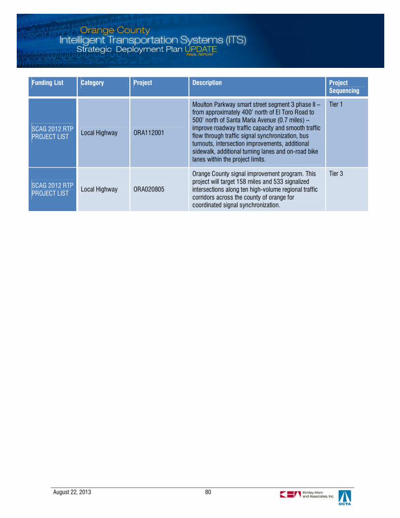
August 22, 2013 80
Funding List Category Project Description ProjectSequencing
SCAG 2012 RTPPROJECT LIST Local Highway ORA112001
Moulton Parkway smart street segment 3 phase II –from approximately 400’ north of El Toro Road to500’ north of Santa Maria Avenue (0.7 miles) –improve roadway traffic capacity and smooth trafficflow through traffic signal synchronization, busturnouts, intersection improvements, additionalsidewalk, additional turning lanes and on-road bikelanes within the project limits.
Tier 1
SCAG 2012 RTPPROJECT LIST
Local Highway ORA020805
Orange County signal improvement program. Thisproject will target 158 miles and 533 signalizedintersections along ten high-volume regional trafficcorridors across the county of orange forcoordinated signal synchronization.
Tier 3

August 22, 2013 81
6.2 Strategic ITS Projects
Additional projects representing ITS strategies that fulfill user and regional needs are listed in thesections below. These strategies support the deployment of the ITS SDP.
6.2.1 Transit Management and Multi-Modal
§ Integrated Transit Management (MM1): Short-term – continue deployment and integrationof ongoing transit management projects; complete ITMS implementation
§ Integrated Transit Management (MM1): Long-term – integrate ITMS with other systems§ Bus Rapid Transit (MM2): Short-term – Limited stop service on several key routes, reduce
number of stops to approximately ¾ of a mile between stops, reduce headways, andbranding
§ Bus Rapid Transit (MM2): Medium-term – Still being examined, might include TSP, web-based real-time arrival information for buses, and/or off-vehicle fare collection; additionalroutes will be examined.
§ Rail Operations and Enhancements (MM3): Short-term – continued rail operationssupported by technologies for safety, such as for positive train control, intersection safety,and operations
§ Rail Operations and Enhancements (MM3): Long-term – establish interface with PTCsystems to obtain train movements and schedule data for planning and operations
§ Integrated Payment (MM4): Short-term – currently being examined in Orange County incoordination with other southern CA agencies, an integrated, open payment method thatwould initially allow for transit payment
§ Integrated Payment (MM4): Medium to Long-term – expand contactless payment system toother transit operators in Orange County and to the rest of Southern California
§ Support for Pedestrian and Bicycle Travel (MM5): Ongoing/Short-term – local deploymentsof pedestrian and bicycle safety and information technologies; deploy a countywide bikesharing program
§ Support for Pedestrian and Bicycle Travel: (MM5) Long-term – integrate countywide bikesharing program with other regional bike sharing systems
§ Support to Commercial Vehicle Operations (CVO) (MM6): Pending – primarily privatelyled, CVO activities will be supported as needed in terms of technology
6.2.2 Traffic Management
Multi-Jurisdictional Arterial Traffic Management:
§ Continued Arterial Traffic Management (TM1): Ongoing/Short-term – continue to managearterials across the county and across jurisdictions; provide a foundation for advancedmanagement and strategies; provide access to more data for operations and planning
§ Continued Arterial Traffic Management (TM1): Short-term/Mid-term – develop aCountywide Communications Master Plan; develop a Countywide Arterial Detection MasterPlan; develop the framework for a countywide data exchange network.

August 22, 2013 82
§ Continued Freeway Traffic Management (TM2): Ongoing/Short-term – continue to managefreeway traffic through existing and future technology and operational procedures.
§ Migration to Grid-based Traffic Signal Synchronization (TM3): Short term – fund projectsthat optimize coordination on crossing arterials
§ Corridor Management Study (TM4): Short-term – Feasibility Assessment, stakeholderoutreach, project concept development
§ Corridor Management Pilot Project (TM4): Medium-term – select corridor segment to testthe concept, including the process of working through the details of the operational conceptand MOUs and any related agreements
§ Regional Coordination of Managed Lanes (TM5): Short-term/Medium-term – expansion ofthe 91 Express Lanes into Riverside County; continued operations of the 91 Express Lanes inOrange County; continued coordination with the southern California Value Pricing Study andpotential future facility developments on adjacent and related facilities (only as vetted withand approved by the Board)
6.2.3 Incident Management and Emergency Response
§ Freeway Service Patrol Management (IM1): Ongoing/Short-term – continue FSPmanagement and coordination; continue to improve on efficiencies through enhanced datasets for more efficient research and decision making
§ Emergency Vehicle Preemption Migration (IM2): Short-term – begin testing GPS-technology applications in select corridors; continue to expand the program geographicallywith additional cities and/or corridors throughout the county.
§ Emergency Vehicle Preemption Migration (IM2): Long-term – full migration to GPS-technology as transponders require replacement and future funding opportunities areidentified.
§ Arterial-based Incident Traffic Management (IM3): Short-term – further evaluation anddiscussion of the project concept or approach to implementing this strategy: approaches tobe considered include center-to-center based real-time coordinated response by multipleagencies (requires staffed TMCs/systems at each participating agency); pre-agreed-uponstrategies that a single agency deploys; or alternate approaches.
§ Arterial-based Incident Traffic Management (IM3) Medium-term – conceptual design ofthe program including geographic phasing. It is recommended to begin with a major corridorand later expand to additional corridors. Agreements among all involved parties will becrafted and executed at this stage prior to system start-up.
§ Arterial-based Incident Traffic Management (IM3): Long-term – deployment on a corridor-by-corridor basis along with further refinement and fine-tuning of response strategies andongoing performance evaluations.
6.2.4 Traveler Information
§ Continued Expansion of the Southern California 511 Program (TI1): Ongoing/Short-term –continued support of Southern California 511 expansion; continued progress towardproviding real-time transit information through Southern California 511 and other web-based

August 22, 2013 83
methods; continued support of improved integration and coordination between Inland Empire511 and Southern California 511; continued support of private market traveler informationofferings
§ Integrated and Localized Parking Guidance Short-term (TI2): Short-term – support oflocally-led PGS
§ Integrated and Localized Parking Guidance (TI2): Medium-term – define and develop aregional PGS for rail and park-and-ride facilities.
6.2.5 Performance Monitoring
§ Countywide Performance Monitoring Short-term (PM1): Short-term – project conceptdefinition and systems engineering; should be done in parallel with the countywidecommunications master plan
§ Countywide Performance Monitoring (PM2): Medium-term – detailed design, development,and integration; construction/deployment of needed field equipment
§ Countywide Performance Monitoring (PM3): Long-term – deployment, operations fine-tuning, training, and ongoing improvements
6.2.6 Communications and Connectivity
§ Countywide Communications Master Plan (CC1): Short-term – identify physical and logicalconnectivity to support multi-modal and multi-agency operations and data sharing needs.
§ Countywide Connectivity Master Plan (CC2): Medium-term – design a method of datasharing across the county for traffic, transit, non-motorized, operations, and planning data.
§ Provide a Connected Vehicles Platform (CC3): Pending – allow for the future possibility ofconnected vehicles in order to capitalize on the robust local operational environment andfurther enhance the existing foundation
6.2.7 Safety
§ Bicycle Detection (SF1): Ongoing/Short-term – support local implementation of bicycledetection technologies at critical intersections and near bicycle and transit hubs
§ Pedestrian Detection (SF2): Ongoing/Short-term – support local implementation of bicycledetection technologies at critical intersections and near bicycle and transit hubs
§ Transit Safety (SF3): Ongoing/Short-term – continue ITMS implementation (refer to MM1)§ Telematics (SF4): Pending – provide a Connected Vehicles platform that alerts motorists of
bicycles and pedestrians in the surrounding environment (refer to CC3)
6.2.8 Institutional
§ Continuously Improve Staffing Levels and Skillsets (IN1): Short-term – evaluate prioritytechnical training needs and available mechanisms to develop and deliver; establish atraining plan that outlines potential resources to develop or support training; and work toestablish training as a specific project or program that could potentially be eligible for funding
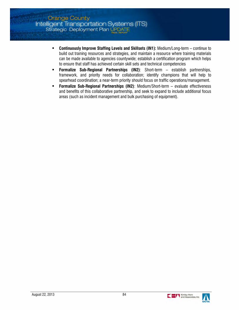
August 22, 2013 84
§ Continuously Improve Staffing Levels and Skillsets (IN1): Medium/Long-term – continue tobuild out training resources and strategies, and maintain a resource where training materialscan be made available to agencies countywide; establish a certification program which helpsto ensure that staff has achieved certain skill sets and technical competencies
§ Formalize Sub-Regional Partnerships (IN2): Short-term – establish partnerships,framework, and priority needs for collaboration; identify champions that will help tospearhead coordination; a near-term priority should focus on traffic operations/management.
§ Formalize Sub-Regional Partnerships (IN2): Medium/Short-term – evaluate effectivenessand benefits of this collaborative partnership, and seek to expand to include additional focusareas (such as incident management and bulk purchasing of equipment).

August 22, 2013 85
7. REGIONAL COMMUNICATIONS AND INTEGRATION
The previous sections describe a series of ITS strategies and projects likely to be deployed over the next tenyears around the county. Communications infrastructure (wireless, hardwire, fiber, and data exchange) formsthe foundation to support these intended programs. This section examines, at a high level, the functionalscope and geographic coverage of the ITS communications infrastructure throughout the county. Theassessment looks at how multi-agency systems can be leveraged to support a county-wide system thatserves future ITS needs and the vision for greater coordination and integration of local and regional operations.Further analysis and the technical details of the future communication network will be analyzed and definedmore specifically in a subsequent, in depth communications master plan study (separate from this study)along with preliminary estimates of construction costs and phasing/deployment opportunities.
7.1 Communication Infrastructure Review
Through OCTA funded programs and local initiatives, traffic system communications are widelydeployed across the regional arterial network. Through June 2012, the Master Plan of Arterial Highways(MPAH) has 1,463 center line miles built of which, over 40% was covered by twisted pair or fiber-opticinterconnect. Figure 3 provides an overall depiction of the communications coverage on the MPAHnetwork.
The following findings summarize the characteristics and make-up of the communicationsinfrastructure in the county:
§ Twisted pair signal interconnect cable remains the most widely used medium for center-to-fieldcommunications.
§ Agencies that use higher bandwidth single mode fiber-optic (SMFO) cable are concentrated in thenorth and central areas of the county. In the south, Mission Viejo has the greatest coverage offiber in its infrastructure.
§ Wireless technologies are used for last-mile communications to signals located in the periphery.Wireless technologies are primarily deployed in Fullerton and Orange, due to some topologicalfeatures that are less favorable for wired interconnect.
§ Most agencies employ distributed networks so that communications is not focused on acentralized location. The communications infrastructure is distributed at key locations throughoutthe network at hub locations that aggregate connections with field devices. This configurationreduces the impact of losing any single point of communications, resulting in a greater faulttolerance.
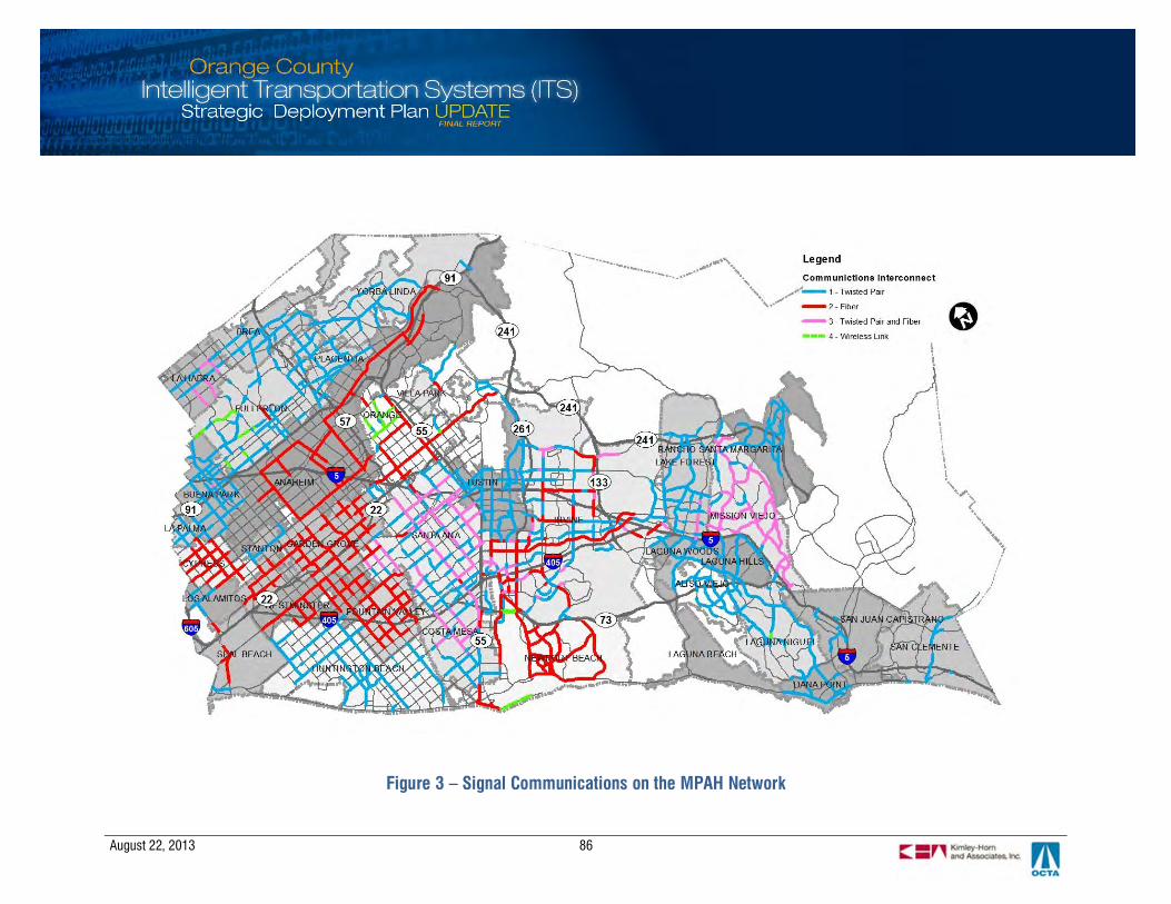
August 22, 2013 86
Figure 3 – Signal Communications on the MPAH Network

August 22, 2013 87
7.2 Opportunities and Challenges to Countywide Integration
The ability to meet future ITS needs starts with a robust communications infrastructure that can expandand evolve with technology. Communication technologies and architecture choices affect a region’sability to keep up with advances in traveler information and active traffic management. As OrangeCounty looks to the next decade of technology deployment in an environment that enables local,regional, and privately-led initiatives, the communications infrastructure choices will become even morecritical to operating a cost-effective transportation system for travelers. This section discussesapproaches for positioning the infrastructure to support greater integration, interoperability andscalability.
7.2.1 System Architectures
An open standard system is defined as a central system architecture that is specifically designedto interface with equipment provided by multiple suppliers. It is provided by a vendor/firm thatdoes not require the owner to purchase firmware or hardware from a single source. Opensystems could encourage agencies to implement projects that use interoperable components andmultiple vendors. With an open system, if a field device vendor stops supporting a particularproduct or it becomes more expensive, it can be replaced by another open standard productwithout wholesale system replacement. The flexibility of an open standard system preservesinitial investments.
The following summarize key benefits of an open system:
§ Agencies are able to procure field device from multiple vendors, thereby offering morecompetitive pricing.
§ Different field devices can be supported including those based on emerging technologies.§ Low risk implementation because open systems, by definition, require adherence to
published protocol standards for interoperability. Software development follows publishedstandards and protocols including AB3418E and NTCIP. This allows for easier futureintegration with other systems or modules.
§ Enables the agency to have separation of hardware and software at the field device level.Multiple-vendor hardware and different field device firmware can be supported. This is abenefit for large agencies that require different functionality at different locations.
§ Permits addition of new agencies and new device classes, granted they adhere to standard,thus promoting expansion and incorporation of new technologies.
The upside to open systems is the compatibility with non-vendor specific components, whichmeans lower integration and replacement costs, especially when aggregated across the County.Open systems allow for devices to be interchanged, supporting software and protocols that makeit easier and less costly to integrate field devices from multiple vendors.
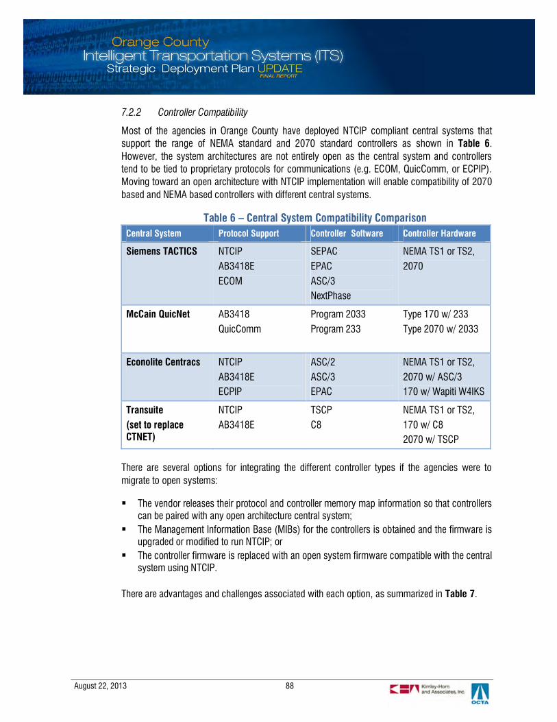
August 22, 2013 88
7.2.2 Controller Compatibility
Most of the agencies in Orange County have deployed NTCIP compliant central systems thatsupport the range of NEMA standard and 2070 standard controllers as shown in Table 6.However, the system architectures are not entirely open as the central system and controllerstend to be tied to proprietary protocols for communications (e.g. ECOM, QuicComm, or ECPIP).Moving toward an open architecture with NTCIP implementation will enable compatibility of 2070based and NEMA based controllers with different central systems.
Table 6 – Central System Compatibility ComparisonCentral System Protocol Support Controller Software Controller Hardware
Siemens TACTICS NTCIPAB3418EECOM
SEPACEPACASC/3NextPhase
NEMA TS1 or TS2,2070
McCain QuicNet AB3418QuicComm
Program 2033Program 233
Type 170 w/ 233Type 2070 w/ 2033
Econolite Centracs NTCIPAB3418EECPIP
ASC/2ASC/3EPAC
NEMA TS1 or TS2,2070 w/ ASC/3170 w/ Wapiti W4IKS
Transuite(set to replaceCTNET)
NTCIPAB3418E
TSCPC8
NEMA TS1 or TS2,170 w/ C82070 w/ TSCP
There are several options for integrating the different controller types if the agencies were tomigrate to open systems:
§ The vendor releases their protocol and controller memory map information so that controllerscan be paired with any open architecture central system;
§ The Management Information Base (MIBs) for the controllers is obtained and the firmware isupgraded or modified to run NTCIP; or
§ The controller firmware is replaced with an open system firmware compatible with the centralsystem using NTCIP.
There are advantages and challenges associated with each option, as summarized in Table 7.
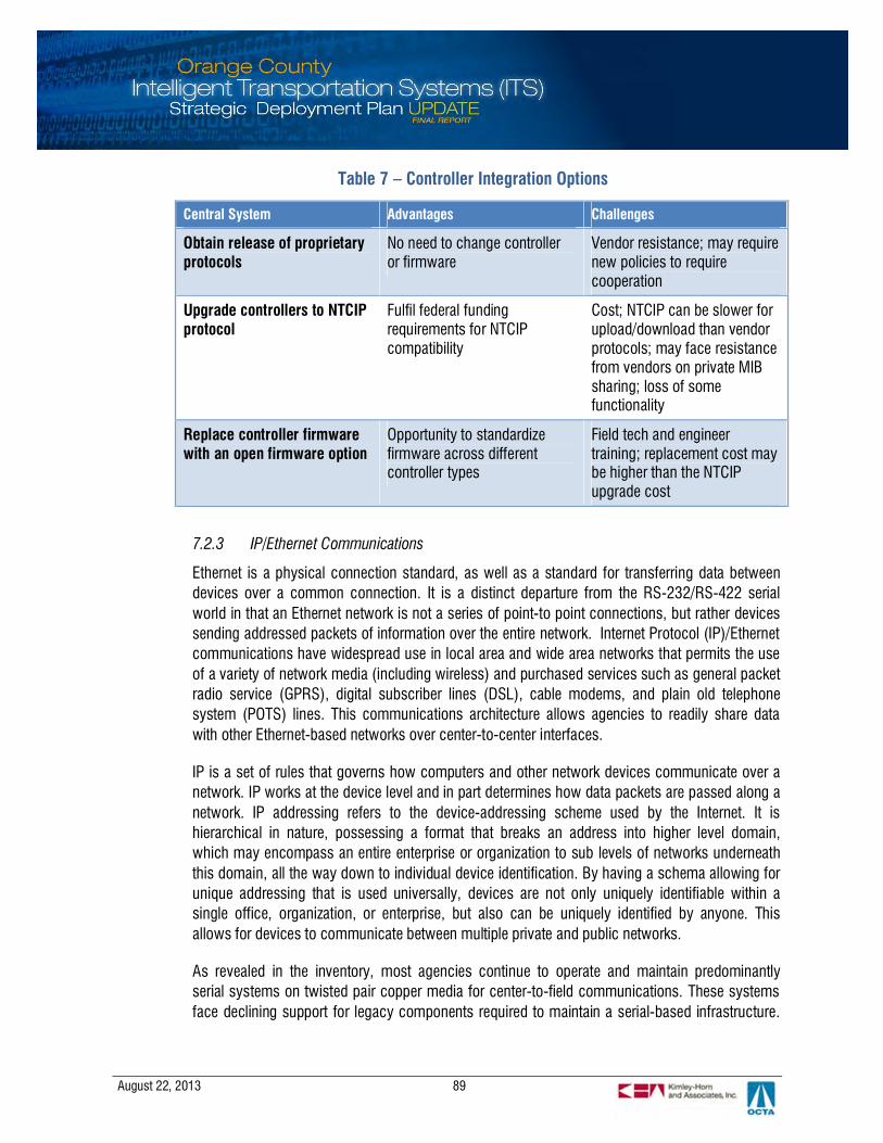
August 22, 2013 89
Table 7 – Controller Integration Options
7.2.3 IP/Ethernet Communications
Ethernet is a physical connection standard, as well as a standard for transferring data betweendevices over a common connection. It is a distinct departure from the RS-232/RS-422 serialworld in that an Ethernet network is not a series of point-to point connections, but rather devicessending addressed packets of information over the entire network. Internet Protocol (IP)/Ethernetcommunications have widespread use in local area and wide area networks that permits the useof a variety of network media (including wireless) and purchased services such as general packetradio service (GPRS), digital subscriber lines (DSL), cable modems, and plain old telephonesystem (POTS) lines. This communications architecture allows agencies to readily share datawith other Ethernet-based networks over center-to-center interfaces.
IP is a set of rules that governs how computers and other network devices communicate over anetwork. IP works at the device level and in part determines how data packets are passed along anetwork. IP addressing refers to the device-addressing scheme used by the Internet. It ishierarchical in nature, possessing a format that breaks an address into higher level domain,which may encompass an entire enterprise or organization to sub levels of networks underneaththis domain, all the way down to individual device identification. By having a schema allowing forunique addressing that is used universally, devices are not only uniquely identifiable within asingle office, organization, or enterprise, but also can be uniquely identified by anyone. Thisallows for devices to communicate between multiple private and public networks.
As revealed in the inventory, most agencies continue to operate and maintain predominantlyserial systems on twisted pair copper media for center-to-field communications. These systemsface declining support for legacy components required to maintain a serial-based infrastructure.
Central System Advantages Challenges
Obtain release of proprietaryprotocols
No need to change controlleror firmware
Vendor resistance; may requirenew policies to requirecooperation
Upgrade controllers to NTCIPprotocol
Fulfil federal fundingrequirements for NTCIPcompatibility
Cost; NTCIP can be slower forupload/download than vendorprotocols; may face resistancefrom vendors on private MIBsharing; loss of somefunctionality
Replace controller firmwarewith an open firmware option
Opportunity to standardizefirmware across differentcontroller types
Field tech and engineertraining; replacement cost maybe higher than the NTCIPupgrade cost
August 22, 2013 90
Moreover, serial communications lack scalability to integrate new devices/technologies in areliable and flexible manner. These systems also lack the capacity to support bandwidth intensiveapplications such as expanded CCTV coverage, adaptive signal operations, future travelerinformation services and performance measurement. The use of IP-based technologies overtwisted pair copper cable is gaining adoption and if used over short distances, provides a viable“last-mile” solution.
The following are key considerations for agencies to migrate their systems to IP/Ethernetcommunications:
§ Local systems will need capacity and scalability to support bandwidth intensive applicationssuch as video surveillance, adaptive signal operations, traveler information services andperformance measurement.
§ Older systems will face declining support for legacy components required to maintain aserial-based infrastructure. Manufacturers of ITS devices have largely migrated to productionof IP-based products.
§ An IP/Ethernet enterprise supports interoperability standards that provide flexibility to use ITSdevices from different manufacturers. By avoiding proprietary technologies, agencies canprocure products and services more competitively from multiple vendors.
§ Use of IP/Ethernet networking permits the sharing of ITS networks with other enterprisenetworks.
§ Reliable communications between central and field is mission critical to traffic managementand public safety. Network monitoring tools are available that provide an effective andefficient approach to identifying, troubleshooting and correcting/repairing system faults forIP/Ethernet networks. The network can also be configured in a ring or mesh topology for datapath redundancy. This provides for greater fault tolerance that reduces the susceptibility todisruptions from a single communication link failure.
7.2.4 National Transportation Communications for ITS Protocol (NTCIP)
Interchangeability has largely been an elusive goal for the traffic signal industry. NEMA controllershave long had proprietary features to set them apart from competitors and have communicatedusing proprietary protocols. As a result, vendors were able to lock-in customers to their products.This has also been true with ATMS packages used to manage signal systems. With fewexceptions, these software packages require controllers by the same vendor to realize their fullfunctionality. The 170 and 2070 standards have separated controller software from the controllerhardware, but the central software vendor still needs to be paired with the controller softwarevendor for full functionality.
The development effort behind NTCIP sought to provide true interchangeability. The goal of NTCIPwas to ensure all NEMA controllers were interchangeable, helping agencies to avoid the vendorlock-in that was common in the industry. To ensure a smooth transition from proprietarystandards, NTCIP standard objects must first be defined through a protocol requirements list.This process reviews device objects and identifies required and optional objects to maximize

August 22, 2013 91
local controller software functionality and interoperability amongst existing and newly deployedcontroller software with the central system software.
Within the Orange County ITS Roundtable group, agencies are discussing the idea of developingan NTCIP specification for Orange County to standardize center-to-field and center-to-centercommunications. Agencies would be able to mandate vendors to provide products that arecompatible with the NTCIP specification defined for the range of ITS devices in use. Withinteroperable devices, agencies could benefit from increased market competition and costsavings from ease of integration and replacement. The definition of the regional NTCIPspecification requires close coordination to define data elements and data messages for eachdevice type; any agency specific elements would be shared with others and incorporated into theregional specification.
7.2.5 Caltrans Fiber
Caltrans has implemented a fiber communications system with IP/Ethernet-based equipment. Atthe heart of the communications system is the TMC, where incidents and events are monitored24 hours a day, seven days a week. Caltrans operations personnel and CHP are collocated at theTMC. All communications and control with the ITS devices on the freeways and toll roads areperformed at the TMC. The field devices are connected to the TMC over fiber, including CCTVcameras, changeable message signs, ramp meters, traffic monitoring stations, and controllers.
The communications system features an IP/Ethernet network with the TMC and fieldcommunications hubs connected using fiber optics, as shown in Figure 4. The system has anetwork of Ethernet switches including a core switch at the TMC, distribution switches in thehubs, and field switches in the field device cabinets. The system was designed not only for faulttolerance and minimal network latency, but also for significant expansion with the ability toaccommodate additional field devices and hubs. Other elements of the system include multiplelevels of physical plant and equipment redundancy, use of Layer 2 and Layer 3 routing protocols,an integrated link with Caltrans’ statewide ATMS control system, and a connection to a videomatrix switch.
A key aspect in the design of this system is the possibility for future system expansion to supportan information sharing network that could include various local and regional agency systems inthe county. Since the network is IP/Ethernet, the system has the capability for Caltrans to sharevideo and data with other agencies and for agencies to utilize the Caltrans backbone to share datawith each other. The dispersion of multiple communication hubs throughout the county providesnumerous access points to connect local systems to the Caltrans backbone.
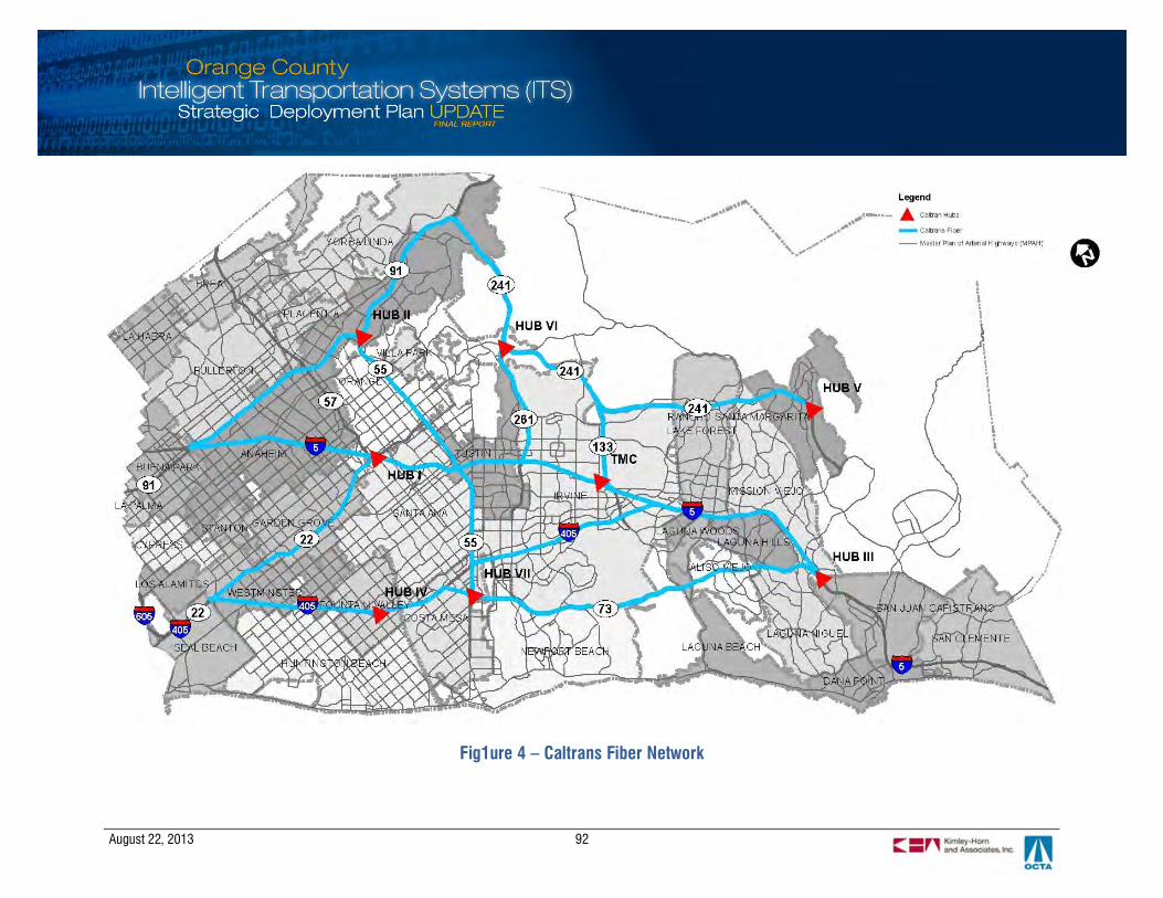
August 22, 2013 92
Fig1ure 4 – Caltrans Fiber Network

August 22, 2013 93
8. PERFORMANCE MONITORING AND REPORTING PLAN
Performance measurement helps to ensure that the benefits of ITS investments are quantified and operationsare optimized to the greatest extent possible. Agencies that monitor performance can demonstrate to decision-makers and taxpayers that their dollars are being spent wisely.A countywide performance monitoring program will establish abaseline understanding of how well the transportation systemperforms, from which performance data can drive decisions onhow operations and ITS investments can be strategicallyleveraged to maximize efficiency.
This section describes how the ITS SDP supports theimplementation of a regional performance monitoring programto serve performance-based objectives. An approach isoutlined for leveraging ITS programs and resources todetermine system performance across travel modes and tomeasure the effectiveness of specific investments in ITSinfrastructure improvements and operations.
8.1 State of the Practice
Many Federal, state and local transportation agencies are using performance measures to assessprogram performance towards goals. State transportation agencies such as Caltrans, Minnesota DOT,Ohio DOT, Missouri DOT, Georgia DOT, and Washington State DOT are well regarded for having robustmeasures of roadway performance and asset management to support the agency’s comprehensivereporting tools. The Washington State DOT, publishes its quarterly “Gray Notebook”, to provide in-depthreports on agency and transportation system performance to decision makers and the public. InCalifornia, the Freeway Performance Measurement System (PeMS) is a leading edge tool developedjointly by Caltrans and the University of California; traffic data is collected automatically from loopdetectors or radar detection devices throughout the freeway system and transmitted to PeMS from theCaltrans district traffic management centers.
8.2 Applicability to Orange County
Orange County agencies currently monitor system performance through a variety of publications andprograms:
§ OCTA publishes performance data on regional mobility in the LRTP every four years and theCongestion Management Program (CMP) every two years
§ The OCTA website publishes detailed outcomes that track operational performance for the TransitDivision on a quarterly basis
§ Local agencies evaluate signal timing improvement effectiveness using Before and After studies.
August 22, 2013 94
§ The Corridor Synchronization Performance Index (CSPI) can be used to evaluate signal timingimprovements using average speed, ratio of greens to red and the number of stops.
§ OCTA monitors the FSP program on an annual basis in order to redistribute FSP beats§ OCTA collects intersection, pedestrian and bicycle counts, as well as Synchro networks for
Project P§ OCTA conducts annual traffic and revenue studies for the 91 Express Lanes§ Caltrans currently monitors freeway performance, HOV lane performance, and equipment reliability
(detectors operational, CCTV cameras operational, etc.)§ Caltrans has deployed the Traffic Management Center Performance Evaluation (TMCPE) Module
application in District 12 to evaluate the value of TMC operations in reducing traffic delay fromfreeway incidents.
§ LA SAFE uses Google Analytics and other custom tools to monitor usage and reliability of the 511system for the region (including for the Orange County portion)
A regional performance monitoring program will help establish a baseline understanding of how well theregional transportation system is performing from a multi-modal standpoint. The data can then helpOCTA and its partners make strategic decisions on how to optimize operations and leverage ITSinvestments to maximize system efficiency and demonstrate mobility gains and benefits to the public.The performance monitoring strategy is based on improved, reduced cost data collection and expandedreporting capabilities that transitions away from annual manual reporting (the most common frequency)to a dynamic, real-time system with the resultant data integrated into a single, searchable front end.Data that reflects fluctuations in daily and seasonal trafficare essential for the next steps for more advancedoperational strategies that are dependent on granular, real-time data. In addition, crowd-sourced data (data frommultiple private traveler sources such as through Bluetooth,GPS, and/or triangulation of cell phones) can provideanother valuable, deep source of travel speed and traveltime information at relatively low additional costs.
Three keys to developing a robust performance monitoringsystem for Orange County are: 1. leveraging existingassets, 2. deploying new technologies to fill data gaps, and3. pursuing integration opportunities to share and distributeinformation. Most of the infrastructure is already in place onfreeways, HOV lanes, and express lanes. Extensivedeployment of arterial traffic systems throughout OrangeCounty provides a strong foundation for the arterial portions. Many of these systems have detectorsand communications to collect and transmit data. In addition, technologies such as Bluetooth andcrowd-sourced data can be used to complete detection gaps and collect end-to-end travel data. A richarray of transit data is already being collected and integrated into a system with more real-time data
August 22, 2013 95
and one that integrates data from the on-board fare collection and AVL systems into a single,sophisticated GIS database system end for enhanced analysis and reporting.
Over the long-term, the program is envisioned to support more frequent and timely performancemonitoring and reporting by transitioning towards a fully automated system that integrates various datasources – freeway and arterial operations; transit management systems; and 511 traveler informationservices. The objective is to build upon existing capabilities and infrastructure investments whileleveraging new technologies and integration opportunities. The end result is a performance monitoringprogram that accounts for all aspects of operations, planning and staffing in determining the overallperformance of the ITS program.
Table 8 summarizes the performance monitoring strategy described above in a phased approach.
Table 8 – Performance Monitoring Phased ApproachCategory Phased Approach
Data collection infrastructure Short-term: Supplement arterial data collected frommanual counts using system detectors and vehicleprobe data from transit vehicles or crowd sourcing;
Mid-term: Mainstream deployment of detectiondevices and/or an automated central system that canaccess and utilize multiple data sources to automatedata collection, thereby reducing the burden on staffresources and creating a source of continuous data tosupport operations
Long-term: Fully integrate work zone, Freeway ServicePatrol beats, and other longer term services andmodes into the process.
Central system data fusion and processing Mid-term: Integrate multi-modal sources of real-timeperformance data – local arterials, freeways, bustransit and rail; develop an archived data managementsystem that transform data inputs into analytics;
Long-term: Develop dashboard capabilities toautomate reporting; provide the ability to individualizedreports depending on user or function –arterial/highway operations; transit operations; safety;and long-range planning
August 22, 2013 96
8.3 Proposed Performance Measures
Table 9 below maps OCTA’s strategic goals and objectives achievable through investment in ITS andthe performance measures to evaluate the effectiveness of those investments. The performancemeasures serve agency goals in the following ways:
§ Mobility: Performance measures that evaluate goals and objectives to improve mobility aretargeted at local agencies and staff, who benefit from detailed, technical data to evaluate theoperational improvements from signal synchronization and transit priority projects.
§ Public Service: Performance measures that evaluate goals and objectives to improve publicservice are focused on translating the detailed, traffic or transit performance data into terms thatare readily understood from the perspective of a commuter or transit user as a member of ageneral public.
§ Fiscal Sustainability, Stewardship and Organizational Excellence: Performance measures thatevaluate goals and objectives related to fiscal sustainability is the focus of policy makers. Thesemeasures compare the dollar investments in project implementation with the quantified benefitsfrom the operations and maintenance of those ITS systems or technologies.
Table 9 – Proposed Performance MeasuresGoal Objectives Measures of Effectiveness (MOEs)
Mobility § Travel Time and Speed
§ Capacity and Level of Service
§ Operational Performance
§ Quality and Ease of Use
§ Arterial/Highway corridor travel time,delay and average speed
§ Transit route travel time, delay andaverage speed
§ Corridor SynchronizationPerformance Index (CSPI): averagespeed; greens to red; and number ofstops
§ Vehicle throughput on key corridors
§ Transit ridership
Public Service § Public Awareness and Perception
§ Customer Satisfaction
§ Community Engagement
§ Collaborative Planning
§ Travel time reliability
§ Travel time reduction§ Corridor Synchronization
Performance Index (CSPI)§ Travel time savings (dollar
equivalent)
§ Transit vehicle on-time performance
§ Transit passenger complaints
§ 511 traveler information usage
§ Freeway Service Patrol usage§ Freeway Service Patrol vehicle
performance

August 22, 2013 97
Goal Objectives Measures of Effectiveness (MOEs)
Fiscal Sustainability,Stewardship, andOrganizationalExcellence
§ Financial Management
§ Efficient Operations
§ External Funding Maximized
§ Investment Protection
§ Return on Investment (ROI)
§ Cost to Benefit Ratio
§ Fare box recovery ratio
§ Transit vehicle service calls
§ Communication up-time
§ Hardware rate of failure
§ Reduction in fuel consumption
§ Reduction in tail pipe emissions
8.4 Data Needs
Performance measurement involves a layered approach that transforms raw data into meaningfulinformation from which the end user can analyze and interpret the results to make determinations as tohow the system is performing. Data needs for measures of effectiveness (MOEs) are identified in Table10. The MOEs are organized into two tiers: Tier 1 MOEs relate to mobility indicators such as travel time,delay and reliability can be analyzed directly from the data for systems management operations andanalysis while the Tier 2 MOEs equate those outcomes with dollar savings and benefits-to-costequivalents. The Tier 2 MOEs cross-cut many of the functional areas of the ITS program and aretargeted at the public and decision makers.
Table 10 – Data NeedsFunctional Area Data Inputs Tier 1 (MOEs) Tier 2 (MOEs)
§ Arterial systemperformance
§ Manual vehicle counts
§ Manual travel time runs§ Vehicle re-identification
(Bluetooth, magnetometers)§ Crowd-sourced data (INRIX,
TomTom, Navteq)§ Hi-resolution phase timing
and detector data
§ Corridor travel time, delayand average speed
§ Travel time reliability
§ Travel time reduction
§ Vehicle throughput on keycorridors
§ Corridor SynchronizationPerformance Index (CSPI)
§ Reduction in fuelconsumption
§ Reduction in tail pipeemissions
§ Travel time savings (dollarequivalent)
§ Return on Investment (ROI)
§ Cost to Benefit Ratio
§ Highway systemperformance
§ PeMS loop detector data§ Vehicle re-identification
technology (Bluetooth,magnetometers)
§ Crowd-sourced data (INRIX,TomTom, Navteq)
§ Corridor travel time, delayand average speed
§ Travel time reliability
§ Travel time reduction
§ Vehicle throughput on keycorridors
§ Travel time savings (dollarequivalent)
§ Return on Investment (ROI)
§ Cost to Benefit Ratio
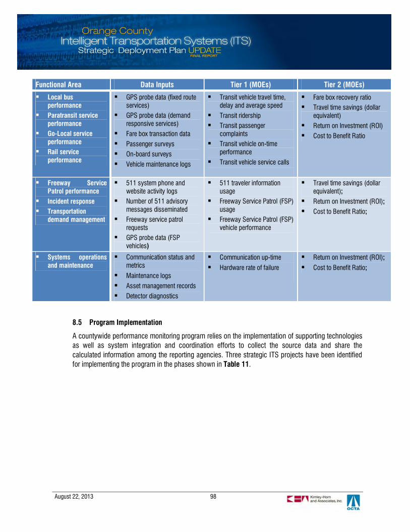
August 22, 2013 98
Functional Area Data Inputs Tier 1 (MOEs) Tier 2 (MOEs)
§ Local busperformance
§ Paratransit serviceperformance
§ Go-Local serviceperformance
§ Rail serviceperformance
§ GPS probe data (fixed routeservices)
§ GPS probe data (demandresponsive services)
§ Fare box transaction data
§ Passenger surveys
§ On-board surveys
§ Vehicle maintenance logs
§ Transit vehicle travel time,delay and average speed
§ Transit ridership§ Transit passenger
complaints§ Transit vehicle on-time
performance
§ Transit vehicle service calls
§ Fare box recovery ratio§ Travel time savings (dollar
equivalent)
§ Return on Investment (ROI)
§ Cost to Benefit Ratio
§ Freeway ServicePatrol performance
§ Incident response§ Transportation
demand management
§ 511 system phone andwebsite activity logs
§ Number of 511 advisorymessages disseminated
§ Freeway service patrolrequests
§ GPS probe data (FSPvehicles)
§ 511 traveler informationusage
§ Freeway Service Patrol (FSP)usage
§ Freeway Service Patrol (FSP)vehicle performance
§ Travel time savings (dollarequivalent);
§ Return on Investment (ROI);§ Cost to Benefit Ratio;
§ Systems operationsand maintenance
§ Communication status andmetrics
§ Maintenance logs
§ Asset management records
§ Detector diagnostics
§ Communication up-time
§ Hardware rate of failure
§ Return on Investment (ROI);
§ Cost to Benefit Ratio;
8.5 Program Implementation
A countywide performance monitoring program relies on the implementation of supporting technologiesas well as system integration and coordination efforts to collect the source data and share thecalculated information among the reporting agencies. Three strategic ITS projects have been identifiedfor implementing the program in the phases shown in Table 11.

August 22, 2013 99
Table 11 – Performance Monitoring Program DeploymentStrategy Phase Objectives
CountywidePerformanceMonitoring
Short-term § Conduct a systems engineering analysis to determine projectrisk and subsequent systems engineering effort
§ Describe how the performance monitoring system works at ahigh-level concept
§ Define user needs and requirements
§ Conduct feasibility assessment
§ Evaluate system alternatives
CountywidePerformanceMonitoring
Mid-term § Develop system concept of operations
§ Develop functional requirements§ Develop bid package to procure field equipment that meet
functional requirements
§ Develop bid package to procure a system integrator§ Develop acceptance test plans to certify system for
deployment
CountywidePerformanceMonitoring
Long-term § Define MOEs
§ Define analytics to calculate MOEs from source data§ Develop countywide standards to evaluate before and after
conditions
§ Develop countywide standards to evaluate travel conditions ona continual basis
§ Develop dashboard application tools to summarize MOEsacross different modes, geographic extents and facilities
§ Develop interagency agreements that identify roles andresponsibilities for data collection and reporting
CountywideCommunicationsMaster Plan
Short-term § Identify system detection gaps
§ Identify communication gaps
§ Develop options for completing last-mile communications
§ Develop options for completing detection coverage§ Develop a data exchange network to transmit, fuse and
archive various data sources
CountywideConnectivityMaster Plan
Mid-term § Address detection technologies in a future regional NTCIPspecification to standardize data transmission for field-to-center communications
§ Address center-to-center data transmission in a futureregional NTCIP specification to standardize data distributionand sharing
§ Define interfaces to obtain data from system detectors andsources of probe data using web connection services or filetransfers

August 22, 2013 100
9. PHASED DEPLOYMENT PLAN
OCTA, in partnership with the cities, County of Orange and Caltrans, has embraced ITS in achieving advancesin multi-jurisdictional arterial traffic management, development of a robust freeway management infrastructureand effective use of technology in transit operations. These projects and programs have set the foundation foradvancing towards integrated transportation management and multi-agency coordination that have a regionalfocus. This ITS SDP have identified strategies and projects to realize OCTA’s vision and position the region foropportunities to deploy emerging technologies that have the potential to improve mobility, safety and efficiencyon a multi-modal transportation system.
The ITS strategies constitute critical actions to guide project development and implementation efforts in thenext decade to support OCTA’s mission in its LRTP to deliver an effective transportation system. This sectionoutlines a roadmap for implementing the strategies over a ten-year timeline in an approach that phases theseactions in logical order by identifying the interconnections between strategies that may take place in sequentialorder or in parallel. For example, regional arterial traffic management requires communications masterplanning and arterial detection deployment before integrated systems can provide data sharing capabilities tosupport coordinated traffic operations and performance monitoring at the regional level.
Figure 5 illustrates the deployment plan for implementing the strategies proposed in this ITS SDP. The timelineis organizes the deployment of the twenty-two ITS strategies described in Section 5 into three distinct timeframes.
§ Short-term: these strategies and projects are taking place now or within three years;§ Medium-term: these strategies and projects would take place between 3 to 5 years from now; and§ Long-term: these strategies and projects would take place between 5 to 10 years from now.
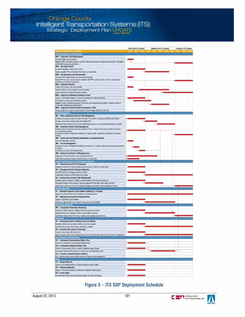
August 22, 2013 101
Figure 5 – ITS SDP Deployment Schedule


August 22, 2013
Appendix A: Regional ITS Architecture – Stakeholders
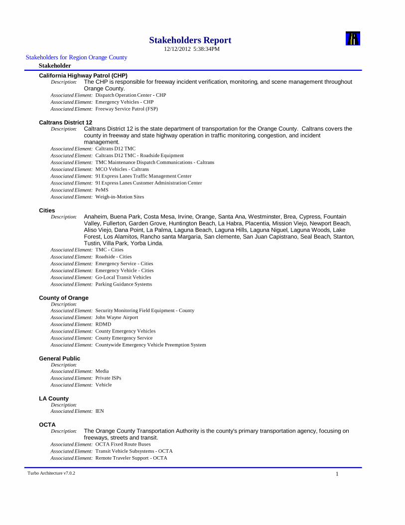
Stakeholders Report 5:38:34PM12/12/2012
StakeholderStakeholders for Region Orange County
California Highway Patrol (CHP)The CHP is responsible for freeway incident verification, monitoring, and scene management throughoutOrange County.
Description:
Associated Element: Dispatch Operation Center - CHPAssociated Element: Emergency Vehicles - CHPAssociated Element: Freeway Service Patrol (FSP)
Caltrans District 12Caltrans District 12 is the state department of transportation for the Orange County. Caltrans covers thecounty in freeway and state highway operation in traffic monitoring, congestion, and incidentmanagement.
Description:
Associated Element: Caltrans D12 TMCAssociated Element: Caltrans D12 TMC - Roadside EquipmentAssociated Element: TMC Maintenance Dispatch Communications - CaltransAssociated Element: MCO Vehicles - CaltransAssociated Element: 91 Express Lanes Traffic Management CenterAssociated Element: 91 Express Lanes Customer Administration CenterAssociated Element: PeMSAssociated Element: Weigh-in-Motion Sites
CitiesAnaheim, Buena Park, Costa Mesa, Irvine, Orange, Santa Ana, Westminster, Brea, Cypress, FountainValley, Fullerton, Garden Grove, Huntington Beach, La Habra, Placentia, Mission Viejo, Newport Beach,Aliso Viejo, Dana Point, La Palma, Laguna Beach, Laguna Hills, Laguna Niguel, Laguna Woods, LakeForest, Los Alamitos, Rancho santa Margaria, San clemente, San Juan Capistrano, Seal Beach, Stanton,Tustin, Villa Park, Yorba Linda.
Description:
Associated Element: TMC - CitiesAssociated Element: Roadside - CitiesAssociated Element: Emergency Service - CitiesAssociated Element: Emergency Vehicle - CitiesAssociated Element: Go-Local Transit VehiclesAssociated Element: Parking Guidance Systems
County of OrangeDescription:Associated Element: Security Monitoring Field Equipment - CountyAssociated Element: John Wayne AirportAssociated Element: RDMDAssociated Element: County Emergency VehiclesAssociated Element: County Emergency ServiceAssociated Element: Countywide Emergency Vehicle Preemption System
General PublicDescription:Associated Element: MediaAssociated Element: Private ISPsAssociated Element: Vehicle
LA CountyDescription:Associated Element: IEN
OCTAThe Orange County Transportation Authority is the county's primary transportation agency, focusing onfreeways, streets and transit.
Description:
Associated Element: OCTA Fixed Route BusesAssociated Element: Transit Vehicle Subsystems - OCTAAssociated Element: Remote Traveler Support - OCTA
Turbo Architecture v7.0.2 1
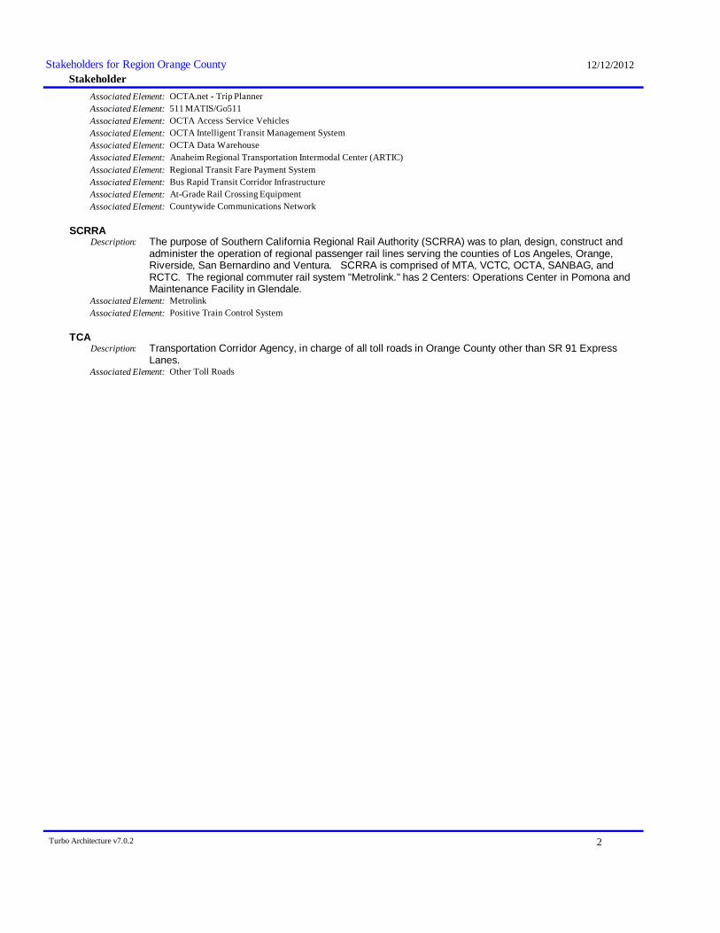
Stakeholder12/12/2012Stakeholders for Region Orange County
Associated Element: OCTA.net - Trip PlannerAssociated Element: 511 MATIS/Go511Associated Element: OCTA Access Service VehiclesAssociated Element: OCTA Intelligent Transit Management SystemAssociated Element: OCTA Data WarehouseAssociated Element: Anaheim Regional Transportation Intermodal Center (ARTIC)Associated Element: Regional Transit Fare Payment SystemAssociated Element: Bus Rapid Transit Corridor InfrastructureAssociated Element: At-Grade Rail Crossing EquipmentAssociated Element: Countywide Communications Network
SCRRAThe purpose of Southern California Regional Rail Authority (SCRRA) was to plan, design, construct andadminister the operation of regional passenger rail lines serving the counties of Los Angeles, Orange,Riverside, San Bernardino and Ventura. SCRRA is comprised of MTA, VCTC, OCTA, SANBAG, andRCTC. The regional commuter rail system "Metrolink." has 2 Centers: Operations Center in Pomona andMaintenance Facility in Glendale.
Description:
Associated Element: MetrolinkAssociated Element: Positive Train Control System
TCATransportation Corridor Agency, in charge of all toll roads in Orange County other than SR 91 ExpressLanes.
Description:
Associated Element: Other Toll Roads
Turbo Architecture v7.0.2 2

August 22, 2013
Appendix B: Regional ITS Architecture – Stakeholder Agreements
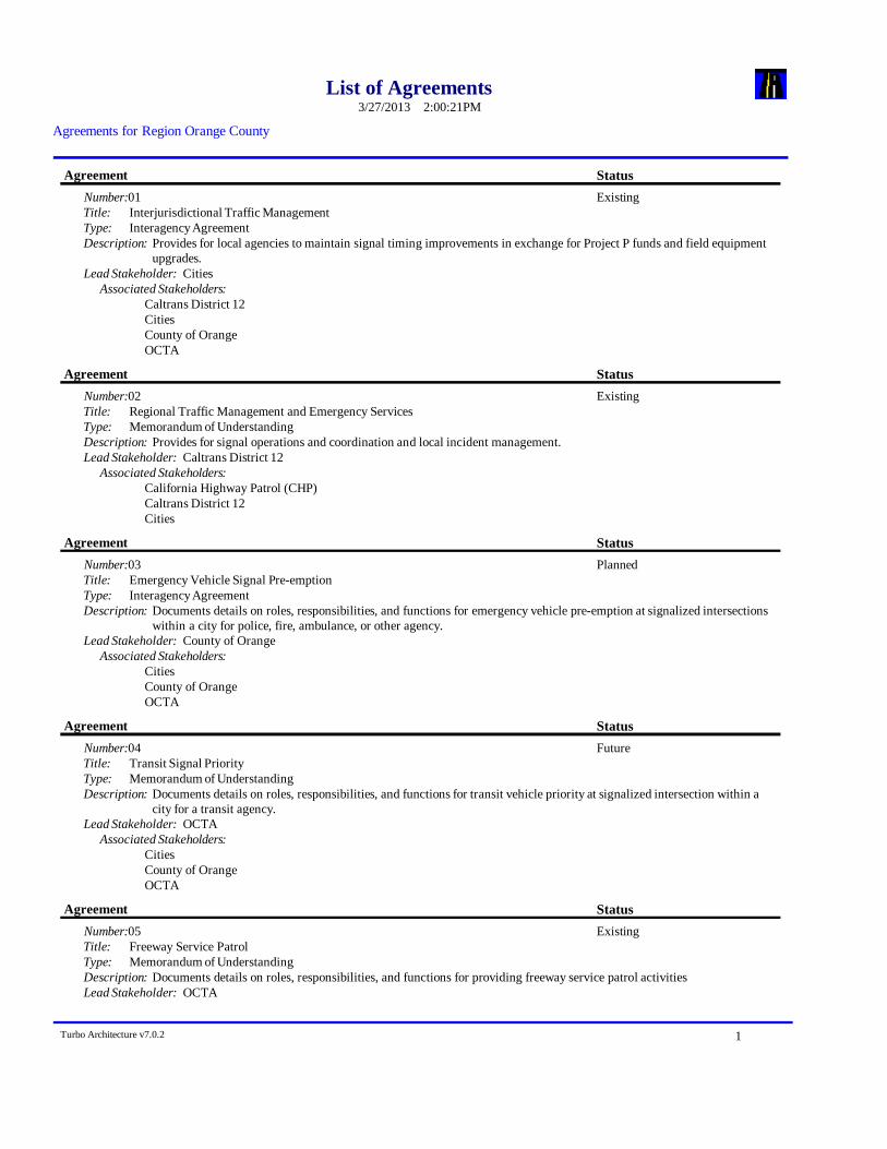
List of Agreements 2:00:21PM3/27/2013
Agreements for Region Orange County
Number:01
Agreement StatusExisting
Interjurisdictional Traffic ManagementTitle:Type: Interagency AgreementDescription: Provides for local agencies to maintain signal timing improvements in exchange for Project P funds and field equipment
upgrades.Lead Stakeholder: Cities
Associated Stakeholders:Caltrans District 12CitiesCounty of OrangeOCTA
Number:02
Agreement StatusExisting
Regional Traffic Management and Emergency ServicesTitle:Type: Memorandum of UnderstandingDescription: Provides for signal operations and coordination and local incident management.Lead Stakeholder: Caltrans District 12
Associated Stakeholders:California Highway Patrol (CHP)Caltrans District 12Cities
Number:03
Agreement StatusPlanned
Emergency Vehicle Signal Pre-emptionTitle:Type: Interagency AgreementDescription: Documents details on roles, responsibilities, and functions for emergency vehicle pre-emption at signalized intersections
within a city for police, fire, ambulance, or other agency.Lead Stakeholder: County of Orange
Associated Stakeholders:CitiesCounty of OrangeOCTA
Number:04
Agreement StatusFuture
Transit Signal PriorityTitle:Type: Memorandum of UnderstandingDescription: Documents details on roles, responsibilities, and functions for transit vehicle priority at signalized intersection within a
city for a transit agency.Lead Stakeholder: OCTA
Associated Stakeholders:CitiesCounty of OrangeOCTA
Number:05
Agreement StatusExisting
Freeway Service PatrolTitle:Type: Memorandum of UnderstandingDescription: Documents details on roles, responsibilities, and functions for providing freeway service patrol activitiesLead Stakeholder: OCTA
Turbo Architecture v7.0.2 1
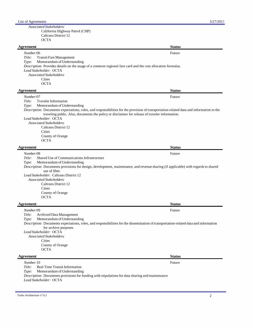
List of Agreements 3/27/2013Associated Stakeholders:
California Highway Patrol (CHP)Caltrans District 12OCTA
Number:06
Agreement StatusFuture
Transit Fare ManagementTitle:Type: Memorandum of UnderstandingDescription: Provides details on the usage of a common regional fare card and the cost allocation formulas.Lead Stakeholder: OCTA
Associated Stakeholders:CitiesOCTA
Number:07
Agreement StatusFuture
Traveler InformationTitle:Type: Memorandum of UnderstandingDescription: Documents expectations, roles, and responsibilities for the provision of transportation-related data and information to the
traveling public. Also, documents the policy or disclaimer for release of traveler information.Lead Stakeholder: OCTA
Associated Stakeholders:Caltrans District 12CitiesCounty of OrangeOCTA
Number:08
Agreement StatusFuture
Shared Use of Communications InfrastructureTitle:Type: Memorandum of UnderstandingDescription: Documents provisions for design, development, maintenance, and revenue sharing (if applicable) with regards to shared
use of fiber.Lead Stakeholder: Caltrans District 12
Associated Stakeholders:Caltrans District 12CitiesCounty of OrangeOCTA
Number:09
Agreement StatusFuture
Archived Data ManagementTitle:Type: Memorandum of UnderstandingDescription: Documents expectations, roles, and responsibilities for the dissemination of transportation-related data and information
for archive purposes.Lead Stakeholder: OCTA
Associated Stakeholders:CitiesCounty of OrangeOCTA
Number:10
Agreement StatusFuture
Real Time Transit InformationTitle:Type: Memorandum of UnderstandingDescription: Documents provisions for funding with stipulations for data sharing and maintenanceLead Stakeholder: OCTA
Turbo Architecture v7.0.2 2
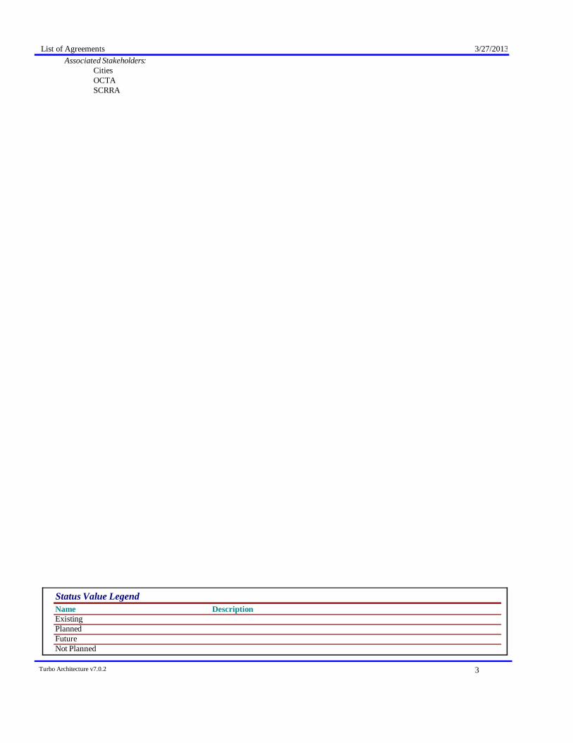
List of Agreements 3/27/2013Associated Stakeholders:
CitiesOCTASCRRA
Name DescriptionStatus Value Legend
ExistingPlannedFutureNot Planned
Turbo Architecture v7.0.2 3

August 22, 2013
Appendix C: Regional ITS Architecture – Functional Requirements

Functional RequirementsOrange County (Region)
5:39:39PM12/12/2012
StatusArchitecture(Region)Orange County (Region)
91 Express Lanes Customer Administration CenterElement:Payment AdministrationEntity:
Functional Area: Center VMT Payment AdministrationManagement of a VMT payment system. Receives VMT data and computesthe total cost to the vehicle owner for payment.
ExistingThe center shall register vehicles for road use payment,establishing accounts that identify owner billing information andpreferences.
Requirement: 1
ExistingThe center shall provide secure user account management,providing user access to rules and policies, current billing status,invoices, payments, and mechanisms for review and challenge ofthe collected data.
Requirement: 2
ExistingThis center shall maintain and publish road use prices, asconfigured by the Payment Administrator.
Requirement: 3
ExistingThe center shall receive VMT data (time stamped log ofroadways used by the vehicle) and compute the total cost to thevehicle owner.
Requirement: 4
ExistingThe center shall calculate road use charges based on the vehicle'smileage, roads traveled, time periods, emissions profile formake/model, fuel economy for make/model, weight, number ofaxles/tires, or other policies.
Requirement: 5
ExistingThe center shall access and use registration and odometerinformation from the DMV to verify and audit collected VMTdata.
Requirement: 6
ExistingThe center shall process and clear payments from vehicle ownersand operators as well as payments to other Center VMT PaymentAdministration through clearing houses provided by financialinstitutions.
Requirement: 7
ExistingThe center shall coordinate with other VMT PaymentAdministration systems to reconcile and apportion payments forvehicles registered in other jurisdictions.
Requirement: 8
ExistingThe center shall report payment violations including vehicleinformation and vehicle image to the designated EnforcementAgency.
Requirement: 9
ExistingThe center shall monitor the operational status of VMT fieldequipment and identify equipment faults.
Requirement: 10
91 Express Lanes Traffic Management CenterElement:Traffic ManagementEntity:
Functional Area: Collect Traffic SurveillanceManagement of traffic sensors and surveillance (CCTV) equipment,collection of current traffic conditions, and distribution of the collectedinformation to other centers and operators.
ExistingThe center shall monitor, analyze, and store traffic sensor data(speed, volume, occupancy) collected from field elements underremote control of the center.
Requirement: 1
Turbo Architecture v7.0.2 1
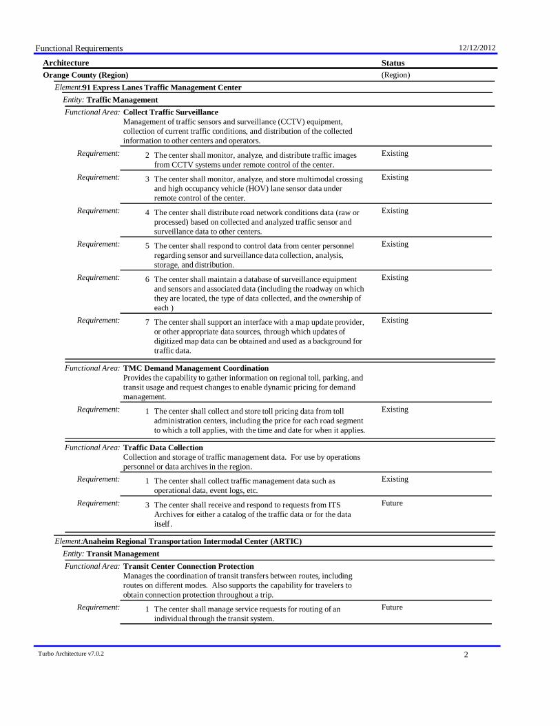
Functional Requirements 12/12/2012
StatusArchitecture(Region)Orange County (Region)
91 Express Lanes Traffic Management CenterElement:Traffic ManagementEntity:
Functional Area: Collect Traffic SurveillanceManagement of traffic sensors and surveillance (CCTV) equipment,collection of current traffic conditions, and distribution of the collectedinformation to other centers and operators.
ExistingThe center shall monitor, analyze, and distribute traffic imagesfrom CCTV systems under remote control of the center.
Requirement: 2
ExistingThe center shall monitor, analyze, and store multimodal crossingand high occupancy vehicle (HOV) lane sensor data underremote control of the center.
Requirement: 3
ExistingThe center shall distribute road network conditions data (raw orprocessed) based on collected and analyzed traffic sensor andsurveillance data to other centers.
Requirement: 4
ExistingThe center shall respond to control data from center personnelregarding sensor and surveillance data collection, analysis,storage, and distribution.
Requirement: 5
ExistingThe center shall maintain a database of surveillance equipmentand sensors and associated data (including the roadway on whichthey are located, the type of data collected, and the ownership ofeach )
Requirement: 6
ExistingThe center shall support an interface with a map update provider,or other appropriate data sources, through which updates ofdigitized map data can be obtained and used as a background fortraffic data.
Requirement: 7
Functional Area: TMC Demand Management CoordinationProvides the capability to gather information on regional toll, parking, andtransit usage and request changes to enable dynamic pricing for demandmanagement.
ExistingThe center shall collect and store toll pricing data from tolladministration centers, including the price for each road segmentto which a toll applies, with the time and date for when it applies.
Requirement: 1
Functional Area: Traffic Data CollectionCollection and storage of traffic management data. For use by operationspersonnel or data archives in the region.
ExistingThe center shall collect traffic management data such asoperational data, event logs, etc.
Requirement: 1
FutureThe center shall receive and respond to requests from ITSArchives for either a catalog of the traffic data or for the dataitself.
Requirement: 3
Anaheim Regional Transportation Intermodal Center (ARTIC)Element:Transit ManagementEntity:
Functional Area: Transit Center Connection ProtectionManages the coordination of transit transfers between routes, includingroutes on different modes. Also supports the capability for travelers toobtain connection protection throughout a trip.
FutureThe center shall manage service requests for routing of anindividual through the transit system.
Requirement: 1
Turbo Architecture v7.0.2 2
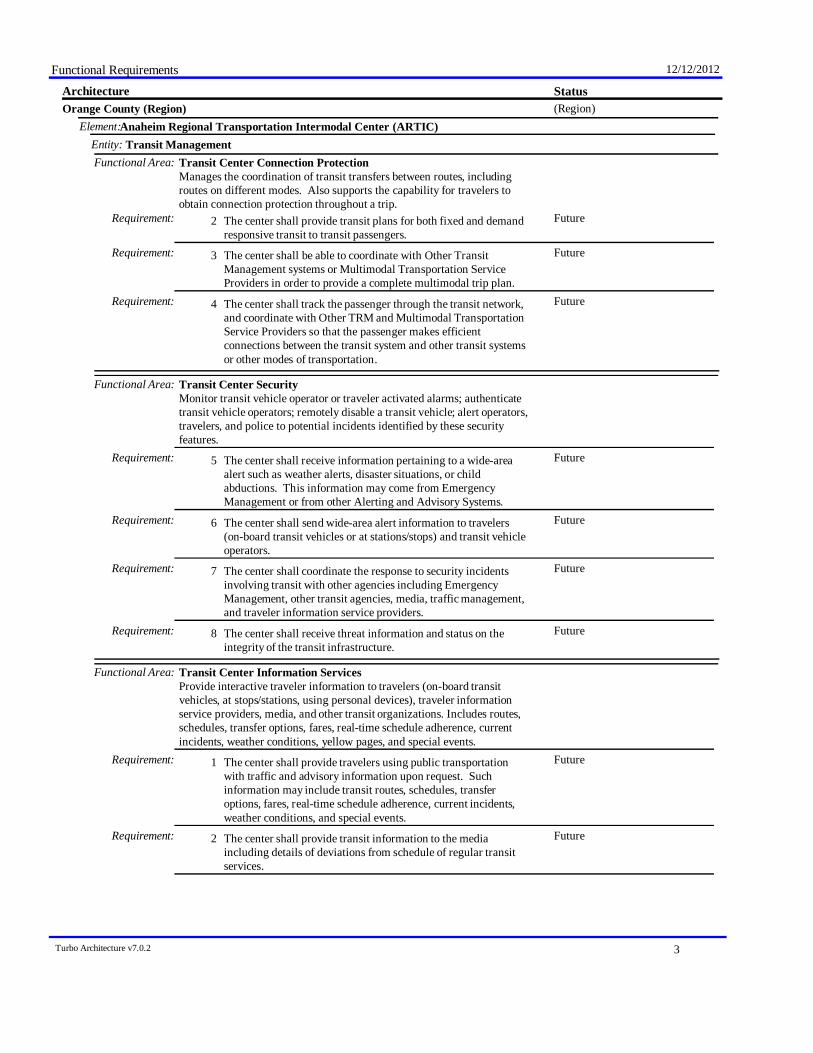
Functional Requirements 12/12/2012
StatusArchitecture(Region)Orange County (Region)
Anaheim Regional Transportation Intermodal Center (ARTIC)Element:Transit ManagementEntity:
Functional Area: Transit Center Connection ProtectionManages the coordination of transit transfers between routes, includingroutes on different modes. Also supports the capability for travelers toobtain connection protection throughout a trip.
FutureThe center shall provide transit plans for both fixed and demandresponsive transit to transit passengers.
Requirement: 2
FutureThe center shall be able to coordinate with Other TransitManagement systems or Multimodal Transportation ServiceProviders in order to provide a complete multimodal trip plan.
Requirement: 3
FutureThe center shall track the passenger through the transit network,and coordinate with Other TRM and Multimodal TransportationService Providers so that the passenger makes efficientconnections between the transit system and other transit systemsor other modes of transportation.
Requirement: 4
Functional Area: Transit Center SecurityMonitor transit vehicle operator or traveler activated alarms; authenticatetransit vehicle operators; remotely disable a transit vehicle; alert operators,travelers, and police to potential incidents identified by these securityfeatures.
FutureThe center shall receive information pertaining to a wide-areaalert such as weather alerts, disaster situations, or childabductions. This information may come from EmergencyManagement or from other Alerting and Advisory Systems.
Requirement: 5
FutureThe center shall send wide-area alert information to travelers(on-board transit vehicles or at stations/stops) and transit vehicleoperators.
Requirement: 6
FutureThe center shall coordinate the response to security incidentsinvolving transit with other agencies including EmergencyManagement, other transit agencies, media, traffic management,and traveler information service providers.
Requirement: 7
FutureThe center shall receive threat information and status on theintegrity of the transit infrastructure.
Requirement: 8
Functional Area: Transit Center Information ServicesProvide interactive traveler information to travelers (on-board transitvehicles, at stops/stations, using personal devices), traveler informationservice providers, media, and other transit organizations. Includes routes,schedules, transfer options, fares, real-time schedule adherence, currentincidents, weather conditions, yellow pages, and special events.
FutureThe center shall provide travelers using public transportationwith traffic and advisory information upon request. Suchinformation may include transit routes, schedules, transferoptions, fares, real-time schedule adherence, current incidents,weather conditions, and special events.
Requirement: 1
FutureThe center shall provide transit information to the mediaincluding details of deviations from schedule of regular transitservices.
Requirement: 2
Turbo Architecture v7.0.2 3

Functional Requirements 12/12/2012
StatusArchitecture(Region)Orange County (Region)
Anaheim Regional Transportation Intermodal Center (ARTIC)Element:Transit ManagementEntity:
Functional Area: Transit Center Information ServicesProvide interactive traveler information to travelers (on-board transitvehicles, at stops/stations, using personal devices), traveler informationservice providers, media, and other transit organizations. Includes routes,schedules, transfer options, fares, real-time schedule adherence, currentincidents, weather conditions, yellow pages, and special events.
FutureThe center shall exchange transit schedules, real-time arrivalinformation, fare schedules, and general transit serviceinformation with other transit organizations to support transittraveler information systems.
Requirement: 3
FutureThe center shall provide transit service information to travelerinformation service providers including routes, schedules,schedule adherence, and fare information as well as transitservice information during evacuation.
Requirement: 4
FutureThe center shall enable yellow pages (including non-motorizedtransportation) information to be output to the traveler.
Requirement: 5
FutureThe center shall broadcast transit advisory data, including alertsand advisories pertaining to major emergencies, or man madedisasters.
Requirement: 6
Functional Area: Transit Center Multi-Modal CoordinationCoordinate schedules with other agencies and modes, including transittransfer cluster and transfer point information.
FutureThe center shall coordinate schedules and services betweentransit agencies, traffic management, maintenance andconstruction operations, parking management, and other surfaceor air transportation modes.
Requirement: 1
FutureThe center shall share transfer cluster and transfer pointinformation with multimodal transportation service providers,other transit agencies, and traveler information service providers.A transfer cluster is a collection of stop points, stations, orterminals where transfers can be made conveniently.
Requirement: 2
FutureThe center shall accept requests from traffic management tochange routes and schedules as part of the implementation ofdemand management strategies.
Requirement: 3
FutureThe center shall coordinate transit services for special events,planning services for the event and managing transit services onthe day of the event.
Requirement: 4
FutureThe center shall provide transit operations personnel with thecapability to control and monitor transit service coordinationactivities.
Requirement: 5
Functional Area: Transit Evacuation SupportSupport evacuation and subsequent reentry of a population in the vicinity ofa disaster or other emergency. Coordinate regional evacuation plans andresources including transit and school bus fleets.
FutureThe center shall manage the use of transit resources to supportevacuation and subsequent reentry of a population in the vicinityof a disaster or other emergency.
Requirement: 1
Turbo Architecture v7.0.2 4

Functional Requirements 12/12/2012
StatusArchitecture(Region)Orange County (Region)
Anaheim Regional Transportation Intermodal Center (ARTIC)Element:Transit ManagementEntity:
Functional Area: Transit Evacuation SupportSupport evacuation and subsequent reentry of a population in the vicinity ofa disaster or other emergency. Coordinate regional evacuation plans andresources including transit and school bus fleets.
FutureThe center shall coordinate regional evacuation plans withEmergency Management - identifying the transit role in anevacuation and the transit resources that would be used.
Requirement: 2
FutureThe center shall adjust and update transit service and fareschedules and provide that information to other agencies as theycoordinate evacuations.
Requirement: 4
At-Grade Rail Crossing EquipmentElement:RoadwayEntity:
Functional Area: Standard Rail CrossingField elements at highway-rail intersections (HRIs) where operationalrequirements do not dictate advanced features (e.g., where rail operationalspeeds are less than 80 miles per hour). Includes traditional HRI warningsystems augmented with other standard traffic management devices.
ExistingThe field element shall monitor the status of the highway-railintersection (HRI) equipment, including both the current stateand mode of operation and the current equipment condition, to beforwarded on to the traffic management center.
Requirement: 2
ExistingThe field element shall monitor the status of the highway-railintersection (HRI) equipment, including both the current stateand mode of operation and the current equipment condition, to beforwarded on to the rail wayside equipment.
Requirement: 3
FutureThe field element shall receive track status from the rail waysideequipment that can be passed on to the traffic managementcenter. This may include the current status of the tracks andwhether a train is approaching.
Requirement: 4
ExistingThe field element shall close the highway-rail intersection (HRI)when a train is approaching using gates, lights/signs, barriers, andtraffic control signals.
Requirement: 7
FutureThe field element shall support the integrated control of adjacenttraffic signals to clear an area in advance of an approaching trainand to manage traffic around the intersection.
Requirement: 8
PlannedThe field element shall forward rail traffic advisories receivedfrom the Wayside Equipment to the traffic management center.
Requirement: 9
Functional Area: Advanced Rail CrossingField elements at highway-rail intersections (HRIs) where operationalrequirements demand advanced features (e.g., where rail operational speedsare greater than 80 miles per hour). Capabilities from the Standard RailCrossing plus systems which preclude entrance into the intersection when thebarriers are activated, additional arriving train information, and detection ofblocked intersections.
FutureThe field element shall collect and process, traffic sensor data inthe vicinity of a highway-rail intersection (HRI).
Requirement: 1
Turbo Architecture v7.0.2 5
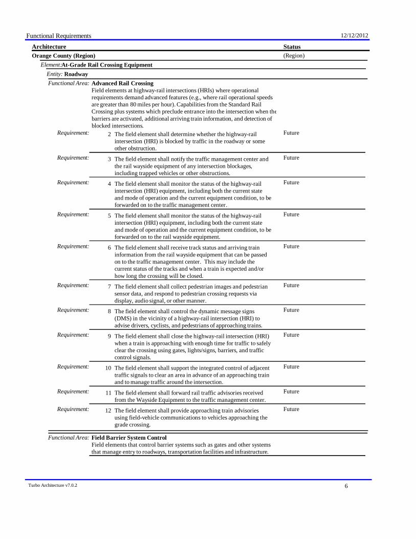
Functional Requirements 12/12/2012
StatusArchitecture(Region)Orange County (Region)
At-Grade Rail Crossing EquipmentElement:RoadwayEntity:
Functional Area: Advanced Rail CrossingField elements at highway-rail intersections (HRIs) where operationalrequirements demand advanced features (e.g., where rail operational speedsare greater than 80 miles per hour). Capabilities from the Standard RailCrossing plus systems which preclude entrance into the intersection when thebarriers are activated, additional arriving train information, and detection ofblocked intersections.
FutureThe field element shall determine whether the highway-railintersection (HRI) is blocked by traffic in the roadway or someother obstruction.
Requirement: 2
FutureThe field element shall notify the traffic management center andthe rail wayside equipment of any intersection blockages,including trapped vehicles or other obstructions.
Requirement: 3
FutureThe field element shall monitor the status of the highway-railintersection (HRI) equipment, including both the current stateand mode of operation and the current equipment condition, to beforwarded on to the traffic management center.
Requirement: 4
FutureThe field element shall monitor the status of the highway-railintersection (HRI) equipment, including both the current stateand mode of operation and the current equipment condition, to beforwarded on to the rail wayside equipment.
Requirement: 5
FutureThe field element shall receive track status and arriving traininformation from the rail wayside equipment that can be passedon to the traffic management center. This may include thecurrent status of the tracks and when a train is expected and/orhow long the crossing will be closed.
Requirement: 6
FutureThe field element shall collect pedestrian images and pedestriansensor data, and respond to pedestrian crossing requests viadisplay, audio signal, or other manner.
Requirement: 7
FutureThe field element shall control the dynamic message signs(DMS) in the vicinity of a highway-rail intersection (HRI) toadvise drivers, cyclists, and pedestrians of approaching trains.
Requirement: 8
FutureThe field element shall close the highway-rail intersection (HRI)when a train is approaching with enough time for traffic to safelyclear the crossing using gates, lights/signs, barriers, and trafficcontrol signals.
Requirement: 9
FutureThe field element shall support the integrated control of adjacenttraffic signals to clear an area in advance of an approaching trainand to manage traffic around the intersection.
Requirement: 10
FutureThe field element shall forward rail traffic advisories receivedfrom the Wayside Equipment to the traffic management center.
Requirement: 11
FutureThe field element shall provide approaching train advisoriesusing field-vehicle communications to vehicles approaching thegrade crossing.
Requirement: 12
Functional Area: Field Barrier System ControlField elements that control barrier systems such as gates and other systemsthat manage entry to roadways, transportation facilities and infrastructure.
Turbo Architecture v7.0.2 6
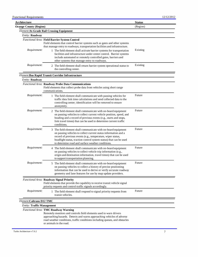
Functional Requirements 12/12/2012
StatusArchitecture(Region)Orange County (Region)
At-Grade Rail Crossing EquipmentElement:RoadwayEntity:
Functional Area: Field Barrier System ControlField elements that control barrier systems such as gates and other systemsthat manage entry to roadways, transportation facilities and infrastructure.
ExistingThe field element shall activate barrier systems for transportationfacilities and infrastructure under center control. Barrier systemsinclude automated or remotely controlled gates, barriers andother systems that manage entry to roadways.
Requirement: 1
ExistingThe field element shall return barrier system operational status tothe controlling center.
Requirement: 2
Bus Rapid Transit Corridor InfrastructureElement:RoadwayEntity:
Functional Area: Roadway Probe Data CommunicationsField elements that collect probe data from vehicles using short rangecommunications.
FutureThe field element shall communicate with passing vehicles fortraffic data link time calculations and send collected data to thecontrolling center; identification will be removed to ensureanonymity.
Requirement: 1
FutureThe field element shall communicate with on-board equipmenton passing vehicles to collect current vehicle position, speed, andheading and a record of previous events (e.g., starts and stops,link travel times) that can be used to determine current trafficconditions.
Requirement: 2
FutureThe field element shall communicate with on-board equipmenton passing vehicles to collect current status information and arecord of previous events (e.g., temperature, wiper status,headlight status, traction control system status) that can be usedto determine road and surface weather conditions.
Requirement: 3
FutureThe field element shall communicate with on-board equipmenton passing vehicles to collect vehicle trip information (e.g.,origin and destination information, travel times) that can be usedto support transportation planning.
Requirement: 4
FutureThe field element shall communicate with on-board equipmenton passing vehicles to collect a history of precise positioninginformation that can be used to derive or verify accurate roadwaygeometry and lane features for use by map update providers.
Requirement: 5
Functional Area: Roadway Signal PriorityField elements that provide the capability to receive transit vehicle signalpriority requests and control traffic signals accordingly.
FutureThe field element shall respond to signal priority requests fromtransit vehicles.
Requirement: 1
Caltrans D12 TMCElement:Traffic ManagementEntity:
Functional Area: TMC Roadway WarningRemotely monitors and controls field elements used to warn driversapproaching hazards. Detects and warns approaching vehicles of adverseroad weather conditions, traffic conditions including queues, and obstaclesor animals in the road.
Turbo Architecture v7.0.2 7
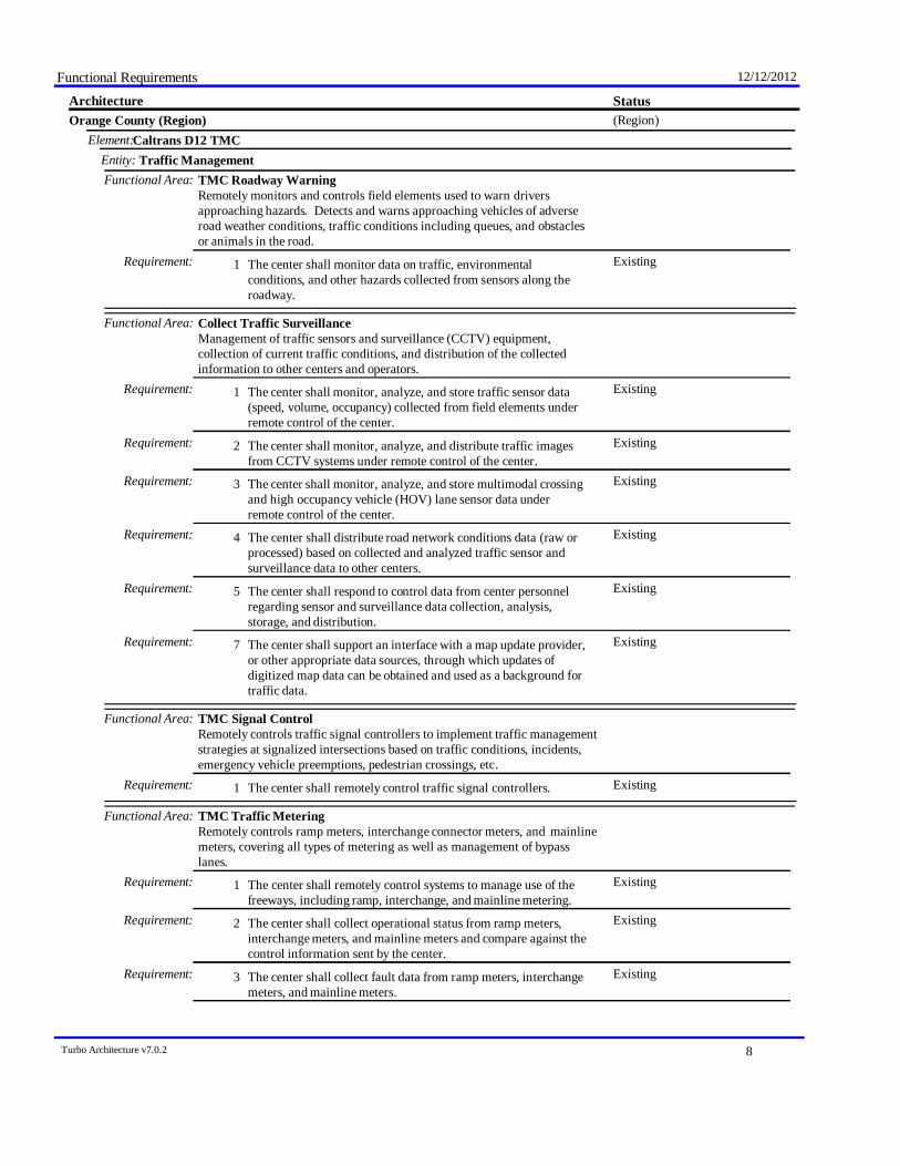
Functional Requirements 12/12/2012
StatusArchitecture(Region)Orange County (Region)
Caltrans D12 TMCElement:Traffic ManagementEntity:
Functional Area: TMC Roadway WarningRemotely monitors and controls field elements used to warn driversapproaching hazards. Detects and warns approaching vehicles of adverseroad weather conditions, traffic conditions including queues, and obstaclesor animals in the road.
ExistingThe center shall monitor data on traffic, environmentalconditions, and other hazards collected from sensors along theroadway.
Requirement: 1
Functional Area: Collect Traffic SurveillanceManagement of traffic sensors and surveillance (CCTV) equipment,collection of current traffic conditions, and distribution of the collectedinformation to other centers and operators.
ExistingThe center shall monitor, analyze, and store traffic sensor data(speed, volume, occupancy) collected from field elements underremote control of the center.
Requirement: 1
ExistingThe center shall monitor, analyze, and distribute traffic imagesfrom CCTV systems under remote control of the center.
Requirement: 2
ExistingThe center shall monitor, analyze, and store multimodal crossingand high occupancy vehicle (HOV) lane sensor data underremote control of the center.
Requirement: 3
ExistingThe center shall distribute road network conditions data (raw orprocessed) based on collected and analyzed traffic sensor andsurveillance data to other centers.
Requirement: 4
ExistingThe center shall respond to control data from center personnelregarding sensor and surveillance data collection, analysis,storage, and distribution.
Requirement: 5
ExistingThe center shall support an interface with a map update provider,or other appropriate data sources, through which updates ofdigitized map data can be obtained and used as a background fortraffic data.
Requirement: 7
Functional Area: TMC Signal ControlRemotely controls traffic signal controllers to implement traffic managementstrategies at signalized intersections based on traffic conditions, incidents,emergency vehicle preemptions, pedestrian crossings, etc.
ExistingThe center shall remotely control traffic signal controllers.Requirement: 1
Functional Area: TMC Traffic MeteringRemotely controls ramp meters, interchange connector meters, and mainlinemeters, covering all types of metering as well as management of bypasslanes.
ExistingThe center shall remotely control systems to manage use of thefreeways, including ramp, interchange, and mainline metering.
Requirement: 1
ExistingThe center shall collect operational status from ramp meters,interchange meters, and mainline meters and compare against thecontrol information sent by the center.
Requirement: 2
ExistingThe center shall collect fault data from ramp meters, interchangemeters, and mainline meters.
Requirement: 3
Turbo Architecture v7.0.2 8

Functional Requirements 12/12/2012
StatusArchitecture(Region)Orange County (Region)
Caltrans D12 TMCElement:Traffic ManagementEntity:
Functional Area: TMC Traffic MeteringRemotely controls ramp meters, interchange connector meters, and mainlinemeters, covering all types of metering as well as management of bypasslanes.
ExistingThe center shall implement control strategies, under control ofcenter personnel, on some or all of the freeway network devices(e.g. ramp meters, interchange meters, and mainline meters),based on data from sensors monitoring traffic conditionsupstream, downstream, and queue data on the approaches to themeters.
Requirement: 4
Functional Area: TMC HOV Lane ManagementRemotely controls HOV lane sensors, HOV lane usage signals, and rampmeters to manage use of HOV or HOT lanes; also detect HOV violators andnotifies enforcement agencies.
ExistingThe center shall remotely control sensors to detecthigh-occupancy vehicle (HOV) lane usage.
Requirement: 1
ExistingThe center shall remotely control freeway control devices, suchas ramp signals and mainline metering and other systemsassociated with freeway operations that control use of HOVlanes.
Requirement: 3
ExistingThe center shall collect traffic flow measures and informationregarding vehicle occupancy (i.e., lane usage) in HOV lanes.
Requirement: 4
ExistingThe center shall collect operational status for the freeway controldevices associated with HOV lane control.
Requirement: 6
ExistingThe center shall collect fault data for the freeway control devicesassociated with HOV lane control for repair.
Requirement: 7
Functional Area: TMC Traffic Information DisseminationControls dissemination of traffic-related data to other centers, the media, andtravelers via the driver information systems (DMS, HAR) that it operates.
ExistingThe center shall remotely control dynamic messages signs fordissemination of traffic and other information to drivers.
Requirement: 1
ExistingThe center shall remotely control driver information systems thatcommunicate directly from a center to the vehicle radio (such asHighway Advisory Radios) for dissemination of traffic and otherinformation to drivers.
Requirement: 2
ExistingThe center shall collect operational status for the driverinformation systems equipment (DMS, HAR, etc.).
Requirement: 3
ExistingThe center shall collect fault data for the driver informationsystems equipment (DMS, HAR, etc.) for repair.
Requirement: 4
ExistingThe center shall distribute traffic data to maintenance andconstruction centers, transit centers, emergency managementcenters, and traveler information providers.
Requirement: 6
ExistingThe center shall distribute traffic data to the media; the capabilityto provide the information in both data stream and graphicaldisplay shall be supported.
Requirement: 7
Turbo Architecture v7.0.2 9
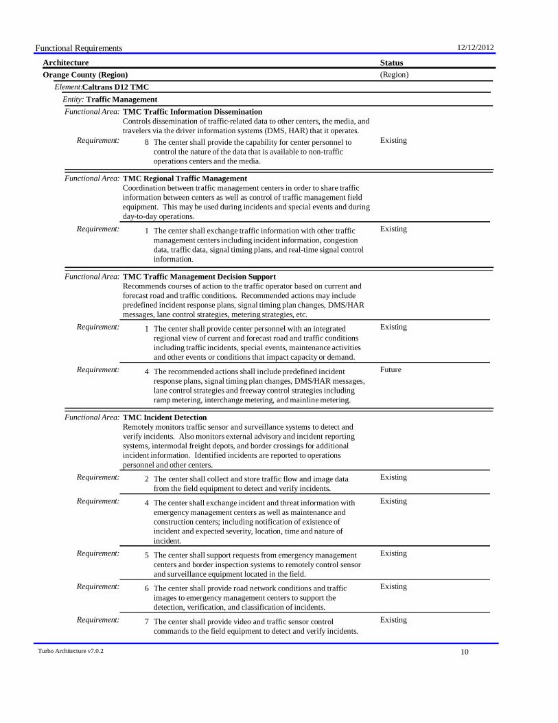
Functional Requirements 12/12/2012
StatusArchitecture(Region)Orange County (Region)
Caltrans D12 TMCElement:Traffic ManagementEntity:
Functional Area: TMC Traffic Information DisseminationControls dissemination of traffic-related data to other centers, the media, andtravelers via the driver information systems (DMS, HAR) that it operates.
ExistingThe center shall provide the capability for center personnel tocontrol the nature of the data that is available to non-trafficoperations centers and the media.
Requirement: 8
Functional Area: TMC Regional Traffic ManagementCoordination between traffic management centers in order to share trafficinformation between centers as well as control of traffic management fieldequipment. This may be used during incidents and special events and duringday-to-day operations.
ExistingThe center shall exchange traffic information with other trafficmanagement centers including incident information, congestiondata, traffic data, signal timing plans, and real-time signal controlinformation.
Requirement: 1
Functional Area: TMC Traffic Management Decision SupportRecommends courses of action to the traffic operator based on current andforecast road and traffic conditions. Recommended actions may includepredefined incident response plans, signal timing plan changes, DMS/HARmessages, lane control strategies, metering strategies, etc.
ExistingThe center shall provide center personnel with an integratedregional view of current and forecast road and traffic conditionsincluding traffic incidents, special events, maintenance activitiesand other events or conditions that impact capacity or demand.
Requirement: 1
FutureThe recommended actions shall include predefined incidentresponse plans, signal timing plan changes, DMS/HAR messages,lane control strategies and freeway control strategies includingramp metering, interchange metering, and mainline metering.
Requirement: 4
Functional Area: TMC Incident DetectionRemotely monitors traffic sensor and surveillance systems to detect andverify incidents. Also monitors external advisory and incident reportingsystems, intermodal freight depots, and border crossings for additionalincident information. Identified incidents are reported to operationspersonnel and other centers.
ExistingThe center shall collect and store traffic flow and image datafrom the field equipment to detect and verify incidents.
Requirement: 2
ExistingThe center shall exchange incident and threat information withemergency management centers as well as maintenance andconstruction centers; including notification of existence ofincident and expected severity, location, time and nature ofincident.
Requirement: 4
ExistingThe center shall support requests from emergency managementcenters and border inspection systems to remotely control sensorand surveillance equipment located in the field.
Requirement: 5
ExistingThe center shall provide road network conditions and trafficimages to emergency management centers to support thedetection, verification, and classification of incidents.
Requirement: 6
ExistingThe center shall provide video and traffic sensor controlcommands to the field equipment to detect and verify incidents.
Requirement: 7
Turbo Architecture v7.0.2 10
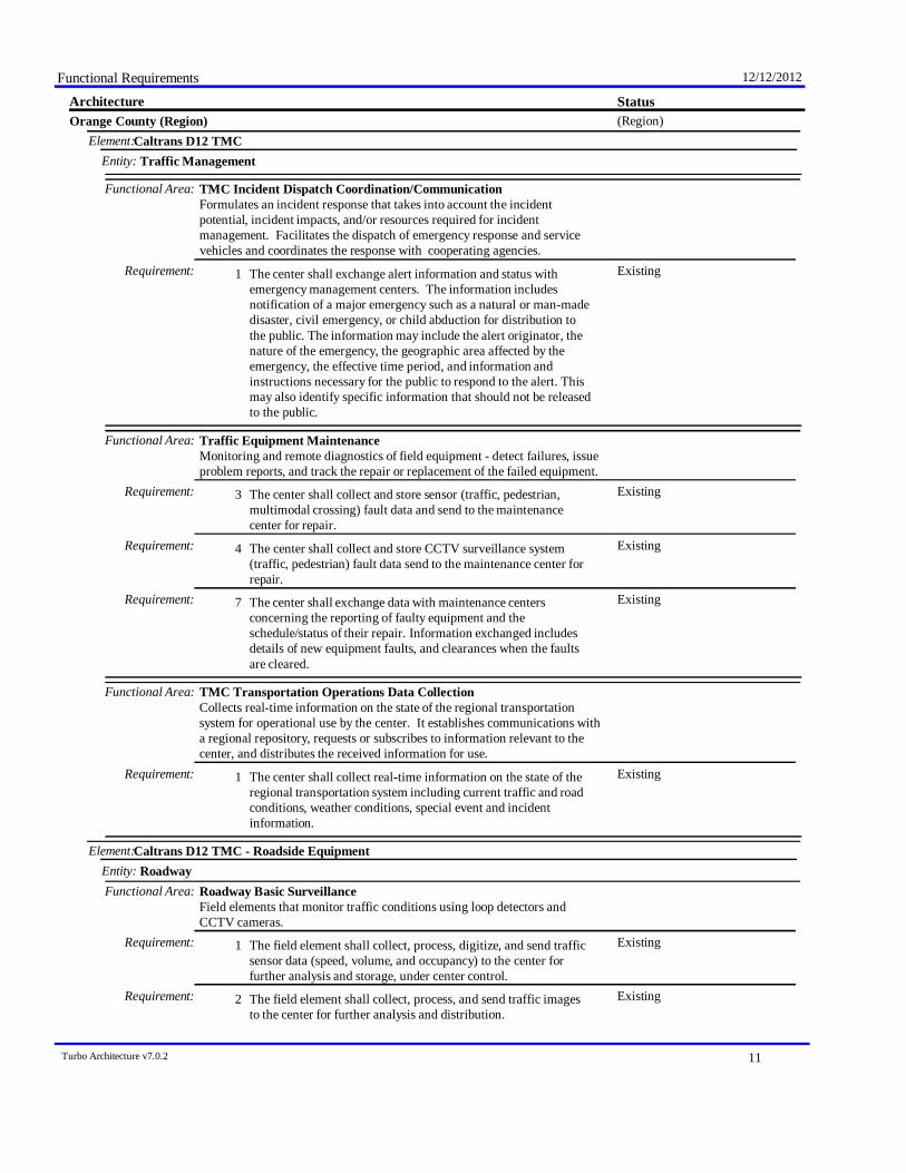
Functional Requirements 12/12/2012
StatusArchitecture(Region)Orange County (Region)
Caltrans D12 TMCElement:Traffic ManagementEntity:
Functional Area: TMC Incident Dispatch Coordination/CommunicationFormulates an incident response that takes into account the incidentpotential, incident impacts, and/or resources required for incidentmanagement. Facilitates the dispatch of emergency response and servicevehicles and coordinates the response with cooperating agencies.
ExistingThe center shall exchange alert information and status withemergency management centers. The information includesnotification of a major emergency such as a natural or man-madedisaster, civil emergency, or child abduction for distribution tothe public. The information may include the alert originator, thenature of the emergency, the geographic area affected by theemergency, the effective time period, and information andinstructions necessary for the public to respond to the alert. Thismay also identify specific information that should not be releasedto the public.
Requirement: 1
Functional Area: Traffic Equipment MaintenanceMonitoring and remote diagnostics of field equipment - detect failures, issueproblem reports, and track the repair or replacement of the failed equipment.
ExistingThe center shall collect and store sensor (traffic, pedestrian,multimodal crossing) fault data and send to the maintenancecenter for repair.
Requirement: 3
ExistingThe center shall collect and store CCTV surveillance system(traffic, pedestrian) fault data send to the maintenance center forrepair.
Requirement: 4
ExistingThe center shall exchange data with maintenance centersconcerning the reporting of faulty equipment and theschedule/status of their repair. Information exchanged includesdetails of new equipment faults, and clearances when the faultsare cleared.
Requirement: 7
Functional Area: TMC Transportation Operations Data CollectionCollects real-time information on the state of the regional transportationsystem for operational use by the center. It establishes communications witha regional repository, requests or subscribes to information relevant to thecenter, and distributes the received information for use.
ExistingThe center shall collect real-time information on the state of theregional transportation system including current traffic and roadconditions, weather conditions, special event and incidentinformation.
Requirement: 1
Caltrans D12 TMC - Roadside EquipmentElement:RoadwayEntity:
Functional Area: Roadway Basic SurveillanceField elements that monitor traffic conditions using loop detectors andCCTV cameras.
ExistingThe field element shall collect, process, digitize, and send trafficsensor data (speed, volume, and occupancy) to the center forfurther analysis and storage, under center control.
Requirement: 1
ExistingThe field element shall collect, process, and send traffic imagesto the center for further analysis and distribution.
Requirement: 2
Turbo Architecture v7.0.2 11
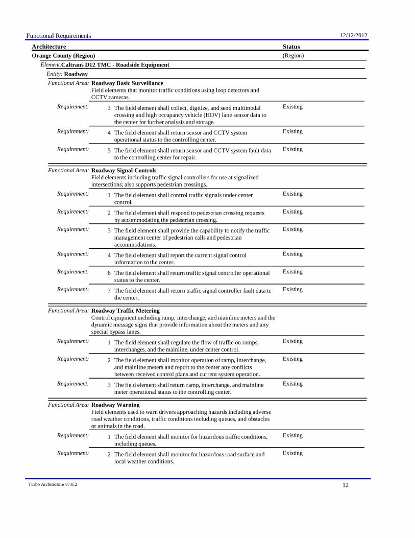
Functional Requirements 12/12/2012
StatusArchitecture(Region)Orange County (Region)
Caltrans D12 TMC - Roadside EquipmentElement:RoadwayEntity:
Functional Area: Roadway Basic SurveillanceField elements that monitor traffic conditions using loop detectors andCCTV cameras.
ExistingThe field element shall collect, digitize, and send multimodalcrossing and high occupancy vehicle (HOV) lane sensor data tothe center for further analysis and storage.
Requirement: 3
ExistingThe field element shall return sensor and CCTV systemoperational status to the controlling center.
Requirement: 4
ExistingThe field element shall return sensor and CCTV system fault datato the controlling center for repair.
Requirement: 5
Functional Area: Roadway Signal ControlsField elements including traffic signal controllers for use at signalizedintersections; also supports pedestrian crossings.
ExistingThe field element shall control traffic signals under centercontrol.
Requirement: 1
ExistingThe field element shall respond to pedestrian crossing requestsby accommodating the pedestrian crossing.
Requirement: 2
ExistingThe field element shall provide the capability to notify the trafficmanagement center of pedestrian calls and pedestrianaccommodations.
Requirement: 3
ExistingThe field element shall report the current signal controlinformation to the center.
Requirement: 4
ExistingThe field element shall return traffic signal controller operationalstatus to the center.
Requirement: 6
ExistingThe field element shall return traffic signal controller fault data tothe center.
Requirement: 7
Functional Area: Roadway Traffic MeteringControl equipment including ramp, interchange, and mainline meters and thedynamic message signs that provide information about the meters and anyspecial bypass lanes.
ExistingThe field element shall regulate the flow of traffic on ramps,interchanges, and the mainline, under center control.
Requirement: 1
ExistingThe field element shall monitor operation of ramp, interchange,and mainline meters and report to the center any conflictsbetween received control plans and current system operation.
Requirement: 2
ExistingThe field element shall return ramp, interchange, and mainlinemeter operational status to the controlling center.
Requirement: 3
Functional Area: Roadway WarningField elements used to warn drivers approaching hazards including adverseroad weather conditions, traffic conditions including queues, and obstaclesor animals in the road.
ExistingThe field element shall monitor for hazardous traffic conditions,including queues.
Requirement: 1
ExistingThe field element shall monitor for hazardous road surface andlocal weather conditions.
Requirement: 2
Turbo Architecture v7.0.2 12

Functional Requirements 12/12/2012
StatusArchitecture(Region)Orange County (Region)
Caltrans D12 TMC - Roadside EquipmentElement:RoadwayEntity:
Functional Area: Roadway WarningField elements used to warn drivers approaching hazards including adverseroad weather conditions, traffic conditions including queues, and obstaclesor animals in the road.
ExistingThe field element shall provide collected sensor data to thecontrolling center.
Requirement: 4
ExistingThe field element shall receive commands from the controllingcenter that activate warning signs to approaching motorists.
Requirement: 6
Functional Area: Roadway Traffic Information DisseminationDriver information systems, such as dynamic message signs and HighwayAdvisory Radio (HAR).
ExistingThe field element shall include dynamic messages signs fordissemination of traffic and other information to drivers, undercenter control; the DMS may be either those that display variabletext messages, or those that have fixed format display(s) (e.g.vehicle restrictions, or lane open/close).
Requirement: 1
Functional Area: Roadway Incident DetectionField elements that monitor traffic conditions to identify incidents. Itincludes traffic detectors that collect traffic flow information and identifyunusual traffic conditions and advanced CCTV cameras with built-inincident detection algorithms.
ExistingThe field element shall collect, process, and send traffic imagesto the center for further analysis and distribution.
Requirement: 1
ExistingThe field element's video devices shall be remotely controlled bya traffic management center.
Requirement: 3
Functional Area: Roadway Work Zone Traffic ControlField elements in maintenance and construction areas including CCTVcameras, driver information systems (such as DMS), and gates/barriers thatmonitor and control traffic and provide information directly to drivers inaffected areas.
ExistingUnder traffic and maintenance center control, the field elementshall include driver information systems (such as dynamicmessages signs and highway advisory radios) that advise driversof activity around the work zone through which they are currentlypassing.
Requirement: 2
County Emergency ServiceElement:Emergency ManagementEntity:
Functional Area: Emergency Call-TakingProvides interface to the emergency call-taking systems such as theEmergency Telecommunications System (e.g., 911) that correlate callinformation with emergencies reported by transit agencies, commercialvehicle operators, or other public safety agencies. Allows the operator toverify the incident and forward the information to the responding agencies.
ExistingThe center shall support the interface to the EmergencyTelecommunications System (e.g. 911 or 7-digit call routing) toreceive emergency notification information and provide it to theemergency system operator.
Requirement: 1
Turbo Architecture v7.0.2 13
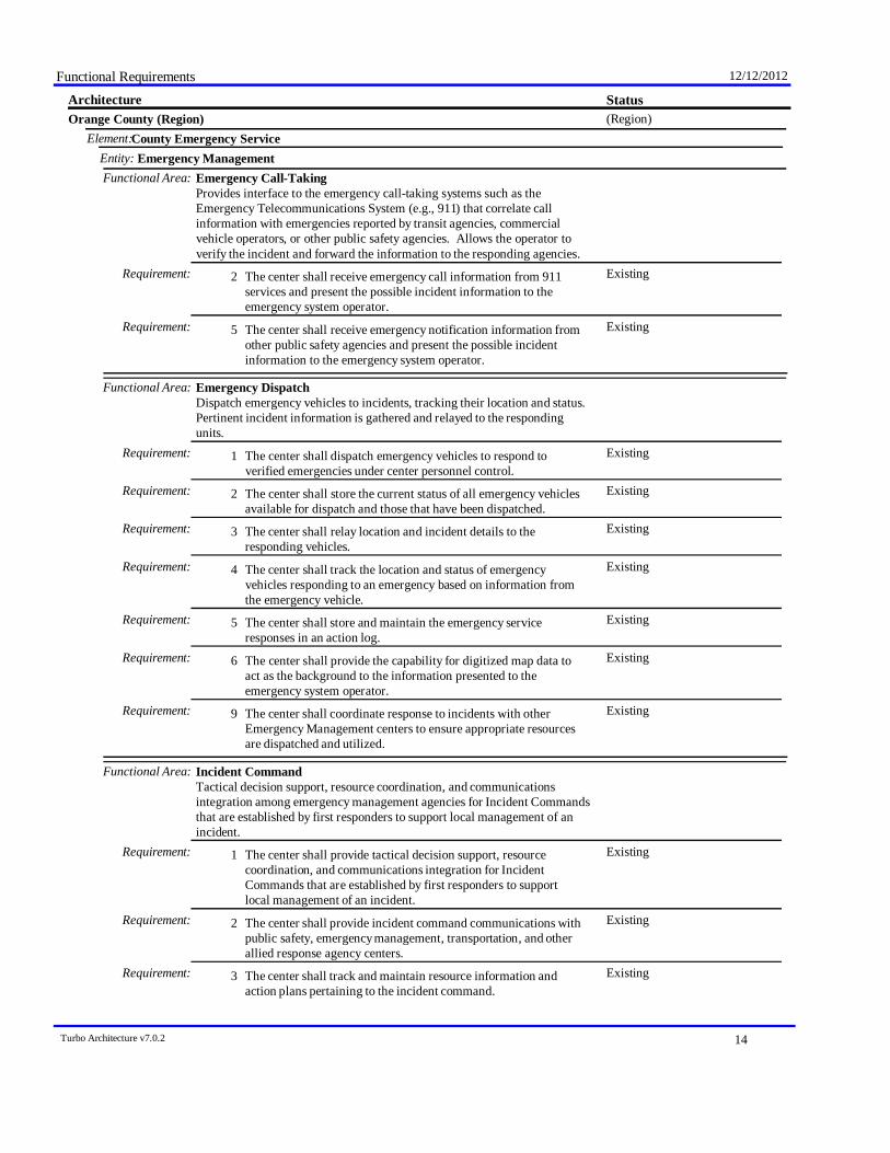
Functional Requirements 12/12/2012
StatusArchitecture(Region)Orange County (Region)
County Emergency ServiceElement:Emergency ManagementEntity:
Functional Area: Emergency Call-TakingProvides interface to the emergency call-taking systems such as theEmergency Telecommunications System (e.g., 911) that correlate callinformation with emergencies reported by transit agencies, commercialvehicle operators, or other public safety agencies. Allows the operator toverify the incident and forward the information to the responding agencies.
ExistingThe center shall receive emergency call information from 911services and present the possible incident information to theemergency system operator.
Requirement: 2
ExistingThe center shall receive emergency notification information fromother public safety agencies and present the possible incidentinformation to the emergency system operator.
Requirement: 5
Functional Area: Emergency DispatchDispatch emergency vehicles to incidents, tracking their location and status.Pertinent incident information is gathered and relayed to the respondingunits.
ExistingThe center shall dispatch emergency vehicles to respond toverified emergencies under center personnel control.
Requirement: 1
ExistingThe center shall store the current status of all emergency vehiclesavailable for dispatch and those that have been dispatched.
Requirement: 2
ExistingThe center shall relay location and incident details to theresponding vehicles.
Requirement: 3
ExistingThe center shall track the location and status of emergencyvehicles responding to an emergency based on information fromthe emergency vehicle.
Requirement: 4
ExistingThe center shall store and maintain the emergency serviceresponses in an action log.
Requirement: 5
ExistingThe center shall provide the capability for digitized map data toact as the background to the information presented to theemergency system operator.
Requirement: 6
ExistingThe center shall coordinate response to incidents with otherEmergency Management centers to ensure appropriate resourcesare dispatched and utilized.
Requirement: 9
Functional Area: Incident CommandTactical decision support, resource coordination, and communicationsintegration among emergency management agencies for Incident Commandsthat are established by first responders to support local management of anincident.
ExistingThe center shall provide tactical decision support, resourcecoordination, and communications integration for IncidentCommands that are established by first responders to supportlocal management of an incident.
Requirement: 1
ExistingThe center shall provide incident command communications withpublic safety, emergency management, transportation, and otherallied response agency centers.
Requirement: 2
ExistingThe center shall track and maintain resource information andaction plans pertaining to the incident command.
Requirement: 3
Turbo Architecture v7.0.2 14
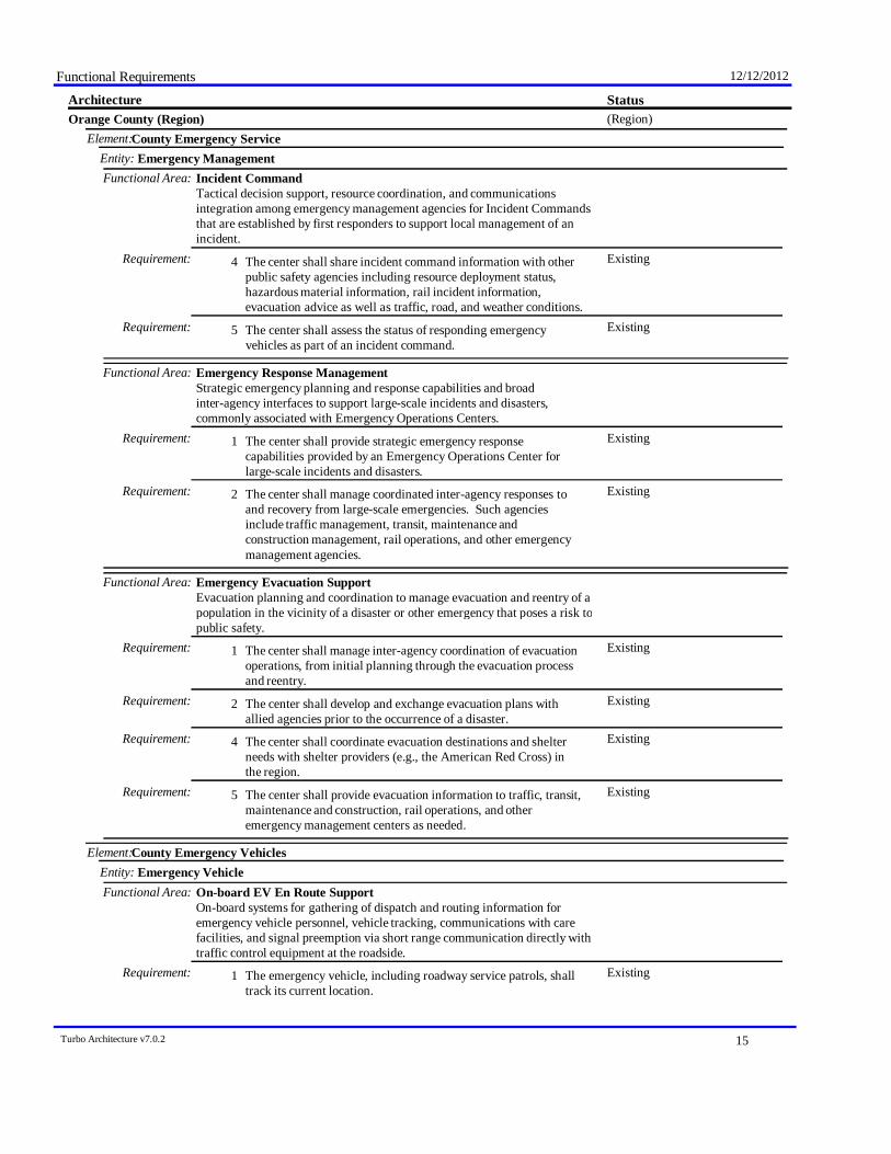
Functional Requirements 12/12/2012
StatusArchitecture(Region)Orange County (Region)
County Emergency ServiceElement:Emergency ManagementEntity:
Functional Area: Incident CommandTactical decision support, resource coordination, and communicationsintegration among emergency management agencies for Incident Commandsthat are established by first responders to support local management of anincident.
ExistingThe center shall share incident command information with otherpublic safety agencies including resource deployment status,hazardous material information, rail incident information,evacuation advice as well as traffic, road, and weather conditions.
Requirement: 4
ExistingThe center shall assess the status of responding emergencyvehicles as part of an incident command.
Requirement: 5
Functional Area: Emergency Response ManagementStrategic emergency planning and response capabilities and broadinter-agency interfaces to support large-scale incidents and disasters,commonly associated with Emergency Operations Centers.
ExistingThe center shall provide strategic emergency responsecapabilities provided by an Emergency Operations Center forlarge-scale incidents and disasters.
Requirement: 1
ExistingThe center shall manage coordinated inter-agency responses toand recovery from large-scale emergencies. Such agenciesinclude traffic management, transit, maintenance andconstruction management, rail operations, and other emergencymanagement agencies.
Requirement: 2
Functional Area: Emergency Evacuation SupportEvacuation planning and coordination to manage evacuation and reentry of apopulation in the vicinity of a disaster or other emergency that poses a risk topublic safety.
ExistingThe center shall manage inter-agency coordination of evacuationoperations, from initial planning through the evacuation processand reentry.
Requirement: 1
ExistingThe center shall develop and exchange evacuation plans withallied agencies prior to the occurrence of a disaster.
Requirement: 2
ExistingThe center shall coordinate evacuation destinations and shelterneeds with shelter providers (e.g., the American Red Cross) inthe region.
Requirement: 4
ExistingThe center shall provide evacuation information to traffic, transit,maintenance and construction, rail operations, and otheremergency management centers as needed.
Requirement: 5
County Emergency VehiclesElement:Emergency VehicleEntity:
Functional Area: On-board EV En Route SupportOn-board systems for gathering of dispatch and routing information foremergency vehicle personnel, vehicle tracking, communications with carefacilities, and signal preemption via short range communication directly withtraffic control equipment at the roadside.
ExistingThe emergency vehicle, including roadway service patrols, shalltrack its current location.
Requirement: 1
Turbo Architecture v7.0.2 15

Functional Requirements 12/12/2012
StatusArchitecture(Region)Orange County (Region)
County Emergency VehiclesElement:Emergency VehicleEntity:
Functional Area: On-board EV En Route SupportOn-board systems for gathering of dispatch and routing information foremergency vehicle personnel, vehicle tracking, communications with carefacilities, and signal preemption via short range communication directly withtraffic control equipment at the roadside.
ExistingThe emergency vehicle, including roadway service patrols, shallsend the vehicle's location and operational data to the center foremergency management and dispatch.
Requirement: 2
ExistingThe emergency vehicle, including roadway service patrols, shallreceive incident details and a suggested route when dispatched toa scene.
Requirement: 3
PlannedThe emergency vehicle shall send requests to traffic signalcontrol equipment at the roadside to preempt the signal.
Requirement: 5
Countywide Communications NetworkElement:Archived Data ManagementEntity:
Functional Area: ITS Data RepositoryCollect and maintain data and data catalogs from one or more data sources.May include quality checks, error notification, and archive coordination.
FutureThe center shall collect data to be archived from one or moredata sources.
Requirement: 1
FutureThe center shall collect data catalogs from one or more datasources. A catalog describes the data contained in the collectionof archived data and may include descriptions of the schema orstructure of the data, a description of the contents of the data;e.g., time range of entries, number of entries; or a sample of thedata (e. g. a thumbnail).
Requirement: 2
FutureThe center shall store the archived data in a focused repositorythat is suited to a particular set of ITS data users.
Requirement: 3
FutureThe center shall include capabilities for performing qualitychecks on the incoming archived data.
Requirement: 4
FutureThe center shall include capabilities for error notification on theincoming archived data.
Requirement: 5
FutureThe center shall include capabilities for archive to archivecoordination.
Requirement: 6
FutureThe center shall support a broad range of archived datamanagement implementations, ranging from simple data martsthat collect a focused set of data and serve a particular usercommunity to large-scale data warehouses that collect, integrate,and summarize transportation data from multiple sources andserve a broad array of users within a region.
Requirement: 7
FutureThe center shall perform quality checks on received data.Requirement: 8FutureThe center shall provide the capability to execute methods on the
incoming data such as cleansing, summarizations, aggregations,or transformations applied to the data before it is stored in thearchive.
Requirement: 9
FutureThe center shall respond to requests from the administratorinterface function to maintain the archive data.
Requirement: 10
Turbo Architecture v7.0.2 16

Functional Requirements 12/12/2012
StatusArchitecture(Region)Orange County (Region)
Countywide Communications NetworkElement:Archived Data ManagementEntity:
Functional Area: ITS Data RepositoryCollect and maintain data and data catalogs from one or more data sources.May include quality checks, error notification, and archive coordination.
FutureWhen data or a catalog of data is received from the archive, thecenter shall generate the requested data product for the userssystems.
Requirement: 11
Functional Area: Traffic and Roadside Data ArchivalCollects and archives traffic and environmental information directly from theroadside for use in off-line planning, research, and analysis.
FutureThe center shall manage the collection of archive data directlyfrom collection equipment located at the roadside.
Requirement: 1
FutureThe center shall collect traffic sensor information from roadsidedevices.
Requirement: 2
FutureThe center shall respond to requests from the Archive DataAdminister to input the parameters that control the collectionprocess.
Requirement: 4
Functional Area: Virtual Data Warehouse ServicesProvides access to data from geographically dispersed archives andcoordinates information exchange with a local data warehouse. Alsoprovides the specialized publishing, directory services, and transactionmanagement functions associated with coordinating remote archives.
FutureThe center shall provide capabilities to access "in-place" datafrom geographically dispersed archives. These capabilities mayinclude analysis, data fusion, or data mining.
Requirement: 1
FutureThe center shall coordinate information exchange with a localdata warehouse.
Requirement: 2
FutureThe center shall provide the specialized publishing, directoryservices, and transaction management functions associated withcoordinating remote archives.
Requirement: 3
FutureThe center shall support the collection of archived data fromother archives on an as-needed basis. (This minimizes the needto duplicate the comprehensive set of data from the remotearchives in the local data warehouse.)
Requirement: 4
FutureThe center shall use data collected from different archives tobuild a set of global schema including the data archive definitionsfor the local archive plus any archives known to the local archive.
Requirement: 5
FutureThe center shall provide the local archived data schema to otherarchive systems.
Requirement: 6
Countywide Emergency Vehicle Preemption SystemElement:RoadwayEntity:
Functional Area: Roadway Signal PreemptionField elements that receive signal preemption requests from approachingemergency vehicles and overrides the current operation of the traffic signals
PlannedThe field element shall respond to signal preemption requestsfrom emergency vehicles.
Requirement: 1
Dispatch Operation Center - CHPElement:
Turbo Architecture v7.0.2 17

Functional Requirements 12/12/2012
StatusArchitecture(Region)Orange County (Region)
Dispatch Operation Center - CHPElement:Emergency ManagementEntity:
Functional Area: Emergency Call-TakingProvides interface to the emergency call-taking systems such as theEmergency Telecommunications System (e.g., 911) that correlate callinformation with emergencies reported by transit agencies, commercialvehicle operators, or other public safety agencies. Allows the operator toverify the incident and forward the information to the responding agencies.
ExistingThe center shall support the interface to the EmergencyTelecommunications System (e.g. 911 or 7-digit call routing) toreceive emergency notification information and provide it to theemergency system operator.
Requirement: 1
ExistingThe center shall receive emergency call information from 911services and present the possible incident information to theemergency system operator.
Requirement: 2
ExistingThe center shall receive emergency call information frommotorist call-boxes and present the possible incident informationto the emergency system operator.
Requirement: 3
ExistingThe center shall receive emergency notification information fromother public safety agencies and present the possible incidentinformation to the emergency system operator.
Requirement: 5
ExistingThe center shall receive emergency notification information frompublic transit systems and present the possible incidentinformation to the emergency system operator.
Requirement: 6
ExistingThe center shall coordinate, correlate, and verify all emergencyinputs, including those identified based on external calls andinternal analysis of security sensor and surveillance data, andassign each a level of confidence.
Requirement: 7
ExistingThe center shall send a request for remote control of CCTVsystems from a traffic management center in order to verify thereported incident.
Requirement: 8
ExistingThe center shall forward the verified emergency information tothe responding agency based on the location and nature of theemergency.
Requirement: 9
ExistingThe center shall update the incident information log once theemergency system operator has verified the incident.
Requirement: 10
Functional Area: Emergency DispatchDispatch emergency vehicles to incidents, tracking their location and status.Pertinent incident information is gathered and relayed to the respondingunits.
ExistingThe center shall dispatch emergency vehicles to respond toverified emergencies under center personnel control.
Requirement: 1
ExistingThe center shall store the current status of all emergency vehiclesavailable for dispatch and those that have been dispatched.
Requirement: 2
ExistingThe center shall relay location and incident details to theresponding vehicles.
Requirement: 3
ExistingThe center shall track the location and status of emergencyvehicles responding to an emergency based on information fromthe emergency vehicle.
Requirement: 4
Turbo Architecture v7.0.2 18
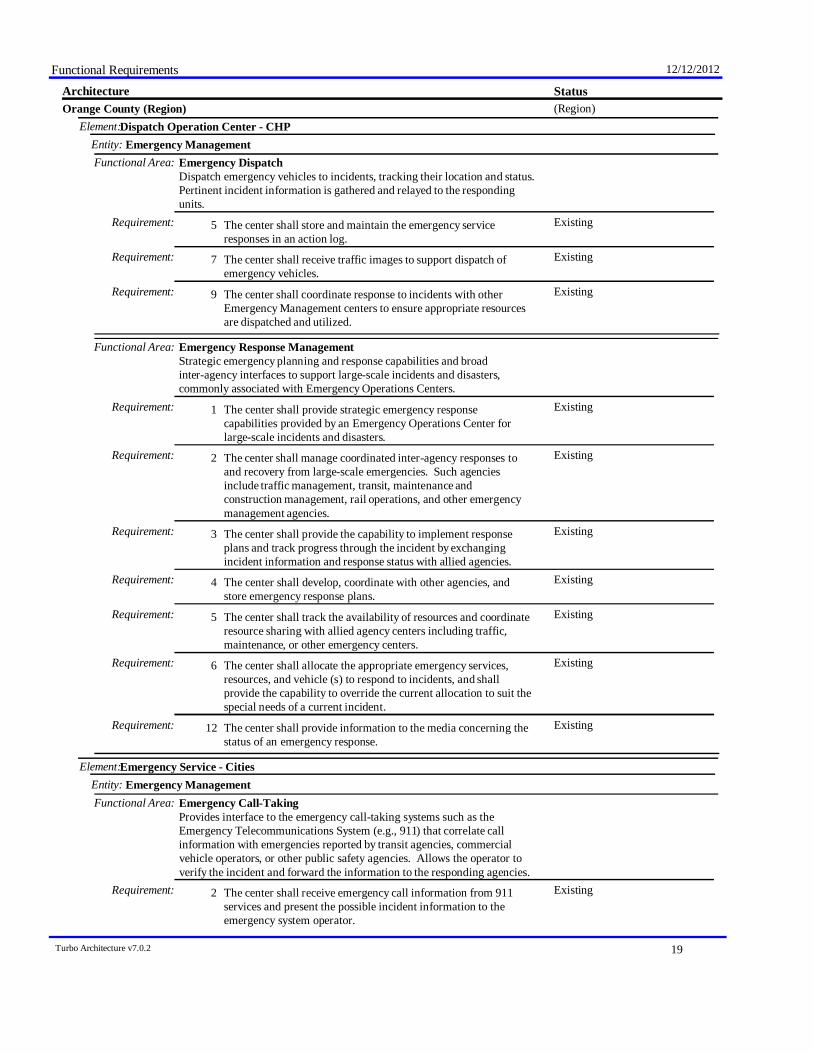
Functional Requirements 12/12/2012
StatusArchitecture(Region)Orange County (Region)
Dispatch Operation Center - CHPElement:Emergency ManagementEntity:
Functional Area: Emergency DispatchDispatch emergency vehicles to incidents, tracking their location and status.Pertinent incident information is gathered and relayed to the respondingunits.
ExistingThe center shall store and maintain the emergency serviceresponses in an action log.
Requirement: 5
ExistingThe center shall receive traffic images to support dispatch ofemergency vehicles.
Requirement: 7
ExistingThe center shall coordinate response to incidents with otherEmergency Management centers to ensure appropriate resourcesare dispatched and utilized.
Requirement: 9
Functional Area: Emergency Response ManagementStrategic emergency planning and response capabilities and broadinter-agency interfaces to support large-scale incidents and disasters,commonly associated with Emergency Operations Centers.
ExistingThe center shall provide strategic emergency responsecapabilities provided by an Emergency Operations Center forlarge-scale incidents and disasters.
Requirement: 1
ExistingThe center shall manage coordinated inter-agency responses toand recovery from large-scale emergencies. Such agenciesinclude traffic management, transit, maintenance andconstruction management, rail operations, and other emergencymanagement agencies.
Requirement: 2
ExistingThe center shall provide the capability to implement responseplans and track progress through the incident by exchangingincident information and response status with allied agencies.
Requirement: 3
ExistingThe center shall develop, coordinate with other agencies, andstore emergency response plans.
Requirement: 4
ExistingThe center shall track the availability of resources and coordinateresource sharing with allied agency centers including traffic,maintenance, or other emergency centers.
Requirement: 5
ExistingThe center shall allocate the appropriate emergency services,resources, and vehicle (s) to respond to incidents, and shallprovide the capability to override the current allocation to suit thespecial needs of a current incident.
Requirement: 6
ExistingThe center shall provide information to the media concerning thestatus of an emergency response.
Requirement: 12
Emergency Service - CitiesElement:Emergency ManagementEntity:
Functional Area: Emergency Call-TakingProvides interface to the emergency call-taking systems such as theEmergency Telecommunications System (e.g., 911) that correlate callinformation with emergencies reported by transit agencies, commercialvehicle operators, or other public safety agencies. Allows the operator toverify the incident and forward the information to the responding agencies.
ExistingThe center shall receive emergency call information from 911services and present the possible incident information to theemergency system operator.
Requirement: 2
Turbo Architecture v7.0.2 19

Functional Requirements 12/12/2012
StatusArchitecture(Region)Orange County (Region)
Emergency Service - CitiesElement:Emergency ManagementEntity:
Functional Area: Emergency Call-TakingProvides interface to the emergency call-taking systems such as theEmergency Telecommunications System (e.g., 911) that correlate callinformation with emergencies reported by transit agencies, commercialvehicle operators, or other public safety agencies. Allows the operator toverify the incident and forward the information to the responding agencies.
ExistingThe center shall coordinate, correlate, and verify all emergencyinputs, including those identified based on external calls andinternal analysis of security sensor and surveillance data, andassign each a level of confidence.
Requirement: 7
ExistingThe center shall update the incident information log once theemergency system operator has verified the incident.
Requirement: 10
Functional Area: Emergency DispatchDispatch emergency vehicles to incidents, tracking their location and status.Pertinent incident information is gathered and relayed to the respondingunits.
ExistingThe center shall dispatch emergency vehicles to respond toverified emergencies under center personnel control.
Requirement: 1
ExistingThe center shall relay location and incident details to theresponding vehicles.
Requirement: 3
ExistingThe center shall track the location and status of emergencyvehicles responding to an emergency based on information fromthe emergency vehicle.
Requirement: 4
Functional Area: Emergency RoutingRouting of emergency vehicles to facilitate the quickest/safest arrival.Routes may be determined based on real-time traffic information and roadconditions or routes may be provided by Traffic Management on request.
ExistingThe center shall collect current traffic and road conditioninformation for emergency vehicle route calculation.
Requirement: 1
Functional Area: Emergency Response ManagementStrategic emergency planning and response capabilities and broadinter-agency interfaces to support large-scale incidents and disasters,commonly associated with Emergency Operations Centers.
ExistingThe center shall manage coordinated inter-agency responses toand recovery from large-scale emergencies. Such agenciesinclude traffic management, transit, maintenance andconstruction management, rail operations, and other emergencymanagement agencies.
Requirement: 2
ExistingThe center shall develop, coordinate with other agencies, andstore emergency response plans.
Requirement: 4
ExistingThe center shall receive event scheduling information from EventPromoters.
Requirement: 7
Emergency Vehicle - CitiesElement:Emergency VehicleEntity:
Functional Area: On-board EV En Route Support
Turbo Architecture v7.0.2 20
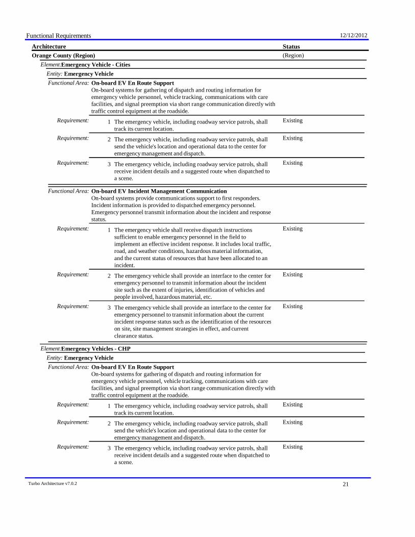
Functional Requirements 12/12/2012
StatusArchitecture(Region)Orange County (Region)
Emergency Vehicle - CitiesElement:Emergency VehicleEntity:
Functional Area: On-board EV En Route SupportOn-board systems for gathering of dispatch and routing information foremergency vehicle personnel, vehicle tracking, communications with carefacilities, and signal preemption via short range communication directly withtraffic control equipment at the roadside.
ExistingThe emergency vehicle, including roadway service patrols, shalltrack its current location.
Requirement: 1
ExistingThe emergency vehicle, including roadway service patrols, shallsend the vehicle's location and operational data to the center foremergency management and dispatch.
Requirement: 2
ExistingThe emergency vehicle, including roadway service patrols, shallreceive incident details and a suggested route when dispatched toa scene.
Requirement: 3
Functional Area: On-board EV Incident Management CommunicationOn-board systems provide communications support to first responders.Incident information is provided to dispatched emergency personnel.Emergency personnel transmit information about the incident and responsestatus.
ExistingThe emergency vehicle shall receive dispatch instructionssufficient to enable emergency personnel in the field toimplement an effective incident response. It includes local traffic,road, and weather conditions, hazardous material information,and the current status of resources that have been allocated to anincident.
Requirement: 1
ExistingThe emergency vehicle shall provide an interface to the center foremergency personnel to transmit information about the incidentsite such as the extent of injuries, identification of vehicles andpeople involved, hazardous material, etc.
Requirement: 2
ExistingThe emergency vehicle shall provide an interface to the center foremergency personnel to transmit information about the currentincident response status such as the identification of the resourceson site, site management strategies in effect, and currentclearance status.
Requirement: 3
Emergency Vehicles - CHPElement:Emergency VehicleEntity:
Functional Area: On-board EV En Route SupportOn-board systems for gathering of dispatch and routing information foremergency vehicle personnel, vehicle tracking, communications with carefacilities, and signal preemption via short range communication directly withtraffic control equipment at the roadside.
ExistingThe emergency vehicle, including roadway service patrols, shalltrack its current location.
Requirement: 1
ExistingThe emergency vehicle, including roadway service patrols, shallsend the vehicle's location and operational data to the center foremergency management and dispatch.
Requirement: 2
ExistingThe emergency vehicle, including roadway service patrols, shallreceive incident details and a suggested route when dispatched toa scene.
Requirement: 3
Turbo Architecture v7.0.2 21
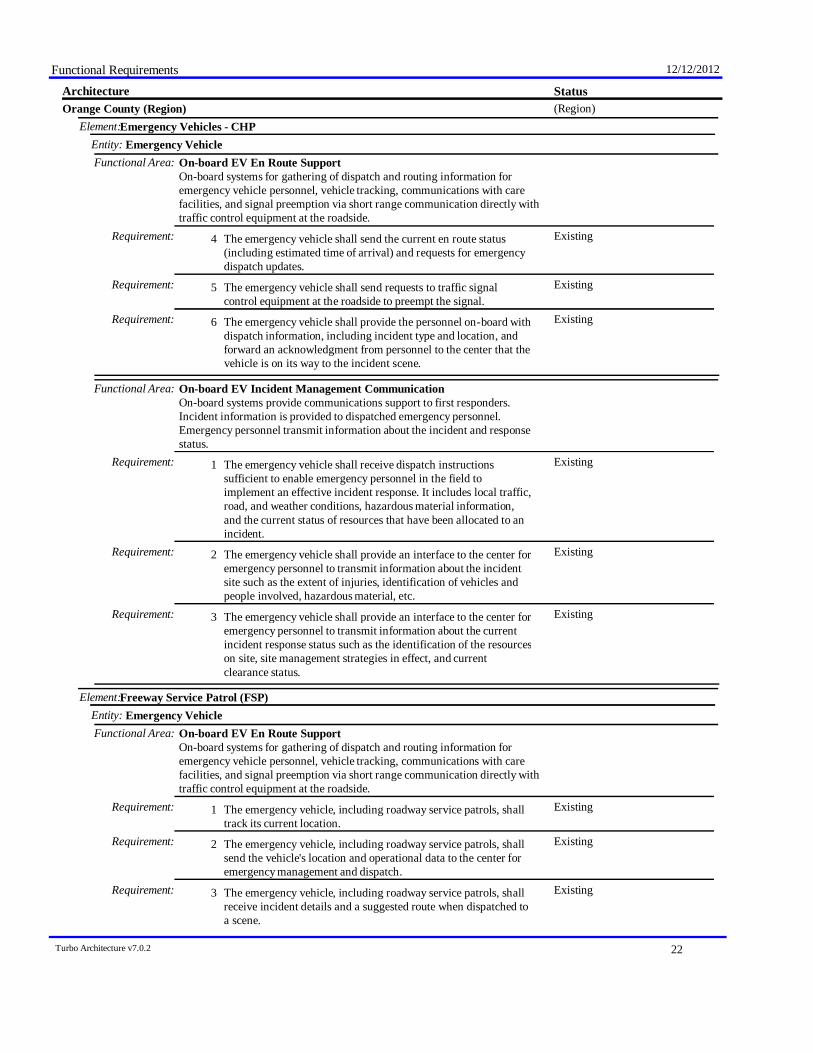
Functional Requirements 12/12/2012
StatusArchitecture(Region)Orange County (Region)
Emergency Vehicles - CHPElement:Emergency VehicleEntity:
Functional Area: On-board EV En Route SupportOn-board systems for gathering of dispatch and routing information foremergency vehicle personnel, vehicle tracking, communications with carefacilities, and signal preemption via short range communication directly withtraffic control equipment at the roadside.
ExistingThe emergency vehicle shall send the current en route status(including estimated time of arrival) and requests for emergencydispatch updates.
Requirement: 4
ExistingThe emergency vehicle shall send requests to traffic signalcontrol equipment at the roadside to preempt the signal.
Requirement: 5
ExistingThe emergency vehicle shall provide the personnel on-board withdispatch information, including incident type and location, andforward an acknowledgment from personnel to the center that thevehicle is on its way to the incident scene.
Requirement: 6
Functional Area: On-board EV Incident Management CommunicationOn-board systems provide communications support to first responders.Incident information is provided to dispatched emergency personnel.Emergency personnel transmit information about the incident and responsestatus.
ExistingThe emergency vehicle shall receive dispatch instructionssufficient to enable emergency personnel in the field toimplement an effective incident response. It includes local traffic,road, and weather conditions, hazardous material information,and the current status of resources that have been allocated to anincident.
Requirement: 1
ExistingThe emergency vehicle shall provide an interface to the center foremergency personnel to transmit information about the incidentsite such as the extent of injuries, identification of vehicles andpeople involved, hazardous material, etc.
Requirement: 2
ExistingThe emergency vehicle shall provide an interface to the center foremergency personnel to transmit information about the currentincident response status such as the identification of the resourceson site, site management strategies in effect, and currentclearance status.
Requirement: 3
Freeway Service Patrol (FSP)Element:Emergency VehicleEntity:
Functional Area: On-board EV En Route SupportOn-board systems for gathering of dispatch and routing information foremergency vehicle personnel, vehicle tracking, communications with carefacilities, and signal preemption via short range communication directly withtraffic control equipment at the roadside.
ExistingThe emergency vehicle, including roadway service patrols, shalltrack its current location.
Requirement: 1
ExistingThe emergency vehicle, including roadway service patrols, shallsend the vehicle's location and operational data to the center foremergency management and dispatch.
Requirement: 2
ExistingThe emergency vehicle, including roadway service patrols, shallreceive incident details and a suggested route when dispatched toa scene.
Requirement: 3
Turbo Architecture v7.0.2 22

Functional Requirements 12/12/2012
StatusArchitecture(Region)Orange County (Region)
Freeway Service Patrol (FSP)Element:Emergency VehicleEntity:
Go-Local Transit VehiclesElement:Transit VehicleEntity:
Functional Area: On-board Transit Trip MonitoringSupport fleet management with automatic vehicle location (AVL) andautomated mileage and fuel reporting and auditing.
FutureThe transit vehicle shall track the current location of the transitvehicle.
Requirement: 1
FutureThe transit vehicle shall support the computation of the locationof a transit vehicle using on-board sensors to augment thelocation determination function. This may include proximity tothe transit stops or other known reference points as well asrecording trip length.
Requirement: 2
FutureThe transit vehicle shall record transit trip monitoring dataincluding vehicle mileage and fuel usage.
Requirement: 3
Functional Area: On-board Transit Fare ManagementOn-board systems provide fare collection using a travelers non-monetaryfare medium. Collected fare data are made available to the center.
FutureThe transit vehicle shall read data from the traveler card /payment instrument presented by boarding passengers.
Requirement: 1
Functional Area: On-board Passenger CountingOn-board systems collect transit vehicle loading data and make it availableto the center.
FutureThe transit vehicle shall count passengers boarding and alighting.Requirement: 1FutureThe passenger counts shall be related to location to support
association of passenger counts with routes, route segments, orbus stops.
Requirement: 2
FutureThe passenger counts shall be timestamped so that ridership canbe measured by time of day and day of week.
Requirement: 3
FutureThe transit vehicle shall send the collected passenger countinformation to the transit center.
Requirement: 4
John Wayne AirportElement:Traffic ManagementEntity:
Functional Area: TMC Traffic Information DisseminationControls dissemination of traffic-related data to other centers, the media, andtravelers via the driver information systems (DMS, HAR) that it operates.
FutureThe center shall retrieve locally stored traffic information,including current and forecasted traffic information, road andweather conditions, traffic incident information, information ondiversions and alternate routes, closures, and special trafficrestrictions (lane/shoulder use, weight restrictions, widthrestrictions, HOV requirements), and the definition of the roadnetwork itself.
Requirement: 5
Functional Area: TMC Regional Traffic Management
Turbo Architecture v7.0.2 23
Functional Requirements 12/12/2012
StatusArchitecture(Region)Orange County (Region)
John Wayne AirportElement:Traffic ManagementEntity:
Functional Area: TMC Regional Traffic ManagementCoordination between traffic management centers in order to share trafficinformation between centers as well as control of traffic management fieldequipment. This may be used during incidents and special events and duringday-to-day operations.
FutureThe center shall exchange traffic information with other trafficmanagement centers including incident information, congestiondata, traffic data, signal timing plans, and real-time signal controlinformation.
Requirement: 1
FutureThe center shall exchange traffic control information with othertraffic management centers to support remote monitoring andcontrol of traffic management devices (e.g. signs, sensors,signals, cameras, etc.).
Requirement: 2
MCO Vehicles - CaltransElement:Maintenance and Construction VehicleEntity:
Functional Area: MCV Work Zone SupportOn-board systems that provide communications and support for localmanagement of a work zone.
ExistingThe maintenance and construction vehicle shall monitor, operate,and control work zone devices located at or alongside theroadway. The devices operated on board the vehicle includedriver information devices (e.g. dynamic message signs) andwork zone intrusion detection and alert devices.
Requirement: 1
ExistingThe maintenance and construction vehicle shall provide aninterface for field personnel to input status of their work zoneactivities.
Requirement: 2
MetrolinkElement:Transit ManagementEntity:
Functional Area: Transit Center Fare ManagementManagement of fare collection at the center - includes setting anddistributing fare information, central processing of fares for transit as well asother ITS services, links to financial institutions and enforcement agencies.
FutureThe center shall support the payment of transit fare transactionsusing data provided by the traveler cards / payment instruments.
Requirement: 4
FutureThe center shall process requests for the advanced payment oftolls and parking lot charges as well as other non-transportationservices, e.g. yellow-pages services.
Requirement: 7
Functional Area: Transit Center Multi-Modal CoordinationCoordinate schedules with other agencies and modes, including transittransfer cluster and transfer point information.
FutureThe center shall coordinate schedules and services betweentransit agencies, traffic management, maintenance andconstruction operations, parking management, and other surfaceor air transportation modes.
Requirement: 1
OCTA Access Service VehiclesElement:Transit VehicleEntity:
Functional Area: On-board Paratransit Operations
Turbo Architecture v7.0.2 24
Functional Requirements 12/12/2012
StatusArchitecture(Region)Orange County (Region)
OCTA Access Service VehiclesElement:Transit VehicleEntity:
Functional Area: On-board Paratransit OperationsOn-board systems to manage paratransit and flexible-route dispatch requests,including multi-stop runs. Passenger data is collected and provided to thecenter.
ExistingThe transit vehicle shall receive the status of demand responsiveor flexible-route transit schedules and passenger loading from thetransit vehicle operator.
Requirement: 2
ExistingThe transit vehicle shall provide the transit vehicle operatorinstructions about the demand responsive or flexible-route transitschedule that has been confirmed from the center.
Requirement: 3
OCTA Data WarehouseElement:Archived Data ManagementEntity:
Functional Area: ITS Data RepositoryCollect and maintain data and data catalogs from one or more data sources.May include quality checks, error notification, and archive coordination.
ExistingThe center shall collect data to be archived from one or moredata sources.
Requirement: 1
ExistingThe center shall collect data catalogs from one or more datasources. A catalog describes the data contained in the collectionof archived data and may include descriptions of the schema orstructure of the data, a description of the contents of the data;e.g., time range of entries, number of entries; or a sample of thedata (e. g. a thumbnail).
Requirement: 2
ExistingThe center shall include capabilities for performing qualitychecks on the incoming archived data.
Requirement: 4
FutureThe center shall support a broad range of archived datamanagement implementations, ranging from simple data martsthat collect a focused set of data and serve a particular usercommunity to large-scale data warehouses that collect, integrate,and summarize transportation data from multiple sources andserve a broad array of users within a region.
Requirement: 7
Functional Area: Traffic and Roadside Data ArchivalCollects and archives traffic and environmental information directly from theroadside for use in off-line planning, research, and analysis.
[Not Defined]Requirement:
Functional Area: Virtual Data Warehouse ServicesProvides access to data from geographically dispersed archives andcoordinates information exchange with a local data warehouse. Alsoprovides the specialized publishing, directory services, and transactionmanagement functions associated with coordinating remote archives.
FutureThe center shall provide capabilities to access "in-place" datafrom geographically dispersed archives. These capabilities mayinclude analysis, data fusion, or data mining.
Requirement: 1
FutureThe center shall coordinate information exchange with a localdata warehouse.
Requirement: 2
OCTA Fixed Route BusesElement:Transit VehicleEntity:
Turbo Architecture v7.0.2 25

Functional Requirements 12/12/2012
StatusArchitecture(Region)Orange County (Region)
OCTA Fixed Route BusesElement:Transit VehicleEntity:
Functional Area: On-board Transit Fare ManagementOn-board systems provide fare collection using a travelers non-monetaryfare medium. Collected fare data are made available to the center.
ExistingThe transit vehicle shall read data from the traveler card /payment instrument presented by boarding passengers.
Requirement: 1
Functional Area: On-board Transit Signal PriorityOn-board systems request signal priority through short range communicationdirectly with traffic control equipment at the roadside (intersections, ramps,interchanges, etc.).
FutureThe transit vehicle shall determine the schedule deviation andestimated times of arrival (ETA) at transit stops.
Requirement: 1
FutureThe transit vehicle shall send priority requests to traffic signalcontrollers at intersections, pedestrian crossings, and multimodalcrossings on the roads (surface streets) and freeway (rampcontrols) network that enable a transit vehicle schedule deviationto be corrected.
Requirement: 2
FutureThe transit vehicle shall send the schedule deviation data andstatus of priority requests to the transit vehicle operator andprovide the capability for the transit vehicle operator to controlthe priority system.
Requirement: 3
FutureThe transit vehicle shall prevent a priority request from beingsent when the transit vehicle cannot use the priority (e.g., whenthe transit vehicle makes a passenger stop on the approach to anintersection).
Requirement: 4
OCTA Intelligent Transit Management SystemElement:Transit ManagementEntity:
Functional Area: Transit Center Vehicle TrackingMonitoring transit vehicle locations via interactions with on-board systems.Furnish users with real-time transit schedule information and maintaininterface with digital map providers.
ExistingThe center shall monitor the locations of all transit vehicleswithin its network.
Requirement: 1
PlannedThe center shall determine adherence of transit vehicles to theirassigned schedule.
Requirement: 2
PlannedThe center shall support an interface with a map update provider,or other appropriate data sources, through which updates ofdigitized map data can be obtained and used as a background fortransit tracking and dispatch.
Requirement: 3
FutureThe center shall provide transit operational data to travelerinformation service providers.
Requirement: 4
FutureThe center shall provide collected transit probe data to trafficmanagement centers and traveler information service providersfor use in measuring current traffic conditions.
Requirement: 5
Functional Area: Transit Center Fixed-Route Operations
Turbo Architecture v7.0.2 26
Functional Requirements 12/12/2012
StatusArchitecture(Region)Orange County (Region)
OCTA Intelligent Transit Management SystemElement:Transit ManagementEntity:
Functional Area: Transit Center Fixed-Route OperationsManagement of fixed route transit operations. Planning, scheduling, anddispatch associated with fixed and flexible route transit services. Updatescustomer service operator systems, and provides current vehicle scheduleadherence and optimum scenarios for schedule adjustment.
PlannedThe center shall generate transit routes and schedules based onsuch factors as parameters input by the system operator, roadnetwork conditions, incident information, operational data oncurrent routes and schedules, and digitized map data.
Requirement: 1
PlannedThe center shall provide the interface to the system operator tocontrol the generation of new routes and schedules (transitservices) including the ability to review and update theparameters used by the routes and schedules generation processesand to initiate these processes
Requirement: 2
FutureThe center shall dispatch fixed route or flexible route transitvehicles
Requirement: 4
FutureThe center shall collect transit operational data for use in thegeneration of routes and schedules.
Requirement: 5
Functional Area: Transit Vehicle AssignmentAssigns individual transit vehicles to vehicle blocks and downloads thisinformation to the transit vehicle, updating assignments as necessitated bychanges. It also provides an inventory management function that storesattributes about each of the transit vehicles.
PlannedThe center shall download vehicle assignments to the transitvehicle prior to the start of the day’s operations.
Requirement: 2
PlannedThe center shall provide an exception handling process for thevehicle assignment function. This process shall generate newsupplemental vehicle assignments as required due to changeevents which occur during the operating day.
Requirement: 3
PlannedThe center shall generate transit vehicle availability listings,current and forecast, to support transit vehicle assignmentplanning.
Requirement: 5
Functional Area: Transit Center Information ServicesProvide interactive traveler information to travelers (on-board transitvehicles, at stops/stations, using personal devices), traveler informationservice providers, media, and other transit organizations. Includes routes,schedules, transfer options, fares, real-time schedule adherence, currentincidents, weather conditions, yellow pages, and special events.
FutureThe center shall provide travelers using public transportationwith traffic and advisory information upon request. Suchinformation may include transit routes, schedules, transferoptions, fares, real-time schedule adherence, current incidents,weather conditions, and special events.
Requirement: 1
FutureThe center shall exchange transit schedules, real-time arrivalinformation, fare schedules, and general transit serviceinformation with other transit organizations to support transittraveler information systems.
Requirement: 3
Turbo Architecture v7.0.2 27
Functional Requirements 12/12/2012
StatusArchitecture(Region)Orange County (Region)
OCTA Intelligent Transit Management SystemElement:Transit ManagementEntity:
Functional Area: Transit Center Information ServicesProvide interactive traveler information to travelers (on-board transitvehicles, at stops/stations, using personal devices), traveler informationservice providers, media, and other transit organizations. Includes routes,schedules, transfer options, fares, real-time schedule adherence, currentincidents, weather conditions, yellow pages, and special events.
FutureThe center shall provide transit service information to travelerinformation service providers including routes, schedules,schedule adherence, and fare information as well as transitservice information during evacuation.
Requirement: 4
Functional Area: Transit Data CollectionCollection and storage of transit management data. For use by operationspersonnel or data archives in the region.
PlannedThe center shall collect transit management data such as transitfares and passenger use, transit services, paratransit operations,transit vehicle maintenance data, etc.
Requirement: 1
PlannedThe center shall assign quality control metrics and meta-data tobe stored along with the data. Meta-data may include attributesthat describe the source and quality of the data and the conditionssurrounding the collection of the data.
Requirement: 2
FutureThe center shall receive and respond to requests from ITSArchives for either a catalog of the transit data or for the dataitself.
Requirement: 3
OCTA.net - Trip PlannerElement:Information Service ProviderEntity:
Functional Area: Interactive Infrastructure InformationPersonalized dissemination of traffic, transit, maintenance and construction,multimodal, event, and weather information to traveler interface systems andvehicles, upon request.
PlannedThe center shall disseminate customized traffic and highwaycondition information to travelers, including incidentinformation, detours and road closures, recommended routes, andcurrent speeds on specific routes upon request.
Requirement: 1
PlannedThe center shall disseminate customized maintenance andconstruction information to travelers, including scheduledmaintenance and construction work activities and work zoneactivities upon request.
Requirement: 2
PlannedThe center shall disseminate customized transit routes andschedules, transit transfer options, transit fares, and real-timeschedule adherence information to travelers upon request.
Requirement: 3
PlannedThe center shall disseminate customized parking information totravelers, including location, availability, and fees upon request.
Requirement: 4
PlannedThe center shall disseminate customized toll fee information totravelers upon request.
Requirement: 5
Functional Area: Traveler Telephone InformationDistribution of traveler information and wide-area alerts to travelertelephone information systems such as 511, based on voice-based travelerrequests.
Turbo Architecture v7.0.2 28
Functional Requirements 12/12/2012
StatusArchitecture(Region)Orange County (Region)
OCTA.net - Trip PlannerElement:Information Service ProviderEntity:
Functional Area: Traveler Telephone InformationDistribution of traveler information and wide-area alerts to travelertelephone information systems such as 511, based on voice-based travelerrequests.
ExistingThe center shall provide the capability to process voice-formattedrequests for traveler information from a traveler telephoneinformation system, and return the information in the requestedformat.
Requirement: 1
ExistingThe center shall provide the capability to process dual-tonemultifrequency (DTMF)-based requests (touch-tone) for travelerinformation from a traveler telephone information system.
Requirement: 2
ExistingThe center shall provide the capability to process travelerinformation requests from a traveler telephone informationsystem.
Requirement: 3
ExistingThe center shall provide transit service information in therequested voice format and for the requested location.
Requirement: 8
Functional Area: Infrastructure Provided Trip PlanningGeneration of pre-trip and enroute trip plans for travelers (and vehicles)based on current traffic conditions, work zones, weather, and travelersconstraints and preferences. Includes end-to-end trips using multiple modes,such as bicycle, transit, etc.
ExistingThe center shall provide the capability to provide specificpre-trip and enroute directions to travelers (and drivers),including costs, arrival times, and transfer points.
Requirement: 1
PlannedThe center shall include bicycle routes, walkways, skyways, andmulti-use trails in the pre-trip and enroute directions it providesto travelers.
Requirement: 2
PlannedThe center shall support on-line route guidance for travelersusing personal devices (such as PDAs).
Requirement: 3
Functional Area: ISP Travel Services Information and ReservationCustomized dissemination of yellow pages information to traveler interfacesystems and vehicles, upon request. Also includes reservation for services tosupport trip planning.
FutureThe center shall disseminate yellow pages information (such aslodging, restaurants, theaters, bicycle facilities, and other touristactivities) to travelers upon request.
Requirement: 1
Functional Area: Infrastructure Provided Dynamic RidesharingDynamic rideshare matching, including traveler eligibility, preferenceinformation, connections to transit or other multimodal services,confirmation, and payment of rideshare matching services.
PlannedThe center shall accept requests from traveler interface systemsfor ridesharing as part of a trip plan request.
Requirement: 1
FutureThe center shall provide a rideshare match based on origin anddestination of the traveler's proposed trip, any routing constraints,preferences specified by the traveler, compatibility of thisrideshare with rideshares confirmed by other travelers, therequesting traveler's eligibility data, and traffic data.
Requirement: 2
Turbo Architecture v7.0.2 29
Functional Requirements 12/12/2012
StatusArchitecture(Region)Orange County (Region)
OCTA.net - Trip PlannerElement:Information Service ProviderEntity:
Functional Area: Infrastructure Provided Dynamic RidesharingDynamic rideshare matching, including traveler eligibility, preferenceinformation, connections to transit or other multimodal services,confirmation, and payment of rideshare matching services.
FutureThe center shall process rideshare requests by balancing therelative benefits of the rideshare to each rideshare participant.
Requirement: 3
FutureThe center shall arrange connections to transit or othermultimodal services for portions of a multi-segment trip thatincludes ridesharing.
Requirement: 4
FutureThe center shall provide a confirmation of the traveler's ridesharematch and provide the capability to support a paymenttransaction for the rideshare service.
Requirement: 5
FutureThe center shall store all rideshare matches and travelereligibility data.
Requirement: 6
Other Toll RoadsElement:Payment AdministrationEntity:
Functional Area: Toll AdministrationManagement of toll collection for private and commercial vehicles, dynamicpricing, payment reconciliation with financial institutions, and violationnotification to enforcement agencies.
ExistingThe center shall manage toll transactions, including maintaining alog of all transactions and toll pricing structure information.
Requirement: 1
ExistingFor electronic toll payments requiring financial payment, thecenter shall process the financial information from toll plazas andmanage an interface to a Financial Institution.
Requirement: 3
ExistingThe center shall manage the details of toll payment violationsbased on vehicle information from the toll plaza, registrationinformation from the Department of Motor Vehicles, invalidpayment information from a Financial Institution, and previousviolation information stored locally, and report such violations toappropriate law enforcement agencies.
Requirement: 5
ExistingThe center shall respond to changes in toll prices from the TollAdministrator.
Requirement: 7
ExistingThe center shall support wide-area alerts from emergency centersby passing on the information to its toll plazas and the TollAdministrator.
Requirement: 10
Functional Area: Center VMT Payment AdministrationManagement of a VMT payment system. Receives VMT data and computesthe total cost to the vehicle owner for payment.
ExistingThe center shall register vehicles for road use payment,establishing accounts that identify owner billing information andpreferences.
Requirement: 1
ExistingThe center shall provide secure user account management,providing user access to rules and policies, current billing status,invoices, payments, and mechanisms for review and challenge ofthe collected data.
Requirement: 2
Turbo Architecture v7.0.2 30
Functional Requirements 12/12/2012
StatusArchitecture(Region)Orange County (Region)
Other Toll RoadsElement:Payment AdministrationEntity:
Functional Area: Center VMT Payment AdministrationManagement of a VMT payment system. Receives VMT data and computesthe total cost to the vehicle owner for payment.
ExistingThis center shall maintain and publish road use prices, asconfigured by the Payment Administrator.
Requirement: 3
ExistingThe center shall receive VMT data (time stamped log ofroadways used by the vehicle) and compute the total cost to thevehicle owner.
Requirement: 4
ExistingThe center shall calculate road use charges based on the vehicle'smileage, roads traveled, time periods, emissions profile formake/model, fuel economy for make/model, weight, number ofaxles/tires, or other policies.
Requirement: 5
ExistingThe center shall access and use registration and odometerinformation from the DMV to verify and audit collected VMTdata.
Requirement: 6
ExistingThe center shall process and clear payments from vehicle ownersand operators as well as payments to other Center VMT PaymentAdministration through clearing houses provided by financialinstitutions.
Requirement: 7
ExistingThe center shall coordinate with other VMT PaymentAdministration systems to reconcile and apportion payments forvehicles registered in other jurisdictions.
Requirement: 8
ExistingThe center shall report payment violations including vehicleinformation and vehicle image to the designated EnforcementAgency.
Requirement: 9
ExistingThe center shall monitor the operational status of VMT fieldequipment and identify equipment faults.
Requirement: 10
Parking Guidance SystemsElement:Parking ManagementEntity:
Functional Area: Parking CoordinationCoordination between parking facilities and between parking facilities andtraffic, transit, and traveler information systems. Includes sharing of hours ofoperation, charging strategies, lot sizes, current parking availability, andparking reservations.
FutureThe parking element shall exchange parking management datawith other parking facilities including location, hours,availability, status, lot usage, operating strategies, and charginginformation.
Requirement: 1
FutureThe parking element shall provide parking management data totraffic management centers upon request as part of theimplementation of demand management programs in the region.This could include changes to hours of operation or pricing.
Requirement: 2
FutureThe parking element shall distribute parking lot information totraffic management centers upon request to support integratedregional traffic control and parking management. This couldinclude information on facility hours of operation and currentparking availability.
Requirement: 3
Turbo Architecture v7.0.2 31
Functional Requirements 12/12/2012
StatusArchitecture(Region)Orange County (Region)
Parking Guidance SystemsElement:Parking ManagementEntity:
Functional Area: Parking CoordinationCoordination between parking facilities and between parking facilities andtraffic, transit, and traveler information systems. Includes sharing of hours ofoperation, charging strategies, lot sizes, current parking availability, andparking reservations.
FutureThe parking element shall distribute parking lot information uponrequest to transit management centers for park and ride facilities,parking shuttle services, and other applications that integratetransit and parking services.
Requirement: 4
FutureThe parking element shall distribute parking lot information uponrequest to traveler information providers to support travelplanning.
Requirement: 5
FutureThe parking element shall support requests for parkingreservations.
Requirement: 6
RDMDElement:Traffic ManagementEntity:
Functional Area: Traffic Equipment MaintenanceMonitoring and remote diagnostics of field equipment - detect failures, issueproblem reports, and track the repair or replacement of the failed equipment.
ExistingThe center shall collect and store sensor (traffic, pedestrian,multimodal crossing) operational status.
Requirement: 1
ExistingThe center shall collect and store CCTV surveillance system(traffic, pedestrian) operational status.
Requirement: 2
ExistingThe center shall collect and store sensor (traffic, pedestrian,multimodal crossing) fault data and send to the maintenancecenter for repair.
Requirement: 3
Remote Traveler Support - OCTAElement:Remote Traveler SupportEntity:
Functional Area: Remote Interactive Information ReceptionPublic traveler interface, such as a kiosk, that provides traffic, transit, yellowpages, special event, and other personalized traveler information servicesupon request.
PlannedThe public interface for travelers shall receive traffic informationfrom a center and present it to the traveler upon request.
Requirement: 1
ExistingThe public interface for travelers shall receive transit informationfrom a center and present it to the traveler upon request.
Requirement: 2
PlannedThe public interface for travelers shall receive yellow pagesinformation (such as lodging, restaurants, theaters, bicyclefacilities, and other tourist activities) from a center and present itto the traveler upon request.
Requirement: 3
ExistingThe public interface for travelers shall receive event informationfrom a center and present it to the traveler upon request.
Requirement: 4
PlannedThe public interface for travelers shall receive evacuationinformation from a center and present it to the traveler.
Requirement: 5
PlannedThe public interface for travelers shall receive wide-area alertsand present it to the traveler.
Requirement: 6
Turbo Architecture v7.0.2 32
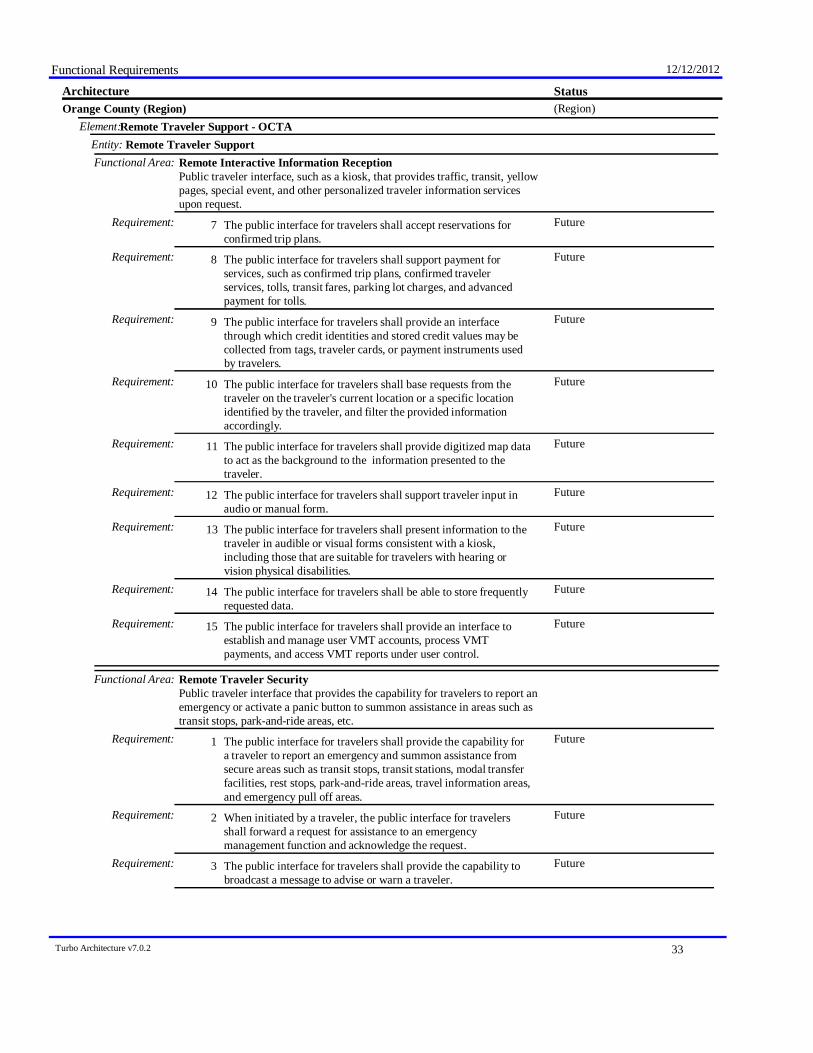
Functional Requirements 12/12/2012
StatusArchitecture(Region)Orange County (Region)
Remote Traveler Support - OCTAElement:Remote Traveler SupportEntity:
Functional Area: Remote Interactive Information ReceptionPublic traveler interface, such as a kiosk, that provides traffic, transit, yellowpages, special event, and other personalized traveler information servicesupon request.
FutureThe public interface for travelers shall accept reservations forconfirmed trip plans.
Requirement: 7
FutureThe public interface for travelers shall support payment forservices, such as confirmed trip plans, confirmed travelerservices, tolls, transit fares, parking lot charges, and advancedpayment for tolls.
Requirement: 8
FutureThe public interface for travelers shall provide an interfacethrough which credit identities and stored credit values may becollected from tags, traveler cards, or payment instruments usedby travelers.
Requirement: 9
FutureThe public interface for travelers shall base requests from thetraveler on the traveler's current location or a specific locationidentified by the traveler, and filter the provided informationaccordingly.
Requirement: 10
FutureThe public interface for travelers shall provide digitized map datato act as the background to the information presented to thetraveler.
Requirement: 11
FutureThe public interface for travelers shall support traveler input inaudio or manual form.
Requirement: 12
FutureThe public interface for travelers shall present information to thetraveler in audible or visual forms consistent with a kiosk,including those that are suitable for travelers with hearing orvision physical disabilities.
Requirement: 13
FutureThe public interface for travelers shall be able to store frequentlyrequested data.
Requirement: 14
FutureThe public interface for travelers shall provide an interface toestablish and manage user VMT accounts, process VMTpayments, and access VMT reports under user control.
Requirement: 15
Functional Area: Remote Traveler SecurityPublic traveler interface that provides the capability for travelers to report anemergency or activate a panic button to summon assistance in areas such astransit stops, park-and-ride areas, etc.
FutureThe public interface for travelers shall provide the capability fora traveler to report an emergency and summon assistance fromsecure areas such as transit stops, transit stations, modal transferfacilities, rest stops, park-and-ride areas, travel information areas,and emergency pull off areas.
Requirement: 1
FutureWhen initiated by a traveler, the public interface for travelersshall forward a request for assistance to an emergencymanagement function and acknowledge the request.
Requirement: 2
FutureThe public interface for travelers shall provide the capability tobroadcast a message to advise or warn a traveler.
Requirement: 3
Turbo Architecture v7.0.2 33
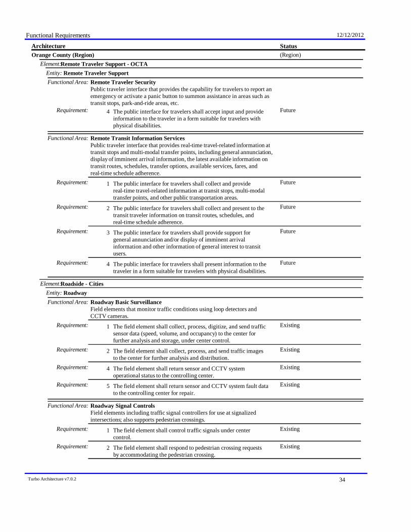
Functional Requirements 12/12/2012
StatusArchitecture(Region)Orange County (Region)
Remote Traveler Support - OCTAElement:Remote Traveler SupportEntity:
Functional Area: Remote Traveler SecurityPublic traveler interface that provides the capability for travelers to report anemergency or activate a panic button to summon assistance in areas such astransit stops, park-and-ride areas, etc.
FutureThe public interface for travelers shall accept input and provideinformation to the traveler in a form suitable for travelers withphysical disabilities.
Requirement: 4
Functional Area: Remote Transit Information ServicesPublic traveler interface that provides real-time travel-related information attransit stops and multi-modal transfer points, including general annunciation,display of imminent arrival information, the latest available information ontransit routes, schedules, transfer options, available services, fares, andreal-time schedule adherence.
FutureThe public interface for travelers shall collect and providereal-time travel-related information at transit stops, multi-modaltransfer points, and other public transportation areas.
Requirement: 1
FutureThe public interface for travelers shall collect and present to thetransit traveler information on transit routes, schedules, andreal-time schedule adherence.
Requirement: 2
FutureThe public interface for travelers shall provide support forgeneral annunciation and/or display of imminent arrivalinformation and other information of general interest to transitusers.
Requirement: 3
FutureThe public interface for travelers shall present information to thetraveler in a form suitable for travelers with physical disabilities.
Requirement: 4
Roadside - CitiesElement:RoadwayEntity:
Functional Area: Roadway Basic SurveillanceField elements that monitor traffic conditions using loop detectors andCCTV cameras.
ExistingThe field element shall collect, process, digitize, and send trafficsensor data (speed, volume, and occupancy) to the center forfurther analysis and storage, under center control.
Requirement: 1
ExistingThe field element shall collect, process, and send traffic imagesto the center for further analysis and distribution.
Requirement: 2
ExistingThe field element shall return sensor and CCTV systemoperational status to the controlling center.
Requirement: 4
ExistingThe field element shall return sensor and CCTV system fault datato the controlling center for repair.
Requirement: 5
Functional Area: Roadway Signal ControlsField elements including traffic signal controllers for use at signalizedintersections; also supports pedestrian crossings.
ExistingThe field element shall control traffic signals under centercontrol.
Requirement: 1
ExistingThe field element shall respond to pedestrian crossing requestsby accommodating the pedestrian crossing.
Requirement: 2
Turbo Architecture v7.0.2 34
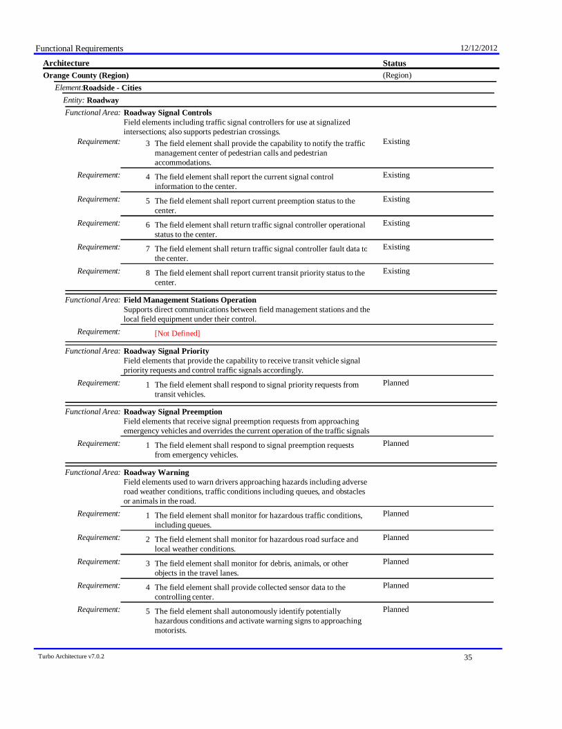
Functional Requirements 12/12/2012
StatusArchitecture(Region)Orange County (Region)
Roadside - CitiesElement:RoadwayEntity:
Functional Area: Roadway Signal ControlsField elements including traffic signal controllers for use at signalizedintersections; also supports pedestrian crossings.
ExistingThe field element shall provide the capability to notify the trafficmanagement center of pedestrian calls and pedestrianaccommodations.
Requirement: 3
ExistingThe field element shall report the current signal controlinformation to the center.
Requirement: 4
ExistingThe field element shall report current preemption status to thecenter.
Requirement: 5
ExistingThe field element shall return traffic signal controller operationalstatus to the center.
Requirement: 6
ExistingThe field element shall return traffic signal controller fault data tothe center.
Requirement: 7
ExistingThe field element shall report current transit priority status to thecenter.
Requirement: 8
Functional Area: Field Management Stations OperationSupports direct communications between field management stations and thelocal field equipment under their control.
[Not Defined]Requirement:
Functional Area: Roadway Signal PriorityField elements that provide the capability to receive transit vehicle signalpriority requests and control traffic signals accordingly.
PlannedThe field element shall respond to signal priority requests fromtransit vehicles.
Requirement: 1
Functional Area: Roadway Signal PreemptionField elements that receive signal preemption requests from approachingemergency vehicles and overrides the current operation of the traffic signals
PlannedThe field element shall respond to signal preemption requestsfrom emergency vehicles.
Requirement: 1
Functional Area: Roadway WarningField elements used to warn drivers approaching hazards including adverseroad weather conditions, traffic conditions including queues, and obstaclesor animals in the road.
PlannedThe field element shall monitor for hazardous traffic conditions,including queues.
Requirement: 1
PlannedThe field element shall monitor for hazardous road surface andlocal weather conditions.
Requirement: 2
PlannedThe field element shall monitor for debris, animals, or otherobjects in the travel lanes.
Requirement: 3
PlannedThe field element shall provide collected sensor data to thecontrolling center.
Requirement: 4
PlannedThe field element shall autonomously identify potentiallyhazardous conditions and activate warning signs to approachingmotorists.
Requirement: 5
Turbo Architecture v7.0.2 35
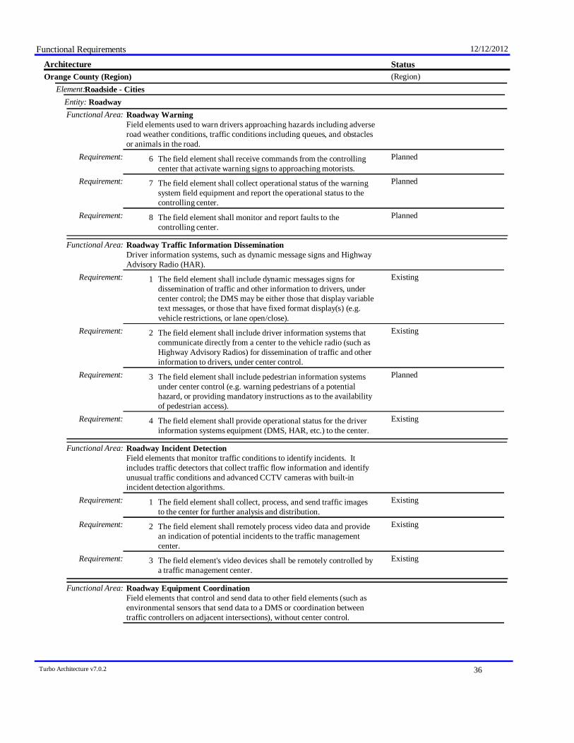
Functional Requirements 12/12/2012
StatusArchitecture(Region)Orange County (Region)
Roadside - CitiesElement:RoadwayEntity:
Functional Area: Roadway WarningField elements used to warn drivers approaching hazards including adverseroad weather conditions, traffic conditions including queues, and obstaclesor animals in the road.
PlannedThe field element shall receive commands from the controllingcenter that activate warning signs to approaching motorists.
Requirement: 6
PlannedThe field element shall collect operational status of the warningsystem field equipment and report the operational status to thecontrolling center.
Requirement: 7
PlannedThe field element shall monitor and report faults to thecontrolling center.
Requirement: 8
Functional Area: Roadway Traffic Information DisseminationDriver information systems, such as dynamic message signs and HighwayAdvisory Radio (HAR).
ExistingThe field element shall include dynamic messages signs fordissemination of traffic and other information to drivers, undercenter control; the DMS may be either those that display variabletext messages, or those that have fixed format display(s) (e.g.vehicle restrictions, or lane open/close).
Requirement: 1
ExistingThe field element shall include driver information systems thatcommunicate directly from a center to the vehicle radio (such asHighway Advisory Radios) for dissemination of traffic and otherinformation to drivers, under center control.
Requirement: 2
PlannedThe field element shall include pedestrian information systemsunder center control (e.g. warning pedestrians of a potentialhazard, or providing mandatory instructions as to the availabilityof pedestrian access).
Requirement: 3
ExistingThe field element shall provide operational status for the driverinformation systems equipment (DMS, HAR, etc.) to the center.
Requirement: 4
Functional Area: Roadway Incident DetectionField elements that monitor traffic conditions to identify incidents. Itincludes traffic detectors that collect traffic flow information and identifyunusual traffic conditions and advanced CCTV cameras with built-inincident detection algorithms.
ExistingThe field element shall collect, process, and send traffic imagesto the center for further analysis and distribution.
Requirement: 1
ExistingThe field element shall remotely process video data and providean indication of potential incidents to the traffic managementcenter.
Requirement: 2
ExistingThe field element's video devices shall be remotely controlled bya traffic management center.
Requirement: 3
Functional Area: Roadway Equipment CoordinationField elements that control and send data to other field elements (such asenvironmental sensors that send data to a DMS or coordination betweentraffic controllers on adjacent intersections), without center control.
Turbo Architecture v7.0.2 36

Functional Requirements 12/12/2012
StatusArchitecture(Region)Orange County (Region)
Roadside - CitiesElement:RoadwayEntity:
Functional Area: Roadway Equipment CoordinationField elements that control and send data to other field elements (such asenvironmental sensors that send data to a DMS or coordination betweentraffic controllers on adjacent intersections), without center control.
FutureThe field element shall include sensors that provide data andstatus information to other field element devices, without centercontrol.
Requirement: 1
FutureThe field element shall include sensors that receive configurationdata from other field element devices, without center control.
Requirement: 2
FutureThe field element shall include devices that provide data andstatus information to other field element devices without centercontrol.
Requirement: 3
FutureThe field element shall include devices that receive configurationdata from other field element devices, without center control.
Requirement: 4
Functional Area: Roadway Speed Monitoring and WarningVehicle speed sensors that detect excessive vehicle speeds, optionally basedon conditions and vehicle type, informing drivers, centers and/orenforcement agencies of speed violations.
ExistingThe field element shall include sensors to detect vehicle speeds,under traffic or maintenance center control.
Requirement: 1
ExistingIf the speed detected by vehicle speed sensors is determined to beexcessive, the field element shall provide a safe speed advisory topassing drivers via a driver information system (such as portablemessages signs, field to vehicle communications to in-vehiclesigning systems, etc.).
Requirement: 3
Functional Area: Roadway Work Zone Traffic ControlField elements in maintenance and construction areas including CCTVcameras, driver information systems (such as DMS), and gates/barriers thatmonitor and control traffic and provide information directly to drivers inaffected areas.
FutureThe field element shall collect, process, and send work zoneimages to the center for further analysis and distribution, undercenter control.
Requirement: 1
ExistingUnder traffic and maintenance center control, the field elementshall include driver information systems (such as dynamicmessages signs and highway advisory radios) that advise driversof activity around the work zone through which they are currentlypassing.
Requirement: 2
Functional Area: Roadway Short Range Traveler Information CommunicationsField elements that distribute information to in-vehicle equipment. Theinformation provided may be determined locally or under the control of acenter.
FutureThe field element shall distribute traveler information includingtraffic and road conditions to passing vehicles using short rangecommunications, under center control.
Requirement: 1
Turbo Architecture v7.0.2 37

Functional Requirements 12/12/2012
StatusArchitecture(Region)Orange County (Region)
Roadside - CitiesElement:RoadwayEntity:
Functional Area: Roadway Short Range Traveler Information CommunicationsField elements that distribute information to in-vehicle equipment. Theinformation provided may be determined locally or under the control of acenter.
FutureThe field element shall distribute advisory information, such asevacuation information, wide-area alerts, incident information,work zone intrusion information, and other special information topassing vehicles using short range communications, under centercontrol.
Requirement: 2
FutureThe field element shall distribute indicator and fixed signinformation, including static sign information (e.g., stop, curvewarning, guide signs, service signs, and directional signs) anddynamic information (e.g., current signal states and localconditions warnings identified by local environmental sensors) toequipment on-board vehicles under center control.
Requirement: 3
FutureThe field element shall return system operational status to thecontrolling center.
Requirement: 4
FutureThe field element shall return system fault data to themaintenance center for repair.
Requirement: 5
Functional Area: Roadway Data CollectionField elements to collect traffic, road, and environmental conditionsinformation for use in transportation planning, research, and other off-lineapplications. Includes the sensors, supporting roadside infrastructure, andcommunications equipment.
ExistingThe field element shall collect traffic, road, and environmentalconditions information.
Requirement: 1
ExistingThe field element shall include the sensors and supportingroadside devices that sense, collect, and send traffic, road, andenvironmental conditions information to a center for archival.
Requirement: 2
ExistingThe field element shall collect sensor status and sensor faultsfrom roadside equipment and send it along with the recorded datato a center for archival.
Requirement: 3
Security Monitoring Field Equipment - CountyElement:Remote Traveler SupportEntity:
Functional Area: Traveler Secure Area SurveillanceSecurity surveillance devices that monitor traveler-frequented areas such astransit stops and rest stops.
ExistingThe field element shall include video and/or audio surveillance oftraveler secure areas including transit stations, transit stops, restareas, park and ride lots, and other fixed sites along travel routes(e.g., emergency pull-off areas and traveler information centers).
Requirement: 1
ExistingThe field element shall be remotely controlled by a center.Requirement: 2ExistingThe field element shall provide equipment status and fault
indication of surveillance equipment to a center.Requirement: 3
ExistingThe field element shall provide raw video or audio data.Requirement: 4
Functional Area: Traveler Secure Area Sensor Monitoring
Turbo Architecture v7.0.2 38
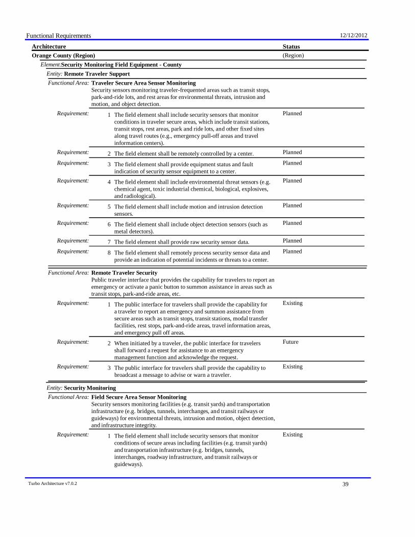
Functional Requirements 12/12/2012
StatusArchitecture(Region)Orange County (Region)
Security Monitoring Field Equipment - CountyElement:Remote Traveler SupportEntity:
Functional Area: Traveler Secure Area Sensor MonitoringSecurity sensors monitoring traveler-frequented areas such as transit stops,park-and-ride lots, and rest areas for environmental threats, intrusion andmotion, and object detection.
PlannedThe field element shall include security sensors that monitorconditions in traveler secure areas, which include transit stations,transit stops, rest areas, park and ride lots, and other fixed sitesalong travel routes (e.g., emergency pull-off areas and travelinformation centers).
Requirement: 1
PlannedThe field element shall be remotely controlled by a center.Requirement: 2PlannedThe field element shall provide equipment status and fault
indication of security sensor equipment to a center.Requirement: 3
PlannedThe field element shall include environmental threat sensors (e.g.chemical agent, toxic industrial chemical, biological, explosives,and radiological).
Requirement: 4
PlannedThe field element shall include motion and intrusion detectionsensors.
Requirement: 5
PlannedThe field element shall include object detection sensors (such asmetal detectors).
Requirement: 6
PlannedThe field element shall provide raw security sensor data.Requirement: 7PlannedThe field element shall remotely process security sensor data and
provide an indication of potential incidents or threats to a center.Requirement: 8
Functional Area: Remote Traveler SecurityPublic traveler interface that provides the capability for travelers to report anemergency or activate a panic button to summon assistance in areas such astransit stops, park-and-ride areas, etc.
ExistingThe public interface for travelers shall provide the capability fora traveler to report an emergency and summon assistance fromsecure areas such as transit stops, transit stations, modal transferfacilities, rest stops, park-and-ride areas, travel information areas,and emergency pull off areas.
Requirement: 1
FutureWhen initiated by a traveler, the public interface for travelersshall forward a request for assistance to an emergencymanagement function and acknowledge the request.
Requirement: 2
ExistingThe public interface for travelers shall provide the capability tobroadcast a message to advise or warn a traveler.
Requirement: 3
Security MonitoringEntity:Functional Area: Field Secure Area Sensor Monitoring
Security sensors monitoring facilities (e.g. transit yards) and transportationinfrastructure (e.g. bridges, tunnels, interchanges, and transit railways orguideways) for environmental threats, intrusion and motion, object detection,and infrastructure integrity.
ExistingThe field element shall include security sensors that monitorconditions of secure areas including facilities (e.g. transit yards)and transportation infrastructure (e.g. bridges, tunnels,interchanges, roadway infrastructure, and transit railways orguideways).
Requirement: 1
Turbo Architecture v7.0.2 39
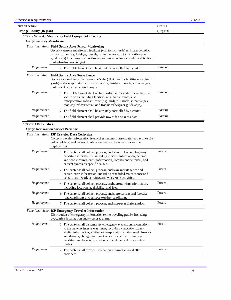
Functional Requirements 12/12/2012
StatusArchitecture(Region)Orange County (Region)
Security Monitoring Field Equipment - CountyElement:Security MonitoringEntity:
Functional Area: Field Secure Area Sensor MonitoringSecurity sensors monitoring facilities (e.g. transit yards) and transportationinfrastructure (e.g. bridges, tunnels, interchanges, and transit railways orguideways) for environmental threats, intrusion and motion, object detection,and infrastructure integrity.
ExistingThe field element shall be remotely controlled by a center.Requirement: 2
Functional Area: Field Secure Area SurveillanceSecurity surveillance devices (audio/video) that monitor facilities (e.g. transityards) and transportation infrastructure (e.g. bridges, tunnels, interchanges,and transit railways or guideways).
ExistingThe field element shall include video and/or audio surveillance ofsecure areas including facilities (e.g. transit yards) andtransportation infrastructure (e.g. bridges, tunnels, interchanges,roadway infrastructure, and transit railways or guideways).
Requirement: 1
ExistingThe field element shall be remotely controlled by a center.Requirement: 2ExistingThe field element shall provide raw video or audio data.Requirement: 4
TMC - CitiesElement:Information Service ProviderEntity:
Functional Area: ISP Traveler Data CollectionCollects traveler information from other centers, consolidates and refines thecollected data, and makes this data available to traveler informationapplications.
FutureThe center shall collect, process, and store traffic and highwaycondition information, including incident information, detoursand road closures, event information, recommended routes, andcurrent speeds on specific routes.
Requirement: 1
FutureThe center shall collect, process, and store maintenance andconstruction information, including scheduled maintenance andconstruction work activities and work zone activities.
Requirement: 2
FutureThe center shall collect, process, and store parking information,including location, availability, and fees.
Requirement: 4
FutureThe center shall collect, process, and store current and forecastroad conditions and surface weather conditions.
Requirement: 6
FutureThe center shall collect, process, and store event information.Requirement: 7
Functional Area: ISP Emergency Traveler InformationDistribution of emergency information to the traveling public, includingevacuation information and wide-area alerts.
FutureThe center shall disseminate emergency evacuation informationto the traveler interface systems, including evacuation zones,shelter information, available transportation modes, road closuresand detours, changes to transit services, and traffic and roadconditions at the origin, destination, and along the evacuationroutes.
Requirement: 1
FutureThe center shall provide evacuation information to shelterproviders.
Requirement: 2
Turbo Architecture v7.0.2 40

Functional Requirements 12/12/2012
StatusArchitecture(Region)Orange County (Region)
TMC - CitiesElement:Information Service ProviderEntity:
Functional Area: ISP Emergency Traveler InformationDistribution of emergency information to the traveling public, includingevacuation information and wide-area alerts.
FutureThe center shall disseminate wide-area alert information to thetraveler interface systems, including major emergencies such as anatural or man-made disaster, civil emergency, child abductions,severe weather watches and warnings, military activities, and lawenforcement warnings.
Requirement: 3
FutureThe center shall provide the capability for a system operator tocontrol the type and update frequency of emergency andwide-area alert information distributed to travelers.
Requirement: 4
Traffic ManagementEntity:Functional Area: TMC Roadway Warning
Remotely monitors and controls field elements used to warn driversapproaching hazards. Detects and warns approaching vehicles of adverseroad weather conditions, traffic conditions including queues, and obstaclesor animals in the road.
ExistingThe center shall monitor data on traffic, environmentalconditions, and other hazards collected from sensors along theroadway.
Requirement: 1
ExistingThe center shall identify hazardous road weather and surfaceconditions.
Requirement: 2
ExistingThe center shall identify hazardous traffic conditions includingqueues.
Requirement: 3
Functional Area: Collect Traffic SurveillanceManagement of traffic sensors and surveillance (CCTV) equipment,collection of current traffic conditions, and distribution of the collectedinformation to other centers and operators.
ExistingThe center shall monitor, analyze, and store traffic sensor data(speed, volume, occupancy) collected from field elements underremote control of the center.
Requirement: 1
ExistingThe center shall monitor, analyze, and distribute traffic imagesfrom CCTV systems under remote control of the center.
Requirement: 2
ExistingThe center shall distribute road network conditions data (raw orprocessed) based on collected and analyzed traffic sensor andsurveillance data to other centers.
Requirement: 4
ExistingThe center shall respond to control data from center personnelregarding sensor and surveillance data collection, analysis,storage, and distribution.
Requirement: 5
ExistingThe center shall maintain a database of surveillance equipmentand sensors and associated data (including the roadway on whichthey are located, the type of data collected, and the ownership ofeach )
Requirement: 6
ExistingThe center shall support an interface with a map update provider,or other appropriate data sources, through which updates ofdigitized map data can be obtained and used as a background fortraffic data.
Requirement: 7
Turbo Architecture v7.0.2 41
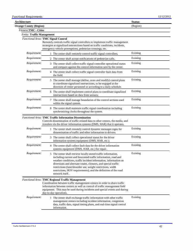
Functional Requirements 12/12/2012
StatusArchitecture(Region)Orange County (Region)
TMC - CitiesElement:Traffic ManagementEntity:
Functional Area: TMC Signal ControlRemotely controls traffic signal controllers to implement traffic managementstrategies at signalized intersections based on traffic conditions, incidents,emergency vehicle preemptions, pedestrian crossings, etc.
ExistingThe center shall remotely control traffic signal controllers.Requirement: 1ExistingThe center shall accept notifications of pedestrian calls.Requirement: 2ExistingThe center shall collect traffic signal controller operational status
and compare against the control information sent by the center.Requirement: 3
ExistingThe center shall collect traffic signal controller fault data fromthe field.
Requirement: 4
ExistingThe center shall manage (define, store and modify) control plansto coordinate signalized intersections, to be engaged at thedirection of center personnel or according to a daily schedule.
Requirement: 5
ExistingThe center shall implement control plans to coordinate signalizedintersections based on data from sensors.
Requirement: 6
ExistingThe center shall manage boundaries of the control sections usedwithin the signal system.
Requirement: 7
ExistingThe center shall maintain traffic signal coordination includingsynchronizing clocks throughout the system.
Requirement: 8
Functional Area: TMC Traffic Information DisseminationControls dissemination of traffic-related data to other centers, the media, andtravelers via the driver information systems (DMS, HAR) that it operates.
ExistingThe center shall remotely control dynamic messages signs fordissemination of traffic and other information to drivers.
Requirement: 1
ExistingThe center shall collect operational status for the driverinformation systems equipment (DMS, HAR, etc.).
Requirement: 3
ExistingThe center shall collect fault data for the driver informationsystems equipment (DMS, HAR, etc.) for repair.
Requirement: 4
ExistingThe center shall retrieve locally stored traffic information,including current and forecasted traffic information, road andweather conditions, traffic incident information, information ondiversions and alternate routes, closures, and special trafficrestrictions (lane/shoulder use, weight restrictions, widthrestrictions, HOV requirements), and the definition of the roadnetwork itself.
Requirement: 5
Functional Area: TMC Regional Traffic ManagementCoordination between traffic management centers in order to share trafficinformation between centers as well as control of traffic management fieldequipment. This may be used during incidents and special events and duringday-to-day operations.
ExistingThe center shall exchange traffic information with other trafficmanagement centers including incident information, congestiondata, traffic data, signal timing plans, and real-time signal controlinformation.
Requirement: 1
Turbo Architecture v7.0.2 42

Functional Requirements 12/12/2012
StatusArchitecture(Region)Orange County (Region)
TMC - CitiesElement:Traffic ManagementEntity:
Functional Area: TMC Regional Traffic ManagementCoordination between traffic management centers in order to share trafficinformation between centers as well as control of traffic management fieldequipment. This may be used during incidents and special events and duringday-to-day operations.
ExistingThe center shall exchange traffic control information with othertraffic management centers to support remote monitoring andcontrol of traffic management devices (e.g. signs, sensors,signals, cameras, etc.).
Requirement: 2
Functional Area: TMC Traffic Management Decision SupportRecommends courses of action to the traffic operator based on current andforecast road and traffic conditions. Recommended actions may includepredefined incident response plans, signal timing plan changes, DMS/HARmessages, lane control strategies, metering strategies, etc.
ExistingThe center shall provide center personnel with an integratedregional view of current and forecast road and traffic conditionsincluding traffic incidents, special events, maintenance activitiesand other events or conditions that impact capacity or demand.
Requirement: 1
PlannedThe center shall identify network imbalances and potentialcourses of action.
Requirement: 2
PlannedThe center shall compare the impact of potential courses ofaction and make recommendations to the operator.
Requirement: 3
PlannedThe recommended actions shall include predefined incidentresponse plans, signal timing plan changes, DMS/HAR messages,lane control strategies and freeway control strategies includingramp metering, interchange metering, and mainline metering.
Requirement: 4
PlannedThe recommended actions shall include multimodal strategiesthat include suggested transit strategies and suggested route andmode choices for travelers.
Requirement: 5
PlannedThe center shall provide an interface to center personnel to inputcontrol parameters for the decision support process and receiverecommended actions and supporting information presentation.
Requirement: 6
Functional Area: TMC Incident DetectionRemotely monitors traffic sensor and surveillance systems to detect andverify incidents. Also monitors external advisory and incident reportingsystems, intermodal freight depots, and border crossings for additionalincident information. Identified incidents are reported to operationspersonnel and other centers.
ExistingThe center shall collect and store traffic flow and image datafrom the field equipment to detect and verify incidents.
Requirement: 2
ExistingThe center shall receive inputs concerning upcoming events thatwould effect the traffic network from event promoters andtraveler information service providers.
Requirement: 3
ExistingThe center shall exchange incident and threat information withemergency management centers as well as maintenance andconstruction centers; including notification of existence ofincident and expected severity, location, time and nature ofincident.
Requirement: 4
Turbo Architecture v7.0.2 43

Functional Requirements 12/12/2012
StatusArchitecture(Region)Orange County (Region)
TMC - CitiesElement:Traffic ManagementEntity:
Functional Area: TMC Incident DetectionRemotely monitors traffic sensor and surveillance systems to detect andverify incidents. Also monitors external advisory and incident reportingsystems, intermodal freight depots, and border crossings for additionalincident information. Identified incidents are reported to operationspersonnel and other centers.
ExistingThe center shall provide road network conditions and trafficimages to emergency management centers to support thedetection, verification, and classification of incidents.
Requirement: 6
Functional Area: TMC Incident Dispatch Coordination/CommunicationFormulates an incident response that takes into account the incidentpotential, incident impacts, and/or resources required for incidentmanagement. Facilitates the dispatch of emergency response and servicevehicles and coordinates the response with cooperating agencies.
ExistingThe center shall exchange alert information and status withemergency management centers. The information includesnotification of a major emergency such as a natural or man-madedisaster, civil emergency, or child abduction for distribution tothe public. The information may include the alert originator, thenature of the emergency, the geographic area affected by theemergency, the effective time period, and information andinstructions necessary for the public to respond to the alert. Thismay also identify specific information that should not be releasedto the public.
Requirement: 1
ExistingThe center shall coordinate planning for incidents withemergency management centers - including pre-planningactivities for disaster response, evacuation, and recoveryoperations.
Requirement: 2
FutureThe center shall support requests from emergency managementcenters to remotely control sensor and surveillance equipmentlocated in the field, provide special routing for emergencyvehicles, and to provide responding emergency vehicles withsignal preemption.
Requirement: 3
FutureThe center shall exchange incident information with emergencymanagement centers, maintenance and construction centers,transit centers, information service providers, and the mediaincluding description, location, traffic impact, status, expectedduration, and response information.
Requirement: 4
FutureThe center shall share resources with allied agency centers toimplement special traffic control measures, assist in clean up,verify an incident, etc. This may also involve coordination withmaintenance centers.
Requirement: 5
FutureThe center shall receive inputs concerning upcoming events thatwould effect the traffic network from event promoters, travelerinformation service providers, media, border crossings, and railoperations centers.
Requirement: 6
FutureThe center shall provide road network conditions and trafficimages to emergency management centers, maintenance andconstruction centers, and traveler information service providers.
Requirement: 7
Turbo Architecture v7.0.2 44
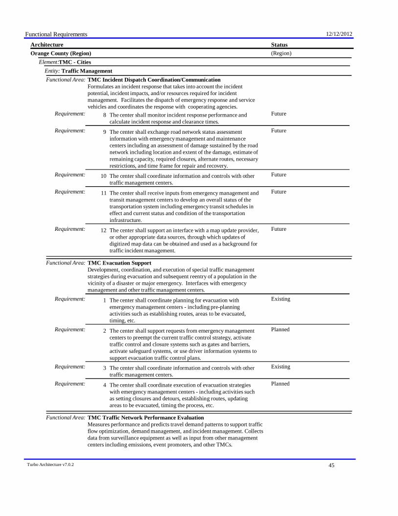
Functional Requirements 12/12/2012
StatusArchitecture(Region)Orange County (Region)
TMC - CitiesElement:Traffic ManagementEntity:
Functional Area: TMC Incident Dispatch Coordination/CommunicationFormulates an incident response that takes into account the incidentpotential, incident impacts, and/or resources required for incidentmanagement. Facilitates the dispatch of emergency response and servicevehicles and coordinates the response with cooperating agencies.
FutureThe center shall monitor incident response performance andcalculate incident response and clearance times.
Requirement: 8
FutureThe center shall exchange road network status assessmentinformation with emergency management and maintenancecenters including an assessment of damage sustained by the roadnetwork including location and extent of the damage, estimate ofremaining capacity, required closures, alternate routes, necessaryrestrictions, and time frame for repair and recovery.
Requirement: 9
FutureThe center shall coordinate information and controls with othertraffic management centers.
Requirement: 10
FutureThe center shall receive inputs from emergency management andtransit management centers to develop an overall status of thetransportation system including emergency transit schedules ineffect and current status and condition of the transportationinfrastructure.
Requirement: 11
FutureThe center shall support an interface with a map update provider,or other appropriate data sources, through which updates ofdigitized map data can be obtained and used as a background fortraffic incident management.
Requirement: 12
Functional Area: TMC Evacuation SupportDevelopment, coordination, and execution of special traffic managementstrategies during evacuation and subsequent reentry of a population in thevicinity of a disaster or major emergency. Interfaces with emergencymanagement and other traffic management centers.
ExistingThe center shall coordinate planning for evacuation withemergency management centers - including pre-planningactivities such as establishing routes, areas to be evacuated,timing, etc.
Requirement: 1
PlannedThe center shall support requests from emergency managementcenters to preempt the current traffic control strategy, activatetraffic control and closure systems such as gates and barriers,activate safeguard systems, or use driver information systems tosupport evacuation traffic control plans.
Requirement: 2
ExistingThe center shall coordinate information and controls with othertraffic management centers.
Requirement: 3
PlannedThe center shall coordinate execution of evacuation strategieswith emergency management centers - including activities suchas setting closures and detours, establishing routes, updatingareas to be evacuated, timing the process, etc.
Requirement: 4
Functional Area: TMC Traffic Network Performance EvaluationMeasures performance and predicts travel demand patterns to support trafficflow optimization, demand management, and incident management. Collectsdata from surveillance equipment as well as input from other managementcenters including emissions, event promoters, and other TMCs.
Turbo Architecture v7.0.2 45
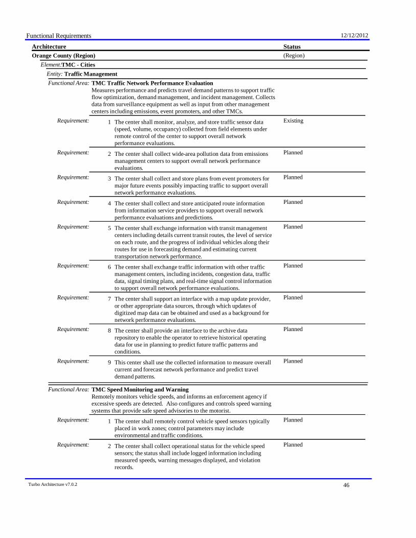
Functional Requirements 12/12/2012
StatusArchitecture(Region)Orange County (Region)
TMC - CitiesElement:Traffic ManagementEntity:
Functional Area: TMC Traffic Network Performance EvaluationMeasures performance and predicts travel demand patterns to support trafficflow optimization, demand management, and incident management. Collectsdata from surveillance equipment as well as input from other managementcenters including emissions, event promoters, and other TMCs.
ExistingThe center shall monitor, analyze, and store traffic sensor data(speed, volume, occupancy) collected from field elements underremote control of the center to support overall networkperformance evaluations.
Requirement: 1
PlannedThe center shall collect wide-area pollution data from emissionsmanagement centers to support overall network performanceevaluations.
Requirement: 2
PlannedThe center shall collect and store plans from event promoters formajor future events possibly impacting traffic to support overallnetwork performance evaluations.
Requirement: 3
PlannedThe center shall collect and store anticipated route informationfrom information service providers to support overall networkperformance evaluations and predictions.
Requirement: 4
PlannedThe center shall exchange information with transit managementcenters including details current transit routes, the level of serviceon each route, and the progress of individual vehicles along theirroutes for use in forecasting demand and estimating currenttransportation network performance.
Requirement: 5
PlannedThe center shall exchange traffic information with other trafficmanagement centers, including incidents, congestion data, trafficdata, signal timing plans, and real-time signal control informationto support overall network performance evaluations.
Requirement: 6
PlannedThe center shall support an interface with a map update provider,or other appropriate data sources, through which updates ofdigitized map data can be obtained and used as a background fornetwork performance evaluations.
Requirement: 7
PlannedThe center shall provide an interface to the archive datarepository to enable the operator to retrieve historical operatingdata for use in planning to predict future traffic patterns andconditions.
Requirement: 8
PlannedThis center shall use the collected information to measure overallcurrent and forecast network performance and predict traveldemand patterns.
Requirement: 9
Functional Area: TMC Speed Monitoring and WarningRemotely monitors vehicle speeds, and informs an enforcement agency ifexcessive speeds are detected. Also configures and controls speed warningsystems that provide safe speed advisories to the motorist.
PlannedThe center shall remotely control vehicle speed sensors typicallyplaced in work zones; control parameters may includeenvironmental and traffic conditions.
Requirement: 1
PlannedThe center shall collect operational status for the vehicle speedsensors; the status shall include logged information includingmeasured speeds, warning messages displayed, and violationrecords.
Requirement: 2
Turbo Architecture v7.0.2 46
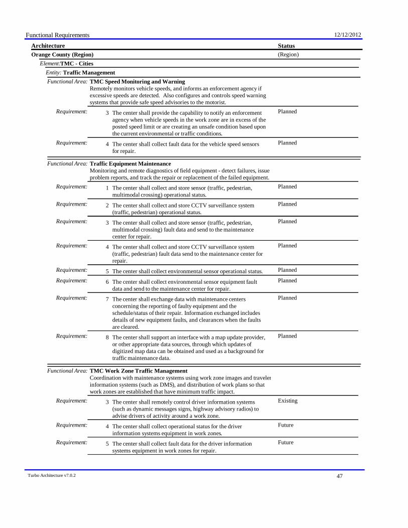
Functional Requirements 12/12/2012
StatusArchitecture(Region)Orange County (Region)
TMC - CitiesElement:Traffic ManagementEntity:
Functional Area: TMC Speed Monitoring and WarningRemotely monitors vehicle speeds, and informs an enforcement agency ifexcessive speeds are detected. Also configures and controls speed warningsystems that provide safe speed advisories to the motorist.
PlannedThe center shall provide the capability to notify an enforcementagency when vehicle speeds in the work zone are in excess of theposted speed limit or are creating an unsafe condition based uponthe current environmental or traffic conditions.
Requirement: 3
PlannedThe center shall collect fault data for the vehicle speed sensorsfor repair.
Requirement: 4
Functional Area: Traffic Equipment MaintenanceMonitoring and remote diagnostics of field equipment - detect failures, issueproblem reports, and track the repair or replacement of the failed equipment.
PlannedThe center shall collect and store sensor (traffic, pedestrian,multimodal crossing) operational status.
Requirement: 1
PlannedThe center shall collect and store CCTV surveillance system(traffic, pedestrian) operational status.
Requirement: 2
PlannedThe center shall collect and store sensor (traffic, pedestrian,multimodal crossing) fault data and send to the maintenancecenter for repair.
Requirement: 3
PlannedThe center shall collect and store CCTV surveillance system(traffic, pedestrian) fault data send to the maintenance center forrepair.
Requirement: 4
PlannedThe center shall collect environmental sensor operational status.Requirement: 5PlannedThe center shall collect environmental sensor equipment fault
data and send to the maintenance center for repair.Requirement: 6
PlannedThe center shall exchange data with maintenance centersconcerning the reporting of faulty equipment and theschedule/status of their repair. Information exchanged includesdetails of new equipment faults, and clearances when the faultsare cleared.
Requirement: 7
PlannedThe center shall support an interface with a map update provider,or other appropriate data sources, through which updates ofdigitized map data can be obtained and used as a background fortraffic maintenance data.
Requirement: 8
Functional Area: TMC Work Zone Traffic ManagementCoordination with maintenance systems using work zone images and travelerinformation systems (such as DMS), and distribution of work plans so thatwork zones are established that have minimum traffic impact.
ExistingThe center shall remotely control driver information systems(such as dynamic messages signs, highway advisory radios) toadvise drivers of activity around a work zone.
Requirement: 3
FutureThe center shall collect operational status for the driverinformation systems equipment in work zones.
Requirement: 4
FutureThe center shall collect fault data for the driver informationsystems equipment in work zones for repair.
Requirement: 5
Turbo Architecture v7.0.2 47

Functional Requirements 12/12/2012
StatusArchitecture(Region)Orange County (Region)
TMC - CitiesElement:Traffic ManagementEntity:
Functional Area: TMC Work Zone Traffic ManagementCoordination with maintenance systems using work zone images and travelerinformation systems (such as DMS), and distribution of work plans so thatwork zones are established that have minimum traffic impact.
FutureThe center shall receive proposed maintenance and constructionwork plans, analyze the activity as a possible incident, andprovide work plan feedback to the sending center.
Requirement: 6
Functional Area: TMC Multimodal CoordinationProvides traffic signal priority for transit vehicles based on center-to-centercommunications with the transit management center; also exchange trafficand transit information.
FutureThe center shall respond to requests from transit managementcenters for signal priority at one or more intersections along aparticular transit route.
Requirement: 1
FutureThe center shall exchange information with transit managementcenters including details current transit routes, the level of serviceon each route, and the progress of individual vehicles along theirroutes.
Requirement: 2
Functional Area: TMC Transportation Operations Data CollectionCollects real-time information on the state of the regional transportationsystem for operational use by the center. It establishes communications witha regional repository, requests or subscribes to information relevant to thecenter, and distributes the received information for use.
ExistingThe center shall collect real-time information on the state of theregional transportation system including current traffic and roadconditions, weather conditions, special event and incidentinformation.
Requirement: 1
ExistingThe center shall support the capability for the system operator tomonitor and control the information collection service.
Requirement: 2
TMC Maintenance Dispatch Communications - CaltransElement:Maintenance and Construction ManagementEntity:
Functional Area: MCM Vehicle TrackingRemotely tracks the location of maintenance and construction vehicles andother equipment; presented to the center personnel.
ExistingThe center shall monitor the locations of all maintenance andconstruction vehicles and other equipment under its jurisdiction.
Requirement: 1
Functional Area: MCM Incident ManagementSupports coordinated response to incidents - share incident notifications,manage incident response resources, and coordinate overall incidentsituation and response among allied response organizations.
ExistingThe center shall receive inputs from the Alerting and AdvisorySystem concerning the possibility or occurrence of severeweather, terrorist activity, or other major emergency, includinginformation provided by the Emergency Alert System.
Requirement: 1
Turbo Architecture v7.0.2 48
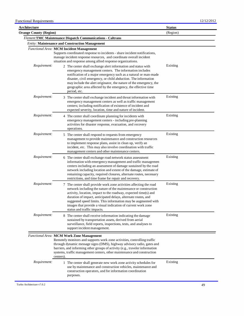
Functional Requirements 12/12/2012
StatusArchitecture(Region)Orange County (Region)
TMC Maintenance Dispatch Communications - CaltransElement:Maintenance and Construction ManagementEntity:
Functional Area: MCM Incident ManagementSupports coordinated response to incidents - share incident notifications,manage incident response resources, and coordinate overall incidentsituation and response among allied response organizations.
ExistingThe center shall exchange alert information and status withemergency management centers. The information includesnotification of a major emergency such as a natural or man-madedisaster, civil emergency, or child abduction. The informationmay include the alert originator, the nature of the emergency, thegeographic area affected by the emergency, the effective timeperiod, etc.
Requirement: 2
ExistingThe center shall exchange incident and threat information withemergency management centers as well as traffic managementcenters; including notification of existence of incident andexpected severity, location, time and nature of incident.
Requirement: 3
ExistingThe center shall coordinate planning for incidents withemergency management centers - including pre-planningactivities for disaster response, evacuation, and recoveryoperations.
Requirement: 4
ExistingThe center shall respond to requests from emergencymanagement to provide maintenance and construction resourcesto implement response plans, assist in clean up, verify anincident, etc. This may also involve coordination with trafficmanagement centers and other maintenance centers.
Requirement: 5
ExistingThe center shall exchange road network status assessmentinformation with emergency management and traffic managementcenters including an assessment of damage sustained by the roadnetwork including location and extent of the damage, estimate ofremaining capacity, required closures, alternate routes, necessaryrestrictions, and time frame for repair and recovery.
Requirement: 6
ExistingThe center shall provide work zone activities affecting the roadnetwork including the nature of the maintenance or constructionactivity, location, impact to the roadway, expected time(s) andduration of impact, anticipated delays, alternate routes, andsuggested speed limits. This information may be augmented withimages that provide a visual indication of current work zonestatus and traffic impacts.
Requirement: 7
ExistingThe center shall receive information indicating the damagesustained by transportation assets, derived from aerialsurveillance, field reports, inspections, tests, and analyses tosupport incident management.
Requirement: 8
Functional Area: MCM Work Zone ManagementRemotely monitors and supports work zone activities, controlling trafficthrough dynamic message signs (DMS), highway advisory radio, gates andbarriers, and informing other groups of activity (e.g., traveler informationsystems, traffic management centers, other maintenance and constructioncenters).
ExistingThe center shall generate new work zone activity schedules foruse by maintenance and construction vehicles, maintenance andconstruction operators, and for information coordinationpurposes.
Requirement: 1
Turbo Architecture v7.0.2 49
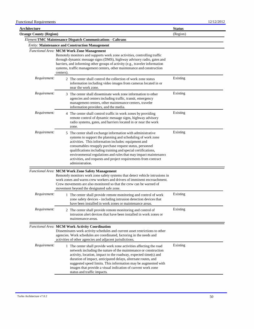
Functional Requirements 12/12/2012
StatusArchitecture(Region)Orange County (Region)
TMC Maintenance Dispatch Communications - CaltransElement:Maintenance and Construction ManagementEntity:
Functional Area: MCM Work Zone ManagementRemotely monitors and supports work zone activities, controlling trafficthrough dynamic message signs (DMS), highway advisory radio, gates andbarriers, and informing other groups of activity (e.g., traveler informationsystems, traffic management centers, other maintenance and constructioncenters).
ExistingThe center shall control the collection of work zone statusinformation including video images from cameras located in ornear the work zone.
Requirement: 2
ExistingThe center shall disseminate work zone information to otheragencies and centers including traffic, transit, emergencymanagement centers, other maintenance centers, travelerinformation providers, and the media.
Requirement: 3
ExistingThe center shall control traffic in work zones by providingremote control of dynamic message signs, highway advisoryradio systems, gates, and barriers located in or near the workzone.
Requirement: 4
ExistingThe center shall exchange information with administrativesystems to support the planning and scheduling of work zoneactivities. This information includes: equipment andconsumables resupply purchase request status, personnelqualifications including training and special certifications,environmental regulations and rules that may impact maintenanceactivities, and requests and project requirements from contractadministration.
Requirement: 5
Functional Area: MCM Work Zone Safety ManagementRemotely monitors work zone safety systems that detect vehicle intrusions inwork zones and warns crew workers and drivers of imminent encroachment.Crew movements are also monitored so that the crew can be warned ofmovement beyond the designated safe zone.
ExistingThe center shall provide remote monitoring and control of workzone safety devices - including intrusion detection devices thathave been installed in work zones or maintenance areas.
Requirement: 1
ExistingThe center shall provide remote monitoring and control ofintrusion alert devices that have been installed in work zones ormaintenance areas.
Requirement: 2
Functional Area: MCM Work Activity CoordinationDisseminates work activity schedules and current asset restrictions to otheragencies. Work schedules are coordinated, factoring in the needs andactivities of other agencies and adjacent jurisdictions.
ExistingThe center shall provide work zone activities affecting the roadnetwork including the nature of the maintenance or constructionactivity, location, impact to the roadway, expected time(s) andduration of impact, anticipated delays, alternate routes, andsuggested speed limits. This information may be augmented withimages that provide a visual indication of current work zonestatus and traffic impacts.
Requirement: 1
Turbo Architecture v7.0.2 50
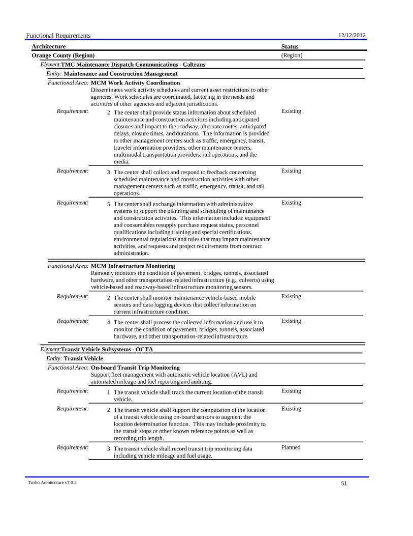
Functional Requirements 12/12/2012
StatusArchitecture(Region)Orange County (Region)
TMC Maintenance Dispatch Communications - CaltransElement:Maintenance and Construction ManagementEntity:
Functional Area: MCM Work Activity CoordinationDisseminates work activity schedules and current asset restrictions to otheragencies. Work schedules are coordinated, factoring in the needs andactivities of other agencies and adjacent jurisdictions.
ExistingThe center shall provide status information about scheduledmaintenance and construction activities including anticipatedclosures and impact to the roadway, alternate routes, anticipateddelays, closure times, and durations. The information is providedto other management centers such as traffic, emergency, transit,traveler information providers, other maintenance centers,multimodal transportation providers, rail operations, and themedia.
Requirement: 2
ExistingThe center shall collect and respond to feedback concerningscheduled maintenance and construction activities with othermanagement centers such as traffic, emergency, transit, and railoperations.
Requirement: 3
ExistingThe center shall exchange information with administrativesystems to support the planning and scheduling of maintenanceand construction activities. This information includes: equipmentand consumables resupply purchase request status, personnelqualifications including training and special certifications,environmental regulations and rules that may impact maintenanceactivities, and requests and project requirements from contractadministration.
Requirement: 5
Functional Area: MCM Infrastructure MonitoringRemotely monitors the condition of pavement, bridges, tunnels, associatedhardware, and other transportation-related infrastructure (e.g., culverts) usingvehicle-based and roadway-based infrastructure monitoring sensors.
ExistingThe center shall monitor maintenance vehicle-based mobilesensors and data logging devices that collect information oncurrent infrastructure condition.
Requirement: 2
ExistingThe center shall process the collected information and use it tomonitor the condition of pavement, bridges, tunnels, associatedhardware, and other transportation-related infrastructure.
Requirement: 4
Transit Vehicle Subsystems - OCTAElement:Transit VehicleEntity:
Functional Area: On-board Transit Trip MonitoringSupport fleet management with automatic vehicle location (AVL) andautomated mileage and fuel reporting and auditing.
ExistingThe transit vehicle shall track the current location of the transitvehicle.
Requirement: 1
ExistingThe transit vehicle shall support the computation of the locationof a transit vehicle using on-board sensors to augment thelocation determination function. This may include proximity tothe transit stops or other known reference points as well asrecording trip length.
Requirement: 2
PlannedThe transit vehicle shall record transit trip monitoring dataincluding vehicle mileage and fuel usage.
Requirement: 3
Turbo Architecture v7.0.2 51
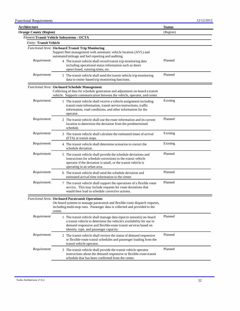
Functional Requirements 12/12/2012
StatusArchitecture(Region)Orange County (Region)
Transit Vehicle Subsystems - OCTAElement:Transit VehicleEntity:
Functional Area: On-board Transit Trip MonitoringSupport fleet management with automatic vehicle location (AVL) andautomated mileage and fuel reporting and auditing.
PlannedThe transit vehicle shall record transit trip monitoring dataincluding operational status information such as doorsopen/closed, running times, etc.
Requirement: 4
PlannedThe transit vehicle shall send the transit vehicle trip monitoringdata to center-based trip monitoring functions.
Requirement: 5
Functional Area: On-board Schedule ManagementCollecting of data for schedule generation and adjustment on-board a transitvehicle. Supports communication between the vehicle, operator, and center .
ExistingThe transit vehicle shall receive a vehicle assignment includingtransit route information, transit service instructions, trafficinformation, road conditions, and other information for theoperator.
Requirement: 1
PlannedThe transit vehicle shall use the route information and its currentlocation to determine the deviation from the predeterminedschedule.
Requirement: 2
ExistingThe transit vehicle shall calculate the estimated times of arrival(ETA) at transit stops.
Requirement: 3
ExistingThe transit vehicle shall determine scenarios to correct theschedule deviation.
Requirement: 4
PlannedThe transit vehicle shall provide the schedule deviations andinstructions for schedule corrections to the transit vehicleoperator if the deviation is small, or the transit vehicle isoperating in an urban area.
Requirement: 5
PlannedThe transit vehicle shall send the schedule deviation andestimated arrival time information to the center.
Requirement: 6
PlannedThe transit vehicle shall support the operations of a flexible routeservice. This may include requests for route deviations thatwould then lead to schedule corrective actions.
Requirement: 7
Functional Area: On-board Paratransit OperationsOn-board systems to manage paratransit and flexible-route dispatch requests,including multi-stop runs. Passenger data is collected and provided to thecenter.
PlannedThe transit vehicle shall manage data input to sensor(s) on-boarda transit vehicle to determine the vehicle's availability for use indemand responsive and flexible-route transit services based onidentity, type, and passenger capacity.
Requirement: 1
PlannedThe transit vehicle shall receive the status of demand responsiveor flexible-route transit schedules and passenger loading from thetransit vehicle operator.
Requirement: 2
PlannedThe transit vehicle shall provide the transit vehicle operatorinstructions about the demand responsive or flexible-route transitschedule that has been confirmed from the center.
Requirement: 3
Turbo Architecture v7.0.2 52

Functional Requirements 12/12/2012
StatusArchitecture(Region)Orange County (Region)
Transit Vehicle Subsystems - OCTAElement:Transit VehicleEntity:
Functional Area: On-board Paratransit OperationsOn-board systems to manage paratransit and flexible-route dispatch requests,including multi-stop runs. Passenger data is collected and provided to thecenter.
PlannedThe transit vehicle shall provide the capability to log passengerboardings and alightings and make passenger use data availableto the transit center.
Requirement: 4
Functional Area: On-board Transit Fare ManagementOn-board systems provide fare collection using a travelers non-monetaryfare medium. Collected fare data are made available to the center.
ExistingThe transit vehicle shall read data from the traveler card /payment instrument presented by boarding passengers.
Requirement: 1
ExistingThe transit vehicle shall calculate the traveler's fare based on theorigin and destination provided by the traveler as well as factorssuch as the transit routing, transit fare category, traveler history,and route-specific information.
Requirement: 4
PlannedThe transit vehicle shall have access to the complete range oftransit services (routes and schedules) that are available to thetraveler.
Requirement: 5
ExistingThe transit vehicle shall provide a transit fare payment interfacethat is suitable for travelers with physical disabilities.
Requirement: 6
PlannedThe transit vehicle shall include a database on-board the transitvehicle for use in fare processing from which the fares for allpossible trips within the transit operational network can bedetermined.
Requirement: 7
PlannedThe transit vehicle shall support an emergency fare structureoverriding all other fares that can be activated during disasters,states of emergency or evacuations.
Requirement: 8
PlannedThe transit vehicle shall support the support advanced paymentsfor tolls, and/or parking lot charges, and/or transit fares via thetraveler card / payment instrument.
Requirement: 9
ExistingThe transit vehicle shall provide fare statistics data to the center.Requirement: 10
Functional Area: On-board Passenger CountingOn-board systems collect transit vehicle loading data and make it availableto the center.
ExistingThe transit vehicle shall count passengers boarding and alighting.Requirement: 1PlannedThe passenger counts shall be related to location to support
association of passenger counts with routes, route segments, orbus stops.
Requirement: 2
PlannedThe passenger counts shall be timestamped so that ridership canbe measured by time of day and day of week.
Requirement: 3
FutureThe transit vehicle shall send the collected passenger countinformation to the transit center.
Requirement: 4
Functional Area: On-board Transit Security
Turbo Architecture v7.0.2 53

Functional Requirements 12/12/2012
StatusArchitecture(Region)Orange County (Region)
Transit Vehicle Subsystems - OCTAElement:Transit VehicleEntity:
Functional Area: On-board Transit SecurityOn-board video/audio surveillance systems, threat sensors, and objectdetection sensors to enhance security and safety on-board a transit vehicles.Also includes silent alarms activated by transit user or vehicle operator,operator authentication, and remote vehicle disabling.
PlannedThe transit vehicle shall perform video and audio surveillanceinside of transit vehicles and output raw video or audio data foreither local monitoring (for processing or direct output to thetransit vehicle operator), remote monitoring or for local storage(e.g., in an event recorder).
Requirement: 1
PlannedThe transit vehicle shall perform local monitoring of video oraudio surveillance data collected inside of transit vehicles, andidentify potential incidents or threats based on receivedprocessing parameters.
Requirement: 2
PlannedThe transit vehicle shall output an indication of potentialincidents or threats and the processed video or audio informationto the center along with the vehicle’s current location.
Requirement: 3
Functional Area: On-board MaintenanceOn-board systems to collect and process transit vehicle maintenance dataincluding mileage and vehicle operating conditions for use in schedulingfuture vehicle maintenance.
[Not Defined]Requirement:
Functional Area: On-board Transit Signal PriorityOn-board systems request signal priority through short range communicationdirectly with traffic control equipment at the roadside (intersections, ramps,interchanges, etc.).
FutureThe transit vehicle shall determine the schedule deviation andestimated times of arrival (ETA) at transit stops.
Requirement: 1
FutureThe transit vehicle shall send priority requests to traffic signalcontrollers at intersections, pedestrian crossings, and multimodalcrossings on the roads (surface streets) and freeway (rampcontrols) network that enable a transit vehicle schedule deviationto be corrected.
Requirement: 2
FutureThe transit vehicle shall send the schedule deviation data andstatus of priority requests to the transit vehicle operator andprovide the capability for the transit vehicle operator to controlthe priority system.
Requirement: 3
FutureThe transit vehicle shall prevent a priority request from beingsent when the transit vehicle cannot use the priority (e.g., whenthe transit vehicle makes a passenger stop on the approach to anintersection).
Requirement: 4
Weigh-in-Motion SitesElement:Commercial Vehicle CheckEntity:
Functional Area: Roadside WIMRoadside check facility equipment to detect and measure the weightcommercial vehicles at high speed. Can include an interface to the credentialchecking or it can be a stand alone package with display.
Turbo Architecture v7.0.2 54

Functional Requirements 12/12/2012
StatusArchitecture(Region)Orange County (Region)
Weigh-in-Motion SitesElement:Commercial Vehicle CheckEntity:
Functional Area: Roadside WIMRoadside check facility equipment to detect and measure the weightcommercial vehicles at high speed. Can include an interface to the credentialchecking or it can be a stand alone package with display.
ExistingThe roadside check facility equipment shall detect the presenceof commercial vehicles and freight equipment approaching afacility. Sensors can differentiate between different types ofvehicles and determine the number of axles, gross vehicle weight,weight per axle, and the identification of the vehicle and itscargo.
Requirement: 1
ExistingThe roadside check facility equipment shall request and inputelectronic screening data from the commercial vehicle'selectronic tag data.
Requirement: 2
ExistingThe roadside check facility equipment shall send a pass/pull-innotification to the commercial vehicle and its driver based on theinformation received from the vehicle and the measurementstaken. The message may be sent to the on-board equipment inthe commercial vehicle or transmitted to the driver usingequipment such as dynamic message signs, red-green lights,flashing signs, etc.
Requirement: 3
Name DescriptionStatus Value Legend
ExistingPlannedFutureNot Planned
Turbo Architecture v7.0.2 55

August 22, 2013
Appendix D: Regional ITS Architecture – Service Package Diagrams

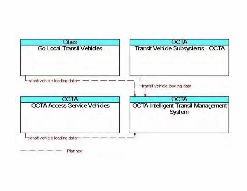
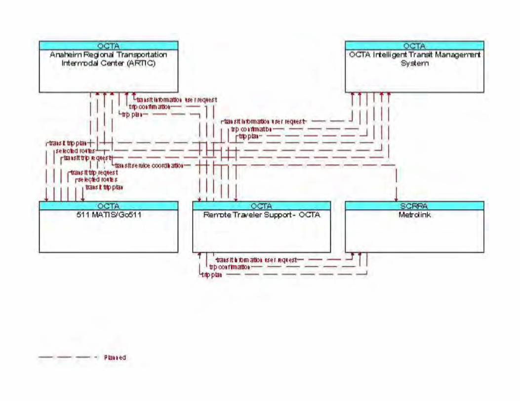
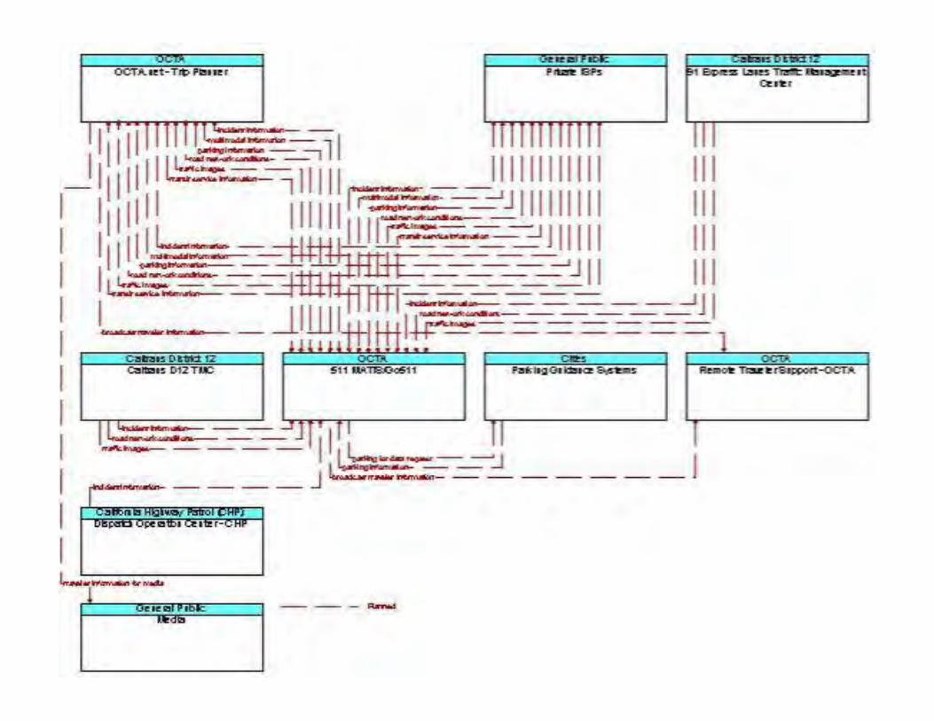
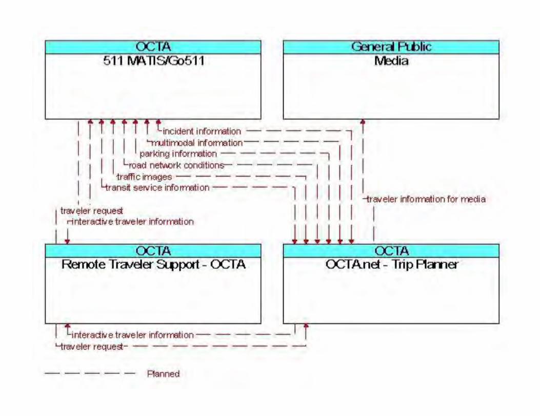

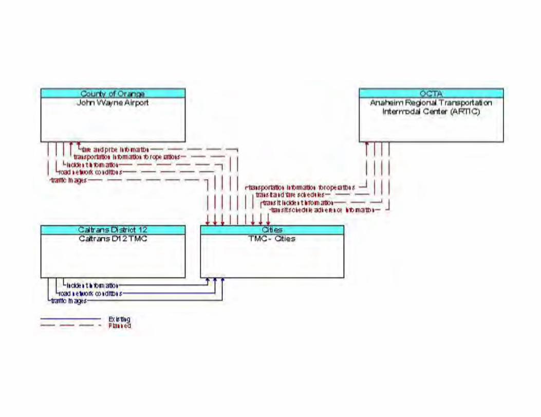
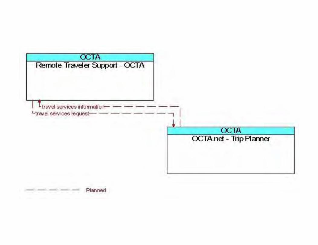
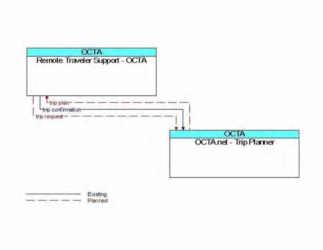
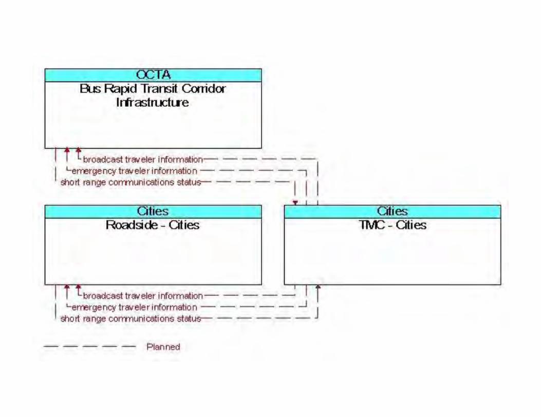
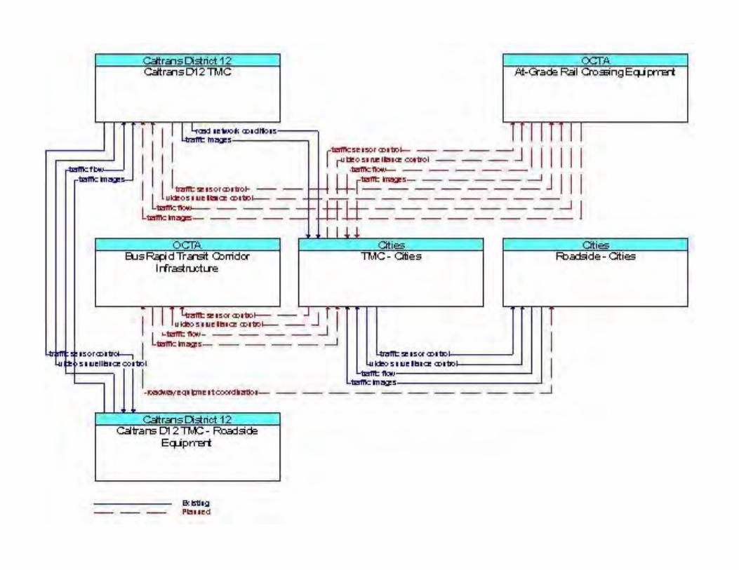

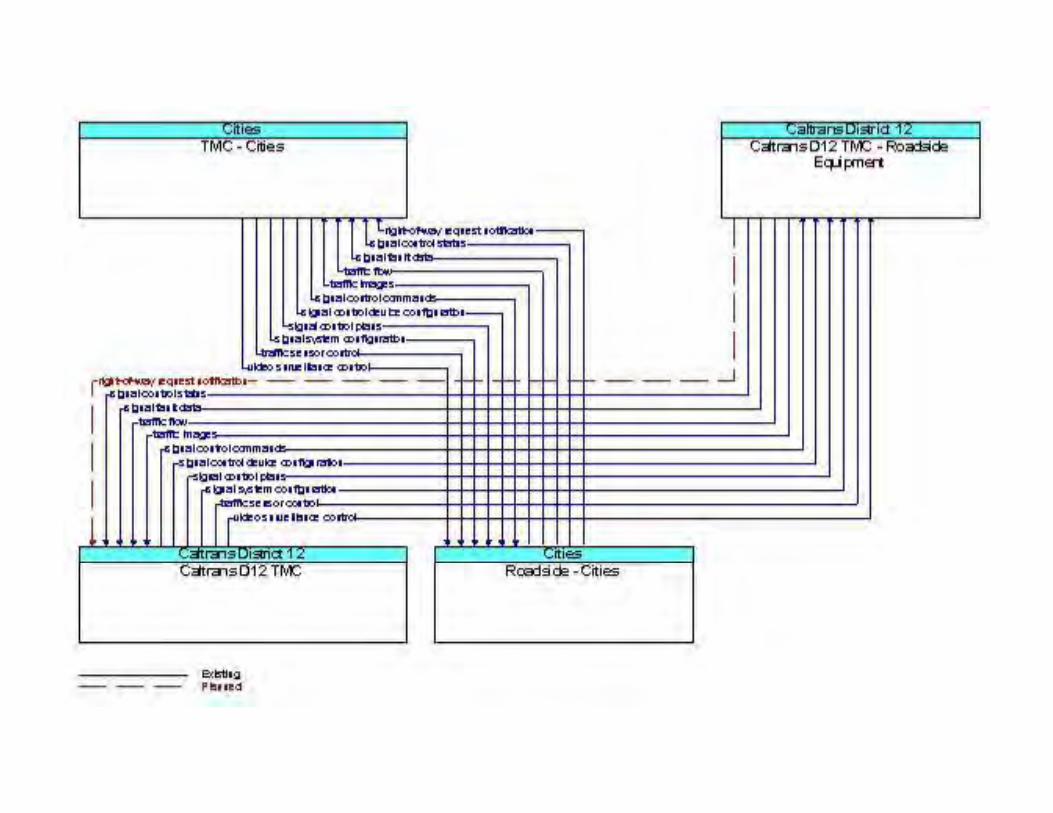
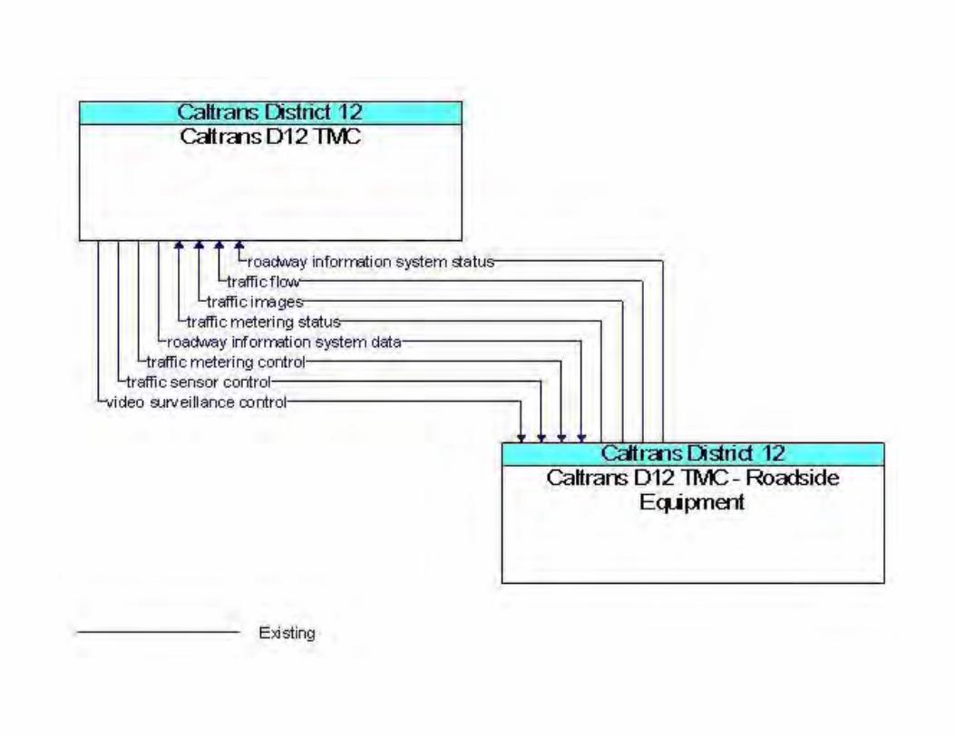
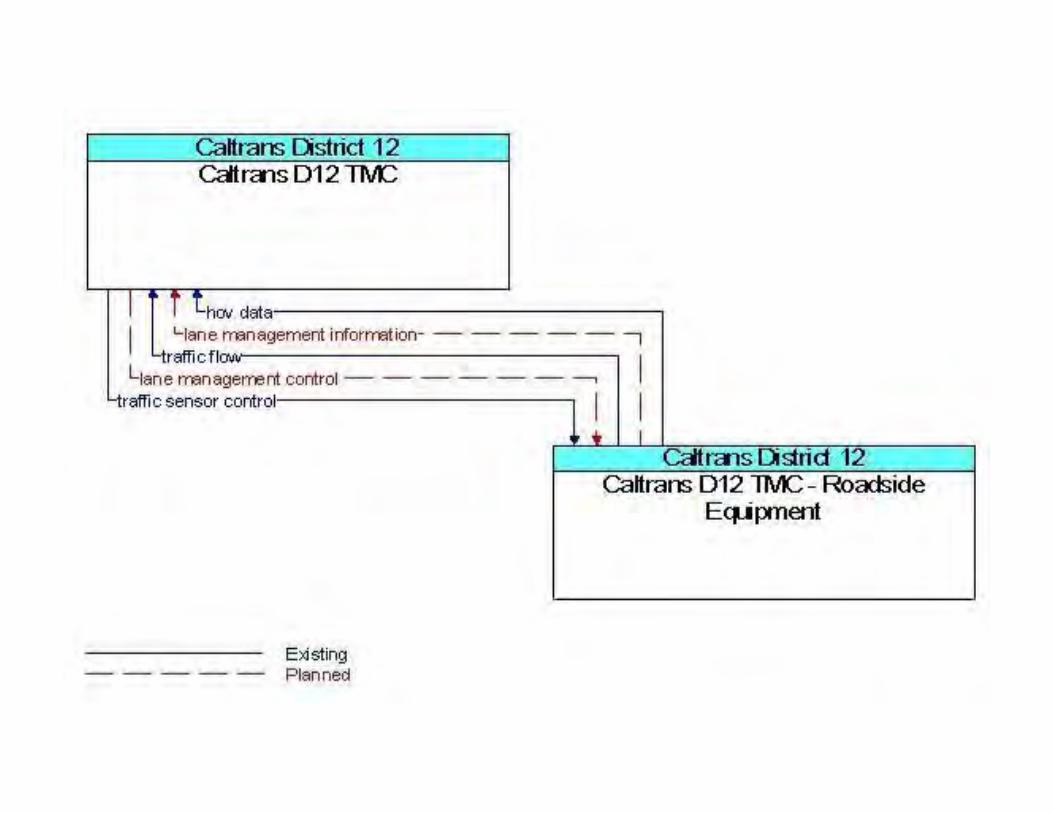

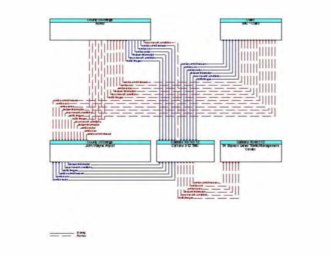
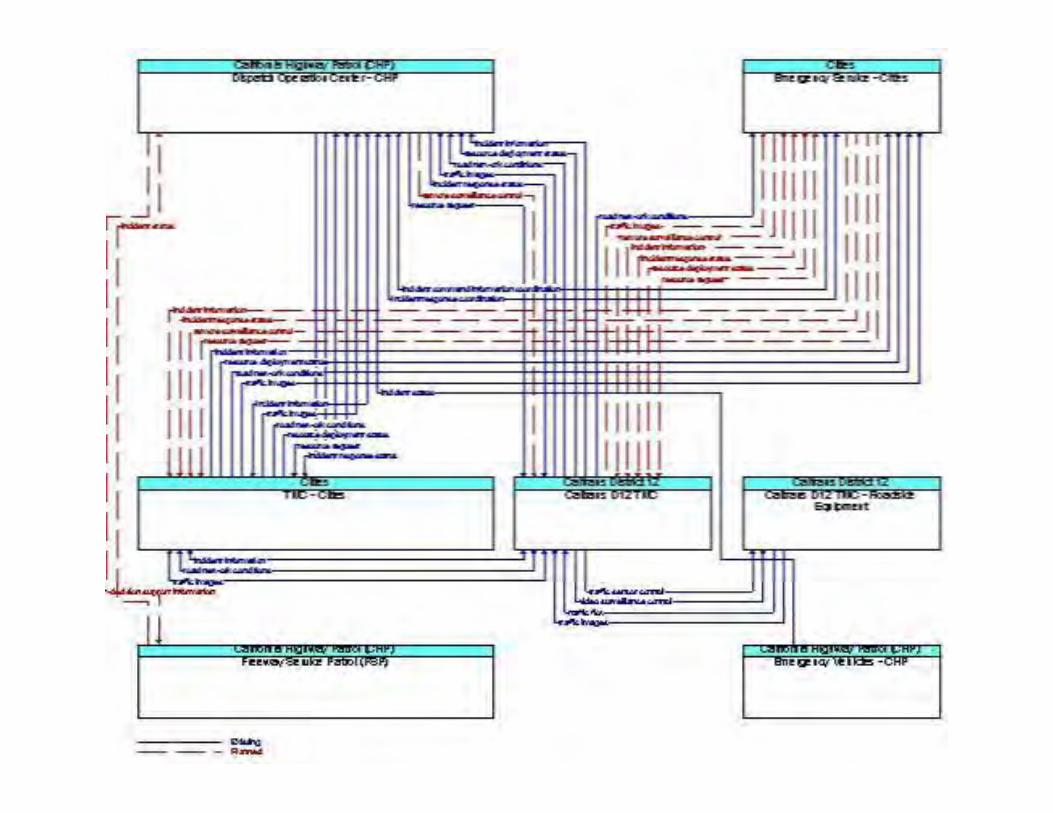

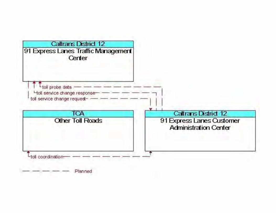
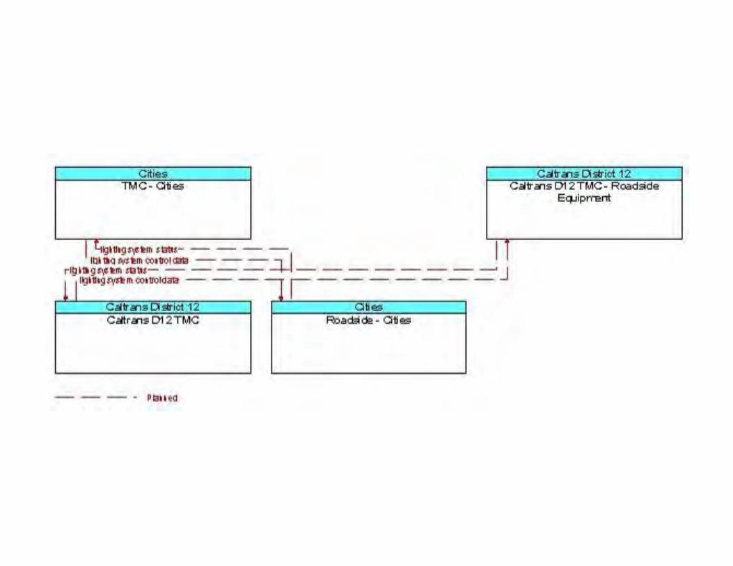
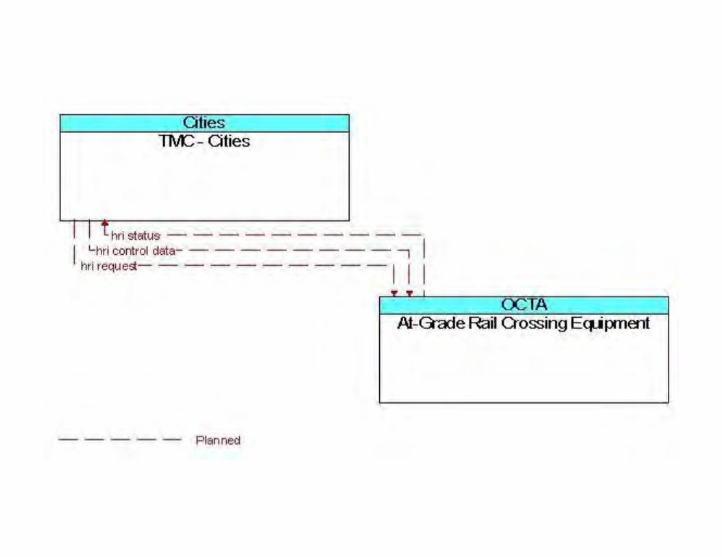
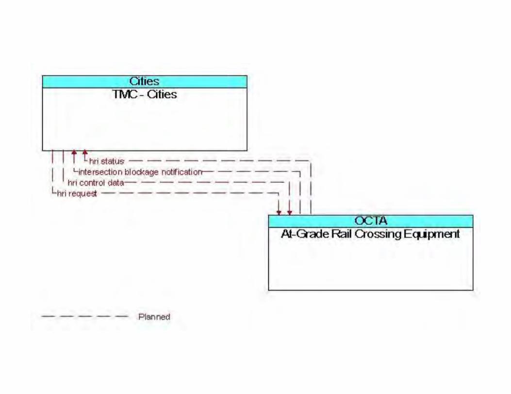


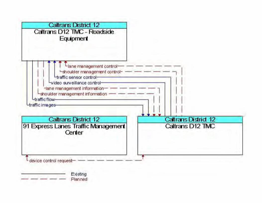
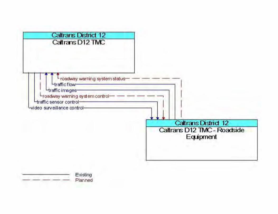
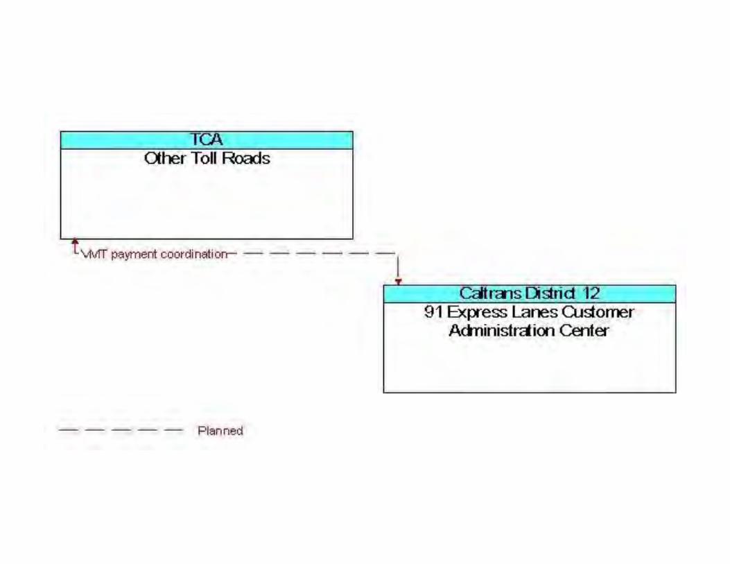
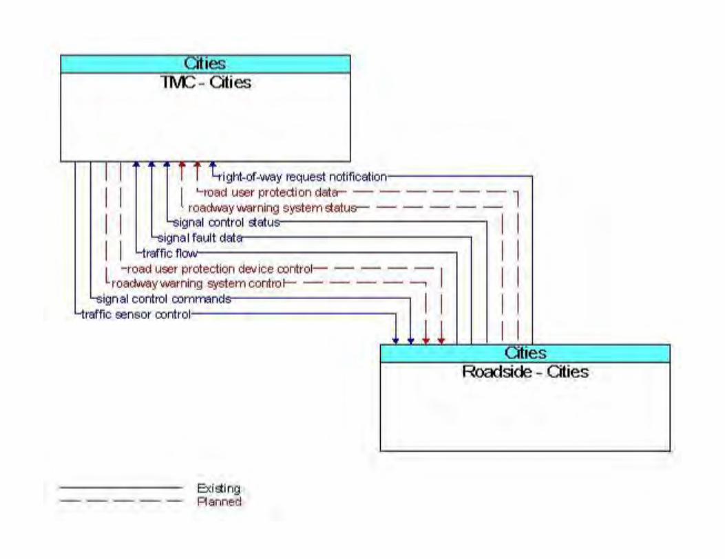


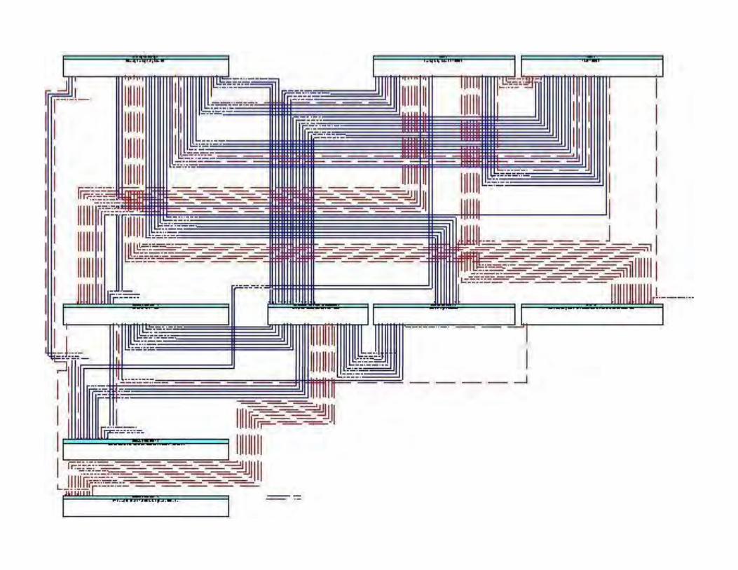
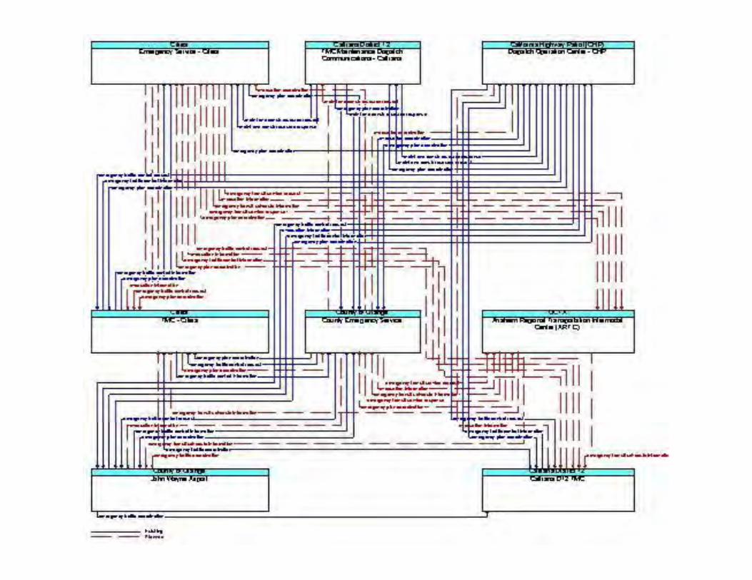
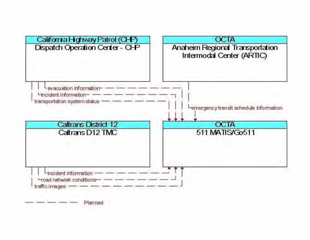


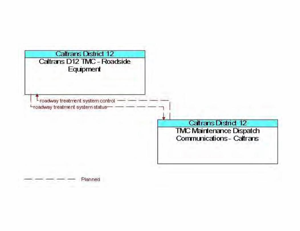

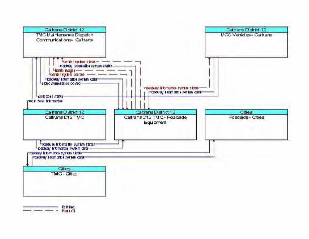
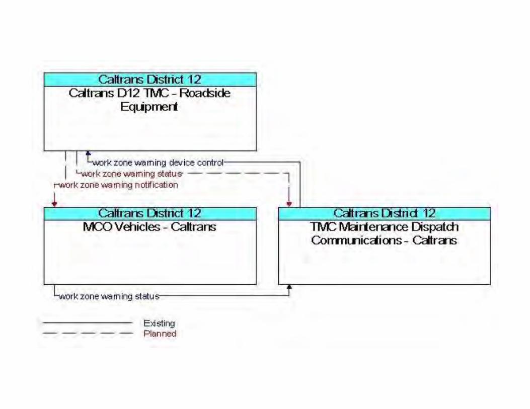

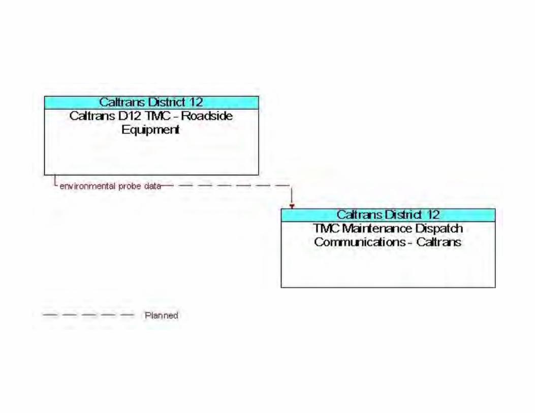

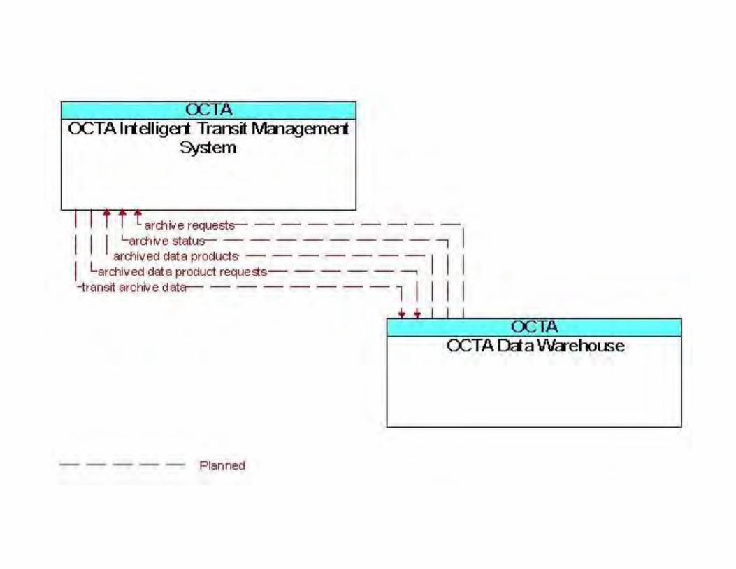

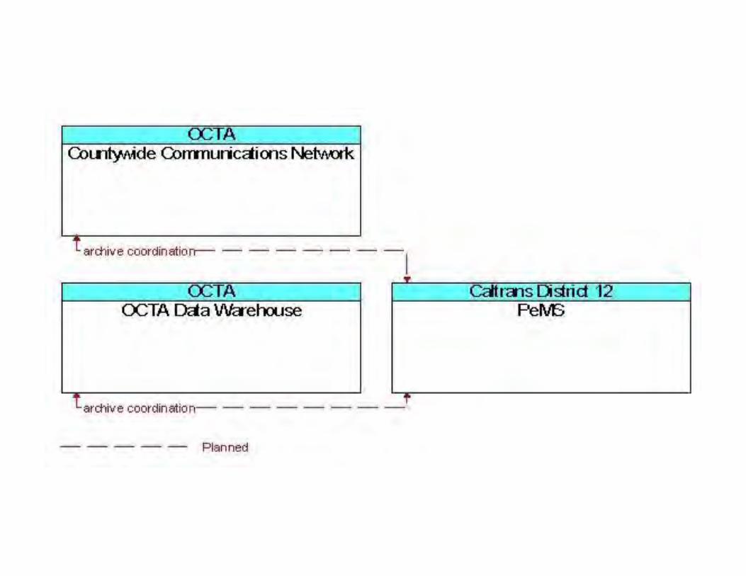
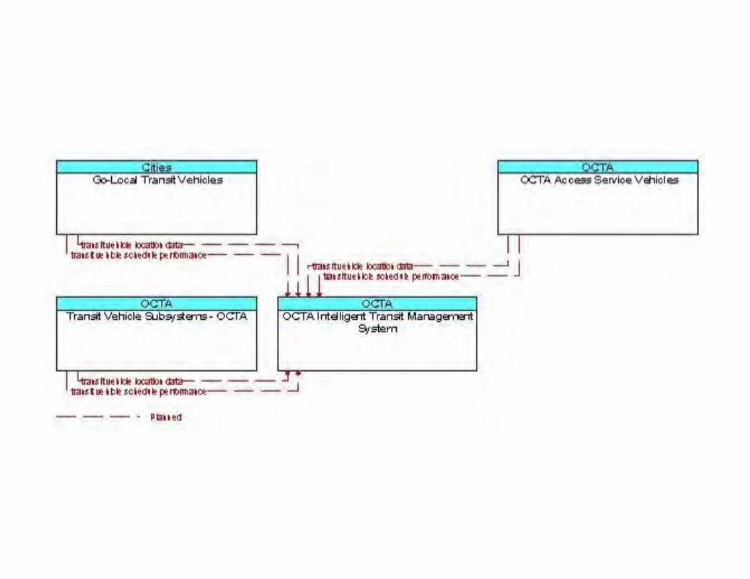
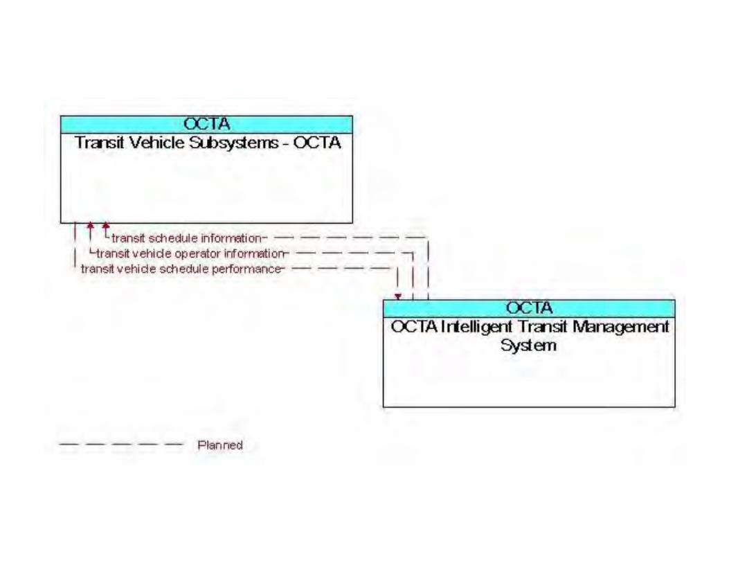


August 22, 2013
Appendix E: Regional ITS Architecture – Standards

Relevant Standards Activities 5:41:09PM12/12/2012
Standards for Orange County
NOTE: The ITS standards presented in this report may represent a supersetof options, and in some cases, provide redundant capabilities. In addition, theseITS standards are at different maturity levels. Care should be taken to select thestandards that best meet the needs of the region or project.
Lead SDO Standard Name Document IDVersion
Traffic Management Data Dictionary (TMDD)and Message Sets for External TrafficManagement Center Communications(MS/ETMCC)
AASHTO/ITE ITE TMDD
NTCIP Center-to-Center Standards GroupAASHTO/ITE/NEMA (See Footnote)NTCIP Center-to-Field Standards GroupAASHTO/ITE/NEMA (See Footnote)Global Object DefinitionsAASHTO/ITE/NEMA NTCIP 1201Object Definitions for Actuated Traffic SignalController (ASC) Units
AASHTO/ITE/NEMA NTCIP 1202
Object Definitions for Dynamic Message Signs(DMS)
AASHTO/ITE/NEMA NTCIP 1203
Object Definitions for Environmental SensorStations (ESS)
AASHTO/ITE/NEMA NTCIP 1204
Object Definitions for Closed Circuit Television(CCTV) Camera Control
AASHTO/ITE/NEMA NTCIP 1205
Object Definitions for Data Collection andMonitoring (DCM) Devices
AASHTO/ITE/NEMA NTCIP 1206
Object Definitions for Ramp Meter Control(RMC) Units
AASHTO/ITE/NEMA NTCIP 1207
Object Definitions for Closed Circuit Television(CCTV) Switching
AASHTO/ITE/NEMA NTCIP 1208
Data Element Definitions for TransportationSensor Systems (TSS)
AASHTO/ITE/NEMA NTCIP 1209
Field Management Stations (FMS) - Part 1:Object Definitions for Signal System Masters
AASHTO/ITE/NEMA NTCIP 1210
Object Definitions for Signal Control andPrioritization (SCP)
AASHTO/ITE/NEMA NTCIP 1211
Object Definitions for Electrical and LightingManagement Systems (ELMS)
AASHTO/ITE/NEMA NTCIP 1213
Object Definitions for Conflict Monitor Units(CMU)
AASHTO/ITE/NEMA NTCIP 1214
Turbo Architecture v7.0.2 1
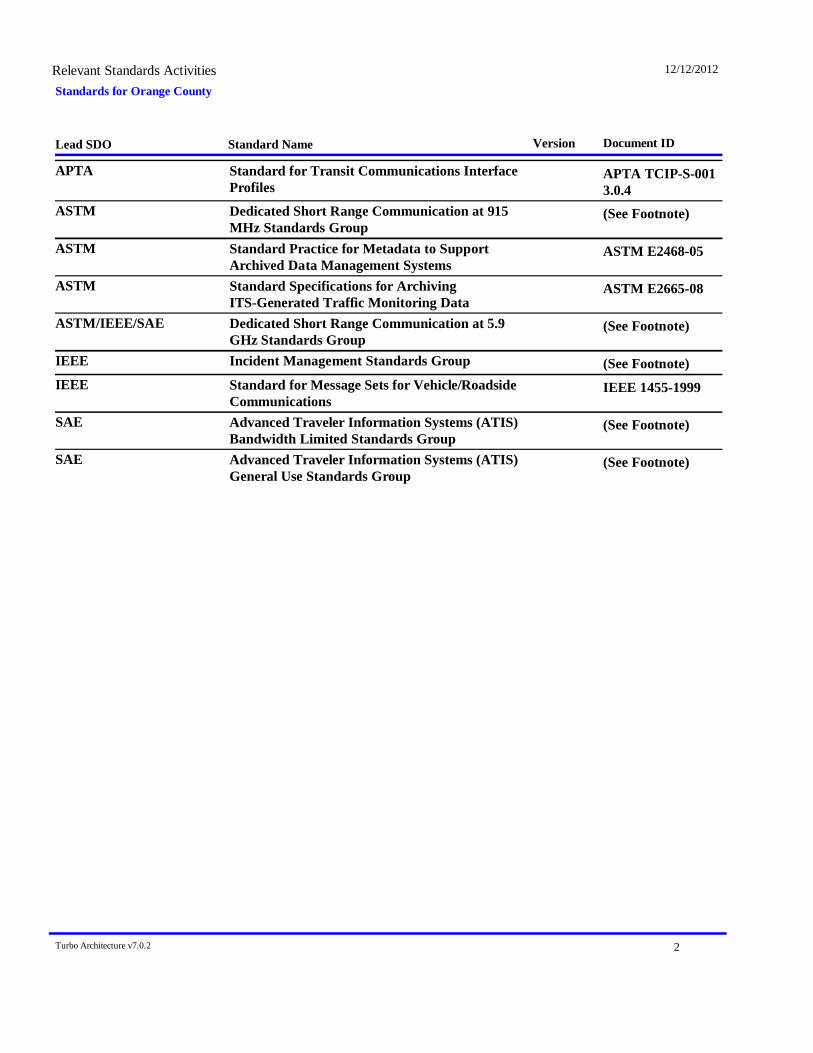
Standards for Orange CountyRelevant Standards Activities 12/12/2012
Lead SDO Standard Name Document IDVersion
Standard for Transit Communications InterfaceProfiles
APTA APTA TCIP-S-0013.0.4
Dedicated Short Range Communication at 915MHz Standards Group
ASTM (See Footnote)
Standard Practice for Metadata to SupportArchived Data Management Systems
ASTM ASTM E2468-05
Standard Specifications for ArchivingITS-Generated Traffic Monitoring Data
ASTM ASTM E2665-08
Dedicated Short Range Communication at 5.9GHz Standards Group
ASTM/IEEE/SAE (See Footnote)
Incident Management Standards GroupIEEE (See Footnote)Standard for Message Sets for Vehicle/RoadsideCommunications
IEEE IEEE 1455-1999
Advanced Traveler Information Systems (ATIS)Bandwidth Limited Standards Group
SAE (See Footnote)
Advanced Traveler Information Systems (ATIS)General Use Standards Group
SAE (See Footnote)
Turbo Architecture v7.0.2 2
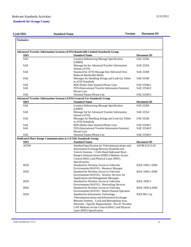
Standards for Orange CountyRelevant Standards Activities 12/12/2012
Lead SDO Standard Name Document IDVersion
Footnotes:
Advanced Traveler Information Systems (ATIS) Bandwidth Limited Standards GroupDocument IDStandard NameSDO
SAE Location Referencing Message Specification(LRMS)
SAE J2266
SAE Message Set for Advanced Traveler InformationSystem (ATIS)
SAE J2354
SAE Standard for ATIS Message Sets Delivered OverReduced Bandwidth Media
SAE J2369
SAE Messages for Handling Strings and Look-Up Tablesin ATIS Standards
SAE J2540
SAE RDS (Radio Data System) Phrase Lists SAE J2540/1SAE ITIS (International Traveler Information Systems)
Phrase ListsSAE J2540/2
SAE National Names Phrase List SAE J2540/3Advanced Traveler Information Systems (ATIS) General Use Standards Group
Document IDStandard NameSDOSAE Location Referencing Message Specification
(LRMS)SAE J2266
SAE Message Set for Advanced Traveler InformationSystem (ATIS)
SAE J2354
SAE Messages for Handling Strings and Look-Up Tablesin ATIS Standards
SAE J2540
SAE RDS (Radio Data System) Phrase Lists SAE J2540/1SAE ITIS (International Traveler Information Systems)
Phrase ListsSAE J2540/2
SAE National Names Phrase List SAE J2540/3Dedicated Short Range Communication at 5.9 GHz Standards Group
Document IDStandard NameSDOASTM Standard Specification for Telecommunications and
Information Exchange Between Roadside andVehicle Systems - 5 GHz Band Dedicated ShortRange Communications (DSRC) Medium AccessControl (MAC) and Physical Layer (PHY)Specifications
ASTM E2213-03
IEEE Standard for Wireless Access in VehicularEnvironments (WAVE) - Resource Manager
IEEE 1609.1-2006
IEEE Standard for Wireless Access in VehicularEnvironments (WAVE) - Security Services forApplications and Management Messages
IEEE 1609.2-2006
IEEE Standard for Wireless Access in VehicularEnvironments (WAVE) - Networking Services
IEEE 1609.3
IEEE Standard for Wireless Access in VehicularEnvironments (WAVE) - Multi-Channel Operation
IEEE 1609.4-2006
IEEE Standard for Information Technology -Telecommunications and Information ExchangeBetween Systems - Local and Metropolitan AreaNetworks - Specific Requirements - Part II: WirelessLAN Medium Access Control (MAC) and PhysicalLayer (PHY) Specification
IEEE 802.11p
Turbo Architecture v7.0.2 3
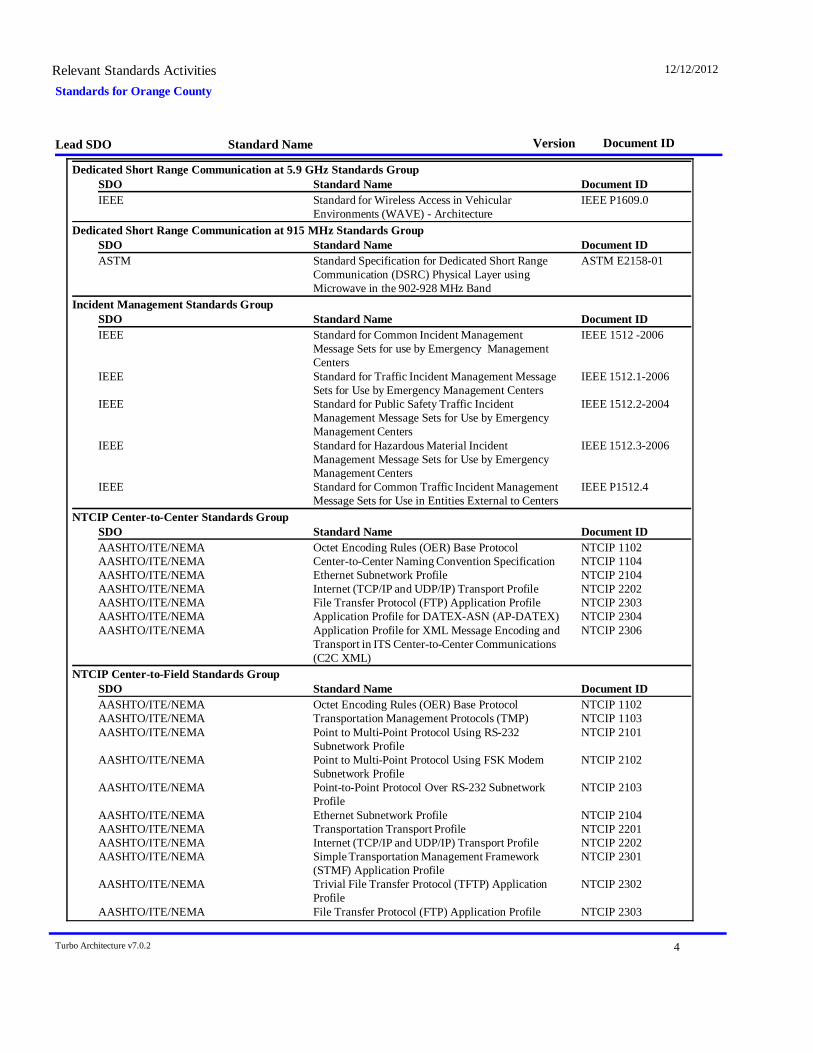
Standards for Orange CountyRelevant Standards Activities 12/12/2012
Lead SDO Standard Name Document IDVersion
Dedicated Short Range Communication at 5.9 GHz Standards GroupDocument IDStandard NameSDO
IEEE Standard for Wireless Access in VehicularEnvironments (WAVE) - Architecture
IEEE P1609.0
Dedicated Short Range Communication at 915 MHz Standards GroupDocument IDStandard NameSDO
ASTM Standard Specification for Dedicated Short RangeCommunication (DSRC) Physical Layer usingMicrowave in the 902-928 MHz Band
ASTM E2158-01
Incident Management Standards GroupDocument IDStandard NameSDO
IEEE Standard for Common Incident ManagementMessage Sets for use by Emergency ManagementCenters
IEEE 1512 -2006
IEEE Standard for Traffic Incident Management MessageSets for Use by Emergency Management Centers
IEEE 1512.1-2006
IEEE Standard for Public Safety Traffic IncidentManagement Message Sets for Use by EmergencyManagement Centers
IEEE 1512.2-2004
IEEE Standard for Hazardous Material IncidentManagement Message Sets for Use by EmergencyManagement Centers
IEEE 1512.3-2006
IEEE Standard for Common Traffic Incident ManagementMessage Sets for Use in Entities External to Centers
IEEE P1512.4
NTCIP Center-to-Center Standards GroupDocument IDStandard NameSDO
AASHTO/ITE/NEMA Octet Encoding Rules (OER) Base Protocol NTCIP 1102AASHTO/ITE/NEMA Center-to-Center Naming Convention Specification NTCIP 1104AASHTO/ITE/NEMA Ethernet Subnetwork Profile NTCIP 2104AASHTO/ITE/NEMA Internet (TCP/IP and UDP/IP) Transport Profile NTCIP 2202AASHTO/ITE/NEMA File Transfer Protocol (FTP) Application Profile NTCIP 2303AASHTO/ITE/NEMA Application Profile for DATEX-ASN (AP-DATEX) NTCIP 2304AASHTO/ITE/NEMA Application Profile for XML Message Encoding and
Transport in ITS Center-to-Center Communications(C2C XML)
NTCIP 2306
NTCIP Center-to-Field Standards GroupDocument IDStandard NameSDO
AASHTO/ITE/NEMA Octet Encoding Rules (OER) Base Protocol NTCIP 1102AASHTO/ITE/NEMA Transportation Management Protocols (TMP) NTCIP 1103AASHTO/ITE/NEMA Point to Multi-Point Protocol Using RS-232
Subnetwork ProfileNTCIP 2101
AASHTO/ITE/NEMA Point to Multi-Point Protocol Using FSK ModemSubnetwork Profile
NTCIP 2102
AASHTO/ITE/NEMA Point-to-Point Protocol Over RS-232 SubnetworkProfile
NTCIP 2103
AASHTO/ITE/NEMA Ethernet Subnetwork Profile NTCIP 2104AASHTO/ITE/NEMA Transportation Transport Profile NTCIP 2201AASHTO/ITE/NEMA Internet (TCP/IP and UDP/IP) Transport Profile NTCIP 2202AASHTO/ITE/NEMA Simple Transportation Management Framework
(STMF) Application ProfileNTCIP 2301
AASHTO/ITE/NEMA Trivial File Transfer Protocol (TFTP) ApplicationProfile
NTCIP 2302
AASHTO/ITE/NEMA File Transfer Protocol (FTP) Application Profile NTCIP 2303
Turbo Architecture v7.0.2 4

Standards for Orange CountyRelevant Standards Activities 12/12/2012
Lead SDO Standard Name Document IDVersion
Turbo Architecture v7.0.2 5
August 22, 2013
Appendix F: Local Communications Inventory Maps
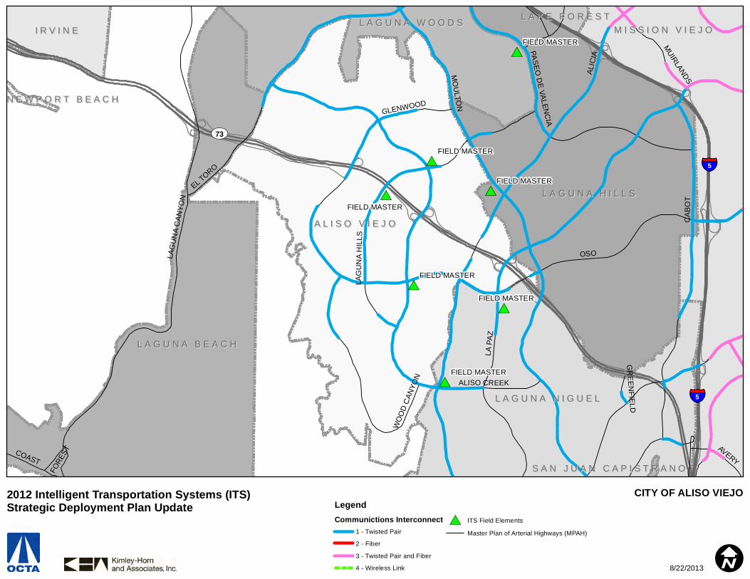
#*
#*
#*
#*
#*
#*
#*
#*
#*
FIELD MASTER
FIELD MASTER
FIELD MASTER
FIELD MASTER
FIELD MASTER
FIELD MASTER
FIELD MASTER
§̈¦5
§̈¦5
UV73
A L I S O V I E J OA L I S O V I E J O
L A G U N A H I L L SL A G U N A H I L L S
L A G U N A B E A C HL A G U N A B E A C H
L A G U N A N I G U E LL A G U N A N I G U E L
M I S S I O N V I E J OM I S S I O N V I E J OL A G U N A W O O D SL A G U N A W O O D S
I R V I N EI R V I N EL A K E F O R E S TL A K E F O R E S T
N E W P O R T B E A C HN E W P O R T B E A C H
S A N J U A N C A P I S T R A N OS A N J U A N C A P I S T R A N O
ALIC
IA
LA P
AZ
MO
ULTO
N
CA
BO
T
OSO
EL TORO
ALISO CREEK
LAG
UN
A C
ANYO
N
LAG
UN
A H
ILLS
PASEO
DE VALEN
CIA
GLENWOOD
MUIRLANDS
AVERY
WO
OD
CAN
YON
COAST
FORE
ST
GR
EENFIELD
CITY OF ALISO VIEJOLegendCommunictions Interconnect
1 - Twisted Pair
2 - Fiber
3 - Twisted Pair and Fiber
4 - Wireless Link
#* ITS Field Elements
Master Plan of Arterial Highways (MPAH)
I
2012 Intelligent Transportation Systems (ITS) Strategic Deployment Plan Update
8/22/2013
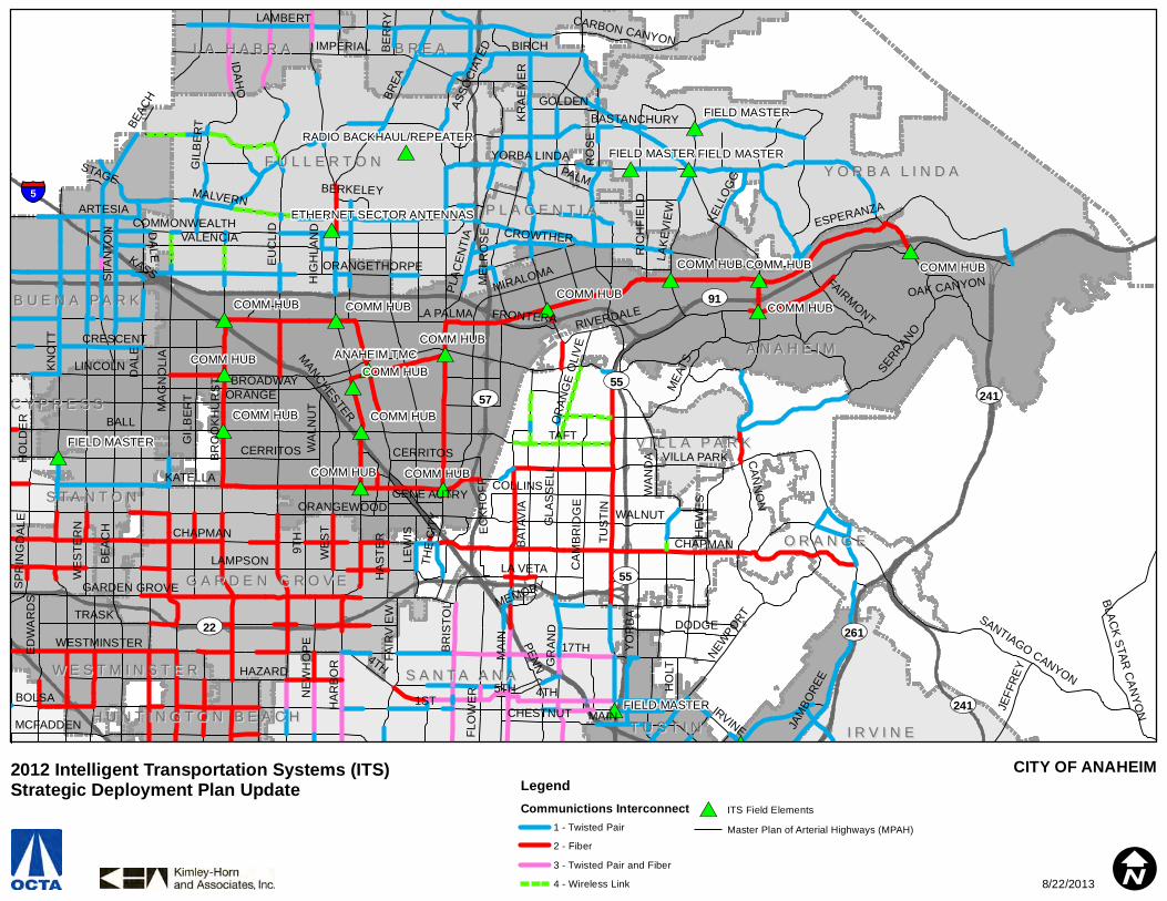
#*
#* #*
#*#*
#*
#*#*
#*
#*
#*
#*
#*
#*
#*
#*
#*
#*
#*
#* #*
#*
#*
#*
#*
#*
#*
#*
COMM HUB
COMM HUB
COMM HUBCOMM HUB
COMM HUB
COMM HUB
COMM HUB
COMM HUB
COMM HUB
COMM HUB
COMM HUB
COMM HUB
COMM HUB
COMM HUB
ANAHEIM TMC
FIELD MASTER
FIELD MASTER
FIELD MASTER
FIELD MASTERFIELD MASTERRADIO BACKHAUL/REPEATER
ETHERNET SECTOR ANTENNAS§̈¦5
UV91
UV261
UV241
UV55UV57
UV22
UV55
UV241
A N A H E I MA N A H E I M
O R A N G EO R A N G E
F U L L E R T O NF U L L E R T O N
B R E AB R E A
Y O R B A L I N D AY O R B A L I N D A
S A N T A A N AS A N T A A N A
G A R D E N G R O V EG A R D E N G R O V E
B U E N A P A R KB U E N A P A R K
I R V I N EI R V I N E
P L A C E N T I AP L A C E N T I A
W E S T M I N S T E RW E S T M I N S T E R
L A H A B R AL A H A B R A
T U S T I NT U S T I N
S T A N T O NS T A N T O N
V I L L A P A R KV I L L A P A R K
C Y P R E S SC Y P R E S S
H U N T I N G T O N B E A C HH U N T I N G T O N B E A C H1ST
LA PALMA
EU
CLI
D
BALL
HA
RB
OR
KATELLA
LINCOLN
IMPERIAL
17TH
TUS
TIN
DA
LE
KN
OTT
TRASK
MA
GN
OLI
A
ORANGETHORPE
LAMBERT
LAMPSON
BOLSA
BASTANCHURY
WE
STE
RN
BREA
BR
OO
KH
UR
ST
RO
SE
HAZARD
ORANGEWOOD
YORBA LINDA
MCFADDEN
ORANGE
VALENCIA
CERRITOS
9TH CHAPMAN
KR
AE
ME
R
NEWPO
RT
BROADWAY
GARDEN GROVE
TAFT
BIRCH
BAT
AVIA
WESTMINSTER
SERRANO
4THM
EATS
GLA
SS
ELL
HE
WE
S
COLLINS
COMMONWEALTH
LAK
EVIE
W
CAN
NO
N
PLA
CEN
TIA
JAM
BORE
E
GR
AN
D
MALVERN
CRESCENT
SANTIAGO CANYON
WE
ST
IRVINE
BR
ISTO
L
MAIN
GIL
BER
T
MIRALOMA
HO
LDE
R
STA
NTO
N
CA
MB
RID
GE
YO
RB
A
FAIR
VIE
W
ARTESIA
ED
WA
RD
S
NE
WH
OP
E
HA
STE
R
IDAH
O
PALM
LEW
IS
WA
LNU
T
BEAC
H
RIVERDALE
ESPERANZA
RIC
HFI
ELD
LA VETA
KELL
OG
G
HO
LT
JEFF
REY
CARBON CANYON
FAIRMONT
ASSO
CIAT
ED
THE
CIT
Y
GOLDEN
CROWTHER
CHESTNUT
OR
ANG
E O
LIV
E
BLAC
K STAR
CA
NYO
N
VILLA PARK
5TH
BE
RR
Y
SP
RIN
GD
ALE
ME
LRO
SE
WA
ND
A
FRONTERA
MANCHESTER
HIG
HLA
ND
BERKELEY
FLO
WE
R
PENN
EC
KH
OFF
STAGE
KASS
DODGE
OAK CANYON
GENE AUTRY
MEMORY
BE
AC
H CHAPMAN
4TH
DALE
MA
IN
GIL
BE
RT
CERRITOS
WALNUT
CITY OF ANAHEIMLegendCommunictions Interconnect
1 - Twisted Pair
2 - Fiber
3 - Twisted Pair and Fiber
4 - Wireless Link
#* ITS Field Elements
Master Plan of Arterial Highways (MPAH)
I
2012 Intelligent Transportation Systems (ITS) Strategic Deployment Plan Update
8/22/2013
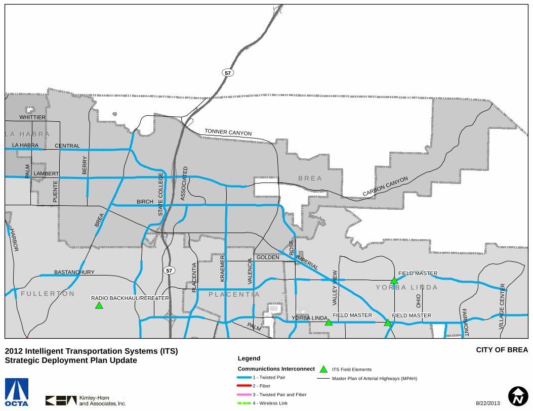
#* #*
#*
#*
FIELD MASTER
FIELD MASTERFIELD MASTER
RADIO BACKHAUL/REPEATER
UV57
UV57
B R E AB R E A
F U L L E R T O NF U L L E R T O NY O R B A L I N D AY O R B A L I N D A
P L A C E N T I AP L A C E N T I A
L A H A B R AL A H A B R A
BREA
IMPERIALBASTANCHURY
YORBA LINDA
LAMBERT
BIRCH
RO
SE
VALE
NC
IA
PALM
KR
AE
ME
R
BE
RR
Y
HAR
BOR
CARBON CANYON
STA
TE C
OLL
EG
E
PU
EN
TE
PLA
CE
NTI
A
FAIRM
ON
T
ASSO
CIA
TED
CENTRAL
GOLDEN
OH
IO
WHITTIER
TONNER CANYON
VALL
EY
VIE
W
VIL
LAG
E C
EN
TER
LA HABRA
PALM
CITY OF BREALegendCommunictions Interconnect
1 - Twisted Pair
2 - Fiber
3 - Twisted Pair and Fiber
4 - Wireless Link
#* ITS Field Elements
Master Plan of Arterial Highways (MPAH)
I
2012 Intelligent Transportation Systems (ITS) Strategic Deployment Plan Update
8/22/2013

#*
#*
#*
#*
#*
#*
#*
#*
#*
#*
#*
#*
#*
#*
#*
#*
COMM HUB
COMM HUB
COMM HUB
COMM HUB
CYPRESS TMC
FIELD MASTER
FIELD MASTER
FIELD MASTER
FIELD MASTER
FIELD MASTER
ETHERNET SECTOR ANTENNAS
§̈¦5
§̈¦605
§̈¦5
§̈¦605
UV91UV91
A N A H E I MA N A H E I M
F U L L E R T O NF U L L E R T O N
B U E N A P A R KB U E N A P A R K
C Y P R E S SC Y P R E S S
L A P A L M AL A P A L M A
S T A N T O NS T A N T O NL O S A L A M I T O SL O S A L A M I T O S
BALL
LINCOLN
BE
AC
H
EU
CLI
D
CERRITOS
ORANGE
KN
OTT
DA
LE
LA PALMA
CRESCENT
WA
LKE
R
WE
STE
RN
HA
RB
OR
ORANGETHORPEMA
GN
OLI
A
MO
OD
Y
MALVERN
VALENCIA
VALL
EY
VIE
W
BROADWAY
BR
OO
KH
UR
ST
ARTESIA
STA
NTO
N
COMMONWEALTHD
EN
NI
GILB
ERT
HO
LDE
R
ROSECRANS
BASTANCHURY
WA
LNU
T
BLO
OM
FIE
LD
PARKS
PIONEER
CHAPMAN
HIG
HLA
ND
MANCHESTER
HOUSTON
STAGE
KASS
SOUTH
LA MIRADA
MA
RQ
UA
RD
T
DA
LE
GIL
BE
RT
CITY OF BUENA PARKLegendCommunictions Interconnect
1 - Twisted Pair
2 - Fiber
3 - Twisted Pair and Fiber
4 - Wireless Link
#* ITS Field Elements
Master Plan of Arterial Highways (MPAH)
I
2012 Intelligent Transportation Systems (ITS) Strategic Deployment Plan Update
8/22/2013

#*
#*#*
#*
#*
#*
#*
#*
HUB - FIRESTATION #6
HUB - FIRESTATION #7
HUB - GENERAL SERVICES
HUB - NEWPORT BEACH POLICE STATION
FOUNTAIN VALLEY - CALTRANS INTERTIE
§̈¦405
UV55
UV55
C O S T A M E S AC O S T A M E S A I R V I N EI R V I N E
N E W P O R T B E A C HN E W P O R T B E A C H
H U N T I N G T O N B E A C HH U N T I N G T O N B E A C H
S A N T A A N AS A N T A A N AF O U N T A I N V A L L E YF O U N T A I N V A L L E Y
T U S T I NT U S T I N
ADAMS
19TH
MAIN
MACARTHUR
ELLIS
HA
RB
OR
IRVIN
E
JAMBOREE
BU
SH
AR
D
17TH
BAKER
MA
GN
OLI
A
NE
WLA
ND
RED HILL
FAIR
VIE
W
TALBERT
BR
OO
KH
UR
ST
CAMPUS
PLA
CE
NTI
A
BE
AR
FAIR
WA
RD
VICTORIA
GARFIELD
SUNFLOWERALTON
NEWPORT
BALBOA
BIRCH
VON KARMAN
ATLANTA
YORKTOWN
HAMILTON
15TH
WILSON
COAST
UNIVERSITY
GISLER
22ND
BRISTOL
HAR
VAR
D
MICHELSON
SOUTH COAST
BISON
PACIFIC COAST
FORD
ANTON
BONITA CANYON
BANNING
DOVER
EASTBLUFF
EUCLID
HY
LAN
D
FLO
WE
R
ARLINGTON
MESA VERDE
SANTA A
NA
DEL MAR
MERRIMAC
PAULARINO
16TH
SANTIAGO
BER
KELE
Y
HOSPITAL
BR
ISTO
L
BEAR
CITY OF COSTA MESALegendCommunictions Interconnect
1 - Twisted Pair
2 - Fiber
3 - Twisted Pair and Fiber
4 - Wireless Link
#* ITS Field Elements
Master Plan of Arterial Highways (MPAH)
I
2012 Intelligent Transportation Systems (ITS) Strategic Deployment Plan Update
8/22/2013

#*
#*
#*
#*
#*
#*
#*
#*
CYPRESS TMC
FIELD MASTER
FIELD MASTER
FIELD MASTER
FIELD MASTER
FIELD MASTER
FIELD MASTER
FIELD MASTER
§̈¦605
§̈¦605
C Y P R E S SC Y P R E S S
A N A H E I MA N A H E I M
B U E N A P A R KB U E N A P A R K
S T A N T O NS T A N T O NL O S A L A M I T O SL O S A L A M I T O S
L A P A L M AL A P A L M A
G A R D E N G R O V EG A R D E N G R O V E
BALL
DA
LE
KATELLA
KN
OTT
BE
AC
H
ORANGE
CERRITOS
LINCOLN
WE
STE
RN
CRESCENT
WA
LKE
R
MO
OD
Y
VALL
EY
VIE
W
HO
LDE
R
LA PALMA
DE
NN
I
ORANGEWOOD
BLO
OM
FIE
LD
LOS
ALA
MIT
OS
STA
NTO
N
LEX
ING
TON
LA PALMA
CITY OF CYPRESSLegendCommunictions Interconnect
1 - Twisted Pair
2 - Fiber
3 - Twisted Pair and Fiber
4 - Wireless Link
#* ITS Field Elements
Master Plan of Arterial Highways (MPAH)
I
2012 Intelligent Transportation Systems (ITS) Strategic Deployment Plan Update
8/22/2013
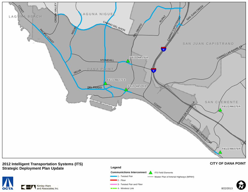
#*
#*
#*
#*
#*
#*
#*
#*
FIELD MASTER
FIELD MASTER
FIELD MASTER
FIELD MASTER
FIELD MASTER
§̈¦5
§̈¦5D A N A P O I N TD A N A P O I N T
S A N J U A N C A P I S T R A N OS A N J U A N C A P I S T R A N O
S A N C L E M E N T ES A N C L E M E N T E
L A G U N A N I G U E LL A G U N A N I G U E LL A G U N A B E A C HL A G U N A B E A C H
COAST
DEL
OBI
SPO
NIG
UEL
PACIFIC COAST
SELVA
STONEHILL
CAMINO DEL AVION
ALIPAZ
CAMINO LAS RAMBLAS
CAM
INO
CAP
ISTR
ANO
DEL PRADO
CR
OW
N V
ALL
EY
SAN JUAN CREEK
CAMIN
O DE
ESTR
ELLA
COAST
CAMINO CAPISTRANO
CITY OF DANA POINTLegendCommunictions Interconnect
1 - Twisted Pair
2 - Fiber
3 - Twisted Pair and Fiber
4 - Wireless Link
#* ITS Field Elements
Master Plan of Arterial Highways (MPAH)
I
2012 Intelligent Transportation Systems (ITS) Strategic Deployment Plan Update
8/22/2013
#*
#*
#* #*
#*FOUNTAIN VALLEY TMC
FOUNTAIN VALLEY HUBFOUNTAIN VALLEY HUB
FOUNTAIN VALLEY HUB
FOUNTAIN VALLEY - CALTRANS INTERTIE
§̈¦405
UV73
F O U N T A I N V A L L E YF O U N T A I N V A L L E Y
S A N T A A N AS A N T A A N A
H U N T I N G T O N B E A C HH U N T I N G T O N B E A C H
C O S T A M E S AC O S T A M E S A
W E S T M I N S T E RW E S T M I N S T E R
G A R D E N G R O V EG A R D E N G R O V E
WARNER
EDINGER
ELLIS
SLATER
BE
AC
H
TALBERT
HA
RB
OR
EU
CLI
D
FAIR
VIE
W
WA
RD
BU
SH
AR
DNE
WLA
ND
MA
GN
OLI
A
GARFIELD
BR
OO
KH
UR
ST
NE
WH
OP
E
HEIL
GISLER
MACARTHUR
SUNFLOWER
SEGERSTROM
SOUTH COAST
HY
LAN
D
MAIN
WA
RD
HEIL
ELLIS
HEIL
CITY OF FOUNTAIN VALLEYLegendCommunictions Interconnect
1 - Twisted Pair
2 - Fiber
3 - Twisted Pair and Fiber
4 - Wireless Link
#* ITS Field Elements
Master Plan of Arterial Highways (MPAH)
I
2012 Intelligent Transportation Systems (ITS) Strategic Deployment Plan Update
8/22/2013

#*
#* #*
#*
#*
RADIO BACKHAUL/REPEATER
ETHERNET SECTOR ANTENNAS
§̈¦5
UV91
UV57
UV57
UV91UV91
F U L L E R T O NF U L L E R T O N
B R E AB R E A
P L A C E N T I AP L A C E N T I A
L A H A B R AL A H A B R A
A N A H E I MA N A H E I M
B U E N A P A R KB U E N A P A R K
IMPERIAL
LAMBERT
EU
CLI
D
BREA
HA
RB
OR
VALENCIA
KR
AE
ME
R
CHAPMAN
ORANGETHORPE
BIRCH
BASTANCHURY
PLA
CEN
TIA
COMMONWEALTH
MALVERN
STA
TE C
OLL
EG
E
GIL
BE
RT
DA
LE
LEM
ON
IDA
HO
AC
AC
IA
ROSECRANS
BE
AC
H
AS
SO
CIA
TED
YORBA LINDA
RAY
MO
ND
MIRALOMA
CROWTHER
MA
GN
OLI
A
ME
LRO
SE
BRAD
FOR
D
BE
RR
Y
PARKSPIONEER
BR
OO
KH
UR
ST
PALM
MADISON
PU
EN
TE
HIG
HLA
ND
BERKELEY
GOLDEN
ARTESIA
KASS
PALM
DA
LEBE
ACH
VALE
NC
IA
BEAC
H
CITY OF FULLERTONLegendCommunictions Interconnect
1 - Twisted Pair
2 - Fiber
3 - Twisted Pair and Fiber
4 - Wireless Link
#* ITS Field Elements
Master Plan of Arterial Highways (MPAH)
I
2012 Intelligent Transportation Systems (ITS) Strategic Deployment Plan Update
8/22/2013
#* #*#*
#*
COMM HUBFIELD MASTER
§̈¦405
§̈¦5
§̈¦405
UV22
G A R D E N G R O V EG A R D E N G R O V E
W E S T M I N S T E RW E S T M I N S T E R
S A N T A A N AS A N T A A N A
A N A H E I MA N A H E I M
S T A N T O NS T A N T O N
C Y P R E S SC Y P R E S S
H U N T I N G T O N B E A C HH U N T I N G T O N B E A C H
F O U N T A I N V A L L E YF O U N T A I N V A L L E Y
O R A N G EO R A N G E
S E A L B E A C HS E A L B E A C H
L O S A L A M I T O SL O S A L A M I T O S
KATELLA
TRASK
LAMPSON
BOLSA
BE
AC
H
1ST
CHAPMAN
EU
CLI
D
EDINGER
MCFADDEN
HA
RB
OR
HAZARD
MA
GN
OLI
A
WESTMINSTER
9TH
ORANGEWOOD
GARDEN GROVE
DA
LE
4TH
BR
OO
KH
UR
ST
SP
RIN
GD
ALE
KN
OTT
WE
ST
FAIR
VIE
W
NE
WLA
ND
ED
WA
RD
S
NE
WH
OP
E
GIL
BE
RT
HO
OV
ER
WE
STE
RN
WA
RD
HA
STE
R
RA
ITT
BO
LSA
CH
ICA
GO
LDE
NW
ES
T
BU
SH
AR
D
VALL
EY
VIE
W
17TH
GR
AH
AM
LEW
IS
CENTER
GO
THA
RD
CLE
ME
NTI
NE
DISNEY
WA
LNU
T
ARGOSY
WA
LKE
R
CIVIC CENTER
LEW
IS
CITY OF GARDEN GROVELegendCommunictions Interconnect
1 - Twisted Pair
2 - Fiber
3 - Twisted Pair and Fiber
4 - Wireless Link
#* ITS Field Elements
Master Plan of Arterial Highways (MPAH)
I
2012 Intelligent Transportation Systems (ITS) Strategic Deployment Plan Update
8/22/2013
#*
#*
#* #*
#*
#*
#*
#*
#*
#*
#*
#*
#*
#*SEAL BEACH TMC
FOUNTAIN VALLEY TMC
FOUNTAIN VALLEY HUBFOUNTAIN VALLEY HUB
FOUNTAIN VALLEY HUB
HUB - FIRESTATION #6
HUNTINGTON BEACH TMC
CALTRANS FIELD MASTER
CALTRANS FIELD MASTER
CALTRANS FIELD MASTER
HUB - GENERAL SERVICES
FOUNTAIN VALLEY - CALTRANS INTERTIE
UV55
UV73
UV55
H U N T I N G T O N B E A C HH U N T I N G T O N B E A C H
C O S T A M E S AC O S T A M E S A
S A N T A A N AS A N T A A N A
S E A L B E A C HS E A L B E A C H W E S T M I N S T E RW E S T M I N S T E R
F O U N T A I N V A L L E YF O U N T A I N V A L L E Y
N E W P O R T B E A C HN E W P O R T B E A C H
G A R D E N G R O V EG A R D E N G R O V E
EDINGER
WARNER
BE
AC
H
HEIL
HA
RB
OR
1STBOLSA
BU
SH
AR
D
SLATER
NE
WLA
ND
FAIR
VIE
W
MA
GN
OLI
APACIFIC COAST
MCFADDEN
ADAMS
EU
CLI
D
19TH
BR
OO
KH
UR
ST
HAZARD
ELLIS
ED
WA
RD
S
RA
ITT
TALBERT
GARFIELD
GO
LDE
NW
ES
T
4TH
WA
RD
NE
WH
OP
E
IRVIN
E
GO
THA
RD
GR
AH
AM
BAKER
BE
AR
SP
RIN
GD
ALE
MAIN
PALM
FAIR
VICTORIA
LAK
E
DE
LAW
AR
E
17TH
BO
LSA
CH
ICA
BALBOA
HAMILTON
INDIANAPOLIS
WILSON
HO
OV
ER
SUNFLOWER
GISLER
SEGERSTROM
ORANGE
DORY
22ND
SEAL
BEAC
H RANCHO
BANNING
SEAPOINT
CENTER
ARLINGTON
MARINA
HEIL
ELLIS
HEIL
WA
RD
CITY OF HUNTINGTON BEACHLegendCommunictions Interconnect
1 - Twisted Pair
2 - Fiber
3 - Twisted Pair and Fiber
4 - Wireless Link
#* ITS Field Elements
Master Plan of Arterial Highways (MPAH)
I
2012 Intelligent Transportation Systems (ITS) Strategic Deployment Plan Update
8/22/2013
#*
#*
#* #*
#*
#*
#*
#*
#*
#*
#*
#*
#* #*
#*
#*#*
#*
#*#*
#*
#*
#*
#*
#*
#*TMC
HUB - NCCC
IRVINE TMC
FIELD MASTER
FIELD MASTER
FIELD MASTER
FIELD MASTER
FIELD MASTER
FIELD MASTER
FIELD MASTER
FIELD MASTER
FIELD MASTER
FIELD MASTERHUB - CITY HALL
FOUNTAIN VALLEY HUB
HUB - FIRESTATION #6
HUB - FIRESTATION #7
HUB - GENERAL SERVICES
HUB - NEWPORT BEACH PUBLIC LIBRARY
HUB - NEWPORT BEACH POLICE STATION
FOUNTAIN VALLEY - CALTRANS INTERTIE
§̈¦405
§̈¦5
UV55
UV241
UV261
UV133UV73
UV22
UV261
I R V I N EI R V I N E
S A N T A A N AS A N T A A N AT U S T I NT U S T I N
N E W P O R T B E A C HN E W P O R T B E A C H
L A K E F O R E S TL A K E F O R E S T
C O S T A M E S AC O S T A M E S A
M I S S I O N V I E J OM I S S I O N V I E J O
G A R D E N G R O V EG A R D E N G R O V E
L A G U N A W O O D SL A G U N A W O O D S
F O U N T A I N V A L L E YF O U N T A I N V A L L E Y
L A G U N A H I L L SL A G U N A H I L L S
A L I S O V I E J OA L I S O V I E J O
O R A N G EO R A N G E
L A G U N A B E A C HL A G U N A B E A C H
W E S T M I N S T E RW E S T M I N S T E R1ST
ALTON
IRVINE
JAMBOREE
17TH
BAKE
EL TORO
HA
RB
OR
YALE
BR
ISTO
L
CULVER
PORTOLA
WARNER
EDINGERFAIR
VIE
W
RED HILL
EU
CLI
D
BARRANCA
CO
AST
FLO
WE
R
GR
AN
D
MA
CAR
THU
R
WALNUT
JERONIMO
LOS ALISOS
BRYAN
NEWPO
RT
SANTIAG
O C
ANYO
N
NE
WH
OP
E
19TH
RA
ITT
LAKE FOREST
HARVARD
BAKER
4TH
IRVINE CENTER
TRABUCO
JEFF
REY
BALBOA
CAMPUS
MUIRLANDS
TRASK
UNIVERSITY
DYERM
AIN
MA
RG
UER
ITE
MICHELSON
TUS
TIN
ADAMS
PLA
CE
NTI
A
ANTO
NIO
OLY
MPI
AD
SUNFLOWER
FAIRHAVEN
BIRCH
ROCKFIELD
VON K
ARM
AN
HEIL
SANTA A
NA
VICTORIA
STA
ND
AR
D
MELINDA
SEGERSTROM
LA PAZ
HO
LT
SANTA CLARA
GISLER
ALICIA
SLATER
CHESTNUT
ANTON
RIDG
ELIN
E
GLENN RANCH
BLAC
K STAR
CA
NYO
N
TECHNOLOGYLA
KE
PAULARINO
RANCHO
PENN
MESA
MARINE W
AY
ARBORWOOD
CREEK
DODGE
NEWPORT
ALICIA
4TH
TRABUCO
JEFF
REY17THBALBO
A
IRVI
NEBRYAN
CITY OF IRVINELegendCommunictions Interconnect
1 - Twisted Pair
2 - Fiber
3 - Twisted Pair and Fiber
4 - Wireless Link
#* ITS Field Elements
Master Plan of Arterial Highways (MPAH)
I
2012 Intelligent Transportation Systems (ITS) Strategic Deployment Plan Update
8/22/2013

#*LA HABRA TMC
L A H A B R AL A H A B R A B R E AB R E A
F U L L E R T O NF U L L E R T O N
IMPERIAL
LAMBERT
WHITTIER
IDA
HO
LA HABRA
HA
RB
OR
EU
CLI
D
BE
AC
H
PALM
PU
EN
TE
CENTRAL
MA
CY
HA
CIE
ND
A
RUSSELL
CITY OF LA HABRALegendCommunictions Interconnect
1 - Twisted Pair
2 - Fiber
3 - Twisted Pair and Fiber
4 - Wireless Link
#* ITS Field Elements
Master Plan of Arterial Highways (MPAH)
I
2012 Intelligent Transportation Systems (ITS) Strategic Deployment Plan Update
8/22/2013

#* #*
#*FIELD MASTER
UV91
L A P A L M AL A P A L M AB U E N A P A R KB U E N A P A R K
C Y P R E S SC Y P R E S S
CRESCENT
WA
LKE
R
MO
OD
Y
VALL
EY
VIE
W
ORANGETHORPE
LA PALMA
HOUSTON
SOUTH
CA
RM
EN
ITA
MA
RQ
UA
RD
T
LA PALMA
CITY OF LA PALMALegendCommunictions Interconnect
1 - Twisted Pair
2 - Fiber
3 - Twisted Pair and Fiber
4 - Wireless Link
#* ITS Field Elements
Master Plan of Arterial Highways (MPAH)
I
2012 Intelligent Transportation Systems (ITS) Strategic Deployment Plan Update
8/22/2013

#*
#*
#*#*
#*
#*
#*
#*#*
#*
#*
#*
#*#*
#*
#*
#*FIELD MASTER
FIELD MASTER
FIELD MASTER
FIELD MASTER
FIELD MASTER
FIELD MASTER
FIELD MASTER
FIELD MASTERFIELD MASTER
FIELD MASTER
FIELD MASTER
HUB - NEWPORT BEACH PUBLIC LIBRARY
§̈¦5
§̈¦5
UV73
UV73
L A G U N A N I G U E LL A G U N A N I G U E L
N E W P O R T B E A C HN E W P O R T B E A C H
L A G U N A B E A C HL A G U N A B E A C H
A L I S O V I E J OA L I S O V I E J O
M I S S I O N V I E J OM I S S I O N V I E J O
L A G U N A H I L L SL A G U N A H I L L S
I R V I N EI R V I N E
D A N A P O I N TD A N A P O I N T
L A G U N A W O O D SL A G U N A W O O D S
S A N J U A N C A P I S T R A N OS A N J U A N C A P I S T R A N O
L A K E F O R E S TL A K E F O R E S T
COAST
ALIC
IA
LA P
AZ
OSO
MO
ULTO
N
NIG
UEL
CAB
OT
EL TORO
MA
RG
UE
RIT
E
ALIPAZ
LAG
UN
A C
ANYO
N
RAN
CH
O VIEJO
DEL O
BISP
O
PACIFIC ISLAND
HIGHLANDS
GLENWOOD
WO
OD
CAN
YON
GLENNEYRE
ORTEGA
BALBOA
OSO
MARGUERITE
CITY OF LAGUNA BEACHLegendCommunictions Interconnect
1 - Twisted Pair
2 - Fiber
3 - Twisted Pair and Fiber
4 - Wireless Link
#* ITS Field Elements
Master Plan of Arterial Highways (MPAH)
I
2012 Intelligent Transportation Systems (ITS) Strategic Deployment Plan Update
8/22/2013

#*
#*
#*
#*
#*
#*
#*
#*
#*TMC
FIELD MASTER
FIELD MASTER
FIELD MASTER
FIELD MASTER
FIELD MASTER
FIELD MASTER
FIELD MASTER
FIELD MASTER
§̈¦5
§̈¦5
UV73
M I S S I O N V I E J OM I S S I O N V I E J O
A L I S O V I E J OA L I S O V I E J O
L A G U N A H I L L SL A G U N A H I L L S
I R V I N EI R V I N E
L A G U N A W O O D SL A G U N A W O O D S
L A K E F O R E S TL A K E F O R E S T
L A G U N A B E A C HL A G U N A B E A C HL A G U N A N I G U E LL A G U N A N I G U E L
R A N C H O S A N T A M A R G A R I T AR A N C H O S A N T A M A R G A R I T A
OSO
LA PAZ
EL TORO
MO
ULT
ON
MA
RG
UE
RIT
E
CA
BO
T
JERONIMO
FELI
PE
LAG
UN
A C
ANYO
N
ALISO CREEK
LOS ALIS
OS
MUIRLANDS
RIDGE ROUTE
TRABUCO
LAG
UN
A H
ILLS
CROWN VALLEYROCKFIELD
PACIFIC PARK
BAKELAKE FOREST
ALICIA
SANTA MARIA
GLENWOOD
WO
OD C
ANYON
ALICIA
CITY OF LAGUNA HILLSLegendCommunictions Interconnect
1 - Twisted Pair
2 - Fiber
3 - Twisted Pair and Fiber
4 - Wireless Link
#* ITS Field Elements
Master Plan of Arterial Highways (MPAH)
I
2012 Intelligent Transportation Systems (ITS) Strategic Deployment Plan Update
8/22/2013
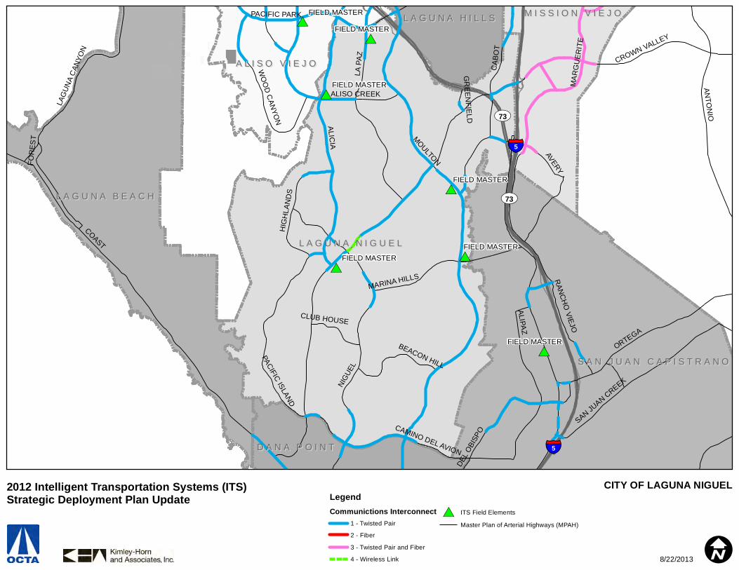
#*#*
#*
#*
#*
#*
#*FIELD MASTER
FIELD MASTER
FIELD MASTER
FIELD MASTER
FIELD MASTER
FIELD MASTERFIELD MASTER
§̈¦5
§̈¦5
UV73
UV73
L A G U N A N I G U E LL A G U N A N I G U E L
L A G U N A B E A C HL A G U N A B E A C H
S A N J U A N C A P I S T R A N OS A N J U A N C A P I S T R A N O
A L I S O V I E J OA L I S O V I E J O
M I S S I O N V I E J OM I S S I O N V I E J O
D A N A P O I N TD A N A P O I N T
L A G U N A H I L L SL A G U N A H I L L S
COAST
ALICIA
CROWN VALLEY
NIG
UEL
LA P
AZ
ANTO
NIO
ORTEGA
ALIPAZ
CAB
OT
MOULTON
MA
RG
UER
ITE
SAN JUAN CREEK
PACIFIC PARK
DEL
OBI
SPOCAMINO DEL AVION
RAN
CH
O VIEJO
PACIFIC ISLAND
ALISO CREEK
LAG
UN
A C
ANYO
N
AVERY
HIG
HLA
ND
SMARINA HILLS
WO
OD
CAN
YON
BEACON HILL
CLUB HOUSE
FOR
EST
GR
EENFIELD
CITY OF LAGUNA NIGUELLegendCommunictions Interconnect
1 - Twisted Pair
2 - Fiber
3 - Twisted Pair and Fiber
4 - Wireless Link
#* ITS Field Elements
Master Plan of Arterial Highways (MPAH)
I
2012 Intelligent Transportation Systems (ITS) Strategic Deployment Plan Update
8/22/2013

#*
#*
#*
#*TMC
FIELD MASTER
FIELD MASTER
§̈¦5L A G U N A W O O D SL A G U N A W O O D S
A L I S O V I E J OA L I S O V I E J O
L A G U N A H I L L SL A G U N A H I L L S
L A K E F O R E S TL A K E F O R E S T
L A G U N A B E A C HL A G U N A B E A C H
I R V I N EI R V I N E
EL TOROM
OU
LTON
SANTA MARIA
RIDGE ROUTE
ALISO CREEK
PASEO
DE VALEN
CIA
GLENWOOD
LAGUNA HILLS
CITY OF LAGUNA WOODSLegendCommunictions Interconnect
1 - Twisted Pair
2 - Fiber
3 - Twisted Pair and Fiber
4 - Wireless Link
#* ITS Field Elements
Master Plan of Arterial Highways (MPAH)
I
2012 Intelligent Transportation Systems (ITS) Strategic Deployment Plan Update
8/22/2013

#*
#*
#*
#*
#*
#*TMC
FIELD MASTER
FIELD MASTER
FIELD MASTER
FIELD MASTER
§̈¦405
§̈¦5
UV241
UV133
UV133
UV241
I R V I N EI R V I N E
L A K E F O R E S TL A K E F O R E S T
M I S S I O N V I E J OM I S S I O N V I E J O
L A G U N A W O O D SL A G U N A W O O D S
R A N C H O S A N T A M A R G A R I T AR A N C H O S A N T A M A R G A R I T A
L A G U N A H I L L SL A G U N A H I L L S
L A G U N A B E A C HL A G U N A B E A C H A L I S O V I E J OA L I S O V I E J O
BAKE
EL TORO
ALTON
IRVINE
PORTOLA
ALICIA
JERONIMO
LOS ALIS
OS
LAKE FOREST
ANTONIO
TRABUCO
MUIRLANDS
MA
RG
UER
ITE
RIDGE ROUTE
TOLEDO
BARRANCA
SAND CANYON
OLYM
PIAD
SANTA MARGARITA
ROCKFIELD
JEFF
REY
MELINDA
MO
ULTO
N
LAGU
NA C
ANYO
N
SANTIAGO CANYON
SANTA MARIA
GLENN RANCH
BRYAN
TECHNOLOGY
AVENIDA DE LAS FLORES
RANCHO
PLA
NO
TR
ABU
CO
MARINE W
AY
TRABUCO
RANCHO
CITY OF LAKE FORESTLegendCommunictions Interconnect
1 - Twisted Pair
2 - Fiber
3 - Twisted Pair and Fiber
4 - Wireless Link
#* ITS Field Elements
Master Plan of Arterial Highways (MPAH)
I
2012 Intelligent Transportation Systems (ITS) Strategic Deployment Plan Update
8/22/2013

#*
#*
#*
#*#*
FIELD MASTERFIELD MASTER
FIELD MASTER
§̈¦605
§̈¦405
§̈¦605
§̈¦405
C Y P R E S SC Y P R E S S
L O S A L A M I T O SL O S A L A M I T O S
G A R D E N G R O V EG A R D E N G R O V E
S E A L B E A C HS E A L B E A C H
B U E N A P A R KB U E N A P A R K
BALL
KATELLA
CERRITOS
VALL
EY
VIE
W
LAMPSON
WA
LKE
R
LOS
ALA
MIT
OS
DE
NN
I
MO
OD
Y
BLO
OM
FIE
LD
LEX
ING
TON
CITY OF LOS ALAMITOSLegendCommunictions Interconnect
1 - Twisted Pair
2 - Fiber
3 - Twisted Pair and Fiber
4 - Wireless Link
#* ITS Field Elements
Master Plan of Arterial Highways (MPAH)
I
2012 Intelligent Transportation Systems (ITS) Strategic Deployment Plan Update
8/22/2013
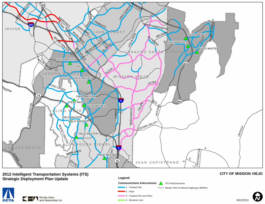
#*
#*
#*
#*#*
#*
#*
#*
#*#*
#*
#*#*
#*
#*TMC
FIELD MASTER
FIELD MASTER
FIELD MASTER
FIELD MASTER
FIELD MASTER
FIELD MASTER
FIELD MASTER
FIELD MASTER
FIELD MASTER
FIELD MASTER
FIELD MASTER
FIELD MASTER
§̈¦5
§̈¦405
§̈¦5
UV241
UV73
UV133
UV241
UV73
I R V I N EI R V I N E
M I S S I O N V I E J OM I S S I O N V I E J O
L A K E F O R E S TL A K E F O R E S T
A L I S O V I E J OA L I S O V I E J O
L A G U N A N I G U E LL A G U N A N I G U E LL A G U N A B E A C HL A G U N A B E A C H
L A G U N A W O O D SL A G U N A W O O D S
R A N C H O S A N T A M A R G A R I T AR A N C H O S A N T A M A R G A R I T A
L A G U N A H I L L SL A G U N A H I L L S
S A N J U A N C A P I S T R A N OS A N J U A N C A P I S T R A N O
F
OSO
EL TORO
BAKE
A
ANTO
NIO
ALTON
LA PAZ
MA
RG
UE
RIT
E
JERONIMO
LOS
ALIS
OS
I
LAG
UN
A C
ANYO
N
CA
BO
T
CROWN VALLEYLA
KE FO
REST
OR
TEG
A
TRABUCO
G
MUIRLANDS
FELI
PE
BARRANCA
ALISO CREEK
RIDGE ROUTE
TOLEDO
OLYMPIAD
IRVINE CENTER
COAST
SANTA MARGARITA
ROCKFIELD
MELINDA
IRV
INE
ALICIA
RANCHO
SANTA MARIA
SAND CANYON
HIGHLANDS
WO
OD
CAN
YON
CR
ISTI
ANIT
OS
NIGUEL
PLA
NO
TR
ABU
CO
MARINE W
AY
CITY OF MISSION VIEJOLegendCommunictions Interconnect
1 - Twisted Pair
2 - Fiber
3 - Twisted Pair and Fiber
4 - Wireless Link
#* ITS Field Elements
Master Plan of Arterial Highways (MPAH)
I
2012 Intelligent Transportation Systems (ITS) Strategic Deployment Plan Update
8/22/2013

#*
#*
#*
#*
#*
#*
#* HUB - NCCCHUB - CITY HALL
HUB - FIRESTATION #6
HUB - FIRESTATION #7
HUB - GENERAL SERVICES
HUB - NEWPORT BEACH PUBLIC LIBRARY
HUB - NEWPORT BEACH POLICE STATION
§̈¦405
UV73
UV55 I R V I N EI R V I N E
N E W P O R T B E A C HN E W P O R T B E A C H
C O S T A M E S AC O S T A M E S A
L A G U N A B E A C HL A G U N A B E A C H
COAST
19TH
IRVIN
E
JAMBOREE
17TH
BALBOA
CAMPUS
ALTON
MA
CA
RTH
UR
CU
LVE
R
UNIVERSITY
PLA
CE
NTI
A
FAIR
VICTORIA
HA
RB
OR
MICHELSON
NEWPORT
BU
SH
AR
D
BIRCH YALE
MA
GN
OLI
A
NEW
PO
RT
CO
AST
BR
OO
KH
UR
ST
15TH
WILSON
DOVE
RFA
IRV
IEW
HARVARDHAMILTON22ND
BARRANCA
BRISTOL
BONITA CANYON
BISON
FORD
JEFFR
EY
RIDG
ELIN
E
BANNING
EAST
BLUF
F
INDIANAPOLIS
TURTLE ROCK
QUAIL HILL
PACIFIC COAST
BAYSIDE
SAND CANYON
ARLINGTON
MARGUERITE
RED HILL
CARLSON
MERRIMAC
AVOCA
DO
SANTIAGOBALBOA
CITY OF NEWPORT BEACHLegendCommunictions Interconnect
1 - Twisted Pair
2 - Fiber
3 - Twisted Pair and Fiber
4 - Wireless Link
#* ITS Field Elements
Master Plan of Arterial Highways (MPAH)
I
2012 Intelligent Transportation Systems (ITS) Strategic Deployment Plan Update
8/22/2013
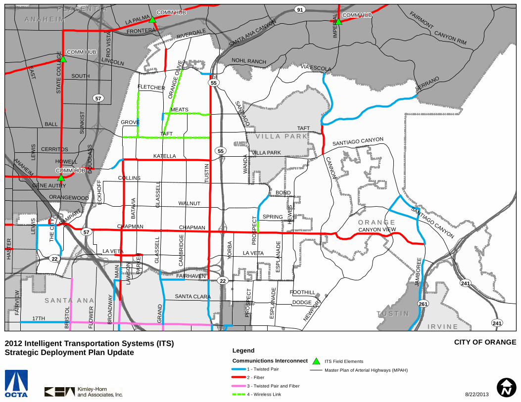
#*
#*
#*
#*
#*
#*
#* #*
#*COMM HUBCOMM HUB
COMM HUB
COMM HUB
UV91
UV261
UV55
UV57
UV241
UV22
UV57
UV55
UV241
UV22
O R A N G EO R A N G E
A N A H E I MA N A H E I M
S A N T A A N AS A N T A A N A
V I L L A P A R KV I L L A P A R K
I R V I N EI R V I N E
T U S T I NT U S T I N
P L A C E N T I AP L A C E N T I A
17TH
TUS
TIN
MA
IN
KATELLA
CHAPMAN
LINCOLNEAST
TAFTB
ATAV
IA
LA PALMA
BALL
SERRANO
MEATS
GLA
SS
ELL
HE
WE
S
COLLINS
CAN
NO
N
NEWPO
RT
SU
NK
IST
WALNUT
NOHL RANCH
CA
MB
RID
GE
YO
RB
A
STA
TE C
OLL
EG
E
HA
STE
R
FAIRHAVEN
JAM
BO
REE
LEW
ISRIVERDALE
SANTIAGO
LA VETAP
RO
SP
EC
T
BR
ISTO
L
SANTA ANA CANYON
SANTA CLARA
GR
AN
D
ORANGEWOOD
CERRITOS
IMP
ER
IAL
CANYON RIM
ANAHEIM
THE
CIT
Y
RIO
VIS
TA
SOUTH
OR
ANG
E O
LIV
E
CANYON VIEW
FAIR
VIE
W
VILLA PARKSANTIAGO CANYON
RAMPART
WA
ND
A
BR
OA
DW
AY
FRONTERA
SPRING
BOND
FAIRMONT
VIA ESCOLA
ESPL
ANA
DE
FLO
WE
R
FOOTHILL
FLETCHER
EC
KH
OFF
PAR
KE
R
DODGE
GROVE
HOWELL
GENE AUTRY
DO
UG
LAS
S
LAW
SO
N
CHAPMAN
LA VETA
TAFT
LEW
IS
SANTIAGO CANYON
ES
PLA
NA
DE
GLA
SS
ELL
PRO
SPE
CT
CITY OF ORANGELegendCommunictions Interconnect
1 - Twisted Pair
2 - Fiber
3 - Twisted Pair and Fiber
4 - Wireless Link
#* ITS Field Elements
Master Plan of Arterial Highways (MPAH)
I
2012 Intelligent Transportation Systems (ITS) Strategic Deployment Plan Update
8/22/2013
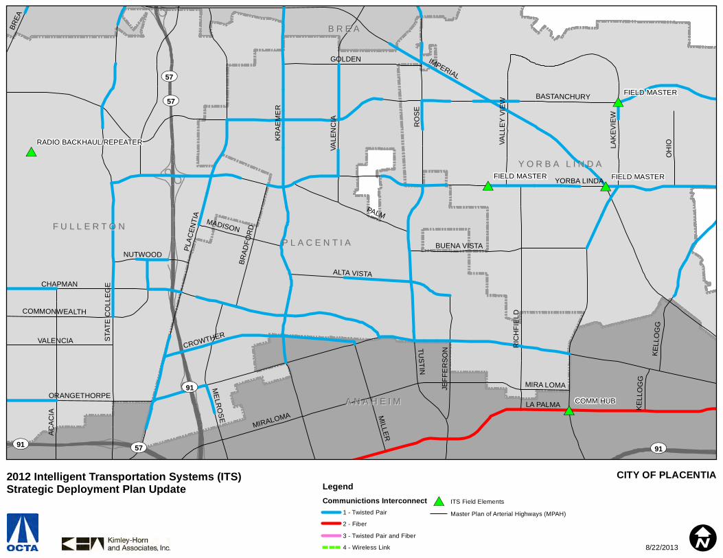
#* #*
#*
#*
#*
#* #*
#*
COMM HUB
FIELD MASTER
FIELD MASTERFIELD MASTER
RADIO BACKHAUL/REPEATER
UV91
UV57
UV91
UV91
UV57
UV57
P L A C E N T I AP L A C E N T I A
A N A H E I MA N A H E I M
F U L L E R T O NF U L L E R T O N
Y O R B A L I N D AY O R B A L I N D A
B R E AB R E A
IMPERIAL
RO
SE
BASTANCHURY
KR
AE
ME
R
YORBA LINDA
ORANGETHORPE
PLA
CEN
TIA
LAK
EV
IEW
LA PALMA
CHAPMAN
MIRALOMA
STA
TE C
OLL
EG
E
PALM
AC
AC
IA
RIC
HFI
ELD
TUSTIN
KELL
OG
G
GOLDEN
CROWTHERM
ILLER
ALTA VISTA
OH
IO
BUENA VISTA
ME
LRO
SE
BRAD
FOR
D
VALENCIA
JEFF
ER
SO
N
VALL
EY
VIE
W
BREA
MADISON
COMMONWEALTH
NUTWOOD
MIRA LOMA
VALE
NC
IA
KE
LLO
GG
CITY OF PLACENTIALegendCommunictions Interconnect
1 - Twisted Pair
2 - Fiber
3 - Twisted Pair and Fiber
4 - Wireless Link
#* ITS Field Elements
Master Plan of Arterial Highways (MPAH)
I
2012 Intelligent Transportation Systems (ITS) Strategic Deployment Plan Update
8/22/2013

#*
#*
#*FIELD MASTER
FIELD MASTER
FIELD MASTER
§̈¦5
UV241
UV241
M I S S I O N V I E J OM I S S I O N V I E J O
R A N C H O S A N T A M A R G A R I T AR A N C H O S A N T A M A R G A R I T A
L A K E F O R E S TL A K E F O R E S T
ANTO
NIO
EL TORO
MAR
GU
ERIT
E
LA PAZ
OSO
LOS
ALIS
OS
OLY
MPI
AD
JERONIMO
SANTA MARGARITA
FELI
PEMELINDA
TRABUCO
ALICIA
CABOT
LAKE F
OREST
RANCHO
ORTEGA
POR
TOLA
ALM
A AL
DEA
ALICIA
ALICIA
OSO
CITY OF RANCHO SANTA MARGARITALegendCommunictions Interconnect
1 - Twisted Pair
2 - Fiber
3 - Twisted Pair and Fiber
4 - Wireless Link
#* ITS Field Elements
Master Plan of Arterial Highways (MPAH)
I
2012 Intelligent Transportation Systems (ITS) Strategic Deployment Plan Update
8/22/2013
#*
#*
#*
#*
#*
#* #*
#*
#*
#*
#*
#*
#*
#*FIELD MASTER
FIELD MASTER
FIELD MASTER
FIELD MASTER
FIELD MASTER
FIELD MASTER
FIELD MASTER
FIELD MASTERFIELD MASTER
FIELD MASTER
FIELD MASTER
FIELD MASTER
§̈¦5
S A N C L E M E N T ES A N C L E M E N T E
D A N A P O I N TD A N A P O I N T
S A N J U A N C A P I S T R A N OS A N J U A N C A P I S T R A N O
L A G U N A N I G U E LL A G U N A N I G U E L
COAST
AVENIDA PICO
EL CAM
INO
REAL
SELVA
STONEHILL
LA PATA
TALEGA
DEL RIO
NIG
UE
L
CAMINO LAS RAMBLAS
DEL PRADODANA POINT HARBOR
CAMINO VERA CRUZ
LA PATA
CITY OF SAN CLEMENTELegendCommunictions Interconnect
1 - Twisted Pair
2 - Fiber
3 - Twisted Pair and Fiber
4 - Wireless Link
#* ITS Field Elements
Master Plan of Arterial Highways (MPAH)
I
2012 Intelligent Transportation Systems (ITS) Strategic Deployment Plan Update
8/22/2013

#*
#*
#*
#*
#*
#*#*
#*
#* #* #*
#*
#*FIELD MASTER
FIELD MASTER
FIELD MASTERFIELD MASTER
FIELD MASTER
FIELD MASTER
FIELD MASTER
§̈¦5
§̈¦5
L A G U N A N I G U E LL A G U N A N I G U E L
S A N J U A N C A P I S T R A N OS A N J U A N C A P I S T R A N O
D A N A P O I N TD A N A P O I N T
S A N C L E M E N T ES A N C L E M E N T E
M I S S I O N V I E J OM I S S I O N V I E J O
A L I S O V I E J OA L I S O V I E J O
A
I
F
ORTEGA
NIG
UEL
LA PATA
G
CROWN V
ALLEY
ALIPAZ
ALIC
IA
CA
MIN
O C
AP
ISTR
AN
O
DEL
OBI
SPO
CR
ISTI
ANIT
OS
ANTO
NIO
SELVA
STONEHILL
RANCHO VIEJO
PACIFIC COAST
CAMINO LAS RAMBLAS
STR
EET
OF
THE
GO
LDEN
LAN
TER
N SAN JUAN CREEK
TALEGA
DEL RIO
LA P
AZ
AVERY
HIG
HLA
ND
S
DEL PRADO
CLUB HOUSE
MOULTON
OSO
LA NOVIA
CITY OF SAN JUAN CAPISTRANOLegendCommunictions Interconnect
1 - Twisted Pair
2 - Fiber
3 - Twisted Pair and Fiber
4 - Wireless Link
#* ITS Field Elements
Master Plan of Arterial Highways (MPAH)
I
2012 Intelligent Transportation Systems (ITS) Strategic Deployment Plan Update
8/22/2013
#*
#*
#* #*
#*
#*
#*#*
#*
#*
#*FIELD MASTER
FIELD MASTER
FIELD MASTER
FIELD MASTER
FOUNTAIN VALLEY TMC
FOUNTAIN VALLEY HUBFOUNTAIN VALLEY HUB
FOUNTAIN VALLEY HUB
FOUNTAIN VALLEY - CALTRANS INTERTIE
§̈¦405
§̈¦5
UV55
UV22
UV261
UV57
UV55S A N T A A N AS A N T A A N A
T U S T I NT U S T I N
G A R D E N G R O V EG A R D E N G R O V E
O R A N G EO R A N G E
I R V I N EI R V I N E
F O U N T A I N V A L L E YF O U N T A I N V A L L E Y
W E S T M I N S T E RW E S T M I N S T E R
C O S T A M E S AC O S T A M E S A
1ST
17TH
EDINGER
WARNER
EU
CLI
D
HA
RB
OR
MCFADDEN
BR
ISTO
L
FLO
WE
R
TRASK
GR
AN
D
MA
GN
OLI
A
FAIR
VIE
W
RED HILL
BU
SH
AR
D
NE
WH
OP
E
RA
ITT
LAMPSON
BR
OO
KH
UR
ST
4TH
ELLIS
HAZARD
TUS
TIN
SLATER
NEWPORT
DYER
MACARTHURALTON
MAIN
BR
OA
DW
AY
IRVINE
WA
RD
GARDEN GROVE
TALBERT
BOLSA
WALNUT
WESTMINSTER
SUNFLOWER
JAMBOREE
FAIRHAVEN
BE
AR
HEIL
TUST
IN R
ANCH
SANTA ANA
STA
ND
AR
D
9TH
SEGERSTROM
HARVARD
LA VETA
CIVIC CENTER HO
LT
HEW
ES
SANTA CLARA
VALENCIA
BARRANCA
BRYAN
YO
RB
A
CHESTNUTW
ES
T
BROWNIN
G
LEW
IS
EL CAMINO REAL
5TH
ANTON
HA
STE
R
GIL
BE
RT
THE
CIT
Y
PRO
SPE
CT
ESPL
ANA
DE
CULVER
GLA
SS
ELL
CA
BR
ILLO PA
RK
VON KARMAN
PAR
KE
R
DODGE
LAW
SO
NSOUTH COAST
MA
BU
RY
ES
PLA
NA
DE
4TH
LA VETA
MA
IN
YO
RB
A
BRYAN
PR
OS
PE
CT
WA
RD
HEIL
CITY OF SANTA ANALegendCommunictions Interconnect
1 - Twisted Pair
2 - Fiber
3 - Twisted Pair and Fiber
4 - Wireless Link
#* ITS Field Elements
Master Plan of Arterial Highways (MPAH)
I
2012 Intelligent Transportation Systems (ITS) Strategic Deployment Plan Update
8/22/2013
#*
#*
#*
#*FIELD MASTER
SEAL BEACH TMC
CALTRANS FIELD MASTER
§̈¦405
UV22UV22UV22
S E A L B E A C HS E A L B E A C H
H U N T I N G T O N B E A C HH U N T I N G T O N B E A C H
W E S T M I N S T E RW E S T M I N S T E R
G A R D E N G R O V EG A R D E N G R O V E
L O S A L A M I T O SL O S A L A M I T O S
EDINGER
SP
RIN
GD
ALE
LAMPSON
SEAL
BEA
CH
WESTMINSTER
BO
LSA
CH
ICA
BOLSA
PACIFIC COAST
GR
AH
AM
DORY
VALL
EY VIE
W
RANCHO
HEIL
MARINA
MCFADDEN
GARDEN GROVE
ELECTRIC
ARGOSY
1ST
CHAPMAN
SAY
BR
OO
K
BOLSA
CITY OF SEAL BEACHLegendCommunictions Interconnect
1 - Twisted Pair
2 - Fiber
3 - Twisted Pair and Fiber
4 - Wireless Link
#* ITS Field Elements
Master Plan of Arterial Highways (MPAH)
I
2012 Intelligent Transportation Systems (ITS) Strategic Deployment Plan Update
8/22/2013

#*
#*
#*FIELD MASTER
FIELD MASTER
UV22
G A R D E N G R O V EG A R D E N G R O V E
S T A N T O NS T A N T O N
C Y P R E S SC Y P R E S S
A N A H E I MA N A H E I MB U E N A P A R KB U E N A P A R K
W E S T M I N S T E RW E S T M I N S T E R
L O S A L A M I T O SL O S A L A M I T O S
DA
LE
KATELLA
LAMPSON
CERRITOS
CHAPMAN
BE
AC
H
KN
OTT
GIL
BE
RT
WE
STE
RN
ORANGEWOOD
GARDEN GROVE
MA
GN
OLI
A
BR
OO
KH
UR
ST
VALL
EY
VIE
W
HO
LDE
RS
PR
ING
DA
LE
CITY OF STANTONLegendCommunictions Interconnect
1 - Twisted Pair
2 - Fiber
3 - Twisted Pair and Fiber
4 - Wireless Link
#* ITS Field Elements
Master Plan of Arterial Highways (MPAH)
I
2012 Intelligent Transportation Systems (ITS) Strategic Deployment Plan Update
8/22/2013
#*
#*#*
#*
#*
#*
#*FIELD MASTER
FIELD MASTER
FIELD MASTER
FIELD MASTER
FIELD MASTER
FIELD MASTER
§̈¦5
UV55
UV261
UV241
UV133
UV241
UV241UV261
I R V I N EI R V I N E
T U S T I NT U S T I N
S A N T A A N AS A N T A A N A
O R A N G EO R A N G E
C O S T A M E S AC O S T A M E S A
1ST
IRVINE
17TH
JAMBOREE
FLO
WE
R
GR
AN
D
YALE
RED HILL
EDINGER
NEWPORT
BRYAN
WALNUT
WARNER
4TH
POR
TOLA
CULVER
DYER
MAINTUSTIN RANCH
BR
OA
DW
AY
ALTON
TUS
TIN
MCFADDEN
FAIRHAVEN
STA
ND
AR
D
TRABUCO
JEFF
REY
HO
LT
HARVARD
EL CAMINO REAL
SANTA ANA
SANTA CLARA
VALENCIA
MACARTHUR BARRANCA
YO
RB
A
CHESTNUT
BROWNIN
G
5TH
CIVIC CENTER
HEW
ES
PRO
SPE
CT
ARMSTRONG
ESPL
ANA
DE
SUNFLOWER
FOOTHILL
CA
BR
ILLO PA
RK
PENN
MEMORY
VON KARMAN
ARBORWOODMEADOWOOD
SOUTHWOOD
DODGE
WESTWOOD
TOWN AND COUNTRY
MA
BU
RY
MA
IN
YO
RB
A
PR
OS
PE
CT
BRYAN
JEFF
REY
CITY OF TUSTINLegendCommunictions Interconnect
1 - Twisted Pair
2 - Fiber
3 - Twisted Pair and Fiber
4 - Wireless Link
#* ITS Field Elements
Master Plan of Arterial Highways (MPAH)
I
2012 Intelligent Transportation Systems (ITS) Strategic Deployment Plan Update
8/22/2013
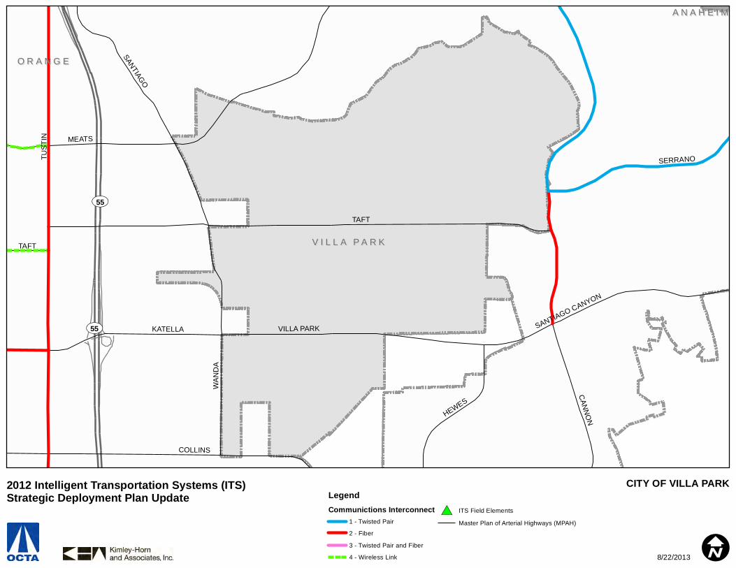
UV55
UV55
O R A N G EO R A N G E
V I L L A P A R KV I L L A P A R K
A N A H E I MA N A H E I M
TAFT
TUS
TIN
CAN
NO
NMEATS
COLLINS
SANTIAGO
VILLA PARKKATELLA
WA
ND
A
SERRANO
HEWES
SANTIAGO CANYON
TAFT
CITY OF VILLA PARKLegendCommunictions Interconnect
1 - Twisted Pair
2 - Fiber
3 - Twisted Pair and Fiber
4 - Wireless Link
#* ITS Field Elements
Master Plan of Arterial Highways (MPAH)
I
2012 Intelligent Transportation Systems (ITS) Strategic Deployment Plan Update
8/22/2013
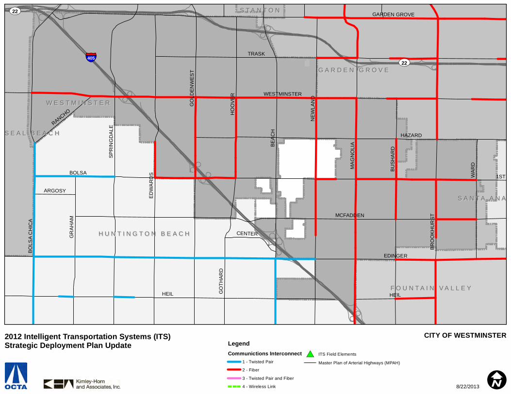
#* #*
§̈¦405UV22
UV22
W E S T M I N S T E RW E S T M I N S T E R
H U N T I N G T O N B E A C HH U N T I N G T O N B E A C H
G A R D E N G R O V EG A R D E N G R O V E
F O U N T A I N V A L L E YF O U N T A I N V A L L E Y
S E A L B E A C HS E A L B E A C H
S A N T A A N AS A N T A A N A
S T A N T O NS T A N T O N
HEIL
BOLSA
EDINGER
TRASK
BE
AC
H
MCFADDEN
HAZARD
WESTMINSTER
NE
WLA
ND
ED
WA
RD
S
MA
GN
OLI
A
GARDEN GROVE
SP
RIN
GD
ALE
HO
OV
ER
BU
SH
AR
D
BR
OO
KH
UR
ST
BO
LSA
CH
ICA
GO
LDE
NW
ES
T
WA
RD
GR
AH
AM
GO
THA
RD
RANCHO
CENTER
ARGOSY
1ST
HEIL
CITY OF WESTMINSTERLegendCommunictions Interconnect
1 - Twisted Pair
2 - Fiber
3 - Twisted Pair and Fiber
4 - Wireless Link
#* ITS Field Elements
Master Plan of Arterial Highways (MPAH)
I
2012 Intelligent Transportation Systems (ITS) Strategic Deployment Plan Update
8/22/2013

#* #*
#*
#* #*
#*
#*COMM HUB
COMM HUB
COMM HUBCOMM HUB
FIELD MASTER
FIELD MASTERFIELD MASTER
UV91
UV241
UV241
A N A H E I MA N A H E I M
Y O R B A L I N D AY O R B A L I N D A
B R E AB R E A
P L A C E N T I AP L A C E N T I A
O R A N G EO R A N G E
LA PALMA
RO
SE
IMPERIAL
YORBA LINDA
LAK
EV
IEWBASTANCHURY
TUSTIN
ORANGETHORPE
WEIR CANYON
ESPERANZA
RIC
HFI
ELD
CARBON CANYON
KELLOGG
FAIRMONT
RIVERDALE
VILL
AGE CENTE
R
OH
IO
VALE
NC
IA
BUENA VISTA
MIRALOMA
SERR
ANO
JEFF
ER
SO
N
PALM
MILLER
GOLDEN
MIRA LOMA
OAK CANYON
GY
PSUM
CAN
YON
CITY OF YORBA LINDALegendCommunictions Interconnect
1 - Twisted Pair
2 - Fiber
3 - Twisted Pair and Fiber
4 - Wireless Link
#* ITS Field Elements
Master Plan of Arterial Highways (MPAH)
I
2012 Intelligent Transportation Systems (ITS) Strategic Deployment Plan Update
8/22/2013
Recommended