C. What lies ahead?
Contact: Sarah Gille ([email protected])Scripps Institution of Oceanography9500 Gilman Drive, MC 0230La Jolla, CA 92093−0230
B. Rough topography dissipates energy
B.3 Correlations between bot-tom roughness and eddy ki-netic energy. Depending on thedepth of the ocean, eddy kineticenergy measured from altimetryappears either correlated or anti-correlated with seafloor rough-ness. In the deepest parts of theocean, high bottom roughnessimplies reduced eddy kinetic en-ergy, suggesting that topographyhelps remove energy from theocean.
Panel b shows a histogram ofocean depth. Most of the oceanis between 3000 and 5000 mdepth where a strong correlationpattern is not detectable usingavailable data.
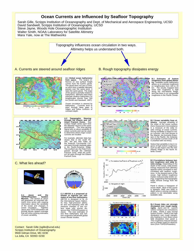
B.4 Ocean tides are str ongl ydissipated over rough topog-raph y. Jayne and St. Laurent(2001) compare two simulationsof tides. Panel a uses normalbottom friction. Panel b has highdissipation over rough topogra-phy, leading to more deep oceantidal dissipation than panel a.This roughness induced dissipa-tion is a better match to observa-tions (from TOPEX/Poseidon).
B.2 Ocean variability from al-timetr y. Average variability ofthe slope of the ocean surface(here measured in microradians)is a measure of the eddy ki-netic energy of ocean currents.Strong variability is linked to ma-jor currents—the Gulf Stream inthe Atlantic, the Kuroshio Exten-sion in the Pacific, the AntarcticCircumpolar Current south of 30S (marked with red lines).
Notice that variability is low in re-gions of high bottom roughness,such as the region over the mid-Atlantic Ridge in the North At-lantic Ocean.
B.1 Estimates of bottomroughness from global altime-try. Available ocean bathymetryallows us to estimate roughnesson lengthscales from 160 to 20km. The results mapped hereshow that roughness is highalong the mid-Atlantic Ridge,and that there is no comparableroughness in the Pacific Ocean.
A.1 Global ocean bath ymetr yfrom space . The largest in-fluence on sea surface heightcomes from the Earth’s geoid.The geoid does not vary in time,so each time a satellite altimeterpasses over the same point, itsees the same geoid. The slopeof the geoid is partially related tobathymetry. Altimeter data helpsestimate seafloor bathymetry onlengthscales shorter than 160km (Smith and Sandwell, 1997).
Ocean circulation is steered bybathymetry. Currents tend topass through deep gaps inridges and follow contours ofconstant depth.
A.2 Topographic Steeringthr ough the Eltanin and Ud-intse v Fracture Zones. Seasurface height varies each timethe altimeter returns to the samegroundtrack. This time-varyingsignal tells us about variability inocean currents and can be usedto determine where major oceancurrents are located.
For example, altimeter data hasshown that in the south Pa-cific, the jets that make upthe Antarctic Circumpolar Cur-rent pass through separate gapsin the Pacific-Antarctic Ridge.The southern jet, the Polar Front,passes through the UdintsevFracture Zone, while the north-ern jet goes through the EltaninFracture Zone.
C.2 ABYSS is a proposed al-timeter to impr ove our esti-mates of sea floor bath ymetr y.ABYSS is designed to fly onthe International Space Station.Its new, high-precision altime-ter and non-repeating orbit willmeasure changes in sea sur-face slope over shorter dis-tances than TOPEX/Poseidon orJason. The new estimates ofsea floor bathymetry and bot-tom roughness will benefit globalocean climate studies.
C.1 Jason and theTOPEX/Poseidon TandemMission. The launch of Jasonwill guarantee an extended alti-metric time series with ongoinginformation about the variabilityof the ocean and changes inocean circulation. TogetherJason and TOPEX/Poseidon willprovide denser spatial coveragethat will refine existing estimatesof ocean variability.
A. Currents are steered around seafloor ridges
Altimetry helps us understand both.
Ocean Currents are Influenced by Seafloor Topography
David Sandwell, Scripps Institution of Oceanography, UCSD
Walter Smith, NOAA Laboratory for Satellite AltimetryMara Yale, now at The Mathworks
Sarah Gille, Scripps Institution of Oceanography and Dept. of Mechanical and Aerospace Engineering, UCSD
Steve Jayne, Woods Hole Oceanographic Institution
Topography influences ocean circulation in two ways.
Recommended