North American Grassland Priority Conservation Areas Page 1 Technical Report and Documentation
North American Grassland Priority Conservation Areas:
Technical Report and Documentation
Prepared by
the Commission for Environmental Cooperation and
The Nature Conservancy
March 14, 2005
Jason W. Karl and Jürgen Hoth, Editors
Cite as: CEC and TNC. 2005. North American Central grasslands priority conservation areas: technical report and documentation. Eds. J.W. Karl and J. Hoth. Commission for Environmental Cooperation and The Nature Conservancy. Montreal, Quebec.
This document is also available online from:
http://www.cec.org/pubs_docs/documents/index.cfm?varlan=english&ID=1745
http://nature.org/initiatives/programs/birds/
North American Grassland Priority Conservation Areas Page 2 Technical Report and Documentation
Executive Summary
This report describes the process followed to identify grasslands priority conservation areas (GPCAs) within North America’s Central Grasslands, an ecosystem considered among the most threatened in the continent and the world. The area addressed comprises North American short, mixed and desert grasslands. The goal of the GPCAs initiative is twofold: to provide guidance of where conservation action is immediately needed due to the trinational importance of the sites; and to offer a geographic rationale for developing a trinational cooperation network of institutions and organizations interested in conserving the grasslands ecosystem as a whole. GPCAs are here defined as areas of tri-national importance due to their ecological significance and threatened nature, which are in need of international cooperation for their successful conservation. This initiative is meant to complement ongoing grasslands conservation efforts that identify priorities within each country. The GPCA selection process relied primarily upon two main components: 1) Pre-workshop integration of ca. 120 GIS data layers, including known grasslands priority-setting initiatives, and a gap analysis thereof to identify regions where priority areas are unreasonably lacking; 2) a workshop involving 36 experts from diverse disciplines to identify the GPCAs (November, 2004) assisted by a consensus GIS-based decision support system. The significance of the areas was further ascertained by assessing 20 key grassland bird and mammal species. At the workshop participants identified and described in total 55 GPCAs: 26 in the Northern Region, 16 in the Central Region and 13 in the Southern Region, comprising 10.5% of study area. Out of these, 28 were selected by the participants as their top priority GPCAs (6.3% of study area). This workshop was jointly organized by the Commission for Environmental Cooperation of North America (CEC) and The Nature Conservancy (TNC). Identifying priority conservation areas is one of several grasslands related initiatives sponsored by the CEC as part of the Strategic Plan for North American Cooperation in the Conservation of Biodiversity, embraced by Canada, Mexico and the United States.
North American Grassland Priority Conservation Areas Page 3 Technical Report and Documentation
Resúmen Ejecutivo
Este reporte describe el proceso seguido para identificar las áreas de los pastizales prioritarias para su conservación (GPCAs, por sus siglas en inglés) dentro de los pastizales centrales de América del Norte, considerado como uno de los ecosistemas más amenazados del continente y del mundo. La región geográfica considerada dentro de este reporte incluye los pastizales cortos, mixtos y desérticos. Los objetivos principales de la iniciativa GPCA son: proveer elementos para orientar en qué áreas se requieren acciones de conservación debido a su importancia trinacional; y proveer el fundamento geográfico para desarrollar una red para la cooperación entre instituciones y organizaciones interesadas en conservar al ecosistema de los pastizales como un todo. Las GPCAs fueron definidas en este reporte como aquellas áreas de importancia trinacional que debido a su importancia ecológica y amenazas necesitan de la cooperación internacional para su exitosa conservación. Esta iniciativa pretende complementar diversos esfuerzos de conservación de pastizales en marcha, en los cuales se identifican prioridades a nivel nacional. El proceso de selección de las GPCAs dependió de dos aspectos. El primero consistió en la integración de cerca de 120 capas de información en SIG, incluyendo áreas prioritarias identificadas por otras iniciativas, y un “análisis de huecos” asociado para identificar regiones donde no se hubieran identificado áreas prioritarias.El segundo consistió de un taller para identificar las GPCAs, el cual contó con la participación de 36 expertos de diversas disciplinas apoyados con un sistema de apoyo para la toma de decisiones con base en el SIG. La importancia de las áreas identificadas se determinó con base en la evaluación de 20 especies clave de aves y mamíferos. Durante el taller los participantes identificaron y describieron 55 GPCAs : 26 en la región norte, 16 en la región central y 13 en la región sur, abarcando juntas el 10.5% del área total considerada. Del total de GPCAs, los participantes escogieron 28 áreas consideradas como las de mayor prioridad (abarcando 6.3% del área estudiada). Este taller fue organizado conjuntamente por la Comisión para la Cooperación Ambiental de América del Norte (CCA) y The Nature Conservancy (TNC). La identificación de áreas prioritarias para su conservación es una de varias iniciativas relacionadas con los pastizales, facilitada a través de la CCA como parte de la implementación del Plan Estratégico para la Cooperación en América del Norte para la Conservación de la Biodiversidad, auspiciado por Canadá, México y los Estados Unidos.
North American Grassland Priority Conservation Areas Page 4 Technical Report and Documentation
Résumé
Le présent rapport décrit le processus que nous avons adopté pour déterminer les aires de conservation prioritaires des prairies (ACPP) dans la région écologique des prairies centrales de l’Amérique du Nord, écosystème qui est considéré comme l’un des plus menacés du continent nord-américain et du monde entier. La zone étudiée est composée de prairies d’herbes courtes, mixtes et désertiques. L’initiative de délimitation des ACPP avait un double but : donner des indications sur les aires où des mesures de conservation immédiates s’imposent, en raison de leur importance à l’échelle trinationale; fournir une assise géographique pour la création d’un réseau trinational de coopération réunissant des institutions et des organisations qui s’intéressent à la conservation de l’ensemble de l’écosystème des prairies. Les ACPP sont définies dans le présent document comme des aires qui ont une importance trinationale, du fait qu’elles présentent un intérêt écologique majeur et qu’elles sont menacées, et dont la conservation nécessite une coopération internationale. Cette initiative vise à compléter les efforts déjà déployés pour conserver l’écosystème des prairies, et dans le cadre desquels des priorités ont été établies dans chaque pays. Le processus de sélection des ACPP comportait deux grandes étapes : 1) des travaux préparatoires à la tenue d’un atelier, qui ont consisté à intégrer dans un système d’information géographique (SIG) environ 120 couches de données sur la zone étudiée, y compris des renseignements sur les initiatives connues d’établissement de priorités, et à effectuer une analyse de carence afin de déterminer les régions présentant un manque indu d’aires prioritaires; 2) la tenue, en novembre 2004, d’un atelier rassemblant 36 experts issus de disciplines variées, qui ont délimité les ACPP en ayant recours à un système d’aide à la décision par consensus basé sur le SIG. L’importance des aires choisies a été vérifiée au moyen d’une évaluation de 20 espèces clés d’oiseaux et de mammifères des prairies. Au cours de l’atelier, les participants ont délimité et décrit 55 ACPP : 26 dans la région du Nord, 16 dans la région du Centre et 13 dans la région du Sud, représentant au total 10,5 % de la zone étudiée. Ils ont ensuite sélectionné 28 de ces aires comme étant des ACPP à priorité absolue (6,3 % de la zone étudiée). Cet atelier a été organisé conjointement par la Commission de coopération environnementale (CCE) et l’organisation The Nature Conservancy (TNC). La délimitation d’aires de conservation prioritaires est l’une de plusieurs initiatives concernant les prairies que la CCE soutient dans le cadre de son Plan stratégique concerté pour la conservation de la biodiversité en Amérique du Nord, qui a été adopté par le Canada, les États-Unis et le Mexique.
North American Grassland Priority Conservation Areas Page 5 Technical Report and Documentation
Preface: toward a grassland conservation network
This report flags the initiation of an initiative jointly facilitated by the Commission for Environmental Cooperation (CEC) and The Nature Conservancy (TNC) to develop a Conservation Network for the Central Grasslands of North America; a biome considered among the most threatened in the continent and worldwide. Identifying priority conservation areas (PCAs) is one of several grasslands initiatives developed by Canada, Mexico and the United States through the Commission for Environmental Cooperation (CEC) of North America as part of its Strategic Plan for North American Cooperation in the Conservation of Biodiversity. We have realized the importance of developing a grasslands conservation network over the past several years of managing several collaborative initiatives to conserve the species and ecosystems unique to the short, mixed-and desert grasslands of North America through both our organizations. Given the scope and scale of the Central Grasslands of North America, we believe that this higher level of cooperation is required to protect our shared grassland systems and its wildlife. The network’s main purpose will be to enhance and strengthen the conservation of biodiversity in critical habitats within North America’s Central grasslands. It is envisioned that this will be accomplished by highlighting biological and socio-economic linkages, promoting information exchange, and by encouraging complimentary regulatory and voluntary conservation approaches. The information contained within this report offers a solid foundation developed by grasslands experts from NGOs and governments from Canada, Mexico and the United States, who generously offered their knowledge and wealth of experience to identify those areas within our shared grassland biome that, based upon their tri-national ecological significance, are critical for long-term conservation success. We feel confident that the Grasslands Priority Conservation Areas (GPCAs) herein identified can now serve as initial focal points to demonstrate the value of tri-national cooperation in achieving a common goal, namely conserving healthy ecosystems for the well being of the species we share.. Efforts like these highlight the need to further expand the number and spectrum of organizations collaborating on grassland conservation. Thus, through the network we will constantly strive to involve all key players engaged in conserving North America’s central grasslands. Hans Herrmann, Commission for Environmental Cooperation Jürgen Hoth, Commission for Environmental Cooperation Bob McCready, The Nature Conservancy Bob Unnasch, The Nature Conservancy
North American Grassland Priority Conservation Areas Page 6 Technical Report and Documentation
Acknowledgements
First and foremost we would like to thank the valuable input of all workshop participants. The full list of workshop participants appears as an appendix to this report. Thomas Meredith, George Dias, and Leah Wilson from McGill University’s project on Community Based Environmental Decision Support provided invaluable expertise and assistance throughout this entire project in organizing and conducting the workshop around the Consensus Mapper expert-knowledge software. Thomas Meredith also made significant contributions to this report We would also like to thank the US Fish and Wildlife Service’s National Conservation Training Center (NCTC) for all their attention and support, both in preparation and during the workshop. Aside from their extraordinary facilities at Shepherdstown, West Virginia conducive to enable groups to work together, the attention provided by Jonathan Byers, Computer Lab Manager and Beth Ann Ring, NCTC meeting planner, were in no small measure crucial to the successful completion of this workshop. We appreciate the contributions of GIS and/or thematic data from the following organizations (listed in alphabetical order): Alberta Community Development Parks and Protected Areas Division, American Bird Conservancy, Bird Studies Canada, Columbia University Center for International Earth Science Information Network, Commission for Environmental Cooperation, Comisión Nacional de Áreas Naturales Protegidas, Comisión Nacional para el Conocimiento y Uso de la Biodiversidad, Conservation Biology Institute, ERIN Consulting Ltd., Instituto del Medio Ambiente y Desarrollo Sustentable del Estado de Sonora, Manitoba Department of Conservation Wildlife Branch, Mexico UNAM Instituto de Geografia, Natural Resources Canada Surveys Division, The Nature Conservancy, NatureServe, North American Bird Conservation Initiative Committee, Playa Lakes Joint Venture, University of Regina Government of Saskatchewan Canadian Plains Research Center, USDA Forest Service, US Department of Energy Pacific National Laboratory, US Fish and Wildlife Service, US Geological Survey, and USGS Patuxent Wildlife Research Center. We would also like to acknowledge the generous assistance of the following individuals in either collecting pertinent spatial data (listed in alphabetical order): Miguel Ángel Cruz, Peter Blancher, Steve Forrest, Susan Haig, David Hanni, Stephanie Harmon, Bill Haskins, Rurik List, Dave Mehlman, Sonia Najera, Jonathan Proctor, J. Shipman, Manuel Valdés, Jim Watson and Ed Wiken. Michael Bradstreet provided valuable insight into developing a network of priority areas that truly represents the biodiversity of central North America’s grasslands and encouraged us to challenge our data and assumptions throughout the process. David Gauthier, Stephanie Jones, and Jorge Nocedal provided extremely helpful review and editing of the report and coordinated reviewers from the northern, central, and southern grassland regions, respectively. The following individuals also reviewed this report (listed in alphabetical order): Barry Adams, Bill Busby, Mauricio Cotera, Brenda Dale, Nic DeGama-Blanchet, Francisco Gonzalez Medrano, Pat Fargey, Bob Godwin, Bill Howe, Brian Martin, Dave Mehlman, Laura Scott, Lowell Strauss and Walter Williams.
North American Grassland Priority Conservation Areas Page 7 Technical Report and Documentation
Table of Contents
Executive Summary ......................................................................................................................... 2 Preface: toward a grassland conservation network ..................................................................... 5 Acknowledgements.......................................................................................................................... 6 Table of Contents ............................................................................................................................ 7 1. Introduction – by Jason Karl and Jürgen Hoth ...................................................................... 8 2. Geographic and Taxonomic Context – by Jason Karl .......................................................... 9 2.1 Study Area ............................................................................................................................. 9 2.2 Grassland Focal Elements and Species ............................................................................. 10 3. Approach and Methods – by Jason Karl, Jürgen Hoth, Hans Herrmann, Bob McCreedy, Thom Meredith, and Robert Unnasch ............................................................... 11 3.1 GIS Data Collection and Gap Analysis............................................................................. 12 3.1.1 GIS Data Collection ...................................................................................................... 12 3.1.2 Gaps in Data Coverage ................................................................................................. 15 3.2 Results of the Gap Analysis ................................................................................................ 16 3.2.1 Ecoregional Representation ......................................................................................... 16 3.2.2 Grassland Representation at a National Scale ........................................................... 19 3.2.3 Grassland Fragmentation.............................................................................................. 19 3.2.4 Focal Species Richness.................................................................................................. 20 3.3 The GPCA Workshop......................................................................................................... 21 3.3.1 Consensus Mapper ........................................................................................................ 22 3.3.2 Spreadsheets for Attribute Capture and Analysis ..................................................... 22 3.3.3 Group Dynamics and Composition by Themes and Regions ................................ 23 3.3.4 Additional Grassland Focal Elements ........................................................................ 24 4. GPCA Workshop Results .......................................................................................................... 24 4.1 Ecologically Significant Areas............................................................................................. 24 4.2 Grassland Priority Conservation Areas............................................................................. 26 5. Conclusions .................................................................................................................................. 31 6. References..................................................................................................................................... 32 List of Acronyms ............................................................................................................................. 36 Figures ............................................................................................................................................... 38 Appendix A. Available GIS data and sources for the grassland priority conservation
network workshop ............................................................................................................. 57 Appendix B. Data source references for grassland GPCA data ............................................... 62 Appendix C. Data source references for black-tailed prairie dog town locations from
Proctor et al (in press) ....................................................................................................... 68 Appendix D. Directory of GPCA workshop participants......................................................... 71 Appendix E. Principles behind the CBED decision support procedure – by Thomas
Meredith, George Dias and Leah Wilson ...................................................................... 74 Appendix F. Guidelines and use of the Identification, Assessment, and Ratings Workbook – by
Robert Unnasch and Jason Karl ..................................................................................... 75 Appendix G. Detailed reports for final ESRs.............................................................................. 78 Appendix H. Detailed reports for final GPCAs.......................................................................... 99
North American Grassland Priority Conservation Areas Page 8 Technical Report and Documentation
1. Introduction – by Jason Karl and Jürgen Hoth The central grasslands of North America represent one of the continent’s largest biomes and harbor a rich biological diversity as well as many grassland endemic species. Human-dominated disturbances have endangered this ecosystem across its entire range to the point of it currently being considered among North America’s most endangered, a category shared worldwide by the grasslands as a biome (Samson and Knopf 1994; World Resources Institute 2000). Scott et al. (2001) found the highly productive soils and relatively gentle terrain of the central grasslands to be one of the least protected landscapes in the United States. Noss et al (1995) classified several of the central grassland types as endangered or threatened ecosystems. While grassland ecosystems have been under pressure from some human disturbances for over 150 years (e.g., livestock grazing, agricultural conversion), other threats are now becoming more pervasive across the biome (e.g., invasive species, urban sprawl/residential development, oil and gas extraction, and wind-power development). These threats are not only resulting in the conversion of native grasslands to other land cover types, but are also degrading the condition of remaining grasslands. In spite of their importance and the level of threat the grasslands as an ecosystem is poorly represented by protected areas compared to other North American ecosystems (Gauthier and Wiken 1998). The case for concentrating cooperation efforts in the grasslands is further supported by recent studies which single out this North American ecosystem, both in a worldwide comparison of the loss of species (Ceballos and Ehrlich 2002), and for its potentially high species’ turn-over (sum of colonizations and extinctions) under climate change (Peterson et al. 2002). Ranging between 20° and 50° latitude, the central short- and mixed-grass prairies are the only continuous terrestrial ecological system to span Canada, the United States, and Mexico. To date, the majority of conservation planning and action has been at local or regional scales and thus has mostly occurred within one nation or around the borders. Increasingly, conservationists are recognizing that bi- or tri-national cooperation, planning, and action is necessary to conserve the full range of the central grassland’s elements and processes at all scales (Samson and Knopf, 1994; Gauthier et al. 2003). Recognizing that conservation of grassland biodiversity could be enhanced by the establishment of bi- and tri- national partnerships, The Commission for Environmental Cooperation (CEC) and The Nature Conservancy (TNC), began coordinating efforts to develop a conservation network for the central grasslands of North America in 2004. The goal of this network is to further grassland conservation by creating and strengthening relationships and encouraging the exchange of information between existing and planned grassland priority areas in Canada, the United States and Mexico as a means to strengthen conservation action for grasslands species and habitats. A first step in building this network is the identification of priority conservation areas of tri-national significance. Hence over November 8-10, 2004, the CEC and TNC convened a tri-national workshop aimed at identifying grasslands priority conservation areas (GPCAs) throughout North America’s central grasslands. This report describes the process of identifying these GPCAs - areas of tri-national importance due to their ecological significance and threatened nature, which are in need of bi- and tri-national cooperative action for their successful conservation This document, therefore, serves three main purposes: First, it presents a gap analysis based upon previous analyses and priority-setting efforts in the study area; second, it presents the resulting
North American Grassland Priority Conservation Areas Page 9 Technical Report and Documentation
GPCAs, documenting the process by which they were identified by workshop participants; and lastly, it describes in detail the GIS and tabular data resulting from the workshop. The GPCAs initiative is complemented by a parallel process promoted through the CEC, aimed at promoting trinational collaboration working with grasslands target species through the North American Conservation Action Plans (NACAPs). The initial species considered under the NACAPs are the burrowing owl, the ferruginous hawk and the black tailed prairie dog. Together these area and species-oriented multi-institutional collaborative approaches shall provide a cohesive trinational framework of opportunities to enhance the conservation effectiveness of any single North American country.
2. Geographic and Taxonomic Context – by Jason Karl
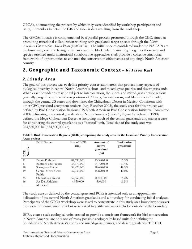
2.1 Study Area The goal of this project was to define priority conservation areas that protect many aspects of biological diversity in central North America’s short- and mixed-grass prairies and desert grasslands. While exact boundaries may be subject to interpretation, the short- and mixed-grass prairie regions generally range from the southern portions of Alberta, Saskatchewan, and Manitoba in Canada, through the central US states and down into the Chihuahuan Desert in Mexico. Consistent with other CEC grassland ecosystem projects (e.g., Blancher 2003), the study area for this project was defined by Bird Conservation Regions (US North American Bird Conservation Initiative Committee 2000) delineating the central grasslands of North America (Table 1, Figure 1). Schmidt (1990) defined the Mega-Chihuahuan Desert as including much of the central grasslands and makes a case for considering the central grasslands as a “natural” unit. Total size of the study area was 264,860,000 ha (654,500,000 ac). Table 1. Bird Conservation Regions (BCRs) comprising the study area for the Grassland Priority Conservation Areas project
BC
R
Nu
mb
er
BCR Name Size of BCR (ha)
Amount of native
grassland (ha)
% of native grassland
11 Prairie Potholes 87,690,000 13,590,000 15.5% 17 Badlands and Prairies 36,770,000 24,770,000 67.4% 18 Shortgrass Prairie 38,470,000 18,680,000 48.5% 19 Central Mixed Grass
Prairie 39,730,000 15,890,000 40.0%
35 Chihuahuan Desert 57,360,000 8,700,000 15.2% 46 Sur Del Altiplano
Mexicano 4,850,000 560,000 11.5%
The study area as defined by the central grassland BCRs is intended only as an approximate delineation of the central North American grasslands and a boundary for conducting initial analyses. Participants of the GPCA workshop were asked to concentrate in this study area boundary; however they were not constrained to it but were asked to justify any areas included outside of the boundary. BCRs, coarse-scale ecological units created to provide a consistent framework for bird conservation in North America, are only one of many possible ecologically-based units for defining the boundaries of North America’s short- and mixed-grass prairies, and desert grasslands. The CEC

North American Grassland Priority Conservation Areas Page 10 Technical Report and Documentation
level 2 ecoregions (CEC 1997) divide the central grasslands into eight ecoregions that roughly correspond to the BCRs used to define the project area (Table 2, Figure 2). Because the GPCAs were intended to represent all aspects of grassland biological diversity, not just birds, and because the Level 2 ecoregions more finely divide the study area (and can be tessellated into finer ecoregions), analysis results in this report will be reported by Level 2 ecoregion where appropriate. Native Grasslands of various compositions and ecological conditions make up around 57.5% of the study area (Table 3, Figure 3). Lands converted to agricultural uses are the second largest land cover type, comprising 26.0% of the study area. Closed shrublands, occurring primarily in the western and southern portions of the study area, account for approximately 10% of the total area. Table 2. Level 2 Ecoregions and native grasslands within the study area.
Eco
regi
on
Nu
mb
er
Ecoregion Name Area (ha)
Ecoregion Hectares in Study Area
% Ecoregion in Study Area
Native/ Natural
Grasslands (ha) in
Ecoregion
% Native Grassland in Ecoregion
6.2 Western Cordillera 2,029,000 2,029,000 100.0% 1,504,000 74.1% 9.2 Temperate Prairies 77,900,000 48,891,000 62.8% 3,493,000 7.1% 9.3 West-Central Semi-
Arid Prairies 86,399,000 79,793,000 92.4% 39,089,000 49.0%
9.4 South-Central Semi-Arid Prairies
96,347,000 71,692,000 74.4% 28,815,000 40.2%
10.4 Chihuahuan Desert 54,435,000 53,875,000 99.0% 7,972,000 14.8% 12.2 Mexican High Plateau 4,979,000 4,474,000 89.9% 479,000 10.7% 13.1 Upper Gila Mountains 1,283,000 1,281,000 99.9% 544,000 42.5% 13.3 Eastern Sierra Madre 5,303,000 1,939,000 36.6% 47,000 2.4% Table 3. Proportions of general land cover types within the study area from Hansen et al. (1998) 1km AVHRR land cover classification.
Land Cover Type Hectares in Study Area
Proportion of Study Area
Grassland (native and non-native) 99,279,000 37.5% Agricultural Lands 68,891,000 26.0% Closed Shrubland 32,497,000 12.3% Open Shrubland 29,522,000 11.1% Wooded Grassland 23,555,000 8.9% Woodland 6,219,000 2.3% Water 1,741,000 0.6% Bare Ground 1,201,000 0.5% Evergreen Coniferous Forest 820,000 0.3% Urban/Developed 596,000 0.2% Mixed Forest 286,000 0.1% Deciduous Broadleaf Forest 135,000 0.0% Evergreen Broadleaf Forest 117,000 0.0%
2.2 Grassland Focal Elements and Species The goal of the GPCA workshop was to identify continental grassland priority areas and begin to build networks and partnerships that will enhance conservation efforts for all aspects of biological diversity and ecological processes in the central grasslands. However, given the complexity of ecological systems it would be impractical, in the context of the GPCA workshop, to consider even
North American Grassland Priority Conservation Areas Page 11 Technical Report and Documentation
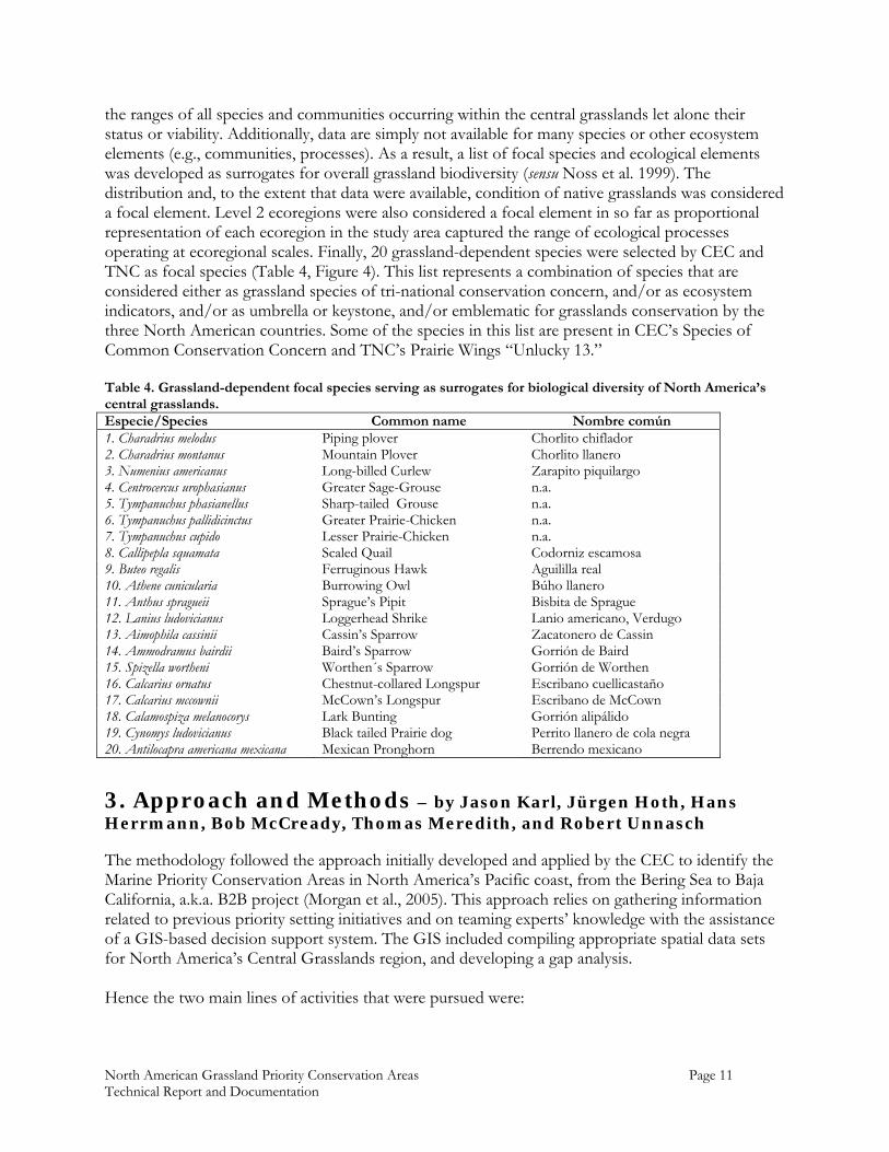
the ranges of all species and communities occurring within the central grasslands let alone their status or viability. Additionally, data are simply not available for many species or other ecosystem elements (e.g., communities, processes). As a result, a list of focal species and ecological elements was developed as surrogates for overall grassland biodiversity (sensu Noss et al. 1999). The distribution and, to the extent that data were available, condition of native grasslands was considered a focal element. Level 2 ecoregions were also considered a focal element in so far as proportional representation of each ecoregion in the study area captured the range of ecological processes operating at ecoregional scales. Finally, 20 grassland-dependent species were selected by CEC and TNC as focal species (Table 4, Figure 4). This list represents a combination of species that are considered either as grassland species of tri-national conservation concern, and/or as ecosystem indicators, and/or as umbrella or keystone, and/or emblematic for grasslands conservation by the three North American countries. Some of the species in this list are present in CEC’s Species of Common Conservation Concern and TNC’s Prairie Wings “Unlucky 13.” Table 4. Grassland-dependent focal species serving as surrogates for biological diversity of North America’s central grasslands. Especie/Species Common name Nombre común 1. Charadrius melodus Piping plover Chorlito chiflador 2. Charadrius montanus Mountain Plover Chorlito llanero 3. Numenius americanus Long-billed Curlew Zarapito piquilargo 4. Centrocercus urophasianus Greater Sage-Grouse n.a. 5. Tympanuchus phasianellus Sharp-tailed Grouse n.a. 6. Tympanuchus pallidicinctus Greater Prairie-Chicken n.a. 7. Tympanuchus cupido Lesser Prairie-Chicken n.a. 8. Callipepla squamata Scaled Quail Codorniz escamosa 9. Buteo regalis Ferruginous Hawk Aguililla real 10. Athene cunicularia Burrowing Owl Búho llanero 11. Anthus spragueii Sprague’s Pipit Bisbita de Sprague 12. Lanius ludovicianus Loggerhead Shrike Lanio americano, Verdugo 13. Aimophila cassinii Cassin’s Sparrow Zacatonero de Cassin 14. Ammodramus bairdii Baird’s Sparrow Gorrión de Baird 15. Spizella wortheni Worthen´s Sparrow Gorrión de Worthen 16. Calcarius ornatus Chestnut-collared Longspur Escribano cuellicastaño 17. Calcarius mccownii McCown’s Longspur Escribano de McCown 18. Calamospiza melanocorys Lark Bunting Gorrión alipálido 19. Cynomys ludovicianus Black tailed Prairie dog Perrito llanero de cola negra 20. Antilocapra americana mexicana Mexican Pronghorn Berrendo mexicano
3. Approach and Methods – by Jason Karl, Jürgen Hoth, Hans Herrmann, Bob McCready, Thomas Meredith, and Robert Unnasch
The methodology followed the approach initially developed and applied by the CEC to identify the Marine Priority Conservation Areas in North America’s Pacific coast, from the Bering Sea to Baja California, a.k.a. B2B project (Morgan et al., 2005). This approach relies on gathering information related to previous priority setting initiatives and on teaming experts’ knowledge with the assistance of a GIS-based decision support system. The GIS included compiling appropriate spatial data sets for North America’s Central Grasslands region, and developing a gap analysis. Hence the two main lines of activities that were pursued were:
North American Grassland Priority Conservation Areas Page 12 Technical Report and Documentation
1) Pre-workshop data acquisition, integration and gap analysis. In preparation to the workshop all possible and relevant geographic information from Canadian, US and Mexican central grasslands was compiled and integrated into a GIS data base to support the discussions to be held at the workshop. Special attention was placed to gather geographic information related to grasslands related priority-setting initiatives. Moreover, based upon the latter, Jason Karl carried out a GIS gap analysis, presented below. 2) Workshop and expert opinion. Workshop experts were deliberately selected from a wide array of professional backgrounds, thematic interests and geographic regions. The challenge of the workshop was to distill from the wealth of knowledge and perspectives⎯and from existing information⎯ in four half-day working sessions, a coherent, informed and supportable process to identify priority conservation areas for North America’s central grasslands. Following is a more detailed account of these two main steps.
3.1 GIS Data Collection and Gap Analysis
3.1.1 GIS Data Collection Ahead of the GPCA workshop, an effort was made to collect all GIS data that would be relevant in defining Ecological Significant Regions (ESRs) and GPCAs1 at a tri-national scale. In particular the workshop organizers avoided developing a process that would identify new priority grassland conservation areas, and instead existing data was compiled from projects previously carried out by individual organizations. These efforts have been regional in scope and so this effort for the first time, compiled information in an attempt to gather this information across approximately 11 ecoregions (or six Bird Conservation Regions). Moreover, data was also collected that would assist the experts in answering three workshop questions related to the most important and threatened grassland regions and areas (see section 3.3.) Data were grouped into major themes according to their use in the project: base layers (e.g., political boundaries, roads), ecoregions, grasslands, species, priority areas, ownership/protected areas, and threats. All data were formatted to work with the Consensus Mapper program developed by the McGill University Project on Community Based Environmental Decision Support (Meredith 2002). Vector data were converted to shapefiles, and raster data were converted to geo-referenced TIFF images. Data were projected into a continental Lambert azimuthal equal area projection (Table 5).
1An Ecological Significant Region, or ESR, comprises regionally significant grasslands, of high intrinsic biological value with species of tri-/bi-national concern and ecologically rich or unique features and processes; while a Grasslands Priority Conservation Area, or GPCA, in addition to comprising regionally significant grasslands, with ecologically rich or unique features, processes, or species of concern and tri-national interest, also plays a significant role at a tri-national scale and could be lost within five years due to impending threats.
North American Grassland Priority Conservation Areas Page 13 Technical Report and Documentation
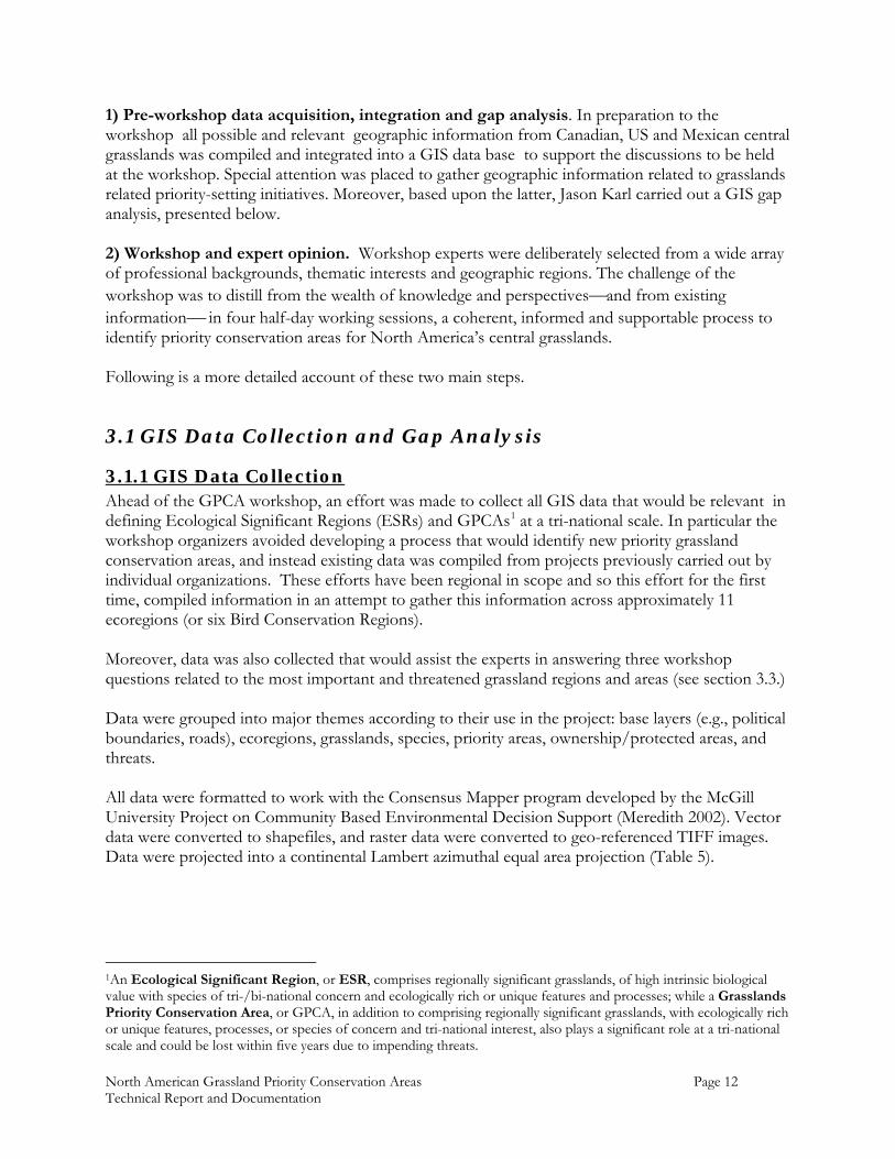
Table 5. Lambert azimuthal equal area projection used for the GPCA GIS data. Projection Parameters Projection Lambert Azimuthal Equal Area Units Meters Datum North American Datum of 1927 Spheroid Clarke 1866 Central Meridian -100.000 degrees Latitude of Origin 45.000 degrees False Easting 0.000 False Northing 0.000
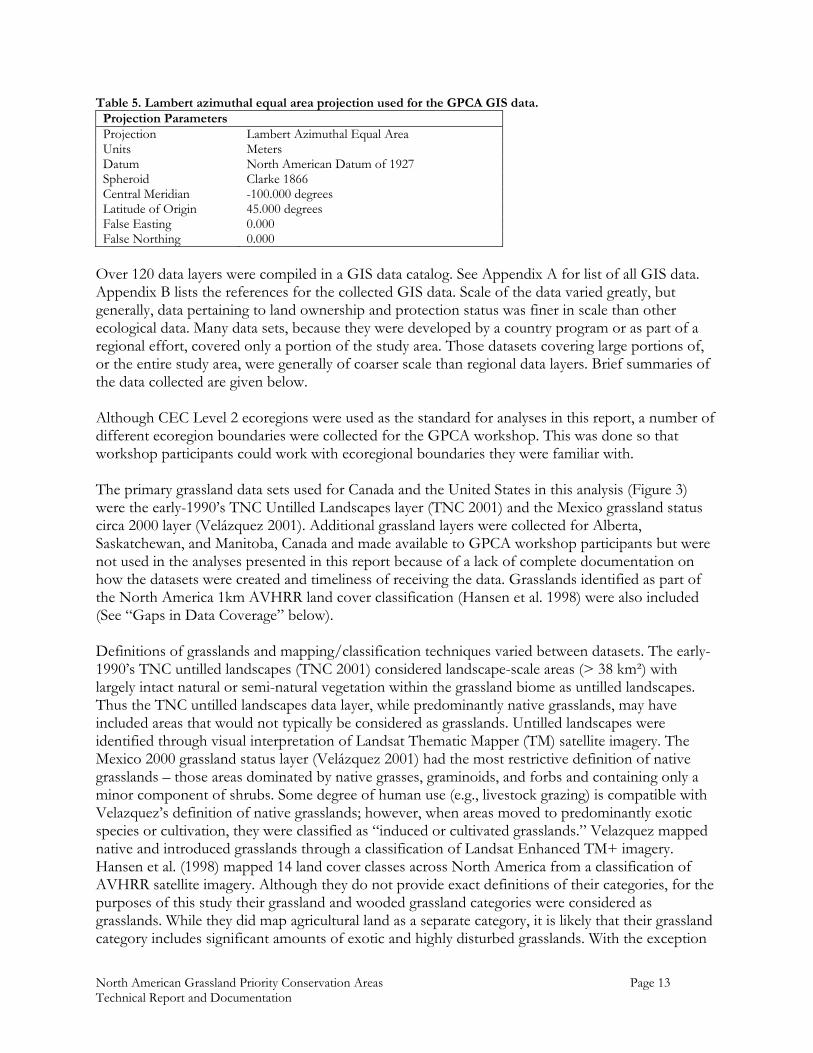
Over 120 data layers were compiled in a GIS data catalog. See Appendix A for list of all GIS data. Appendix B lists the references for the collected GIS data. Scale of the data varied greatly, but generally, data pertaining to land ownership and protection status was finer in scale than other ecological data. Many data sets, because they were developed by a country program or as part of a regional effort, covered only a portion of the study area. Those datasets covering large portions of, or the entire study area, were generally of coarser scale than regional data layers. Brief summaries of the data collected are given below. Although CEC Level 2 ecoregions were used as the standard for analyses in this report, a number of different ecoregion boundaries were collected for the GPCA workshop. This was done so that workshop participants could work with ecoregional boundaries they were familiar with. The primary grassland data sets used for Canada and the United States in this analysis (Figure 3) were the early-1990’s TNC Untilled Landscapes layer (TNC 2001) and the Mexico grassland status circa 2000 layer (Velázquez 2001). Additional grassland layers were collected for Alberta, Saskatchewan, and Manitoba, Canada and made available to GPCA workshop participants but were not used in the analyses presented in this report because of a lack of complete documentation on how the datasets were created and timeliness of receiving the data. Grasslands identified as part of the North America 1km AVHRR land cover classification (Hansen et al. 1998) were also included (See “Gaps in Data Coverage” below). Definitions of grasslands and mapping/classification techniques varied between datasets. The early-1990’s TNC untilled landscapes (TNC 2001) considered landscape-scale areas (> 38 km²) with largely intact natural or semi-natural vegetation within the grassland biome as untilled landscapes. Thus the TNC untilled landscapes data layer, while predominantly native grasslands, may have included areas that would not typically be considered as grasslands. Untilled landscapes were identified through visual interpretation of Landsat Thematic Mapper (TM) satellite imagery. The Mexico 2000 grassland status layer (Velázquez 2001) had the most restrictive definition of native grasslands – those areas dominated by native grasses, graminoids, and forbs and containing only a minor component of shrubs. Some degree of human use (e.g., livestock grazing) is compatible with Velazquez’s definition of native grasslands; however, when areas moved to predominantly exotic species or cultivation, they were classified as “induced or cultivated grasslands.” Velazquez mapped native and introduced grasslands through a classification of Landsat Enhanced TM+ imagery. Hansen et al. (1998) mapped 14 land cover classes across North America from a classification of AVHRR satellite imagery. Although they do not provide exact definitions of their categories, for the purposes of this study their grassland and wooded grassland categories were considered as grasslands. While they did map agricultural land as a separate category, it is likely that their grassland category includes significant amounts of exotic and highly disturbed grasslands. With the exception
North American Grassland Priority Conservation Areas Page 14 Technical Report and Documentation
of the Western Cordillera ecoregion, Hansen et al.’s (1998) data classified much more area as grasslands than either of the other data layers (Table 6, Figure 5). For this reason, we created a composite native grassland layer by combining the best available datasets for each area. Table 6. Comparison of hectares mapped as grassland in each study area ecoregion by the three data sources used in the grassland priority conservation area project.
Eco
regi
on
Nu
mb
er
Ecoregion Name
Hansen et al. (1998)
AVHRR
TNC early-1990’s Untilled
Landscapes (TNC 2001)
2000 Mexico Native Grasslands Velazquez (2001)
% Difference between Hansen et al. (1998) and
others 6.2 Western Cordillera 1,061,800 1,503,500 +41.6% 9.2 Temperate Prairies 12,366,500 3,493,000 -71.8% 9.3 West-Central Semi-Arid
Prairies 57,355,900 39,088,900 -31.8% 9.4 South-Central Semi-Arid
Prairies 36,563,600 28,372,400 -22.4% 10.4* Chihuahuan Desert 11,243,700 1,781,200 2,707,300 -60.1% 12.2 Mexican High Plateau 2,244,700 479,200 -78.7% 13.1 Upper Gila Mountains 537,700 40,300 -92.5% 13.3 Eastern Sierra Madre 1,102,900 47,200 -95.7% Total 122,476,800 74,279,300 3,233,700 -40.0% * A portion of the Chihuahuan Desert ecoregion was not mapped by either Velazquez’s (2001) Mexico natural grasslands or the early-1990’s TNC untilled landscapes (TNC 2001). See “Gaps in Data Coverage” below for more detail. Data regarding areas protected2 and managed for biological diversity were also collected (Figure 6). The Conservation Biology Institute’s (2001) Protected Areas Database formed the foundation for ownership and protected areas data in the United States. Protected areas and federal ownership in Canada were identified by data layers from each province. While a large portion of government-owned lands in Canada are owned by the provinces, no data were available identifying non-protected provincial lands in Canada (See “Gaps in Data Coverage” below). Federal protected areas in Mexico were identified by data provided by the Comisión Nacional de Áreas Naturales Protegidas (CONANP 2004). As a supplemental dataset, the North American Conservation Areas Database (ERIN 2000) was also included. This database consisted of point (latitude/longitude) locations of each protected area in North America. All other layers were polygon data. There were several existing conservation planning approaches identifying conservation priorities in portions of the North American central grasslands (Figure 7). GIS layers representing these conservation priorities were collected. The most extensive prioritization efforts to date were TNC’s ecoregional assessments and the Important Bird Areas program. All data were obtained in digital format except the important bird areas for the United States which were digitized from a hard copy map at a scale of 1:2,500,000 (American Bird Conservancy 2002) because this data is not yet available in digital format (G. Fenwick, American Bird Conservancy, pers. comm.). Data were collected on the range, distribution within the range, habitats, and migration patterns of the GPCA focal species (Table 4). Continental ranges for each species were obtained from the
2 “Protected Areas” included National, State and Provincial Parks, wilderness areas, wildlife refuges, nature preserves and conservation easements
North American Grassland Priority Conservation Areas Page 15 Technical Report and Documentation
NatureServe Digital Distribution Maps series (Figure 4). More detailed range maps were obtained from various sources for the Sage Grouse (Centrocercus urophasianus), Lesser Prairie-Chicken (Tympanuchus cupido), Black-tailed Prairie Dog (Cynomys ludovicianus), and Mexican Pronghorn (Antilocapra americana mexicana) (See Appendices B and C for descriptions and sources). A number of useful GIS layers, based on species ranges, analyzing the contribution of the central grasslands with respect to breeding and wintering birds were obtained from Blancher (2003). Because focal species data was needed only to adequately represent the distribution of a species and its habitats at coarse, continental scales (e.g., 1:5,000,000), only data sources that covered all, or a large portion, of a focal species range were considered. Point location data from the US Fish and Wildlife Service Breeding Bird Survey and the Audubon’s Christmas Bird Count formed the foundation for the location records of the focal bird species. A number of additional sources also provided location and habitat data for the focal species. Canadian bird banding and band-recovery data were provided by Blancher (2003). Data on the distribution of Mexican and Sonoran pronghorn were obtained through Valdés and Manterola (in press), and the Instituto del Medio Ambiente y Desarrollo Sustentable del Estado de Sonora (2000), respectively. Results from the 2001 International Piping Plover Census (Ferland and Haig, 2002), and migration data from a study of Ferruginous Hawks (Watson and Banasch, 2003) were also included. The Predator Conservation Alliance provided numerous data layers of Black-tailed Prairie Dog town locations in Proctor et al. (in press, Appendix C). Data on threats to grassland systems varied greatly in quality and geographic coverage. An effort was made to collect data on the distribution and intensity of commonly recognized threats to grassland ecosystems. Most of the threats layers presented in this report were collected for other grassland conservation projects. Similar to data for the focal species however, much of the data relating to threats existed at scales that were beyond the scope of this project. Additionally threats against grassland ecosystems are constantly changing, with new threats developing and recurrent threats occurring in new areas. Given the effort and time involved in compiling and publishing GIS data at regional, national, or continental scales, the dynamic nature of grasslands threats is difficult to capture effectively. For these reasons, the experts attending the workshop were considered to be the best source of information on threats to grassland ecosystems.
3.1.2 Gaps in Data Coverage Although many data sets were collected for this project, geographic coverage of the data as well as data quality varied across the study area. Generally speaking, in terms of geographic data coverage, most of the focal species and threats data layers available for Canada and the United States were not available for Mexico. For example, both the Breeding Bird Survey and Christmas Bird Count programs cover the United States and Canada, but have no sites in Mexico (Figure 8). Aside from the general species ranges, there were few focal species datasets that extended into Mexico. For the Worthen’s Sparrow (Spizella wortheni), a species endemic to the grasslands of Mexico, no data was available other than its general range. Given the above considerations of data coverage and quality, areas of a species range without any observation locations or other data must be interpreted carefully. With the exception of the Breeding Bird Survey the data collected for this project represent only locations where a species was observed and not all surveyed locations where it wasn’t detected. Thus it would be difficult to distinguish between where a species does not occur and where no data on its presence exists..
North American Grassland Priority Conservation Areas Page 16 Technical Report and Documentation
For a species with only a portion of its range in Mexico, care must be used in interpreting occurrence data so that bias is not given to areas where survey data is available at the expense of unsurveyed – and potentially equal or even better – areas. Spatial representation of native grasslands within the study area came primarily from two layers; the 2000 Untilled Landscapes layer (TNC 2001) for Canada and the United States, and the 2000 Mexico native grasslands layer (Velazquez 2001). There was an 18.4 million hectare gap in coverage between these two layers (Figure 5). The Untilled Landscapes layer was an ecoregion-based classification that included all of the grassland ecoregions except for the Chihuahuan Desert. The Mexico grassland classification stopped at the US-Mexico border. Hence, there was no detailed grassland coverage for the US portion of the Chihuahuan Desert Ecoregion. Grassland distribution for this area was taken from Hansen et al. (1998) 1-km AVHRR land cover classification of North America. Data coverage for public ownership, protected areas, and existing priority areas was generally consistent across the study area with one significant exception. Although a large amount of lands in Canada are owned by the provinces, no data sets could be obtained in the timeframe of this project that identify provincial ownership. In the case of at least Manitoba this was partly due to the fact that the provincial ownership data were considered proprietary information and not publicly available. The omission of these data may have affected the results of analysis of existing protected and conservation priority areas and the results presented below should be interpreted with this in mind.
3.2 Results of the gap analysis
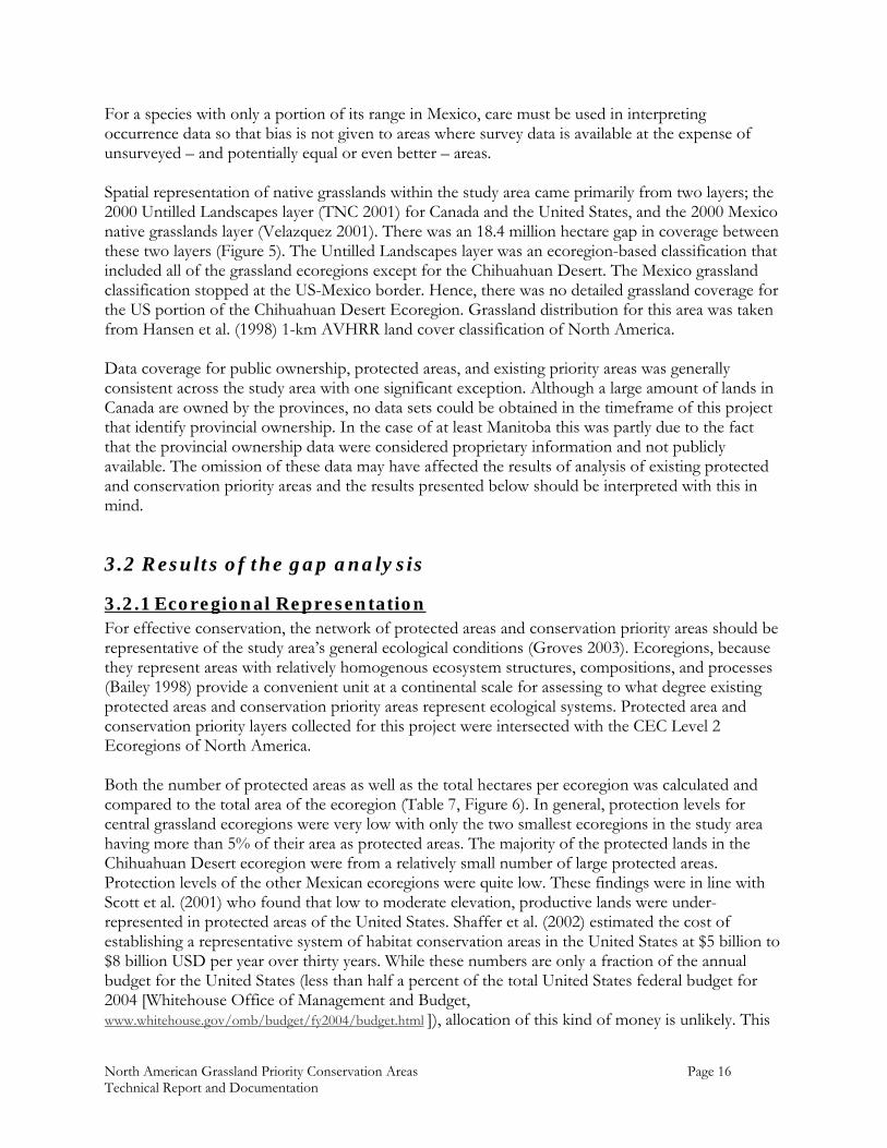
3.2.1 Ecoregional Representation For effective conservation, the network of protected areas and conservation priority areas should be representative of the study area’s general ecological conditions (Groves 2003). Ecoregions, because they represent areas with relatively homogenous ecosystem structures, compositions, and processes (Bailey 1998) provide a convenient unit at a continental scale for assessing to what degree existing protected areas and conservation priority areas represent ecological systems. Protected area and conservation priority layers collected for this project were intersected with the CEC Level 2 Ecoregions of North America. Both the number of protected areas as well as the total hectares per ecoregion was calculated and compared to the total area of the ecoregion (Table 7, Figure 6). In general, protection levels for central grassland ecoregions were very low with only the two smallest ecoregions in the study area having more than 5% of their area as protected areas. The majority of the protected lands in the Chihuahuan Desert ecoregion were from a relatively small number of large protected areas. Protection levels of the other Mexican ecoregions were quite low. These findings were in line with Scott et al. (2001) who found that low to moderate elevation, productive lands were under-represented in protected areas of the United States. Shaffer et al. (2002) estimated the cost of establishing a representative system of habitat conservation areas in the United States at $5 billion to $8 billion USD per year over thirty years. While these numbers are only a fraction of the annual budget for the United States (less than half a percent of the total United States federal budget for 2004 [Whitehouse Office of Management and Budget, www.whitehouse.gov/omb/budget/fy2004/budget.html ]), allocation of this kind of money is unlikely. This
North American Grassland Priority Conservation Areas Page 17 Technical Report and Documentation
suggests that clear conservation priorities must be defined and new and innovative approaches to achieving conservation are needed. Creation of conservation networks may help facilitate the development and exchange of information on novel conservation techniques. Table 7. Distribution of protected areas* in the CEC Level 2 ecoregions within the study area and amount of native grasslands protected by them. Percent of ecoregion in protection is expressed as the proportion of hectares protected to area of the ecoregion within the study area (not the total area of the ecoregion).
Ecoregion
Native grassland
(ha)
Number of Protected
Areas Hectares Protected
% Ecoregion in Protection
Native Grasslands in Protected Areas (ha)
% Native Grassland in
Protected Areas
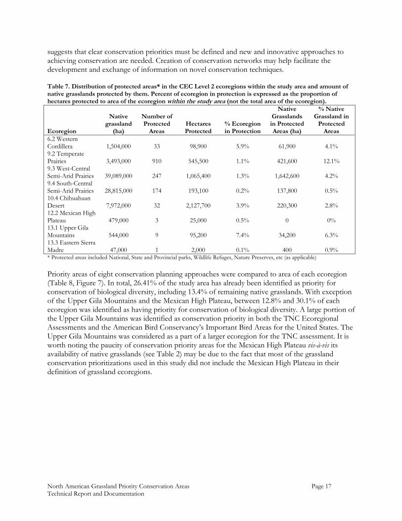
6.2 Western Cordillera 1,504,000 33 98,900 5.9% 61,900 4.1% 9.2 Temperate Prairies 3,493,000 910 545,500 1.1% 421,600 12.1% 9.3 West-Central Semi-Arid Prairies 39,089,000 247 1,065,400 1.3% 1,642,600 4.2% 9.4 South-Central Semi-Arid Prairies 28,815,000 174 193,100 0.2% 137,800 0.5% 10.4 Chihuahuan Desert 7,972,000 32 2,127,700 3.9% 220,300 2.8% 12.2 Mexican High Plateau 479,000 3 25,000 0.5% 0 0% 13.1 Upper Gila Mountains 544,000 9 95,200 7.4% 34,200 6.3% 13.3 Eastern Sierra Madre 47,000 1 2,000 0.1% 400 0.9% * Protected areas included National, State and Provincial parks, Wildlife Refuges, Nature Preserves, etc (as applicable) Priority areas of eight conservation planning approaches were compared to area of each ecoregion (Table 8, Figure 7). In total, 26.41% of the study area has already been identified as priority for conservation of biological diversity, including 13.4% of remaining native grasslands. With exception of the Upper Gila Mountains and the Mexican High Plateau, between 12.8% and 30.1% of each ecoregion was identified as having priority for conservation of biological diversity. A large portion of the Upper Gila Mountains was identified as conservation priority in both the TNC Ecoregional Assessments and the American Bird Conservancy’s Important Bird Areas for the United States. The Upper Gila Mountains was considered as a part of a larger ecoregion for the TNC assessment. It is worth noting the paucity of conservation priority areas for the Mexican High Plateau vis-à-vis its availability of native grasslands (see Table 2) may be due to the fact that most of the grassland conservation prioritizations used in this study did not include the Mexican High Plateau in their definition of grassland ecoregions.
North American Grassland Priority Conservation Areas Page 18 Technical Report and Documentation
Table 8. Distribution of areas identified in existing conservation prioritizations by CEC Level 2 ecoregions within the study area. Approximate total prioritization area per ecoregion was calculated as the maximum non-overlapping extent of priority areas that were converted to 1 sq. km. grid cells. Because the polygon features were converted to grids, area calculations are approximate. Percent of ecoregion in priority areas is expressed as the proportion of hectares protected to area of the ecoregion within the study area (not the total area of the ecoregion).
Ecoregion Imp
orta
nt
Bir
d A
reas
for
Mex
ico
(CO
NA
BIO
199
9)
Imp
orta
nt
Bir
d A
reas
for
Can
ada
(Cou
rtie
r an
d W
ilcox
200
4)
Imp
orta
nt
Bir
d A
reas
for
USA
(A
mer
ican
Bir
d C
onse
rvan
cy 2
002)
TN
C C
hih
uahu
an D
eser
t E
core
gion
al A
sses
smen
t (P
ron
atu
ra
et a
l. 20
04)
Com
bin
ed T
NC
Eco
regi
onal
A
sses
smen
ts a
s of
Jan
uar
y 30
, 200
4 (e
xclu
din
g C
hih
uah
ua,
TN
C u
np
ub
. d
ata)
TN
C P
rair
ie W
ings
Con
serv
atio
n
Pri
orit
izat
ion
(T
NC
un
pu
b. d
ata)
Th
e W
ildla
nds
Pro
ject
Sie
rra
Mad
re
Pri
oirt
y A
reas
USD
A F
ores
t Se
rvic
e Sp
ecia
l D
esig
nat
ion
Are
as (
USD
A F
ores
t Se
rvic
e 20
00)
Ap
pro
xim
ate
Tot
al P
rior
itiz
atio
n
Are
a p
er E
core
gion
in H
ecta
res
Per
cen
t of
Eco
regi
on in
Pri
orit
y A
reas
Tot
al P
rior
itiz
atio
n A
rea
of
Eco
regi
on in
Nat
ive
Gra
ssla
nd
s
Per
cen
t of
Pri
orit
ized
Are
a in
E
core
gion
in N
ativ
e G
rass
lan
ds
6.2 Western Cordillera N/A 3,500 20,500 N/A 357,300 2,600 N/A 49,600 363,500 21.7% 257,100 12.7%9.2 Temperate Prairies N/A 679,600 163,000 N/A 3,596,700 2,075,900 N/A 6,262,800 12.8% 919,000 1.9% 9.3 West-Central Semi-
Arid Prairies N/A 945,800 1,620,601 N/A 16,665,200 6,161,400 N/A 4,500 20,687,500 25.9% 16,681,600 20.9%
9.4 South-Central Semi-Arid Prairies
N/A N/A 1,683,800 N/A 18,634,400 7,508,400 N/A 2,700 24,455,800 34.1% 14,598,100 20.4%
10.4 Chihuahuan Desert
1,462,600 N/A 1,312,100 948,800 N/A 1,677,400 283,400 N/A 16,468,500 30.6% 2,662,600 4.9%
12.2 Mexican High Plateau
61,000 N/A N/A N/A N/A N/A N/A N/A 61,000 1.4% 5,000 0.1%
13.1 Upper Gila Mountains
N/A N/A 555,000 N/A 462,500 N/A N/A 41,000 808,100 63.1% 354,100 26.8%
13.3 Eastern Sierra Madre
125,300 N/A N/A 36,600 N/A 16,800 N/A 0 598,800 30.9% 2,300 1.2%
Total prioritization area in native grasslands
227,500 890,400 2,917,200 2,594,600 29,203,500 2,783,600 14,200 33,300 35,479,800 13.4% 35,479,800 13.4%
Note: No information was obtained from any of the Joint Ventures that would be applicable to this table. Because the USFWS National Wildlife Refuges are included in the US
Important Bird Areas (and they’re included in the previous table covering protected areas), it was deemed unnecessary to include them as a separate entry. Besides, National Wildlife Refuges don’t fit the definition of prioritizations in the sense that the other entries in this table do. The same thing can be said for Tribal lands.
North American Grassland Priority Conservation Areas Page 19 Technical Report and Documentation
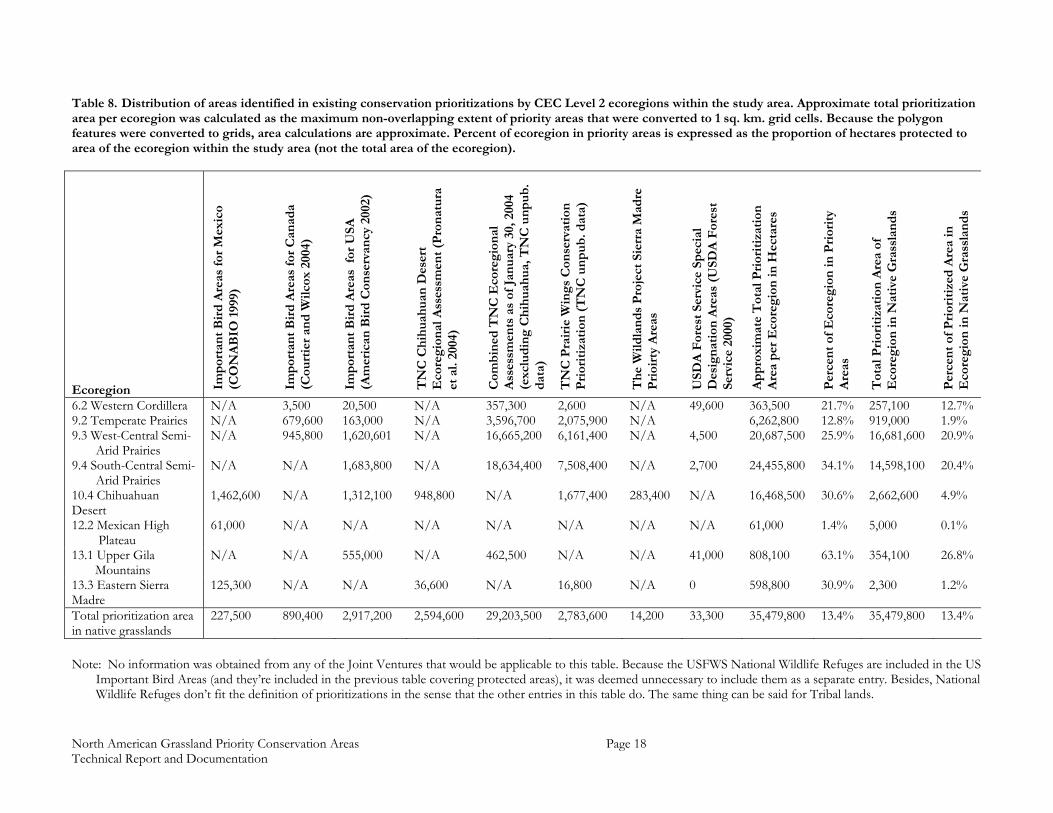
3.2.2 Grassland Representation at a National Scale The protection status of native/natural grasslands by country was assessed by intersecting the protected areas layers with the 2000 TNC Untilled Landscapes (TNC 2001), 2000 Mexico Grasslands (Velázquez 2001) and the Hansen et al. (1998) 1-km AVHRR land cover classification (Table 9). Canadian protected areas had the highest percentage of grasslands and accounted for the highest proportion of native grasslands occurring in Canada. Protection status for grasslands in the United States and Mexico was quite low; most of the study area in these countries was in private ownership. The 1-km AVHRR layer used in the northern portion of the Chihuahuan ecoregion included many areas that might be considered arid shrub-steppe under a different classification. Within the Canadian portion of the study area, the majority of protected areas were in Native Grasslands. Within the United States a large portion of the protected areas within the study area were in land cover types other than native grasslands. In Mexico, a relatively small portion of the protected areas were in native grasslands. Table 9. Protection status of native/natural grasslands in the study area by country, based on the 2000 TNC Untilled Landscapes (TNC 2001), Mexico Grasslands circa 2000 (Velázquez 2001) datasets, and 1KM AVHRR Land Cover Classification (Hansen et al. 1998) for the gap between the above data sets.
Area of Native Grassland (ha)
% of Native Grasslands in
Protected Areas % of Protected Areas in Native Grasslands
Canada 8,655,400 14.95% 89.22% United States 69,620,600 1.61% 37.87% Mexico 3,844,300 1.80% 6.61% The grassland data layers were intersected with each of the conservation prioritizations collected for the project (Table 10). There were a high percentage of native/natural grasslands in defined conservation priority areas. Similar to the low protection status observed for Mexican grasslands, the relatively low percentages of grasslands in the Mexican prioritizations could be due to how grasslands were defined in the Mexican grasslands data layer.
3.2.3 Grassland Fragmentation The size and fragmentation of grassland patches is clearly not consistent across the study area (Figure 3). While large, unfragmented landscapes offer the best opportunities for preserving functional ecological systems (see Noss and Csuti 1994), a system of ESRs and GPCAs focused only on the largest grassland patches would not fully capture the range of ecological conditions in the study area. Although smaller grassland patches in a fragmented matrix may face higher pressure from certain threats, they may still provide valuable habitat for grassland species (especially migratory birds) and may be important parts of a tri-national grassland network (e.g. Blancher 2003). An understanding of how patch size and fragmentation varies across the study area is necessary to avoid inadvertently biasing the results toward the largest and most intact grassland systems. Grassland types were aggregated to 10,000km2 grid cells across the study area (Figure 9) after Hansen et al. (1998) 1-km AVHRR land cover classification. The 1-km AVHRR classification was used for this analysis over other potentially more accurate grassland layers
North American Grassland Priority Conservation Areas Page 20 Technical Report and Documentation
because it was consistent over the study area and thus eliminated the possibility of differences in cover type definitions or methodologies influencing the results. For each grid cell, the area of grasslands and the number of grassland patches (individual, contiguous polygons mapped as grassland) were calculated. Looking only at area of grasslands per cell, the highest ranked areas of grasslands occur on the margins between the eastern and southern portions of the study area which have fewer, smaller grasslands and the west-central portion which has the most big, unfragmented grasslands. This result suggests that these cells have either some large grasslands interspersed with small grassland patches, or that these cells consist primarily of small, fragmented grassland patches. To overcome this, area of grasslands was divided by the number of patches per cell. Under this scheme, the highest-ranked cells were those with a large area of grasslands and a small number of patches. Conversely, the lowest-ranked cells had both small grassland area and low number of grassland patches. According to this method, the most intact grassland systems were in the north-central portion of the study area. The eastern and southern portions of the study area showed more fragmented grassland landscapes. Table 10. Percent of each conservation prioritization that is classified as native/natural grasslands based on the TNC Untilled Landscapes (TNC 2001), Mexico Grasslands circa 2000 (Velazquez 2001) datasets, and 1KM AVHRR Land Cover Classification (Hansen et al. 1998) for the gap between the above data sets.
Conservation prioritization initiatives
Native grasslands
(ha)
Percent Prioritization
in Native Grasslands
Important Bird Ares of Mexico (CONABIO´s AICAS) 227,500 13.69% Important Bird Areas of Canada (Bird Studies Canada) 890,400 54.54% Important Bird Areas at the United States (American Bird Conservancy)
2,917,200 54.64%
TNC Chihuahuan Desert Ecoregional Assessment 2,594,600 17.35% Combined TNC Ecoregional Assessments as of January 30, 2004 (excluding Chihuahua)
29,203,500 72.18%
TNC Prairie Wings Conservation Prioritization 2,783,600 68.89% The Wildlands Project Sierra Madre Prioirty Areas 14,200 5.10% USDA Forest Service Special Designation Areas 33,300 33.88%
3.2.4 Focal Species Richness Given the disparity in coverage of observation data, analysis of focal species across the study area was restricted to comparisons of their ranges. Ranges for each focal species were intersected to create species richness (number of species occurring in a given area) maps (Figure 10). The richness of all species indicated Mexico and Texas as having the most species-rich area in the study area. However, since many of the focal bird species migrate between the southern and northern portions of the study area, richness of breeding and wintering bird ranges should be considered. Canada and the north-central plains states showed the highest richness of breeding birds in the study area. Richness of wintering birds followed closely the results for all species. These results corresponded to Blancher’s (2003) analysis of range-richness of all birds dependent on the central grasslands for either breeding or wintering. The focal species richness maps were intersected with conservation prioritization layers collected for this project. The percent of each richness category (number of species)
North American Grassland Priority Conservation Areas Page 21 Technical Report and Documentation
captured by at least one conservation priority area was calculated (Figure 11). The results showed that there was little trend toward conservation priority areas being located in areas of high species-richness, and that conservation priority areas were generally evenly distributed with respect to occurrence of the focal species. While richness maps can be useful for identifying general areas of correspondence among elements of biodiversity, care must be used in interpreting richness-based maps in the context of conservation planning. In none of the richness maps generated for this analysis was there overlap of the ranges of all species. The possibility exists that the majority of a species range could fall outside of a high-richness area. Additionally, richness measures may favor areas of ecological transition where species from two different ecological systems co-occur. These areas may not be representative of the ecological conditions in other parts of a species range and population dynamics in these areas may also be different.
3.3 The GPCA Workshop Thirty-six grassland experts attended the GPCA workshop – eleven each from Canada and Mexico, and 14 from the United States. Experts were invited based on their knowledge of grassland systems across large regions of North America. Of the total workshop participants, 20 were considered experts on northern grasslands, 29 on central grasslands, and 17 on southern grasslands (participants could be considered an expert for more than one region; see complete directory in Appendix D). Workshop participants were given three questions to guide them through the process of identifying large ESRs, smaller GPCAs contained within the ESRs, and finally into describing each GPCA´s threat related attributes: Question 1: Ecologically Significant Areas (ESRs): What are the most important grassland
regions of Central North America in terms of the biodiversity richness, ecological uniqueness, and bi-national/tri-national significance?
Expected results from this question were broad agreement, based on ecological foundations, on large-scale polygons comprising important tri-national grassland regions and rationale for their selection. Participants were asked to keep in mind the following guiding criteria:
• High importance for migratory and trans-boundary species in terms of breeding, wintering, and migratory habitats
• High native species composition (richness) and or high degrees of endemism • Polygons in the order of 250,000 km2 (see Figure 1.) • Total area encompassed by ESRs was anticipated to be less than or equal to 40% of
the total study area. Question 2: Grassland Priority Conservation Areas (GPCAs): What areas within the
ESRs are conservation priorities for your national/geographic region? Consider the imminence of threats over a 5-year period and the continent-wide significance of loss of these sites.
North American Grassland Priority Conservation Areas Page 22 Technical Report and Documentation
Expected results from this question were broad agreement of smaller-scale polygons identified within the ESR with rationales for the entire central grasslands region identified in terms of their ecological importance and threat. Participants were asked to keep in mind the following guiding criteria:
• Areas that could be lost within five years, but of appropriate size to allow for long-term ecological functionality
• Polygons in the order of 10,000 km2 (see Figure 1); however, GPCAs should be sized appropriate to conservation actions and together ensure long-term viability of priority conservation targets.
• Total area delineated as GPCAs should be less than or equal to 10% of the identified ESR area.
Question 3: Selected GPCAs: What is the relative conservation urgency of resulting GPCAs,
based upon their value and the imminence of threat upon them? Expected results from this question were an assessment among the GPCAs of their relative importance for migratory and trans-boundary species in terms of breeding, wintering, and migration habitats; and an assessment of the importance of the impending threats over the next five years. Participants were asked to consider the importance of each GPCA in relation to conservation priorities, the imminence of threats upon each GPCA, and opportunities for conservation.
3.3.1 Consensus Mapper The building of consensus and overlay of information during the workshop relied on a procedure developed by McGill University’s project on Community-Based Environmental Decision (CBED). This included the Consensus Mapper GIS software - an easy-to-use GIS designed for non-GIS users⎯ engineered by G. Dias for accessing compiled GIS data and capturing output from the various groups of workshop participants. This software has a simple, yet robust design that supports features such as zooming and panning over base maps, display of various map layers, drawing and editing of new polygon features, calculation of polygon areas, and submission of finished maps, as ESRI shapefiles, to a specified location either on the local computer or over a computer network. Consensus Mapper is a stand-alone GIS package created using ESRI’s MapObjects and does not require the installation of any other ESRI GIS products (e.g., ArcView, ArcGIS) to be used. (See Appendix E for the principles behind this procedure and also Balram et al. 2004.)
3.3.2 Spreadsheets for Attribute Capture and Analysis A series of pre-formatted spreadsheets within a Microsoft Excel Workbook were designed for this workshop by TNC´s Bob Unnasch (see Appendix F) to complement the use of the Consensus Mapper. The spreadsheets were intended to provide an objective, and quantitative method for ranking the ESRs and GPCAs, as well as to record additional information about the users’ mapped regions (see Appendix F for detailed description of function of the spreadsheets). Concurrent to mapping ESRs and GPCAs in Consensus Mapper, each workshop group filled out the appropriate descriptive information in the spreadsheets and assessed ESRs and GPCAs in terms of their significance to the focal species/elements (see Grassland Focal Elements and Species above) and threats related to
North American Grassland Priority Conservation Areas Page 23 Technical Report and Documentation
GPCAs. The spreadsheets were designed to be flexible enough for users to enter comments and modify the lists of focal species/elements and threats. Data from the ESR and GPCA worksheets were automatically transferred to PCA summary worksheet where ESRs and GPCAs were ranked and displayed in relation to each other. Color codes were used on relative rankings of ESRs and GPCAs and PCA threats to aid in interpretation of the combined results. Summary worksheets from all workshop groups could be combined to provide a comprehensive look of the entire study area.
3.3.3 Group dynamics and composition by themes and regions Each of these questions was discussed in plenary first so that the meaning and intention of the questions, and distinctions between the questions, were clear. When break-out groups were later formed, group members were asked for each question first to discuss the criteria that they would use to establish each of these maps and then to select - by tracing on a base map - the areas they propose. The full group of participants met first in plenary to discuss background issues, goals, working assumptions and procedures of the workshop. The CMRT procedures were explained and an introduction to Consensus Mapper provided. The group was then divided into six roughly equal groups based on fields of expertise (see Appendix D). Each group was asked to delineate draft ESRs based on the knowledge of their group. Each group’s set of ESR polygons was considered a data layer which captured the group’s priorities. These maps were submitted to the facilitators and a combined overlay map was produced. This map was projected on the main screen so that all could see it, consider it, correct errors and comment on their own or other contributions. For the second iteration of ESRs, groups were changed from being based on the experts’ field of expertise to being based on their regional area of expertise. Six new groups were created, two each for the northern, central, and southern grasslands. The ESR overlay map was then returned to each of the workstations and the groups were asked to refine the ESR selections based on the plenary discussions and their regional knowledge. Each region reconciled their ESRs and the results were compiled into the final ESR layer for the workshop. This cycle could have been continued in a modified Delphi approach until consensus was reached or irreconcilable differences were identified. However, in this case, the process ended at this stage and the resultant map was treated as the group consensus on ESRs. The final map was displayed and discussed by the entire group and the substance of the output as well as the procedure was discussed. Maintaining the same groups based on geographic knowledge, workshop participants then identified through an iterative process GPCAs within the ESRs and assessed their status and potential future condition. There were two iterations for this for this portion parallel to the second and third iterations of ESR process. First, each region was to produce PCA maps in two separate groups. They were then to compare and discuss their selected GPCAs and create a map of GPCAs together, as a region. The participants in the northern group chose to split up based on nationality, so one group made a map for Canada while the other
North American Grassland Priority Conservation Areas Page 24 Technical Report and Documentation
mapped GPCAs for the United States. They did not compare and discuss their products to produce a final because they had each mapped exclusive areas. The central groups opted to merge into one group immediately, thus also skipping the second iteration. The southern group followed the original plan. While mapping GPCAs, information was entered into the data collection spreadsheets that described the relative importance of each GPCA for the species listed in the spreadsheet. In the exercise, the polygons were drawn first and the spreadsheets were filled in to reflect characteristics of the polygons. The spreadsheet information was compiled and the GPCAs were subsequently ranked based on the values calculated from the spreadsheet. In the end, each region identified its top priority GPCAs
3.3.4 Additional Grassland Focal Elements Workshop participants added three species and one vegetation community to the list of focal elements and targets prepared prior to the workshop. The northern and central groups added bison (Bos bison) to their lists. The Central group also added northern bobwhite quail (Colinus virginianus). The southern group added the Mexican prairie dog (Cynomys mexicanus) and gypsophilous vegetation. None of the workshop participants felt that any of the focal elements and species selected prior to the workshop should not be considered.
4. GPCA Workshop Results
4.1 Ecologically Significant Areas The overlay of the first iteration ESR maps produced by the groups based on expert’s field of expertise showed some areas of definite consensus on tri-national areas of significance (Figure 12). Four general areas were identified by all six groups: 1) the border region between Montana, Saskatchewan, and Alberta; 2) the Thunder Basin and Sandhills area of Nebraska, South Dakota, and Wyoming; 3) the southern prairie region of Oklahoma, Colorado, New Mexico, and Texas; and 4) the El Tokio area of Mexico. The combined ESR layers from all six groups comprised 81.0% of the entire study area (calculated as percent of ESRs within the study area). Areas identified as ESRs by four or more groups comprised 24.0% of the combined ESR area. Areas identified by only one group as ESRs comprised 34.2% of the total combined ESR area. The first refinement of ESRs where new, geographically arranged groups edited the draft ESRs from the previous step resulted in 19 distinct ESR polygons (Figure 13) that accounted for 47.3% of the study area. After the regional groups had reconciled the differences in their ESR delineations, the final version defined 21 ESRs (Figure 14, Table 11) totaling 40.0% of the study area. See Appendix G for detailed descriptions and rationale for each ESR. Prior to the workshop, ESRs were anticipated to be on the order of 250,000 km2 in size. Final ESRs ranged in size from 4,000 to 229,000 km2. Mean ESR size was 57,000 km2.
North American Grassland Priority Conservation Areas Page 25 Technical Report and Documentation
Table 11. Final ESRs with their quantitative ratings (sorted by quantitative rating). Importance of each ESR to the list of focal species is also shown using the following abbreviations: V = Very High, H = High, M = Moderate, L = Low, P = Present/Not Significant. Blank cells indicate that the species is not known to occur in the PCA
ESR Name ESR
NumberESR Area
(Km2) Expert Rating
Quantitative Rating Based
on Focal Species M
oun
tain
Plo
ver
Pip
ing
plo
ver
Lon
g-b
illed
Cu
rlew
F
erru
gin
ous
Haw
k Sc
aled
Qu
ail
Les
ser
Pra
irie
-Ch
icke
n
Gre
ater
Pra
irie
-Ch
icke
n
Shar
p-t
aile
d G
rou
se
Sage
Gro
use
B
urr
owin
g O
wl
Log
gerh
ead
Sh
rike
Sp
ragu
e's
Pip
it
Lar
k B
un
tin
g M
cCow
n's
Lon
gsp
ur
Bai
rd's
Sp
arro
w
Cas
sin
's S
par
row
C
hes
tnu
t-co
llare
d L
ong
spu
r W
orth
en´s
Sp
arro
w
Bla
ck t
aile
d P
rair
ie d
og
Mex
ican
Pro
ngh
orn
B
ison
N
orth
ern
Bob
wh
ite
Qu
ail
Mex
ican
Pra
irie
Dog
G
ypso
ph
illim
Veg
etat
ion
Chihuahua – El Tokio/Mapimi 1 93,563 Very High 13.25 V H H H V H M V L M V V V V V V
Chihuahua - Marfa/Big Bend/Maderas del Carmen
2 81,977 Very High 7.24 L H M H H M H M L M M
Sierra Madre Occidental Foothills 3 218,501 Very High 12..48 V V V V V H V H M V M H V
Southern Prairies 4 229,494 Very High 11.25 V P M V H V H H M M V L V V H M
Smoky Hills 5 38,298 Moderate 5.42 P P M H H M M P M P P L M M M
Flint Hills 6 32,860 Very High 4.24 L V L M P L L M
Arickaree 7 11,647 High 3.16 P L M L M L M P P L
Pawnee Grasslands 8 17,397 High 5.88 H L M L M M M P M V P P M L
Thunder Basin/Conata 9 37,000 Very High 8.66 H H M L M H M M M H V H
Sandhills 10 47,073 High 3.88 P L L M H L L L M P L L P
Powder River/Big Open 11 76,100 Moderate 6.93 M M L H M M M H L M H
Cheyenne Prairie 12 41,700 High 6.64 H M M M M P M L H V
Prairie Couteau/Sheyenne Delta 13 16,400 Moderate 1.22 P M P L P P
Little Missouri Badlands 14 13,000 Moderate 3.32 L L M P L M P L L L L
Agassiz Tallgrass 15 10,700 Very High 2.00 M L L P
Manitoba Mixed-grass/Towner Sandhills 16 7,400 Moderate 3.02 L M P M L L L
Carberry Sandhills 17 4,000 Moderate 1.155 M P P
Rocky Mountain Front 18 18,000 Very High 1.89 L L L P L P L
Missouri Couteau 19 63,000 Very High 7.33 V L H L M H M H H
Medicine Line Mixed-grass 20 108,000 Very High 12.14 H L V H M V H H H H H V V H V
Northern Fescue 21 31,000 High 3.67 H P H L L L
North American Grassland Priority Conservation Areas Page 26 Technical Report and Documentation
Experts evaluated each ESR with respect to the list of focal elements and species. There were no ESRs with very high importance for three species: loggerhead shrike, northern bobwhite quail, and sharp-tailed grouse. The loggerhead shrike and sharp-tailed grouse are wide-ranging species, occurring on all 21 and 14 ESRs, respectively. The northern bobwhite quail occurred on only 4 ESRs. The northern ESRs were generally rated by the workshop participants as having significance to the fewest number of focal species on the list. This could be due to the fact that many of the focal species spend only their breeding seasons in the northern region, or that significance of northern ESRs was due primarily to grassland conditions and not to focal species. Experts rated 47.6%, 23.8%, and 28.6% of the final ESRs as very high, high, and moderate in importance, respectively. Quantitative ratings were based on the importance of each ESR to the list of focal elements and species with higher numbers, inferring that an area was relatively more important than those with lower numbers. Areas with a high degree of importance to many species would have higher numbers. Quantitative ratings of ESRs ranged from 1.16 to 13.25. When ESR quantitative ratings were ranked and split into quartiles, all ESRs in the top quartile (8.66 to 13.25) were rated by experts as of very high importance. However, two ESRs in the lowest quartile (1.16 to 3.02) were rated by the workshop participants as very high. Both of these ESRs were rated by workshop participants as having low importance for any of the focal species, suggesting that other factors not adequately captured by the focal elements and species list contributed to their significance.
4.2 Grasslands Priority Conservation Areas After several iterations, the workshop participants defined in total 55 GPCAs: 26 in the Northern Region (Figure 15), 16 in the Central Region (Figure 16), and 13 in the Southern Region (Figure 17), comprising 10.5% of the study area (calculated as percent of PCAs in the study area) and 22.5% of identified ESRs (Table 12). PCA quantitative ratings calculated by the data entry spreadsheets are shown in Figure 18. See Appendix H for detailed descriptions of each GPCA. Final GPCAs ranged in size from 834 to 14,821 km2. Mean GPCA size was 4,852 km2. Experts evaluated each GPCA with respect to the list of focal elements and species. Initally seventeen GPCAs identified by the workshop participants had no ratings completed for the list of focal elements and species. Fifteen of these, however, were completed post-workshop through the review process by region. There were no GPCAs with very high importance for four species: sharp-tailed grouse, McCown’s longspur, Mexican pronghorn, and northern bobwhite quail. The two GPCAs rated as significant for the northern bobwhite quail were rated as low (Panhandle and Kiowa). The same GPCA (Tokio) was rated as of very high significance for both the Worthen’s sparrow and Mexican prairie dog, and was the only GPCA identified as significant for these species. Regional reviewers of this report were asked to provide species importance ratings for GPCAs that were not attributed before the close of the expert workshop. In some instances, reviewers also suggested changes to the species importance ratings given to individual GPCAs during the workshop. Changing the species importance ratings for a GPCA would change it’s quantitative ranking and could also result in a change in its rank order. Because 1)
North American Grassland Priority Conservation Areas Page 27 Technical Report and Documentation
the purpose of this report was to capture the consensus of experts at the workshop regarding GPCAs; 2) workshop participants made selections of the GPCAs based in part on the presented quantitative scores and rank orders; and 3) not all workshop participants would have had chance to evaluate the suggested changes; species importance ratings for individual GPCAs were not changed according to reviewer comments except to fill in importance ratings for GPCAs not attributed at the workshop. Quantitative GPCA ratings were based on the importance of each GPCA to the list of focal elements and species with higher numbers inferring an area was relatively more important than those with lower numbers. Areas with a high degree of importance to many species would have higher numbers. Quantitative ratings of ESRs ranged from 1.89 to 12.48. No expert overall ratings were given to GPCAs. Instead, workshop participants were asked to identify their top priority GPCAs for need of conservation action within the next five years. Consequently, workshop participants selected 28 GPCAs as their top priority areas: 13, in the Northern; 8, in the Central, and 7 in the Southern Regions (Figure 19). Selected GPCAs totaled just over 166,000 km2 or 6.3% of the study area. Workshop participants evaluated the threats affecting each of the GPCAs and the focal elements and species occurring therein with respect to the type of threat, an overall rating of the risks from the threat, and the urgency and trend of the threat. See Appendix H for detailed lists of threats assigned to each GPCA. There could be up to five threats assigned to each GPCA. Fifty three (98.1%) of GPCAs were assigned at least one threat. More than one threat was assigned to 49 (90.7%) GPCAs with 43 (79.6%), 22 (40.7%), and 5 (9.3%) GPCAs receiving three, four, and five threats, respectively. Workshop participants assigned 11 different threats to the GPCAs (Table 13) with habitat disturbance or destruction, habitat fragmentation, altered fire regimes, altered structure or composition, excessive herbivory, and extraordinary predation or parasitism being the most frequently assigned. Threat pressures over GPCAs were overall most commonly rated as high, having very high urgency for addressing the threat, and with threat trends either stable or increasing in magnitude.
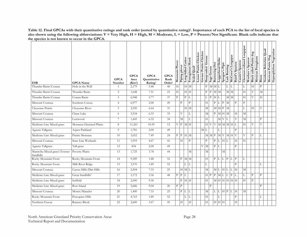
North American Grassland Priority Conservation Areas Page 28 Technical Report and Documentation
Table 12. Final GPCAs with their quantitative ratings and rank order (sorted by quantitative rating)1. Importance of each PCA to the list of focal species is also shown using the following abbreviations: V = Very High, H = High, M = Moderate, L = Low, P = Present/Not Significant. Blank cells indicate that the species is not known to occur in the GPCA.
ESR GPCA Name GPCA
Number
GPCA Area
(Km2)
GPCA Quantitative
Rating1
GPCA Rank Order1 M
oun
tain
Plo
ver
Pip
ing
plo
ver
Lon
g-b
illed
Cu
rlew
F
erru
gin
ous
Haw
k Sc
aled
Qu
ail
Les
ser
Pra
irie
-Ch
icke
n
Gre
ater
Pra
irie
-Ch
icke
n
Shar
p-t
aile
d G
rou
se
Sage
Gro
use
B
urr
owin
g O
wl
Log
gerh
ead
Sh
rike
Sp
ragu
e's
Pip
it
Lar
k B
un
tin
g M
cCow
n's
Lon
gsp
ur
Bai
rd's
Sp
arro
w
Cas
sin
's S
par
row
C
hes
tnu
t-co
llare
d L
ong
spu
r W
orth
en´s
Sp
arro
w
Bla
ck t
aile
d P
rair
ie d
og
Mex
ican
Pro
ngh
orn
B
ison
N
orth
ern
Bob
wh
ite
Qu
ail
Mex
ican
Pra
irie
Dog
G
ypso
ph
ylou
s V
eget
atio
n
Thunder Basin\Conata Hole in the Wall 1 2,179 5.48 40 H H M P M M L L L L H P
Thunder Basin\Conata Thunder Basin 2 1,648 7.51 23 H H H P P M M M M H V M
Thunder Basin\Conata Conata Basin 3 6,948 5.77 37 P P L L P H L M M H V H
Missouri Couteau Southern Coteau 4 6,977 2.00 49 P P H P L P M P P
Cheyenne Prairie Cheyenne River 5 2,550 6.64 31 H M M M M P M L H V
Missouri Couteau Chase Lake 6 3,534 6.33 33 V L M P M H M H M
Missouri Couteau Lostwood 7 1,443 6.32 34 M L H M V L V M P
Medicine Line Mixed-grass Montana Glaciated Plains 8 11,261 10.59 12 V P M H H V V M M M H L H V V
Agassiz Tallgrass Aspen Parkland 9 1,781 2.00 49 M L L P
Medicine Line Mixed-grass Prairie Montana 10 3,652 7.49 24 P P H M M M P M V M H V V P L
Missouri Couteau State Line Wetlands 11 1,919 4.67 41 H P P P L H L H H
Agassiz Tallgrass Tall-grass 12 834 2.00 49 V M P L P
Manitoba Mixed-grass\Towner Sandhills
Poverty Plains 13 1,725 3.78 44 M M M
Rocky Mountain Front Rocky Mountain Front 14 9,189 1.88 52 P M M H P L L P L P L
Rocky Mountain Front Milk River Ridge 15 3,570 1.89 52 L L L P L
Missouri Couteau Cactus Hills/Dirt Hills 16 2,504 7.33 25 H M L M M L H L L H M
Medicine Line Mixed-grass Great Sandhills2 17 3,172 3.36 48 P P L H P P M L L P L L P P
Medicine Line Mixed-grass Suffield 18 2,690 9.30 P H H H M H H H H H H P
Medicine Line Mixed-grass Bow Island 19 5,686 9.04 20 P P P P
Missouri Couteau Monet/Matador 20 1,400 7.33 25 P L L M L L H P L H M
Rocky Mountain Front Porcupine Hills 21 4,763 1.89 52 L L H L P L
Northern Fescue Rumsey Block 22 2,600 3.67 45 H H H H H H H

North American Grassland Priority Conservation Areas Page 29 Technical Report and Documentation
ESR GPCA Name GPCA
Number
GPCA Area
(Km2)
GPCA Quantitative
Rating1
GPCA Rank Order1 M
oun
tain
Plo
ver
Pip
ing
plo
ver
Lon
g-b
illed
Cu
rlew
F
erru
gin
ous
Haw
k Sc
aled
Qu
ail
Les
ser
Pra
irie
-Ch
icke
n
Gre
ater
Pra
irie
-Ch
icke
n
Shar
p-t
aile
d G
rou
se
Sage
Gro
use
B
urr
owin
g O
wl
Log
gerh
ead
Sh
rike
Sp
ragu
e's
Pip
it
Lar
k B
un
tin
g M
cCow
n's
Lon
gsp
ur
Bai
rd's
Sp
arro
w
Cas
sin
's S
par
row
C
hes
tnu
t-co
llare
d L
ong
spu
r W
orth
en´s
Sp
arro
w
Bla
ck t
aile
d P
rair
ie d
og
Mex
ican
Pro
ngh
orn
B
ison
N
orth
ern
Bob
wh
ite
Qu
ail
Mex
ican
Pra
irie
Dog
G
ypso
ph
ylou
s V
eget
atio
n
Northern Fescue Manitou 23 2,100 3.67 45 H L L M
Northern Fescue Wainwright/Neutral Hills 24 5,800 3.67 45 M M M M M M M M M
Southern Prairies Central Red Hills 25 2,956 11.25 4 P L H M M P P P L M M H
Southern Prairies Western Red Hills 26 3,856 11.25 4 P P L V M L P L L M L M M
Southern Prairies Ellis 27 4,210 11.25 4 L L L M M L H M
Southern Prairies Cimarron 28 7,622 11.25 4 H H M M H H M M M H M H M
Southern Prairies Mescalero Sands 29 11,595 11.25 4 L M H V L M P M M V H L M
Southern Prairies Rita Blanca 30 9,262 11.25 4 L M P M L P L L L H M P
Flint Hills Flint Hills 31 14,005 4.24 42 L P V P H P P L H
Smoky Hills Chalk Bluff2 32 3,811 5.68 38 M M H H H
Southern Prairies Carrzozo2 33 3,445 6.25 35 M L P L L L P L M
Southern Prairies Thunder Basin, Bill2 34 14,821 9.75 14 H M M H M
Pawnee Grasslands Pawnee 35 9,097 6.41 32 H L M L M M M V M M H M
Thunder Basin\Conata Sioux Box Butte 36 5,229 4.22 43 L M H L H H M L L H P
Southern Prairies Roosevelt2 37 3,365 9.50 17 M H H M M V M
Southern Prairies Panhandle2 38 1,655 10.50 13 H H H H L
Southern Prairies Kiowa2 39 855 6.06 36 M P P P L L H L P L
Southern Prairies Curry2 40 1,368 9.75 14 M H H M M
Chihuahua - Tokio/Mapimi Cuatro Cienegas 41 1,531 9.22 19 P P L M M M L M V
Chihuahua - Tokio/Mapimi Tokio 42 9,364 12.25 2 V V V M V H L L L H V V V
Chihuahua - Tokio/Mapimi Mapimi 43 6,824 11.75 3 M H M V H H L V P M V H
Sierra Madre Occidental Foothills
Cuchillas de la Zarca 44 5,914 9.71 16 M M M H L H L
Chihuahua - Marfa/Big Bend/Maderas del Carmen
Valle Colombia 45 4,477 7.24 27
Chihuahua - Marfa/Big Bend/Maderas del Carmen
Valles Centrales 46 10,316 12.48 1
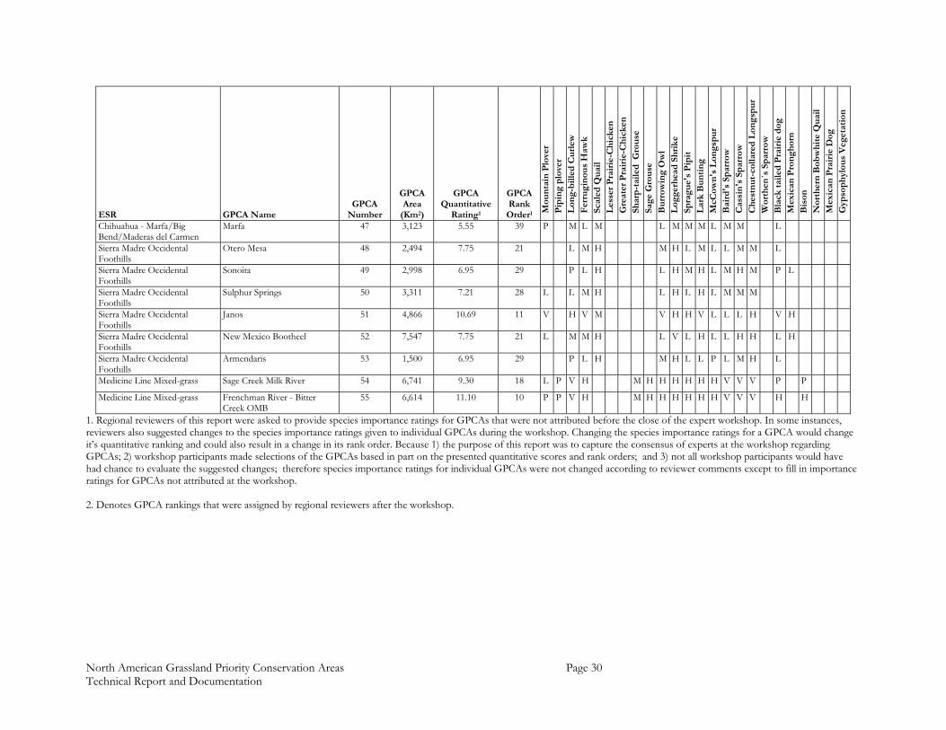
North American Grassland Priority Conservation Areas Page 30 Technical Report and Documentation
ESR GPCA Name GPCA
Number
GPCA Area
(Km2)
GPCA Quantitative
Rating1
GPCA Rank Order1 M
oun
tain
Plo
ver
Pip
ing
plo
ver
Lon
g-b
illed
Cu
rlew
F
erru
gin
ous
Haw
k Sc
aled
Qu
ail
Les
ser
Pra
irie
-Ch
icke
n
Gre
ater
Pra
irie
-Ch
icke
n
Shar
p-t
aile
d G
rou
se
Sage
Gro
use
B
urr
owin
g O
wl
Log
gerh
ead
Sh
rike
Sp
ragu
e's
Pip
it
Lar
k B
un
tin
g M
cCow
n's
Lon
gsp
ur
Bai
rd's
Sp
arro
w
Cas
sin
's S
par
row
C
hes
tnu
t-co
llare
d L
ong
spu
r W
orth
en´s
Sp
arro
w
Bla
ck t
aile
d P
rair
ie d
og
Mex
ican
Pro
ngh
orn
B
ison
N
orth
ern
Bob
wh
ite
Qu
ail
Mex
ican
Pra
irie
Dog
G
ypso
ph
ylou
s V
eget
atio
n
Chihuahua - Marfa/Big Bend/Maderas del Carmen
Marfa 47 3,123 5.55 39 P M L M L M M M L M M L
Sierra Madre Occidental Foothills
Otero Mesa 48 2,494 7.75 21 L M H M H L M L L M M L
Sierra Madre Occidental Foothills
Sonoita 49 2,998 6.95 29 P L H L H M H L M H M P L
Sierra Madre Occidental Foothills
Sulphur Springs 50 3,311 7.21 28 L L M H L H L H L M M M
Sierra Madre Occidental Foothills
Janos 51 4,866 10.69 11 V H V M V H H V L L L H V H
Sierra Madre Occidental Foothills
New Mexico Bootheel 52 7,547 7.75 21 L M M H L V L H L L H H L H
Sierra Madre Occidental Foothills
Armendaris 53 1,500 6.95 29 P L H M H L L P L M H L
Medicine Line Mixed-grass Sage Creek Milk River 54 6,741 9.30 18 L P V H M H H H H H H V V V P P
Medicine Line Mixed-grass Frenchman River - Bitter Creek OMB
55 6,614 11.10 10 P P V H M H H H H H H V V V H H
1. Regional reviewers of this report were asked to provide species importance ratings for GPCAs that were not attributed before the close of the expert workshop. In some instances, reviewers also suggested changes to the species importance ratings given to individual GPCAs during the workshop. Changing the species importance ratings for a GPCA would change it’s quantitative ranking and could also result in a change in its rank order. Because 1) the purpose of this report was to capture the consensus of experts at the workshop regarding GPCAs; 2) workshop participants made selections of the GPCAs based in part on the presented quantitative scores and rank orders; and 3) not all workshop participants would have had chance to evaluate the suggested changes; therefore species importance ratings for individual GPCAs were not changed according to reviewer comments except to fill in importance ratings for GPCAs not attributed at the workshop. 2. Denotes GPCA rankings that were assigned by regional reviewers after the workshop.
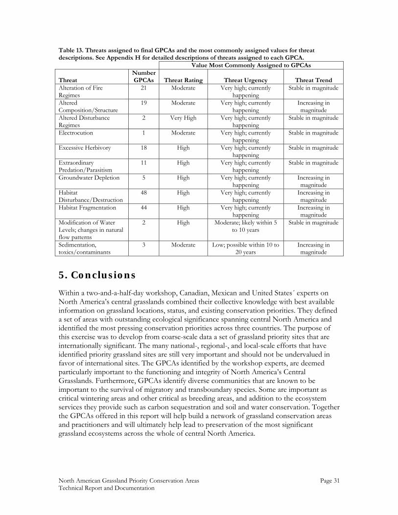
North American Grassland Priority Conservation Areas Page 31 Technical Report and Documentation
Table 13. Threats assigned to final GPCAs and the most commonly assigned values for threat descriptions. See Appendix H for detailed descriptions of threats assigned to each GPCA. Value Most Commonly Assigned to GPCAs
Threat Number GPCAs Threat Rating Threat Urgency Threat Trend
Alteration of Fire Regimes
21 Moderate Very high; currently happening
Stable in magnitude
Altered Composition/Structure
19 Moderate Very high; currently happening
Increasing in magnitude
Altered Disturbance Regimes
2 Very High Very high; currently happening
Stable in magnitude
Electrocution 1 Moderate Very high; currently happening
Stable in magnitude
Excessive Herbivory 18 High Very high; currently happening
Stable in magnitude
Extraordinary Predation/Parasitism
11 High Very high; currently happening
Stable in magnitude
Groundwater Depletion 5 High Very high; currently happening
Increasing in magnitude
Habitat Disturbance/Destruction
48 High Very high; currently happening
Increasing in magnitude
Habitat Fragmentation 44 High Very high; currently happening
Increasing in magnitude
Modification of Water Levels; changes in natural flow patterns
2 High Moderate; likely within 5 to 10 years
Stable in magnitude
Sedimentation, toxics/contaminants
3 Moderate Low; possible within 10 to 20 years
Increasing in magnitude
5. Conclusions
Within a two-and-a-half-day workshop, Canadian, Mexican and United States´ experts on North America’s central grasslands combined their collective knowledge with best available information on grassland locations, status, and existing conservation priorities. They defined a set of areas with outstanding ecological significance spanning central North America and identified the most pressing conservation priorities across three countries. The purpose of this exercise was to develop from coarse-scale data a set of grassland priority sites that are internationally significant. The many national-, regional-, and local-scale efforts that have identified priority grassland sites are still very important and should not be undervalued in favor of international sites. The GPCAs identified by the workshop experts, are deemed particularly important to the functioning and integrity of North America’s Central Grasslands. Furthermore, GPCAs identify diverse communities that are known to be important to the survival of migratory and transboundary species. Some are important as critical wintering areas and other critical as breeding areas, and addition to the ecosystem services they provide such as carbon sequestration and soil and water conservation. Together the GPCAs offered in this report will help build a network of grassland conservation areas and practitioners and will ultimately help lead to preservation of the most significant grassland ecosystems across the whole of central North America.
North American Grassland Priority Conservation Areas Page 32 Technical Report and Documentation
6. References
American Bird Conservancy. 2002. Important Bird Areas of the United States. http://www.abcbirds.org/iba/
Bailey 1998. Ecoregions: the ecosystem geography of oceans and continents. Springer-
Verlag. New York. Balram, S., S. Dragićević and T. Meredith, 2004. A collaborative GIS method for integrating
local and technical knowledge in establishing biodiversity conservation priorities Biodiversity and Conservation, 13: 1195–1208.
Blancher, P. 2003. Importance of North America’s grasslands to birds. Report to the
Commission for Environmental Cooperation. Montreal, Canada.. www.bsc-eoc.org/grassbirdsrpt.html
Ceballos, G., and P.R. Ehrlich. 2002. Mammal population losses and the extinction crisis.
Science 296:904-907. Commission for Environmental Cooperation (CEC). 2003. Strategic Plan for North
American Cooperation in the Conservation of Biodiversity. Commission for Environmental Cooperation. Montreal. 99 pp. http://cec.org/pubs_docs/documents/index.cfm?varlan=english&ID=1088
Commission for Environmental Cooperation (CEC). 1997. Ecological regions of North
America: towards a common perspective. Montreal, Quebec, Canada. www.cec.org/pubs_docs/documents/index.cfm?varlan=english&ID=344
Comisión Nacional de Áreas Naturales Protegidas (CONANP). 2004. Áreas Naturales
Protegidas Federales de México. México, D.F. http://www.conanp.gob.mx Conservation Biology Institute. 2001. CBI Protected Areas Database, Second Edition.
Corvallis, Oregon, USA. http://www.consbio.org Couturier, A. and K. Wilcox. 2004. Important bird areas of Canada database, edition 1.0.
Bird Studies Canada and the Canadian Nature Federation. Port Rowan, Ontario, Canada.
ERIN Consulting Ltd. 2000. North American Conservation Areas Database. Regina,
Saskatchewan, Canada. http://gogratis.cgdi.gc.ca/download/north_america_cad Ferland, C.L. and S.M. Haig. 2002. 2001 International Piping Plover Census.U.S. Geological
Survey, Forest and Rangeland Ecosystem Science Center, Corvallis, Oregon. 293 pp. Gauthier, D. A. and E. B. Wiken. 1998. The Great Plains of North America. IUCN PARKS
8(3): 9-20.
North American Grassland Priority Conservation Areas Page 33 Technical Report and Documentation
Gauthier, D.A., A. Lafon, T. Toombs, J. Hoth and E.Wiken, 2003. Grasslands: Toward a North American Conservation Strategy. Canadian Plains Research Center, University of Regina, Regina, Saskatchewan, and Commission for Environmental Cooperation (CEC), Montreal, Quebec, Canada. http://cec.org/pubs_docs/documents/index.cfm?varlan=english&ID=1246
Groves, C.R. 2003. Drafting a conservation blueprint: a practitioner’s guide to conservation
planning for biodiversity. Island Press, Washington, D.C. Hansen, M., DeFries, R., Townshend, J. R. G. and Sohlberg, R.. 1998. 1 Km Land Cover
Classification Derived from AVHRR. College Park, Maryland: The Global Land Cover Facility. http://glcf.umiacs.umd.edu/data/landcover/
Instituto del Medio Ambiente y Desarrollo Sustentable del Estado de Sonora (IMADES),
2000. “Evaluación del ámbito hogareño del Berrendo sonorense (Antilocapra americana sonoriensis)”. Extraído del proyecto L112 Evaluación del ámbito hogareño y calidad del hábitat del Borrego cimarrón (Ovis canadensis mexicana), Berrendo sonorense (Antilocapra americana sonoriensis) y Puma (Felis concolor) en la Reserva de la Biosfera El Pinacate y Gran Desierto de Altar. Escala 1:50 000. López Saavedra, Eduardo y Paredes Aguilar, Rafaela. México. El proyecto fue financiado por la Comisión Nacional para el Conocimiento y Uso de la Biodiversidad (CONABIO).
Meredith, T.C. 2002 Using spatial decision support systems in expert workshops. Human
Ecology Review 9:72-76. Morgan, L. S. Maxwell, F. Tsao, T. Wilkinson and P. Etnoyer. 2005. Marine Priority
Conservation Areas: Baja California to the Bering Sea. Commission for Environmental Cooperation (CEC) and the Marine Conservation Biology Institute (MCBI). Montreal.
Noss, R.F. and B. Csuti. 1994. Habitat fragmentation. Pp 237-264 in Meffe, G.K. and C.R.
Carroll. Principles of Conservation Biology. Sinauer Associates, Inc. Sunderland Massachussets, USA.
Noss, R.F., E. Dinerstein, B. Gilbert, M. Gilpin, B.J. Miller, J. Terborgh, and S. Troublulak.
1999. Core areas: where nature begins. Pp 99-128 in Soule, M.E. and J. Terborgh, eds. Continental Conservation: Scientific Foundations of Regional Reserve Networks. Island Press, Washington, D.C.
Noss, R.F., E.T. LaRoe III, and J.M. Scott. 1995. Endangered ecosystems of the United
States: a preliminary assessment of loss and degradation. US Department of the Interior National Biological Service. Biological Report 28.
Peterson, A.T., Ortega-Huerta, M.A., Bartley, J., Sanchez-Cordero, V., Soberon, J.,
Buddemeier, R.H., and Stockwell, D.R.B. 2002. Future projections for Mexican faunas under global climate change scenarios. Nature 416:626-629
North American Grassland Priority Conservation Areas Page 34 Technical Report and Documentation
Proctor, J.D, B. Haskins, and S.C. Forrest. In Press. Focal areas for conservation of prairie dogs and the grassland ecosystem. In Hoogland, J. (ed). Conservation and management of prairie dogs.
Pronatura, The Nature Conservancy, and The World Wildlife Fund. 2004. Ecoregional
Conservation Assessment of the Chihuahuan Desert. The Nature Conservancy. Ridgely, R. S., T. F. Allnutt, T. Brooks, D. K. McNicol, D. W. Mehlman, B. E. Young, and J.
R. Zook. 2003. Digital Distribution Maps of the Birds of the Western Hemisphere, version 1.0. NatureServe, Arlington, Virginia, USA.
Samson, F., and F. Knopf. 1994. Prairie Conservation in North America. Bioscience 44(6):
418-421. Schmidt, R.H.. 1990. The Mega-Chihuahuan Desert. Pp. 105-115 in Powell, A.M., Hollander,
R.R., Barlow, J.C., McGillivray, W.B., and Schmidly, D.J. (eds.). Symposium on Resources of the Chihuahuan Desert Region. Chihuahuan Desert Research Institute.
Scott, J.M., F.W. Davis, R.G. McGhie, G. Wright, C. Groves, and J. Estes. 2001. Nature
reserves: do they capture the full range of America’s biological diversity? Ecological Applications 11:99-107
Sección Mexicana del Consejo Internacional para la Preservación de las Aves CIPAMEX –
Comisión Nacional para el Conocimiento y Uso de la Biodiversidad CONABIO. 1999. “Áreas de Importancia para la Conservación de las Aves”. Escala 1:250 000. México. Financiado por CONABIO–FMCN–CCA.
Shaffer, M.L., J.M. Scott, and F. Casey. 2002. Noah’s options: initial cost estimates of a
national system of habitat conservation areas in the United States. BioScience 52:439-443.
Shipman, J.W. 1996. A Christmas Bird Count Database, Version 4.0. Zoological Data
Processing. Socorro, NM. http://www.nmt.edu/~john/ The Nature Conservancy. 2001. Untilled Landscapes of the Great Plains Bioregion. The
Nature Conservancy’s Midwest Regional Office. Minneapolis, Minnesota, USA. USGS Patuxent Wildlife Research Center. 2004. The North American Breeding Bird Survey,
Route level Data Summaries 1966 - 2003. Version 2004.1. Laurel, MD, USA. US North American Bird Conservation Initiative Committee. 2000. Bird conservation region
descriptions: a supplement to the North American bird conservation initiative bird conservation regions map. US Fish and Wildlife Service, Division of Bird Habitat Conservation. Arlington, Virginia, USA. http://www.nabci-us.org/bcrs.html
Valdés, M. and Manterola, C. In press. "El Berrendo en Chihuahua". Unidos para la
Conservación, A.C.
North American Grassland Priority Conservation Areas Page 35 Technical Report and Documentation
Velázquez, A. 2001. Situación de México con respecto a la conservación de los pastizales abiertos: mapas. Comisión de Cooperación Ambiental (CEC). Universidad Nacional Autónoma de México.
Watson, J.W., and U. Banasch. 2003. A Tri-National investigation of ferruginous hawk
migration. Progress Report 1. Washington Department of Fish and Wildlife, Olympia, Washington, USA and Canadian Wildlife Service, Edmonton, Alberta , Canada.
World Resources Institute. 2000. Chapter 2-Taking Stock of Ecosystems-Grassland Ecosystems. Pp.
119-131 In World Resources 2000-2001: People and Ecosystems - The Fraying Web of Life. (Available at http://pubs.wri.org)
North American Grassland Priority Conservation Areas Page 36 Technical Report and Documentation
List of Acronyms
ABC American Bird Conservancy AVHRR Advanced, Very-High Resolution Radiometer BCR Bird Conservation Region CBED Community-Based Environmental Decisions CEC Commission for Environmental Cooperation CMRT Consensus Mapper Round Tables CONABIO Comisión Nacional para el Conocimiento y Uso de la Biodiversidad CONANP Comisión Nacional de Áreas Naturales Protegidas ESR Ecologically Significant Region ESRI Environmental Systems Research Institute GIS Geographic Information System GPCA Grassland Priority Conservation Area PIF Partners In Flight TNC The Nature Conservancy USDA United States Department of Agriculture

North American Grassland Priority Conservation Areas Page 37 Technical Report and Documentation
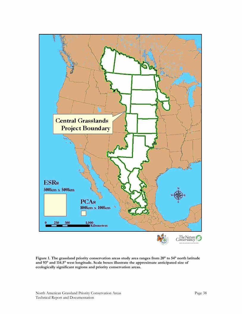
North American Grassland Priority Conservation Areas Page 38 Technical Report and Documentation
Figure 1. The grassland priority conservation areas study area ranges from 20° to 54° north latitude and 93° and 114.5° west longitude. Scale boxes illustrate the approximate anticipated size of ecologically significant regions and priority conservation areas.
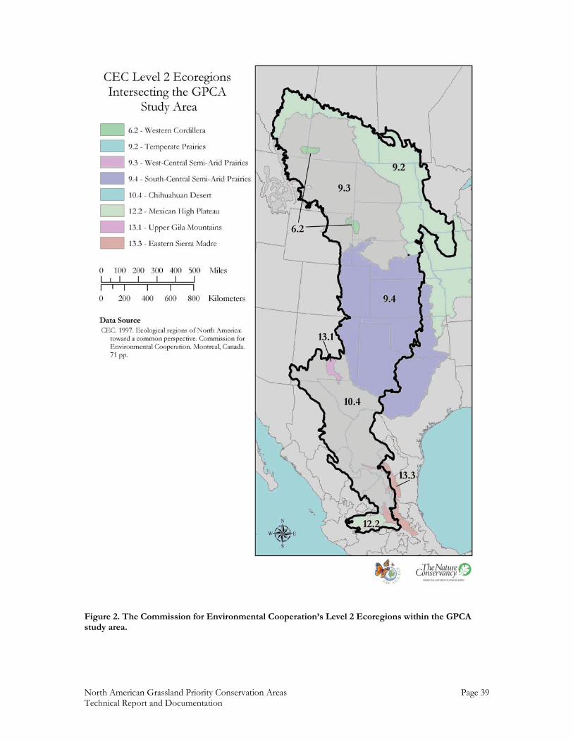
North American Grassland Priority Conservation Areas Page 39 Technical Report and Documentation
Figure 2. The Commission for Environmental Cooperation’s Level 2 Ecoregions within the GPCA study area.
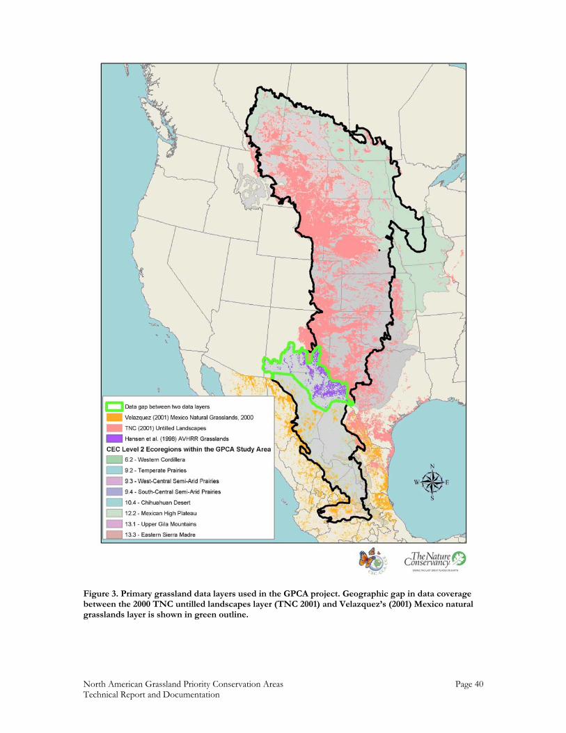
North American Grassland Priority Conservation Areas Page 40 Technical Report and Documentation
Figure 3. Primary grassland data layers used in the GPCA project. Geographic gap in data coverage between the 2000 TNC untilled landscapes layer (TNC 2001) and Velazquez’s (2001) Mexico natural grasslands layer is shown in green outline.
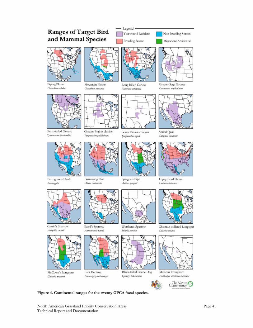
North American Grassland Priority Conservation Areas Page 41 Technical Report and Documentation
Figure 4. Continental ranges for the twenty GPCA focal species.
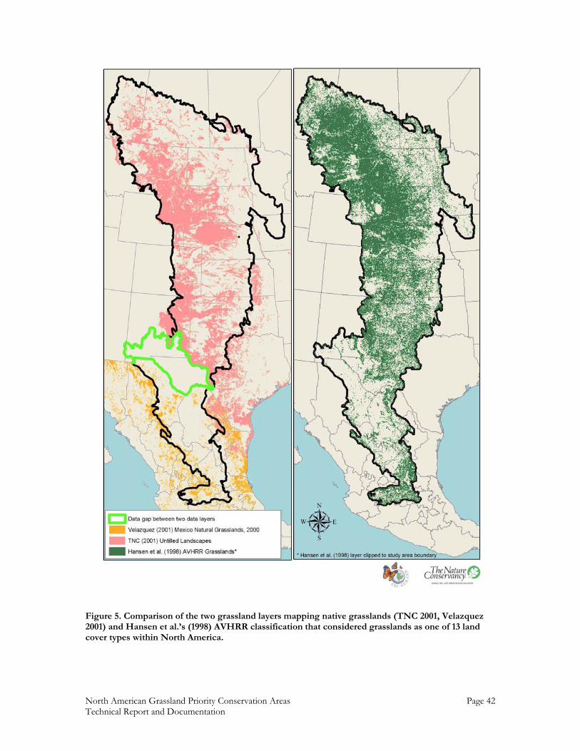
North American Grassland Priority Conservation Areas Page 42 Technical Report and Documentation
Figure 5. Comparison of the two grassland layers mapping native grasslands (TNC 2001, Velazquez 2001) and Hansen et al.’s (1998) AVHRR classification that considered grasslands as one of 13 land cover types within North America.
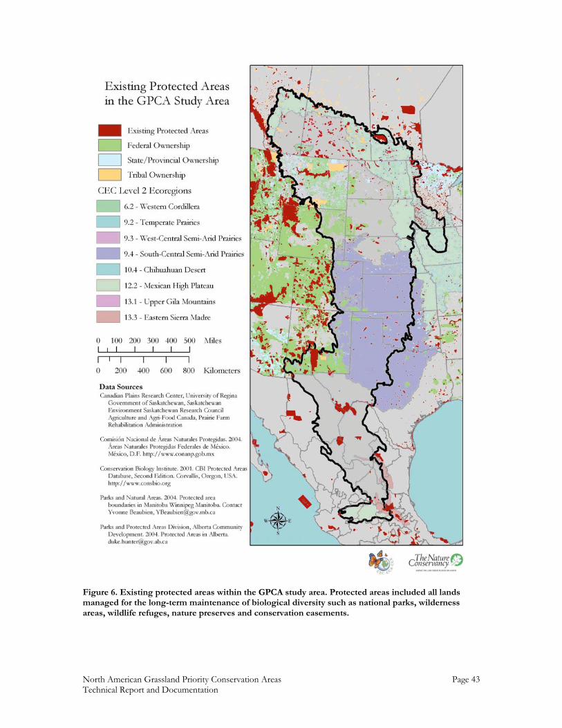
North American Grassland Priority Conservation Areas Page 43 Technical Report and Documentation
Figure 6. Existing protected areas within the GPCA study area. Protected areas included all lands managed for the long-term maintenance of biological diversity such as national parks, wilderness areas, wildlife refuges, nature preserves and conservation easements.
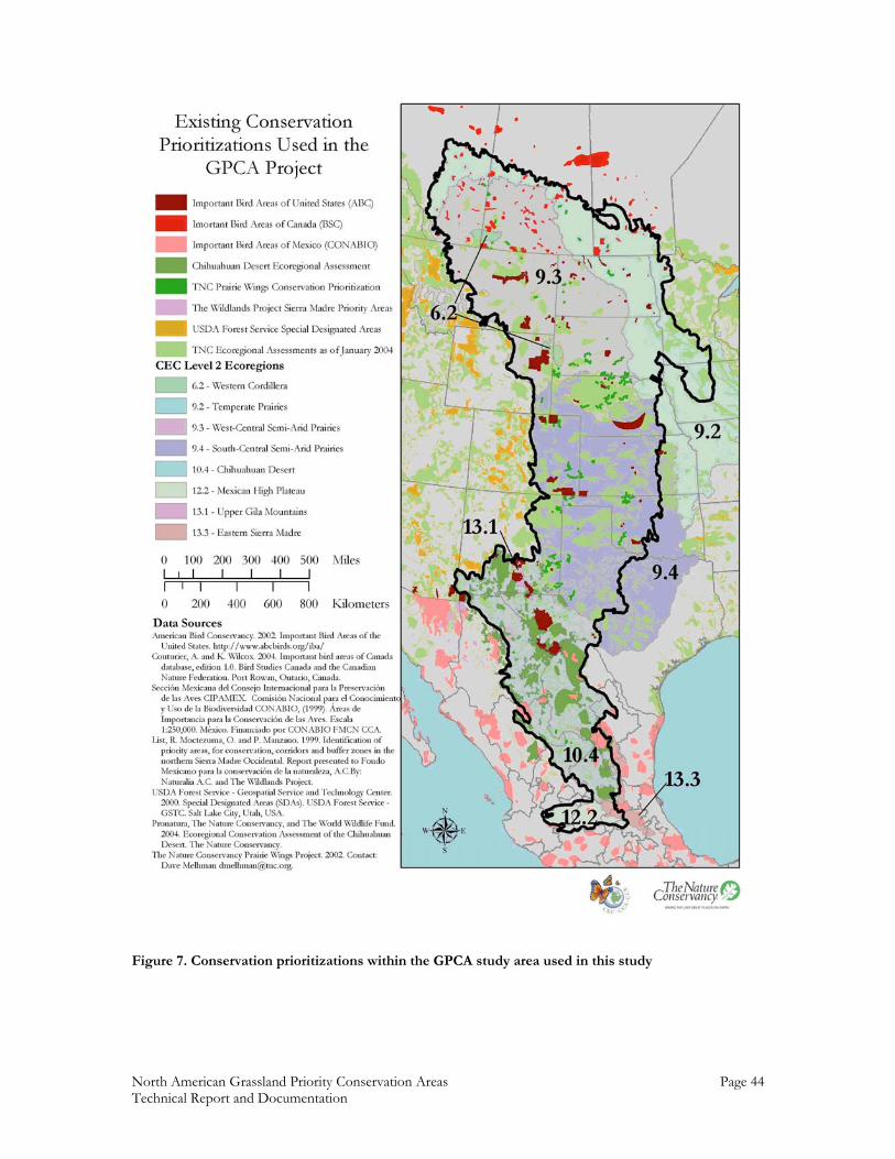
North American Grassland Priority Conservation Areas Page 44 Technical Report and Documentation
Figure 7. Conservation prioritizations within the GPCA study area used in this study
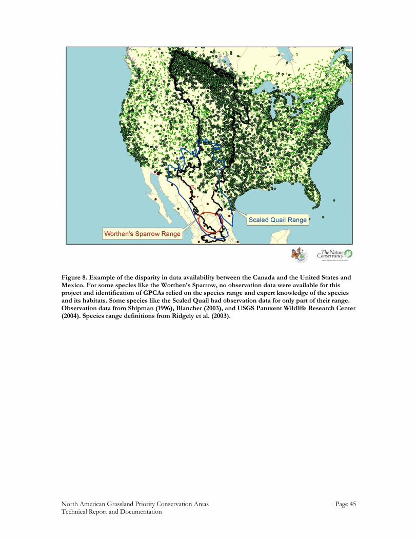
North American Grassland Priority Conservation Areas Page 45 Technical Report and Documentation
Figure 8. Example of the disparity in data availability between the Canada and the United States and Mexico. For some species like the Worthen’s Sparrow, no observation data were available for this project and identification of GPCAs relied on the species range and expert knowledge of the species and its habitats. Some species like the Scaled Quail had observation data for only part of their range. Observation data from Shipman (1996), Blancher (2003), and USGS Patuxent Wildlife Research Center (2004). Species range definitions from Ridgely et al. (2003).
Nor
th A
mer
ican
Gra
sslan
d Pr
iorit
y Co
nser
vatio
n A
reas
Page
46
Tech
nica
l Rep
ort a
nd D
ocum
enta
tion
F
igu
re 9
. Con
serv
atio
n in
tegr
ity
as r
epre
sen
ted
by
gras
slan
d a
rea
nor
mal
ized
by
nu
mb
er o
f p
atch
es. G
rass
lan
d a
rea
nor
mal
ized
by
nu
mb
er o
f p
atch
es
give
s th
e b
est
rep
rese
nta
tion
of
pat
ch s
ize
and
con
nec
tivi
ty. S
tati
stic
s on
gra
ssla
nd
fra
gmen
tati
on c
alcu
late
d f
rom
gra
ssla
nd
s as
def
ined
by
Han
sen
et
al.
(199
8).
Nor
th A
mer
ican
Gra
sslan
d Pr
iorit
y Co
nser
vatio
n A
reas
Page
47
Tech
nica
l Rep
ort a
nd D
ocum
enta
tion
F
igu
re 1
0. R
ich
nes
s of
foc
al s
pec
ies
ran
ges
for
a) a
ll fo
cal s
peci
es (
bre
edin
g an
d w
inte
r ra
nge
s fo
r b
ird
s), b
) b
reed
ing
ran
ges
of f
ocal
bir
d s
pec
ies,
an
d c
) w
inte
rin
g ra
nge
s fo
r fo
cal b
ird
sp
ecie
s. R
ich
nes
s ex
pre
ssed
in n
um
ber
of
spec
ies
co-o
ccu
rrin
g in
a g
iven
loca
tion
.
North American Grassland Priority Conservation Area Page 48 Technical Report and Documentation
A. All Species Richness B. Breeding Bird Species Richness C. Wintering Bird Species Richness Figure 11. Percent of each focal species richness category that existing priority areas cover for a) all focal species ranges, b) breeding focal bird ranges, and c) wintering focal bird ranges. For example, the priority areas compiled for this project account for approximately 6% of the area occupied by the highest richness (14 species) of wintering birds.
0.00%
5.00%
10.00%
15.00%
20.00%
25.00%
30.00%
35.00%
40.00%
45.00%
50.00%
1 2 3 4 5 6 7 8 9 10 11 12 13 14 15 16 17 18
Species Richness Categories
0.00%
5.00%
10.00%
15.00%
20.00%
25.00%
30.00%
35.00%
40.00%
45.00%
1 2 3 4 5 6 7 8 9 10 11 12
Species Richness Categories
0.00%
5.00%
10.00%
15.00%
20.00%
25.00%
30.00%
35.00%
40.00%
45.00%
50.00%
1 2 3 4 5 6 7 8 9 10 11 12 13 14
Species Richness Categories
North American Grassland Priority Conservation Area Page 49 Technical Report and Documentation
Figure 12. Overlap of ecologically significant regions (ESRs) from six thematically-arranged groups of workshop participants asked to identify ESRs across the entire study area based on their areas of expertise.
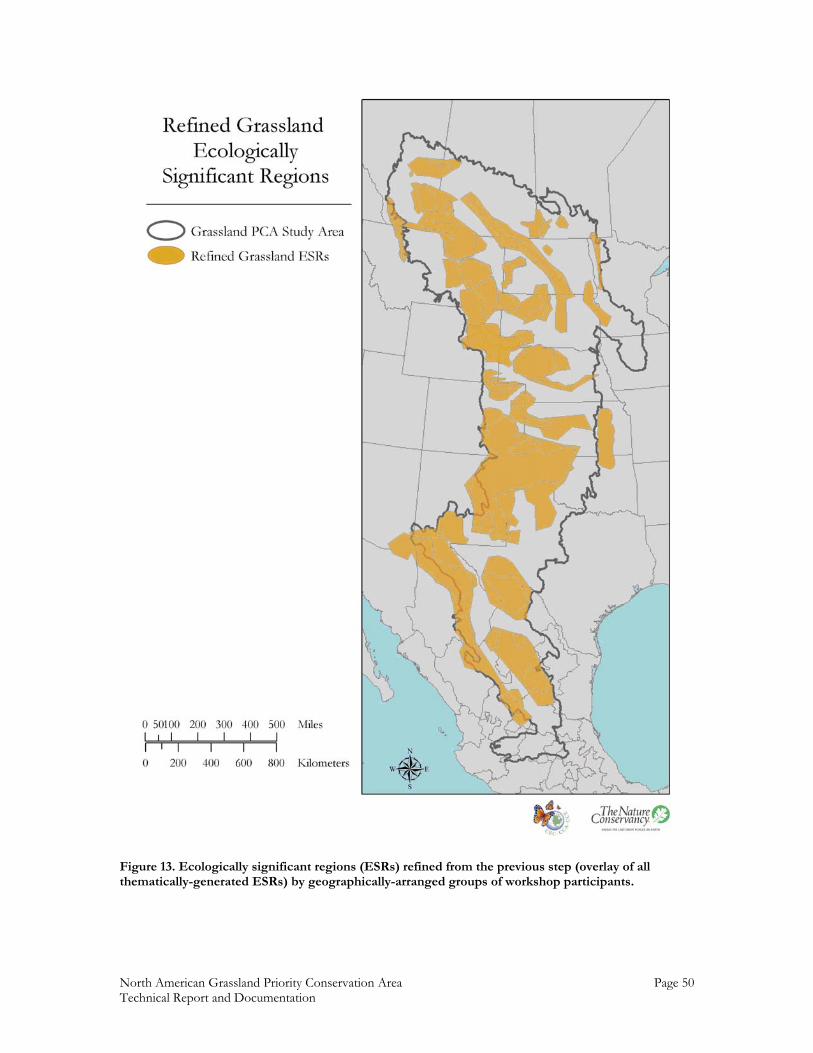
North American Grassland Priority Conservation Area Page 50 Technical Report and Documentation
Figure 13. Ecologically significant regions (ESRs) refined from the previous step (overlay of all thematically-generated ESRs) by geographically-arranged groups of workshop participants.
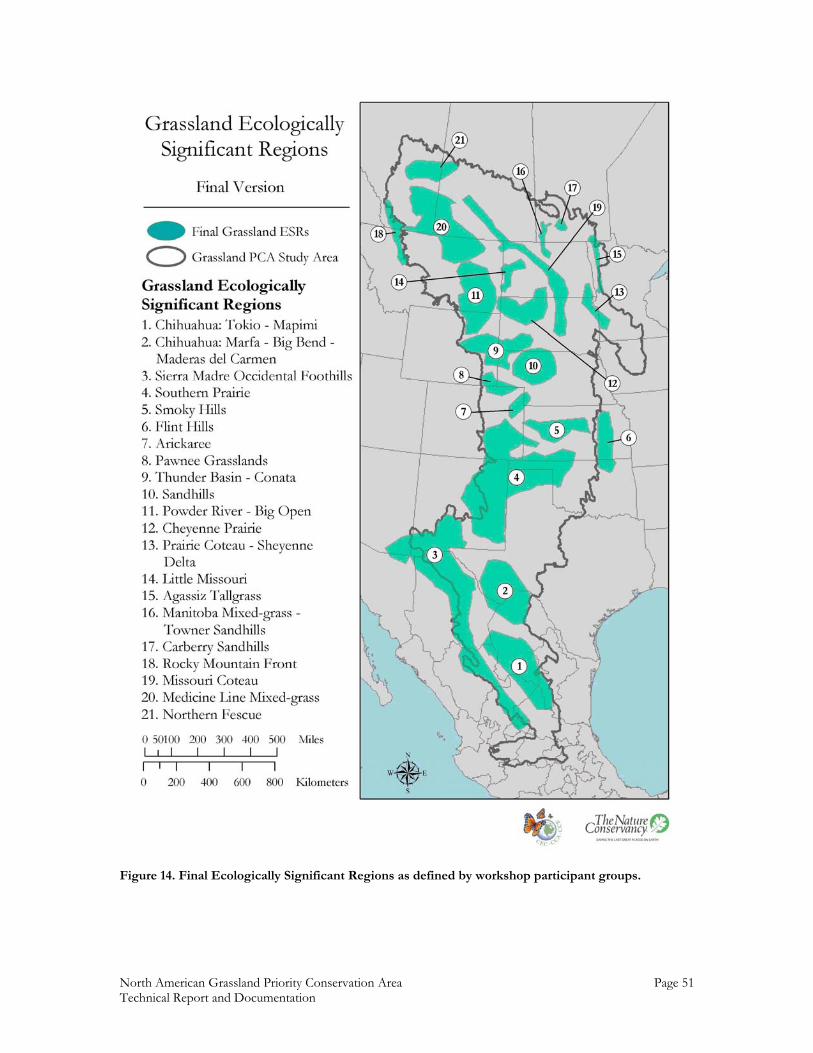
North American Grassland Priority Conservation Area Page 51 Technical Report and Documentation
Figure 14. Final Ecologically Significant Regions as defined by workshop participant groups.
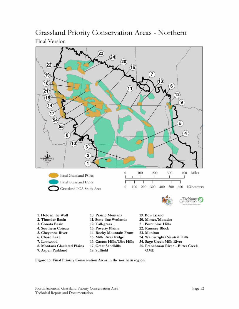
North American Grassland Priority Conservation Area Page 52 Technical Report and Documentation
1. Hole in the Wall 2. Thunder Basin 3. Conata Basin 4. Southern Coteau 5. Cheyenne River 6. Chase Lake 7. Lostwood 8. Montana Glaciated Plains 9. Aspen Parkland
10. Prairie Montana 11. State-line Wetlands 12. Tall-grass 13. Poverty Plains 14. Rocky Mountain Front 15. Milk River Ridge 16. Cactus Hills/Dirt Hills 17. Great Sandhills 18. Suffield
19. Bow Island 20. Monet/Matador 21. Porcupine Hills 22. Rumsey Block 23. Manitou 24. Wainwright/Neutral Hills 54. Sage Creek Milk River 55. Frenchman River – Bitter Creek OMB
Figure 15. Final Priority Conservation Areas in the northern region.
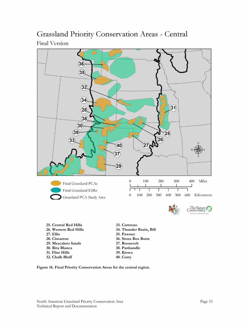
North American Grassland Priority Conservation Area Page 53 Technical Report and Documentation
25. Central Red Hills 26. Western Red Hills 27. Ellis 28. Cimarron 29. Mescalero Sands 30. Rita Blanca 31. Flint Hills 32. Chalk Bluff
33. Carrzozo 34. Thunder Basin, Bill 35. Pawnee 36. Sioux Box Butte 37. Roosevelt 38. Panhandle 39. Kiowa 40. Curry
Figure 16. Final Priority Conservation Areas for the central region.
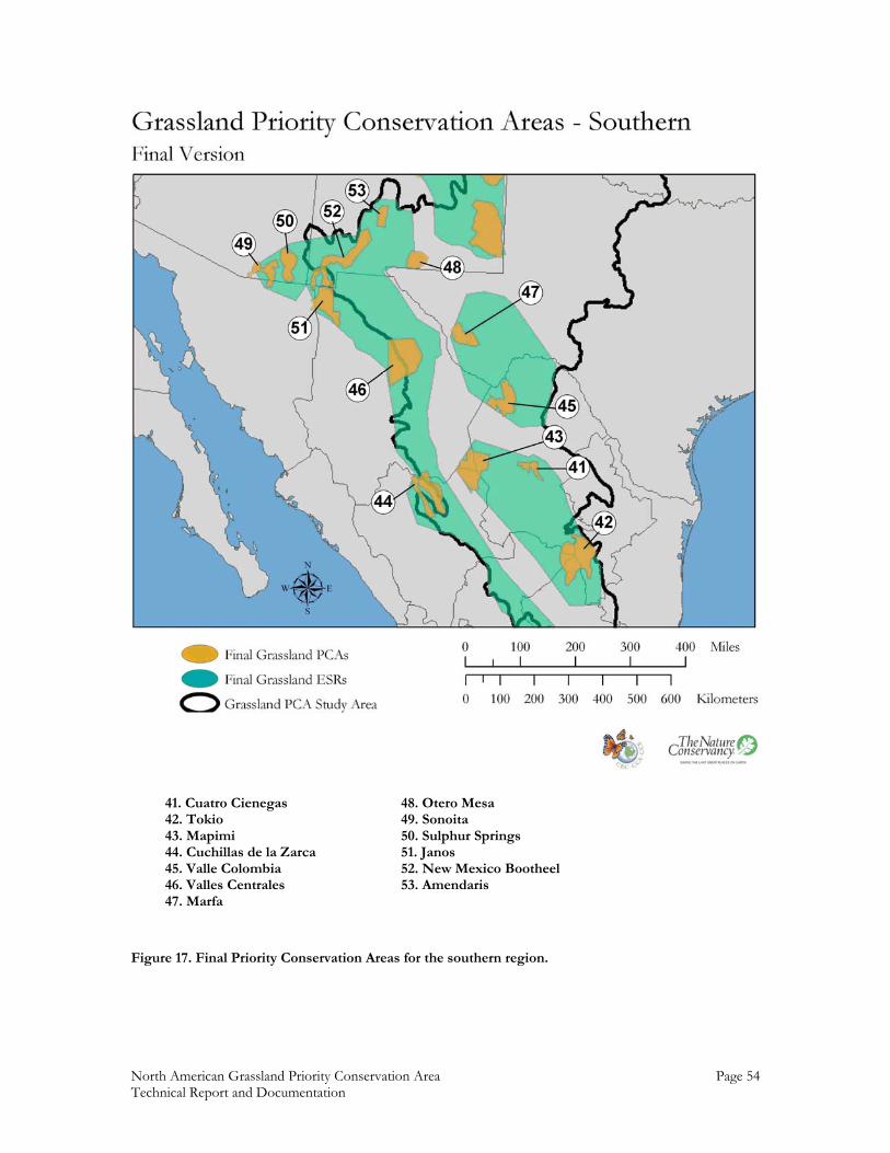
North American Grassland Priority Conservation Area Page 54 Technical Report and Documentation
41. Cuatro Cienegas 42. Tokio 43. Mapimi 44. Cuchillas de la Zarca 45. Valle Colombia 46. Valles Centrales 47. Marfa
48. Otero Mesa 49. Sonoita 50. Sulphur Springs 51. Janos 52. New Mexico Bootheel 53. Amendaris
Figure 17. Final Priority Conservation Areas for the southern region.
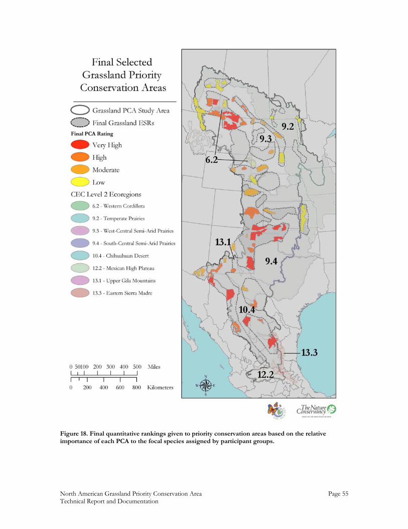
North American Grassland Priority Conservation Area Page 55 Technical Report and Documentation
Figure 18. Final quantitative rankings given to priority conservation areas based on the relative importance of each PCA to the focal species assigned by participant groups.

North American Grassland Priority Conservation Area Page 56 Technical Report and Documentation
Figure 19. Final priority conservation areas selected by workshop participant groups as the highest conservation priorities over the next five years.
Appe
ndix
A. A
vaila
ble
GIS
dat
a an
d so
urce
s for
the
gras
slan
d pr
iorit
y co
nser
vatio
n ar
eas w
orks
hop
Nor
th A
mer
ican
Gra
sslan
d Pr
iorit
y Co
nser
vatio
n A
reas
Page
57
Tech
nica
l Rep
ort a
nd D
ocum
enta
tion
Them
e D
escr
iptio
n La
yer N
ame
Sour
ce
App
roxi
mat
e Sc
ale
Den
omin
ator
Question 1. Ecological Significant Regions
Question 2. Priority Conservation Areas
Question 3. Assessment: status and Future
1. B
ase
Laye
rs
Bi
rd C
onse
rvat
ion
Regi
ons m
akin
g up
the
stud
y ar
ea b
ound
ary
Gra
sslan
d_PC
A_S
tudy
_Are
a_BC
Rs
2.3*
1,
000,
000
Gen
erali
zed
stud
y ar
ea b
ound
ary
Gra
sslan
d_PC
A_S
tudy
_Are
a 2.
3*
1,00
0,00
0
1k
m re
solu
tion
digi
tal e
leva
tion
mod
el
elev
atio
n 1.
2 2,
500,
000
1km
reso
lutio
n b/
w sh
aded
relie
f hi
ll_sh
d 1.
2 3,
000,
000
1km
reso
lutio
n pa
inte
d re
lief l
ayer
pa
int_
relie
f 1.
4 3,
000,
000
M
exico
M
ajor c
ities
of M
exico
M
ajor_
Citie
s 1.
2 1,
000,
000
Majo
r lak
es o
f Mex
ico
Majo
r_La
kes
1.2
3,00
0,00
0
M
ajor r
iver
s of M
exico
M
ajor_
Rive
rs
1.2
3,00
0,00
0
M
ajor r
oads
in M
exico
M
ajor_
Road
s 1.
2 1,
000,
000
Mex
ican
stat
es
Stat
es
1.2
3,00
0,00
0
M
exic
an m
unic
ipali
ties (
coun
ties)
with
199
6 po
pulat
ion
Mx_
mun
icip
alitie
s 1.
6 1,
000,
000
Det
ailed
rive
rs c
over
age
for M
exico
M
X_r
iver
s_CO
NA
BIO
1.
5 4,
000,
000
Ca
nada
D
etail
ed c
ities
and
tow
n po
ints
M
ediu
m C
ities
1.
2 1,
000,
000
Cana
da m
ajor c
ities
M
ajor_
Citie
s 1.
2 1,
000,
000
Majo
r roa
ds in
Can
ada
Majo
r_Ro
ads
1.2
1,50
0,00
0
Pr
ovin
cial
boun
darie
s Pr
ovin
ce
1.2
50,0
00
Ca
nada
railr
oad
lines
Ra
ilroa
d_Li
nes
1.2
4,00
0,00
0
Ca
nada
regi
onal
mun
icipa
lities
- co
unty
eq
uiva
lents
Re
gion
al_M
unici
palit
ies
1.2
50,0
00
M
ajor l
akes
and
oce
an
Wat
er
1.2
100,
000
Majo
r riv
ers o
f Can
ada
Cana
da_R
iver
s 1.
1 1,
000,
000
USA
U
S Co
unty
bou
ndar
ies w
ith p
opul
atio
n at
tribu
tes
coun
ties
1.2
3,00
0,00
0
D
etail
ed c
ities
and
tow
n po
ints
D
etail
ed_C
ities
1.
2 2,
000,
000
Det
ailed
lake
s and
rese
rvoi
rs
Det
ailed
_Lak
es
1.2
1,00
0,00
0
D
etail
ed ri
vers
and
can
als
Det
ailed
_Riv
ers
1.2
1,00
0,00
0
St
ate
rout
es, i
nter
stat
e ro
utes
and
hig
hway
s D
etail
ed_R
oads
1.
2 5,
000,
000
Appe
ndix
A. A
vaila
ble
GIS
dat
a an
d so
urce
s for
the
gras
slan
d pr
iorit
y co
nser
vatio
n ar
eas w
orks
hop
Nor
th A
mer
ican
Gra
sslan
d Pr
iorit
y Co
nser
vatio
n A
reas
Page
58
Tech
nica
l Rep
ort a
nd D
ocum
enta
tion
U
S hi
ghw
ays
Inte
rsta
tes
1.2
250,
000
US
majo
r citi
es
Majo
r_Ci
ties
1.2
250,
000
US
majo
r lak
es
Majo
r_La
kes
1.2
5,00
0,00
0
U
S m
ajor r
iver
s M
ajor_
Rive
rs
1.2
5,00
0,00
0
U
S m
ajor r
oads
M
ajor_
Road
s 1.
2 50
,000
US
stat
e bo
unda
ries
Stat
es
1.2
100,
000
2.
Eco
regi
on D
ata:
Leve
l 1 E
core
gion
s Le
vel1
_Eco
2.
2 3,
168,
000
Yes
Y
es
Yes
Leve
l 2 E
core
gion
s Le
vel2
_Eco
2.
2 3,
168,
000
Yes
Y
es
Yes
Leve
l 3 E
core
gion
s Le
vel3
_Eco
2.
2 3,
168,
000
Yes
Y
es
Yes
Bird
Con
serv
atio
n Re
gion
s Bi
rd_C
onse
rvat
ion_
Regi
ons
2.3
1,00
0,00
0Y
es
Yes
Y
es
TN
C E
core
gion
s for
the
US
TNC_
US_
Eco
regi
ons_
2001
2.
1 50
0,00
0Y
es
Yes
Y
es
Sa
skat
chew
an P
rairi
e ec
ozon
e sa
skat
chew
an_p
rairi
e_ec
ozon
e 2.
4 50
0,00
0Y
es
Yes
Y
es
Sa
skat
chew
an P
rairi
e ec
oreg
ions
sa
skat
chew
an_p
rairi
e_ec
oreg
ions
2.
4 50
0,00
0Y
es
Yes
Y
es
La
ndsc
ape
area
s in
the
Sask
atch
ewan
eco
zone
sa
skat
chew
an_p
rairi
e_lan
dsca
pe_a
reas
2.
4 50
0,00
0Y
es
Yes
Y
es
A
lber
ta n
atur
al su
breg
ions
gr
assla
nds_
natre
g 2.
5 50
0,00
0Y
es
Yes
Y
es
3. G
rass
land
Dat
a:
m
exic
o gr
assla
nd st
atus
circ
a 20
00
mx_
2000
Gra
sslan
ds
3.4
250,
000
Yes
mex
ico
gras
sland
stat
us c
irca
1976
m
x_19
76G
rass
lands
3.
4 25
0,00
0Y
es
co
mpa
rison
of m
exico
gra
sslan
d st
atus
from
19
76 to
200
0 m
x_19
76-2
000_
gras
sland
s_m
erge
3.
4 25
0,00
0Y
es
1k
m A
VH
RR L
and
Cove
r clas
sific
atio
n fo
r N
orth
Am
erica
na
_lnd
cov_
1km
3.
2 1,
000,
000
Yes
Unt
illed
land
scap
es la
yer f
or N
orth
Am
eric
a TN
C_U
ntill
ed_L
ands
cape
s 3.
1 25
0,00
0Y
es
Play
as a
s ide
ntifi
ed b
y th
e Pl
aya
Lake
s Joi
nt
Ven
ture
- co
verin
g th
e so
uthe
rn p
ortio
n of
BC
Rs 1
8 an
d 19
Pl
ayas
_Sou
th
3.3
24,0
00Y
es
Play
as a
s ide
ntifi
ed b
y th
e Pl
aya
Lake
s Joi
nt
Ven
ture
- co
verin
g th
e no
rther
n po
rtion
of
BCRs
18
and
19
Play
as_N
orth
3.
3 24
,000
Yes
N
ativ
e D
omin
ant G
rass
land
Laye
r for
Sa
sket
chew
an P
rairi
e E
cozo
ne
ndg6
0m
3.5
250,
000
Yes
A
lber
ta N
ativ
e Pr
ariri
e V
eget
atio
n by
1/4
se
ctio
n na
tpr_
75
3.6
100,
000
Yes
Alb
erta
Nat
ive
Plan
t Com
mm
uniti
es
albna
tveg
3.
7,3.
8 10
0,00
0Y
es
Y
es
4. O
wne
rshi
p D
ata
of P
rote
cted
Are
as
Pr
otec
ted
Are
as fr
om M
anito
ba a
nd
PAD
_Can
ada
4.1
100,
000
Y
es
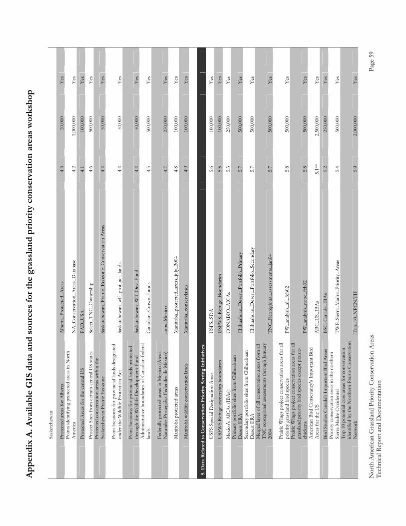
Appe
ndix
A. A
vaila
ble
GIS
dat
a an
d so
urce
s for
the
gras
slan
d pr
iorit
y co
nser
vatio
n ar
eas w
orks
hop
Nor
th A
mer
ican
Gra
sslan
d Pr
iorit
y Co
nser
vatio
n A
reas
Page
59
Tech
nica
l Rep
ort a
nd D
ocum
enta
tion
Sask
etch
ewan
Pr
otec
ted
area
s for
Alb
erta
A
lber
ta_P
rote
cted
_Are
as
4.3
20,0
00
Yes
Po
ints
iden
tifyi
ng p
rote
cted
are
as in
Nor
th
Am
erica
N
A_C
onse
rvat
ion_
Are
as_D
atab
ase
4.2
1,00
0,00
0
Yes
Pr
otec
ted
Are
as fo
r the
cen
tral U
S PA
D_U
SA
4.1
100,
000
Y
es
Proj
ect S
ites f
rom
cer
tain
cen
tral U
S st
ates
Se
lect
_TN
C_O
wne
rshi
p 4.
6 50
0,00
0
Yes
Pr
otec
ted
cons
erva
tion
area
s with
in th
e Sa
sket
chew
an P
rairi
e E
cozo
ne
Sask
atch
ewan
_Pra
irie_
Eco
zone
_Con
serv
atio
n A
reas
4.
4 50
,000
Y
es
Po
int l
ocat
ions
for p
rovi
ncial
land
s des
igna
ted
unde
r the
Wild
life
Prot
ectio
n A
ct
Sask
atch
ewan
_wlf_
prot
_act
_lan
ds
4.4
50,0
00
Yes
Po
int l
ocat
ions
for p
rovi
ncial
land
s pro
tect
ed
thro
ugh
the
Wild
life
Dev
elop
men
t Fun
d Sa
skat
chew
an_W
lf_D
ev_F
und
4.4
50,0
00
Yes
A
dmin
istra
tive
boun
darie
s of C
anad
ian fe
dera
l lan
ds
Cana
dian
_Cro
wn_
Land
s 4.
5 50
0,00
0
Yes
Fe
dera
lly p
rote
cted
are
as in
Mex
ico (Á
reas
N
atur
ales P
rote
gida
s Fed
erale
s de
Méx
ico)
anps
_Mex
ico
4.7
250,
000
Y
es
M
anito
ba p
rote
cted
are
as
Man
itoba
_pro
tect
ed_a
reas
_jul
y_20
04
4.8
100,
000
Y
es
M
anito
ba w
ildlif
e co
nser
vatio
n lan
ds
Man
itoba
_con
serv
lands
4.
9 10
0,00
0
Yes
5. D
ata
Rel
ated
to C
onse
rvat
ion
Prio
rity
Setti
ng In
itiat
ives
USF
S Sp
ecial
Des
igna
tion
Are
as
USF
S_SD
A
5.6
100,
000
Y
es
USF
WS
Refu
ge o
wne
rshi
p bo
unda
ries
USF
WS_
Refu
ge_B
ound
arie
s 5.
5 10
0,00
0
Yes
M
exic
o's A
ICA
s (IB
As)
CO
NA
BIO
_AIC
As
5.3
250,
000
Y
es
Pr
imar
y po
rtfol
io si
tes f
rom
Chi
huah
uan
Des
ert E
RA
Chih
uahu
an_D
eser
t_Po
rtfol
io_P
rimar
y 5.
7 50
0,00
0
Yes
Se
cond
ary
portf
olio
site
s fro
m C
hihu
ahua
n D
eser
t ERA
Ch
ihua
huan
_Des
ert_
Portf
olio
_Sec
onda
ry
5.7
500,
000
Y
es
Mer
ged
layer
of a
ll co
nser
vatio
n ar
eas f
rom
all
TNC
ecor
egio
nal a
sses
smen
ts th
roug
h Ja
nuar
y 20
04
TNC_
Eco
regi
onal_
asse
ssm
ents
_jan
04
5.7
500,
000
Y
es
Pr
airie
Win
gs p
roje
ct c
onse
rvat
ion
area
s for
all
prio
rity
gras
sland
bird
spec
ies
PW_a
nalys
is_all
_feb
02
5.8
500,
000
Y
es
Prair
ie W
ings
pro
ject
con
serv
atio
n ar
eas f
or a
ll gr
assla
nd p
riorit
y bi
rd sp
ecies
exc
ept p
rairi
e-ch
icke
ns
PW_a
naly
sis_n
opc_
feb0
2 5.
8 50
0,00
0
Yes
A
mer
ican
Bird
Con
seva
ncy's
Impo
rtant
Bird
A
reas
for t
he U
S A
BC_U
S_IB
As
5.1*
* 2,
500,
000
Y
es
Bird
Stu
dies
Can
ada's
Impo
rtant
Bird
Are
as
BSC_
Cana
da_I
BAs
5.2
250,
000
Y
es
Pr
iorit
y co
nser
vatio
n ar
eas i
n th
e no
rther
n Si
erra
Mad
re O
ccid
enta
l TW
P_Si
erra
_Mad
re_P
riorit
y_A
reas
5.
4 50
0,00
0
Yes
Top
10 p
oten
tial c
ore
area
s for
con
serv
atio
n id
entif
ied b
y th
e N
orth
ern
Prair
ie C
onse
rvat
ion
Net
wor
k To
p_10
_NPC
N.T
IF
5.9
2,00
0,00
0
Yes
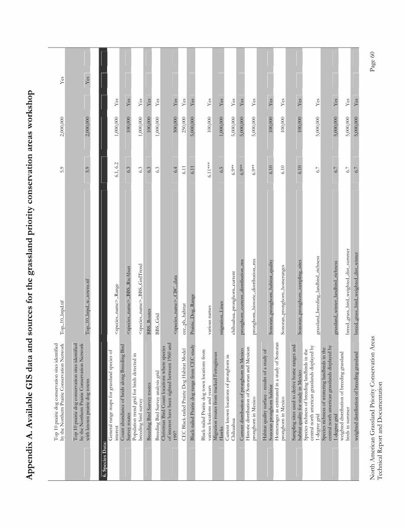
Appe
ndix
A. A
vaila
ble
GIS
dat
a an
d so
urce
s for
the
gras
slan
d pr
iorit
y co
nser
vatio
n ar
eas w
orks
hop
Nor
th A
mer
ican
Gra
sslan
d Pr
iorit
y Co
nser
vatio
n A
reas
Page
60
Tech
nica
l Rep
ort a
nd D
ocum
enta
tion
To
p 10
pra
irie
dog
cons
erva
tion
sites
iden
tifie
d by
the
Nor
ther
n Pr
airie
Con
serv
atio
n N
etw
ork
Top_
10_b
tpd.
tif
5.9
2,00
0,00
0
Yes
Top
10 p
rairi
e do
g co
nser
vatio
n sit
es id
entif
ied
by th
e N
orth
ern
Prair
ie Co
nser
vatio
n N
etw
ork
with
kno
wn
prair
ie d
og to
wns
To
p_10
_btp
d_w
_tow
ns.ti
f 5.
9 2,
000,
000
Y
es
6.
Spe
cies
Dat
a:
G
ener
al ra
nge
map
s for
gra
sslan
d sp
ecies
of
inte
rest
<
spec
ies_
nam
e>_R
ange
6.
1, 6
.2
1,00
0,00
0Y
es
Co
unt a
bund
ance
of b
rids a
long
Bre
edin
g Bi
rd
Surv
ey ro
utes
<
spec
ies_
nam
e>_B
BS_R
teA
bun
6.3
100,
000
Yes
Po
pulat
ion
trend
grid
for b
irds d
etec
ted
in
bree
ding
bird
surv
ey
<sp
ecie
s_na
me>
_BBS
_Grd
Tren
d 6.
3 1,
000,
000
Yes
Bree
ding
Bird
Sur
vey
rout
es
BBS_
Rout
es
6.3
100,
000
Yes
Bree
ding
Bird
Sur
vey
analy
sis g
rid
BBS_
Grid
6.
3 1,
000,
000
Yes
Chris
tmas
Bird
Cou
nt lo
catio
ns w
here
spec
ies
of in
tere
st h
ave
been
sigh
ted
betw
een
1960
and
19
97
<sp
ecie
s_na
me>
_CBC
_dat
a 6.
4 50
0,00
0Y
es
CE
C Bl
ack-
taile
d Pr
airie
Dog
Hab
itat M
odel
cec_
pb_h
abita
t 6.
11
250,
000
Yes
Blac
k-ta
iled
Prair
ie d
og ra
nge
from
CE
C st
udy
Prair
ie_D
og_R
ange
6.
11
5,00
0,00
0Y
es
Bl
ack-
taile
d Pr
airie
dog
tow
n lo
catio
ns fr
om
vario
us lo
catio
ns a
nd y
ears
va
rious
nam
es
6.11
***
100,
000
Yes
M
igra
tion
rout
es fr
om tr
acke
d Fe
rrug
inou
s H
awks
m
igra
tion_
Line
s 6.
5 1,
000,
000
Yes
Cu
rren
t kno
wn
loca
tions
of p
rong
horn
in
Chih
uahu
a ch
ihua
hua_
pron
ghor
n_cu
rren
t 6.
9**
5,00
0,00
0Y
es
Cu
rren
t dist
ribut
ion
of p
rong
horn
in M
exico
pr
ongh
orn_
curr
ent_
dist
ribut
ion_
mx
6.9*
* 5,
000,
000
Yes
H
istor
ic di
strib
utio
n of
Son
oran
and
Mex
ican
pr
ongh
orn
in M
exic
o pr
ongh
orn_
hist
oric
_dist
ribut
ion_
mx
6.9*
* 5,
000,
000
Yes
H
abita
t qua
lity
surf
ace
- res
ults
of a
stud
y of
So
nora
n pr
ongh
orn
habi
tat
Sono
ran_
pron
ghor
n_ha
bita
t_qu
ality
6.
10
100,
000
Yes
H
omer
ange
s as e
stim
ated
in a
stud
y of
Son
oran
pr
ongh
orn
in M
exic
o So
nora
n_pr
ongh
orn_
hom
eran
ges
6.10
10
0,00
0Y
es
Sa
mpl
ing
sites
use
d to
der
ive
hom
e ra
nges
and
ha
bita
t qua
lity
for s
tudy
in M
exico
So
nora
n_pr
ongh
orn_
sam
plin
g_sit
es
6.10
10
0,00
0Y
es
Spec
ies r
ichn
ess o
f bre
edin
g lan
dbird
s in
the
cent
ral n
orth
am
erica
n gr
assla
nds d
isplay
ed b
y 1-
degr
ee g
rid
gras
sland
_bre
edin
g_lan
dbird
_ric
hnes
s 6.
7 5,
000,
000
Yes
Spec
ies r
ichn
ess o
f win
terin
g lan
dbird
s in
the
cent
ral n
orth
am
erica
n gr
assla
nds d
isplay
ed b
y 1-
degr
ee g
rid
gras
sland
_win
ter_
landb
ird_r
ichn
ess
6.7
5,00
0,00
0Y
es
w
eigh
ted
dist
ribut
ion
of b
reed
ing
gras
sland
bi
rds i
n su
mm
er
bree
d_gr
ass_
bird
_weig
hted
_dist
_sum
mer
6.
7 5,
000,
000
Yes
wei
ghte
d di
strib
utio
n of
bre
edin
g gr
assla
nd
bree
d_gr
ass_
bird
_weig
hted
_dist
_win
ter
6.7
5,00
0,00
0Y
es
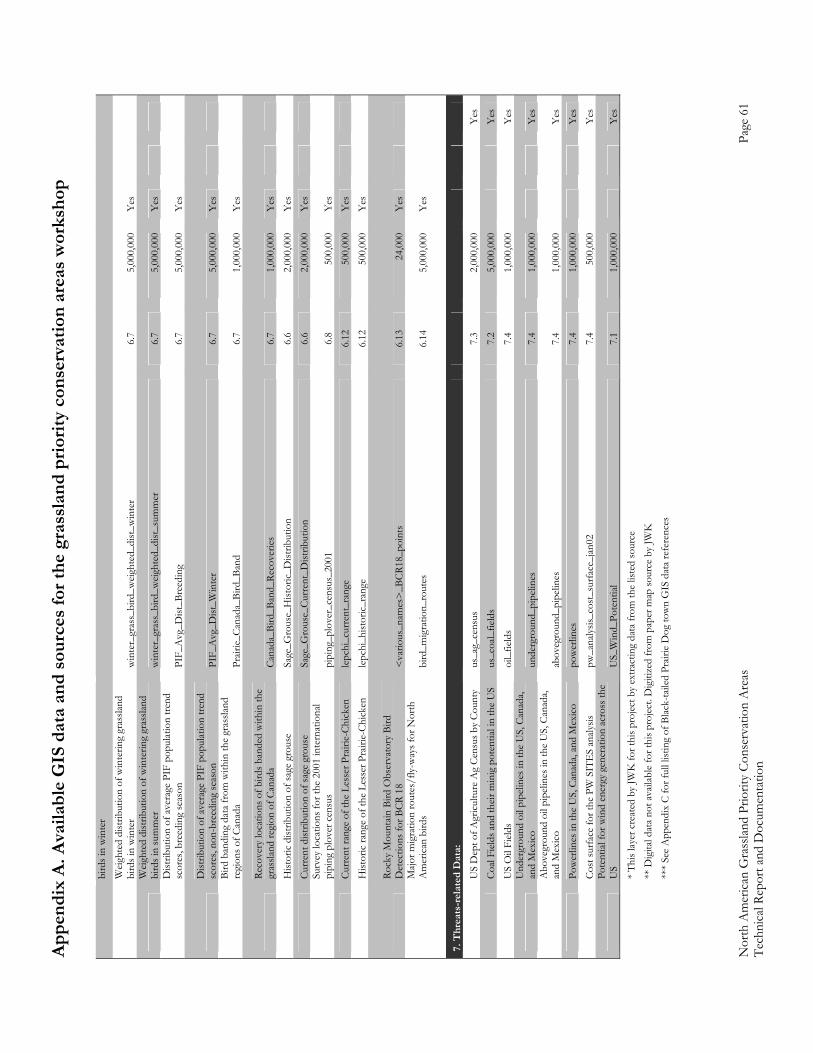
Appe
ndix
A. A
vaila
ble
GIS
dat
a an
d so
urce
s for
the
gras
slan
d pr
iorit
y co
nser
vatio
n ar
eas w
orks
hop
Nor
th A
mer
ican
Gra
sslan
d Pr
iorit
y Co
nser
vatio
n A
reas
Page
61
Tech
nica
l Rep
ort a
nd D
ocum
enta
tion
bird
s in
win
ter
W
eigh
ted
dist
ribut
ion
of w
inte
ring
gras
sland
bi
rds i
n w
inte
r w
inte
r_gr
ass_
bird
_weig
hted
_dist
_win
ter
6.7
5,00
0,00
0Y
es
W
eigh
ted
dist
ribut
ion
of w
inte
ring
gras
sland
bi
rds i
n su
mm
er
win
ter_
gras
s_bi
rd_w
eight
ed_d
ist_s
umm
er
6.7
5,00
0,00
0Y
es
D
istrib
utio
n of
ave
rage
PIF
pop
ulat
ion
trend
sc
ores
, bre
edin
g se
ason
PI
F_A
vg_D
ist_B
reed
ing
6.7
5,00
0,00
0Y
es
D
istrib
utio
n of
ave
rage
PIF
pop
ulat
ion
trend
sc
ores
, non
-bre
edin
g se
ason
PI
F_A
vg_D
ist_W
inte
r 6.
7 5,
000,
000
Yes
Bi
rd b
andi
ng d
ata
from
with
in th
e gr
assla
nd
regi
ons o
f Can
ada
Prair
ie_C
anad
a_Bi
rd_B
and
6.7
1,00
0,00
0Y
es
Re
cove
ry lo
catio
ns o
f bird
s ban
ded
with
in th
e gr
assla
nd re
gion
of C
anad
a Ca
nada
_Bird
_Ban
d_Re
cove
ries
6.7
1,00
0,00
0Y
es
H
istor
ic di
strib
utio
n of
sage
gro
use
Sage
_Gro
use_
Hist
oric
_Dist
ribut
ion
6.6
2,00
0,00
0Y
es
Cu
rren
t dist
ribut
ion
of sa
ge g
rous
e Sa
ge_G
rous
e_Cu
rren
t_D
istrib
utio
n 6.
6 2,
000,
000
Yes
Su
rvey
loca
tions
for t
he 2
001
inte
rnat
iona
l pi
ping
plo
ver c
ensu
s pi
ping
_plo
ver_
cens
us_2
001
6.8
500,
000
Yes
Curr
ent r
ange
of t
he L
esse
r Pra
irie-
Chic
ken
lepch
i_cu
rren
t_ra
nge
6.12
50
0,00
0Y
es
H
istor
ic ra
nge
of th
e Le
sser
Pra
irie-
Chic
ken
lepch
i_hi
stor
ic_ra
nge
6.12
50
0,00
0Y
es
Ro
cky
Mou
ntain
Bird
Obs
erva
tory
Bird
D
etec
tions
for B
CR 1
8 <
vario
us_n
ames
>_B
CR18
_poi
nts
6.13
24
,000
Yes
M
ajor m
igra
tion
rout
es/f
ly-w
ays f
or N
orth
A
mer
ican
bird
s bi
rd_m
igra
tion_
rout
es
6.14
5,
000,
000
Yes
7.
Thr
eats
-rel
ated
Dat
a:
U
S D
ept o
f Agr
icultu
re A
g Ce
nsus
by
Coun
ty
us_a
g_ce
nsus
7.
3 2,
000,
000
Yes
Coal
Field
s and
their
min
ig p
oten
tial i
n th
e U
S us
_coa
l_fie
lds
7.2
5,00
0,00
0
Y
es
U
S O
il Fi
elds
oi
l_fie
lds
7.4
1,00
0,00
0
Y
es
U
nder
grou
nd o
il pi
pelin
es in
the
US,
Can
ada,
and
Mex
ico
unde
rgro
und_
pipe
lines
7.
4 1,
000,
000
Yes
A
bove
grou
nd o
il pi
pelin
es in
the
US,
Can
ada,
and
Mex
ico
abov
egro
und_
pipe
lines
7.
4 1,
000,
000
Yes
Pow
erlin
es in
the
US,
Can
ada,
and
Mex
ico
pow
erlin
es
7.4
1,00
0,00
0
Y
es
Co
st su
rfac
e fo
r the
PW
SIT
ES
analy
sis
pw_a
nalys
is_co
st_s
urfa
ce_j
an02
7.
4 50
0,00
0
Y
es
Po
tent
ial fo
r win
d en
ergy
gen
erat
ion
acro
ss th
e U
S U
S_W
ind_
Pote
ntial
7.
1 1,
000,
000
Yes
*
This
layer
cre
ated
by
JWK
for t
his p
roje
ct b
y ex
tract
ing
data
from
the
liste
d so
urce
**
Dig
ital d
ata
not a
vaila
ble
for t
his p
rojec
t. D
igiti
zed
from
pap
er m
ap so
urce
by
JWK
**
* Se
e A
ppen
dix
C fo
r ful
l list
ing
of B
lack-
taile
d Pr
airie
Dog
tow
n G
IS d
ata
refe
renc
es
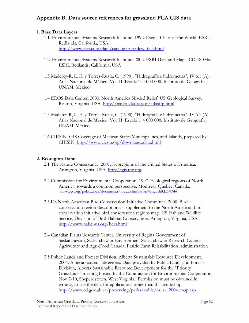
Appendix B. Data source references for grassland PCA GIS data
North American Grassland Priority Conservation Areas Page 62 Technical Report and Documentation
1. Base Data Layers: 1.1. Environmental Systems Research Institute. 1992. Digital Chart of the World. ESRI.
Redlands, California, USA. http://www.esri.com/data/catalog/esri/dcw_fact.html
1.2. Environmental Systems Research Institute: 2002. ESRI Data and Maps. CD-ROMs.
ESRI. Redlands, California, USA 1.3 Maderey-R, L. E. y Torres-Ruata, C. (1990), "Hidrografía e hidrometría", IV.6.1 (A).
Atlas Nacional de México. Vol. II. Escala 1: 4 000 000. Instituto de Geografía, UNAM. México.
1.4 EROS Data Center. 2003. North America Shaded Relief. US Geological Survey.
Reston, Virginia, USA. http://nationalatlas.gov/atlasftp.html 1.5 Maderey-R, L. E. y Torres-Ruata, C. (1990), "Hidrografía e hidrometría", IV.6.1 (A).
Atlas Nacional de México. Vol. II. Escala 1: 4 000 000. Instituto de Geografía, UNAM. México.
1.6 CIESIN. GIS Coverage of Mexican States,Municipalities, and Islands, prepared by
CIESIN. http://www.ciesin.org/download_data.html 2. Ecoregion Data:
2.1 The Nature Conservancy. 2001. Ecoregions of the United States of America. Arlington, Virginia, USA. http://gis.tnc.org
2.2 Commission for Environmental Cooperation. 1997. Ecological regions of North
America: towards a common perspective. Montreal, Quebec, Canada. www.cec.org/pubs_docs/documents/index.cfm?varlan=english&ID=344
2.3 US North American Bird Conservation Initiative Committee. 2000. Bird
conservation region descriptions: a supplement to the North American bird conservation initiative bird conservation regions map. US Fish and Wildlife Service, Devision of Bird Habitat Conservation. Arlington, Virginia, USA. http://www.nabci-us.org/bcrs.html
2.4 Canadian Plains Research Center, University of Regina Government of
Saskatchewan, Saskatchewan Environment Saskatchewan Research Council Agriculture and Agri-Food Canada, Prairie Farm Rehabilitation Administration
2.5 Public Lands and Forests Division, Alberta Sustainable Resource Development.
2004. Alberta natural subregions. Data provided by Public Lands and Forests Division, Alberta Sustainable Resource Development for the "Priority Grasslands" meeting hosted by the Commission for Environmental Cooperation, Nov 7-10, Sheperdstown, West Virginia. Permission must be obtained in writing, to use the data for applications other than this workshop. http://www.cd.gov.ab.ca/preserving/parks/anhic/nr_sr_2004_map.asp
Appendix B. Data source references for grassland PCA GIS data
North American Grassland Priority Conservation Areas Page 63 Technical Report and Documentation
3. Grassland Data:
3.1 The Nature Conservancy. 2001. Untilled Landscapes of the Great Plains Bioregion. The Nature Conservancy’s Midwest Regional Office. Minneapolis, Minnesota, USA.
3.2 Hansen, M., DeFries, R., Townshend, J. R. G. and Sohlberg, R.. 1998. 1 Km Land
Cover Classification Derived from AVHRR. College Park, Maryland: The Global Land Cover Facility. http://glcf.umiacs.umd.edu/data/landcover/
3.3 Playa Lakes Joint Venture. 2004. Playas GIS data. US Fish and Wildlife Service,
Grand Island, Nebraska, USA. 3.4 Velazquez, A. 2001. Situacion de Mexico con respecto a la conservacion de los
pastizales abiertos: mapas. Comision de Cooperacion Ambiental (CEC). Universidad Nacional Autonoma de Mexico.
3.5 Canadian Plains Research Center, University of Regina Government of
Saskatchewan, Saskatchewan Environment Saskatchewan Research Council Agriculture and Agri-Food Canada, Prairie Farm Rehabilitation Administration
3.6 Alberta Prairie Conservation Forum. 2004. Alberta native prairie vegetation coverage.
Alberta natural subregions. Data provided by Public Lands and Forests Division, Alberta Sustainable Resource Development for the "Priority Grasslands" meeting hosted by the Commission for Environmental Cooperation, Nov 7-10, Sheperdstown, West Virginia. Permission must be obtained in writing, to use the data for applications other than this workshop. http://www.albertapcf.ab.ca/background.htm
3.7 LandWise Inc., 1998. Soil series and Soil Landscape Model correlation for SCAs 1, 2,
3, 4, 5, 6, 8 and 16. Prepared for Alberta Public Lands. Lethbridge, Alberta. Data provided by Public Lands and Forests Division, Alberta Sustainable Resource Development for the "Priority Grasslands" meeting hosted by the Commission for Environmental Cooperation, Nov 7-10, Sheperdstown, West Virginia. Permission must be obtained in writing, to use the data for applications other than this workshop.
3.8 McNeil, R.L., 2003. Ecological/range sites and potential plant communities of
southern Alberta, derived from AGRASID 3.0. Prepared by LandWise Inc. for the Integrated Resource Management Branch, Alberta Environment. Data provided by Public Lands and Forests Division, Alberta Sustainable Resource Development for the "Priority Grasslands" meeting hosted by the Commission for Environmental Cooperation, Nov 7-10, Sheperdstown, West Virginia. Permission must be obtained in writing, to use the data for applications other than this workshop.
4. Ownership Data:
Appendix B. Data source references for grassland PCA GIS data
North American Grassland Priority Conservation Areas Page 64 Technical Report and Documentation
4.1 Conservation Biology Institute. 2001. CBI Protected Areas Database, Second Edition. Corvallis, Oregon, USA. http://www.consbio.org
4.2 ERIN Consulting Ltd. 2000. North American Conservation Areas Database. Regina,
Saskatchewan, Canada. http://gogratis.cgdi.gc.ca/download/north_america_cad 4.3 Parks and Protected Areas Division, Alberta Community Development. 2004.
Protected Areas in Alberta. [email protected] 4.4 Canadian Plains Research Center, University of Regina Government of
Saskatchewan, Saskatchewan Environment Saskatchewan Research Council Agriculture and Agri-Food Canada, Prairie Farm Rehabilitation Administration
4.5 Surveys Division, Geomatics Canada, Natural Resources Canada. 2004. National
Framework Canada Lands Administrative Boundaries Level 1. http://geogratis.cgdi.gc.ca/clf/en?action=geobase
4.6 The Nature Conservancy Prairie Wings Project. 2002. Contact: Dave Melhman
4.7 Comisión Nacional de Áreas Naturales Protegidas. 2004. Áreas Naturales Protegidas
Federales de México. México, D.F. http://www.conanp.gob.mx 4.8 Parks and Natural Areas. 2004. Protected area boundaries in Manitoba Winnipeg
Manitoba. Contact Yvonne Beaubien, [email protected] 4.9 Manitoba Department of Conservation, Wildlife Branch. 1997. Manitoba
administrative boundaries. Winnipeg, Manitoba. Contact Dan Teillet, [email protected]
5. Priority Conservation Areas Data:
5.1 American Bird Conservancy. 2002. Important Bird Areas of the United States. http://www.abcbirds.org/iba/
5.2 Couturier, A. and K. Wilcox. 2004. Important bird areas of Canada database, edition
1.0. Bird Studies Canada and the Canadian Nature Federation. Port Rowan, Ontario, Canada.
5.3 Sección Mexicana del Consejo Internacional para la Preservación de las Aves
CIPAMEX – Comisión Nacional para el Conocimiento y Uso de la Biodiversidad CONABIO, (1999). “Áreas de Importancia para la Conservación de las Aves”. Escala 1:250 000. México. Financiado por CONABIO–FMCN–CCA.
5.4 List, R. Moctezuma, O. and P. Manzano. 1999. Identification of priority areas, for
conservation, corridors and buffer zones in the northern Sierra Madre
Appendix B. Data source references for grassland PCA GIS data
North American Grassland Priority Conservation Areas Page 65 Technical Report and Documentation
Occidental. Report presented to Fondo Mexicano para la conservación de la naturaleza, A.C.By: Naturalia A.C. and The Wildlands Project.
5.5 USFWS, Region 9, Information Technology Management, Branch of Data and
Systems Services. 2001. USFWS, Revised Refuge Boundaries (Interactive mapping version). http://www.fws.gov/data/gishome.html
5.6 USDA Forest Service – Geospatial Service and Technology Center. 2000. Special
Designated Areas (SDAs). USDA Forest Service – GSTC. Salt Lake City, Utah, USA.
5.7 Pronatura, The Nature Conservancy, and The World Wildlife Fund. 2004.
Ecoregional Conservation Assessment of the Chihuahuan Desert. The Nature Conservancy.
5.8 The Nature Conservancy Prairie Wings Project. 2002. Contact: Dave Melhman
[email protected]. 5.9 Forrest, S.C., H. Strand, W.H. Haskins, C. Freese, J. Proctor and E. Dinerstein. 2004.
Ocean of Grass:A Conservation Assessment for the Northern Great Plains. Northern Plains Conservation Network and Northern Great Plains Ecoregion, WWF-US, Bozeman, MT.
6. Species Data:
6.1 Ridgely, R. S., T. F. Allnutt, T. Brooks, D. K. McNicol, D. W. Mehlman, B. E. Young, and J. R. Zook. 2003. Digital Distribution Maps of the Birds of the Western Hemisphere, version 1.0. NatureServe, Arlington, Virginia, USA. Data provided by NatureServe in collaboration with Robert Ridgely, James Zook, The Nature Conservancy ― Migratory Bird Program, Conservation International ― Center for Applied Biodiversity Science, World Wildlife Fund ― US, and Environment Canada ― WILDSPACE.
6.2 Patterson, B. D., G. Ceballos, W. Sechrest, M. F. Tognelli, T. Brooks, L. Luna, P. Ortega, I. Salazar, and B. E. Young. 2003. Digital Distribution Maps of the Mammals of the Western Hemisphere, version 1.0. NatureServe, Arlington, Virginia, USA. Data provided by NatureServe in collaboration with Bruce Patterson, Wes Sechrest, Marcelo Tognelli, Gerardo Ceballos, The Nature Conservancy – Migratory Bird Program, Conservation International – CABS, World Wildlife Fund – US, and Environment Canada – WILDSPACE
6.3 USGS Patuxent Wildlife Research Center. 2004. The North American Breeding Bird
Survey, Route level Data Summaries 1966 - 2003. Version 2004.1. Laurel, MD, USA.
Appendix B. Data source references for grassland PCA GIS data
North American Grassland Priority Conservation Areas Page 66 Technical Report and Documentation
http://www.pwrc.usgs.gov/bbs/geographic_information/geographic_information_products.htm
6.4 Shipman, J.W. 1996. A Christmas Bird Count Database, Version 4.0. Zoological Data
Processing. Socorro, NM. http://www.nmt.edu/~john/ 6.5 Watson, J.W., and U. Banasch. 2004. A Tri-National investigation of ferruginous
hawk migration. Progress Report 1. Washington Department of Fish and Wildlife, Olympia, Washington, USA and Canadian Wildlife Service, Edmonton, Alberta , Canada.
6.6 Schroeder, M. A., et al. 2004. Distribution of Sage-grouse in North America. Condor
106:363-376.
6.7 Blancher, P. 2003. Importance of North America’s grasslands to birds. Report to the Commission for Environmental Cooperation. Montreal, Ouebec.
6.8 Ferland, C.L. and S.M. Haig. 2002. 2001 International Piping Plover Census.U.S.
Geological Survey, Forest and Rangeland Ecosystem Science Center, Corvallis, Oregon. 293 pp.
6.9 Valdés, M. and Manterola, C. In press. "El Berrendo en Chihuahua". Unidos para la
Conservacion, A.C. 6.10 Instituto del Medio Ambiente y Desarrollo Sustentable del Estado de Sonora
(IMADES), (2000). “Evaluación del ámbito hogareño del Berrendo sonorense (Antilocapra americana sonoriensis)”. Extraído del proyecto L112 Evaluación del ámbito hogareño y calidad del hábitat del Borrego cimarrón (Ovis canadensis mexicana), Berrendo sonorense (Antilocapra americana sonoriensis) y Puma (Felis concolor) en la Reserva de la Biosfera El Pinacate y Gran Desierto de Altar. Escala 1:50 000. López Saavedra, Eduardo y Paredes Aguilar, Rafaela. México. El proyecto fue financiado por la Comisión Nacional para el Conocimiento y Uso de la Biodiversidad (CONABIO).
6.11 Proctor, J.D, B. Haskins, and S.C. Forrest. In Press. Focal areas for conservation of
prairie dogs and the grassland ecosystem. In Hoogland, J. (ed). Conservation and management of prairie dogs.
6.12 Data obtained from Stephanie Harmon, US Fish and Wildlife Service.
[email protected]. 6.13 Hanni, D. J., and M. McLachlan. 2004. Section-based Monitoring of Breeding Birds
within the Shortgrass Prairie Bird Conservation Region (BCR 18). Brighton, CO: Rocky Mountain Bird Observatory. 178 pp.
6.14 Data obtained from Ed Wikken, Wildlife Habitat Canada, [email protected].
Source unknown.
Appendix B. Data source references for grassland PCA GIS data
North American Grassland Priority Conservation Areas Page 67 Technical Report and Documentation
7. Threats-related Data:
7.1 Elliot, D.L., C.G. Holladay, W.R. Barchet, H.P. Foote, and W.F. Sandusky. 1986. Wind energy resources of the United States. U.S. Department of Energy, Pacific National Laboratory. Richland, Washington, USA.
7.2 Tully, J. 2001. Coal fields of the United States. US Geological Survey Eastern Energy
Team. Reston, Virginia, USA. http://www.nationalatlas.gov 7.3 U.S. Geological Survey. 2000. Agricultural census of the United States. US
Geological Survey. Reston, Virginia, USA. http://www.nationalatlas.gov 7.4 The Nature Conservancy Prairie Wings Project. 2002. Contact: Dave Melhman
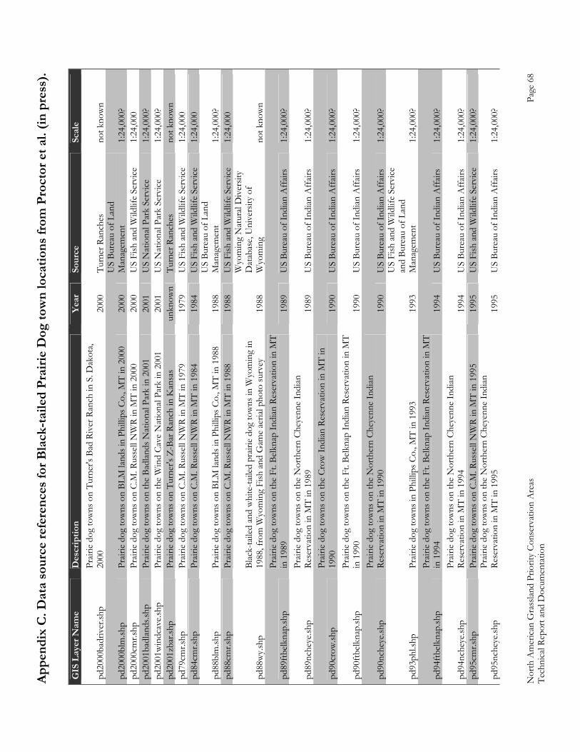
Appe
ndix
C. D
ata
sour
ce re
fere
nces
for B
lack
-taile
d Pr
airie
Dog
tow
n lo
catio
ns fr
om P
roct
or e
t al.
(in p
ress
).
Nor
th A
mer
ican
Gra
sslan
d Pr
iorit
y Co
nser
vatio
n A
reas
Page
68
Tech
nica
l Rep
ort a
nd D
ocum
enta
tion
GIS
Lay
er N
ame
Des
crip
tion
Year
So
urce
Sc
ale
pd20
00ba
driv
er.sh
p Pr
airie
dog
tow
ns o
n Tu
rner
's Ba
d Ri
ver R
anch
in S
. Dak
ota,
2000
20
00
Turn
er R
anch
es
not k
now
n
pd20
00bl
m.sh
p Pr
airie
dog
tow
ns o
n BL
M la
nds i
n Ph
illip
s Co.
, MT
in 2
000
2000
U
S Bu
reau
of L
and
Man
agem
ent
1:24
,000
? pd
2000
cmr.s
hp
Prair
ie do
g to
wns
on
C.M
. Rus
sell
NW
R in
MT
in 2
000
2000
U
S Fi
sh a
nd W
ildlif
e Se
rvice
1:
24,0
00
pd20
01ba
dlan
ds.sh
p Pr
airie
dog
tow
ns o
n th
e Ba
dlan
ds N
atio
nal P
ark
in 2
001
2001
U
S N
atio
nal P
ark
Serv
ice
1:24
,000
? pd
2001
win
dcav
e.shp
Pr
airie
dog
tow
ns o
n th
e W
ind
Cave
Nat
iona
l Par
k in
200
1 20
01
US
Nat
iona
l Par
k Se
rvice
1:
24,0
00?
pd20
01zb
ar.sh
p Pr
airie
dog
tow
ns o
n Tu
rner
's Z
-Bar
Ran
ch in
Kan
sas
unkn
own
Turn
er R
anch
es
not k
now
n pd
79cm
r.shp
Pr
airie
dog
tow
ns o
n C.
M. R
usse
ll N
WR
in M
T in
197
9 19
79
US
Fish
and
Wild
life
Serv
ice
1:24
,000
pd
84cm
r.shp
Pr
airie
dog
tow
ns o
n C.
M. R
usse
ll N
WR
in M
T in
198
4 19
84
US
Fish
and
Wild
life
Serv
ice
1:24
,000
pd88
blm
.shp
Prair
ie do
g to
wns
on
BLM
land
s in
Phill
ips C
o., M
T in
198
8 19
88
US
Bure
au o
f Lan
d M
anag
emen
t 1:
24,0
00?
pd88
cmr.s
hp
Prair
ie do
g to
wns
on
C.M
. Rus
sell
NW
R in
MT
in 1
988
1988
U
S Fi
sh a
nd W
ildlif
e Se
rvice
1:
24,0
00
pd88
wy.s
hp
Blac
k-ta
iled
and
whi
te-ta
iled
prair
ie do
g to
wns
in W
yom
ing
in
1988
, fro
m W
yom
ing
Fish
and
Gam
e ae
rial p
hoto
surv
ey
1988
Wyo
min
g N
atur
al D
iver
sity
Dat
abas
e, U
nive
rsity
of
Wyo
min
g no
t kno
wn
pd89
ftbelk
nap.
shp
Prair
ie do
g to
wns
on
the
Ft. B
elkna
p In
dian
Res
erva
tion
in M
T in
198
9 19
89
US
Bure
au o
f Ind
ian A
ffairs
1:
24,0
00?
pd89
nche
ye.sh
p Pr
airie
dog
tow
ns o
n th
e N
orth
ern
Chey
enne
Indi
an
Rese
rvat
ion
in M
T in
198
9 19
89
US
Bure
au o
f Ind
ian A
ffairs
1:
24,0
00?
pd90
crow
.shp
Prair
ie do
g to
wns
on
the
Crow
Indi
an R
eser
vatio
n in
MT
in
1990
19
90
US
Bure
au o
f Ind
ian A
ffairs
1:
24,0
00?
pd90
ftbelk
nap.
shp
Prair
ie do
g to
wns
on
the
Ft. B
elkna
p In
dian
Res
erva
tion
in M
T in
199
0 19
90
US
Bure
au o
f Ind
ian A
ffairs
1:
24,0
00?
pd90
nche
ye.sh
p Pr
airie
dog
tow
ns o
n th
e N
orth
ern
Chey
enne
Indi
an
Rese
rvat
ion
in M
T in
199
0 19
90
US
Bure
au o
f Ind
ian A
ffairs
1:
24,0
00?
pd93
phl.s
hp
Prair
ie do
g to
wns
in P
hilli
ps C
o., M
T in
199
3 19
93
US
Fish
and
Wild
life
Serv
ice
and
Bure
au o
f Lan
d M
anag
emen
t 1:
24,0
00?
pd94
ftbelk
nap.
shp
Prair
ie do
g to
wns
on
the
Ft. B
elkna
p In
dian
Res
erva
tion
in M
T in
199
4 19
94
US
Bure
au o
f Ind
ian A
ffairs
1:
24,0
00?
pd94
nche
ye.sh
p Pr
airie
dog
tow
ns o
n th
e N
orth
ern
Chey
enne
Indi
an
Rese
rvat
ion
in M
T in
199
4 19
94
US
Bure
au o
f Ind
ian A
ffairs
1:
24,0
00?
pd95
cmr.s
hp
Prair
ie do
g to
wns
on
C.M
. Rus
sell
NW
R in
MT
in 1
995
1995
U
S Fi
sh a
nd W
ildlif
e Se
rvice
1:
24,0
00?
pd95
nche
ye.sh
p Pr
airie
dog
tow
ns o
n th
e N
orth
ern
Chey
enne
Indi
an
Rese
rvat
ion
in M
T in
199
5 19
95
US
Bure
au o
f Ind
ian A
ffairs
1:
24,0
00?
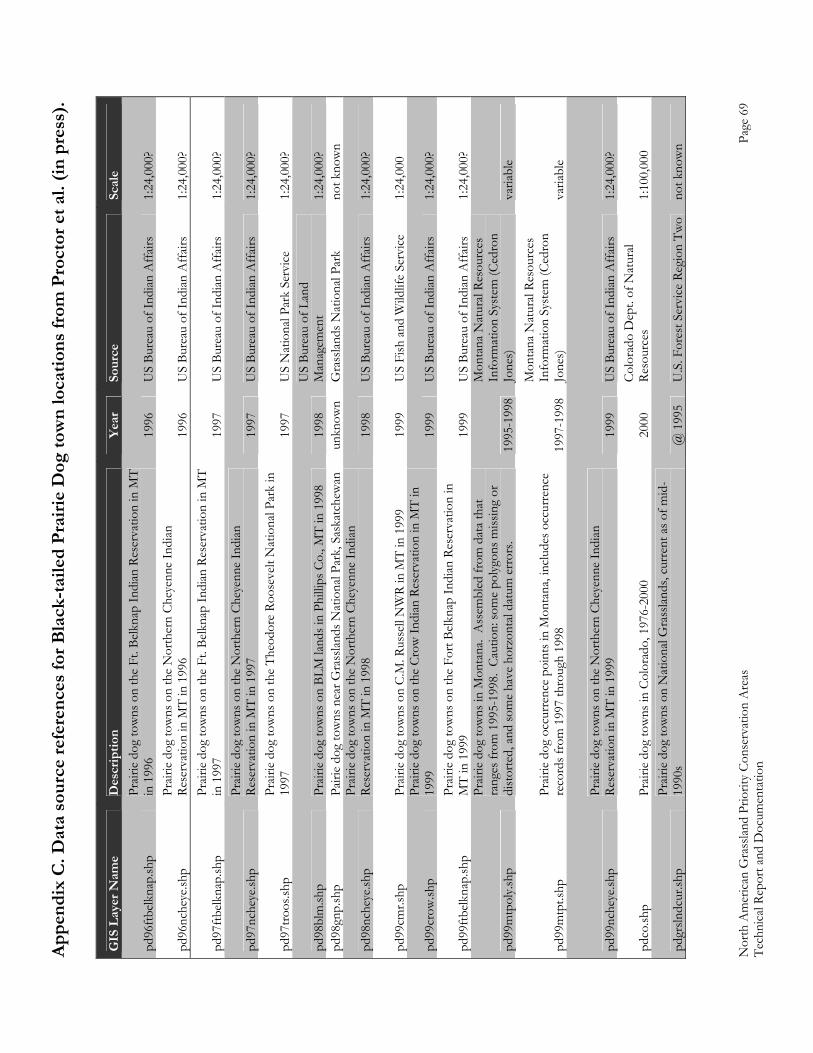
Appe
ndix
C. D
ata
sour
ce re
fere
nces
for B
lack
-taile
d Pr
airie
Dog
tow
n lo
catio
ns fr
om P
roct
or e
t al.
(in p
ress
).
Nor
th A
mer
ican
Gra
sslan
d Pr
iorit
y Co
nser
vatio
n A
reas
Page
69
Tech
nica
l Rep
ort a
nd D
ocum
enta
tion
GIS
Lay
er N
ame
Des
crip
tion
Year
So
urce
Sc
ale
pd96
ftbelk
nap.
shp
Prair
ie do
g to
wns
on
the
Ft. B
elkna
p In
dian
Res
erva
tion
in M
T in
199
6 19
96
US
Bure
au o
f Ind
ian A
ffairs
1:
24,0
00?
pd96
nche
ye.sh
p Pr
airie
dog
tow
ns o
n th
e N
orth
ern
Chey
enne
Indi
an
Rese
rvat
ion
in M
T in
199
6 19
96
US
Bure
au o
f Ind
ian A
ffairs
1:
24,0
00?
pd97
ftbelk
nap.
shp
Prair
ie do
g to
wns
on
the
Ft. B
elkna
p In
dian
Res
erva
tion
in M
T in
199
7 19
97
US
Bure
au o
f Ind
ian A
ffairs
1:
24,0
00?
pd97
nche
ye.sh
p Pr
airie
dog
tow
ns o
n th
e N
orth
ern
Chey
enne
Indi
an
Rese
rvat
ion
in M
T in
199
7 19
97
US
Bure
au o
f Ind
ian A
ffairs
1:
24,0
00?
pd97
troos
.shp
Prair
ie do
g to
wns
on
the
Theo
dore
Roo
seve
lt N
atio
nal P
ark
in
1997
19
97
US
Nat
iona
l Par
k Se
rvice
1:
24,0
00?
pd98
blm
.shp
Prair
ie do
g to
wns
on
BLM
land
s in
Phill
ips C
o., M
T in
199
8 19
98
US
Bure
au o
f Lan
d M
anag
emen
t 1:
24,0
00?
pd98
gnp.
shp
Pairi
e do
g to
wns
nea
r Gra
sslan
ds N
atio
nal P
ark,
Sas
katc
hew
an
unkn
own
Gra
sslan
ds N
atio
nal P
ark
not k
now
n
pd98
nche
ye.sh
p Pr
airie
dog
tow
ns o
n th
e N
orth
ern
Chey
enne
Indi
an
Rese
rvat
ion
in M
T in
199
8 19
98
US
Bure
au o
f Ind
ian A
ffairs
1:
24,0
00?
pd99
cmr.s
hp
Prair
ie do
g to
wns
on
C.M
. Rus
sell
NW
R in
MT
in 1
999
1999
U
S Fi
sh a
nd W
ildlif
e Se
rvice
1:
24,0
00
pd99
crow
.shp
Prair
ie do
g to
wns
on
the
Crow
Indi
an R
eser
vatio
n in
MT
in
1999
19
99
US
Bure
au o
f Ind
ian A
ffairs
1:
24,0
00?
pd99
ftbelk
nap.
shp
Prair
ie do
g to
wns
on
the
Fort
Belk
nap
Indi
an R
eser
vatio
n in
M
T in
199
9 19
99
US
Bure
au o
f Ind
ian A
ffairs
1:
24,0
00?
pd99
mtp
oly.s
hp
Prair
ie do
g to
wns
in M
onta
na.
Ass
embl
ed fr
om d
ata
that
ra
nges
from
199
5-19
98.
Caut
ion:
som
e po
lygon
s miss
ing
or
dist
orte
d, a
nd so
me
have
hor
zont
al da
tum
err
ors.
1995
-199
8
Mon
tana
Nat
ural
Reso
urce
s In
form
atio
n Sy
stem
(Ced
ron
Jone
s)
varia
ble
pd99
mtp
t.shp
Pr
airie
dog
occu
rren
ce p
oint
s in
Mon
tana
, inc
lude
s occ
urre
nce
reco
rds f
rom
199
7 th
roug
h 19
98
1997
-199
8
Mon
tana
Nat
ural
Reso
urce
s In
form
atio
n Sy
stem
(Ced
ron
Jone
s)
varia
ble
pd99
nche
ye.sh
p Pr
airie
dog
tow
ns o
n th
e N
orth
ern
Chey
enne
Indi
an
Rese
rvat
ion
in M
T in
199
9 19
99
US
Bure
au o
f Ind
ian A
ffairs
1:
24,0
00?
pdco
.shp
Prair
ie do
g to
wns
in C
olor
ado,
197
6-20
00
2000
Co
lora
do D
ept.
of N
atur
al Re
sour
ces
1:10
0,00
0
pdgr
slndc
ur.sh
p Pr
airie
dog
tow
ns o
n N
atio
nal G
rass
lands
, cur
rent
as o
f mid
-19
90s
@ 1
995
U.S
. For
est S
ervi
ce R
egio
n Tw
o no
t kno
wn
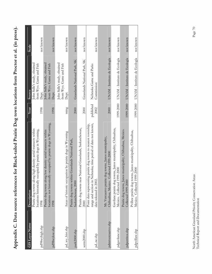
Appe
ndix
C. D
ata
sour
ce re
fere
nces
for B
lack
-taile
d Pr
airie
Dog
tow
n lo
catio
ns fr
om P
roct
or e
t al.
(in p
ress
).
Nor
th A
mer
ican
Gra
sslan
d Pr
iorit
y Co
nser
vatio
n A
reas
Page
70
Tech
nica
l Rep
ort a
nd D
ocum
enta
tion
GIS
Lay
er N
ame
Des
crip
tion
Year
So
urce
Sc
ale
pd98
wyh
igh.
shp
Prair
ie do
g to
wns
alo
ng h
igh
dens
ity a
erial
tran
sect
s with
in
loca
tions
hist
orica
lly o
ccup
ied b
y pr
arie
dog
s in
Wyo
min
g,
1998
19
98
John
Sid
le's s
tudy
, obt
ained
fr
om W
yo. G
ame
and
Fish
D
ept.
not k
now
n
pd98
wylo
w.sh
p
Prair
ie do
g to
wns
alo
ng lo
w d
ensit
y ae
rial t
rans
ects
with
in
loca
tions
not
hist
orica
lly o
ccup
ied b
y pr
airie
dogs
in W
yom
ing,
19
98
1998
John
Sid
le's s
tudy
, obt
ained
fr
om W
yo. G
ame
and
Fish
D
ept.
not k
now
n
pd_w
y_hi
st.sh
p A
reas
of h
istor
ic oc
cupa
tion
by p
rairi
e do
gs in
Wyo
min
g m
ing
John
Sid
le's s
tudy
, obt
ained
fr
om W
yo. G
ame
and
Fish
D
ept.
not k
now
n
park
2000
.shp
Prair
ie do
g to
wns
with
in G
rass
lands
Nat
iona
l Par
k,
Sask
atch
ewan
, 200
0 20
00
Gra
sslan
ds N
atio
nal P
ark,
SK
no
t kno
wn
serm
2000
.shp
Prair
ie do
g to
wns
nea
r Nat
iona
l Gra
sslan
ds, S
aska
tche
wan
, 20
00
2000
G
rass
lands
Nat
iona
l Par
k, S
K
not k
now
n
pd_n
e.shp
Poin
t dat
a re
pres
entin
g pr
airie
dog
tow
ns to
nea
rest
tow
nshi
p,
rang
e an
d se
ctio
n in
Neb
rask
a; tim
e pe
riod
of d
ata
not k
now
n,
data
relea
sed
in 2
002.
pu
blish
ed
2002
N
ebra
ska
Gam
e an
d Pa
rks
Com
miss
ion
not k
now
n
pdm
tver
cuer
vo.sh
p M
t. V
ercu
ervo
pra
irie
dog
tow
ns, J
anos
mun
icipa
lity,
Chih
uahu
a, M
exico
. Co
llect
ed 1
999-
2000
20
00
UN
AM
- In
stitu
to d
e E
colo
gía
not k
now
n
pdga
vilan
e.shp
G
avila
ne p
rairi
e do
g to
wns
, Jan
os m
unici
palit
y, Ch
ihua
hua,
Mex
ico.
Colle
cted
199
9-20
00
1999
-200
0U
NA
M -
Inst
ituto
de
Eco
logí
a no
t kno
wn
pdpe
rrito
s.shp
Pr
airie
dog
tow
ns, J
anos
mun
icipa
lity,
Chih
uahu
a, M
exico
. Co
llect
ed 1
999-
2000
19
99-2
000
UN
AM
- In
stitu
to d
e E
colo
gía
not k
now
n
pdpv
illaw
.shp
Pvill
aw p
rairi
e do
g to
wns
, Jan
os m
unici
palit
y, Ch
ihua
hua,
Mex
ico.
Colle
cted
199
9-20
00
1999
-200
0U
NA
M -
Inst
ituto
de
Eco
logí
a no
t kno
wn
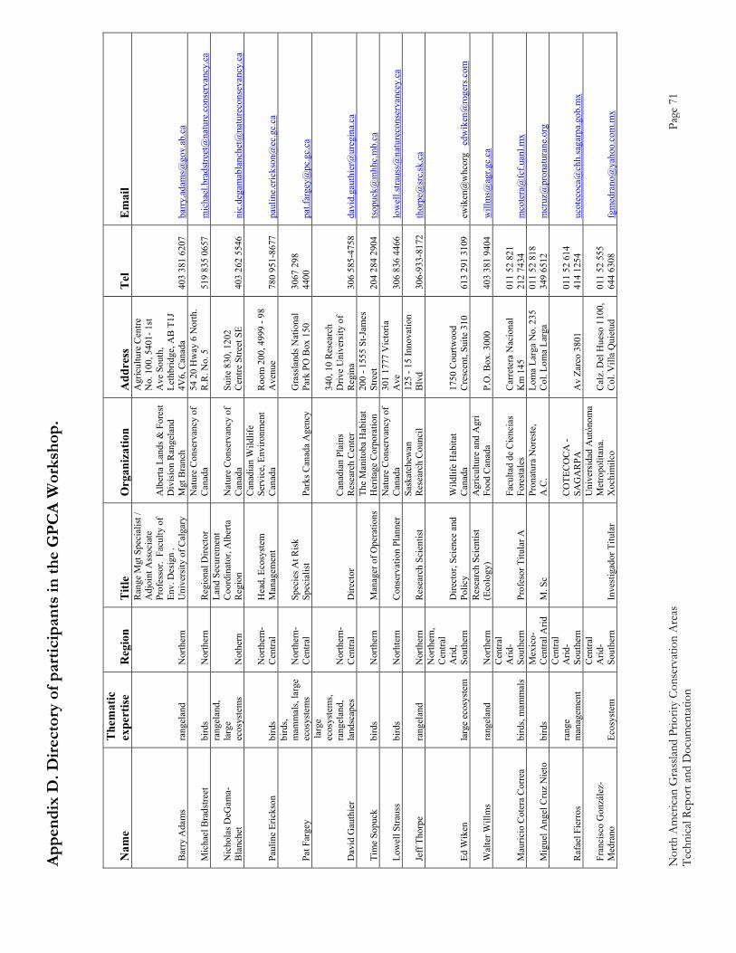
Appe
ndix
D. D
irect
ory
of p
artic
ipan
ts in
the
GPC
A W
orks
hop.
Nor
th A
mer
ican
Gra
sslan
d Pr
iorit
y Co
nser
vatio
n A
reas
Page
71
Tech
nica
l Rep
ort a
nd D
ocum
enta
tion
Nam
e T
hem
atic
ex
pert
ise
Reg
ion
Titl
e O
rgan
izat
ion
Add
ress
T
el
Em
ail
Bar
ry A
dam
s ra
ngel
and
Nor
ther
n
Ran
ge M
gt S
peci
alis
t /
Adj
oint
Ass
ocia
te
Prof
esso
r. F
acul
ty o
f En
v. D
esig
n .
Uni
vers
ity o
f Cal
gary
Alb
erta
Lan
ds &
For
est
Div
isio
n R
ange
land
M
gt B
ranc
h
Agr
icul
ture
Cen
tre
No.
100
, 540
1- 1
st
Ave
Sou
th,
Leth
brid
ge, A
B T
1J
4V6,
Can
ada
403
381
6207
ba
rry.
adam
s@go
v.ab
.ca
Mic
hael
Bra
dstre
et
bird
s N
orth
ern
Reg
iona
l Dire
ctor
N
atur
e C
onse
rvan
cy o
f C
anad
a 54
20
Hw
ay 6
Nor
th.
R.R
. No.
5
519
835
0657
m
icha
el.b
rads
treet
@na
ture
.con
serv
ancy
.ca
Nic
hola
s DeG
ama-
Bla
nche
t
rang
elan
d,
larg
e ec
osys
tem
s N
othe
rn
Land
Sec
urem
ent
Coo
rdin
ator
, Alb
erta
R
egio
n N
atur
e C
onse
rvan
cy o
f C
anad
a Su
ite 8
30, 1
202
Cen
tre S
treet
SE
403
262
5546
ni
c.de
gam
abla
nche
t@na
ture
cons
evan
cy.c
a
Paul
ine
Eric
kson
bi
rds
Nor
ther
n-C
entra
l H
ead,
Eco
syst
em
Man
agem
ent
Can
adia
n W
ildlif
e Se
rvic
e, E
nviro
nmen
t C
anad
a R
oom
200
, 499
9 - 9
8 A
venu
e 78
0 95
1-86
77
paul
ine.
eric
kson
@ec
.gc.
ca
Pat F
arge
y
bird
s, m
amm
als,
larg
e ec
osys
tem
s N
orth
ern-
Cen
tral
Spec
ies A
t Ris
k Sp
ecia
list
Park
s Can
ada
Age
ncy
Gra
ssla
nds N
atio
nal
Park
PO
Box
150
30
67 2
98
4400
pa
t.far
gey@
pc.g
c.ca
Dav
id G
auth
ier
larg
e ec
osys
tem
s, ra
ngel
and,
la
ndsc
apes
N
orth
ern-
Cen
tral
Dire
ctor
C
anad
ian
Plai
ns
Res
earc
h C
ente
r
340,
10
Res
earc
h D
rive
Uni
vers
ity o
f R
egin
a 30
6 58
5-47
58
davi
d.ga
uthi
er@
ureg
ina.
ca
Tim
e So
puck
bi
rds
Nor
ther
n M
anag
er o
f Ope
ratio
ns
The
Man
itoba
Hab
itat
Her
itage
Cor
pora
tion
200
- 155
5 St
-Jam
es
Stre
et
204
284
2904
ts
opuc
k@m
hhc.
mb.
ca
Low
ell S
traus
s bi
rds
Nor
hter
n C
onse
rvat
ion
Plan
ner
Nat
ure
Con
serv
ancy
of
Can
ada
301
1777
Vic
toria
A
ve
306
836
4466
lo
wel
l.stra
uss@
natu
reco
nser
vanc
ey.c
a
Jeff
Tho
rpe
rang
elan
d N
orth
ern
Res
earc
h Sc
ient
ist
Sask
atch
ewan
R
esea
rch
Cou
ncil
125
- 15
Inno
vatio
n B
lvd
306-
933-
8172
th
orpe
@sr
c.sk
.ca
Ed W
iken
la
rge
ecos
yste
m
Nor
ther
n,
Cen
tral
Arid
, So
uthe
rn
Dire
ctor
, Sci
ence
and
Po
licy
Wild
life
Hab
itat
Can
ada
1750
Cou
rtwoo
d C
resc
ent,
Suite
310
61
3 29
1 31
09
ewik
en@
whc
org
edw
iken
@ro
gers
.com
Wal
ter W
illm
s ra
ngel
and
Nor
ther
n R
esea
rch
Scie
ntis
t (E
colo
gy)
Agr
icul
ture
and
Agr
i Fo
od C
anad
a P.
O. B
ox. 3
000
403
381
9404
w
illm
s@ag
r.gc.
ca
Mau
ricio
Cot
era
Cor
rea
bird
s, m
amm
als
Cen
tral
Arid
-So
uthe
rn
Prof
esor
Titu
lar A
Fa
culta
d de
Cie
ncia
s Fo
rest
ales
C
arre
tera
Nac
iona
l K
m 1
45
011
52 8
21
212
7434
m
cote
ra@
fcf.u
anl.m
x
Mig
uel A
ngel
Cru
z N
ieto
bi
rds
Mex
ico-
Cen
tral A
rid
M. S
c Pr
onat
ura
Nor
este
, A
.C.
Lom
a La
rga
No.
235
C
ol. L
oma
Larg
a 01
1 52
818
34
9 65
12
mcr
uz@
pron
atur
ane.
org
Raf
ael F
ierr
os
rang
e m
anag
emen
t
Cen
tral
Arid
-So
uthe
rn
C
OTE
CO
CA
- SA
GA
RPA
A
v Za
rco
3801
01
1 52
614
41
4 12
54
ucot
ecoc
a@ch
h.sa
garp
a.go
b.m
x
Fran
cisc
o G
onzá
lez-
Med
rano
Ec
osys
tem
Cen
tral
Arid
-So
uthe
rn
Inve
stig
ador
Titu
lar
Uni
vers
idad
Aut
ónom
a M
etro
polit
ana.
X
ochi
milc
o C
alz.
Del
Hue
so 1
100,
C
ol. V
illa
Qui
etud
01
1 52
555
64
4 63
08
fgm
edra
no@
yaho
o.co
m.m
x
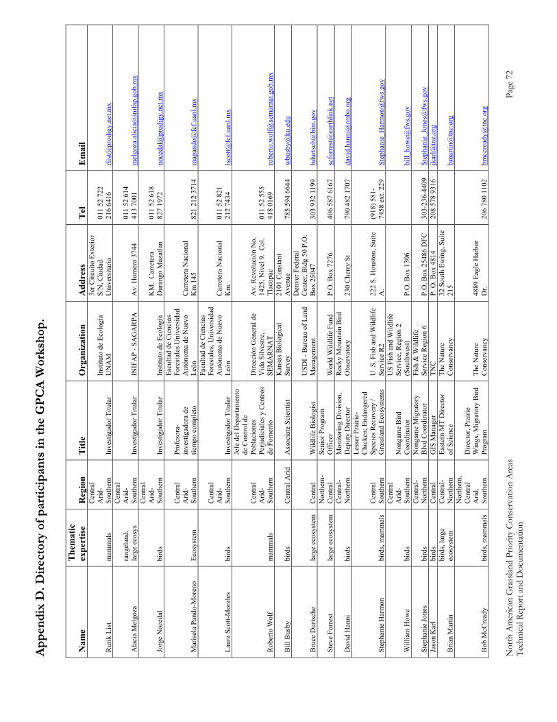
Appe
ndix
D. D
irect
ory
of p
artic
ipan
ts in
the
GPC
A W
orks
hop.
Nor
th A
mer
ican
Gra
sslan
d Pr
iorit
y Co
nser
vatio
n A
reas
Page
72
Tech
nica
l Rep
ort a
nd D
ocum
enta
tion
Nam
e T
hem
atic
ex
pert
ise
Reg
ion
Titl
e O
rgan
izat
ion
Add
ress
T
el
Em
ail
Rur
ik L
ist
mam
mal
s
Cen
tral
Arid
-So
uthe
rn
Inve
stig
ador
Titu
lar
Inst
ituto
de
Ecol
ogía
U
NA
M
3er C
ircui
to E
xter
ior
S/N
, Ciu
dad
Uni
vers
itaria
01
1 52
722
21
6 64
16
rlist
@pr
odig
y.ne
t.mx
Ala
cia
Mel
goza
ra
ngel
and,
la
rge
ecos
ys
Cen
tral
Arid
-So
uthe
rn
Inve
stig
ador
Titu
lar
INIF
AP
- SA
GA
RPA
A
v. H
omer
o 37
44
011
52 6
14
413
7001
m
elgo
za.a
licia
@in
ifap.
gob.
mx
Jorg
e N
oced
al
bird
s
Cen
tral
Arid
-So
uthe
rn
Inve
stig
ador
Titu
lar
Inst
ituto
de
Ecol
ogía
K
M.
Car
rete
ra
Dur
ango
Maz
atla
n 01
1 52
618
82
7 19
72
noce
dal@
prod
igy.
net.m
x
Mar
isel
a Pa
ndo-
Mor
eno
Ecos
yste
m
Cen
tral
Arid
-So
uthe
rn
Prof
esor
a-in
vest
igad
ora
de
tiem
po c
ompl
eto
Facu
ltad
de C
ienc
ias
Fore
stal
es U
nive
rsid
ad
Aut
ónom
a de
Nue
vo
León
C
arre
tera
Nac
iona
l K
m 1
45
821
212
3714
m
apan
do@
fcf.u
anl.m
x
Laur
a Sc
ott-M
oral
es
bird
s
Cen
tral
Arid
-So
uthe
rn
Inve
stig
ador
Titu
lar
Facu
ltad
de C
ienc
ias
Fore
stal
es, U
nive
rsid
ad
Aut
ónom
a de
Nue
vo
León
C
arre
tera
Nac
iona
l K
m.
011
52 8
21
212
7434
ls
cott@
fcf.u
anl.m
x
Rob
erto
Wol
f m
amm
als
Cen
tral
Arid
-So
uthe
rn
Jefe
del
Dep
arta
men
to
de C
ontro
l de
Pobl
acio
nes
Perju
dici
ales
y C
entro
s de
Fom
ento
Dire
cció
n G
ener
al d
e V
ida
Silv
estre
, SE
MA
RN
AT
Av.
Rev
oluc
ión
No.
14
25, N
ivel
9.
Col
. Tl
acop
ac
011
52 5
55
418
0169
ro
berto
.wol
f@se
mar
nat.g
ob.m
x
Bill
Bus
by
bird
s C
entra
l Arid
A
ssoc
iate
Sci
entis
t K
ansa
s Bio
logi
cal
Surv
ey
2101
Con
stan
t A
venu
e 78
5 59
4 66
44
wbu
sby@
ku.e
du
Bru
ce D
urts
che
larg
e ec
osys
tem
C
entra
l W
ildlif
e B
iolo
gist
U
SDI -
Bur
eau
of L
and
Man
agem
ent
Den
ver F
eder
al
Cen
ter,
Bld
g 50
P.O
. B
ox 2
5047
30
3 93
2 11
99
bdur
tsch
@bi
m.g
ov
Stev
e Fo
rres
t la
rge
ecos
yste
m
Nor
ther
n-C
entra
l Se
nior
Pro
gram
O
ffic
er
Wor
ld W
ildlif
e Fu
nd
P.O
. Box
727
6 40
6 58
7 61
67
scfo
rres
t@ea
rthlin
k.ne
t
Dav
id H
anni
bi
rds
Cen
tral-
Nor
ther
n M
onito
ring
Div
isio
n,
Dep
uty
Dire
ctor
R
ocky
Mou
ntai
n B
ird
Obs
erva
tory
23
0 C
herr
y St
79
0 48
2 17
07
davi
d.ha
nni@
rmbo
.org
Step
hani
e H
arm
on
bird
s, m
amm
als
Cen
tral
Sout
hern
Less
er P
rairi
e-C
hick
en; E
ndan
gere
d Sp
ecie
s Rec
over
y /
Gra
ssla
nd E
cosy
stem
s U
. S. F
ish
and
Wild
life
Serv
ice
R2
222
S. H
oust
on, S
uite
A
. (9
18) 5
81-
7458
ext
. 229
St
epha
nie_
Har
mon
@fw
s.gov
Will
iam
How
e bi
rds
Cen
tral
Arid
-So
uthe
rn
Non
gam
e B
ird
Coo
rdin
ator
US
Fish
and
Wild
life
Serv
ice,
Reg
ion
2 (S
outh
wes
t) P.
O. B
ox 1
306
bi
ll_ho
we@
fws.g
ov
Step
hani
e Jo
nes
bird
s C
entra
l-N
orth
ern
Non
gam
e M
igra
tory
B
lvd
Coo
rdin
ator
Fi
sh &
Wild
life
Serv
ice
Reg
ion
6 P.
O. B
ox 2
5486
DFC
30
3-23
6-44
09
Step
hani
e_Jo
nes@
fws.g
ov
Jaso
n K
arl
bird
s C
entra
l G
IS M
anag
er
TNC
P.
O. B
ox 4
814
208
578
9316
jk
arl@
tnc.
org
Bria
n M
artin
bi
rds,
larg
e ec
osys
tem
C
entra
l-N
orth
ern
East
ern
MT
Dire
ctor
of
Sci
ence
Th
e N
atur
e C
onse
rvan
cy
32 S
outh
Ew
ing,
Sui
te
215
bm
artin
@tn
c.or
g
Bob
McC
read
y bi
rds,
mam
mal
s
Nor
ther
n,
Cen
tral
Arid
, So
uthe
rn
Dire
ctor
, Pra
irie
Win
gs, M
igra
tory
Bird
Pr
ogra
m
The
Nat
ure
Con
serv
ancy
48
89 E
agle
Har
bor
Dr.
206
780
1102
bm
ccre
ady@
tnc.
org
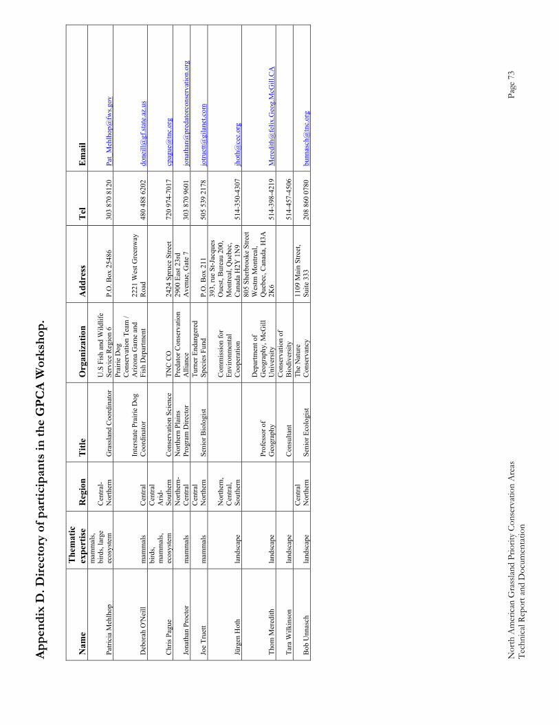
Appe
ndix
D. D
irect
ory
of p
artic
ipan
ts in
the
GPC
A W
orks
hop.
Nor
th A
mer
ican
Gra
sslan
d Pr
iorit
y Co
nser
vatio
n A
reas
Page
73
Tech
nica
l Rep
ort a
nd D
ocum
enta
tion
Nam
e T
hem
atic
ex
pert
ise
Reg
ion
Titl
e O
rgan
izat
ion
Add
ress
T
el
Em
ail
Patri
cia
Meh
lhop
mam
mal
s, bi
rds,
larg
e ec
osys
tem
C
entra
l-N
orth
ern
Gra
ssla
nd C
oord
inat
or
U.S
Fis
h an
d W
ildlif
e Se
rvic
e R
egio
n 6
P.O
. Box
254
86
303
870
8120
Pa
t_M
ehlh
op@
fws.g
ov
Deb
orah
O'N
eill
mam
mal
s C
entra
l In
ters
tate
Pra
irie
Dog
C
oord
inat
or
Prai
rie D
og
Con
serv
atio
n Te
am /
Ariz
ona
Gam
e an
d Fi
sh D
epar
tmen
t 22
21 W
est G
reen
way
R
oad
480
488
6202
do
neill
@gf
.stat
e.az
.us
Chr
is P
ague
bird
s, m
amm
als,
ecos
yste
m
Cen
tral
Arid
-So
uthe
rn
Con
serv
atio
n Sc
ienc
e
TNC
CO
24
24 S
pruc
e St
reet
72
0 97
4-70
17
cpag
ue@
tnc.
org
Jona
than
Pro
ctor
m
amm
als
Nor
ther
n-C
entra
l N
orth
ern
Plai
ns
Prog
ram
Dire
ctor
Pr
edat
or C
onse
rvat
ion
Alli
ance
29
00 E
ast 2
3rd
Ave
nue,
Gat
e 7
303
870
9601
jo
nath
an@
pred
ator
cons
erva
tion.
org
Joe
True
tt m
amm
als
Cen
tral
Nor
ther
n Se
nior
Bio
logi
st
Turn
er E
ndan
gere
d Sp
ecie
s Fun
d P.
O. B
ox 2
11
505
539
2178
jo
truet
t@gi
lane
t.com
Jürg
en H
oth
land
scap
e
Nor
ther
n,
Cen
tral,
Sout
hern
Com
mis
sion
for
Envi
ronm
enta
l C
oope
ratio
n
393,
rue
St-J
acqu
es
Oue
st, B
urea
u 20
0,
Mon
treal
, Que
bec,
C
anad
a H
2Y 1
N9
514-
350-
4307
jh
oth@
cec.
org
Thom
Mer
edith
la
ndsc
ape
Pr
ofes
sor o
f G
eogr
aphy
Dep
artm
ent o
f G
eogr
aphy
, McG
ill
Uni
vers
ity
805
Sher
broo
ke S
treet
W
estm
Mon
treal
, Q
uebe
c, C
anad
a, H
3A
2K6
514-
398-
4219
M
ered
ith@
felix
.Geo
g.M
cGill
.CA
Tara
Wilk
inso
n la
ndsc
ape
C
onsu
ltant
C
onse
rvat
ion
of
Bio
dive
rsity
514-
457-
4506
Bob
Unn
asch
la
ndsc
ape
Cen
tral
Nor
ther
n Se
nior
Eco
logi
st
The
Nat
ure
Con
serv
ancy
11
09 M
ain
Stre
et,
Suite
333
20
8 86
0 07
80
bunn
asch
@tn
c.or
g
Appendix E. Principles behind the CBED decision support procedure – by Thomas Meredith, George Dias and Leah Wilson
North American Grassland Priority Conservation Areas Page 74 Technical Report and Documentation
Environmental degradation is the root of so many problems -- ranging from loss of health, livelihood and quality of life, to loss of ecological heritage and environmental security. The need for better forms of environmental protection must be taken as urgent. CBED is conducting research on “environmental decision support,” that is, on what sort of procedures lead to fairer, more efficient and more effective environmental choices. The focus is two promising, closely linked, avenues of research: one is to make better use of existing information resources (both scientific and traditional), the other is to include more people, with a wider array of backgrounds and experiences, in environmental decision making. Mechanisms for consensus-building are essential. Canada, the US and Mexico, represent “Afrontline” questions in the dialogue on global environmental and sustainable development issues. Biodiversity loss is, amongst all environmental issues, perhaps the most irreversible, and the one with the strongest social dimension. For these reasons, researchers at CBED were anxious to engage with the CEC to explore questions of information management in North American biodiversity conservation decision making and, most recently, to participate in defining grassland priority conservation sites. Measures to protect biodiversity are typically initiated "in the public interest" but, to be effective, must be site-specific in their application. The potential for conflict amongst stakeholders is high. Effective conservation strategies must include mechanisms for dealing with the human dimensions, specifically with information dissemination and conflict resolution. Species mobility, ecosystem interconnectedness, and issues of scale in determining representation suggest that biodiversity conservation goals cannot be effectively defined at a micro scale but should ideally be assessed in harmonized local, regional, national and continental programs. This challenges conventional techniques of consultation and consensus-building. Part of the challenge is in the trade-offs between complexity and accessibility, and between simplicity and accuracy. How complex can data management be and still be accessible? Is there a hierarchic structure that allows consistent decision-support at a level of detail proportional to the users' needs and capabilities? Working in a three day meeting requires that enough information be introduced to ensure accurate outcomes, but that information is accessible enough that it can be communicated between interest groups, that detail can be adjusted to ensure momentum within the meeting, and that the goals and purpose remain achievable. The CBED procedure involves Consensus Mapper, a geographic information system (GIS) that allows collaborative exploration of spatial data, discussion of decision priorities, and mapping of environmental values or concerns. The Consensus Mapper is used in a Round Table meeting that permits stakeholders to participate in an open discussion about spatial understandings or priorities, but also to have independent means of expressing their own views. This allows groups with shared interests to clarify their common understandings and groups with divergent interests to clarify points of disagreement and perhaps work toward compromise. Consensus Mapper Round Tables (CMRT) are about person-to-person communication of ideas. Networked computers with an interactive GIS support communication, but only as and when it is appropriate to facilitate inclusive communication and clarity in spatial decisions. This requires that the GIS be transparent to the users, not an obstacle or a force that dominates proceedings. This, in turn, requires strong technical support and open and adaptive facilitation. Clear and sound ideas are the ends, group discussion is the means and maps and computers are the aids.
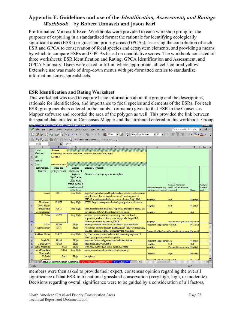
Appendix F. Guidelines and use of the Identification, Assessment, and Ratings Workbook – by Robert Unnasch and Jason Karl
North American Grassland Priority Conservation Areas Page 75 Technical Report and Documentation
Pre-formatted Microsoft Excel Workbooks were provided to each workshop group for the purposes of capturing in a standardized format the rationale for identifying ecologically significant areas (ESRs) or grassland priority areas (GPCAs), assessing the contribution of each ESR and GPCA to conservation of focal species and ecosystem elements, and providing a means by which to compare ESRs and GPCAs based on quantitative scores. The workbook consisted of three worksheets: ESR Identification and Rating, GPCA Identification and Assessment, and GPCA Summary. Users were asked to fill-in, where appropriate, all cells colored yellow. Extensive use was made of drop-down menus with pre-formatted entries to standardize information across spreadsheets. ESR Identification and Rating Worksheet This worksheet was used to capture basic information about the group and the descriptions, rationale for identification, and importance to focal species and elements of the ESRs. For each ESR, group members entered in the number (or name) given to that ESR in the Consensus Mapper software and recorded the area of the polygon as well. This provided the link between the spatial data created in Consensus Mapper and the attributed entered in this workbook. Group
members were then asked to provide their expert, consensus opinion regarding the overall significance of that ESR to tri-national grassland conservation (very high, high, or moderate). Decisions regarding overall significance were to be guided by a consideration of all factors,
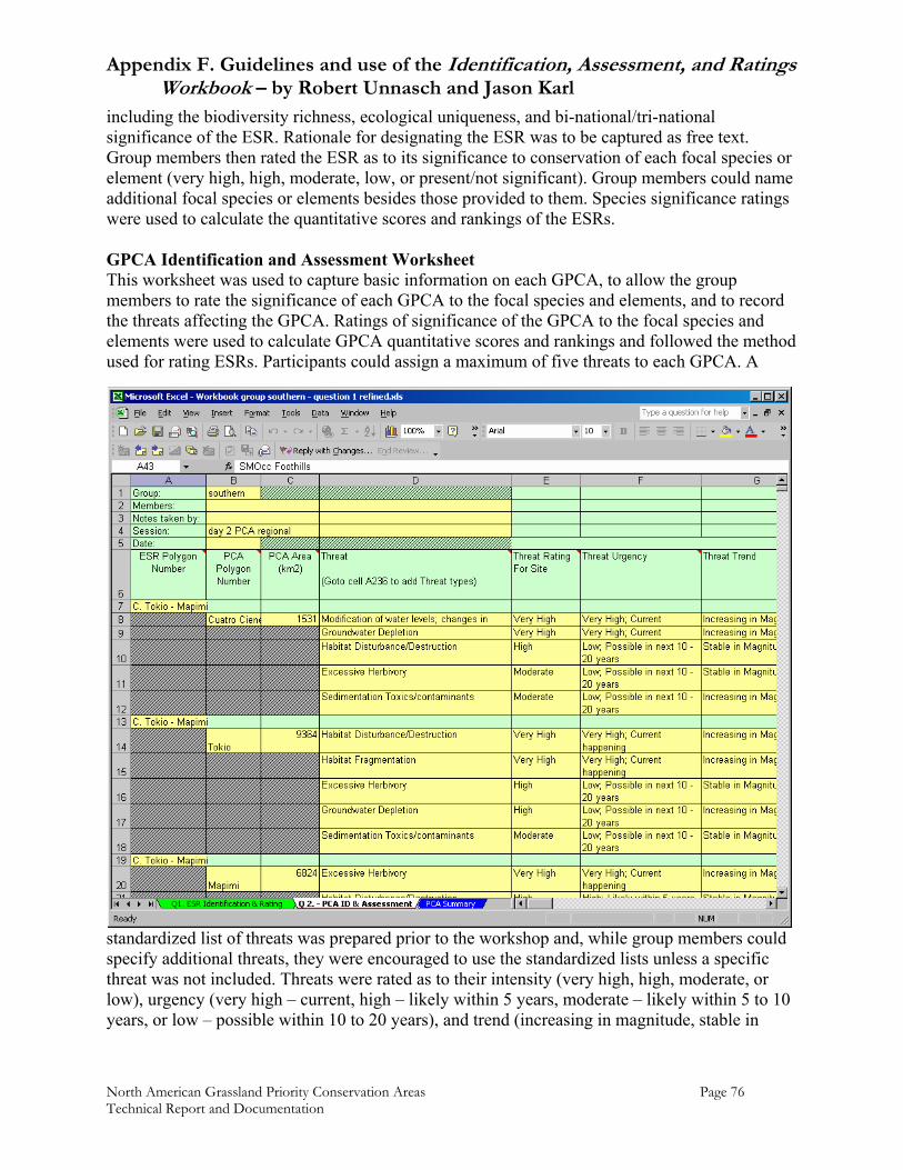
Appendix F. Guidelines and use of the Identification, Assessment, and Ratings Workbook – by Robert Unnasch and Jason Karl
North American Grassland Priority Conservation Areas Page 76 Technical Report and Documentation
including the biodiversity richness, ecological uniqueness, and bi-national/tri-national significance of the ESR. Rationale for designating the ESR was to be captured as free text. Group members then rated the ESR as to its significance to conservation of each focal species or element (very high, high, moderate, low, or present/not significant). Group members could name additional focal species or elements besides those provided to them. Species significance ratings were used to calculate the quantitative scores and rankings of the ESRs. GPCA Identification and Assessment Worksheet This worksheet was used to capture basic information on each GPCA, to allow the group members to rate the significance of each GPCA to the focal species and elements, and to record the threats affecting the GPCA. Ratings of significance of the GPCA to the focal species and elements were used to calculate GPCA quantitative scores and rankings and followed the method used for rating ESRs. Participants could assign a maximum of five threats to each GPCA. A
standardized list of threats was prepared prior to the workshop and, while group members could specify additional threats, they were encouraged to use the standardized lists unless a specific threat was not included. Threats were rated as to their intensity (very high, high, moderate, or low), urgency (very high – current, high – likely within 5 years, moderate – likely within 5 to 10 years, or low – possible within 10 to 20 years), and trend (increasing in magnitude, stable in
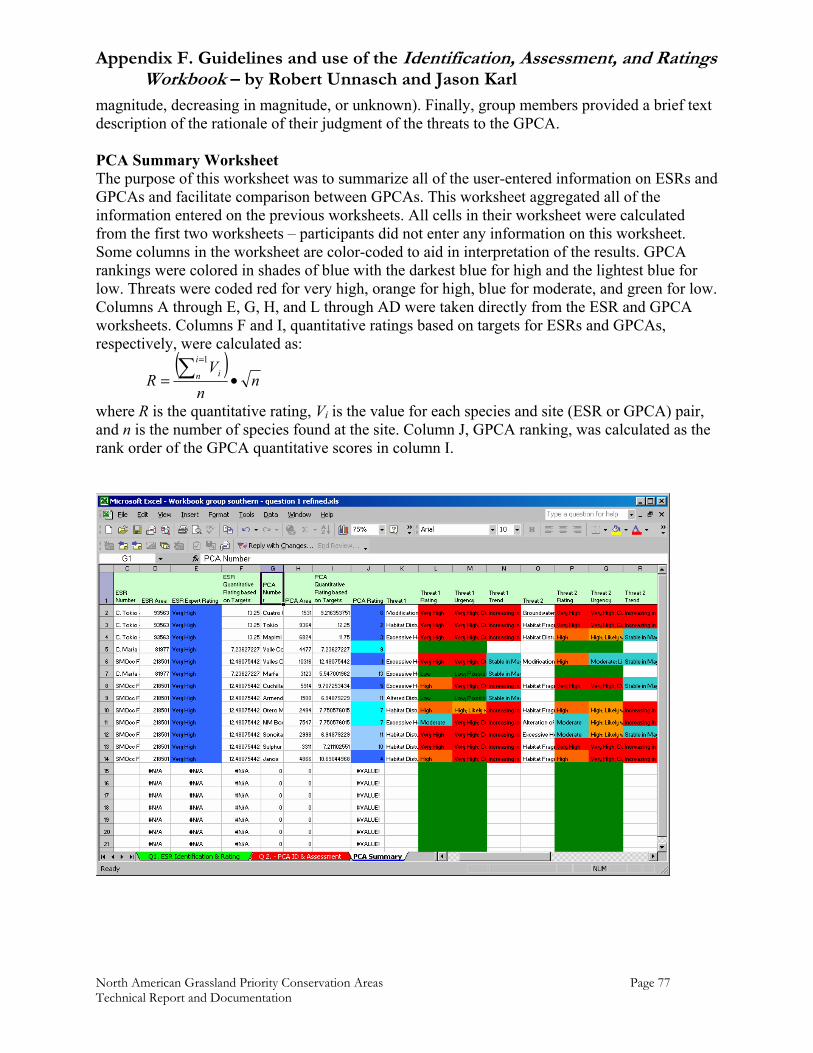
Appendix F. Guidelines and use of the Identification, Assessment, and Ratings Workbook – by Robert Unnasch and Jason Karl
North American Grassland Priority Conservation Areas Page 77 Technical Report and Documentation
magnitude, decreasing in magnitude, or unknown). Finally, group members provided a brief text description of the rationale of their judgment of the threats to the GPCA. PCA Summary Worksheet The purpose of this worksheet was to summarize all of the user-entered information on ESRs and GPCAs and facilitate comparison between GPCAs. This worksheet aggregated all of the information entered on the previous worksheets. All cells in their worksheet were calculated from the first two worksheets – participants did not enter any information on this worksheet. Some columns in the worksheet are color-coded to aid in interpretation of the results. GPCA rankings were colored in shades of blue with the darkest blue for high and the lightest blue for low. Threats were coded red for very high, orange for high, blue for moderate, and green for low. Columns A through E, G, H, and L through AD were taken directly from the ESR and GPCA worksheets. Columns F and I, quantitative ratings based on targets for ESRs and GPCAs, respectively, were calculated as:
( )n
nV
Ri
n i •= ∑ =1
where R is the quantitative rating, Vi is the value for each species and site (ESR or GPCA) pair, and n is the number of species found at the site. Column J, GPCA ranking, was calculated as the rank order of the GPCA quantitative scores in column I.
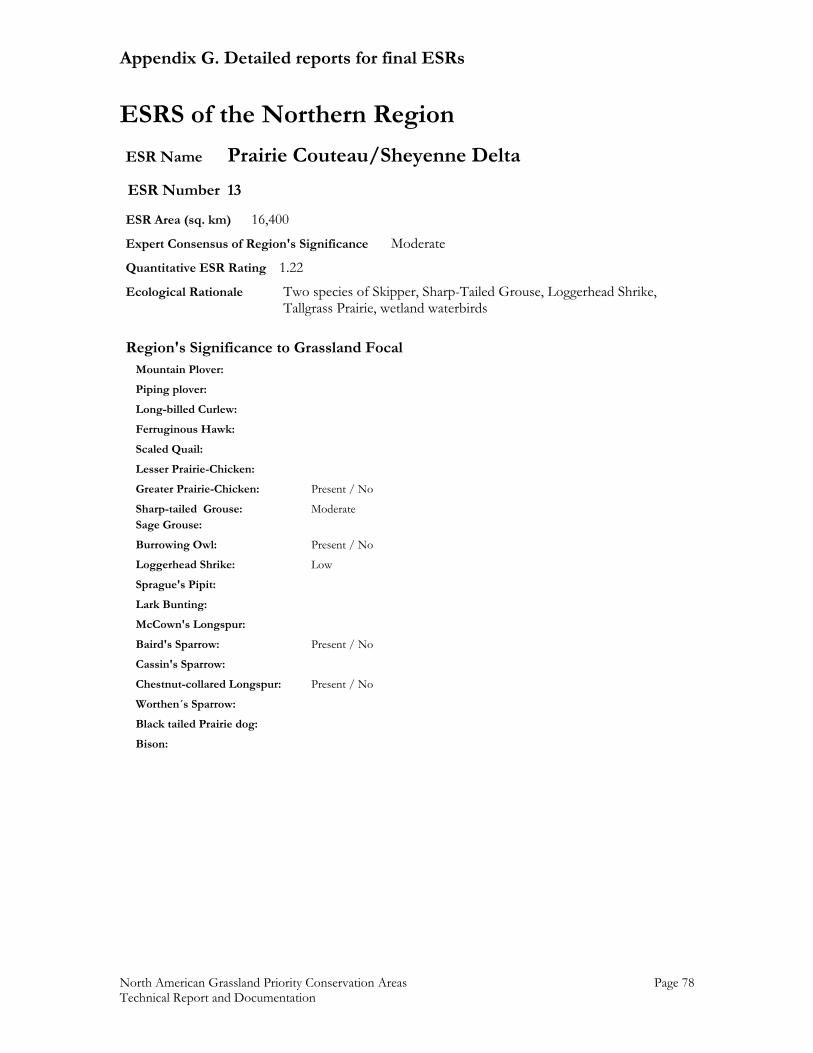
Appendix G. Detailed reports for final ESRs
North American Grassland Priority Conservation Areas Page 78 Technical Report and Documentation
ESRS of the Northern Region ESR Name Prairie Couteau/Sheyenne Delta ESR Number 13 ESR Area (sq. km) 16,400 Expert Consensus of Region's Significance Moderate Quantitative ESR Rating 1.22 Ecological Rationale Two species of Skipper, Sharp-Tailed Grouse, Loggerhead Shrike, Tallgrass Prairie, wetland waterbirds
Region's Significance to Grassland Focal Mountain Plover: Piping plover: Long-billed Curlew: Ferruginous Hawk: Scaled Quail: Lesser Prairie-Chicken: Greater Prairie-Chicken: Present / No Sharp-tailed Grouse: Moderate Sage Grouse: Burrowing Owl: Present / No Loggerhead Shrike: Low Sprague's Pipit: Lark Bunting: McCown's Longspur: Baird's Sparrow: Present / No Cassin's Sparrow: Chestnut-collared Longspur: Present / No Worthen´s Sparrow: Black tailed Prairie dog: Bison:
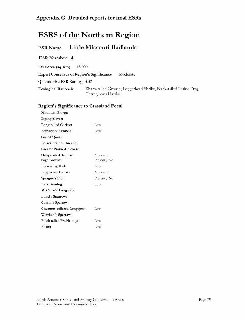
Appendix G. Detailed reports for final ESRs
North American Grassland Priority Conservation Areas Page 79 Technical Report and Documentation
ESRS of the Northern Region ESR Name Little Missouri Badlands ESR Number 14 ESR Area (sq. km) 13,000 Expert Consensus of Region's Significance Moderate Quantitative ESR Rating 3.32 Ecological Rationale Sharp-tailed Grouse, Loggerhead Shrike, Black-tailed Prairie Dog, Ferruginous Hawks
Region's Significance to Grassland Focal Mountain Plover: Piping plover: Long-billed Curlew: Low Ferruginous Hawk: Low Scaled Quail: Lesser Prairie-Chicken: Greater Prairie-Chicken: Sharp-tailed Grouse: Moderate Sage Grouse: Present / No Burrowing Owl: Low Loggerhead Shrike: Moderate Sprague's Pipit: Present / No Lark Bunting: Low McCown's Longspur: Baird's Sparrow: Cassin's Sparrow: Chestnut-collared Longspur: Low Worthen´s Sparrow: Black tailed Prairie dog: Low Bison: Low
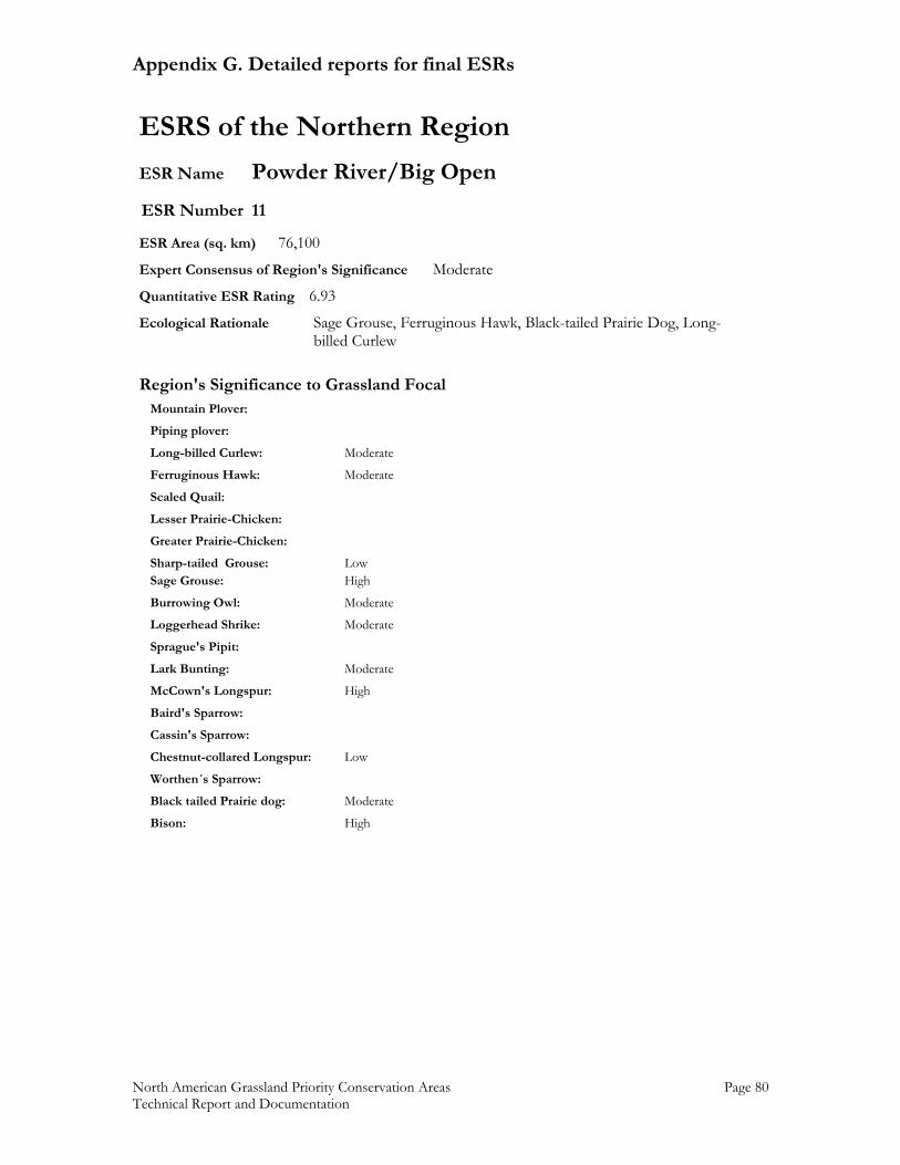
Appendix G. Detailed reports for final ESRs
North American Grassland Priority Conservation Areas Page 80 Technical Report and Documentation
ESRS of the Northern Region ESR Name Powder River/Big Open ESR Number 11 ESR Area (sq. km) 76,100 Expert Consensus of Region's Significance Moderate Quantitative ESR Rating 6.93 Ecological Rationale Sage Grouse, Ferruginous Hawk, Black-tailed Prairie Dog, Long- billed Curlew
Region's Significance to Grassland Focal Mountain Plover: Piping plover: Long-billed Curlew: Moderate Ferruginous Hawk: Moderate Scaled Quail: Lesser Prairie-Chicken: Greater Prairie-Chicken: Sharp-tailed Grouse: Low Sage Grouse: High Burrowing Owl: Moderate Loggerhead Shrike: Moderate Sprague's Pipit: Lark Bunting: Moderate McCown's Longspur: High Baird's Sparrow: Cassin's Sparrow: Chestnut-collared Longspur: Low Worthen´s Sparrow: Black tailed Prairie dog: Moderate Bison: High
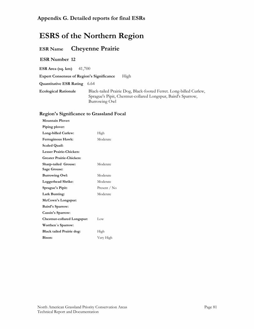
Appendix G. Detailed reports for final ESRs
North American Grassland Priority Conservation Areas Page 81 Technical Report and Documentation
ESRS of the Northern Region ESR Name Cheyenne Prairie ESR Number 12 ESR Area (sq. km) 41,700 Expert Consensus of Region's Significance High Quantitative ESR Rating 6.64 Ecological Rationale Black-tailed Prairie Dog, Black-footed Ferret. Long-billed Curlew, Sprague's Pipit, Chestnut-collared Longspur, Baird's Sparrow, Burrowing Owl
Region's Significance to Grassland Focal Mountain Plover: Piping plover: Long-billed Curlew: High Ferruginous Hawk: Moderate Scaled Quail: Lesser Prairie-Chicken: Greater Prairie-Chicken: Sharp-tailed Grouse: Moderate Sage Grouse: Burrowing Owl: Moderate Loggerhead Shrike: Moderate Sprague's Pipit: Present / No Lark Bunting: Moderate McCown's Longspur: Baird's Sparrow: Cassin's Sparrow: Chestnut-collared Longspur: Low Worthen´s Sparrow: Black tailed Prairie dog: High Bison: Very High
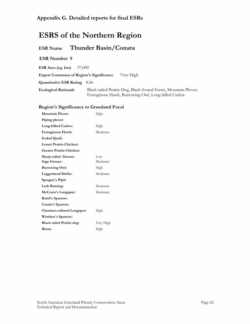
Appendix G. Detailed reports for final ESRs
North American Grassland Priority Conservation Areas Page 82 Technical Report and Documentation
ESRS of the Northern Region ESR Name Thunder Basin/Conata ESR Number 9 ESR Area (sq. km) 37,000 Expert Consensus of Region's Significance Very High Quantitative ESR Rating 8.66 Ecological Rationale Black-tailed Prairie Dog, Black-footed Ferret, Mountain Plover, Ferruginous Hawk, Burrowing Owl, Long-billed Curlew
Region's Significance to Grassland Focal Mountain Plover: High Piping plover: Long-billed Curlew: High Ferruginous Hawk: Moderate Scaled Quail: Lesser Prairie-Chicken: Greater Prairie-Chicken: Sharp-tailed Grouse: Low Sage Grouse: Moderate Burrowing Owl: High Loggerhead Shrike: Moderate Sprague's Pipit: Lark Bunting: Moderate McCown's Longspur: Moderate Baird's Sparrow: Cassin's Sparrow: Chestnut-collared Longspur: High Worthen´s Sparrow: Black tailed Prairie dog: Very High Bison: High
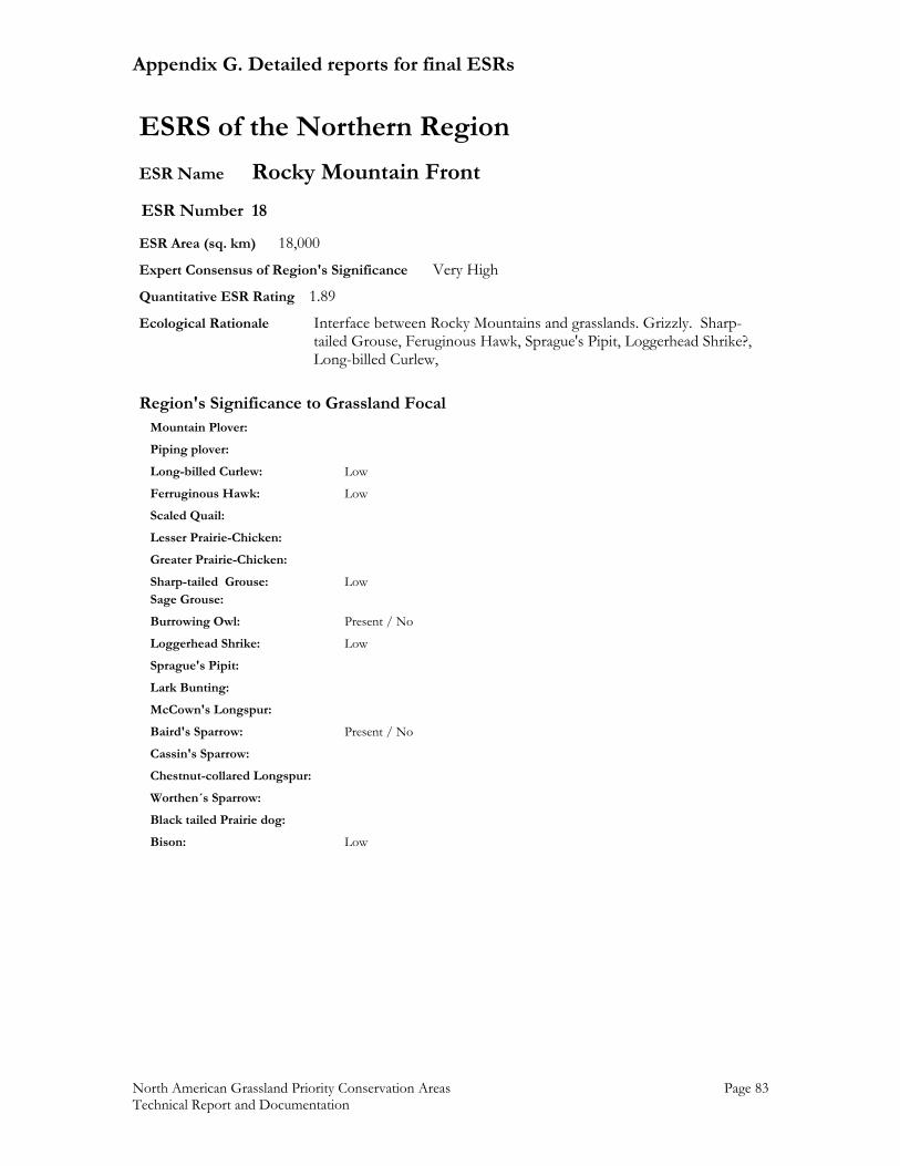
Appendix G. Detailed reports for final ESRs
North American Grassland Priority Conservation Areas Page 83 Technical Report and Documentation
ESRS of the Northern Region ESR Name Rocky Mountain Front ESR Number 18 ESR Area (sq. km) 18,000 Expert Consensus of Region's Significance Very High Quantitative ESR Rating 1.89 Ecological Rationale Interface between Rocky Mountains and grasslands. Grizzly. Sharp- tailed Grouse, Feruginous Hawk, Sprague's Pipit, Loggerhead Shrike?, Long-billed Curlew,
Region's Significance to Grassland Focal Mountain Plover: Piping plover: Long-billed Curlew: Low Ferruginous Hawk: Low Scaled Quail: Lesser Prairie-Chicken: Greater Prairie-Chicken: Sharp-tailed Grouse: Low Sage Grouse: Burrowing Owl: Present / No Loggerhead Shrike: Low Sprague's Pipit: Lark Bunting: McCown's Longspur: Baird's Sparrow: Present / No Cassin's Sparrow: Chestnut-collared Longspur: Worthen´s Sparrow: Black tailed Prairie dog: Bison: Low
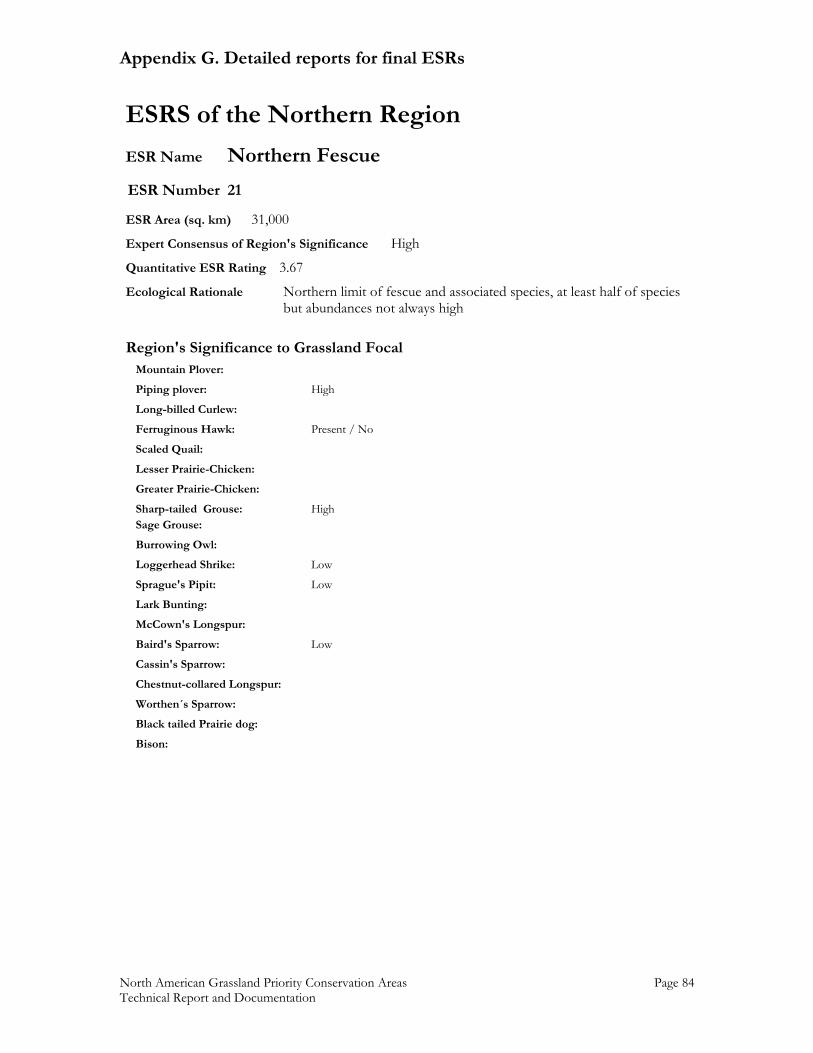
Appendix G. Detailed reports for final ESRs
North American Grassland Priority Conservation Areas Page 84 Technical Report and Documentation
ESRS of the Northern Region ESR Name Northern Fescue ESR Number 21 ESR Area (sq. km) 31,000 Expert Consensus of Region's Significance High Quantitative ESR Rating 3.67 Ecological Rationale Northern limit of fescue and associated species, at least half of species but abundances not always high
Region's Significance to Grassland Focal Mountain Plover: Piping plover: High Long-billed Curlew: Ferruginous Hawk: Present / No Scaled Quail: Lesser Prairie-Chicken: Greater Prairie-Chicken: Sharp-tailed Grouse: High Sage Grouse: Burrowing Owl: Loggerhead Shrike: Low Sprague's Pipit: Low Lark Bunting: McCown's Longspur: Baird's Sparrow: Low Cassin's Sparrow: Chestnut-collared Longspur: Worthen´s Sparrow: Black tailed Prairie dog: Bison:
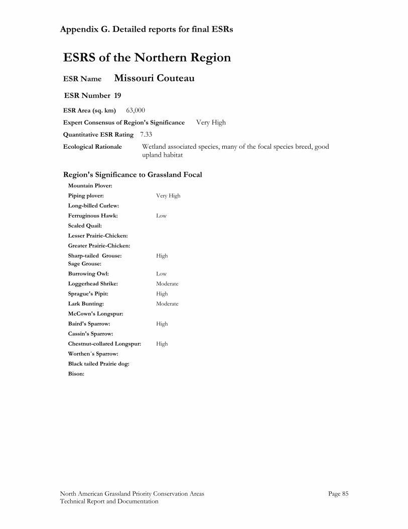
Appendix G. Detailed reports for final ESRs
North American Grassland Priority Conservation Areas Page 85 Technical Report and Documentation
ESRS of the Northern Region ESR Name Missouri Couteau ESR Number 19 ESR Area (sq. km) 63,000 Expert Consensus of Region's Significance Very High Quantitative ESR Rating 7.33 Ecological Rationale Wetland associated species, many of the focal species breed, good upland habitat
Region's Significance to Grassland Focal Mountain Plover: Piping plover: Very High Long-billed Curlew: Ferruginous Hawk: Low Scaled Quail: Lesser Prairie-Chicken: Greater Prairie-Chicken: Sharp-tailed Grouse: High Sage Grouse: Burrowing Owl: Low Loggerhead Shrike: Moderate Sprague's Pipit: High Lark Bunting: Moderate McCown's Longspur: Baird's Sparrow: High Cassin's Sparrow: Chestnut-collared Longspur: High Worthen´s Sparrow: Black tailed Prairie dog: Bison:
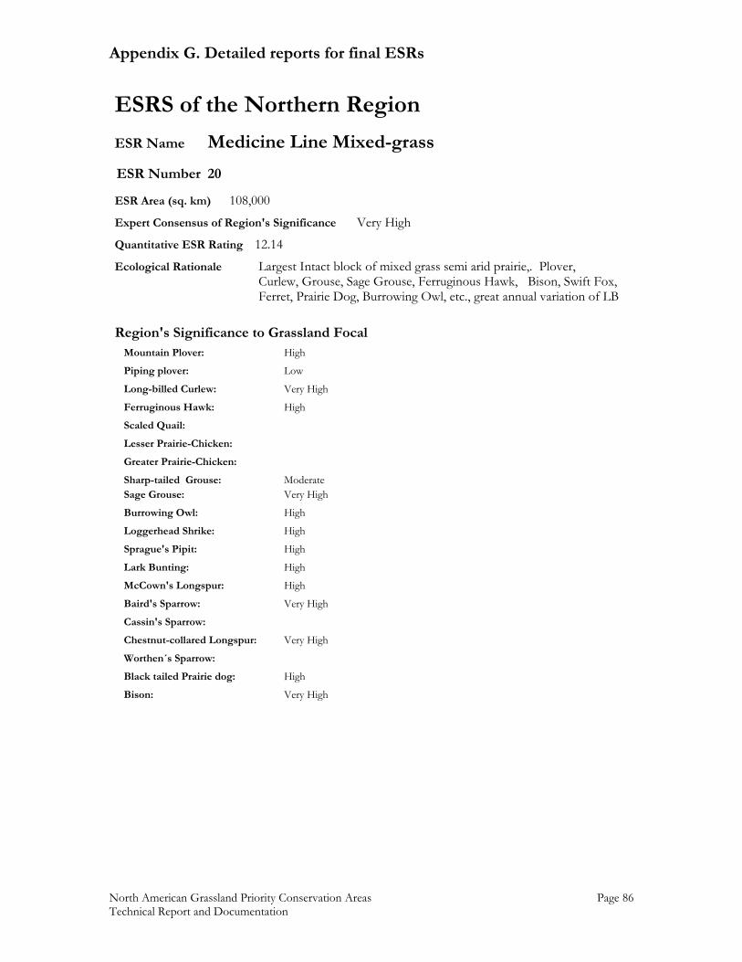
Appendix G. Detailed reports for final ESRs
North American Grassland Priority Conservation Areas Page 86 Technical Report and Documentation
ESRS of the Northern Region ESR Name Medicine Line Mixed-grass ESR Number 20 ESR Area (sq. km) 108,000 Expert Consensus of Region's Significance Very High Quantitative ESR Rating 12.14 Ecological Rationale Largest Intact block of mixed grass semi arid prairie,. Plover,
Curlew, Grouse, Sage Grouse, Ferruginous Hawk, Bison, Swift Fox, Ferret, Prairie Dog, Burrowing Owl, etc., great annual variation of LB
Region's Significance to Grassland Focal Mountain Plover: High Piping plover: Low Long-billed Curlew: Very High Ferruginous Hawk: High Scaled Quail: Lesser Prairie-Chicken: Greater Prairie-Chicken: Sharp-tailed Grouse: Moderate Sage Grouse: Very High Burrowing Owl: High Loggerhead Shrike: High Sprague's Pipit: High Lark Bunting: High McCown's Longspur: High Baird's Sparrow: Very High Cassin's Sparrow: Chestnut-collared Longspur: Very High Worthen´s Sparrow: Black tailed Prairie dog: High Bison: Very High
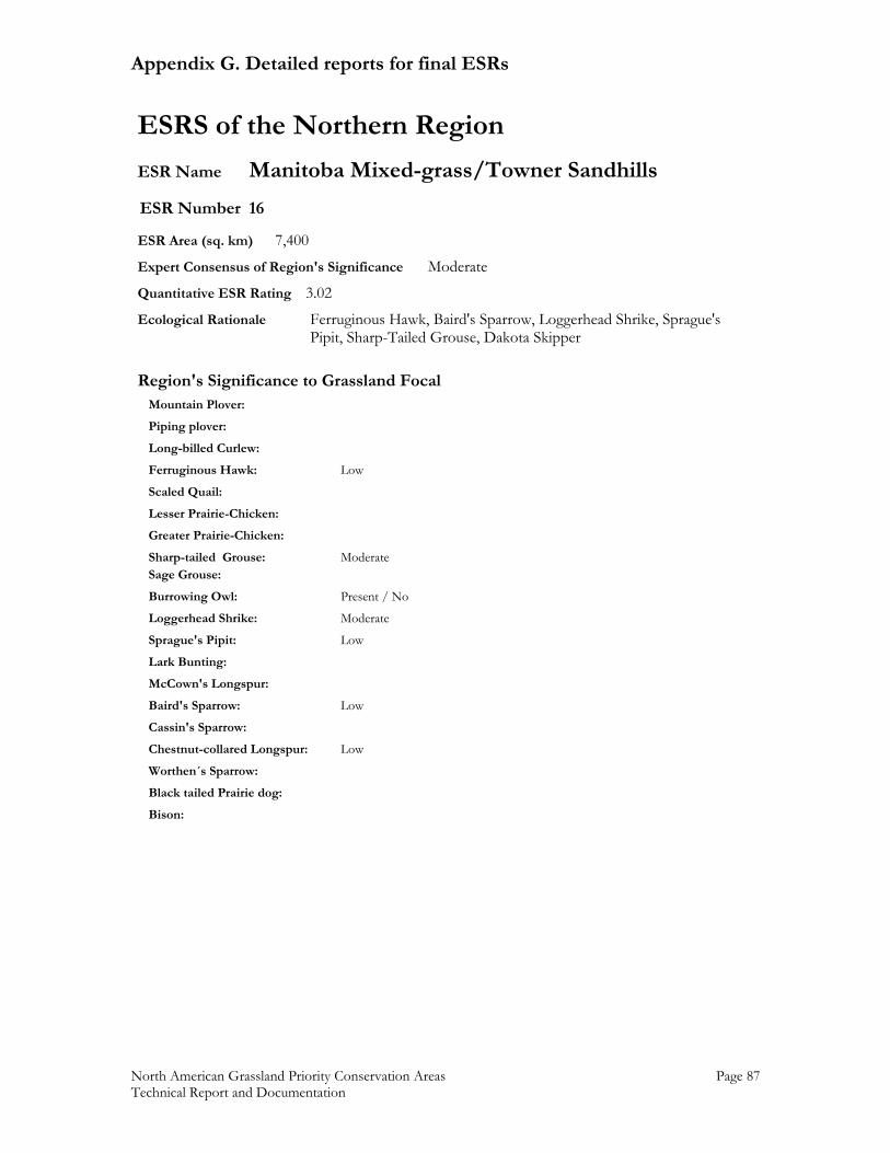
Appendix G. Detailed reports for final ESRs
North American Grassland Priority Conservation Areas Page 87 Technical Report and Documentation
ESRS of the Northern Region ESR Name Manitoba Mixed-grass/Towner Sandhills ESR Number 16 ESR Area (sq. km) 7,400 Expert Consensus of Region's Significance Moderate Quantitative ESR Rating 3.02 Ecological Rationale Ferruginous Hawk, Baird's Sparrow, Loggerhead Shrike, Sprague's Pipit, Sharp-Tailed Grouse, Dakota Skipper
Region's Significance to Grassland Focal Mountain Plover: Piping plover: Long-billed Curlew: Ferruginous Hawk: Low Scaled Quail: Lesser Prairie-Chicken: Greater Prairie-Chicken: Sharp-tailed Grouse: Moderate Sage Grouse: Burrowing Owl: Present / No Loggerhead Shrike: Moderate Sprague's Pipit: Low Lark Bunting: McCown's Longspur: Baird's Sparrow: Low Cassin's Sparrow: Chestnut-collared Longspur: Low Worthen´s Sparrow: Black tailed Prairie dog: Bison:
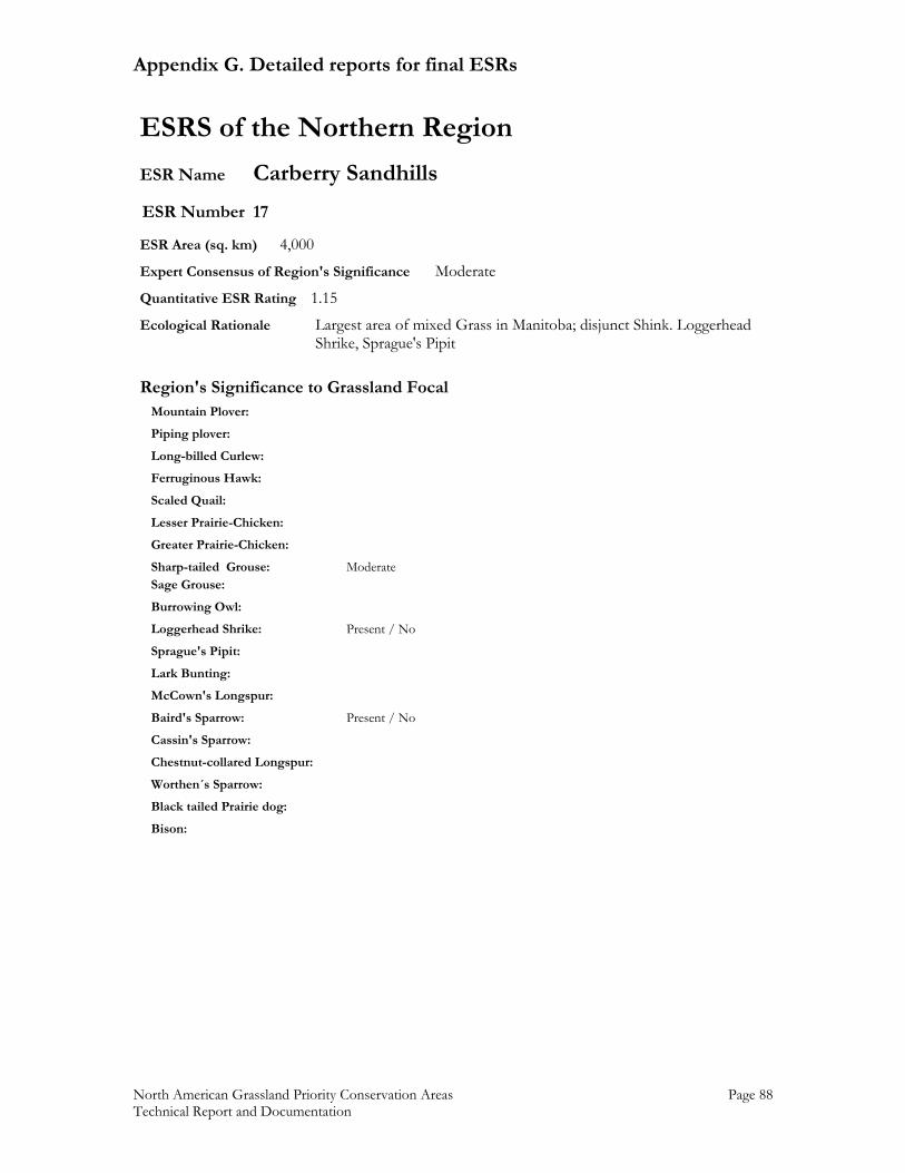
Appendix G. Detailed reports for final ESRs
North American Grassland Priority Conservation Areas Page 88 Technical Report and Documentation
ESRS of the Northern Region ESR Name Carberry Sandhills ESR Number 17 ESR Area (sq. km) 4,000 Expert Consensus of Region's Significance Moderate Quantitative ESR Rating 1.15 Ecological Rationale Largest area of mixed Grass in Manitoba; disjunct Shink. Loggerhead Shrike, Sprague's Pipit
Region's Significance to Grassland Focal Mountain Plover: Piping plover: Long-billed Curlew: Ferruginous Hawk: Scaled Quail: Lesser Prairie-Chicken: Greater Prairie-Chicken: Sharp-tailed Grouse: Moderate Sage Grouse: Burrowing Owl: Loggerhead Shrike: Present / No Sprague's Pipit: Lark Bunting: McCown's Longspur: Baird's Sparrow: Present / No Cassin's Sparrow: Chestnut-collared Longspur: Worthen´s Sparrow: Black tailed Prairie dog: Bison:
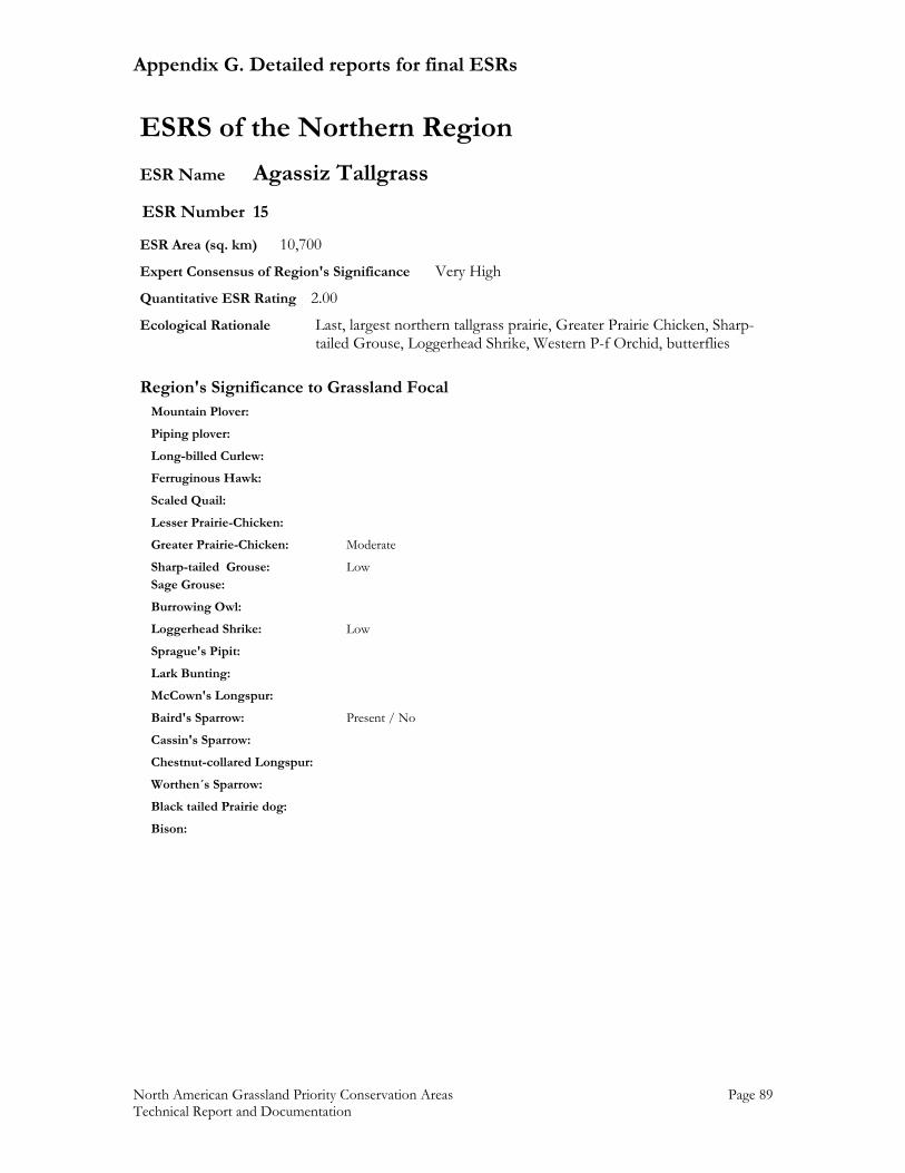
Appendix G. Detailed reports for final ESRs
North American Grassland Priority Conservation Areas Page 89 Technical Report and Documentation
ESRS of the Northern Region ESR Name Agassiz Tallgrass ESR Number 15 ESR Area (sq. km) 10,700 Expert Consensus of Region's Significance Very High Quantitative ESR Rating 2.00 Ecological Rationale Last, largest northern tallgrass prairie, Greater Prairie Chicken, Sharp- tailed Grouse, Loggerhead Shrike, Western P-f Orchid, butterflies
Region's Significance to Grassland Focal Mountain Plover: Piping plover: Long-billed Curlew: Ferruginous Hawk: Scaled Quail: Lesser Prairie-Chicken: Greater Prairie-Chicken: Moderate Sharp-tailed Grouse: Low Sage Grouse: Burrowing Owl: Loggerhead Shrike: Low Sprague's Pipit: Lark Bunting: McCown's Longspur: Baird's Sparrow: Present / No Cassin's Sparrow: Chestnut-collared Longspur: Worthen´s Sparrow: Black tailed Prairie dog: Bison:
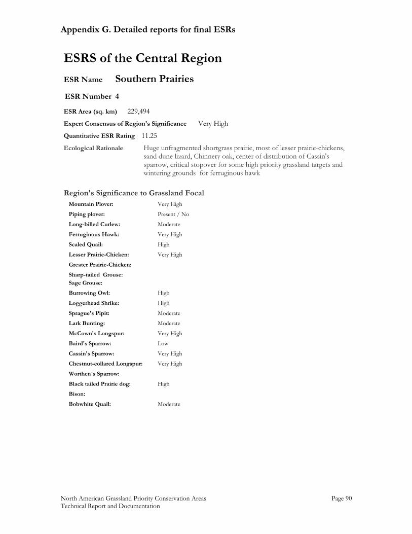
Appendix G. Detailed reports for final ESRs
North American Grassland Priority Conservation Areas Page 90 Technical Report and Documentation
ESRS of the Central Region ESR Name Southern Prairies ESR Number 4 ESR Area (sq. km) 229,494 Expert Consensus of Region's Significance Very High Quantitative ESR Rating 11.25 Ecological Rationale Huge unfragmented shortgrass prairie, most of lesser prairie-chickens, sand dune lizard, Chinnery oak, center of distribution of Cassin's sparrow, critical stopover for some high priority grassland targets and wintering grounds for ferruginous hawk
Region's Significance to Grassland Focal Mountain Plover: Very High Piping plover: Present / No Long-billed Curlew: Moderate Ferruginous Hawk: Very High Scaled Quail: High Lesser Prairie-Chicken: Very High Greater Prairie-Chicken: Sharp-tailed Grouse: Sage Grouse: Burrowing Owl: High Loggerhead Shrike: High Sprague's Pipit: Moderate Lark Bunting: Moderate McCown's Longspur: Very High Baird's Sparrow: Low Cassin's Sparrow: Very High Chestnut-collared Longspur: Very High Worthen´s Sparrow: Black tailed Prairie dog: High Bison: Bobwhite Quail: Moderate
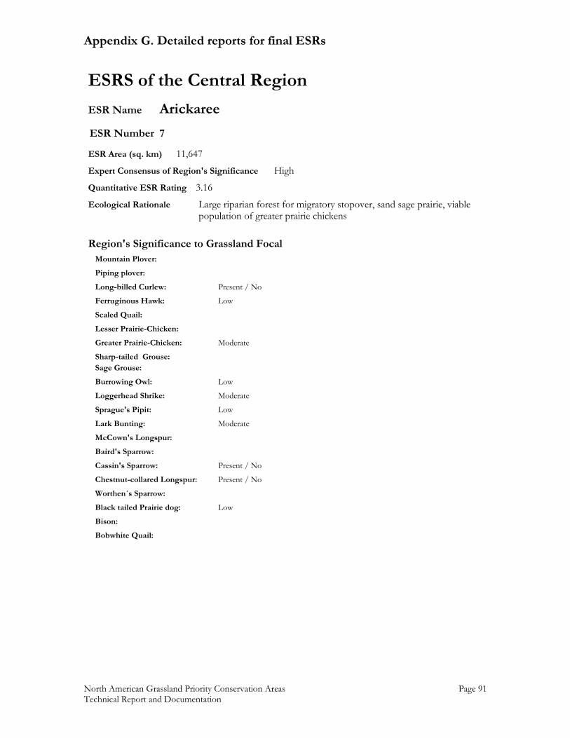
Appendix G. Detailed reports for final ESRs
North American Grassland Priority Conservation Areas Page 91 Technical Report and Documentation
ESRS of the Central Region ESR Name Arickaree ESR Number 7 ESR Area (sq. km) 11,647 Expert Consensus of Region's Significance High Quantitative ESR Rating 3.16 Ecological Rationale Large riparian forest for migratory stopover, sand sage prairie, viable population of greater prairie chickens
Region's Significance to Grassland Focal Mountain Plover: Piping plover: Long-billed Curlew: Present / No Ferruginous Hawk: Low Scaled Quail: Lesser Prairie-Chicken: Greater Prairie-Chicken: Moderate Sharp-tailed Grouse: Sage Grouse: Burrowing Owl: Low Loggerhead Shrike: Moderate Sprague's Pipit: Low Lark Bunting: Moderate McCown's Longspur: Baird's Sparrow: Cassin's Sparrow: Present / No Chestnut-collared Longspur: Present / No Worthen´s Sparrow: Black tailed Prairie dog: Low Bison: Bobwhite Quail:
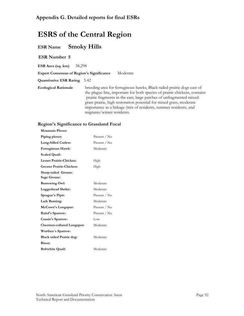
Appendix G. Detailed reports for final ESRs
North American Grassland Priority Conservation Areas Page 92 Technical Report and Documentation
ESRS of the Central Region ESR Name Smoky Hills ESR Number 5 ESR Area (sq. km) 38,298 Expert Consensus of Region's Significance Moderate Quantitative ESR Rating 5.42 Ecological Rationale breeding area for ferruginous hawks, Black-tailed prairie dogs east of the plague line, important for both species of prairie chickens, contains prairie fragments in the east, large patches of unfragmented mixed- grass prairie, high restoration potential for mixed grass, moderate importance as a linkage (mix of residents, summer residents, and migrants/winter residents.
Region's Significance to Grassland Focal Mountain Plover: Piping plover: Present / No Long-billed Curlew: Present / No Ferruginous Hawk: Moderate Scaled Quail: Lesser Prairie-Chicken: High Greater Prairie-Chicken: High Sharp-tailed Grouse: Sage Grouse: Burrowing Owl: Moderate Loggerhead Shrike: Moderate Sprague's Pipit: Present / No Lark Bunting: Moderate McCown's Longspur: Present / No Baird's Sparrow: Present / No Cassin's Sparrow: Low Chestnut-collared Longspur: Moderate Worthen´s Sparrow: Black tailed Prairie dog: Moderate Bison: Bobwhite Quail: Moderate
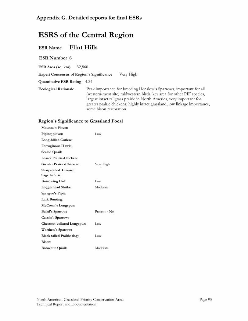
Appendix G. Detailed reports for final ESRs
North American Grassland Priority Conservation Areas Page 93 Technical Report and Documentation
ESRS of the Central Region ESR Name Flint Hills ESR Number 6 ESR Area (sq. km) 32,860 Expert Consensus of Region's Significance Very High Quantitative ESR Rating 4.24 Ecological Rationale Peak importance for breeding Henslow’s Sparrows, important for all (western-most site) midwestern birds, key area for other PIF species, largest intact tallgrass prairie in North America, very important for greater prairie chickens, highly intact grassland, low linkage importance, some bison restoration.
Region's Significance to Grassland Focal Mountain Plover: Piping plover: Low Long-billed Curlew: Ferruginous Hawk: Scaled Quail: Lesser Prairie-Chicken: Greater Prairie-Chicken: Very High Sharp-tailed Grouse: Sage Grouse: Burrowing Owl: Low Loggerhead Shrike: Moderate Sprague's Pipit: Lark Bunting: McCown's Longspur: Baird's Sparrow: Present / No Cassin's Sparrow: Chestnut-collared Longspur: Low Worthen´s Sparrow: Black tailed Prairie dog: Low Bison: Bobwhite Quail: Moderate
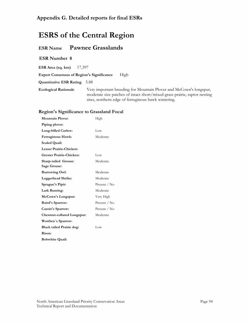
Appendix G. Detailed reports for final ESRs
North American Grassland Priority Conservation Areas Page 94 Technical Report and Documentation
ESRS of the Central Region ESR Name Pawnee Grasslands ESR Number 8 ESR Area (sq. km) 17,397 Expert Consensus of Region's Significance High Quantitative ESR Rating 5.88 Ecological Rationale Very important breeding for Mountain Plover and McCown's longspur, moderate size patches of intact short/mixed-grass prairie, raptor nesting
sites, northern edge of ferruginous hawk wintering.
Region's Significance to Grassland Focal Mountain Plover: High Piping plover: Long-billed Curlew: Low Ferruginous Hawk: Moderate Scaled Quail: Lesser Prairie-Chicken: Greater Prairie-Chicken: Low Sharp-tailed Grouse: Moderate Sage Grouse: Burrowing Owl: Moderate Loggerhead Shrike: Moderate Sprague's Pipit: Present / No Lark Bunting: Moderate McCown's Longspur: Very High Baird's Sparrow: Present / No Cassin's Sparrow: Present / No Chestnut-collared Longspur: Moderate Worthen´s Sparrow: Black tailed Prairie dog: Low Bison: Bobwhite Quail:
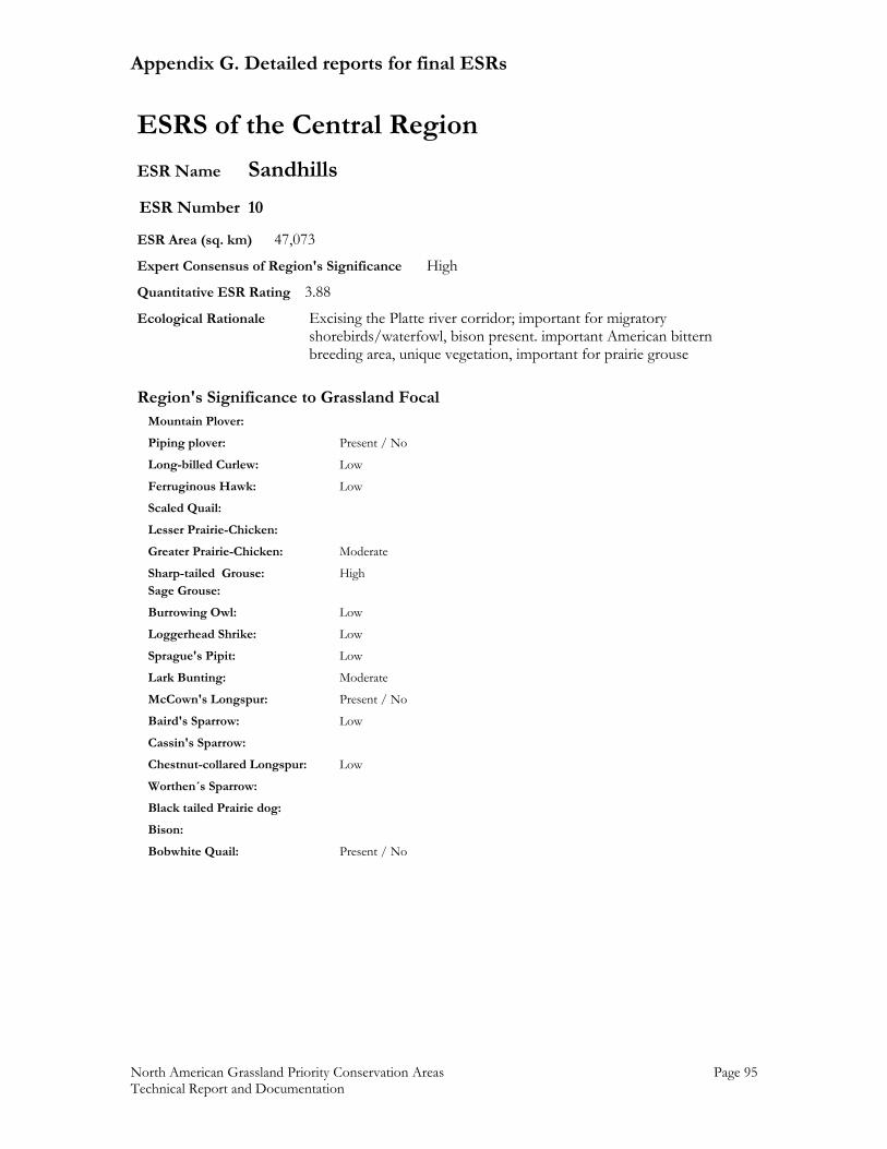
Appendix G. Detailed reports for final ESRs
North American Grassland Priority Conservation Areas Page 95 Technical Report and Documentation
ESRS of the Central Region ESR Name Sandhills ESR Number 10 ESR Area (sq. km) 47,073 Expert Consensus of Region's Significance High Quantitative ESR Rating 3.88 Ecological Rationale Excising the Platte river corridor; important for migratory shorebirds/waterfowl, bison present. important American bittern breeding area, unique vegetation, important for prairie grouse
Region's Significance to Grassland Focal Mountain Plover: Piping plover: Present / No Long-billed Curlew: Low Ferruginous Hawk: Low Scaled Quail: Lesser Prairie-Chicken: Greater Prairie-Chicken: Moderate Sharp-tailed Grouse: High Sage Grouse: Burrowing Owl: Low Loggerhead Shrike: Low Sprague's Pipit: Low Lark Bunting: Moderate McCown's Longspur: Present / No Baird's Sparrow: Low Cassin's Sparrow: Chestnut-collared Longspur: Low Worthen´s Sparrow: Black tailed Prairie dog: Bison: Bobwhite Quail: Present / No
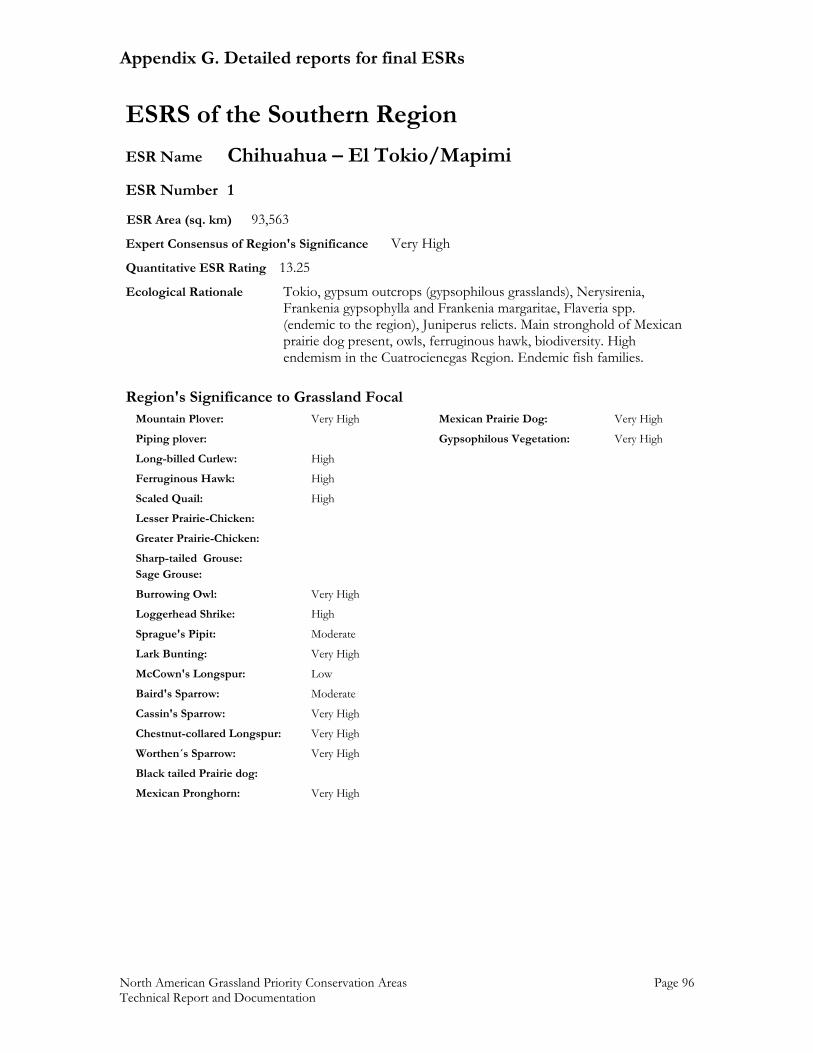
Appendix G. Detailed reports for final ESRs
North American Grassland Priority Conservation Areas Page 96 Technical Report and Documentation
ESRS of the Southern Region ESR Name Chihuahua – El Tokio/Mapimi ESR Number 1 ESR Area (sq. km) 93,563 Expert Consensus of Region's Significance Very High Quantitative ESR Rating 13.25 Ecological Rationale Tokio, gypsum outcrops (gypsophilous grasslands), Nerysirenia, Frankenia gypsophylla and Frankenia margaritae, Flaveria spp. (endemic to the region), Juniperus relicts. Main stronghold of Mexican prairie dog present, owls, ferruginous hawk, biodiversity. High endemism in the Cuatrocienegas Region. Endemic fish families.
Region's Significance to Grassland Focal Mountain Plover: Very High Mexican Prairie Dog: Very High Piping plover: Gypsophilous Vegetation: Very High Long-billed Curlew: High Ferruginous Hawk: High Scaled Quail: High Lesser Prairie-Chicken: Greater Prairie-Chicken: Sharp-tailed Grouse: Sage Grouse: Burrowing Owl: Very High Loggerhead Shrike: High Sprague's Pipit: Moderate Lark Bunting: Very High McCown's Longspur: Low Baird's Sparrow: Moderate Cassin's Sparrow: Very High Chestnut-collared Longspur: Very High Worthen´s Sparrow: Very High Black tailed Prairie dog: Mexican Pronghorn: Very High
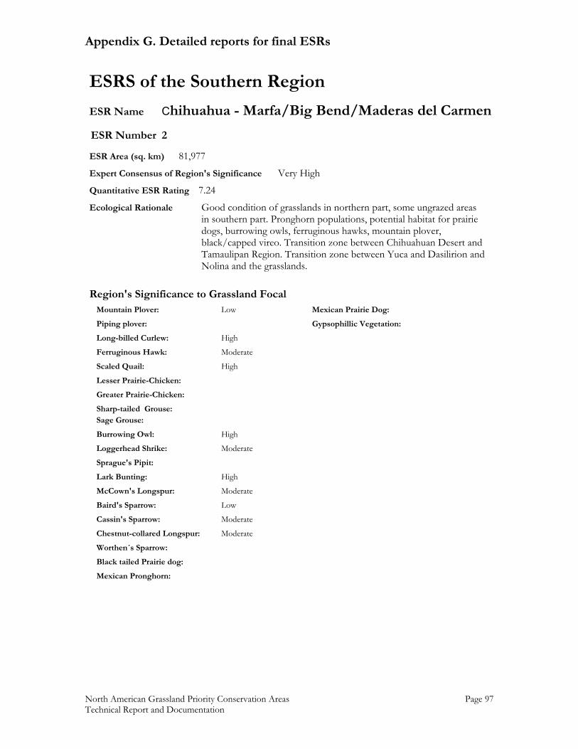
Appendix G. Detailed reports for final ESRs
North American Grassland Priority Conservation Areas Page 97 Technical Report and Documentation
ESRS of the Southern Region ESR Name Chihuahua - Marfa/Big Bend/Maderas del Carmen ESR Number 2 ESR Area (sq. km) 81,977 Expert Consensus of Region's Significance Very High Quantitative ESR Rating 7.24 Ecological Rationale Good condition of grasslands in northern part, some ungrazed areas in southern part. Pronghorn populations, potential habitat for prairie dogs, burrowing owls, ferruginous hawks, mountain plover, black/capped vireo. Transition zone between Chihuahuan Desert and Tamaulipan Region. Transition zone between Yuca and Dasilirion and Nolina and the grasslands.
Region's Significance to Grassland Focal Mountain Plover: Low Mexican Prairie Dog: Piping plover: Gypsophillic Vegetation: Long-billed Curlew: High Ferruginous Hawk: Moderate Scaled Quail: High Lesser Prairie-Chicken: Greater Prairie-Chicken: Sharp-tailed Grouse: Sage Grouse: Burrowing Owl: High Loggerhead Shrike: Moderate Sprague's Pipit: Lark Bunting: High McCown's Longspur: Moderate Baird's Sparrow: Low Cassin's Sparrow: Moderate Chestnut-collared Longspur: Moderate Worthen´s Sparrow: Black tailed Prairie dog: Mexican Pronghorn:
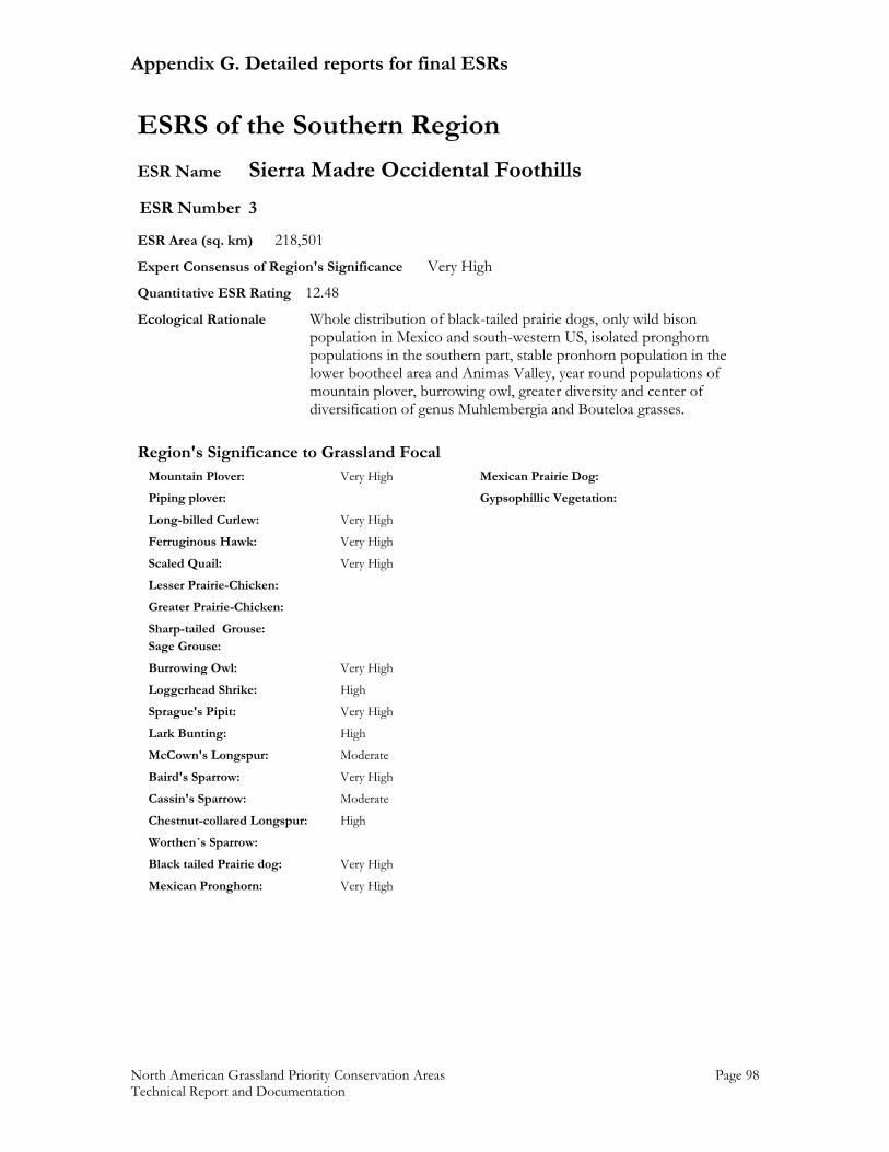
Appendix G. Detailed reports for final ESRs
North American Grassland Priority Conservation Areas Page 98 Technical Report and Documentation
ESRS of the Southern Region ESR Name Sierra Madre Occidental Foothills ESR Number 3 ESR Area (sq. km) 218,501 Expert Consensus of Region's Significance Very High Quantitative ESR Rating 12.48 Ecological Rationale Whole distribution of black-tailed prairie dogs, only wild bison population in Mexico and south-western US, isolated pronghorn populations in the southern part, stable pronhorn population in the lower bootheel area and Animas Valley, year round populations of mountain plover, burrowing owl, greater diversity and center of diversification of genus Muhlembergia and Bouteloa grasses.
Region's Significance to Grassland Focal Mountain Plover: Very High Mexican Prairie Dog: Piping plover: Gypsophillic Vegetation: Long-billed Curlew: Very High Ferruginous Hawk: Very High Scaled Quail: Very High Lesser Prairie-Chicken: Greater Prairie-Chicken: Sharp-tailed Grouse: Sage Grouse: Burrowing Owl: Very High Loggerhead Shrike: High Sprague's Pipit: Very High Lark Bunting: High McCown's Longspur: Moderate Baird's Sparrow: Very High Cassin's Sparrow: Moderate Chestnut-collared Longspur: High Worthen´s Sparrow: Black tailed Prairie dog: Very High Mexican Pronghorn: Very High
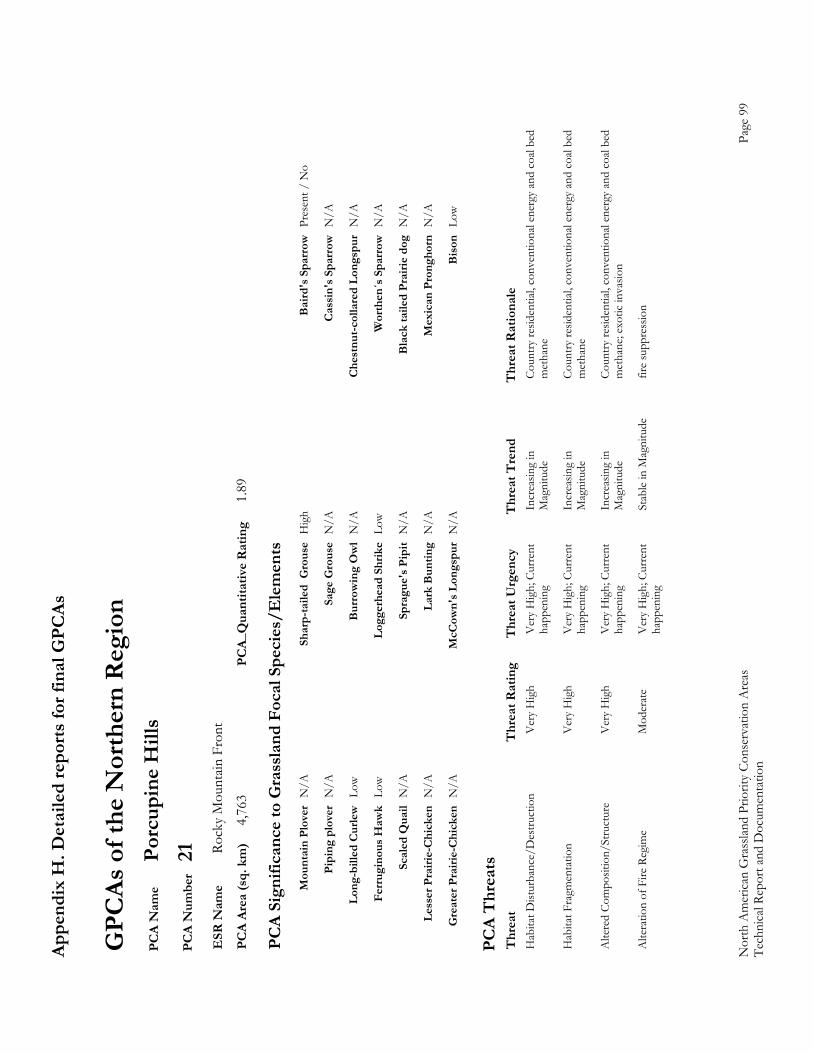
Appe
ndix
H. D
etai
led
repo
rts fo
r fin
al G
PCAs
Nor
th A
mer
ican
Gra
sslan
d Pr
iorit
y Co
nser
vatio
n A
reas
Page
99
Tech
nica
l Rep
ort a
nd D
ocum
enta
tion
GPC
As o
f the
Nor
ther
n R
egio
n P
CA
Nam
e Po
rcup
ine
Hill
s P
CA
Num
ber
21
ESR
Nam
e Ro
cky
Mou
ntain
Fro
nt
PC
A Ar
ea (s
q. k
m)
4,76
3 PC
A_Q
uant
itativ
e R
atin
g 1.
89
PC
A Si
gnifi
canc
e to
Gra
ssla
nd F
ocal
Spe
cies
/Ele
men
ts
M
ount
ain
Plov
er N
/A
Shar
p-ta
iled
Gro
use
Hig
h B
aird
's S
parr
ow P
rese
nt /
No
Pi
ping
plo
ver
N/A
Sa
ge G
rous
e N
/A
Cas
sin'
s Spa
rrow
N/A
Lo
ng-b
illed
Cur
lew L
ow
Bur
row
ing
Ow
l N
/A
Che
stnu
t-col
lare
d Lo
ngsp
ur N
/A
Fe
rrug
inou
s Haw
k Lo
w
Logg
erhe
ad S
hrik
e Lo
w
Wor
then
´s S
parr
ow N
/A
Sc
aled
Qua
il N
/A
Spra
gue'
s Pip
it N
/A
Bla
ck ta
iled
Prai
rie d
og N
/A
Le
sser
Pra
irie-
Chi
cken
N/A
La
rk B
untin
g N
/A
Mex
ican
Pro
ngho
rn N
/A
G
reat
er P
rairi
e-C
hick
en N
/A
McC
own'
s Lon
gspu
r N
/A
Bis
on L
ow
PC
A T
hrea
ts
Thr
eat
Thr
eat R
atin
g T
hrea
t Urg
ency
T
hrea
t Tre
nd
Thr
eat R
atio
nale
H
abita
t Dist
urba
nce/
Des
truct
ion
V
ery
Hig
h V
ery
Hig
h; C
urre
nt
Incr
easin
g in
Co
untry
resid
entia
l, co
nven
tiona
l ene
rgy
and
coal
bed
happ
enin
g M
agni
tude
m
etha
ne
Hab
itat F
ragm
enta
tion
V
ery
Hig
h V
ery
Hig
h; C
urre
nt
Incr
easin
g in
Co
untry
resid
entia
l, co
nven
tiona
l ene
rgy
and
coal
bed
happ
enin
g M
agni
tude
m
etha
ne
Alte
red
Com
posit
ion/
Stru
ctur
e V
ery
Hig
h V
ery
Hig
h; C
urre
nt
Incr
easin
g in
Co
untry
resid
entia
l, co
nven
tiona
l ene
rgy
and
coal
bed
happ
enin
g M
agni
tude
m
etha
ne; e
xotic
inva
sion
Alte
ratio
n of
Fire
Reg
ime
Mod
erat
e V
ery
Hig
h; C
urre
nt
Stab
le in
Mag
nitu
de
fire
supp
ress
ion
ha
ppen
ing
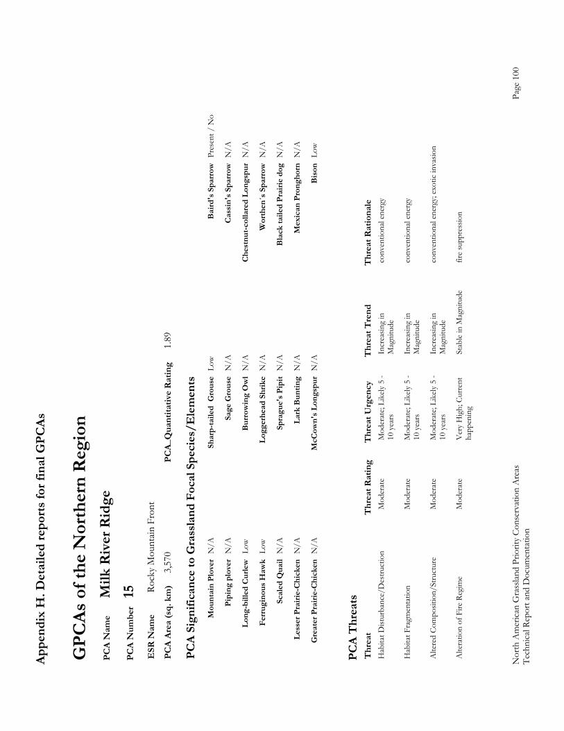
Appe
ndix
H. D
etai
led
repo
rts fo
r fin
al G
PCAs
Nor
th A
mer
ican
Gra
sslan
d Pr
iorit
y Co
nser
vatio
n A
reas
Page
100
Te
chni
cal R
epor
t and
Doc
umen
tatio
n
GPC
As o
f the
Nor
ther
n R
egio
n P
CA
Nam
e M
ilk R
iver
Rid
ge
PC
A N
umbe
r 15
E
SR N
ame
Rock
y M
ount
ain F
ront
P
CA
Area
(sq.
km
) 3,
570
PCA_
Qua
ntita
tive
Rat
ing
1.89
PC
A Si
gnifi
canc
e to
Gra
ssla
nd F
ocal
Spe
cies
/Ele
men
ts
M
ount
ain
Plov
er N
/A
Shar
p-ta
iled
Gro
use
Low
Bai
rd's
Spa
rrow
Pre
sent
/ N
o
Pi
ping
plo
ver
N/A
Sa
ge G
rous
e N
/A
Cas
sin'
s Spa
rrow
N/A
Lo
ng-b
illed
Cur
lew L
ow
Bur
row
ing
Ow
l N
/A
Che
stnu
t-col
lare
d Lo
ngsp
ur N
/A
Fe
rrug
inou
s Haw
k Lo
w
Logg
erhe
ad S
hrik
e N
/A
Wor
then
´s S
parr
ow N
/A
Sc
aled
Qua
il N
/A
Spra
gue'
s Pip
it N
/A
Bla
ck ta
iled
Prai
rie d
og N
/A
Le
sser
Pra
irie-
Chi
cken
N/A
La
rk B
untin
g N
/A
Mex
ican
Pro
ngho
rn N
/A
G
reat
er P
rairi
e-C
hick
en N
/A
McC
own'
s Lon
gspu
r N
/A
Bis
on L
ow
PC
A T
hrea
ts
Thr
eat
Thr
eat R
atin
g T
hrea
t Urg
ency
T
hrea
t Tre
nd
Thr
eat R
atio
nale
H
abita
t Dist
urba
nce/
Des
truct
ion
M
oder
ate
Mod
erat
e; Li
kely
5 -
Incr
easin
g in
co
nven
tiona
l ene
rgy
10
yea
rs
Mag
nitu
de
Hab
itat F
ragm
enta
tion
M
oder
ate
Mod
erat
e; Li
kely
5 -
Incr
easin
g in
co
nven
tiona
l ene
rgy
10
yea
rs
Mag
nitu
de
Alte
red
Com
posit
ion/
Stru
ctur
e M
oder
ate
Mod
erat
e; Li
kely
5 -
Incr
easin
g in
co
nven
tiona
l ene
rgy;
exot
ic in
vasio
n
10 y
ears
Mag
nitu
de
Alte
ratio
n of
Fire
Reg
ime
Mod
erat
e V
ery
Hig
h; C
urre
nt
Stab
le in
Mag
nitu
de
fire
supp
ress
ion
ha
ppen
ing
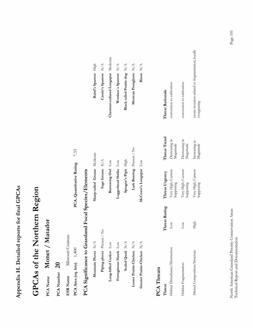
Appe
ndix
H. D
etai
led
repo
rts fo
r fin
al G
PCAs
Nor
th A
mer
ican
Gra
sslan
d Pr
iorit
y Co
nser
vatio
n A
reas
Page
101
Te
chni
cal R
epor
t and
Doc
umen
tatio
n
GPC
As o
f the
Nor
ther
n R
egio
n P
CA
Nam
e M
onet
/ M
atad
or
PC
A N
umbe
r 20
E
SR N
ame
Miss
ouri
Cout
eau
PC
A Ar
ea (s
q. k
m)
1,40
0 PC
A_Q
uant
itativ
e R
atin
g 7.
33
PC
A Si
gnifi
canc
e to
Gra
ssla
nd F
ocal
Spe
cies
/Ele
men
ts
M
ount
ain
Plov
er N
/A
Shar
p-ta
iled
Gro
use
Mod
erat
e B
aird
's S
parr
ow H
igh
Pi
ping
plo
ver
Pres
ent /
No
Sage
Gro
use
N/A
C
assi
n's S
parr
ow N
/A
Lo
ng-b
illed
Cur
lew L
ow
Bur
row
ing
Ow
l Lo
w
Che
stnu
t-col
lare
d Lo
ngsp
ur M
oder
ate
Fe
rrug
inou
s Haw
k Lo
w
Logg
erhe
ad S
hrik
e Lo
w
Wor
then
´s S
parr
ow N
/A
Sc
aled
Qua
il N
/A
Spra
gue'
s Pip
it H
igh
Bla
ck ta
iled
Prai
rie d
og N
/A
Le
sser
Pra
irie-
Chi
cken
N/A
La
rk B
untin
g Pr
esen
t / N
o M
exic
an P
rong
horn
N/A
G
reat
er P
rairi
e-C
hick
en N
/A
McC
own'
s Lon
gspu
r Lo
w
Bis
on N
/A
PC
A T
hrea
ts
Thr
eat
Thr
eat R
atin
g T
hrea
t Urg
ency
T
hrea
t Tre
nd
Thr
eat R
atio
nale
H
abita
t Dist
urba
nce/
Des
truct
ion
Lo
w
Ver
y H
igh;
Cur
rent
D
ecre
asin
g in
co
nver
sion
to c
ultiv
atio
n
happ
enin
g M
agni
tude
Hab
itat F
ragm
enta
tion
Lo
w
Ver
y H
igh;
Cur
rent
D
ecre
asin
g in
co
nver
sion
to c
ultiv
atio
n
happ
enin
g M
agni
tude
Alte
red
Com
posit
ion/
Stru
ctur
e H
igh
Ver
y H
igh;
Cur
rent
In
crea
sing
in
exot
ic in
vasio
n re
lated
to fr
agm
enta
tion;
loca
lly
ha
ppen
ing
Mag
nitu
de
over
graz
ing
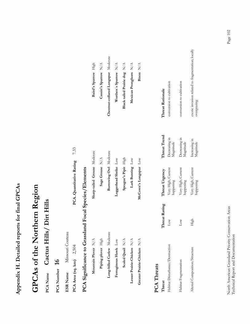
Appe
ndix
H. D
etai
led
repo
rts fo
r fin
al G
PCAs
Nor
th A
mer
ican
Gra
sslan
d Pr
iorit
y Co
nser
vatio
n A
reas
Page
102
Te
chni
cal R
epor
t and
Doc
umen
tatio
n
GPC
As o
f the
Nor
ther
n R
egio
n P
CA
Nam
e C
actu
s Hill
s/ D
irt H
ills
PC
A N
umbe
r 16
E
SR N
ame
Miss
ouri
Cout
eau
PC
A Ar
ea (s
q. k
m)
2,50
4 PC
A_Q
uant
itativ
e R
atin
g 7.
33
PC
A Si
gnifi
canc
e to
Gra
ssla
nd F
ocal
Spe
cies
/Ele
men
ts
M
ount
ain
Plov
er N
/A
Shar
p-ta
iled
Gro
use
Mod
erat
e B
aird
's S
parr
ow H
igh
Pi
ping
plo
ver
Hig
h Sa
ge G
rous
e N
/A
Cas
sin'
s Spa
rrow
N/A
Lo
ng-b
illed
Cur
lew M
oder
ate
Bur
row
ing
Ow
l M
oder
ate
Che
stnu
t-col
lare
d Lo
ngsp
ur M
oder
ate
Fe
rrug
inou
s Haw
k Lo
w
Logg
erhe
ad S
hrik
e Lo
w
Wor
then
´s S
parr
ow N
/A
Sc
aled
Qua
il N
/A
Spra
gue'
s Pip
it H
igh
Bla
ck ta
iled
Prai
rie d
og N
/A
Le
sser
Pra
irie-
Chi
cken
N/A
La
rk B
untin
g Lo
w
Mex
ican
Pro
ngho
rn N
/A
G
reat
er P
rairi
e-C
hick
en N
/A
McC
own'
s Lon
gspu
r Lo
w
Bis
on N
/A
PC
A T
hrea
ts
Thr
eat
Thr
eat R
atin
g T
hrea
t Urg
ency
T
hrea
t Tre
nd
Thr
eat R
atio
nale
H
abita
t Dist
urba
nce/
Des
truct
ion
Lo
w
Ver
y H
igh;
Cur
rent
D
ecre
asin
g in
co
nver
sion
to c
ultiv
atio
n
happ
enin
g M
agni
tude
Hab
itat F
ragm
enta
tion
Lo
w
Ver
y H
igh;
Cur
rent
D
ecre
asin
g in
co
nver
sion
to c
ultiv
atio
n
happ
enin
g M
agni
tude
Alte
red
Com
posit
ion/
Stru
ctur
e H
igh
Ver
y H
igh;
Cur
rent
In
crea
sing
in
exot
ic in
vasio
n re
lated
to fr
agm
enta
tion;
loca
lly
ha
ppen
ing
Mag
nitu
de
over
graz
ing

Appe
ndix
H. D
etai
led
repo
rts fo
r fin
al G
PCAs
Nor
th A
mer
ican
Gra
sslan
d Pr
iorit
y Co
nser
vatio
n A
reas
Page
103
Te
chni
cal R
epor
t and
Doc
umen
tatio
n
GPC
As o
f the
Nor
ther
n R
egio
n P
CA
Nam
e G
reat
San
dhill
s P
CA
Num
ber
17
ESR
Nam
e M
edic
ine
Line
Mix
ed-g
rass
P
CA
Area
(sq.
km
) 3,
172
PCA_
Qua
ntita
tive
Rat
ing
3.36
PC
A Si
gnifi
canc
e to
Gra
ssla
nd F
ocal
Spe
cies
/Ele
men
ts
M
ount
ain
Plov
er P
rese
nt /
No
Sh
arp-
taile
d G
rous
e H
igh
Bai
rd's
Spa
rrow
Low
Sign
ifica
nce
Pi
ping
plo
ver
Pres
ent /
No
Sa
ge G
rous
e Pr
esen
t / N
o
Cas
sin'
s Spa
rrow
N/A
Sign
ifica
nce
Sign
ifica
nce
Lo
ng-b
illed
Cur
lew L
ow
Bur
row
ing
Ow
l Pr
esen
t / N
o
Che
stnu
t-col
lare
d Lo
ngsp
ur L
ow
Si
gnifi
canc
e
Ferr
ugin
ous H
awk
N/A
Lo
gger
head
Shr
ike
Mod
erat
e W
orth
en´s
Spa
rrow
N/A
Sc
aled
Qua
il N
/A
Spra
gue'
s Pip
it Lo
w
Bla
ck ta
iled
Prai
rie d
og P
rese
nt /
No
Sign
ifica
nce
Le
sser
Pra
irie-
Chi
cken
N/A
La
rk B
untin
g Lo
w
Mex
ican
Pro
ngho
rn N
/A
G
reat
er P
rairi
e-C
hick
en N
/A
McC
own'
s Lon
gspu
r Pr
esen
t / N
o
Bis
on P
rese
nt /
No
Sign
ifica
nce
Si
gnifi
canc
e
PC
A T
hrea
ts
Thr
eat
Thr
eat R
atin
g T
hrea
t Urg
ency
T
hrea
t Tre
nd
Thr
eat R
atio
nale
H
abita
t Fra
gmen
tatio
n
Ver
y H
igh
Ver
y H
igh;
Cur
rent
In
crea
sing
in
gas d
rillin
g w
ith e
xotic
inva
sion
ha
ppen
ing
Mag
nitu
de
Alte
red
Com
posit
ion/
Stru
ctur
e M
oder
ate
Ver
y H
igh;
Cur
rent
In
crea
sing
in
gas d
rillin
g w
ith e
xotic
inva
sion
ha
ppen
ing
Mag
nitu
de
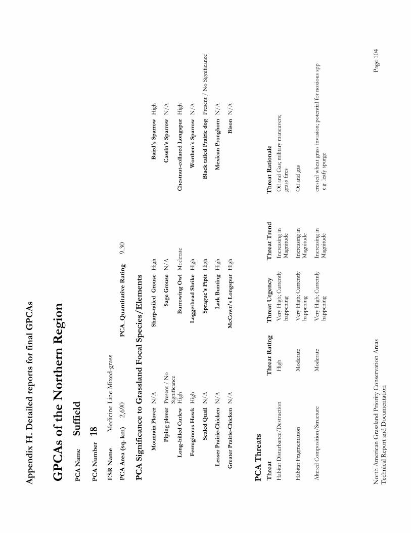
Appe
ndix
H. D
etai
led
repo
rts fo
r fin
al G
PCAs
Nor
th A
mer
ican
Gra
sslan
d Pr
iorit
y Co
nser
vatio
n A
reas
Page
104
Te
chni
cal R
epor
t and
Doc
umen
tatio
n
GPC
As o
f the
Nor
ther
n R
egio
n P
CA
Nam
e Su
ffiel
d
PC
A N
umbe
r 18
E
SR N
ame
Med
icin
e Li
ne M
ixed
-gra
ss
PC
A Ar
ea (s
q. k
m)
2,69
0 PC
A_Q
uant
itativ
e R
atin
g 9.
30
PC
A Si
gnifi
canc
e to
Gra
ssla
nd F
ocal
Spe
cies
/Ele
men
ts
M
ount
ain
Plov
er N
/A
Shar
p-ta
iled
Gro
use
Hig
h B
aird
's S
parr
ow H
igh
Pi
ping
plo
ver
Pres
ent /
No
Sa
ge G
rous
e N
/A
Cas
sin'
s Spa
rrow
N/A
Sign
ifica
nce
Lo
ng-b
illed
Cur
lew H
igh
Bur
row
ing
Ow
l M
oder
ate
Che
stnu
t-col
lare
d Lo
ngsp
ur H
igh
Fe
rrug
inou
s Haw
k H
igh
Logg
erhe
ad S
hrik
e H
igh
Wor
then
´s S
parr
ow N
/A
Sc
aled
Qua
il N
/A
Spra
gue'
s Pip
it H
igh
Bla
ck ta
iled
Prai
rie d
og P
rese
nt /
No
Sign
ifica
nce
Le
sser
Pra
irie-
Chi
cken
N/A
La
rk B
untin
g H
igh
Mex
ican
Pro
ngho
rn N
/A
G
reat
er P
rairi
e-C
hick
en N
/A
McC
own'
s Lon
gspu
r H
igh
Bis
on N
/A
PC
A T
hrea
ts
Thr
eat
Thr
eat R
atin
g T
hrea
t Urg
ency
T
hrea
t Tre
nd
Thr
eat R
atio
nale
Hab
itat D
istur
banc
e/D
estru
ctio
n
Hig
h V
ery
Hig
h; C
urre
ntly
In
crea
sing
in
Oil
and
Gas
; mili
tary
man
euve
rs;
happ
enin
g M
agni
tude
gr
ass f
ires
H
abita
t Fra
gmen
tatio
n
Mod
erat
e V
ery
Hig
h; C
urre
ntly
In
crea
sing
in
Oil
and
gas
ha
ppen
ing
Mag
nitu
de
A
ltere
d Co
mpo
sitio
n/St
ruct
ure
Mod
erat
e V
ery
Hig
h; C
urre
tnly
Incr
easin
g in
cr
este
d w
heat
gra
ss in
vasio
n; p
oten
tial f
or n
oxio
us sp
p
happ
enin
g M
agni
tude
e
.g. l
eafy
spur
ge
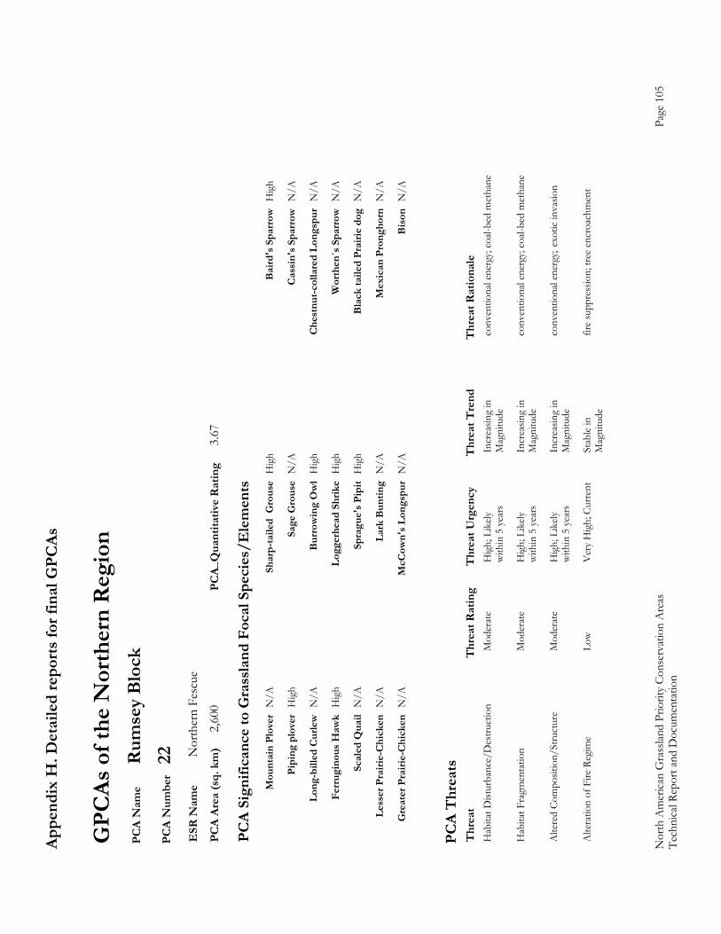
Appe
ndix
H. D
etai
led
repo
rts fo
r fin
al G
PCAs
Nor
th A
mer
ican
Gra
sslan
d Pr
iorit
y Co
nser
vatio
n A
reas
Page
105
Te
chni
cal R
epor
t and
Doc
umen
tatio
n
GPC
As o
f the
Nor
ther
n R
egio
n P
CA
Nam
e R
umse
y B
lock
P
CA
Num
ber
22
ESR
Nam
e N
orth
ern
Fesc
ue
PC
A Ar
ea (s
q. k
m)
2,60
0 PC
A_Q
uant
itativ
e R
atin
g 3.
67
PC
A Si
gnifi
canc
e to
Gra
ssla
nd F
ocal
Spe
cies
/Ele
men
ts
M
ount
ain
Plov
er N
/A
Shar
p-ta
iled
Gro
use
Hig
h B
aird
's S
parr
ow H
igh
Pi
ping
plo
ver
Hig
h Sa
ge G
rous
e N
/A
Cas
sin'
s Spa
rrow
N/A
Lo
ng-b
illed
Cur
lew N
/A
Bur
row
ing
Ow
l H
igh
Che
stnu
t-col
lare
d Lo
ngsp
ur N
/A
Fe
rrug
inou
s Haw
k H
igh
Logg
erhe
ad S
hrik
e H
igh
Wor
then
´s S
parr
ow N
/A
Sc
aled
Qua
il N
/A
Spra
gue'
s Pip
it H
igh
Bla
ck ta
iled
Prai
rie d
og N
/A
Le
sser
Pra
irie-
Chi
cken
N/A
La
rk B
untin
g N
/A
Mex
ican
Pro
ngho
rn N
/A
G
reat
er P
rairi
e-C
hick
en N
/A
McC
own'
s Lon
gspu
r N
/A
Bis
on N
/A
PC
A T
hrea
ts
Thr
eat
Thr
eat R
atin
g T
hrea
t Urg
ency
T
hrea
t Tre
nd
Thr
eat R
atio
nale
H
abita
t Dist
urba
nce/
Des
truct
ion
M
oder
ate
Hig
h; L
ikely
In
crea
sing
in
conv
entio
nal e
nerg
y; co
al-be
d m
etha
ne
w
ithin
5 y
ears
Mag
nitu
de
Hab
itat F
ragm
enta
tion
M
oder
ate
Hig
h; L
ikely
In
crea
sing
in
conv
entio
nal e
nerg
y; co
al-be
d m
etha
ne
w
ithin
5 y
ears
Mag
nitu
de
Alte
red
Com
posit
ion/
Stru
ctur
e M
oder
ate
Hig
h; L
ikely
In
crea
sing
in
conv
entio
nal e
nerg
y; ex
otic
inva
sion
w
ithin
5 y
ears
Mag
nitu
de
Alte
ratio
n of
Fire
Reg
ime
Low
Ver
y H
igh;
Cur
rent
St
able
in
fire
supp
ress
ion;
tree
enc
roac
hmen
t
M
agni
tude
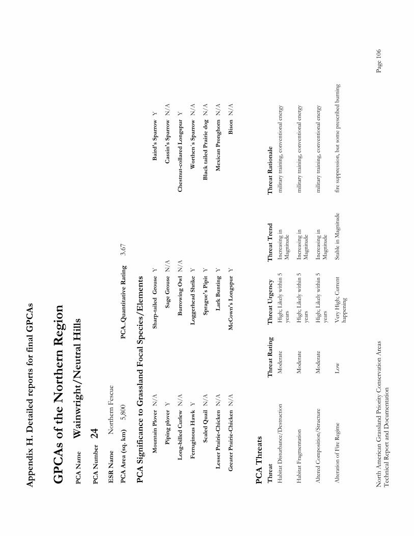
Appe
ndix
H. D
etai
led
repo
rts fo
r fin
al G
PCAs
Nor
th A
mer
ican
Gra
sslan
d Pr
iorit
y Co
nser
vatio
n A
reas
Page
106
Te
chni
cal R
epor
t and
Doc
umen
tatio
n
GPC
As o
f the
Nor
ther
n R
egio
n P
CA
Nam
e W
ainw
right
/Neu
tral H
ills
PC
A N
umbe
r 24
E
SR N
ame
Nor
ther
n Fe
scue
P
CA
Area
(sq.
km
) 5,
800
PCA_
Qua
ntita
tive
Rat
ing
3.67
PC
A Si
gnifi
canc
e to
Gra
ssla
nd F
ocal
Spe
cies
/Ele
men
ts
M
ount
ain
Plov
er N
/A
Shar
p-ta
iled
Gro
use
Y
Bai
rd's
Spa
rrow
Y
Pi
ping
plo
ver
Y
Sage
Gro
use
N/A
C
assi
n's S
parr
ow N
/A
Lo
ng-b
illed
Cur
lew N
/A
Bur
row
ing
Ow
l N
/A
Che
stnu
t-col
lare
d Lo
ngsp
ur Y
Fe
rrug
inou
s Haw
k Y
Logg
erhe
ad S
hrik
e Y
Wor
then
´s S
parr
ow N
/A
Sc
aled
Qua
il N
/A
Spra
gue'
s Pip
it Y
Bla
ck ta
iled
Prai
rie d
og N
/A
Le
sser
Pra
irie-
Chi
cken
N/A
La
rk B
untin
g Y
Mex
ican
Pro
ngho
rn N
/A
G
reat
er P
rairi
e-C
hick
en N
/A
McC
own'
s Lon
gspu
r Y
Bis
on N
/A
PC
A T
hrea
ts
Thr
eat
Thr
eat R
atin
g T
hrea
t Urg
ency
T
hrea
t Tre
nd
Thr
eat R
atio
nale
H
abita
t Dist
urba
nce/
Des
truct
ion
M
oder
ate
Hig
h; L
ikely
with
in 5
In
crea
sing
in
mili
tary
train
ing,
con
vent
iona
l ene
rgy
ye
ars
Mag
nitu
de
Hab
itat F
ragm
enta
tion
M
oder
ate
Hig
h; L
ikely
with
in 5
In
crea
sing
in
mili
tary
train
ing,
con
vent
iona
l ene
rgy
ye
ars
Mag
nitu
de
Alte
red
Com
posit
ion/
Stru
ctur
e M
oder
ate
Hig
h; L
ikely
with
in 5
In
crea
sing
in
mili
tary
train
ing,
con
vent
iona
l ene
rgy
ye
ars
Mag
nitu
de
Alte
ratio
n of
Fire
Reg
ime
Low
Ver
y H
igh;
Cur
rent
St
able
in M
agni
tude
fir
e su
ppre
ssio
n, b
ut so
me
pres
crib
ed b
urni
ng
ha
ppen
ing
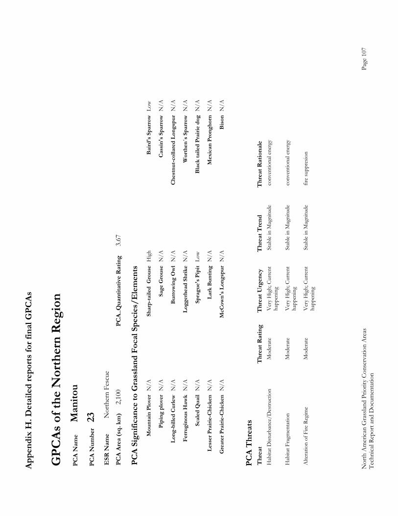
Appe
ndix
H. D
etai
led
repo
rts fo
r fin
al G
PCAs
Nor
th A
mer
ican
Gra
sslan
d Pr
iorit
y Co
nser
vatio
n A
reas
Page
107
Te
chni
cal R
epor
t and
Doc
umen
tatio
n
GPC
As o
f the
Nor
ther
n R
egio
n P
CA
Nam
e M
anito
u P
CA
Num
ber
23
ESR
Nam
e N
orth
ern
Fesc
ue
PC
A Ar
ea (s
q. k
m)
2,10
0 PC
A_Q
uant
itativ
e R
atin
g 3.
67
PC
A Si
gnifi
canc
e to
Gra
ssla
nd F
ocal
Spe
cies
/Ele
men
ts
M
ount
ain
Plov
er N
/A
Shar
p-ta
iled
Gro
use
Hig
h B
aird
's S
parr
ow L
ow
Pi
ping
plo
ver
N/A
Sa
ge G
rous
e N
/A
Cas
sin'
s Spa
rrow
N/A
Lo
ng-b
illed
Cur
lew N
/A
Bur
row
ing
Ow
l N
/A
Che
stnu
t-col
lare
d Lo
ngsp
ur N
/A
Fe
rrug
inou
s Haw
k N
/A
Logg
erhe
ad S
hrik
e N
/A
Wor
then
´s S
parr
ow N
/A
Sc
aled
Qua
il N
/A
Spra
gue'
s Pip
it Lo
w
Bla
ck ta
iled
Prai
rie d
og N
/A
Le
sser
Pra
irie-
Chi
cken
N/A
La
rk B
untin
g N
/A
Mex
ican
Pro
ngho
rn N
/A
G
reat
er P
rairi
e-C
hick
en N
/A
McC
own'
s Lon
gspu
r N
/A
Bis
on N
/A
PC
A T
hrea
ts
Thr
eat
Thr
eat R
atin
g T
hrea
t Urg
ency
T
hrea
t Tre
nd
Thr
eat R
atio
nale
H
abita
t Dist
urba
nce/
Des
truct
ion
M
oder
ate
Ver
y H
igh;
Cur
rent
St
able
in M
agni
tude
co
nven
tiona
l ene
rgy
ha
ppen
ing
Hab
itat F
ragm
enta
tion
M
oder
ate
Ver
y H
igh;
Cur
rent
St
able
in M
agni
tude
co
nven
tiona
l ene
rgy
ha
ppen
ing
Alte
ratio
n of
Fire
Reg
ime
Mod
erat
e V
ery
Hig
h; C
urre
nt
Stab
le in
Mag
nitu
de
fire
supp
resio
n
happ
enin
g

Appe
ndix
H. D
etai
led
repo
rts fo
r fin
al G
PCAs
Nor
th A
mer
ican
Gra
sslan
d Pr
iorit
y Co
nser
vatio
n A
reas
Page
108
Te
chni
cal R
epor
t and
Doc
umen
tatio
n
GPC
As o
f the
Nor
ther
n R
egio
n P
CA
Nam
e Sa
ge C
reek
Milk
Riv
er
PC
A N
umbe
r 54
E
SR N
ame
Med
icin
e Li
ne M
ixed
-gra
ss
PC
A Ar
ea (s
q. k
m)
6,74
1 PC
A_Q
uant
itativ
e R
atin
g 9.
30
PC
A Si
gnifi
canc
e to
Gra
ssla
nd F
ocal
Spe
cies
/Ele
men
ts
M
ount
ain
Plov
er L
ow
Shar
p-ta
iled
Gro
use
Mod
erat
e B
aird
's S
parr
ow V
ery
Hig
h
Pi
ping
plo
ver
Pres
ent /
No
Sa
ge G
rous
e H
igh
Cas
sin'
s Spa
rrow
Ver
y H
igh
Si
gnifi
canc
e
Long
-bill
ed C
urle
w V
ery
Hig
h B
urro
win
g O
wl
Hig
h C
hest
nut-c
olla
red
Long
spur
Ver
y H
igh
Fe
rrug
inou
s Haw
k H
igh
Logg
erhe
ad S
hrik
e H
igh
Wor
then
´s S
parr
ow N
/A
Sc
aled
Qua
il N
/A
Spra
gue'
s Pip
it H
igh
Bla
ck ta
iled
Prai
rie d
og P
rese
nt /
No
Sign
ifica
nce
Le
sser
Pra
irie-
Chi
cken
N/A
La
rk B
untin
g H
igh
Mex
ican
Pro
ngho
rn N
/A
G
reat
er P
rairi
e-C
hick
en N
/A
McC
own'
s Lon
gspu
r H
igh
Bis
on P
rese
nt /
No
Sign
ifica
nce
PC
A T
hrea
ts
Thr
eat
Thr
eat R
atin
g T
hrea
t Urg
ency
T
hrea
t Tre
nd
Thr
eat R
atio
nale
H
abita
t Dist
urba
nce/
Des
truct
ion
H
igh
Ver
y H
igh;
Cur
rent
In
crea
sing
in
Oil
and
Gas
prim
arily
, sm
all a
mou
nt o
f agr
icultu
ral
ha
ppen
ing
Mag
nitu
de
culti
vatio
n
Alte
red
Com
posit
ion/
Stru
ctur
e M
oder
ate
Ver
y H
igh;
Cur
rent
In
crea
sing
in
cres
ted
whe
at g
rass
inva
sion;
pot
entia
l for
nox
ious
spp
ha
ppen
ing
Mag
nitu
de
e.g
. lea
fy sp
urge
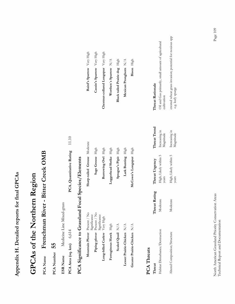
Appe
ndix
H. D
etai
led
repo
rts fo
r fin
al G
PCAs
Nor
th A
mer
ican
Gra
sslan
d Pr
iorit
y Co
nser
vatio
n A
reas
Page
109
Te
chni
cal R
epor
t and
Doc
umen
tatio
n
GPC
As o
f the
Nor
ther
n R
egio
n P
CA
Nam
e Fr
ench
man
Riv
er -
Bitt
er C
reek
OM
B
PC
A N
umbe
r 55
E
SR N
ame
Med
icin
e Li
ne M
ixed
-gra
ss
PC
A Ar
ea (s
q. k
m)
6,61
4 PC
A_Q
uant
itativ
e R
atin
g 11
.10
PC
A Si
gnifi
canc
e to
Gra
ssla
nd F
ocal
Spe
cies
/Ele
men
ts
M
ount
ain
Plov
er P
rese
nt /
No
Sh
arp-
taile
d G
rous
e M
oder
ate
Bai
rd's
Spa
rrow
Ver
y H
igh
Si
gnifi
canc
e
Pipi
ng p
love
r Pr
esen
t / N
o
Sage
Gro
use
Hig
h C
assi
n's S
parr
ow V
ery
Hig
h
Sign
ifica
nce
Lo
ng-b
illed
Cur
lew V
ery
Hig
h B
urro
win
g O
wl
Hig
h C
hest
nut-c
olla
red
Long
spur
Ver
y H
igh
Fe
rrug
inou
s Haw
k H
igh
Logg
erhe
ad S
hrik
e H
igh
Wor
then
´s S
parr
ow N
/A
Sc
aled
Qua
il N
/A
Spra
gue'
s Pip
it H
igh
Bla
ck ta
iled
Prai
rie d
og H
igh
Le
sser
Pra
irie-
Chi
cken
N/A
La
rk B
untin
g H
igh
Mex
ican
Pro
ngho
rn N
/A
G
reat
er P
rairi
e-C
hick
en N
/A
McC
own'
s Lon
gspu
r H
igh
Bis
on H
igh
PC
A T
hrea
ts
Thr
eat
Thr
eat R
atin
g T
hrea
t Urg
ency
T
hrea
t Tre
nd
Thr
eat R
atio
nale
H
abita
t Dist
urba
nce/
Des
truct
ion
M
oder
ate
Hig
h; L
ikely
with
in 5
In
crea
sing
in
Oil
and
Gas
prim
arily
, sm
all a
mou
nt o
f agr
icultu
ral
ye
ars
Mag
nitu
de
culti
vatio
n
Alte
red
Com
posit
ion/
Stru
ctur
e M
oder
ate
Hig
h; L
ikely
with
in 5
In
crea
sing
in
cres
ted
whe
at g
rass
inva
sion;
pot
entia
l for
nox
ious
spp
ye
ars
Mag
nitu
de
e.g
. lea
fy sp
urge
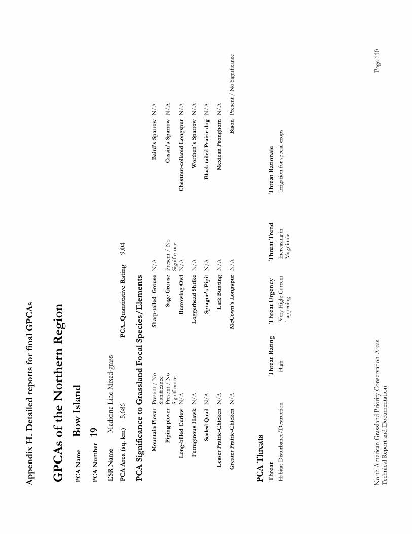
Appe
ndix
H. D
etai
led
repo
rts fo
r fin
al G
PCAs
Nor
th A
mer
ican
Gra
sslan
d Pr
iorit
y Co
nser
vatio
n A
reas
Page
110
Te
chni
cal R
epor
t and
Doc
umen
tatio
n
GPC
As o
f the
Nor
ther
n R
egio
n P
CA
Nam
e B
ow Is
land
P
CA
Num
ber
19
ESR
Nam
e M
edic
ine
Line
Mix
ed-g
rass
P
CA
Area
(sq.
km
) 5,
686
PCA_
Qua
ntita
tive
Rat
ing
9.04
PC
A Si
gnifi
canc
e to
Gra
ssla
nd F
ocal
Spe
cies
/Ele
men
ts
M
ount
ain
Plov
er P
rese
nt /
No
Sh
arp-
taile
d G
rous
e N
/A
Bai
rd's
Spa
rrow
N/A
Sign
ifica
nce
Pi
ping
plo
ver
Pres
ent /
No
Sa
ge G
rous
e Pr
esen
t / N
o
Cas
sin'
s Spa
rrow
N/A
Sign
ifica
nce
Sign
ifica
nce
Lo
ng-b
illed
Cur
lew N
/A
Bur
row
ing
Ow
l N
/A
Che
stnu
t-col
lare
d Lo
ngsp
ur N
/A
Fe
rrug
inou
s Haw
k N
/A
Logg
erhe
ad S
hrik
e N
/A
Wor
then
´s S
parr
ow N
/A
Sc
aled
Qua
il N
/A
Spra
gue'
s Pip
it N
/A
Bla
ck ta
iled
Prai
rie d
og N
/A
Le
sser
Pra
irie-
Chi
cken
N/A
La
rk B
untin
g N
/A
Mex
ican
Pro
ngho
rn N
/A
G
reat
er P
rairi
e-C
hick
en N
/A
McC
own'
s Lon
gspu
r N
/A
Bis
on P
rese
nt /
No
Sign
ifica
nce
PC
A T
hrea
ts
Thr
eat
Thr
eat R
atin
g T
hrea
t Urg
ency
T
hrea
t Tre
nd
Thr
eat R
atio
nale
H
abita
t Dist
urba
nce/
Des
truct
ion
H
igh
Ver
y H
igh;
Cur
rent
In
crea
sing
in
Irrig
atio
n fo
r spe
cial c
rops
happ
enin
g M
agni
tude
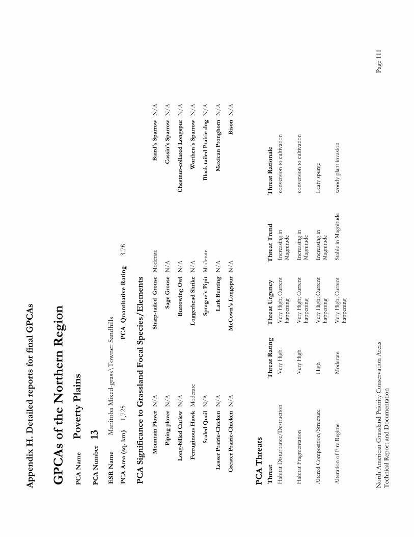
Appe
ndix
H. D
etai
led
repo
rts fo
r fin
al G
PCAs
Nor
th A
mer
ican
Gra
sslan
d Pr
iorit
y Co
nser
vatio
n A
reas
Page
111
Te
chni
cal R
epor
t and
Doc
umen
tatio
n
GPC
As o
f the
Nor
ther
n R
egio
n P
CA
Nam
e Po
verty
Pla
ins
PC
A N
umbe
r 13
E
SR N
ame
Man
itoba
Mix
ed-g
rass
\Tow
ner S
andh
ills
PC
A Ar
ea (s
q. k
m)
1,72
5 PC
A_Q
uant
itativ
e R
atin
g 3.
78
PC
A Si
gnifi
canc
e to
Gra
ssla
nd F
ocal
Spe
cies
/Ele
men
ts
M
ount
ain
Plov
er N
/A
Shar
p-ta
iled
Gro
use
Mod
erat
e B
aird
's S
parr
ow N
/A
Pi
ping
plo
ver
N/A
Sa
ge G
rous
e N
/A
Cas
sin'
s Spa
rrow
N/A
Lo
ng-b
illed
Cur
lew N
/A
Bur
row
ing
Ow
l N
/A
Che
stnu
t-col
lare
d Lo
ngsp
ur N
/A
Fe
rrug
inou
s Haw
k M
oder
ate
Logg
erhe
ad S
hrik
e N
/A
Wor
then
´s S
parr
ow N
/A
Sc
aled
Qua
il N
/A
Spra
gue'
s Pip
it M
oder
ate
Bla
ck ta
iled
Prai
rie d
og N
/A
Le
sser
Pra
irie-
Chi
cken
N/A
La
rk B
untin
g N
/A
Mex
ican
Pro
ngho
rn N
/A
G
reat
er P
rairi
e-C
hick
en N
/A
McC
own'
s Lon
gspu
r N
/A
Bis
on N
/A
PC
A T
hrea
ts
Thr
eat
Thr
eat R
atin
g T
hrea
t Urg
ency
T
hrea
t Tre
nd
Thr
eat R
atio
nale
H
abita
t Dist
urba
nce/
Des
truct
ion
V
ery
Hig
h V
ery
Hig
h; C
urre
nt
Incr
easin
g in
co
nver
sion
to c
ultiv
atio
n
happ
enin
g M
agni
tude
Hab
itat F
ragm
enta
tion
V
ery
Hig
h V
ery
Hig
h; C
urre
nt
Incr
easin
g in
co
nver
sion
to c
ultiv
atio
n
happ
enin
g M
agni
tude
Alte
red
Com
posit
ion/
Stru
ctur
e H
igh
Ver
y H
igh;
Cur
rent
In
crea
sing
in
Leaf
y sp
urge
happ
enin
g M
agni
tude
Alte
ratio
n of
Fire
Reg
ime
Mod
erat
e V
ery
Hig
h; C
urre
nt
Stab
le in
Mag
nitu
de
woo
dy p
lant i
nvas
ion
ha
ppen
ing
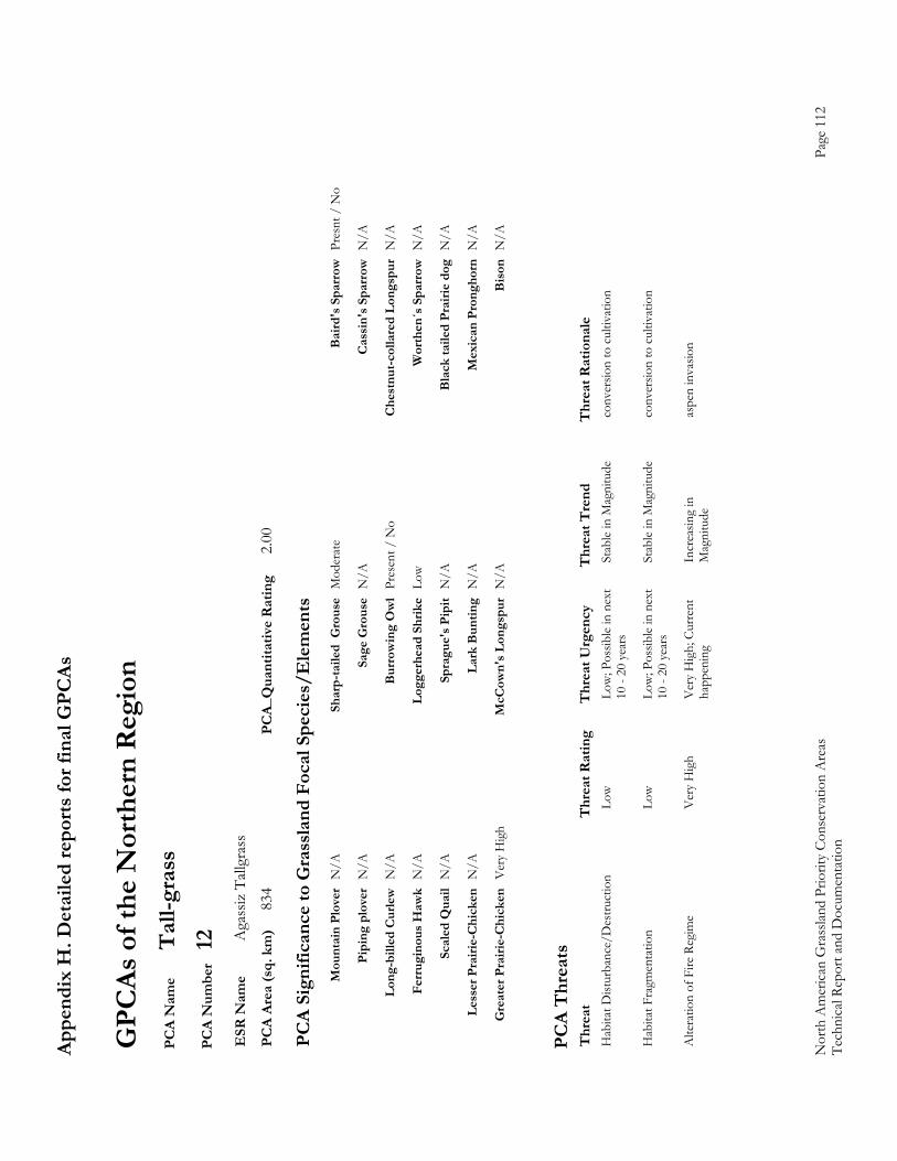
Appe
ndix
H. D
etai
led
repo
rts fo
r fin
al G
PCAs
Nor
th A
mer
ican
Gra
sslan
d Pr
iorit
y Co
nser
vatio
n A
reas
Page
112
Te
chni
cal R
epor
t and
Doc
umen
tatio
n
GPC
As o
f the
Nor
ther
n R
egio
n P
CA
Nam
e T
all-g
rass
P
CA
Num
ber
12
ESR
Nam
e A
gass
iz T
allgr
ass
PC
A Ar
ea (s
q. k
m)
834
PCA_
Qua
ntita
tive
Rat
ing
2.00
PC
A Si
gnifi
canc
e to
Gra
ssla
nd F
ocal
Spe
cies
/Ele
men
ts
M
ount
ain
Plov
er N
/A
Shar
p-ta
iled
Gro
use
Mod
erat
e B
aird
's S
parr
ow P
resn
t / N
o
Pi
ping
plo
ver
N/A
Sa
ge G
rous
e N
/A
Cas
sin'
s Spa
rrow
N/A
Lo
ng-b
illed
Cur
lew N
/A
Bur
row
ing
Ow
l Pr
esen
t / N
o C
hest
nut-c
olla
red
Long
spur
N/A
Fe
rrug
inou
s Haw
k N
/A
Logg
erhe
ad S
hrik
e Lo
w
Wor
then
´s S
parr
ow N
/A
Sc
aled
Qua
il N
/A
Spra
gue'
s Pip
it N
/A
Bla
ck ta
iled
Prai
rie d
og N
/A
Le
sser
Pra
irie-
Chi
cken
N/A
La
rk B
untin
g N
/A
Mex
ican
Pro
ngho
rn N
/A
G
reat
er P
rairi
e-C
hick
en V
ery
Hig
h M
cCow
n's L
ongs
pur
N/A
B
ison
N/A
PC
A T
hrea
ts
Thr
eat
Thr
eat R
atin
g T
hrea
t Urg
ency
T
hrea
t Tre
nd
Thr
eat R
atio
nale
H
abita
t Dist
urba
nce/
Des
truct
ion
Lo
w
Low
; Pos
sible
in n
ext
Stab
le in
Mag
nitu
de
conv
ersio
n to
cul
tivat
ion
10
- 20
yea
rs
Hab
itat F
ragm
enta
tion
Lo
w
Low
; Pos
sible
in n
ext
Stab
le in
Mag
nitu
de
conv
ersio
n to
cul
tivat
ion
10
- 20
yea
rs
Alte
ratio
n of
Fire
Reg
ime
Ver
y H
igh
Ver
y H
igh;
Cur
rent
In
crea
sing
in
aspe
n in
vasio
n
happ
enin
g M
agni
tude
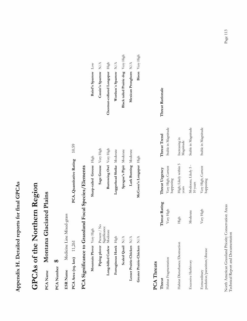
Appe
ndix
H. D
etai
led
repo
rts fo
r fin
al G
PCAs
Nor
th A
mer
ican
Gra
sslan
d Pr
iorit
y Co
nser
vatio
n A
reas
Page
113
Te
chni
cal R
epor
t and
Doc
umen
tatio
n
GPC
As o
f the
Nor
ther
n R
egio
n P
CA
Nam
e M
onta
na G
laci
ated
Pla
ins
PC
A N
umbe
r 8
ESR
Nam
e M
edic
ine
Line
Mix
ed-g
rass
P
CA
Area
(sq.
km
) 11
,261
PC
A_Q
uant
itativ
e R
atin
g 10
.59
PC
A Si
gnifi
canc
e to
Gra
ssla
nd F
ocal
Spe
cies
/Ele
men
ts
M
ount
ain
Plov
er V
ery
Hig
h Sh
arp-
taile
d G
rous
e H
igh
Bai
rd's
Spa
rrow
Low
Pi
ping
plo
ver
Pres
ent /
No
Sa
ge G
rous
e V
ery
Hig
h C
assi
n's S
parr
ow N
/A
Si
gnifi
canc
e
Long
-bill
ed C
urle
w M
oder
ate
Bur
row
ing
Ow
l V
ery
Hig
h C
hest
nut-c
olla
red
Long
spur
Hig
h
Fe
rrug
inou
s Haw
k H
igh
Logg
erhe
ad S
hrik
e M
oder
ate
Wor
then
´s S
parr
ow N
/A
Sc
aled
Qua
il N
/A
Spra
gue'
s Pip
it M
oder
ate
Bla
ck ta
iled
Prai
rie d
og V
ery
Hig
h
Le
sser
Pra
irie-
Chi
cken
N/A
La
rk B
untin
g M
oder
ate
Mex
ican
Pro
ngho
rn N
/A
G
reat
er P
rairi
e-C
hick
en N
/A
McC
own'
s Lon
gspu
r H
igh
Bis
on V
ery
Hig
h
PC
A T
hrea
ts
Thr
eat
Thr
eat R
atin
g T
hrea
t Urg
ency
T
hrea
t Tre
nd
Thr
eat R
atio
nale
H
abita
t Fra
gmen
tatio
n
Ver
y H
igh
Ver
y H
igh;
Cur
rent
St
able
in M
agni
tude
happ
enin
g
Hab
itat D
istur
banc
e/D
estru
ctio
n
Hig
h H
igh;
Lik
ely w
ithin
5
Incr
easin
g in
year
s M
agni
tude
Exc
essiv
e H
erbi
vory
M
oder
ate
Mod
erat
e; Li
kely
5 -
Stab
le in
Mag
nitu
de
10
yea
rs
Ext
raor
dina
ry
Ver
y H
igh
Ver
y H
igh;
Cur
rent
St
able
in M
agni
tude
p
reda
tion/
para
sitism
/dise
ase
happ
enin
g

Appe
ndix
H. D
etai
led
repo
rts fo
r fin
al G
PCAs
Nor
th A
mer
ican
Gra
sslan
d Pr
iorit
y Co
nser
vatio
n A
reas
Page
114
Te
chni
cal R
epor
t and
Doc
umen
tatio
n
GPC
As o
f the
Nor
ther
n R
egio
n P
CA
Nam
e Pr
airie
Mon
tana
P
CA
Num
ber
10
ESR
Nam
e M
edic
ine
Line
Mix
ed-g
rass
P
CA
Area
(sq.
km
) 3,
652
PCA_
Qua
ntita
tive
Rat
ing
7.49
PC
A Si
gnifi
canc
e to
Gra
ssla
nd F
ocal
Spe
cies
/Ele
men
ts
M
ount
ain
Plov
er P
rese
nt /
No
Sh
arp-
taile
d G
rous
e M
oder
ate
Bai
rd's
Spa
rrow
Ver
y H
igh
Si
gnifi
canc
e
Pipi
ng p
love
r Pr
esen
t / N
o
Sage
Gro
use
Mod
erat
e C
assi
n's S
parr
ow N
/A
Si
gnifi
canc
e
Long
-bill
ed C
urle
w H
igh
Bur
row
ing
Ow
l Pr
esen
t / N
o
Che
stnu
t-col
lare
d Lo
ngsp
ur V
ery
Hig
h
Sign
ifica
nce
Fe
rrug
inou
s Haw
k M
oder
ate
Logg
erhe
ad S
hrik
e M
oder
ate
Wor
then
´s S
parr
ow N
/A
Sc
aled
Qua
il N
/A
Spra
gue'
s Pip
it V
ery
Hig
h B
lack
taile
d Pr
airie
dog
Pre
sent
/ N
o Si
gnifi
canc
e
Le
sser
Pra
irie-
Chi
cken
N/A
La
rk B
untin
g M
oder
ate
Mex
ican
Pro
ngho
rn N
/A
G
reat
er P
rairi
e-C
hick
en N
/A
McC
own'
s Lon
gspu
r H
igh
Bis
on L
ow
PC
A T
hrea
ts
Thr
eat
Thr
eat R
atin
g T
hrea
t Urg
ency
T
hrea
t Tre
nd
Thr
eat R
atio
nale
E
xces
sive
Her
bivo
ry
Mod
erat
e M
oder
ate;
Like
ly 5
- St
able
in M
agni
tude
N
o pr
airie
dogs
10 y
ears
Alte
red
Com
posit
ion/
Stru
ctur
e H
igh
Hig
h; L
ikely
with
in 5
In
crea
sing
in
ye
ars
Mag
nitu
de
Hab
itat F
ragm
enta
tion
H
igh
Ver
y H
igh;
Cur
rent
In
crea
sing
in
ha
ppen
ing
Mag
nitu
de
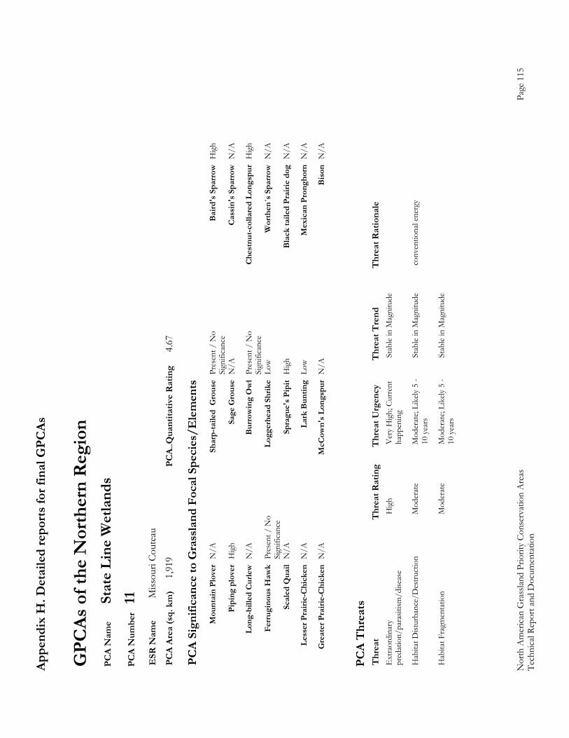
Appe
ndix
H. D
etai
led
repo
rts fo
r fin
al G
PCAs
Nor
th A
mer
ican
Gra
sslan
d Pr
iorit
y Co
nser
vatio
n A
reas
Page
115
Te
chni
cal R
epor
t and
Doc
umen
tatio
n
GPC
As o
f the
Nor
ther
n R
egio
n P
CA
Nam
e St
ate
Line
Wet
land
s P
CA
Num
ber
11
ESR
Nam
e M
issou
ri Co
utea
u P
CA
Area
(sq.
km
) 1,
919
PCA_
Qua
ntita
tive
Rat
ing
4.67
PC
A Si
gnifi
canc
e to
Gra
ssla
nd F
ocal
Spe
cies
/Ele
men
ts
M
ount
ain
Plov
er N
/A
Shar
p-ta
iled
Gro
use
Pres
ent /
No
B
aird
's S
parr
ow H
igh
Si
gnifi
canc
e
Pipi
ng p
love
r H
igh
Sage
Gro
use
N/A
C
assi
n's S
parr
ow N
/A
Lo
ng-b
illed
Cur
lew N
/A
Bur
row
ing
Ow
l Pr
esen
t / N
o
Che
stnu
t-col
lare
d Lo
ngsp
ur H
igh
Si
gnifi
canc
e
Ferr
ugin
ous H
awk
Pres
ent /
No
Lo
gger
head
Shr
ike
Low
Wor
then
´s S
parr
ow N
/A
Si
gnifi
canc
e
Scal
ed Q
uail
N/A
Sp
ragu
e's P
ipit
Hig
h B
lack
taile
d Pr
airie
dog
N/A
Le
sser
Pra
irie-
Chi
cken
N/A
La
rk B
untin
g Lo
w
Mex
ican
Pro
ngho
rn N
/A
G
reat
er P
rairi
e-C
hick
en N
/A
McC
own'
s Lon
gspu
r N
/A
Bis
on N
/A
PC
A T
hrea
ts
Thr
eat
Thr
eat R
atin
g T
hrea
t Urg
ency
T
hrea
t Tre
nd
Thr
eat R
atio
nale
E
xtra
ordi
nary
H
igh
Ver
y H
igh;
Cur
rent
St
able
in M
agni
tude
p
reda
tion/
para
sitism
/dise
ase
happ
enin
g
Hab
itat D
istur
banc
e/D
estru
ctio
n
Mod
erat
e M
oder
ate;
Like
ly 5
- St
able
in M
agni
tude
co
nven
tiona
l ene
rgy
10
yea
rs
Hab
itat F
ragm
enta
tion
M
oder
ate
Mod
erat
e; Li
kely
5 -
Stab
le in
Mag
nitu
de
10
yea
rs
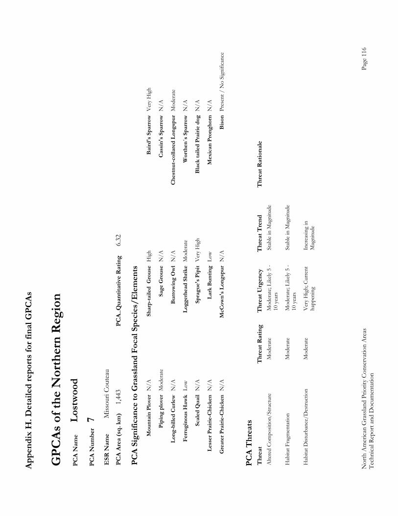
Appe
ndix
H. D
etai
led
repo
rts fo
r fin
al G
PCAs
Nor
th A
mer
ican
Gra
sslan
d Pr
iorit
y Co
nser
vatio
n A
reas
Page
116
Te
chni
cal R
epor
t and
Doc
umen
tatio
n
GPC
As o
f the
Nor
ther
n R
egio
n P
CA
Nam
e Lo
stw
ood
PC
A N
umbe
r 7
ESR
Nam
e M
issou
ri Co
utea
u P
CA
Area
(sq.
km
) 1,
443
PCA_
Qua
ntita
tive
Rat
ing
6.32
PC
A Si
gnifi
canc
e to
Gra
ssla
nd F
ocal
Spe
cies
/Ele
men
ts
M
ount
ain
Plov
er N
/A
Shar
p-ta
iled
Gro
use
Hig
h B
aird
's S
parr
ow V
ery
Hig
h
Pi
ping
plo
ver
Mod
erat
e Sa
ge G
rous
e N
/A
Cas
sin'
s Spa
rrow
N/A
Lo
ng-b
illed
Cur
lew N
/A
Bur
row
ing
Ow
l N
/A
Che
stnu
t-col
lare
d Lo
ngsp
ur M
oder
ate
Fe
rrug
inou
s Haw
k Lo
w
Logg
erhe
ad S
hrik
e M
oder
ate
Wor
then
´s S
parr
ow N
/A
Sc
aled
Qua
il N
/A
Spra
gue'
s Pip
it V
ery
Hig
h B
lack
taile
d Pr
airie
dog
N/A
Le
sser
Pra
irie-
Chi
cken
N/A
La
rk B
untin
g Lo
w
Mex
ican
Pro
ngho
rn N
/A
G
reat
er P
rairi
e-C
hick
en N
/A
McC
own'
s Lon
gspu
r N
/A
Bis
on P
rese
nt /
No
Sign
ifica
nce
PC
A T
hrea
ts
Thr
eat
Thr
eat R
atin
g T
hrea
t Urg
ency
T
hrea
t Tre
nd
Thr
eat R
atio
nale
A
ltere
d Co
mpo
sitio
n/St
ruct
ure
Mod
erat
e M
oder
ate;
Like
ly 5
- St
able
in M
agni
tude
10 y
ears
Hab
itat F
ragm
enta
tion
M
oder
ate
Mod
erat
e; Li
kely
5 -
Stab
le in
Mag
nitu
de
10
yea
rs
Hab
itat D
istur
banc
e/D
estru
ctio
n
Mod
erat
e V
ery
Hig
h; C
urre
nt
Incr
easin
g in
happ
enin
g M
agni
tude
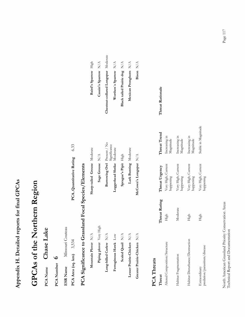
Appe
ndix
H. D
etai
led
repo
rts fo
r fin
al G
PCAs
Nor
th A
mer
ican
Gra
sslan
d Pr
iorit
y Co
nser
vatio
n A
reas
Page
117
Te
chni
cal R
epor
t and
Doc
umen
tatio
n
GPC
As o
f the
Nor
ther
n R
egio
n P
CA
Nam
e C
hase
Lak
e P
CA
Num
ber
6 E
SR N
ame
Miss
ouri
Cout
eau
PC
A Ar
ea (s
q. k
m)
3,53
4 PC
A_Q
uant
itativ
e R
atin
g 6.
33
PC
A Si
gnifi
canc
e to
Gra
ssla
nd F
ocal
Spe
cies
/Ele
men
ts
M
ount
ain
Plov
er N
/A
Shar
p-ta
iled
Gro
use
Mod
erat
e B
aird
's S
parr
ow H
igh
Pi
ping
plo
ver
Ver
y H
igh
Sage
Gro
use
N/A
C
assi
n's S
parr
ow N
/A
Lo
ng-b
illed
Cur
lew N
/A
Bur
row
ing
Ow
l Pr
esen
t / N
o
Che
stnu
t-col
lare
d Lo
ngsp
ur M
oder
ate
Si
gnifi
canc
e
Ferr
ugin
ous H
awk
Low
Logg
erhe
ad S
hrik
e M
oder
ate
Wor
then
´s S
parr
ow N
/A
Sc
aled
Qua
il N
/A
Spra
gue'
s Pip
it H
igh
Bla
ck ta
iled
Prai
rie d
og N
/A
Le
sser
Pra
irie-
Chi
cken
N/A
La
rk B
untin
g M
oder
ate
Mex
ican
Pro
ngho
rn N
/A
G
reat
er P
rairi
e-C
hick
en N
/A
McC
own'
s Lon
gspu
r N
/A
Bis
on N
/A
PC
A T
hrea
ts
Thr
eat
Thr
eat R
atin
g T
hrea
t Urg
ency
T
hrea
t Tre
nd
Thr
eat R
atio
nale
A
ltere
d Co
mpo
sitio
n/St
ruct
ure
Hig
h V
ery
Hig
h; C
urre
nt
Incr
easin
g in
happ
enin
g M
agni
tude
Hab
itat F
ragm
enta
tion
M
oder
ate
Ver
y H
igh;
Cur
rent
In
crea
sing
in
ha
ppen
ing
Mag
nitu
de
Hab
itat D
istur
banc
e/D
estru
ctio
n
Hig
h V
ery
Hig
h; C
urre
nt
Incr
easin
g in
happ
enin
g M
agni
tude
Ext
raor
dina
ry
Hig
h V
ery
Hig
h; C
urre
nt
Stab
le in
Mag
nitu
de
pre
datio
n/pa
rasit
ism/d
iseas
e ha
ppen
ing
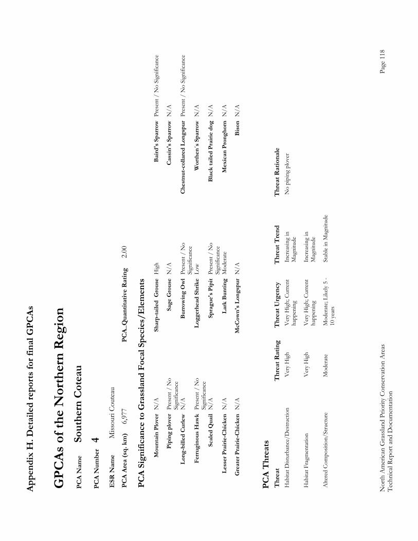
Appe
ndix
H. D
etai
led
repo
rts fo
r fin
al G
PCAs
Nor
th A
mer
ican
Gra
sslan
d Pr
iorit
y Co
nser
vatio
n A
reas
Page
118
Te
chni
cal R
epor
t and
Doc
umen
tatio
n
GPC
As o
f the
Nor
ther
n R
egio
n P
CA
Nam
e So
uthe
rn C
otea
u P
CA
Num
ber
4 E
SR N
ame
Miss
ouri
Cout
eau
PC
A Ar
ea (s
q. k
m)
6,97
7 PC
A_Q
uant
itativ
e R
atin
g 2.
00
PC
A Si
gnifi
canc
e to
Gra
ssla
nd F
ocal
Spe
cies
/Ele
men
ts
M
ount
ain
Plov
er N
/A
Shar
p-ta
iled
Gro
use
Hig
h B
aird
's S
parr
ow P
rese
nt /
No
Sign
ifica
nce
Pi
ping
plo
ver
Pres
ent /
No
Sa
ge G
rous
e N
/A
Cas
sin'
s Spa
rrow
N/A
Sign
ifica
nce
Lo
ng-b
illed
Cur
lew N
/A
Bur
row
ing
Ow
l Pr
esen
t / N
o
Che
stnu
t-col
lare
d Lo
ngsp
ur P
rese
nt /
No
Sign
ifica
nce
Si
gnifi
canc
e
Ferr
ugin
ous H
awk
Pres
ent /
No
Lo
gger
head
Shr
ike
Low
Wor
then
´s S
parr
ow N
/A
Si
gnifi
canc
e
Scal
ed Q
uail
N/A
Sp
ragu
e's P
ipit
Pres
ent /
No
B
lack
taile
d Pr
airie
dog
N/A
Sign
ifica
nce
Le
sser
Pra
irie-
Chi
cken
N/A
La
rk B
untin
g M
oder
ate
Mex
ican
Pro
ngho
rn N
/A
G
reat
er P
rairi
e-C
hick
en N
/A
McC
own'
s Lon
gspu
r N
/A
Bis
on N
/A
PC
A T
hrea
ts
Thr
eat
Thr
eat R
atin
g T
hrea
t Urg
ency
T
hrea
t Tre
nd
Thr
eat R
atio
nale
H
abita
t Dist
urba
nce/
Des
truct
ion
V
ery
Hig
h V
ery
Hig
h; C
urre
nt
Incr
easin
g in
N
o pi
ping
plo
ver
ha
ppen
ing
Mag
nitu
de
Hab
itat F
ragm
enta
tion
V
ery
Hig
h V
ery
Hig
h; C
urre
nt
Incr
easin
g in
happ
enin
g M
agni
tude
Alte
red
Com
posit
ion/
Stru
ctur
e M
oder
ate
Mod
erat
e; Li
kely
5 -
Stab
le in
Mag
nitu
de
10
yea
rs
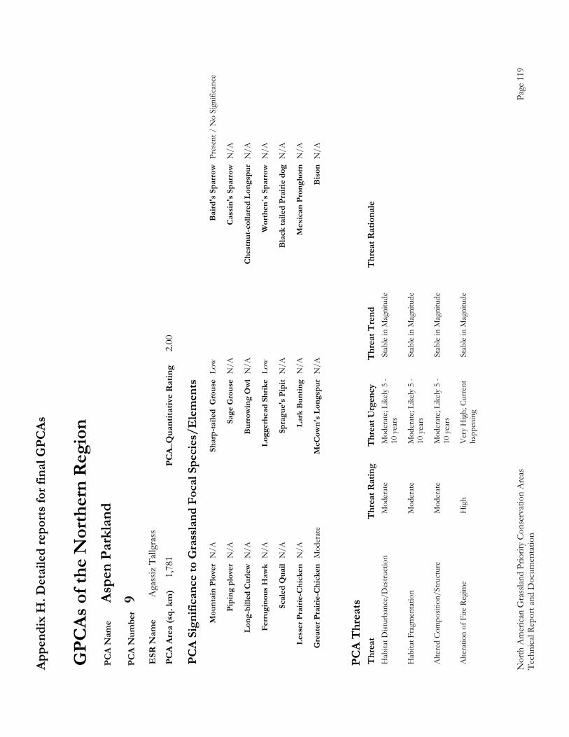
Appe
ndix
H. D
etai
led
repo
rts fo
r fin
al G
PCAs
Nor
th A
mer
ican
Gra
sslan
d Pr
iorit
y Co
nser
vatio
n A
reas
Page
119
Te
chni
cal R
epor
t and
Doc
umen
tatio
n
GPC
As o
f the
Nor
ther
n R
egio
n P
CA
Nam
e As
pen
Park
land
P
CA
Num
ber
9 E
SR N
ame
Aga
ssiz
Tall
gras
s P
CA
Area
(sq.
km
) 1,
781
PCA_
Qua
ntita
tive
Rat
ing
2.00
PC
A Si
gnifi
canc
e to
Gra
ssla
nd F
ocal
Spe
cies
/Ele
men
ts
M
ount
ain
Plov
er N
/A
Shar
p-ta
iled
Gro
use
Low
Bai
rd's
Spa
rrow
Pre
sent
/ N
o Si
gnifi
canc
e
Pi
ping
plo
ver
N/A
Sa
ge G
rous
e N
/A
Cas
sin'
s Spa
rrow
N/A
Lo
ng-b
illed
Cur
lew N
/A
Bur
row
ing
Ow
l N
/A
Che
stnu
t-col
lare
d Lo
ngsp
ur N
/A
Fe
rrug
inou
s Haw
k N
/A
Logg
erhe
ad S
hrik
e Lo
w
Wor
then
´s S
parr
ow N
/A
Sc
aled
Qua
il N
/A
Spra
gue'
s Pip
it N
/A
Bla
ck ta
iled
Prai
rie d
og N
/A
Le
sser
Pra
irie-
Chi
cken
N/A
La
rk B
untin
g N
/A
Mex
ican
Pro
ngho
rn N
/A
G
reat
er P
rairi
e-C
hick
en M
oder
ate
McC
own'
s Lon
gspu
r N
/A
Bis
on N
/A
PC
A T
hrea
ts
Thr
eat
Thr
eat R
atin
g T
hrea
t Urg
ency
T
hrea
t Tre
nd
Thr
eat R
atio
nale
H
abita
t Dist
urba
nce/
Des
truct
ion
M
oder
ate
Mod
erat
e; Li
kely
5 -
Stab
le in
Mag
nitu
de
10
yea
rs
Hab
itat F
ragm
enta
tion
M
oder
ate
Mod
erat
e; Li
kely
5 -
Stab
le in
Mag
nitu
de
10
yea
rs
Alte
red
Com
posit
ion/
Stru
ctur
e M
oder
ate
Mod
erat
e; Li
kely
5 -
Stab
le in
Mag
nitu
de
10
yea
rs
Alte
ratio
n of
Fire
Reg
ime
Hig
h V
ery
Hig
h; C
urre
nt
Stab
le in
Mag
nitu
de
ha
ppen
ing
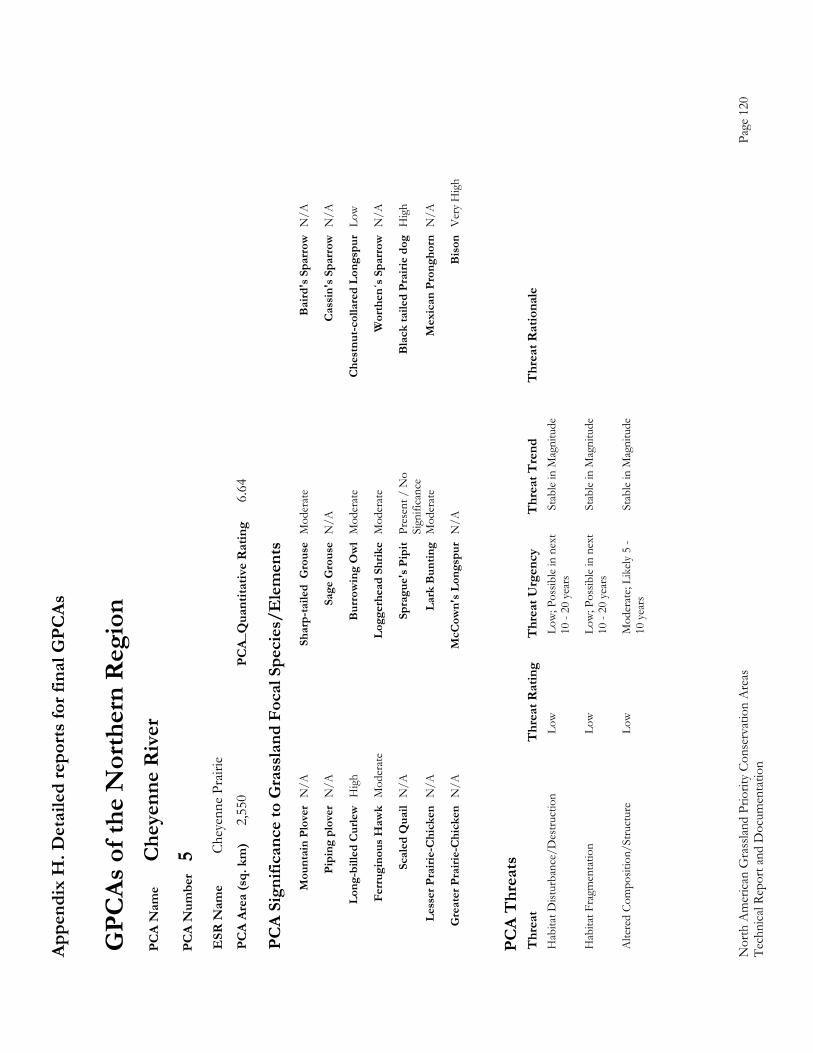
Appe
ndix
H. D
etai
led
repo
rts fo
r fin
al G
PCAs
Nor
th A
mer
ican
Gra
sslan
d Pr
iorit
y Co
nser
vatio
n A
reas
Page
120
Te
chni
cal R
epor
t and
Doc
umen
tatio
n
GPC
As o
f the
Nor
ther
n R
egio
n P
CA
Nam
e C
heye
nne
Riv
er
PC
A N
umbe
r 5
ESR
Nam
e Ch
eyen
ne P
rairi
e P
CA
Area
(sq.
km
) 2,
550
PCA_
Qua
ntita
tive
Rat
ing
6.64
PC
A Si
gnifi
canc
e to
Gra
ssla
nd F
ocal
Spe
cies
/Ele
men
ts
M
ount
ain
Plov
er N
/A
Shar
p-ta
iled
Gro
use
Mod
erat
e B
aird
's S
parr
ow N
/A
Pi
ping
plo
ver
N/A
Sa
ge G
rous
e N
/A
Cas
sin'
s Spa
rrow
N/A
Lo
ng-b
illed
Cur
lew H
igh
Bur
row
ing
Ow
l M
oder
ate
Che
stnu
t-col
lare
d Lo
ngsp
ur L
ow
Fe
rrug
inou
s Haw
k M
oder
ate
Logg
erhe
ad S
hrik
e M
oder
ate
Wor
then
´s S
parr
ow N
/A
Sc
aled
Qua
il N
/A
Spra
gue'
s Pip
it Pr
esen
t / N
o
Bla
ck ta
iled
Prai
rie d
og H
igh
Si
gnifi
canc
e
Less
er P
rairi
e-C
hick
en N
/A
Lark
Bun
ting
Mod
erat
e M
exic
an P
rong
horn
N/A
G
reat
er P
rairi
e-C
hick
en N
/A
McC
own'
s Lon
gspu
r N
/A
Bis
on V
ery
Hig
h
PC
A T
hrea
ts
Thr
eat
Thr
eat R
atin
g T
hrea
t Urg
ency
T
hrea
t Tre
nd
Thr
eat R
atio
nale
H
abita
t Dist
urba
nce/
Des
truct
ion
Lo
w
Low
; Pos
sible
in n
ext
Stab
le in
Mag
nitu
de
10
- 20
yea
rs
Hab
itat F
ragm
enta
tion
Lo
w
Low
; Pos
sible
in n
ext
Stab
le in
Mag
nitu
de
10
- 20
yea
rs
Alte
red
Com
posit
ion/
Stru
ctur
e Lo
w
Mod
erat
e; Li
kely
5 -
Stab
le in
Mag
nitu
de
10
yea
rs
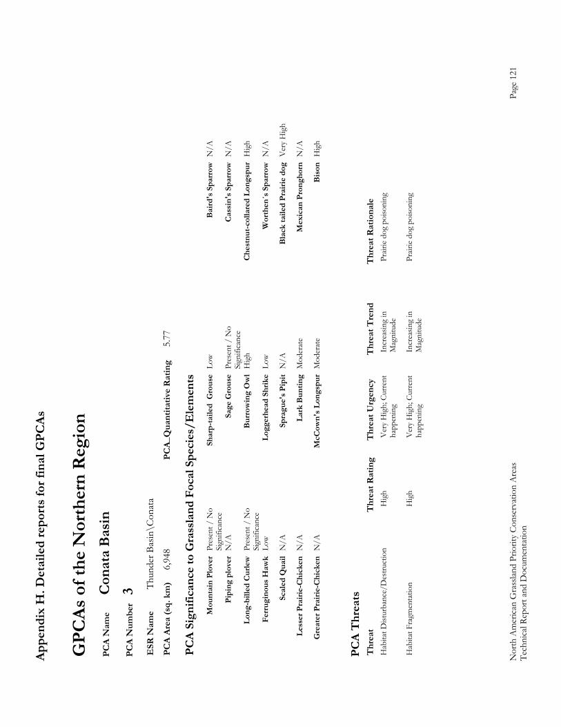
Appe
ndix
H. D
etai
led
repo
rts fo
r fin
al G
PCAs
Nor
th A
mer
ican
Gra
sslan
d Pr
iorit
y Co
nser
vatio
n A
reas
Page
121
Te
chni
cal R
epor
t and
Doc
umen
tatio
n
GPC
As o
f the
Nor
ther
n R
egio
n P
CA
Nam
e C
onat
a B
asin
P
CA
Num
ber
3 E
SR N
ame
Thun
der B
asin
\Con
ata
PC
A Ar
ea (s
q. k
m)
6,94
8 PC
A_Q
uant
itativ
e R
atin
g 5.
77
PC
A Si
gnifi
canc
e to
Gra
ssla
nd F
ocal
Spe
cies
/Ele
men
ts
M
ount
ain
Plov
er P
rese
nt /
No
Sh
arp-
taile
d G
rous
e Lo
w
Bai
rd's
Spa
rrow
N/A
Sign
ifica
nce
Pi
ping
plo
ver
N/A
Sa
ge G
rous
e Pr
esen
t / N
o
Cas
sin'
s Spa
rrow
N/A
Sign
ifica
nce
Lo
ng-b
illed
Cur
lew P
rese
nt /
No
B
urro
win
g O
wl
Hig
h C
hest
nut-c
olla
red
Long
spur
Hig
h
Sign
ifica
nce
Fe
rrug
inou
s Haw
k Lo
w
Logg
erhe
ad S
hrik
e Lo
w
Wor
then
´s S
parr
ow N
/A
Sc
aled
Qua
il N
/A
Spra
gue'
s Pip
it N
/A
Bla
ck ta
iled
Prai
rie d
og V
ery
Hig
h
Le
sser
Pra
irie-
Chi
cken
N/A
La
rk B
untin
g M
oder
ate
Mex
ican
Pro
ngho
rn N
/A
G
reat
er P
rairi
e-C
hick
en N
/A
McC
own'
s Lon
gspu
r M
oder
ate
Bis
on H
igh
PC
A T
hrea
ts
Thr
eat
Thr
eat R
atin
g T
hrea
t Urg
ency
T
hrea
t Tre
nd
Thr
eat R
atio
nale
H
abita
t Dist
urba
nce/
Des
truct
ion
H
igh
Ver
y H
igh;
Cur
rent
In
crea
sing
in
Prair
ie d
og p
oiso
ning
happ
enin
g M
agni
tude
Hab
itat F
ragm
enta
tion
H
igh
Ver
y H
igh;
Cur
rent
In
crea
sing
in
Prair
ie d
og p
oiso
ning
happ
enin
g M
agni
tude
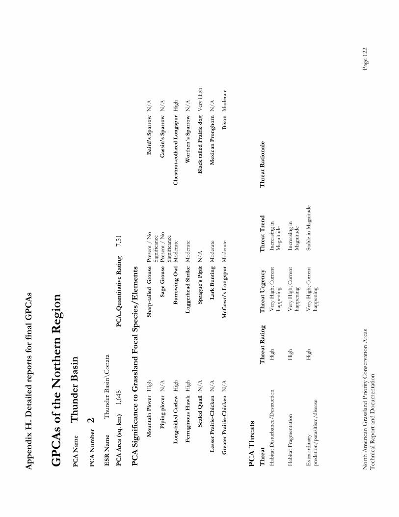
Appe
ndix
H. D
etai
led
repo
rts fo
r fin
al G
PCAs
Nor
th A
mer
ican
Gra
sslan
d Pr
iorit
y Co
nser
vatio
n A
reas
Page
122
Te
chni
cal R
epor
t and
Doc
umen
tatio
n
GPC
As o
f the
Nor
ther
n R
egio
n P
CA
Nam
e T
hund
er B
asin
P
CA
Num
ber
2 E
SR N
ame
Thun
der B
asin
\Con
ata
PC
A Ar
ea (s
q. k
m)
1,64
8 PC
A_Q
uant
itativ
e R
atin
g 7.
51
PC
A Si
gnifi
canc
e to
Gra
ssla
nd F
ocal
Spe
cies
/Ele
men
ts
M
ount
ain
Plov
er H
igh
Shar
p-ta
iled
Gro
use
Pres
ent /
No
B
aird
's S
parr
ow N
/A
Si
gnifi
canc
e
Pipi
ng p
love
r N
/A
Sage
Gro
use
Pres
ent /
No
C
assi
n's S
parr
ow N
/A
Si
gnifi
canc
e
Long
-bill
ed C
urle
w H
igh
Bur
row
ing
Ow
l M
oder
ate
Che
stnu
t-col
lare
d Lo
ngsp
ur H
igh
Fe
rrug
inou
s Haw
k H
igh
Logg
erhe
ad S
hrik
e M
oder
ate
Wor
then
´s S
parr
ow N
/A
Sc
aled
Qua
il N
/A
Spra
gue'
s Pip
it N
/A
Bla
ck ta
iled
Prai
rie d
og V
ery
Hig
h
Le
sser
Pra
irie-
Chi
cken
N/A
La
rk B
untin
g M
oder
ate
Mex
ican
Pro
ngho
rn N
/A
G
reat
er P
rairi
e-C
hick
en N
/A
McC
own'
s Lon
gspu
r M
oder
ate
Bis
on M
oder
ate
PC
A T
hrea
ts
Thr
eat
Thr
eat R
atin
g T
hrea
t Urg
ency
T
hrea
t Tre
nd
Thr
eat R
atio
nale
H
abita
t Dist
urba
nce/
Des
truct
ion
H
igh
Ver
y H
igh;
Cur
rent
In
crea
sing
in
ha
ppen
ing
Mag
nitu
de
Hab
itat F
ragm
enta
tion
H
igh
Ver
y H
igh;
Cur
rent
In
crea
sing
in
ha
ppen
ing
Mag
nitu
de
Ext
raor
dina
ry
Hig
h V
ery
Hig
h; C
urre
nt
Stab
le in
Mag
nitu
de
pre
datio
n/pa
rasit
ism/d
iseas
e ha
ppen
ing
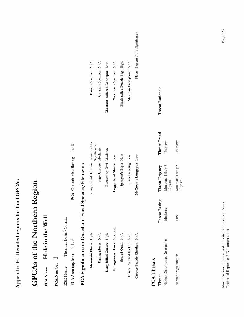
Appe
ndix
H. D
etai
led
repo
rts fo
r fin
al G
PCAs
Nor
th A
mer
ican
Gra
sslan
d Pr
iorit
y Co
nser
vatio
n A
reas
Page
123
Te
chni
cal R
epor
t and
Doc
umen
tatio
n
GPC
As o
f the
Nor
ther
n R
egio
n P
CA
Nam
e H
ole
in th
e W
all
PC
A N
umbe
r 1
ESR
Nam
e Th
unde
r Bas
in\C
onat
a P
CA
Area
(sq.
km
) 2,
179
PCA_
Qua
ntita
tive
Rat
ing
5.48
PC
A Si
gnifi
canc
e to
Gra
ssla
nd F
ocal
Spe
cies
/Ele
men
ts
M
ount
ain
Plov
er H
igh
Shar
p-ta
iled
Gro
use
Pres
ent /
No
B
aird
's S
parr
ow N
/A
Si
gnifi
canc
e
Pipi
ng p
love
r N
/A
Sage
Gro
use
Mod
erat
e C
assi
n's S
parr
ow N
/A
Lo
ng-b
illed
Cur
lew H
igh
Bur
row
ing
Ow
l M
oder
ate
Che
stnu
t-col
lare
d Lo
ngsp
ur L
ow
Fe
rrug
inou
s Haw
k M
oder
ate
Logg
erhe
ad S
hrik
e Lo
w
Wor
then
´s S
parr
ow N
/A
Sc
aled
Qua
il N
/A
Spra
gue'
s Pip
it N
/A
Bla
ck ta
iled
Prai
rie d
og H
igh
Le
sser
Pra
irie-
Chi
cken
N/A
La
rk B
untin
g Lo
w
Mex
ican
Pro
ngho
rn N
/A
G
reat
er P
rairi
e-C
hick
en N
/A
McC
own'
s Lon
gspu
r Lo
w
Bis
on P
rese
nt /
No
Sign
ifica
nce
PC
A T
hrea
ts
Thr
eat
Thr
eat R
atin
g T
hrea
t Urg
ency
T
hrea
t Tre
nd
Thr
eat R
atio
nale
H
abita
t Dist
urba
nce/
Des
truct
ion
M
oder
ate
Mod
erat
e; Li
kely
5 -
Unk
now
n
10 y
ears
Hab
itat F
ragm
enta
tion
Lo
w
Mod
erat
e; Li
kely
5 -
Unk
now
n
10 y
ears

Appe
ndix
H. D
etai
led
repo
rts fo
r fin
al G
PCAs
Nor
th A
mer
ican
Gra
sslan
d Pr
iorit
y Co
nser
vatio
n A
reas
Page
124
Te
chni
cal R
epor
t and
Doc
umen
tatio
n
GPC
As o
f the
Nor
ther
n R
egio
n P
CA
Nam
e R
ocky
Mou
ntai
n Fr
ont
PC
A N
umbe
r 14
E
SR N
ame
Rock
y M
ount
ain F
ront
P
CA
Area
(sq.
km
) 9,
189
PCA_
Qua
ntita
tive
Rat
ing
1.89
PC
A Si
gnifi
canc
e to
Gra
ssla
nd F
ocal
Spe
cies
/Ele
men
ts
M
ount
ain
Plov
er N
/A
Shar
p-ta
iled
Gro
use
Hig
h B
aird
's S
parr
ow P
rese
nt /
No
Pi
ping
plo
ver
Pres
ent /
No
Sage
Gro
use
N/A
C
assi
n's S
parr
ow N
/A
Lo
ng-b
illed
Cur
lew M
oder
ate
Bur
row
ing
Ow
l Pr
esen
t / N
o C
hest
nut-c
olla
red
Long
spur
Low
Fe
rrug
inou
s Haw
k M
oder
ate
Logg
erhe
ad S
hrik
e Lo
w
Wor
then
´s S
parr
ow N
/A
Sc
aled
Qua
il N
/A
Spra
gue'
s Pip
it Lo
w
Bla
ck ta
iled
Prai
rie d
og N
/A
Le
sser
Pra
irie-
Chi
cken
N/A
La
rk B
untin
g Pr
esen
t / N
o M
exic
an P
rong
horn
N/A
G
reat
er P
rairi
e-C
hick
en N
/A
McC
own'
s Lon
gspu
r Lo
w
Bis
on N
/A
PC
A T
hrea
ts
Thr
eat
Thr
eat R
atin
g T
hrea
t Urg
ency
T
hrea
t Tre
nd
Thr
eat R
atio
nale
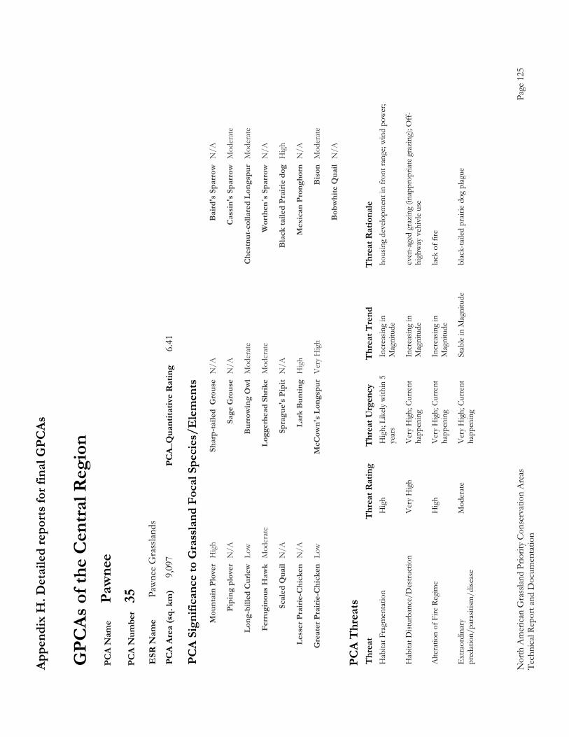
Appe
ndix
H. D
etai
led
repo
rts fo
r fin
al G
PCAs
Nor
th A
mer
ican
Gra
sslan
d Pr
iorit
y Co
nser
vatio
n A
reas
Page
125
Te
chni
cal R
epor
t and
Doc
umen
tatio
n
GPC
As o
f the
Cen
tral R
egio
n P
CA
Nam
e Pa
wne
e P
CA
Num
ber
35
ESR
Nam
e Pa
wne
e G
rass
lands
P
CA
Area
(sq.
km
) 9,
097
PCA_
Qua
ntita
tive
Rat
ing
6.41
PC
A Si
gnifi
canc
e to
Gra
ssla
nd F
ocal
Spe
cies
/Ele
men
ts
M
ount
ain
Plov
er H
igh
Shar
p-ta
iled
Gro
use
N/A
B
aird
's S
parr
ow N
/A
Pi
ping
plo
ver
N/A
Sa
ge G
rous
e N
/A
Cas
sin'
s Spa
rrow
Mod
erat
e
Lo
ng-b
illed
Cur
lew L
ow
Bur
row
ing
Ow
l M
oder
ate
Che
stnu
t-col
lare
d Lo
ngsp
ur M
oder
ate
Fe
rrug
inou
s Haw
k M
oder
ate
Logg
erhe
ad S
hrik
e M
oder
ate
Wor
then
´s S
parr
ow N
/A
Sc
aled
Qua
il N
/A
Spra
gue'
s Pip
it N
/A
Bla
ck ta
iled
Prai
rie d
og H
igh
Le
sser
Pra
irie-
Chi
cken
N/A
La
rk B
untin
g H
igh
Mex
ican
Pro
ngho
rn N
/A
G
reat
er P
rairi
e-C
hick
en L
ow
McC
own'
s Lon
gspu
r V
ery
Hig
h B
ison
Mod
erat
e
Bob
whi
te Q
uail
N/A
PC
A T
hrea
ts
Thr
eat
Thr
eat R
atin
g T
hrea
t Urg
ency
T
hrea
t Tre
nd
Thr
eat R
atio
nale
H
abita
t Fra
gmen
tatio
n
Hig
h H
igh;
Lik
ely w
ithin
5
Incr
easin
g in
ho
usin
g de
velo
pmen
t in
fron
t ran
ge; w
ind
pow
er;
ye
ars
Mag
nitu
de
Hab
itat D
istur
banc
e/D
estru
ctio
n
Ver
y H
igh
Ver
y H
igh;
Cur
rent
In
crea
sing
in
even
-age
d gr
azin
g (in
appr
opria
te g
razi
ng);
Off-
happ
enin
g M
agni
tude
hi
ghw
ay v
ehiv
le us
e
Alte
ratio
n of
Fire
Reg
ime
Hig
h V
ery
Hig
h; C
urre
nt
Incr
easin
g in
lac
k of
fire
happ
enin
g M
agni
tude
Ext
raor
dina
ry
Mod
erat
e V
ery
Hig
h; C
urre
nt
Stab
le in
Mag
nitu
de
blac
k-ta
iled
prair
ie do
g pl
ague
p
reda
tion/
para
sitism
/dise
ase
happ
enin
g
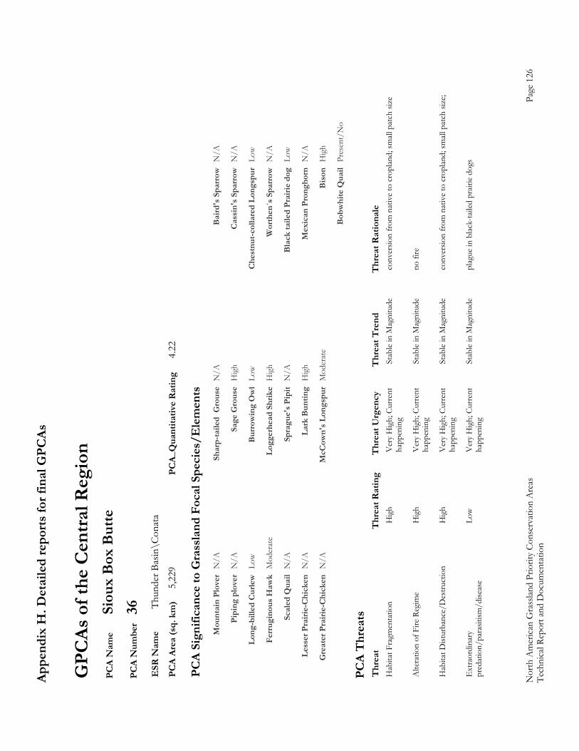
Appe
ndix
H. D
etai
led
repo
rts fo
r fin
al G
PCAs
Nor
th A
mer
ican
Gra
sslan
d Pr
iorit
y Co
nser
vatio
n A
reas
Page
126
Te
chni
cal R
epor
t and
Doc
umen
tatio
n
GPC
As o
f the
Cen
tral R
egio
n P
CA
Nam
e Si
oux
Box
But
te
PC
A N
umbe
r 36
E
SR N
ame
Thun
der B
asin
\Con
ata
PC
A Ar
ea (s
q. k
m)
5,22
9 PC
A_Q
uant
itativ
e R
atin
g 4.
22
PC
A Si
gnifi
canc
e to
Gra
ssla
nd F
ocal
Spe
cies
/Ele
men
ts
M
ount
ain
Plov
er N
/A
Shar
p-ta
iled
Gro
use
N/A
B
aird
's S
parr
ow N
/A
Pi
ping
plo
ver
N/A
Sa
ge G
rous
e H
igh
Cas
sin'
s Spa
rrow
N/A
Lo
ng-b
illed
Cur
lew L
ow
Bur
row
ing
Ow
l Lo
w
Che
stnu
t-col
lare
d Lo
ngsp
ur L
ow
Fe
rrug
inou
s Haw
k M
oder
ate
Logg
erhe
ad S
hrik
e H
igh
Wor
then
´s S
parr
ow N
/A
Sc
aled
Qua
il N
/A
Spra
gue'
s Pip
it N
/A
Bla
ck ta
iled
Prai
rie d
og L
ow
Le
sser
Pra
irie-
Chi
cken
N/A
La
rk B
untin
g H
igh
Mex
ican
Pro
ngho
rn N
/A
G
reat
er P
rairi
e-C
hick
en N
/A
McC
own'
s Lon
gspu
r M
oder
ate
Bis
on H
igh
B
obw
hite
Qua
il Pr
esen
t/N
o
PC
A T
hrea
ts
Thr
eat
Thr
eat R
atin
g T
hrea
t Urg
ency
T
hrea
t Tre
nd
Thr
eat R
atio
nale
H
abita
t Fra
gmen
tatio
n
Hig
h V
ery
Hig
h; C
urre
nt
Stab
le in
Mag
nitu
de
conv
ersio
n fr
om n
ativ
e to
cro
plan
d; sm
all p
atch
size
happ
enin
g
Alte
ratio
n of
Fire
Reg
ime
Hig
h V
ery
Hig
h; C
urre
nt
Stab
le in
Mag
nitu
de
no fi
re
ha
ppen
ing
Hab
itat D
istur
banc
e/D
estru
ctio
n
Hig
h V
ery
Hig
h; C
urre
nt
Stab
le in
Mag
nitu
de
conv
ersio
n fr
om n
ativ
e to
cro
plan
d; sm
all p
atch
size
;
happ
enin
g
Ext
raor
dina
ry
Low
Ver
y H
igh;
Cur
rent
St
able
in M
agni
tude
pl
ague
in b
lack-
taile
d pr
airie
dogs
p
reda
tion/
para
sitism
/dise
ase
happ
enin
g
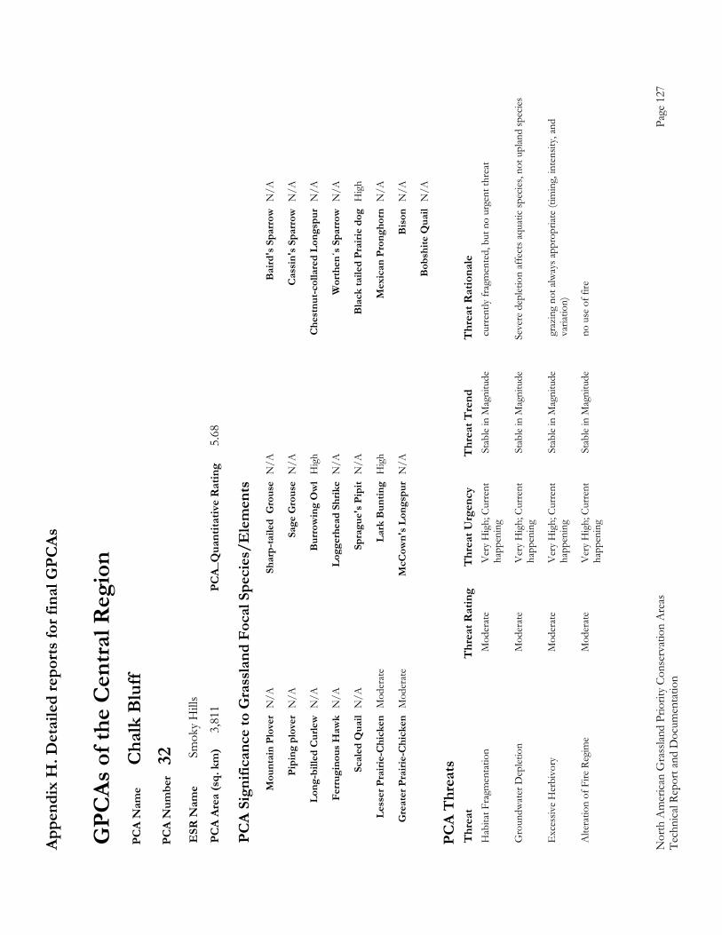
Appe
ndix
H. D
etai
led
repo
rts fo
r fin
al G
PCAs
Nor
th A
mer
ican
Gra
sslan
d Pr
iorit
y Co
nser
vatio
n A
reas
Page
127
Te
chni
cal R
epor
t and
Doc
umen
tatio
n
GPC
As o
f the
Cen
tral R
egio
n P
CA
Nam
e C
halk
Blu
ff P
CA
Num
ber
32
ESR
Nam
e Sm
oky
Hill
s P
CA
Area
(sq.
km
) 3,
811
PCA_
Qua
ntita
tive
Rat
ing
5.68
PC
A Si
gnifi
canc
e to
Gra
ssla
nd F
ocal
Spe
cies
/Ele
men
ts
M
ount
ain
Plov
er N
/A
Shar
p-ta
iled
Gro
use
N/A
B
aird
's S
parr
ow N
/A
Pi
ping
plo
ver
N/A
Sa
ge G
rous
e N
/A
Cas
sin'
s Spa
rrow
N/A
Lo
ng-b
illed
Cur
lew N
/A
Bur
row
ing
Ow
l H
igh
Che
stnu
t-col
lare
d Lo
ngsp
ur N
/A
Fe
rrug
inou
s Haw
k N
/A
Logg
erhe
ad S
hrik
e N
/A
Wor
then
´s S
parr
ow N
/A
Sc
aled
Qua
il N
/A
Spra
gue'
s Pip
it N
/A
Bla
ck ta
iled
Prai
rie d
og H
igh
Le
sser
Pra
irie-
Chi
cken
Mod
erat
e La
rk B
untin
g H
igh
Mex
ican
Pro
ngho
rn N
/A
G
reat
er P
rairi
e-C
hick
en M
oder
ate
McC
own'
s Lon
gspu
r N
/A
Bis
on N
/A
B
obsh
ite Q
uail
N/A
PC
A T
hrea
ts
Thr
eat
Thr
eat R
atin
g T
hrea
t Urg
ency
T
hrea
t Tre
nd
Thr
eat R
atio
nale
H
abita
t Fra
gmen
tatio
n
Mod
erat
e V
ery
Hig
h; C
urre
nt
Stab
le in
Mag
nitu
de
curr
ently
frag
men
ted,
but
no
urge
nt th
reat
happ
enin
g
Gro
undw
ater
Dep
letio
n M
oder
ate
Ver
y H
igh;
Cur
rent
St
able
in M
agni
tude
Se
vere
dep
letio
n af
fect
s aqu
atic
spec
ies,
not u
plan
d sp
ecies
happ
enin
g
Exc
essiv
e H
erbi
vory
M
oder
ate
Ver
y H
igh;
Cur
rent
St
able
in M
agni
tude
gr
azin
g no
t alw
ays a
ppro
priat
e (ti
min
g, in
tens
ity, a
nd
ha
ppen
ing
varia
tion)
Alte
ratio
n of
Fire
Reg
ime
Mod
erat
e V
ery
Hig
h; C
urre
nt
Stab
le in
Mag
nitu
de
no u
se o
f fire
happ
enin
g
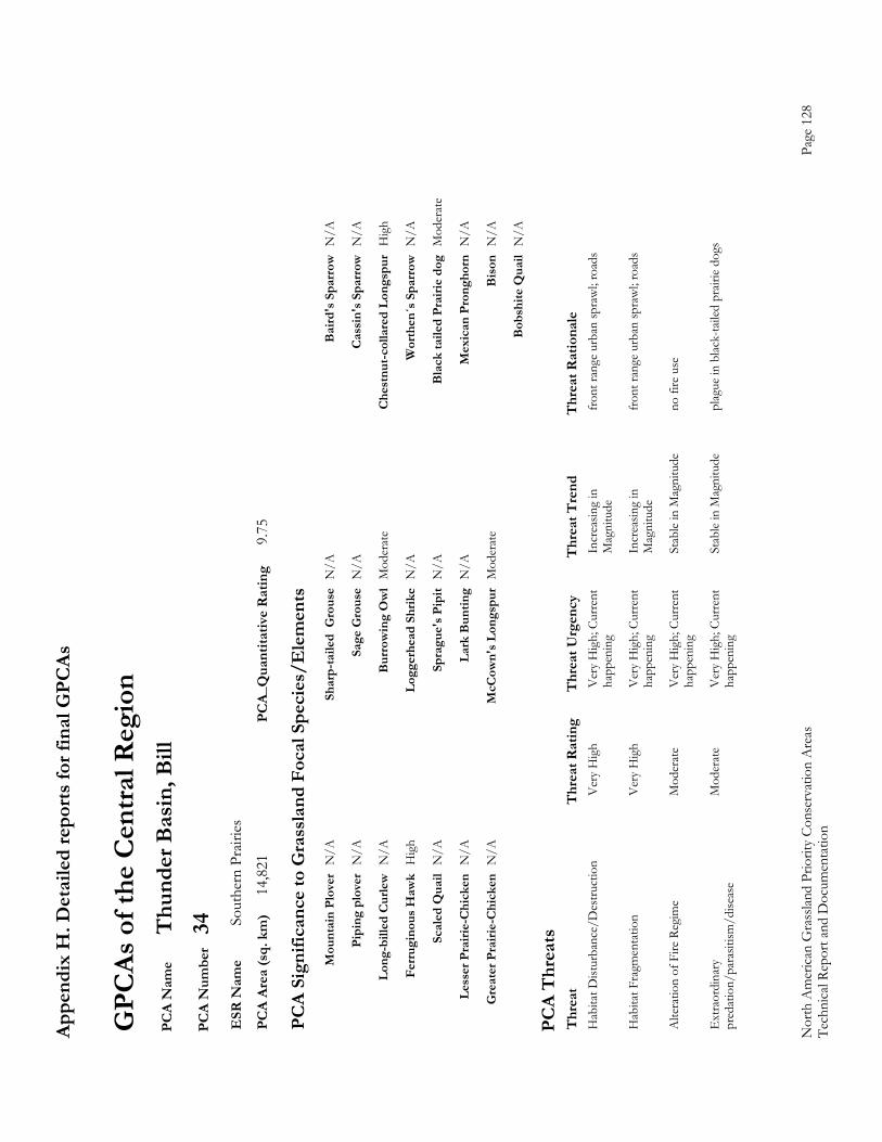
Appe
ndix
H. D
etai
led
repo
rts fo
r fin
al G
PCAs
Nor
th A
mer
ican
Gra
sslan
d Pr
iorit
y Co
nser
vatio
n A
reas
Page
128
Te
chni
cal R
epor
t and
Doc
umen
tatio
n
GPC
As o
f the
Cen
tral R
egio
n P
CA
Nam
e T
hund
er B
asin
, Bill
P
CA
Num
ber
34
ESR
Nam
e So
uthe
rn P
rairi
es
PC
A Ar
ea (s
q. k
m)
14,8
21
PCA_
Qua
ntita
tive
Rat
ing
9.75
PC
A Si
gnifi
canc
e to
Gra
ssla
nd F
ocal
Spe
cies
/Ele
men
ts
M
ount
ain
Plov
er N
/A
Shar
p-ta
iled
Gro
use
N/A
B
aird
's S
parr
ow N
/A
Pi
ping
plo
ver
N/A
Sa
ge G
rous
e N
/A
Cas
sin'
s Spa
rrow
N/A
Lo
ng-b
illed
Cur
lew N
/A
Bur
row
ing
Ow
l M
oder
ate
Che
stnu
t-col
lare
d Lo
ngsp
ur H
igh
Fe
rrug
inou
s Haw
k H
igh
Logg
erhe
ad S
hrik
e N
/A
Wor
then
´s S
parr
ow N
/A
Sc
aled
Qua
il N
/A
Spra
gue'
s Pip
it N
/A
Bla
ck ta
iled
Prai
rie d
og M
oder
ate
Le
sser
Pra
irie-
Chi
cken
N/A
La
rk B
untin
g N
/A
Mex
ican
Pro
ngho
rn N
/A
G
reat
er P
rairi
e-C
hick
en N
/A
McC
own'
s Lon
gspu
r M
oder
ate
Bis
on N
/A
B
obsh
ite Q
uail
N/A
PC
A T
hrea
ts
Thr
eat
Thr
eat R
atin
g T
hrea
t Urg
ency
T
hrea
t Tre
nd
Thr
eat R
atio
nale
H
abita
t Dist
urba
nce/
Des
truct
ion
V
ery
Hig
h V
ery
Hig
h; C
urre
nt
Incr
easin
g in
fr
ont r
ange
urb
an sp
raw
l; ro
ads
ha
ppen
ing
Mag
nitu
de
Hab
itat F
ragm
enta
tion
V
ery
Hig
h V
ery
Hig
h; C
urre
nt
Incr
easin
g in
fr
ont r
ange
urb
an sp
raw
l; ro
ads
ha
ppen
ing
Mag
nitu
de
Alte
ratio
n of
Fire
Reg
ime
Mod
erat
e V
ery
Hig
h; C
urre
nt
Stab
le in
Mag
nitu
de
no fi
re u
se
ha
ppen
ing
Ext
raor
dina
ry
Mod
erat
e V
ery
Hig
h; C
urre
nt
Stab
le in
Mag
nitu
de
plag
ue in
blac
k-ta
iled
prair
ie do
gs
pre
datio
n/pa
rasit
ism/d
iseas
e ha
ppen
ing
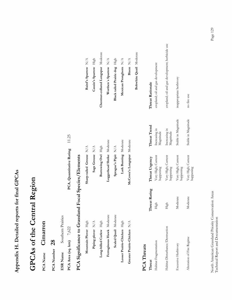
Appe
ndix
H. D
etai
led
repo
rts fo
r fin
al G
PCAs
Nor
th A
mer
ican
Gra
sslan
d Pr
iorit
y Co
nser
vatio
n A
reas
Page
129
Te
chni
cal R
epor
t and
Doc
umen
tatio
n
GPC
As o
f the
Cen
tral R
egio
n P
CA
Nam
e C
imar
ron
PC
A N
umbe
r 28
E
SR N
ame
Sout
hern
Pra
iries
P
CA
Area
(sq.
km
) 7,
622
PCA_
Qua
ntita
tive
Rat
ing
11.2
5
PC
A Si
gnifi
canc
e to
Gra
ssla
nd F
ocal
Spe
cies
/Ele
men
ts
M
ount
ain
Plov
er H
igh
Shar
p-ta
iled
Gro
use
N/A
B
aird
's S
parr
ow N
/A
Pi
ping
plo
ver
N/A
Sa
ge G
rous
e N
/A
Cas
sin'
s Spa
rrow
Hig
h
Lo
ng-b
illed
Cur
lew H
igh
Bur
row
ing
Ow
l H
igh
Che
stnu
t-col
lare
d Lo
ngsp
ur M
oder
ate
Fe
rrug
inou
s Haw
k M
oder
ate
Logg
erhe
ad S
hrik
e M
oder
ate
Wor
then
´s S
parr
ow N
/A
Sc
aled
Qua
il M
oder
ate
Spra
gue'
s Pip
it N
/A
Bla
ck ta
iled
Prai
rie d
og H
igh
Le
sser
Pra
irie-
Chi
cken
Hig
h La
rk B
untin
g M
oder
ate
Mex
ican
Pro
ngho
rn N
/A
G
reat
er P
rairi
e-C
hick
en N
/A
McC
own'
s Lon
gspu
r M
oder
ate
Bis
on N
/A
B
obw
hite
Qua
il M
oder
ate
PC
A T
hrea
ts
Thr
eat
Thr
eat R
atin
g T
hrea
t Urg
ency
T
hrea
t Tre
nd
Thr
eat R
atio
nale
H
abita
t Fra
gmen
tatio
n
Hig
h V
ery
Hig
h; C
urre
nt
Incr
easin
g in
cr
oplan
d; o
il an
d ga
s dev
elopm
ent
ha
ppen
ing
Mag
nitu
de
Hab
itat D
istur
banc
e/D
estru
ctio
n
Hig
h V
ery
Hig
h; C
urre
nt
Incr
easin
g in
cr
oplan
d; o
il an
d ga
s dev
elopm
ent;
herb
icide
use
happ
enin
g M
agni
tude
Exc
essiv
e H
erbi
vory
M
oder
ate
Ver
y H
igh;
Cur
rent
St
able
in M
agni
tude
in
appr
opria
te h
erbi
vory
happ
enin
g
Alte
ratio
n of
Fire
Reg
ime
Mod
erat
e V
ery
Hig
h; C
urre
nt
Stab
le in
Mag
nitu
de
no fi
re u
se
ha
ppen
ing
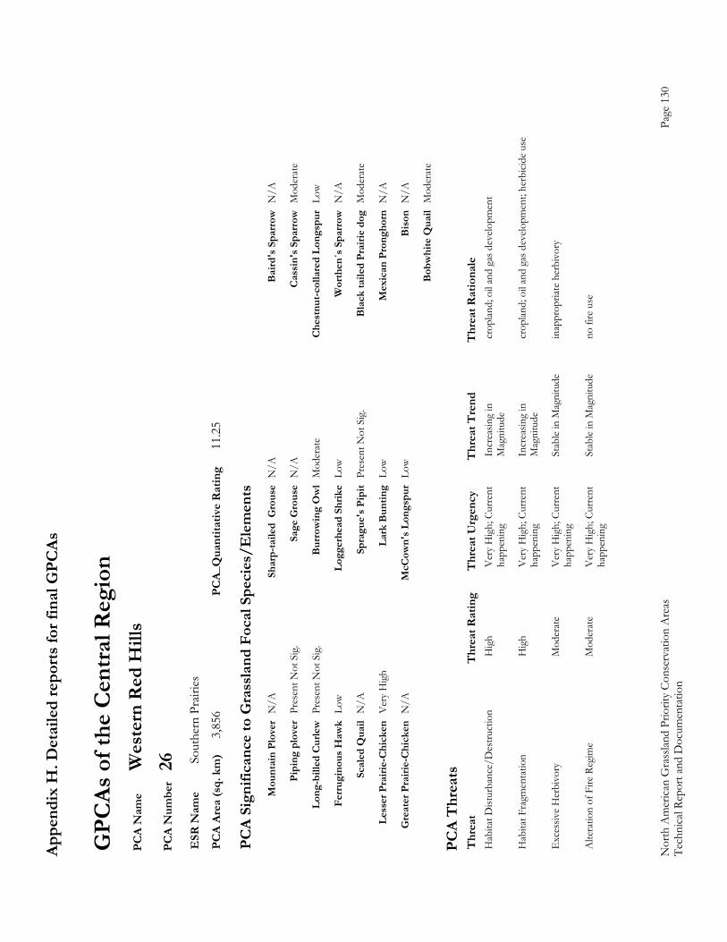
Appe
ndix
H. D
etai
led
repo
rts fo
r fin
al G
PCAs
Nor
th A
mer
ican
Gra
sslan
d Pr
iorit
y Co
nser
vatio
n A
reas
Page
130
Te
chni
cal R
epor
t and
Doc
umen
tatio
n
GPC
As o
f the
Cen
tral R
egio
n P
CA
Nam
e W
este
rn R
ed H
ills
PC
A N
umbe
r 26
E
SR N
ame
Sout
hern
Pra
iries
P
CA
Area
(sq.
km
) 3,
856
PCA_
Qua
ntita
tive
Rat
ing
11.2
5
PC
A Si
gnifi
canc
e to
Gra
ssla
nd F
ocal
Spe
cies
/Ele
men
ts
M
ount
ain
Plov
er N
/A
Shar
p-ta
iled
Gro
use
N/A
B
aird
's S
parr
ow N
/A
Pi
ping
plo
ver
Pres
ent N
ot S
ig.
Sage
Gro
use
N/A
C
assi
n's S
parr
ow M
oder
ate
Lo
ng-b
illed
Cur
lew P
rese
nt N
ot S
ig.
Bur
row
ing
Ow
l M
oder
ate
Che
stnu
t-col
lare
d Lo
ngsp
ur L
ow
Fe
rrug
inou
s Haw
k Lo
w
Logg
erhe
ad S
hrik
e Lo
w
Wor
then
´s S
parr
ow N
/A
Sc
aled
Qua
il N
/A
Spra
gue'
s Pip
it Pr
esen
t Not
Sig
. B
lack
taile
d Pr
airie
dog
Mod
erat
e
Le
sser
Pra
irie-
Chi
cken
Ver
y H
igh
Lark
Bun
ting
Low
Mex
ican
Pro
ngho
rn N
/A
G
reat
er P
rairi
e-C
hick
en N
/A
McC
own'
s Lon
gspu
r Lo
w
Bis
on N
/A
B
obw
hite
Qua
il M
oder
ate
PC
A T
hrea
ts
Thr
eat
Thr
eat R
atin
g T
hrea
t Urg
ency
T
hrea
t Tre
nd
Thr
eat R
atio
nale
H
abita
t Dist
urba
nce/
Des
truct
ion
H
igh
Ver
y H
igh;
Cur
rent
In
crea
sing
in
crop
land;
oil
and
gas d
evelo
pmen
t
happ
enin
g M
agni
tude
Hab
itat F
ragm
enta
tion
H
igh
Ver
y H
igh;
Cur
rent
In
crea
sing
in
crop
land;
oil
and
gas d
evelo
pmen
t; he
rbici
de u
se
ha
ppen
ing
Mag
nitu
de
Exc
essiv
e H
erbi
vory
M
oder
ate
Ver
y H
igh;
Cur
rent
St
able
in M
agni
tude
in
appr
opria
te h
erbi
vory
happ
enin
g
Alte
ratio
n of
Fire
Reg
ime
Mod
erat
e V
ery
Hig
h; C
urre
nt
Stab
le in
Mag
nitu
de
no fi
re u
se
ha
ppen
ing
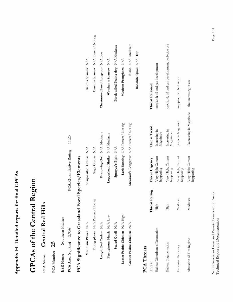
Appe
ndix
H. D
etai
led
repo
rts fo
r fin
al G
PCAs
Nor
th A
mer
ican
Gra
sslan
d Pr
iorit
y Co
nser
vatio
n A
reas
Page
131
Te
chni
cal R
epor
t and
Doc
umen
tatio
n
GPC
As o
f the
Cen
tral R
egio
n P
CA
Nam
e C
entra
l Red
Hill
s P
CA
Num
ber
25
ESR
Nam
e So
uthe
rn P
rairi
es
PC
A Ar
ea (s
q. k
m)
2,95
6 PC
A_Q
uant
itativ
e R
atin
g 11
.25
PC
A Si
gnifi
canc
e to
Gra
ssla
nd F
ocal
Spe
cies
/Ele
men
ts
M
ount
ain
Plov
er N
/A
Shar
p-ta
iled
Gro
use
N/A
B
aird
's S
parr
ow N
/A
Pi
ping
plo
ver
N/A
Pre
sent
/ N
ot si
g Sa
ge G
rous
e N
/A
Cas
sin'
s Spa
rrow
N/A
Pre
sent
/ N
ot si
g
Lo
ng-b
illed
Cur
lew N
/A
Bur
row
ing
Ow
l N
/A M
oder
ate
Che
stnu
t-col
lare
d Lo
ngsp
ur N
/A L
ow
Fe
rrug
inou
s Haw
k N
/A L
ow
Logg
erhe
ad S
hrik
e N
/A M
oder
ate
Wor
then
´s S
parr
ow N
/A
Sc
aled
Qua
il N
/A
Spra
gue'
s Pip
it N
/A
Bla
ck ta
iled
Prai
rie d
og N
/A M
oder
ate
Le
sser
Pra
irie-
Chi
cken
N/A
Hig
h La
rk B
untin
g N
/A P
rese
nt/
Not
sig
Mex
ican
Pro
ngho
rn N
/A
G
reat
er P
rairi
e-C
hick
en N
/A
McC
own'
s Lon
gspu
r N
/A P
rese
nt/
Not
sig
Bis
on N
/A M
oder
ate
B
obsh
ite Q
uail
N/A
Hig
h
PC
A T
hrea
ts
Thr
eat
Thr
eat R
atin
g T
hrea
t Urg
ency
T
hrea
t Tre
nd
Thr
eat R
atio
nale
H
abita
t Dist
urba
nce/
Des
truct
ion
H
igh
Ver
y H
igh;
Cur
rent
In
crea
sing
in
crop
land;
oil
and
gas d
evelo
pmen
t
happ
enin
g M
agni
tude
Hab
itat F
ragm
enta
tion
H
igh
Ver
y H
igh;
Cur
rent
In
crea
sing
in
crop
land;
oil
and
gas d
evelo
pmen
t; he
rbici
de u
se
ha
ppen
ing
Mag
nitu
de
Exc
essiv
e H
erbi
vory
M
oder
ate
Ver
y H
igh;
Cur
rent
St
able
in M
agni
tude
in
appr
opria
te h
erbi
vory
happ
enin
g
Alte
ratio
n of
Fire
Reg
ime
Mod
erat
e V
ery
Hig
h; C
urre
nt
Dec
reas
ing
in M
agni
tude
f
ire in
crea
sing
in u
se
ha
ppen
ing
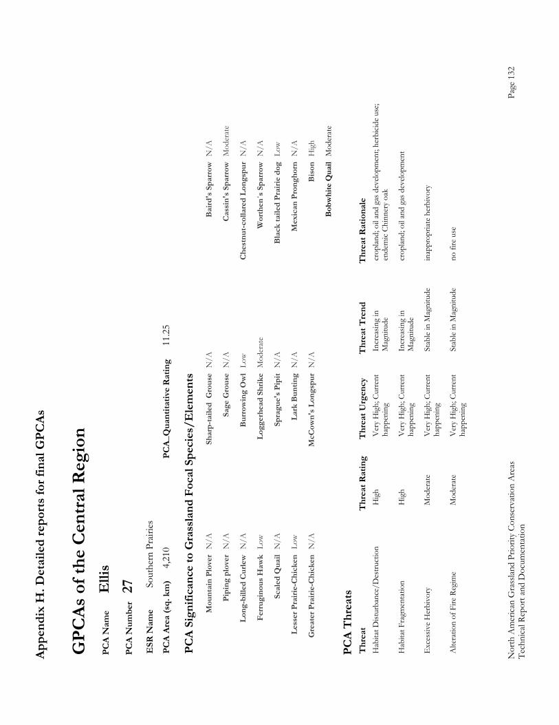
Appe
ndix
H. D
etai
led
repo
rts fo
r fin
al G
PCAs
Nor
th A
mer
ican
Gra
sslan
d Pr
iorit
y Co
nser
vatio
n A
reas
Page
132
Te
chni
cal R
epor
t and
Doc
umen
tatio
n
GPC
As o
f the
Cen
tral R
egio
n P
CA
Nam
e E
llis
PC
A N
umbe
r 27
E
SR N
ame
Sout
hern
Pra
iries
P
CA
Area
(sq.
km
) 4,
210
PCA_
Qua
ntita
tive
Rat
ing
11.2
5
PC
A Si
gnifi
canc
e to
Gra
ssla
nd F
ocal
Spe
cies
/Ele
men
ts
M
ount
ain
Plov
er N
/A
Shar
p-ta
iled
Gro
use
N/A
B
aird
's S
parr
ow N
/A
Pi
ping
plo
ver
N/A
Sa
ge G
rous
e N
/A
Cas
sin'
s Spa
rrow
Mod
erat
e
Lo
ng-b
illed
Cur
lew N
/A
Bur
row
ing
Ow
l Lo
w
Che
stnu
t-col
lare
d Lo
ngsp
ur N
/A
Fe
rrug
inou
s Haw
k Lo
w
Logg
erhe
ad S
hrik
e M
oder
ate
Wor
then
´s S
parr
ow N
/A
Sc
aled
Qua
il N
/A
Spra
gue'
s Pip
it N
/A
Bla
ck ta
iled
Prai
rie d
og L
ow
Le
sser
Pra
irie-
Chi
cken
Low
La
rk B
untin
g N
/A
Mex
ican
Pro
ngho
rn N
/A
G
reat
er P
rairi
e-C
hick
en N
/A
McC
own'
s Lon
gspu
r N
/A
Bis
on H
igh
B
obw
hite
Qua
il M
oder
ate
PC
A T
hrea
ts
Thr
eat
Thr
eat R
atin
g T
hrea
t Urg
ency
T
hrea
t Tre
nd
Thr
eat R
atio
nale
H
abita
t Dist
urba
nce/
Des
truct
ion
H
igh
Ver
y H
igh;
Cur
rent
In
crea
sing
in
crop
land;
oil
and
gas d
evelo
pmen
t; he
rbici
de u
se;
ha
ppen
ing
Mag
nitu
de
ende
mic
Chin
nery
oak
Hab
itat F
ragm
enta
tion
H
igh
Ver
y H
igh;
Cur
rent
In
crea
sing
in
crop
land;
oil
and
gas d
evelo
pmen
t
happ
enin
g M
agni
tude
Exc
essiv
e H
erbi
vory
M
oder
ate
Ver
y H
igh;
Cur
rent
St
able
in M
agni
tude
in
appr
opria
te h
erbi
vory
happ
enin
g
Alte
ratio
n of
Fire
Reg
ime
Mod
erat
e V
ery
Hig
h; C
urre
nt
Stab
le in
Mag
nitu
de
no fi
re u
se
ha
ppen
ing
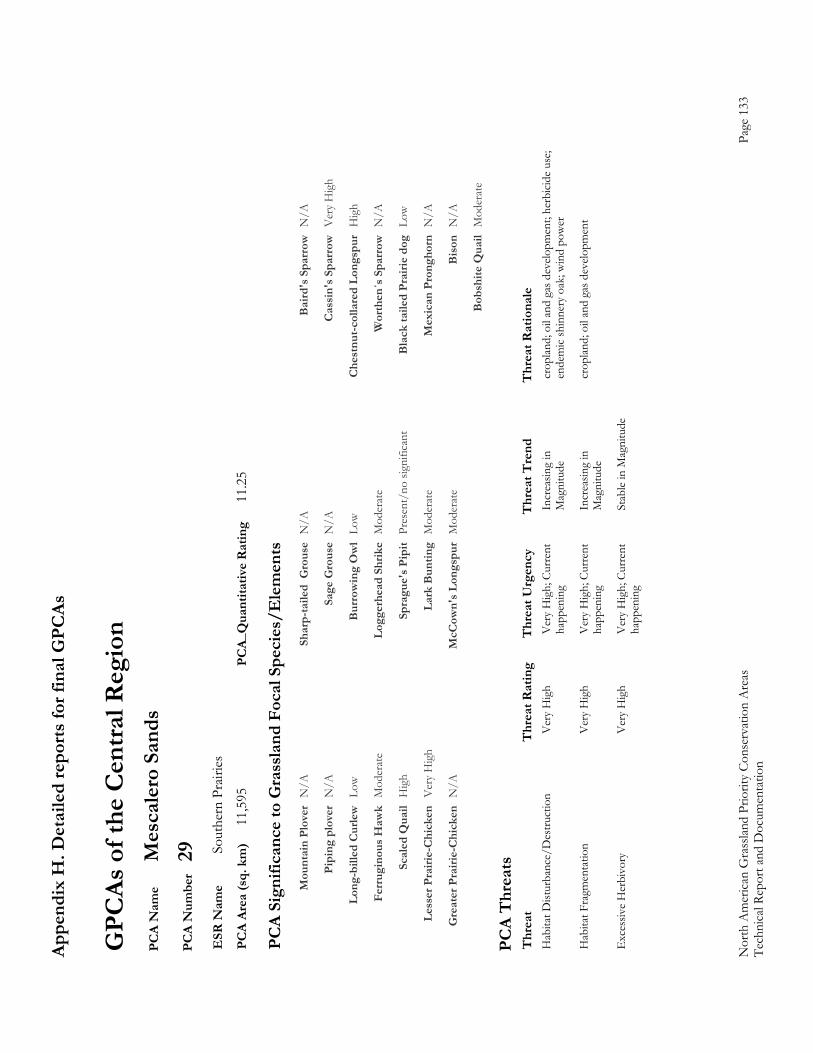
Appe
ndix
H. D
etai
led
repo
rts fo
r fin
al G
PCAs
Nor
th A
mer
ican
Gra
sslan
d Pr
iorit
y Co
nser
vatio
n A
reas
Page
133
Te
chni
cal R
epor
t and
Doc
umen
tatio
n
GPC
As o
f the
Cen
tral R
egio
n P
CA
Nam
e M
esca
lero
San
ds
PC
A N
umbe
r 29
E
SR N
ame
Sout
hern
Pra
iries
P
CA
Area
(sq.
km
) 11
,595
PC
A_Q
uant
itativ
e R
atin
g 11
.25
PC
A Si
gnifi
canc
e to
Gra
ssla
nd F
ocal
Spe
cies
/Ele
men
ts
M
ount
ain
Plov
er N
/A
Shar
p-ta
iled
Gro
use
N/A
B
aird
's S
parr
ow N
/A
Pi
ping
plo
ver
N/A
Sa
ge G
rous
e N
/A
Cas
sin'
s Spa
rrow
Ver
y H
igh
Lo
ng-b
illed
Cur
lew L
ow
Bur
row
ing
Ow
l Lo
w
Che
stnu
t-col
lare
d Lo
ngsp
ur H
igh
Fe
rrug
inou
s Haw
k M
oder
ate
Logg
erhe
ad S
hrik
e M
oder
ate
Wor
then
´s S
parr
ow N
/A
Sc
aled
Qua
il H
igh
Spra
gue'
s Pip
it Pr
esen
t/no
sign
ifica
nt
Bla
ck ta
iled
Prai
rie d
og L
ow
Le
sser
Pra
irie-
Chi
cken
Ver
y H
igh
Lark
Bun
ting
Mod
erat
e M
exic
an P
rong
horn
N/A
G
reat
er P
rairi
e-C
hick
en N
/A
McC
own'
s Lon
gspu
r M
oder
ate
Bis
on N
/A
B
obsh
ite Q
uail
Mod
erat
e
PC
A T
hrea
ts
Thr
eat
Thr
eat R
atin
g T
hrea
t Urg
ency
T
hrea
t Tre
nd
Thr
eat R
atio
nale
H
abita
t Dist
urba
nce/
Des
truct
ion
V
ery
Hig
h V
ery
Hig
h; C
urre
nt
Incr
easin
g in
cr
oplan
d; o
il an
d ga
s dev
elopm
ent;
herb
icide
use
;
happ
enin
g M
agni
tude
en
dem
ic sh
inne
ry o
ak; w
ind
pow
er
Hab
itat F
ragm
enta
tion
V
ery
Hig
h V
ery
Hig
h; C
urre
nt
Incr
easin
g in
cr
oplan
d; o
il an
d ga
s dev
elopm
ent
ha
ppen
ing
Mag
nitu
de
Exc
essiv
e H
erbi
vory
V
ery
Hig
h V
ery
Hig
h; C
urre
nt
Stab
le in
Mag
nitu
de
ha
ppen
ing
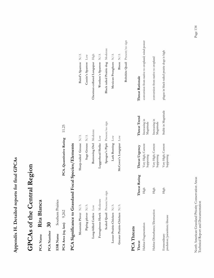
Appe
ndix
H. D
etai
led
repo
rts fo
r fin
al G
PCAs
Nor
th A
mer
ican
Gra
sslan
d Pr
iorit
y Co
nser
vatio
n A
reas
Page
134
Te
chni
cal R
epor
t and
Doc
umen
tatio
n
GPC
As o
f the
Cen
tral R
egio
n P
CA
Nam
e R
ita B
lanc
a P
CA
Num
ber
30
ESR
Nam
e So
uthe
rn P
rairi
es
PC
A Ar
ea (s
q. k
m)
9,26
2 PC
A_Q
uant
itativ
e R
atin
g 11
.25
PC
A Si
gnifi
canc
e to
Gra
ssla
nd F
ocal
Spe
cies
/Ele
men
ts
M
ount
ain
Plov
er N
/A
Shar
p-ta
iled
Gro
use
N/A
B
aird
's S
parr
ow N
/A
Pi
ping
plo
ver
N/A
Sa
ge G
rous
e N
/A
Cas
sin'
s Spa
rrow
Low
Lo
ng-b
illed
Cur
lew L
ow
Bur
row
ing
Ow
l M
oder
ate
Che
stnu
t-col
lare
d Lo
ngsp
ur H
igh
Fe
rrug
inou
s Haw
k M
oder
ate
Logg
erhe
ad S
hrik
e Lo
w
Wor
then
´s S
parr
ow N
/A
Sc
aled
Qua
il Pr
esen
t/no
sign
Sp
ragu
e's P
ipit
Pres
ent/
no si
gn
Bla
ck ta
iled
Prai
rie d
og M
oder
ate
Le
sser
Pra
irie-
Chi
cken
N/A
La
rk B
untin
g Lo
w
Mex
ican
Pro
ngho
rn N
/A
G
reat
er P
rairi
e-C
hick
en N
/A
McC
own'
s Lon
gspu
r Lo
w
Bis
on N
/A
B
obsh
ite Q
uail
Pres
ent/
no si
gn
PC
A T
hrea
ts
Thr
eat
Thr
eat R
atin
g T
hrea
t Urg
ency
T
hrea
t Tre
nd
Thr
eat R
atio
nale
H
abita
t Fra
gmen
tatio
n
Hig
h V
ery
Hig
h; C
urre
nt
Incr
easin
g in
co
nver
sion
from
nat
ive
to c
ropl
and;
win
d po
wer
happ
enin
g M
agni
tude
Hab
itat D
istur
banc
e/D
estru
ctio
n
Hig
h V
ery
Hig
h; C
urre
nt
Incr
easin
g in
co
nver
sion
from
nat
ive
to c
ropl
and
ha
ppen
ing
Mag
nitu
de
Ext
raor
dina
ry
Hig
h V
ery
Hig
h; C
urre
nt
Stab
le in
Mag
nitu
de
plag
ue in
blac
k-ta
iled
prair
ie do
gs is
hig
h p
reda
tion/
para
sitism
/dise
ase
happ
enin
g
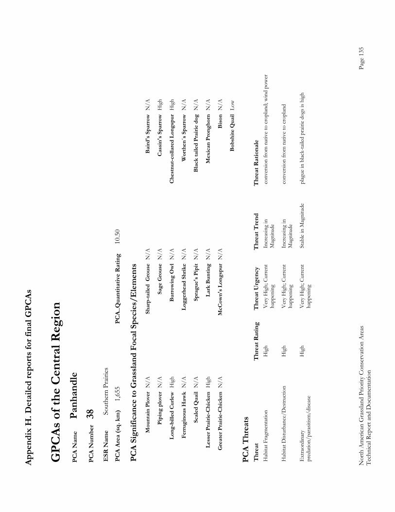
Appe
ndix
H. D
etai
led
repo
rts fo
r fin
al G
PCAs
Nor
th A
mer
ican
Gra
sslan
d Pr
iorit
y Co
nser
vatio
n A
reas
Page
135
Te
chni
cal R
epor
t and
Doc
umen
tatio
n
GPC
As o
f the
Cen
tral R
egio
n P
CA
Nam
e Pa
nhan
dle
PC
A N
umbe
r 38
E
SR N
ame
Sout
hern
Pra
iries
P
CA
Area
(sq.
km
) 1,
655
PCA_
Qua
ntita
tive
Rat
ing
10.5
0
PC
A Si
gnifi
canc
e to
Gra
ssla
nd F
ocal
Spe
cies
/Ele
men
ts
M
ount
ain
Plov
er N
/A
Shar
p-ta
iled
Gro
use
N/A
B
aird
's S
parr
ow N
/A
Pi
ping
plo
ver
N/A
Sa
ge G
rous
e N
/A
Cas
sin'
s Spa
rrow
Hig
h
Lo
ng-b
illed
Cur
lew H
igh
Bur
row
ing
Ow
l N
/A
Che
stnu
t-col
lare
d Lo
ngsp
ur H
igh
Fe
rrug
inou
s Haw
k N
/A
Logg
erhe
ad S
hrik
e N
/A
Wor
then
´s S
parr
ow N
/A
Sc
aled
Qua
il N
/A
Spra
gue'
s Pip
it N
/A
Bla
ck ta
iled
Prai
rie d
og N
/A
Le
sser
Pra
irie-
Chi
cken
Hig
h La
rk B
untin
g N
/A
Mex
ican
Pro
ngho
rn N
/A
G
reat
er P
rairi
e-C
hick
en N
/A
McC
own'
s Lon
gspu
r N
/A
Bis
on N
/A
B
obsh
ite Q
uail
Low
PC
A T
hrea
ts
Thr
eat
Thr
eat R
atin
g T
hrea
t Urg
ency
T
hrea
t Tre
nd
Thr
eat R
atio
nale
H
abita
t Fra
gmen
tatio
n
Hig
h V
ery
Hig
h; C
urre
nt
Incr
easin
g in
co
nver
sion
from
nat
ive
to c
ropl
and;
win
d po
wer
happ
enin
g M
agni
tude
Hab
itat D
istur
banc
e/D
estru
ctio
n
Hig
h V
ery
Hig
h; C
urre
nt
Incr
easin
g in
co
nver
sion
from
nat
ive
to c
ropl
and
ha
ppen
ing
Mag
nitu
de
Ext
raor
dina
ry
Hig
h V
ery
Hig
h; C
urre
nt
Stab
le in
Mag
nitu
de
plag
ue in
blac
k-ta
iled
prair
ie do
gs is
hig
h p
reda
tion/
para
sitism
/dise
ase
happ
enin
g
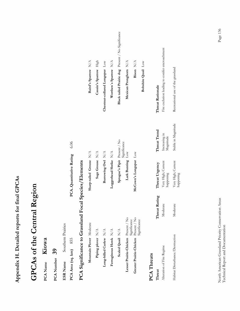
Appe
ndix
H. D
etai
led
repo
rts fo
r fin
al G
PCAs
Nor
th A
mer
ican
Gra
sslan
d Pr
iorit
y Co
nser
vatio
n A
reas
Page
136
Te
chni
cal R
epor
t and
Doc
umen
tatio
n
GPC
As o
f the
Cen
tral R
egio
n P
CA
Nam
e K
iow
a P
CA
Num
ber
39
ESR
Nam
e So
uthe
rn P
rairi
es
PC
A Ar
ea (s
q. k
m)
855
PCA_
Qua
ntita
tive
Rat
ing
6.06
PC
A Si
gnifi
canc
e to
Gra
ssla
nd F
ocal
Spe
cies
/Ele
men
ts
M
ount
ain
Plov
er M
oder
ate
Shar
p-ta
iled
Gro
use
N/A
B
aird
's S
parr
ow N
/A
Pi
ping
plo
ver
N/A
Sa
ge G
rous
e N
/A
Cas
sin'
s Spa
rrow
Hig
h
Lo
ng-b
illed
Cur
lew N
/A
Bur
row
ing
Ow
l N
/A
Che
stnu
t-col
lare
d Lo
ngsp
ur L
ow
Fe
rrug
inou
s Haw
k N
/A
Logg
erhe
ad S
hrik
e N
/A
Wor
then
´s S
parr
ow N
/A
Sc
aled
Qua
il N
/A
Spra
gue'
s Pip
it Pr
esen
t / N
o
Bla
ck ta
iled
Prai
rie d
og P
rese
nt /
No
Sign
ifica
nce
Si
gnifi
canc
e
Less
er P
rairi
e-C
hick
en P
rese
nt /
No
La
rk B
untin
g Lo
w
Mex
ican
Pro
ngho
rn N
/A
Si
gnifi
canc
e
Gre
ater
Pra
irie-
Chi
cken
Pre
sent
/ N
o
McC
own'
s Lon
gspu
r Lo
w
Bis
on N
/A
Si
gnifi
canc
e
Bob
shite
Qua
il Lo
w
PC
A T
hrea
ts
Thr
eat
Thr
eat R
atin
g T
hrea
t Urg
ency
T
hrea
t Tre
nd
Thr
eat R
atio
nale
A
ltera
tion
of F
ire R
egim
e M
oder
ate
Ver
y H
igh;
Cur
rent
In
crea
sing
in
Fire
exc
lutio
n lea
ding
to c
onife
r enc
roac
hmen
t
happ
enin
g M
agni
tude
Hab
itat D
istur
banc
e/D
estru
ctio
n
Mod
erat
e V
ery
Hig
h; C
urre
nt
Stab
le in
Mag
nitu
de
Recr
eatio
nal u
se o
f the
gra
sslan
d
happ
enin
g
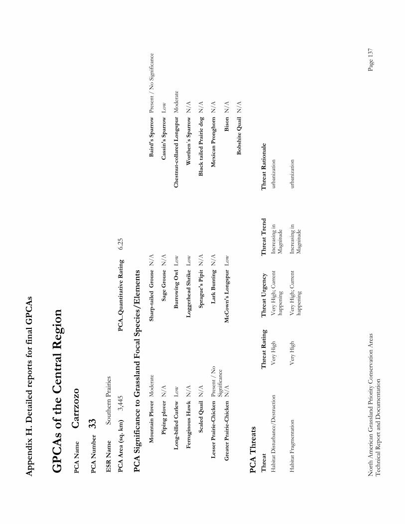
Appe
ndix
H. D
etai
led
repo
rts fo
r fin
al G
PCAs
Nor
th A
mer
ican
Gra
sslan
d Pr
iorit
y Co
nser
vatio
n A
reas
Page
137
Te
chni
cal R
epor
t and
Doc
umen
tatio
n
GPC
As o
f the
Cen
tral R
egio
n P
CA
Nam
e C
arrz
ozo
PC
A N
umbe
r 33
E
SR N
ame
Sout
hern
Pra
iries
P
CA
Area
(sq.
km
) 3,
445
PCA_
Qua
ntita
tive
Rat
ing
6.25
PC
A Si
gnifi
canc
e to
Gra
ssla
nd F
ocal
Spe
cies
/Ele
men
ts
M
ount
ain
Plov
er M
oder
ate
Shar
p-ta
iled
Gro
use
N/A
B
aird
's S
parr
ow P
rese
nt /
No
Sign
ifica
nce
Pi
ping
plo
ver
N/A
Sa
ge G
rous
e N
/A
Cas
sin'
s Spa
rrow
Low
Lo
ng-b
illed
Cur
lew L
ow
Bur
row
ing
Ow
l Lo
w
Che
stnu
t-col
lare
d Lo
ngsp
ur M
oder
ate
Fe
rrug
inou
s Haw
k N
/A
Logg
erhe
ad S
hrik
e Lo
w
Wor
then
´s S
parr
ow N
/A
Sc
aled
Qua
il N
/A
Spra
gue'
s Pip
it N
/A
Bla
ck ta
iled
Prai
rie d
og N
/A
Le
sser
Pra
irie-
Chi
cken
Pre
sent
/ N
o
Lark
Bun
ting
N/A
M
exic
an P
rong
horn
N/A
Sign
ifica
nce
G
reat
er P
rairi
e-C
hick
en N
/A
McC
own'
s Lon
gspu
r Lo
w
Bis
on N
/A
B
obsh
ite Q
uail
N/A
PC
A T
hrea
ts
Thr
eat
Thr
eat R
atin
g T
hrea
t Urg
ency
T
hrea
t Tre
nd
Thr
eat R
atio
nale
H
abita
t Dist
urba
nce/
Des
truct
ion
V
ery
Hig
h V
ery
Hig
h; C
urre
nt
Incr
easin
g in
ur
bani
zatio
n
happ
enin
g M
agni
tude
Hab
itat F
ragm
enta
tion
V
ery
Hig
h V
ery
Hig
h; C
urre
nt
Incr
easin
g in
ur
bani
zatio
n
happ
enin
g M
agni
tude

Appe
ndix
H. D
etai
led
repo
rts fo
r fin
al G
PCAs
Nor
th A
mer
ican
Gra
sslan
d Pr
iorit
y Co
nser
vatio
n A
reas
Page
138
Te
chni
cal R
epor
t and
Doc
umen
tatio
n
GPC
As o
f the
Cen
tral R
egio
n P
CA
Nam
e R
oose
velt
PC
A N
umbe
r 37
E
SR N
ame
Sout
hern
Pra
iries
P
CA
Area
(sq.
km
) 3,
365
PCA_
Qua
ntita
tive
Rat
ing
9.50
PC
A Si
gnifi
canc
e to
Gra
ssla
nd F
ocal
Spe
cies
/Ele
men
ts
M
ount
ain
Plov
er M
oder
ate
Shar
p-ta
iled
Gro
use
N/A
B
aird
's S
parr
ow N
/A
Pi
ping
plo
ver
N/A
Sa
ge G
rous
e N
/A
Cas
sin'
s Spa
rrow
Ver
y H
igh
Lo
ng-b
illed
Cur
lew N
/A
Bur
row
ing
Ow
l M
oder
ate
Che
stnu
t-col
lare
d Lo
ngsp
ur N
/A
Fe
rrug
inou
s Haw
k H
igh
Logg
erhe
ad S
hrik
e M
oder
ate
Wor
then
´s S
parr
ow N
/A
Sc
aled
Qua
il N
/A
Spra
gue'
s Pip
it N
/A
Bla
ck ta
iled
Prai
rie d
og M
oder
ate
Le
sser
Pra
irie-
Chi
cken
Hig
h La
rk B
untin
g N
/A
Mex
ican
Pro
ngho
rn N
/A
G
reat
er P
rairi
e-C
hick
en N
/A
McC
own'
s Lon
gspu
r N
/A
Bis
on N
/A
B
obsh
ite Q
uail
N/A
PC
A T
hrea
ts
Thr
eat
Thr
eat R
atin
g T
hrea
t Urg
ency
T
hrea
t Tre
nd
Thr
eat R
atio
nale
H
abita
t Fra
gmen
tatio
n
Hig
h V
ery
Hig
h; C
urre
nt
Incr
easin
g in
co
nver
sion
from
nat
ive
to c
ropl
and;
win
d po
wer
happ
enin
g M
agni
tude
Hab
itat D
istur
banc
e/D
estru
ctio
n
Hig
h V
ery
Hig
h; C
urre
nt
Incr
easin
g in
co
nver
sion
from
nat
ive
to c
ropl
and
ha
ppen
ing
Mag
nitu
de
Ext
raor
dina
ry
Hig
h V
ery
Hig
h; C
urre
nt
Stab
le in
Mag
nitu
de
plag
ue in
blac
k-ta
iled
prair
ie do
gs is
hig
h p
reda
tion/
para
sitism
/dise
ase
happ
enin
g
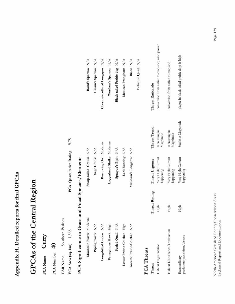
Appe
ndix
H. D
etai
led
repo
rts fo
r fin
al G
PCAs
Nor
th A
mer
ican
Gra
sslan
d Pr
iorit
y Co
nser
vatio
n A
reas
Page
139
Te
chni
cal R
epor
t and
Doc
umen
tatio
n
GPC
As o
f the
Cen
tral R
egio
n P
CA
Nam
e C
urry
P
CA
Num
ber
40
ESR
Nam
e So
uthe
rn P
rairi
es
PC
A Ar
ea (s
q. k
m)
1,36
8 PC
A_Q
uant
itativ
e R
atin
g 9.
75
PC
A Si
gnifi
canc
e to
Gra
ssla
nd F
ocal
Spe
cies
/Ele
men
ts
M
ount
ain
Plov
er M
oder
ate
Shar
p-ta
iled
Gro
use
N/A
B
aird
's S
parr
ow N
/A
Pi
ping
plo
ver
N/A
Sa
ge G
rous
e N
/A
Cas
sin'
s Spa
rrow
N/A
Lo
ng-b
illed
Cur
lew N
/A
Bur
row
ing
Ow
l M
oder
ate
Che
stnu
t-col
lare
d Lo
ngsp
ur N
/A
Fe
rrug
inou
s Haw
k H
igh
Logg
erhe
ad S
hrik
e M
oder
ate
Wor
then
´s S
parr
ow N
/A
Sc
aled
Qua
il N
/A
Spra
gue'
s Pip
it N
/A
Bla
ck ta
iled
Prai
rie d
og N
/A
Le
sser
Pra
irie-
Chi
cken
Hig
h La
rk B
untin
g N
/A
Mex
ican
Pro
ngho
rn N
/A
G
reat
er P
rairi
e-C
hick
en N
/A
McC
own'
s Lon
gspu
r N
/A
Bis
on N
/A
B
obsh
ite Q
uail
N/A
PC
A T
hrea
ts
Thr
eat
Thr
eat R
atin
g T
hrea
t Urg
ency
T
hrea
t Tre
nd
Thr
eat R
atio
nale
H
abita
t Fra
gmen
tatio
n
Hig
h V
ery
Hig
h; C
urre
nt
Incr
easin
g in
co
nver
sion
from
nat
ive
to c
ropl
and;
win
d po
wer
happ
enin
g M
agni
tude
Hab
itat D
istur
banc
e/D
estru
ctio
n
Hig
h V
ery
Hig
h; C
urre
nt
Incr
easin
g in
co
nver
sion
from
nat
ive
to c
ropl
and
ha
ppen
ing
Mag
nitu
de
Ext
raor
dina
ry
Hig
h V
ery
Hig
h; C
urre
nt
Stab
le in
Mag
nitu
de
plag
ue in
blac
k-ta
iled
prair
ie do
gs is
hig
h p
reda
tion/
para
sitism
/dise
ase
happ
enin
g
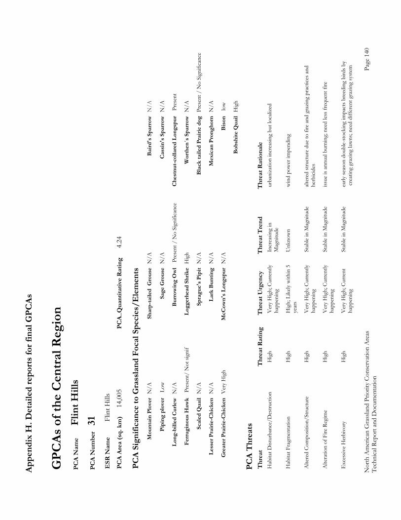
Appe
ndix
H. D
etai
led
repo
rts fo
r fin
al G
PCAs
Nor
th A
mer
ican
Gra
sslan
d Pr
iorit
y Co
nser
vatio
n A
reas
Page
140
Te
chni
cal R
epor
t and
Doc
umen
tatio
n
GPC
As o
f the
Cen
tral R
egio
n P
CA
Nam
e Fl
int H
ills
PC
A N
umbe
r 31
E
SR N
ame
Flin
t Hill
s P
CA
Area
(sq.
km
) 14
,005
PC
A_Q
uant
itativ
e R
atin
g 4.
24
PC
A Si
gnifi
canc
e to
Gra
ssla
nd F
ocal
Spe
cies
/Ele
men
ts
M
ount
ain
Plov
er N
/A
Shar
p-ta
iled
Gro
use
N/A
B
aird
's S
parr
ow N
/A
Pi
ping
plo
ver
Low
Sa
ge G
rous
e N
/A
Cas
sin'
s Spa
rrow
N/A
Lo
ng-b
illed
Cur
lew N
/A
Bur
row
ing
Ow
l P
rese
nt /
No
Sign
ifica
nce
Che
stnu
t-col
lare
d Lo
ngsp
ur
Pres
ent
Fe
rrug
inou
s Haw
k P
rese
nt/
Not
sign
if Lo
gger
head
Shr
ike
Hig
h W
orth
en´s
Spa
rrow
N/A
Sc
aled
Qua
il N
/A
Spra
gue'
s Pip
it N
/A
Bla
ck ta
iled
Prai
rie d
og P
rese
nt /
No
Sign
ifica
nce
Le
sser
Pra
irie-
Chi
cken
N/A
La
rk B
untin
g N
/A
Mex
ican
Pro
ngho
rn N
/A
G
reat
er P
rairi
e-C
hick
en V
ery
Hig
h M
cCow
n's L
ongs
pur
N/A
B
ison
lo
w
B
obsh
ite Q
uail
Hig
h
PC
A T
hrea
ts
Thr
eat
Thr
eat R
atin
g T
hrea
t Urg
ency
T
hrea
t Tre
nd
Thr
eat R
atio
nale
H
abita
t Dist
urba
nce/
Des
truct
ion
H
igh
Ver
y H
igh;
Cur
rent
ly
Incr
easin
g in
ur
bani
zatio
n in
crea
sing
but l
ocali
zed
ha
ppen
ing
Mag
nitu
de
Hab
itat F
ragm
enta
tion
H
igh
Hig
h; L
ikely
with
in 5
U
nkno
wn
win
d po
wer
impe
ndin
g
year
s
Alte
red
Com
posit
ion/
Stru
ctur
e H
igh
Ver
y H
igh;
Cur
rent
ly
Stab
le in
Mag
nitu
de
alter
ed st
ruct
ure
due
to fi
re a
nd g
razi
ng p
ract
ices a
nd
ha
ppen
ing
herb
icide
s
Alte
ratio
n of
Fire
Reg
ime
Hig
h V
ery
Hig
h; C
urre
ntly
St
able
in M
agni
tude
iss
ue is
ann
ual b
urni
ng; n
eed
less f
requ
ent f
ire
ha
ppen
ing
Exc
essiv
e H
erbi
vory
H
igh
Ver
y H
igh;
Cur
rent
St
able
in M
agni
tude
ea
rly se
ason
dou
ble-
stoc
king
impa
cts b
reed
ing
bird
s by
ha
ppen
ing
cre
atin
g gr
azin
g law
ns; n
eed
diff
eren
t gra
zing
syst
em
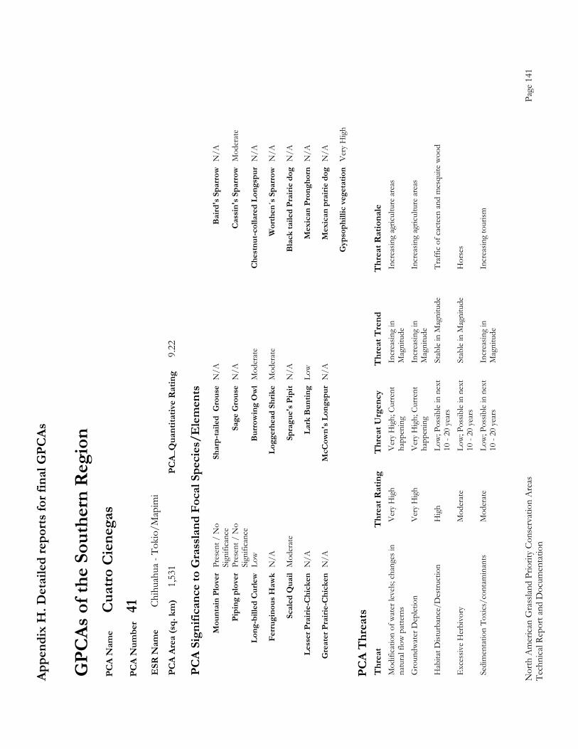
Appe
ndix
H. D
etai
led
repo
rts fo
r fin
al G
PCAs
Nor
th A
mer
ican
Gra
sslan
d Pr
iorit
y Co
nser
vatio
n A
reas
Page
141
Te
chni
cal R
epor
t and
Doc
umen
tatio
n
GPC
As o
f the
Sou
ther
n R
egio
n P
CA
Nam
e C
uatro
Cie
nega
s P
CA
Num
ber
41
ESR
Nam
e Ch
ihua
hua
- Tok
io/M
apim
i P
CA
Area
(sq.
km
) 1,
531
PCA_
Qua
ntita
tive
Rat
ing
9.22
PC
A Si
gnifi
canc
e to
Gra
ssla
nd F
ocal
Spe
cies
/Ele
men
ts
M
ount
ain
Plov
er P
rese
nt /
No
Sh
arp-
taile
d G
rous
e N
/A
Bai
rd's
Spa
rrow
N/A
Sign
ifica
nce
Pi
ping
plo
ver
Pres
ent /
No
Sa
ge G
rous
e N
/A
Cas
sin'
s Spa
rrow
Mod
erat
e
Sign
ifica
nce
Lo
ng-b
illed
Cur
lew L
ow
Bur
row
ing
Ow
l M
oder
ate
Che
stnu
t-col
lare
d Lo
ngsp
ur N
/A
Fe
rrug
inou
s Haw
k N
/A
Logg
erhe
ad S
hrik
e M
oder
ate
Wor
then
´s S
parr
ow N
/A
Sc
aled
Qua
il M
oder
ate
Spra
gue'
s Pip
it N
/A
Bla
ck ta
iled
Prai
rie d
og N
/A
Le
sser
Pra
irie-
Chi
cken
N/A
La
rk B
untin
g Lo
w
Mex
ican
Pro
ngho
rn N
/A
G
reat
er P
rairi
e-C
hick
en N
/A
McC
own'
s Lon
gspu
r N
/A
Mex
ican
pra
irie
dog
N/A
G
ypso
phill
ic v
eget
atio
n V
ery
Hig
h
PC
A T
hrea
ts
Thr
eat
Thr
eat R
atin
g T
hrea
t Urg
ency
T
hrea
t Tre
nd
Thr
eat R
atio
nale
M
odifi
catio
n of
wat
er le
vels;
cha
nges
in
Ver
y H
igh
Ver
y H
igh;
Cur
rent
In
crea
sing
in
Incr
easin
g ag
ricul
ture
are
as
nat
ural
flow
pat
tern
s ha
ppen
ing
Mag
nitu
de
Gro
undw
ater
Dep
letio
n V
ery
Hig
h V
ery
Hig
h; C
urre
nt
Incr
easin
g in
In
crea
sing
agric
ultu
re a
reas
happ
enin
g M
agni
tude
H
abita
t Dist
urba
nce/
Des
truct
ion
H
igh
Low
; Pos
sible
in n
ext
Stab
le in
Mag
nitu
de
Traf
fic o
f cac
teen
and
mes
quite
woo
d
10 -
20 y
ears
E
xces
sive
Her
bivo
ry
Mod
erat
e Lo
w; P
ossib
le in
nex
t St
able
in M
agni
tude
H
orse
s
10 -
20 y
ears
S
edim
enta
tion
Toxi
cs/c
onta
min
ants
Mod
erat
e Lo
w; P
ossib
le in
nex
t In
crea
sing
in
Incr
easin
g to
urism
10 -
20 y
ears
Mag
nitu
de
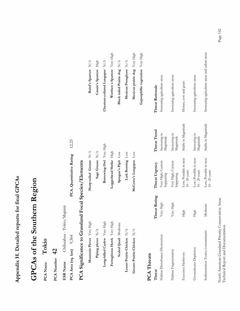
Appe
ndix
H. D
etai
led
repo
rts fo
r fin
al G
PCAs
Nor
th A
mer
ican
Gra
sslan
d Pr
iorit
y Co
nser
vatio
n A
reas
Page
142
Te
chni
cal R
epor
t and
Doc
umen
tatio
n
GPC
As o
f the
Sou
ther
n R
egio
n P
CA
Nam
e T
okio
P
CA
Num
ber
42
ESR
Nam
e Ch
ihua
hua
- Tok
io/M
apim
i P
CA
Area
(sq.
km
) 9,
364
PCA_
Qua
ntita
tive
Rat
ing
12.2
5
PC
A Si
gnifi
canc
e to
Gra
ssla
nd F
ocal
Spe
cies
/Ele
men
ts
M
ount
ain
Plov
er V
ery
Hig
h Sh
arp-
taile
d G
rous
e N
/A
Bai
rd's
Spa
rrow
N/A
Pi
ping
plo
ver
N/A
Sa
ge G
rous
e N
/A
Cas
sin'
s Spa
rrow
Hig
h
Lo
ng-b
illed
Cur
lew V
ery
Hig
h B
urro
win
g O
wl
Ver
y H
igh
Che
stnu
t-col
lare
d Lo
ngsp
ur N
/A
Fe
rrug
inou
s Haw
k V
ery
Hig
h Lo
gger
head
Shr
ike
Hig
h W
orth
en´s
Spa
rrow
Ver
y H
igh
Sc
aled
Qua
il M
oder
ate
Spra
gue'
s Pip
it Lo
w
Bla
ck ta
iled
Prai
rie d
og N
/A
Le
sser
Pra
irie-
Chi
cken
N/A
La
rk B
untin
g Lo
w
Mex
ican
Pro
ngho
rn N
/A
G
reat
er P
rairi
e-C
hick
en N
/A
McC
own'
s Lon
gspu
r Lo
w
Mex
ican
pra
irie
dog
Ver
y H
igh
G
ypso
phill
ic v
eget
atio
n V
ery
Hig
h
PC
A T
hrea
ts
Thr
eat
Thr
eat R
atin
g T
hrea
t Urg
ency
T
hrea
t Tre
nd
Thr
eat R
atio
nale
H
abita
t Dist
urba
nce/
Des
truct
ion
V
ery
Hig
h V
ery
Hig
h; C
urre
nt
Incr
easin
g in
In
crea
sing
agric
ultu
re a
reas
happ
enin
g M
agni
tude
Hab
itat F
ragm
enta
tion
V
ery
Hig
h V
ery
Hig
h; C
urre
nt
Incr
easin
g in
In
crea
sing
agric
ultu
re a
reas
happ
enin
g M
agni
tude
Exc
essiv
e H
erbi
vory
H
igh
Low
; Pos
sible
in n
ext
Stab
le in
Mag
nitu
de
Hor
ses,
cow
and
goa
ts
10
- 20
yea
rs
Gro
undw
ater
Dep
letio
n H
igh
Low
; Pos
sible
in n
ext
Incr
easin
g in
In
crea
sing
agric
ultu
re a
reas
10 -
20 y
ears
Mag
nitu
de
Sed
imen
tatio
n To
xics
/con
tam
inan
ts
Mod
erat
e Lo
w; P
ossib
le in
nex
t St
able
in M
agni
tude
In
crea
sing
agric
ultu
re a
reas
and
urb
an a
reas
10 -
20 y
ears
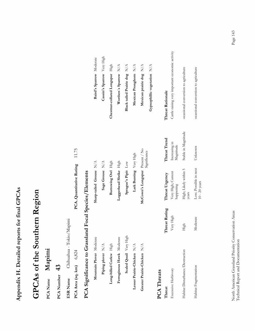
Appe
ndix
H. D
etai
led
repo
rts fo
r fin
al G
PCAs
Nor
th A
mer
ican
Gra
sslan
d Pr
iorit
y Co
nser
vatio
n A
reas
Page
143
Te
chni
cal R
epor
t and
Doc
umen
tatio
n
GPC
As o
f the
Sou
ther
n R
egio
n P
CA
Nam
e M
apim
i P
CA
Num
ber
43
ESR
Nam
e Ch
ihua
hua
- Tok
io/M
apim
i P
CA
Area
(sq.
km
) 6,
824
PCA_
Qua
ntita
tive
Rat
ing
11.7
5
PC
A Si
gnifi
canc
e to
Gra
ssla
nd F
ocal
Spe
cies
/Ele
men
ts
M
ount
ain
Plov
er M
oder
ate
Shar
p-ta
iled
Gro
use
N/A
B
aird
's S
parr
ow M
oder
ate
Pi
ping
plo
ver
N/A
Sa
ge G
rous
e N
/A
Cas
sin'
s Spa
rrow
Ver
y H
igh
Lo
ng-b
illed
Cur
lew H
igh
Bur
row
ing
Ow
l H
igh
Che
stnu
t-col
lare
d Lo
ngsp
ur H
igh
Fe
rrug
inou
s Haw
k M
oder
ate
Logg
erhe
ad S
hrik
e H
igh
Wor
then
´s S
parr
ow N
/A
Sc
aled
Qua
il V
ery
Hig
h Sp
ragu
e's P
ipit
Low
Bla
ck ta
iled
Prai
rie d
og N
/A
Le
sser
Pra
irie-
Chi
cken
N/A
La
rk B
untin
g V
ery
Hig
h M
exic
an P
rong
horn
N/A
G
reat
er P
rairi
e-C
hick
en N
/A
McC
own'
s Lon
gspu
r Pr
esen
t / N
o
Mex
ican
pra
irie
dog
N/A
Sign
ifica
nce
G
ypso
phill
ic v
eget
atio
n N
/A
PC
A T
hrea
ts
Thr
eat
Thr
eat R
atin
g T
hrea
t Urg
ency
T
hrea
t Tre
nd
Thr
eat R
atio
nale
E
xces
sive
Her
bivo
ry
Ver
y H
igh
Ver
y H
igh;
Cur
rent
In
crea
sing
in
Cattl
e ra
ising
ver
y im
porta
nt e
cono
mic
activ
ity
ha
ppen
ing
Mag
nitu
de
Hab
itat D
istur
banc
e/D
estru
ctio
n
Hig
h H
igh;
Lik
ely w
ithin
5
Stab
le in
Mag
nitu
de
ocas
siona
l con
vers
ion
to a
gricu
lture
year
s
Hab
itat F
ragm
enta
tion
M
oder
ate
Low
; Pos
sible
in n
ext
Unk
now
n oc
assio
nal c
onve
rsio
n to
agr
icultu
re
10
- 20
yea
rs
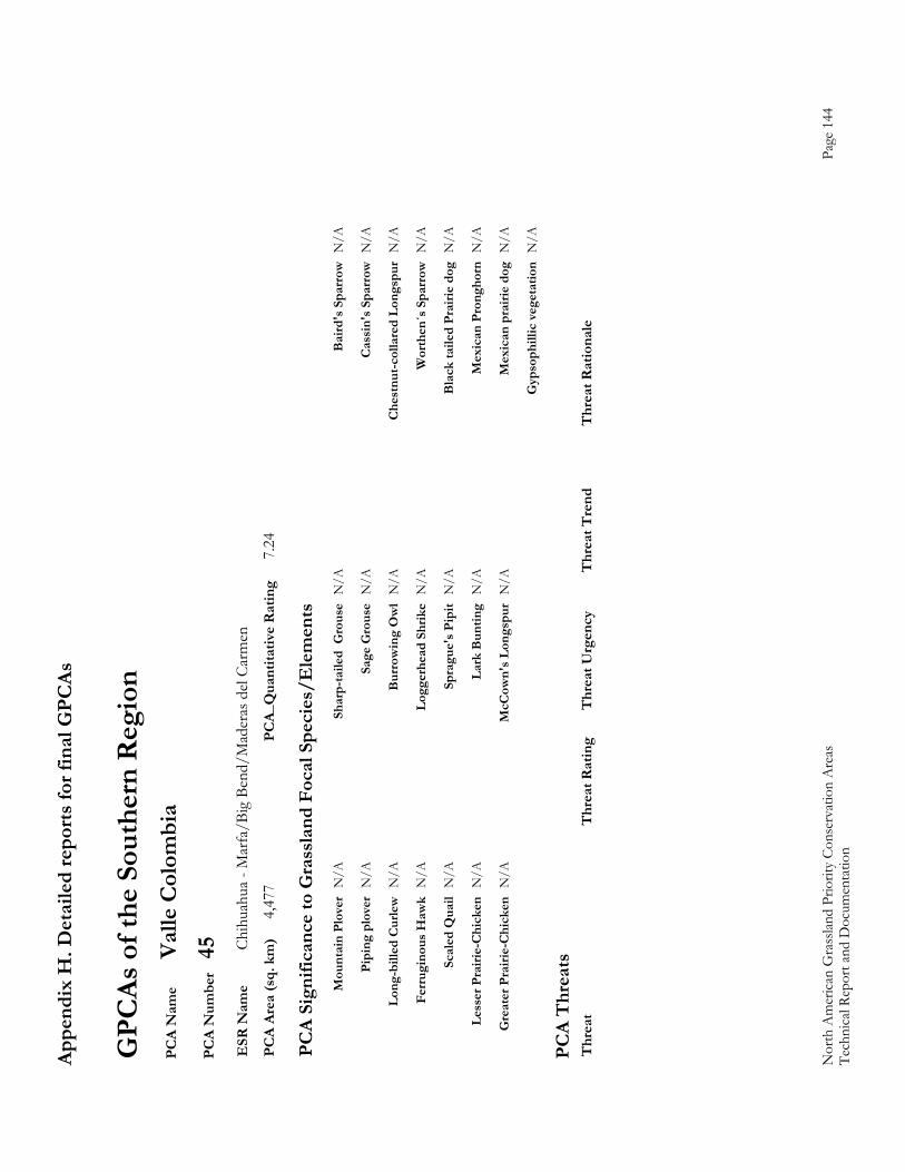
Appe
ndix
H. D
etai
led
repo
rts fo
r fin
al G
PCAs
Nor
th A
mer
ican
Gra
sslan
d Pr
iorit
y Co
nser
vatio
n A
reas
Page
144
Te
chni
cal R
epor
t and
Doc
umen
tatio
n
GPC
As o
f the
Sou
ther
n R
egio
n P
CA
Nam
e Va
lle C
olom
bia
PC
A N
umbe
r 45
E
SR N
ame
Chih
uahu
a - M
arfa
/Big
Ben
d/M
ader
as d
el Ca
rmen
P
CA
Area
(sq.
km
) 4,
477
PCA_
Qua
ntita
tive
Rat
ing
7.24
PC
A Si
gnifi
canc
e to
Gra
ssla
nd F
ocal
Spe
cies
/Ele
men
ts
M
ount
ain
Plov
er N
/A
Shar
p-ta
iled
Gro
use
N/A
B
aird
's S
parr
ow N
/A
Pi
ping
plo
ver
N/A
Sa
ge G
rous
e N
/A
Cas
sin'
s Spa
rrow
N/A
Lo
ng-b
illed
Cur
lew N
/A
Bur
row
ing
Ow
l N
/A
Che
stnu
t-col
lare
d Lo
ngsp
ur N
/A
Fe
rrug
inou
s Haw
k N
/A
Logg
erhe
ad S
hrik
e N
/A
Wor
then
´s S
parr
ow N
/A
Sc
aled
Qua
il N
/A
Spra
gue'
s Pip
it N
/A
Bla
ck ta
iled
Prai
rie d
og N
/A
Le
sser
Pra
irie-
Chi
cken
N/A
La
rk B
untin
g N
/A
Mex
ican
Pro
ngho
rn N
/A
G
reat
er P
rairi
e-C
hick
en N
/A
McC
own'
s Lon
gspu
r N
/A
Mex
ican
pra
irie
dog
N/A
G
ypso
phill
ic v
eget
atio
n N
/A
PC
A T
hrea
ts
Thr
eat
Thr
eat R
atin
g T
hrea
t Urg
ency
T
hrea
t Tre
nd
Thr
eat R
atio
nale
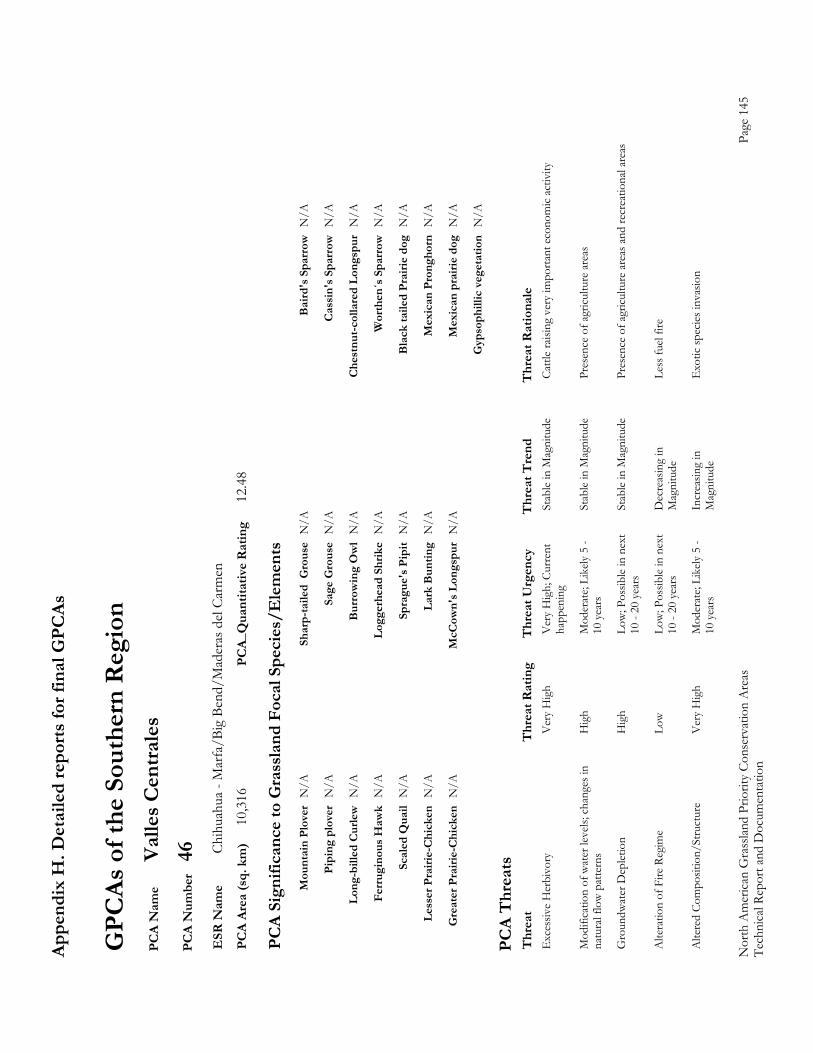
Appe
ndix
H. D
etai
led
repo
rts fo
r fin
al G
PCAs
Nor
th A
mer
ican
Gra
sslan
d Pr
iorit
y Co
nser
vatio
n A
reas
Page
145
Te
chni
cal R
epor
t and
Doc
umen
tatio
n
GPC
As o
f the
Sou
ther
n R
egio
n P
CA
Nam
e Va
lles C
entra
les
PC
A N
umbe
r 46
E
SR N
ame
Chih
uahu
a - M
arfa
/Big
Ben
d/M
ader
as d
el Ca
rmen
P
CA
Area
(sq.
km
) 10
,316
PC
A_Q
uant
itativ
e R
atin
g 12
.48
PC
A Si
gnifi
canc
e to
Gra
ssla
nd F
ocal
Spe
cies
/Ele
men
ts
M
ount
ain
Plov
er N
/A
Shar
p-ta
iled
Gro
use
N/A
B
aird
's S
parr
ow N
/A
Pi
ping
plo
ver
N/A
Sa
ge G
rous
e N
/A
Cas
sin'
s Spa
rrow
N/A
Lo
ng-b
illed
Cur
lew N
/A
Bur
row
ing
Ow
l N
/A
Che
stnu
t-col
lare
d Lo
ngsp
ur N
/A
Fe
rrug
inou
s Haw
k N
/A
Logg
erhe
ad S
hrik
e N
/A
Wor
then
´s S
parr
ow N
/A
Sc
aled
Qua
il N
/A
Spra
gue'
s Pip
it N
/A
Bla
ck ta
iled
Prai
rie d
og N
/A
Le
sser
Pra
irie-
Chi
cken
N/A
La
rk B
untin
g N
/A
Mex
ican
Pro
ngho
rn N
/A
G
reat
er P
rairi
e-C
hick
en N
/A
McC
own'
s Lon
gspu
r N
/A
Mex
ican
pra
irie
dog
N/A
G
ypso
phill
ic v
eget
atio
n N
/A
PC
A T
hrea
ts
Thr
eat
Thr
eat R
atin
g T
hrea
t Urg
ency
T
hrea
t Tre
nd
Thr
eat R
atio
nale
E
xces
sive
Her
bivo
ry
Ver
y H
igh
Ver
y H
igh;
Cur
rent
St
able
in M
agni
tude
Ca
ttle
raisi
ng v
ery
impo
rtant
eco
nom
ic ac
tivity
happ
enin
g
Mod
ifica
tion
of w
ater
leve
ls; c
hang
es in
H
igh
Mod
erat
e; Li
kely
5 -
Stab
le in
Mag
nitu
de
Pres
ence
of a
gricu
lture
are
as
nat
ural
flow
pat
tern
s 10
yea
rs
Gro
undw
ater
Dep
letio
n H
igh
Low
; Pos
sible
in n
ext
Stab
le in
Mag
nitu
de
Pres
ence
of a
gricu
lture
are
as a
nd re
crea
tiona
l are
as
10
- 20
yea
rs
Alte
ratio
n of
Fire
Reg
ime
Low
Low
; Pos
sible
in n
ext
Dec
reas
ing
in
Less
fuel
fire
10
- 20
yea
rs
Mag
nitu
de
Alte
red
Com
posit
ion/
Stru
ctur
e V
ery
Hig
h M
oder
ate;
Like
ly 5
- In
crea
sing
in
Exo
tic sp
ecies
inva
sion
10
yea
rs
Mag
nitu
de
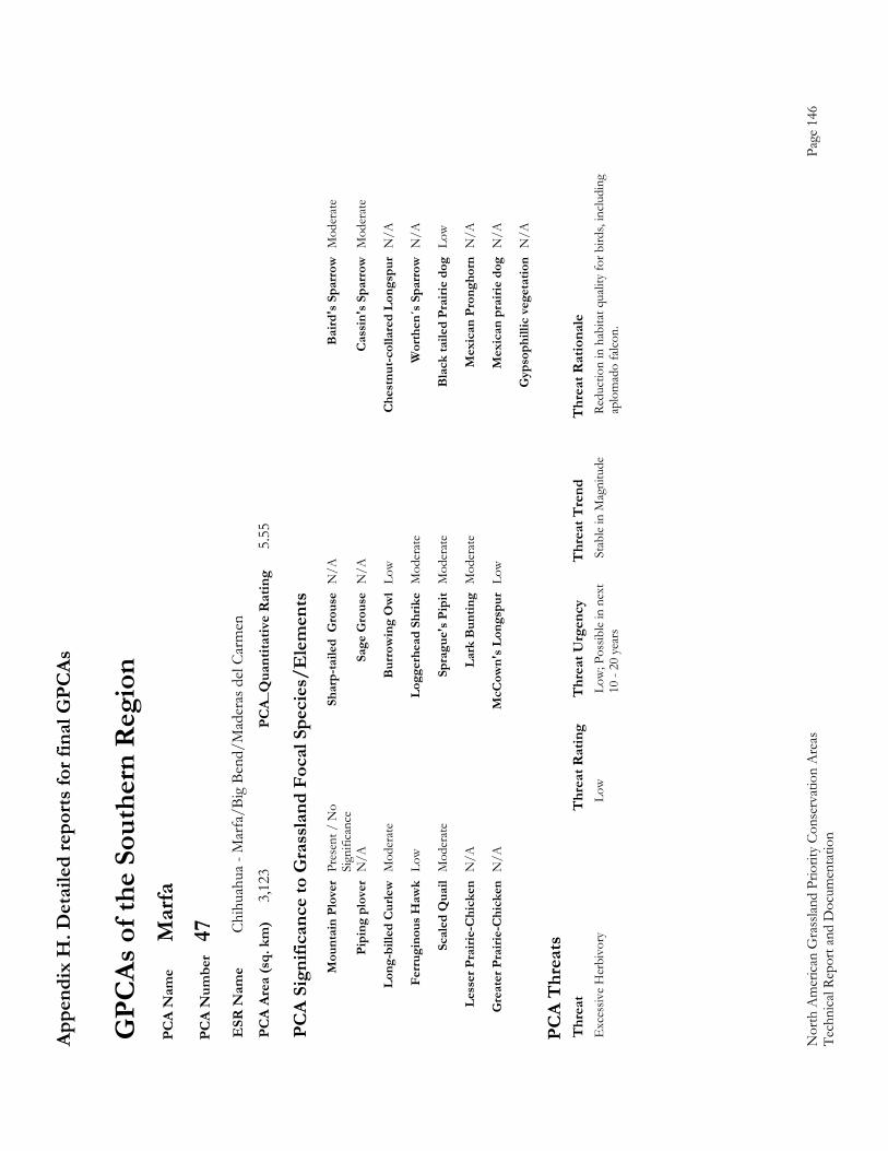
Appe
ndix
H. D
etai
led
repo
rts fo
r fin
al G
PCAs
Nor
th A
mer
ican
Gra
sslan
d Pr
iorit
y Co
nser
vatio
n A
reas
Page
146
Te
chni
cal R
epor
t and
Doc
umen
tatio
n
GPC
As o
f the
Sou
ther
n R
egio
n P
CA
Nam
e M
arfa
P
CA
Num
ber
47
ESR
Nam
e Ch
ihua
hua
- Mar
fa/B
ig B
end/
Mad
eras
del
Carm
en
PC
A Ar
ea (s
q. k
m)
3,12
3 PC
A_Q
uant
itativ
e R
atin
g 5.
55
PC
A Si
gnifi
canc
e to
Gra
ssla
nd F
ocal
Spe
cies
/Ele
men
ts
M
ount
ain
Plov
er P
rese
nt /
No
Sh
arp-
taile
d G
rous
e N
/A
Bai
rd's
Spa
rrow
Mod
erat
e
Sign
ifica
nce
Pi
ping
plo
ver
N/A
Sa
ge G
rous
e N
/A
Cas
sin'
s Spa
rrow
Mod
erat
e
Lo
ng-b
illed
Cur
lew M
oder
ate
Bur
row
ing
Ow
l Lo
w
Che
stnu
t-col
lare
d Lo
ngsp
ur N
/A
Fe
rrug
inou
s Haw
k Lo
w
Logg
erhe
ad S
hrik
e M
oder
ate
Wor
then
´s S
parr
ow N
/A
Sc
aled
Qua
il M
oder
ate
Spra
gue'
s Pip
it M
oder
ate
Bla
ck ta
iled
Prai
rie d
og L
ow
Le
sser
Pra
irie-
Chi
cken
N/A
La
rk B
untin
g M
oder
ate
Mex
ican
Pro
ngho
rn N
/A
G
reat
er P
rairi
e-C
hick
en N
/A
McC
own'
s Lon
gspu
r Lo
w
Mex
ican
pra
irie
dog
N/A
G
ypso
phill
ic v
eget
atio
n N
/A
PC
A T
hrea
ts
Thr
eat
Thr
eat R
atin
g T
hrea
t Urg
ency
T
hrea
t Tre
nd
Thr
eat R
atio
nale
E
xces
sive
Her
bivo
ry
Low
Low
; Pos
sible
in n
ext
Stab
le in
Mag
nitu
de
Redu
ctio
n in
hab
itat q
ualit
y fo
r bird
s, in
cludi
ng
10
- 20
yea
rs
aplo
mad
o fa
lcon.
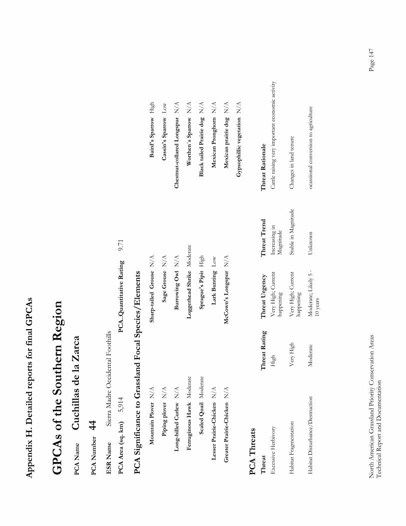
Appe
ndix
H. D
etai
led
repo
rts fo
r fin
al G
PCAs
Nor
th A
mer
ican
Gra
sslan
d Pr
iorit
y Co
nser
vatio
n A
reas
Page
147
Te
chni
cal R
epor
t and
Doc
umen
tatio
n
GPC
As o
f the
Sou
ther
n R
egio
n P
CA
Nam
e C
uchi
llas d
e la
Zar
ca
PC
A N
umbe
r 44
E
SR N
ame
Sier
ra M
adre
Occ
iden
tal F
ooth
ills
PC
A Ar
ea (s
q. k
m)
5,91
4 PC
A_Q
uant
itativ
e R
atin
g 9.
71
PC
A Si
gnifi
canc
e to
Gra
ssla
nd F
ocal
Spe
cies
/Ele
men
ts
M
ount
ain
Plov
er N
/A
Shar
p-ta
iled
Gro
use
N/A
B
aird
's S
parr
ow H
igh
Pi
ping
plo
ver
N/A
Sa
ge G
rous
e N
/A
Cas
sin'
s Spa
rrow
Low
Lo
ng-b
illed
Cur
lew N
/A
Bur
row
ing
Ow
l N
/A
Che
stnu
t-col
lare
d Lo
ngsp
ur N
/A
Fe
rrug
inou
s Haw
k M
oder
ate
Logg
erhe
ad S
hrik
e M
oder
ate
Wor
then
´s S
parr
ow N
/A
Sc
aled
Qua
il M
oder
ate
Spra
gue'
s Pip
it H
igh
Bla
ck ta
iled
Prai
rie d
og N
/A
Le
sser
Pra
irie-
Chi
cken
N/A
La
rk B
untin
g Lo
w
Mex
ican
Pro
ngho
rn N
/A
G
reat
er P
rairi
e-C
hick
en N
/A
McC
own'
s Lon
gspu
r N
/A
Mex
ican
pra
irie
dog
N/A
G
ypso
phill
ic v
eget
atio
n N
/A
PC
A T
hrea
ts
Thr
eat
Thr
eat R
atin
g T
hrea
t Urg
ency
T
hrea
t Tre
nd
Thr
eat R
atio
nale
E
xces
sive
Her
bivo
ry
Hig
h V
ery
Hig
h; C
urre
nt
Incr
easin
g in
Ca
ttle
raisi
ng v
ery
impo
rtant
eco
nom
ic ac
tivity
happ
enin
g M
agni
tude
Hab
itat F
ragm
enta
tion
V
ery
Hig
h V
ery
Hig
h; C
urre
nt
Stab
le in
Mag
nitu
de
Chan
ges i
n lan
d te
nure
happ
enin
g
Hab
itat D
istur
banc
e/D
estru
ctio
n
Mod
erat
e M
oder
ate;
Like
ly 5
- U
nkno
wn
ocas
siona
l con
vers
ion
to a
gricu
lture
10 y
ears
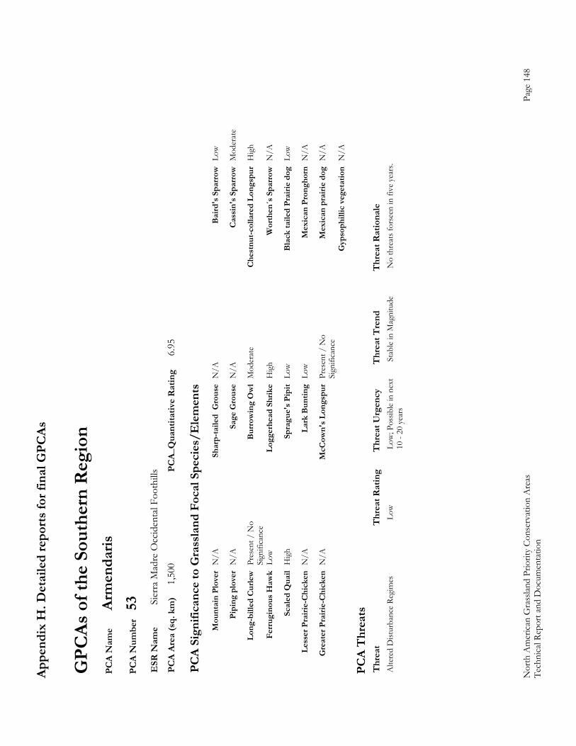
Appe
ndix
H. D
etai
led
repo
rts fo
r fin
al G
PCAs
Nor
th A
mer
ican
Gra
sslan
d Pr
iorit
y Co
nser
vatio
n A
reas
Page
148
Te
chni
cal R
epor
t and
Doc
umen
tatio
n
GPC
As o
f the
Sou
ther
n R
egio
n P
CA
Nam
e Ar
men
daris
P
CA
Num
ber
53
ESR
Nam
e Si
erra
Mad
re O
ccid
enta
l Foo
thill
s P
CA
Area
(sq.
km
) 1,
500
PCA_
Qua
ntita
tive
Rat
ing
6.95
PC
A Si
gnifi
canc
e to
Gra
ssla
nd F
ocal
Spe
cies
/Ele
men
ts
M
ount
ain
Plov
er N
/A
Shar
p-ta
iled
Gro
use
N/A
B
aird
's S
parr
ow L
ow
Pi
ping
plo
ver
N/A
Sa
ge G
rous
e N
/A
Cas
sin'
s Spa
rrow
Mod
erat
e
Lo
ng-b
illed
Cur
lew P
rese
nt /
No
B
urro
win
g O
wl
Mod
erat
e C
hest
nut-c
olla
red
Long
spur
Hig
h
Sign
ifica
nce
Fe
rrug
inou
s Haw
k Lo
w
Logg
erhe
ad S
hrik
e H
igh
Wor
then
´s S
parr
ow N
/A
Sc
aled
Qua
il H
igh
Spra
gue'
s Pip
it Lo
w
Bla
ck ta
iled
Prai
rie d
og L
ow
Le
sser
Pra
irie-
Chi
cken
N/A
La
rk B
untin
g Lo
w
Mex
ican
Pro
ngho
rn N
/A
G
reat
er P
rairi
e-C
hick
en N
/A
McC
own'
s Lon
gspu
r Pr
esen
t / N
o
Mex
ican
pra
irie
dog
N/A
Sign
ifica
nce
G
ypso
phill
ic v
eget
atio
n N
/A
PC
A T
hrea
ts
Thr
eat
Thr
eat R
atin
g T
hrea
t Urg
ency
T
hrea
t Tre
nd
Thr
eat R
atio
nale
A
ltere
d D
istur
banc
e Re
gim
es
Low
Low
; Pos
sible
in n
ext
Stab
le in
Mag
nitu
de
No
thre
ats f
orse
en in
five
yea
rs.
10
- 20
yea
rs
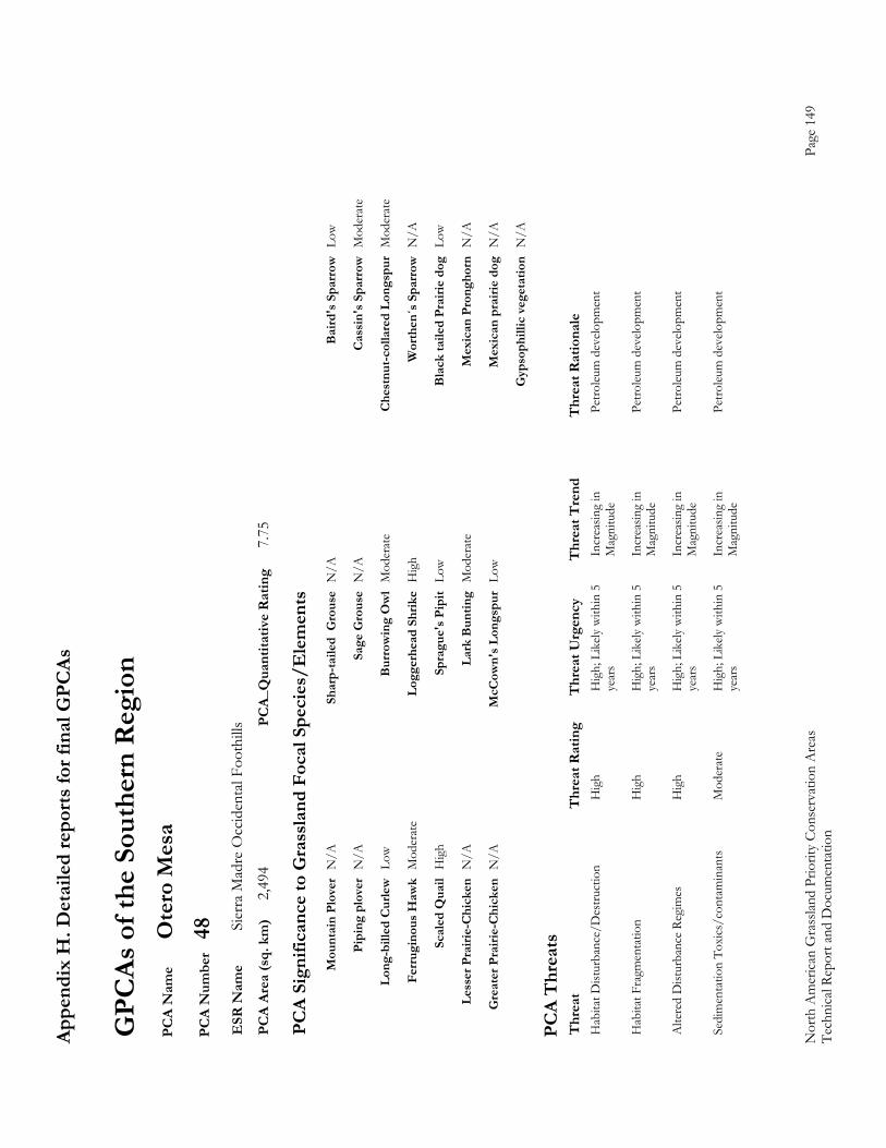
Appe
ndix
H. D
etai
led
repo
rts fo
r fin
al G
PCAs
Nor
th A
mer
ican
Gra
sslan
d Pr
iorit
y Co
nser
vatio
n A
reas
Page
149
Te
chni
cal R
epor
t and
Doc
umen
tatio
n
GPC
As o
f the
Sou
ther
n R
egio
n P
CA
Nam
e O
tero
Mes
a P
CA
Num
ber
48
ESR
Nam
e Si
erra
Mad
re O
ccid
enta
l Foo
thill
s P
CA
Area
(sq.
km
) 2,
494
PCA_
Qua
ntita
tive
Rat
ing
7.75
PC
A Si
gnifi
canc
e to
Gra
ssla
nd F
ocal
Spe
cies
/Ele
men
ts
M
ount
ain
Plov
er N
/A
Shar
p-ta
iled
Gro
use
N/A
B
aird
's S
parr
ow L
ow
Pi
ping
plo
ver
N/A
Sa
ge G
rous
e N
/A
Cas
sin'
s Spa
rrow
Mod
erat
e
Lo
ng-b
illed
Cur
lew L
ow
Bur
row
ing
Ow
l M
oder
ate
Che
stnu
t-col
lare
d Lo
ngsp
ur M
oder
ate
Fe
rrug
inou
s Haw
k M
oder
ate
Logg
erhe
ad S
hrik
e H
igh
Wor
then
´s S
parr
ow N
/A
Sc
aled
Qua
il H
igh
Spra
gue'
s Pip
it Lo
w
Bla
ck ta
iled
Prai
rie d
og L
ow
Le
sser
Pra
irie-
Chi
cken
N/A
La
rk B
untin
g M
oder
ate
Mex
ican
Pro
ngho
rn N
/A
G
reat
er P
rairi
e-C
hick
en N
/A
McC
own'
s Lon
gspu
r Lo
w
Mex
ican
pra
irie
dog
N/A
G
ypso
phill
ic v
eget
atio
n N
/A
PC
A T
hrea
ts
Thr
eat
Thr
eat R
atin
g T
hrea
t Urg
ency
T
hrea
t Tre
nd
Thr
eat R
atio
nale
H
abita
t Dist
urba
nce/
Des
truct
ion
H
igh
Hig
h; L
ikely
with
in 5
In
crea
sing
in
Petro
leum
dev
elopm
ent
ye
ars
Mag
nitu
de
Hab
itat F
ragm
enta
tion
H
igh
Hig
h; L
ikely
with
in 5
In
crea
sing
in
Petro
leum
dev
elopm
ent
ye
ars
Mag
nitu
de
Alte
red
Dist
urba
nce
Regi
mes
H
igh
Hig
h; L
ikely
with
in 5
In
crea
sing
in
Petro
leum
dev
elopm
ent
ye
ars
Mag
nitu
de
Sed
imen
tatio
n To
xics
/con
tam
inan
ts
Mod
erat
e H
igh;
Lik
ely w
ithin
5
Incr
easin
g in
Pe
troleu
m d
evelo
pmen
t
year
s M
agni
tude
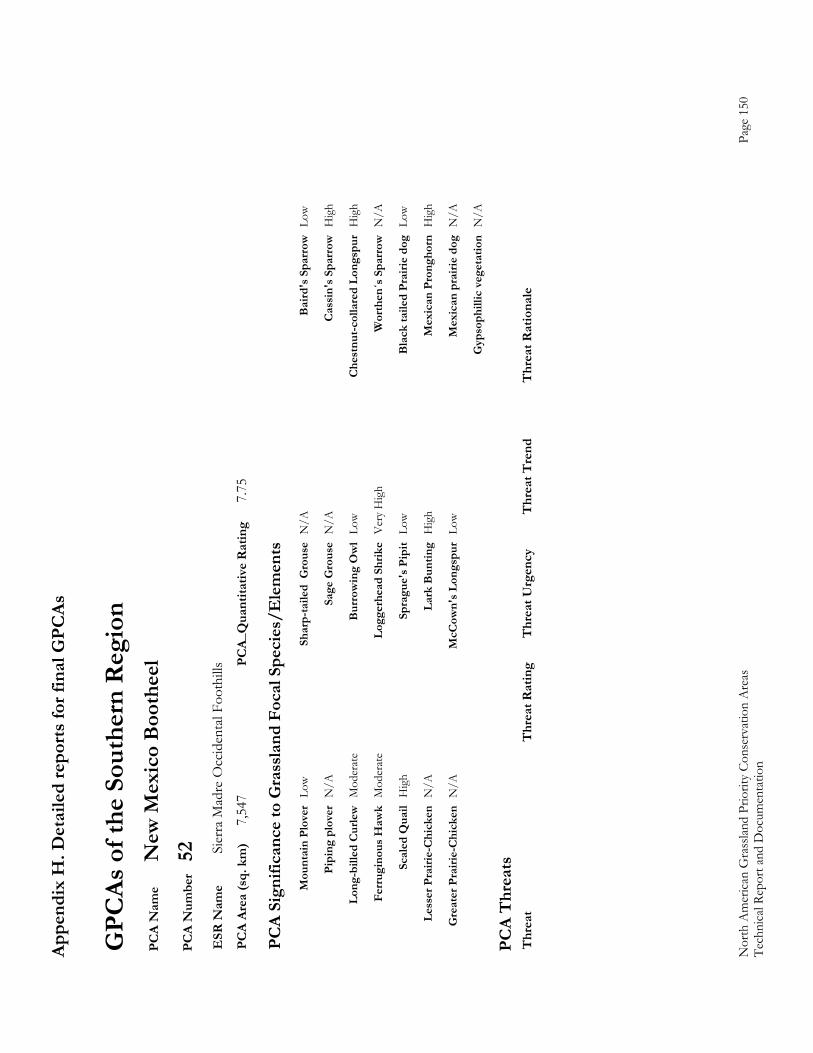
Appe
ndix
H. D
etai
led
repo
rts fo
r fin
al G
PCAs
Nor
th A
mer
ican
Gra
sslan
d Pr
iorit
y Co
nser
vatio
n A
reas
Page
150
Te
chni
cal R
epor
t and
Doc
umen
tatio
n
GPC
As o
f the
Sou
ther
n R
egio
n P
CA
Nam
e N
ew M
exic
o B
ooth
eel
PC
A N
umbe
r 52
E
SR N
ame
Sier
ra M
adre
Occ
iden
tal F
ooth
ills
PC
A Ar
ea (s
q. k
m)
7,54
7 PC
A_Q
uant
itativ
e R
atin
g 7.
75
PC
A Si
gnifi
canc
e to
Gra
ssla
nd F
ocal
Spe
cies
/Ele
men
ts
M
ount
ain
Plov
er L
ow
Shar
p-ta
iled
Gro
use
N/A
B
aird
's S
parr
ow L
ow
Pi
ping
plo
ver
N/A
Sa
ge G
rous
e N
/A
Cas
sin'
s Spa
rrow
Hig
h
Lo
ng-b
illed
Cur
lew M
oder
ate
Bur
row
ing
Ow
l Lo
w
Che
stnu
t-col
lare
d Lo
ngsp
ur H
igh
Fe
rrug
inou
s Haw
k M
oder
ate
Logg
erhe
ad S
hrik
e V
ery
Hig
h W
orth
en´s
Spa
rrow
N/A
Sc
aled
Qua
il H
igh
Spra
gue'
s Pip
it Lo
w
Bla
ck ta
iled
Prai
rie d
og L
ow
Le
sser
Pra
irie-
Chi
cken
N/A
La
rk B
untin
g H
igh
Mex
ican
Pro
ngho
rn H
igh
G
reat
er P
rairi
e-C
hick
en N
/A
McC
own'
s Lon
gspu
r Lo
w
Mex
ican
pra
irie
dog
N/A
G
ypso
phill
ic v
eget
atio
n N
/A
PC
A T
hrea
ts
Thr
eat
Thr
eat R
atin
g T
hrea
t Urg
ency
T
hrea
t Tre
nd
Thr
eat R
atio
nale
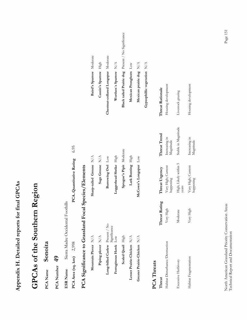
Appe
ndix
H. D
etai
led
repo
rts fo
r fin
al G
PCAs
Nor
th A
mer
ican
Gra
sslan
d Pr
iorit
y Co
nser
vatio
n A
reas
Page
151
Te
chni
cal R
epor
t and
Doc
umen
tatio
n
GPC
As o
f the
Sou
ther
n R
egio
n P
CA
Nam
e So
noita
P
CA
Num
ber
49
ESR
Nam
e Si
erra
Mad
re O
ccid
enta
l Foo
thill
s P
CA
Area
(sq.
km
) 2,
998
PCA_
Qua
ntita
tive
Rat
ing
6.95
PC
A Si
gnifi
canc
e to
Gra
ssla
nd F
ocal
Spe
cies
/Ele
men
ts
M
ount
ain
Plov
er N
/A
Shar
p-ta
iled
Gro
use
N/A
B
aird
's S
parr
ow M
oder
ate
Pi
ping
plo
ver
N/A
Sa
ge G
rous
e N
/A
Cas
sin'
s Spa
rrow
Hig
h
Lo
ng-b
illed
Cur
lew P
rese
nt /
No
B
urro
win
g O
wl
Low
Che
stnu
t-col
lare
d Lo
ngsp
ur M
oder
ate
Si
gnifi
canc
e
Ferr
ugin
ous H
awk
Low
Logg
erhe
ad S
hrik
e H
igh
Wor
then
´s S
parr
ow N
/A
Sc
aled
Qua
il H
igh
Spra
gue'
s Pip
it M
oder
ate
Bla
ck ta
iled
Prai
rie d
og P
rese
nt /
No
Sign
ifica
nce
Le
sser
Pra
irie-
Chi
cken
N/A
La
rk B
untin
g H
igh
Mex
ican
Pro
ngho
rn L
ow
G
reat
er P
rairi
e-C
hick
en N
/A
McC
own'
s Lon
gspu
r Lo
w
Mex
ican
pra
irie
dog
N/A
G
ypso
phill
ic v
eget
atio
n N
/A
PC
A T
hrea
ts
Thr
eat
Thr
eat R
atin
g T
hrea
t Urg
ency
T
hrea
t Tre
nd
Thr
eat R
atio
nale
H
abita
t Dist
urba
nce/
Des
truct
ion
V
ery
Hig
h V
ery
Hig
h; C
urre
nt
Incr
easin
g in
H
ousin
g de
velo
pmen
t
happ
enin
g M
agni
tude
Exc
essiv
e H
erbi
vory
M
oder
ate
Hig
h; L
ikely
with
in 5
St
able
in M
agni
tude
Li
vest
ock
graz
ing
ye
ars
Hab
itat F
ragm
enta
tion
V
ery
Hig
h V
ery
Hig
h; C
urre
nt
Incr
easin
g in
H
ousin
g de
velo
pmen
t
happ
enin
g M
agni
tude
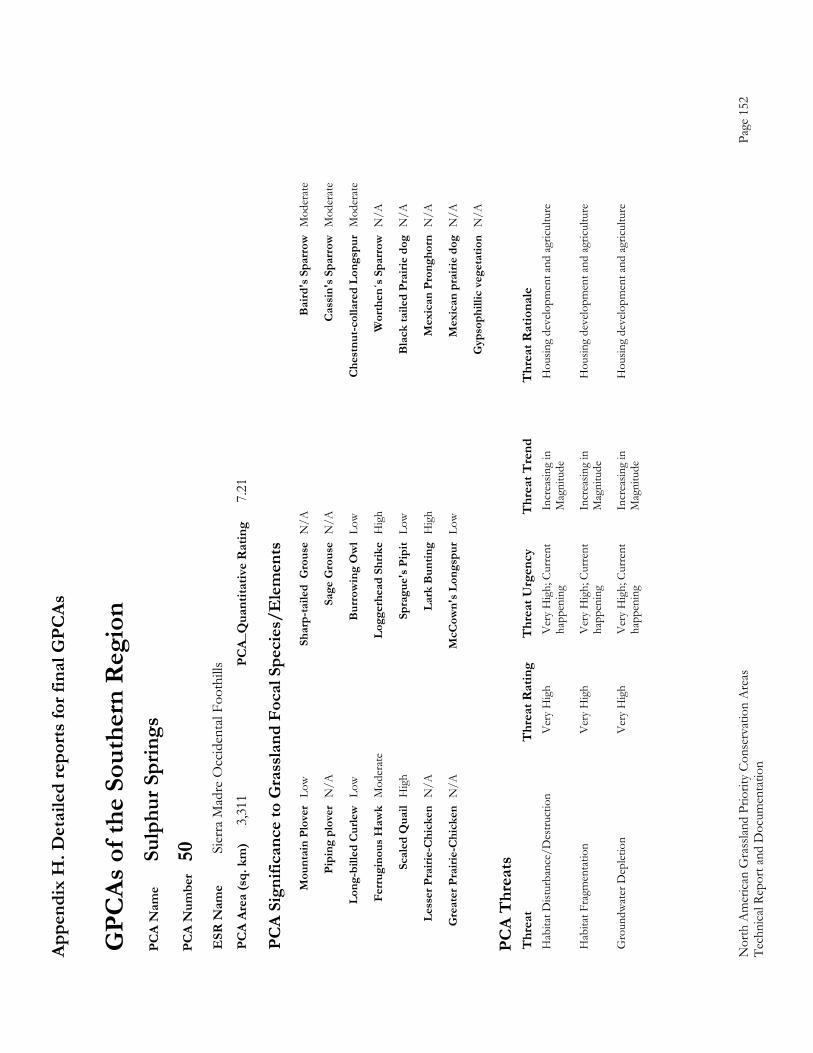
Appe
ndix
H. D
etai
led
repo
rts fo
r fin
al G
PCAs
Nor
th A
mer
ican
Gra
sslan
d Pr
iorit
y Co
nser
vatio
n A
reas
Page
152
Te
chni
cal R
epor
t and
Doc
umen
tatio
n
GPC
As o
f the
Sou
ther
n R
egio
n P
CA
Nam
e Su
lphu
r Spr
ings
P
CA
Num
ber
50
ESR
Nam
e Si
erra
Mad
re O
ccid
enta
l Foo
thill
s P
CA
Area
(sq.
km
) 3,
311
PCA_
Qua
ntita
tive
Rat
ing
7.21
PC
A Si
gnifi
canc
e to
Gra
ssla
nd F
ocal
Spe
cies
/Ele
men
ts
M
ount
ain
Plov
er L
ow
Shar
p-ta
iled
Gro
use
N/A
B
aird
's S
parr
ow M
oder
ate
Pi
ping
plo
ver
N/A
Sa
ge G
rous
e N
/A
Cas
sin'
s Spa
rrow
Mod
erat
e
Lo
ng-b
illed
Cur
lew L
ow
Bur
row
ing
Ow
l Lo
w
Che
stnu
t-col
lare
d Lo
ngsp
ur M
oder
ate
Fe
rrug
inou
s Haw
k M
oder
ate
Logg
erhe
ad S
hrik
e H
igh
Wor
then
´s S
parr
ow N
/A
Sc
aled
Qua
il H
igh
Spra
gue'
s Pip
it Lo
w
Bla
ck ta
iled
Prai
rie d
og N
/A
Le
sser
Pra
irie-
Chi
cken
N/A
La
rk B
untin
g H
igh
Mex
ican
Pro
ngho
rn N
/A
G
reat
er P
rairi
e-C
hick
en N
/A
McC
own'
s Lon
gspu
r Lo
w
Mex
ican
pra
irie
dog
N/A
G
ypso
phill
ic v
eget
atio
n N
/A
PC
A T
hrea
ts
Thr
eat
Thr
eat R
atin
g T
hrea
t Urg
ency
T
hrea
t Tre
nd
Thr
eat R
atio
nale
H
abita
t Dist
urba
nce/
Des
truct
ion
V
ery
Hig
h V
ery
Hig
h; C
urre
nt
Incr
easin
g in
H
ousin
g de
velo
pmen
t and
agr
icultu
re
ha
ppen
ing
Mag
nitu
de
Hab
itat F
ragm
enta
tion
V
ery
Hig
h V
ery
Hig
h; C
urre
nt
Incr
easin
g in
H
ousin
g de
velo
pmen
t and
agr
icultu
re
ha
ppen
ing
Mag
nitu
de
Gro
undw
ater
Dep
letio
n V
ery
Hig
h V
ery
Hig
h; C
urre
nt
Incr
easin
g in
H
ousin
g de
velo
pmen
t and
agr
icultu
re
ha
ppen
ing
Mag
nitu
de
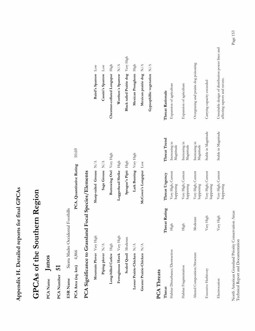
Appe
ndix
H. D
etai
led
repo
rts fo
r fin
al G
PCAs
Nor
th A
mer
ican
Gra
sslan
d Pr
iorit
y Co
nser
vatio
n A
reas
Page
153
Te
chni
cal R
epor
t and
Doc
umen
tatio
n
GPC
As o
f the
Sou
ther
n R
egio
n P
CA
Nam
e Ja
nos
PC
A N
umbe
r 51
E
SR N
ame
Sier
ra M
adre
Occ
iden
tal F
ooth
ills
PC
A Ar
ea (s
q. k
m)
4,86
6 PC
A_Q
uant
itativ
e R
atin
g 10
.69
PC
A Si
gnifi
canc
e to
Gra
ssla
nd F
ocal
Spe
cies
/Ele
men
ts
M
ount
ain
Plov
er V
ery
Hig
h Sh
arp-
taile
d G
rous
e N
/A
Bai
rd's
Spa
rrow
Low
Pi
ping
plo
ver
N/A
Sa
ge G
rous
e N
/A
Cas
sin'
s Spa
rrow
Low
Lo
ng-b
illed
Cur
lew H
igh
Bur
row
ing
Ow
l V
ery
Hig
h C
hest
nut-c
olla
red
Long
spur
Hig
h
Fe
rrug
inou
s Haw
k V
ery
Hig
h Lo
gger
head
Shr
ike
Hig
h W
orth
en´s
Spa
rrow
N/A
Sc
aled
Qua
il M
oder
ate
Spra
gue'
s Pip
it H
igh
Bla
ck ta
iled
Prai
rie d
og V
ery
Hig
h
Le
sser
Pra
irie-
Chi
cken
N/A
La
rk B
untin
g V
ery
Hig
h M
exic
an P
rong
horn
Hig
h
G
reat
er P
rairi
e-C
hick
en N
/A
McC
own'
s Lon
gspu
r Lo
w
Mex
ican
pra
irie
dog
N/A
G
ypso
phill
ic v
eget
atio
n N
/A
PC
A T
hrea
ts
Thr
eat
Thr
eat R
atin
g T
hrea
t Urg
ency
T
hrea
t Tre
nd
Thr
eat R
atio
nale
H
abita
t Dist
urba
nce/
Des
truct
ion
H
igh
Ver
y H
igh;
Cur
rent
In
crea
sing
in
Exp
ansio
n of
agr
icultu
re
ha
ppen
ing
Mag
nitu
de
Hab
itat F
ragm
enta
tion
H
igh
Ver
y H
igh;
Cur
rent
In
crea
sing
in
Exp
ansio
n of
agr
icultu
re
ha
ppen
ing
Mag
nitu
de
Alte
red
Com
posit
ion/
Stru
ctur
e M
oder
ate
Ver
y H
igh;
Cur
rent
In
crea
sing
in
Ove
rgra
zing
and
pra
irie
dog
poiso
ning
happ
enin
g M
agni
tude
Exc
essiv
e H
erbi
vory
V
ery
Hig
h V
ery
Hig
h; C
urre
nt
Stab
le in
Mag
nitu
de
Carr
ying
capa
city
exce
eded
happ
enin
g
Ele
ctro
cutio
n V
ery
Hig
h V
ery
Hig
h; C
urre
nt
Stab
le in
Mag
nitu
de
Uns
uita
ble
desig
n of
dist
ribut
ion
pow
er li
nes a
nd
ha
ppen
ing
affe
ctin
g ra
ptor
s and
rave
ns.
Recommended