In Reply »ef*i TOJ KP-?-l NOV 2b 5333
Gulf 011 Exploration anr* Production Company
Attentions Mr. * . t *iei«*rt frost Offlca tiox W#w Ori *ns f Louisiana 70161
Gentlement
1efe»-*nce 1s made to yoor I n i t i a l Man of Exploration snd Environmental Report rtct lved November l«M3 f for leate OCS-G 5790, Block Wft, Vtosca Knoll Area. Thfs plan Includes tne d r i 11 Ino of fnur wel ls .
In accordance with in CFR revised December 13, 1979, and our letter datad J*mi*ry ?o, l o j o f th is plan has been determined to be complete at of November 28, 19«3, and H now being considered fnr approval.
Vour plan control number 1s M 4 1 ? and should he referenced 1n your conmunlci-t ion and correspondence concerning t h i s plan.
Sincerely your*,
(Orig. Sgd) D.W. Solanas
D. W. Solanas C l o n a l Supervisor Rules and Production
CP
bcc: Lease 0CS-«! 5790 (OPS-4) tll2£Sri-W/lUlW1c Info copy of the plan and ER (?ub11c Records) 00-5
HHekmatdoost:kks:l 1/10/33 disk 3a
Office of Management Support
NOV 3 o 1983
Records Management
Noted D. Arcana
P 8 M o r v a t h
C»P O U * ! ' O N M t h i C f n
N ! w i m i I «M' . . « [ » Novefnber 9, 1983 p o Bo«eiseo
N l w O r l t a m L A 7 0 1 B 1
Deputy Mineral (Manager ~_ > Offshore Oper ai ions Support U. S. Departmaht of the Interior Minerals Management Service*-* Gulf of Mexico, OCS Region Post Office Box 7944 Metairie, LA 70010
Dear Sir:
Plan of Exploration Block 986, OCS-G-5790 Viosca Knoll Area Offshore, Louisiana
AJ- Office of -v "dement Support
R«*rds Management Oulf Oil Corporation and Pennzoil Company plan to d r i l l four wildcat wells on Viosca Knoll Block 986.
Qulf w i l l act as operator of the lease.
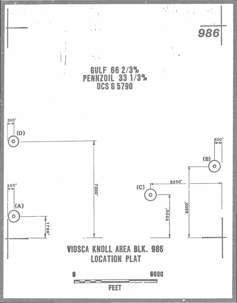
Well "A" w i l l be a straight hole at a site 500 feet from the West line and 1700 feet from the South line. We propose to begin operations with the Diamond M Century or a similar type semi-submersible r i g between January 1, 1984 and February 29, 1984. D r i l l i n g operations should require about 95 days. Any testing for coimercial production may require an additional 30 days.
Well "B" w i l l be a straight hole at u site 500 feet from the East line and 5300 feet from the South line. D r i l l i n g operations should require about 95 days. Any testing for conmercial production may require an additional 30 days.
Well "C" w i l l be a straight hole at a site 5250 feet from the East line and 3200 feet from the South line. D r i l l i n g operations should require about 95 days. Any testing for commercial production may require an additional 30 days.
Well "D" w i l l be a straight hole at a site 500 feet from the West line and 7300 feet from the South line. D r i l l i n g operations should require about 95 days. Any testing for conmercial production may require an additional 30 days.
The rig w i l l be equipped and operated in compliance with OCS Order Nos. 2, 5 and 7. A l i s t of the d r i l l i n g mud components and additives is included among the enclosures to this letter. Other enclosures illustrate the locations of the tests relative to the block boundaries and to the shoreline.
f^olJ.JJeLatdocii A O I V I 5 ' O N O f G U L F O I L C O R P O R A T I O N
serviced using existing f ac i l i t i e s at Venice. Boats w i l l use Gulf's existing dock faci l i t ies whiles-helicopters w i l l u t i l i ze PHI heliports.
Our approved o i l s p i l l contingency plan i s on f i l e with your o f f i ce . Gulf i s member of Clean Gulf Associates (OGA) which maintains o i l s p i l l containment and cleanup equipment at Grand I s le , La., which i s about 76 miles from the d r i l l aites. Response time within a 100 mile radius i s 12 hours.
I f the tests are successful, they w i l l be l e f t with a buoyed casing stub. Hie stub w i l l f a c i l i t a t e the installation of a p la t fom to accommodate surface producing equipment and possible additional d r i l l i n g . Oi l that may be discovered w i l l be barged, at least i n i t i a l l y . We w i l l seek a pipeline connection for gas.
I f the well i s i*ot a success,it w i l l be abandoned according to the terms of OCS Order No. 3. Any additional d r i l l i n g that i s proposed subsequent to t h i s test w i l l be described by a new plan.
Qulf has collected the data required by the Notice to Lessees and Operators No. 83-3 (d r i l l i ng hazards). These data are being forwarded to you under separate cover. An a i r emissions statement i s also attached. We have evaluated the data and f i nd no evidence of any shallow hazards to d r i l l i n g . Please contact this o f f i c e for any additional information you may require.
BE/RLM/ec
Enclosures:
Shoreline Vicinity Plat Location Plat L i s t of Mud Additives A i r Emission Data Rig Description Consistency Cert if icat ion Public Notice Cert if icat ion Anomaly Plat S i t e Clearance Letter for Shallow
GULF OIL CORPORATION
R. L. Meinert Manager Exploration Operations.
Dr i l l ing Hazards Environmental Reporc
986
GULF 66 2/3% PENNZOIL 33 1/3%
OCS 6 5790
500'
"1(D)
©-
500*
(A)
o o
V
l m 5250'
,c,(§=^ o o M <0
O o CO it)
VIOSCA KNOLL AREA BLK. 986 LOCATION PLAT
600'
(B)
©
1000
FEET

986
> 1
GULF 66 2/3% PENNZOIL 33 1/3%
OCS G 5790
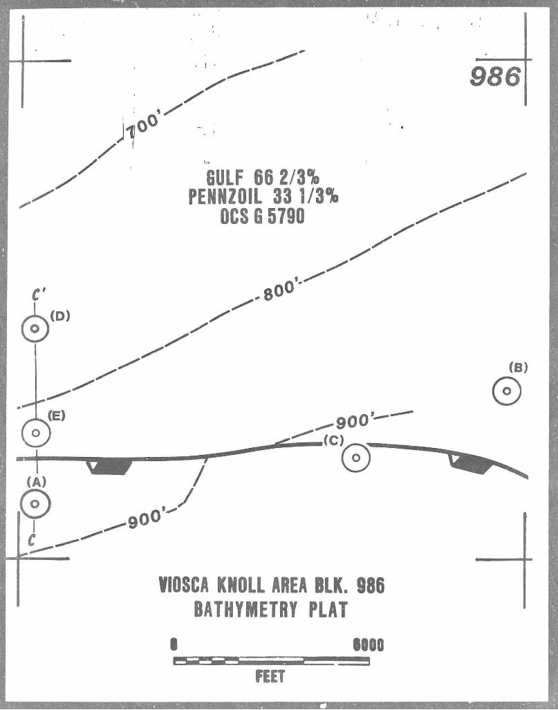
VIOSCA KNOLL AREA BLK. 986 BATHYMETRY PLAT
I IOOO
FEET
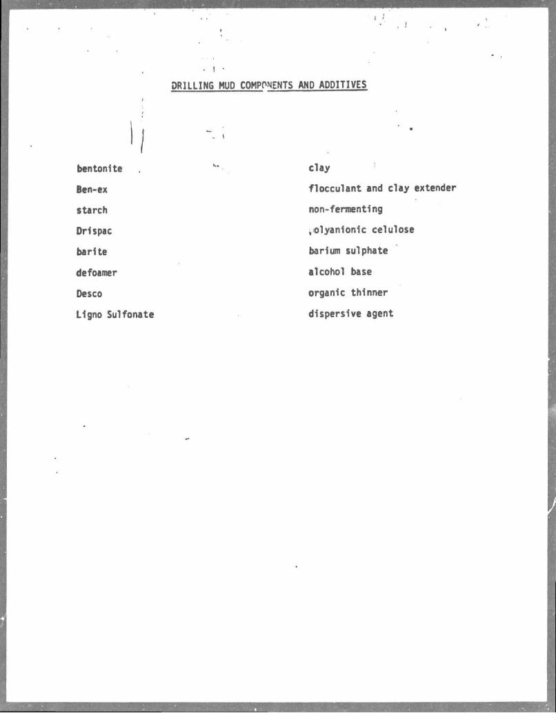
DRILLING MUD COMPONENTS AND ADDITIVES
bentonite
Ben-ex
starch
Drispac
barite
defoamer
Desco
Ligno Sulfonate
clay
flocculant and clay extender
non-fermenting
polyanionic eelulose
barium sulphate
alcohol base
organic thinner
dispersive agent
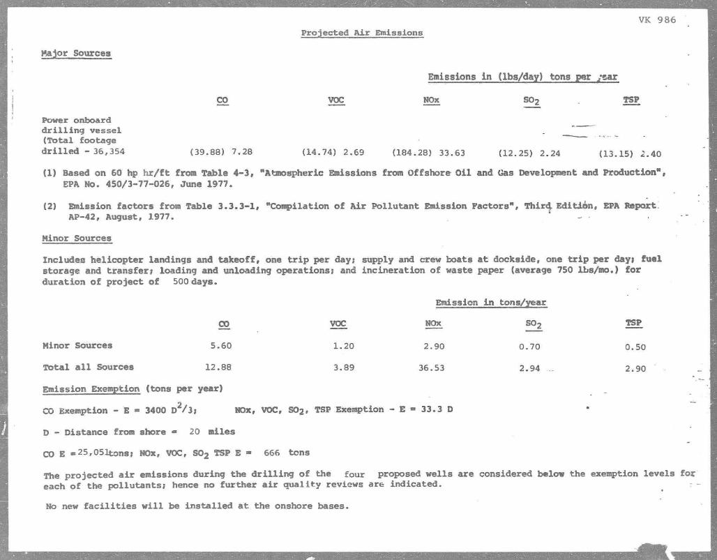
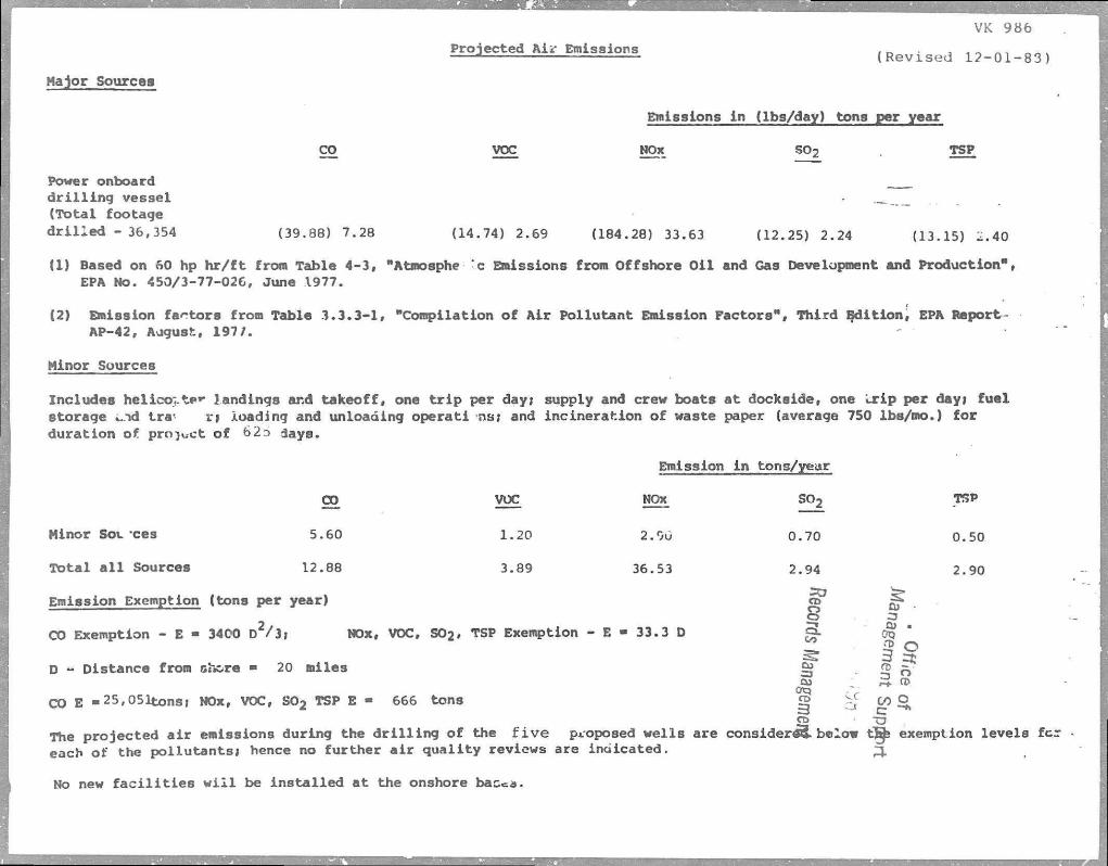
VK 986 Projected A i r Emissions
Hajor Sources
Emissions in (lba/day) tons per ysar
CO VOC NOx S02 TSP
Power onboard d r i l l i n g vessel _ " (Total footage d r i l l e d - 36,354 (39.88) 7.28 (14.74) 2.69 (184.28) 33.63 (12.25) 2.24 (13.15) 2.40
(1) Based on 60 hp h r / f t from Table 4-3, "Atmospheric Emissions from Offshore Oil and Gas Development and Production", EPA No. 450/3-77-026, June 1977.
(2) Emission factors from Table 3.3.3-1, "Compilation of Air Pollutant Emission Factors", Third; Edition, EPA Report. AP-42, August, 1977. - • "
Minor Sources
Includes helicopter landings and takeoff, one t r i p per day* supply and crew boats at dockside, one t r i p per day* fuel storage and transfer; loading and unloading operations; and incineration of waste paper (average 750 lbs/mo.) for duration of project of 500 days.
Emission i n tons/year
CO VOC NOx S02 TSP
Minor Sources 5.60 1.20 2.90 0.70 0.50
Total a l l Sources 12.88 3.89 36.53 2.94 „ 2.90
Emission Exemption (tons per year)
CO Exemption - E - 3400 D 2/j; NOx, VOC, S02, TSP Exemption - E - 33.3 D
D - Distance from shore - 20 miles
CO E «25,051tons; NOx, VOC, S02 TSP E - 666 tons
The projected a i r emissions during the d r i l l i n g of the four proposed wells are considered below the exemption levels for each of the pollutants; hence no further a i r quality reviews are indicated.
No new f a c i l i t i e s w i l l be installed at the onshore bases.
. . Viosca Knoll Block 986
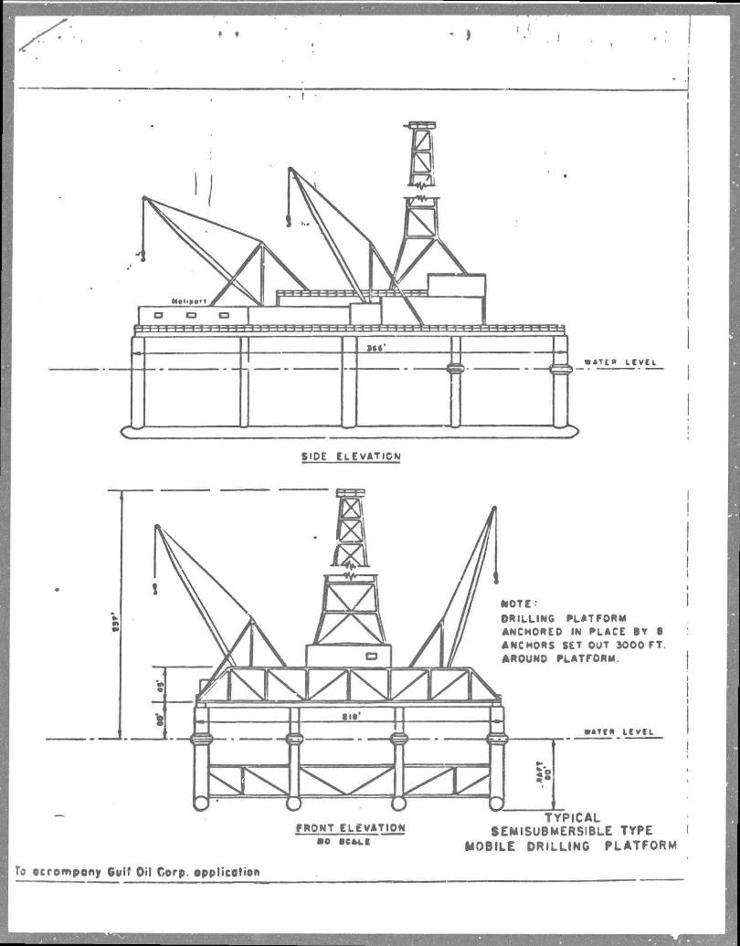
Rig Description J
\ r i
The speclific mobile _dri 11 ing r i g that w i l l d r i l l the, proposed wells i n Vioscja iKnoll Block 986 has not been selected.
The r i g w i l l have B.O.P. equipment, sanitation f a c i l i t i e s , curbes, drains, and a l l other*'equipment required for pollution prevention and personnel safety. D r i l l i n g activites w i l l be conducted i n compliance with a l l O.C.S. Orders.
When the r i g i s selected, a l l pertinent information w i l l be presented fo r approval to the Geological Survey with Form 9-331 (Permit to D r i l l ) .
To ocrompony Gulf Oil Corp. opplicotion
I
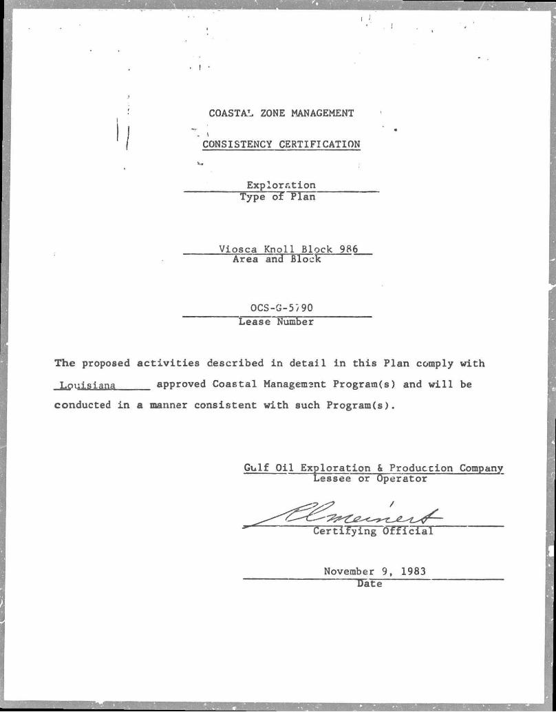
COASTAL ZONE MANAGEMENT
CONSISTENCY CERTIFICATION
• Exploration
Type of Plan Viosca Knoll Block 986
Area and Block OCS-G-5"/90
~~Lease Number
The proposed a c t i v i t i e s described i n detail i n this Plan comply with
Louisiana approved Coastal Managemant Program(s) and w i l l be
conducted i n a manner consistent with such Program(s).
Gulf Oil Exploration & Production Company Leasee or Operator
Certifying O f f i c i a l
November 9, 1983 TJate
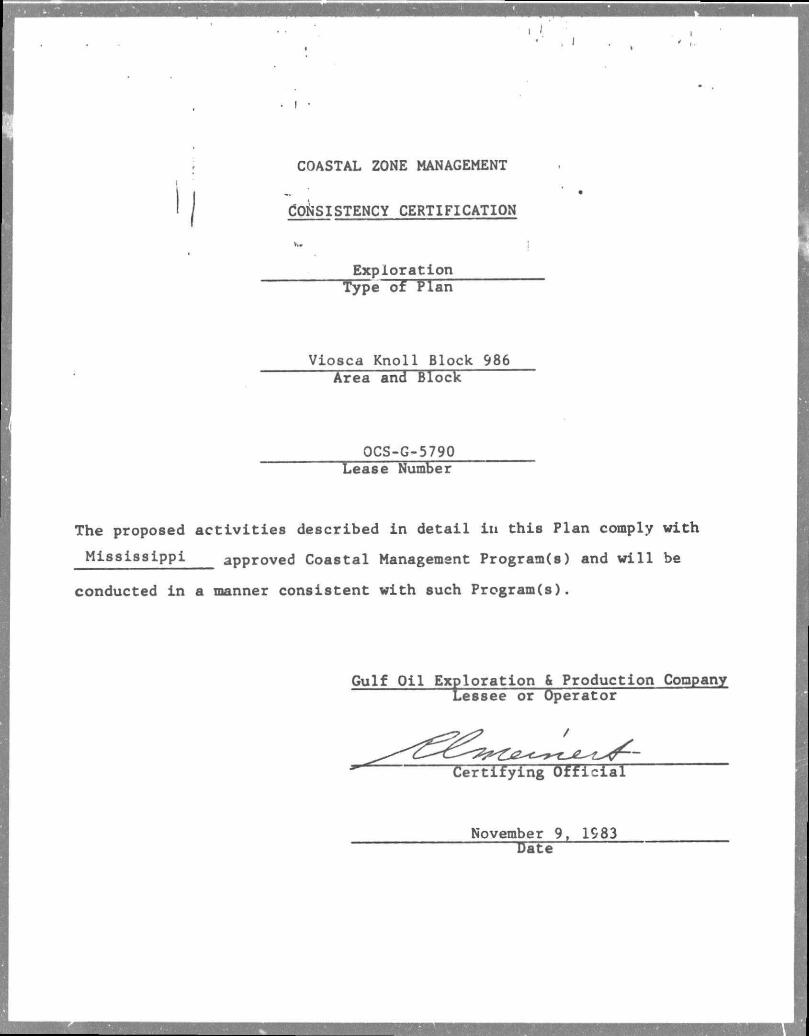
I COASTAL ZONE MANAGEMENT i
I | CONSISTENCY CERTIFICATION
v.. j
Exploration Type of Plan
Viosca Knoll Block 986 Area and Block
OCS-G-5790 Lease Number
The proposed activities described in detail in this Plan comply with
Mississippi approved Coastal Management Program(s) and will be
conducted in a manner consistent with such Program(s).
Gulf Oil Exploration & Production Conpany Lessee or Operator
Certifying Official
November 9, 1983 Date
I
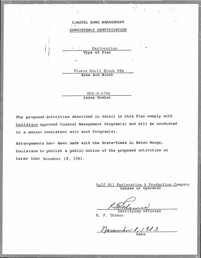
COASTAL ZONE MANAGEMENT • t •
CONSISTENCY CERTIFICATION
• t Exploration Type of Plan
...
Viosca Knoll Block 986 Area and Block
OCS-G-5790 Lease Number
The proposed activities described in detail in this Plan comply with
Louisiana approved Coastal Management Program(s) and will be conducted
in a manner consistent with such Program(s).
Arrangements hav*) been wade with the State-Times ir* Baton Rouge,
Louisiana to publish a public notice of the proposed activities no
la t e r than November 18, 1983.
Gulf Oil Exploration & Production Companv Lessee or Operator
Certifying Official R. F. Thomas
Date
n.rv**. , November 1, 1983 E x p l o r a t i o n H u o i g t r Hew O r l s s n t A r s s
I "
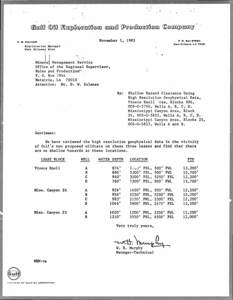
I I Mlnera| Management Service Office of the Regional Supervisor, Rules and Production" P. 0. Box 7944 Metairie, LA 70010 Attention: Mr. D. V. Solanas
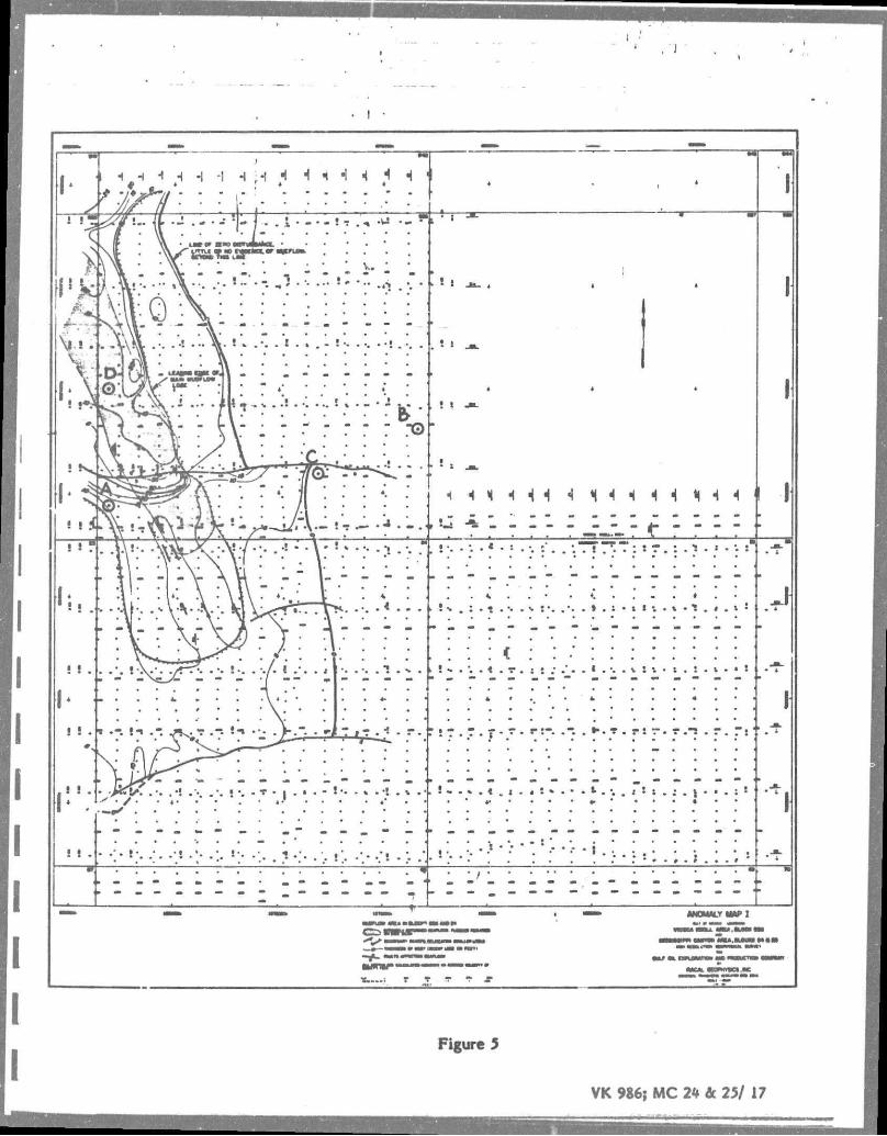
Re: Shallov Hazard Clearance Using High Resolution Geophysical Data, Viosca Knoll -rea. Blocks 986, OCS-G-5790, Wells A, B, C, D. Mississippi Canyon Area, Block 24, OCS-G-5822, Wells A, B, C, D. Mississippi Canyon Area, Blocks 25, OCS-G-5823, Wells A and B.
Gentlemen:
We have reviewed the high resolution geophysical data ln tha vicinity of Gulf's ten proposed wildcats on these three leases and find that there are no shallow hazards at these locations.
LEASE BLOCK WELL WATER DEPTH LOCATION PTD
Viosca Knoll A 874' lioJ' FSL, 500' FWL 12,200* B 896* 5300* FSL, 500' FWL 12,700' C 9401 3200* FSL, 5250* FEL 12,200' D 760* 73001 FSL, 500' FWL 12,700'
Miss. Canyon 24 A 926' 1450' FNL, 500* FWL 12,200' B 956' 2250* FNL, 5200* FWL 12,200' C 983* 2150* FNL, 5300' FEL 12,200' D 1046' 5900* FNL, 2475' FEL 12,200'
Miss. Canyon 25 A 1020' 1200* FNL, 2350* FWL 12,200' B 1210* 5550' FSL, 4500' FEL 12,000'
Very truly yours,
P. O. B O K 61BOO M * w O r l e a n s . LA T O W
W. H. Murphy * Manager-Technical
WHMrrm
A D I V I S I O N o * G U L * OIL COSPOOATiON
Environmental Report (Exploration)
for
Viosca Knoll Area Block 986, OCS G5790
Mississippi Canyon Area Block 24, OCS G5822 Block 25, OCS G5823
Lessee
Gulf Oil Exploration and Production Company
November 9, 1983
Contact Person:
Mr. L. R. Henry P.O.Box 61590 New Orleans, LA 70161 (504) 569-3430
(2) DESCRIPTION OF PROPOSED ACTION • ! •
(a) TRAVEL MODES AND ROUTES
Transportation of m a t e r i a l , supplies, and personnel between Viosca
boat and h e l i c o p t e r . Boats £rom the Venice Shorebase , w i l l t r a v e l to the
d r i l l s i t e v i a the M i s s i s s i p p i River, South Pass o u t l e t through the Gulf
o f Mexico to the d r i l l s i t e . Helicopters w i l l generally t r a v e l the most
d i r e c t route from PHI's base at Venice to the d r i l l s i t e , although weather
cond tions may sometimes a l t e r t h i s route. Helicopter f l i g h t s t r a n s f e r r i n g
crew members to and from the d r i l l s i t e w i l l be done weekly. I f severe
weather conditions p r o h i b i t these f l i g h t s , the crews w i l l be tra n s f e r r e d
by crew boats. Other service company and operator personnel t r a v e l may
re q u i r e approximately 10 round t r i p f l i g h t s of the h e l i c o p t e r ( B e l l 206
and 212 models) per week. The supply boat w i l l make d a i l y runs from
Venice to the d r i l l i n g l o c a t i o n ,
(b) SUPPORT BASE
The onshore support base f o r the proposed d r i l l i n g operation on Block
986, Block 24, and Block 25 w i l l be from the e x i s t i n g Gulf dock at Venice,
Louisiana. No enlargement or changes i n t h i s f a c i l i t y w i l l be needed t o
accommodate the proposed d r i l l i n g a c t i v i t y . Approximately 40 r i g crew
members, and supervisory personnel w i l l be required on each seven day
t o u r . In a d d i t i o n , about 25 other service company people w i l l be required
d u r i n g the course of the d r i l l i n g operation.
Two (2) radio dispatchers working on 12 hour s h i f t s w i l l be located
a t the shore base. Othar personnel located at the shore base include a
materi a l s supervisor, a tr a n s p o r t a t i o n supervisor, f i v e other company
employees and 20 contract employees to handle the loading and tr a n s f e r of
K n o l l Block 986 i foi Canyon Block 24 and Mississippi Canyon Block
ase at Venice, Louisiana w i l l be by
- 1 -
supplies and material onto workboats for use at the d r i l l s i t e . Workboats
ing f a c i l i t y is not being operated at f u l l capacity.
(d) DESCRIPTION OF NEW TECHNIQUES OR UNUSUAL TECHNOLOGY
There w i l l not be any new techniques or unusual technology required
i n carrying out the proposed d r i l l i n g operation.
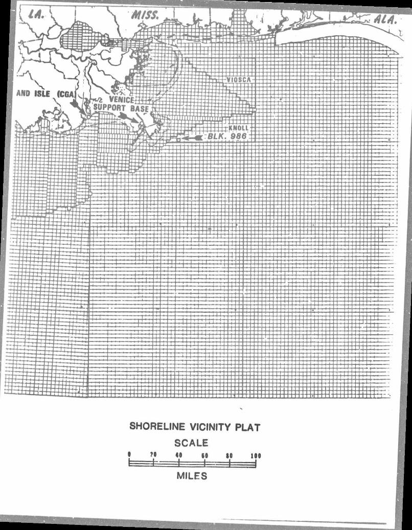
(e) MAP OF THE PROPOSED ACTIVITY WITH RESPECT TO STATE'S COASTAL ZONE
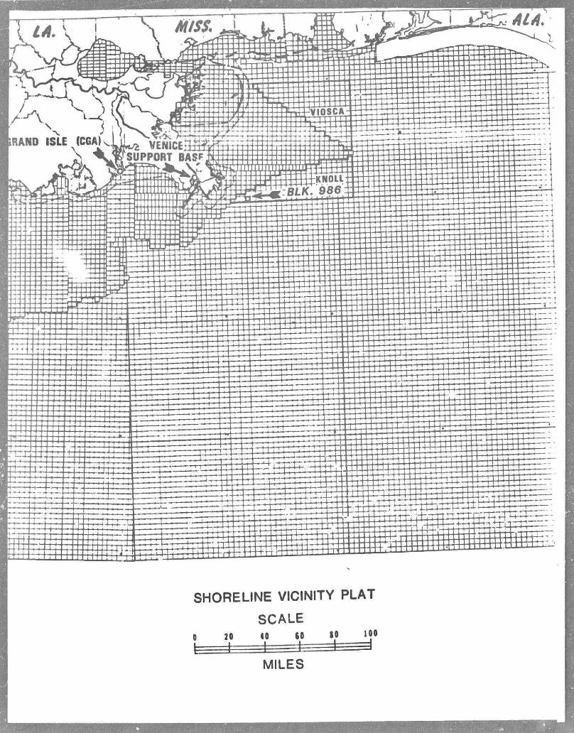
A shoreline v i c i n i t y plat showing the location of Viosca Knoll Block 986,
Mississippi Canyon Block 24 or Mississippi Canyon Block 25 with respect to
the coastline of the State of Louisiana and the coastline of the State of
Mississippi i s attached. Also attached i s a plat showing the location of
the d r i l l s i t e within Block 986. Block 24 or Block 25.
( f ) FOR PLANS OF DEVELOPMENT/PRODUCTION, THE MEANS OF TRANSPORTATION
OF OIL AND GAS
The proposed a c t i v i t y i s to conduct an exploratory investigation for
o i l and gas. I f hydrocarbons are discovered, a development/production
plan w i l l be submitted at that time describing the plans for transporting
o i l and gas to shore and to markets on the mainland.
(a) PHYSICAL AND ENVIRONMENTAL
(1) Commercial Fishing
The lease sites are situated approximately 20 statute miles due east
of the mouth of South Pass on the Mississippi Delta front i n water depths
ranging frcm 640' i n the northwest corner to 1,320' i n the southeast corner
require a crew of five people normally working tours of 7 to 14 days.
(c) NEW SUPPORT FACILITY
(3) DESCRIPTION OF THE AFFECTED ENVIRONMENT AND IMPACT
of the b locks . • i •
By f a r the most product ive f i s h e r y region i n the Gulf of Mexico i n
terras o f pounds of ca tch i s i n Gr id Zone 15 o f f Atchafalya Bay. Grid Zones r i
16 and 17 to the west are the next most productive areas i n the northern
Gulf. THe^e three zones make-up nearly 66Z of a l l the poundage caught i n
the Gulf for the years. 1968 - 1974. Commercial landings i n the Gulf
accounted for 36Z of the total U.S. catch on a poundage basis and 26Z of
the d o l l a r value of such catches during 1982 (USDC, NMFS, 1983).
The Gulf fishery i s dominated by the shell fisheries; i . e . , shrimp,
crabs, and oysters with small amounts of clam and scallops. The t o t a l
d o l l a r value is about the same as the f i n f i s h harvest although the f i n f i s h
landings are at least f i v e (5) times greater. The shrimp fishery in the
Gulf includes brown, white and pink shrimp and are taken almost exclusively
by t r a w l fishing i n water depths from 6 to 250 feet. Th ̂ catch i n 1982
from Louisiana and Mississippi waters was 90.5 m i l l i o n pounds valued at
$188.2 m i l l i o n and 10.2 mi l l i o n pounds valued at $21.2 m i l l i o n respectively
(USDC, NMFS, 1983).
These species of shrimp spawn i n the open ocean and undergo a series
of l a r v a l phases i n the plankton, followed by migration i n the post-larval
phase to an estuarine nursery ar**a, then return to the ocean as adults.
I n terms of pounds of catch, the menhaden fishery is the Gulf of
Mexico Region's largest (1.9 b i l l i o n pounds i n 1982) and second largest
i n value ($72.7. m i l l i o n i n 1982). The oyster fishery ranks t h i r d in
do l l a r value ($34.1 m i l l i o n ) (USDC, NMFS, 1983).
The blue crab makes up 98Z of the crab harvest for the Gulf Region
(Riley, 1970). I t s l i f e cycle is similar to the shrimp i n that i t under
goes the planktonic, estuarine, and open ocean phases. Gravid females
migrate to the open Gulf and release their eggs i n the spring and summer
- 3 -
months. The adult crabs, are found i n the estuarines and thus inland, from
the leased area.
Viosca Knoll Block 986 and Mississippi Canyon Blocks 24 and 25 are
located in art area that annually accounts for 21.6% of the t o t a l Gulf of
Mexico's colmkrical landings and 14.2% of the t o t a l value. Block 986,
Block 24, and Block 25 are also located in the area designated as the pri n
c i p a l royal red shrimp grounds. However, these blocks are located seawards
of the outer l i m i t s of the major f i n f i s h grounds, pink shrimp harvest area,
and the brown and white shrimp harvest area. (USDI, FREIS, 1983, Visual 10)
Viosca Knoll Block 986 and Mississippi Canyon Blocks 24 and 25 are not
included in the area classified as either "high marine productivity" or as
a "high density s h e l l f i s h " area. (USDI, FREIS, 1983, Visual 10)
The proposed d r i l l i n g operation may degrade the water quality i n the
immediate v i c i n i t y of the d r i l l s i t e temporarily due to discharges of d r i l l
mud and cuttings. Such a change i n water quality may cause some species to
avoid the area surrounding the d r i l l site during this period while active
d r i l l i n g operations are underway. Once d r i l l i n g is completed the popula
t i o n should return to the area.
Some larvae and eggs of certain species could also be adversely
affected in the immediate area of the d r i l l s i t e due to temporary degrada
t i o n of water quality. This condition would be short term and would not
be expecr.ed to have any measurable effect on any fishery.
The impact from the discharge of d r i l l cuttings would be to smother
sessile benthic organisms i n the area around the well. Studies have shown
that these deposits arcs quickly re-colonized (Zingula, 1975). Also, heavy
solids contained i n d r i l l mud discharges may also be deposited on the
bottom as a l i g h t coating which may have some temporary adverse effect.
These areas apparently are quickly repopulated indicating no persistant
- 4 -
t o x i c i t y of the mud sediments. (Reigh et a l , 1980; G i l b i l l a u et a l , 198G) • i •
An o i l s p i l l could also cause water quality degradation due to the
introduction of possible toxins into the water column. Most adult f i s h , r i
however, would probably avoid such areas and no s i g n i f i c a n t or pers i s ten t
d i r e c t e f f e c t on j : i s h popula t ion would be expected. Any s p i l l would be
subject; tu immediate containment and clean-up. O i l s p i l l s have a low
p r o b a b i l i t y of occur r ing dur ing explora tory d r i l l i n g . (Dannenberger, 1976)
(2) Shipping
There are no designated shipping safety fairways or anchorage area
crossings located within Viosca Knoll Block 986 and Mississippi Canyon
Block 24 and 25. (USDI, FREIS, 1983, Visual 11)
(3) Small Craft Pleasure Boating, Sport Fishing, and Recreation
Studies have shown that f i s h which would normally be scattered
throughout large areas are often concentrated i n small areas surrounding
petroleum platforms and attracted by the food and shelter which the
structure offers. Many of the f i s h species that congregate around petro
leum structures are prime sport fishing targets including snapper, grouper,
mackerels, cobia, etc. I t i s believed, too, the new a r t i f i c i a l reefs have
l i t t l e , i f any, effect on the carrying capacity or the size distribution
o f f i s h on the natural reefs (Stone •• 1979). I t could, therefore, be
assumed that the quality and quantity of offshore fishing would be further
enhance by any increase i n petroleum structures on the OCS. As a result,
these structures provide both sport and commercial fishermen an area with
an abundant f i s h population. The Gulf of Mexico Fishery Management
Council (G.M.F.M.C) recently published data indicating that red snapper
stocks were on the decline and th i s condition was possibly due to over
f i s h i n g by the recreational fisher (1980 b). The GMFMC report suggested
the possiblity, too, that the apparent decline i n snapper population
- 5 -
may not be a r e a l one but rather the population spread out over greater
«. .eas due to increasing numbers at platforms being i n s t a l l e d . According
t o the report, natural reef f i s h i n g h a b i t a t i n the Gulf provides approxi-? r
mately 39,000 KM ,. The h a b i t a t provided by 2,000 petroleum platforms,
assuming an area |ofl 50 meters-by 50 meters each, would provide another
5,000 KM2 of h a b i t a t . Km
(4) C u l t u r a l Resources
Viosca K n o l l Block 986 and M i s s i s s i p p i Canyon Blocks 24 and 25 are
located on the seaward side of the lines marking the outer l i m i t s of the
zones designated as "high probably l i n e s f o r p r e h i s t o r i c and h i s t o r i c
c u l t u r a l resources" (U.S.D.I., FREIS, 1983, Visual 11) and, as such, the
requirements of Lease s t i p u l a t i o n No. 1 were not invoked as being a p p l i
cable to these Blocks (Letter to the Lessees by MMS, Gulf of Mexico Region)
(5) Ecological Sensitive Features
There are no b i o l o g i c a l l y s e n s i t i v e features or areas of p a r t i c u l a r
concern i n the projset area. The closest designated b i o l o g i c a l l y sensi
t i v e area (Sackett Bank) i s approximately 48 miles to the southwest.
(U.S.D.I., FREIS, 1983, Visual 10).
A l l the coastal area of Louisiana and M i s s i s s i p p i have been included
i n each state's coastal zone management plan. As such, any proposed OCS
a c t i v i t y must be reviewed by the affected state's CZM a u t h o r i t i e s and, as
provided by Federal law, such a c t i v i t y must be consistant w i t h the respec
t i v e state's management plan before a permit f o r the project can be issued
by the responsible Federal agency.
(6) E x i s t i n g Pipeline and Cables
There are no pipelines crossing Block 986, Block 24, or Block 25 as
determined from the shallow hazard survey (Recal Geophysics, Inc., July,
1983). There are no known cables crossing the blocks.
- 6 -
(7) Other Mineral Uses • i •
There are no other known mineral resources on Blcck 986, Bio k 24,
or Block 25 other than possible o i l and gas deposits.
(8) Ocean Dumping A c t i v i t i e s
The l e a l e j i area i s not: located w i t h i n any EPA designated ocean
dumping s i t e or any i n t e r i m dumping s i t e t h a t has been so designated by
EPA (U.S.D.I., FREIS, 1983, Visual 11).
(9) Endangered or Thr3aten Species
Seven species of marine mammals that have been sighted i n the Gulf
of Mexico have been c l a s s i f i e d as endangered species (Federal Register,
1975). These are the sperm whale, black r i g h t whale, humpback whale, sei
whale, f i n whale, blue whale, and the West Indian manatee.
Five species of marine t u r t l e s that occur i n the Gulf area ar~ also
on the endangered or threatened species l i s t . Ihese are the loggerhead,
green A t l a n t i c Ridley, h a w k s b i l l , and the leatherback. According t o
Hildebrard, a major feeding area for the A t l a n t i c Ridley may be o f f the
Louisiana coas- 'nd reoorts have indicated that p c i t u n i d crab comprises
a large por k ^ j t to the specimens examined. Except for reported
occasional nesting along the southern Texas coast t h i s species nests
e n t i r e l y along a 14 mile s t r e t c h of the Mexican coast.
The leatherback, although i u i s a t r o p i c a l nesting species, ranges
widely throughout the Gulf of Mexico and western North A t l a n t i c as f a r
north as Nova Scotia. Large numbers have also been observed i n inshore
waters during c e r t a i n periods of the year and are usually associated with
areas where j e l l y f i s h are found i n abundance, presumably which they fo l l o w
and feed upon.
Any impact of the proposed a c t i v i t y on marine mammals and t u r t l e s
cannot be accurately assessed but would appear to be somewhat dependent
- 7 -
upon the probability of an o i l s p i l l , the population size and di s t r i b u -
t i o n of the species, as well as the size and location of the area impacted
by the spilled o i l . • Recent studies, however, have indicated that o i l
remaining on a bea,cn for one year after a s p i l l did not s i g n i f i c a n t l y
a f f e c t mortality olf jsea t u r t l e "efegs. The effect of petroleum on the
development and survival of t u r t l e embryos is s t i l l inconclusive, although
fresh o i l on top of the sand may cause extensive mortality to incubating
sea t u r t l e eggs,
(b) SOCIO-ECONOMIC
No new personnel or other significant changes t..at might otherwise
a f f e c t the coastal communities are contemplated by the proposed exploration
e f f o r t .
(4) UNAVOIDABLE ADVERSE IMPACT
Most of the unavoidable adverse impacts are of a temporary nature and
the environment should be completely restored soon after d r i l l i n g operations
have ceased. Discharges of d r i l l mud and cuttings may c~use some water
q u a l i t y degradation while d r i l l i n g . Similarly, the deposition of d r i l l
cuttings on the ocean floor could smother sessile benthic organisms but
these, uoo, should quickly re-colonize. Air quality w i l l be temporarily
degraded due to emissions from the exhaust of diesel engines and possibly
hydrocarbon vapors from diesel storage tanks. Any hydrocarbons vented
to the atmosphere while testing the well may also cause rome degradation
of a i r quality. Any blowout of a well which caught f i r e may also introduce
i n t o the atmosphere large amount of carbon particulates, and other pollu
tants such as oxides of sulphur and nitrogen. In most cases, such a
condition would be dissipated rather quickly by climatic conditions and
would not seriously impair a i r quality at the shoreline.
Because of the c r i t i c a l need to develop new energy reserves for
- 8 -
, J
the economy "and security of . the United States, the proposed ac t iv i ty shou.ld
be implementad without delay. No new feasible technology that would tend
to mitigate these minimal and temporary adverse impacts can be expected
within the foreseeable future .
- 9 -
• * (5) REFERENCES . , .
Recal Geophysics, Incorpora ted , Ju ly 1983, A High Resolution Geophysical Survey of Viosca K n o l l Area, Block 986 and Mis s i s s i pp i Canyon Area, Houston, TX.
DannenbergerL E. P. , 1C76, O i l S p i l l s , 1971 - 1975, Gulf of Mexico Outer 1 Continental SHelf, Geological Survey
U n i t e d States Department of the I n t e r i o r , Bureau of Land Management, and Minerals Management Service, Various, F ina l Environmental Impact Statement, Outer Cont inenta l Shelf O i l and as Lease Sale
U n i t e d S ta te ! Department of Commerce, 1980, F ina l Environmental Impact Statement f o r Louisiana Coastal Resources Program, O f f i c e of Coastal Zone Management, Washington, D.C.
U n i t e d States Department of Commerce, A p r i l , 1983, Current Fishery S t a t i s t i c s No. 8300 Fisheries o f the United States, 1982, Nat ional Marine Fisheries Services, Washington, D.C.
(6 ) STATEMENT
The proposed a c t i v i t y w i l l be carried out and completed with
the guarantee of the following items:
(1) The best available and safest technologies w i l l be u t i l i z e d
throughout the project. This includes meeting a l l applicable re
quirements for equipment types, general project layout, safety
systems, and equipment and monitoring systems.
(2) A l l operations w i l l be covered by an MMS approved o i l s p i l l
contingency plan.
(3) A l l applicable Federal, State, and Local requirements regard
ing a i r eraissons and water quality and discharge for the proposed
a c t i v i t i e s , as well as any other permit conditions, w i l l be complied
with.
- 10 -
I
DATE nrr. 0 5 1383
Plan of Fx ni trat ion ^tnTrtTTTTfft^ 7 T^ ,* i ir»* •• • ' '•'•<»•« •• i n.p>.»-i
L n - s e ^ OCS-G _5J2JLS Control to. A / - / 4 / 2.
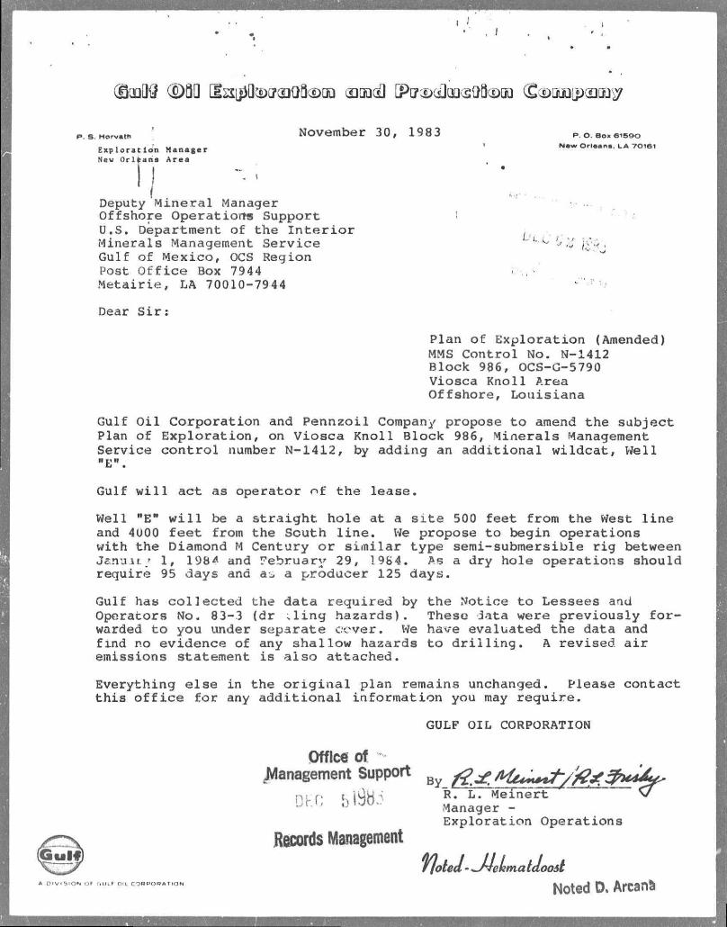
P . S . H o r v a t h November 30, 1983 E x p l o r a t i o n M a n a g e r New O r l e a n s A r e a
Deputy M i n e r a l Manager Of f sho re Opera t ior ts Support U.S. Department o f the I n t e r i o r Mine ra l s Management S e r v i c e Gulf o f M e x i c o , OCS Region Post O f f i c e Box 7944 M e t a i r i e , LA 70010-7944
P. O . B O K 6 1 5 Q O
N e w O r l a a n a . L A 7 0 1 6 1
Dear S i r :
Plan of Exploration (Amended) MMS Control No. N-1412 Block 986, OCS-G-5790 Viosca Knoll Area Offshore, Louisiana
Gulf O i l Corporation and Pennzoil Company propose t o amend the subject Plan of Exploration, on Viosca Knoll Block 986, Minerals Management Service c o n t r o l number N-1412, by adding an add i t i o n a l wildcat, Well "E".
Gulf w i l l act as operator of the lease.
Well "E" w i l l be a s t r a i g h t hole at a s i t e 500 feet from the West l i n e and 4U00 f e e t from the South l i n e . We propose to begin operations with the Diamond M Century or s i m i l a r type semi-submersible r i g between Jenuit •• 1, 198 A and February 29, 1984. As a dry hole operations should require 95 days and as a producer 125 days.
Gulf has co l l e c t e d the data required by the Notice t o Lessees and Operators No. 83-3 (dr ; l i n g hazards). These lata were previously f o r warded t o you under separate cover. We have evaluated the data and find no evidence of any shallow hazards t o d r i l l i n g . A revised, a i r emissions statement is also attached.
Everything else in the o r i g i n a l plan remains unchanged. Please contact t h i s o f f i c e f o r any a d d i t i o n a l information you may require.
GULF OIL CORPORATION
I O N O F G U L F O U C O R P O R A T I O N
Office of JVIanagement Support By ^ fiti+^/fafrUJ^
Di- r; 5198:5 £ L- *elne"rt * u J Manager -
E x p l o r a t i o n Opera t ions
Records Management ffoteJ- *J4ehmatdoo&t
Noted D» Arcana
1 I
>
Deputy M i n e r a l f.anager - 2 - November 30, 198 3
i
,kr̂ /cdC
Enclosures: Shoreline V i c i n i t y Plat Location Plat A i r Emission Data Anomaly Plat S i t e Clearance L e t t e r f o r Shallow
D r i l l i n g Hazards
SHORELINE VICINITY PLAT
SCALE 0 20 40 60 10 100
1 I I Et 1 i MILES
986
GULF 66 2/3% PENNZOIL 33 1/3%
OCS G 5790
600'
P © (D)
600'
m' (E)
0 500'
©--J o o
co !o q
o §
(C) 6250'
© o a CVJ CO
o o eo IS)
L_ _ VIOSCA KNOLL AflEA BLK. 986
LOCATION PLAT
<e)
©
•000
FEET
986
6ULF 66 2/3% PENNZOIL 33 1/3%
OCS G 5790
VIOSCA KNOLL AREA BLK. 986 BATHYMETRY PLAT
l noo FEET
I
P . S H o r v a t h
E x p l o r a t i o n M a n a g e r ; New O r l e a n s A r e a
December 2, 1983 P. O B o » 6 1 5 9 0
N a v * O r l e a n s . L A 7 0 1 6 1
Mineral . .anageroent Sen/ i t O f f i c e o f the Regional Supervisor , Rules and Production T. 0. Box 7944 Metairie, LA 70010 Attention: Mr. D. W. Solanas
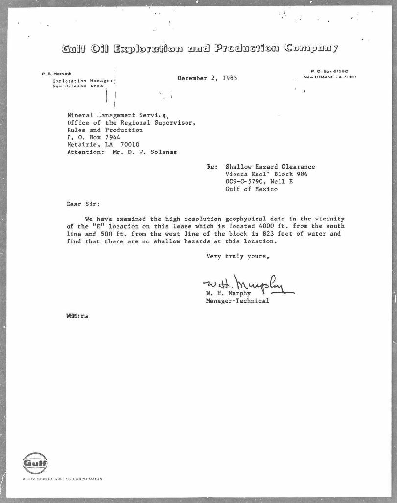
Re: Shallow Hazard Clearance Viosca Knor Block 986 OCS-G-5790, Well E Gulf of Mexico
Dear Sir:
We have examined the high resolution geophysical data in the v i c i n i t y of the "E" location on this lease which is located 4000 f t . frora the south line and 500 f t . from the west line of the block i n 823 feet of water and find that there are no shallow hazards at this location.
Very t r u l y yours,
W. H. Murphy > V Manager-Technical
WHMsrai
(Guif)
A O i v . s i O N o r G U L T O I L C O R P O R A T I O N
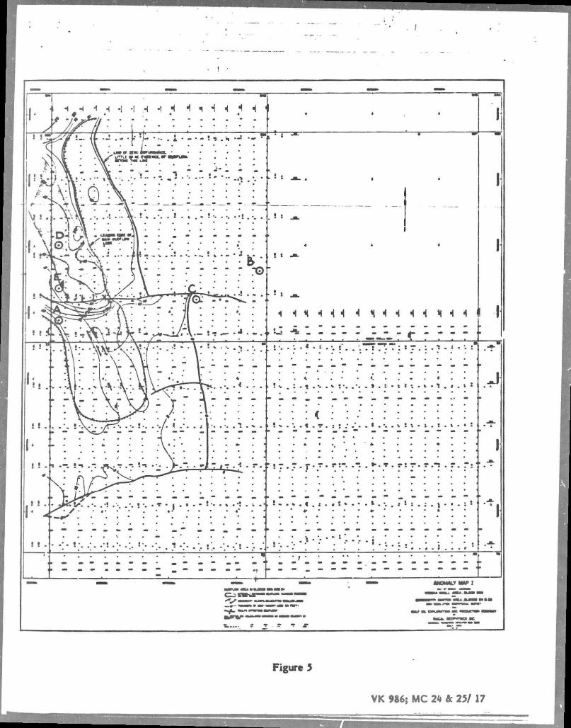
Figure 5
VK 986; MC 2k & 25/ 17
VK 986 Proiected Air Emissions , _ _,
d (Revised 12-01-83) Major Sources
Emissions in (lbs/day) tons per year
CO VOC NOx SO 2 TSP
Power onboard d r i l l i n g vessel (Total footage d r i l l e d - 36,354 (39.88) 7.28 (14.74) 2.69 (184.28) 33.63 (12.25) 2.24 (13.15) 2.40
(1) Based on 60 hp h r / f t from Table 4-3, "Atmosphe c Emissions from Offshore Oil and Gas Development and Production", EPA No. 450/3-77-026, June 1977.
(2) Emission factors from Table 3.3.3-1, "Compilation of Air Pollutant Emission Factors", Third Edition, EPA Report AP-42, August, 197/.
Minor Sources
Includes hclico; te»- landings and takeoff, one t r i p per day; supply and crew boats at dockside, one Lrip per day, fuel storage i^id tra r f loading and unloading operati ns; and incineration of waste paper (average 750 lbs/mo.) for duration of product of 62D days.
Emission In tons/year
CO VOC NOx S02 TSP
Minor Sou-ces 5.60 1.20 2.00 0.70 0.50
Total a l l Sources 12.88 3.89 36.53 2.94 2.90
Emission Exemption (tons per year) in 7
CO Exemption - E - 3400 D / J i NOx, VOC, SO2, TSP Exemption - E-33.3D 3. c£?
D - Distance frora shore - 20 miles g . ^ -
CO E -25,051tons; NOx, VOC, S02 TSP E - 666 tons g g) O CD XD
The projected a i r emissions during the d r i l l i n g of the f i v e proposed wells are considered-below tKfe exemption levels fcr each of the pollutants; hence no further a i r quality reviews are indicated. ^ j .
No new f a c i l i t i e s w i l l be installed at the onshore bacea.
Recommended