1 ©HortonworksInc.2011– 2017.AllRightsReserved
IngestingDroneDataintoBigDataPlatformsTimothySpann(@PaasDev)OracleCodeNYC2017https://github.com/tspannhw/IngestingDroneData
[BRK1238-NYC]
2 ©HortonworksInc.2011– 2017.AllRightsReserved
Agenda
• Drones 101• Metadata Insights• Ingestion Formats: MQTT, Files, REST JSON, Images, FTP
and more.• Apache NiFi• Big Data Storage: HDFS, HBase, Phoenix, Hive
3 ©HortonworksInc.2011– 2017.AllRightsReserved
Code Walk Through
• Processing Images with TensorFlow for Image Recognition • Writing a Java 8 Processor for Sentiment Analysis• Writing a Java 8 Processor for analyzing HTML • Writing a Java 8 Microservice for retrieving Phoenix/Hbase
data • Writing a Java 8 Microservice for retrieving Hive data • Writing a NiFi flow to wire it all together
4 ©HortonworksInc.2011– 2017.AllRightsReserved
UAV / Drones
A drone is an unmanned aircraft, better known as a unmanned aerial vehicle (UAV) or unmanned aircraft systems (UAS).
For enterprise purposes, we are thinking of serious drones that contain high resolution video/still cameras with onboard sensors and GPS.
For almost all drones, they are regulated by the Federal Aviation Administration (FAA) and there are strict regulations you must register your drone. If you aren’t prepare for the regulations or cost, keep your drone in your house or under half a pound.
5 ©HortonworksInc.2011– 2017.AllRightsReserved
6 ©HortonworksInc.2011– 2017.AllRightsReserved
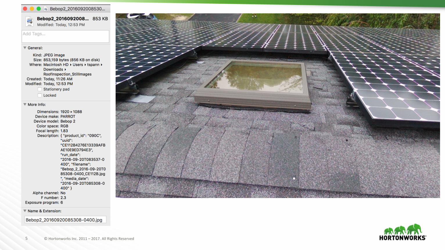
MetaData EXIF Geotagging
Photographs taken from UAVs, the JPEGs will have extra data stored in EXIF.Apache NiFi can extract this information, which is very helpful.The most important information it contains is GPS information for latitude and longitude.
GPS Altitude Ref: Sea levelGPS Altitude: 21 metresGPS Longitude: -73° 4' 50.41GPS Latitude: 40° 45' 16.51
7 ©HortonworksInc.2011– 2017.AllRightsReserved
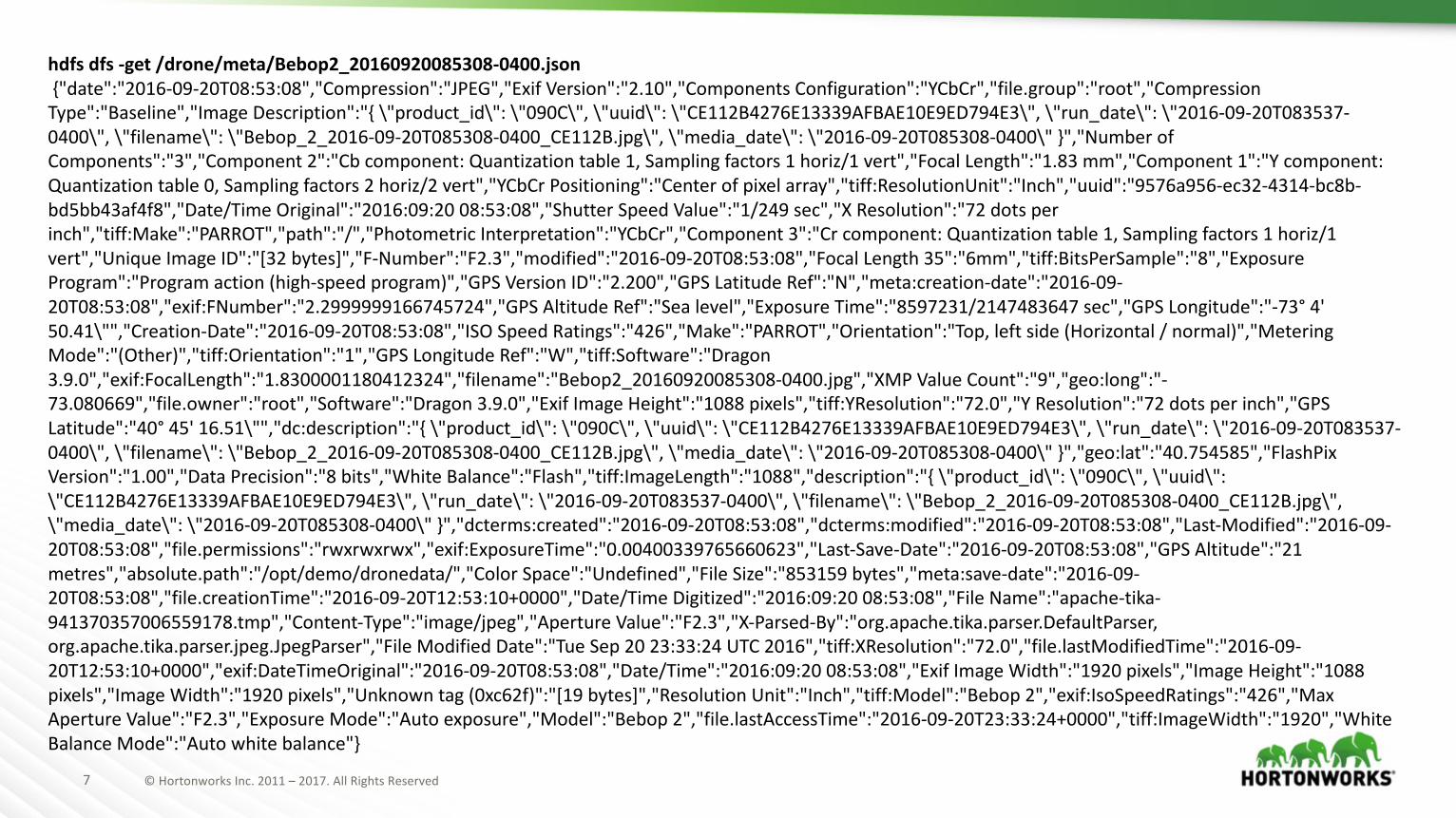
hdfs dfs -get/drone/meta/Bebop2_20160920085308-0400.json{"date":"2016-09-20T08:53:08","Compression":"JPEG","ExifVersion":"2.10","ComponentsConfiguration":"YCbCr","file.group":"root","CompressionType":"Baseline","Image Description":"{\"product_id\":\"090C\",\"uuid\":\"CE112B4276E13339AFBAE10E9ED794E3\",\"run_date\":\"2016-09-20T083537-0400\",\"filename\":\"Bebop_2_2016-09-20T085308-0400_CE112B.jpg\",\"media_date\":\"2016-09-20T085308-0400\"}","NumberofComponents":"3","Component2":"Cbcomponent:Quantizationtable1,Samplingfactors1horiz/1vert","Focal Length":"1.83mm","Component 1":"Ycomponent:Quantizationtable0,Samplingfactors2horiz/2vert","YCbCr Positioning":"Center ofpixelarray","tiff:ResolutionUnit":"Inch","uuid":"9576a956-ec32-4314-bc8b-bd5bb43af4f8","Date/TimeOriginal":"2016:09:2008:53:08","ShutterSpeedValue":"1/249sec","X Resolution":"72dotsperinch","tiff:Make":"PARROT","path":"/","PhotometricInterpretation":"YCbCr","Component3":"Crcomponent:Quantizationtable1,Samplingfactors1horiz/1vert","Unique ImageID":"[32bytes]","F-Number":"F2.3","modified":"2016-09-20T08:53:08","FocalLength35":"6mm","tiff:BitsPerSample":"8","ExposureProgram":"Program action(high-speedprogram)","GPSVersionID":"2.200","GPSLatitudeRef":"N","meta:creation-date":"2016-09-20T08:53:08","exif:FNumber":"2.2999999166745724","GPSAltitudeRef":"Sea level","Exposure Time":"8597231/2147483647sec","GPS Longitude":"-73° 4'50.41\"","Creation-Date":"2016-09-20T08:53:08","ISOSpeedRatings":"426","Make":"PARROT","Orientation":"Top,leftside(Horizontal/normal)","MeteringMode":"(Other)","tiff:Orientation":"1","GPSLongitudeRef":"W","tiff:Software":"Dragon3.9.0","exif:FocalLength":"1.8300001180412324","filename":"Bebop2_20160920085308-0400.jpg","XMPValueCount":"9","geo:long":"-73.080669","file.owner":"root","Software":"Dragon3.9.0","ExifImageHeight":"1088pixels","tiff:YResolution":"72.0","YResolution":"72dotsperinch","GPSLatitude":"40° 45'16.51\"","dc:description":"{\"product_id\":\"090C\",\"uuid\":\"CE112B4276E13339AFBAE10E9ED794E3\",\"run_date\":\"2016-09-20T083537-0400\",\"filename\":\"Bebop_2_2016-09-20T085308-0400_CE112B.jpg\",\"media_date\":\"2016-09-20T085308-0400\"}","geo:lat":"40.754585","FlashPixVersion":"1.00","DataPrecision":"8bits","White Balance":"Flash","tiff:ImageLength":"1088","description":"{\"product_id\":\"090C\",\"uuid\":\"CE112B4276E13339AFBAE10E9ED794E3\",\"run_date\":\"2016-09-20T083537-0400\",\"filename\":\"Bebop_2_2016-09-20T085308-0400_CE112B.jpg\",\"media_date\":\"2016-09-20T085308-0400\"}","dcterms:created":"2016-09-20T08:53:08","dcterms:modified":"2016-09-20T08:53:08","Last-Modified":"2016-09-20T08:53:08","file.permissions":"rwxrwxrwx","exif:ExposureTime":"0.00400339765660623","Last-Save-Date":"2016-09-20T08:53:08","GPSAltitude":"21metres","absolute.path":"/opt/demo/dronedata/","ColorSpace":"Undefined","File Size":"853159bytes","meta:save-date":"2016-09-20T08:53:08","file.creationTime":"2016-09-20T12:53:10+0000","Date/TimeDigitized":"2016:09:2008:53:08","FileName":"apache-tika-941370357006559178.tmp","Content-Type":"image/jpeg","Aperture Value":"F2.3","X-Parsed-By":"org.apache.tika.parser.DefaultParser,org.apache.tika.parser.jpeg.JpegParser","FileModifiedDate":"Tue Sep2023:33:24UTC2016","tiff:XResolution":"72.0","file.lastModifiedTime":"2016-09-20T12:53:10+0000","exif:DateTimeOriginal":"2016-09-20T08:53:08","Date/Time":"2016:09:2008:53:08","ExifImageWidth":"1920pixels","Image Height":"1088pixels","Image Width":"1920pixels","Unknown tag(0xc62f)":"[19bytes]","ResolutionUnit":"Inch","tiff:Model":"Bebop2","exif:IsoSpeedRatings":"426","MaxApertureValue":"F2.3","ExposureMode":"Auto exposure","Model":"Bebop 2","file.lastAccessTime":"2016-09-20T23:33:24+0000","tiff:ImageWidth":"1920","WhiteBalanceMode":"Auto whitebalance"}
8 ©HortonworksInc.2011– 2017.AllRightsReserved
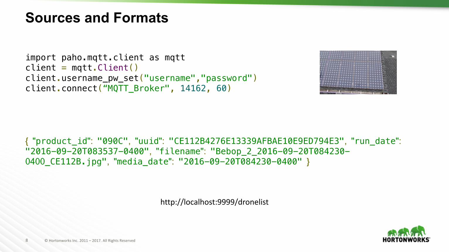
import paho.mqtt.client as mqttclient = mqtt.Client()client.username_pw_set("username","password")client.connect(“MQTT_Broker", 14162, 60)
Sources and Formats
{ "product_id": "090C", "uuid": "CE112B4276E13339AFBAE10E9ED794E3", "run_date": "2016-09-20T083537-0400", "filename": "Bebop_2_2016-09-20T084230-0400_CE112B.jpg", "media_date": "2016-09-20T084230-0400" }
http://localhost:9999/dronelist
9 ©HortonworksInc.2011– 2017.AllRightsReserved
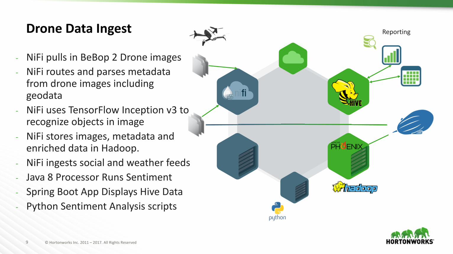
ReportingDroneDataIngest
- NiFipullsinBeBop 2Droneimages- NiFiroutesandparsesmetadatafromdroneimagesincludinggeodata
- NiFiusesTensorFlow Inceptionv3torecognizeobjectsinimage
- NiFistoresimages,metadataandenricheddatainHadoop.
- NiFiingestssocialandweatherfeeds- Java8ProcessorRunsSentiment- SpringBootAppDisplaysHiveData- PythonSentimentAnalysisscripts
10 ©HortonworksInc.2011– 2017.AllRightsReserved
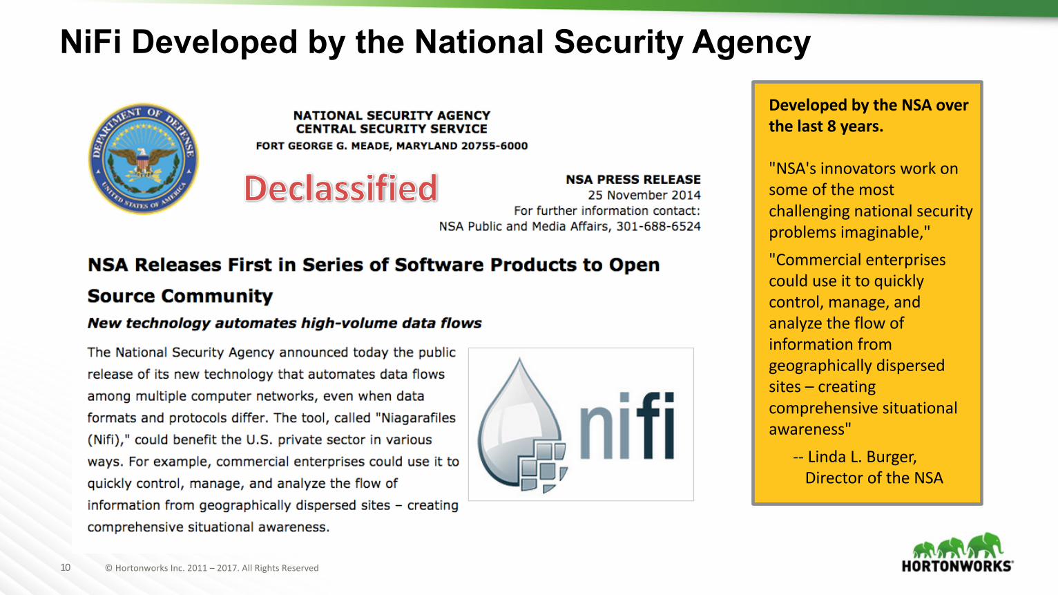
DevelopedbytheNSAoverthelast8years.
"NSA'sinnovatorsworkonsomeofthemostchallengingnationalsecurityproblemsimaginable,""Commercialenterprisescoulduseittoquicklycontrol,manage,andanalyzetheflowofinformationfromgeographicallydispersedsites– creatingcomprehensivesituationalawareness"
-- LindaL.Burger,DirectoroftheNSA
NiFi Developed by the National Security Agency
11 ©HortonworksInc.2011– 2017.AllRightsReserved
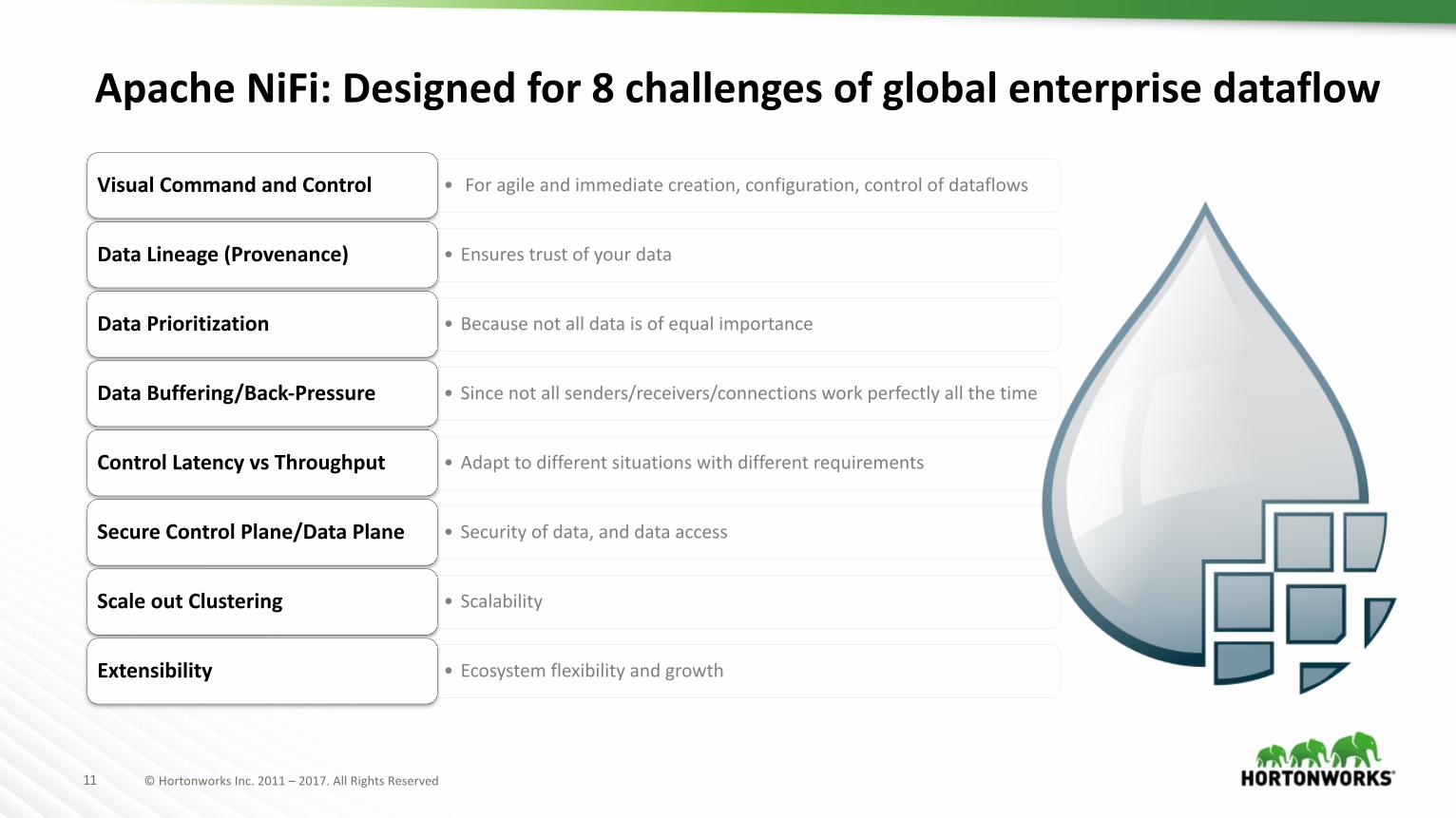
• Foragileandimmediatecreation,configuration,controlofdataflowsVisual CommandandControl
• EnsurestrustofyourdataDataLineage(Provenance)
• Becausenotalldataisofequal importanceDataPrioritization
• Sincenotallsenders/receivers/connectionsworkperfectlyallthetimeDataBuffering/Back-Pressure
• Adapttodifferentsituations withdifferentrequirementsControl LatencyvsThroughput
• Securityofdata,anddataaccessSecure ControlPlane/DataPlane
• ScalabilityScaleoutClustering
• Ecosystem flexibilityandgrowthExtensibility
ApacheNiFi:Designedfor8challengesofglobalenterprisedataflow
12 ©HortonworksInc.2011– 2017.AllRightsReserved
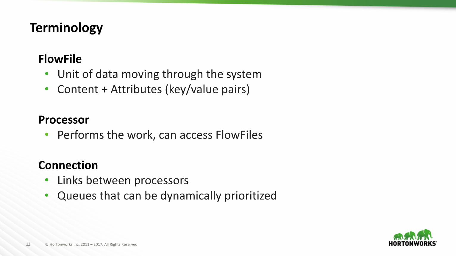
FlowFile• Unitofdatamovingthroughthesystem• Content+Attributes(key/valuepairs)
Processor• Performsthework,canaccessFlowFiles
Connection• Linksbetweenprocessors• Queuesthatcanbedynamicallyprioritized
Terminology
13 ©HortonworksInc.2011– 2017.AllRightsReserved
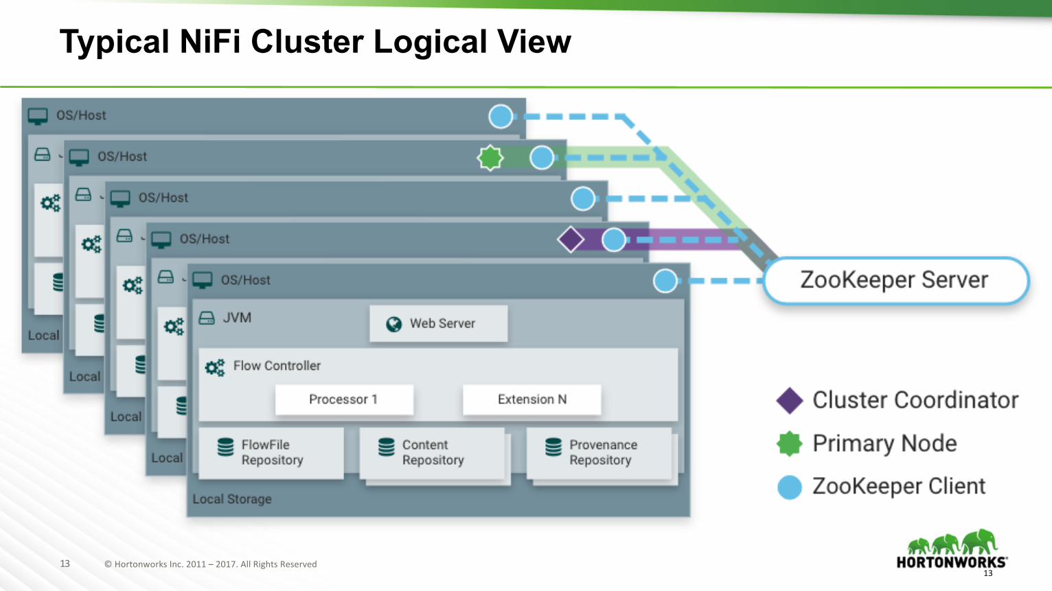
Typical NiFi Cluster Logical View
13
14 ©HortonworksInc.2011– 2017.AllRightsReserved
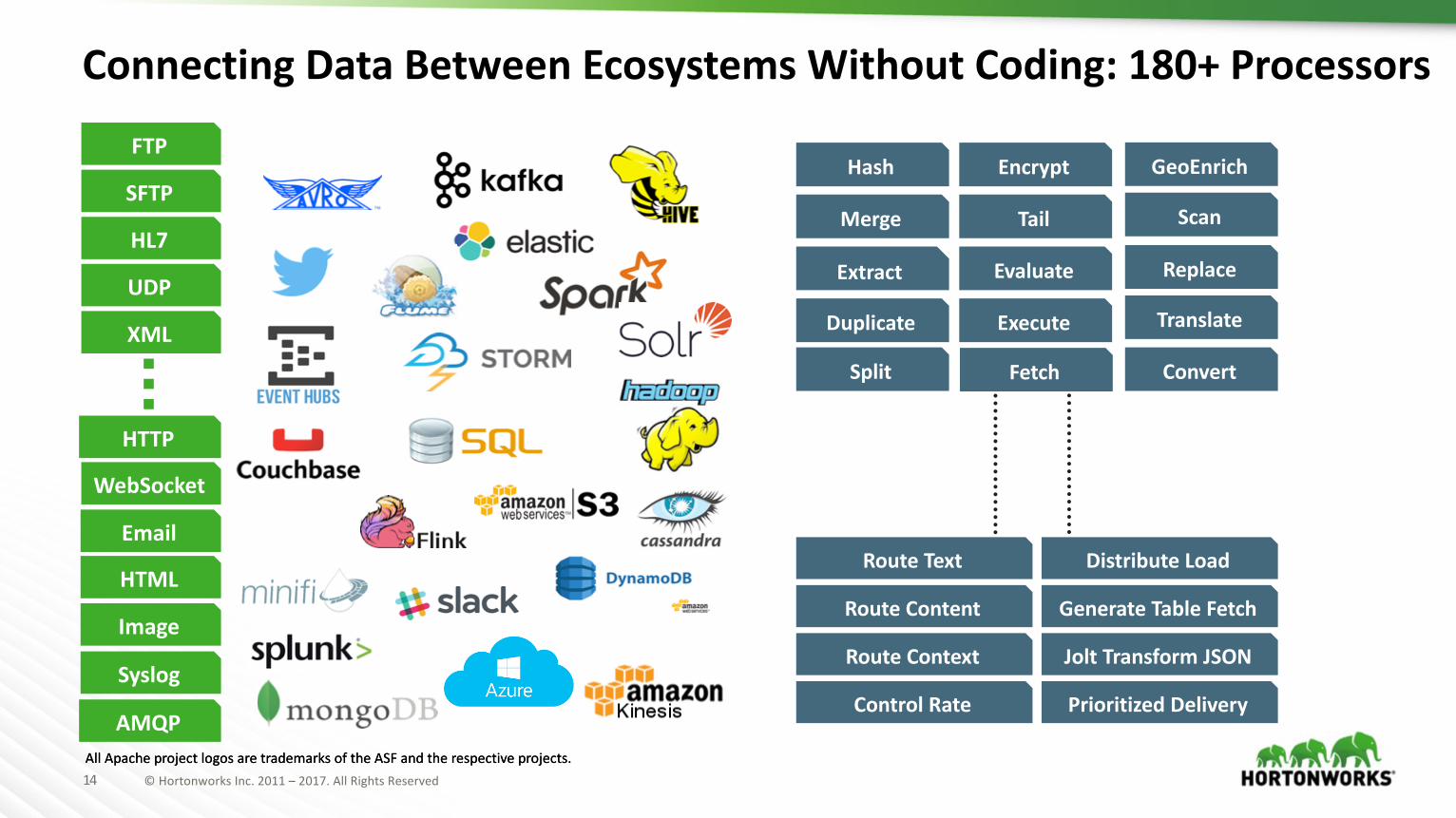
ConnectingDataBetweenEcosystemsWithoutCoding:180+Processors
AllApacheprojectlogosaretrademarksoftheASFandtherespectiveprojects.
Hash
Extract
Merge
Duplicate
Scan
GeoEnrich
Replace
ConvertSplit
Translate
RouteContent
RouteContext
RouteText
ControlRate
DistributeLoad
GenerateTableFetch
JoltTransformJSON
PrioritizedDelivery
Encrypt
Tail
Evaluate
Execute
AllApacheprojectlogosaretrademarksoftheASFandtherespectiveprojects.
Fetch
HTTP
Syslog
HTML
Image
HL7
FTP
UDP
XML
SFTP
AMQP
WebSocket
15 ©HortonworksInc.2011– 2017.AllRightsReserved
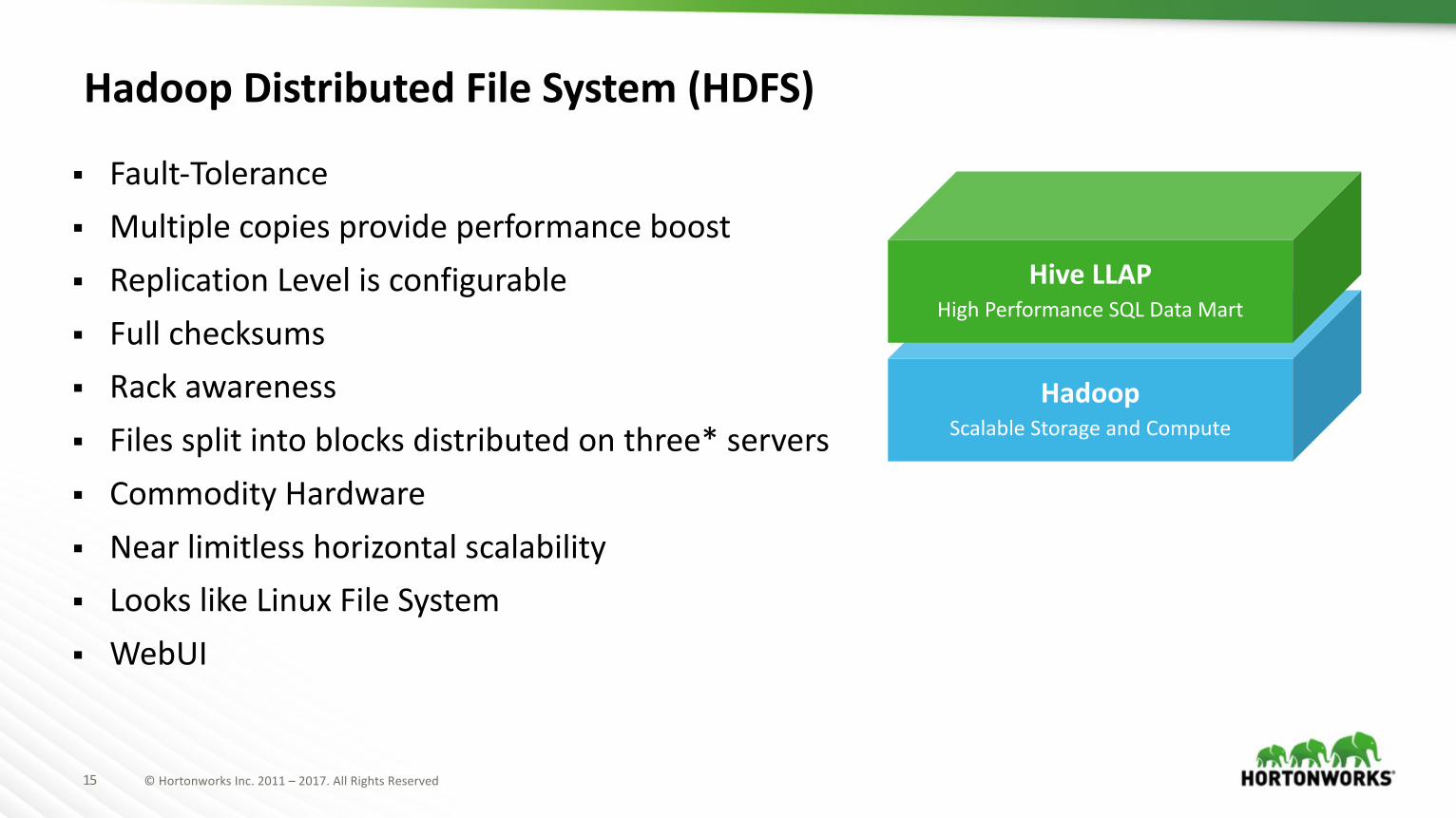
HadoopDistributedFileSystem(HDFS)
§ Fault-Tolerance§ Multiplecopiesprovideperformanceboost§ ReplicationLevelisconfigurable§ Fullchecksums§ Rackawareness§ Filessplitintoblocksdistributedonthree*servers§ CommodityHardware§ Nearlimitlesshorizontalscalability§ LookslikeLinuxFileSystem§ WebUI
HadoopScalableStorageandCompute
HiveLLAPHighPerformanceSQLDataMart
16 ©HortonworksInc.2011– 2017.AllRightsReserved
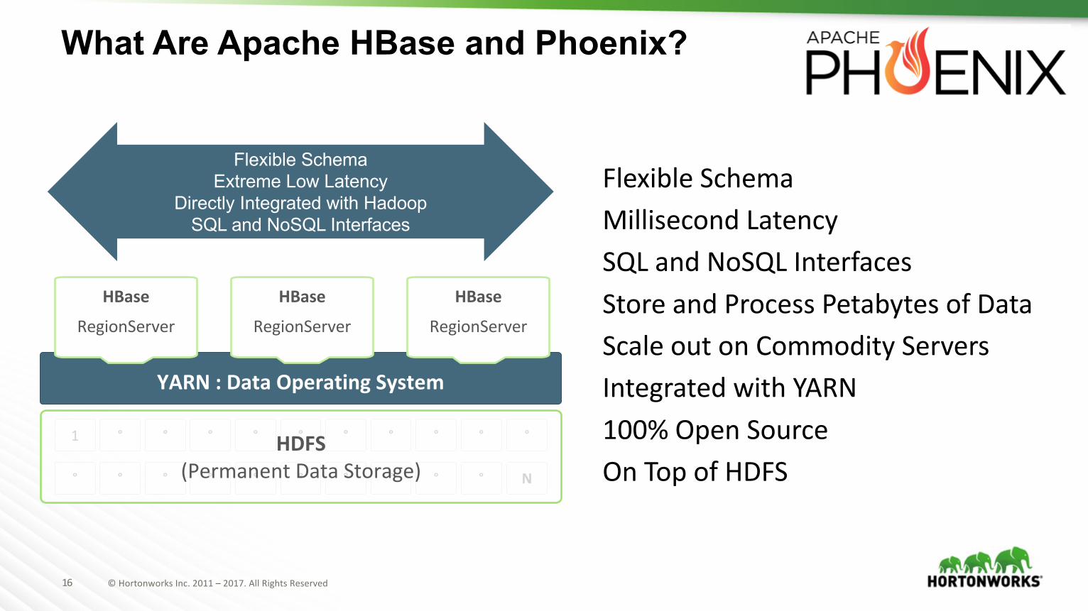
What Are Apache HBase and Phoenix?
FlexibleSchemaMillisecondLatencySQLandNoSQL InterfacesStoreandProcessPetabytesofDataScaleoutonCommodityServersIntegratedwithYARN100%OpenSourceOnTopofHDFS
YARN:DataOperatingSystem
HBase
RegionServer
1 ° ° ° ° ° ° ° ° ° °
° ° ° ° ° ° ° ° ° ° N
HDFS(PermanentDataStorage)
HBase
RegionServer
HBase
RegionServer
Flexible SchemaExtreme Low Latency
Directly Integrated with HadoopSQL and NoSQL Interfaces
17 ©HortonworksInc.2011– 2017.AllRightsReserved
WhatAreApachePhoenixandHBase?
Apache HBase is distributed database modeled after Google’s BigTable and designed toprovide real-time access to data in Hadoop. Apache Phoenix provides an ANSI SQLinterface to HBase.
Features:• Real-TimeDataManagementforHadoop• PB+Scale• ANSISQLInterface• SecondaryIndexes• Cross-DCReplication• Fine-GrainedSecurity• DevelopinJDBC,ODBC,.NET,andmore
18 ©HortonworksInc.2011– 2017.AllRightsReserved
WhatIsApacheHive?
ApacheHive isaSQLdatawarehouseinfrastructurethatdeliversfast,scalableSQLprocessingonHadoopandintheCloud.
Features:• ExtensiveSQL:2011Support• ACIDTransactions• In-MemoryCaching• Cost-BasedOptimizer• User-BasedDynamicSecurity• ReplicationandDisasterRecovery• JDBCandODBCSupport• CompatiblewitheverymajorBITool• Provenat300+PBScale• OnTopofHDFS

19 ©HortonworksInc.2011– 2017.AllRightsReserved
CODE!!!!
20 ©HortonworksInc.2011– 2017.AllRightsReserved
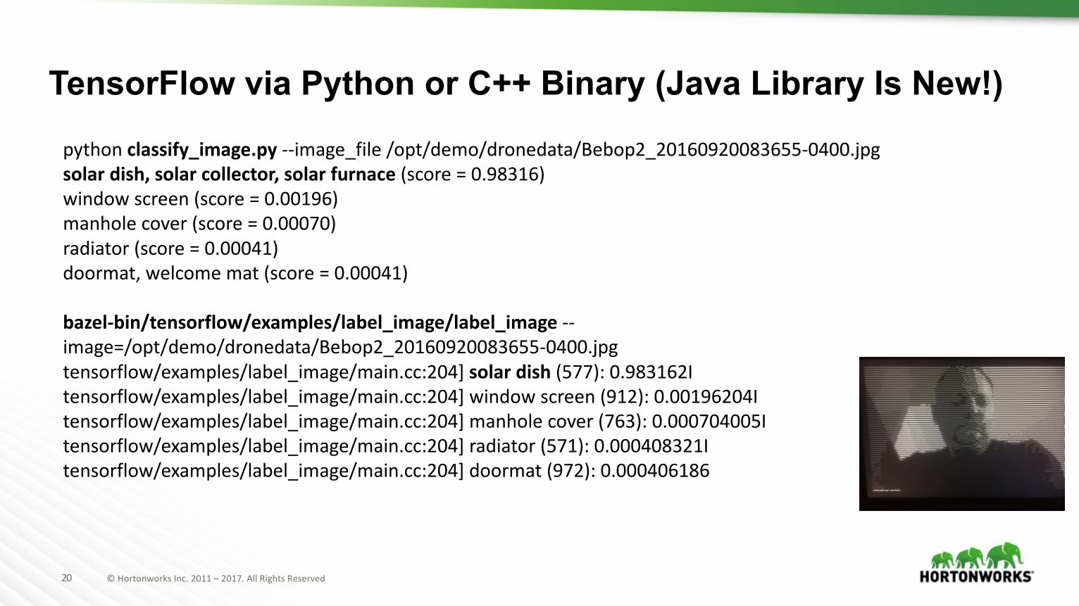
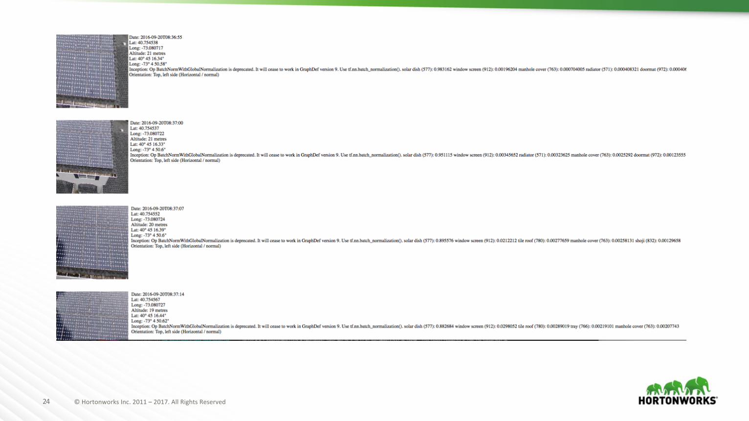
pythonclassify_image.py --image_file /opt/demo/dronedata/Bebop2_20160920083655-0400.jpgsolardish,solarcollector,solarfurnace(score=0.98316)windowscreen(score=0.00196)manholecover(score=0.00070)radiator(score=0.00041)doormat,welcomemat(score=0.00041)
bazel-bin/tensorflow/examples/label_image/label_image --image=/opt/demo/dronedata/Bebop2_20160920083655-0400.jpgtensorflow/examples/label_image/main.cc:204]solardish(577):0.983162Itensorflow/examples/label_image/main.cc:204]windowscreen(912):0.00196204Itensorflow/examples/label_image/main.cc:204]manholecover(763):0.000704005Itensorflow/examples/label_image/main.cc:204]radiator(571):0.000408321Itensorflow/examples/label_image/main.cc:204]doormat(972):0.000406186
TensorFlow via Python or C++ Binary (Java Library Is New!)
21 ©HortonworksInc.2011– 2017.AllRightsReserved
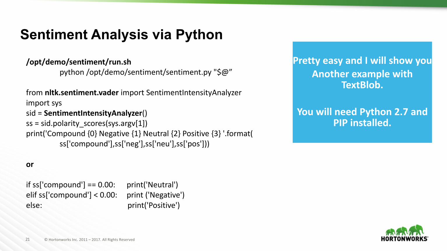
/opt/demo/sentiment/run.shpython/opt/demo/sentiment/sentiment.py "$@”
fromnltk.sentiment.vader importSentimentIntensityAnalyzerimportsyssid =SentimentIntensityAnalyzer()ss =sid.polarity_scores(sys.argv[1])print('Compound{0}Negative{1}Neutral{2}Positive{3}'.format(
ss['compound'],ss['neg'],ss['neu'],ss['pos']))
or
ifss['compound']==0.00: print('Neutral')elif ss['compound']<0.00: print('Negative')else: print('Positive')
Sentiment Analysis via PythonPrettyeasyandIwillshowyou
AnotherexamplewithTextBlob.
YouwillneedPython2.7andPIPinstalled.
22 ©HortonworksInc.2011– 2017.AllRightsReserved
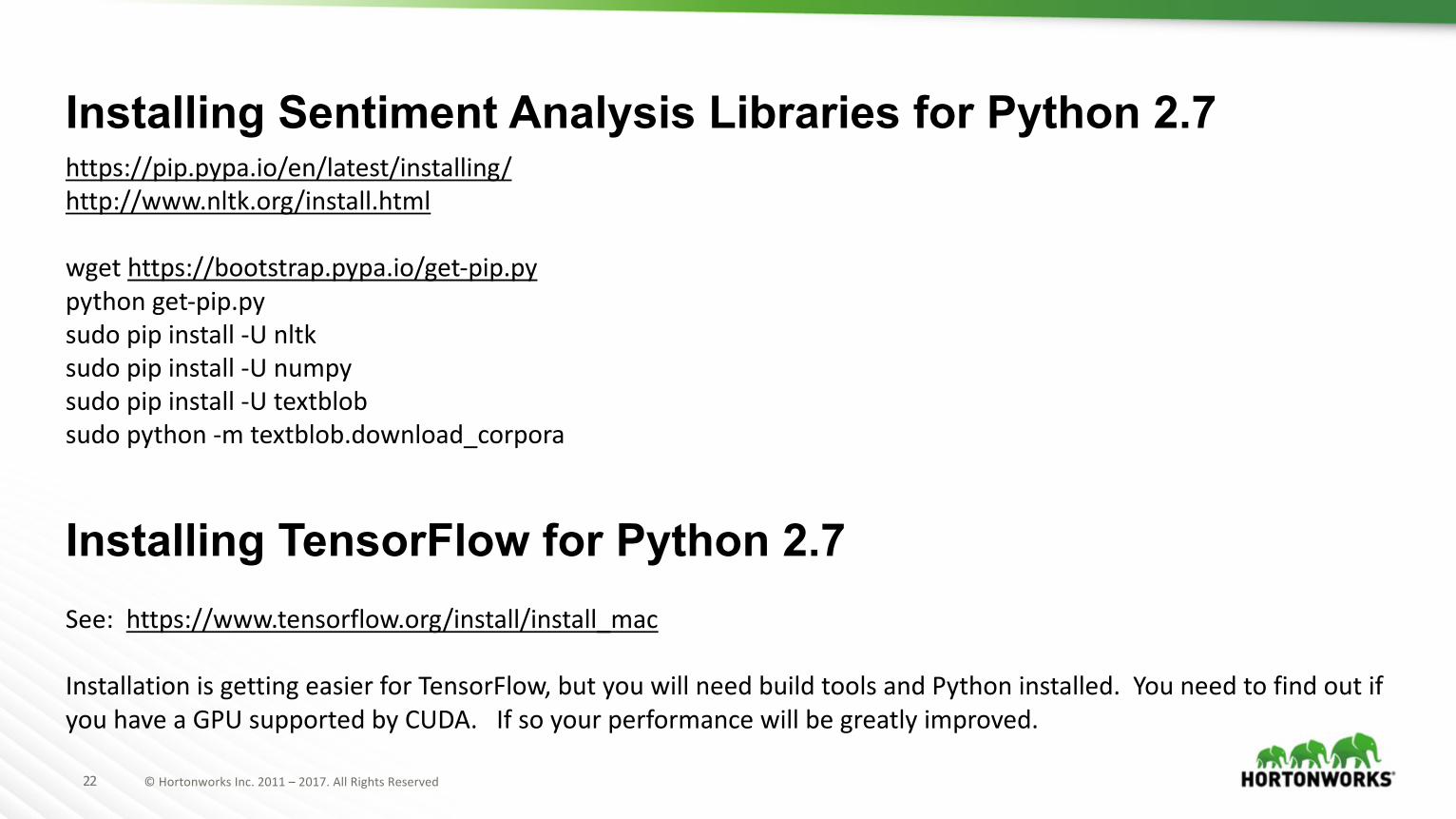
https://pip.pypa.io/en/latest/installing/http://www.nltk.org/install.html
wget https://bootstrap.pypa.io/get-pip.pypythonget-pip.pysudo pip install -U nltksudo pip install -U numpysudo pipinstall-Utextblobsudo python-mtextblob.download_corpora
Installing Sentiment Analysis Libraries for Python 2.7
Installing TensorFlow for Python 2.7See:https://www.tensorflow.org/install/install_mac
InstallationisgettingeasierforTensorFlow,butyouwillneedbuildtoolsandPythoninstalled.YouneedtofindoutifyouhaveaGPUsupportedbyCUDA.Ifsoyourperformancewillbegreatlyimproved.
23 ©HortonworksInc.2011– 2017.AllRightsReserved
24 ©HortonworksInc.2011– 2017.AllRightsReserved
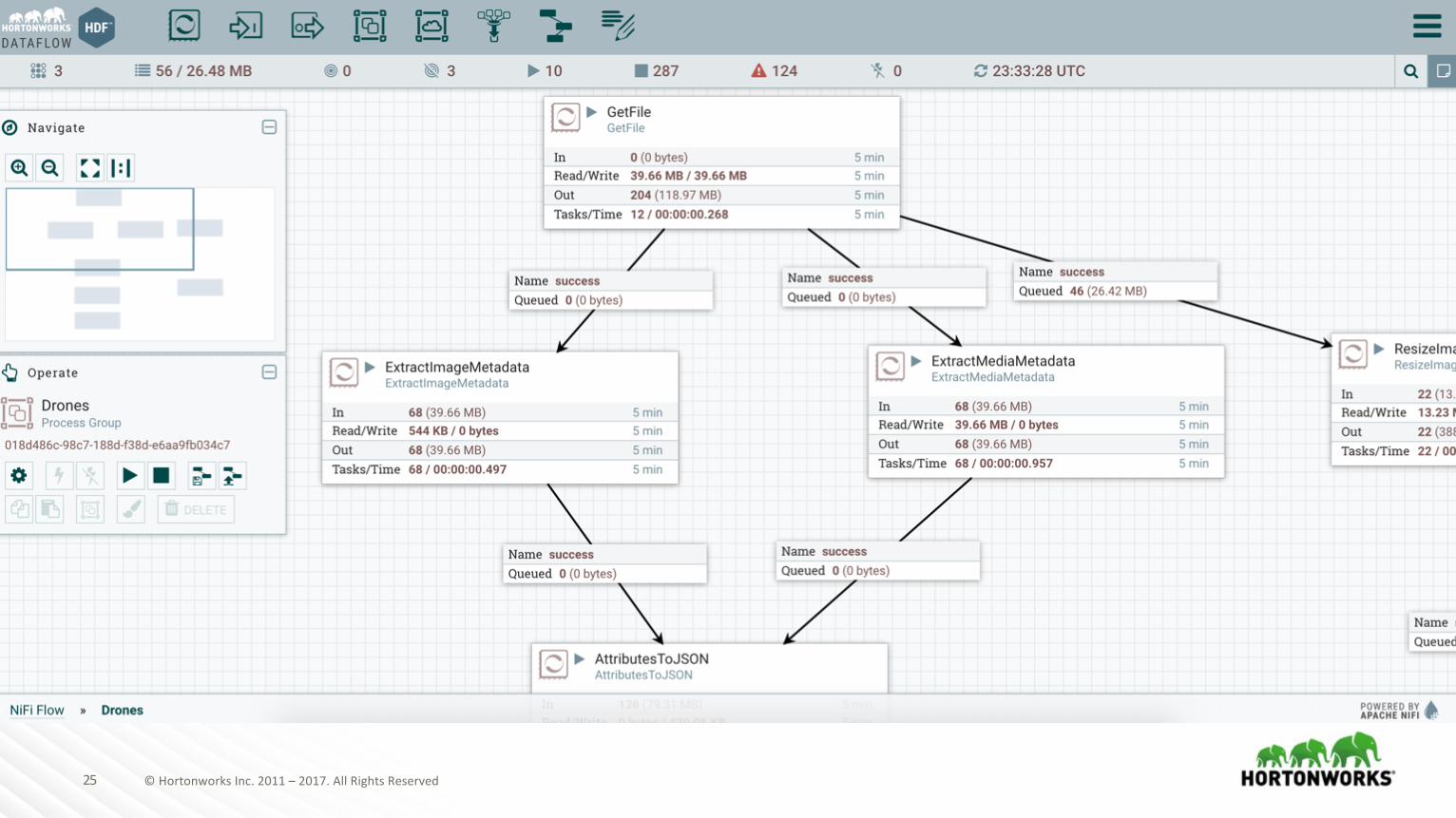
25 ©HortonworksInc.2011– 2017.AllRightsReserved
26 ©HortonworksInc.2011– 2017.AllRightsReserved
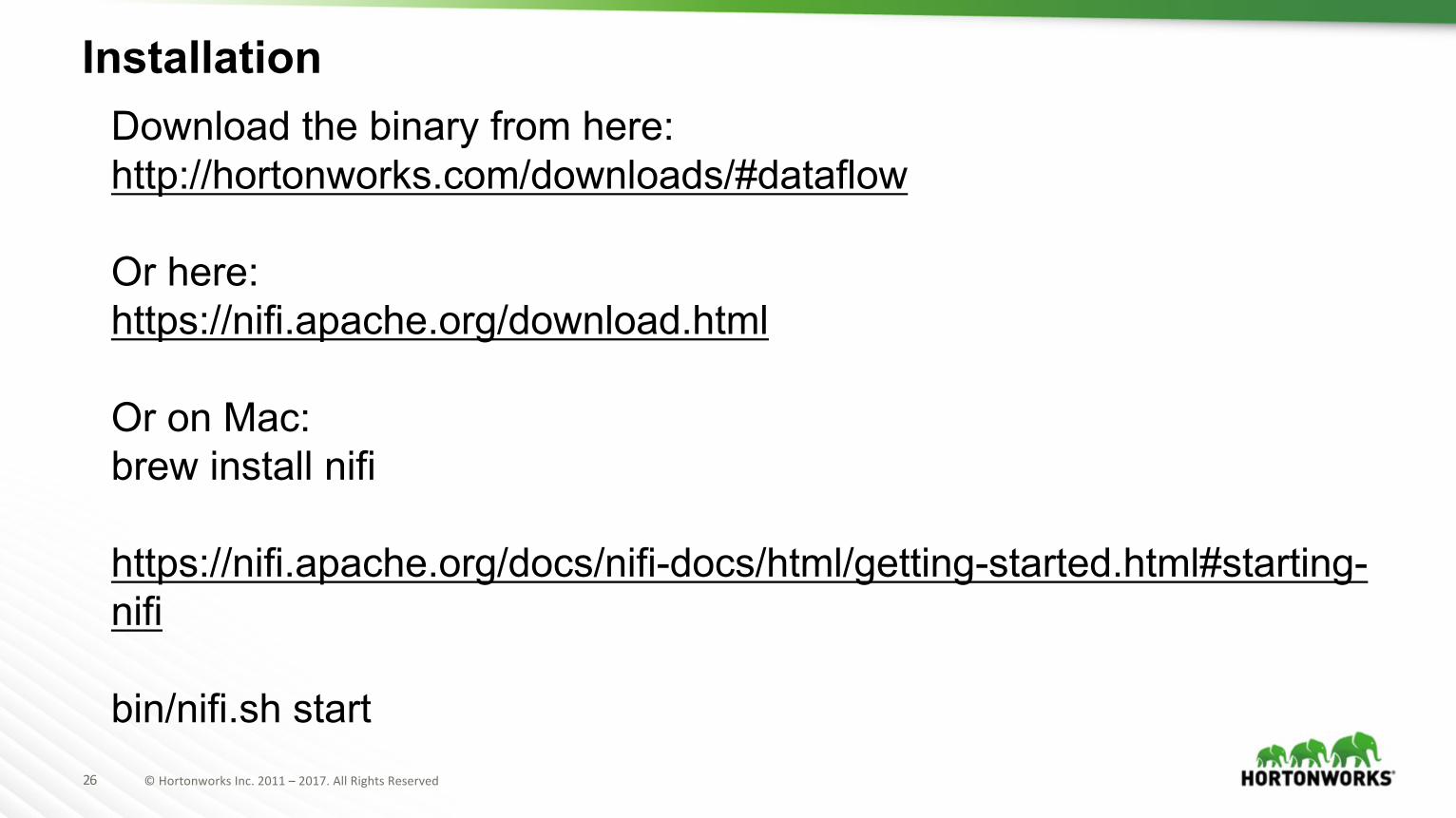
InstallationDownload the binary from here: http://hortonworks.com/downloads/#dataflow
Or here:https://nifi.apache.org/download.html
Or on Mac:brew install nifi
https://nifi.apache.org/docs/nifi-docs/html/getting-started.html#starting-nifi
bin/nifi.sh start
27 ©HortonworksInc.2011– 2017.AllRightsReserved
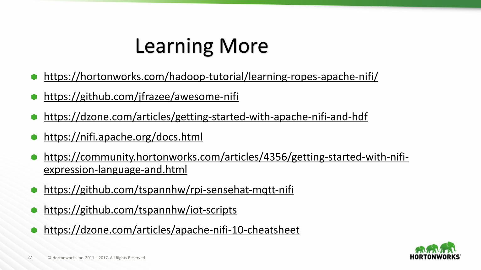
à https://hortonworks.com/hadoop-tutorial/learning-ropes-apache-nifi/
à https://github.com/jfrazee/awesome-nifi
à https://dzone.com/articles/getting-started-with-apache-nifi-and-hdf
à https://nifi.apache.org/docs.html
à https://community.hortonworks.com/articles/4356/getting-started-with-nifi-expression-language-and.html
à https://github.com/tspannhw/rpi-sensehat-mqtt-nifi
à https://github.com/tspannhw/iot-scripts
à https://dzone.com/articles/apache-nifi-10-cheatsheet
LearningMore
28 ©HortonworksInc.2011– 2017.AllRightsReserved
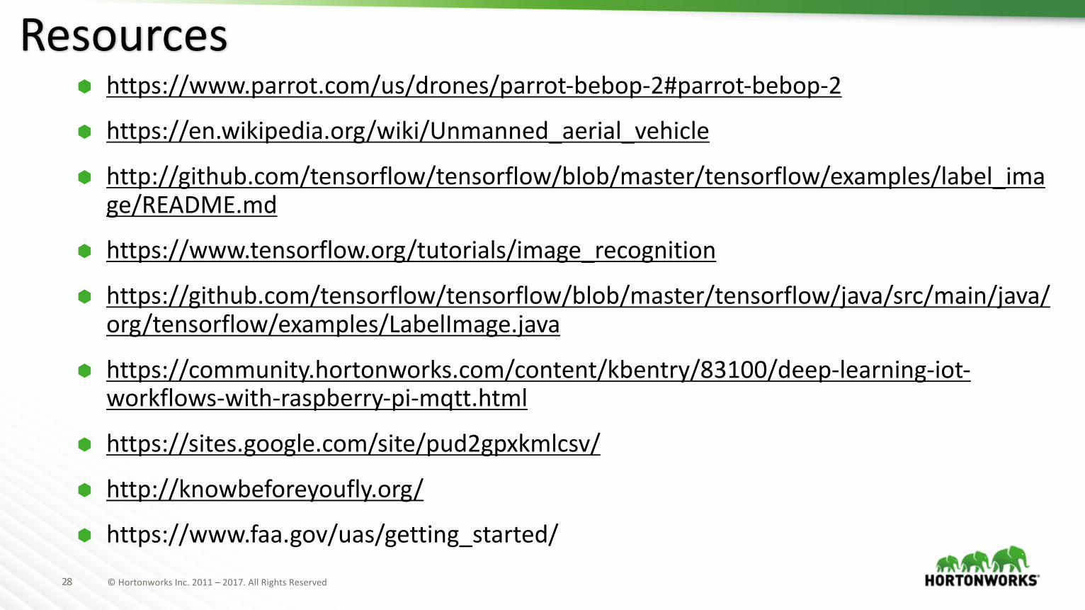
à https://www.parrot.com/us/drones/parrot-bebop-2#parrot-bebop-2
à https://en.wikipedia.org/wiki/Unmanned_aerial_vehicle
à http://github.com/tensorflow/tensorflow/blob/master/tensorflow/examples/label_image/README.md
à https://www.tensorflow.org/tutorials/image_recognition
à https://github.com/tensorflow/tensorflow/blob/master/tensorflow/java/src/main/java/org/tensorflow/examples/LabelImage.java
à https://community.hortonworks.com/content/kbentry/83100/deep-learning-iot-workflows-with-raspberry-pi-mqtt.html
à https://sites.google.com/site/pud2gpxkmlcsv/
à http://knowbeforeyoufly.org/
à https://www.faa.gov/uas/getting_started/
Resources
29 ©HortonworksInc.2011– 2017.AllRightsReserved
à KenKranz – DirectorofUASBigData atCognizant.@kenkranz
à JoeWitt- SeniorDirectorofEngineeringatHortonworks.@joewitt26
à ChrisCasano – SolutionEnngineer ManageratHortonworks.
à TomMcCuch – Sr.TechnicalDirectoratHortonworks.@tmccuch
à IngestingDroneDataintoBigDataPlatformshttps://github.com/tspannhw/IngestingDroneData
Thanks
30 ©HortonworksInc.2011– 2017.AllRightsReserved
Contact:
TimothySpann@PaaSDeV
www.meetup.com/futureofdata-princetonhttps://dzone.com/users/297029/bunkertor.htmlcommunity.hortonworks.com/users/9304/tspann.html
Recommended