‘Imageryand Beyond’ Jamie Ritchie
Esri

Imagery content is at the
heart of many GIS platforms

The power of imagery1
Delivering patterns2
3 Utilising with others

16 February 2016 4
For humanitarian benefit

May 2014: Major Floods in Serbia
© Copyright Airbus DS/CNES

© Copyright Airbus DS/CNES

© Copyright Airbus DS/CNES
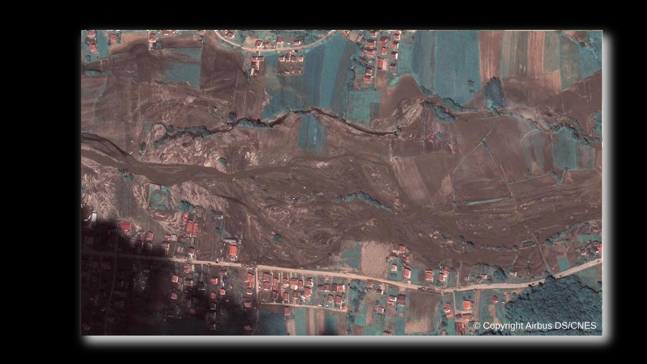
Kupanj - Pleiades
© Copyright Airbus DS/CNES

Change detection MDA??
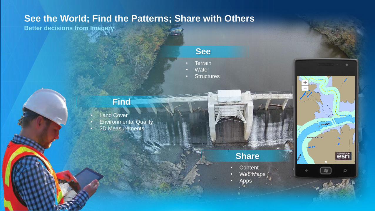
See the World; Find the Patterns; Share with Others
See
Better decisions from Imagery
Share
Find
• Terrain
• Water
• Structures
• Land Cover
• Environmental Quality
• 3D Measurements
• Content
• Web Maps
• Apps

Professional
Imagery &
Geospatial
Analysts
Server
The ArcGIS Platform is Highly Imagery CapableAdvanced Enterprise Imagery Management enables the entire platform
System of
Record
System of
Insight
System of
Engagement
Image
Processing
&
Analytics
FindPatterns
Remotely
Sensed Content
See
Sharing &
Collaboration
Share

ArcGIS
Drone2Map for ArcGIS
Turn Drones into Enterprise Productivity Tools

Drone2Map for ArcGIS
Drones become more than just image capture devices
Ortho Mosaics
3D Point Clouds and Meshes
Smart Inspection Photos
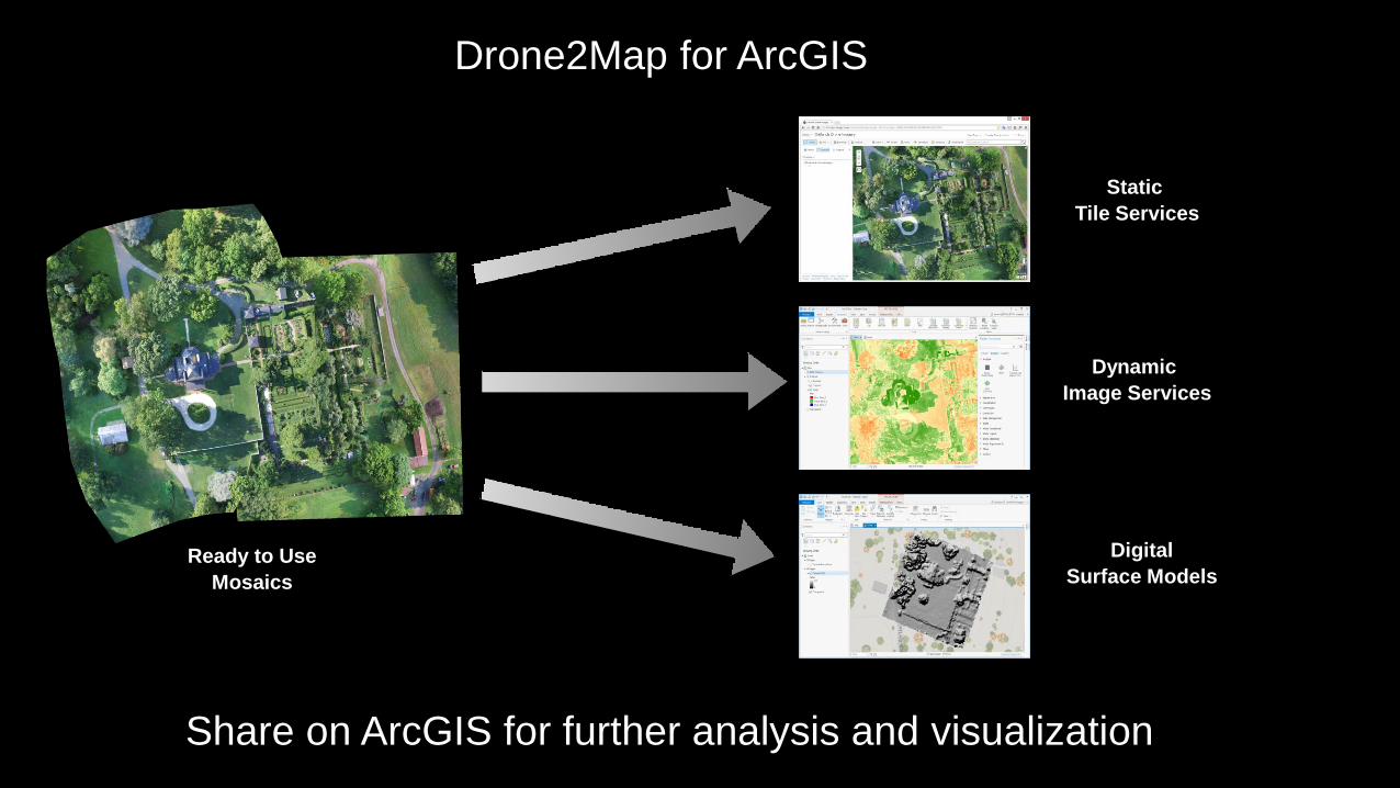
Drone2Map for ArcGIS
Share on ArcGIS for further analysis and visualization
Static
Tile Services
Ready to Use
Mosaics
Dynamic
Image Services
Digital
Surface Models

Drone2Map for ArcGIS
Consume in ArcGIS Earth and other 3D products
3D Point Clouds
and Meshes
3D Web Scenes in
ArcGIS Online and Portal

Drone2Map for ArcGIS
Share and Use High Resolution Photos for Inspections
Oblique Imagery Smart Inspection
on Web and Desktop

ArcGIS
Drone2Map for ArcGIS
What Will Your Drone Do For You?

• Desktop App (.NET Runtime)
• Annual Subscription Fee
(“Premium App”)
• Licensed per named user
(ArcGIS Online or Portal)
• Allow for ‘offline’ use (e.g.
field work)
• CatB or CatC product
• Final Pricing TBD
Named UserDrone2Map License
Assigned by administrator
Drone2Map for ArcGIS
Leverage Your ArcGIS Identity
ArcGIS

Supporting Single Scenes . . .
. . . and Massive Collections
• Integrated Analysis Tools (100+)
• New Workflow Templates
• Additional Sensor Support
Managing, Analyzing, and Serving Remotely Sensed Data
Image Classification
Accuracy Assessment
Oblique Imagery and Measurements
Object-Based Image Analysis
Dynamic Processing Chains
Scientific Data
Full-Motion Video
UAV/Drone Support
Imagery

• MarketPlace
• Esri Provided
• Build-your-own
Content
Imagery
Services
• Change Detection
• Land Cover Analysis
• Feature Extraction
Workflows &
Models
Analytics:
The Power of the Imagery PlatformBringing it all together
Web Apps
• Templates
• Widgets
• Dynamic
Content
ArcGIS
Operators
SEE the Earth
FIND the patterns SHARE with others
Recommended