GSICS Coordination Center Activities
Manik Bali (ESSIC/CISSES), Lawrence E Flynn and Mitch Goldberg(NOAA)
11th November 2019CISESS Science Meeting
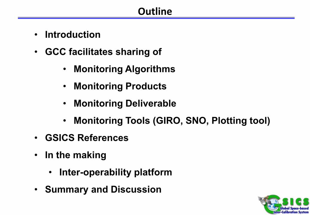
Outline
• Introduction
• GCC facilitates sharing of
• Monitoring Algorithms
• Monitoring Products
• Monitoring Deliverable
• Monitoring Tools (GIRO, SNO, Plotting tool)
• GSICS References
• In the making
• Inter-operability platform
• Summary and Discussion
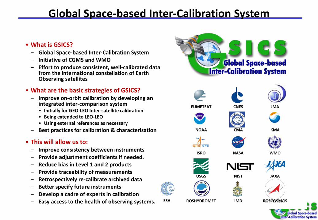
Global Space-based Inter-Calibration System
• What is GSICS?– Global Space-based Inter-Calibration System– Initiative of CGMS and WMO– Effort to produce consistent, well-calibrated data
from the international constellation of Earth Observing satellites
• What are the basic strategies of GSICS?– Improve on-orbit calibration by developing an
integrated inter-comparison system• Initially for GEO-LEO Inter-satellite calibration• Being extended to LEO-LEO• Using external references as necessary
– Best practices for calibration & characterisation
• This will allow us to:– Improve consistency between instruments– Provide adjustment coefficients if needed.– Reduce bias in Level 1 and 2 products– Provide traceability of measurements– Retrospectively re-calibrate archived data– Better specify future instruments– Develop a cadre of experts in calibration– Easy access to the health of observing systems.
EUMETSAT CNES JMA
NOAA CMA KMA
ISRO NASA WMO
USGS NIST JAXA
ROSHYDROMET IMD ROSCOSMOSESA
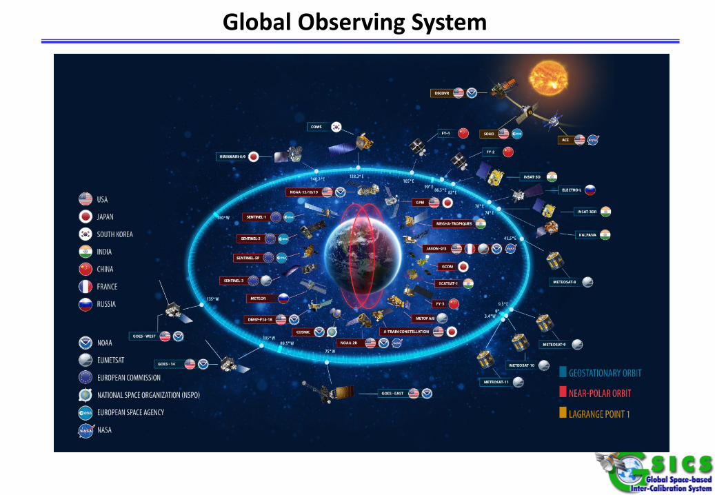
Global Observing System
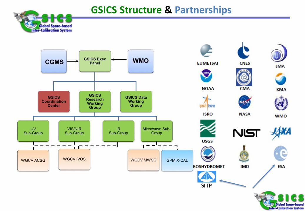
GSICS Structure & Partnerships
New members
GSICS Exec Panel
GSICS Coordination
Center
GSICS Research Working Group
UV Sub-Group
WGCV ACSG
VIS/NIR Sub-Group
WGCV IVOS
IR Sub-Group
Microwave Sub-Group
WGCV MWSG GPM X-CAL
GSICS Data Working Group
CGMS WMO
6
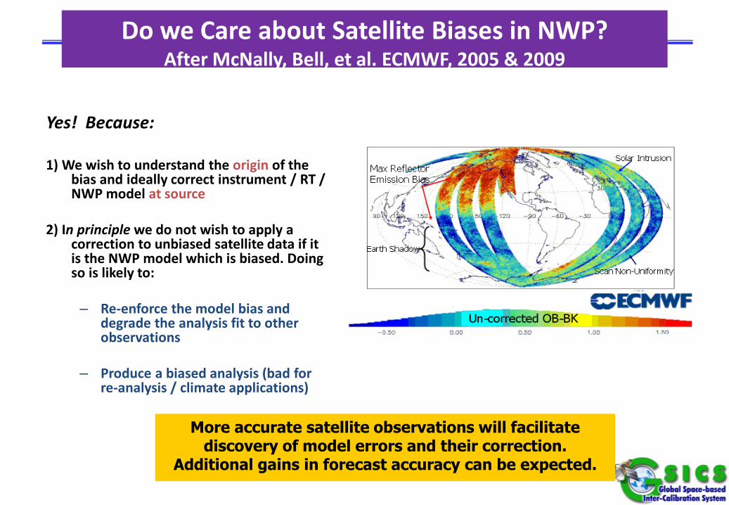
Do we Care about Satellite Biases in NWP?After McNally, Bell, et al. ECMWF, 2005 & 2009
Yes! Because:
1) We wish to understand the origin of the bias and ideally correct instrument / RT / NWP model at source
2) In principle we do not wish to apply a correction to unbiased satellite data if it is the NWP model which is biased. Doing so is likely to:
– Re-enforce the model bias and degrade the analysis fit to other observations
– Produce a biased analysis (bad for re-analysis / climate applications)
More accurate satellite observations will facilitate discovery of model errors and their correction.
Additional gains in forecast accuracy can be expected.
SSMIS calibration biases cause regional weather patterns
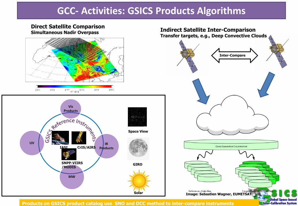
GCC- Activities: GSICS Products AlgorithmsDirect Satellite ComparisonSimultaneous Nadir Overpass Indirect Satellite Inter-Comparison
Transfer targets, e.g., Deep Convective Clouds
IR Products
Vis Products
MW
UVCrIS/AIRSIASI
SNPP-VIIRS/MODIS
Products on GSICS product catalog use SNO and DCC method to inter-compare instruments
GIRO
Solar
Space View
Image: Sebastien Wagner, EUMETSAT
Inter-Compare
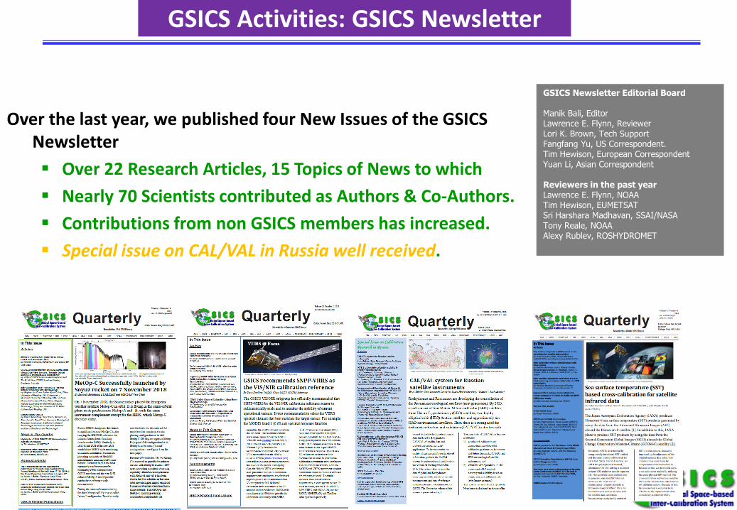
GSICS Activities: GSICS Newsletter
Over the last year, we published four New Issues of the GSICS Newsletter Over 22 Research Articles, 15 Topics of News to which Nearly 70 Scientists contributed as Authors & Co-Authors. Contributions from non GSICS members has increased. Special issue on CAL/VAL in Russia well received.
GSICS Newsletter Editorial Board
Manik Bali, Editor Lawrence E. Flynn, Reviewer Lori K. Brown, Tech Support Fangfang Yu, US Correspondent. Tim Hewison, European Correspondent Yuan Li, Asian Correspondent
Reviewers in the past yearLawrence E. Flynn, NOAATim Hewison, EUMETSATSri Harshara Madhavan, SSAI/NASATony Reale, NOAAAlexy Rublev, ROSHYDROMET
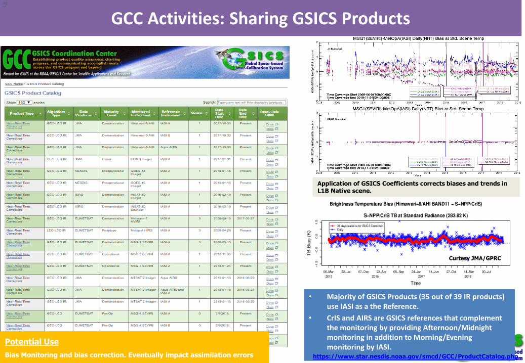
GCC Activities: Sharing GSICS Products
• Majority of GSICS Products (35 out of 39 IR products) use IASI as a the Reference.
• CrIS and AIRS are GSICS references that complement the monitoring by providing Afternoon/Midnight monitoring in addition to Morning/Evening monitoring by IASI.
Application of GSICS Coefficients corrects biases and trends in L1B Native scene.
Curtesy JMA/GPRC
Potential UseBias Monitoring and bias correction. Eventually impact assimilation errors https://www.star.nesdis.noaa.gov/smcd/GCC/ProductCatalog.php
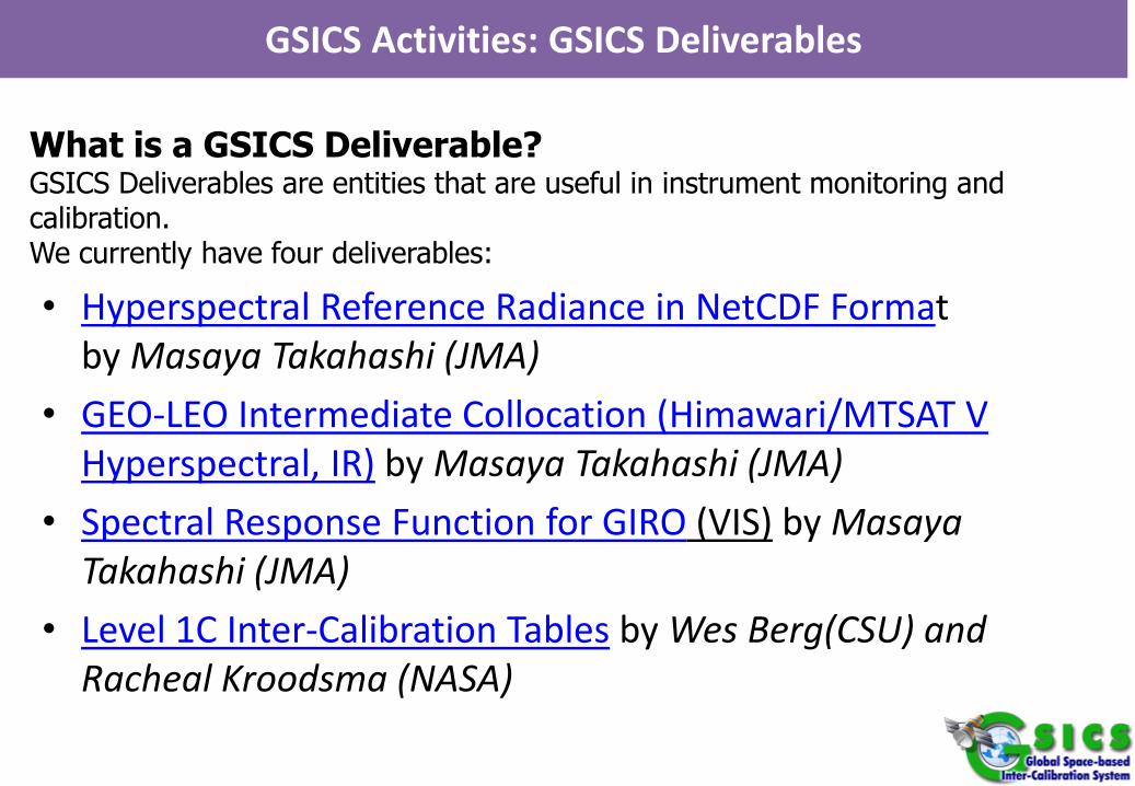
• Hyperspectral Reference Radiance in NetCDF Format by Masaya Takahashi (JMA)
• GEO-LEO Intermediate Collocation (Himawari/MTSAT V Hyperspectral, IR) by Masaya Takahashi (JMA)
• Spectral Response Function for GIRO (VIS) by Masaya Takahashi (JMA)
• Level 1C Inter-Calibration Tables by Wes Berg(CSU) and Racheal Kroodsma (NASA)
GSICS Activities: GSICS Deliverables
What is a GSICS Deliverable?GSICS Deliverables are entities that are useful in instrument monitoring and calibration.We currently have four deliverables:
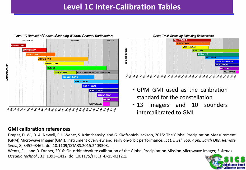
• GPM GMI used as the calibrationstandard for the constellation
• 13 imagers and 10 soundersintercalibrated to GMI
GMI calibration referencesDraper, D. W., D. A. Newell, F. J. Wentz, S. Krimchansky, and G. Skofronick-Jackson, 2015: The Global Precipitation Measurement (GPM) Microwave Imager (GMI): Instrument overview and early on-orbit performance. IEEE J. Sel. Top. Appl. Earth Obs. Remote Sens., 8, 3452–3462, doi:10.1109/JSTARS.2015.2403303.Wentz, F. J. and D. Draper, 2016: On-orbit absolute calibration of the Global Precipitation Mission Microwave Imager, J. Atmos. Oceanic Technol., 33, 1393–1412, doi:10.1175/JTECH-D-15-0212.1.
Level 1C Inter-Calibration Tables
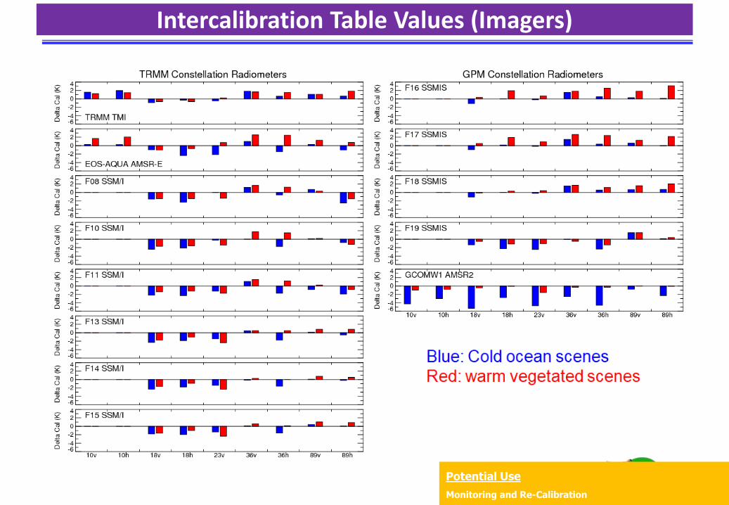
Intercalibration Table Values (Imagers)
Potential UseMonitoring and Re-Calibration
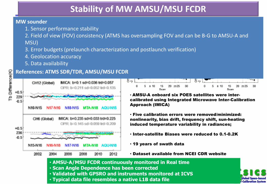
• AMSU-A/MSU FCDR continuously monitored in Real time• Scan Angle Dependence has been corrected• Validated with GPSRO and instruments monitored at ICVS• Typical data file resembles a native L1B data file
Stability of MW AMSU/MSU FCDR
• AMSU-A onboard six POES satellites were inter-calibrated using Integrated Microwave Inter-Calibration Approach (IMICA)
• Five calibration errors were removed/minimized: nonlinearity, bias drift, frequency shift, sun-heating induced temperature variability in radiances;
• Inter-satellite Biases were reduced to 0.1-0.2K
• 19 years of swath data
• Dataset available from NCEI CDR website
MW sounder1. Sensor performance stability2. Field of view (FOV) consistency (ATMS has oversampling FOV and can be B-G to AMSU-A and MSU)3. Error budgets (prelaunch characterization and postlaunch verification)4. Geolocation accuracy5. Data availability
References: ATMS SDR/TDR, AMSU/MSU FCDR
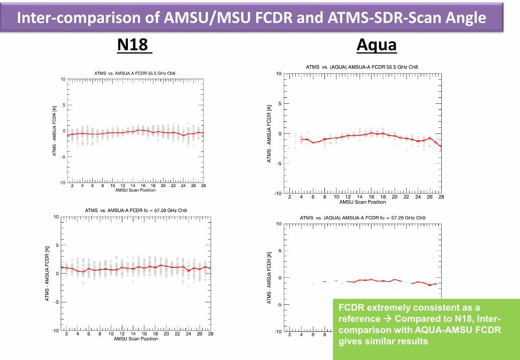
N18 AquaInter-comparison of AMSU/MSU FCDR and ATMS-SDR-Scan Angle
FCDR extremely consistent as a reference Compared to N18, Inter-comparison with AQUA-AMSU FCDR gives similar results
In-Orbit Reference for VIS• GSICS recommends SNPP-VIIRS as the VIS/NIR calibration reference
MODIS is ageing and will deorbit in the early 2020’s.• SNPP-VIIRS is a design improvement over MODIS, and there will be 4
more successive VIIRS sensors all in the same orbit.• There are many VIIRS calibrated datasets, such as NASA and NOAA.
NOAA has the official archive. • NOAA has a version 2 calibrated dataset that contains their best
calibration, but it is not available at the CLASS archive. It will take at least a year to reprocess the VIIRS datasets.
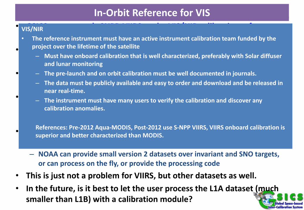
• We are in discussion with NOAA on how to get the version 2 calibration out to the calibration community– NOAA can provide small version 2 datasets over invariant and SNO targets,
or can process on the fly, or provide the processing code
• This is just not a problem for VIIRS, but other datasets as well.• In the future, is it best to let the user process the L1A dataset (much
smaller than L1B) with a calibration module?
VIS/NIR• The reference instrument must have an active instrument calibration team funded by the
project over the lifetime of the satellite– Must have onboard calibration that is well characterized, preferably with Solar diffuser
and lunar monitoring– The pre-launch and on orbit calibration must be well documented in journals.– The data must be publicly available and easy to order and download and be released in
near real-time.– The instrument must have many users to verify the calibration and discover any
calibration anomalies.
References: Pre-2012 Aqua-MODIS, Post-2012 use S-NPP VIIRS, VIIRS onboard calibration is superior and better characterized than MODIS.
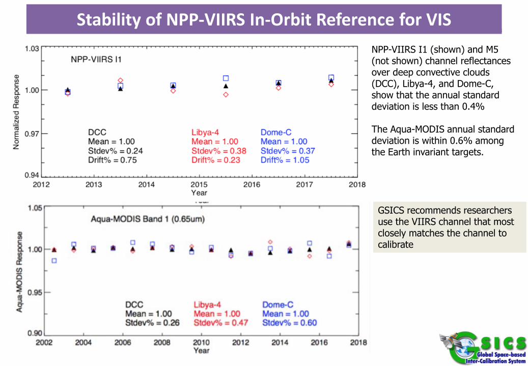
Stability of NPP-VIIRS In-Orbit Reference for VIS
GSICS recommends researchers use the VIIRS channel that most closely matches the channel to calibrate
NPP-VIIRS I1 (shown) and M5 (not shown) channel reflectancesover deep convective clouds (DCC), Libya-4, and Dome-C, show that the annual standard deviation is less than 0.4%
The Aqua-MODIS annual standard deviation is within 0.6% among the Earth invariant targets.
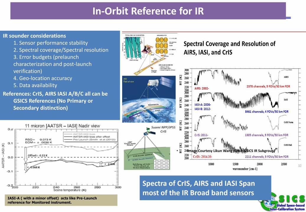
Spectra of CrIS, AIRS and IASI Span most of the IR Broad band sensors
In-Orbit Reference for IR
• Image Courtesy Likun Wang (Chair GSICS IR Subgroup)
IR sounder considerations1. Sensor performance stability2. Spectral coverage/Spectral resolution3. Error budgets (prelaunch characterization and post-launch verification)4. Geo-location accuracy5. Data availability
References: CrIS, AIRS IASI A/B/C all can be GSICS References (No Primary or Secondary distinction)
IASI-A ( with a minor offset) acts like Pre-Launch reference for Monitored instrument.
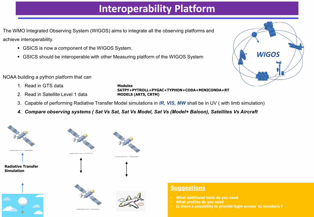
Interoperability Platform
The WMO Integrated Observing System (WIGOS) aims to integrate all the observing platforms and
achieve interoperability.
GSICS is now a component of the WIGOS System.
GSICS should be interoperable with other Measuring platform of the WIGOS System
NOAA building a python platform that can
1. Read in GTS data
2. Read in Satellite Level 1 data
3. Capable of performing Radiative Transfer Model simulations in IR, VIS, MW shall be in UV ( with limb simulation)
4. Compare observing systems ( Sat Vs Sat, Sat Vs Model, Sat Vs (Model+ Baloon), Satellites Vs Aircraft
Radiative Transfer Simulation
ModulesSATPY+PYTROLL+PYGAC+TYPHON+CODA+MINICONDA+RT MODELS (ARTS, CRTM)
Suggestions• What additional tools do you need• What profiles do you need• Is there a possibility to provide login access to members ?
• GSICS has over 60 inter-comparision products that aim to monitor GEO and LEO instruments by
comparing them with IASI, AIRS and CrIS for the IR and MODIS and VIIRs for the Visible.
• Potential use
• Bias Correction
• Re-Calibration
• Create FCDR
• GSICS has four deliverables. These include GIRO SRF, SNO Intermediate products and SSMI series
inter-comparision table
• GSICS References are CrIS family, IASI family , AIRS and VIIRS family
• A New inter-operability platform that has the capability to inter-compare components of the
WIGOS system is being built on a python platform using public tools such as Pytroll, PyGAC,
Satpy and Typhon. Suggestions welcomed.
Summary & Conclusion
THANK YOU
Deliverable – IASI-A Reference Radiance
1. Objective of the Deliverable - Why the Group/Subgroup/Communityneeds it?Some GSICS agencies need to use reference LEO L1 subset for their GEO-LEOcollocation to generate GSICS inter-calibration products.
2. How is it created?Data provider (IASI L1C by EUMETSAT) creates and makes it availableon the GSICS Collaboration Server based on user's requests.
3. How do you use it?Use the file as an input for inter-calibration ATBD.
4. References: Publications, websites etc.EUMETSAT GSICS Collaboration Server:http://gsics.eumetsat.int/thredds/catalog.html
Potential UseIASI Reference radiances can be used directly for monitoring instruments. Easy to read NetCDF format.
1. Objective of the Deliverable - Why the Group/Subgroup/Communityneeds it?Input for deriving inter-calibration coefficients, which is mainly used byproducers of GSICS products, but may be useful for other users.
2. How is it created?Created by producers of GSICS Products (e.g. JMA)
3. How do you use it?The data are used by the producers to generate GSICS Correction. Otherusers may want to replicate the process, or use them for their researchpurpose.
4. References: Publications, websites etc.Convention (template):http://gsics.atmos.umd.edu/bin/view/Development/NetcdfConvention#Collocation_DataData (example of JMA's data):http://gsics.eumetsat.int/thredds/jmaIntermediate.html (Data transfer wasstopped in 2018 due to slow FTP connection: root causes are underinvestigation)
Deliverable – GEO-LEO Intermediate Collocation Data
Potential UseIntermediate data can be used to understand the impact of apply thresholds on bias
Spectral Response Function for GIRO
1. Objective of the Deliverable - Why the Group/Subgroup/Communityneeds it?To support GSICS activities such as Lunar Calibration using GIRO (GSICSImplementation of the ROLO model)
2. How is it created?GDWG Chair basically has created based on users' requests, but some usersalso generate the files by themselves by referring the followingConvention or document.
3. How do you use it?To use as an input file to execute GIRO and other applications for GSICSresearch
4. References:Convention (document is attached on the page):http://gsics.atmos.umd.edu/bin/view/Development/SrfNcdfConventionDocument for GIRO:http://gsics.atmos.umd.edu/pub/Development/LunarWorkArea/GSICS_ROLO_HighLevDescript_IODefinition.pdf5. Deliverable Locationhttp://gsics.atmos.umd.edu/bin/view/Development/Srf4Giro
Potential UseSRF used by GIRO can be used for Lunar Radiance Simulation
Recommended