REGIONAL TECTONIC CONTEXT
PLATE 3.1
Laurentian sub-basin study - CANADA – June 2014
Regional Tectonic Context
CHAPTER 3
REGIONAL TECTONIC CONTEXT
REGIONAL TECTONIC CONTEXT
PLATE 3.2
Laurentian sub-basin study - CANADA – June 2014
Bathymetry and gravimetric anomaly maps : main tectonic features
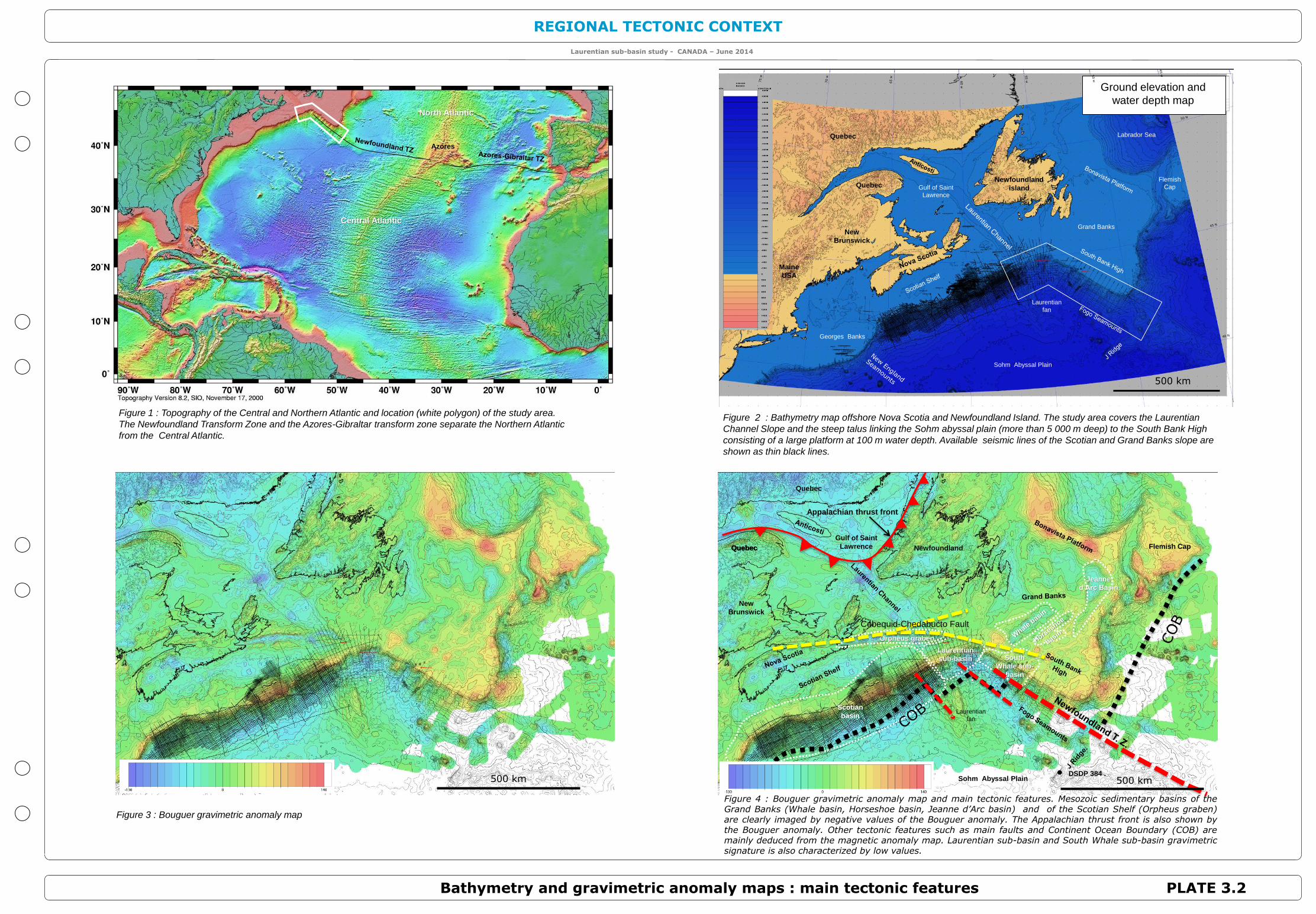
Figure 2 : Bathymetry map offshore Nova Scotia and Newfoundland Island. The study area covers the Laurentian
Channel Slope and the steep talus linking the Sohm abyssal plain (more than 5 000 m deep) to the South Bank High
consisting of a large platform at 100 m water depth. Available seismic lines of the Scotian and Grand Banks slope are
shown as thin black lines.
Figure 3 : Bouguer gravimetric anomaly map
New
Brunswick
Quebec
Quebec
Gulf of Saint
Lawrence
Grand Banks
Flemish
Cap
Sohm Abyssal Plain
Georges Banks
Maine
USA
Laurentian
fan
Labrador Sea
Newfoundland
island
Ground elevation and
water depth map North Atlantic
Central Atlantic
Azores
Newfoundland Flemish Cap
DSDP 384 .
Quebec
New
Brunswick
Jeanne
d’Arc Basin
Scotian
basin
Laurentian
sub-basin South
Whale sub-
basin
Orpheus graben
Quebec
Gulf of Saint
Lawrence
Sohm Abyssal Plain
Cobequid-Chedabucto Fault
Appalachian thrust front
Quebec
Figure 1 : Topography of the Central and Northern Atlantic and location (white polygon) of the study area.
The Newfoundland Transform Zone and the Azores-Gibraltar transform zone separate the Northern Atlantic
from the Central Atlantic.
Figure 4 : Bouguer gravimetric anomaly map and main tectonic features. Mesozoic sedimentary basins of theGrand Banks (Whale basin, Horseshoe basin, Jeanne d’Arc basin) and of the Scotian Shelf (Orpheus graben)are clearly imaged by negative values of the Bouguer anomaly. The Appalachian thrust front is also shown bythe Bouguer anomaly. Other tectonic features such as main faults and Continent Ocean Boundary (COB) aremainly deduced from the magnetic anomaly map. Laurentian sub-basin and South Whale sub-basin gravimetricsignature is also characterized by low values.
Laurentian
fan
500 km
500 km500 km
REGIONAL TECTONIC CONTEXT
PLATE 3.3
Laurentian sub-basin study - CANADA – June 2014
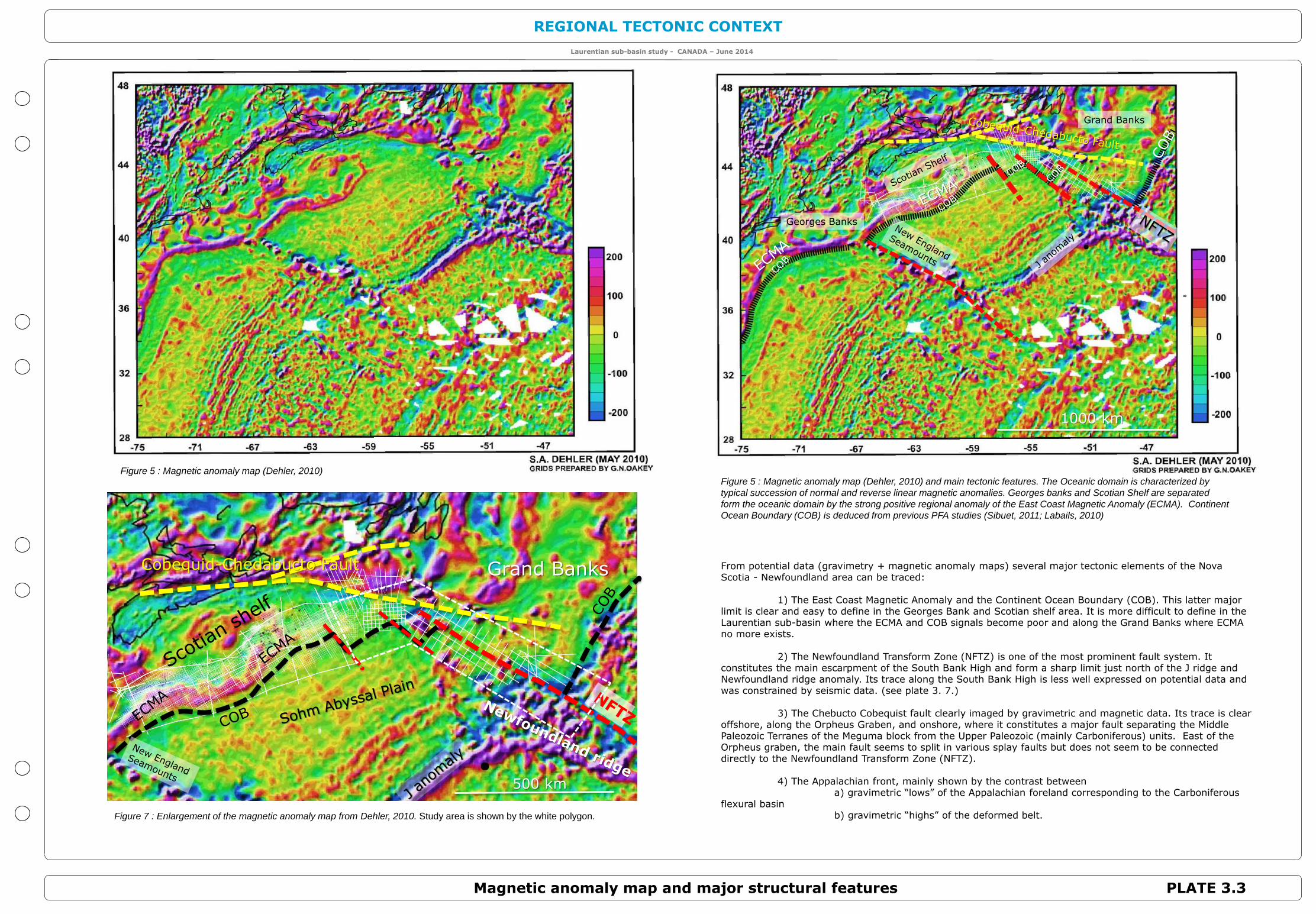
Magnetic anomaly map and major structural features
1000 km
Grand Banks
Grand BanksCobequid-Chedabucto Fault
500 km
Figure 5 : Magnetic anomaly map (Dehler, 2010)Figure 5 : Magnetic anomaly map (Dehler, 2010) and main tectonic features. The Oceanic domain is characterized by
typical succession of normal and reverse linear magnetic anomalies. Georges banks and Scotian Shelf are separated
form the oceanic domain by the strong positive regional anomaly of the East Coast Magnetic Anomaly (ECMA). Continent
Ocean Boundary (COB) is deduced from previous PFA studies (Sibuet, 2011; Labails, 2010)
Georges Banks
Figure 7 : Enlargement of the magnetic anomaly map from Dehler, 2010. Study area is shown by the white polygon.
From potential data (gravimetry + magnetic anomaly maps) several major tectonic elements of the Nova Scotia - Newfoundland area can be traced:
1) The East Coast Magnetic Anomaly and the Continent Ocean Boundary (COB). This latter major limit is clear and easy to define in the Georges Bank and Scotian shelf area. It is more difficult to define in the Laurentian sub-basin where the ECMA and COB signals become poor and along the Grand Banks where ECMA no more exists.
2) The Newfoundland Transform Zone (NFTZ) is one of the most prominent fault system. It constitutes the main escarpment of the South Bank High and form a sharp limit just north of the J ridge and Newfoundland ridge anomaly. Its trace along the South Bank High is less well expressed on potential data and was constrained by seismic data. (see plate 3. 7.)
3) The Chebucto Cobequist fault clearly imaged by gravimetric and magnetic data. Its trace is clear offshore, along the Orpheus Graben, and onshore, where it constitutes a major fault separating the Middle Paleozoic Terranes of the Meguma block from the Upper Paleozoic (mainly Carboniferous) units. East of the Orpheus graben, the main fault seems to split in various splay faults but does not seem to be connected directly to the Newfoundland Transform Zone (NFTZ).
4) The Appalachian front, mainly shown by the contrast between a) gravimetric “lows” of the Appalachian foreland corresponding to the Carboniferous
flexural basinb) gravimetric “highs” of the deformed belt.

REGIONAL TECTONIC CONTEXT
PLATE 3.4
Laurentian sub-basin study - CANADA – June 2014
Pre-Mesozoic evolution
Jurassic oceanic domain
GSC open file 3657, 1998
Grenville orogeny (1 by ago- Precambrian)
Post-Grenville rifting (~ 500 My ago - Cambrian)
Acadian orogeny (Devonian 400-380 Ma)
Cambro-Ordovician passive margin
Iapetus ocean
Avalonia
Subduction
Island arc
Taconic orogeny (Ordovician 450 Ma)
Appalachian orogeny (Carboniferous 350 -300 Ma)
Gondwana
AvaloniaExotic continental block
RODINIA
PANGEA
Iapetus ocean Rheic ocean
Rheic ocean Gondwana
The Nova Scotia-Newfoundland margin results of a complex evolution since Proterozoic times. The present day
passive margin stage appeared after a first complete Wilson cycle with the breakup of the Rodinia super
continent, the formation of the Pangea supercontinent and the breakup of the Pangea. Breakup of Rodinia and
formation of Pangea result of the following events.
Grenville Orogeny (1 000 Ma)
Grenvillian rocks are subdivided into a set of allochtonous terranes arranged in the form of a south-easterly
dipping thrust stack emplaced over a continental margin of Archean age and intruded by numerous post orogenic
plutons.
Post-Grenville rifting (~ 500 My ago - Cambrian) Iapetus Ocean
After the Grenville orogeny, resulting of two continental blocks collision, the newly formed Rodinia continent is
broken during a rifting event in Cambrian times. This break-up leads to the formation of a new ocean (the Iapetus
Ocean) separating two large continental blocks (Laurentia and Gondwana)
Taconic orogeny (Ordovician 450 Ma)
During Ordovician times Island arc material is accreted to the Cambro-Ordovician passive margin inducing a first
major orogeny.
Acadian orogeny (Devonian 400-380 Ma)
During Ordovician times, the collision of an isolated continental block (Avalonia block) induced the closure of the
Iapetus ocean and the second major orogeny.
Appalachian orogeny (Carboniferous 350 -300 Ma)
During Carboniferous times the collision of the future African continental block (Gondwana) with the north
America continental plate (Laurentia) caused the closure of the Rheic ocean, the formation of the Appalachian
orogen and the Pangea surpercontinent.
The Foreland Anticosti basin preserved Cambrian to Carboniferous shelf and foreland basin rocks (figures 9 and
11). Cambrian and Ordovician rocks of the Anticosti Basin include sandstones and carbonates that once formed
part of a broad continental shelf that bordered the ancient continent of Laurentia. Basins such as these in
Quebec and Ontario have produced oil and gas from reservoirs in Ordovician carbonates.(Newfoundland and
Labrador gov. report 2000-1).
Triassic rifting (250-200 My ago)Atlantic Ocean Passive margin history
The next step of this evolution is the Triassic rifting, initiating a new Wilson Cycle
Figure 8 : Geological map of Proterozoic and Paleozoic basement. Contours indicate:
1) Depth to pre-Mesozoic basement (brown and yellow colors)
2) Depth to pre-Carboniferous basement (grey-blue colors)
3) Depth to pre-Paleozoic basement (grey-green colors)
Figure 9 : Nova Scotia Newfoundland island main tectonic units. 1) Canadian Archean and Proterozoic Craton (white) 2)
Proterozoic Grenville Orogen (Pinkish) 3) Paleozoic units including Appalachain foreland and Appalachian orogen (Greyish) 4)
Mesozoic passive margin (yellow and brown contour map) 5) Jurassic oceanic doamin (Violet) 6) Cretaceous oceanic domain
(green)
https://mountainbeltway.wordpress.com/category/west-virginia/
Figure 10 : Schematic cross-section showing the pre-Mesozoic evolution of
Nova Scotia – Newfoundland. Modified from :
J.S. Bell and R.D. Howie, 1990
Appalachian Front
Figure 11 : Interpreted “subcrop” map of the Paleozoic series showing the
possible extension of the Cobequid-Chedabucto fault. In this extrapolation,
basement of the South Bank High is made of Lower Paleozoic Meguma
rocks. The Cobequist Chedabucto fault is not directly connected to the NFZ
transform but separates Lower Paleozoic units from the Meguma terranes
(without any proven potential for petroleum exploration) from Carboniferous
units containing proven source rocks related with oil and gas shows.
Laurentia
Laurentia
Laurentia
REGIONAL TECTONIC CONTEXT
PLATE 3.5
Laurentian sub-basin study - CANADA – June 2014
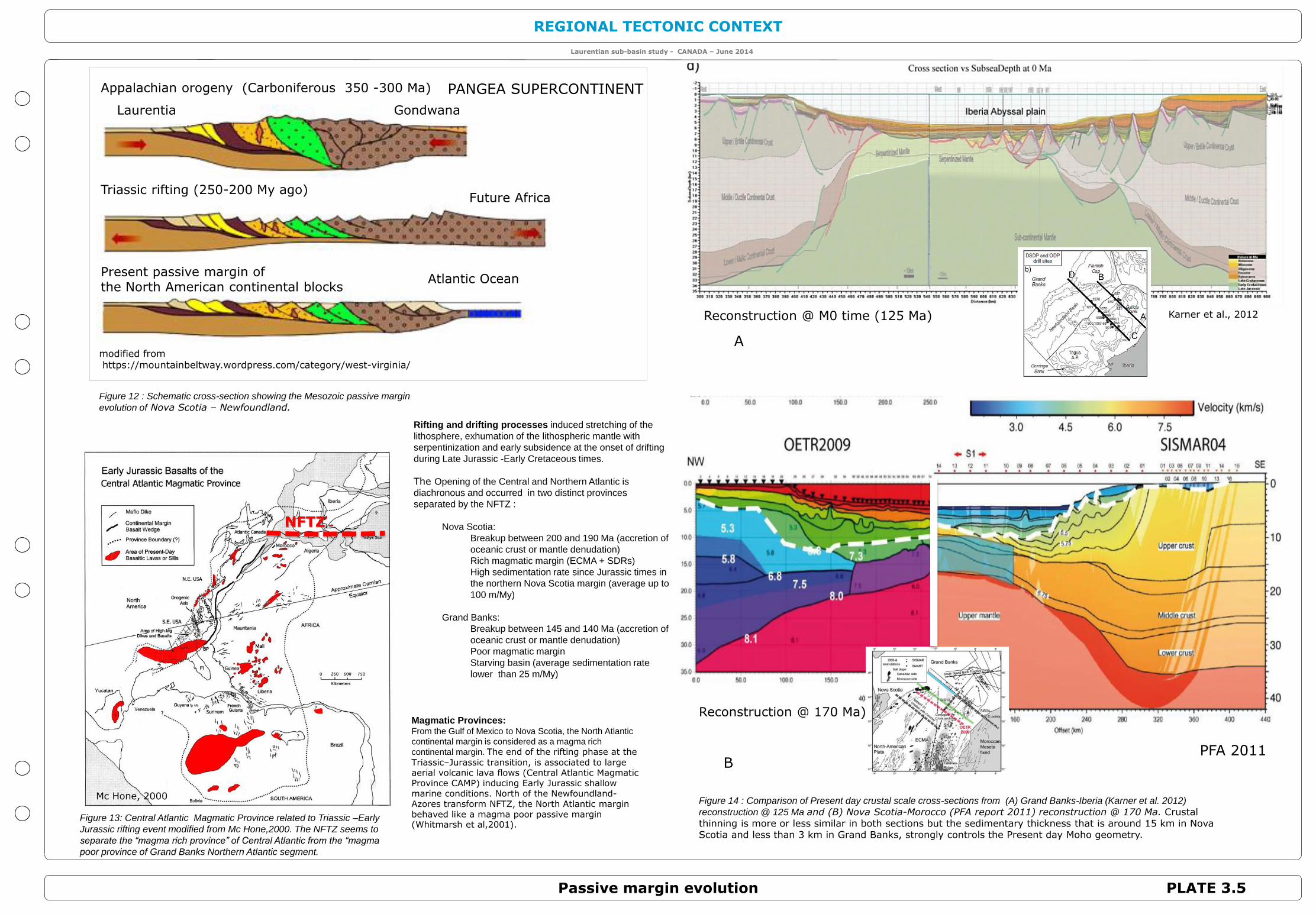
Passive margin evolution
Mc Hone, 2000
NFTZ
Karner et al., 2012
Rifting and drifting processes induced stretching of the
lithosphere, exhumation of the lithospheric mantle with
serpentinization and early subsidence at the onset of drifting
during Late Jurassic -Early Cretaceous times.
The Opening of the Central and Northern Atlantic is
diachronous and occurred in two distinct provinces
separated by the NFTZ :
Nova Scotia:
Breakup between 200 and 190 Ma (accretion of
oceanic crust or mantle denudation)
Rich magmatic margin (ECMA + SDRs)
High sedimentation rate since Jurassic times in
the northern Nova Scotia margin (average up to
100 m/My)
Grand Banks:
Breakup between 145 and 140 Ma (accretion of
oceanic crust or mantle denudation)
Poor magmatic margin
Starving basin (average sedimentation rate
lower than 25 m/My)
Figure 13: Central Atlantic Magmatic Province related to Triassic –Early
Jurassic rifting event modified from Mc Hone,2000. The NFTZ seems to
separate the “magma rich province” of Central Atlantic from the “magma
poor province of Grand Banks Northern Atlantic segment.
Atlantic Ocean
Appalachian orogeny (Carboniferous 350 -300 Ma)
Triassic rifting (250-200 My ago)
Present passive margin of the North American continental blocks
Future Africa
modified fromhttps://mountainbeltway.wordpress.com/category/west-virginia/
PANGEA SUPERCONTINENT
Laurentia Gondwana
Figure 12 : Schematic cross-section showing the Mesozoic passive margin
evolution of Nova Scotia – Newfoundland.
Figure 14 : Comparison of Present day crustal scale cross-sections from (A) Grand Banks-Iberia (Karner et al. 2012)
reconstruction @ 125 Ma and (B) Nova Scotia-Morocco (PFA report 2011) reconstruction @ 170 Ma. Crustal thinning is more or less similar in both sections but the sedimentary thickness that is around 15 km in Nova Scotia and less than 3 km in Grand Banks, strongly controls the Present day Moho geometry.
PFA 2011B
A
Reconstruction @ M0 time (125 Ma)
Reconstruction @ 170 Ma)Magmatic Provinces:From the Gulf of Mexico to Nova Scotia, the North Atlantic
continental margin is considered as a magma rich
continental margin. The end of the rifting phase at the
Triassic–Jurassic transition, is associated to large aerial volcanic lava flows (Central Atlantic Magmatic Province CAMP) inducing Early Jurassic shallow marine conditions. North of the Newfoundland-Azores transform NFTZ, the North Atlantic margin behaved like a magma poor passive margin (Whitmarsh et al,2001).

REGIONAL TECTONIC CONTEXT
PLATE 3.6
Laurentian sub-basin study - CANADA – June 2014
Passive Margin Evolution and plate reconctruction (from PFA 2011)
Kinematic reconstruction at chron ECMA (end of rifting)Sinemurian/Pliensbachian boundary 190 Ma(Upper Eurydice – Argo time)
BSMA reconstructionMiddle Bajocian 170 Ma(Mohican time)
M22 reconstructionTithonian 150 Ma(Mic Mac time)
M11 reconstructionValanginian 136 Ma(Lower Mississauga time)
M0 reconstructionLate Barremian / early Aptian, 125 Ma(O marker time)
C34 reconstructionSantonian, 83.5 Ma(Wyandot time)
Sinemurian/Pliensbachian limit (190 Ma)Mohican – Iroquois times
Middle Bajocian (170 Ma)Scatarie time
Tithonian (150 Ma)Mic Mac time
Valanginian (136 Ma)Lower Mississauga time
Late Barremian-early Aptian (125 Ma)O Marker time
Santonian (83.5 Ma)Wyandot time
Avalon uplift 145-135 Ma
Figure 16 :Plate reconstruction : isochron magnetic anomaly maps (Sibuet et al. 2010)
Outline of salt structures
Figure 15 : Plate reconstruction : offshore paleofacies maps (Sibuet et al. 2010)
Avalon uplift 145-135 Ma
The Newfoundland Transform Fault Zone acted as a left lateral strike-slip between Grand Banks and Morocco continental blocks during Early Jurassic times.

REGIONAL TECTONIC CONTEXT
PLATE 3.7
Laurentian sub-basin study - CANADA – June 2014
Newfoundland Transform Zone (NFTZ)
NFTZ
Keen M. J. and Piper D. J. W., 1990
Line 1438-101-M stack
N ESW
0
2
4
6
10
8
Heron
salt
Shale prone facies
Slope fans ?
Fluvio - deltaic system
Volcano clastics
VolcanicSeamount
T 29
Carbonate platform ?
Continental crustOceanic crust
Newfoundland Ridge ?
Pico FZ
J150
T 50
T 50 T 29
J200
K130
K 101
NFTZ 10 km
Line 1494-101M
10
0
8
6
S
4
2
N
Pico FZ
Newfoundland Ridge ?
MOHO ?
Continental crust
Oceanic crust
J150 ?
Jurassic ?
K130
T 29
T 50
Syn rift
K101
J200 NFTZ
10 km
Line 1510-101-M stack
NESW
3
2
4
5
6
7
8
Slope fans
Basin floor fans
channels
Volcano clastics
VolcanicSeamount
J150 ?
K130
T 29
T 50
K 101
J 200 NFTZ10 km
The Nova Scotia margin is a classical passive margin with
progressively stretched continental crust and progressive transition
to oceanic domain. The stretched crust was loaded by a more than
10 km thick sedimentary wedge.
The southern Grand Banks is characterized by an abrupt transition
between continental crust and oceanic domain. Average sediment
thickness is less than 5km.
The Newfoundland Transform is a major crustal transform zone separating Grand
Banks continental block from oceanic domain of the Scotian passive margin.
In seismic profiles it appears as a 30 km wide zone of highly faulted basement. The
vertical offset of the base of the sediments is approximately 7 km.
Seismic images suggest fault zone was mainly active during Early Jurassic times.
As shown by kinematic reconstructions the NFTZ was a left lateral strike-slip fault
during the Jurassic drift of the future African plate with respect of the North American
plate.
It seems to be sealed by Cretaceous strata as shown by onlaps on the paleo-fault
escarpment. Neogene deposits drape the paleo-escarpment and are not cut by any
reactivation of the fault zone suggesting the fault zone is presently inactive (?)
Distribution of autochthonous salt basins and discontinuity of the ECMA suggest
possible secondary faults “offseting” continental blocks of the Scotian margin. Those
secondary faults are minor replicas of the main NFTZ and acted also as early
transforms faults.
It seems there is no direct connection of the NFTZ with the Cobequid-Chedabucto
fault.
Figure 17 : Crustal scale cross-section of (A) the Southern Grand Banks and
(B) Nova Scotia Margin
A
B
NW SE
NE SW
Figure 18 : Main structural elements of the Laurentian sub-basin and South Whale basin;
NFTZ : Newfoundland Transform Zone
COB : Continent Ocean Boundary
Figure 20 : Interpreted seismic lines of the southern slope of the South Bank High showing the
Newfoundland Transform Fault Zone (NFTZ). See location in figure 18. Volcanic activity
contemporaneous of the Avalon uplift-erosional event produced numerous seamounts south of the
NFTZ.
B
A
C
A
B C
Figure 19 :Schematic map of the plate boundary configuration on the first
phases of drifting (Early Jurassic times). During this early drift, NFTZ acted
as a left lateral strike-slip fault. Once bounded to the south by oceanic crust
the transform fault became relatively inactive along the Southern Grand
Banks.
GrandBanks
Iberia
Morocco

REGIONAL TECTONIC CONTEXT
PLATE 3.8
Laurentian sub-basin study - CANADA – June 2014
Avalon Unconformity
MacLean et al., 1989
The “Avalon unconformity” results of a major tectonic uplift
which occurred in the Grand Banks area at the Jurassic –
Cretaceous boundary (between 145 and 140 Ma).
This event is characterized by a sharp angular unconformity
(Figures 23 and 24) resulting from deformation and
subsequent uplift and erosion.
Deformation mainly consists in:
Normal faulting and block tilting caused by the
rifting event associated to the Grand Banks-Iberia separation
Salt tectonic : salt dome and collapse structures
(Carboniferous Winsor salt + Triassic Argo salt diapirs) also
probably related to the rifting event
Uplift and erosion is the result of combined phenomena:
Doming before rifting between Iberia and Grand
Banks (lithospheric thinning)
Rift shoulder uplift : “free” light lithospheric
promontory bounded by dense oceanic domains
Volcanic activity (uprising of hot mantellic
material)
MacLean et al. 1989
Bowman, 2010
Avalon Unconformity
Carboniferous salt
Bowman, 2010
Avalon Unconformity
Figure 22 : Stratigraphic diagram showing the effect of the Avalon erosional event in the South Whale sub-basin,
Whale basin and Jeanne d’Arc basin. Jeanne d’Arc basin was poorly affected while, in the South Whale and Whale
basins, erosion took place at the Jurassic and Cretaceous boundary. Locally, in “ridge” areas, the Avalon erosional event could have removed the whole Jurassic and Carboniferous series. Ridge areas (Bear ridge and
Treworgie ridge) remained emerged zones till the end of Lower Cretaceous.
Figure 24 : Grand Banks NW-SE seismic section (see location in Figure 21) showing the Avalon angular unconformity.
Figure 23 : Grand Banks NW-SE seismic section (see location in Figure 21)showing the Avalon angular unconformity . Carboniferous and Trias-Jurassic tilted strata (Salt tectonics + tilted faulted block) have been deeply eroded.
Figure 21: Approximate depth to basement map in km showing the Avalon uplift zone and the location of (A) Figure 23 and (B) Figure 24.
A B
A
B
This uplift and erosional event is responsible of the large
influx of clastic material (sandstone) of Early Cretaceous age
(Mississauga Fm.) in the Laurentian and Scotian basins
REGIONAL TECTONIC CONTEXT
PLATE 3.9
Laurentian sub-basin study - CANADA – June 2014
Regional Tectonic Context Bibliographic References
Albertz, M., C. Beaumont, J. W. Shimeld, S. J. Ings, and S. Gradmann, 2010, An investigation of salt tectonic structural styles in the Scotian Basin,
offshore Atlantic Canada: 1. Comparison of observations with geometrically simple numerical models: Tectonics, v. 29, TC4017.
Amante, C., and B. W. Eakins, 2009, ETOPO1 1 Arc-Minute Global Relief Model: Procedures, Data Sources and Analysis, 19 p.
Beaumont, C. 2011. Report on continuation of OETR Nova Scotia margin project: forward dynamical modeling of: 1) Margin development during
rifting and 2) Salt tectonics. In PFA Atlas Annex 10.
Bell J.S. and R.D. Howie, 1990, Palaeozoic Geology, Chapter 4, M.J. Keen and G. L. Williams edts Geology of the Continental margin of Eastern
Canada, p. 143-165.
Bensalah, M. K., Youbi, N., Mahmoudi, A., Bertrand, H., Mata, J., El Hachimi, H., & Ben, A. M. (2011). The Central Atlantic Magmatic Province
(CAMP) volcanic sequences of Berrechid and Doukkala basins (Western Meseta, Morocco): volcanology and geochemistry. Comunicacoes
Geologicas, 98(1), 15-27.
Boillot et Coulon, 1998, La déchirure continentale et l’ouverture océanique. Géologie des marges passives. Scientifique GB éditions, ISBN 90-5699-
188-4, 210 p
Boillot, G. & Froitzheim, N. (2001): Non-volcanic rifted margins, continental break-up and the onset of sea-floor spreading: some outstanding
questions. In: Wilson, R.C.L., Whitmarsh, R.B., Taylor, B, & Froitzheim, N. (2001): Non-Volcanic Rifting of Continental Margins: A Comparison of
Evidence from Land and Sea. Geological Society, London, Special Publications, 187, 9-30
Bowman, S., 2010, Cretaceous tectonism and volcanism in the eastern Scotian Basin,offshore Nova Scotia, MsC thesis, St Marys’s University 186 p
Bown, J. W., and R. S. White, 1995, Effect of finite extension rate on melt generation at rifted continental margins: Journal of Geophysical Research,
100, 18,011-018, 029.
Bronner, A, D. Sauter, G. Manatschal, G. Péron-Pinvidic, M. Munschy, 2011, Magmatic breakup as an explanation for magnetic anomalies at
magma-poor rifted margins, Nature Geoscience, Volume:4,Pages:549–553
Brown, David E. 2012, Potential for lacustrine source rocks in Triassic synrift basins offshore Eastern North America, , Third Central & North Atlantic
Conjugate Margins Conference, Trinity College Dublin, 22-24 August 2012, Abstracts volume, p130
Bullock, A. D., and T. A. Minshull, 2005, From continental extension to seafloor spreading: Crustal structure of the Goban Spur rifted margin,
southwest of the UK: Geophysical Journal International, v. 163, p. 527-546.
Christensen, N. I., and W. D. Mooney, 1995, Seismic velocity structure and composition of the continental crust: A global view: Journal of
Geophysical Research, v. 100, p. 9761-9788.
Contrucci, I., F. Klingelhoefer, J. Perrot, R. Bartolome, M.-A. Gutscher, M. Sahabi, J.-A. Malod, and J.-P. Réhault, 2004, The crustal structure of the
NW Moroccan continental margin from wide-angle and refraction data: Geophysical Journal International, v. 159, p. 117-128.
Cooper, M., Weissenberger, J., Knight, I., Hostad, D., Gillespie, D., Williams, H., ... & Clark, E. (2001). Basin evolution in western Newfoundland: new
insights from hydrocarbon exploration. AAPG bulletin, 85(3), 393-418.
Davison, I., and P. Dailly, 2010, Salt tectonics in the Cap Boujdour area, Aaiun Basin, NW Africa: Marine and Petroleum Geology, v. 27, p. 435-441.
Dehler, S. A., 2010, Initial rifting and break-up between Nova Scotia and Morocco: An examination of new geophysical data and models, paper
presented at Central and north Atlantic conjugate margins conference, http://metododirecto.pt/CM2010, Lisboa.
Deptuck, Mark E, 2011, Proximal to distal postrift structural provinces of the western Scotian Margin, offshore Eastern Canada: Geological context
and parcel prospectivity for Call for Bids NS11-1 CNSOPB Geoscience Open File Report, 2011-001MF, 42 p.
Deptuck, Mark E., Kris Kendell, David E. Brown, Brenton M. Smith, 2014, Seismic stratigraphic framework and structural evolution of the eastern
Scotian Slope: geological context for the NS14-1 Call for Bids area, offshore Nova Scotia, CNSOPB Geoscience Open File Report, 2014-001MF, 58
p.
Dick, H. J. B., J. Lin, and H. Schouten, 2003, An ultraslow-spreading class of ocean ridge: Nature, v. 426, p. 405-412.
Edwards, A., P. P. Moir, and K. Coflin, 2000, Structure and isopach maps of the Jeanne d'Arc Basin, Grand Banks, Newfoundland: Geological Survey
of Canada, Geological Survey of Canada Open File 3755.
Fagan A.J., 2010, STRUCTURAL AND STRATGRAPHIC STUDY OF THE LAURENTIAN BASIN,OFFSHORE EASTERN CANADA, M Sc Thesis,
School of Graduate Studies, St John, Newfoundland,
Funck, T., J. R. Hopper, H. C. Larsen, K. E. Louden, B. E. Tucholke, and S. Holbrook, 2004, Crustal structure of the ocean-continent transition at
Flemish Cap: Seismic refraction results: Journal of Geophysical Research, v. 108(B11), p. 2531, doi:2510.1029/2003JB002434
Geological Map of North America, first edition, 1:5,000,000, 2005, edited by J. C. Reed, Jr., J. O. Wheeler, and B. E. Tucholke, U.S. Geological
Survey Data Series 424.
Government of Newfoundlands and Labrador, Department of Mines and Energy, 2000, Sedimentary basins and hydrocarbon potential of
Newfoundland and Labrador Report 2000-1
Gernigon, L., Ringenbach, J.C., Planke, S. and Le Gall, B., 2004. Deep structures and breakup along volcanic rifted margins: Insights from integrated
studies along the outer Vøring Basin (Norway). Marine and Petroleum Geology, 21(3), p. 363-372.
Gradstein, F. M., L. F. Jansa, S. P. Srivastava, M. A. Williamson, G. Bonham-Carter, and B. Stam, (1990), Aspects of North Atlantic paleo-oceanography,
in M. J. Keen and G. L. Williams, eds., Geology of the Continental Margin of Eastern Canada, Chapter 8: Geological Survey of Canada, Geology of
Canada, n°2, pp. 351 389 (also Geological Society of America, the Geology of North America, v. I-1).
Grant, A. C., L. F. Jansa, K. D. McAlpine, and A. Edwards,1988, MESOZOIC-CENOZOIC GEOLOGY OF THE EASTERN MARGIN OF THE GRAND
BANKS AND ITS RELATION TO GALICIA BANK in Boillot, G., Winterer, E. L., et al. eds, Proc. ODP, Sci. Results, 103: College Station, TX (Ocean
Drilling Program).
Hafid, M., G. Tari, D. Bouhadioui, L. El Moussaid, H. Echarfaoui, A. Ait Salem, M. Nahim, and M. Dakki, (2008), Atlantic basins, in A. Michard, ed.,
Continental evolution: The geology of Morocco, Lecture notes in Earth Sciences, Springer-Verlag, Berlin, Heidelberg, p. 303-329.
Holik, J. S., P. D. Rabinowitz, and J. A. Austin, 1991, Effects of Canary hotspot volcanism on structure of oceanic crust off Morocco, Journal of
Geophysical Research, v. 96, 12,039-012, 067.
Jokat, W., O. Ritzmann, M. C. Schmidt-Aursch, S. Drachev, S. Gauger, and J. Snow, 2003, Geophysical evidence for reduced melt production on the
Arctic ultraslow Gakkel mid-ocean ridge: Nature, v. 423, p. 962-965.
Karner, Garry D., Christopher A. Johnson, Geoffrey Mohn and Gianreto Manatschal, 2012, Depositional environments and source distribution across
hyper-extended rifted margins of the North Atlantic: Insights from the Iberia-Newfoundland margin, Third Central & North Atlantic Conjugate Margins
Conference, Trinity College Dublin, 22-24 August 2012, Abstracts volume, p 7-17.
Keen, M. J., & Piper, D. J. W. (1990). Geological and historical perspective. Geology of the continental margin of eastern Canada, 1, 5-30.
Keen, C.E., and Potter, D.P., 1995b,The transition from a volcanic to nonvolcanic rifted margin off eastern Canada.Tectonics, vol.14, no.2, p.359-371.
Klingelhoefer, F., L. Géli, L. Matias, N. Steinsland, and J. Mohr, 2000, Crustal structure of a super-slow spreading centre: A seismic refraction study of
Mohns Ridge, 72°N: Geophysical Journal International, v. 141, p. 509-526.
Klitgord, K. D., and H. Schouten, 1986, Plate Kinematics of the Central Atlantic, in P. R. Vogt and B. E. Tucholke, eds., The geology of the north Atlantic:
Geological Society of America, Boulder, CO, p. 351-378.
Labails, C., J.L. Olivet, D. Aslanian, and W. R. Roest, 2010, An alternative early opening scenario for the Central Atlantic Ocean: Earth and Planetary
Science Letters, v. 297, p. 355–368.
Laracy, P. J., & Hiscott, R. N. (1982). Carboniferous redbeds of alluvial origin, Spanish Room Formation, Avalon Zone, southeastern Newfoundland.
Bulletin of Canadian Petroleum Geology, 30(4), 264-273.
Louden, K., Lau, H. Wu, Y., Nedimovic, M., 2010. Refraction crustal models and plate reconstruction of the Nova Scotia and Morocco margins. In PFA
Atlas Annex 14.
Louden, K. E., J. C. Osler, S. P. Srivastava, and C. E. Keen, 1996, Formation of oceanic crust at slow spreading rates: New constraints from an extinct
spreading center in the Labrador Sea: Geology, v. 24, p. 771-774.
Luheshi, M., Roberts, D. G., Nunn, K., Makris, J., Colletta, B., Wilson, H., ... & Dubille, M. (2012). The impact of conjugate margins analysis on play
fairway evaluation–an analysis of the hydrocarbon potential of Nova Scotia. first break, 30(1), 61-72.
MacLean, B.C., A. Edwards; K.D. McAlpine and J. A. Wade, 1989The Enigmatic Avalon Unconformity, Geological Survey Ottawa, Open File 2099
Magoon, Leslie B., Travis L. Hudson, and Kenneth E. Peters, 2005, Egret-Hibernia(!), a significant petroleum system, northern Grand Banks area,
offshore eastern Canada ,AAPG Bulletin, v. 89, no. 9 , pp. 1203–1237
Maillard, A., J. Malod, E. Thiébot, F. Klingelhoefer, and J.P. Réhault, 2006, Imaging a lithospheric detachment at the continent-ocean crustal transition off
Morocco: Earth and Planetary Science Letters, v. 241, p. 686-698.
Makris, J., K. Nunn, D. Roberts, and M. Luheshi, 2010, A crust and basin study of the Nova Scotia margin and its ocean transition based on densely
spaced ocean bottom seismic observations, paper presented at Central and north Atlantic conjugate margins conference, http://metododirecto.pt/CM2010,
Lisbon.
Matias, H., W. Mohriak, P. Menezes, F. Sandnes, V. C. F. Barbosa, L. Matias, and F. Santos, 2005, Salt distribution and morphology in the offshore
Algarve Basin, 25th annual Bob F. Perkins Research Conference: Petroleum systems of divergent continental margin basins, GCS-SEPM 2005, p. 481-
509.
Maus, S., et al., 2009, EMAG2: A 2 – arc min resolution Earth Magnetic Anomaly Grid compiled from satellite, airborne, and marine magnetic
measurements: Geochemistry Geophysical Geosystem, 10, Q08005, doi:10.1029/2009GC002471.
McCartney, W. D. (1969). Geology of the Avalon Peninsula, southeast Newfoundland. Memoir-American Association of Petroleum Geologists, 12, 115-
129.
McHone, J. G. (2000). Non-plume magmatism and rifting during the opening of the central Atlantic Ocean. Tectonophysics, 316(3), 287-296.
Müller, R. D., Sdrolias, M., Gaina, C., & Roest, W. R. (2008). Age, spreading rates, and spreading asymmetry of the world's ocean crust. Geochemistry,
Geophysics, Geosystems, 9(4).
Murphy, J. B., Fernández-Suárez, J., Keppie, J. D., & Jeffries, T. E. (2004). Contiguous rather than discrete Paleozoic histories for the Avalon and
Meguma terranes based on detrital zircon data. Geology, 32(7), 585-588.

REGIONAL TECTONIC CONTEXT
PLATE 3.10
Laurentian sub-basin study - CANADA – June 2014
Regional tectonic Context Bibliographic References
Nemcok, M., C. Stuart, M. P. Segall, R. B. Allen, C. Christensen, S. A. Hermeston, and I. Davison, 2005, Structural development of southern Morocco:
Interaction of tectonics and deposition 25th annual Bob F. Perkins Research Conference: Petroleum systems of divergent continental margin basins,
GCS-SEPM 2005, 151-202.
Oakey, G.N. and Dehler, S.A., 2004, Atlantic Canada Magnetic Map Series: Atlantic Canada. Geological Survey of Canada, Open File 1813, 1:3 000
000.
Ogg, J. G., G. Ogg, and F. M. Gradstein, 2008, The Concise Geologic Time scale, 150 pp., Cambridge University Press.
Pe-Piper, G., & Piper, D. J. (2004). The effects of strike-slip motion along the Cobequid-Chedabucto-southwest Grand Banks fault system on the
Cretaceous-Tertiary evolution of Atlantic Canada. Canadian Journal of Earth Sciences, 41(7), 799-808.
Pe-Piper, G., Piper, D. J., Jansa, L. F., & De Jonge, A. (2007). Early Cretaceous opening of the North Atlantic Ocean: Implications of the petrology
and tectonic setting of the Fogo Seamounts off the SW Grand Banks, Newfoundland. Geological Society of America Bulletin, 119(5-6), 712-724.
Ranero, C. S., and M. Pérez-Gussinyé, 2010, Sequential faulting explains the asymmetry and extension discrepancy of conjugate margins: Nature, v.
468, p. 294-300.
Reston Tim and Ken McDermott, 2012,Continental breakup and the formation of conjugate magma-poor margins in North Atlantic:mechanism,
symmetry and the extension discrepancy, , Third Central & North Atlantic Conjugate Margins Conference, Trinity College Dublin, 22-24 August 2012,
Abstracts volume, p 81
Schenk, P. E. (1997). Sequence stratigraphy and proveance on Gondwana's margin: the Meguma Zone (Cambrian to Devonian) of Nova Scotia,
Canada. Geological Society of America Bulletin, 109(4), 395-409.
Sibuet, J.C., Rouzo S., 2010. Re-Reprocessing of SISMAR refraction lines. GeoPro GmbH Hamburg, 2010. Vp/Vs converted waves report, Central
Nova Scotia margin Canada. In PFA Atlas, Annex 13.
Sibuet, J.C., Rouzo S., Srivastava S., 2011. Plate tectonic reconstructions and paleo-geographic maps of the central and north Atlantic oceans. In
PFA Atlas Annex 13.
Sibuet, J. C., Rouzo, S., & Srivastava, S. (2012). Plate tectonic reconstructions and paleogeographic maps of the central and North Atlantic oceans 1,
2 1 This article is one of a series of papers published in this CJES Special Issue on the theme of Mesozoic–Cenozoic geology of the Scotian Basin. 2
Earth Sciences Sector Contribution 20120172. Canadian Journal of Earth Sciences, 49(12), 1395-1415.
Srivastava, S., J. Verhoef, and R. Macnab, 1988, Results from a detailed aeromagnetic survey across the northeast Newfoundland margin, Part 2:
Early opening of the north Atlantic between the British Isles and Newfoundland: Marine and Petroleum Geology, v. 5, p. 324-337.
Srivastava, S., and J. Verhoef, 1992, Evolution of Mesozoic sedimentary basins around the north Central Atlantic: a preliminary plate kinematic
solution, in J. Parnell, ed., Basins on the Atlantic seaboard: Petroleum geology, sedimentology and basin evolution: Geological Society, Special
publications, London, p. 397-420.
Srivastava, S., J.C. Sibuet, S. Cande, W. R. Roest, and I. R. Reid, 2000, Magnetic evidence for slow seafloor spreading during the formation of the
Newfoundland and Iberian margins: Earth and Planetary Science Letters, v. 182, p. 61-76.
Srivastava, S. P., W. R. Roest, L. C. Kovacs, H. Schouten, and K. Klitgord, 1990, Iberian plate kinematics: A jumping plate boundary between Eurasia
and Africa: Nature, v. 344, p. 756-759.
Stampfli, G.M., and G.D. Borel, 2002a, A plate tectonic model for the Paleozoic and Mesozoic constrained by dynamic plate boundaries and restored
synthetic oceanic isochrons: Earth and Planetary Science Letters, v. 196, p. 17-33.
Structural Map of the North Atlantic Ocean, first edition, 1:20 000 000, 2008, CGMW/UNESCO.
Tankard A. J., and H. J; Welsink , 1987, Extensional tectonics and stratigraphy of Hibernia oil field, Grand Banks, Newfoundland, AAPG Bulletin, V.
71, N) 10, p 1210-1232.
Tari, G., and J. Molnar, 2005, Correlation of syn-rift structures between Morocco and Nova Scotia, Canada 25th annual Bob F. Perkins Research
Conference: Petroleum systems of divergent continental margin basins, GCS-SEPM 2005, p. 132-150.
The 1:5 Million International Geological Map of Europe and Adjacent Areas, 2005, 1:5,000,000 scale, edited by Bundesanstalt für Geowissenschaften
und Rohstoffe (BGR), Hannover.
Thinon, I., L. Matias, J.P. Réhault, A. Hirn, L. Fidalgo-Gonzalez, and F. Avedik, 2003, Deep structure of the Armorican basin (Bay of Biscay): A review
of Norgasis seismic reflection and refraction data: Journal of the Geological Society of London, v. 160, p. 99-116.
Thompson, T. (2003). Preliminary findings on basin architecture, segmentation and inversion on a passive margin offshore Newfoundland: Expanded
Abstract. In Calgary CSPG/CSEG Joint Conference
Tucholke, B. E., and J.-C. Sibuet, 2007, Leg 210 synthesis: tectonic, magmatic, and sedimentary evolution of the Newfoundland-Iberia rift, in B. E.
Tucholke, et al., eds, Proceedings of the Ocean Drilling Program, Scientific Results, 210, Ocean Drilling Program, College Station, TX, p. 1-56.
Tucholke, B. E., and R. B. Whitmarsh, 2011, The Newfounland-Iberia conjugate rifted margins, in, A. W. Bally and D. G. Roberts, eds., Principles of
Phanerozoic regional geology, in press.
Van Avendonk, H. J., Lavier, L. L., Shillington, D. J., & Manatschal, G. (2009). Extension of continental crust at the margin of the eastern Grand
Banks, Newfoundland. Tectonophysics, 468(1), 131-148.
Verhoef, J., R. Macnab, and Project Team, 1996, Compilation of magnetic data in the Arctic and north Atlantic oceans, Bedford Institute of Oceanography
unpublished report, p. 1-13.
Vogt, P. R., C. N. Anderson, and D. R. Bracey (1971), Mesozoic magnetic anomalies, sea-floor spreading, and geomagnetic reversals in the
southwestern north Atlantic: Journal of Geophysical Research, v. 76, p. 4796-4823.
Wade, J. A., and B. C. MacLean, 1990, The geology of the southeastern margin of Canada, in M. J. M.J. Keen and G. L. Williams, eds,. Geology of North
America, Geological Society of America, Boulder, p. 167-238.
Welford, J. Kim, Patrick M. Shannon, Brian M. O’Reilly and Jeremy Hall, 2012, Comparison of lithosphere structure across the Orphan Basin/Flemish
Cap and Irish Atlantic conjugate continental margins from constrained 3-D gravity inversions, , Third Central & North Atlantic Conjugate Margins
Conference, Trinity College Dublin, 22-24 August 2012, Abstracts volume, p104
Wessel, P., and W. H. F. Smith, 1998, New, improved version of Generic Mapping Tools released, EOS trans. AGU, v. 79, p. 579.
White, R. S., D. McKenzie, and K. O'Nions, 1992, Oceanic crustal thickness from seismic measurements and rare earth element inversions: Journal of
Geophysical Research, 97, 19,683-19,715.
Whitmarsh, R. B., P. Miles, J.-C. Sibuet, and V. Louvel, 1996, Geological and geophysical implications of deep-tow magnetometer observations near
ODP Sites 897, 898, 899, 900 and 901 on the west Iberia continental margin, in D. S. Sawyer, et al., eds., Proc. ODP, Scientific Results, College Station,
TX (Ocean Drilling Program), p. 665-674.
Whitmarsh, R. B., G. Manatschal, and T. A. Minshull, 2001, Evolution of magma-poor continental margins from rifting to seafloor spreading: Nature, 413,
150-154.
Williams, H., & Grant, A. C. (1998). Tectonic assemblages map. Atlantic region, Canada: Geological Survey of Canada Open-File, 3657.
Wilson, Hamish, Matt Luheshi, David Roberts and Bernard Colletta, 2012, Play Risks and Volumes - Offshore Nova Scotia, , Third Central & North
Atlantic Conjugate Margins Conference, Trinity College Dublin, 22-24 August 2012, Abstracts volume, p108
Wu, Y., K. E. Louden, T. Funck, H. R. Jackson, and S. A. Dehler, 2006, Crustal structure of the central Nova Scotia margin off Eastern Canada: Journal
of Geophysical Research, v. 166, p. 878-906
Ziegler, Peter A. 1999, EVOLUTION OF THE ARCTIC-NORTH ATLANTIC AND THE WESTERN TETHYS--A VISUAL PRESENTATION OF A SERIES
OF PALEOGEOGRAPHIC-PALEOTECTONIC MAPS*, AAPG Search and Discovery Article #30002
Recommended