Embed Size (px)
Citation preview
21
CHAPTER 2
Geology and Regional Tectonic Setting
2.1 Regional geology and tectonic setup
The Himalayan orogenic belt is the result of Cenozoic Indo- Eurasian plate collision
(Gansser 1974, Yin and Harrison, 2000; Aitchison et al., 2007) and represents one of
the youngest and the highest mountain range in the world. In Indian shield it is
bounded by the Indus in the west and Brahmaputra in the east. Geologically Himalaya
is the example of continental collision with diversity in lithology, stratigraphy,
tectonic and metamorphic history (Pande, 1975). This mighty mountain range spread
along 2400 km and across 240-325 km (Gansser, 1974) spread into the southeast
Asian landmass. It has been divided into the western, central and eastern Himalaya
along strike length and outer, lesser and higher Himalayan zone from south to north
across the Himalayan trend.
North East India is a tectonically distinct geological domain. The Geological history
of the region directly or indirectly involves almost all the major geological ages from
the Archean to the Recent (Nandy, 1975). The Paleozoic Himalayan sedimentary
basin in the north and the Cenozoic Assam – Arakan sedimentary basin in the south
are the two most important tectonosedimentary domain in this region. While the
Gondwana sediments are recorded from the Himalayan basin, the oldest sedimentary
record within the Assam-Arakan basin is found to be Upper Cretaceous. The Siwaliks
foredeep molasses in front of the Himalaya and Tipam molasses of Upper Assam
basin in front of Indo-Myanmar mobile belt are separated by the Brahmaputra
Alluvium that itself represent a basin fill with an enormous repository of Quaternary
Alluvium overlying the Cenozoic sequence. Proterozoic to early Paleazoic granites
are found in the Shillong Plateau, which are of intrusive in character. On the other
hand the Tertiary granites are found in the upper part of the Eastern Himalaya. The
Jurassic-cretaceous rocks are found in the Shillong plateau while the Abor volcanic

22
rocks (Upper Palaeozoic to Eocene) are found in the Himalaya. The carbonatites and
ultramafic rocks of Cretaceous time found in the Shillong plateau and Mikir hills. The
Gondwana rocks are found in a narrow belt along the foothill of Himalaya, which
indicate the rift-drift tectonism. Thus, geological beds ranging from Precambrian to
recent periods can be found scattered in the region (Nandy, 1975).
On the northern side of the Brahmaputra Valley the inselberg zone gradually gives
way to alluvial plain abutting against the ENE-WSW Siwalik ridge of sub Himalayan
trend. In the sub-Himalaya zone trend varies from E-W to ENE-WSW and gradually
assume a NE-SW trend (Nandy 2001). On the basis of geology and geomorphology
(Burrard and Hayden, 1907), the Himalayan range has been divided into four different
longitudinal sections. These sections running parallel to the length of the mountain
from south to north are: the Outer or Sub Himalaya, the Inner or Lesser Himalaya, the
Greater or Higher Himalaya, the Tethys or Trans Himalaya.
In the Arunachal Himalayan region the older rocks are exposed successively from
south to northwards. The outermost hills Neogene clastic of Siwaliks Hills, were
folded and uplifted to give rise to Sub Himalayan ranges (Kunte et al., 1983, Kumar,
1997) and demarcated by the HFT (Himalayan Frontal Thrust) from the alluvial of
Brahmaputra. The mountain front along with the HFT is suggested to be tectonically
active because of southward progression of deformation of the Hiamalaya (Lave and
Avouac, 2001). Gondwana sediments of lesser Himalaya are separated by the Main
Boundary Thrust (MBT) from the Neogene sequence of Sub Himalaya. MCT (Main
Central Thrust) separate the lesser Himalaya from the central crystalline zone of
Higher Himalaya. North of central crystalline rocks, lies the Tethyan belt of
Palaeozoic-Mesozoic sediments along Main Northern Thrust (MNT) and further
ophiolite zone of Indo-Tsangpo suture belt (Nandy, 1975). The lesser Himalaya
succession lies between the MCT and MBT is composed of low-medium grade
metamorphic rocks (Nandy, 2001; Kumar, 1997). The Higher Himalayan crystalline
zone is composed of high grade, Kyanite-sillimanite bearing schist and gneiss with
intrusions of Tertiary leucogranite and quartzite (Kumar. 1997).
Assam and other seven state of Northeast India display tectonically distinct geological
setup. This part represents the dynamic frontal part of the Indian Plate and the

23
relatively stable Central (Chinese) Plate. Arunachal Pradesh comprises of four
geotectonic blocks, viz., the Himalaya, the Mishimi Hills, Naga-Patkoi range and the
Brahmaputra Plain (Figure: 2.1). These four are characterised by distinct stratigraphy
and structure, and separated by Major tectonic lineaments.
The Sub-Himalayan fold and thrust belt of western Arunachal Pradesh includes
Miocene and younger sedimentary rocks that comprise northward dipping thrust
sheets, structurally below the Main Boundary Thrust (MBT) and above the Himalayan
Frontal Thrust (HFT). Three regionally significant faults are developed from north to
south and are the: (1) MBT, (2) Tipi Thrust and (3) HFT. These faults are sub-parallel
and strike approximately E-W for 200 km from the eastern Bhutan/India border to the
Dikrang River, where the strike changes to N50°E and continues NE to eastern
syntaxsis. (Yin et al., 2004)
Figure 2.1: Regional tectonic elements of NE India and adjoining region draped on
SRTM DEM (after Nandy 2001, Murthy et al., 1969)

24
2.2 Geology of the study area
Geologically the Jia Bharali basin is characterized by a wide spectrum of
lithostratigraphic units ranging from Quaternary Alluvium in the south to Precambrian
crystallines in the north. The Jia Bharali with a total area of 11,280 sq km. debouches
from the Himalayan through a dissected piedmont plain and is restricted within a
narrow valley wall. The catchment area covers the outer hills or Sub-Himalaya
(Siwalik), Lesser Himalaya and Higher Himalaya. In its course from debouching from
Himalaya to the confluence with Brahmaputra River, the river flows on gravel bed
upto Ghoramari along straight, braided channel and then flows a slightly sinuous
braided path.
The Geology of the lower regime of the Jia Bharali basin area is mainly alluvial
terrain with isolated exposure of Precambrian basement. Inselbergs of granitic
gneissic rocks, with intruded Quartz veins, having several sets of joints are found in
the extreme south of the area on the north bank of river Brahmaputra. The northern
part of the catchment from Bhalukpong and beyond is covered by rocks belonging to
Tertiary Siwaliks, Gondwanas and Lesser Himalayan sequence, Higher Himalayan
Crystalline (Joshi and Chakraborty 1999-2000). The regional trend of rocks in this
area is E-W to ENE-WSW. The alluvial segment of the basin is occupied by
Quaternary sediments composed of gravel, sand silt and clay and found in the form of
different terrace levels. The Quaternary sequence is more than 1000m thick within
Brahmaputra valley and they bear signatures of Quaternary tectonics and/or climatic
fluctuations resulting in various phases of river rejuvenation.
The Neogene clastics juxtaposed with the Quaternary Alluvium across the Himalayan
Frontal Thrust (HFT) are considered equivalent of the Siwaliks (Ranga Rao, 1983)
which are divided into Kimin, Subansiri, and Dafla Formation (Ranga Rao and Babu,
1972, Singh and Chowdhary 1990, Kumar 1997). While the Kimin is predominantly a
conglomerate- sandstone association, the Subansiri and Dafla represent a
predominantly fluviatile deposits of thick sandstone beds and this shale beds. The
tectonostratigraphic unit bounded by the MBT and Tipi Thrust consists exclusively of
Dafla Formation. The Tipi Thrust is interpreted to flatten into a decollement that is
regionally extensive and located at the base-Neogene unconformity. Further north

25
sandstone, shale and thin coal beds of Gondwana affinity are found exposed along a
narrow zone following the Arunachal Himalayan trend. Good Gondwana exposures
are found in and around Sessa (92o31’52.3”E 27o06’16.2”N) where the sequence is
characterized by thick sandstone beds alternating with thin shale beds and intervening
coal seams. The coal bear imprints of various flora of Gondwana.
Northward towards Bomdila and beyond metamorphic rocks composed of mainly
phylite, quartzite, schist and gneisses are encountered. These metamorphic shows a
general increase in grade towards north and are variously grouped under different
lithostratigraphic names viz., Bomdila Group, Sela Group (Bakliwal and Das, 1971,
Kumar 1997, Dhoundial, et.al, 1989). Rocks in the upland terrain show a regional
trend of E-W to ENE-WSW in conformity with the eastern Himalayan trend. Three
major structural and tectonic elements viz., HFT (Himalayan Frontal Thrust) which
separates the Siwalik from the alluvial plain of Brahmaputra, MBT (Main Boundary
Thrust), which separates the Siwalik rocks from the Lesser Himalayan rocks and
MCT (Main Central Thrust) which separates the Lesser Himalayan rocks from the
Higher Himalayan crystalline rocks are encountered from south to north.
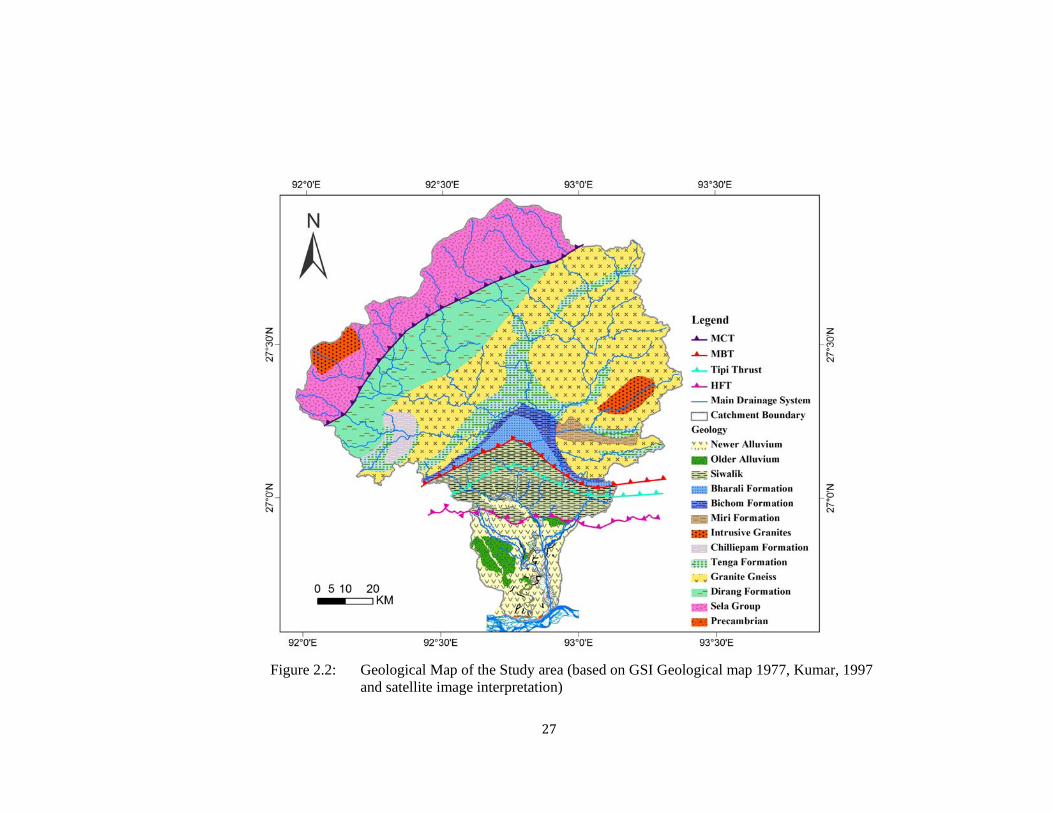
The study area, Jia Bharali is constituted of four major geological units (Figure 2.1).
The Quaternary sediments constitute the alluvial part. The Sub-Himalayan zone
consists of Siwalik rocks constituted of indurated sandstone and shale at the
bottommost part followed upwards by monotonous soft, massive sandstone along
with siltstone, clay and gravel, while the Lesser Himalayan zone comprises of two
litho-units, viz. Gondwana Group and Bomdila Group. The Gondwana Group,
constituted of shale/slate, sandstone and siltstone with coaly material, is thrusted over
the Siwaliks along the Main Boundary Thrust (MBT). Towards the north of the
Gondwanas lie the Bomdila Group constituted primarily of gneissic rocks belonging
to the Precambrian age (Srinivasan, 2003). Further northwest of the catchment Higher
Himalayan crystalline rocks of Sela Group appear along the MCT. Dirang Formation
is in between the Bomdila Group of rock and Sela Group.

26
Table 2.1 Generalized lithostratigraphy of the Jia Bharali basin
(after Geological Survey of India, 2010, Kumar 1997)
Quaternary Sediments Younger Alluvium Holocene to Recent Older Alluvium Middle to Upper Pleistocene
-------------------------------------------HFT------------------------------------------- Siwalik Group (Neogene Clastics)
Kimin Formation Mio-Pliocene ~~~~~~~~~~~~~~~~~~~~~~~~~~~~~~~~~~~~~~~~~~~~~~~~~~~~~~ Subnansiri Formation Mio-Pliocene -------------------------------------- Tipi Thrust----------------------------------------
Dafla Formation Miocene -----------------------------------------MBT--------------------------------------------- Gondwana Group
Bharali Formation Permo-Carboniferous Bichom Formation Permo-Carboniferous Miri Formation Lower Palaeozoic
~~~~~~~~~~~~~~~~~~~~~~~~~~~~ Intrusive contact~~~~~~~~~~~~~~~~~~~~~~~~~~ Biotite Granite ~~~~~~~~~~~~~~~~~~~~~~~~~~~~ Intrusive contact~~~~~~~~~~~~~~~~~~~~~~~~~~~ Dirang Formation ~~~~~~~~~~~~~~~~~~~~~~~~~~~~~Unconformity~~~~~~~~~~~~~~~~~~~~~~~~~~~~~
Bomdila Group Palaeo-Proterozoic Bomdila/Ziro/Daporijo Gneiss Chilliepam (Dedza) Formations Tenga Formation Khetabari,
----------------------------------------- MCT ------------------------------------------- Sela Group Palaeo- Proterozoic
27
Figure 2.2: Geological Map of the Study area (based on GSI Geological map 1977, Kumar, 1997
and satellite image interpretation)

28
2.2.1 Quaternary Alluvium deposits
The alluvium deposits Jia Bharali basin area was filled up by nonclastic fluvial
lacustrine deposits of post Neogen Clastics sediments on the basement of Precambrian
in the Brahmaputra foreland basin and on the Paleogene-Neogene sequances of
Siwaliks in the foothill region. The Quaternary deposits, viz., alluvial fan, terraces,
piedmont deposits, consist of heterogeneous mixture of boulders, cobbles, pebbles,
and granules, sands of all grades, silt and yellowish clay. The alluvium deposits is of
recent to sub-recent origin and represents cycle of valley fill deposits which were
subsequently out or eroded by river. On the basis of oxidation these alluvium deposits broadly
classified into Older Alluvium and Younger Alluvium. The alluvium of Brahmaputra plain is
separated by Himalayan Frontal Thrust from the Arunachal Himalaya.
Table 2.2 Lithostratigraphy of the Alluvium of Jia Bharali basin (after GSI, 1977, Kumar 1997)
Group Formation Lithology Age
Alluvium Younger Alluvium Non-oxidised Sediments of Holocene
the active channels, Boulders,
Cobbles, Pebbles with Sand
~~~~~~~~~~~~~~~~Disconformity ~~~~~~~~~~~~~~~~~~~~~~~
Older Alluvium Boulders, cobbles, gravel, Pleistocene
oxidised sand, silt, clay
--------------------------------------------- Unconformity ---------------------------------------
Basement
Older Alluvium
Older alluvial plain are the terraces which forms the higher elevation than the younger
alluvial plain. The Older Alluviums are found in the different terrace of Pleistocene to
Holocene period. The terraces on the either sides of the Jia Bharali river form distinct
physiographic features. Older Alluvium consists of oxidised sands (Figure 2.3b) with
admixture of cobbles and boulders. The Older Alluvium is of fluviatile origin being
carried down by the Himalayan Rivers and deposited along their original area of
inundation, which has been later raised to its present position. They are mostly
unconsolidated to semi-consolidated sand silt, clay with underlying pebbles horizons.

29
The high level terraces are represents the Older Alluvium and they are consist of
oxidized sediments.
Newer (Younger) Alluvium
Younger Alluvium represents the non-oxidised sediments deposits by the river along
its course (Figure 2.3c). The valley fills sediments, point bar, sand bar of alluvial river
are of recent alluvium. The recent alluviums are found along the active flood plain,
swamps area, sand bar natural levees etc. of the different river in the alluvium plain. It
consists of flood plains of river Brahmaputra, Jia Bharali, and Bor Dikrai consists of
unconsolidated gravels, sands, silts and clays.
The alluvium deposits of Jia Bharali river catchment has been classified into six
informal stratigraphic formation (Viswanathan and Chakrabarti, 1977) on the basis of
their relative height, type of soil formation, type of sediments, degree of oxidation.
These formations named after their locality name.
Table 2.3: Stratigraphic succession of Older Alluvium (after Viswanathan and Chakrabarti, 1977)
Flood Plain Piedmont Plain
Kuruwani Formation Recent geavel bar deposits
Solabari Formation Seijosa Formation
Itakhola Formation ?
Rangapara Formation Balipara Formation
~~~~~~~~~~~~~~~~~~~Unconformity~~~~~~~~~~~~~~~~~~~~~~
? Siwalik Group Siwalik Group
~~~~~~~~~~~~~~~~~~~Unconformity~~~~~~~~~~~~~~~~~~~~~~
Basement
(Granitoid gneisses of the inselberg of Tezpur, Singri, Bhomoraguri hills and Bishwanath granitoid gneisses)

30
Figure 2.3: Deposits of Alluvium a) Alluvial Fan deposits along the foothill; b) Quartzo feldspatic sands with granules and pebbles deposits of Older Alluvium and c) channel bar of recent alluvium deposits in the Bor Dikrai river.
a b c

31
Rangapara Formation:
Rangapara formation is exposed in the dissected surface Sessa, Kathalguri, Tarajuli,
Naharani, Sonajuli Tea Garden. All along the bank of Diputa Nadi we found well
exposure of this formation from Kacharigaon in the north to Binduguri in the south.
Exposures of ~16m height are found near the Rangapara town, Namonigaon and
Thakurbari.
Figure 2.4: Terrace exposure of the Rangapar Formation along Diputa Nadi (T3
T2- Older Alluvium, T1- Younger Alluvium)
Generally the Rangapara formation is composed in its upper part of ferruginous silty
clay with fine sand lenses and followed by a thin bed of clay and light brown clay. A
thin sandy-pebbly bed below the thin clay layer is exposed. Again below this layer a
brown colour medium to fine sand found with large scale current bedding and
followed by some alternate clay and fine sand layer. A thick massive oxidised silt
clay layer is found overlain by a non oxidised massive clay layer on which present
day river bed is flowing.
Itakhola Formation:
The alluvial sediments belong to Older Alluvium comprising the Itakhola
Geomorphic surface have been Group under Itakhola formation (Viswanathan and
Chakrabarti, 1977). Near Itakhola and others tea garden 2-5m high exposure of
medium to fine sands and pebbly sands also exposed in the nala sections. This surface
is characterized by a bottom stratum of gravel of very well rounded pebbles, cobbles.
Above this layer a 1-3 m alternate beds of medium to fine sands bed found.
32
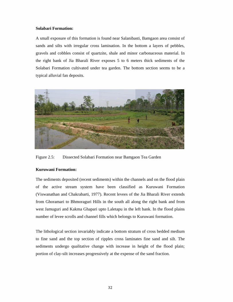
Solabari Formation:
A small exposure of this formation is found near Salanibasti, Bamgaon area consist of
sands and silts with irregular cross lamination. In the bottom a layers of pebbles,
gravels and cobbles consist of quartzite, shale and minor carbonaceous material. In
the right bank of Jia Bharali River exposes 5 to 6 meters thick sediments of the
Solabari Formation cultivated under tea garden. The bottom section seems to be a
typical alluvial fan deposits.
Figure 2.5: Dissected Solabari Formation near Bamgaon Tea Garden
Kuruwani Formation:
The sediments deposited (recent sediments) within the channels and on the flood plain
of the active stream system have been classified as Kuruwani Formation
(Viswanathan and Chakrabarti, 1977). Recent levees of the Jia Bharali River extends
from Ghoramari to Bhmoraguri Hills in the south all along the right bank and from
west Jamuguri and Kakma Ghapari upto Laletapu in the left bank. In the flood plains
number of levee scrolls and channel fills which belongs to Kuruwani formation.
The lithological section invariably indicate a bottom stratum of cross bedded medium
to fine sand and the top section of ripples cross laminates fine sand and silt. The
sediments undergo qualitative change with increase in height of the flood plain;
portion of clay-silt increases progressively at the expense of the sand fraction.

33
Figure 2.6: Channel Fill and Bank deposits near Bihiagaon with ripple cross laminations composed of fine sand, silt and minor clay (Younger Alluvium)
Figure 2.7: Vertical Profile Section made along the Ghiladhari river flood Plain of
recent or Younger Alluvium. In the lower part (h), the opposite current bedding represents the different flow of the river with a small laminated bed.
a

34
In the Figure 2.7, the upper section is silty-loam near about 1m thick (b). Below this
an alternate layer of clay and sand found of varying thickness (d). Sand layer are of
medium grain with impression of cross bedding (c). In the lower part thickness of clay
layer increase and the sand layer are as pocket. Again below this a layer of .75m thick
sand with medium grained with laminated structure seen (e) followed by a alternate
sand a clay layer of almost same thickness (f). A layer of 30cm laminated sand layer
with medium grain size (g). In the lower part of the section a thick layer of sand with
two opposite current. In between there is a small layer of laminated sands (h). The
different alternate layer represents the cyclic deposits of the river.
Balipara Formation:
Balipara Formation is the oldest stratigraphic unit near the foothills resting with
profound erossional unconformity on the terraced sediments of moderately northerly
dipping Siwaliks (Viswanathan and Chakrabarti, 1977). The alluvial deposits which
constitute the dissected upland surface are grouped as Balipara Formation. It
comprises semi-consolidated poorly sorted mixtures of gravel, pebble, boulder, coarse
sands and minor silts. The sand undergone weathering and pedogeneiss; the matrix is
brick red, ochre to chocolate brown coloured silty loam. Along the road side near
Chotaigaon and along the Khari Dikrai in the left bank of Jia Bharali good exposure
Balipara formation found.
Figure 2.8: Mara Bharali flood plain and Balipara Surface

35
Seijosa Formation:
This formation comprises reddish brown sands and grey clays in the top layers.
Whereas the bottom layer is consist of pebbles and cobbles. In general the sand layers
are of medium grain exhibit finely current bedding. The sediments are more compact
and consolidated and rest upon the Siwaliks
2.2.2 Precambrian crystallines
Isolated hillocks with rounded topped and protruding out in the Quaternary deposits.
Inselberg of Granitic gneisses, with intruded Quartz veins, having several sets of
joints are found in the extreme south of the study area on the north bank of river
Brahmaputra (Figure 2.9). These are isolate hillocks of Precambrian basement.
Agnigarh hills near Tezpur, Bhomoraguri hills near Koliabhomora bridge area are
well foliated medium to course grained granitic gneisses. Magnetic and gravity survey
done by Oil and Natural Gas Commission have proved the existence of basement
crystalline rock below the alluvial plain in between the inselberg and the Siwalik
ridges in the North.
Figure 2.9: Granitic Gneiss of Precambrian near Bhomoraguri Hills

36
2.2.3 Siwalik
The tertiary Neogene Clastic sequence, Siwalik cropping out in a linear belt all along
the Arunachal foothills is rest unconformably upon the Gondwana. The northern limit
is defined by MBT while in the south, alluvium of Brahmaputra plain defines the
boundary and marked by HFT. It is well exposed in the present study area along
Bhalukpong-Bomdila road and in the bank of Bor-Dikarai Nadi near Seijosa. The
Tertiary sediments mainly composed of green-grey-earthy brown sandstone; siltstone,
claystone, carbonaceous shale etc. are found in the foot hill region of Arunachal
Himalayan range. This sequence is devisable on the basis of lithology into three
stratigraphic units viz, Dafla, Subansiri, and Kimin Formation (Ranga Rao and Babu,
1972). The Tipi thrust separates the Dafla Formation from Subansiri and Kimin
Formation (Kumar 1997). In different published work on the Siwaliks of Arunachal
Himalaya reported the presence of fossils in the Siwaliks. Singh and Prakash, 1980
has reported the leaf impression in the shale beds of Dafla Formation. Dutta and
Singh, 1980 reported miofloral assemblages in the Subansiri and Kimin Formation.
Figure 2.10: Sequence of Shale, Claystone and Sandstone of Swialiks
Dafla Formation
The steeply dipping beds of the Dafla Formation are highly distorted and fractured. It
consists of alternate beds of sandstone, shale and clay. The sandstone beds are
dominantly bluish-grey and brown coloured fine-to medium-grained, well-bedded
with minor coal partings and thin clay bands. The Dafla formation is comparatively

37
hard sandstone than the Subansiri Formation. They are poorly micaceous, quartzite
and bear resemblance to the Gondwana sandstones. The clays beds are greenish grey
in color and the shales beds are greenish grey to dark grey in colour. Shale beds are
comparatively thin than the sandstone beds. The beds are dipping northwest between
20° to 60°. Dafla Formation is bounded by MBT in the north and Tipi thrust in the
south and about 3800m thick (Karunakaran and Ranga Rao 1983).
Figure 2.11: Exposure of Dafla Formation along the Bhalukpung-Bomdila road. Medium grain massive brownish sandstone with alternate thin shale bed (92o35’40.2”E 27o05’30.8”N)
Subansiri Formation
The Subansiri Formation consist of sandstone beds with trough cross bedding.
Sandstone beds are very thick medium to coarse grained. Very few beds of clay bands
present with in the sandstone bed. The sandstone beds are grey in colour and poorly
micaceous. The sandstones beds have the current bedding and thickness ranges from
0.3 to 4 m. Subansiri is about 4200m thick (Karunakaran and Ranga Rao 1983)

38
Figure 2.12: a) Exposure of Subansiri Formation b) Cross Bedding in the Sandstone
Subansiri Formation (92o35’42.2”E 27o02’48.3”N)
Kimin Formation
The Kimin Formation is dominantly a conglomeratic sequences, consists of alternate
beds of pebble conglomerates, coarse-grained sandstone and clays. This Formation is
poorly cemented and younger formation of Siwalik formation. The conglomerate beds
range in thickness from 1-6m with fragments of pebble to boulder size (Figure 2.13).
In the road section Bhalukpong to Tipi, pebbles are oriented parallel to the bedding,
and the whole section is dipping 58o towards north with strike of 140o. Lithologically,
the pebbles and boulders are composed of gneisses, quartzites and schists in order of
their abundance. The sandstones are grey to orange brown in color, fine to coarse
grained, gritty and pebbly and are generally soft and massive.
Figure 2.13: Exposure of Kimin Formation (N27o02’07.9” E92o36’21.9”) alternate
beds of soft sandstone, clay and conglomerate beds
a b

39
2.2.4 Gondwana
This belt is mainly composed of grey sandstone, carbonaceous shaley slate, siltstone,
grey coloured medium to coarse grained feldspathic gritty sandstone and intercalated
coal bed. The Gondwana Group exposed along MBT, occurs in an E-W to NE-SW
trending narrow linear belt. Gondwana belt is best exposed along the Bhalukpong-
Sessa road. Geological Survey of India established the Gondwana sequence is of
continental and marine origin. ONGC mapped the area as in west from Dikrang river
upto Bhutan Boarder the Gondwana are of continental and while its east the rocks are
marine. According to Acharyya et al., 1974, 1975 demarcated it as the continental
sequence. Gondwana can be sub grouped as Bharali, Bichom and Miri Formation
(GSI, 2010).
Along the Bhalukpong-Bomdila road section the Gondwana sequence is a thick
alternating bed of grayish coloured medium to coarse grained sandstone and
carbonaceous shales, with patchy occurrences of coal (Figure 2.14b).
Figure 2.14: Exposure of Gondwana a) Gondwana sandstone and carbonaceous shale bed b) Coal occurrences in the Gondwana (92o35’01.3”E 27o05’10.5”N)
Bhareli Formation:
Exposure of Bhareli formation is best exposed near Pinjoli and Sessa along the
Bhalukpong-Bomdila road section. Exposure of thick sequence of grey to dark grey
feldspathic sandstone and grey shale observed. Some lenticular coal beds found which
rich in Lower Gondwana floral assemblage. These represent the continental facies of
the Lower Permian sequence (GSI, 2010). Bhareli Formation is conformably overlain
the Bichom Formation. Achayya et al., 1975; Bhusan et al., 1989, 1990 have reported
the presence of Gloossopteries and Gangamopteries floral assemblage.
a b

40
Figure 2.15: Exposure of Bhareli Formation, alternate beds of Grey sandstone and shale (92o32’55.7”E 27o06’36.7”N)
Bichom Formation:
Bichom Formation is conformably overlain by Bhareli Formation and composed of
dark grey quartzite rock and minor occurance of phylite similar to Tenga Formation.
Exposures are found near Bame. The bed is highly fractured and crashed. It may be
due to the effect of MBT. These rocks were also mapped in the lower reaches of
Bichom valley as Bichom Formation (Anon 1974, Das et.al, 1975).
Figure 2.16: Highly Fractured dark grey quartzite rock of Bichom Formation. (92o33’04.3”E 27o07’35.2”N)

41
Miri Formations:
This formation is composed of conglomerate, sandstone, orthoquartzite-dolomite
assemblage. It is mapped in the East Kameng district and it well exposed along the
Bana-Palizi road section. It is steeply dipping quartzites of pink and white colours
with thin purple shale and unconformably overlying by the Bomdila Group and
conformably overlain by the Bichom Formation. GSI, 1973 has marked the Miri
formation in the eastern part of the Jia Bharali basin.
Chakraborty et.al, (2002) described a thrusted contact of Bomdila Group with Miri
Formation and a conglomerate unit with interbands of quartzite as the passage of Miri
Formation to Bichom Formation (marine Palaeozoic). Miri Frormation is well
exposed below the Bomdila gneiss. Kumar and Singh (1974) and Singh and Singh
(1983) lowered the status of Miri Group to a Formation and gave a separate identity
between the Bomdila Group and the overlying Bichom Formation. Miri Quattzite lies
unconformably over a unit equivalent to Buxa Group represented by dolomite with a
basal conglomerate and a laterite horizon at the base.
Figure 2.17: Showing the sandstone, quartzite beds of Miri Formation (92o55’35.1”E
27o14’01.8”N)
2.2.5 Bomdila Group:
Rocks of the Bomdila Group are exposed over a vast area in the West Kameng
District of Arunachal Pradesh. Good exposures are found along the road section
approaching the Bomdila town. Bomdila group is low to medium grade
metasediments comprising Pink to purple ortho-quartzite with conglomerate lenses,
purple shale with diamictite bands Quartzite-Carbonate, Schist/Phyillite association

42
and Gneisses and intrusive granite. Bomdila group is overlain by Dirang Formation in
the north and by the Gondwana sedimendts in the south. Lithostratigraphically,
different worker has been classified this group differently. Bhusan (1999) subdivided
into Tenga Formation, Dedza Formation, Dirang Formation and intrusives in
ascending order on the basis of section measurement between the MBF and MCT.
The Bomdila Group and associated acid and basic intrusive (Bhusan et al., 1919) are
well exposed in the West Kameng district. Kumar (1997) subdivided the Bomdila
Group into three formations viz., Khetabari, Tenga and the Chilliepam (Dedza)
Formations and the biotite gneisses according to area of intrusion. Presently GSI,
2010 has been compiled a classification adopted from Dhoundial, et.al, (1989) and
Kumar (1997), with some modifications. Dirang Formation is not considered as a part
of Bomdila Group (Kumar, 1997). Dirang Formation has a unconformable
relationship with Tenga and Chillepam Formation of Bomdila Group.
Khetabari Formation:
Constitute of metasediments comprising sericite-quartzphyllite, garnetiferous phyllite
and schists, graphitic carbonaceous phyllite, quartzite. A small occurrences of
Khetabari Formation in the Jia Bharali Catchment, along the Bichom valley and
overlain by Tenga Formation (Kumar, 1997)
Tenga Formation:
Tenga Formation is well exposed along the Tenga river. Tenga Formation is
constitute of low grade metasediments of green phyllite, quartzite. Originally
described by Das, et.al, (1975) are referred to as Tenga Formation. In the Arunachal
Himalaya Tenga Formation occurs in a linear belt from Bhutan border in the west and
Subansiri river in the east. Bhusan, et.al, (1989) also divided the Tenga Formation on
the basis of lithostratigraphy into a lower and an upper member and referred as Along
Member and Jameri Member. The Jameri member is separated from the Gondwana by
a series of granite intrusion which leads to the thermal metamorphisim along the
intrusions (Kumar, 1997).

43
Figure 2.18: Exposure of quartzite and green phyllite of Tenga Formation
(92o24’27.1”E 27o13’19.5”N)
Chilliepam Formation:
Chilliepam Formation is exposed along the Bomdial Sheragaon road. Composed of
carbonate rock and unconformably overlying the Tenga Formation. This sequence is
referred as Chilliepam Formation named after the Chillipam village (Anon 1974, Jain
et.al, 1979). Kumar 1997, 1999 broadly divided this formation into two members viz.,
the lower Kabak Member (after Kabak formation of Roy Chowdhury and
Lakshminarayana in Krishnaswamy, 1986), consists of a basal oligomictic
conglomerate with pebbles and cobbles of quartzite and upper member referred to as
Niumi Member (Kumar and Bora, 1984-85) comprises mainly carbonates with
alternations of greenish grey, purple and dark grey carbonaceous phyllites
Intrusive within Bomdila Group
Bomdila Gneiss:
Bomdila gneisses are well exposed along the road side of the Bomdila. Bomdila
Gneisses are foliated, augen-bearing, medium to coarse grained, leucocratic and
consists of quartz, plagioclase, microcline, biotite and muscovite as essential minerals.
Bomdila gneisses consist of a coarse-grained porphyritic gneiss (CPG) comprising of
biotite and muscovite and a weakly to non-foliated leucogranite having abundant
tourmaline (referred as tourmaline-bearing granite) (Rashid. A. S. 2008).
Exposure of Biotite granite gneiss are found between Jameri and Sessa (92o33’26.2”E
27o09’44.55”N) and around Bomdila Town (92o32’18.3”E 27o06’45.4”N). Bhalla and

44
Bishnu 1989, made whole rock isochorn dating of these two intrusion of 1644± 40
and 1676±122Ma respectively. Whereas Dikshitulu et al., 1995 has dated the Augen
gneiss of Bomdila as 1914±23Ma (Rb/Sr Isochron dating). The older biotite granite
gneiss of Bomdila is foliated, straky Augen bearing. It consist of alternate bands of
quartzo feldpathic material and mica and the augen are of quartz-Na-Plagioclase
(Bhusan et.al., 1991, Dikshitulu et al. 1995)
Figure 2.19: a, b Exposure of Bomdila gneisses near Bomdila Town, c-Porphyritic
granite with thin biotite foliation. d-Quartz vein in the granite
Tourmaline bearing leucogranite is also found near Eagle’s Nest Pass. Xenolith of
fine grained melanocratic rock (?) found in the leucogranite (Figure 2.20). In the
Eastern part of Kameng River near Rilo in Pachuk valley biotite granite is reported by
Singh and Sharma 1990. Kumar 1997, reported mafic intrusion of sills and dyke of
amphybolite is reported in the chilliepam Formation

45
Figure 2.20: Exposure of xenoliths of fine grained melanocratic rock in the
tourmaline rich leucocratic granite in the Bomdila Group of rock
2.2.6 Dirang Formation:
A thick sequence of low grade metasedimentaries comprising garnetiferous mica
schist, phyllite, sericite quartzite, calc-silicate and tremolite-actinolite marble
unconformably overlying the Bomdila Group and truncated in the north by the MCT
has been designated as Dirang Formation. It was first mapped as Dirang Schist in
Diggin Valley (Anon 1974, Das et.al, 1975). It is intruded by biotite-augen gneiss
(Bhusan et.al, 1991). Similar sequence has been mapped in the Pachuk river section
(Singh and Sharma, 1990) and around Rupa and Shergaon (Bhusan, 1999). Bhusan
et.al, (1989) in Shergaon-Morshing area, has subdivided the Dirang Formation into
five units (A-E).
Figure 2.21: Garnetiferous mica Schist of Dirang Formation

46
2.2.7 Sela Group:
Sela Group is the oldest sequence and structurally highest unit in the Jia Bharali
catchment area, which is separated from the Dirang Formation to the south by Main
Central Thrust (MCT). Sela Group is undergoes polyphase of deformation and consist
of medium grade to high grade rocks derived its name from the Se La pass in West
Kameng district (Bakliwal and Das, 1971). It consists of calc-silicates, marble,
kyanite-sillimanite, deformed schists, migmatites, high-grade ortho-augen gneisses
and amphibolites, etc. with younger intrusions of hornblende granite (Dikshitulu et
al., 1995), tourmaline granite (Bhalla and Bishui, 1989, 1919), pegmatites and aplites.
Figure 2.22: a. Augen Gneiss; b. Quaterzite-Kyanite-Sillimanite schist of Sela
Group
On the basis of difference in Lithology Verma and Tandon (1976) divided the Sela
Group into two distinct units, a) Northeren Unit consisting of fine grained biotite-
quartz-plagioclase gneiss exposed around Sela. Gneiss is intruded by granite and
some place pegmatite veins. b) Southern Unit consist of hornblende gneiss with thin
flaks of muscovite. Kumar 1997, GSI 2010, Sub divided Sela Group into two
formation- Taliha and Galensinik Formation. Taliha Formation is well exposed in
Subansiri river section. Gulensinik is also named after a village of Subansiri Valley
consist of high grade gneiss and schist, which are best exposed in and around Sela
Pass along the Bomdila-Tawang road. Bhala et al., 1991 reported the tourmaline
granite (29±7Ma) intrusion in the Sela Group near Sela, whereas hornblende granite
intrusion 481±23 Ma (Dikshitulu et al. 1995) close to MCT.
a b