All-Weather Wind Vector Measurements from Intercalibrated Active and Passive
Microwave Satellite Sensors
Thomas MeissnerLucrezia Ricciardulli
Frank Wentz
IGARSS 2011Vancouver, BC,
Canada July 26, 2011
Outline
• Passive (radiometer: WindSat) vs active (scatterometer: QuikSCAT) wind speed retrievals: – Surface emissivity versus radar backscatter.
• Ocean Surface Emissivity Model.• Overview: RSS WindSat version 7 ocean products.• WindSat all-weather wind speeds.• Improved QuikSCAT Ku2011 geophysical model function.• Validation.
– High winds.
• Rain impact study. • Selected storm case: Hurricane Katrina.• Conclusion: active vs passive - strength +weaknesses.
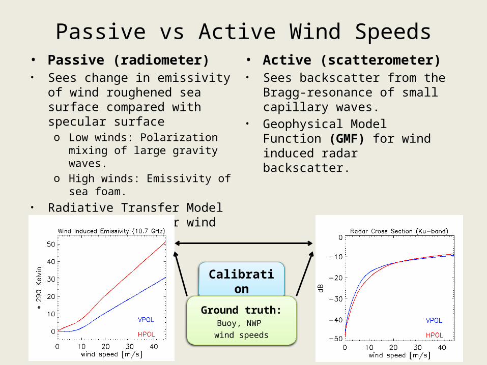
Passive vs Active Wind Speeds• Passive (radiometer)• Sees change in emissivity of wind
roughened sea surface compared with specular surfaceo Low winds: Polarization mixing of
large gravity waves.o High winds: Emissivity of sea foam.
• Radiative Transfer Model (RTM) function for wind induced surface emissivity.
• Active (scatterometer)• Sees backscatter from the Bragg-
resonance of small capillary waves.• Geophysical Model Function (GMF)
for wind induced radar backscatter.
Calibration
Ground truth:Buoy, NWP wind speeds
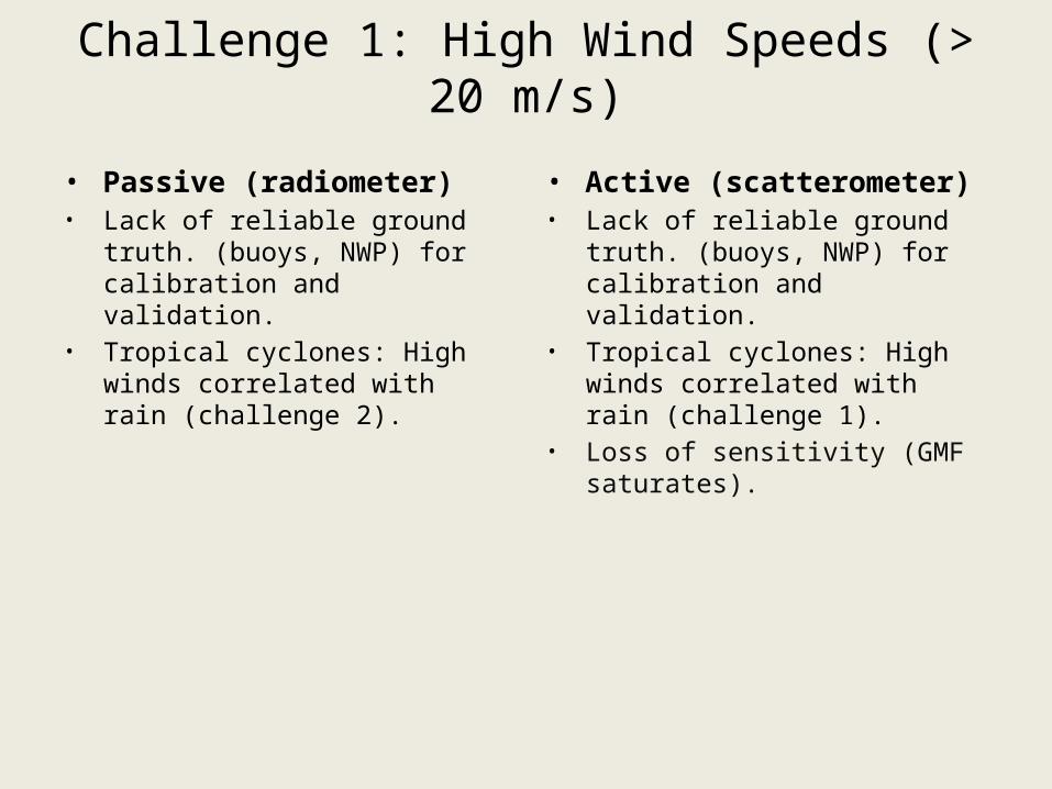
Challenge 1: High Wind Speeds (> 20 m/s)
• Passive (radiometer)• Lack of reliable ground truth.
(buoys, NWP) for calibration and validation.
• Tropical cyclones: High winds correlated with rain (challenge 2).
• Active (scatterometer)• Lack of reliable ground truth.
(buoys, NWP) for calibration and validation.
• Tropical cyclones: High winds correlated with rain (challenge 1).
• Loss of sensitivity (GMF saturates).
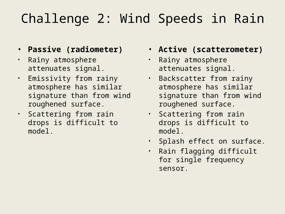
Challenge 2: Wind Speeds in Rain
• Passive (radiometer)• Rainy atmosphere attenuates
signal.• Emissivity from rainy atmosphere
has similar signature than from wind roughened surface.
• Scattering from rain drops is difficult to model.
• Active (scatterometer)• Rainy atmosphere attenuates
signal.• Backscatter from rainy atmosphere
has similar signature than from wind roughened surface.
• Scattering from rain drops is difficult to model.
• Splash effect on surface.• Rain flagging difficult for single
frequency sensor.
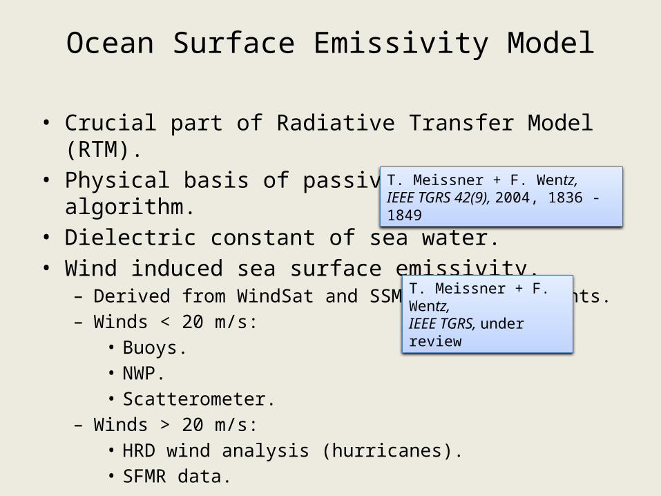
Ocean Surface Emissivity Model
• Crucial part of Radiative Transfer Model (RTM). • Physical basis of passive wind retrieval algorithm.• Dielectric constant of sea water.• Wind induced sea surface emissivity.
– Derived from WindSat and SSM/I TB measurements.– Winds < 20 m/s:
• Buoys.• NWP.• Scatterometer.
– Winds > 20 m/s: • HRD wind analysis (hurricanes).• SFMR data.
T. Meissner + F. Wentz, IEEE TGRS 42(9), 2004, 1836 - 1849
T. Meissner + F. Wentz, IEEE TGRS, under review
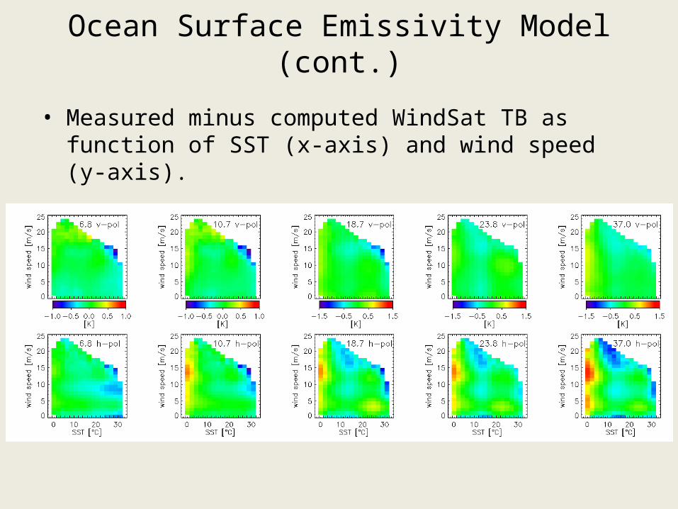
Ocean Surface Emissivity Model (cont.)
• Measured minus computed WindSat TB as function of SST (x-axis) and wind speed (y-axis).
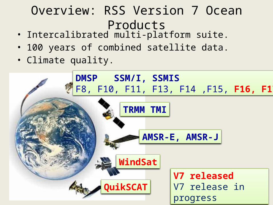
Overview: RSS Version 7 Ocean Products
DMSP SSM/I, SSMISF8, F10, F11, F13, F14 ,F15, F16, F17
TRMM TMI
AMSR-E, AMSR-J
QuikSCAT
WindSatV7 releasedV7 release in progress
• Intercalibrated multi-platform suite.• 100 years of combined satellite data.• Climate quality.
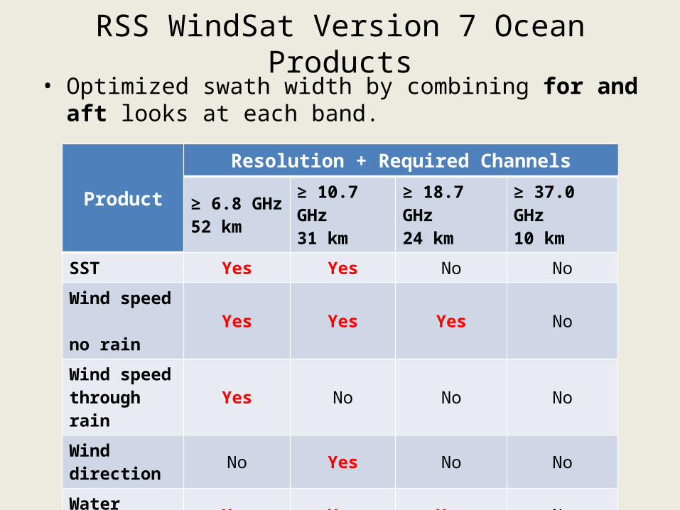
RSS WindSat Version 7 Ocean Products• Optimized swath width by combining for and aft looks at
each band.
ProductResolution + Required Channels
≥ 6.8 GHz52 km
≥ 10.7 GHz31 km
≥ 18.7 GHz24 km
≥ 37.0 GHz10 km
SST Yes Yes No No
Wind speed no rain
Yes Yes Yes No
Wind speed through rain
Yes No No No
Wind direction
No Yes No No
Water vapor Yes Yes Yes No
Liquid cloud water
Yes Yes Yes Yes
Rain rate No No No Yes
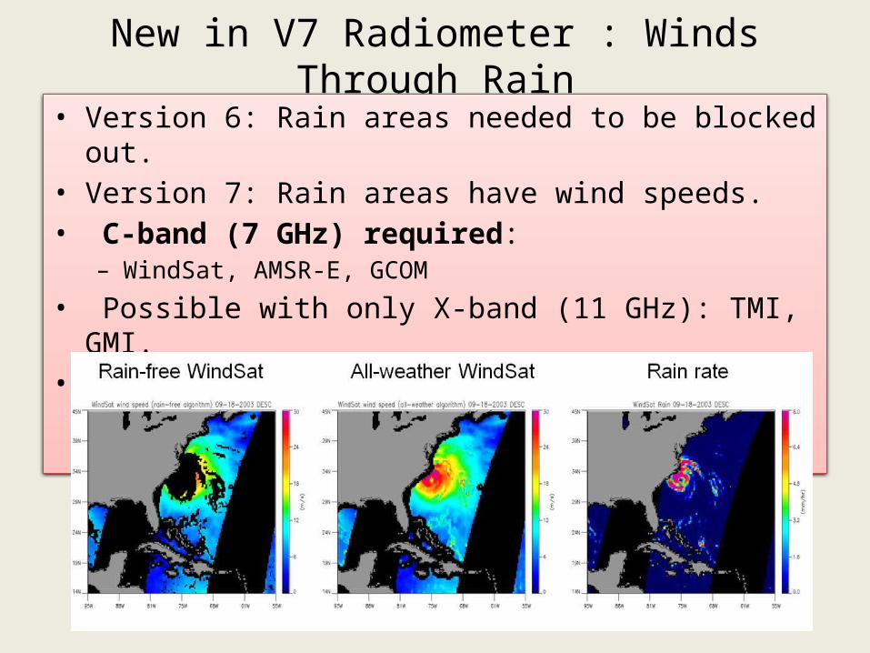
New in V7 Radiometer : Winds Through Rain• Version 6: Rain areas needed to be blocked out.• Version 7: Rain areas have wind speeds.• C-band (7 GHz) required:
– WindSat, AMSR-E, GCOM
• Possible with only X-band (11 GHz): TMI, GMI.• Residual degradation in rain.
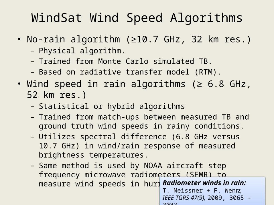
WindSat Wind Speed Algorithms
• No-rain algorithm (≥10.7 GHz, 32 km res.)– Physical algorithm.– Trained from Monte Carlo simulated TB. – Based on radiative transfer model (RTM).
• Wind speed in rain algorithms (≥ 6.8 GHz, 52 km res.) – Statistical or hybrid algorithms– Trained from match-ups between measured TB and ground truth
wind speeds in rainy conditions.– Utilizes spectral difference (6.8 GHz versus 10.7 GHz) in wind/rain
response of measured brightness temperatures.– Same method is used by NOAA aircraft step frequency microwave
radiometers (SFMR) to measure wind speeds in hurricanes.
Radiometer winds in rain: T. Meissner + F. Wentz, IEEE TGRS 47(9), 2009, 3065 - 3083
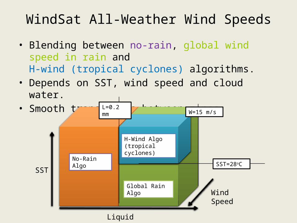
WindSat All-Weather Wind Speeds
• Blending between no-rain, global wind speed in rain and H-wind (tropical cyclones) algorithms.
• Depends on SST, wind speed and cloud water.• Smooth transitions between zones.
Liquid Water
SST
Wind Speed
No-Rain Algo
Global Rain Algo
H-Wind Algo(tropical cyclones)
L=0.2 mm
SST=28oC
W=15 m/s
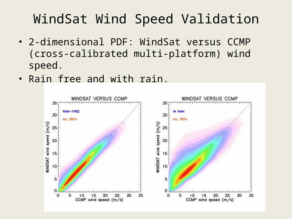
WindSat Wind Speed Validation
• 2-dimensional PDF: WindSat versus CCMP (cross-calibrated multi-platform) wind speed.
• Rain free and with rain.
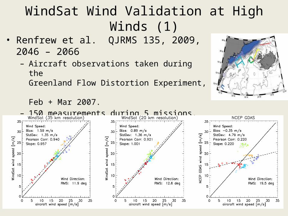
WindSat Wind Validation at High Winds (1)
• Renfrew et al. QJRMS 135, 2009, 2046 – 2066– Aircraft observations taken during the
Greenland Flow Distortion Experiment, Feb + Mar 2007.
– 150 measurements during 5 missions.– Wind vectors measured by turbulence probe.– Adjusted to 10m above surface.
Improved QuikSCAT Ku2011 GMF: Purpose
• Improvement at high wind speeds.– When RSS Ku2001 was developed (Wentz and Smith, 1999),
validation data at high winds were limited. – GMF at high winds had to be extrapolated. – Analyses showed Ku2001 overestimated high winds.
• WindSat wind speeds have been validated.– Confident up to 30 – 35 m/s.– Emissivity does not saturate at high winds. Good sensitivity.– Excellent validation at low and moderate wind speeds < 20 m/s
(Buoys, SSM/I, CCMP, NCEP,…), > 20 m/s: Aircraft flights.– WindSat can be used as ground truth to calibrate new Ku-band
scatterometer GMF.
• Produce a climate data record of ocean vector winds. – Combining QuikSCAT with other sensors using consistent
methodology.
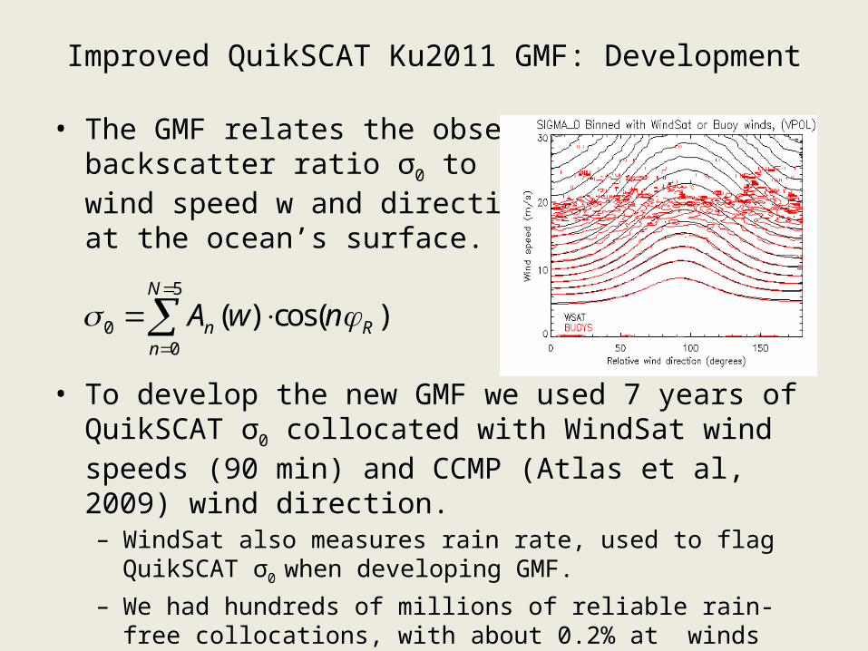
Improved QuikSCAT Ku2011 GMF: Development
• The GMF relates the observed backscatter ratio σ0 to wind speed w and direction φ at the ocean’s surface.
• To develop the new GMF we used 7 years of QuikSCAT σ0 collocated with WindSat wind speeds (90 min) and CCMP (Atlas et al, 2009) wind direction. – WindSat also measures rain rate, used to flag QuikSCAT σ0 when
developing GMF. – We had hundreds of millions of reliable rain-free collocations, with
about 0.2% at winds greater than 20 m/s.
5
00
( ) cos( )N
n Rn
A w n
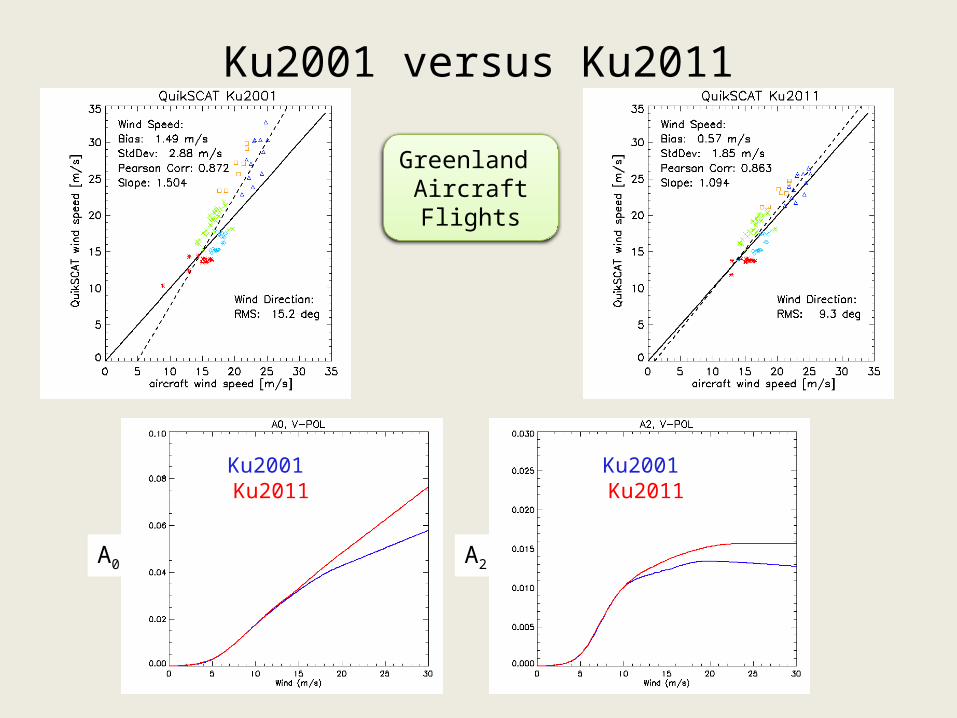
Ku2001 versus Ku2011
Ku2001 Ku2011 Ku2001 Ku2011
A0 A2
Greenland Aircraft Flights
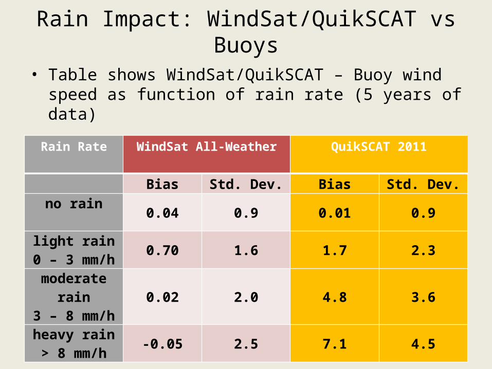
Rain Impact: WindSat/QuikSCAT vs Buoys
• Table shows WindSat/QuikSCAT – Buoy wind speed as function of rain rate (5 years of data)
Rain Rate WindSat All-Weather QuikSCAT 2011
Bias Std. Dev. Bias Std. Dev.no rain
0.04 0.9 0.01 0.9
light rain0 – 3 mm/h
0.70 1.6 1.7 2.3
moderate rain3 – 8 mm/h
0.02 2.0 4.8 3.6
heavy rain> 8 mm/h
-0.05 2.5 7.1 4.5
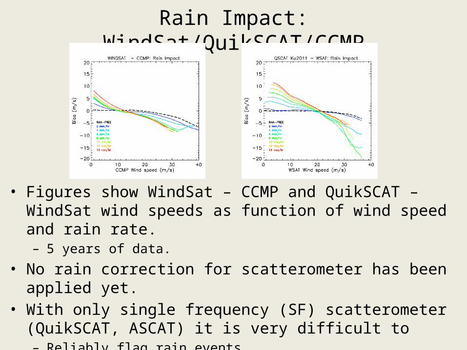
Rain Impact: WindSat/QuikSCAT/CCMP
• Figures show WindSat – CCMP and QuikSCAT – WindSat wind speeds as function of wind speed and rain rate.– 5 years of data.
• No rain correction for scatterometer has been applied yet.• With only single frequency (SF) scatterometer (QuikSCAT,
ASCAT) it is very difficult to – Reliably flag rain events– Retrieve rain rate which is needed to perform rain correction
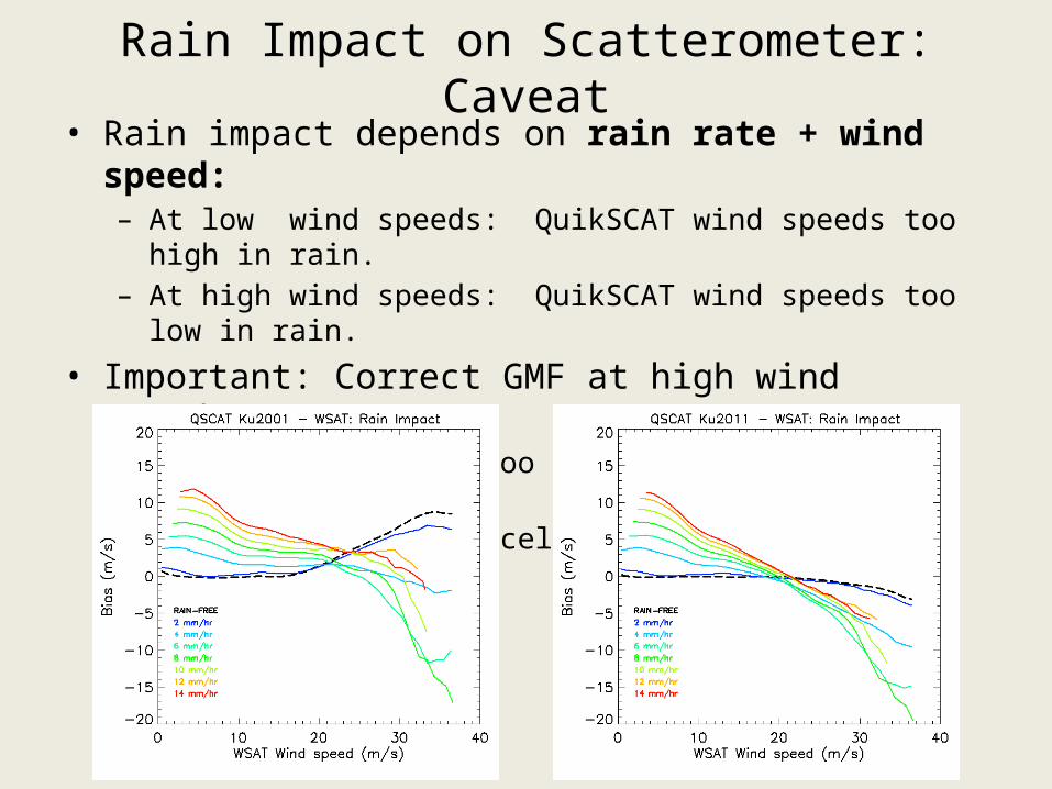
Rain Impact on Scatterometer: Caveat• Rain impact depends on rain rate + wind speed:
– At low wind speeds: QuikSCAT wind speeds too high in rain.– At high wind speeds: QuikSCAT wind speeds too low in rain.
• Important: Correct GMF at high wind speeds.– Ku2001 wind speeds too high at high wind speeds.– Accidental error cancellation possible in certain cases.
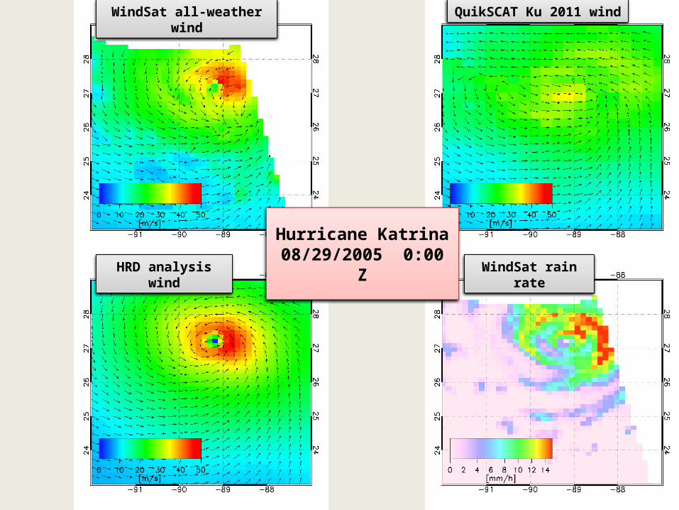
Hurricane Katrina08/29/2005 0:00 Z
WindSat all-weather wind
HRD analysis wind
QuikSCAT Ku 2011 wind
WindSat rain rate
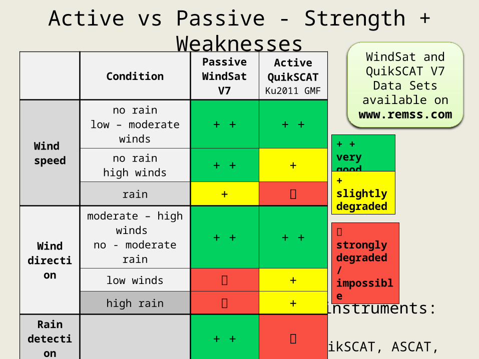
Active vs Passive - Strength + Weaknesses
• Assessment based on operating instruments:– Polarimetric radiometer (WindSat).– Single frequency scatterometer (QuikSCAT, ASCAT, Oceansat).
ConditionPassive
WindSat V7
ActiveQuikSCAT
Ku2011 GMF
Wind speed
no rainlow – moderate winds + + + +
no rainhigh winds + + +
rain +
Wind direction
moderate – high winds
no - moderate rain+ + + +
low winds +
high rain +Rain
detection + +
+ + very good
+ slightly degraded
strongly degraded / impossible
WindSat and QuikSCAT V7 Data Sets available on www.remss.com
Recommended