By Brad Torry
HOUSTON–As 2015 begins amid un-certainty about commodity prices, oneregion in the Gulf of Mexico bears an in-teresting revival that should survive theseprices swings: the “Shelf region.”For all intents and purposes, we will
classify the Shelf region as the areacovered by Outer Continental Shelf blocksin the five-year-term window (see Figure1), which encompasses the historical post-salt and flex trends. With significant ad-vancements in drilling technology, activityin the Gulf of Mexico over the past 10years has seen an increased focus on thedeepwater exploration prize.From 2005 to the present, many major
exploration and production companieshave divested assets on the Shelf to anew breed of independents, many ofwhich have technical teams that departedthe majors. In the traditional cause andeffect relationship, this has re-establisheda round of activity in this highly prospec-tive region.We believe a number of factors are
driving this revival: new geologic targets,infrastructure capacity, and new technology(seismic and drilling). Combine this witha willingness to push the envelope toidentify and pursue new play conceptsand previously inaccessible pay that wasnot recognizable with available data, anda revival is occurring.Although the GOM Shelf region has
had extensive seismic coverage (Figure1), the majority of these data are limitedto narrow-azimuth ocean bottom cableor streamer data, which means they weregathered with limited offsets and azimuths.With historical production occurring atdepths ranging from 5,000 to 15,000 feet(fewer than 5 percent of wells exceed15,000 feet) in this complex depositionaland structural (salt) environment, increasedspatial (lateral) and temporal (vertical)resolution from seismic is required to re-solve smaller/thinner geologic targets.Early revival was made possible by
advances in data processing algorithmsand computational power that led to en-hanced subsurface images. However, chal-lenges remain, based on input data.Where accessible (with accessibility
being the key), the acquisition of wide-azimuth (WAZ), multiwide-azimuth(MWAZ) and full-azimuth (FAZ, although
gaps remain with streamer acquisition)data acquired with a variety ofstreamer/vessel configurations has madea material impact, particularly in the deepwater. Each of these configurations fun-damentally offers long-offset, broad (notfull) azimuth data to image prospectivezones and unlock subsalt potential.However, if current Shelf coverage
(Figure 1) is limited to only what wouldbe considered modern wide-azimuth seis-mic (long offsets that have a minimumof 30 percent azimuthal coverage), a sig-nificant void in new data coverage becomesevident (yellow and blue areas).This challenge creates opportunity.
Independents have identified the consid-erable untapped potential. Given the ad-vancement in ocean bottom node (OBN)technology, a step change or new paradigmfor new full-azimuthal nodal data (FAN)will support the resurgence of activity inthis region.
Why Now?
After the last round of major Shelfactivity in the early part of the new mil-lennium, most discoveries now are ondecline. The new breed of independentoperator has recognized the significantamount of bypassed pay, pool extensions,deeper reservoirs, and enhanced recoveryopportunities. Add to this an increasedunderstanding of depositional environ-
ments (through extending onshore inter-pretations to the Shelf) and the expandedunderstanding of salt tectonics, and theregion has experienced numerous newideas and learnings.Add new technology (WAZ, FAN, and
short-leg horizontal drilling) with properapplication, and these opportunities haveled to strong return on investment foroperators and the identification of newpotential geologic fairways.Examples of this can be found in the
success of companies such as EnergyXXI, which has increased reserves andproduction from existing fields, andFreeport McMoRan with its deep explo-ration drilling program (Davy Jones,Blackbeard and Lafitte prospects). Al-though the final verdict on these deeperwells remains outstanding, I believe theyhave and will provide significant geot-echnical information that will lead to on-going exploration and development onthe Shelf.Figure 2 provides an excellent visual
summary of the concepts that are returningpeople to the Shelf. The final piece of in-formation that needs to be added to thisequation is modern geoscience data. Theindustry’s ability to integrate and modelthis data from source to sink, and to un-derstand its complexities from local stratig-raphy to basin-scale, thermal maturationmodels, has reopened the door to prospec-
Advances In Seismic Rejuvenate Shelf
FIGURE 1
Map of GOM Shelf Region With Seismic Coverage
Plans Filed in Past Six Months
Submitted Application for Permit to Drill
2014 Data
New Data
Early Vintage
Year Established Unknown
Shelf Trend
TGS 3-D Projects (in Progress)
TGS 3-D Surveys
SpecialReport: Gulf of Mexico Update
THE AMERICAN OIL & GAS REPORTER FEBRUARY 2015
©AOGR
©AOGR

tivity.What exactly do I mean by this? I
have mentioned the application of WAZdata and improvements in imaging algo-rithms. However, much of this has notbeen available on the Shelf, except forlong-offset 2-D data. But with the com-mercial application of full-azimuth nodalsurveys using ocean-bottom node tech-nology, new, industry-leading seismic im-ages are within reach, and provide an ad-vanced path to continued developmentand the future for the Shelf.
Operations And Logistics
The Shelf region holds a number ofunique operational and logistical chal-lenges for exploration, drilling and pro-duction, not the least of which are theBureau of Ocean Energy Management’sfive-year lease term conditions. As BOEMenters its 2017-22 planning cycle, manyrequests have been made to make Shelflease terms similar to the 10-year termson deepwater blocks.Considering, however, that BOEM is
not likely to make such a change, com-panies must execute exploration and de-velopment plans within the guise of thecurrent cycle time. To optimize thoseplans, operators require superior data thatmeet the current and future demands ofexploration, field development, and in-frastructure planning and utilization.For most geoscientists, the natural al-
ternative would be to acquire new WAZdata. Unfortunately, the water depths (10-300 meters) and amount of infrastructureprohibit acquiring new data.The turn radius for line changes re-
quired for modern WAZ configurations(often 10-20 kilometers), the setback dis-tance for obstructions (generally 500 me-ters), and the required run-in distance tomeet the obstruction setback distance, insimple terms are not attainable on theShelf.Figure 3 provides an example of cov-
erage loss resulting from avoiding infra-structure. These significant gaps in datacreate imaging challenges that cannot beovercome other than by “infilling” withshort-offset ocean bottom cable or earlyvintage narrow-azimuth (NAZ) data.Thankfully, with the development of
OBN technology, these challenges canbe averted and the capability to acquirenew seismic data with all the offeringsof MWAZ, FAZ and more has become areality. Industry has the ability to deploya regular grid of seismic receivers within100 meters of offshore structures andwith no limit to offsets and azimuths. Wecan avoid feathering issues caused bysurface currents, and are not limited byoperational speed and deployment capacity
FIGURE 2
Gulf of Mexico Shelf Opportunities
FIGURE 3
Limitations in Streamer Recording
FIGURE 4
Imaging Uplift from NAZ to MWAZ Data
THE AMERICAN OIL & GAS REPORTER FEBRUARY 2015
©AOGR
©AOGR
(number and length of streamers).
Ocean Bottom Nodes
In the history of geotechnical data,the ability to integrate, analyze and sim-ulate has never been greater. Industry’sgreatest challenge still remains the qualityof input data. As discussed earlier, thelast round of activity on the Shelf sawapplication of new imaging technologyfor seismic data and WAZ data, whereaccessible. An example of this can beseen in Figure 4, which represents theuplift from NAZ streamer data to MWAZstreamer data.So, how does one get the same advan-
tages on the Shelf? All has changed withdevelopment of ocean bottom nodes. Withthe ability to record data continuouslyfor 45 days utilizing autonomous nodesdeployed on the seafloor, combined withthe ability to deploy equipment in anyand all configurations, true full-azimuthdata are now a reality.Looking to forward modeling (data
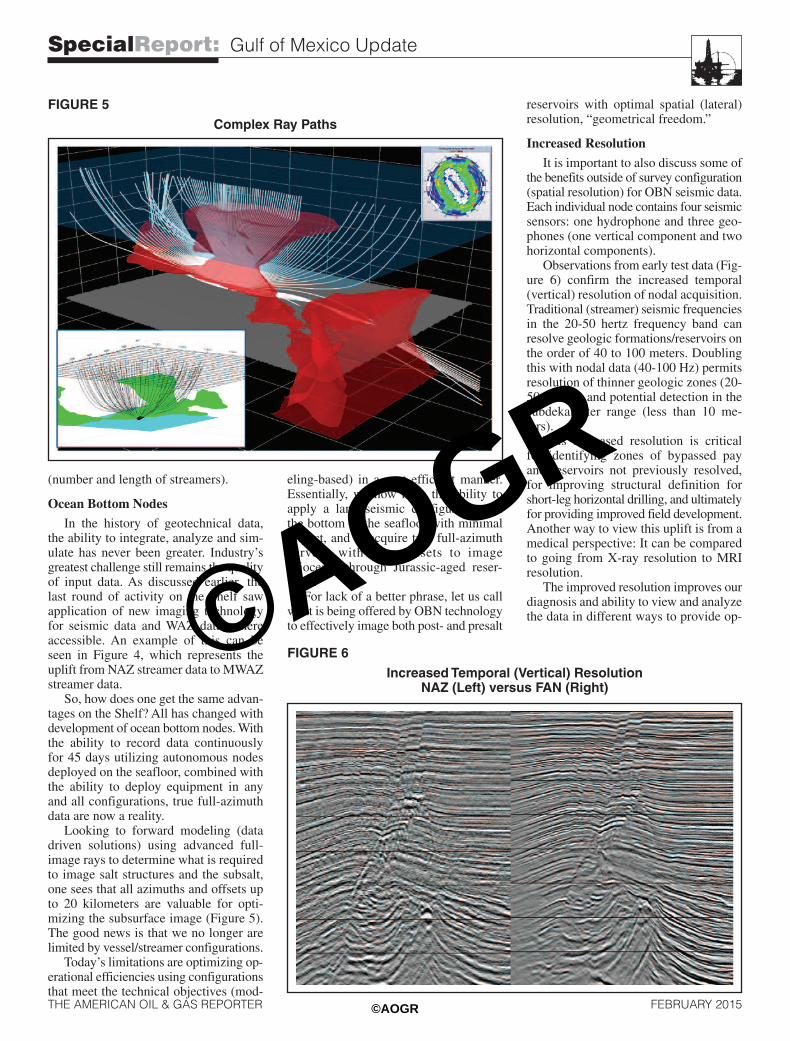
driven solutions) using advanced full-image rays to determine what is requiredto image salt structures and the subsalt,one sees that all azimuths and offsets upto 20 kilometers are valuable for opti-mizing the subsurface image (Figure 5).The good news is that we no longer arelimited by vessel/streamer configurations.Today’s limitations are optimizing op-
erational efficiencies using configurationsthat meet the technical objectives (mod-
eling-based) in a cost efficient manner.Essentially, we now have the ability toapply a land seismic configuration onthe bottom of the seafloor with minimalimpact, and to acquire true full-azimuthsurveys with long offsets to imageMiocene- through Jurassic-aged reser-voirs.For lack of a better phrase, let us call
what is being offered by OBN technologyto effectively image both post- and presalt
reservoirs with optimal spatial (lateral)resolution, “geometrical freedom.”
Increased Resolution
It is important to also discuss some ofthe benefits outside of survey configuration(spatial resolution) for OBN seismic data.Each individual node contains four seismicsensors: one hydrophone and three geo-phones (one vertical component and twohorizontal components).Observations from early test data (Fig-
ure 6) confirm the increased temporal(vertical) resolution of nodal acquisition.Traditional (streamer) seismic frequenciesin the 20-50 hertz frequency band canresolve geologic formations/reservoirs onthe order of 40 to 100 meters. Doublingthis with nodal data (40-100 Hz) permitsresolution of thinner geologic zones (20-50 meters) and potential detection in thesubdekameter range (less than 10 me-ters).This increased resolution is critical
for identifying zones of bypassed payand reservoirs not previously resolved,for improving structural definition forshort-leg horizontal drilling, and ultimatelyfor providing improved field development.Another way to view this uplift is from amedical perspective: It can be comparedto going from X-ray resolution to MRIresolution.The improved resolution improves our
diagnosis and ability to view and analyzethe data in different ways to provide op-
Increased Temporal (Vertical) ResolutionNAZ (Left) versus FAN (Right)
FIGURE 5
Complex Ray Paths
FIGURE 6
SpecialReport: Gulf of Mexico Update
THE AMERICAN OIL & GAS REPORTER FEBRUARY 2015
©AOGR
©AOGR

timal images of the subsurface, reducedrilling risk, and improve importantmetrics such as estimated ultimate re-covery, and 2P (proved, probable) and3P (proved, probable and possible) reserveestimates.
Secondary benefits not often discussedinclude:
• The general static positioning ofthe receivers on the seafloor can be re-peated for future 4-D (time lapse) moni-toring of a proven field.
• Receiver arrays on the seafloorrecord both the up- and down-going wavefield, which permits both to be processedand the differing data to be used in ad-vanced noise elimination applications.
• Subsurface structural positioningis improved compared with streamer data(i.e., the source is the only moving part).These benefits accrue from the primary
vertical component (and hydrophone)data. Additional long-term benefit fromhorizontal components remains in its in-fancy. As technology continues to develop,shear-wave data pose significant potentialfor delineating reservoirs and identifyinghazards.
Cost/Value Proposition
This discussion would not be completewithout considering costs. Because thedeployment and operational efficienciesof the technology are still in their infancy,there remains much to learn. In comparisonwith early NAZ streamer data, the quantumadvance most likely is 10-to-1. However,when compared with current MWAZ/FAZoperational costs, we estimate FAN to beequivalent (per unit area).The primary difference is speed of
data collection, which remains an estimated
5-10 times slower than streamer operations(on a square unit coverage area). Thispoints to the importance of planning sur-veys in the exploration cycle to ensuredata are captured and processed to meetcritical deadlines.The more important question, however,
is value. In most market conditions, costreduction typically is viewed as a primaryobjective. I believe the difference liespurely in differentiating investment andcost.Based on drilling costs in the tens to
hundreds of millions of dollars, is it betterto spend $5 million on seismic data toget a 50 percent solution with four prospec-tive targets, or to spend $15 million toget a 65 percent solution with six prospects(or two confirmed prospects, since theother two were “false positives”)? Havingexperience with portfolio ranking andMonte Carlo risk analysis, I think mostpeople would take the second option.As the industry embarks on its first
collection of true multiclient, FAN seismicdata, I believe the paradigm shift is onus. One dataset with multiple data volumes(p-wave, hydrophone and shear wave)that maximizes capture of full offsetsand full azimuths in one pass is, funda-mentally, the highest trace density perunit area of any seismic technology avail-able.To again draw on a medical analogy,
this is equivalent to capturing an X-ray,CT scan and MRI at the same time, andhaving the ability to repeat the test 10years later to see what has changed.Data volumes created with this tech-
nology should provide a paradigm shiftin how the industry acquires data, andprovide new and improved subsurface
insight. They will uncover bypassed payand untapped reservoirs, and will improvedrilling success, field development, andthe discovery of new, deeper zones. Thefuture of the Shelf is bright for thosewilling to embrace technology and theoperational conditions inherent in all thatis exploration.Happy hunting. �
BRADTORRY
Brad Torry is director of geosciencesand Gulf of Mexico project developmentfor TGS-NOPEC Geophysical Co. ASA.He spent the first half of his 29-yearcareer as a senior geophysicist/teamleader. The second half has been spentas founder, president and chief executiveofficer of Arcis Seismic Solutions inCalgary, which was acquired by TGSin 2012. Torry has extensive operationaland interpretation expertise in hydro-carbon prospect/trend delineation, in-cluding economics and risk analysis.His seismic related experience includesprogram design and implementation;signal processing, interpretation andanalysis; quality, health, safety andenvironmental control; procurement;regulatory affairs; and contract facil-itation.
SpecialReport: Gulf of Mexico Update
THE AMERICAN OIL & GAS REPORTER FEBRUARY 2015
©AOGR
©AOGR
Recommended