×
Log in
Upload File
Most Popular
Art & Photos
Automotive
Business
Career
Design
Education
Hi-Tech
+ Browse for More
Download pdf -
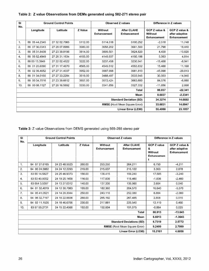
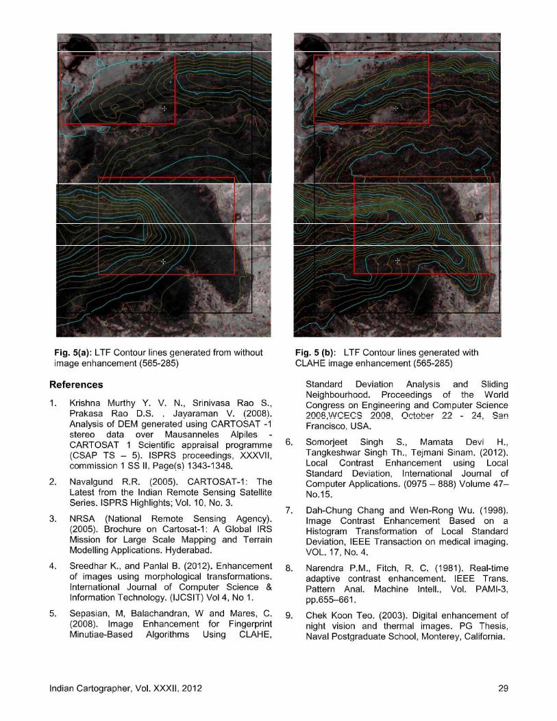
Adaptive Image Contrast Enhancement Technique on CARTOSAT - 1 Stereo pair for DEM quality improvement
Download pdf
Transcript
Page 1
Page 2
Page 3
Page 4
Page 5
Page 6
Page 7
Page 8
LOAD MORE
Recommended
Economic and Social Council Distr. LIMITED …...even higher resolution for stereo-images from satellite plateforms. Indian Remote Sensing satellite, Cartosat scheduled for launch
Documents
Creating a Digital Elevation Model (DEM) from SPOT 4 ... · Creating a Digital Elevation Model (DEM) from SPOT 4 Satellite Stereo-Pair Images for Wadi Watier - Sinai Peninsula, Egypt
Documents
IHS Cartosat-1
Documents
towards automated dem generation from high resolution stereo satellite images
Documents
Accuracy Assessment of Cartosat-1 Stereo Image Data-Derived Digital Elevation Models
Documents
ENVI DIGITAL ELEVATION MODEL (DEM) EXTRACTION …€¦ · need to view anaglyph stereo pairs, ... EASILY CREATE DEMS FROM GEOSPATIAL IMAGERY The ENVI DEM Extraction Module allows
Documents
EPIPOLAR RECTIFICATION FOR CARTOSAT-1 … RECTIFICATION FOR CARTOSAT-1 STEREO IMAGES ... rectification followed by SIFT and then we outline RANSAC ... with a tilt in flight direction
Documents
PhotoSat WorldView-2 Stereo Satellite DEM Comparison … · PhotoSat WorldView-2 Stereo Satellite DEM Comparison to a LiDAR DEM in Southeast California. Gerry Mitchell, PhotoSat,
Documents
Automated DEM Extraction and Orthoimage Generation from ... · Automated DEM Extraction and Orthoimage Generation from SPOT Level ... stereo-pair have been acquired ... developed
Documents
PHOTOGRAMMETRIC PROCESSING OF CARTOSAT-1 STEREO IMAGERY · PHOTOGRAMMETRIC PROCESSING OF CARTOSAT-1 STEREO IMAGERY ... CARTOSAT-1 is meant to support the extraction of …
Documents
Extracting DEM from stereo photos - tmackinnon.com
Documents
analysis of dem generated using cartosat-1 stereo data over
Documents
extracting DEM from stereo photos - PCI Geomatics · Extracting Elevation from Air Photos TUTORIAL www. pc ig eo matics.c om A digital elevation model (DEM) is a digital raster surface
Documents
First Impressions of CARTOSAT-1 · 2016-06-09 · First Impressions of CARTOSAT-1 JACIE Workshop March 14-16, 2006 3 CARTOSAT-1 Payload Overview Camera Fore (+26 deg) Aft (-5 deg)
Documents
AUTOMATED DSM BASED GEOREFERENCING OF CARTOSAT-1 …
Documents
PhotoSat GeoEye-1 Stereo Satellite DEM Comparison to a LiDAR
Documents
CARTOSAT-1: ORIENTATION, DEM AND … · CARTOSAT-1: ORIENTATION, DEM AND ORTHORECTIFICATION QUALITY ASSESMENT R. Dabrowskia, W. Fedorowicz-Jackowski a, M. Kedzierskib, P. Walczykowskib,
Documents
Cartosat En
Documents