3SAQS Network Assessment
Till Stoeckenius, ENVIRON
Three-State Air Quality Working GroupConference Call17 January 2014
2
Today’s Agenda
• Review discussion from 1/10 call• Provide summary of information received
since the 1/10 call• Gather additional information, comments and
suggestions• Discuss potential recommendations• Get ready for 24 January call

3
Highlights from Last Call
• Site classification method– Step 1: List of
“permanent” and “non-permanent” sites
– Step 2: Non-Permanent Class A vs Class B sites
• Review Class B sites and potentially underserved areas (UAs)
No
Yes
Yes
No
Permanent Sites
Retain (Class A
Site)
Potential 3SAQS Sites
Monitoring Site Classification
Step 1:Permanent Site?
Step 2 :High value
location?
Non-Permanent
Sites
Consider Moving
(Class B Site)
Monitoring Network
Objectives
Starting Network

4
Input Received Past Week(see new map, revised site spreadsheet and revised UA table)
• USFS (J. Korfmacher and D. Miller)– Changes to “permanent” vs. “non-permanent” site list– Comments on Class A vs. Class B non-permanent sites– Comments on UAs
• UDAQ (P. Barickman)– Comments on Class A vs. Class B non-permanent sites– Comments on UAs
• WY DEQ (C. Keslar)– Potential funding problems for Hiawatha and Campbell Co. sites; move to “non-permanent”– A temporary monitor is currently located in East-Central WY (UA2) for 2013 - 2014– Comments on UAs
• CDPHE (G. Pierce)– Move Pawnee Buttes to “non-permanent” – Palisade and Aspen considered “permanent” – Lay Peak to stay put through 2014; possible move in 2015?– Walden will operate through at least 2014– Recommended high priority UAs (in order):
a. UA5 East of Dinosaur NMb. UA13 Roan Plateauc. UA12 Kremmling as this area had some issues with air quality when the LP waferboard plant was in operation. It is unknown what impact the current pellet facility might have, but the area is subject to deep inversions.d. UA9 Dove Creek

5
Updated 16 January“Permanent” Sites
Rifle Dinosaur Casper
Gothic Vernal Boulder
Shamrock Redwash Daniel
Ignacio Ouray Pinedale
Bondad Rabbit Mountain Big Piney
Rocky Mountain Whiterocks Juel Spring
Cortez Hurricane Pinedale-CASTNET
Mesa Verde Zion
Meeker Centennial Wamsutter
Rangely Basin Moxa
Palisade Thunder Basin Grand Teton
Roosevelt Yellowstone
Myton Devil's Tower Newcastle
Sheridan South Pass Pawnee Buttes
Canyonlands N. Cheyenne Horsepool
Aspen

6
Updated 15 January “Non-Permanent” Sites
Trout Creek Pass Briggsdale
Goliath Peak Price [Official 3SAQS site]
Flattops Fruitland [Official 3SAQS site]
Ripple Creek Little Mountain
Sunlight Mountain Sinclair Casper
McClure Pass
Walden [Official 3SAQS site] Wyoming Range
Dutch John
Grand Mesa Escalante [Official 3SAQS site]
Silt-Collbran Murphy Ridge
Colorado NM South Campbell Co.
Lay Peak [Official 3SAQS site] Hiawatha Green
Kenosha Pass
Norwood

7
Updated 16 January “Non-Permanent” Sites: Recommended Classifications
(draft)Class A: Keep in Current Location Not Sure
Class B: Would be willing to move if appropriate
Briggsdale Escalante [Official 3SAQS site] Trout Creek Pass
Goliath PeakColorado NM Walden [Official 3SAQS site]: (not
before Oct. 2014)
FlattopsSinclair Casper
Dutch John
Ripple Creek Murphy Ridge Grand Mesa
Sunlight Mountain South Campbell Co. Silt-Collbran
McClure Pass Hiawatha GreenLay Peak [Official 3SAQS site] (not before 2015)
Price [Official 3SAQS site] Norwood
Fruitland [Official 3SAQS site]
Little Mountain
Kenosha Pass

“Permanent” Site
“Non-Permanent”
Site
Industry Site
Old Great Sand Dunes O3 Monitor (1988-1991)
USFS Holy Cross (potential replacement
for Wilson)
New Snowbird O3 Monitor
Wyoming Range (Closed)
New Deadman Pass SiteNew
Storm Peak (DRI)
17 January Update
Site Type
9
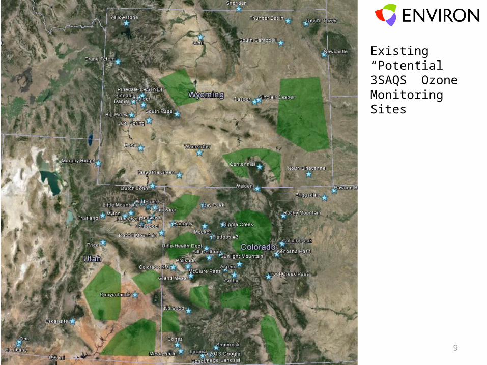
Existing “Potential 3SAQS” Ozone Monitoring Sites
10
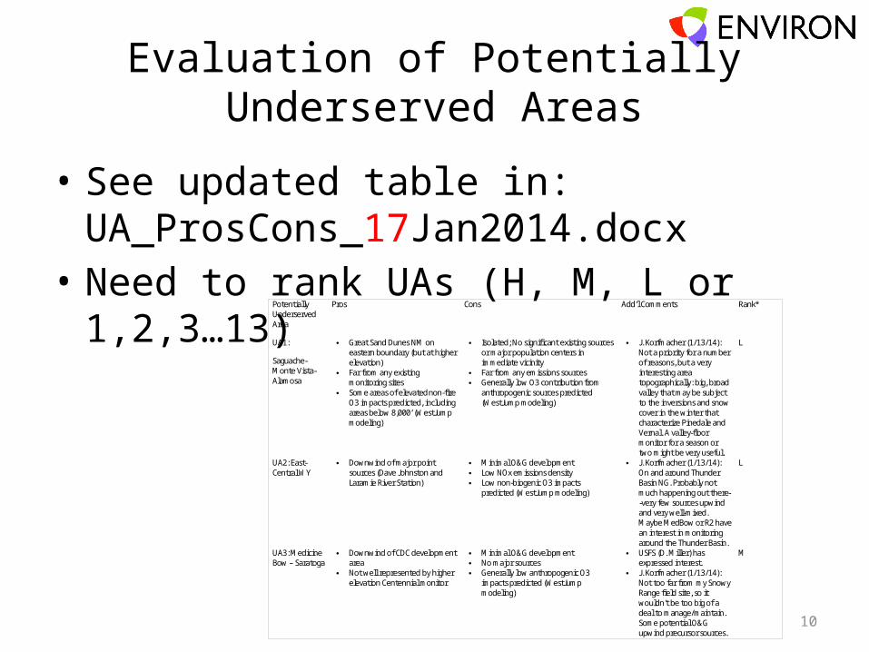
Evaluation of Potentially Underserved Areas
• See updated table in: UA_ProsCons_17Jan2014.docx
• Need to rank UAs (H, M, L or 1,2,3…13)Potentially Underserved Area
Pros Cons Add’l Comments Rank*
UA1:
Saguache-Monte Vista-Alamosa
Great Sand Dunes NM on eastern boundary (but at higher elevation)
Far from any existing monitoring sites
Some areas of elevated non-fire O3 impacts predicted, including areas below 8,000’ (WestJump modeling)
Isolated; No significant existing sources or major population centers in immediate vicinity
Far from any emissions sources Generally low O3 contribution from
anthropogenic sources predicted (WestJump modeling)
J. Korfmacher (1/13/14): Not a priority for a number of reasons, but a very interesting area topographically: big, broad valley that may be subject to the inversions and snow cover in the winter that characterize Pinedale and Vernal. A valley-floor monitor for a season or two might be very useful.
L
UA2: East-Central WY
Downwind of major point sources (Dave Johnston and Laramie River Station)
Minimal O&G development Low NOx emissions density Low non-biogenic O3 impacts
predicted (WestJump modeling)
J. Korfmacher (1/13/14): On and around Thunder Basin NG. Probably not much happening out there--very few sources upwind and very well-mixed. Maybe MedBow or R2 have an interest in monitoring around the Thunder Basin.
L
UA3: Medicine Bow – Saratoga
Downwind of CDC development area
Not well represented by higher elevation Centennial monitor
Minimal O&G development No major sources Generally low anthropogenic O3
impacts predicted (WestJump modeling)
USFS (D. Miller) has expressed interest.
J. Korfmacher (1/13/14): Not too far from my Snowy Range field site, so it wouldn't be too big of a deal to manage/maintain. Some potential O&G upwind precursor sources.
M

11
Reminder:3SAQS Monitoring Network Objectives
• Provide adequate spatial coverage of study area• Monitor locations with O3 close to or above
NAAQS• Monitor locations downwind of existing or
planned future development areas• Monitor Class I and sensitive Class II AQRV impacts• Characterize background O3
• Provide data for model performance evaluation (O3, PM and precursors)

12
Area Informal Summary Assessment Recommended Rank [DRAFT]
UA13: Roan Plateau Downwind of O&G developments and far from Rangely; USFS suggests Douglas Pass site
3
UA5: Dinosaur East Side Of interest for several reasons and commentators have suggested high priority but USFS may have difficulty servicing this remote location
3
UA12: Kremmling Area Mostly high elevation; downwind of White River O&G development; low elevation areas not well represented by current network; potential USFS Holy Cross site in southern end and DRI Storm Peak in northern end
2-3
UA2: East-Central WY Considered high priority by WY DEQ due to future development plans; considered low priority by other agencies; mobile monitor in place 2013 - 2014
3 (based on WY DEQ analysis)
UA3: Medicine Bow – Saratoga
Potentially downwind of large O&G development but WestJump predicts low anthropogenic impact; may be manageable by USFS
2
UA9: Dove Creek North Side May be reasonably well represented by existing sites but there is potential for future development in the area (Mancos and Paradox)
2
UA4: Central West WY Some on-going development to the south but otherwise of lower interest; considered medium priority by WY DEQ
1-2
UA6(Caineville-Hanksville), UA7(Green River-Westwater), UA8(Blanding Area)
Long way from any existing assets; UDAQ suggests existing sites are reasonably representative of UA6, UA7 and UA8
1
UA10(Delta-Montrose), UA11(Black Canyon of the Gunnison)
Minimal evidence of ozone greater than background; Near otherwise unmonitored Class I areas (Black Canyon of the Gunnison and West Elk); Easy access via US-50
1
UA1: Saguache-Monte Vista-Alamosa
Low priority based on ENVIRON analysis and other comments received; 1

13
Next Steps – Jan. 10th through mid-Feb.Step Deadline
Obtain additional input :
• Assessment WG review of site status / rankings TODAY!!
• ENVIRON provides revised network map and first draft of recommendations
By 23 January
• Call for Assessment WG to reach consensus on draft recommendations
Target of 24 January at 2:00 PM MST
• Additional calls as needed for Assessment WG to reach consensus
Possible calls on 28 and/or 29 January, or morning of 31 January
Complete recommendations memo for distribution to Steering Committee
before or on 6 February
Review of recommendations memo by Steering Committee, including input on site operations commitments by each funding agency
by 14 February
Finalize memo including data files, map layers, data sources and processing procedures
21 February

Recommended