KANSAS SEVERE WEATHER AWARENESS WEEK MARCH 2–6, 2015
2015 KANSAS SEVERE WEATHER AWARENESS WEEK
MARCH 2 - 6, 2015
TORNADO SAFETY DRILL
TUESDAY, MARCH 3rd
1:30 PM CST
INFORMATION PACKET
National Weather Service
2
KANSAS SEVERE WEATHER AWARENESS WEEK MARCH 2–6, 2015
Table of Contents Page Number
3
4
7
8
10
12
14
16
19
20
27
29
30
2014 Kansas Tornado Facts
Kansas Tornado Statistics by County
2014 Severe Summary for Extreme East Central and Northeast Kansas
NWS Pleasant Hill, MO
2014 Severe Summary for Northeast and East Central Kansas
NWS Topeka, KS
2014 Severe Summary for Central, South Central and SE Kansas
NWS Wichita, KS
2014 Severe Summary for North Central Kansas
NWS Hastings, NE
2014 Severe Summary for Southwest Kansas
NWS Dodge City, KS
2014 Severe Summary for Northwest Kansas
NWS Goodland, KS
2014 Severe Summary for Southeastern Kansas
NWS Springfield, MO
Severe Weather Handouts – Pamphlets
Weather Safety Handout in Spanish
StormReady
Weather Ready Nation Ambassador Program
3
KANSAS SEVERE WEATHER AWARENESS WEEK MARCH 2–6, 2015
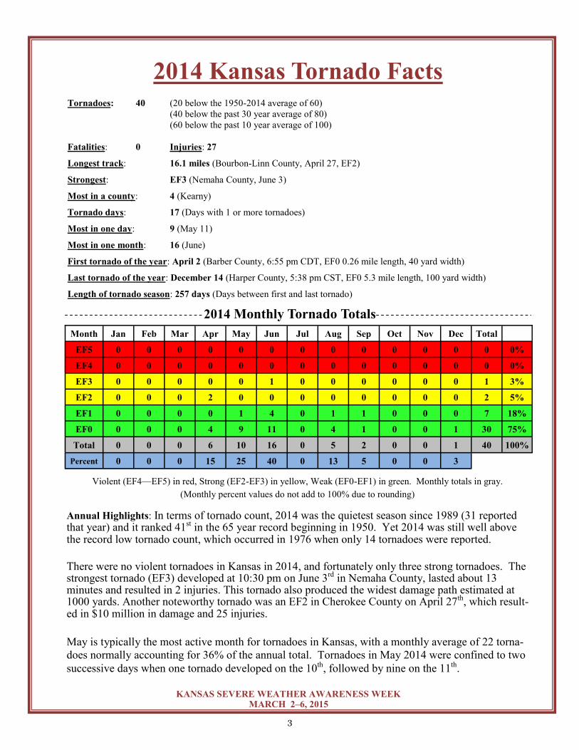
Month Jan Feb Mar Apr May Jun Jul Aug Sep Oct Nov Dec Total
EF5 0 0 0 0 0 0 0 0 0 0 0 0 0 0%
EF4 0 0 0 0 0 0 0 0 0 0 0 0 0 0%
EF3 0 0 0 0 0 1 0 0 0 0 0 0 1 3%
EF2 0 0 0 2 0 0 0 0 0 0 0 0 2 5%
EF1 0 0 0 0 1 4 0 1 1 0 0 0 7 18%
EF0 0 0 0 4 9 11 0 4 1 0 0 1 30 75%
Total 0 0 0 6 10 16 0 5 2 0 0 1 40 100%
Percent 0 0 0 15 25 40 0 13 5 0 0 3
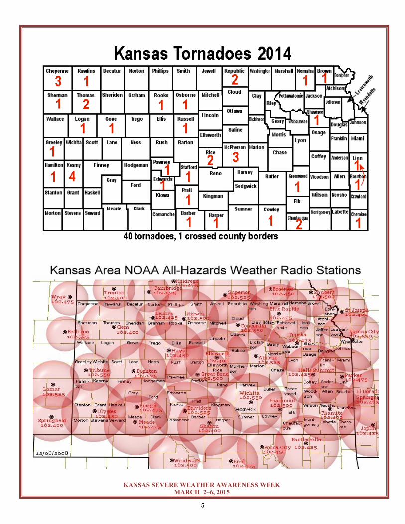
2014 Kansas Tornado Facts Tornadoes: 40 (20 below the 1950-2014 average of 60)
(40 below the past 30 year average of 80)
(60 below the past 10 year average of 100)
Fatalities: 0 Injuries: 27
Longest track: 16.1 miles (Bourbon-Linn County, April 27, EF2)
Strongest: EF3 (Nemaha County, June 3)
Most in a county: 4 (Kearny)
Tornado days: 17 (Days with 1 or more tornadoes)
Most in one day: 9 (May 11)
Most in one month: 16 (June)
First tornado of the year: April 2 (Barber County, 6:55 pm CDT, EF0 0.26 mile length, 40 yard width)
Last tornado of the year: December 14 (Harper County, 5:38 pm CST, EF0 5.3 mile length, 100 yard width)
Length of tornado season: 257 days (Days between first and last tornado)
Annual Highlights: In terms of tornado count, 2014 was the quietest season since 1989 (31 reported that year) and it ranked 41st in the 65 year record beginning in 1950. Yet 2014 was still well above the record low tornado count, which occurred in 1976 when only 14 tornadoes were reported.
There were no violent tornadoes in Kansas in 2014, and fortunately only three strong tornadoes. The strongest tornado (EF3) developed at 10:30 pm on June 3rd in Nemaha County, lasted about 13 minutes and resulted in 2 injuries. This tornado also produced the widest damage path estimated at 1000 yards. Another noteworthy tornado was an EF2 in Cherokee County on April 27th, which result-ed in $10 million in damage and 25 injuries.
May is typically the most active month for tornadoes in Kansas, with a monthly average of 22 torna-
does normally accounting for 36% of the annual total. Tornadoes in May 2014 were confined to two
successive days when one tornado developed on the 10th, followed by nine on the 11th.
Violent (EF4—EF5) in red, Strong (EF2-EF3) in yellow, Weak (EF0-EF1) in green. Monthly totals in gray.
(Monthly percent values do not add to 100% due to rounding)
2014 Monthly Tornado Totals
4
KANSAS SEVERE WEATHER AWARENESS WEEK MARCH 2–6, 2015
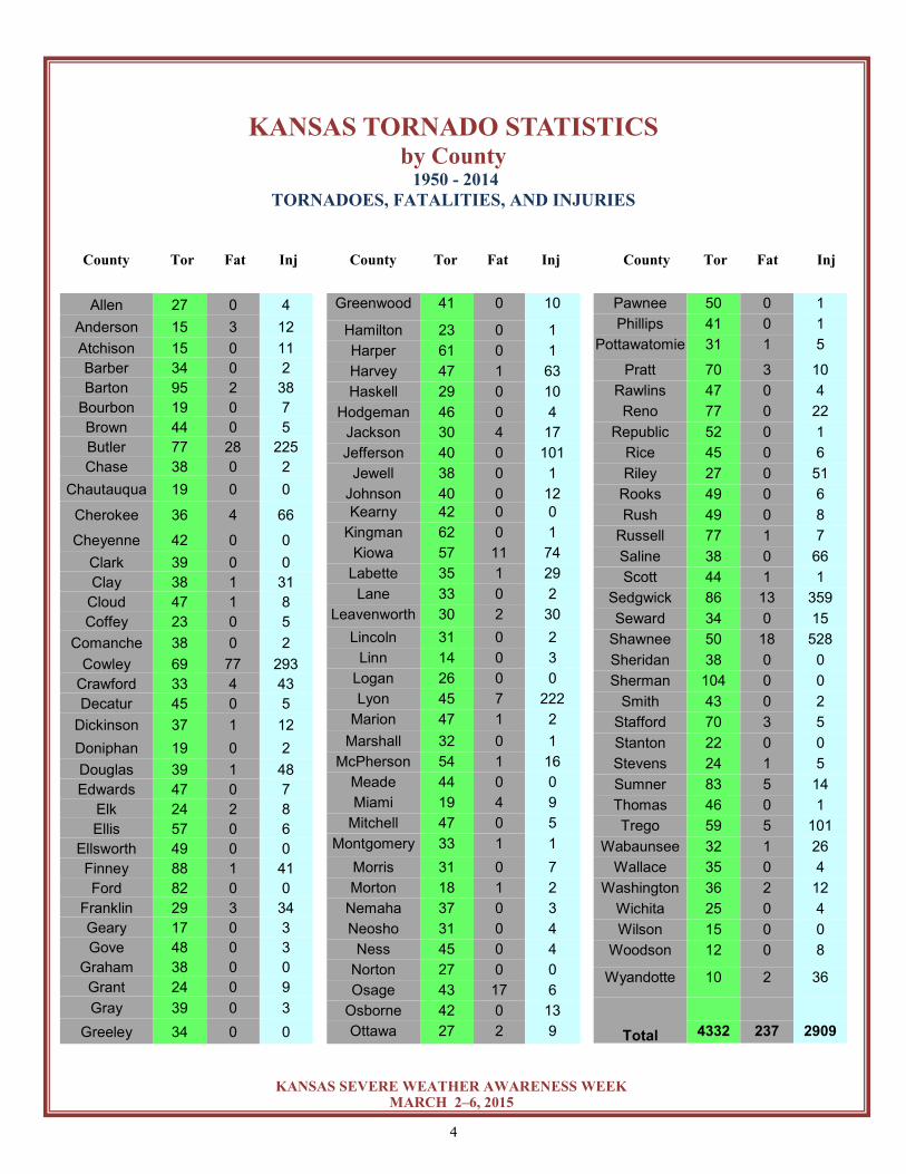
County Tor Fat Inj County Tor Fat Inj County Tor Fat Inj
KANSAS TORNADO STATISTICS by County
1950 - 2014 TORNADOES, FATALITIES, AND INJURIES
Allen 27 0 4
Anderson 15 3 12
Atchison 15 0 11
Barber 34 0 2
Barton 95 2 38
Bourbon 19 0 7
Brown 44 0 5
Butler 77 28 225
Chase 38 0 2
Chautauqua 19 0 0
Cherokee 36 4 66
Cheyenne 42 0 0
Clark 39 0 0
Clay 38 1 31
Cloud 47 1 8
Coffey 23 0 5
Comanche 38 0 2
Cowley 69 77 293
Crawford 33 4 43
Decatur 45 0 5
Dickinson 37 1 12
Doniphan 19 0 2
Douglas 39 1 48
Edwards 47 0 7
Elk 24 2 8
Ellis 57 0 6
Ellsworth 49 0 0
Finney 88 1 41
Ford 82 0 0
Franklin 29 3 34
Geary 17 0 3
Gove 48 0 3
Graham 38 0 0
Grant 24 0 9
Gray 39 0 3
Greeley 34 0 0
Greenwood 41 0 10
Hamilton 23 0 1
Harper 61 0 1
Harvey 47 1 63
Haskell 29 0 10
Hodgeman 46 0 4
Jackson 30 4 17
Jefferson 40 0 101
Jewell 38 0 1
Johnson 40 0 12
Kearny 42 0 0
Kingman 62 0 1
Kiowa 57 11 74
Labette 35 1 29
Lane 33 0 2
Leavenworth 30 2 30
Lincoln 31 0 2
Linn 14 0 3
Logan 26 0 0
Lyon 45 7 222
Marion 47 1 2
Marshall 32 0 1
McPherson 54 1 16
Meade 44 0 0
Miami 19 4 9
Mitchell 47 0 5
Montgomery 33 1 1
Morris 31 0 7
Morton 18 1 2
Nemaha 37 0 3
Neosho 31 0 4
Ness 45 0 4
Norton 27 0 0
Osage 43 17 6
Osborne 42 0 13
Ottawa 27 2 9
Pawnee 50 0 1
Phillips 41 0 1
Pottawatomie 31 1 5
Pratt 70 3 10
Rawlins 47 0 4
Reno 77 0 22
Republic 52 0 1
Rice 45 0 6
Riley 27 0 51
Rooks 49 0 6
Rush 49 0 8
Russell 77 1 7
Saline 38 0 66
Scott 44 1 1
Sedgwick 86 13 359
Seward 34 0 15
Shawnee 50 18 528
Sheridan 38 0 0
Sherman 104 0 0
Smith 43 0 2
Stafford 70 3 5
Stanton 22 0 0
Stevens 24 1 5
Sumner 83 5 14
Thomas 46 0 1
Trego 59 5 101
Wabaunsee 32 1 26
Wallace 35 0 4
Washington 36 2 12
Wichita 25 0 4
Wilson 15 0 0
Woodson 12 0 8
Wyandotte 10 2 36
Total
4332 237 2909
5
KANSAS SEVERE WEATHER AWARENESS WEEK MARCH 2–6, 2015
6
KANSAS SEVERE WEATHER AWARENESS WEEK MARCH 2–6, 2015
Check out a Storm Spotter and Weather Safety Training
presentation near you this spring…
Each spring, the National Weather Service offices that serve the state of Kansas conduct storm spotter and
weather safety training sessions in most counties in the state. The sessions are free and open to the public.
You are not required to become a storm spotter nor will you have to take a test; however the presentations
provide a great deal of information on severe weather in Kansas. They cover severe weather safety, ways
to get weather information from the National Weather Service, and you can meet a meteorologist from your
local National Weather Service office.
The schedule for storm spotter training sessions varies in each community, please check out
www.weather.gov and click on your location for more information on a training session in your area.
Kansas Tornado Facts Days with more than 20 tornadoes
Date #Tornadoes
05/23/08 70
04/14/12 43
06/15/92 39
05/05/07 36
06/04/55 33
05/29/04 28
10/26/06 28
05/25/97 25
06/09/05 25
05/15/91 24
07/07/04 23
04/26/91 21
06/15/09 21
Kansas Tornado Count By Decade
1950s: 560
1960s: 457
1970s: 303
1980s: 339
1990s: 789
2000s: 1192
2010s: 346 (through 2014)
Most Tornadoes in One Episode
May 23, 2008 70 Tornadoes
April 14, 2012 43 Tornadoes
June 15-16, 1992 41 Tornadoes
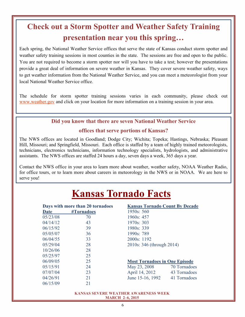
Did you know that there are seven National Weather Service
offices that serve portions of Kansas?
The NWS offices are located in Goodland; Dodge City; Wichita; Topeka; Hastings, Nebraska; Pleasant
Hill, Missouri; and Springfield, Missouri. Each office is staffed by a team of highly trained meteorologists,
technicians, electronics technicians, information technology specialists, hydrologists, and administrative
assistants. The NWS offices are staffed 24 hours a day, seven days a week, 365 days a year.
Contact the NWS office in your area to learn more about weather, weather safety, NOAA Weather Radio,
for office tours, or to learn more about careers in meteorology in the NWS or in NOAA. We are here to
serve you!

7
KANSAS SEVERE WEATHER AWARENESS WEEK MARCH 2–6, 2015
2014 Severe Weather Summary
Extreme East Central and Northeast Kansas
National Weather Service Pleasant Hill, MO
2014 started out with a blanket of fresh snow, followed by unusually cold weather over eastern Kansas. Two
to four inches of snow fell across far eastern Kansas the night of January 4th into the morning of January 5th,
setting the perfect stage for arctic air to slide into the area the following night. On the morning of January
6th, air temperatures bottomed out between -10 °F and -13 °F, with wind chill values dropped to around -30 °
F.
Early January’s snowpack gradually diminished by mid-month, then returned with vigor as a major winter
storm plowed through the central Plains in early February. More than ten inches of snow was measured from
February 4-5 across far eastern Kansas, including 11.0” in Atchison, 11.7” in Leavenworth, and 11.9” in
Overland Park.
One final brush with winter came in early March, when light freezing rain, sleet, and several inches of snow
blanketed the area. The long duration of the event created travel issues from March 1st through March 3rd,
then winter gave way to a fairly active severe weather season.
Several rounds of severe storms moved through eastern Kansas from late March through late April, dropping
up to baseball sized hail (Goodrich, KS; April 2nd) and producing very strong thunderstorm winds.
On April 27th, two rounds of severe storms impacted portions of
eastern Kansas. The second round of storms occurred during the
mid to late afternoon, and fueled a supercell which produced an
EF2 tornado from north of Fort Scott to Pleasanton. Trees, sever-
al vehicles, and an historic church were destroyed along this
strong tornado’s 16.1 mile track through rural Kansas.
The severe weather season continued through the remainder of
the spring and into summer, bringing up to 2” hail on May 10th,
flash flooding in early June, and several rounds of damaging
straight line winds from June through August. One notable wind
event occurred in early June when a line of strong thunderstorms moved through the region the night of June
4th, then a wake low developed on the back side of the storms, resulting in 60+ mph winds during the morn-
ing hours of June 5th.
Although the severe weather season was on the downswing by early fall, a few flooding events impacted
parts of eastern KS in September and early October. Heavy rain fell across eastern KS on September 3rd, Oc-
tober 2nd, and October 9th, all resulting in isolated flash flood events.
Comparatively benign conditions rounded out the late fall and early winter, and although November tempera-
tures were well below normal throughout the region, dry conditions prevented any notable wintry precipita-
tion.
Fort Scott – Pleasanton Tornado,
© Kory Hartman
8
KANSAS SEVERE WEATHER AWARENESS WEEK MARCH 2–6, 2015
2014 Severe Weather Summary Northeast and North Central Kansas
National Weather Service-Topeka, KS Fun Facts: The month of May had no tornadoes, which is rare for northeast Kansas. In fact, northeast Kansas
went without a tornado for just over one year. The last tornado in 2013 was on May 28th and the first tornado
in 2014 was on June 1st.
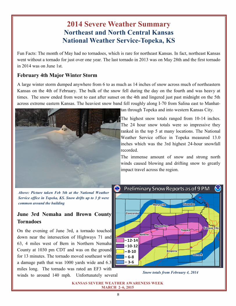
February 4th Major Winter Storm
A large winter storm dumped anywhere from 6 to as much as 14 inches of snow across much of northeastern
Kansas on the 4th of February. The bulk of the snow fell during the day on the fourth and was heavy at
times. The snow ended from west to east after sunset on the 4th and lingered just past midnight on the 5th
across extreme eastern Kansas. The heaviest snow band fell roughly along I-70 from Salina east to Manhat-
tan through Topeka and into western Kansas City.
The highest snow totals ranged from 10-14 inches.
The 24 hour snow totals were so impressive they
ranked in the top 5 at many locations. The National
Weather Service office in Topeka measured 13.0
inches which was the 3rd highest 24-hour snowfall
recorded.
The immense amount of snow and strong north
winds caused blowing and drifting snow to greatly
impact travel across the region.
June 3rd Nemaha and Brown County
Tornadoes
On the evening of June 3rd, a tornado touched
down near the intersection of Highways 71 and
63, 4 miles west of Bern in Northern Nemaha
County at 1030 pm CDT and was on the ground
for 13 minutes. The tornado moved southeast with
a damage path that was 1000 yards wide and 6.3
miles long. The tornado was rated an EF3 with
winds to around 140 mph. Unfortunately several
Above: Picture taken Feb 5th at the National Weather
Service office in Topeka, KS. Snow drifts up to 3 ft were
common around the building
Snow totals from February 4, 2014
9
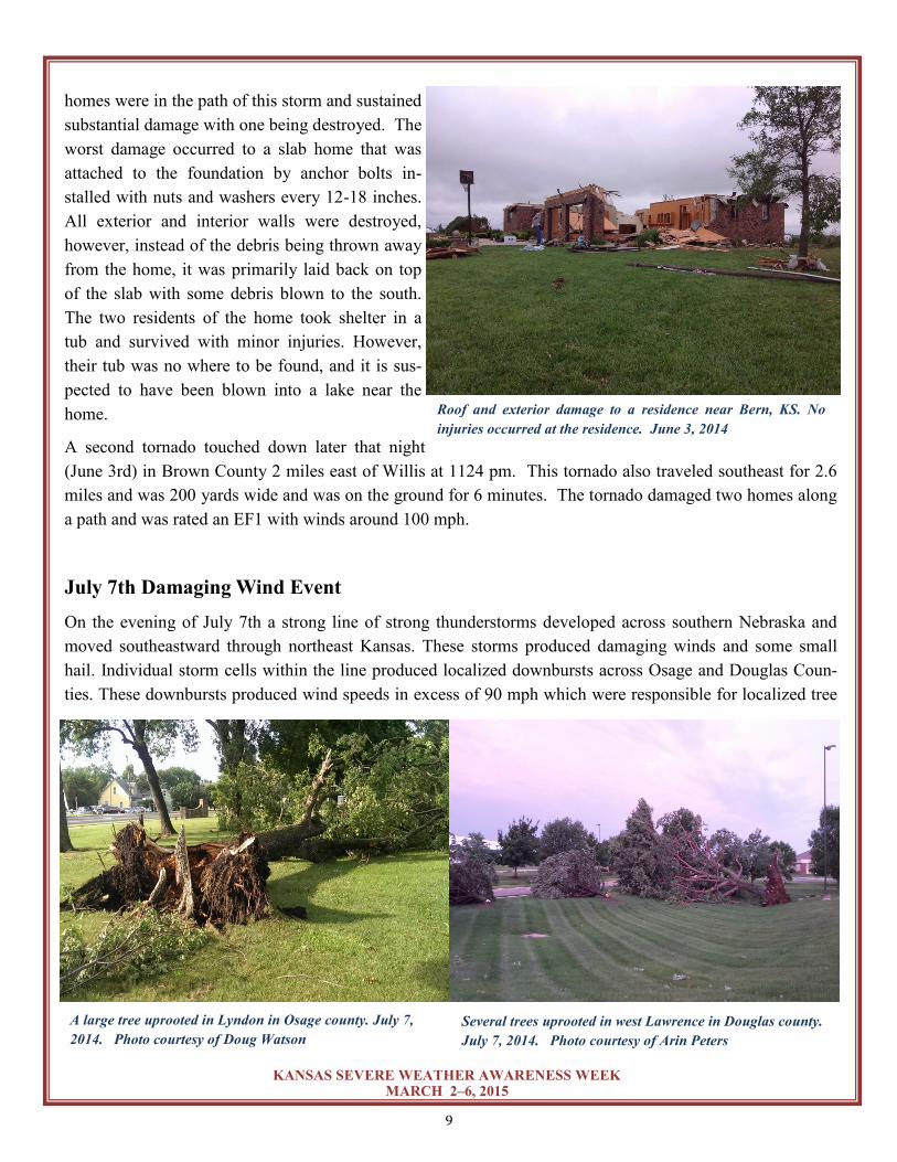
KANSAS SEVERE WEATHER AWARENESS WEEK MARCH 2–6, 2015
homes were in the path of this storm and sustained
substantial damage with one being destroyed. The
worst damage occurred to a slab home that was
attached to the foundation by anchor bolts in-
stalled with nuts and washers every 12-18 inches.
All exterior and interior walls were destroyed,
however, instead of the debris being thrown away
from the home, it was primarily laid back on top
of the slab with some debris blown to the south.
The two residents of the home took shelter in a
tub and survived with minor injuries. However,
their tub was no where to be found, and it is sus-
pected to have been blown into a lake near the
home.
A second tornado touched down later that night
(June 3rd) in Brown County 2 miles east of Willis at 1124 pm. This tornado also traveled southeast for 2.6
miles and was 200 yards wide and was on the ground for 6 minutes. The tornado damaged two homes along
a path and was rated an EF1 with winds around 100 mph.
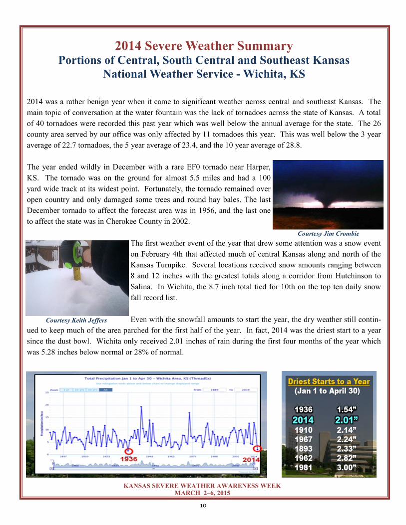
July 7th Damaging Wind Event
On the evening of July 7th a strong line of strong thunderstorms developed across southern Nebraska and
moved southeastward through northeast Kansas. These storms produced damaging winds and some small
hail. Individual storm cells within the line produced localized downbursts across Osage and Douglas Coun-
ties. These downbursts produced wind speeds in excess of 90 mph which were responsible for localized tree
Roof and exterior damage to a residence near Bern, KS. No
injuries occurred at the residence. June 3, 2014
A large tree uprooted in Lyndon in Osage county. July 7,
2014. Photo courtesy of Doug Watson
Several trees uprooted in west Lawrence in Douglas county.
July 7, 2014. Photo courtesy of Arin Peters
10
KANSAS SEVERE WEATHER AWARENESS WEEK MARCH 2–6, 2015
2014 Severe Weather Summary Portions of Central, South Central and Southeast Kansas
National Weather Service - Wichita, KS
2014 was a rather benign year when it came to significant weather across central and southeast Kansas. The
main topic of conversation at the water fountain was the lack of tornadoes across the state of Kansas. A total
of 40 tornadoes were recorded this past year which was well below the annual average for the state. The 26
county area served by our office was only affected by 11 tornadoes this year. This was well below the 3 year
average of 22.7 tornadoes, the 5 year average of 23.4, and the 10 year average of 28.8.
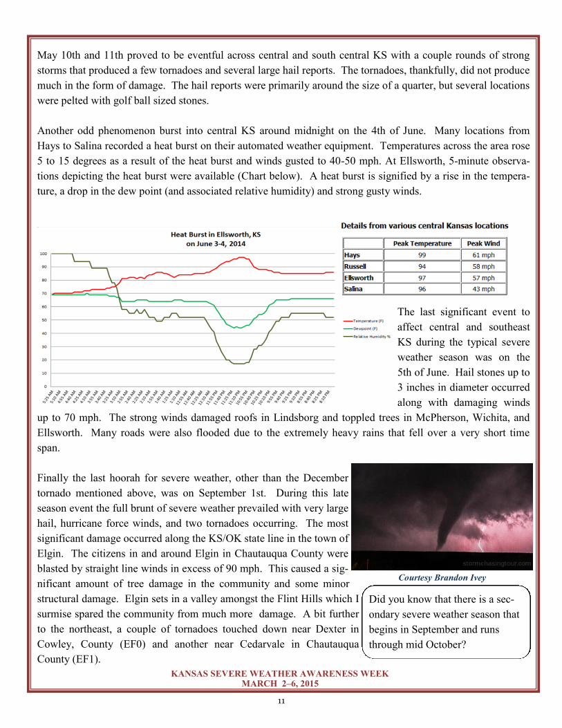
The year ended wildly in December with a rare EF0 tornado near Harper,
KS. The tornado was on the ground for almost 5.5 miles and had a 100
yard wide track at its widest point. Fortunately, the tornado remained over
open country and only damaged some trees and round hay bales. The last
December tornado to affect the forecast area was in 1956, and the last one
to affect the state was in Cherokee County in 2002.
The first weather event of the year that drew some attention was a snow event
on February 4th that affected much of central Kansas along and north of the
Kansas Turnpike. Several locations received snow amounts ranging between
8 and 12 inches with the greatest totals along a corridor from Hutchinson to
Salina. In Wichita, the 8.7 inch total tied for 10th on the top ten daily snow
fall record list.
Even with the snowfall amounts to start the year, the dry weather still contin-
ued to keep much of the area parched for the first half of the year. In fact, 2014 was the driest start to a year
since the dust bowl. Wichita only received 2.01 inches of rain during the first four months of the year which
was 5.28 inches below normal or 28% of normal.
Courtesy Jim Crombie
Courtesy Keith Jeffers
11
KANSAS SEVERE WEATHER AWARENESS WEEK MARCH 2–6, 2015
May 10th and 11th proved to be eventful across central and south central KS with a couple rounds of strong
storms that produced a few tornadoes and several large hail reports. The tornadoes, thankfully, did not produce
much in the form of damage. The hail reports were primarily around the size of a quarter, but several locations
were pelted with golf ball sized stones.
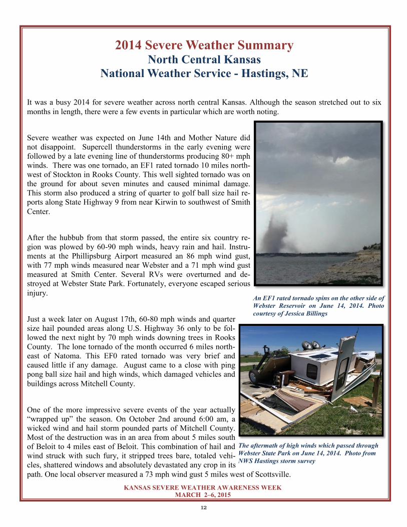
Another odd phenomenon burst into central KS around midnight on the 4th of June. Many locations from
Hays to Salina recorded a heat burst on their automated weather equipment. Temperatures across the area rose
5 to 15 degrees as a result of the heat burst and winds gusted to 40-50 mph. At Ellsworth, 5-minute observa-
tions depicting the heat burst were available (Chart below). A heat burst is signified by a rise in the tempera-
ture, a drop in the dew point (and associated relative humidity) and strong gusty winds.
The last significant event to
affect central and southeast
KS during the typical severe
weather season was on the
5th of June. Hail stones up to
3 inches in diameter occurred
along with damaging winds
up to 70 mph. The strong winds damaged roofs in Lindsborg and toppled trees in McPherson, Wichita, and
Ellsworth. Many roads were also flooded due to the extremely heavy rains that fell over a very short time
span.
Finally the last hoorah for severe weather, other than the December
tornado mentioned above, was on September 1st. During this late
season event the full brunt of severe weather prevailed with very large
hail, hurricane force winds, and two tornadoes occurring. The most
significant damage occurred along the KS/OK state line in the town of
Elgin. The citizens in and around Elgin in Chautauqua County were
blasted by straight line winds in excess of 90 mph. This caused a sig-
nificant amount of tree damage in the community and some minor
structural damage. Elgin sets in a valley amongst the Flint Hills which I
surmise spared the community from much more damage. A bit further
to the northeast, a couple of tornadoes touched down near Dexter in
Cowley, County (EF0) and another near Cedarvale in Chautauqua
County (EF1).
Courtesy Brandon Ivey
Did you know that there is a sec-
ondary severe weather season that
begins in September and runs
through mid October?
12
KANSAS SEVERE WEATHER AWARENESS WEEK MARCH 2–6, 2015
2014 Severe Weather Summary North Central Kansas
National Weather Service - Hastings, NE
It was a busy 2014 for severe weather across north central Kansas. Although the season stretched out to six
months in length, there were a few events in particular which are worth noting.
Severe weather was expected on June 14th and Mother Nature did
not disappoint. Supercell thunderstorms in the early evening were
followed by a late evening line of thunderstorms producing 80+ mph
winds. There was one tornado, an EF1 rated tornado 10 miles north-
west of Stockton in Rooks County. This well sighted tornado was on
the ground for about seven minutes and caused minimal damage.
This storm also produced a string of quarter to golf ball size hail re-
ports along State Highway 9 from near Kirwin to southwest of Smith
Center.
After the hubbub from that storm passed, the entire six country re-
gion was plowed by 60-90 mph winds, heavy rain and hail. Instru-
ments at the Phillipsburg Airport measured an 86 mph wind gust,
with 77 mph winds measured near Webster and a 71 mph wind gust
measured at Smith Center. Several RVs were overturned and de-
stroyed at Webster State Park. Fortunately, everyone escaped serious
injury.
Just a week later on August 17th, 60-80 mph winds and quarter
size hail pounded areas along U.S. Highway 36 only to be fol-
lowed the next night by 70 mph winds downing trees in Rooks
County. The lone tornado of the month occurred 6 miles north-
east of Natoma. This EF0 rated tornado was very brief and
caused little if any damage. August came to a close with ping
pong ball size hail and high winds, which damaged vehicles and
buildings across Mitchell County.
One of the more impressive severe events of the year actually
“wrapped up” the season. On October 2nd around 6:00 am, a
wicked wind and hail storm pounded parts of Mitchell County.
Most of the destruction was in an area from about 5 miles south
of Beloit to 4 miles east of Beloit. This combination of hail and
wind struck with such fury, it stripped trees bare, totaled vehi-
cles, shattered windows and absolutely devastated any crop in its
path. One local observer measured a 73 mph wind gust 5 miles west of Scottsville.
The aftermath of high winds which passed through
Webster State Park on June 14, 2014. Photo from
NWS Hastings storm survey
An EF1 rated tornado spins on the other side of
Webster Reservoir on June 14, 2014. Photo
courtesy of Jessica Billings
13
KANSAS SEVERE WEATHER AWARENESS WEEK MARCH 2–6, 2015
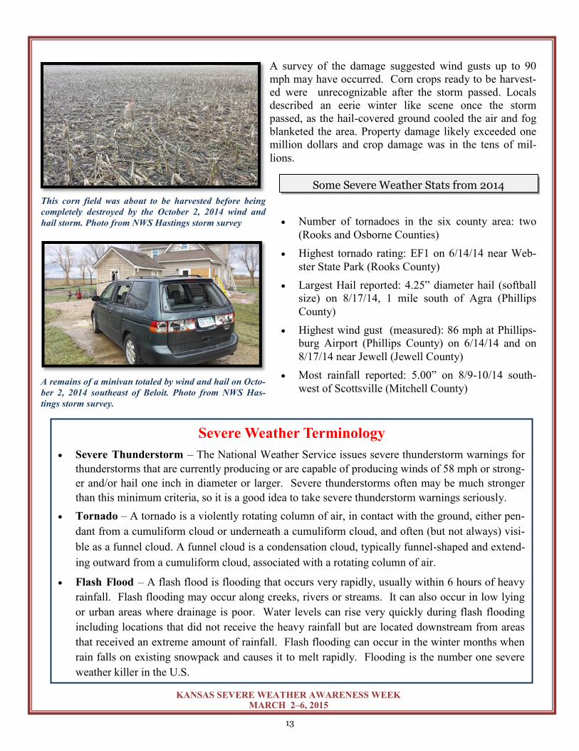
A survey of the damage suggested wind gusts up to 90
mph may have occurred. Corn crops ready to be harvest-
ed were unrecognizable after the storm passed. Locals
described an eerie winter like scene once the storm
passed, as the hail-covered ground cooled the air and fog
blanketed the area. Property damage likely exceeded one
million dollars and crop damage was in the tens of mil-
lions.
Number of tornadoes in the six county area: two
(Rooks and Osborne Counties)
Highest tornado rating: EF1 on 6/14/14 near Web-
ster State Park (Rooks County)
Largest Hail reported: 4.25” diameter hail (softball
size) on 8/17/14, 1 mile south of Agra (Phillips
County)
Highest wind gust (measured): 86 mph at Phillips-
burg Airport (Phillips County) on 6/14/14 and on
8/17/14 near Jewell (Jewell County)
Most rainfall reported: 5.00” on 8/9-10/14 south-
west of Scottsville (Mitchell County)
Severe Weather Terminology
Severe Thunderstorm – The National Weather Service issues severe thunderstorm warnings for
thunderstorms that are currently producing or are capable of producing winds of 58 mph or strong-
er and/or hail one inch in diameter or larger. Severe thunderstorms often may be much stronger
than this minimum criteria, so it is a good idea to take severe thunderstorm warnings seriously.
Tornado – A tornado is a violently rotating column of air, in contact with the ground, either pen-
dant from a cumuliform cloud or underneath a cumuliform cloud, and often (but not always) visi-
ble as a funnel cloud. A funnel cloud is a condensation cloud, typically funnel-shaped and extend-
ing outward from a cumuliform cloud, associated with a rotating column of air.
Flash Flood – A flash flood is flooding that occurs very rapidly, usually within 6 hours of heavy
rainfall. Flash flooding may occur along creeks, rivers or streams. It can also occur in low lying
or urban areas where drainage is poor. Water levels can rise very quickly during flash flooding
including locations that did not receive the heavy rainfall but are located downstream from areas
that received an extreme amount of rainfall. Flash flooding can occur in the winter months when
rain falls on existing snowpack and causes it to melt rapidly. Flooding is the number one severe
weather killer in the U.S.
This corn field was about to be harvested before being
completely destroyed by the October 2, 2014 wind and
hail storm. Photo from NWS Hastings storm survey
A remains of a minivan totaled by wind and hail on Octo-
ber 2, 2014 southeast of Beloit. Photo from NWS Has-
tings storm survey.
Some Severe Weather Stats from 2014
14
KANSAS SEVERE WEATHER AWARENESS WEEK MARCH 2–6, 2015
2014 Severe Weather Summary Southwest Kansas
National Weather Service - Dodge City
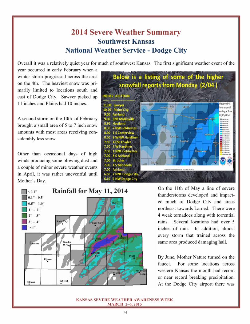
Overall it was a relatively quiet year for much of southwest Kansas. The first significant weather event of the
year occurred in early February when a
winter storm progressed across the area
on the 4th. The heaviest snow was pri-
marily limited to locations south and
east of Dodge City. Sawyer picked up
11 inches and Plains had 10 inches.
A second storm on the 10th of February
brought a small area of 5 to 7 inch snow
amounts with most areas receiving con-
siderably less snow.
Other than occasional days of high
winds producing some blowing dust and
a couple of minor severe weather events
in April, it was rather uneventful until
Mother’s Day.
On the 11th of May a line of severe
thunderstorms developed and impact-
ed much of Dodge City and areas
northeast towards Larned. There were
4 weak tornadoes along with torrential
rains. Several locations had over 5
inches of rain. In addition, almost
every storm that trained across the
same area produced damaging hail.
By June, Mother Nature turned on the
faucet. For some locations across
western Kansas the month had record
or near record breaking precipitation.
At the Dodge City airport there was
A wall of dirt moves into Ulysses on May 8th
15
KANSAS SEVERE WEATHER AWARENESS WEEK MARCH 2–6, 2015
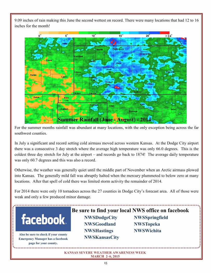
9.09 inches of rain making this June the second wettest on record. There were many locations that had 12 to 16
inches for the month!
For the summer months rainfall was abundant at many locations, with the only exception being across the far
southwest counties.
In July a significant and record setting cold airmass moved across western Kansas. At the Dodge City airport
there was a consecutive 3 day stretch where the average high temperature was only 66.0 degrees. This is the
coldest three day stretch for July at the airport – and records go back to 1874! The average daily temperature
was only 60.7 degrees and this was also a record.
Otherwise, the weather was generally quiet until the middle part of November when an Arctic airmass plowed
into Kansas. The generally mild fall was abruptly halted when the mercury plummeted to below zero at many
locations. After that spell of cold there was limited storm activity the remainder of 2014.
For 2014 there were only 10 tornadoes across the 27 counties in Dodge City’s forecast area. All of those were
weak and only a few produced minor damage.
Be sure to find your local NWS office on facebook
NWSDodgeCity NWSSpringfield
NWSGoodland NWSTopeka
NWSHastings NWSWichita
NWSKansasCity Also be sure to check if your county
Emergency Manager has a facebook
page for your county.
16
KANSAS SEVERE WEATHER AWARENESS WEEK MARCH 2–6, 2015
2014 Severe Weather Summary Northwest Kansas
National Weather Service - Goodland, KS
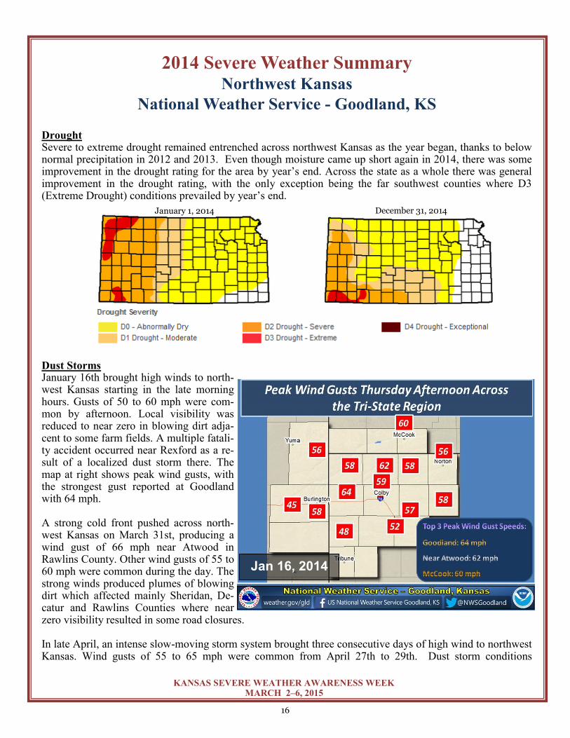
Drought Severe to extreme drought remained entrenched across northwest Kansas as the year began, thanks to below normal precipitation in 2012 and 2013. Even though moisture came up short again in 2014, there was some improvement in the drought rating for the area by year’s end. Across the state as a whole there was general improvement in the drought rating, with the only exception being the far southwest counties where D3 (Extreme Drought) conditions prevailed by year’s end. Dust Storms January 16th brought high winds to north-west Kansas starting in the late morning hours. Gusts of 50 to 60 mph were com-mon by afternoon. Local visibility was reduced to near zero in blowing dirt adja-cent to some farm fields. A multiple fatali-ty accident occurred near Rexford as a re-sult of a localized dust storm there. The map at right shows peak wind gusts, with the strongest gust reported at Goodland with 64 mph. A strong cold front pushed across north-west Kansas on March 31st, producing a wind gust of 66 mph near Atwood in Rawlins County. Other wind gusts of 55 to 60 mph were common during the day. The strong winds produced plumes of blowing dirt which affected mainly Sheridan, De-catur and Rawlins Counties where near zero visibility resulted in some road closures. In late April, an intense slow-moving storm system brought three consecutive days of high wind to northwest Kansas. Wind gusts of 55 to 65 mph were common from April 27th to 29th. Dust storm conditions
Jan 16, 2014
December 31, 2014 January 1, 2014
17
KANSAS SEVERE WEATHER AWARENESS WEEK MARCH 2–6, 2015
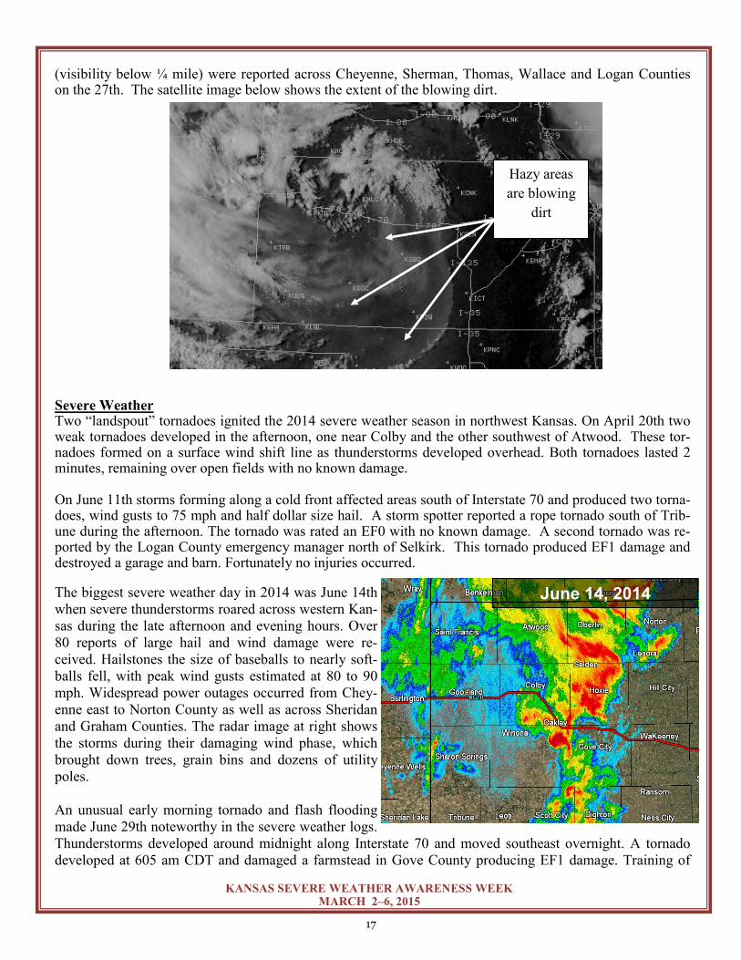
(visibility below ¼ mile) were reported across Cheyenne, Sherman, Thomas, Wallace and Logan Counties on the 27th. The satellite image below shows the extent of the blowing dirt. Severe Weather Two “landspout” tornadoes ignited the 2014 severe weather season in northwest Kansas. On April 20th two weak tornadoes developed in the afternoon, one near Colby and the other southwest of Atwood. These tor-nadoes formed on a surface wind shift line as thunderstorms developed overhead. Both tornadoes lasted 2 minutes, remaining over open fields with no known damage. On June 11th storms forming along a cold front affected areas south of Interstate 70 and produced two torna-does, wind gusts to 75 mph and half dollar size hail. A storm spotter reported a rope tornado south of Trib-une during the afternoon. The tornado was rated an EF0 with no known damage. A second tornado was re-ported by the Logan County emergency manager north of Selkirk. This tornado produced EF1 damage and destroyed a garage and barn. Fortunately no injuries occurred.
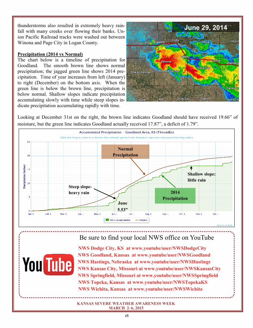
The biggest severe weather day in 2014 was June 14th
when severe thunderstorms roared across western Kan-
sas during the late afternoon and evening hours. Over
80 reports of large hail and wind damage were re-
ceived. Hailstones the size of baseballs to nearly soft-
balls fell, with peak wind gusts estimated at 80 to 90
mph. Widespread power outages occurred from Chey-
enne east to Norton County as well as across Sheridan
and Graham Counties. The radar image at right shows
the storms during their damaging wind phase, which
brought down trees, grain bins and dozens of utility
poles.
An unusual early morning tornado and flash flooding
made June 29th noteworthy in the severe weather logs.
Thunderstorms developed around midnight along Interstate 70 and moved southeast overnight. A tornado
developed at 605 am CDT and damaged a farmstead in Gove County producing EF1 damage. Training of
Hazy areas
are blowing
dirt
June 14, 2014
18
KANSAS SEVERE WEATHER AWARENESS WEEK MARCH 2–6, 2015
thunderstorms also resulted in extremely heavy rain-
fall with many creeks over flowing their banks. Un-
ion Pacific Railroad tracks were washed out between
Winona and Page City in Logan County.
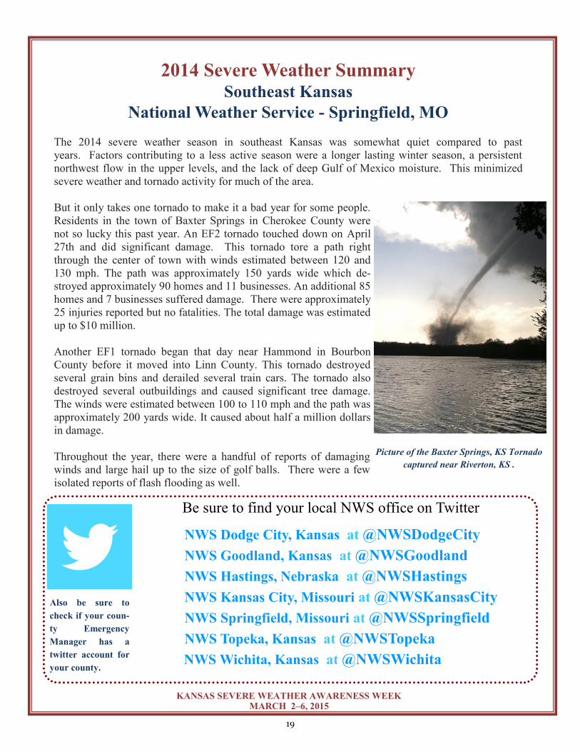
Precipitation (2014 vs Normal)
The chart below is a timeline of precipitation for
Goodland. The smooth brown line shows normal
precipitation; the jagged green line shows 2014 pre-
cipitation. Time of year increases from left (January)
to right (December) on the bottom axis. When the
green line is below the brown line, precipitation is
below normal. Shallow slopes indicate precipitation
accumulating slowly with time while steep slopes in-
dicate precipitation accumulating rapidly with time.
Looking at December 31st on the right, the brown line indicates Goodland should have received 19.66” of
moisture, but the green line indicates Goodland actually received 17.87”, a deficit of 1.79”.
Be sure to find your local NWS office on YouTube
NWS Dodge City, KS at www.youtube/user/NWSDodgeCity
NWS Goodland, Kansas at www.youtube/user/NWSGoodland
NWS Hastings, Nebraska at www.youtube/user/NWSHastings
NWS Kansas City, Missouri at www.youtube/user/NWSKansasCity
NWS Springfield, Missouri at www.youtube/user/NWSSpringfield
NWS Topeka, Kansas at www.youtube/user/NWSTopekaKS
NWS Wichita, Kansas at www.youtube/user/NWSWichita
June 29, 2014
Steep slope-
heavy rain 2014
Precipitation
Normal
Precipitation
June
5.53”
Shallow slope:
little rain
19
KANSAS SEVERE WEATHER AWARENESS WEEK MARCH 2–6, 2015
2014 Severe Weather Summary Southeast Kansas
National Weather Service - Springfield, MO
The 2014 severe weather season in southeast Kansas was somewhat quiet compared to past
years. Factors contributing to a less active season were a longer lasting winter season, a persistent
northwest flow in the upper levels, and the lack of deep Gulf of Mexico moisture. This minimized
severe weather and tornado activity for much of the area.
But it only takes one tornado to make it a bad year for some people.
Residents in the town of Baxter Springs in Cherokee County were
not so lucky this past year. An EF2 tornado touched down on April
27th and did significant damage. This tornado tore a path right
through the center of town with winds estimated between 120 and
130 mph. The path was approximately 150 yards wide which de-
stroyed approximately 90 homes and 11 businesses. An additional 85
homes and 7 businesses suffered damage. There were approximately
25 injuries reported but no fatalities. The total damage was estimated
up to $10 million.
Another EF1 tornado began that day near Hammond in Bourbon
County before it moved into Linn County. This tornado destroyed
several grain bins and derailed several train cars. The tornado also
destroyed several outbuildings and caused significant tree damage.
The winds were estimated between 100 to 110 mph and the path was
approximately 200 yards wide. It caused about half a million dollars
in damage.
Throughout the year, there were a handful of reports of damaging
winds and large hail up to the size of golf balls. There were a few
isolated reports of flash flooding as well.
Be sure to find your local NWS office on Twitter
NWS Dodge City, Kansas at @NWSDodgeCity
NWS Goodland, Kansas at @NWSGoodland
NWS Hastings, Nebraska at @NWSHastings
NWS Kansas City, Missouri at @NWSKansasCity
NWS Springfield, Missouri at @NWSSpringfield
NWS Topeka, Kansas at @NWSTopeka
NWS Wichita, Kansas at @NWSWichita
Also be sure to
check if your coun-
ty Emergency
Manager has a
twitter account for
your county.
Picture of the Baxter Springs, KS Tornado
captured near Riverton, KS .
20
KANSAS SEVERE WEATHER AWARENESS WEEK MARCH 2–6, 2015
In High-Rise Buildings: Go to interior small rooms or halls. Stay away from exte-rior walls or areas with glass. In Mobile Homes:
ABANDON THEM IMMEDIATELY!!! Many deaths occur in mobile homes. If you are in a mobile home when severe weather ap-proaches, leave it immediately and go to a sub-stantial structure or designated tornado shelter. Determine your shelter ahead of time so you don’t have to think about it when weather strikes. If no Suitable Structure is Nearby: Lie flat in the nearest ditch or depression and use your hands to cover your head. Be alert for flash floods.
In Homes or Small Buildings: Go to the basement or to an in-terior room on the lowest floor (e.g. closet or bathroom). Upper floors are unsafe. If there is no time to descend, go to a closet, a small room with strong walls or an inside hallway. Wrap yourself in overcoats or blankets to protect yourself from flying debris. In Schools, Hospitals, Factories, or Shopping Centers: Go to interior rooms and halls on the lowest floor. Stay away from glass enclosed places or areas with wide span roofs such as auditoriums and warehouses. Crouch down and cover your head. Don’t take shelter in halls that open to the south or the west. Centrally-located stairwells are good shelter.
If a warning is issued or threatening weather approaches
Always remember “DUCK”
Stay away from windows
Get out of automobiles and get into a sturdy structure or ditch.
Or, buckle your seat belt and get below window level of your vehicle.
Before the storm:
Develop a plan of action
Have frequent drills
Have a NOAA Weather Radio with a warning alarm tone
Listen to radio and television for information
If planning a trip outdoors, listen to forecasts
Kansas
National
Weather
Service
Weather Safety
Tornado Safety Tips
Have you ever sat down with your family to discuss and plan what you would do in case of an immediate weather threat? If you haven’t, now would be an excellent time to sit down with your family and devise a plan. Finding the time to do this can be difficult, but taking the 15 minutes to develop and practice a plan could save the lives of ones you love. Please remem-ber these tips when planning and carrying out your actions.
“DUCK” Down to the lowest level
Under something sturdy
Cover your head
Keep in the shelter until the storm has passed
21
KANSAS SEVERE WEATHER AWARENESS WEEK MARCH 2–6, 2015
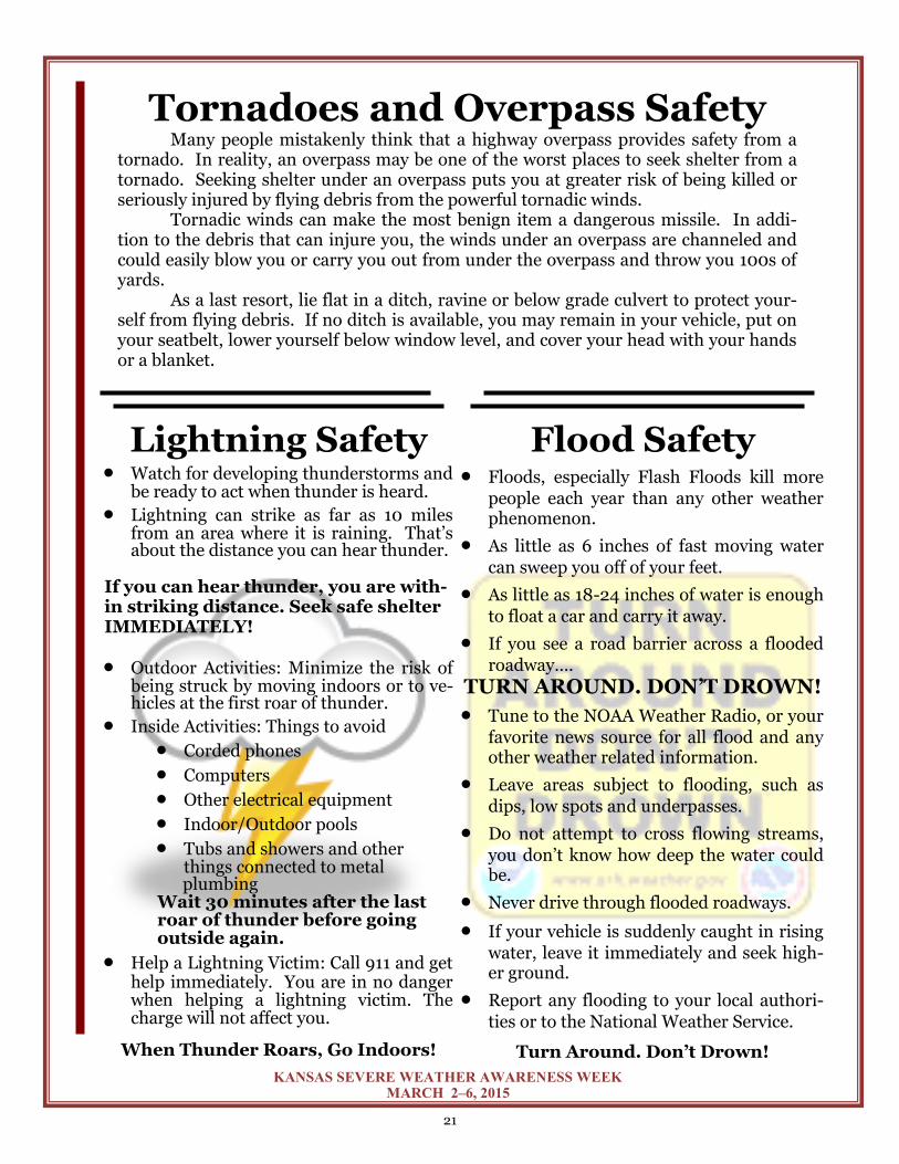
Tornadoes and Overpass Safety Many people mistakenly think that a highway overpass provides safety from a tornado. In reality, an overpass may be one of the worst places to seek shelter from a tornado. Seeking shelter under an overpass puts you at greater risk of being killed or seriously injured by flying debris from the powerful tornadic winds. Tornadic winds can make the most benign item a dangerous missile. In addi-tion to the debris that can injure you, the winds under an overpass are channeled and could easily blow you or carry you out from under the overpass and throw you 100s of yards. As a last resort, lie flat in a ditch, ravine or below grade culvert to protect your-self from flying debris. If no ditch is available, you may remain in your vehicle, put on your seatbelt, lower yourself below window level, and cover your head with your hands or a blanket.
Lightning Safety Watch for developing thunderstorms and
be ready to act when thunder is heard.
Lightning can strike as far as 10 miles from an area where it is raining. That’s about the distance you can hear thunder.
If you can hear thunder, you are with-in striking distance. Seek safe shelter IMMEDIATELY!
Outdoor Activities: Minimize the risk of being struck by moving indoors or to ve-hicles at the first roar of thunder.
Inside Activities: Things to avoid
Corded phones
Computers
Other electrical equipment
Indoor/Outdoor pools
Tubs and showers and other things connected to metal
plumbing Wait 30 minutes after the last roar of thunder before going outside again.
Help a Lightning Victim: Call 911 and get help immediately. You are in no danger when helping a lightning victim. The charge will not affect you.
When Thunder Roars, Go Indoors!
Flood Safety Floods, especially Flash Floods kill more
people each year than any other weather phenomenon.
As little as 6 inches of fast moving water can sweep you off of your feet.
As little as 18-24 inches of water is enough to float a car and carry it away.
If you see a road barrier across a flooded roadway….
TURN AROUND. DON’T DROWN!
Tune to the NOAA Weather Radio, or your favorite news source for all flood and any other weather related information.
Leave areas subject to flooding, such as dips, low spots and underpasses.
Do not attempt to cross flowing streams, you don’t know how deep the water could be.
Never drive through flooded roadways.
If your vehicle is suddenly caught in rising water, leave it immediately and seek high-er ground.
Report any flooding to your local authori-ties or to the National Weather Service.
Turn Around. Don’t Drown!
22
KANSAS SEVERE WEATHER AWARENESS WEEK MARCH 2–6, 2015
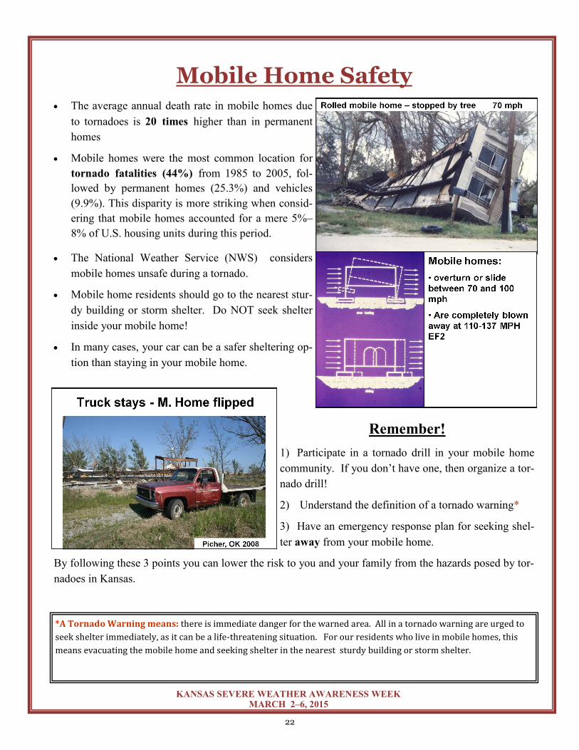
Mobile Home Safety The average annual death rate in mobile homes due
to tornadoes is 20 times higher than in permanent
homes
Mobile homes were the most common location for
tornado fatalities (44%) from 1985 to 2005, fol-
lowed by permanent homes (25.3%) and vehicles
(9.9%). This disparity is more striking when consid-
ering that mobile homes accounted for a mere 5%–
8% of U.S. housing units during this period.
The National Weather Service (NWS) considers
mobile homes unsafe during a tornado.
Mobile home residents should go to the nearest stur-
dy building or storm shelter. Do NOT seek shelter
inside your mobile home!
In many cases, your car can be a safer sheltering op-
tion than staying in your mobile home.
Remember!
1) Participate in a tornado drill in your mobile home
community. If you don’t have one, then organize a tor-
nado drill!
2) Understand the definition of a tornado warning*
3) Have an emergency response plan for seeking shel-
ter away from your mobile home.
By following these 3 points you can lower the risk to you and your family from the hazards posed by tor-
nadoes in Kansas.
*A Tornado Warning means: there is immediate danger for the warned area. All in a tornado warning are urged to
seek shelter immediately, as it can be a life-threatening situation. For our residents who live in mobile homes, this
means evacuating the mobile home and seeking shelter in the nearest sturdy building or storm shelter.
23
KANSAS SEVERE WEATHER AWARENESS WEEK MARCH 2–6, 2015
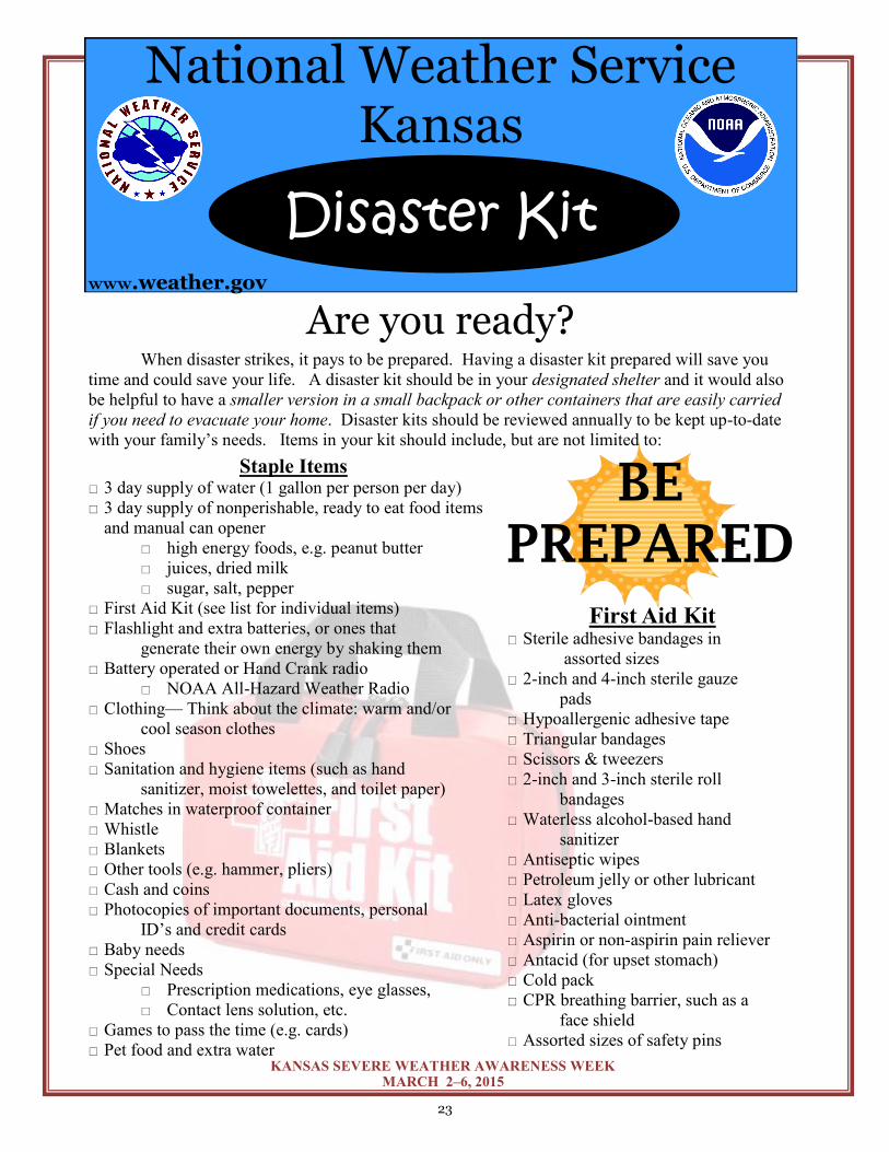
Are you ready? When disaster strikes, it pays to be prepared. Having a disaster kit prepared will save you
time and could save your life. A disaster kit should be in your designated shelter and it would also
be helpful to have a smaller version in a small backpack or other containers that are easily carried
if you need to evacuate your home. Disaster kits should be reviewed annually to be kept up-to-date
with your family’s needs. Items in your kit should include, but are not limited to:
Staple Items 3 day supply of water (1 gallon per person per day)
3 day supply of nonperishable, ready to eat food items
and manual can opener
high energy foods, e.g. peanut butter
juices, dried milk
sugar, salt, pepper
First Aid Kit (see list for individual items)
Flashlight and extra batteries, or ones that
generate their own energy by shaking them
Battery operated or Hand Crank radio
NOAA All-Hazard Weather Radio
Clothing— Think about the climate: warm and/or
cool season clothes
Shoes
Sanitation and hygiene items (such as hand
sanitizer, moist towelettes, and toilet paper)
Matches in waterproof container
Whistle
Blankets
Other tools (e.g. hammer, pliers)
Cash and coins
Photocopies of important documents, personal
ID’s and credit cards
Baby needs
Special Needs
Prescription medications, eye glasses,
Contact lens solution, etc.
Games to pass the time (e.g. cards)
Pet food and extra water
BE
PREPARED
Disaster Kit www.weather.gov
National Weather Service Kansas
First Aid Kit Sterile adhesive bandages in
assorted sizes
2-inch and 4-inch sterile gauze
pads
Hypoallergenic adhesive tape
Triangular bandages
Scissors & tweezers
2-inch and 3-inch sterile roll
bandages
Waterless alcohol-based hand
sanitizer
Antiseptic wipes
Petroleum jelly or other lubricant
Latex gloves
Anti-bacterial ointment
Aspirin or non-aspirin pain reliever
Antacid (for upset stomach)
Cold pack
CPR breathing barrier, such as a
face shield
Assorted sizes of safety pins
24
KANSAS SEVERE WEATHER AWARENESS WEEK MARCH 2–6, 2015
Winter Disaster Kit Winterizing your Disaster Kit
A Disaster Kit for your Vehicle
If you live in a cold climate, you must think about warmth. It is possible that you will not have heat during or after a disaster. Think about your clothing and bed-ding needs. Be sure to include one set of the following for each person to add to your Disaster Kit.
You may be in your vehicle when disaster strikes, or possibly stuck in your vehicle in a summer/winter environ-ment. Below are a few items that you should keep in your car as part of your Vehicle Disaster Kit.
Flashlight and extra batteries
Maps
Small First Aid Kit
White Distress Flag
Tire Repair kit Winter supplies Blanket or Sleeping Bag Hat and Mittens Shovel Sand Bags Tire Chains Windshield Scraper Florescent Distress Flag
Jacket or Coat
Long pants and long sleeve shirt
Sturdy Shoes
Hat, Mittens, and Scarf
Sleeping Bag or Warm Blanket
Extra Blankets
Lantern or Flashlight
Booster/Jumper cables Air pump Flares Bottled water Non-perishable foods such as granola
bars Summer Supplies Sunscreen Shade Item (umbrella or wide
brimmed hat) Bug spray
25
KANSAS SEVERE WEATHER AWARENESS WEEK MARCH 2–6, 2015
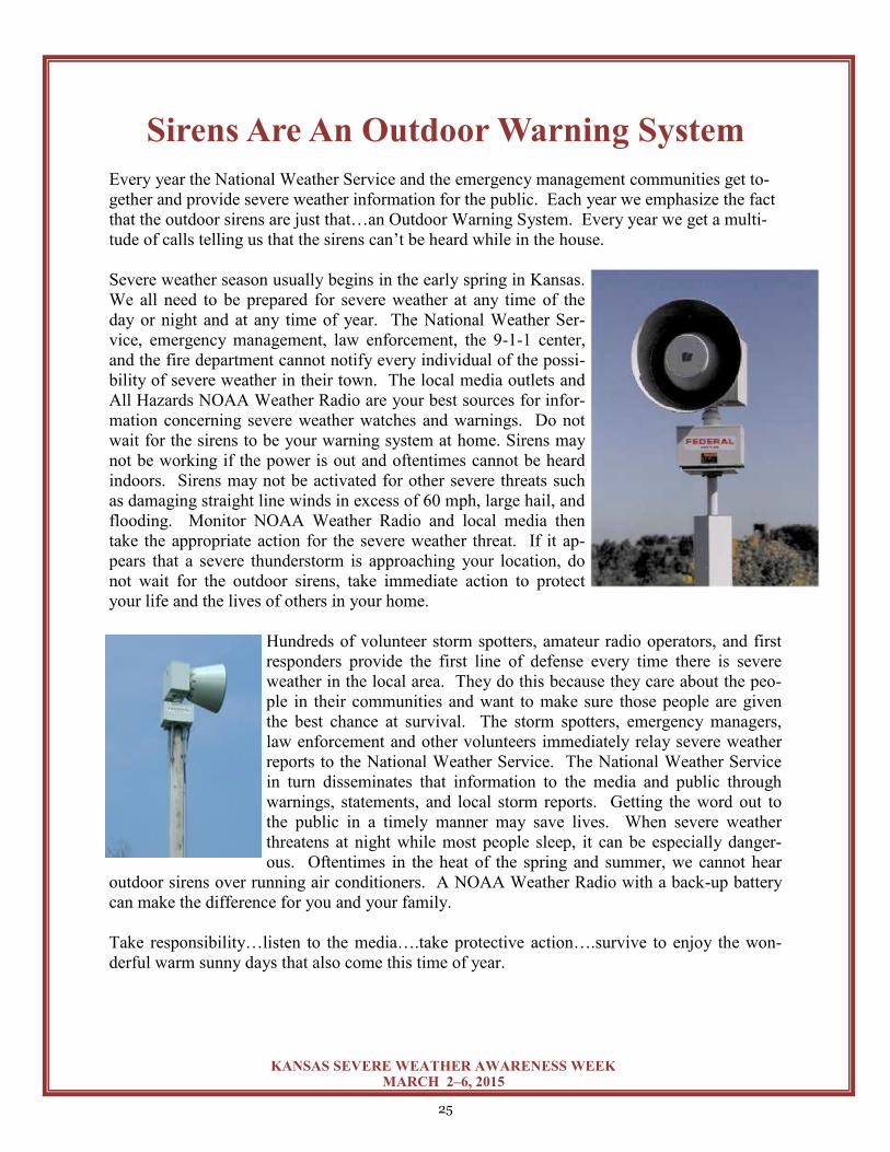
Sirens Are An Outdoor Warning System
Every year the National Weather Service and the emergency management communities get to-
gether and provide severe weather information for the public. Each year we emphasize the fact
that the outdoor sirens are just that…an Outdoor Warning System. Every year we get a multi-
tude of calls telling us that the sirens can’t be heard while in the house.
Severe weather season usually begins in the early spring in Kansas.
We all need to be prepared for severe weather at any time of the
day or night and at any time of year. The National Weather Ser-
vice, emergency management, law enforcement, the 9-1-1 center,
and the fire department cannot notify every individual of the possi-
bility of severe weather in their town. The local media outlets and
All Hazards NOAA Weather Radio are your best sources for infor-
mation concerning severe weather watches and warnings. Do not
wait for the sirens to be your warning system at home. Sirens may
not be working if the power is out and oftentimes cannot be heard
indoors. Sirens may not be activated for other severe threats such
as damaging straight line winds in excess of 60 mph, large hail, and
flooding. Monitor NOAA Weather Radio and local media then
take the appropriate action for the severe weather threat. If it ap-
pears that a severe thunderstorm is approaching your location, do
not wait for the outdoor sirens, take immediate action to protect
your life and the lives of others in your home.
Hundreds of volunteer storm spotters, amateur radio operators, and first
responders provide the first line of defense every time there is severe
weather in the local area. They do this because they care about the peo-
ple in their communities and want to make sure those people are given
the best chance at survival. The storm spotters, emergency managers,
law enforcement and other volunteers immediately relay severe weather
reports to the National Weather Service. The National Weather Service
in turn disseminates that information to the media and public through
warnings, statements, and local storm reports. Getting the word out to
the public in a timely manner may save lives. When severe weather
threatens at night while most people sleep, it can be especially danger-
ous. Oftentimes in the heat of the spring and summer, we cannot hear
outdoor sirens over running air conditioners. A NOAA Weather Radio with a back-up battery
can make the difference for you and your family.
Take responsibility…listen to the media….take protective action….survive to enjoy the won-
derful warm sunny days that also come this time of year.
26
KANSAS SEVERE WEATHER AWARENESS WEEK MARCH 2–6, 2015
Weather
Safety
Handout
In Spanish
27
KANSAS SEVERE WEATHER AWARENESS WEEK MARCH 2–6, 2015
Está en un edificio de muchos pisos: Busque refugio en un cuarto interior o un pasillo. Evite las ventanas y las paredes exteriores.
Está en una casa prefabricada o un auto: ¡¡¡Abandónelo Inmediatamente!!!
La mayoría de las muertes ocurren en casas prefabricadas o en autos. Si está en una casa prefabricada o un auto entonces abandónelo inmediatamente y busque refugio en un edificio con una estructura fuerte. Planee y determine su refugio antes que el clima severo ocurra. Si no hay edificio cerca: Busque un refugio en una cuneta y cobra su cabeza o zanja y cubra su cabeza con sus manos. Esté alerta por si hay una inundación.
Está en una casa o en un edificio pequeño: Busque un refugio en el sótano, en una habitación o en el pasillo del nivel más bajo del edificio. Si no le da tiempo de bajar busque refugio en un ropero, un cuarto dentro de la casa que tenga paredes resistentes. Cúbrase con unas cobijas o una bolsa de dormir para protegerse de los escombros que salgan volando. Está la escuela, hospital, una fábrica o en un centro comercial: Busque refugio en un cuarto interior o un pasillo del nivel más bajo. Evite las ventanas o las áreas abiertas como un almacén o un auditorio. Las escaleras en el centro son un buen refugio.
Si se emite una alarma
Evite las ventanas
Abandone los autos y busque un refugio en una zanja o una cuneta (drenaje vial).
Antes de la tormenta:
Tenga un plan de acción
Practique frecuentemente los procedimientos a seguir
Compre un radio del tiempo NOAA para que tener una alarma
Escuche el radio y la televisión para tener más información
Si está planeando una actividad al aire libre primero investigue el pronóstico del tiempo
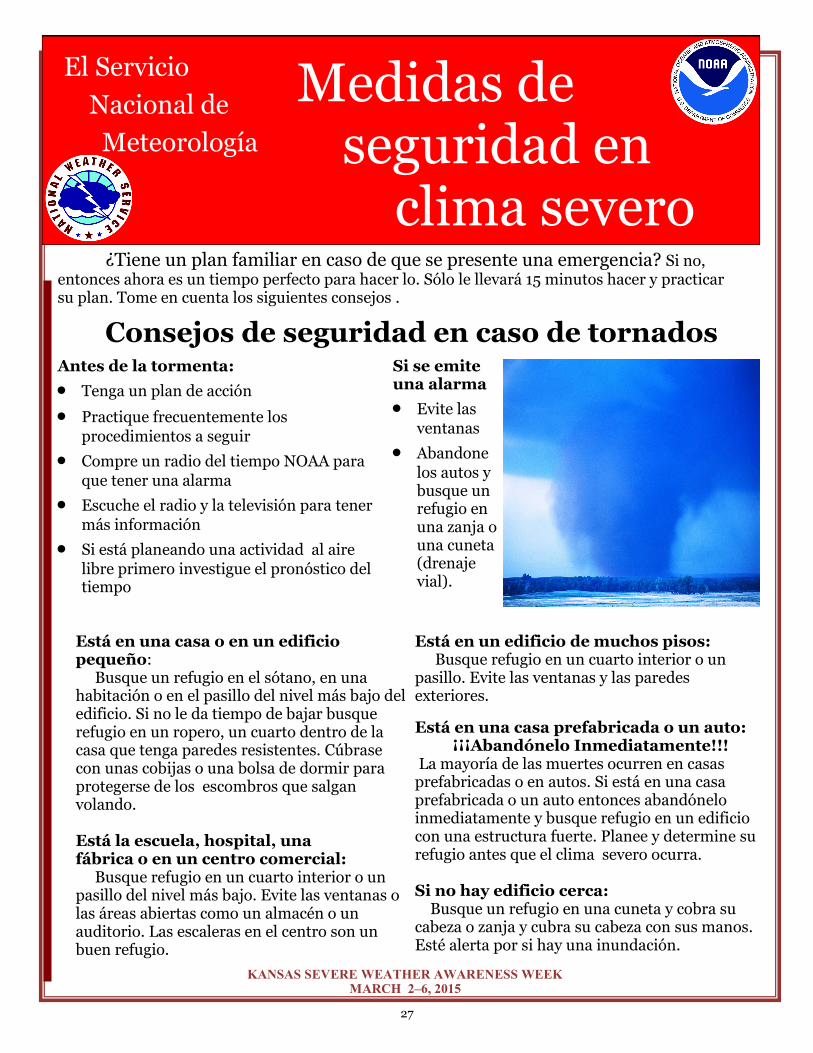
El Servicio
Nacional de
Meteorología
Medidas de seguridad en
clima severo
Consejos de seguridad en caso de tornados
¿Tiene un plan familiar en caso de que se presente una emergencia? Si no, entonces ahora es un tiempo perfecto para hacer lo. Sólo le llevará 15 minutos hacer y practicar su plan. Tome en cuenta los siguientes consejos .
28
KANSAS SEVERE WEATHER AWARENESS WEEK MARCH 2–6, 2015
Tornados y Seguridad en Puentes Muchas personas piensan, equivocadamente, que los puentes o pasos a desnivel en las carreteras son lugares seguros para protegerse de un tornado. En realidad, esos puentes son los peores lugares para buscar refugio de un tornado. Buscar protegerse debajo de un puente le pone en mayor riesgo de muerte o de ser fuertemente herido debido a los escombros que los fuertes vientos del tornado arrastran.
Los vientos del tornado pueden convertir los objetos menos peligrosos en armas de muerte. Además del peligro de los escombros, los vientos debajo del puente son más intensos y pueden fácilmente sacarlo de ahí y aventarlo cientos de millas.
Como último recurso, acuéstese boca abajo en una zanja a lado de la carretera, o entre en un tubo de drenaje para protegerse de ser arrastrado. Si no hay ninguna zanja o tubo qué-dese en su carro con su cinturón de seguridad puesto y póngase debajo del nivel de la ventana. Cubra su cabeza con sus manos o con una sábana.
Aléjese de los Relámpagos Esté al pendiente de saber si habrá tormen-
tas eléctricas y alístese para actuar.
Los rayos pueden caer hasta 10 millas de distancia de donde está lloviendo. Esa es la distancia aproximada de donde se puede escuchar un trueno.
Si puede escuchar el trueno, significa que está en un área peligrosa donde puede caerle un rayo ¡Aléjese y busque refugio!
Actividades al aire libre: Para evitar ser tocado por un rayo mejor realice las activi-dades en un lugar techado o entre en su carro cuando escuche el primer trueno.
Actividades Interiores: Cosas a evitar
Teléfonos conectados a la electricidad
Computadoras
Cualquier equipo eléctrico
Albercas techadas o al aire libre
Tuberías, regaderas y cualquier otra cosa que esté conectada a la tubería
Después de escuchar el último trueno espere 30 minutos antes de salir.
Para ayudar una victima de un rayo: Llame al 9-1-1 o a su servicio local de ambulancia. Y pida ayuda inmediatamente. Usted no corre peligro al ayudar a una víctima de un rayo. La energía que esa persona recibió no le afectará a usted.
¡Cuando escuche un trueno, ir a dentro es bueno!
Seguridad de Las Inundaciones
Las inundaciones, particularmente las riadas,
cada año provocan la muerte de muchas personas más que cualquier otro evento asociado con clima severo .
Aguas de 6 pulgadas de profundidad que se
muevan rápidamente pueden arrastrar a casi cualquier persona.
Su auto, camión o SUV puede empezar a flotar
en agua de menos de 2 pies de profundidad y que se están moviendo rápidamente.
Cuando vea una calle inundada...
¡ES MEJOR REGRESARSE, QUE AHOGARSE!
Escuche el radio de NOAA o su noticiero local
para más información de las inundaciones.
Salga de las áreas que son susceptibles a la
inundación por ejemplo sótanos y valles.
No trate de cruzar los riachuelos.
Nunca conduzca en caminos inundad0s.
Si su auto está en un lugar donde el nivel del
agua sube rápidamente, abandónelo y busque refugio en un lugar alto.
Llame a las autoridades locales o su Servicio
Nacional de Meteorología para informar de la inundación
¡ES MEJOR REGRESARSE, QUE AHOGARSE!
29
KANSAS SEVERE WEATHER AWARENESS WEEK MARCH 2–6, 2015
Americans live in the most severe weather-prone country on Earth, and the state of Kansas is no
exception. Each year a startling 10,000 thunderstorms, 2,500 floods, 1,000 tornadoes, and 10
hurricanes impact the United States. Potentially deadly severe weather impacts every Ameri-
can. Communities can rely on the National Weather Service’s StormReady program to help
them guard against the ravages of Mother Nature.
What is StormReady? Ninety percent of all presidentially declared disasters are weather related. Through the Storm-
Ready program, NOAA’s National Weather Service gives communities the skills and education
needed to survive severe weather – before and during the event. StormReady helps community
leaders and emergency managers strengthen their local hazardous weather operations.
StormReady Does Not Mean Storm Proof StormReady communities are better prepared to save lives from the onslaught of severe weather
through better planning, education and awareness. Communities have fewer fatalities and prop-
erty damage if they plan before dangerous weather arrives. No community is storm proof, but
StormReady can help communities save lives.
How Can My Community Become StormReady? The entire community – from the mayor and emergency managers, to business leaders and civic
groups – can take the lead on becoming StormReady. Local National Weather Service forecast
offices work with communities to complete an application and review process. To be recog-
nized as StormReady, a community must:
Establish a 24-hour warning point and emergency operations center.
Have more than one way to receive severe weather warnings and forecasts and to
alert the public.
Create a system that monitors local weather conditions.
Promote the importance of public readiness through community seminars.
Develop a formal hazardous weather plan, which includes training severe weather
spotters and holding emergency exercises.
Go to http://www.stormready.noaa.gov for more information.

30
KANSAS SEVERE WEATHER AWARENESS WEEK MARCH 2–6, 2015
30
KANSAS SEVERE WEATHER AWARENESS WEEK MARCH 2–6, 2015
Recommended