Embed Size (px)
Citation preview

ZONING ORDINANCE
PARSONS
TENNESSEE
Original Adoption – October, 1983
Updated Amendments (1984-2014)
Reprinted June 9, 2014

~ B L A N K P A G E ~

MUNICIPAL – REGIONAL PLANNING COMMISSION
PARSONS TENNESSEE
John Long, Chairman Dwight Lancaster, Alderman and Vice Chairman
Tom Leitch, Secretary Mayor Tim David Boaz, Commisssioner
Pam Villaflor, Commissioner
With the Assistance from: Southwest Tennessee Development District
Regional Planning Office 102 E. College Street
Jackson, Tennessee 38301

~ B L A N K P A G E ~
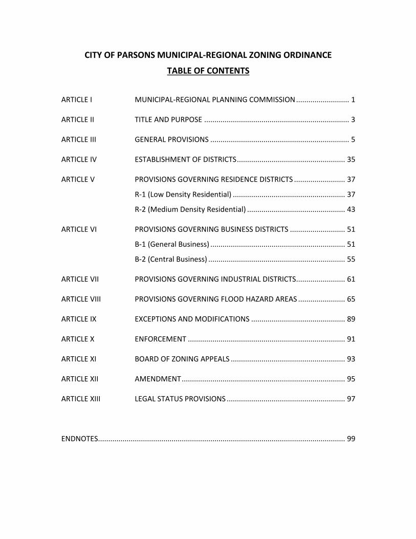
CITY OF PARSONS MUNICIPAL-REGIONAL ZONING ORDINANCE
TABLE OF CONTENTS
ARTICLE I MUNICIPAL-REGIONAL PLANNING COMMISSION .......................... 1
ARTICLE II TITLE AND PURPOSE ....................................................................... 3
ARTICLE III GENERAL PROVISIONS .................................................................... 5
ARTICLE IV ESTABLISHMENT OF DISTRICTS ..................................................... 35
ARTICLE V PROVISIONS GOVERNING RESIDENCE DISTRICTS ......................... 37
R-1 (Low Density Residential) ....................................................... 37
R-2 (Medium Density Residential) ................................................ 43
ARTICLE VI PROVISIONS GOVERNING BUSINESS DISTRICTS ........................... 51
B-1 (General Business) .................................................................. 51
B-2 (Central Business) ................................................................... 55
ARTICLE VII PROVISIONS GOVERNING INDUSTRIAL DISTRICTS........................ 61
ARTICLE VIII PROVISIONS GOVERNING FLOOD HAZARD AREAS ....................... 65
ARTICLE IX EXCEPTIONS AND MODIFICATIONS .............................................. 89
ARTICLE X ENFORCEMENT ............................................................................. 91
ARTICLE XI BOARD OF ZONING APPEALS ........................................................ 93
ARTICLE XII AMENDMENT ................................................................................ 95
ARTICLE XIII LEGAL STATUS PROVISIONS .......................................................... 97
ENDNOTES ......................................................................................................................... 99

~ B L A N K P A G E ~
Zoning Ordinance - City of Parsons -Zoning Ordinance 1
ARTICLE I
PARSONS MUNICIPAL-REGIONAL PLANNING COMMISSION
SECTION
A. Creation and Membership B. Organization, Rules, Staff and Finances C. Powers and Duties
Section A. Creation and Membership Pursuant to the provisions of Section 13-3-102, Tennessee Code Annotated, there is hereby created a municipal-regional planning commission, hereinafter referred to as the planning commission. The planning commission shall consist of five (5) members; two (2) of these shall be the Mayor and another member of the City Council by the City Council; all other three (3) members shall be appointed by the Mayor. All members of the planning commission shall serve as such without compensation. Except for the initial appointments, the terms of the three (3) members appointed by the Mayor shall be for three (3) years each. The three (3) members first appointed shall be appointed for terms of one (1), two (2), and three (3) years respectively so that the term of one (1) member expires each year. The terms of the Mayor and the member selected by the City Council shall run concurrently with their terms of office. Any vacancy in an appointive membership shall be filled for the unexpired term of the Mayor, and he shall have power to remove any appointive member at his pleasure.
Section B. Organization, Rules, Staff, and Finances The planning commission shall elect its chairman from its appointive members. The term of chairman shall be one year with eligibility for re-election. The commission shall adopt rules for the transactions, findings and determinations, which record shall be a public record. The commission may appoint such employees and staff as it may deem necessary for its work and may contract with city planners and other consultants for such services as it may require. The expenditures of the commission, exclusive of gifts, shall be within the amounts appropriated for the purpose by the City Council.
Section C. Powers and Duties The planning commission shall be organized and shall carry out its powers, functions, and duties in accordance with Title 13 of the Tennessee Code Annotated.

Zoning Ordinance - City of Parsons -Zoning Ordinance 2
~ B L A N K P A G E ~

Zoning Ordinance - City of Parsons | 3
ARTICLE II
TITLE AND PURPOSE
SECTION
A. Title B. Purpose
Section A. Title Articles II through XII shall be known as the "Zoning Ordinance of the City of Parsons, Tennessee." The map herein referred to, which is identified by the title "Zoning Map of Parsons, Tennessee," which is on file in the Parsons City Hall is hereby adopted and made a part of this ordinance.
Section B. Purpose The zoning regulations and districts as herein set forth have been made in accordance with a comprehensive plan for the purpose of promoting the public health, safety, morals, and convenience, order, prosperity, and general welfare of the community. They have been designed to lessen congestion in the streets, to secure safety from fire, panic and other dangers, to provide adequate light and air, to prevent the overcrowding of land, to avoid undue concentration of population, to facilitate the adequate provision of transportation, water, sewerage, schools, parks and other public requirements. They have been made with reasonable consideration, among other things, as to the character of each district and its peculiar suitability for particular uses, and with a view of conserving the value of building and encouraging the most appropriate use of land through the town.

Zoning Ordinance - City of Parsons | 4
~ B L A N K P A G E ~

Zoning Ordinance - City of Parsons | 5
ARTICLE III
GENERAL PROVISIONS
SECTION
A. Provisions Apply to Whole Town B. Definitions C. Zoning Affects Every Building and Use D. Continuance of Non-Conforming Use E. Erection of More than One Principal Building on Any Lot F. Street Frontage G. Off-Street Automobile Storage H. Required Yard cannot be used by Another Building I. Rear Yard Abutting a Public Street J. Obstruction to Vision at Street Intersection Prohibited K. Off-Street Loading and Unloading Space L. Access Control M. Future Street Lines N. Site Plan Review O. Provisions Governing Signsi P. Design Review Guidelinesii
Section A. Provisions Apply to Whole Town For the purpose of this ordinance, there shall be certain general provisions which shall apply to the town as a whole.
Section B. Definitions Unless otherwise stated the following words shall, for the purpose of this ordinance, have the meaning herein indicated. Words used in the present tense include the future. The singular number includes the plural and the plural the singular. The word "shall" is mandatory, not directory.
1. "Alley” Any public or private way set aside for public travel twenty (20) feet or less in width.
2. "Area of Building" The area of the first floor of the building including covered porches, attached garages and carports
3. "Base Flood" means the flood having a one percent chance of being equaled or exceeded in any given year. This is sometimes called the 100 year flood.
4. "Building" Any structure constructed or used for residence, business, industry, or other public or private purposes, or accessory thereto, and including tents, lunch wagons, dining cars, trailers, mobile homes, billboards, signs and similar structures whether stationary or movable.
(a) "Principal Building” A building in which is conducted the principal use of the lot on which it is situated. In any residential district any dwelling shall be deemed to be the principal building on the lot on which the same is situated.
Zoning Ordinance - City of Parsons | 6
(b) "Accessory Building" A subordinate building, the use of which is incidental to that of a principal building on the same lot. Swimming pools shall be considered accessory buildings in residential districts.
5. "Clinic" A facility for the examination and treatment of ill and afflicted human outpatients provided, however, those patients are not kept overnight except under emergency conditions. This includes doctor and dental offices.
6. "Dwelling, Single-Family" A detached residential dwelling unit other than a mobile home, designed for and occupied by one family only.
7. "Dwelling, Two-Family" A detached residential dwelling unit other than a mobile home, designed for and occupied by two families only.
8. "Dwelling, Multiple-Family" A residential building designed for or occupied by three or more families with the number of families in residence not exceeding the number of dwelling units provided.
9. "Dwelling Unit" One room or rooms connected together constituting a separate independent housekeeping establishment for owner occupancy, or rental or lease on a weekly, monthly, or longer basis, and physically separated from any other rooms or dwelling units which may be in the same structure and containing independent cooking and sleeping facilities.
10. "Family" One (1) or more persons occupying a premise and living as a single, nonprofit housekeeping unit.
11. "Junk Yard" Commercial establishment used for the storage, sale, and trade of scrap metal.
12. "Lot" A piece, parcel, or plot of land in one ownership, which may include one (1) or more lots of record, occupied or to be occupied by buildings and accessory buildings and including the open spaces required under this ordinance. All lots shall front on and have access to a street.
(a) "Lot Line" The boundary dividing a given lot from a street, an alley, or adjacent lots.
(b) "Lot of record" A lot, the boundaries of which are filed as a legal record.
13. "Mobile Home" A detached residential dwelling unit designed for transportation after fabrication on streets or highways on its own wheels or on flatbed or other trailers, and arriving at the site where it is to be occupied as a dwelling complete and ready for occupancy except for minor and incidental unpacking and assembly operations, locations on jacks and other temporary or permanent foundations, connection to utilities, and the like. The character of a mobile home as a non-permanent dwelling shall not be changed in the view of this ordinance by removal of the wheels and/or carriage or placement on a permanent foundation.

Zoning Ordinance - City of Parsons | 7
14. "Mobile Home Park" Any plot of ground upon which three (3) or more mobile homes, occupied for dwelling or sleeping purposes, are located, regardless of whether or not a charge is made for such accommodation.
15. "Nonconforming Use" A use of a building or of land lawful at the time of the enactment of this ordinance that does not conform with the provisions of this ordinance for the district in which it is located.
16. “Nonconforming Structure" A structure which was lawfully constructed prior to enactment, or amendment, of this ordinance that does not conform to the provisions of this ordinance for the district in which it is located.
17. "Townhouse" A building consisting of a series of three (3) or more non-communicating one-family dwelling sections with separate entrance on ground level to each unit, and having a common wall between each two (2) adjacent sections.
18. "Travel Trailer" A travel trailer, pick-up camper, converted bus, tent-trailer, tent, or similar device used for temporary portable housing or a unit which:
(a) Can operate independent of connections to external sewer, water and electrical systems;
(b) Contains water storage facilities and may contain a lavatory, kitchen sink and/or bath facilities; and/or
(c) Is identified by the manufacturers as a travel trailer.
A travel trailer is not to be considered as a mobile home.
19. "Story" That portion of a building included between the upper surface of any floor and the upper surface of the floor next above, or any portion of a building used for human occupancy between the topmost floor and the roof. A basement not used for human occupancy other than for a janitor or domestic employee shall not be counted as a story.
20. "Street" Any public or private way set aside for public travel twenty-one (21) feet or more in width. The word "street" shall include the words "roads", "highway", and "thoroughfare."
21. "Total Floor Area" The area of all floors of a building including finished attic, finished basements, covered porches and attached garages or carports.
22. "Yards" A required open space other than a court unoccupied and unobstructed by any structure or portion of a structure from 30 inches above the general ground level of the graded lot upward, provided however that fences, walls, poles, posts, and other customary yard accessories, ornaments, and furniture may be permitted in any yard subject to height limitations and requirements limiting obstruction of visibility.
(a) "Front Yard" The yard extending across the entire width of the lot between the front yard line, and the nearest part of the principal building, including covered porches and carports.

Zoning Ordinance - City of Parsons | 8
(b) "Rear Yard" The yard extending across the entire width of the lot between the rear lot line, and the nearest part of the principal building, including covered porches and carports.
(c) "Side Yard" A yard extending along the side lot line from the front yard to the rear yard and lying between the side lot line and the nearest part of the principal building, including covered porches and carports.
23. "Travel Trailer Park" The term travel trailer park shall mean any plot of ground within the City of Parsons on which two (2) or more travel trailers, occupied for camping or periods of short stay, are located.
Section C. Zoning Affects Every Building and Use No building or land shall hereafter be used and no building or part thereof shall be erected, moved or altered unless for a use expressly permitted by and in conformity with the regulations herein specified for the district in which it is located, except as hereinafter stated.
Section D. Continuance of Non-conforming Use
1. Within the districts established by this ordinance or amendments that may later be adopted there exist uses and/or structures which were lawful before this ordinance was passed or amended, but which would be prohibited, regulated, or restricted under the terms of this ordinance or future amendment the following shall apply:
(a) Any non-conforming structure may not be:
(1) Extended except in conformity with this ordinance.
(2) Rebuilt or repaired after damage exceeding seventy-five (75) percent of replacement value except in conformity with the provisions of this ordinance.
(3) Removed and replaced with another nonconforming structure.
(b) Any non-conforming use of land may not be:
(1) Changed to another non-conforming use which would be more detrimental to the district in which it is located.
(2) Extended, except in conformity with this ordinance.
(c) Any non-conforming use or structure may not be:
(1) Changed to another non-conforming use.
(2) Re-established after discontinuance of one year.
(3) Extended except in conformity with this ordinance.
(d) Any structure used for a non-conforming use shall not be rebuilt or repaired after damage exceeding seventy-five (75) percent of replacement cost unless the use and structure conform to the provisions of this ordinance.

Zoning Ordinance - City of Parsons | 9
2. For any non-conformity created by amendments to this ordinance passed after the passage of Chapter 279 of the Public Act of 1973 of the State of Tennessee the following shall apply:
(a) Residential non-conformity will apply as stated in Paragraph 1, Section D.
(b) Industrial, commercial, or business establishments, which were non-conformities prior to the passage of Chapter 270 of the Public Act of 1973 will be covered by Paragraph 1, Section D.
(c) Industrial, commercial, or business establishments, which were made non-conformities after the passage of Chapter 270 of the Public Acts of 1973 will be permitted to expand, rebuild or distrust in accordance with the provisions of Section 13-7-208, Tennessee Code Annotated.
Section E. Erection of More Than One Principal Building on Any Lot In any district, more than one structure housing a permitted or permissible principal use may be erected on a single lot, provided the yard and other requirements of this ordinance shall be met for each structure as though it were on an individual lot. This provision does not apply to group housing developments as permitted under Article XIII.
Section F. Street Frontage Required No building shall be erected in any district except the B-2 (Central Business District) on a lot which does not abut at least one public street for at least fifty (50) feet. This shall not be construed to apply to properties abutting a cul-de-sac type turn-around: a minimum street abutment of twenty-five (25) feet shall apply to cul-de-sacs if the minimum lot width requirements are provided at the front yard setback (building) line.
Section G. Off-Street Automobile Storage
1. There shall be provided, at the time of erection of any building or structure, or at the time any main building or structure is enlarged or increased in capacity by adding dwelling units, guest rooms, seats or floor area, or before conversion from one zoning use of occupancy to another, permanent off-street parking space of at least two hundred (200) square feet per space with vehicular access to a street or alley. The city reserves the right to control ingress and egress over private right-of-way. Off-street parking space shall be deemed to be required open space associated with the permitted use and shall not hereafter be reduced or encroached upon in any manner.
(a) Dwelling: Not less than one (1) space for each dwelling plus 1/2 space for each additional unit or apartment.
(b) Boarding Houses, Rooming Houses: No less than one (1) space for each room or unit occupied by boarders or roomers.
(c) Tourist Accommodations: No less than one (1) space for each room or unit offered for tourist accommodations.

Zoning Ordinance - City of Parsons | 10
(d) Office Buildings, Manufacturing or Other Industrial Building or Use: In all business and industrial districts, except a B-2 (Central Business District) not less than one (1) space for each two (2) persons employed computed on the basis of total number of employees on the two largest consecutive shifts. In addition, there shall be sufficient parking for all vehicles used directly in the conduct of such office or industrial use.
(e) Retail Uses: In all business and industrial districts, except a B-2 (Central Business District), not less than one (1) space for each two hundred (200) square feet of store sales area.
(f) Theaters, Auditoriums, Stadiums, Churches, or Other Use Designed to Draw an Assembly of Persons: Not less than one (1) space for each five (5) seats provided in such place of assembly, except in a B-2 (Central Business District).
(g) Public Building: Not less than one (1) space for each two hundred (200) square feet of total floor area of all floors in building except basement, except in a B-2 (Central Business District).
(h) Medical Offices: In all business districts, except a B-2 (Central Business District) three (3) patient's parking spaces per staff doctor, plus two (2) per three (3) employees, plus one (1) per staff doctor.
(i) Funeral Homes: In all business districts, except a B-2 (Central Business District) one space for each company vehicle plus one space for each three (3) seats in meeting room.
2. Parking space maintained in connection with an existing and continuing main building or structure on the effective date of this ordinance up to the number required by this ordinance shall be continued and may not be counted as serving a new structure or addition, nor may any parking space be substituted for a loading space, nor any loading space substituted for a parking space.
3. If off-street parking space required above cannot be reasonably provided on the same lot on which the principal use is conducted, the Board of Zoning Appeals may permit such space to be provided on other off-street property provided such space lies within four hundred (400) feet of the main entrance to such principal use. Such vehicle standing space shall be deemed to be required open space associated with the permitted use and shall not thereafter be reduced or encroached upon in any manner.
Section H. Required Yard Cannot be used by Another Building No part of a yard or other open space required about any building for the purpose of complying with the provisions of these regulations shall be included as a part of a yard or other open space required under these regulations for another building.
Zoning Ordinance - City of Parsons | 11
Section I. Rear Yard Abutting a Public Street When the rear yard of a lot abuts a public street, all structures built in that rear yard shall observe the same setback from the street line, centerline of the street, or property line as required for adjacent properties that front on that street. In addition, any structure located within twenty-five (25) feet of that setback line shall be no closer to any side property than the distance required for side yards on adjoining properties fronting on that street.
Section J. Obstruction to Vision at Street Intersection Prohibited On a corner lot not in a B-2 (Central Business District), within the area formed by the center lines of the intersecting or intercepting streets and a line joining points on such center lines at a distance of seventy (70) feet from their intersection there shall be no obstruction to vision between a height of two and one half (2 1/2) feet and a height of ten (10) feet above the average grade of each street at the center line thereof. The requirements of this section shall not be construed to prohibit any necessary retaining wall.
Section K. Off-street Loading and Unloading Space In all business and industrial districts, except a B-2 (Central Business District) every building or structure used for business or trade shall provide adequate space for the loading or unloading of vehicles off the street or public alley. Such space shall have access to a public alley or if there is no alley, to a public street. Loading space maintained in connection with an existing and continuing main building or structure on the effective date of this ordinance up to the number required by this ordinance shall be continued and may not be counted as serving a new structure or addition.
Section L. Access Control In order to promote the safety of the motorist and pedestrian and to minimize traffic congestion and conflict by reducing the points of contact, the following regulations shall apply:
1. A point of access, i.e., a drive or other opening for vehicles onto a street shall not exceed thirty (30) feet in width.
2. There shall be not more than two (2) points of access to any one (1) public street on a lot less than 400 feet but more than 100 feet in width. Lots less than one hundred (100) feet in width shall have no more than one (1) point of access to any one (1) public street.
3. Point of access to any one (1) public street for lots of more than four hundred (400) feet in width shall be no closer than one hundred (100) feet apart.
4. No point of access shall be allowed within ten (10) feet of the right-of-way of any public street intersection.
5. Where sidewalks exist, the area existing between the street and an interior parking space or driveway parallel to the street shall have a curb of at least six (6) inches in height and six (6) inches in width separating the parking area from the sidewalk to prevent encroachment of vehicles onto the sidewalk area.
6. No curbs on city streets or rights-of-way shall be cut or altered without written approval of the Building Inspector.
Zoning Ordinance - City of Parsons | 12
7. Cases requiring variances relative to this action, and hardships not caused by the property owner, shall be heard and acted upon by the Board of Zoning Appeals, provided, further that no curb cuts for off-street automobile storage or parking space shall be permitted where the arrangement would require that vehicles back directly into a public street (this is not to include private parking for residential property).
8. Access control on property abutting state or federal highways shall be governed by official regulations of the Tennessee Department of Highways or the provisions of this ordinance whichever is higher.
Section M. Future Street Lines For the purpose of providing adequate space for widening major streets in the future, the minimum required front yard on a lot abutting a major street shall be measured from the proposed right-of-way width shown on the latest Major Street Plan officially adopted and placed on public record by the Planning Commission.
Section N. Procedures and Requirements for Site Plan Review/Statement of Purpose and Goals. The following procedures and standards are established for those Sections and Chapters of this Ordinance that require the submission and approval of a site plan prior to the issuance of a building permit or certificate of occupancy. The site plan must be based on a to-scale drawing of the property. The Parsons Municipal-Regional Planning Commission shall act in the official review of all required site plans and shall have the power to approve or disapprove all required site plans according to the terms specified herein. All site plans submitted for the review of the location of any Use Permitted on Appeal by the Board of Zoning Appeals shall be reviewed and approved according to its conformance with the terms specified herein by the Parsons Municipal-Regional Planning Commission before the issuance of a building permit or certificate of occupancy. Every site plan submitted to the City of Parsons shall become the property of the City and shall be maintained in the permanent files of the Building Inspector. Site plan approval, once granted, shall be in effect for a period on one (1) year from the date of the approval.
Site Plan Submission and Review
1. In instances where site plan review is required by the Parsons Municipal Zoning Ordinance, the following procedures shall apply:
Contents of Site Plan
a. The site plan shall include:
(1) Name of development and address.
(2) Name and address of owner of record and the applicant
(3) Scale of 1” - 100’
(4) Note present zoning classification of the site and all abutting properties. Also, note nature of proposed use.
(5) Date, scale, and north point with reference to source of meridian. Note all related dimensions and bearings of the lot.
Zoning Ordinance - City of Parsons | 13
(6) Courses and distances of center lines of all streets.
(7) All buildings restriction lines (yard setbacks and rights-of-way)right-of-way and highway setback lines, easements, covenants, reservations and rights-of-way.
(8) The acreage or square footage of the lot.
(9) Sufficient grade and elevation information to demonstrate that the property will properly drain and can be connected to the public sewer system to provide gravity discharge of waste from the building. Topography to be shown by dashed line illustrating contours and/or spot elevation, if required, and as required by the City.
b. The site plan shall show the location, dimensions, site and height of the following when existing and/or when proposed:
(1) Sidewalks, streets, alleys, easements and utilities.
(2) Buildings and structures including the front (street) elevation of proposed building.
(3) Public sewer systems.
(4) Slopes, terraces, and retaining walls.
(5) Driveways, entrances (all access points), exists, parking areas, sidewalks and garbage collection site.
(6) Water mains and fire hydrants.
(7) The following when applicable:
a. Number of dwelling units.
b. Number and size of parking stalls and type of proposed pavement either Portland concrete or asphalt).
c. Number of loading spaces and type of proposed pavement (either Portland concrete or asphalt).
d. Number of Commercial or Industrial tenants and employees.
(8) Plans for the collection and discharge of storm water and methods for landscaping. The delineation of the limits of floodplains, if any. Also the site plan must denote the minimum 100-year, base flood elevation level if any portion of the site lies within the FEMA-designated special flood hazard area.
(9) Proposed grading plan.
Site Plan Review Authority
a. The Planning Commission shall have the power to require such changes in the required site plan as may be necessary to minimize the impact of the required

Zoning Ordinance - City of Parsons | 14
use. This may include, but not be limited to, setbacks, screening, lighting, parking location and layouts, access and general landscaping requirements. This power for review shall not include the authority to specify or alter the architectural style of proposed or existing buildings, and authority to specify building materials, colors, or similar considerations.
The Planning Commission shall have the power to require a buffering of the development from surrounding properties by the use of fencing, plantings, or combinations thereof.
b. The Board of Zoning Appeals shall have the power to require such changes in the required site plan as may be necessary to minimize the impact of the use permitted on appeal. This may include, but not be limited to, setbacks, screening, lighting, parking location and layout, access and general landscaping requirements. This power of review shall not include the authority to specify or alter the architectural style of proposed or existing buildings, the authority to specify building materials, colors, or similar considerations.
The Board of Zoning Appeals shall have the authority to require a buffering of the use permitted on appeal from surrounding properties by the use of fencing, plantings or a combination thereof.
Section O. Provisions Governing Signsiii
1. Statement of Purpose
The regulations set forth herein are established in order to promote and protect public health, safety, comfort, prosperity, welfare, and in order to accomplish the following specific purposes to enhance the economy, business, and industry of Parsons by promoting the reasonable, orderly, and effective use and display of signs; to enhance the physical appearance of the city; to protect the general public from damage and injury which might be caused by the faulty and uncontrolled construction and use of signs within the city; to protect the public use of streets and highways by reducing sign or advertising distractions that may increase traffic accidents; to protect the physical and mental wellbeing of the general public by recognizing and encouraging a sense of aesthetic appreciation for the visual environment; and to preserve the value of private property by assuring the compatibility of signs with surrounding land uses.
2. Definitions
Abandoned/Obsolete Sign – any sign which identified or advertises a business, lesser, service, owner, product, or activity, which is no longer available at the indicated location or no longer available on the premises or for which no legal owner can be found.
Animated sign – Sign that uses movement or change of light depict or to create a special effect or scene (does not include time, temperature or message signs).
Attached Business Sign – Any sign which is affixed directly to or otherwise inscribed or painted on a wall or parapet wall of any building or structure with the exposed face of the sign in a plane approximately parallel to the plane of such wall and extending there from less than twelve (12) inches.
Zoning Ordinance - City of Parsons | 15
Awning/Canopy Sign – A sign painted n, printed on, or attached flat against the surface of an awning or canopy projecting from and supported by the exterior wall of a building.
Banner Sign – A sign made of fabric or other non-rigid materials with no enclosing framework. National flags, state or municipal flags, or the official flag of any institution or business shall not be considered banners.
Bed and Breakfast Homestayiv – An incidental and subordinate use of a private dwelling unit operated solely by the permanent residents of such dwelling unit, said use being a part-time for pay operation providing accommodations and at least one meal per day to guests for a period of time not to exceed fourteen consecutive days per guest per month, and said use limited to no more than three guest sleeping rooms.
Building Inspector – The city official or authorized representative charged with the responsibilities of enforcing the chapter.
Business Identification Signs – A freestanding sign identifying a recognized firm, business, or service.
Canopy – An extension of the roof of a building or a freestanding structure that ha a roof with support, but no walls.
Central Business District – The area contained within the B-2 (Central Business) zone as identified on the Official Zoning Map of Parsons, Tennessee.
Construction Sign – A temporary sign identifying an architect, contractor, subcontractor, and/or material supplier participating in construction on the property on which the sign is located.
Directional/Informational Sign – Any on-premises sign giving directions, instructions, or facility information, e.g., parking or exist and entrance signs, and which may contain the name or logo of an establishment but no other advertising copy.
Flashing Sign – Any directly or indirectly illuminated sign that contains an intermittent flashing light source. (This does not include message center or time/temperature signs)
Freestanding Sign – Any sign supported by uprights or braces placed on or in the ground and not attached to any building..
Ground Sign – Any sign supported by the ground with little or no vertical clearance.
Height (of a sign)- This vertical distance measured from the highest point of the sign, excluding decorative embellishments, to the grade of the adjacent street or the surface grade beneath the sign, whichever is less.
Illegal Sign – Any sign and/or advertising structure erected without a permit required by this Ordinance, or in violation of any of the limitations, prohibitions or requirements of this Ordinance.
Maintenance – For the purposes of this Ordinance, the cleaning, painting repair, or replacement of defective parts or a sign in a manner that does not alter the basic copy, design, or structure of the sign.

Zoning Ordinance - City of Parsons | 16
Mall Grouping Signs – Signs on one pole identifying a group of stores, businesses, or professional offices located in one development. These include office center signs and shopping center signs.
Message Board – A sign with changeable, removable letters to allow the user to replace or update the copy on the sign.
Nonconforming Sign (a) Any sign which was erected legally but which does not comply with subsequently enacted sign regulations and restrictions; (b) A sign which does not conform to the Sign Code requirements but for which a variance has been issued. These signs are grandfathered provided they do not violate the provisions of Section 11-1507(b).
Off-Premise Sign – A sign not located on the property that it advertises.
Office Center – Two or more offices having a common parking lot.
Owner – The fee owner of a sign, the lessee of the sign, the fee holder of the property upon which the sign is located, the leaseholder of such property or the individual, person or business who has purchased the copy on a sign.
Political Sign – A sign displaying the name and/or picture of an individual seeking election to a public office or a sign otherwise relating to a forthcoming public election or referendum.
Projecting Sign – Any sign which by its construction or nature may be or intended to be freely moved from one location to another. When on a trailer, the removal of the wheels or undercarriage does not place the sign in another category; neither does the anchoring of the sign by means of concrete blocks, sandbags or other types of temporary anchors. Portable signs include, but are not limited to, signs designed to be transported by means of whole, signs converted to A or T frames, menu and sandwich board signs, balloons used as signs, umbrellas used for advertising.
Public Sign – Any temporary or permanent sign erected and maintained by the City, County, State or Federal Government for traffic direction or for the designation of or direction to any school, hospital, historical site, or public service, property or facility.
Real Estate Sign – Any temporary sign advertising the real estate upon which the sign is located as being for rent, lease or sale.
Residential Districts- Any temporary sign advertising the real estate upon which the sign is located as being for rent, lease or sale.
Residential Districts – Any parcel in the City of Parsons zoned R-1, R-2 .
Roof Sign – Any sign erected, constructed or maintained wholly or partially upon or over the roof line of any building with the principal structural support on the roof or building structure.
Shopping Center – Two or more businesses sharing a common parking lot. This shall include indoor and outdoor malls
Sign – Any object, device, graphic design or part thereof, situated outdoors or indoors and which objects, device, graphic design or the effect produced is used to advertise, announce, identify, declare, demonstrate, display, instruct, direct or attract attention by any means
Zoning Ordinance - City of Parsons | 17
including words, letters, figures, designs, fixtures, colors, motion, illumination, sound and projecting images. Any sign requiring a permit is considered to be a structure.
Sign Area – (a) Freestanding, Roof and Projecting Signs. The area enclosed by one continuous line, connecting the extreme points or edges of the sign. The area shall be determined using the largest sign area or silhouette, but excluding the necessary supports or uprights. Two-sided signs constructed back to back shall use the square footage of one side only for compliance. Three-sided signs with n more than 60 degrees between the faces shall be figured using one face only. (b) Attached Business, Awning and Canopy Signs: The area including all lettering, wording, and accompanying design or symbols together with any background. For a sign composed of individual letters or figures, the area is that of the smallest rectangle or other geometric shape that encompasses all the letters or symbols.
Sign Permit – A written permit granted by the Building Inspector for the erection, construction, enlargement, relocation or conversion of any sign for which a permit is required.
Subdivision, Identification Sign – A freestanding or wall sign identifying a recognized subdivision, condominium complex or residential development.
Time and Temperature Sign – Electrically controlled public service time, temperature and date signs displayed on a lamp, bank, other electronic display
Temporary Sign.- Any sign, banner, pennant, valance or advertising display or sign constructed of light fabric, cardboard, wallboard, plywood, paper or other light materials, with or without frames, intended to be displayed for a limited period of time, i.e. garage sale, rummage, open house and similar types of signs.
User – The fee user of a sign, the lessee of the sign, the fee holder of the property upon which the sign is located, the leaseholder of such property or the individual, person or business who has purchased the copy of a sign.
Vehicle Mounted Sign – Any sign painted on or attached to a vehicle relating to the business, activity, use, service or product of the owner of the vehicle, or to the sale of the vehicle and which sign is incidental to the primary use of the vehicle.
Window Sign – Any on premise business sign installed in or on a window and intended to be viewed from the outside.
3 Regulations and Standards
a. Business Identification Signs
(1) Shall be allowed in B-1, B-2, and M-1 districts only.
(2) Only one sign per business per frontage shall be allowed. The sign shall be no greater than 175 square feet in area per sideband shall have no more than three (3) sides. In B-1 zones, double signs are allowed. The top sign shall be no greater than 64 square feet and the lower sign shall be no greater than 32 square feet in area. The lower sign may be used for on-premises advertising, community service, or a message board.
Zoning Ordinance - City of Parsons | 18
(3) Business identification signs must be located a minimum of five (5) feet from the right-of-way of any highway, street, or road, and a minimum of three (3) ft. from the edge of any sidewalk. In no case shall a sign be located on the public right-of-way. The sign shall in no way extend out over the right-of-way. The location must not interfere with traffic or pedestrian vision or safety.
(4) Lots fronting on two or more streets are allowed the permitted signage for each street frontage. Signage cannot be accumulated and used on one street in excess of that allowed for lots with only one street frontage.
(5) Ground signs are allowed. The height of the sign must not exceed thirty-five (35) feet above the ground elevation.
b. Attached Business Signs
(1) Shall be allowed in all Commercial and Industrial districts.
(2) Each business is limited to two (2) attached business sign per building face. The total area of both signs shall be no greater in area than 33% of the face of the wall on which it is located.
(3) An awning or canopy with the business name or related information is allowed in addition to the business sign. All such awnings or canopies shall be structurally sound and approved by the Building Inspector. The lowest portion shall not be less than ten (10) feet above the ground.
c. Off Premise Signs
(1) Off Premise signs are allowed as a principal use permitted on appeal by the Board of Zoning Appeals within the M-1 District.
(a) Off premise signs shall be no greater than 378 square feet in area per side and shall have no more than two (2) sides.
(b) Off premise signs may not be stacked.
(c) The maximum height of off-premise signs shall not be greater than 50 feet. The bottom of the sign must be a minimum of 10 ft. above the ground/pavement elevation.
(d) Off premise signs shall be placed a minimum of 1,000 linear feet from any other off premise sign on the same side of the highway.
(e) Off premise signs must be ;located a minimum of ten (10) feet from the right-of-way of any highway, street, or road and a minimum of five (5) ft. from the edge of any sidewalk. In no case shall a sign be located on the public right-of-way or interfere with traffic or pedestrian vision or safety.

Zoning Ordinance - City of Parsons | 19
d. Mall Grouping Signs
(1) Shopping Centers – A sign designating a shopping center and its tenants shall have a maximum area of eighty (80) square feet plus ten (10) square feet for each tenant over two, not to exceed one hundred-fifty (150) square feet. Signs designating individual business are not allowed, except attached business signs.
(2) Office Centers - A sign designating an office center and its tenants shall have a maximum area of sixty-four (64) square feet.
(3) Mall grouping signs must be located a minimum of ten (10) feet from, the right-of-way of any highway, street, or road and a minimum of three (3) feet from the edge of any sidewalk. In no case shall a sign be located on the public right-of-way. The sign shall in no way extend out over the right-of-way.
(4) Any mixture of offices and retail establishments shall be interpreted as a shopping center if there is a majority of retail establishments and shall be interpreted as an office center if there is a majority of offices and/or professional uses.
e. Residential Signs
(1) Apartment complexes, churches, and schools in residential districts may have a single identification sign not to exceed thirty-two (32) square feet. Lots fronting on two or more streets are allowed the permitted signage for each street frontage. Signage cannot be accumulated and used on one street in excess of that allowed for lots with only one street frontage.
2 Name places are allowed in residential districts but must be limited to three (3) square feet.
f. Projecting Signs
Projecting signs shall not exceed twenty 20 square feet in area and shall have a minimum of nine (9) feet of clearance above the ground or sidewalk. A projecting sign must be structurally sound and approved by the Building inspector.
g. Portable Signs
Portable signs will be allowed only in B-1 (General Business) and B-2 (Central-Business) districts. Portable signs shall not interfere with vehicular or pedestrian traffic.
h. Real Estate Signs
(1) Real estate signs are limited to one sign per road frontage, not to exceed thirty-two (32) square feet in area in a residential zone or forty-eight (48)
Zoning Ordinance - City of Parsons | 20
square feet in a commercial or industrial zone. No real estate signs shall have a height greater than twelve (12) feet.
(2) On multi-unit developments (commercial or industrial), one additional sign per unit, not to exceed ten (10) square feet in area is allowed.
(3) Real estate signs must be located a minimum of five (5) feet from the right-of-way of any highway, street, or road, and a minimum of three (3) ft. from the edge of any sidewalk. In no case shall a sign be located on the public right-of-way. The sign shall in no way extend out over the right-of-way. The location must not interfere with traffic or pedestrian vision .
(4) Real estate signs do not require a permit.
I. Construction, Lighting, and Maintenance Standards
(1) General Regulations
a) All signs and their locations shall comply with the provisions of the City of Parsons.
b) Signs shall not be erected, constructed or maintained so as to obstruct any fire escape, required exit way, window or door opening used as a means of egress, to prevent free passage from one part of a room to another part thereof or access thereto.
c) Signs shall not be attached in any form, shape or manner which will interfere with any opening required for ventilation, except that such a sign may be erected in front of and may cover windows when not in violation of the provisions of the Building or Fire Prevention Codes.
d) The height of the signs shall in no case exceed the height restrictions for buildings in the zoning district.
e) In no case shall existing supports, such as utility poles or traffic control sign supports, be utilized for any sign.
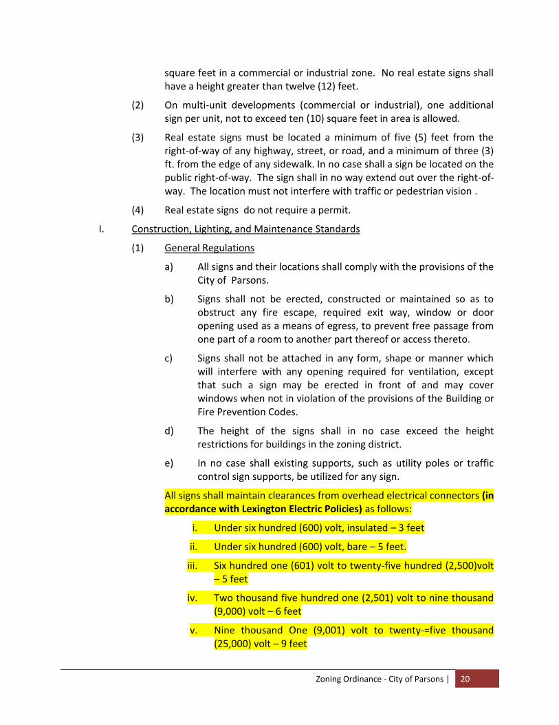
All signs shall maintain clearances from overhead electrical connectors (in accordance with Lexington Electric Policies) as follows:
i. Under six hundred (600) volt, insulated – 3 feet
ii. Under six hundred (600) volt, bare – 5 feet.
iii. Six hundred one (601) volt to twenty-five hundred (2,500)volt – 5 feet
iv. Two thousand five hundred one (2,501) volt to nine thousand (9,000) volt – 6 feet
v. Nine thousand One (9,001) volt to twenty-=five thousand (25,000) volt – 9 feet

Zoning Ordinance - City of Parsons | 21
vi. Twenty-five thousand one (25,001) volt t seventy-five (75)KV – 10 feet
vii. Above seventy-five (75)kv – 12 feet
g. Signs shall be suspended by chains or other devices that will allow the sign to swing, due to wind action. Signs shall be anchored to prevent any lateral movement that could cause wear on supporting members or connections.
h. Supports and braces shall be an integral part of the sign design. Angle irons, channels, or wires used for supports or braces shall be hidden from public view to the extent technically feasible.
i. Freestanding signs shall be self-supporting structures and be permanently attached to sufficient foundations.
j. Attached business signs must derive their principle and total suppor6t from the building to which they are attached.
k. All signs shall be constructed to withstand wind loads of 30 pounds per square foot on the largest face of the sign and structure.
l. In no case shall the existing ground elevation by built up in order to have a taller sign.
m. Free hand, spray paint, stencils, and signs not conforming to excepted sign standards, as determined by the Planning Commission, will be allowed.
2. Electrical Standards
a. Electrical service to on premise, freestanding signs shall be concealed whenever possible.
b. Electrical signs shall be marked with input amperes at full load.
c. Each illuminated and/or electrical sign shall bare thereon a label or certification visible from the ground, from the Underwriter’s Laboratories., Inc. or any other approved independent electrical inspection agency qualified to make such certification or have written approval from the local Electrical Inspector.
d. No artificial light, of whatever type or nature used in conjunction with or the lighting of any sign, shall be constructed as to direct or reflect any artificial light onto any structure or to constitute a hazard to the safe and efficient operations of vehicles upon a street or highway.
e. Flashing or rotating lights, flashing signs, flashing or moving lights on signs, and reflective pennants are prohibited, except that signs that exhibit time, temperature, date or other similar information and
Zoning Ordinance - City of Parsons | 22
search lights permitted by the Building Inspector as an attention getting device are permitted.
f. In no case shall electrical wiring, extension cords, or any other means of power be laid on the ground or in parking areas.
3. Maintenance Standards
a. Every sign, including, but not limited to those signs for which permits are required, shall be maintained in a safe, presentable and good structural condition at all times, including replacement of defective parts (except when a weathered or natural surface is intended), repainting, cleaning and other acts required for the maintenance of such sign.
b. The ground area around any freestanding sign shall be kept free and clean of weeds, trash and other debris.
J Prohibited Signs
The following types of signs are prohibited in all zoning districts in Parsons.
1. Signs on public property, except for public signs in conjunction with city state and federal government uses and temporary signs upon permission by the public authority having jurisdiction.
2. Signs erected at the intersection of any streets or alleys in such a manner as to obstruct free and clear vision; or in any location where, by reason of the position, shape or color, it may interfere with, obstruct the view of or be confused with any authorized traffic signs, signal or device, or which makes use of the words, “STOP, LOOK, DRIVE-IN,” GO SLOW”, “CAUTION”, or similar wording or other symbols as to interfere with, mislead or confuse traffic., No signs shall be allowed between a height of two and one-half (2.5) feet and ten (10) feet on the front property line
3. Signs which blend with or can be confused with traffic signals.
4. Signs which contain reflective materials which present a hazard or danger to traffic or the general public.
5. Signs which are structurally unsound.
6. Signs which display thereon or advertises any obscene, indecent or immoral matter.
K Temporary Signs
No temporary sign shall be allowed except as set forth herein and which is affixed to a building, pole or other structure and located on the same property and allowed under the provisions of this Chapter. Temporary signs are allowed in all zoned districts as specified below. A sign permit is required for all
Zoning Ordinance - City of Parsons | 23
temporary signs except for vehicle signs, construction signs, posters, garage sale signs, and non-profit organization events signs.
1. Street Banners – It shall be unlawful for any person to have placed across or upon any public street, alley or place a banner, electrical or floral festoon, without first obtaining a permit. Such banner or electrical or floral festoon shall be in conjunction with an official, civic, or philanthropic, festival, or parade and shall be allowed for a period not to exceed thirty-five (35) days as determined by the Building Inspector. Street banners shall be removed within seven (7) days after the event being advertised has occurred.
2. Off-Building Advertising Banners – Shall be allowed, after obtaining a permit, for a period not to exceed fourteen (14) days per calendar quarter. They are subject to the building setback requirements of the zone in which they are located. They may be used only in Commercial and Industrial zones and may not exceed twenty-four (24) square feet in total area. On-building banners do not require a permit, however total signage on any face of a building must not exceed 25% of the total area of the building face.
3. Posters- Shall only be authorized in conjunction with an official, civic, or philanthropic event and shall be allowed only thirty-five (35) (35) days prior to and forty-eight (48) hours after the event.
4. Vehicular Signs – Any vehicle carrying or having a sign painted on it shall be considered a sign reflated under this chapter. Such signs shall be prohibited unless displayed on a vehicle in operable condition carrying all current valid licenses, tags or plates as requ9ired by all governmental authorities. This may include valid dealer licenses, tags or plates.
5. Construction – Construction signs shall be allowed in all districts during the actual period of construdt9on and shall be limited in size t sixty-four square feet and a height of twelve (12) feet. The sign announcement shall be limited to the project name, sponsor or funding agent, owner, general contractor and subcontractors, architect or engineer.
6. Signs not exceeding five (5) square feet in area noting garage sales provided it is an on-site sign. This sign shall be allowed to be erected no more than seven (7) days prior to and two (2) days after the event that it advertises.
7. Political and campaign signs on behalf of candidates for public office or measures on election ballots provided that said sign conforms to the following regulations.
Zoning Ordinance - City of Parsons | 24
a Said signs may be erected no earlier than ninety (90) days prior to said election and shall be removed within three(3) days flowing said election.
b No sign shall be located within or over the public right-of-way.
c The candidate or the candidate’s organization must obtain a general sign permit covering all of the candidate’s signs in Parsons. There will be no charge for this permit.
d Political signs in residential districts shall be limited to sixteen (16) square feet in area and shall be limited to thirty-two (32) square feet in all other districts.
L. Exemptions
The following signs shall be allowed in all zoning districts of the City of Parsons provided that the sign conforms to the regulations of this Chapter. A sign permit is not required to erect exempt signs described below.
Signs not more than two 92 square feet which identify street numbers, owner names, occupant name, and professional names, as allowed herein.
1. Official National, State or Municipal flags properly displayed.
2. Signs, identifying merchandise, or manufacturer, offering sale if on a dispensing or vending machine, or on windows.
3. Signs wholly within buildings or on windows.
4. Public signs that are signs erected by, or on the order of a public officer in the performance of his public duty, such as safety signs, danger, signs legal notices and such temporary, emergency or non-advertising signs as may be approved by the Building Inspector.,
5. Historical markers as required by local, State, or Federal authorities.
6. Signs of a primary decorative nature,. Clearly, incidental and customary and commonly associated with any national, local or religious holiday.
7. No trespassing or no dumping signs.
8. Memorial signs or tablets, names of buildings and date of erection when cut in any masonry surface or when constructed on bond or noncombustible material.
9. Public signs, or signs specifically authorized for public purposes by any law, statue or chapter; which may be of any type, number, area, height above grade, location, illumination or animation, required by law, statue or chapter under which the signs are erected. Also exempted are signs on public property erected by order of the Mayor and Board of Aldermen, which shall be allowed subject to all appropriate sight,

Zoning Ordinance - City of Parsons | 25
distance, and safety considerations being met, as determined by the Mayor and Board of Aldermen.
10. Warning signs warning the pubic of the existence of danger, containing no advertising material, of a size as may be necessary to be removed upon the subsidence of danger.
11. Private property directional signs such as “no parking”, “exit”, “parking”, etc., not to exceed fie (5) square feet.
12. Non-electrical free standing business and non-electrical attached business signs will not require permits if they do not exceed thirty0two (32) square feet.
M. Illegal, Nonconforming, and Unused Signs
1. Illegal Signs
a. Definition: An illegal sign is any sign erected or altered after the effective date of this Chapter not complying with the provisions thereof unless said provision was expressly waived or granted a variance.
b. Disposition: Any illegal sign shall be removed from the premises upon which it is located within thirty (30) days from the effective date of this Chapter or notice of violation and shall not remain on the premises or elsewhere in the City until a sign permit is issued.
2. Nonconforming Signs – Any sign that has been erected, constructed or placed in its location and that is being used as of the effective date of this Chapter, shall be conclusively presumed to have been so erected, constructed or placed and used in compliance with the codes and chapters of the City of Parsons pertaining to signs that were in effect immediately prior to such date.
a. Any sign that is non-conforming because it fails to comply with the provisions of this Chapter may not be repaired, restored or reconstructed, provided that such work alters structurally, extends, or enlarges, in whole or in part, unless such sign as to altered, extended or enlarged shall conform with the provisions of this Chapter and a proper permit is obtained.
b. No owner, user, or other person shall alter any non-conforming sign (including alterations in the colors, letters, words, numbers, objects or symbols appearing thereon, excluding message boards), unless such sign as so altered shall conform to the provisions of this chapter,/ The violation of any one or more of the flowing regulations shall constitute a forfeiture of the right to continue to use and maintain a non-conforming sign. Consequently, this sign will now be defined as an illegal sign.
Zoning Ordinance - City of Parsons | 26
(1) A non-conforming sign shall not be replaced with another non-conforming sign.
(2) A non-conforming sign shall not have any changes in the words, logo or symbols that are a part of a message unless the sign if a freestanding message board, mom-portable.
(3) A non-confirming sign shall not be structurally altered so as to prolong the life of the sign, to be increased in size or shape, or type, or design.
(4) A non-conforming sign shall not be re-established after damage or destruction if the estimated expense of reconstruction exceeds 50% of the value of the original structure
(5) A non-conforming sign shall not be re-established after the activity or name of the business or ownership shall be changed requiring a change in the sign name or advertisement itself.
c. All signs which are nonconforming because of the use of flashing, blinking, intermittent or exposed lighting (except neon); signs which constitute a traffic hazard, block or restrict the visibility of motorists or pedestrians; otherwise constitute an immediate hazard to the general health, safety and welfare of the public of the City, shall be brought into conformity within ten (10) days of the effective date of this Chapter. If such signs are not removed within the aforementioned ten (10) day period, written notification of the obligation to remove such signs shall be furnished by the Building Inspector and deliverer to the sign owner/user/property owner by certified mail and the owner/user/property owner shall thereafter be required to remove said sign from the premises within five (5) days of the receipt of notification from the Building Inspector. Failure to remove such signs within the time periods herein provided shall constitute a violation of this Ordinance.
d. Disposition: It shall be the duty of the sign owner/user and property owner to remove any nonconforming sign in accordance with the requirements of this Section.
e. A request for a variance or interpretation of this chapter, as it pertains to the mom-conformity, and which is filed within thirty 930) days of the effective date of this chapter, shall stay further administrative actions pertaining to said sign until such time as the variance or request for interpretation is acted upon.
Zoning Ordinance - City of Parsons | 27
3. Unused (Abandoned) Signs
a. Definition: An unused or abandoned sign is a sign that meets any of the following criteria:
(1) A sign that identified an establishment or goods or services that are no longer provided on the premises where the sign is located.
(2) A sign that identifies a time, event or purpose which has passed or no longer applies.
(3) This also applies to sign structures with or without a sign.
b. Disposition:
(1) Any sign which is defined under paragraph C.(1)(a) of this subsection, and which condition exists for a period of one month, and which sign is otherwise nonconforming, shall be removed by the owner/user/property owner within five (5) days of the end of the one month (thirty (30) day) period.
(2) Any sign which is defined under subparagraph C.(1)(a) of this subsection which remains in such condition for a period of one month, and which sign is otherwise conforming shall have its copy vacated within thirty (30) days from when the stated circumstances commenced. If the copy remains vacant for a period of six (6) months or more from the date the stated circumstances commenced, the sign structure shall be removed by the owner/user/property owner. Removal shall be within five 95) days following the expiration of the aforementioned six (6) month period.
(3) Any sign defined under subparagraph C(1)(b) of this subsection shall be removed by the owner/user /property owner within three (3) days from the time the event or purpose has passed or no longe4r applies.
(4) Removal:
Any illegal, nonconforming or unused sign which is not removed from the premises by the owner/user/property owner within the time frames prescribed herein shall be considered a violation of the provisions of this Ordinance and shall be subject to the maximum penalties allowed by law. Each day such violation shall continue shall constitute a separate offense.
Zoning Ordinance - City of Parsons | 28
Failure to Remove: A failure to remove any illegal, nonconforming or unusual sign and subsequent failure by the Building Inspector to duly notify the owner/user/property owner of the provisions of this Section shall not be deemed to constitute a waiver of any violations of this Ordinance, nor shall such inaction be deemed to constitute a determination that any such sign is legal, in conformity with this Ordinance or to be given any special status. If, through administrative neglect or inaction, any owner/user/ property owner is not notified of the requirements of this Ordinance within the time frames herein set forth, but is later so notified, said owner/user/property owner shall take action to either correct the illegality, nonconformity or nonuse or shall cause the sign to be removed within twenty (20) days of such notification.
N. Appeals to the Board of Zoning Appeals
1. Right to Appeal
Except for instances relating to signs located or proposed to be located on public property,. Which is within the jurisdiction of the City Board, any person who has been ordered by the Building Inspector for the removal of any sign, or any person whose application for a permit for a sign has been refused, may appeal to the Board of Zoning Appeals by serving written notice to the Building Inspector. Such appeals to the Board of Zoning App4eals shall be on forms provided by the Building Inspector and upon filing of a notice of appeal, the Building Inspector shall take no further action with regard to the sign involved until the final decision of the Board of Zoning Appeals has been rendered, unless the Building Inspector finds by reason of condition, location or nature of the sign involved presents an immediate and serious danger to the public, in which case he shall proceed immediately as provided herein.
2. Variances. The Board of Zoning Appeals may grant variances concerning the height and setback of signs, the period for removal of nonconforming signs, the maximum sign area, the maximum number of signs, the removal of prohibited signs, and such others as provide for herein only if the following determinations have been made:
a The appeal falls within the jurisdiction of the Board. b. That all parties directly in interest have been notified of the
proceedings. c. That the granting of the appeal would not have the effect of
applying sign standards from a less restrictive zone.
Zoning Ordinance - City of Parsons | 29
d. That the property cannot be reasonably used in conformity with the provisions of this Ordinance.
e. That the difficulty complained of is unique to the property in question and is not common to all properties similarly situated.
O. Permits
In accordance with this Ordinance, no sign shall be erected, altered, or relocated without a building permit acquired subject to the following:
1. The permit application shall contain the location of the sign structure, the name and address of the sign owner and sign erection, a drawing showing the design, location, materials and colors of the sign.
2. Required electrical permits shall be obtained prior to submission for a building permit.
3. Fees for permanent signs shall be in accordance with the normal rate schedule for the Standard Building Code as adopted with a minimum fee of $15.00. Fees for temporary signs shall be the minimum permit fee.
4. A building permit for a sign shall become null and void if the sign has not been completed within six (6) months of the date of the permit or the sign varies in any respect from the approved design and location.
5. Normal sign maintenance to prolong the life of the sign shall not require a permit.
6. Permits issued to non-profit organizations will not be charged a fee.
Section P. Design Review Guidelinesv
1. Intent – Design Review Standards are needed to encourage and protect the investment of individual property owners when their property is redeveloped and improved. Accordingly, any new building or redevelopment of an existing property in the district shall be designed and constructed to be architecturally compatible in materials, scale and massing. Such standards are not intended to create a monolithic architectural appearance in these districts, but to encourage creative and attractive building elements and finishes.
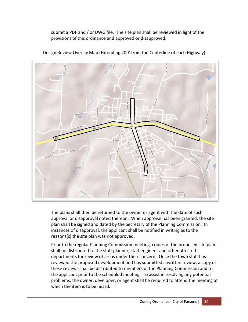
2. The DRC Overlay District is described as Town of Parsons’ territory two hundred (200) feet either side of the centerlines of Highways 412 / 20 and 69 / 641 between four specific points. The four specific points are: the westernmost point being the municipal boundary on Hwy 412, the easternmost point being the municipal boundary on Hwy 412, the southernmost point being the intersection of Hwy 69 and Holly Street and the northernmost point being the intersection of Hwy 69 and Earl Jordan Lane. Map on next page illustrates an approximate illustration of the effective area)
3. Guidelines - The following guidelines are meant to provide for suitable and harmonious development within the DRC Overlay District only.
a. Plan Content – The owner or developer shall submit four (4) paper copies of the proposed site plan to the Building Inspector fifteen (15) days prior to the regular meeting date of the Planning Commission. The developer is encouraged to also
Zoning Ordinance - City of Parsons | 30
submit a PDF and / or DWG file. The site plan shall be reviewed in light of the provisions of this ordinance and approved or disapproved.
Design Review Overlay Map (Extending 200’ from the Centerline of each Highway)
The plans shall then be returned to the owner or agent with the date of such approval or disapproval noted thereon. When approval has been granted, the site plan shall be signed and dated by the Secretary of the Planning Commission. In instances of disapproval, the applicant shall be notified in writing as to the reasons(s) the site plan was not approved.
Prior to the regular Planning Commission meeting, copies of the proposed site plan shall be distributed to the staff planner, staff engineer and other affected departments for review of areas under their concern. Once the town staff has reviewed the proposed development and has submitted a written review, a copy of these reviews shall be distributed to members of the Planning Commission and to the applicant prior to the scheduled meeting. To assist in resolving any potential problems, the owner, developer, or agent shall be required to attend the meeting at which the item is to be heard.

Zoning Ordinance - City of Parsons | 31
In instances where site plan review is required by either the Building Inspector, the planning staff, the Design Review Commission (Planning Commission) or the Mayor and Board of Alderman, the site plan shall be drawn to a scale of not less than 1" = 50' and shall include:
Name and address of development
Name and address of the applicant and owner of record
Present zoning of the site and abutting properties
Date, graphic scale, and north point with reference to source of meridian
Courses and distances of centers of all streets and all property lines, setback lines, property restricting lines, easements, covenants, reservations and rights-of -way
The total land area
A vicinity map showing the location of the property in relation to the Town of Parsons
Topography of the existing ground and paved areas and elevations in relation to mean sea level of streets, alleys, utilities, sanitary and storm sewers, and buildings and structures. Topography to be shown by dashed line illustrating two (2) foot contours and by spot elevation where necessary to indicate flat areas
Certification as to the following: Certificate of accuracy of the plan by a licensed architect or engineer; and, certificate of approval by the Parsons Municipal / Regional Planning Commission or the Parsons Municipal Board of Zoning Appeals, whichever is applicable to the type of use that is requested. (See Appendix A3 for examples of certificates.)
The location, dimensions, site and height of the following when existing:
Sidewalks, streets, alleys, easements and utilities;
Buildings and structures;
Public waste water systems;
Slopes, terraces and retaining walls;
Driveways, entrances, exits, parking areas and sidewalks;
Water mains and fire hydrants;
Trees and shrubs;
Recreational areas and swimming pools;
Natural and artificial water courses;
Limits of flood plains;
Building Elevations detailing exterior surface materials
The location, dimensions, site and height of the following when proposed:
Sidewalks, streets, alleys, easements and utilities;

Zoning Ordinance - City of Parsons | 32
Buildings and structures including the front (street) elevation of proposed buildings;
Public waste water systems;
Slopes and terraces, and retaining walls;
Driveways, entrances, exits, parking areas and sidewalks;
Water mains and fire hydrants;
Trees and shrubs;
Recreational areas; and,
Distances between buildings
Estimates of the following when applicable:
Number of dwelling units;
Number of parking spaces;
Number of loading spaces; and,
Number of commercial tenants and employees
Plans for collecting storm water and methods of treatment of natural and artificial watercourses including a delineation of limits or floodplains
Proposed grading, surface drainage terraces, retaining wall heights, grades on paving area, and ground floor elevations of proposed building and structures
Proposed topography of the site shall be shown by two (2) foot contours
In instances where the proposed construction is a multifamily residence, the site plan shall consist of the following:
All property lines and their surveyed distances and courses
All building restricting lines, setback lines, easements, covenants, reservations and rights-of-way
Total land area. Present zoning of site and abutting properties
Name, address of owner of record and applicant
Provisions for utilities (water, sewer, etc.)
Location and dimensions of the proposed structures
b. Expiration of Approval and Renewal - A site plan approved by the Design Review Commission or the Board of Mayor and Alderman shall lapse unless a building permit, based thereon, is issued within one (1) year from the date of such approval unless an extension of time is applied for and granted by the appropriate approving body.

Zoning Ordinance - City of Parsons | 33
c. Design Standards for Multi-Family, General Commercial, Neighborhood Commercial Districts
Applicable standards - Within the parameters set forth in the Intent, the following design standards shall apply in the development and redevelopment of property in the R-2, B-1 and B-2 districts:
Exterior materials and details - Quality materials which are durable and attractive should be used on all buildings.
All publicly visible sides of the building are recommended to have a minimum of 25% of the exterior façades (excluding windows, trim and doors) covered in brick, cast stone, cultured stone, or an alternative masonry material acceptable to the planning commission. Split faced block may be used in the true service areas in combination with the above materials if it is integrally colored, not stained or painted. Concrete panels, prefabricated metal panels, fluted concrete cinder block, cementitious sheathing materials and similar imitation masonry materials, and stucco finishes should be avoided as the main exterior material.
In R-2 Districts, it is recommended that multi-family have a minimum of 25% of the exterior façades (excluding windows, trim and doors) covered in brick, cast stone, cultured stone, or an alternative masonry material acceptable to the planning commission.
In B-1 and B-2 Districts, it is recommended that all publicly visible sides of the building should have a minimum of 25% of the exterior façades (excluding windows, trim and doors) covered in brick, cast stone, cultured stone, or an alternative masonry material acceptable to the planning commission.
Window/door openings – It is recommended that each floor facing a public street or park should have windows covering at least 15 % of the wall area. Buildings should have clearly defined and highly visible customer entrances, which should be recessed or framed by a sheltering element such as an overhang, arcade, portico or other roof form. Individual framed windows should be provided instead of continuous horizontal "ribbon or band" type windows. Reflective glass, glass curtain walls and other continuous, floor-to-ceiling windows should also be avoided on all floors. Windows shall have a minimum sill height of 18 inches off of finished floor. The patterns of window openings and details of bays should be used to create a sense of scale and add visual interest to building facades. Wall openings should not span vertically more than one story.
Awnings – It is recommended that the design of awnings, including the selection of material and color, should complement the architectural style and character of the building. Large buildings with multiple storefronts should have compatible, though not necessarily identical, awnings. Signage may be allowed on awnings so long as it meets design and signage standards of Article 3 of this ordinance and is approved by the planning commission. Signage on awnings shall count toward the total number of signs as well as the maximum sign area
Zoning Ordinance - City of Parsons | 34
allowed under Article 3 of this ordinance. Striping may be allowed on awnings, provided there are no more than two colors, which should be in keeping with the overall character of the district. Awnings may not be back lit. Awnings should be made of fabric or metal and may project up to three feet into the public right-of-way with the bottom of the canopy at least nine feet above the sidewalk. Awnings shall be kept in good repair.
Landscaping - The landscape of the City mirrors the predominant landscape of the surrounding region, with informal groupings of plants amidst green lawns. Landscape design should complement this image.
To provide a more immediate effect in commercial areas and offset the larger scale structures, the preferred street trees are 3 inch - 3 ½ inch caliper oak, planted no further apart than 50 feet on center.
Evergreen species are desirable for screening views, such as views into parking or service areas.
As an extension of the surrounding natural landscape, plant species should be native or well adapted to the region.
4. Appeals
All appeals shall be made to the Board of Mayor and Aldermen. In order to appeal, the owner or developer shall submit five (5) copies of the proposed site plan to the Building Inspector fifteen (15) days prior to the regular meeting date of the Mayor and Board of Alderman. The site plan shall be reviewed in light of the provisions of this ordinance and approved or disapproved. The plans shall then be returned to the owner or agent with the date of such approval or disapproval noted thereon. When approval has been granted, the site plan shall be signed and dated by the Town Mayor. In instances of disapproval, the applicant shall be notified in writing as to the reason(s) the site plan was disapproved.
Prior to the scheduled meeting, copies of the proposed site plan shall be distributed to the staff planner, staff engineer and other affected departments for review of areas under their concern. Once the town staff has reviewed the proposed development and has submitted a written review, a copy of these reviews shall be distributed to members of the Mayor and Board of Alderman and to the applicant prior to the scheduled meeting. To assist in resolving any potential problems, the owner, developer, or agent shall be required to attend the meeting at which the item is to be heard.
Zoning Ordinance - City of Parsons | 35
ARTICLE IV
ESTABLISHMENT OF DISTRICTS
SECTION
A. Classification of Districts. B. Boundaries of Districts C. Provisions Governing Signs
Section A. Classification of Districts For the purpose of this ordinance, Parsons, Tennessee, is hereby divided into five (5) districts, designated as follows:
R-1 Low Density Residential
R-2 Medium Density Residential
B-1 General Business
B-2 Central Business District
M-1 Industrial
Section B. Boundaries of Districts
1. The boundaries of districts in Section A of this Chapter are hereby established as shown on the Official Zoning Map entitled "Zoning Map of Parsons, Tennessee," which is a part of this ordinance and which is on file in the city hall.
2. Unless otherwise indicated on the zoning map, the boundaries are lot lines, the center lines of streets or alleys, railroad rights-of-way, or the corporate limit lines as they existed at the time of the enactment of this ordinance. Questions concerning the exact locations of district boundaries shall be determined by the Board of Zoning Appeals.
3. Where a district boundary divides a lot, as existing at the time this ordinance takes effect and the major portion of said lot is in the less restricted district, the regulations relative to that district may be extended to twenty (20) feet within the more restricted district within said lot.

Zoning Ordinance - City of Parsons | 36
~ B L A N K P A G E ~
Zoning Ordinance - City of Parsons | 37
ARTICLE V
PROVISIONS GOVERNING RESIDENTIAL DISTRICTS
SECTION
A. R-1 (Low Density Residential) Districts. B. R-2 (Medium Density Residential) Districts.
Section A. R-1 (Low Density Residential) Districts. Within the R-1 (Low Density Residential) Districts, as shown on the zoning map of Parsons, Tennessee, the following regulations shall apply:
1. Uses Permitted
(a) Single family and two family dwellings, excluding mobile homes on individual lotsvi
(b) Accessory buildings or uses customarily incidental to any aforementioned permitted use.
(c) Real estate signs advertising the sale, rental, or leasing of only the premises on which they are maintained, provided that they are not over four (4) square feet in area.
2. Uses Permissible on Appealvii
(a) Churches and other places of worship, parish houses, public libraries, schools offering general education courses, public parks and public recreational facilities, railroad right-of-way, as a matter of right, provided, however, that the provisions of this ordinance are observed and subject to approval of the site plans by the Board of Zoning Appeals. The board of Zoning Appeals may attach such conditions to permit as are necessary to minimize vehicle and pedestrian congestion and to preserve and protect the character of the district.
(b) The Board of Zoning Appeals may at its discretion permit county, state, or federal uses, public utilities facilities, cemeteries, philanthropic institutions and clubs, except a club the chief activity of which is customarily carried on as a business, general farming uses, gardens, and buildings incidental thereto, but not including commercial, animal or poultry farms or kennels; provided, however, that no permit shall be issued except with written approval of the Board of Zoning Appeals and subject to such conditions as the Board of Zoning Appeals may require in order to preserve and protect the character of the neighborhood in which the proposed use is located.
(c) Customary incidental home occupations provided that no building permit or certificate of occupancy for such use shall be issued without the written approval of the Board of Zoning Appeals and subject to such conditions as the Board of Zoning Appeals may require in order to protect and preserve the character of the
Zoning Ordinance - City of Parsons | 38
neighborhood in which the proposed use is located; and then provided further that:
(1) the proposed use shall be located and conducted in the principal building only;
(2) the principals and employees engaged in the proposed use shall be residents of the dwelling unit in which the proposed use is located;
(3) not more than fifteen (15) percent of the total floor area in dwelling unit shall be devoted to proposed use;
(4) proposed use shall not constitute primary or incidental storage facilities for a business, industrial, or agricultural activity conducted elsewhere;
(5) no activity, materials, goods, or equipment indicative of the proposed use shall be visible from any public way;
(6) the proposed use shall not be advertised by the display of goods or signs on the lot on which the proposed use is located;
(7) the proposed use shall not generate noise, odor, fumes, smoke, vehicular or pedestrian traffic, nor nuisance of any kind which would tend to depreciate the residential character of the neighborhood in which the proposed use is located; and
(8) the proposed use shall provide adequate off-street parking facilities;
(9) the following occupations, subject to the preceding requirements, shall be the only ones permitted as customary home occupations, provided a resident of the home is engaged in such occupations.
(I) Artist, sculptor, author
(II) Dressmaker, milliner, seamstress, tailor
(III) Beauty and barber shops, limited to two (2) operators, one of whom may be a non-resident of the home.
(IV) Day care, provided compliance with all State and Federal laws governing day care.
(V) Foster care, provided compliance with all State and federal laws governing foster care.
(VI) Teaching, including tutoring, musical instruction or dancing, but limited to two (2) pupils present for instruction at one time.
(VII) Rooming and boarding houses limited to three (3) non-family roomers or boarders.
(VIII) Other uses similar in nature, which will not be a detriment to the neighborhood or adjacent structures, as determined by the Board of Zoning Appeals.
Zoning Ordinance - City of Parsons | 39
(10) Nothing in this section shall be interpreted to mean the discontinuance of an existing lawful home occupation, but henceforth all new home occupations, and those existing home occupations allowed to lapse for one (1) year or more shall be governed by the foregoing provisions relative to home occupations.
(d) Bed and Breakfast Homestaysviii provided they meet the following criteria:
(1) The Bed and Breakfast Homestay must be located on a route designated as either an existing or proposed arterial or collector status street on the official Major Road Plan for the City of Parsons.
(2) The principals and employees engaged in the operation shall be residents of the dwelling unit in which the operation is located, provided that non-resident temporary cleaning services may be engaged for the operation.
(3) No more than three sleeping rooms shall be used for occupancy by paying guests. Residents shall establish sleeping quarters separate and distinct from those provided for guests.
(4) All applicable Federal, State, and municipal Codes, including municipal fire, building, and electrical codes shall be complied with as a condition of approval by the Board of Zoning Appeals.
(5) The outside appearance of the dwelling unit shall maintain conformance with the general character of the neighborhood in which it is located.
(6) A minimum of one on-site parking space shall be provided in addition to any parking required for the principal residents.
(7) One sign, no more than three square feet in area and no higher than six feet above ground level with no illumination shall be permitted to identify the bed and breakfast establishment.
(8) An accurately drawn site plan shall be presented to the Board of Zoning Appeals at least fifteen (15) days prior to the meeting. The site plan shall show the location of the principal building, off street parking, relationship to adjoining properties and surrounding land use, existing zoning of the proposed site, any required screening, and other information as required
(9) Any conditions established by the Board of Zoning Appeals as necessary to protect the surrounding neighborhood shall be the responsibility of the proprietors of the bed and breakfast establishment.
(e) Homes for the Aged, including but not limited to Nursing Homes, Assisted Living and Retirement Homes, provided that they meet the following:ix
(1) The Minimum Lot Area is not less than eight (8) acres.
(2) The Front Yard Setback is at least fifty (50) feet.

Zoning Ordinance - City of Parsons | 40
(3) Elevations of the building are suitable for the surrounding built environment.
The Board of Zoning Appeals may impose additional conditions based on the location and topography of the site.
3. Uses Prohibited
(a) Any other use of structure not specifically permitted or permissible on appeal in this Chapter. This shall include mobile homes on individual lots, mobile home parks, advertising signs or billboards, except as specifically permitted by this provision.
4. Location of Buildings
(a) No accessory building shall be erected in any required front or side yard. Accessory building shall not cover more than thirty (30) percent of any required rear yard, and shall be at least five (5) feet from all lot lines and from any other building on the same lot.
(b) Accessory buildings on corner lots shall conform to front yard setbacks for both intersecting streets.
5. Regulations Controlling Lot Area, Lot Width, Yards, Building Height The principal building shall be located so as to comply with the following requirements:
(a) Minimum required lot area
(1) Single Family 10,000 sq. ft.
(2) Two family 17,500 sq. ft.
(3) Churches One (1) acre or 200 square feet of lot area per auditorium seat, whichever is greater
(4) Schools Four (4) acres plus one (1) acre for each 100 students
(5) Other Uses As required by the Board of Zoning Appeals
(b) Minimum required lot width at the building line
(1) Dwellings 75 feet
(2) Churches 200 feet
(3) Other Uses As required by the Board of Zoning Appeal
(c) Minimum required front yard
(1) Dwellings 30 feet
(2) Churches 40 feet
(3) Other Uses 40 feet or more as required by the Board of the Zoning Appeals
Zoning Ordinance - City of Parsons | 41
(d) Minimum required rear yard
(1) Dwellings 30 feet
(2) Churches 30 feet
(3) Other Uses 30 feet or more as required by the Board of Zoning Appeals
(4) Rear Yard on Corner Lot 25 feet
(e) Minimum required side yard on each side of lot
(1) Dwellings -One & Two Story 15 feet
Three Story 20 feet
(2) Churches 30 feet
(3) Other Uses 15 feet or more as required by the Board of Zoning Appeals
(f) Minimum required side yard for side facing street on corner lots - 30 feet
(g) Maximum lot coverage by all buildings
(1) Dwelling and accessory 30%
(2) Churches 25%
(3) Other Uses 50% or less as required by the Board of Zoning Appeals
(h) Maximum permitted height of structures
(1) No building shall exceed three (3) stories or thirty-five (35) feet in height.
(2) On a lot less than fifty (50) feet in width at the building line no building shall exceed one and one-half (1 1/2) stories or twenty-five (25) feet in height.
(3) No accessory building shall exceed two (2) stories in height.
(4) Free standing poles, spires, towers, antennae and similar structures not designed for, or suitable to human occupancy may exceed the height provisions of this ordinance provided they comply with all other codes and ordinances and provided that they are located a distance equal to their own height plus ten (10) feet from the nearest property lines, unless adjoining property owners sign a written waiver.

Zoning Ordinance - City of Parsons | 42
~ B L A N K P A G E ~
Zoning Ordinance - City of Parsons | 43
Section B. R-2 (Medium Density Residential) Districts. Within the R-2 (Medium Density Residential) Districts as shown on the Zoning Map of Parsons, Tennessee, the following regulations shall apply:
1. Uses Permitted
(a) Single family and two family dwellings, and mobile homes on individual lots.
(b) Townhouses and multiple family dwellings or apartments, provided however, that the Building Inspector shall not issue a permit for any dwelling containing three (3) or more units until a site plan has been submitted to and approved by the Parson Planning Commission. The site plan shall show the location, height, and bulk of all proposed buildings, pedestrian and vehicular circulation, off-street parking, walls, hedges, fences and the proposed system for storm drainage. The proposed building shall meet all minimum lot and yard requirements of this section. In addition, the planning commission shall have the power to impose greater requirements than those set forth in this section or to impose conditions on the location and design of access points or other features as may be required to protect the neighborhood from traffic congestion or other similar features not directly related to the public health, safety and welfare. The planning commission and city board shall state in writing the reasons for denial of any properly submitted site plan. Any site plan not acted upon within sixty (60) days from submittal shall be deemed approved.
(c) Mobile Home Park, provided however, that a site plan has been submitted to and approved by the Parsons Planning Commission, and further provided that the park is developed in conformance with the following minimum requirements and provisions:
1. The site shall contain a minimum of two (2) acres.
2. The site plan drawn to a scale of 1" = 100' shall include:
a. Area and dimensions of the tract of land to be used for a mobile home park;
b. Number, location and size of all mobile home and trailer spaces;
c. Location and width of roadways, walkways, and easements;
d. Location of all existing or proposed buildings and other structures, screening and existing or proposed utilities;
e. Topography and drainage and grading plan for the site.
3. Mobile homes shall not be used for commercial, industrial, or other non-residential uses within the mobile home park.
4. Access roads within a mobile home park shall be to a width of not less than eighteen (18) feet. Where access roads are to a width of twenty eight (28) feet or more, the required guest parking area shall be waived.
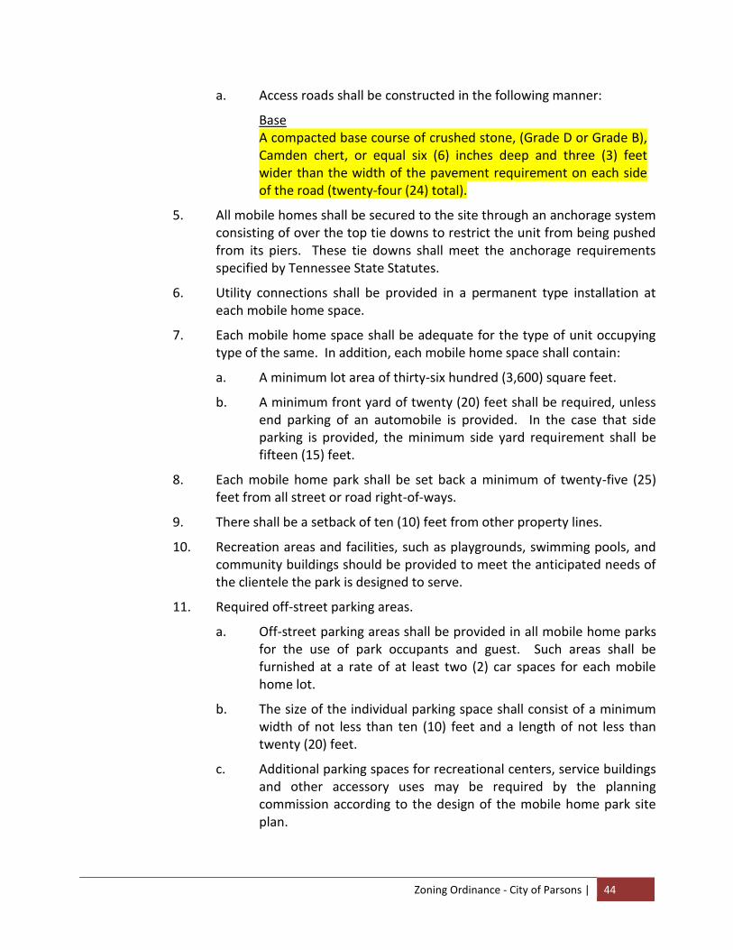
Zoning Ordinance - City of Parsons | 44
a. Access roads shall be constructed in the following manner:
Base A compacted base course of crushed stone, (Grade D or Grade B), Camden chert, or equal six (6) inches deep and three (3) feet wider than the width of the pavement requirement on each side of the road (twenty-four (24) total).
5. All mobile homes shall be secured to the site through an anchorage system consisting of over the top tie downs to restrict the unit from being pushed from its piers. These tie downs shall meet the anchorage requirements specified by Tennessee State Statutes.
6. Utility connections shall be provided in a permanent type installation at each mobile home space.
7. Each mobile home space shall be adequate for the type of unit occupying type of the same. In addition, each mobile home space shall contain:
a. A minimum lot area of thirty-six hundred (3,600) square feet.
b. A minimum front yard of twenty (20) feet shall be required, unless end parking of an automobile is provided. In the case that side parking is provided, the minimum side yard requirement shall be fifteen (15) feet.
8. Each mobile home park shall be set back a minimum of twenty-five (25) feet from all street or road right-of-ways.
9. There shall be a setback of ten (10) feet from other property lines.
10. Recreation areas and facilities, such as playgrounds, swimming pools, and community buildings should be provided to meet the anticipated needs of the clientele the park is designed to serve.
11. Required off-street parking areas.
a. Off-street parking areas shall be provided in all mobile home parks for the use of park occupants and guest. Such areas shall be furnished at a rate of at least two (2) car spaces for each mobile home lot.
b. The size of the individual parking space shall consist of a minimum width of not less than ten (10) feet and a length of not less than twenty (20) feet.
c. Additional parking spaces for recreational centers, service buildings and other accessory uses may be required by the planning commission according to the design of the mobile home park site plan.
Zoning Ordinance - City of Parsons | 45
(d) Accessory buildings customarily incidental to any aforementioned permitted use.
(e) Real estate signs advertising the sale, rental or lease of only the premises on which they are maintained, provided they are not over four (4) square feet in area.
2. Uses Permissible on Appealx
(a) Churches and other places of worship, parish houses, public libraries, schools offering general education courses, public parks and public recreational facilities, and railroad right-of-way shall be permitted as a matter of right, provided, however, that the provisions of this ordinance are observed and subject to approval of the site plans by the Board of Zoning Appeals. The Board of Zoning Appeals may attach such conditions to the permit as are necessary to minimize vehicle and pedestrian congestion and to preserve and protect the character of the district in which the proposed use is located. This power shall include: the power to require greater setbacks and yard spaces than required by other provisions of this ordinance, the power to specify access points and driveway and parking locations, and similar site design matters. This power shall not include the power to specify or alter the style of proposed buildings, the power to specify building materials or colors, or other similar powers.
(b) The Board of Zoning Appeals may at its discretion permit county, state, or federal uses, public utilities facilities, cemeteries, kindergartens, philanthropic institutions and clubs, except a club the chief activity of which is customarily general farming uses, gardens, and buildings incidental thereto, but not including commercial animal or poultry farms or kennels; provided, however, that no permit shall be issued except with the written approval of the Board of Zoning Appeals and subject to such conditions as the Board of Zoning Appeals may require in order to preserve and protect the character of the neighborhood in which the proposed use is located.
(c) Customary incidental home occupation provided that no building or certificate of occupancy for such use shall be issued without the written approval of the Board of Zoning Appeals and subject to such conditions as the Board of Zoning Appeals may require in order to protect and preserve the character of the neighborhood in which the proposed use is located; and then provided further that:
(1) the proposed use shall be located and conducted in the principal building only;
(2) not more than fifteen (15) percent of the total floor area in dwelling unit shall be devoted to proposed use;
(3) the principals and employees engaged in proposed use shall be residents of the dwelling unit in which the proposed use is located;
Zoning Ordinance - City of Parsons | 46
(4) proposed use shall not constitute primary or incidental storage facilities for a business, industrial, or agricultural activity conducted elsewhere;
(5) no activity, materials, goods, or equipment indicative of the proposed use shall be visible from any public way;
(6) the proposed use shall not be advertised by the display of goods or signs on the lot on which the proposed use is located;
(7) the proposed use shall not generate noise, odor, fumes, smoke, vehicles or pedestrian traffic, nor nuisance of any kind which would tend to depreciate the residential character of the neighborhood in which the proposed use is located;
(8) the proposed use shall provide adequate off-street parking facilities;
(9) the following occupations, subject to the preceding requirements, shall be the only ones permitted as customary home occupations provided a resident of the home is engaged in such occupations:
(I) Artist, sculptor, author;
(II) Dressmaker, milliner, seamstress, tailor;
(III) Beauty and barber shops, limited to two (2) operators, one of whom may be a non-resident of the home;
(IV) Day care, provided, compliance with all State and Federal laws governing day care;
(V) Foster care, provided compliance with all State and Federal laws governing day care;
(VI) Teaching, including tutoring, musical instruction or dancing, but limited to two (2) pupils present for instruction at any one time;
(VII) Rooming and boarding houses limited to three (3) non-family roomers or boarders;
(VIII) Other uses similar in nature, which will not be a detriment to the neighborhood or adjacent structures, as determined by the Board of Zoning Appeals.
(10) Nothing in this section shall be interpreted to mean the discontinuance of an existing lawful home occupation, but henceforth all new home occupations, and those existing home occupations allowed to lapse for one (1) year or more shall be governed by the foregoing provisions relative to home occupations.
(d) Homes for the Aged, including but not limited to Nursing Homes, Assisted Living and Retirement Homes, provided that they meet the following:xi xii
(1) The Front Yard Setback is at least fifty (50) feet.
Zoning Ordinance - City of Parsons | 47
(2) Elevations of the building are suitable for the surrounding built environment.
The Board of Zoning Appeals may impose additional conditions based on the location and topography of the site.
3. Uses Prohibited
(a) Any other use or structure not specifically permitted or permissible on appeal in this Article. This shall include advertising signs, or billboards, except as specifically permitted by these provisions.
4. Location of Accessory Buildings
(a) No accessory building shall be erected in any required front or side yard. Accessory buildings shall not cover more than thirty (30) percent of any required rear yard, and shall be at least five (5) feet from all lot lines and from any other building on the same lot.
(b) Accessory buildings on corner lots shall conform to front yard setback for both intersecting streets.
5. Regulations Controlling Lot Area, Lot Width, Yards, Building Coverage and Building Height
(a) Minimum required lot area
(1) Single Family 7,500 sq. ft.
(2) Two Family 12,500 sq. ft.
(3) Multi-Family 5,500 sq. ft. for the first dwelling unit plus 2,500 sq. ft. for each additional dwelling unit.
(4) Townhouses 3,500 sq. ft. per unit
(5) Churches One (1) acre or 200 sq. ft. of lot area per auditorium seat, whichever is greater.
(6) Schools Four (4) acres plus one (1) acre for each 100 students.
(7) Mobile Home Park Minimum of two acres.
(8) Other Uses As required by the Board of Zoning Appeals.
(b) Minimum required lot width at the building line
(1) Dwellings and apartments 60 feet
(2) Townhouses None
(3) Churches 100 feet
(4) Other Uses As required by the Board of Zoning Appeals.
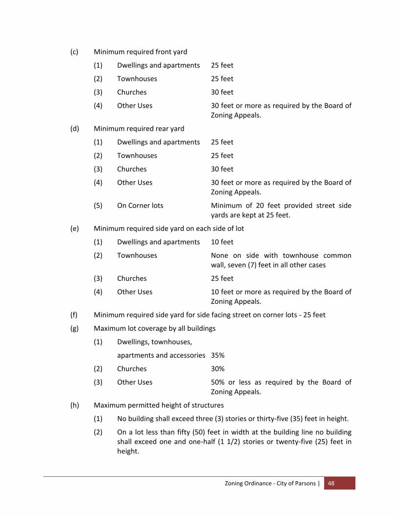
Zoning Ordinance - City of Parsons | 48
(c) Minimum required front yard
(1) Dwellings and apartments 25 feet
(2) Townhouses 25 feet
(3) Churches 30 feet
(4) Other Uses 30 feet or more as required by the Board of Zoning Appeals.
(d) Minimum required rear yard
(1) Dwellings and apartments 25 feet
(2) Townhouses 25 feet
(3) Churches 30 feet
(4) Other Uses 30 feet or more as required by the Board of Zoning Appeals.
(5) On Corner lots Minimum of 20 feet provided street side yards are kept at 25 feet.
(e) Minimum required side yard on each side of lot
(1) Dwellings and apartments 10 feet
(2) Townhouses None on side with townhouse common wall, seven (7) feet in all other cases
(3) Churches 25 feet
(4) Other Uses 10 feet or more as required by the Board of Zoning Appeals.
(f) Minimum required side yard for side facing street on corner lots - 25 feet
(g) Maximum lot coverage by all buildings
(1) Dwellings, townhouses,
apartments and accessories 35%
(2) Churches 30%
(3) Other Uses 50% or less as required by the Board of Zoning Appeals.
(h) Maximum permitted height of structures
(1) No building shall exceed three (3) stories or thirty-five (35) feet in height.
(2) On a lot less than fifty (50) feet in width at the building line no building shall exceed one and one-half (1 1/2) stories or twenty-five (25) feet in height.
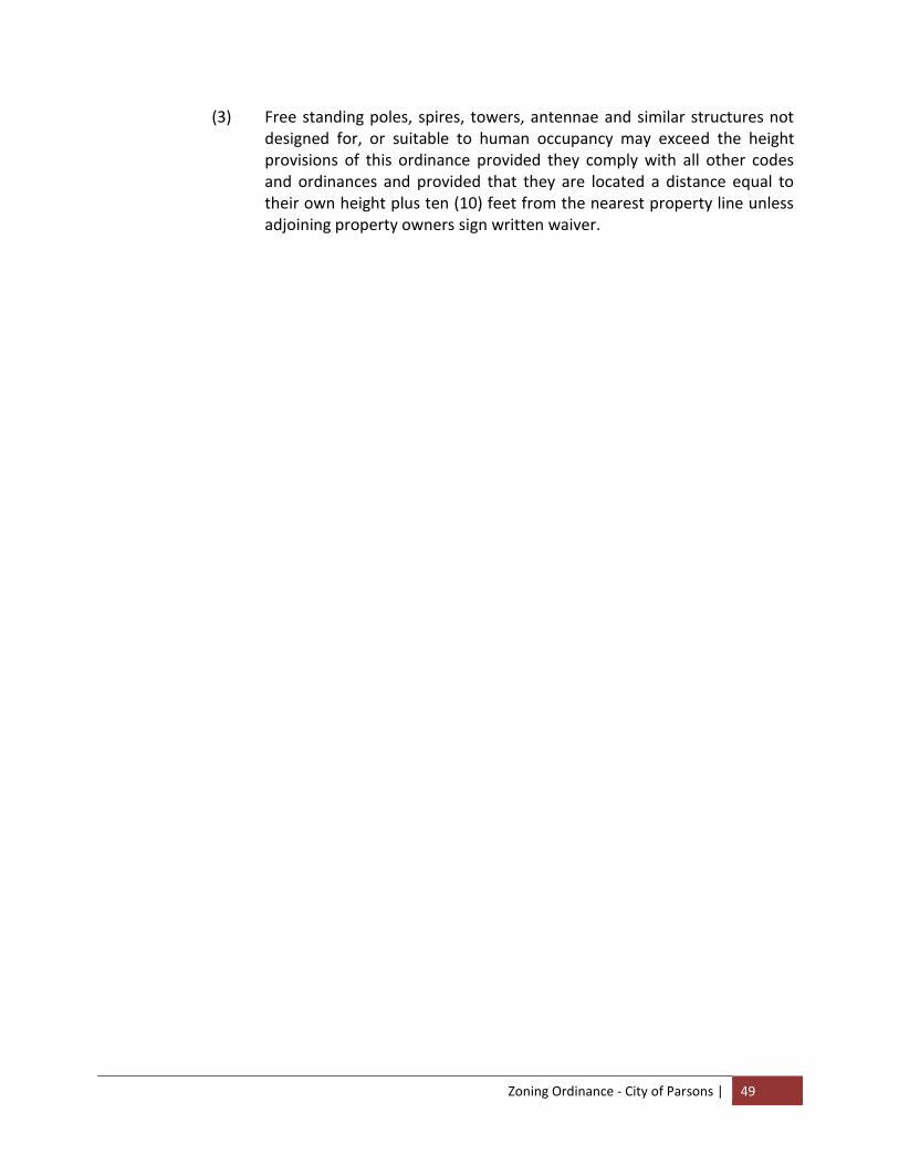
Zoning Ordinance - City of Parsons | 49
(3) Free standing poles, spires, towers, antennae and similar structures not designed for, or suitable to human occupancy may exceed the height provisions of this ordinance provided they comply with all other codes and ordinances and provided that they are located a distance equal to their own height plus ten (10) feet from the nearest property line unless adjoining property owners sign written waiver.

Zoning Ordinance - City of Parsons | 50
~ B L A N K P A G E ~
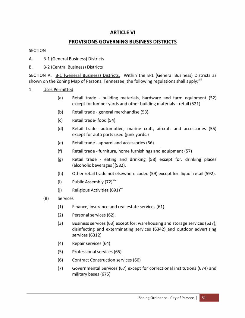
Zoning Ordinance - City of Parsons | 51
ARTICLE VI
PROVISIONS GOVERNING BUSINESS DISTRICTS
SECTION
A. B-1 (General Business) Districts
B. B-2 (Central Business) Districts
SECTION A. B-1 (General Business) Districts. Within the B-1 (General Business) Districts as shown on the Zoning Map of Parsons, Tennessee, the following regulations shall apply:xiii
1. Uses Permitted
(a) Retail trade - building materials, hardware and farm equipment (52) except for lumber yards and other building materials - retail (521)
(b) Retail trade - general merchandise (53).
(c) Retail trade- food (54).
(d) Retail trade- automotive, marine craft, aircraft and accessories (55) except for auto parts used (junk yards.)
(e) Retail trade - apparel and accessories (56).
(f) Retail trade - furniture, home furnishings and equipment (57)
(g) Retail trade - eating and drinking (58) except for. drinking places (alcoholic beverages )(582).
(h) Other retail trade not elsewhere coded (59) except for. liquor retail (592).
(i) Public Assembly (72)xiv
(j) Religious Activities (691)xv
(B) Services
(1) Finance, insurance and real estate services (61).
(2) Personal services (62).
(3) Business services (63) except for: warehousing and storage services (637), disinfecting and exterminating services (6342) and outdoor advertising services (6312)
(4) Repair services (64)
(5) Professional services (65)
(6) Contract Construction services (66)
(7) Governmental Services (67) except for correctional institutions (674) and military bases (675)
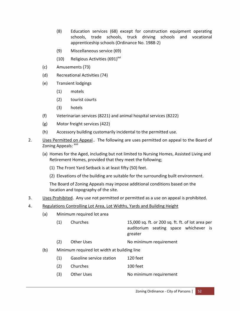
Zoning Ordinance - City of Parsons | 52
(8) Education services (68) except for construction equipment operating schools, trade schools, truck driving schools and vocational apprenticeship schools (Ordinance No. 1988-2)
(9) Miscellaneous service (69)
(10) Religious Activities (691)xvi
(c) Amusements (73)
(d) Recreational Activities (74)
(e) Transient lodgings
(1) motels
(2) tourist courts
(3) hotels
(f) Veterinarian services (8221) and animal hospital services (8222)
(g) Motor freight services (422)
(h) Accessory building customarily incidental to the permitted use.
2. Uses Permitted on Appeal.. The following are uses permitted on appeal to the Board of Zoning Appeals: xvii
(a) Homes for the Aged, including but not limited to Nursing Homes, Assisted Living and Retirement Homes, provided that they meet the following;
(1) The Front Yard Setback is at least fifty (50) feet.
(2) Elevations of the building are suitable for the surrounding built environment.
The Board of Zoning Appeals may impose additional conditions based on the location and topography of the site.
3. Uses Prohibited. Any use not permitted or permitted as a use on appeal is prohibited.
4. Regulations Controlling Lot Area, Lot Widths, Yards and Building Height
(a) Minimum required lot area
(1) Churches 15,000 sq. ft. or 200 sq. ft. ft. of lot area per auditorium seating space whichever is greater
(2) Other Uses No minimum requirement
(b) Minimum required lot width at building line
(1) Gasoline service station 120 feet
(2) Churches 100 feet
(3) Other Uses No minimum requirement
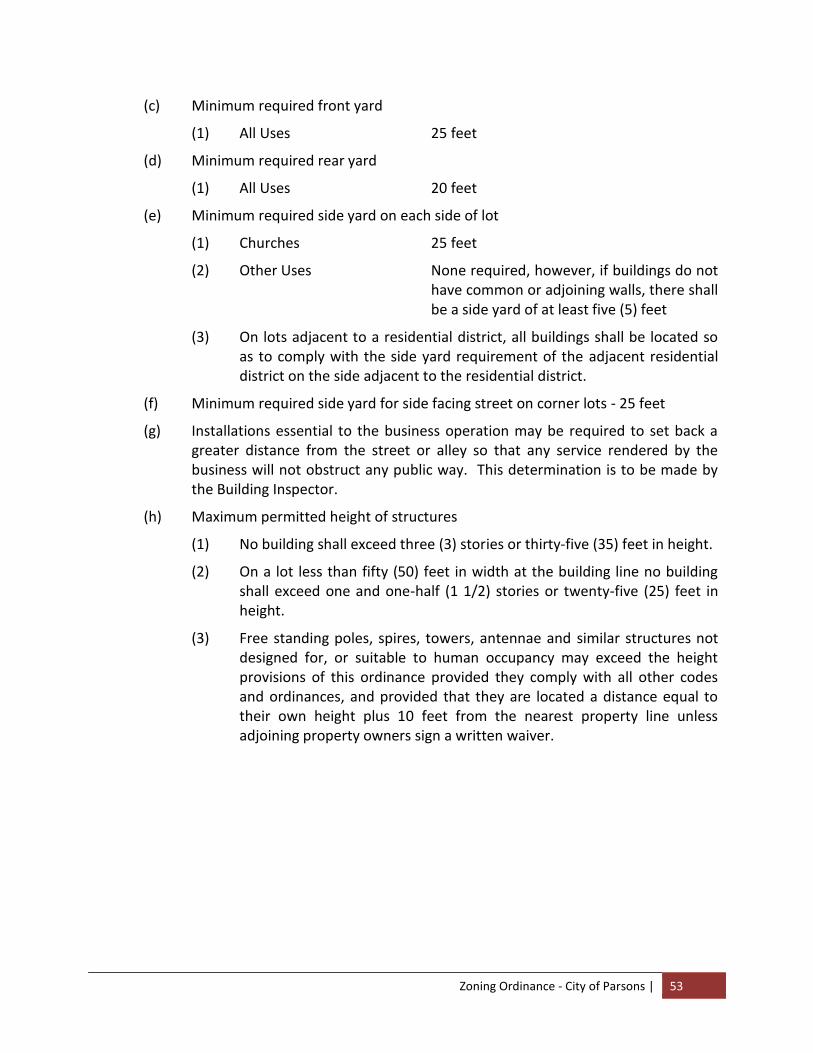
Zoning Ordinance - City of Parsons | 53
(c) Minimum required front yard
(1) All Uses 25 feet
(d) Minimum required rear yard
(1) All Uses 20 feet
(e) Minimum required side yard on each side of lot
(1) Churches 25 feet
(2) Other Uses None required, however, if buildings do not have common or adjoining walls, there shall be a side yard of at least five (5) feet
(3) On lots adjacent to a residential district, all buildings shall be located so as to comply with the side yard requirement of the adjacent residential district on the side adjacent to the residential district.
(f) Minimum required side yard for side facing street on corner lots - 25 feet
(g) Installations essential to the business operation may be required to set back a greater distance from the street or alley so that any service rendered by the business will not obstruct any public way. This determination is to be made by the Building Inspector.
(h) Maximum permitted height of structures
(1) No building shall exceed three (3) stories or thirty-five (35) feet in height.
(2) On a lot less than fifty (50) feet in width at the building line no building shall exceed one and one-half (1 1/2) stories or twenty-five (25) feet in height.
(3) Free standing poles, spires, towers, antennae and similar structures not designed for, or suitable to human occupancy may exceed the height provisions of this ordinance provided they comply with all other codes and ordinances, and provided that they are located a distance equal to their own height plus 10 feet from the nearest property line unless adjoining property owners sign a written waiver.

Zoning Ordinance - City of Parsons | 54
~ B L A N K P A G E ~
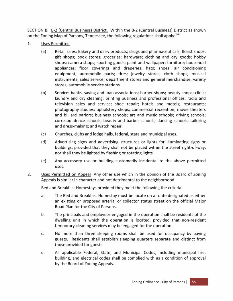
Zoning Ordinance - City of Parsons | 55
SECTION B. B-2 (Central Business) District. Within the B-2 (Central Business) District as shown on the Zoning Map of Parsons, Tennessee, the following regulations shall apply:xviii
1. Uses Permitted
(a) Retail sales: Bakery and dairy products; drugs and pharmaceuticals; florist shops; gift shops; book stores; groceries; hardware; clothing and dry goods; hobby shops; camera shops; sporting goods; paint and wallpaper; furniture; household appliances; floor coverings and draperies; hats; shoes; air conditioning equipment; automobile parts; tires; jewelry stores; cloth shops; musical instruments; sales service; department stores and general merchandise; variety stores; automobile service stations.
(b) Service: banks, saving and loan associations; barber shops; beauty shops; clinic; laundry and dry cleaning; printing business and professional offices; radio and television sales and service; shoe repair; hotels and motels; restaurants; photography studies; upholstery shops; commercial recreation; movie theaters and billiard parlors; business schools; art and music schools; driving schools; correspondence schools; beauty and barber schools; dancing schools; tailoring and dress-making; and watch repair.
(c) Churches, clubs and lodge halls, federal, state and municipal uses.
(d) Advertising signs and advertising structures or lights for illuminating signs or buildings, provided that they shall not be placed within the street right-of-way, nor shall they be lighted by flashing or rotating lights.
(e) Any accessory use or building customarily incidental to the above permitted uses.
2. Uses Permitted on Appeal Any other use which in the opinion of the Board of Zoning Appeals is similar in character and not detrimental to the neighborhood.
Bed and Breakfast Homestays provided they meet the following the criteria:
a. The Bed and Breakfast Homestay must be locate on a route designated as either an existing or proposed arterial or collector status street on the official Major Road Plan for the City of Parsons.
b. The principals and employees engaged in the operation shall be residents of the dwelling unit in which the operation is located, provided that non-resident temporary cleaning services may be engaged for the operation.
c. No more than three sleeping rooms shall be used for occupancy by paying guests. Residents shall establish sleeping quarters separate and distinct from those provided for guests.
d. All applicable Federal, State, and Municipal Codes, including municipal fire, building, and electrical codes shall be complied with as a condition of approval by the Board of Zoning Appeals.

Zoning Ordinance - City of Parsons | 56
e. The outside appearance of the dwelling unit shall maintain conformance with the general character of the neighborhood in which it is located.
f. A minimum of one on-site parking space shall be provided in addition to any parking required for the principal residents.
g. One sign, no more than three square feet in area and no higher than six feet above ground level with no illumination, shall be permitted to identify the bed and breakfast establishment.
h. An accurately drawn site plan shall be presented to the Board of Zoning Appeals at least fifteen (15) days prior to the meeting. The site plan shall show the location of the principal building, off street [along. Relationship to adjoining properties and surrounding land use, existing zoning of the proposed site, any required screening, and other information as required by the Parsons Board of Zoning Appeals.
i. Any conditions established by the Board of Zoning Appeals as necessary to protect the surrounding neighborhood shall be the responsibility of the proprietors of the bed and breakfast establishment.
3. Uses Prohibited Any use not specifically permitted or permissible on appeal in this Section.
4. Regulations Controlling Lot Area, Lot Widths, Yards and Building Height
(a) Minimum required lot area
(1) Churches 15,000 sq. ft. or 200 sq. ft. of lot area per auditorium seating space whichever is greater
(2) Other Uses No minimum requirements
(b) Minimum required lot width at the building line
(1) Gasoline service stations 120 feet
(2) Churches 100 feet
(3) Other Uses No minimum requirements
(c) Minimum required front yard
(1) Gasoline service stations 25 feet
(2) Churches 25 feet
(3) Other Uses No less than the minimum setback of other structures on the block in which it is located
(d) Minimum required rear yard
(1) Service Stations 20 feet
(2) Churches 20 feet

Zoning Ordinance - City of Parsons | 57
(3) Other Uses No less than the minimum setback of other structures on the block in which it is located
(e) Minimum required side yard on each side of lot
(1) Churches 25 feet
(2) Other Uses None required, however, if buildings do not have common or adjoining wall there shall be a side yard of at least five (5) feet
(3) On lots adjacent to a residential district, all buildings shall be located so as to comply with the side yard requirements of the adjacent residential district on the side adjacent to the residential district.
(f) Minimum required side yard for side facing street on corner lots - None required, unless side yard has frontage on street of residential uses, in which case a 25 foot side yard is required.
(g) Maximum permitted height of structures
(1) No building or structure shall exceed three (3) stories or thirty-five (35) feet in height.
(2) Free standing poles, spires, towers, antennae and similar structures not designed for, or suitable for human occupancy may exceed the height provisions of this ordinance provided they comply with all other codes and ordinances and provided that they are located a distance equal to their own height plus 10 feet from the nearest property line unless adjoining property owners sign a written waiver.

Zoning Ordinance - City of Parsons | 58
~ B L A N K P A G E ~

Zoning Ordinance - City of Parsons | 59
ARTICLE VII
PROVISIONS GOVERNING INDUSTRIAL DISTRICTS
SECTION
A. M-1 Industrial Districtsxix
Section A. M-1 Industrial Districts Within the M-1 Industrial Districts as shown on the Zoning Map of Parsons, Tennessee, the following regulations shall apply:
1. Uses Permitted
(a) Wholesale Trade including:
(1) Motor vehicles and automotive equipment wholesale except for auto parts used (auto junk yards)
(2) Drugs, chemicals and allied products -wholesale
(3) Dry goods and apparel -wholesale
(4) Groceries and related products-wholesale
(5) Farm products (raw materials) - wholesale except for livestock horses and mules wholesale
(6) Electrical goods-wholesale
(7) Machinery, equipment and supplies-wholesale
(8) Other wholesale trade, NEC*-Limited to:
a. Metals and minerals (Except petroleum products and scrap wholesale)
b. Tobacco and tobacco products - wholesale
c. Beer, wine and distilled alcoholic beverages - wholesale
d. Paper and paper products - wholesale
e. Furniture and home furnishings - wholesale
f. Lumber and construction materials (wholesale)
g. Other wholesale trade, NEC*
(b) Retail trade -limited to:
(1) Retail trade -eating and drinking
(2) Retail trade - building materials, hardware and farm equipment
(c) Business services - limited to:
(1) Dwelling and other building services
(2) Warehousing and storage services - excluding
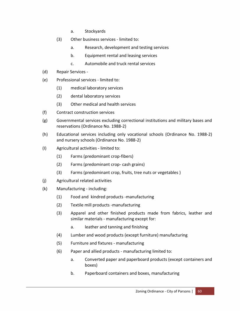
Zoning Ordinance - City of Parsons | 60
a. Stockyards
(3) Other business services - limited to:
a. Research, development and testing services
b. Equipment rental and leasing services
c. Automobile and truck rental services
(d) Repair Services -
(e) Professional services - limited to:
(1) medical laboratory services
(2) dental laboratory services
(3) Other medical and health services
(f) Contract construction services
(g) Governmental services excluding correctional institutions and military bases and reservations (Ordinance No. 1988-2)
(h) Educational services including only vocational schools (Ordinance No. 1988-2) and nursery schools (Ordinance No. 1988-2)
(I) Agricultural activities - limited to:
(1) Farms (predominant crop-fibers)
(2) Farms (predominant crop- cash grains)
(3) Farms (predominant crop, fruits, tree nuts or vegetables )
(j) Agricultural related activities
(k) Manufacturing - including:
(1) Food and kindred products -manufacturing
(2) Textile mill products -manufacturing
(3) Apparel and other finished products made from fabrics, leather and similar materials - manufacturing except for:
a. leather and tanning and finishing
(4) Lumber and wood products (except furniture) manufacturing
(5) Furniture and fixtures - manufacturing
(6) Paper and allied products - manufacturing limited to:
a. Converted paper and paperboard products (except containers and boxes)
b. Paperboard containers and boxes, manufacturing
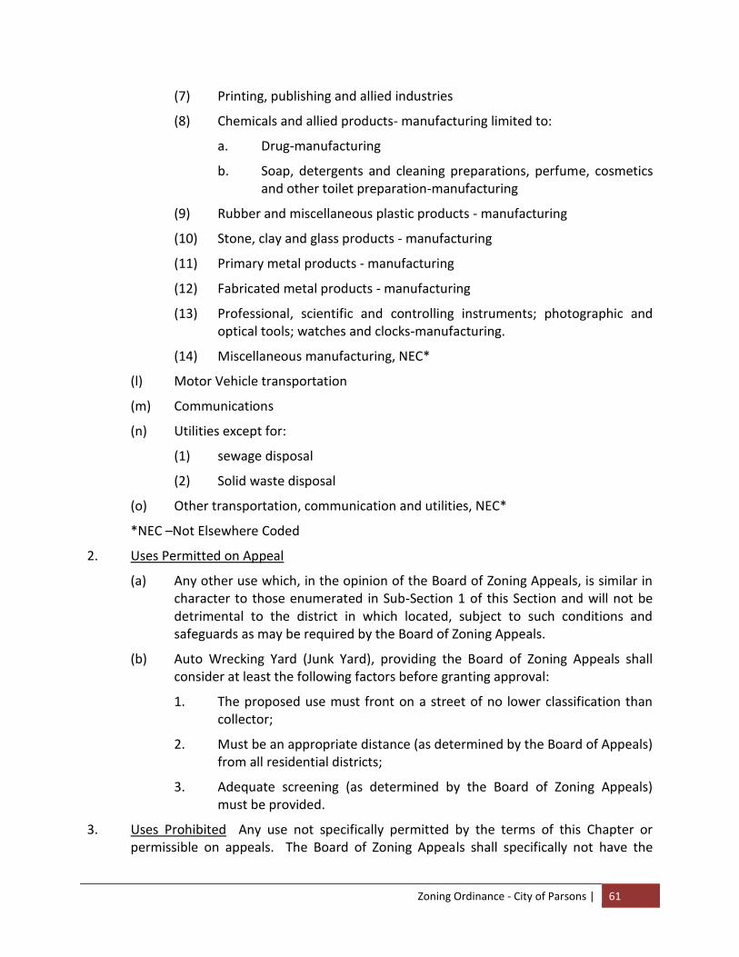
Zoning Ordinance - City of Parsons | 61
(7) Printing, publishing and allied industries
(8) Chemicals and allied products- manufacturing limited to:
a. Drug-manufacturing
b. Soap, detergents and cleaning preparations, perfume, cosmetics and other toilet preparation-manufacturing
(9) Rubber and miscellaneous plastic products - manufacturing
(10) Stone, clay and glass products - manufacturing
(11) Primary metal products - manufacturing
(12) Fabricated metal products - manufacturing
(13) Professional, scientific and controlling instruments; photographic and optical tools; watches and clocks-manufacturing.
(14) Miscellaneous manufacturing, NEC*
(l) Motor Vehicle transportation
(m) Communications
(n) Utilities except for:
(1) sewage disposal
(2) Solid waste disposal
(o) Other transportation, communication and utilities, NEC*
*NEC –Not Elsewhere Coded
2. Uses Permitted on Appeal
(a) Any other use which, in the opinion of the Board of Zoning Appeals, is similar in character to those enumerated in Sub-Section 1 of this Section and will not be detrimental to the district in which located, subject to such conditions and safeguards as may be required by the Board of Zoning Appeals.
(b) Auto Wrecking Yard (Junk Yard), providing the Board of Zoning Appeals shall consider at least the following factors before granting approval:
1. The proposed use must front on a street of no lower classification than collector;
2. Must be an appropriate distance (as determined by the Board of Appeals) from all residential districts;
3. Adequate screening (as determined by the Board of Zoning Appeals) must be provided.
3. Uses Prohibited Any use not specifically permitted by the terms of this Chapter or permissible on appeals. The Board of Zoning Appeals shall specifically not have the

Zoning Ordinance - City of Parsons | 62
authority to permit: single and multi-family dwellings; hotels and motels; bag cleaning; boiler and tank works; crematory; curing; tanning and storage of raw hides and skins; distillation of bones, coal, wood or scrap paper; rag storage or baling; sawmills; slaughter house or stockyards; smelting; and the manufacture of acetylene, acid, alcohol, ammonia, bleaching powder, chemicals, brick, pottery, terra cotta or tile, candles, disinfectants, dye stuffs, fertilizers, illuminating or heating gas (or storage of same), linseed oil, paint, screws and bolts, wire and tires, or any other use which would cause injurious or obnoxious noise, vibrations, smoke, gas, fumes, odors, dust or other objectionable conditions.
4. Regulations Controlling Yards and Building Height
a. Yard and Space Requirements:
(1) Minimum Lot Area None
(2) Minimum Depth of 50 feet front and corner side yards
(3) Minimum width of 20 feet except along boundaries other side yards abutting a railroad and rear yards for each building other than accessory buildings.
b. Building Requirements When Lot Adjacent to a Developed Residential District Where a lot in the industrial district faces a developed residential district in the rear or on the side of the principal building or use and wherever an industrial building or use, except required off-street parking space, is to be within one hundred (100) feet of the residential district, a wall or fence of solid appearance or a tight evergreen hedge shall be placed and maintained parallel to the common district boundary and such wall, fence or hedge shall extend for any portion adjacent to or facing the residential district required front yard or within twenty-five of the intersection of a driveway centerline and a street line.
c. Accessory Buildings and Use Within the Manufacturing and Industrial District, buildings and uses customarily accessory to the principal land use are permitted. Accessory buildings shall not be located in any required front, side or rear yard.
Accessory Buildings and Uses include but are not limited to:
(1) Garage for storage or repairs of appurtenant motor vehicles
(2) Offices pertaining to the industrial operations
(3) Employee restaurant and recreation facilities
Zoning Ordinance - City of Parsons | 63
d. Maximum permitted height of structures
(1) No building shall exceed three (3) stories or thirty-five (35) feet in height.
(2) Free standing poles, spires, towers, antennae and similar structures not designed for, or suitable to human occupancy may exceed the height provisions of this ordinance provided they comply with all other codes and ordinances, and provided that they are located a distance equal to their own height plus 10 feet from the nearest property line unless adjoining property owners sign a written waiver.

Zoning Ordinance - City of Parsons | 64
~ B L A N K P A G E ~

Zoning Ordinance - City of Parsons | 65
ARTICLE VIII
PROVISIONS GOVERNING FLOOD HAZARD AREAS xx
ARTICLE I. STATUTORY AUTHORIZATION, FINDINGS OF FACT, PURPOSE AND OBJECTIVES
Section A. Statutory Authorization
The Legislature of the State of Tennessee has in Sections 13-7-201 through 13-7-210, Tennessee Code Annotated delegated the responsibility to local governmental units to adopt regulations designed to promote the public health, safety, and general welfare of its citizenry. Therefore, the City of Parsons, Tennessee, Mayor and City Council, do ordain as follows:
Section B. Findings of Fact
1. The City of Parsons, Tennessee, Mayor and its Legislative Body wishes to maintain eligibility in the National Flood Insurance Program (NFIP) and in order to do so must meet the NFIP regulations found in Title 44 of the Code of Federal Regulations (CFR), Ch. 1, Section 60.3.
2. Areas of the City of Parsons, Tennessee are subject to periodic inundation which could result in loss of life and property, health and safety hazards, disruption of commerce and governmental services, extraordinary public expenditures for flood protection and relief, and impairment of the tax base, all of which adversely affect the public health, safety and general welfare.
3. Flood losses are caused by the cumulative effect of obstructions in floodplains, causing increases in flood heights and velocities; by uses in flood hazard areas which are vulnerable to floods; or construction which is inadequately elevated, floodproofed, or otherwise unprotected from flood damages.
Section C. Statement of Purpose
It is the purpose of this Ordinance to promote the public health, safety and general welfare and to minimize public and private losses due to flood conditions in specific areas. This Ordinance is designed to:
1. Restrict or prohibit uses which are vulnerable to flooding or erosion hazards, or which result in damaging increases in erosion, flood heights, or velocities;
2. Require that uses vulnerable to floods, including community facilities, be protected against flood damage at the time of initial construction;
3. Control the alteration of natural floodplains, stream channels, and natural protective barriers which are involved in the accommodation of floodwaters;
4. Control filling, grading, dredging and other development which may increase flood damage or erosion;
5. Prevent or regulate the construction of flood barriers which will unnaturally divert flood waters or which may increase flood hazards to other lands.
Zoning Ordinance - City of Parsons | 66
Section D. Objectives
The objectives of this Ordinance are:
1. To protect human life, health, safety and property;
2. To minimize expenditure of public funds for costly flood control projects;
3. To minimize the need for rescue and relief efforts associated with flooding and generally undertaken at the expense of the general public;
4. To minimize prolonged business interruptions;
5. To minimize damage to public facilities and utilities such as water and gas mains, electric, telephone and sewer lines, streets and bridges located in floodprone areas;
6. To help maintain a stable tax base by providing for the sound use and development of floodprone areas to minimize blight in flood areas;
7. To ensure that potential homebuyers are notified that property is in a floodprone area;
8. To maintain eligibility for participation in the NFIP.
ARTICLE II. DEFINITIONS
Unless specifically defined below, words or phrases used in this Ordinance shall be interpreted as to give them the meaning they have in common usage and to give this Ordinance its most reasonable application given its stated purpose and objectives.
"Accessory Structure" means a subordinate structure to the principal structure on the same lot and, for the purpose of this Ordinance, shall conform to the following:
1. Accessory structures shall only be used for parking of vehicles and storage.
2. Accessory structures shall be designed to have low flood damage potential.
3. Accessory structures shall be constructed and placed on the building site so as to offer the minimum resistance to the flow of floodwaters.
4. Accessory structures shall be firmly anchored to prevent flotation, collapse, and lateral movement, which otherwise may result in damage to other structures.
5. Utilities and service facilities such as electrical and heating equipment shall be elevated or otherwise protected from intrusion of floodwaters.
"Addition (to an existing building)" means any walled and roofed expansion to the perimeter or height of a building.
"Appeal" means a request for a review of the local enforcement officer’s interpretation of any provision of this Ordinance or a request for a variance.
"Area of Shallow Flooding" means a designated AO or AH Zone on a community's Flood Insurance Rate Map (FIRM) with one percent or greater annual chance of flooding to an average depth of one to three feet where a clearly defined channel does not exist, where the
Zoning Ordinance - City of Parsons | 67
path of flooding is unpredictable and indeterminate; and where velocity flow may be evident. Such flooding is characterized by ponding or sheet flow.
"Area of Special Flood-related Erosion Hazard" is the land within a community which is most likely to be subject to severe flood-related erosion losses. The area may be designated as Zone E on the Flood Hazard Boundary Map (FHBM). After the detailed evaluation of the special flood-related erosion hazard area in preparation for publication of the FIRM, Zone E may be further refined.
"Area of Special Flood Hazard" see “Special Flood Hazard Area”.
"Base Flood" means the flood having a one percent chance of being equaled or exceeded in any given year. This term is also referred to as the 100-year flood or the one (1)-percent annual chance flood.
"Basement" means any portion of a building having its floor subgrade (below ground level) on all sides.
"Building" see “Structure”.
"Development" means any man-made change to improved or unimproved real estate, including, but not limited to, buildings or other structures, mining, dredging, filling, grading, paving, excavating, drilling operations, or storage of equipment or materials.
"Elevated Building" means a non-basement building built to have the lowest floor of the lowest enclosed area elevated above the ground level by means of solid foundation perimeter walls with openings sufficient to facilitate the unimpeded movement of floodwater, pilings, columns, piers, or shear walls adequately anchored so as not to impair the structural integrity of the building during a base flood event.
"Emergency Flood Insurance Program" or "Emergency Program" means the program as implemented on an emergency basis in accordance with Section 1336 of the Act. It is intended as a program to provide a first layer amount of insurance on all insurable structures before the effective date of the initial FIRM.
"Erosion" means the process of the gradual wearing away of land masses. This peril is not “per se” covered under the Program.
"Exception” means a waiver from the provisions of this Ordinance which relieves the applicant from the requirements of a rule, regulation, order or other determination made or issued pursuant to this Ordinance.
"Existing Construction" means any structure for which the "start of construction" commenced before the effective date of the initial floodplain management code or ordinance adopted by the community as a basis for that community’s participation in the NFIP.
"Existing Manufactured Home Park or Subdivision" means a manufactured home park or subdivision for which the construction of facilities for servicing the lots on which the manufactured homes are to be affixed (including, at a minimum, the installation of utilities, the construction of streets, final site grading or the pouring of concrete pads) is completed before
Zoning Ordinance - City of Parsons | 68
the effective date of the first floodplain management code or ordinance adopted by the community as a basis for that community’s participation in the NFIP.
"Existing Structures" see "Existing Construction".
"Expansion to an Existing Manufactured Home Park or Subdivision" means the preparation of additional sites by the construction of facilities for servicing the lots on which the manufactured homes are to be affixed (including the installation of utilities, the construction of streets, and either final site grading or the pouring of concrete pads).
"Flood" or "Flooding" means a general and temporary condition of partial or complete inundation of normally dry land areas from:
1. The overflow of inland or tidal waters.
2. The unusual and rapid accumulation or runoff of surface waters from any source.
"Flood Elevation Determination" means a determination by the Federal Emergency Management Agency (FEMA) of the water surface elevations of the base flood, that is, the flood level that has a one percent or greater chance of occurrence in any given year.
"Flood Elevation Study” means an examination, evaluation and determination of flood hazards and, if appropriate, corresponding water surface elevations, or an examination, evaluation and determination of mudslide (i.e., mudflow) or flood-related erosion hazards.
"Flood Hazard Boundary Map (FHBM)" means an official map of a community, issued by FEMA, where the boundaries of areas of special flood hazard have been designated as Zone A.
"Flood Insurance Rate Map (FIRM)" means an official map of a community, issued by FEMA, delineating the areas of special flood hazard or the risk premium zones applicable to the community.
"Flood Insurance Study" is the official report provided by FEMA, evaluating flood hazards and containing flood profiles and water surface elevation of the base flood.
"Floodplain" or "Floodprone Area" means any land area susceptible to being inundated by water from any source (see definition of "flooding").
"Floodplain Management” means the operation of an overall program of corrective and preventive measures for reducing flood damage, including but not limited to emergency preparedness plans, flood control works and floodplain management regulations.
"Flood Protection System” means those physical structural works for which funds have been authorized, appropriated, and expended and which have been constructed specifically to modify flooding in order to reduce the extent of the area within a community subject to a "special flood hazard" and the extent of the depths of associated flooding. Such a system typically includes hurricane tidal barriers, dams, reservoirs, levees or dikes. These specialized flood modifying works are those constructed in conformance with sound engineering standards.
Zoning Ordinance - City of Parsons | 69
"Floodproofing" means any combination of structural and nonstructural additions, changes, or adjustments to structures which reduce or eliminate flood damage to real estate or improved real property, water and sanitary facilities and structures and their contents.
"Flood-related Erosion" means the collapse or subsidence of land along the shore of a lake or other body of water as a result of undermining caused by waves or currents of water exceeding anticipated cyclical levels or suddenly caused by an unusually high water level in a natural body of water, accompanied by a severe storm, or by an unanticipated force of nature, such as a flash flood, or by some similarly unusual and unforeseeable event which results in flooding.
"Flood-related Erosion Area" or "Flood-related Erosion Prone Area" means a land area adjoining the shore of a lake or other body of water, which due to the composition of the shoreline or bank and high water levels or wind-driven currents, is likely to suffer flood-related erosion damage.
"Flood-related Erosion Area Management" means the operation of an overall program of corrective and preventive measures for reducing flood-related erosion damage, including but not limited to emergency preparedness plans, flood-related erosion control works and floodplain management regulations.
"Floodway" means the channel of a river or other watercourse and the adjacent land areas that must be reserved in order to discharge the base flood without cumulatively increasing the water surface elevation more than a designated height.
"Freeboard" means a factor of safety usually expressed in feet above a flood level for purposes of floodplain management. "Freeboard" tends to compensate for the many unknown factors that could contribute to flood heights greater than the height calculated for a selected size flood and floodway conditions, such as wave action, blockage of bridge or culvert openings, and the hydrological effect of urbanization of the watershed.
"Functionally Dependent Use" means a use which cannot perform its intended purpose unless it is located or carried out in close proximity to water. The term includes only docking facilities, port facilities that are necessary for the loading and unloading of cargo or passengers, and ship building and ship repair facilities, but does not include long-term storage or related manufacturing facilities.
"Highest Adjacent Grade" means the highest natural elevation of the ground surface, prior to construction, adjacent to the proposed walls of a structure.
"Historic Structure" means any structure that is:
1. Listed individually in the National Register of Historic Places (a listing maintained by the U.S. Department of Interior) or preliminarily determined by the Secretary of the Interior as meeting the requirements for individual listing on the National Register;
2. Certified or preliminarily determined by the Secretary of the Interior as contributing to the historical significance of a registered historic district or a district preliminarily determined by the Secretary to qualify as a registered historic district;
Zoning Ordinance - City of Parsons | 70
3. Individually listed on the Tennessee inventory of historic places and determined as eligible by states with historic preservation programs which have been approved by the Secretary of the Interior; or
4. Individually listed on the City of Parsons, Tennessee inventory of historic places and determined as eligible by communities with historic preservation programs that have been certified either:
a. By the approved Tennessee program as determined by the Secretary of the Interior or
b. Directly by the Secretary of the Interior.
"Levee" means a man-made structure, usually an earthen embankment, designed and constructed in accordance with sound engineering practices to contain, control or divert the flow of water so as to provide protection from temporary flooding.
"Levee System" means a flood protection system which consists of a levee, or levees, and associated structures, such as closure and drainage devices, which are constructed and operated in accordance with sound engineering practices.
"Lowest Floor" means the lowest floor of the lowest enclosed area, including a basement. An unfinished or flood resistant enclosure used solely for parking of vehicles, building access or storage in an area other than a basement area is not considered a building's lowest floor; provided, that such enclosure is not built so as to render the structure in violation of the applicable non-elevation design requirements of this Ordinance.
"Manufactured Home" means a structure, transportable in one or more sections, which is built on a permanent chassis and designed for use with or without a permanent foundation when attached to the required utilities. The term "Manufactured Home" does not include a "Recreational Vehicle".
"Manufactured Home Park or Subdivision" means a parcel (or contiguous parcels) of land divided into two or more manufactured home lots for rent or sale.
"Map" means the Flood Hazard Boundary Map (FHBM) or the Flood Insurance Rate Map (FIRM) for a community issued by FEMA.
"Mean Sea Level" means the average height of the sea for all stages of the tide. It is used as a reference for establishing various elevations within the floodplain. For the purposes of this Ordinance, the term is synonymous with the National Geodetic Vertical Datum (NGVD) of 1929, the North American Vertical Datum (NAVD) of 1988, or other datum, to which Base Flood Elevations shown on a community's Flood Insurance Rate Map are referenced.
"National Geodetic Vertical Datum (NGVD)" means, as corrected in 1929, a vertical control used as a reference for establishing varying elevations within the floodplain.
"New Construction" means any structure for which the "start of construction" commenced on or after the effective date of the initial floodplain management Ordinance and includes any subsequent improvements to such structure.
Zoning Ordinance - City of Parsons | 71
"New Manufactured Home Park or Subdivision" means a manufactured home park or subdivision for which the construction of facilities for servicing the lots on which the manufactured homes are to be affixed (including at a minimum, the installation of utilities, the construction of streets, and either final site grading or the pouring of concrete pads) is completed on or after the effective date of this ordinance or the effective date of the initial floodplain management ordinance and includes any subsequent improvements to such structure.
"North American Vertical Datum (NAVD)" means, as corrected in 1988, a vertical control used as a reference for establishing varying elevations within the floodplain.
"100-year Flood" see "Base Flood".
"Person" includes any individual or group of individuals, corporation, partnership, association, or any other entity, including State and local governments and agencies.
“Reasonably Safe from Flooding” means base flood waters will not inundate the land or damage structures to be removed from the Special Flood Hazard Area and that any subsurface waters related to the base flood will not damage existing or proposed structures.
"Recreational Vehicle" means a vehicle which is:
1. Built on a single chassis;
2. 400 square feet or less when measured at the largest horizontal projection;
3. Designed to be self-propelled or permanently towable by a light duty truck;
4. Designed primarily not for use as a permanent dwelling but as temporary living quarters for recreational, camping, travel, or seasonal use.
"Regulatory Floodway" means the channel of a river or other watercourse and the adjacent land areas that must be reserved in order to discharge the base flood without cumulatively increasing the water surface elevation more than a designated height.
"Riverine" means relating to, formed by, or resembling a river (including tributaries), stream, brook, etc.
“Special Flood Hazard Area” is the land in the floodplain within a community subject to a one percent or greater chance of flooding in any given year. The area may be designated as Zone A on the FHBM. After detailed ratemaking has been completed in preparation for publication of the FIRM, Zone A usually is refined into Zones A, AO, AH, A1-30, AE or A99.
"Special Hazard Area" means an area having special flood, mudslide (i.e., mudflow) and/or flood-related erosion hazards, and shown on an FHBM or FIRM as Zone A, AO, A1-30, AE, A99, or AH.
"Start of Construction" includes substantial improvement, and means the date the building permit was issued, provided the actual start of construction, repair, reconstruction, rehabilitation, addition, placement, or other improvement was within 180 days of the permit date. The actual start means either the first placement of permanent construction of a structure (including a manufactured home) on a site, such as the pouring of slabs or footings,
Zoning Ordinance - City of Parsons | 72
the installation of piles, the construction of columns, or any work beyond the stage of excavation; and includes the placement of a manufactured home on a foundation. Permanent construction does not include initial land preparation, such as clearing, grading and filling; nor does it include the installation of streets and/or walkways; nor does it include excavation for a basement, footings, piers, or foundations or the erection of temporary forms; nor does it include the installation on the property of accessory buildings, such as garages or sheds, not occupied as dwelling units or not part of the main structure. For a substantial improvement, the actual start of construction means the first alteration of any wall, ceiling, floor, or other structural part of a building, whether or not that alteration affects the external dimensions of the building.
"State Coordinating Agency" the Tennessee Department of Economic and Community Development is designated by the Governor of the State of Tennessee at the request of FEMA to assist in the implementation of the NFIP for the State.
"Structure" for purposes of this Ordinance, means a walled and roofed building, including a gas or liquid storage tank, that is principally above ground, as well as a manufactured home.
"Substantial Damage" means damage of any origin sustained by a structure whereby the cost of restoring the structure to its before damaged condition would equal or exceed fifty percent (50%) of the market value of the structure before the damage occurred.
"Substantial Improvement" means any reconstruction, rehabilitation, addition, alteration or other improvement of a structure in which the cost equals or exceeds fifty percent (50%) of the market value of the structure before the "start of construction" of the initial improvement. This term includes structures which have incurred "substantial damage", regardless of the actual repair work performed. The market value of the structure should be (1) the appraised value of the structure prior to the start of the initial improvement, or (2) in the case of substantial damage, the value of the structure prior to the damage occurring.
The term does not, however, include either: (1) Any project for improvement of a structure to correct existing violations of State or local health, sanitary, or safety code specifications which have been pre-identified by the local code enforcement official and which are the minimum necessary to assure safe living conditions and not solely triggered by an improvement or repair project or; (2) Any alteration of a "historic structure", provided that the alteration will not preclude the structure's continued designation as a "historic structure".
"Substantially Improved Existing Manufactured Home Parks or Subdivisions" is where the repair, reconstruction, rehabilitation or improvement of the streets, utilities and pads equals or exceeds fifty percent (50%) of the value of the streets, utilities and pads before the repair, reconstruction or improvement commenced.
"Variance" is a grant of relief from the requirements of this Ordinance.
"Violation" means the failure of a structure or other development to be fully compliant with the community's floodplain management regulations. A structure or other development without the elevation certificate, other certification, or other evidence of compliance required
Zoning Ordinance - City of Parsons | 73
in this Ordinance is presumed to be in violation until such time as that documentation is provided.
"Water Surface Elevation" means the height, in relation to the National Geodetic Vertical Datum (NGVD) of 1929, the North American Vertical Datum (NAVD) of 1988, or other datum, where specified, of floods of various magnitudes and frequencies in the floodplains of riverine areas.
ARTICLE III. GENERAL PROVISIONS
Section A. Application
This Ordinance shall apply to all areas within the incorporated area of the City of Parsons, Tennessee.
Section B. Basis for Establishing the Areas of Special Flood Hazardxxi
The Areas of Special Flood Hazard identified on the Decatur County, Tennessee, as identified by FEMA, and in its Flood Insurance Study (FIS) 47039V001A and Flood Insurance Rate Map (FIRM), Community Panel Number(s) 47039C0092E, 47039C0094E, 47039C0103E, 47039C0111E, 47039C0113E, 47039C0151E, dated April 19, 2010, along with all supporting technical data, are adopted by reference and declared to be a part of this Ordinance.
Section C. Requirement for Development Permit
A development permit shall be required in conformity with this Ordinance prior to the commencement of any development activities.
Section D. Compliance
No land, structure or use shall hereafter be located, extended, converted or structurally altered without full compliance with the terms of this Ordinance and other applicable regulations.
Section E. Abrogation and Greater Restrictions
This Ordinance is not intended to repeal, abrogate, or impair any existing easements, covenants or deed restrictions. However, where this Ordinance conflicts or overlaps with another regulatory instrument, whichever imposes the more stringent restrictions shall prevail.
Section F. Interpretation
In the interpretation and application of this Ordinance, all provisions shall be: (1) considered as minimum requirements; (2) liberally construed in favor of the governing body and; (3) deemed neither to limit nor repeal any other powers granted under Tennessee statutes.
Section G. Warning and Disclaimer of Liability
The degree of flood protection required by this Ordinance is considered reasonable for regulatory purposes and is based on scientific and engineering considerations. Larger floods can and will occur on rare occasions. Flood heights may be increased by man-made or natural causes. This Ordinance does not imply that land outside the Areas of Special Flood Hazard or uses permitted within such areas will be free from flooding or flood damages. This Ordinance shall not create liability on the part of the City of Parsons, Tennessee or by any officer or
Zoning Ordinance - City of Parsons | 74
employee thereof for any flood damages that result from reliance on this Ordinance or any administrative decision lawfully made hereunder.
Section H. Penalties for Violation
Violation of the provisions of this Ordinance or failure to comply with any of its requirements, including violation of conditions and safeguards established in connection with grants of variance shall constitute a misdemeanor punishable as other misdemeanors as provided by law. Any person who violates this ordinance or fails to comply with any of its requirements shall, upon adjudication therefore, be fined as prescribed by Tennessee statutes, and in addition, shall pay all costs and expenses involved in the case. Each day such violation continues shall be considered a separate offense. Nothing herein contained shall prevent the City of Parsons, Tennessee from taking such other lawful actions to prevent or remedy any violation.
ARTICLE IV. ADMINISTRATION
Section A. Designation of Ordinance Administrator
The Building Inspector is hereby appointed as the Administrator to implement the provisions of this Ordinance.
Section B. Permit Procedures
Application for a development permit shall be made to the Administrator on forms furnished by the community prior to any development activities. The development permit may include, but is not limited to the following: plans in duplicate drawn to scale and showing the nature, location, dimensions, and elevations of the area in question; existing or proposed structures, earthen fill placement, storage of materials or equipment, and drainage facilities. Specifically, the following information is required:
1. Application stage
a. Elevation in relation to mean sea level of the proposed lowest floor, including basement, of all buildings where Base Flood Elevations are available, or to certain height above the highest adjacent grade when applicable under this Ordinance.
b. Elevation in relation to mean sea level to which any non-residential building will be floodproofed where Base Flood Elevations are available, or to certain height above the highest adjacent grade when applicable under this Ordinance.
c. A FEMA Floodproofing Certificate from a Tennessee registered professional engineer or architect that the proposed non-residential floodproofed building will meet the floodproofing criteria in Article V, Sections A and B.
d. Description of the extent to which any watercourse will be altered or relocated as a result of proposed development.

Zoning Ordinance - City of Parsons | 75
2. Construction Stage
Within AE Zones, where Base Flood Elevation data is available, any lowest floor certification made relative to mean sea level shall be prepared by or under the direct supervision of, a Tennessee registered land surveyor and certified by same. The Administrator shall record the elevation of the lowest floor on the development permit. When floodproofing is utilized for a non-residential building, said certification shall be prepared by, or under the direct supervision of, a Tennessee registered professional engineer or architect and certified by same.
Within approximate A Zones, where Base Flood Elevation data is not available, the elevation of the lowest floor shall be determined as the measurement of the lowest floor of the building relative to the highest adjacent grade. The Administrator shall record the elevation of the lowest floor on the development permit. When floodproofing is utilized for a non-residential building, said certification shall be prepared by, or under the direct supervision of, a Tennessee registered professional engineer or architect and certified by same.
For all new construction and substantial improvements, the permit holder shall provide to the Administrator an as-built certification of the lowest floor elevation or floodproofing level upon the completion of the lowest floor or floodproofing.
Any work undertaken prior to submission of the certification shall be at the permit holder's risk. The Administrator shall review the above-referenced certification data. Deficiencies detected by such review shall be corrected by the permit holder immediately and prior to further work being allowed to proceed. Failure to submit the certification or failure to make said corrections required hereby, shall be cause to issue a stop-work order for the project.
Section C. Duties and Responsibilities of the Administrator
Duties of the Administrator shall include, but not be limited to, the following:
1. Review all development permits to assure that the permit requirements of this Ordinance have been satisfied, and that proposed building sites will be reasonably safe from flooding.
2. Review proposed development to assure that all necessary permits have been received from those governmental agencies from which approval is required by Federal or State law, including Section 404 of the Federal Water Pollution Control Act Amendments of 1972, 33 U.S.C. 1334.
3. Notify adjacent communities and the Tennessee Department of Economic and Community Development, prior to any alteration or relocation of a watercourse and submit evidence of such notification to FEMA.
4. For any altered or relocated watercourse, submit engineering data/analysis within six (6) months to FEMA to ensure accuracy of community FIRM’s through the Letter of Map Revision process.
Zoning Ordinance - City of Parsons | 76
5. Assure that the flood carrying capacity within an altered or relocated portion of any watercourse is maintained.
6. Record the elevation, in relation to mean sea level or the highest adjacent grade, where applicable, of the lowest floor (including basement) of all new and substantially improved buildings, in accordance with Article IV, Section B.
7. Record the actual elevation, in relation to mean sea level or the highest adjacent grade, where applicable to which the new and substantially improved buildings have been floodproofed, in accordance with Article IV, Section B.
8. When floodproofing is utilized for a nonresidential structure, obtain certification of design criteria from a Tennessee registered professional engineer or architect, in accordance with Article IV, Section B.
9. Where interpretation is needed as to the exact location of boundaries of the Areas of Special Flood Hazard (for example, where there appears to be a conflict between a mapped boundary and actual field conditions), make the necessary interpretation. Any person contesting the location of the boundary shall be given a reasonable opportunity to appeal the interpretation as provided in this Ordinance.
10. When Base Flood Elevation data and floodway data have not been provided by FEMA, obtain, review, and reasonably utilize any Base Flood Elevation and floodway data available from a Federal, State, or other sources, including data developed as a result of these regulations, as criteria for requiring that new construction, substantial improvements, or other development in Zone A on the City of Parsons, Tennessee FIRM meet the requirements of this Ordinance.
11. Maintain all records pertaining to the provisions of this Ordinance in the office of the Administrator and shall be open for public inspection. Permits issued under the provisions of this Ordinance shall be maintained in a separate file or marked for expedited retrieval within combined files.
ARTICLE V. PROVISIONS FOR FLOOD HAZARD REDUCTION
Section A. General Standards
In all areas of special flood hazard, the following provisions are required:
1. New construction and substantial improvements shall be anchored to prevent flotation, collapse and lateral movement of the structure;
2. Manufactured homes shall be installed using methods and practices that minimize flood damage. They must be elevated and anchored to prevent flotation, collapse and lateral movement. Methods of anchoring may include, but are not limited to, use of over-the-top or frame ties to ground anchors. This requirement is in addition to applicable State of Tennessee and local anchoring requirements for resisting wind forces.
Zoning Ordinance - City of Parsons | 77
3. New construction and substantial improvements shall be constructed with materials and utility equipment resistant to flood damage;
4. New construction and substantial improvements shall be constructed by methods and practices that minimize flood damage;
5. All electrical, heating, ventilation, plumbing, air conditioning equipment, and other service facilities shall be designed and/or located so as to prevent water from entering or accumulating within the components during conditions of flooding;
6. New and replacement water supply systems shall be designed to minimize or eliminate infiltration of flood waters into the system;
7. New and replacement sanitary sewage systems shall be designed to minimize or eliminate infiltration of flood waters into the systems and discharges from the systems into flood waters;
8. On-site waste disposal systems shall be located and constructed to avoid impairment to them or contamination from them during flooding;
9. Any alteration, repair, reconstruction or improvements to a building that is in compliance with the provisions of this Ordinance, shall meet the requirements of "new construction" as contained in this Ordinance;
10. Any alteration, repair, reconstruction or improvements to a building that is not in compliance with the provision of this Ordinance, shall be undertaken only if said non-conformity is not further extended or replaced;
11. All new construction and substantial improvement proposals shall provide copies of all necessary Federal and State permits, including Section 404 of the Federal Water Pollution Control Act amendments of 1972, 33 U.S.C. 1334;
12. All subdivision proposals and other proposed new development proposals shall meet the standards of Article V, Section B;
13. When proposed new construction and substantial improvements are partially located in an area of special flood hazard, the entire structure shall meet the standards for new construction;
14. When proposed new construction and substantial improvements are located in multiple flood hazard risk zones or in a flood hazard risk zone with multiple Base Flood Elevations, the entire structure shall meet the standards for the most hazardous flood hazard risk zone and the highest Base Flood Elevation.
Section B. Specific Standards
In all Areas of Special Flood Hazard, the following provisions, in addition to those set forth in Article V, Section A, are required:

Zoning Ordinance - City of Parsons | 78
1. Residential Structures
In AE Zones where Base Flood Elevation data is available, new construction and substantial improvement of any residential building (or manufactured home) shall have the lowest floor, including basement, elevated to no lower than one (1) foot above the Base Flood Elevation. Should solid foundation perimeter walls be used to elevate a structure, openings sufficient to facilitate equalization of flood hydrostatic forces on both sides of exterior walls shall be provided in accordance with the standards of this section: “Enclosures”.
Within approximate A Zones where Base Flood Elevations have not been established and where alternative data is not available, the administrator shall require the lowest floor of a building to be elevated to a level of at least three (3) feet above the highest adjacent grade (as defined in Article II). Should solid foundation perimeter walls be used to elevate a structure, openings sufficient to facilitate equalization of flood hydrostatic forces on both sides of exterior walls shall be provided in accordance with the standards of this section: “Enclosures”
2. Non-Residential Structures
In AE Zones, where Base Flood Elevation data is available, new construction and substantial improvement of any commercial, industrial, or non-residential building, shall have the lowest floor, including basement, elevated or floodproofed to no lower than one (1) foot above the level of the Base Flood Elevation. Should solid foundation perimeter walls be used to elevate a structure, openings sufficient to facilitate equalization of flood hydrostatic forces on both sides of exterior walls shall be provided in accordance with the standards of this section: “Enclosures”
In approximate A Zones, where Base Flood Elevations have not been established and where alternative data is not available, new construction and substantial improvement of any commercial, industrial, or non-residential building, shall have the lowest floor, including basement, elevated or floodproofed to no lower than three (3) feet above the highest adjacent grade (as defined in Article II). Should solid foundation perimeter walls be used to elevate a structure, openings sufficient to facilitate equalization of flood hydrostatic forces on both sides of exterior walls shall be provided in accordance with the standards of this section: “Enclosures”
Non-Residential buildings located in all A Zones may be floodproofed, in lieu of being elevated, provided that all areas of the building below the required elevation are watertight, with walls substantially impermeable to the passage of water, and are built with structural components having the capability of resisting hydrostatic and hydrodynamic loads and the effects of buoyancy. A Tennessee registered professional engineer or architect shall certify that the design and methods of construction are in accordance with accepted standards of practice
Zoning Ordinance - City of Parsons | 79
for meeting the provisions above, and shall provide such certification to the Administrator as set forth in Article IV, Section B.
3. Enclosures
All new construction and substantial improvements that include fully enclosed areas formed by foundation and other exterior walls below the lowest floor that are subject to flooding, shall be designed to preclude finished living space and designed to allow for the entry and exit of flood waters to automatically equalize hydrostatic flood forces on exterior walls.
a. Designs for complying with this requirement must either be certified by a Tennessee professional engineer or architect or meet or exceed the following minimum criteria.
1) Provide a minimum of two openings having a total net area of not less than one (1) square inch for every square foot of enclosed area subject to flooding;
2) The bottom of all openings shall be no higher than one (1) foot above the finished grade;
3) Openings may be equipped with screens, louvers, valves or other coverings or devices provided they permit the automatic flow of floodwaters in both directions.
b. The enclosed area shall be the minimum necessary to allow for parking of vehicles, storage or building access.
c. The interior portion of such enclosed area shall not be finished or partitioned into separate rooms in such a way as to impede the movement of floodwaters and all such partitions shall comply with the provisions of Article V, Section B.
4. Standards for Manufactured Homes and Recreational Vehicles
a. All manufactured homes placed, or substantially improved, on: (1) individual lots or parcels, (2) in expansions to existing manufactured home parks or subdivisions, or (3) in new or substantially improved manufactured home parks or subdivisions, must meet all the requirements of new construction.
b. All manufactured homes placed or substantially improved in an existing manufactured home park or subdivision must be elevated so that either:
1) In AE Zones, with Base Flood Elevations, the lowest floor of the manufactured home is elevated on a permanent foundation to no lower than one (1) foot above the level of the Base Flood Elevation or
Zoning Ordinance - City of Parsons | 80
2) In approximate A Zones, without Base Flood Elevations, the manufactured home chassis is elevated and supported by reinforced piers (or other foundation elements of at least equivalent strength) that are at least three (3) feet in height above the highest adjacent grade (as defined in Article II).
c. Any manufactured home, which has incurred “substantial damage” as the result of a flood, must meet the standards of Article V, Sections A and B.
d. All manufactured homes must be securely anchored to an adequately anchored foundation system to resist flotation, collapse and lateral movement.
e. All recreational vehicles placed in an identified Special Flood Hazard Area must either:
1) Be on the site for fewer than 180 consecutive days;
2) Be fully licensed and ready for highway use (a recreational vehicle is ready for highway use if it is licensed, on its wheels or jacking system, attached to the site only by quick disconnect type utilities and security devices, and has no permanently attached structures or additions), or;
3) The recreational vehicle must meet all the requirements for new construction.
5. Standards for Subdivisions and Other Proposed New Development Proposals
Subdivisions and other proposed new developments, including manufactured home parks, shall be reviewed to determine whether such proposals will be reasonably safe from flooding.
a. All subdivision and other proposed new development proposals shall be consistent with the need to minimize flood damage.
b. All subdivision and other proposed new development proposals shall have public utilities and facilities such as sewer, gas, electrical and water systems located and constructed to minimize or eliminate flood damage.
c. All subdivision and other proposed new development proposals shall have adequate drainage provided to reduce exposure to flood hazards.
d. In all approximate A Zones require that all new subdivision proposals and other proposed developments (including proposals for manufactured home parks and subdivisions) greater than 50 lots or 5 acres, whichever is the lesser, include within such proposals Base Flood Elevation data (See Article V, Section E).

Zoning Ordinance - City of Parsons | 81
Section C. Standards for Special Flood Hazard Areas with Established Base Flood Elevations and With Floodways Designated
Located within the Special Flood Hazard Areas established in Article III, Section B, are areas designated as floodways. A floodway may be an extremely hazardous area due to the velocity of floodwaters, debris or erosion potential. In addition, the area must remain free of encroachment in order to allow for the discharge of the base flood without increased flood heights and velocities. Therefore, the following provisions shall apply:
1. Encroachments are prohibited, including earthen fill material, new construction, substantial improvements or other development within the regulatory floodway. Development may be permitted however, provided it is demonstrated through hydrologic and hydraulic analyses performed in accordance with standard engineering practices that the cumulative effect of the proposed encroachments or new development shall not result in any increase in the water surface elevation of the Base Flood Elevation, velocities, or floodway widths during the occurrence of a base flood discharge at any point within the community. A Tennessee registered professional engineer must provide supporting technical data, using the same methodologies as in the effective Flood Insurance Study for the City of Parsons, Tennessee and certification, thereof.
2. New construction and substantial improvements of buildings, where permitted, shall comply with all applicable flood hazard reduction provisions of Article V, Sections A and B.
Section D. Standards for Areas of Special Flood Hazard Zones AE with Established Base Flood Elevations but Without Floodways Designated
Located within the Special Flood Hazard Areas established in Article III, Section B, where streams exist with base flood data provided but where no floodways have been designated (Zones AE), the following provisions apply:
1. No encroachments, including fill material, new construction and substantial improvements shall be located within areas of special flood hazard, unless certification by a Tennessee registered professional engineer is provided demonstrating that the cumulative effect of the proposed development, when combined with all other existing and anticipated development, will not increase the water surface elevation of the base flood more than one (1) foot at any point within the community. The engineering certification should be supported by technical data that conforms to standard hydraulic engineering principles.
2. New construction and substantial improvements of buildings, where permitted, shall comply with all applicable flood hazard reduction provisions of Article V, Sections A and B.
Zoning Ordinance - City of Parsons | 82
Section E. Standards for Streams without Established Base Flood Elevations and Floodways (A Zones)
Located within the Special Flood Hazard Areas established in Article III, Section B, where streams exist, but no base flood data has been provided and where a Floodway has not been delineated, the following provisions shall apply:
1. The Administrator shall obtain, review, and reasonably utilize any Base Flood Elevation and floodway data available from any Federal, State, or other sources, including data developed as a result of these regulations (see 2 below), as criteria for requiring that new construction, substantial improvements, or other development in approximate A Zones meet the requirements of Article V, Sections A and B.
2. Require that all new subdivision proposals and other proposed developments (including proposals for manufactured home parks and subdivisions) greater than 50 lots or 5 acres, whichever is the lesser, include within such proposals Base Flood Elevation data.
3. Within approximate A Zones, where Base Flood Elevations have not been established and where such data is not available from other sources, require the lowest floor of a building to be elevated or floodproofed to a level of at least three (3) feet above the highest adjacent grade (as defined in Article II). All applicable data including elevations or floodproofing certifications shall be recorded as set forth in Article IV, Section B. Openings sufficient to facilitate automatic equalization of hydrostatic flood forces on exterior walls shall be provided in accordance with the standards of Article V, Section B.
4. Within approximate A Zones, where Base Flood Elevations have not been established and where such data is not available from other sources, no encroachments, including structures or fill material, shall be located within an area equal to the width of the stream or twenty feet (20), whichever is greater, measured from the top of the stream bank, unless certification by a Tennessee registered professional engineer is provided demonstrating that the cumulative effect of the proposed development, when combined with all other existing and anticipated development, will not increase the water surface elevation of the base flood more than one (1) foot at any point within the City of Parsons, Tennessee. The engineering certification should be supported by technical data that conforms to standard hydraulic engineering principles.
5. New construction and substantial improvements of buildings, where permitted, shall comply with all applicable flood hazard reduction provisions of Article V, Sections A and B. Within approximate A Zones, require that those subsections of Article V Section B dealing with the alteration or relocation of a watercourse, assuring watercourse carrying capacities are maintained and manufactured homes provisions are complied with as required.
Zoning Ordinance - City of Parsons | 83
Section F. Standards For Areas of Shallow Flooding (AO and AH Zones)
Located within the Special Flood Hazard Areas established in Article III, Section B, are areas designated as shallow flooding areas. These areas have special flood hazards associated with base flood depths of one (1) to three (3) feet where a clearly defined channel does not exist and where the path of flooding is unpredictable and indeterminate; therefore, the following provisions, in addition to those set forth in Article V, Sections A and B, apply:
1. All new construction and substantial improvements of residential and non-residential buildings shall have the lowest floor, including basement, elevated to at least one (1) foot above as many feet as the depth number specified on the FIRM’s, in feet, above the highest adjacent grade. If no flood depth number is specified on the FIRM, the lowest floor, including basement, shall be elevated to at least three (3) feet above the highest adjacent grade. Openings sufficient to facilitate automatic equalization of hydrostatic flood forces on exterior walls shall be provided in accordance with standards of Article V, Section B.
2. All new construction and substantial improvements of non-residential buildings may be floodproofed in lieu of elevation. The structure together with attendant utility and sanitary facilities must be floodproofed and designed watertight to be completely floodproofed to at least one (1) foot above the flood depth number specified on the FIRM, with walls substantially impermeable to the passage of water and with structural components having the capability of resisting hydrostatic and hydrodynamic loads and the effects of buoyancy. If no depth number is specified on the FIRM, the structure shall be floodproofed to at least three (3) feet above the highest adjacent grade. A Tennessee registered professional engineer or architect shall certify that the design and methods of construction are in accordance with accepted standards of practice for meeting the provisions of this Ordinance and shall provide such certification to the Administrator as set forth above and as required in accordance with Article IV, Section B.
3. Adequate drainage paths shall be provided around slopes to guide floodwaters around and away from proposed structures.
Section G. Standards For Areas Protected by Flood Protection System (A-99 Zones)
Located within the Areas of Special Flood Hazard established in Article III, Section B, are areas of the 100-year floodplain protected by a flood protection system but where Base Flood Elevations have not been determined. Within these areas (A-99 Zones) all provisions of Article IV and Article V shall apply.
Section H. Standards for Unmapped Streams
Located within the City of Parsons, Tennessee, are unmapped streams where areas of special flood hazard are neither indicated nor identified. Adjacent to such streams, the following provisions shall apply:
Zoning Ordinance - City of Parsons | 84
1. No encroachments including fill material or other development including structures shall be located within an area of at least equal to twice the width of the stream, measured from the top of each stream bank, unless certification by a Tennessee registered professional engineer is provided demonstrating that the cumulative effect of the proposed development, when combined with all other existing and anticipated development, will not increase the water surface elevation of the base flood more than one (1) foot at any point within the Parsons.
2. When a new flood hazard risk zone, and Base Flood Elevation and floodway data is available, new construction and substantial improvements shall meet the standards established in accordance with Articles IV and V.
ARTICLE VI. VARIANCE PROCEDURES
Section A. Municipal Board of Zoning Appeals
1. Authority
The City of Parsons, Tennessee Municipal Board of Zoning Appeals shall hear and decide appeals and requests for variances from the requirements of this Ordinance.
2. Procedure
Meetings of the Municipal Board of Zoning Appeals shall be held at such times, as the Board shall determine. All meetings of the Municipal Board of Zoning Appeals shall be open to the public. The Municipal Board of Zoning Appeals shall adopt rules of procedure and shall keep records of applications and actions thereof, which shall be a public record. Compensation of the members of the Municipal Board of Zoning Appeals shall be set by the Legislative Body.
3. Appeals: How Taken
An appeal to the Municipal Board of Zoning Appeals may be taken by any person, firm or corporation aggrieved or by any governmental officer, department, or bureau affected by any decision of the Administrator based in whole or in part upon the provisions of this Ordinance. Such appeal shall be taken by filing with the Municipal Board of Zoning Appeals a notice of appeal, specifying the grounds thereof. In all cases where an appeal is made by a property owner or other interested party, a fee (amount to be determined in accordance with current City Policy) for the cost of publishing a notice of such hearings shall be paid by the appellant. The Administrator shall transmit to the Municipal Board of Zoning Appeals all papers constituting the record upon which the appeal action was taken. The Municipal Board of Zoning Appeals shall fix a reasonable time for the hearing of the appeal, give public notice thereof, as well as due notice to parties in interest and decide the same within a reasonable time which shall not be more than 15 days from the date of the hearing. At the
Zoning Ordinance - City of Parsons | 85
hearing, any person or party may appear and be heard in person or by agent or by attorney.
4. Powers
The Municipal Board of Zoning Appeals shall have the following powers:
a. Administrative Review
To hear and decide appeals where it is alleged by the applicant that there is error in any order, requirement, permit, decision, determination, or refusal made by the Administrator or other administrative official in carrying out or enforcement of any provisions of this Ordinance.
b. Variance Procedures
In the case of a request for a variance the following shall apply:
1) The City of Parsons, Tennessee Municipal Board of Zoning Appeals shall hear and decide appeals and requests for variances from the requirements of this Ordinance.
2) Variances may be issued for the repair or rehabilitation of historic structures as defined, herein, upon a determination that the proposed repair or rehabilitation will not preclude the structure's continued designation as a historic structure and the variance is the minimum necessary deviation from the requirements of this Ordinance to preserve the historic character and design of the structure.
3) In passing upon such applications, the Municipal Board of Zoning Appeals shall consider all technical evaluations, all relevant factors, all standards specified in other sections of this Ordinance, and:
a) The danger that materials may be swept onto other property to the injury of others;
b) The danger to life and property due to flooding or erosion;
c) The susceptibility of the proposed facility and its contents to flood damage;
d) The importance of the services provided by the proposed facility to the community;
e) The necessity of the facility to a waterfront location, in the case of a functionally dependent use;
f) The availability of alternative locations, not subject to flooding or erosion damage, for the proposed use;
Zoning Ordinance - City of Parsons | 86
g) The relationship of the proposed use to the comprehensive plan and floodplain management program for that area;
h) The safety of access to the property in times of flood for ordinary and emergency vehicles;
i) The expected heights, velocity, duration, rate of rise and sediment transport of the flood waters and the effects of wave action, if applicable, expected at the site;
j) The costs of providing governmental services during and after flood conditions including maintenance and repair of public utilities and facilities such as sewer, gas, electrical, water systems, and streets and bridges.
4) Upon consideration of the factors listed above, and the purposes of this Ordinance, the Municipal Board of Zoning Appeals may attach such conditions to the granting of variances, as it deems necessary to effectuate the purposes of this Ordinance.
5) Variances shall not be issued within any designated floodway if any increase in flood levels during the base flood discharge would result.
Section B. Conditions for Variances
1. Variances shall be issued upon a determination that the variance is the minimum relief necessary, considering the flood hazard and the factors listed in Article VI, Section A.
2. Variances shall only be issued upon: a showing of good and sufficient cause, a determination that failure to grant the variance would result in exceptional hardship; or a determination that the granting of a variance will not result in increased flood heights, additional threats to public safety, extraordinary public expense, create nuisance, cause fraud on or victimization of the public, or conflict with existing local laws or Ordinances.
3. Any applicant to whom a variance is granted shall be given written notice that the issuance of a variance to construct a structure below the Base Flood Elevation will result in increased premium rates for flood insurance (as high as $25 for $100) coverage, and that such construction below the Base Flood Elevation increases risks to life and property.
4. The Administrator shall maintain the records of all appeal actions and report any variances to FEMA upon request.
Zoning Ordinance - City of Parsons | 87
ARTICLE VII. LEGAL STATUS PROVISIONS
Section A. Conflict with Other Ordinances
In case of conflict between this Ordinance or any part thereof, and the whole or part of any existing or future Ordinance of the City of Parsons, Tennessee, the most restrictive shall in all cases apply.
Section B. Severability
If any section, clause, provision, or portion of this Ordinance shall be held to be invalid or unconstitutional by any court of competent jurisdiction, such holding shall not affect any other section, clause, provision, or portion of this Ordinance which is not of itself invalid or unconstitutional.

Zoning Ordinance - City of Parsons | 88
~ B L A N K P A G E ~
Zoning Ordinance - City of Parsons | 89
ARTICLE IX
EXCEPTIONS AND MODIFICATIONS
SECTION
A. Lot of Record
B. Front Yards
C. Group Housing Projects
Section A. Lot of Record Where the owner of a lot consisting of one or more adjacent lots of official record at the time of the adoption of this ordinance does not own sufficient land to enable him to conform to the yard or other requirements of this ordinance, an application may be submitted to the Board of Zoning Appeals for a variance from the terms of this ordinance, in accordance with Article X. Section D. Such lot may be used as a building site, provided, however, that the yard and other requirements of the district are complied with as closely as is possible in the opinion of the Board of Zoning Appeals.
Section B. Front Yards The front yard requirements of this ordinance for dwellings shall not apply to any lot where the average depth of existing front yards on developed lots located within one hundred (100) feet on each side of such lot and within the same block and zoning district and fronting on the same street as such lots, is less than the minimum required front yard depth. In such case, the minimum front yard shall be the average of the existing front yard depths on the developed lots.
Section C. Group Housing Project In the case of a group housing project of two or more buildings to be constructed on a plot of ground not subdivided into the customary street and lots, and which will not be subdivided or where the existing or contemplated street and lot layout make it impracticable to apply the requirements of this ordinance to the individual building units in such housing projects, the application of the terms of this ordinance may be varied by the Board of Zoning Appeals in a manner that will be in harmony with the character of the neighborhood, will insure substantially the same character of occupancy and an intensity of land use no higher and a standard of open space no lower than that permitted by this ordinance in the district in which the proposed project is to be located. However, in no case shall the Board of Zoning Appeals authorize a use prohibited in the district in which the project is to be located, or a smaller area per family than the minimum required in such district, or a greater height, or a larger coverage than the requirements of this ordinance permit in such district. The procedure for approval of group development plans shall consist of the submission of a design plan showing the proposed layout, including the location of buildings, driveways, off street parking spaces and recreation areas, to the Parsons Planning Commission for study and recommendation prior to final approval by the Board of Zoning Appeals.

Zoning Ordinance - City of Parsons | 90
~ B L A N K P A G E ~
Zoning Ordinance - City of Parsons | 91
ARTICLE X
ENFORCEMENT
SECTION
A. Enforcing Officer
B. Building Permits and Certificates of Occupancy
C. Penalties
Section A. Enforcing Officer The provisions of this ordinance shall be enforced by a Building Inspector appointed by the City Council who shall have the power to make inspection of buildings or premises necessary to carry out his duties in the enforcement of this ordinance.
Section B. Building Permits and Certificates of Occupancy
1. Building Permit Required It shall be unlawful to commence the excavation for the construction of any building, including accessory buildings, or to commence the moving or alteration of any building, including accessory buildings, until the Building Inspector has issued a building permit for such work.
2. Issuance of Building Permit. In applying to the Building Inspector for a building permit, the applicant shall submit a dimensional sketch or a scale plan indicating the shape, size, height and location on the lot of all buildings to be erected, altered or moved and of any building already on the lot. He shall also state the existing and intended use of all such buildings and supply such other information for determining whether the provisions of this ordinance are being observed. If the proposed excavation or construction as set forth in the application is in conformity with the provisions of this ordinance and other ordinances of the City of Parsons, Tennessee then in force, the Building Inspector shall issue a building permit for such excavation or construction. If a building permit is refused, the Building Inspector shall state such refusal in writing with the cause.
(a) The issuance of a permit shall in no case be construed as waiving any provision of this ordinance.
(b) A building permit shall become void six (6) months from the date of issuance unless substantial progress has been made by that date on the project described therein.
3. Certificate of Occupancy No land or building or part thereof hereafter erected or altered in its use of structure shall be used until the Building Inspector shall have issued a certification of occupancy stating that such land, building or part thereof and the proposed use thereof are found to be in conformity with the provisions of this ordinance. Within three (3) days after notification that a building or premises or part thereof is ready for occupancy or use, it shall be the duty of the Building Inspector to make a final inspection thereof and to issue a certificate of occupancy if the land, building or part thereof and the proposed use thereof are found to conform with the

Zoning Ordinance - City of Parsons | 92
provisions of this Ordinance, or, if such certificate is refused, to state such refusal in writing with the cause.
4. Records A complete record of such application, sketches, and plans shall be maintained in the office of the Building Inspector.
5. Permit Fee A fee will be charged for issuance of a building permit.
Section C. Penalties Any person violating any provisions of this ordinance shall be guilty of a misdemeanor, and shall be punished as provided by law. Each day such violation shall continue shall constitute a separate offense. And upon conviction shall be fined not less than two ($2) dollars but not more than fifty ($50) dollars for each offense.xxii

Zoning Ordinance - City of Parsons | 93
ARTICLE XI
BOARD OF ZONING APPEALS
SECTION
A. Creation and Appointment
B. Procedure
C. Appeals: How Taken
D. Powers
Section A. Creation and Appointment A Board of Appeals is hereby established. The word "Board" when used in this Section shall be construed to mean the Board of Appeals. Said Board shall be the Parsons Planning Commission and the terms of membership shall run concurrently with planning commission terms. Vacancies shall be filled for the unexpired term of the member whose place has become vacant. Members shall be removed for cause by the Mayor and City Council upon written charges and after public hearing. One of the members of the Board shall be named as chairman at the time of his appointment.
Section B. Procedure Meetings of the Board of Zoning Appeals shall be held at the call of the Chairman and at such other times as the Board may determine. All meetings of the Board shall be open to the public. The Board shall adopt rules of procedure and shall keep records of applications and action thereon, which shall be a public record.
Section C. Appeals: How Taken An appeal to the Board of Zoning Appeals may be taken by any person, firm or corporation aggrieved, or by a governmental officer, department, board or bureau affected by any decision of the Building Inspector based in whole or in part upon the provisions of this ordinance. Such appeal shall be taken by filing with the Board of Zoning Appeals a notice of appeal, specifying the grounds thereof. The Building Inspector shall transmit to the Board all papers constituting the record upon which the action appealed was taken. The Board shall fix a reasonable time for the hearing of the appeal, give public notice thereof, as well as due notice to the parties in interest, and decide the same within a reasonable time which shall not be more than fifteen (15) days from the date of the hearing. Upon the hearing any person or party may appear and be heard in person or by agent or by attorney.
Section D. Powers The Board of Zoning Appeal shall have the following powers:
1. Administrative Review To hear and decide appeals where it is alleged by the appellant that there is error in any order, requirement, permit, decision, determination or refusal made by the Building Inspector or other administrative official in the carrying out or enforcement of any provision of this ordinance.
2. Special Exceptions To hear and decide applications for special exceptions upon which the Board of Zoning Appeals is specifically authorized to pass.
3. Variance To hear and decide applications for variance from the terms of this ordinance, but only where by reason of exceptional narrowness, shallowness or shape of a specific
Zoning Ordinance - City of Parsons | 94
piece of property which at the time of the adoption of this ordinance was a lot of record; or where by reason of exceptional topographic conditions or other extraordinary or exceptional situations or conditions of a piece of property the strict application of the provisions of this ordinance would result in exceptional practical difficulties to or exceptional and undue hardship upon the owner of such property, provided that such relief may be granted without detriment to the public good and the intent and purpose of this ordinance. Financial disadvantage to the property owner is no proof of hardship within the purpose of zoning.
(a) In granting a variance the Board may attach thereto such conditions regarding the location, character and other features of the proposed building, structure or use as it may deem advisable in furtherance of the purpose of this ordinance.
(b) Before any variance is granted it shall be shown that circumstances are attached to the property and do not generally apply to other property in the neighborhood.
Zoning Ordinance - City of Parsons | 95
ARTICLE XII
AMENDMENT
SECTION
A. Right to Petition
B. Application Fee
C. Procedure
D. Planning Commission Review
E. Public Hearing on Proposed Amendment
Section A. Right to Petition Amendments to the zoning map may be proposed by the City Council, the Planning Commission or by any owner of property or his authorized agent (an option holder may petition also provided both he and the owner sign the application), provided, however, that an owner of property or his authorized agent, including option holder, shall not initiate action for an amendment to the zoning map affecting the same parcel more often than once every twelve (12) months. Amendments to the text of this ordinance may be initiated by any citizen of Parsons, the Planning Commission or the City Council. When the Planning Commission or the City Council shall initiate an amendment, the public notice fee, as described below, shall be waived.
Section B. Application Fee Each application shall be accompanied by a payment (determined by the City Clerk) to cover the expense of advertising for public hearing. No payment shall be refunded for any reason other than if a public notice is not given (such as, if the application is withdrawn).
Section C. Procedure Each application shall be accompanied by the following:
1. A plat prepared by a competent professional person showing:
(a) All property lines with accurate dimensions;
(b) Adjoining streets with right-of-way and pavement widths;
(c) Location of buildings or other structures, easements, etc.;
(d) Other pertinent information that the Planning Commission or Board may request in order to properly evaluate the application.
Section D. Planning Commission Review No such amendment shall become effective unless the same be first submitted for approval, disapproval or suggestions to the Planning Commission. If the Planning Commission within sixty (60) days disapproved after such submission, it shall require the favorable vote of a majority of the City Council to become effective. If the Planning Commission neither approves nor disapproves such proposed amendment within sixty (60) days after such submission, the action on such amendment by said commission shall be deemed favorable.

Zoning Ordinance - City of Parsons | 96
Section E. Public Hearing on Proposed Amendment Upon the introduction of an amendment to this ordinance or upon the receipt of a petition to amend this ordinance, the City Council shall publish a notice of such request for an amendment, together with the notice of time set for hearing by the City Council on the requested change. Said notice shall be published in some newspaper of general circulation in the City of Parsons, Tennessee. Said hearing by the City Council shall take place not sooner than fifteen (15) days after the date of publication of such notice.
Zoning Ordinance - City of Parsons | 97
ARTICLE XIII
LEGAL STATUS PROVISIONS
SECTIONS
A. Conflict with Other Ordinances
B. Validity
Section A. Conflict with Other Ordinances In case of conflict between this ordinance or any part thereof, and the whole or part of any existing or future ordinance of the City of Parsons, the most restrictive shall in all cases apply.
Section B. Validity If any section, clause, provision, or portion of this ordinance shall be held to be invalid or unconstitutional by any court of competent jurisdiction, such holding shall not affect any other section, clause, provision, or portion of this ordinance which is not in itself invalid or unconstitutional.

Zoning Ordinance - City of Parsons | 98
~ B L A N K P A G E ~
Zoning Ordinance - City of Parsons | 99
END NOTES:
i Ordinance 268 (May 7, 2007) ii Ordinance 239 (March 4, 2013)
iii Ordinance 268 (May 7, 2007)
iv Ordinance 270 (June 4, 2007)
v Ordinance 239 (March 4, 2013)
vi Ordinance 123 (May 5, 1997)
vii Ordinance 122 (May 5, 1997)
viii Ordinance 270 (June 4, 2007)
ix Ordinance 350 (September 9, 2013)
x Ordinance 122 (May 5, 1997)
xi Ordinance 350 (September 9, 2013)
xii Ordinance 353 (February 13, 2014) – deleted minimum lot size
xiii Ordinance 121 (May 5, 1999)
xiv Ordinance 202 (May 19, 2003)
xv Ordinance 248 (September 11, 2006)
xvi Ordinance 248 (September 11, 2006)
xvii Ordinance 353 (February 13, 2014)
xviii Ordinance 120 (May 5, 1997)
xix Ordinance 118 (May 5, 1997)
xx Ordinance 321 (February 10, 2010)
xxi Prior to Ordinance 321, #254 (December 11, 2006)- updated to 2006 FIRM
xxii Ordinance 189 (December 9, 2002)


![6. RESIDENTIAL ZONE REGULATIONS - Regina · 5.1 SIDE YARD [2001/10264] (1) The minimum width of a required side yard abutting an alley or road ... Page 6.6 RESIDENTIAL ZONE REGULATIONS](https://img.pdfslide.us/doc/110x75/5b63ebbe7f8b9a0e428ca442/6-residential-zone-regulations-regina-51-side-yard-200110264-1-the.jpg)


![Town of Whitingham Zoning Regulations November 19, 2014 Regulations 2014... · JUNKYARD - See SALVAGE YARD; Junkyard is now salvage yard [24 V.S.A. § 2242] LAND DEVELOPMENT - The](https://img.pdfslide.us/doc/110x75/5f7336da232de15ee3118dff/town-of-whitingham-zoning-regulations-november-19-2014-regulations-2014-junkyard.jpg)