Embed Size (px)
Citation preview

Laboratory of Land Resource Management, Department of Biological and
Environmental Engineering Head: Prof. Yohei Sato
Graduate School of Agricultural and Life Sciences 1-1-1-chome Yayoi, Bunkyo-ku, Tokyo 113, JAPAN
Comparative Model Evaluation in LUCC Research
Y.Sato, M.Breiling, N.Yoshikawa
Lab. f. Land Resource Sciences
The University of Tokyo
Working paper presented at
LUCC and Environmental Problems Colloquium.
Bogor, Indonesia, Dec. 19-21, 2003
Abstract
Capable approaches to assess the likely future of lands on various spatial scales, from
global to local are required. The aim of integration was formulated 10 years ago in the
LUCC Science Plan. An effort was made to structure 30 land use and land cover change
models many out of them originating from Asia according to their spatial and temporal
range as a first attempt to structure individual models or case studies. A simple scale time
matrix proposed 9 classes from long range and long term to short range and short term.
Models within the same classes are considered for comparative studies and thereby
provide more information than for the purpose they were written for. However, when
coming to the more detailed level, even “near” models from time scale evaluation are far
away from to be integrated. They are separated and LUCC community should develop
simple modelling standards to make case studies comparable to each other in the future.
Introduction
Climate change, food production, health, urbanisation, coastal zone management,
transboundary migration, and availability and quality of water are addressed in the
research of the Land Use and Cover Change Program (LUCC) a partial program within
1

the International Geosphere Biosphere Program (IGBP) and the International Human
Dimension Program (IHDP). Their impacts on the quality of human life are investigated.
LUCC studies time and space dynamics of land-use and land-cover changes. An effort is
made to define sustainability in relation to various land uses. Some projects aim to
understand the interrelationship between LUCC, biogeochemistry and climate, while
other projects explore the opinions of decision makers in LUCC. LUCC established three
research foci to address these questions: Focus 1 Land-Use Dynamics, is a comparative
case study approach aimed at improving our understanding of variations in the nature-
society dynamics of land management. Focus 2 Land-Cover Dynamics, involves regional
assessments of land-cover change as determined from direct observation (e.g., satellite
imagery and field studies) and models built from these observations. Focus 3 Regional
and Global Models, aims to improve upon existing models and build new ones, and to
integrate a variety of approaches while strengthening agricultural sector models by
including water, urban, biophysical, and other such linkages, and coupling these models
to forest/timber and livestock sector models. Global, regional and local changes have to
be considered in a combined effort.
In the following we bring forward a position deriving from a highly developed, rich
country, namely Japan, including various experiences from case studies in developing
countries and we make even use from previous evaluations of models in LUCC program.
Global Scale Issues
Some of the major challenges are still in place, despite the many efforts to cope with:
resource consumption and population growth. Today a population of 6.2 billion people
(US Bureau of census 2001) cultivates 700 million hectares of cereal land. An expected
increase of global population to 10 billion and more will result in a major intensification
in agricultural land uses with a multiplication of current input levels. Development, or,
more broadly, modernisation, is changing the structure of economies and settlement
particularly in the developing world. An increasingly significant proportion of land-use
and land-cover change is a result of urban demands for agricultural or forest products
rather than rural subsistence needs. Some 25% of the world's population were until
recently engaged in peasant agriculture (Cancian 1989), covering a significant proportion
of the earth's land surface. On the other hand, 44% of the world's population lived in an
urban setting in 1990 compared with 34% in 1960 (Simpson 1993). By 2025 some 60%,
2

and by 2050, some 75% of the developing world's population is likely to be urbanised.
The share of population practicing agriculture will be very low then. The loss of arable
land is likely to be compensated by the deforestation of tropical forests. Recent estimates
propose, that some 60 million hectares will be converted in the next 30 years from
cropland to urban land. This in turn will require another conversion of 100 to 200 million
of forest and pasture land to cropland in marginally suitable areas (Döös 2002). The
reduction of labour force is likely to result in a higher resource demand and an increased
rate of greenhouse gas emissions. The recent development in agriculture of Japan could
itself become a model for the world.
National Scale Issues
In the case of Japan the development goes towards rural depopulation. The number of
farm households diminished from 6 million in 1960 to 3 million in 2002. (Statistical
Handbook of Japan 2003). Only three out of four farms were also selling products to the
market. In total agriculture contributes no more than 20% of the total household income
and this despite heavy subsidies to agriculture. The pattern of life style changed within
farm households: the age group of people under 30 years in agricultural households has
sharply dropped and is today close to zero. In Japan, agriculture is predominantly female,
having a share of 60% of people working in agriculture. Most men in working age try to
get jobs and income outside agriculture. Modern agriculture is highly dependent on
resource inputs, which are not sustainable in the long run.
3

Figure 1:
Source: G. Ahamer (1995), Global Change Database
Figure 1 indicates the change within one category of land use based on the energy
required on one ha agricultural land in Japan, in Sweden and in the World. While a rice
field may look similar in shape and form to the one decades ago, the resource use
accompanied with it changed drastically. In particular due to agricultural machinery, the
use of fertilizers and pesticides the situation changed from low input cultivation to high
input cultivation. In three decades the energy demand increased in Japan from 3 GJ per
hectare to 70 GJ per hectare. Every 10 years the energy demand increased 3 times, while
it increased only by 1.5 times on the global scale and 1.3 times in the case of Sweden. If
Japan should become a model for China or Indonesia, major changes in the overall
condition of global environment have to be expected.
Local scale
On the more local scale, we would like to bring an example representative for entire
Japan what concerns the retreat of human beings from remote areas. The example is the
village Kamiseya in Kyoto prefecture situated in the mountains bordering to the Japan
seaside. Kamiseya is one of the 140,000 Japanese smaller scale administrative units and it
covers a few square kilometres. From some 300 people living there in 1960, some 30 still
live in the village. Depending on the age of population one can anticipate, when the
village will disappear and how much land will by then be out of control.
4

The change during 1970 and 1995 was described recently (Fukamachi et al. 2002).
Resource use and machinery input in modern agriculture made it considerably easier to
cultivate the land. But certain uses ad the edge of profitability disappeared. Forest use is
one of them. Previously the forest was the source of energy and nutrition for cultivated
plants. Today the variety of different plants got lost as the cultivation work necessary for
particular ecological conditions got lost. Forest work in steep terrain is not suitable for the
aged farmers. The younger generation that could manage the land, but lives several hours
away in the cities and hardly finds incentives to return. The question arises, if agriculture
and forestry is likely to disappear and what happens thereafter.
5

LUCC Research
LUCC's interdisciplinary research agenda is implemented through case studies,
development of models and integrative analyses.
The LUCC Science Plan calls for a set of integrative research foci to improve
understanding of: (i) the driving forces (exogenous variables) of land use change and the
role of land managers; (ii) the land-cover implications of land use; (iii) the spatial and
temporal variability in land-use/cover dynamics; and (iv) nesting of local models in
regional and global models and up scaling of local models to larger scales with
projections of land-use/cover change. A true interdisciplinary approach was considered to
retain all aspects.
Selection of case studies
We employ 2 recent reviews of LUCC models by Parker et al. (2002) and Verburg et al.
(2002) and introduced several other models, some of them related to our own work or
from colleagues and co-researchers which we considered to be part of LUCC framework.
In total we had 30 models/case studies at our availability and the selection does not cover
the whole range of LUCC research, which we consider to be even larger. We assume
nevertheless that these models are somehow representative and suited for an evaluation.
From the first glance it seemed to be difficult to compare the models as they were isolated
and some of them were included as LUCC project after they were finished and not before.
So we had first to orientate on a minimum requirement out of the four conditions
described in the science plan and later on we wanted to go further in depth. We choose to
evaluate them from the spatial and temporal variability. If the temporal or spatial patterns
of models do not fit, it will be difficult or impossible to transfer the approaches and
methods between each other.
Each model was designed for a particular purpose. In a closer analysis it became obvious,
that some of the aims described in the LUCC science plan and related to the integration of
various models, could not be completely achieved. Each of the 30 studies was
concentrating on the inner logic of the model rather than on the overall aim of the LUCC
program to become interchangeable and highly integrative with other models.
6

Another reason for coming up with an evaluating structure for classes is that the amount
of models and case studies in LUCC community is expected to grow and a more specific
search according to scale and time is wanted to filter out just suitable models.
Table 1: Overview of case studies and models
Publication Model
1 Balmann(1997) Balmann et
al (2002)
Cellular Automata Model applied in
Hohenlohe
2 Breiling (1993) Statistical models, multiple regression
analysis
3 Benoit Mertens and Eric F. Lambin (2000) Logistic Multiple Regression Model
4 Berger (2001) Multiple Agent Modeling Applied to Agro-
Ecological Development
5 Berger(http://www.csiss.org/events/other/agent-
based/papers/berger.pdf)
Multiple Agent Modeling Applied to Agro-
Ecological Development
6 Clarke and Gaydos (1998) Urban Growth Model (UGM)
7 d'Aquino et al The SelfCormas Experiment
8 Deadman et al. (2001) LUCITA
9 Dean et al. (2000) Agent-based Model
10 Engelen and others (1999) GEONAMICA
11 Fischer and Sun (2001) IIASA-LUC
12 Fukamachi et al. (2002) Statistical models, cluster analysis
13 Hoffmann et al. (2002) Agent-based Model applied in Indiana
14 Hua (2001) CA Model with AHP-Derived Transition
Rules
15 Huigen (1997) MameLuke
16 Kohler et al. (2000) Agent-based Model applied in Mesa
Verde
17 Ligtenberg et al. (2001) Multi-actor-based land use modelling
18 Lim et al. (2001) Agent-based Model of Household
Decision Making
19 Lynam (2002) Multi-Agent Model by Lynam
20 Manson (2000) SYPR (Southern Yucatán Peninsular
Region)
21 Parker et al. (2001) LUCIM
22 Polhill et al. (2001) FEARLUS
23 Rajan and Shibasaki (2000) AGENT-LUC
24 Rouchier et al. (2001) Multi-Agent Model by Rouchier
25 Sanders et al. (1997) SIMPOP Multi Agent Model
26 Sato and Li (2002) Diffusion-based model
27 Torrens (2002) SprawlSim
28 Veldkamp, Verburg and others (1996) CLUE
29 Veldkamp, Verburg and others (1997) CLUE-s
30 Wada (2002) ABM for Luangprabang *Source: Partly Arranged from Parker et al. (2003), and Parker et al. (2001)
7

Scale and time evaluation of models/case studies
Considering scale and time, we find many terms referring to regional or local, but they
differ according to the understanding of the author. In a first approximation, we evaluate
scale and time just in a very rough way with larger, intermediate and smaller scales.
Figure 2: Spatial understanding of LUCC models
Small scale
Large scale Intermediate scale
In figure 1, we assume three spatial scales of relevance, large scale which refers to
regions of the world covering 100,000 km² or more, intermediate scale = national scale
analysis or larger regions covering the range of 100,000km² to 1,000 km², and small scale
referring to less than 1,000 km². We can call the large scale global, the intermediate scale
regional and the small scale the local scale according to the borders we set. In our
evaluation the scale refers to the largest extension of the model or case study, which will
be subdivided into more hierarchies and units. At this point we disregard the endogenous
spatial structure of the models.
Figure 3: Process understanding LUCC models
Long termMedium term
Short term
8
Second component is time. As long time horizon we propose 50 years. A medium time
horizon will look 10 to 50 years ahead and short time planning will cover 10 years or less
and come quite close to a “usual” time understanding urban and regional scale planning.
Analogue to spatial scales, these borders were chosen by us and include the entire
reference period. Any model will divide the overall period into sub-periods, depending on
the collection of data and monitoring of the factors involved. This will define the
operational frequency of a model. At this point we disregard the endogenous temporal
structure of the models.
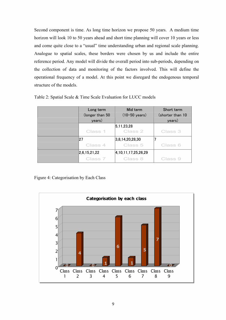
Table 2: Spatial Scale & Time Scale Evaluation for LUCC models
Long term
(longer than 50
years)
Mid term
(10-50 years)
Short term
(shorter than 10
years)
Large scale
beyond 100,000Km^2
5,11,23,28
Intermediate scale
1,000km-100,000Km^2
27 3,8,14,20,28,30 7
Small scale
up to 1,000km^2
2,6,15,21,22 4,10,11,17,25,26,29
Class 2 Class 1 Class 3
Class 6 Class 4 Class 5
Class 7 Class 8 Class 9
Figure 4: Categorisation by Each Class
0
4
0 1
6
1
5
7
001234567
Class1
Class2
Class3
Class4
Class5
Class6
Class7
Class8
Class9
Categorisation by each class
0
4
0 1
6
1
5
7
001234567
Class1
Class2
Class3
Class4
Class5
Class6
Class7
Class8
Class9
Categorisation by each class
9

We found a concentration of models in certain classes, while some classes like
long term and large scale had no hits. Out of 9 classes four classes appear
frequently, while other combinations seemed less popular.
Assuming the amount of case studies will further increase in the future, only the
relevant LUCC models regarding their spatial and temporal characteristics will
be considered. This will help newcomers in LUCC research to develop their own
strategies, based on a few selected models, which fit to their range of interest.
Even though the individual approaches might still not precisely match the scale
and time, they are much closer to each other than of any other group.
Conclusion:
LUCC program became a global platform for individual case studies of land-use
and land-cover change. The necessity to explore land-use and land-cover change
phenomena is widely recognised.
The LUCC science plan was overoptimistic with its goals: The level of possible
integration between individual models remains limited. The simple scale time
evaluation can already give some explanation why this is the case without going
into details with driving forces.
Beside a LUCC strategy, a simple modelling standard should be defined if we
really want to compare models. Easiest: the same period and a similar size of
territory should be compared. If this works the standard can be gradually become
less scarce.
Having such a standard, the amount of models/case studies - in particular from
developing countries where we have fewer models - will become more useful.
For now the mentioned examples remain isolated what concerns modelling.
The period of 300 years or even 150 years once considered as favourable from
LUCC researchers is too long and does not match the period in models we
evaluated. In particular when concerns developing countries a shorter time
period is desirable as it might be difficult to get information going back 50 years
or more.
10

References
Balmann, A. (1997). Farm-based modelling of regional structural change. European Review of Agricultural Economics 25(1): pp85-195. Balmann, A., K. Happe, K. Kellermann, and A. Kleingarn. (2002). Adjustment costs of agri-environmental policy switchings: A multi-agent approach in M.A. Janssen, ed. Complexity and Ecosystem Management: The Theory and Practice of Multi-agent Approaches. Edward Dlgar Publishers, Cheltenham, U.K.; Northampton, MA. Breiling, M. (1993). Die zukünftige Umwelt- und Wirtschaftsituation peripherer alpiner Gebiete. PhD thesis, Institut für Landschaftsgestaltung, Universität für Bodenkultur, April 1993, Wien. Breiling M. (2000). The Regional Model of Hermagor District: Endogenous Development and Exogenous Change Simulations. Extended abstract to Workshop on "Advanced Techniques for Assessment of Natural Hazards" Igls organised by University of Innsbruck, June 5th to 7th, 2000. Berger, T. (2001). Agent-based spatial models applied to agriculture: a simulation tool for technology diffusion, resource use changes and policy analysis, Agricultural Economics 25(2-3): pp245-260. Berger, T. Multiple Agent Modeling Applied to Agro-Ecological Development, Bonn University, Center for Development Research. http://www.csiss.org/events/other/agent-based/papers/berger.pdf Clarke, K. C. and L. J. Gaydos. (1998) Loose-coupling a cellular automaton model and GIS: long-term urban growth prediction for San Francisco and Washington/Baltimore. International Journal of Geographical Information Science 12, pp699-714. Crosson, P., J.R. Anderson, 1992. Resources and global food prospects – supply and demand for cereals to 2030. Technical Report no. 184 of the World Bank, Washington. Statistical Handbook of Japan 2003. D’Aquino, P., O. Barreteau, M. Etienne, S. Boissau, S. Aubert, F. Bousquet, C. Le Page, W. Daré. The Role Playing Games in an ABM Participatory Modeling Process: Outcomes from Five Different Experiments Carried out in the Last Five Years, http://www.iemss.org/iemss2002/proceedings/pdf/volume%20due/192_daquino.pdf Deadman, P., and E. Schlager (2001) Agent-based simulations of household decision making and land use change near Altamira, Brazil in H. R. Gimblett, ed. Integrating Geographic Information Systems and Agent-Based Modeling Techniques for Understanding Social and Ecological processes. Oxford University Press. Dean, J.S., G. J. Gumerman, J. M. Epstein, R. L. Axtell, A. C. Swedlund, M. T. Parket, and S. McCarroll. (2000) understanding Anasazi cultural change through
11

agent-based modeling. pp179-206 in T.A. Kohler and G.J. Gumerman, eds. Dynamics in Human and Primate Societies. Oxford University Press. Döös, B. R. (2002). Population growth and loss of arable land, Global Environmental Change, Volume 12, Issue 4, pp 303-311. Elengen, G., S. Geertman, P. Smits, C. Wessels, (1999) ‘Dynamic GIS and Strategic Physical Planning Support: a practical application to the Ijmond/Zuid-Kennermerland region' in Stillwell, J.C.H., Geertman, S. and Openshaw, S. (eds) Geographical Information and Planning, Heidelberg, Springer Verlag, Chapter 1, pp3-22. FAOSTAT. http://apps.fao.org/ Fukamachi K., H. Oku, T. Nakashizuka (2002). The change of a Satoyama landscape and its causality in Kamiseya, Kyoto Prefecture, Japan between 1970 and 1995. In Landscape Ecology 16: pp703-717. Fischer, G. and L. X. Sun. (2001) Model based analysis of future land-use development in China. Agriculture, Ecosystems and Environment 85, pp163-176. Hoffmann, M., H. Kelley, and T. Evans. (2002) Simulating land-cover change in South Central Indiana: An agent-based model of deforestation and afforestation in M. A. Janssen, ed. Complexity and Ecosystem Management: The Theory and Practice of Multi-Agent Approaches. Edward Elgar Publishers, Cheltenham, U.K.; Northampton, MA. Hua, J. (2001) Research on Land Transformation Thtough the Integrated CA Model with AHP-Derived Transition Rules: Exemplifying the southern part of Jiangsu province, China. Doctoral Dissertation at the Department of Biological and Environmental Engineering. (CSIS), University of Tokyo. Huigen, M. (1997) Special Operations Procedure with Special Operation Payments: A Study on Forest Policy Distortion in the Philippines. CVPED Field Report No. 71. Leiden, The Netherlands: Center of Environmental Science, Leiden University. Kohler, T. A., J. Kresl, C. V. West, E. Carr, and R. H. Wilshusen. (2000), Be there then: A modeling approach to settlement determinants and spatial efficiency among late ancestral pueblo populations of the Mesa Verde region, U. S. Southwest. pp145-178. in T.A. Kohler and G. J. Gumerman, eds, Dynamics in Human and Primate Societies. Oxford University press, New York and Oxford. Ligtenberg, A., A. K. Bregt, and R. V. Lammeren. (2001) Multi-actor-based land use modelling: spatial planning using agents, Landscape and Urban Planning 56: pp21-33. Lim, K., P. Deadman, E. Moran, E. Brondizio, and S. McCracken. (2001). Agent-based simulations of household decision making and land use change near Altamira, Brazil in H. R. Gimblett, ed. Integrating Geographic Information Systems and Agent-
12

Based Modeling Techniques for Understanding Social and Ecological processes. Oxford University Press. Lynam, T. (2002) Complex and useful but certainly wrong: A multi-agent agro-ecosystem model from the semi-arid areas of Zimbabwe in M.A. Janssen, ed. Complexity and Ecosystem Management: The Theory and Practice of Multi-agent Approaches. Edward Dlgar Publishers, Cheltenham, U.K.; Northampton, MA. Manson, S. M. (2000) Agent-based dynamic spatial simulation of land-use/cover change in the Yucatan peninsula, Mexico. Paper presented in the Fourth International Conference on Integrating GIS and Environmental modeling (GIS/EM4), Banff, Canada. Mertens, B. Lambin, E. F. (2000) Land-Cover-Change Trajectories in Southern Cameroon. Annals of the Association of American Geographers, 90(3), pp467-494. Ministry of Public Management, Home Affairs, Posts and Telecommunications Japan (2003) Statistical Handbook of Japan, Japan. Nunes, C. and J.I. Auge. (1999) IGBP Report 48/IHDP Report 10. Parker, D. C., T. Berger, and S. M. Manson, eds. (2001) Agent-Based Models of Land-Use and Land-Cover Change, Report and Review of an International Workshop, October 4–7, Irvine, California, USA Polhill, J. G., N. M. Gotts, and A. N. Law. (2001) Imitative versus nonimitative strategies in a land-use simulation. Cybernetics and Systems 32 (1): pp285-307. Rajan, K. S., and R. Shibasaki. (2001) A GIS Based Integrated Land Use/Cover Change Model to Study Agricultural and Urban Land Use Changes. Paper presented at the 22nd Asian Conference on Remote Sensing, 5-9 November 2001, Singapore. Rouchier, J., F. Bousquet, M. Require-Desjardins, and M. Antona. (2001) A multi-agent model for describing transhumance in North Cameroon: Comparison of different rationality to develop a routine. Journal of Economic Dynamics and Control 25: pp527-559. Sanders, L., D. Pumain, H. Mathian, F. Guerin-Pace, and S. Bura. (1997) SIMPOP – a multiagent system for the study of urbanism. Environment and planning B: Planning and Design 24:pp285-305. Sato, Y. and L. Li. (2002) A Diffusion-based Macro Model for Regional Urban Expansion in the Case of the Eastern Part of China, in K. Otsubo eds. Study on the Processes and Impact of Land-Use Change in China. Final Report of the LU/GEC second phase, CGER-Report, Center for Global Environmental Reserch, National Institute for Environmental Studies. Singh, K. D. (1993) The 1990 tropical forest resources assessment. Unasylva No. 174, Forest resources assessment. http://www.fao.org/docrep/v0290E/v0290e04.htm#TopOfPage
13

14
Torrens, P. M. (2002) New advances in urban simulation: Cellular automata and multi-agent systems as planning support tools in S. S. Geertman, J., ed. Planning Support Systems in Practice, Springer-Verlag, London. Turner II B.L., D. Skole, S. Sanderson, G. Fischer, L. Fresco, R. Leemans and D. Graetz, T. Kitamura, Y. Liu, L. Martinelli, E. Milanova, D. Norse, H. W. O. Okoth-Ogendo, M. Parry, L Pritchard, K. Strezpek and T. Veldkamp. (1995). Integrated Regional and Global Modelling Stockholm and Geneva, 1995 Veldkamp, A., and L. O. Fresco. (1996) CLUE: A conceptual model to study the conversion of land use and its effects. Ecological Modelling 85 2/3: pp253-270. Verburg, P. H.., P. Schot, M. Dijist , and A. Veldkamp.(2002) Land use change modelling: current practice and research priorities. GeoJournal. In press. Wada, Y. (2002) Study and Development of a Land use/cover change Model with focus on Shifting Cultivation in Luangprabang Province Lao P.D.R. Doctoral Dissertation at Center for Spatial Information Science (CSIS), University of Tokyo. Woelcke, J., T. Berger, P. Soojin. (2002) Land Management and Technology Adoption in Uganda: An Integrated Bio-Economic Modelling Approach. In Nkonya, E., D. Sserunkuuma, and J. Pender eds. Policies for Improbed Land Management in Uganda: Second National Workshop. EPTD Workshop Summery Paper no. 12. Environment and Production Technology Division International Food Policy Research Institute. http://www.ifpri.org/divs/eptd/ws/papers/eptws12.p