Embed Size (px)
Citation preview


Year
7 G
eog
– S
kills
No.
1U
se t
he S
chool pla
n b
elo
w t
o
answ
er
Quest
ion 1
A t
o 1
H
Sca
le;
2cm
= 5
0
metr
es
(A)
Corr
ect
ly p
lace
the lett
ers
N
(N
ort
h)
S(S
outh
)E
(East
)W
(West
)on t
he d
irect
ion indic
ato
r in
the m
ap g
iven.
(B)I
f you w
ere
to b
e looki
ng f
or
the Indust
rial
Art
s B
lock
to 'B
lock
A', in w
hic
h d
irect
ion is
'BLO
CK
A' fr
om
the Indust
rial A
rts
Blo
ck?
(a)N
ort
h,
(b)S
outh
,(c
)East
,(d
) W
est
.
(C)
The m
ark
ing
on t
he m
ap r
epre
sents
:(a
) path
s,(h
) cl
ass
room
s,(c
) tr
ees,
(d)
steps.
(D)T
he m
ark
ing
on t
he m
ap r
epre
sents
:(a
)the a
ssem
bly
are
a,
(b)a
tennis
court
,(c
)an o
val,
(d)a
car
park
.
E)T
he d
ista
nce
acr
oss
the
ass
em
bly
are
a f
rom
room
2 is
about:
(a)
30
metr
es,
(b)
25
metr
es,
(c)
70
metr
es,
(d)
95
metr
es.
(F)T
he d
ista
nce
alo
ng t
he p
ath
fr
om
the s
teps
at
the f
oot
of
Blo
ck
A t
o t
he f
ootp
ath
in M
ain
Str
eet
is
about:
(a)7
5 m
etr
es,
(b)3
0 m
etr
es,
(c)1
00
metr
es,
(d)5
0 m
etr
es.
(G)
Room
4 is
in g
rid s
quare
:(a
)A
3,
(b)
D4
,(c
)C
5,
(d)
B3
.
(H)
Room
1 is
in g
rid s
quare
:(a
)A
3,
(b)
D4
,(c
)C
5,
(d)
B3
.
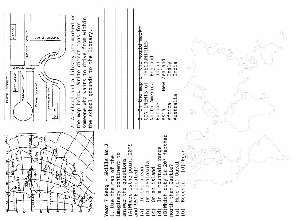
Year
7 G
eog
– S
kills
No.2
1.
Use
the m
ap o
f th
e im
agin
ary
co
nti
nent
to a
nsw
er
the q
uest
ions
(A)W
here
ist
he p
oin
t 2
0°S
and
95
°E loca
ted?
(a)
In t
he o
cean
(b)
On a
penin
sula
(c)
On a
n isl
and
(d)
In a
mounta
in r
ange
(B)W
hic
h c
ity is
20
° fa
rther
nort
h
than C
ast
le?
(a)
Hum
e(c
) D
uval
(b)
Beech
er
(d)
Egan
2.
A s
chool and a
lib
rary
are
mark
ed o
n t
he m
ap
belo
w.
Wri
te d
irect
ions
for
som
eone w
ho w
ants
to
dri
ve f
rom
wit
hin
the s
chool gro
unds
to t
he
libra
ry.
____
____
____
____
____
____
____
____
____
____
____
____
____
____
____
____
____
____
____
____
____
___
____
____
____
____
____
____
____
____
____
____
____
____
___
____
____
____
____
____
____
____
____
____
____
____
___
____
____
___
____
____
____
____
____
____
____
____
____
____
____
___
____
____
____
____
____
____
____
____
____
____
____
____
___
____
____
____
____
_3
. O
n t
he m
ap o
f th
e w
orl
d m
ark
CO
NTIN
EN
TS o
fTH
EC
OU
NTR
IES
Nort
h A
meri
caEngla
nd
Euro
pe
Japan
Asi
aN
ew
Zeala
nd
Afr
ica
Italy
Aust
ralia
India

3.
Imagin
e y
ou w
ere
ask
ed t
o d
o a
n
ass
ignm
ent
on Indonesi
a u
sing t
he
Libra
ry r
efe
rence
book "
A S
hort
His
tory
of
Indonesi
a"
In w
hic
h p
art
of
the b
ook w
ould
you look
(A)
To fi
nd o
ut
what
page t
he c
hapte
r about
Pre
sident
Suka
rno b
egin
s?a)
Bib
liogra
phy
b)
Table
of
Conte
nts
c)In
dex
d)
Glo
ssary
e)
Intr
oduct
ion
(B)
To fi
nd o
ut
what
the w
ord
'Sam
bal'
means?
a)
Bib
liogra
phy
b)
List
of
Illust
rati
ons
c)In
dex
d)
Glo
ssary
e)
Table
of
Conte
nts
(C)
To s
ee if
this
book
menti
ons
Will
en
Van B
art
en?
a)
Bib
liogra
phy
b)
List
of
Illust
rati
ons
c)In
dex
d)
Glo
ssary
e)
Table
of
conte
nts
(D)
To s
ee if
there
is
a m
ap o
f In
donesi
aa)
Intr
oduct
ion
b)
Bib
liogra
phy
c)Li
st o
f Ill
ust
rati
ons
d)
Index
e)
Glo
ssary
(E)
If t
here
are
any o
ther
books
on Indonesi
an H
isto
ry
a)
Bib
liogra
phy
b)
Table
of
Conte
nts
c)In
dex
d)
Glo
ssary
e)
List
of
Illust
rati
ons
Year
7 G
eog
– S
kills
No.
32
. Im
agin
e y
ou w
ere
ask
ed t
o
answ
er
the f
ollo
win
g q
uest
ions
usi
ng L
ibra
ry r
efe
rence
books
. W
hic
h o
f th
e f
ollo
win
g b
ooks
would
you u
se f
or
each
quest
ion(A
) H
ow
do y
ou g
et
from
Spence
r Str
eet
Sta
tion t
o V
.F.L
. Pa
rk?
a)
Atl
as
h)
Str
eet
Dir
ect
ory
c)Ye
ar
Book
d)
Ency
clopedia
e)
His
tory
Text
(B)
In w
hic
h r
ange o
f M
ounta
ins
is
Wilp
ena P
ound s
ituate
d?
a)
Atl
as
b)
Str
eet
Dir
ect
ory
c>Ye
ar
Book
d)
Ency
clopedia
e)
His
tory
Text
(C)
What
were
the m
ain
ach
ievem
ents
of
Sir
John M
onash
?a)
Atl
as
b)
Str
eet
Dir
ect
ory
c)Ye
ar
Book
d)
Ency
clopedia
e)
His
tory
Text
(D)
How
many m
igra
nts
retu
rned t
o
Engla
nd f
rom
Aust
ralia
Last
Year?
a)
Atl
as
b)
Str
eet
Dir
ect
ory
c>Ye
ar
Book
d)
Ency
clopedia
e)
His
tory
Text
(F)
How
hig
h is
Mt.
Egm
ont
in N
ew
Z
eala
nd?
a)
Atl
as
b)
Str
eet
Dir
ect
ory
c)Ye
ar
Book
d)
Ency
clopedia
e)
His
tory
Text

Year 7 Geog – Skills No. 41.Follow the directions given to make a picture below. Work neatly with a sharp pencil and rule all lines. Neatly cross off each numbered point as you plot it. Begin at point X.1.S3,E2 2.E1 3.52 4.S2,E1 5.S3,E3 6.S2,E1 7.S3,E19.S4,W2 10.S1,W1 11.S1,W2 12.W1 13.N1 14.W1,S1 15.W117.N2,W2 18.N1 19.W1,S1 20.W1 21.N2,W2 22.S2,W6
23.S1,W225.N1,W1 26.E1,N1 27.W2,N4 28.N1 29.N1,W1 30.N2 31.N2,E233.N1 34.E1,N1 35.E1 36.E1,N2 37.E1,N1 38.E1 39.S1,E141.E2,N1 42.E3,S1 43.S2,W1 44.S1,E4 45.E1,N5
8.S2,W116.N1,W124.S1,W332.E3,N240.E1,N2

Year 7 Geog – Skills No.5Sometimes it is more important to discover what one cannot do than what one can do. Lin Yutana (1895 19761Find the hidden words – they run either vertically, horizontally or diagonally. Then place them in their correct meaning in the passage below.
N X W U N G R U E W X U B L N F A JG 0 X G 0 D J J S I I E E A E P C PA Q R S R E R G V N C A A L E D T 0T F J T T G K C A D A S R R D L E IV R 0 P H R Q Y A S A T I Y L I B NK 0 U Y W E S U N U T Z N N E D G TT M R E E E A J W F A A G G 0 V Z SE Z F 0 S S C S B E Y B R E R R K PI C B A T C D P T E S S H S A I T EV 0 D I R E C T I 0 N T Y I E R D HC S 0 U T H E A S T H H E S T H F SP N T U L S A Q M A G N E T I C A B0 D H C 0 M P A S S U S 0 U T H L FT B A I S 0 U T H W E S T H Q M K 0
north south east west northeast northwestsoutheast southwest direction true magnetic gridcompass wind needle stars sun degreesfrombearing Pointsfrom
The four main or cardinal p _ _ _ _ _ of the c _ _ _ _ _ _ are n _ _ _ _, s _ _ _ _, e _ _ _,
w _ _ _ _. To find d _ _ _ _ _ _ _ _ you can use a c _ _ _ _ _ _, the s _ _ or the s _ _ _ _. A compass n _ _ _ _ _ points to m _ _ _ _ _ _ _ north. Two other types of north are g _ _ _ north and t _ _ _ north. Direction can be given as a b _ _ _ _ _ _ in d _ _ _ _ _ _. When w _ _ _ direction is given, it is the direction from which the wind comes f _ _ _.

Year
7 G
eog
– S
kills
No.
61
. O
n t
he m
ap o
f A
ust
ralia
mark
The S
tate
s of
The C
itie
s of
New
South
Wale
sC
anberr
aO
ueensl
and
Sydney
Tasm
ania
Darw
inV
icto
ria
Pert
hW
est
ern
Aust
ralia
Hobart
2.
Usi
ng t
he m
ap fi
g. 1
giv
e t
he
appro
xim
ate
loca
tion in
lati
tude a
nd
longit
ude (
0°)
of
tile
follo
win
g p
lace
s:
New
York
: _
____
____
____
____
____
____
_Syd
ney:
___
____
____
____
____
____
____
_H
on
gKon
g:
____
____
____
____
____
____
__Lo
ndon:
____
____
____
____
____
____
____
Haw
aii:
___
____
____
____
____
____
____
_B
om
bay:
____
____
____
____
____
____
____
3.
Make
a lis
t of
the p
eople
whose
liv
es
may
som
eti
mes
depend o
n b
ein
g a
ble
to g
ive t
heir
lo
cati
on a
ccura
tely
esp
eci
ally
in t
ime o
f dis
tress
or
em
erg
ency
.a)
____
____
____
____
____
____
____
____
____
__b
)__
____
____
____
____
____
____
____
____
____
c)__
____
____
____
____
____
____
____
____
____
d)
____
____
____
____
____
____
____
____
____
__e)
____
____
____
____
____
____
____
____
____
__f)
____
____
____
____
____
____
____
____
____
__

Year 7 Geog – Skills No. 71.What direction does the house face? ______2.What is the depth of the house from front to back? ___________metres( A B is the front part )3.What is the width of the house? _____________ metres4.How long is the longest part of the lounge room? _____________ metres5.What direction is the dining room from Bedroom 3? _______6.Taking the scale into account, how many maps this size would be needed to cover the floor of this house? _________7.Mark in the names of the rooms left blank8.In the KEY table, use symbols or colours to make up a suitable key for this map. This could refer to furnishings, room use etc. __________9.In the space below the map draw the front view of the house. Follow these instructions:Point A is 121 metres above sea level and point A is at 121.5 metres. Draw a light vertical line from A and B to the rectangle below to help you place the ends correctly. The floor of the house is 0.5 metres above the ground at point B. The distance from floor to ceiling is 2.5 metres. The distance from the ceiling to the peak of the roof is 1.5 metres. The windows are 0.5 metres above the floor and are 1.5 metres high. The front door is 2.1 metres high. Design your own roof style.10.Add any features you think will improve the house ( steps etc ), but make sure the major outlines are clear.

Towns States Minerals True/False
Mt Morgan Queensland Gold True Savage River Tasmania Copper False(a) Collie Western Australia Coal(b) Ravensthorpe Western Australia Copper(c) Cobar N.S.W. Bauxite (d) Rum Jungle Northern Territory Uranium(e) Meekatharra Western Australia Uranium(f) Bendigo Victoria Gold(g) White Cliffs N.S.W. Bauxite(h) Weipa Queensland Bauxite(i) Mt Isa Queensland Silver(j) Mt Lyell Tasmania Opals
Year 7 Geog – Skills No.8In the able below. State True or False if a particular mineral is found in that location
Study the map and write down TRUE or FALSE for these statements. Some will just require you to look carefully, while others will require a little more thought. (a)Mt Lyell (Tas.) has copper, gold and silver. (b)Opals are found in two places in South Australia. (c)Weipa (Qld) and Gove (N.T.) have the same mineral. (d)Mt Tom Price (W.A.) and Mt Morgan (Old) have the same mineral. (e)The Northern Territory is the chief uranium mining area. (f)Gold is found only in W.A. and Victoria. (g)Oil is found off the Victorian coast. (h)Collie (W.A.), Leigh Creek (S.A.) and Mt Morgan (Old) all have coal. (i)Western Australia is the most important mining State. (j)Gold is Victoria's main mineral. (k)Queensland's south western region has no minerals. (Careful!) (I) Iron ore is quite often found in mountain ranges. (m) Coal is usually found fairly close to the coast. (n) Bauxite is found only in northern Australia. (o) Opals are found in three States. (p) Kalgoorlie (W.A.) is a uranium mining area. (q) Minerals in Tasmania are found on the west coast. (r) The mineral closest to Alice Springs is opals. (s) Oil is found only in the sea. (t) Iron ore and gold are Western Australia's main minerals.
Year 7 Geog – Skills No. 9Latitude and longitudeGeographers use lines of latitude and longitude to help locate places (see figure 1). Aeroplanes and ships use and longitude to find their way around the world. Lines of latitude are called 'parallels', lines of longitude are called 'meridians'.Latitude is measured in Degrees________ Or_____________
of the equator (which is at 0°). All places in Australia are_______ of the equator. The major lines of latitude In the world are the equator (0°), the Tropic of______________(23½° north), the Tropic of______________(23½° south), the_____________Circle (66½° north) and the____________________Circle (66½° south)Longitude is, measured in 'degrees (E) or west (W) of the line (meridian) which runs through the town of_____________ in England (0°). This starting point for measuring longitude is known as the_______________________.All places in_____________ are east of the Greenwich meridian. The world's other major line of longitude is the International Date Line (180°). One degree of latitude orlongitude can be broken Into sixty smaller parts known asminutes (shown by the symbol '). So 24°30' is____________ between 24° and_____. Sydney's latitude is 33°53' south and Its longitude is 151°10' east. Latitude Is always given first, and north, south, east or west is always written after the minutes to show whether the place is north or south of the equator or east or___________of the Greenwich meridian.Arctic , west , Greenwich, latitude, halfway, North, cancer, equator, Greenwich meridian, south, south, Australia, Capricorn, Antarctic.

Year
7 G
eog
– S
kills
No 1
.0 F
irst
com
ple
te t
his
key w
ith t
he s
ym
bols
use
d in t
his
map:
Churc
hes
Sig
nal B
ox
Pond.
Sch
ool
Mars
h
Quarr
y
Lighth
ouse
Railw
ay E
mbankm
ent
Ferr
y T
erm
inus
2.
Map R
efe
rence
sN
oti
ce t
hat
the s
traig
ht
lines
on t
he m
ap,
calle
d t
he g
rid,
are
num
bere
d f
or
refe
rence
. The e
nd o
f th
e jett
y h
as
the
refe
rence
4/1
as
the b
ott
om
num
ber
should
be r
ead fi
rst.
To b
e m
ore
acc
ura
te w
e c
an
imagin
e t
he s
pace
betw
een t
he lin
es
to b
e
div
ided into
tenth
s. T
he h
ouse
mark
ed 'H
o'
will
then h
ave a
map r
efe
rence
2.5
/1.5
or,
as
it is
more
usu
ally
giv
en 2
51
5.
The
quarr
y a
t th
e t
op is
67
75
(6
.7/7
.5)
and t
he
railw
ay s
tati
on is
50
40
. W
rite
the m
ap r
efe
rence
s of
the f
ollo
win
g:
a.
The s
ignal box
___
____
____
____
___
b.
The s
chool __
____
____
____
____
___
c.The isl
and _
____
____
____
____
____
d.
The r
ailw
ay b
ridges
____
____
____
__
Whic
h o
bje
cts
are
sit
uate
d a
t th
ese
poin
ts ?
:6
03
0 _
____
____
____
____
____
26
67
___
____
____
____
____
__5
02
0 _
____
____
____
____
____
18
38
___
____
____
____
____
__
55
23
. __
____
____
____
____
___
55
24
___
____
____
____
____
__5
52
5 _
____
____
____
____
____
57
57
___
____
____
____
____
__
3.
Dis
tance
To m
easu
re d
ista
nce
fair
ly a
ccura
tely
use
a p
air
of
com
pass
es
and s
et
them
at
25
0m
, usi
ng t
ie s
cale
on t
he m
ap,
then
walk
them
alo
ng t
he r
oad c
ounti
ng
every
ste
p a
s 2
50
m.
What
are
the
follo
win
g d
ista
nce
s by r
oad o
r tr
ack
?:
a.
From
the r
ailw
ay s
tati
on t
o t
he
quarr
y .
....
....
....
....
....
....
....
....
....
....
....
....
....
....
....
....
....
....
....
....
....
....
..b
.Fr
om
the r
ailw
ay s
tati
on t
o t
he v
illage
(55
60
) ..
....
....
....
....
....
....
....
....
....
....
....
....
....
....
....
....
....
....
....
....
....
c. F
rom
the s
chool to
the h
ouse
'H
o'
d.
usi
ng t
he f
err
y
____
____
____
____
____
____
__e.
goin
g b
y r
oad
____
____
____
____
____
____
____
4.
Dir
ect
ion
Measu
rem
ents
for
dir
ect
ion a
re in a
st
raig
ht
line,
not
alo
ng r
oads.
What
are
th
e f
ollo
win
g b
uild
ings?
:f.
One k
m E
ast
of
the f
arm
20
30
g
.2
. H
alf a
km
Nort
h o
f th
e lig
hth
ouse
.

2.The following are market gardens, find them and colour them purple:
5344 5348 5038 50555346 5350 5042 6045
3.This is moorland (yellow):
6555 1525 1355 15756570 1540 1565
4.The rest of the land is ploughed and should be brown,
Year 7 Geog – Skills No. 11
1.By the river the land is not well drained and the paddocks are grass. These are their references. find them and colour them green:
1515 2545 2168 3070
4245 3020 2055 2075
3067 4535 3030 2550
1555 3060 5235 3040
2263 3078 3555
and by the school
6545 6536
and the open spaces in the town.

Year 7 Geog – Skills No. 12The Lennaville Endurance Horse Race has to go around a group of lakes and a pit, so jockeys are given a map before the day of the big race.Unfortunately, the race organisers ran out of ink before they could finish the maps and only marked in the lakes, the pit and the start.On the map below, using the instructions given to the jockeys, mark in the race course. The map's scale is 1 cm represents 1 km and you are required to draw a linear representation of this on your map. Make sure to include a suitable heading to your map too.Instructions to the jockeys1 Go 3 km south2 Then 1 km south east3 Then 3 km south4 Then 2.5 km south west5 Then 6 km due west6 Then 2.5 km north west7 Then 6 km north8 Then 6 km east9Then 4 km due north10Then 4.5 km north east11Then 3.5 km south east12Then 4.5 km south13Then 2 km south west14Then 1 km west15 Then 3 km north

Year 7 Geog – Skills No. 13. WHAT ARE SYNOPTIC CHARTS? These are the weather maps that you see on television and in the newspaper. WHAT ARE ISOBARS? Isobars are the lines on weather maps. They join areas of equal air pressure. Numbers higher than 1013 hectopascals on an isobar indicate high air pressure. Numbers lower than 1013 hectopascals indicate low air pressure. WHAT ARE LOWS AND HIGHS? Low Air Pressure System - Hot moist air rises. This leaves an area underneath the rising air where there is less air. This area has low air pressure. Low pressure systems indicate cloudy or rainy periods. High Air Pressure System – On the other hand, cool dry air sinks. This forms an area where is more air with high air pressure. High pressure systems indicate fine cool dry weather. HOW DO ISOBARS INDICATE WIND? If the isobars are quite close together on the weather map, wind will blow from the higher pressure area to the lower pressure area. The closer the isobars, the faster will be the wind. The further apart the isobars, the gentler will be the wind. www.qldscienceteachers.com WHAT SYMBOLS INDICATE CLOUDS OR RAIN? Low Pressure Area ( L ) – Lows indicate clouds or rain. Troughs ( - - - - - - ) – Troughs are elongated areas of low pressure where clouds or rain will probably occur. Cold Front ( ) – A cold front is an area where a mass of cold air moves very quickly underneath a mass of warm moist air. This causes the warm moist air to suddenly drop its rain. The result is a very sudden thunderstorm. Warm Front ( ) - A warm front occurs when a mass of warm moist air moves slowly over the top of a mass of cold air. The result is drizzling rain that may last a few days. Tropical Cyclone ( T.C. ) – In summer in tropical areas near the coast, a lot of hot moist air rises rapidly. This can cause an extremely low pressure system (less than 970 hectopascals) which can begin to spiral upwards. This ‘sucks’ up even more hot moist air to make rain clouds and winds that create fierce damaging storms.
QUESTIONS 1. In the table describe or draw symbols on weather maps that indicate a particular weather type:
Fine dry weather
Windy weather
Cloudy weather
Rainy weather
Cairns
Brisbane
Sydney
Melbourne
Adelaide
Perth
Cairns
Brisbane
Sydney
Melbourne
Adelaide
Perth
2. Look at the two weather maps below. For each map, write the type of weather expected in each city in the table below.

1.Suggest names for the three dotted lines,1, ________________________________2 ________________________________3. ________________________________
By giving both the latitude and longitude of your position you are able to give your exact location on the globe. Notice that it is usual to give the latitude first followed by the longitude.
2.Give the locations of the following places on fig. 1.A.Lat ____________ Long. ____________ B.Lat ____________ Long. ____________C.Lat ____________ Long. ____________D.Lat ____________ Long. ____________E.Lat ____________ Long. ____________FLat ____________ Long ____________
3. Drawing isobarsConnect the dots to show the pressure system
Year 7 Geog – Skills No. 14

Some Rules to follow when reading Weather Maps.1.Lines joining places of equal air pressure are called isobars. All isobars are numbered and they show areas of high or low pressure (cells). The unit of measurement is the hectopascal (hPa)2.High pressure is shown by high hPa numbers (say more than 1010 ), while low pressure Is shown by low hPa numbers (say below 1000 ).3.Winds blow clockwise around a low pressure cell and anti clockwise around a high pressure cell.4.Many dose isobars mean strong winds, few widely spacedisobars mean light winds.5.Winds tend to blow in the same direction as the isobars.6.Pressure cells in Australia tend to move in an east to south easterly direction. They usually move about 500 to 700 kms a day.7.An advancing mass of cold air is called a cold front.8.Air from the sea brings moisture. Air from inland is usually hot and dry.9.Mountain barriers cause air to rise and if it is moist then rain results.10.Mountain barriers stop moist winds from reaching inland.11.Northern areas are generally hotter than southern areas because of the effect of latitude. Inland areas have greater extremes of temperature.
Year 7 Geog – Skills No. 15Read te rules and answer the questions.1. Label all the isobars on the Map, e.g. "1008 ".2. On the Map, mark (a)a high pressure cell (H) (b)a low pressure cell (L).3.What was the wind speed and direction at(a) Kalgoorlie?(b) Townsville?(c) Darwin?(d) Perth?4.What is about to happen at Perth?________________________________________________________________________________________________5.What effect will this have on the wind direction there?____________________________________________________________________________________________6. Name two centres which are experiencing calm conditions(a)_____________________________________________
(b)______________________________________________7. Which town would have the hottest day and why?________________________________________________________________________________________________8.Which area of Australia is most likely to have rain?______________________________________________9.Would it be cloudy or nor at(a) Alice Springs?(b) Townsville?10. If the pressure cells continued to move in the normal way, what weather could Adelaide expect to have in the next two days?_______________________________________________________________________________________________Why?____________________________________________________________________________________________

Year 7 Geog – Skills No. 16
1. Choose from the terms below to complete the definitions in the table.
A weather forecast A cloud lines of latitude HumidityPrecipitationTemperature The Bureau of Meteorology
Specialised term Defining
verbClass of thing Characteristics
is water falling to earth.
is water vapour held in the atmosphere. is a measurement of heat. is water vapour that can be seen in the atmosphere. are lines which are imaginary and run
around the earth parallel with theequator.
is a prediction of the weather over the next fewdays.
is a place where weather patterns arestudied.
2. Find the words
visibilitycloudyhumidrainsleetcloudycyclonesoutherly bustershowerssnowcold frontdrizzlelong rangerainfallsqualls
barometereasterlieslow pressurewidespread
sunshinebeaufort scaleheatwavemercurysatelliteovercastchartshigh pressuremeteorology
localised

Year 7 Geog – Skills 17Weather maps (synoptic charts) show isobars which are lines joining places with the same atmospheric pressure. Winds flow around these isobars, clockwise in the case of LOWS and anticlockwise in the case of HIGHS. Just as contour lines show areas of higher or lower landforms, isobars form areas of higher or lower pressure, called cells. The closer the isobars are together, the stronger are the winds, just as contours indicate relative steepness.MAP A:1. Find the atmospheric pressure at :¬-Melbourne __________ hPa Alice Springs_________hPaPort Hedland ________ hPa Townsvile ___________hPa2.Name the two features in the bottom comers of the map.____________________________________________3.Which centre is experiencing the strongest winds?centre________________strength ______________ kph4. Give the wind direction and strength at the following centres :¬Perth direction________________ strength _______kphHobart direction________________ strength _______kphCanberra direction______________strength _______kph5.Which centres have experienced rain during the past 24 hours? _______________________________________MAP B:1. Find the atmospheric pressure at :¬Sydney__________hPa Port Hedland ___________hPaPerth __________ hPa Darwin ______________ hPa2.Name the feature in the bottom left comer of the map.3.Which centre is experiencing the strongest winds?Centre _________________strength ________ kph4.Give the wind direction and strength at the following centres :¬Perth direction _________ strength _________ kphSydneydirection _________ strength _________ kphCanberra direction _________ strength_______ kph5.Which centres have experienced rain during the past 24 hours? _______________________________________
Mark in the cells of high and low pressure on both maps.

Year
7 G
eog
– S
kills
No.
18
1.
Wh
ich
are
on
th
e s
am
e level as
the N
urs
ery
?2
. (
Cir
cle t
he a
nsw
ers
.)a.
Th
ron
e R
oom
b.. R
oyal B
ed
cham
ber
c. Li
bra
ryd
. A
rmou
r R
oo
e. Lo
oko
ut
Room
2. Th
e d
raw
bri
dg
e o
pen
s ou
t acr
oss
th
e m
oat
from
w
hat
room
___
____
____
____
____
____
____
____
_3
. H
ow
man
y fi
rep
lace
s are
sh
ow
n in
th
e c
ast
le?
____
_4
. W
hat
room
is
dir
ect
ly b
elo
w t
he G
overn
ess
's
Room
?__
____
____
____
____
____
____
____
____
____
___
5. W
hat
room
is
dir
ect
ly a
bove t
he K
itch
en
an
d
Scu
llery
?___
____
____
____
____
____
____
____
___
6. S
om
eon
e w
ho d
esc
en
ds
the s
tair
way n
ear
the
Kin
g's
Serv
an
t's
Room
wou
ld e
nd
up
in
wh
at
room
?__
____
____
____
____
____
____
____
____
____
___
6.
Whic
h o
f th
ese
are
cro
ssed b
y t
he
hig
hw
ay?
a.
Ida S
treet
b.
Cherr
y L
n.
c.C
anyon R
dd
.`D
' St
e.
.the R
ailr
oad
f.Spla
sh R
iver
g.
Quart
z D
r.h
. M
ica A
ve
7.
B4 is
the g
rid loca
tion o
fa.
Wetl
and P
ark
b.
the P
izze
ria
c. B
arr
ier
Dam
d.
The B
oat
Ram
pe.
Superm
ark
et
8.
The F
ire D
epart
ment
gri
d loca
tion
is i.B
6j.
A6
k.C
7l.
A7
9.
C6 is
the g
rid loca
tion o
fm
.9th
St
n.
b.
Tow
n H
all
o.
c. H
ors
e T
rail
p.
d.
Gra
mm
ar
Sch
ool
q.
e.
Lodge
9.
About
how
far
is it
from
the
Gra
mm
ar
school to
the A
irport
?r.
25 k
ms.
15 k
mt.
10 k
mu
.7 k
m.
Whic
h is
about
20 k
ilom
etr
es
dow
n
the h
ighw
ay f
rom
Wetl
and P
ark
?a.
the R
ailr
oad
b.
the B
ubble
gum
Fact
ory
c. M
ica A
venue
d.
Barr
ier
Dam
e.
Canyon R
d
1.
What
dir
ect
ion is
the a
irport
fro
m t
he B
arr
ier
Dam
? __
____
____
____
____
____
____
___
2.
Whic
h f
act
ory
is
furt
hest
east
?___
____
__3.
Whic
h p
ark
is
south
east
of
Fish
Lake
? __
__W
hat
dir
ect
ion is
the M
ovi
e T
heatr
e f
rom
the H
ors
e
Sta
ble
s? _
____
____
____
____
____
4.
Whic
h is
south
west
of
Lake
Fro
nt
Park
?B
arr
ier
Dam
A
mber
Ave
The B
oat
Ram
p
Fis
h
Lake
Lib
rary
Superm
ark
et
H
ors
e S
table
s
6th
Ave
5.
If y
ou t
ravel fr
om
the r
ailr
oad t
o t
he S
hoppin
g
Centr
e o
n A
mber
Ave a
nd M
ica1 A
ve,
you w
ould
tr
avel:
N,
then W
NE,
then N
WN
W,
then N
ESW
, th
en S
ESE,
then S
W

Year
7 G
eog
– S
kil
ls N
o.
19
Did
you k
now
for
thou
san
ds
of
years
noon w
as
consi
dere
d t
he t
ime w
hen t
he s
un
reach
ed
its
hig
hest
posi
tion in
the s
ky?
Noon
arr
ives
in e
ast
ern
cit
ies
firs
t beca
use
the e
art
h r
ota
tes
tow
ard
th
e e
ast
. Sta
nfo
rd F
lem
ing
, a C
anadia
n,
suggest
ed t
hat
since
the e
art
h t
ake
s 2
4 h
ou
rs
to m
ake
on
e r
ota
tion, th
e e
art
h s
hou
ld b
e d
ivid
ed into
24
tim
e z
ones.
In 1
88
4,
a g
rou
p o
f co
untr
ies
est
ablis
hed s
tandard
tim
e z
ones
for
the w
hole
eart
h.
Imagin
ary
vert
ical lin
es
mark
th
e b
oun
dari
es
of
tim
e z
ones.
Tim
e is
measu
red
fro
m t
he p
rim
e
meri
dia
n (
0°)
. E
xact
ly 1
80
° in
eit
her
dir
ect
ion
fro
m t
he p
rim
e m
eri
dia
n is
the inte
rnati
onal
date
lin
e,
an im
ag
inary
lin
e w
here
each
day b
egin
s. U
sin
g t
he t
ime z
one m
ap
pro
vid
ed,
an
swer
these
quest
ions.
1.H
ow
man
y t
ime z
ones
are
there
? __
____
____
____
____
____
_2
.How
man
y d
egre
es
of
long
itude in e
ach
tim
e z
on
e?
____
____
____
____
____
____
___
3.W
hen it
is n
oon in L
on
don
, w
hat
tim
e is
it in S
ydney?
____
____
____
____
____
____
____
4.Y
our
uncl
e s
ends
you a
tic
ket
to v
isit
him
in P
ari
s. Y
our
flig
ht
leaves
Syd
ney o
n M
on
day a
t 8
:00
a.m
. fo
r a 2
0 h
our
flig
ht.
At
wh
at
tim
e a
nd
on w
hic
h d
ay d
o y
ou
arr
ive?
____
____
____
____
____
____
5.Y
ou a
nd y
our
un
cle s
et
out
on a
tri
p a
roun
d t
he w
orl
d!
Firs
t st
op . . . C
op
en
hagen, a 2
hou
r flig
ht.
If
you leave P
ari
s at
10
:00
a.m
., w
hat
tim
e d
o y
ou
arr
ive in C
op
enh
ag
en?
____
____
____
____
____
____
6.W
hile
in C
openhagen,
your
un
cle s
uggest
s th
at
you
call
your
sist
er
who liv
es
in N
ew
York
. If
you w
ant
to r
each
her
at
8:0
0 a
.m.
in N
ew
York
, at
what
tim
e s
hould
you
pla
ce y
our
call?
__
____
____
____
__7
.Sin
ce y
our
uncl
e w
an
ts y
ou t
o s
ee e
very
thin
g, h
e p
lan
s a q
uic
k tr
ip t
o A
lgie
rs, A
lgeri
a. If
you
le
ave C
op
enhag
en a
t 7
:00
p.m
., F
rid
ay, on a
flig
ht
headed f
or
Alg
iers
, w
hat
tim
e a
nd d
ay
(Alg
iers
Tim
e)
should
you a
rriv
e if
the fl
ight
is 4
hours
? __
____
____
____
____
____
____
____
____
____
___
8.A
fter
a f
ew
days
back
in C
op
enhag
en, you h
ead e
ast
to B
om
bay,
India
. It
is
1:0
0 a
.m.
on
Wednesd
ay w
hen y
ou a
rriv
e in B
om
bay.
Th
e fl
ight
from
Copenhagen
was
5 h
ours
long. W
hat
tim
e a
nd
day d
id y
ou leave C
open
hag
en?
____
____
____
____
____
____
____
____
____
____
____
____
____
___
9.F
rom
Bom
bay, at
noon o
n F
rid
ay, you c
all
your
mum
in S
ydn
ey.
Wh
at
tim
e is
it f
or
her
when
she a
nsw
ers
the p
hone?
____
____
____
____
____
____
____
____
____
____
____
__1
0.Y
ou leave B
om
bay a
t 5
a.m
. fo
r H
on
g K
ong.
Wh
at
tim
e is
it in H
on
g K
on
g?
____
____
____
____
___
11
.It'
s ti
me t
o g
o h
om
e. Yo
u leave H
on
g K
ong a
t 1
0:0
0 a
.m. lo
cal ti
me a
nd a
rriv
e in S
ydney a
t 8
p.m
. on t
he s
am
e d
ay.
How
lon
g d
id y
our
flig
ht
take
? __
____
____
____
____
____
____
____
____
__

Year 7 Geog – Skills No. 20As the crow flies, what is the distance of the following?From To Distance(a) Humbug Clam Beach ____________(b) Dibblerville Jerboa Point ____________(c) Echidna Village Camp Thorny Devil ____________(d) Possumville Shingleback Village ____________(e) Monitor Beach Shingleback Village ____________(f) Kangaroo City Echidna Village ____________(g) Camp Rock Cod Camp Shrimp ____________(h) Mt Sugar Glider Mt Dingo ____________(i) Mt Dingo Numbat Peak ____________(j) Camp Python Tiger Cat Peak ____________(k) Tiger Cat Peak Jerboa Point ____________(I) Mt Sugar Glider Dibblerville ____________(m) Numbat Range Mt Cuscus ___________(n) Camp Shrimp Mt Cuscus ___________(o) Mt Cuscus Possumville ___________ (p) Monitor Beach Mt Sugar Glider ___________ (q) Jerboa Point Kangaroo City ___________ (r) Camp Shrimp Mouth of Heron Creek _________ (s)Platypus Bay Camp Python __________ (t) Camp Rock Cod Echidna Village __________

Year 7 Geog – Skills No. 21What should every school have?On a map 1 cm represents 4 km. Using this scale, convert the map distances below to actual distances, choosing your answers from the list at the bottom of the page. When you have finished, use the letters next to the distances left over to find the solution to the puzzle.1 1.5 cm2 2 cm3 0.5 cm4 3 cmS 4 cm6 6 c m7 9 cm8 0.25 cm9 15 cm10 12 cm 11 2.5 cm12 5 cm13 10 cm14 4.5 cm15 0.75 cm16 10.5 cm17 24 cm18 18 cm 19 0.4 cm 20 0.2 cm
ANSWER_______________________
A. 12 kmC 1 kmF . 60 kmD 3 kmI 6 kmE 94 kmO 72 kmL 48 kmH 0.2 kmN 20 kmY 25 kmT 44 kmActual distancesG 4 kmB 1.6 kmG 0.5 kmI 0.8 kmM 40 kmR 7.2 kmE 35 kmK 10 kmP 24 km .H 15 kmX 2 kmE 18 kmY 96 kmA 5 kmN 42 kmA 22 kmF 8 kmO 50 kmR 36 kmQ 16 kmP 14 kmE 30 kmC 55 kmR 66 km
Fix the punctuation in each sentence. Capital letters should be used at the beginning of each sentence, for proper nouns, and for acronyms.Add capital letters and full stops where they are needed. 1.the most spectacular of all the marine ecosystems is the coral reef.2.the world's largest coral reef is australia's great barrier reef.3.located off the coast of north queensland, the great barrier reef is a popular tourist attraction especially for visitors from japan and the united states.4.a recent threat to the great barrier reef is the crown of thorns starfish, which has spread all over the reef, killing coral and the marine life that feeds off it 5.scientists and marine biologists are trying to stop the crown of thorns starfish from completely taking over the reef 6.the coral reefs in the caribbean are ecosystems also under threat 7.the islands of the eastern Caribbean, known as the west indies, consist of three main island groups 8.known for its palm trees and relaxed atmosphere, this tropical area includes the islands of barbados and antigua. 9.tourists from europe and north america flock to this area most of the year round. 10. half the workforce of barbados is employed in the tourist industry.11. the importance of the tourist dollar has led to the construction of tourist resorts near the most beautiful areas.12. the problem is that many developments have been poorly planned.13. infrastructure for sewage treatment has been neglected causing raw sewage to be pumped into the sea, polluting beaches and damaging the delicate reefs14. individual tourists also damage the reef through touching the delicate coral when diving15. some careless boating enthusiasts damage coral when throwing anchors in to the water

Year 7 Geog – Skills No. 221.Give the location of :-a. Picnic Point (skate park ) _____________b. Jubilee Park______________________c. Pelican Feeding____________________d. North Entrance Surf Club____________The Entrance Ocean Baths______________
2.a. Write a set of directions for someone to drive from the Bowling Club in Park Rd to the Community hall in Hutton Rd, North Entrance.__________________________________________________________________________________________________________________________________________________________________________________________________________________________________________________________________________________________________________________________________________________________________________________________________________________________________________________________
b. What is the straight line distance between these two places?_________________________________c. What is the road distance according to your directions?__________________________________

Country Percentage of incomegoing to:poorest 10% wealthiest 10%
Sweden 8.0 36.9United Kingdom
5.8 34.5
Australia
4.4 42.2
Japan 8.7 44.6Italy 6.8 41.0Germany
6.8 38.7
Canada 5.1 40.2USA 4.7 41.9France 6.3 40.8
Country Percentage of incomegoing to:poorest 10% wealthiest 10%
Bangladesh
7.0 37.2
Sri Lanka
4.8 56.1
Pakistan 7.8 54.6India 8.1 41.4Indonesia
8.8 41.3
Philippines
5.0 48.0
Malaysia 4.6 51.2Colombia 4.0 53.0Brazil 2.4 62.6
Year 7 Geog – Skills No. 23
Table A Industrialised Countries
Table B Other countries
1 In which industrialised country did the poorest 20 per cent get the lowest percentage of national income?
_____________________________________________2 In which industrialised country did the poorest 20 per cent get the
highest percentage of national income?_____________________________________________
3 Was the share of the poorest 20 per cent greater in Italy or the USA?_____________________________________________
4 Was the share of the poorest 20 per cent greater in Pakistan or Malaysia?
_____________________________________________
5 In which industrialised country did the wealthiest 20 per cent have the lowest percentage of national income?
_____________________________________________
6 In which industrialised country did the wealthiest 20 per cent have the highest percentage of national income?
_____________________________________________
7 In which unindustrialised country did the wealthiest 20 per cent have the highest percentage of national income?
_____________________________________________
8 In which unindustrialised country did the poorest 20 per cent have the lowest percentage of the national income
_____________________________________________
9 In which unindustrialised country did the poorest 20 per cent have the highest percentage of the national income?
_____________________________________________
10 How many of the unindustrialised countries are in Asia?_____________________________________________
![HIS STUDYthe test. A cube of sample (2cm × 2cm × 2cm) was cut from the middle of sample (bread) and was placed centrally beneath the probe [(p/36 cylinder probe (36mm)] in order](https://img.pdfslide.us/doc/110x75/5e766751bd1b0f32727fc5d4/his-study-the-test-a-cube-of-sample-2cm-2cm-2cm-was-cut-from-the-middle.jpg)