Embed Size (px)
Citation preview

Year 6 unit overview — Australian Curriculum: GeographySource: Australian Curriculum, Assessment and Reporting Authority (ACARA), Australian Curriculum v5.0: Geography for Foundation–10, www.australiancurriculum.edu.au/Geography/Curriculum/F-10.
Unit no. Unit title Duration of unit
1 Investigating global diversity 20 hours
Unit outline
The Year 6 curriculum shifts to a global scale with a geographical study of the world’s cultural, economic, demographic and social diversity.In this unit students learn about the diversity of peoples and cultures around the world including indigenous peoples of other countries, and reflect on cultural differences and similarities. Students explore spatial distributions, patterns and trends in a range of maps, graphs and tables.Students’ mental maps of the world and their understanding of place are further developed through learning the location of the major countries in the Asia region, and investigating the geographical diversity and variety of connections between people and places.There is a strong focus in this unit on the use of geographical inquiry and skills. The students will: collect and record relevant geographic data and information from sources about the economic, demographic and social diversity of different countries evaluate the usefulness of collected data and information and represent data in different forms such as maps, plans, graphs, tables, sketches and diagrams represent the locations and features on maps of major countries of the Asian region in relation to Australia interpret geographical data and information, to identify distributions, patterns and trends and infer relationships, using digital and spatial technologies where
appropriate present findings and reflect on learning in different texts such as written, oral, graphic, tabular, visuals and maps, using digital and spatial technologies
where appropriate.Specific new geographic skills in Year 5–6 include the constructing and interpreting of graphs such as bar, column and line graphs and population pyramids. There are opportunities to make connections to Australian Curriculum: Mathematics and Australian Curriculum: Science in working with tables and graphs.The inquiry questions for the unit are: How do places, people and cultures differ across the world? What are Australia’s global connections between people and places?
DRAFT Queensland Studies Authority July 2013 | 1
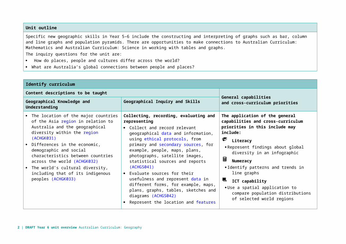
Identify curriculum
Content descriptions to be taught General capabilities and cross-curriculum prioritiesGeographical Knowledge and Understanding Geographical Inquiry and Skills
The location of the major countries of the Asia region in relation to Australia and the geographical diversity within the region (ACHGK031)
Differences in the economic, demographic and social characteristics between countries across the world (ACHGK032)
The world’s cultural diversity, including that of its indigenous peoples (ACHGK033)
Collecting, recording, evaluating and representing Collect and record relevant geographical data
and information, using ethical protocols, from primary and secondary sources, for example, people, maps, plans, photographs, satellite images, statistical sources and reports (ACHGS041)
Evaluate sources for their usefulness and represent data in different forms, for example, maps, plans, graphs, tables, sketches and diagrams (ACHGS042)
Represent the location and features of places and different types of geographical information by constructing large-scale and small-scale maps that conform to cartographic conventions including border, source, scale, legend, title and north point, using spatial technologies as appropriate (ACHGS043)
Interpreting, analysing and concluding Interpret geographical data and other
information using digital and spatial technologies as appropriate, and identify spatial distributions, patterns and trends, and infer relationships to draw conclusions (ACHGS044)
Communicating Present findings and ideas in a range of
communication forms, for example, written, oral, graphic, tabular, visual and maps, using geographical terminology and digital technologies as appropriate (ACHGS045)
The application of the general capabilities and cross-curriculum priorities in this include may include:
LiteracyRepresent findings about global diversity in an
infographic
Numeracy Identify patterns and trends in line graphs
ICT capabilityUse a spatial application to compare population
distributions of selected world regions
Critical and creative thinkingEvaluate the reliability of information in sources
Personal and social capabilityCollaborate to draw conclusions from selected
geographical data and information
Ethical understandingReflect on personal beliefs about global
inequalities
Intercultural understanding Investigate the relationship between cultural
beliefs and population size in different countries
2 | DRAFT Year 6 unit overview Australian Curriculum: Geography
Identify curriculum
Aboriginal and Torres Strait Islander histories and cultures
Compare the distribution of Aboriginal or Torres Strait Islander Language groups with other indigenous peoples
Asia and Australia’s engagement with Asia
Use geographical tools to locate major countries of the Asian region in relation to Australia
Sustainability Develop a course of action to manage
population growth in selected countries
Geographical understandings
The unit provides opportunities for students to develop geographical understandings that are particularly focused on the following concepts.
☒ Place ☒ Space ☒ Environment ☒ Scale ☒ Interconnection ☒ Sustainability ☒ Change
Explanations of the geographical concepts with examples are provided in the QSA year level plans at: www.qsa.qld.edu.au/yr6-geography-resources.html > Curriculum > Planning templates and exemplars > Year level plans and in the Appendix.
Achievement standard
By the end of Year 6, students explain the characteristics of diverse places in different locations at different scales from local to global. They describe the interconnections between people and places, identify factors that influence these interconnections and describe how they change places and affect people. They describe the location of selected countries in absolute and relative terms and identify and compare spatial distributions and patterns among phenomena. They identify and describe alternative views on how to respond to a geographical challenge and propose a response.Students develop geographical questions to frame an inquiry. They locate relevant information from a range of sources to answer inquiry questions. They represent data and the location of places and their characteristics in different graphic forms, including large-scale and small-scale maps that use cartographic conventions of border, source, scale, legend, title and north point. Students interpret data and other information to identify and compare spatial distributions, patterns and trends, infer relationships and draw conclusions. They present findings and ideas using geographical terminology and graphic representations in a range of communication forms. They propose action in response to a geographical challenge and describe the expected effects of their proposal.
DRAFT Queensland Studies Authority July 2013 | 3
Relevant prior curriculum Curriculum working towards
The Queensland SOSE Essential Learnings by the end of Year 7Ways of workingStudents are able to: identify issues and use common and own focus questions collect and analyse information and evidence from primary and secondary
sources evaluate sources of information and evidence for relevance, reliability,
origins and perspective draw conclusions and make decisions based on information and evidence
by identifying patterns and connections communicate descriptions, decisions and conclusions, using different text
types for specific purposes and the conventions of research-based texts reflect on learning, apply new understandings and identify future
applications.
Year 7 Australian Curriculum: GeographyGeographical Inquiry and skillsObserving, questioning and planning Develop geographically significant questions and plan an inquiry, using
appropriate geographical methodologies and concepts (ACHGS047)Collecting, recording, evaluating and representing Collect, select and record relevant geographical data and information,
using ethical protocols, from appropriate primary and secondary sources (ACHGS048)
Evaluate sources for their reliability and usefulness and represent data in a range of appropriate forms, for example, climate graphs, compound column graphs, population pyramids, tables, field sketches and annotated diagrams, with and without the use of digital and spatial technologies (ACHGS049)
Represent the spatial distribution of different types of geographical phenomena by constructing appropriate maps at different scales that conform to cartographic conventions, using spatial technologies as appropriate (ACHGS050)
Interpreting, analysing and concluding Analyse geographical data and other information using qualitative and
quantitative methods, and digital and spatial technologies as appropriate, to identify and propose explanations for spatial distributions, patterns and trends and infer relationships (ACHGS051) Apply geographical concepts to draw conclusions based on the analysis of the data and information collected (ACHGS052)
Communicating Present findings, arguments and ideas in a range of communication forms
selected to suit a particular audience and purpose; using geographical terminology and digital technologies as appropriate (ACHGS053)
Reflecting and responding Reflect on their learning to propose individual and collective action in
response to a contemporary geographical challenge, taking account of environmental, economic and social considerations, and predict the expected outcomes of their proposal (ACHGS054)
4 | DRAFT Year 6 unit overview Australian Curriculum: Geography
Bridging content
The SOSE Essential Learnings by the end of Year 7 do not focus on the differences in economic, demographic and social characteristics — including the cultural diversity of indigenous peoples — between countries across the world, so bridging learning experiences may assist in developing geographical understanding of global diversity.
Links to other learning areas
Geography is a subject in the Humanities and Social Sciences learning area and has connections to History, Civics and Citizenship, and Economics and Business. There are opportunities to connect learning experiences in Geography to other learning areas.In the Australian Curriculum: History Stories of groups of people who migrated to Australia (including from ONE Asian country) and the reasons they migrated, such as World War II and
Australian migration programs since the war (ACHHK115) Identify and locate a range of relevant sources (ACHHS120) Compare information from a range of sources (ACHHS122) Use a range of communication forms (oral, graphic, written) and digital technologies (ACHHS125)In the Australian Curriculum: Mathematics Interpret and compare a range of data displays, including side-by-side column graphs for two categorical variables (ACMSP147)In the Australian Curriculum: Science Construct and use a range of representations, including tables and graphs, to represent and describe observations, patterns or relationships in data using
digital technologies as appropriate (ACSIS107)In the Australian Curriculum: English Identify and explain how analytical images like figures, tables, diagrams, maps and graphs contribute to our understanding of verbal information in factual
and persuasive texts (ACELA1524) Use a range of software, including word processing programs, learning new functions as required to create texts (ACELY1717)
DRAFT Queensland Studies Authority July 2013 | 5
Assessment Make judgments
Describe the assessment Teachers gather evidence to make judgments about the following characteristics of student work:Understanding The characteristics of diverse places in different locations at
different places at different scale from local to global the locations of selected countries in absolute and relative
terms the comparison of spatial distributions and patterns among
geographical phenomenaSkills Interpret data and other information to identify and compare
spatial distributions, patterns and trends infer relationships and draw conclusions present findings and ideas using geographical terminology
and graphic representationsValued features of the Standard Elaborations targeted in this assessment: Geographical knowledge and understanding Interpreting and analysing CommunicatingFor further advice and guidelines on constructing task-specific standards, refer to the standards elaborations: www.qsa.qld.edu.au/26025.html > select the Year level > choose the Resources tab > Standards elaborations
Students are given opportunities to demonstrate their knowledge, skills and understanding across a range of assessments. This assessment is collected in student folios and allows for ongoing feedback to students on their learning. Year 6 teachers make decisions about the length of time required to complete the tasks and the conditions under which assessment is to be conducted. The teaching and learning experiences throughout the term provide opportunities for students to develop the understanding and skills required to complete these assessments. As students engage with these learning experiences, the teacher can provide feedback on specific skills.Collection of work: Written/MultimodalThe purpose of this assessment is to make judgments about students’ responses to a series of focused tasks within a specified context and based on the process of geographical inquiry and skills. The focus of the collection of work is geographical data and information that identifies spatial distributions, patterns and trends of economic, demographic and social characteristics between countries across the world in relation to Australia, including the Asian region.Students: identify locations and features of a map of major countries of the Asian region represent demographic characteristics of places in the Asian region in a population
pyramid interpret and analyse data and information about the characteristics of selected
countries and Australia infer relationships between the characteristics of places such as population density, life
expectancy, energy consumption and per capita income present ideas about the global diversity in an infographic or other multimodal text Suggested conditions open Written/multimodal 50–300 wordsRefer to Australian Curriculum: Geography — Assessment categories, techniques and conditions: www.qsa.qld.edu.au/downloads/p_10/ac_geography_assess_advice.pdf
6 | DRAFT Year 6 unit overview Australian Curriculum: Geography

Teaching and learning
Teaching strategies and learning experiences Supportive learning environment1 Resources
Introduction Identify nationality of ancestors of students in class, or nationality of students
themselves. Use a digital application, such as Gapminder (see link in resources), to represent the data. Ask student to select a country in the Asia region to use as a focus for discussion in small groups.
On an outline map, locate the selected country in the Asia region. Use a spatial application, such as Google Earth or Google Maps, to compare its location to Australia. Ask students to identify what they already know about the selected country.
Provide two or three photographs per group of the Asian country of choice. Ask students to consider where the photograph was taken and to name the city, country or continent. Once they have decided on the locations, examine the photographs together, asking students to justify their choices.
Use a spatial application to reveal the locations of each of the photographs. Ask students to rank the photographs from most to least representative of that locality or country. These conversations will establish students’ preconceived ideas of the country. Discuss the importance of using a range of sources to develop an understanding of the diversity of people, places and environments.
Developing questions Develop geographical questions to investigate global diversity: How do we
compare differences between people and cultures across the world? How can we measure these differences between countries and across the world? Why is it important to know about differences between countries?
Collaborate to select areas of interest and to collect and record relevant geographic data and information from sources under the headings of: Economic, Demographic and Social Diversity of selected country in comparison to Australia
Identify and explain geographic terms used to describe the characteristics of places such as population density, life expectancy, energy consumption, per capita income, industrialised world and developing world.
Adjustments for needs of learners
Teaching geography Cattling, S 2012, Teaching
Primary Geography for Australian Schools, Hawker Brownlow, Australia.
Australian Geography Teachers Association, 2010, Keys to Geography: Essential skills and tools, Macmillan, South Yarra.
Geogspace,Australian Geography Teachers of Australia, www.geogspace.edu.au
Online photographs NPR,
Everything you own in a Photo: A look at our worldly possession www.npr.org/blogs/pictureshow/2010/08/10/129113632/picturingpossessions
1 Part 6 of the Disability Standards for Education (The Standards for Curriculum Development, Accreditation and Delivery) states that education providers, including class teachers, must take reasonable steps to ensure a course/program is designed to allow any child to participate and experience success in learning. The Disability Standards for Education 2005 (Cwlth) is available from: www.ag.gov.au > select Human rights and anti-discrimination > Disability standards for education.
DRAFT Queensland Studies Authority July 2013 | 7
Teaching and learning
Teaching strategies and learning experiences Supportive learning environment Resources
Collecting, recording, representingStudents: collect and organise information and evidence about selected countries using
geographical tools such as a globe, wall chart or digital application. explore the geographical diversity of the Asian region.
Consider use of the Google Earth > View > Historical Imagery to view changes in environmental features over time
investigate progress towards environmental sustainability and the human actions that have impacted on the environment in the selected countries. Use websites such as National Geographic or Living Planet to collect data and information
represent demographic characteristics of places in the Asian region in relation to Australia using graphs such as population pyramids
construct a line graph for two sets of data for selected countries to show trends over time
represent data using graphic planners and tables to gather information to show similarities and differences in official languages and religions across the Asian region including Australia.
represent relationships that Australia has with other countries in the Asian region using a flow or choropleth map
register for postcrossing — where classes can send postcards to other nations for sharing of information (see link in resources)
review the cartographic conventions of border, source, scale, legend, title and north point using practical exercises. Construct large and small scale maps of selected Asian country and its region
represent and describe location and features of places in the Asian region on large scale and small scale maps in absolute and relative terms
invite an external visitor or speaker to share their experiences and knowledge about different places. Ask them to bring photographs, artefacts or personal possessions typical of the area to help children envisage being there.
Spatial applications Gapminder,
Dollar street www.gapminder.org/downloads/dollar-streetPopulation growth explained with IKEA boxeswww.gapminder.org/videos/population-growth-explained-with-ikea-boxes
Google Maps http://maps.google.com.au/
Google Earth www.google.com/intl/en/earth/index.html
Useful Websites Australian Bureau of
Statistics, Migrants and ethnicity www.abs.gov.au/websitedbs/c311215.nsf/web/migrant+and+ethnicity
National Geographic www.nationalgeographic.com
World vision www.worldvision.com.au/resources
WWFLiving Planet Report http://wwf.panda.org/about_our_earth/all_publications/living_planet_report/
8 | DRAFT Year 6 unit overview Australian Curriculum: Geography
Teaching and learning
Teaching strategies and learning experiences Supportive learning environment Resources
Interpreting, analysing, concludingStudents: evaluate the usefulness of collected data. Who has produced the information?
For what purpose has it been produced? What particular point of view is being presented? When was the information developed? Is it the information valid and reliable?
group data and information into selected categories identify and analyse data and information about the economic, demographic and
social characteristics of different countries. Discuss patterns, trends and relationships between evidence gathered
look at the relationships between the characteristics of places, such as population density, life expectancy and per capita income to describe patterns that are observed in the data and information
create a ‘balance sheet’ of impressions of the selected countries and places, identifying what is liked, what is less appreciated and factors that influence awareness and opinions of places, e.g. the media, significant events, proximity to places and personal relationships with places.
CommunicatingStudents: present findings about global diversity in a multimodal text, such as an
infographic (see link in resources), that is suited to graphically displaying data and visual information for interpretation and show the similarities and differences between life in selected countries and in Australia. The findings should include data such as population density, life expectancy, energy consumption and per capita income.
Owl & Mouse Online Asia maps www.yourchildlearns.com/online-atlas-asia.htm
Av media systemsInteractive whiteboard resources: Geography, history and civics websites www.avsystems.com.au/default/sose_resources
Asia Education Foundation Curriculum resourcesGeographywww.asiaeducation.edu.au/curriculum_resources/geography/geography_cr.html
Post crossing http://www.postcrossing.com/
Asia Education Foundation: Jakarta faces www.asiaeducation.edu.au/curriculum_resources/geography/year_7-8_jakarta_faces/year_7-8_jakarta_faces.html
Infogram (requires registration) http://infogr.am
Books Menzel, P 2004, Material
World: A Global Family Portrait, Sierra, United States.
Heydlauff, L 2004, Going to school in India, Viking, India.
DRAFT Queensland Studies Authority July 2013 | 9
Use feedback
Ways to monitor learning and assessment
Teachers meet to collaboratively plan the teaching, learning and assessment to meet the needs of all learners in each unit.Teachers create opportunities for discussion about levels of achievement to develop shared understandings; co-mark or cross mark at key points to ensure consistency of judgments; and participate in moderating samples of student work at school or cluster level to reach consensus and consistency.
Feedback to students Teachers strategically plan opportunities and ways to provide ongoing feedback (both written and informal) and encouragement to students on their strengths and areas for improvement.Students reflect on and discuss with their teachers or peers what they can do well and what they need to improve.Teachers reflect on and review learning opportunities to incorporate specific learning experiences and provide multiple opportunities for students to experience, practise and improve.
Reflection on the unit plan Identify what worked well during and at the end of the unit, including: activities that worked well and why activities that could be improved and how assessment that worked well and why assessment that could be improved and how common student misconceptions that need, or needed, to be clarified.
10 | DRAFT Year 6 unit overview Australian Curriculum: Geography
Appendix
Concepts for developing geographical understandings in Years 3–6Concept Description
Place Places are parts of the Earth’s surface and can be described by location, shape, boundaries, features and environmental and human characteristics. Places are unique in their characteristics and play a fundamental role in human life. They may be perceived, experienced, understood and valued differently. They range in size from a part of a room to a major world region. For Aboriginal peoples and Torres Strait Islander peoples, Country/Place is important for its significance to culture, identity and spirituality.In Years 3–6, students describe and compare the environmental and human characteristics of places in different locations and the factors that shape the diverse characteristics of places.
Space Spaces are defined by the location of environmental and human features, geographical phenomena and activities across the Earth’s surface to form distributions and patterns. Spaces are perceived, structured, organised and managed and can be designed and redesigned to achieve particular purposes. Space can be explored at different levels or scales.In Years 3–6, students examine how human decisions and actions influence the way spaces within places are organised and managed. For example, students can investigate how urban planning organises the space within cities or regions.
Environment The environment is the product of geological, atmospheric, hydrological, geomorphic, edaphic (soil), biotic and human processes. The concept of environment is about the significance of the environment in human life, and the important interrelationships between humans and the environment. The environment supports and enriches human and other life by providing raw materials and food, absorbing and recycling wastes, maintaining a safe habitat and being a source of enjoyment and inspiration.In Years 3–6, students learn how the environment supports their life and the life of other living things.
Interconnection Interconnection is the way that people and/or geographical phenomena are connected to each other through environmental processes and human activity. Interconnections can be simple, complex, reciprocal or interdependent and have strong influence on the characteristics of places. An understanding of the concept of interconnection leads to holistic thinking. This helps students to understand Aboriginal peoples’ and Torres Strait Islander peoples’ holistic connection to Country/Place and the knowledge and practices that developed as a result of this connection.In Years 3–6, students examine how human action influences the environmental characteristics of places and how these characteristics influence the human characteristics of places. Students also study Australia’s interconnections with other places and the effects of these interconnections.
DRAFT Queensland Studies Authority July 2013 | 11
Concept Description
Change Change involves any alteration to the natural or cultural environment and can involve both time and space. The concept of change is about explaining geographical phenomena by investigating how they developed over time. Environmental change can occur over both short and long time frames, and have interrelationships with human activities. An understanding of the current processes of change can be used to predict change in the future and to identify what would be needed to achieve more sustainable futures.
In Year 3, students explore the changes in phenomena between places in terms of climate and types of settlements.
In Years 4 and 5, students examine the influence of Aboriginal peoples and Torres Strait peoples on the environmental characteristics of Australian places over time.In Year 6, students examine how the connections Australia has with other countries change people and places.
Sustainability Sustainability addresses the ongoing capacity of the Earth to maintain all life. It is both a goal and a way of thinking about how to progress towards that goal. Sustainable patterns of living meet the needs of the present without compromising the ability of future generations to meet their needs (economic, social and environmental). Sustainability depends on the maintenance or restoration of the functions that sustain all life and human wellbeing.In Years 3–6, students examine different views on how to protect environments and how to use resources and manage waste sustainably. Students become aware of why the environment needs to be cared for and consider how they can contribute to this, laying foundations for active citizenship and the way of thinking about sustainability.
Scale Scale refers to the different spatial levels used to investigate phenomena or represent phenomena visually (maps, images, graphs), from the personal to local, regional, national, world regional and global levels. Scale is also involved when geographers look for explanations or outcomes at different levels. Scale may be perceived differently by groups and can be used to elevate or diminish the significance of an issue, for example, a local issue or global issue.
In Years 3–4, students compare places in locations at the local, regional and national scale.In Year 6, the scale of study shifts to the global, with a study of the world’s cultural, economic, demographic and social diversity.
12 | DRAFT Year 6 unit overview Australian Curriculum: Geography