Embed Size (px)
Citation preview

October 2011
Yarrabilba Urban Development Area
Development Scheme

Yarrabilba Urban Development Area Development Scheme
Introduction ................................ 11.1 The Urban Land Development Authority ......... 11.2 Urban Development Area ............................... 11.3 Application of the development scheme......... 11.4 Elements of the development scheme ............ 11.5 Acknowledgements ........................................ 1
Strategic Context ......................... 22.1 Background ................................................... 22.2 Vision statement ........................................... 3
Land Use Plan ............................. 63.1 Components of the land use plan .................. 6
3.1.1 Components of the land use plan ....... 6
3.1.2 UDA development requirements ......... 6
3.1.3 Levels of assessment .......................... 6
3.1.4 Schedules ........................................... 6
3.2 Development assessment ............................. 73.2.1 Interpretation ..................................... 7
3.2.2 Requirements for self-assessable development....................................... 7
3.2.3 Development consistent with the land use plan .............................................. 7
3.2.4 Development approval ....................... 7
3.2.5 Infrastructure agreements .................. 7
3.2.6 Consideration in principle ................... 7
3.2.7 Development application .................... 7
3.2.8 Context plans ...................................... 7
3.2.9 Plan of Development........................... 8
3.2.10 Notification requirements ................... 8
3.2.11 Interim use ......................................... 8
3.2.12 Relationship with local government planning scheme and other legislation 9
3.2.13 Land not included in a zone ................ 9
3.3 UDA-wide criteria .......................................... 93.3.1 Neighbourhoods ................................. 9
3.3.2 Centres .............................................. 11
3.3.3 Housing diversity and affordability .... 11
3.3.4 Employment opportunities ................ 11
3.3.5 Movement network ............................12
3.3.6 Community greenspace network .......12
3.3.7 Community facilities ..........................13
3.3.8 Natural and cultural values ................13
3.3.9 Community safety and development constraints .........................................14
3.3.10 Service infrastructure ........................14
3.3.11 General requirements ........................14
3.4 Zone provisions ............................................ 223.4.1 Zone map .......................................... 22
3.4.2 Zone intents ...................................... 22
Infrastructure Plan ................... 31Infrastructure Plan .............................................31
Implementation Strategy .......... 36Implementation Strategy ................................... 36
Schedules................................... 41Schedule 1: Exempt development .......................41Schedule 2: Definitions ...................................... 43Schedule 3: Self-assessable provisions ............. 49
Introduction ........................... 1
Strategic Context .................... 2
Land Use Plan ........................ 6
Infrastructure Plan .............. 31
Implementation Strategy ..... 36
Schedules.............................. 41
Contents
1.1 The Urban Land Development Authority
The Urban Land Development Authority (ULDA) is a statutory authority under the Urban Land Development Authority Act 2007 (the ULDA Act) and a key element of the Queensland Housing Affordability Strategy.
The role of the ULDA is to facilitate:
(i) the availability of land for urban purposes
(ii) the provision of a range of housing options to address diverse community needs
(iii) the provision of infrastructure for urban purposes
(iv) planning principles that give effect to ecological sustainability and best practice urban design
(v) the provision of an ongoing availability of affordable housing options for low to moderate income households.
The ULDA works with local and state governments, community, local landowners and the development industry to deliver commercially viable developments that include diverse, affordable, sustainable housing and use best-practice urban design principles.
1.2 Urban Development Area
The Yarrabilba Urban Development Area (UDA) was declared by regulation on 8 October 2010.
1.3 Application of the development scheme
The Yarrabilba UDA Development Scheme (the scheme) is applicable to all development on land within the boundaries of the UDA.
From the date of approval under a regulation, the scheme replaces the Yarrabilba Urban Development Area Interim Land Use Plan which commenced upon declaration.
1.4 Elements of the development scheme
The scheme consists of:
(i) a vision
(ii) a land use plan
(iii) an infrastructure plan
(iv) an implementation strategy.
The vision for the UDA is expressed through the vision statement and Map 2 - Vision.
The land use plan regulates development in the UDA.
The infrastructure plan details the infrastructure necessary to support the land use plan for the UDA.
The implementation strategy describes other strategies and mechanisms that the ULDA will use to complement the land use plan and infrastructure plan to achieve the outcomes for the UDA.
1.5 AcknowledgementsThe scheme was prepared in collaboration with key stakeholders including Logan City Council, State agencies and Allconnex Water.
The ULDA is particularly grateful for the technical assistance provided by Logan City Council's Major Cities Program.
The scheme draws on the extensive planning work undertaken in the preparation of the Yarrabilba Land Use Structure Plan (LUSP) which was endorsed by Logan City Council in December 2010.
Other key reference documents that have informed the preparation of the scheme include:
È South East Queensland Regional Plan 2009-2031 (SEQ Regional Plan)
È Draft Connecting SEQ 2031 - An Integrated Regional Transport Plan for South East Queensland
È Strategic transport network investigations for Mt Lindesay/Beaudesert undertaken by the Department of Transport and Main Roads.
1Yarrabilba Urban Development Area Development Scheme 1
1.0Introduction

2.1 BackgroundThe Yarrabilba UDA is approximately 2,200 hectares and is located in the south-west growth corridor of South East Queensland within the Logan City local government area.
The site is bounded by Waterford Tamborine Road to the west, areas of significant vegetation associated with the Plunkett Conservation Park to the east, Plunkett Road to the south and the Logan Village rural residential precinct to the north (refer to Map 1).
Yarrabilba is located approximately three kilometres south of Logan Village and seven kilometres east of Jimboomba. The predominant surrounding land uses are rural or rural residential.
Strategically located close to the Brisbane - Gold Coast corridor, within 15 minutes of the Pacific Motorway (M1), approximately 40 kilometres south-east of the Brisbane CBD, Yarrabilba enjoys ready access to the existing regional activity centres and sub-regional employment centres of Logan Central, Beenleigh, Yatala and Browns Plains. The site has good access to the existing road network providing links to Brisbane, the Gold Coast, Ipswich, Beaudesert and Beenleigh.
The SEQ Regional Plan identifies Yarrabilba North as a Regional Development Area (Major regional activity centre) and Greater Yarrabilba as an Identified Growth Area.
Map 1: Yarrabilba UDA boundaryThe UDA site's natural features present significant opportunities and few constraints for urban development. The UDA has a natural valley setting created by the Cooingee Range to the east (incorporating Plunkett Conservation Park), the Darlington Range to the south and southeast and the Birnam Range to the west providing potential views and a scenic backdrop for the future urban communities.
The land is gently undulating with a majority of the land having a less than 5% slope which is favourable for urban development to occur without major changes to the natural contours of the land. A ridgeline runs along Waterford Tamborine Road that branches through the site and gradually falls away to a central basin of flat lands. There are some steeper slopes to the east in areas that adjoin the Plunkett Conservation Park.
The majority of the land was formerly used for commercial pine production. Following the cessation of forestry practices the site now comprises small clusters and lineal stands of native regrowth and remnant vegetation predominately along the existing drainage lines and watercourses.
A number of drainage lines (tributaries of Quinzeh Creek flowing north to the Logan River and tributaries flowing south from the site to the Albert River) traverse the site with some corridors subject to Q100 flood inundation in the central flatter areas.
2 Yarrabilba Urban Development Area Development Scheme
2.0 Strategic Context
The site has potential wildlife corridor connections. A 275 kV Transmission line and easement runs through the northern section of the site. Investigations are underway for a proposed east-west arterial major transport corridor (the Southern Infrastructure Corridor) which would traverse the northern section of the UDA.
2.2 Vision statementYarrabilba will be a self-contained new town, "with a strong, healthy and prosperous community, rich in social capital which provides employment, learning and diverse housing opportunities through the adoption of sustainable development principles." (Yarrabilba LUSP, Vision statement)
It will provide an attractive lifestyle in a well designed urban community that will provide housing for up to 50,000 people in 20,000 dwellings.
Yarrabilba achieves the potential identified in the SEQ Regional Plan, providing a wide range of housing choices and employment opportunities, supported by community services and public transport.
The vision for Yarrabilba is expressed through five key themes:
A vibrant community
È Development will provide a network of attractive, pedestrian friendly centres which provide readily accessible shopping, employment, entertainment, community and cultural activities.
È Residents live in neighbourhoods which have a discernable identity and sense of place, and are designed around a community focal point which may be a local park, a school, a community facility or a neighbourhood centre.
È Centres and open space facilities provide a wide range of opportunities for recreation, including community events that bring people together.
An inclusive community
È Yarrabilba will provide a diversity of housing, including affordable and accessible housing to cater for the broad demographic mix attracted to the area and changes in lifestyle as the community matures.
È A wide range of community facilities will cater for a variety of activities and interests, providing opportunities for life-long learning and recreation, promoting health and safety and meet the needs of the future Yarrabilba community.
È Yarrabilba will have early provision of a range of services and community facilities preferably co-located near schools or neighbourhood and district centres.
È People have a multitude of opportunities for social interaction in the centres and parks that provide the focus for communities throughout Yarrabilba.
A prosperous community
È Yarrabilba will provide a high level of local employment through the establishment of a wide range of employment opportunities that complement and strengthen the existing employment centres in Logan City.
È Yarrabilba will foster life long learning opportunities through a network of public and private schools and strong links to universities.
An accessible community
È Yarrabilba will be a compact, well planned community with higher density residential development within and adjacent to centres and transport nodes to enhance accessibility to services and facilities and reduce demand for travel by private vehicles.
È Yarrabilba is designed for walking and cycling. It will have a network of pedestrian and cycle paths built around the major road network, community greenspace network, walkable streets and neighbourhoods.
È An integrated public transport system will serve all neighbourhoods and centres and provide good access to work, education and other opportunities elsewhere in the region.
È The road network will provide convenient movement for residents between their homes, employment, recreation, leisure, retail and community facilities.
A sustainable community
È Development will respect the natural topography and biodiversity values of the area. The gentle natural slope of the land facilitates the delivery of urban development without major changes to natural contours.
È Water quality management and water sensitive design practices will protect waterways and tributaries of the Logan River (Quinzeh Creek) and Albert River system. Sections of the creek system will be rehabilitated.
È Development will respect the significant regional biodiversity values in the Plunkett Conservation Park through development setbacks, buffering and reinstated connectivity.
È Development will protect and enhance important patches of remnant and regrowth vegetation within drainage reserves and surrounds that have the potential to provide local ecological linkages and wildlife corridors.
3Yarrabilba Urban Development Area Development Scheme 3
2.0Strategic Context

È Development will establish and/or rehabilitate a fauna corridor linking remnant vegetation in the Plunkett Conservation Park in the east and the Birnam Range west of the UDA, providing movement opportunities and habitat for a number of species, in particular the koala.
È Buildings and other development respond positively to the key environmental issues of climate change, healthy waterways and waste management and take advantage of attractive views and vistas.
È Utilities and services are provided in an efficient and environmentally sustainable manner in accordance with industry best practice.
Map 2 - Vision is indicative only. Details of development, including greenspace, will be resolved through development applications and context planning.
4 Yarrabilba Urban Development Area Development Scheme
2.0 Strategic Context

Map 2 - Vision
Produced by the Urban Land Development Authority (ULDA) 2011 Map is intended for illustration purposes only and unless stated is not to scale
5Yarrabilba Urban Development Area Development Scheme 5
2.0Strategic Context
Land Use Plan: Context
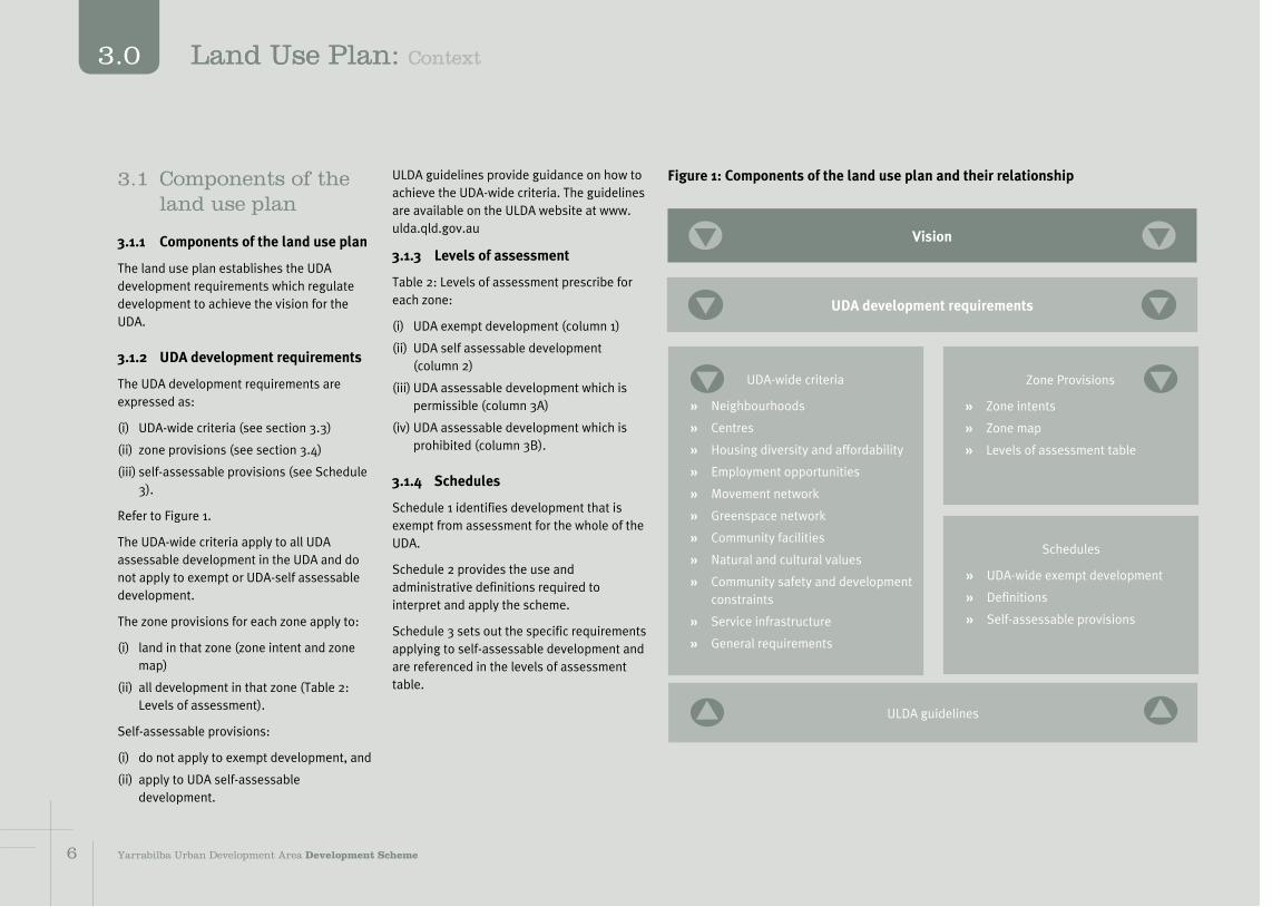
Figure 1: Components of the land use plan and their relationshipULDA guidelines provide guidance on how to achieve the UDA-wide criteria. The guidelines are available on the ULDA website at www.ulda.qld.gov.au
3.1.3 Levels of assessment
Table 2: Levels of assessment prescribe for each zone:
(i) UDA exempt development (column 1)
(ii) UDA self assessable development (column 2)
(iii) UDA assessable development which is permissible (column 3A)
(iv) UDA assessable development which is prohibited (column 3B).
3.1.4 Schedules
Schedule 1 identifies development that is exempt from assessment for the whole of the UDA.
Schedule 2 provides the use and administrative definitions required to interpret and apply the scheme.
Schedule 3 sets out the specific requirements applying to self-assessable development and are referenced in the levels of assessment table.
3.1 Components of the land use plan
3.1.1 Components of the land use plan
The land use plan establishes the UDA development requirements which regulate development to achieve the vision for the UDA.
3.1.2 UDA development requirements
The UDA development requirements are expressed as:
(i) UDA-wide criteria (see section 3.3)
(ii) zone provisions (see section 3.4)
(iii) self-assessable provisions (see Schedule 3).
Refer to Figure 1.
The UDA-wide criteria apply to all UDA assessable development in the UDA and do not apply to exempt or UDA-self assessable development.
The zone provisions for each zone apply to:
(i) land in that zone (zone intent and zone map)
(ii) all development in that zone (Table 2: Levels of assessment).
Self-assessable provisions:
(i) do not apply to exempt development, and
(ii) apply to UDA self-assessable development.
Vision
UDA development requirements
UDA-wide criteria
È Neighbourhoods
È Centres
È Housing diversity and affordability
È Employment opportunities
È Movement network
È Greenspace network
È Community facilities
È Natural and cultural values
È Community safety and development constraints
È Service infrastructure
È General requirements
Zone Provisions
È Zone intents
È Zone map
È Levels of assessment table
Schedules
È UDA-wide exempt development
È Definitions
È Self-assessable provisions
ULDA guidelines
6 Yarrabilba Urban Development Area Development Scheme
3.0 Land Use Plan: Context
3.2 Development assessment
3.2.1 Interpretation
Under the ULDA Act, section 6 development is development defined under the Sustainable Planning Act 2009, section 7.
Schedule 2 defines particular words used in this scheme, including uses and administrative terms.
3.2.2 Requirements for self-assessable development
UDA self-assessable development must comply with the applicable schedule (see schedule 3).
Under the ULDA Act, section 43, UDA self-assessable development must comply with the requirements under the development scheme for carrying out the UDA self-assessable development.
3.2.3 Development consistent with the land use plan
UDA assessable development is consistent with the land use plan if:
(i) the development complies with all relevant UDA-wide criteria and the zone intents, or
(ii) the development does not comply with one or more of the UDA-wide criteria or zone intent but:
a. the development does not conflict with the UDA vision, and
b. there are sufficient grounds to justify the approval of the development despite the non compliance with the UDA-wide criteria or zone intents.
UDA prohibited development is inconsistent with the land use plan. Under the ULDA Act, section 56 UDA assessable development that is inconsistent with the land use plan cannot be granted approval.
In this section 'grounds' means matters of public interest which include the matters specified as the main purposes of the Act as well as:
(i) superior outcomes
(ii) overwhelming community need.
'Grounds' does not include the personal circumstances of an applicant, owner or interested third party.
3.2.4 Development approval
Identification of development as UDA assessable development does not mean that a UDA development approval (with or without conditions) will be granted.
UDA assessable development requires a UDA development application to be lodged with the ULDA for assessment and decision.
Approval is required before UDA assessable development is undertaken.
3.2.5 Infrastructure agreements
A UDA development condition may require the land owner to enter into an infrastructure agreement, under section 97 of the Act, to address the provisions and requirements of the infrastructure plan and implementation strategy.
3.2.6 Consideration in principle
A request may be made to the ULDA for consideration in principle for proposed development.
In considering the request, the ULDA may decide to:
(i) support all or part of the proposed development, with or without qualifications that may amend the proposed development
(ii) oppose all or part of the proposed development
(iii) give no indication of either support or opposition to all or part of the proposed development.
The ULDA, when considering a development application:
(i) is not bound by any decision made regarding an application for consideration in principle
(ii) may give such weight as it considers appropriate to the decision in respect of the application for consideration in principle.
3.2.7 Development application
To the extent the UDA-wide criteria, zone intents and ULDA guidelines are relevant, they are to be taken into account in the preparation of a UDA development application and the assessment of the application by the ULDA.
The infrastructure plan and implementation strategy may include further information which should be taken into account in the preparation, design and feasibility of development proposals.
3.2.8 Context plans
The scheme maps provide a broad spatial framework to guide development of the UDA. Context plans provide the intermediate level of spatial planning between the scheme maps and individual development proposals. Context plans are required to ensure that the development proposal will not prejudice the achievement of the UDA vision, UDA-wide criteria and zone intents in a broader area around the development site.
Context plans are prepared by applicants and are required to accompany a UDA development application for:
(i) the first permissible development in the relevant context plan area, or
(ii) a later permissible development that is materially inconsistent with the existing ULDA-endorsed context plan for the context plan area.
However, a context plan is not required if:
77Yarrabilba Urban Development Area Development Scheme
3.0Land Use Plan: Context

(i) in the ULDA's opinion the proposed development is of a nature or scale, or will operate for such period of time, that the UDA vision, UDA-wide criteria and zone intents will not be compromised, or
(ii) the ULDA has undertaken more detailed planning for the broader area around the development site, has consulted with the community about the more detailed plan and the development proposal is materially consistent with the more detailed planning intentions for the area.
Applicants should discuss the requirement for a context plan with the ULDA in pre-application meetings.
A context plan is part of the supporting information for a UDA development application and will not form part of a UDA development approval.
The ULDA will assess the submitted context plan as part of the development assessment process for the UDA development application. The ULDA may request the applicant to change a context plan. A context plan may cover two or more contiguous context plan areas.
If the ULDA is satisfied that the context plan is consistent with the achievement of the UDA vision, UDA-wide criteria and zone intents the ULDA will signify that it has endorsed the context plan by placing the UDA endorsed context plan on the ULDA website. Once endorsed by the ULDA the context plan supersedes any previous ULDA-endorsed context plan for the same context
3.2.9 Plan of Development
A Plan of Development (PoD) may accompany an application for a material change of use or reconfiguring a lot and may deal with residential or non-residential uses as well as operational work.
A PoD is prepared by an applicant and may include maps, graphics and text that collectively demonstrate how proposed uses, works and lots will contribute towards the achievement of the vision and will be consistent with the relevant UDA development requirements.
The PoD can not include land beyond the boundary of the land the subject of the application, but may cover only part of the land the subject of the application.
Under Table 2: Levels of assessment, development approved in accordance with a PoD is exempt development and requires no further development approval under the scheme.
For further advice on preparing a PoD refer to the applicable ULDA practice note available on the ULDA website.
3.2.10 Notification requirements
A UDA development application will require public notification1 if the application:
È includes a proposal for development which does not comply with the zone intents
1 The ULDA practice note provides further guidance.
plan area. This process will allow context plans to evolve in response to changing market conditions or improved information and to progressively reflect the development intentions of various landowners in the context plan area.
A context plan should:
(i) resolve (if required) any development constraints that may determine the extent of developable area or appropriate uses
(ii) identify the location of major network infrastructure, including transport, within the context plan area
(iii) resolve the boundaries of centres, community greenspace network and sites for major community infrastructure such as parks and schools, and
(iv) demonstrate that the development proposal:
a. does not prejudice the ability for surrounding land to be developed in an orderly and efficient manner consistent with the UDA vision, UDA-wide criteria and zone intents, and
b. is consistent with existing and approved development in the context plan area and adjoining context plan areas.
A ULDA practice note provides details on how to prepare a context plan, and identifies the specific areas for which context plans are required (the context plan areas).
È is accompanied by a context plan required under section 3.2.8, or
È is for development which in the opinion of the ULDA, may have undue impacts on the amenity or development potential of adjoining land under separate ownership, including development for a non-residential use adjacent to land approved for or accommodating a residential use in the urban living zone.
The ULDA may require public notification in other circumstances if the development application is for a use, or of a size or nature which, in the opinion of the ULDA, warrants public notification.
3.2.11 Interim use
An interim use is a land use that, because of its nature, scale, form or intensity is not an appropriate long term use of the land. Interim land uses may occur if appropriately developed and operated and where located in areas which will not compromise the zone intent in the longer term. Possible interim uses are identified in the zone provisions.
The ULDA may approve an interim use if it can be demonstrated that an interim use will not preclude or delay an appropriate long term use or intensity of development. Information to support an application for an interim use may include:
È a context plan
È a schedule of land supply and projected take-up rates, or
8 Yarrabilba Urban Development Area Development Scheme
3.0 Land Use Plan: UDA wide criteria
È plans showing how the development could transition from the proposed interim use to an appropriate longer term use2.
The ULDA may impose a condition of approval that limits the duration of an interim use.
Interim uses will only be approved if it can be demonstrated that the use will not prejudice the achievement of the vision for the UDA.
3.2.12 Relationship with local government planning scheme and other legislation
This scheme may apply a provision of a planning instrument, or a plan, policy or code made under the SPA or another Act. However, the scheme prevails to the extent of any inconsistency with those instruments.
Car parking provisions
For exempt and self-assessable development, the relevant car parking provisions in the planning scheme.
Other legislation
In addition to assessment against the scheme, development may require assessment against other legislation including for example the Plumbing and Drainage Act 2002 and SPA.
2 The applicable ULDA guideline provides examples of how this might be achieved to centres.
3.2.13 Land not included in a zone
This section applies to land which is not shown in the land use plan as being included in a zone (unallocated land).
Where the unallocated land adjoins land in a zone, the unallocated land is deemed to be included in that zone.
Where the unallocated land adjoins land included in different zones, the unallocated land is deemed to be included in those zones with the centreline of the unallocated land being the boundary between the zones.
Environmental Design (CPTED) principles such as passive surveillance of public spaces, and a legible street network that minimises traffic impacts on residential areas
È locate higher density residential close to centres, significant transit opportunities, recreation and corridor parks, or along busier streets that lead directly to centres
È are designed to promote optimum solar access and use of prevailing breezes
È may be of an urban or suburban nature distinguished by residential density
È locate urban neighbourhoods in the major centre with good accessibility to transport nodes
È locate suburban neighbourhoods in residential areas
È appropriately interface with existing residential development adjoining the UDA boundary by:
È considering densities through minimum lot sizes and the location of property boundaries
È access arrangements
È uses
È height.
Neighbourhoods are designed to achieve:
È the standards set out in the applicable ULDA guideline and
È the minimum net residential densities
and specific requirements in Table 1.
3.3 UDA-wide criteria3.3.1 Neighbourhoods
Development delivers neighbourhoods that:
È are compact and walkable. Neighbourhoods comprise the area within a 5 minute walk (400 metre radius) of a community focal point. A cluster of neighbourhoods supports a neighbourhood centre
È have a highly permeable, legible street pattern, designed to promote walking and cycling as the primary modes for local movements
È contain a variety of dwelling types including affordable and accessible housing
È are designed to respond to local site characteristics, settings, landmarks, scenic amenity and views, and use natural features, such as ridges and waterways, or man made features such as built form and public parks to provide local identity and character
È have a centrally located focal point which must comprise of at least a local recreation park but which can also include a public transport stop, community facility, local shop or similar
È are interconnected and provide good access to public transport, parks, schools and other community facilities and neighbourhood centres
È provide a safe environment through the application of Crime Prevention Through
9Yarrabilba Urban Development Area Development Scheme 9
3.0Land Use Plan: UDA wide criteria

Zones
Urban living zone Major centre zone
Industry and business zoneSuburban
neighbourhoods (each)
Neighbourhood centres (each)
District centres (each) Core Frame
Maximum building height (storeys) 2(iv) (9.0m) 4 4
4 - 8 (with 4 adjoining Urban
living zone) .4 storeys.
4 - 8 (with 4 to
Waterford Tamborine
Road).
Minimum net residential density
15(ii) 20 25 40 20 N/A
Retail uses gross leasable area (maximum)
N/A 4,000m2 (i) 10,000m2 (i) 30,000(i) - 40,000m2 30,000(i) - 40,000m2 1,200m2 (i)
Showroom gross leasable area
(maximum)N/A N/A 2,000m2 (i) 40,000 - 80,000m2 50,000m2 (i)
Commercial uses gross leasable area (maximum)
N/A 1,000m2 2,500m2 75,000m2 40,000m2(i)
Community services(iii) (indicative GFA)
300m2 500-1,800m2 3,000-8,000m2 10,000-30,000m2 N/A
(i) Development proposals that would result in the aggregate gross leaseable area exceeding these indicative maximums (30,000m2 in the Major centre zone (Core) and Major centre zone (Frame)) must be accompanied by an economic impact assessment study report that demonstrates how the proposed additional area will complement and not compromise the network of centres in Logan City. This analysis must also demonstrate that:
(a) transport infrastructure can service the additional gross leaseable area and not jeopardise the road hierarchy and movement network and
(b) the additional gross leaseable area provides for increased employment opportunities and contributes to self containment within the UDA.
(ii) Unless it can be demonstrated this density cannot be achieved due to site constraints.
(iii) Includes community facilities as well as privately delivered services such as health, child care, aged care and respite services, sport and recreation and youth services.
(iv) With opprtunity for 3 storeys in appropriate locations.
Table 1: Height, gross leasable area and density provisions
1110 Yarrabilba Urban Development Area Development Scheme
3.0 Land Use Plan: Zones

3.3.2 Centres
Development delivers centres that:
È provide for knowledge, community and commerce accommodating a range of employment, education, cultural and community, retail, community greenspace, entertainment, sport and recreational opportunities which meet the needs of the community, encourage community interaction and active, healthy lifestyles
È are commensurate with their role in the SEQ Regional Plan, the broader Logan City network and the UDA centres network and the size of their service catchment
È comprise the major centre, district centres and neighbourhood centres. Centres are focal points for their catchments and provide a wide range of services and facilities
È respond to local site characteristics, settings, landmarks and views and use natural features to provide specific identity and character
È are active places characterised by a high quality public realm and safe, attractive pedestrian areas
È have a local recreation or civic park as a central focal point for community activities
È are located to maximise accessibility and distributed to ensure convenient access for residents taking into account the likely catchment and the centres
hierarchy
È provide a focus for corridor parks, the road network and act as hubs for feeder public transport and walking and cycling networks
È give priority to public and active transport
È have a permeable road network that provides vehicle access into centres through a network of low-speed urban streets
È locate higher density development, including residential development and key community facilities in the core of the centre. The core is the area within the 400 metre primary walking catchment of the major transit node or central focal point
È locates lower intensity and car dependent uses on the periphery of the centre. The major centre frame can also include neighbourhoods with a higher density residential development
È contain commercial, retail and other uses which require high levels of accessibility.
The major centre is the focal point of the community. It will provide a wide range of facilities and services, including most higher-order services. The highest density of activities and key community facilities are in the core, close to the major transit node.
District centres are the intermediate tier in the centres hierarchy and provide a wide range of goods and services with relatively high densities.
Neighbourhood centres provide a range of services and activities to meet day-to-day needs. Neighbourhood centres are located on collector or higher order roads with good access by public and active transport.
Small scale shops and office activities, with an aggregate gross floor area of 250m2 or less, are acceptable outside a centre where development will not constitute an incremental expansion to a designated centre and will not have a detrimental impact on residential amenity and the centres hierarchy.
Non-residential uses are located within or adjacent to centres, or in other locations that maintain a high quality of residential amenity.
Map 3 - Centres and transport networks indicates the general distribution of centres within the UDA
Centres are designed to achieve:
È the principles and design standards set out in the applicable ULDA guideline and
È the specific requirements set out in Table 1.
3.3.3 Housing diversity and affordability
Development delivers:
È housing choice and diversity to meet the needs of the community, through a mix of densities, types, designs, tenures and levels of affordability, to cater for a range of lifestyles, incomes and life cycle needs
È residential development that complements or enhances the character of the neighbourhood and streetscape and contributes to the creation of an attractive and safe environment
È dwellings that provide appropriate levels of amenity and privacy and adequate outdoor areas and car parking to meet varying household needs
È energy efficient, climatically responsive design including appropriate solar orientation, shading, cross ventilation, natural lighting and passive cooling techniques.
The ULDA's applicable guidelines provide additional information on how to achieve these criteria.
3.3.4 Employment opportunities
Development delivers:
È a wide range of accessible employment opportunities
È employment and training opportunities which complement those in nearby major industry employment areas such as Yatala
È employment activities in centres, including centre frames, or local industry and business areas
È low impact activities including low impact industry, service industry, research and technology facilities and warehouses
11Yarrabilba Urban Development Area Development Scheme 1110
3.0Land Use Plan: Zones
È development of a scale and intensity which is compatible with existing and proposed development in the vicinity.
Non-residential uses may be established in the urban living zone where
È development does not impact on residential amenity
È there is adequate access including access by public and active transport modes
È development does not attract high volumes or unacceptable types of traffic (i.e. heavy service vehicles) into residential areas.
The applicable ULDA guideline provides additional information on how to achieve these criteria.
3.3.5 Movement network
Development contributes to:
È an effective, efficient and integrated movement network that provides a high level of safety and accessibility, maintains residential amenity and promotes the use of public and active transport particularly for local trips
È a major road network that provides effective links between centres and the neighbourhoods they serve, and to the external road network, and accommodates a range of users including cars, service vehicles, pedestrians, cyclists and public transport
È a road network that has a functional hierarchy, provides multiple access routes to and through neighbourhoods and minimises traffic impacts on residential areas
È the provision of a public transport network that is readily accessible to the community (90% of all dwellings should be within 400 metres of a potential public transport service) and provides effective links to centres and key external destinations3
È a comprehensive active transport (walking and cycling) network based around major active transport spines, supplemented with local links and a safe and permeable street network within neighbourhoods4. The active transport network provides safe and direct links to and through key destinations including centres, parks and schools.
Map 3 - Centres and transport networks identifies the indicative road and public transport network for the UDA.
The applicable ULDA guideline provides additional information to assist in achieving these criteria.
3 Future transport investigations may be undertaken into connecting development in Yarrabilba to other centres in Logan City.
4 Where active transport enters the on-road environment, treatment should be consistent with Austroads: "Cycling Aspects of Austroads Guides (March 2011)".
È providing ecological corridors and linkages, including to areas outside the neighbourhood or community.
Development delivers parks that:
È contribute to the ahievement of an integrated, high quality greenspace network that caters for a variety of recreation functions and experiences to meet the needs of residents and visitors
È are accessible for users
È provide for multiple purposes and uses including recreational, sporting, ecological and stormwater management functions
È incorporate existing natural features where possible and are landscaped to assist in creating neighbourhood identity and wayfinding
È retain existing significant vegetation to the greatest extent practicable
È are shaped and embellished to suit their anticipated use
È support the community's recreational needs and provide opportunities for community and special events.
The community greenspace network is distributed generally in accordance with Map 4 - Community greenspace network.
The community greenspace network is located and designed to achieve the principles and design standards set out in the applicable ULDA guideline.
The applicable ULDA guideline provides more detail on how to achieve environmental criteria.
3.3.6 Community greenspace network
Development contributes to the provision of an integrated, high quality, regional community greenspace network that caters for a range of environmental needs by:
È retaining where possible locally significant remnant vegetation and habitat for fauna
È achieving a 200 metre wide corridor across the central fauna corridor that traverses the site from Plunkett Conservation Park to the crossing at Waterford Tamborine Road
È achieving a 100 metre wide corridor in the secondary fauna corridor south west of Plunkett Conservation Park along the tributary of the creek flowing south to the Albert River and the secondary central east-west corridor
È locating and designing fauna connectivity structures for species native to the region in road infrastructure that traverses identified future fauna corridors
È interface treatments between development and the primary and secondary fauna corridors will be designed to enhance the protection of significant fauna and flora habitat while also integrating open space adjacent to these corridors
È protecting important landscape and visual quality values including scenic amenity areas
È enhancing wetland communities as part of stormwater management
12 Yarrabilba Urban Development Area Development Scheme
3.0 Land Use Plan: UDA wide criteria
3.3.7 Community facilities
Development facilitates the delivery of:
È sustainable communities with a strong community identity and access to community facilities and services that meet diverse needs, maximise potential for community development and enhance community wellbeing
È a range of community facilities and services that are accessible and appropriate to the needs of the community and reduce physical and social isolation
È community facilities and services that are located where accessibility to the facility's target market is maximised through good access to public transport, pedestrian and cycle paths.
È a hierarchy of community facilities and services in neighbourhood, district and major centres. Neighbourhood level community facilities and services are located within walking distance for most residents, meet everyday needs and are provided early in development. District level community facilities and services serve a broader population catchment, reflect the diverse needs of the population and are provided in response to population growth thresholds. Major community facilities and services are of a higher order and accessed by a sub-regional population.
Map 5 - Community facilities indicates the general distribution of community facilities within the UDA.
Community facilities are designed to achieve the principles and standards set out in the applicable ULDA guideline.
3.3.8 Natural and cultural values
Development responds to the constraints of the land and delivers:
È protection of significant environmental and ecological values
È protection of Remnant Endangered vegetation where proven by groundtruthing to be viable
È minimal emissions to land, water and atmosphere
È protection of culturally significant places and items
È efficient use of land and resources.
The design, siting and layout of development:
È avoids, minimises or offsets development impacts on areas of biodiversity value
È maintains or improves ecological connectivity in the local urban context
È incorporates landscaping with endemic species that contribute to bushland character, flora and fauna habitat, and fauna movement
È respects cultural heritage values
È minimises adverse impacts on natural landforms and the visual amenity of the site
È maintains or improves the ecological health and environmental values of surface and groundwater in and adjacent to the UDA
È maintains and improves the functioning and characteristics of the hydrological network (including surface and groundwater) and generally maintains the natural flow regime
È incorporates total water cycle management and water sensitive urban design principles to appropriately manage floodwater and stormwater
È applies best practice sediment and erosion control techniques
È ensures that all land and groundwater will be fit for purpose in accordance with accepted standards and practices
È manages air quality, noise and hazardous materials according to current standards
È promotes innovative and efficient use of energy and water
È maximises recycling opportunities and reduces waste generation.
Koala conservation
The design, siting and layout of development:
È incorporates koala conservation and habitat protection outcomes in a way that contributes to a net increase in koala habitat and assists in the long term viability of koala populations in SEQ
È avoids (to the greatest extent possible) the clearing of areas mapped as High Value Bushland on the relevant State Planning Policy 2/10: Koala Conservation in South East Queensland (SPP) Koala Habitat Values Map
È caters for koala movement between conserved areas of bushland koala habitat
È ensures impacts on koala habitat are offset5 through the delivery of a net benefit to koalas, including through the expansion of habitat on lands as suitable for rehabilitation
È incorporates koala sensitive urban design.
Map 6 - Natural values shows the key natural and cultural values in the UDA.
The applicable ULDA guideline provides more detail on how to achieve these criteria.
5 Refer to the applicable ULDA guideline for koala offsets.
13Yarrabilba Urban Development Area Development Scheme 13
3.0Land Use Plan: UDA wide criteria
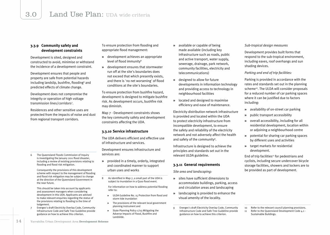
3.3.9 Community safety and development constraints
Development is sited, designed and constructed to avoid, minimise or withstand the incidence of a development constraint.
Development ensures that people and property are safe from potential hazards including landslip, bushfire, flooding6 and predicted effects of climate change.
Development does not compromise the integrity or operation of high voltage transmission lines/corridors7.
Residences and other sensitive uses are protected from the impacts of noise and dust from regional transport corridors.
6 The Queensland Floods Commission of Inquiry is investigating the January 2011 flood disaster, including a review of existing provisions relating to flooding and flood risk mitigation.
Consequently the provisions of this development scheme with respect to the management of flooding and flood risk mitigation may be subject to change at the direction of the Queensland Government in the near future.
This should be taken into account by applicants and assessment managers when considering development in this UDA. Applicants are advised to make relevant enquiries regarding the status of the provisions relating to flooding to the time of lodgement.
7 Energex's draft Electricity Overlay Code, Community Infrastructure Code and Safe Tree Guideline provide guidance on how to achieve this criterion.
To ensure protection from flooding and appropriate flood management:
È development achieves an appropriate level of flood immunity8
È development ensures that stormwater run off at the site's boundaries does not exceed that which presently exists, and there is 'no net worsening' of flood conditions at the site's boundaries.
To ensure protection from bushfire hazard, development is designed to mitigate bushfire risk. As development occurs, bushfire risk may diminish.
Map 7 - Development constraints shows the key community safety and development constraints affecting the UDA.
3.3.10 Service infrastructure
The UDA delivers efficient and effective use of infrastructure and services.
Development ensures infrastructure and services are:
È provided in a timely, orderly, integrated and coordinated manner to support urban uses and works
8 As identified in Map 7, a small part of the UDA is subject to inundation in a Q100 flood event.
For information on how to address potential flooding refer to:
È ULDA Guideline No. 15 Protection from flood and storm tide inundation
È The provisions of the relevant local government planning instrument and
È State Planning Policy 1/03 Mitigating the Adverse Impacts of Flood, Bushfire and Landslide.
È available or capable of being made available (including key infrastructure such as roads, public and active transport, water supply, sewerage, drainage, park network, community facilities, electricity and telecommunications)
È designed to allow for future developments in information technology and providing access to technology in neighbourhood facilities
È located and designed to maximise efficiency and ease of maintenance.
Electricity distribution network infrastructure is provided and located within the UDA to protect electricity infrastructure from incompatible development, to ensure the safety and reliability of the electricity network and not adversely affect the health and safety of the community9.
Infrastructure is designed to achieve the principles and standards set out in the relevant ULDA guideline.
3.3.11 General requirements
Site area and landscaping:
È sites have sufficient dimensions to accommodate buildings, parking, access and circulation areas and landscaping
È landscaping is provided to enhance the visual amenity of the locality.
9 Energex's draft Electricity Overlay Code, Community Infrastructure Code and Safe Tree Guideline provide guidance on how to achieve this criterion.
Sub-tropical design measures
Development provides built forms that respond to the sub-tropical environment, including eaves, roof overhangs and sun shading devices.
Parking and end of trip facilities:
Parking is provided in accordance with the rates and standards set out in the planning scheme10. The ULDA will consider proposals for a reduced number of car parking spaces where it can be justified due to factors including:
È availability of on-street car parking
È public transport accessibility
È overall accessibility, including for all residential development, location within or adjoining a neighbourhood centre
È potential for sharing car parking spaces by different uses and activities
È target markets for residential development.
End of trip facilities11 for pedestrians and cyclists, including secure undercover bicycle storage facilities, showers and lockers are to be provided as part of development.
10 Refer to the relevant council planning provisions.11 Refer to the Queensland Development Code 4.1 -
Sustainable Buildings.
14 Yarrabilba Urban Development Area Development Scheme
3.0 Land Use Plan: UDA wide criteria

Advertising devices:
Advertising devices are in accordance with standards set out in the planning scheme12.
È cater for the needs of display homes and businesses to clearly identify the location, the goods or services which are supplied to the public
È are consistent with the scale and design of existing buildings and other works on the site and in the locality and complement the local streetscape
È where appropriate, reflect the character of the area
È are sited and provided on premises having regard to safety and amenity.
12 Refer to relevant council planning provisions.
15Yarrabilba Urban Development Area Development Scheme 15
3.0Land Use Plan: UDA wide criteria

Map 3 - Centres and transport network
Produced by the Urban Land Development Authority (ULDA) 2011 Map is intended for illustration purposes only and unless stated is not to scale
16 Yarrabilba Urban Development Area Development Scheme
3.0 Land Use Plan: UDA wide criteria

Map 4 - Community greenspace network
Produced by the Urban Land Development Authority (ULDA) 2011 Map is intended for illustration purposes only and unless stated is not to scale
17Yarrabilba Urban Development Area Development Scheme 17
3.0Land Use Plan: UDA wide criteria

Map 5 - Community facilities
Produced by the Urban Land Development Authority (ULDA) 2011 Map is intended for illustration purposes only and unless stated is not to scale
18 Yarrabilba Urban Development Area Development Scheme
3.0 Land Use Plan: UDA wide criteria

Map 6 - Natural values
Produced by the Urban Land Development Authority (ULDA) 2011 Map is intended for illustration purposes only and unless stated is not to scale
19Yarrabilba Urban Development Area Development Scheme 19
3.0Land Use Plan: UDA wide criteria

Map 7 - Development constraints
Produced by the Urban Land Development Authority (ULDA) 2011 Map is intended for illustration purposes only and unless stated is not to scale
212020 Yarrabilba Urban Development Area Development Scheme
3.0 Land Use Plan: UDA wide criteria

Map 8 - Zones
Produced by the Urban Land Development Authority (ULDA) 2011 Map is intended for illustration purposes only and unless stated is not to scale
21Yarrabilba Urban Development Area Development Scheme 2120
3.0Land Use Plan: Zones

3.4 Zone provisions
3.4.1 Zone map
Map 8 - Zones shows the location and boundaries of zones in the UDA. The UDA contains 4 zones:
È Urban living
È Major centre
È Industry and business
È Environmental protection
Inclusion of land within the urban living, major centre, industry and business zone does not imply that all such lands can be developed for urban purposes. Some land may not be available or appropriate to be developed due to local site conditions or other constraints.
3.4.2 Zone intents
Urban living zone
The urban living zone applies to most of the area intended for urban development in the UDA. The majority of the zone is intended to be developed as urban and suburban neighbourhoods focused on identifiable and accessible centres and comprising of a mix of residential development including houses, multiple residential and other residential and live work opportunities through home based business.
The urban living zone is also intended to accommodate a wide range of other non-residential activities. These other activities include:
È district centres and neighbourhood centres
È a community greenspace network comprising parks, environmental areas and open space corridors along waterways
È local employment areas such as small scale industry and business areas (e.g. service/trade clusters) and local shops
È specific facilities and institutions such as educational establishments, child care centres and community facilities.
Other than in identified centres, non-residential uses may also be approved in the urban living zone where it is demonstrated to the satisfaction of the ULDA that:
È the proposed use has appropriate vehicular access that will not result in excessive numbers of vehicles passing through residential areas
È cater for the needs of the immediate community and are consistent with or do not compete/undermine the vitality of the centres hierarchy
È any impacts associated with the use (e.g. noise, dust, emissions) will not affect residential or other sensitive uses.
Reference should be made to Table 1 and applicable ULDA guidelines for further detail on the preferred locations, scale, form and nature of development in the urban living zone.
The urban living zone may also accommodate Interim uses such as:
È Agriculture
È Agriculture supply store
È Animal keeping and husbandry
È Intensive horticulture.
The UDA-wide criteria provide guidance about the preferred nature and locations for some of these activities.
Major centre zone
The major centre zone provides the central focus of the UDA and is located in the geographic centre of Yarrabilba. The major centre zone accommodates the greatest mix of land uses and highest densities in the UDA.
Land within the major centre zone falls into two categories: the major centre core and the major centre frame.
The exact boundaries between the major centre core and major centre frame will be determined through the context planning and development assessment process.
Interim uses may include:
È Bulk landscape supplies
È Warehouse.
Rural uses are not envisaged in the major centre zone.
Major centre core
The major centre core accommodates the highest order mixed use centre activities providing a mix of commercial, business, professional, community, entertainment, retail and high density residential activities. The major centre core is the most intense urban setting, forms the heart of the UDA and is capable of servicing the whole UDA.
The major centre is characterized by high density development up to 8 storeys in height, transitioning to 4 storeys on properties adjacent to residential neighbourhoods.
Development within the major centre core delivers:
È a centre which is commensurate with its role in the SEQ Regional Plan, UDA centres network, the broader Logan City Council network and the size of their service catchments
È safe, attractive and permeable movement networks for pedestrians and cyclists
È ground floor areas which are used primarily for retail, 'shop front' and other active uses
2322 Yarrabilba Urban Development Area Development Scheme
3.0 Land Use Plan: Zones

È upper floor levels which are used for a variety of uses including retail, offices, entertainment and residential uses
È provides north-south and east-west connections supporting vehicular and pedestrian/cycle traffic
È lower intensity uses or large building format uses which are 'sleeved' by active street frontage uses
È parking in basements or where provided at ground level, partially screened from streets and other public areas by buildings or landscaping
È high quality design that recognises the importance of streetscape and public realm and contributes to the overall attractiveness of the major centre
È buildings, streets and parks that optimize physical and visual connections to surrounding open space areas.
The major centre core is the principal focus of retail activities in the UDA. The retail precinct includes:
È speciality retail
È department stores, discount department stores and supermarkets
È entertainment, recreation, leisure, cultural, education and community facilities
È food, beverage and dining facilities, including alfresco dining
È convenience retail for workers, residents and visitors.
The major centre core also accommodates major civic buildings, educational and health facilities and a centrally located public activity plaza as a social meeting point for the community.
Uses other than retail, residential and commercial should not have any off-site impacts that may affect the amenity of adjoining areas whether developed or not.
Lower intensity uses and uses that do not require high levels of public transport accessibility, such as showrooms and warehouses are not appropriate long-term uses in the major centre core.
Major centre frame
The major centre frame accommodates a mix of land uses including:
È uses that support activities in the major centre core (such as service industry and low impact industry)
È uses that benefit from a central, accessible location within the UDA but are low intensity uses (such as warehouses, outdoor sales, showrooms and service stations)
È residential uses take advantage of proximity to the range of employment opportunities, services and facilities located in the major centre core
È a variety of public open spaces including local parks with play facilities and access to open space corridors.
Retail development that has the potential to detract from the vitality and viability of retailing in the major centre core is not suitable for the major centre frame. Retail development will only be approved in the major centre frame where it is:
È not suitable for the major centre core
È small scale retail to meet the needs of a local catchment of residents or workers
È retailing activity that has a nexus with a use that is not suitable for the major centre
È for a retail showroom.
The major centre frame will incorporate a number of urban neighbourhoods. The transitional nature of this area between the major centre core and the surrounding residential neighbourhoods means there is likely to be a wide variety of dwelling types ranging from small precincts of houses to multi-level apartment buildings, with densities increasing with proximity to the major centre core.
Key roads in the major centre frame, including those providing direct access to the major centre core, are pedestrian and cyclist friendly with high quality streetscapes and a distinct urban feel. Any large format retail/commercial buildings should ultimately be sleeved along these streets by smaller-scale shops, food premises and businesses, where practical, to ensure active frontages and visual interest.
Phasing of development in the major centre zone
The desired long-term layout, mix of uses and intensity of development will only be delivered in the long term. However it is important to ensure that the active, pedestrian friendly character is established as part of the initial stage of development of the major centre. Staging of development and interim uses may be acceptable where they do not compromise the delivery of the desired long term outcomes.
Some land within the major centre zone may not be developed until the Yarrabilba community reaches certain population thresholds. These areas should be retained for longer term development with interim uses supported where control of the land parcels allows later redevelopment. Context plans should demonstrate how earlier development takes into account longer term development areas and maintains the integrity and compactness of earlier development.
The applicable ULDA guideline provides more information on achieving these requirements including indicative staging of development.
23Yarrabilba Urban Development Area Development Scheme 2322
3.0Land Use Plan: Zones
Industry and business zone
The industry and business zone accommodates industrial, business park and commercial activities which do not generate dust, noise and odour emissions beyond the zone. The zone provides for a wide range of compatible industrial uses including low and medium impact industry, research and technological industries, knowledge creation, entrepreneurial activity and service industry activities.
A limited range of other uses may also be acceptable in the industry and business zone where it can be demonstrated that the use:
È supports or otherwise has a clear nexus with the primary uses within the zone
È provides a service to the workforce within the zone
È will not prejudice the establishment or operation of the primary uses within the zone.
Non-industrial uses, such as commercial, trade retail activities, business and a range of other supporting/ complementary uses may locate in the zone where such uses do not compromise the intended industrial/ business character of the local area. Uses that promote knowledge creation and entrepreneurial activity in industry, science and technology and research and development are encouraged.
The location, design, operation and management of uses and works contribute to the amenity, built form, landscaping and
streetscape which enhances the industrial and business character of the area.
Development will include visual buffering at appropriate locations along Waterford Tamborine Road to promote the establishment of a landscape screen for external properties facing the development in the industry and business zone.
Development has linkages to existing and proposed transport infrastructure, public transport services, bicycle and pedestrian networks and community facilities and maximises the sustainable and efficient use of essential services, including water, sewer, energy, and telecommunications infrastructure.
The zone may accommodate unanticipated interim land uses that do not compromise the long term use of the land for its intended purpose.
Environmental protection zone
The environmental protection zone includes areas that are of environmental significance and have associated conservation, biodiversity, habitat or scenic amenity values. The zone may also provide for buffers between incompatible land uses and includes land constrained by features such as bushfire risk and steep slopes. The zone may accommodate elements of an integrated open space network providing for multi-purpose functions that respond to community needs provided they do not compromise environmental values.
Very low intensity development may occur where such uses do not affect the environmental significance of the local area. Development should embrace sustainable land management practices, minimise clearing and contribute to the amenity and landscape of the area. The environmental protection zone provides opportunities for habitat improvement.
2524 Yarrabilba Urban Development Area Development Scheme
3.0 Land Use Plan: Zones

Table 2: Levels of assessment
Column 1Exempt development
Column 2 UDA self assessable development
Column 3 – UDA assessable development
Column 3APermissible development
Column 3BProhibited development
In the Urban living zone
1. An environmentally relevant activity if:
(i) a code of environmental compliance has been made for that activity under the Environmental Protection Regulation 2008, and
(ii) the activity complies with that code.
2. If the land is not on the Environmental Management Register or Contaminated Land Register:
(i) development specified in schedule 1
(ii) development for Home based business
(iii) development for a sales office where not greater than 150m2
(iv) material change of use, where not involving building work (other than minor building work) or operational work, for a use other than Car park, where:
(a) any existing use and the proposed use are both included in either the Commercial use or Retail use categories in schedule 2 where complying with the parking rate in the planning scheme
1. If the land is not on the Environmental Management Register or Contaminated Land Register:
(i) Material change of use for a House or Display home where:
(a) the lot is 400m2 or more
(b) the lot frontage is 12.5 metres or more
(c) it complies with the applicable self assessable provisions in schedule 3, and
(d) the house is situated outside a development constraint area depicted on Map 7.
1. Reconfiguring a lot that is not mentioned in schedule 1
2. Making a material change of use if
(i) the use is not defined in schedule 2, or
(ii) the change of use is not mentioned in columns 1, 2, or 3B.
3. Operational work or building work if the work is not mentioned in columns 1, 2, or 3B.
Development for:
1. Extractive industry
2. High impact industry
3. Medium impact industry
4. Noxious and hazardous industry.
25Yarrabilba Urban Development Area Development Scheme 2524
3.0Land Use Plan: Zones
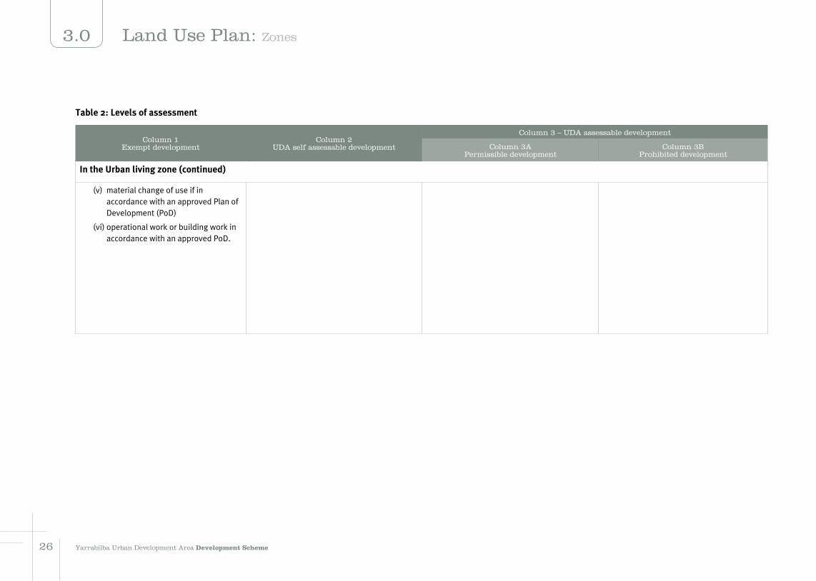
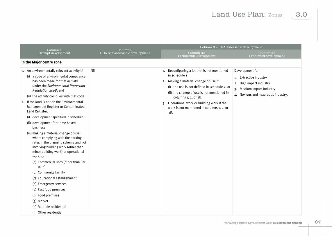
Table 2: Levels of assessment
Column 1Exempt development
Column 2 UDA self assessable development
Column 3 – UDA assessable development
Column 3APermissible development
Column 3BProhibited development
In the Urban living zone (continued)
(v) material change of use if in accordance with an approved Plan of Development (PoD)
(vi) operational work or building work in accordance with an approved PoD.
2726 Yarrabilba Urban Development Area Development Scheme
3.0 Land Use Plan: Zones
Column 1Exempt development
Column 2 UDA self assessable development
Column 3 – UDA assessable development
Column 3APermissible development
Column 3BProhibited development
In the Major centre zone
1. An environmentally relevant activity if:
(i) a code of environmental compliance has been made for that activity under the Environmental Protection Regulation 2008, and
(ii) the activity complies with that code.
2. If the land is not on the Environmental Management Register or Contaminated Land Register:
(i) development specified in schedule 1
(ii) development for Home based business
(iii) making a material change of use where complying with the parking rates in the planning scheme and not involving building work (other than minor building work) or operational work for:
(a) Commercial uses (other than Car park)
(b) Community facility
(c) Educational establishment
(d) Emergency services
(e) Fast food premises
(f) Food premises
(g) Market
(h) Multiple residential
(i) Other residential
Nil 1. Reconfiguring a lot that is not mentioned in schedule 1
2. Making a material change of use if
(i) the use is not defined in schedule 2, or
(ii) the change of use is not mentioned in columns 1, 2, or 3B.
3. Operational work or building work if the work is not mentioned in columns 1, 2, or 3B.
Development for:
1. Extractive industry
2. High impact industry
3. Medium impact industry
4. Noxious and hazardous industry.
27Yarrabilba Urban Development Area Development Scheme 2726
3.0Land Use Plan: Zones

Column 1Exempt development
Column 2 UDA self assessable development
Column 3 – UDA assessable development
Column 3APermissible development
Column 3BProhibited development
In the Major centre zone (continued)
(j) Place of assembly
(k) Research and technology facility
(l) Shop
(m) Showroom
(n) Sport, recreation and entertainment
(o) Warehouse
(iv) material change of use if in accordance with an approved Plan of Development (PoD)
(v) operational work or building work in accordance with an approved PoD.
2928 Yarrabilba Urban Development Area Development Scheme
3.0 Land Use Plan: Zones

Column 1Exempt development
Column 2 UDA self assessable development
Column 3 – UDA assessable development
Column 3APermissible development
Column 3BProhibited development
In the Industry and business zone
1. An environmentally relevant activity if:
(i) a code of environmental compliance has been made for that activity under the Environmental Protection Regulation 2008, and
(ii) the activity complies with that code.
2. If the land is not on the Environmental Management Register or Contaminated Land Register:
(i) development specified in schedule 1
(ii) making a material change of use where complying with the parking rates in the planning scheme and not involving building work (other than minor building work) or operational work for:
(a) Emergency services
(b) Low impact industry
(c) Research and technology facility
(d) Service industry
(e) Showroom
(f) Warehouse.
Nil 1. Reconfiguring a lot that is not mentioned in schedule 1
2. Making a material change of use if
(i) the use is not defined in schedule 2, or
(ii) the change of use is not mentioned in columns 1, 2, or 3B.
3. Operational work or building work if the work is not mentioned in columns 1, 2, or 3B.
Development for:
1. Extractive industry
2. High impact industry
3. Noxious and hazardous industry
4. Residential (other than Short term accommodation)
5. Rural
6. Tourist park.
29Yarrabilba Urban Development Area Development Scheme 2928
3.0Land Use Plan: Zones

Column 1Exempt development
Column 2 UDA self assessable development
Column 3 – UDA assessable development
Column 3APermissible development
Column 3BProhibited development
In the Environmental Protection Zone
Nil Nil 1. Operational work
2. Development for:
È Agriculture
È Animal keeping and husbandry
È Emergency Services
È Environmentally relevant activities
È Park
È Telecommunication facility
È Tourist attraction
È Utility installation.
All other development, including development not defined in schedule 2, other than development mentioned in Columns 1, 2 and 3A.
3130 3130 Yarrabilba Urban Development Area Development Scheme
3.0 Land Use Plan: Zones

Infrastructure Plan
4.1 Approach
Infrastructure requirements to achieve the planning outcomes will be delivered through the development assessment process, imposed as conditions of a UDA approval for development and delivered as part of the building and operational works on the site.
Infrastructure delivery is divided into 2 components:
1. Local infrastructure will include all internal works and external water and sewerage connections required to deliver the development including:
a. transport (including roads, public transport and active transport)
b. community facilities (including parks and plazas, community facility sites, State school sites)
c. network infrastructure (including water supply and sewerage, stormwater management, telecommunications and power).
2. Sub-regional infrastructure which includes major trunk works for connection to council and state's transport network systems and the local water authority's treatment system. These works are detailed in section 4.4.
In this UDA the developer will be required to deliver all local infrastructure required to service the development along with a contribution towards sub-regional infrastructure.
Listed in Table 4.3 and 4.4 is the infrastructure currently associated with the Yarrabilba UDA. These infrastructure requirements reflect current understanding. However, further more detailed infrastructure investigations will occur as the development continues and the infrastructure requirements and delivery responsibilities may be amended to reflect the outcomes of these investigations.
State expenditure for investment in infrastructure will be subject to consideration through normal budgetary processes and will be part of an approved state agency capital works program.
4.2 Infrastructure agreements
A UDA development condition may require the land owner to enter into an infrastructure agreement, under section 97 of the Act, to address the provisions and requirements of the infrastructure plan and implementation strategy.
For larger sites, to ensure the UDA community evolves over time to achieve innovation and best practice, a tiered infrastructure agreement approach is required with a head infrastructure agreement and numerous secondary infrastructure agreements.
The overarching head infrastructure agreement will contain commitments for the whole UDA and address the applicant's responsibilities in relation to the delivery of:
È key infrastructure items delivered within the site
È key infrastructure items delivered external to the site (eg. road upgrades, trunk water and sewerage infrastructure)
È affordable housing
È public transport
È strategies to achieve ecological sustainability outcomes contained in the implementation strategy.
Separate agreements with individual utilities and the local authority may also be required.
The head infrastructure agreement will include provisions to identify the monitoring, compliance and enforcement system that will apply over the UDA's life.
Secondary infrastructure agreements will support the head infrastructure agreement and generally cover the same geographic areas as the context plans. Like context plans, these secondary infrastructure agreements will be progressively entered into at relevant points in the future which will ensure they include best practice standards and practices that are contemporary to that time. Secondary infrastructure agreements will address:
È area specific infrastructure delivery obligations (eg. transport, water, open space, community facilities)
È delivery of environmental protection areas
È housing types and percentages
È pedestrian and cycle network facilities
È location and size of community land and facilities.
The combination of context plans and a tiered infrastructure agreement approach provides the mechanism to review the appropriateness of development standards and practices and to incorporate improvements in technology and practices in future context plans and secondary infrastructure agreements.
31Yarrabilba Urban Development Area Development Scheme 3130
4.0Infrastructure Plan
3130
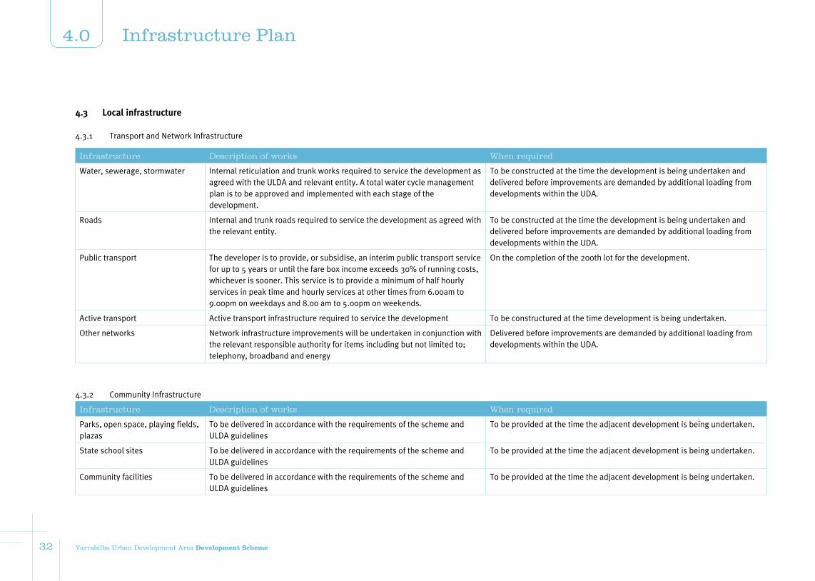
4.3.1 Transport and Network Infrastructure
Infrastructure Description of works When required
Water, sewerage, stormwater Internal reticulation and trunk works required to service the development as agreed with the ULDA and relevant entity. A total water cycle management plan is to be approved and implemented with each stage of the development.
To be constructed at the time the development is being undertaken and delivered before improvements are demanded by additional loading from developments within the UDA.
Roads Internal and trunk roads required to service the development as agreed with the relevant entity.
To be constructed at the time the development is being undertaken and delivered before improvements are demanded by additional loading from developments within the UDA.
Public transport The developer is to provide, or subsidise, an interim public transport service for up to 5 years or until the fare box income exceeds 30% of running costs, whichever is sooner. This service is to provide a minimum of half hourly services in peak time and hourly services at other times from 6.00am to 9.00pm on weekdays and 8.00 am to 5.00pm on weekends.
On the completion of the 200th lot for the development.
Active transport Active transport infrastructure required to service the development To be constructured at the time development is being undertaken.
Other networks Network infrastructure improvements will be undertaken in conjunction with the relevant responsible authority for items including but not limited to; telephony, broadband and energy
Delivered before improvements are demanded by additional loading from developments within the UDA.
4.3.2 Community Infrastructure
Infrastructure Description of works When required
Parks, open space, playing fields, plazas
To be delivered in accordance with the requirements of the scheme and ULDA guidelines
To be provided at the time the adjacent development is being undertaken.
State school sites To be delivered in accordance with the requirements of the scheme and ULDA guidelines
To be provided at the time the adjacent development is being undertaken.
Community facilities To be delivered in accordance with the requirements of the scheme and ULDA guidelines
To be provided at the time the adjacent development is being undertaken.
4.3 Local infrastructure
32 Yarrabilba Urban Development Area Development Scheme
4.0 Infrastructure Plan
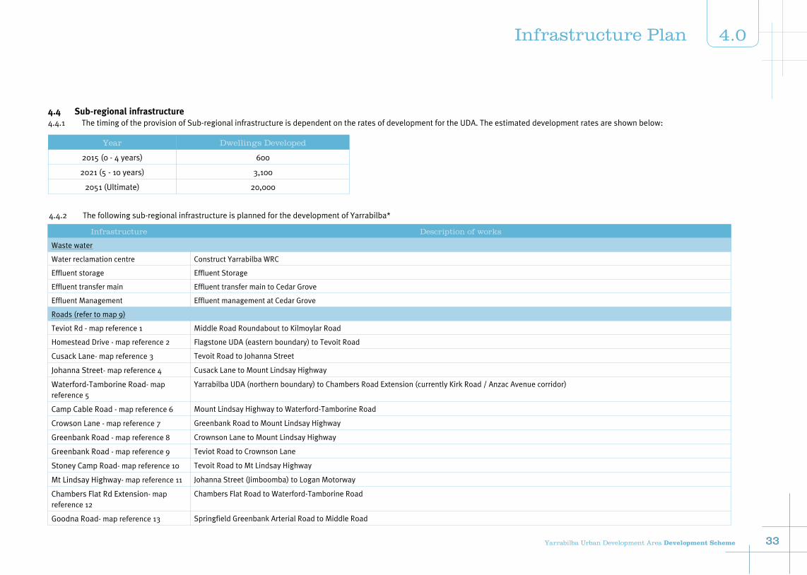
4.4 Sub-regional infrastructure4.4.1 The timing of the provision of Sub-regional infrastructure is dependent on the rates of development for the UDA. The estimated development rates are shown below:
Year Dwellings Developed
2015 (0 - 4 years) 600
2021 (5 - 10 years) 3,100
2051 (Ultimate) 20,000
Infrastructure Description of works
Waste water
Water reclamation centre Construct Yarrabilba WRC
Effluent storage Effluent Storage
Effluent transfer main Effluent transfer main to Cedar Grove
Effluent Management Effluent management at Cedar Grove
Roads (refer to map 9)
Teviot Rd - map reference 1 Middle Road Roundabout to Kilmoylar Road
Homestead Drive - map reference 2 Flagstone UDA (eastern boundary) to Tevoit Road
Cusack Lane- map reference 3 Tevoit Road to Johanna Street
Johanna Street- map reference 4 Cusack Lane to Mount Lindsay Highway
Waterford-Tamborine Road- map reference 5
Yarrabilba UDA (northern boundary) to Chambers Road Extension (currently Kirk Road / Anzac Avenue corridor)
Camp Cable Road - map reference 6 Mount Lindsay Highway to Waterford-Tamborine Road
Crowson Lane - map reference 7 Greenbank Road to Mount Lindsay Highway
Greenbank Road - map reference 8 Crownson Lane to Mount Lindsay Highway
Greenbank Road - map reference 9 Teviot Road to Crownson Lane
Stoney Camp Road- map reference 10 Tevoit Road to Mt Lindsay Highway
Mt Lindsay Highway- map reference 11 Johanna Street (Jimboomba) to Logan Motorway
Chambers Flat Rd Extension- map reference 12
Chambers Flat Road to Waterford-Tamborine Road
Goodna Road- map reference 13 Springfield Greenbank Arterial Road to Middle Road
4.4.2 The following sub-regional infrastructure is planned for the development of Yarrabilba*
33Yarrabilba Urban Development Area Development Scheme 33
4.0Infrastructure Plan
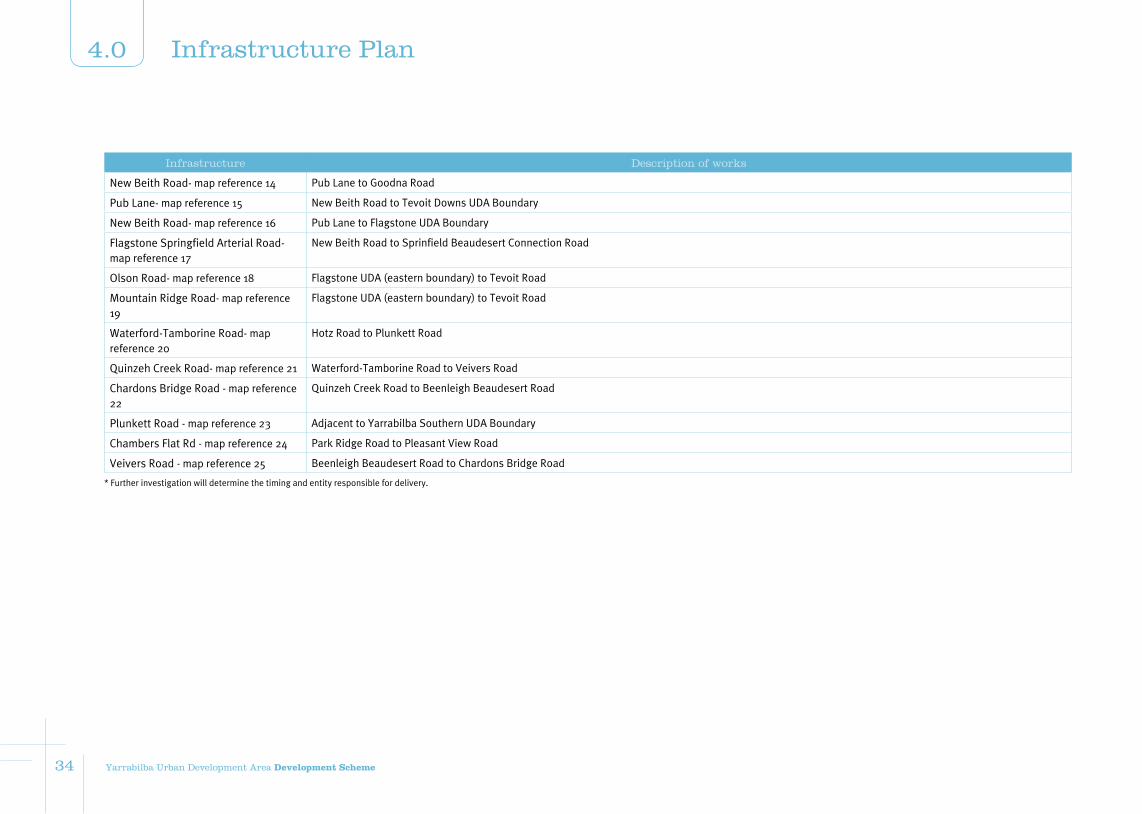
Infrastructure Description of works
New Beith Road- map reference 14 Pub Lane to Goodna Road
Pub Lane- map reference 15 New Beith Road to Tevoit Downs UDA Boundary
New Beith Road- map reference 16 Pub Lane to Flagstone UDA Boundary
Flagstone Springfield Arterial Road- map reference 17
New Beith Road to Sprinfield Beaudesert Connection Road
Olson Road- map reference 18 Flagstone UDA (eastern boundary) to Tevoit Road
Mountain Ridge Road- map reference 19
Flagstone UDA (eastern boundary) to Tevoit Road
Waterford-Tamborine Road- map reference 20
Hotz Road to Plunkett Road
Quinzeh Creek Road- map reference 21 Waterford-Tamborine Road to Veivers Road
Chardons Bridge Road - map reference 22
Quinzeh Creek Road to Beenleigh Beaudesert Road
Plunkett Road - map reference 23 Adjacent to Yarrabilba Southern UDA Boundary
Chambers Flat Rd - map reference 24 Park Ridge Road to Pleasant View Road
Veivers Road - map reference 25 Beenleigh Beaudesert Road to Chardons Bridge Road
* Further investigation will determine the timing and entity responsible for delivery.
34 Yarrabilba Urban Development Area Development Scheme
4.0 Infrastructure Plan
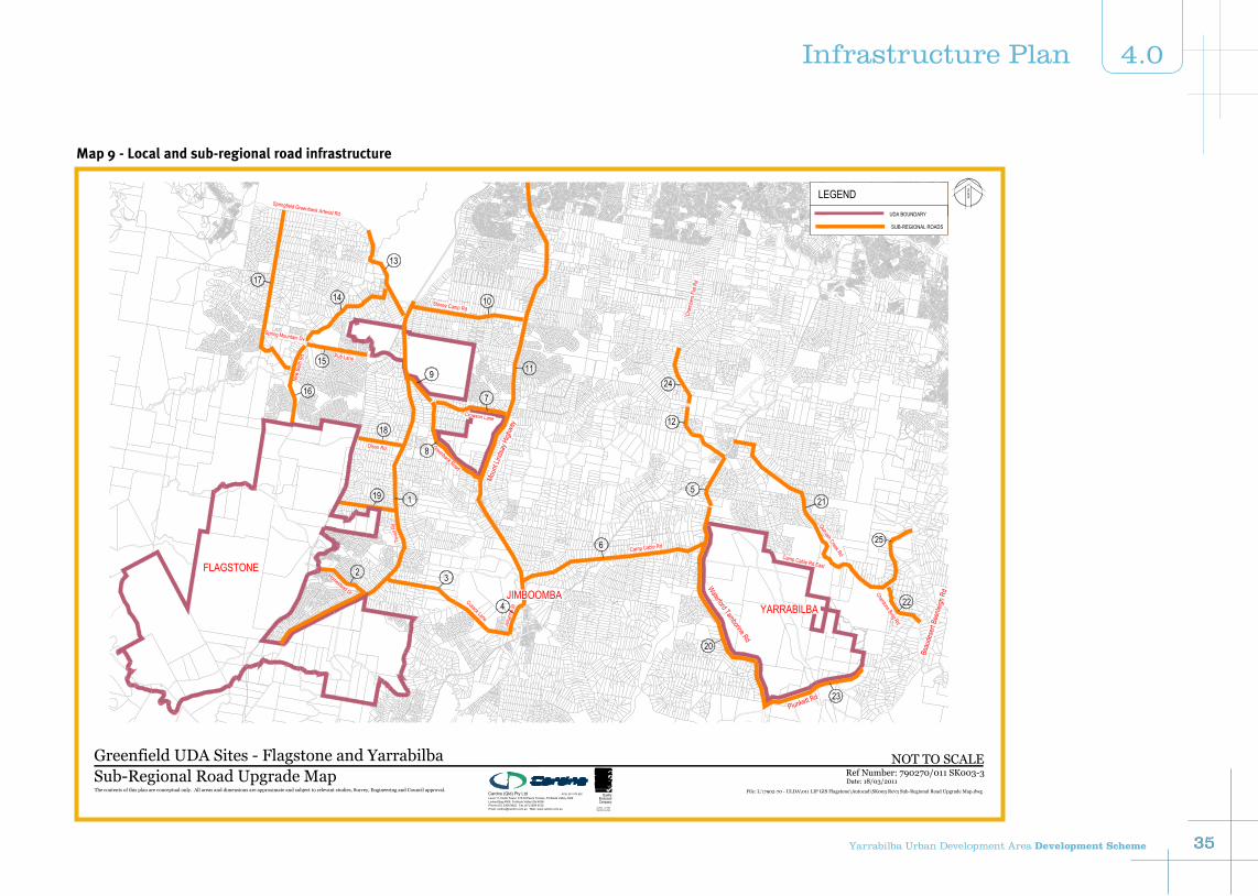
Map 9 - Local and sub-regional road infrastructure
FLAGSTONE
Waterford Tamborine Rd
Cusack Lane
Homestead Dr
Olson Rd
Crowson Lane
Pub Lane
New
Beith
Rd
Stoney Camp Rd
Cham
bers
Flat R
d
Chardons Brdg Rd
Quinzeh Creek Rd
Camp Cable Rd East
Camp Cable Rd
Moun
t Lind
say H
ighwa
y
Springfield Greenbank Arterial Rd
Tevo
it Rd
Plunkett Rd
Beau
dese
rt Bee
nleigh
Rd
YARRABILBAJIMBOOMBA
Spring Mountain Dv
Joha
nna S
t
Greenbank Road
11
4
32
119
18
9
1014
13
16
17
6
5
22
21
23
20
7
8
15
12
24
25
NO
RTH
Greenfield UDA Sites - Flagstone and YarrabilbaRef Number: 790270/011 SK003-3
File: L:\7902-70 - ULDA\011 LIP GIS Flagstone\Autocad\SK003 Rev3 Sub-Regional Road Upgrade Map.dwg
Date: 18/03/2011Sub-Regional Road Upgrade MapThe contents of this plan are conceptual only. All areas and dimensions are approximate and subject to relevant studies, Survey, Engineering and Council approval.
AS 9001 Lic. 5960Standards Australia
CompanyEndorsed
QualityACN: 051 074 992
Phone (07) 3369 9822 Fax (07) 3369 9722
Cardno (Qld) Pty LtdLevel 11, North Tower, 515 St Paul's Terrace, Fortitude Valley 4006Locked Bag 4006, Fortitude Valley Qld 4006
Email: [email protected] Web: www.cardno.com.au
NOT TO SCALE
LEGEND
SUB-REGIONAL ROADS
UDA BOUNDARY
35Yarrabilba Urban Development Area Development Scheme 35
4.0Infrastructure Plan
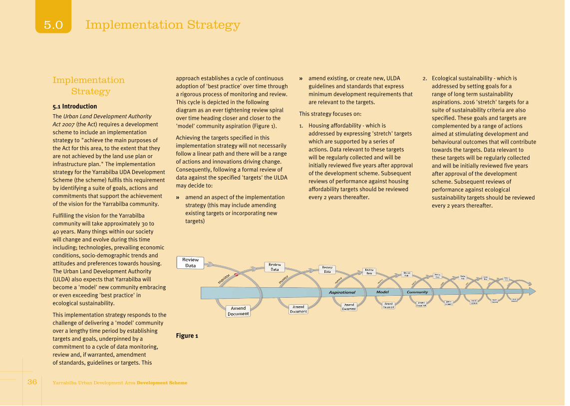
Implementation Strategy
5.1 Introduction
The Urban Land Development Authority Act 2007 (the Act) requires a development scheme to include an implementation strategy to "achieve the main purposes of the Act for this area, to the extent that they are not achieved by the land use plan or infrastructure plan." The implementation strategy for the Yarrabilba UDA Development Scheme (the scheme) fulfils this requirement by identifying a suite of goals, actions and commitments that support the achievement of the vision for the Yarrabilba community.
Fulfilling the vision for the Yarrabilba community will take approximately 30 to 40 years. Many things within our society will change and evolve during this time including; technologies, prevailing economic conditions, socio-demographic trends and attitudes and preferences towards housing. The Urban Land Development Authority (ULDA) also expects that Yarrabilba will become a 'model' new community embracing or even exceeding 'best practice' in ecological sustainability.
This implementation strategy responds to the challenge of delivering a 'model' community over a lengthy time period by establishing targets and goals, underpinned by a commitment to a cycle of data monitoring, review and, if warranted, amendment of standards, guidelines or targets. This
approach establishes a cycle of continuous adoption of 'best practice' over time through a rigorous process of monitoring and review. This cycle is depicted in the following diagram as an ever tightening review spiral over time heading closer and closer to the 'model' community aspiration (Figure 1).
Achieving the targets specified in this implementation strategy will not necessarily follow a linear path and there will be a range of actions and innovations driving change. Consequently, following a formal review of data against the specified 'targets' the ULDA may decide to:
È amend an aspect of the implementation strategy (this may include amending existing targets or incorporating new targets)
È amend existing, or create new, ULDA guidelines and standards that express minimum development requirements that are relevant to the targets.
This strategy focuses on:
1. Housing affordability - which is addressed by expressing 'stretch' targets which are supported by a series of actions. Data relevant to these targets will be regularly collected and will be initially reviewed five years after approval of the development scheme. Subsequent reviews of performance against housing affordability targets should be reviewed every 2 years thereafter.
2. Ecological sustainability - which is addressed by setting goals for a range of long term sustainability aspirations. 2016 'stretch' targets for a suite of sustainability criteria are also specified. These goals and targets are complemented by a range of actions aimed at stimulating development and behavioural outcomes that will contribute towards the targets. Data relevant to these targets will be regularly collected and will be initially reviewed five years after approval of the development scheme. Subsequent reviews of performance against ecological sustainability targets should be reviewed every 2 years thereafter.
Figure 1
36 Yarrabilba Urban Development Area Development Scheme
5.0 Implementation Strategy

ULDA Actions Stretch targets Goals
The ULDA will:
È work with developers to produce suitable housing designs to meet defined price points
È monitor dwelling prices and amount of accessible housing produced
È include in landowner development agreements:
È provisions requiring the land owner deliver housing to achieve nominated price points and accessibility targets where the monitoring process indicates targets are not being achieved
È where subsidy is required to achieve these price points, additional provisions will be required to ensure the retention of the affordability over time.
Greater than 25% housing that is affordable for key workers and first home buyers in accordance with the income targets in the ULDA Housing Strategy.
Greater than 10% accessible housing
Neighbourhoods include a diversity of housing, including that which is affordable for households on low to moderate incomes, and accessible to reflect changing requirements as the community matures.
The ULDA will work with the Department of Communities, Not for Profit providers and the land owner to identify opportunities for the inclusion of social housing projects progressively over the life of the project.
5% Social housing
5.2 Housing options
Facilitating the provision of housing that is affordable to households on low to moderate incomes is set out as a core purpose in the Act.
The ULDA Housing Strategy defines low to moderate income households which is typically the income of first home buyers and key workers.
37Yarrabilba Urban Development Area Development Scheme 37
5.0Implementation Strategy

5.3 Ecological sustainability
The ULDA Act defines ecological sustainability as a balance that integrates:
È protection of ecological processes and natural systems
È economic development
È maintenance of the cultural, economic, physical and social wellbeing of people and communities.
The achievement of ecological sustainability is required by the land use plan and can lead to reduced development and housing costs, including ongoing living costs. Energy, transport, water and access to services are major cost burdens on all household budgets. The land use plan is supported by guidelines which provides development standards to ensure the minimization of adverse impacts on ecological processes and natural systems. The infrastructure plan identifies the key infrastructure required with standards set by the applicable guideline.
This element of the implementation strategy will be critical to achieve continuous improvement in all aspects of ecological sustainability as technology and community needs change during the life of the UDA.
There are aspirations for a growing community that cannot be achieved by the land use or infrastructure plans alone. This element of the implementation strategy is critical to achieve innovation and continuous improvement in ecological sustainability.
ULDA actions Stretch targets Goals
The ULDA will work with landowners, councils, government agencies, utility providers and other organisations to develop:
Strategies for:
È community education to promote the protection and enhancement of the natural environment
È demand optimisation for water and energy efficiency and demand management strategies, including builder education
È reducing, recycling and reusing demolition, construction and household waste
È addressing urban heat island effect to ensure urban amenity and lower energy use in dwellings and buildings.
Demonstration projects to:
È deliver alternative technology and service model projects for local renewable energy, water self sufficiency and waste avoidance and recovery
È deliver affordable sustainable housing projects that reduces energy use and inputs to achieve zero emissions
È facilitate for early introduction of electric vehicles and associated infrastructure.
The ULDA will work with the Department of Transport and Main Roads (including the TransLink Transit Authority) and the council to facilitate the commencement of a public transport service to connect the UDA with education, health and retail centres in the regional area from the time the first residents move into the project.
Natural resources and environment
By 2016
Potable water usage reduction to an average of 140 litres per person per day
Average household energy usage reduction to 15 kilowatt hours (kWh) per day
20% peak energy demand reduction from 5 kilovolt ampere (kVa) to 4 kVa average diversified maximum demand
Household waste reduction to 150kg per person per year
75% reduction in demolition and construction waste
Active and Public Transport
By 2016
Achieve 20% share of all trips as active transport (walking and cycling) trips
Economic sustainability
By 2016
100% wireless internet connection for all centres
Communities that:
È are in a harmonised, built and natural environment that provides a socially inclusive, resilient and affordable place to live (in terms of set up and living costs)
È generate no net green house gas emissions with all new buildings (being carbon neutral as a result of their normal use through a combination of thermal and energy efficiency and use of renewable energy from either centralised, community or direct sources)
È maximise local sustainable water harvesting and the efficient utilisation of local water, wastewater, and stormwater resources while protecting the ecosystem health of natural waterways
È have sustainable transport with zero emission private vehicles, active travel and public transport that is safe and equitable for all members of the community
È have a sustainable waste avoidance and resource recovery that eliminates waste from household and commercial activities
È support growth of regional connected economy through the provision of diverse sustainable livelihoods linked with public transport and other sustainable transport
38 Yarrabilba Urban Development Area Development Scheme
5.0 Implementation Strategy

ULDA actions Stretch targets Goals
The ULDA will work with landowners, education providers and the community to:
È deliver active transport strategies such as walking school bus services
È facilitate pilot community urban agriculture projects.
The ULDA will work with government agencies, the council and the landowner to:
È formulate and implement diverse and connected employment generation strategies
È facilitate the concept design and development of centres for knowledge, community and commerce by establishing reference working groups including the council, relevant state agencies and the land owner ahead of the development of each neighbourhood
È facilitate wireless internet connection for all centres for knowledge, community and commerce, and major transport stations
È facilitate a local clean tech economic development strategy.
ULDA actions will be subject to monitoring and feedback processes.
È provide services, facilities and infrastructure that meet the social, communication, recreational and entertainment needs of residents creating opportunities for social interaction and networking from the outset of development.
This will be achieved by delivering affordable, sustainable living through early provision of community facilities and services, an early focus on demand management and ongoing technology, and service integration innovations during the life of the UDA.
39Yarrabilba Urban Development Area Development Scheme 39
5.0Implementation Strategy
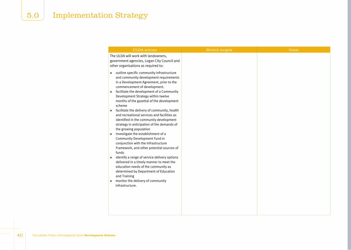
ULDA actions Stretch targets Goals
The ULDA will work with landowners, government agencies, Logan City Council and other organisations as required to:
È outline specific community infrastructure and community development requirements in a Development Agreement, prior to the commencement of development.
È facilitate the development of a Community Development Strategy within twelve months of the gazettal of the development scheme
È facilitate the delivery of community, health and recreational services and facilities as identified in the community development strategy in anticipation of the demands of the growing population
È investigate the establishment of a Community Development Fund in conjunction with the Infrastructure Framework, and other potential sources of funds
È identify a range of service delivery options delivered in a timely manner to meet the education needs of the community as determined by Department of Education and Training
È monitor the delivery of community infrastructure.
40 Yarrabilba Urban Development Area Development Scheme
5.0 Implementation Strategy

Schedule 1: Exempt development
Development prescribed in Schedule 4 of the Sustainable Planning Regulation 2009, other than Table 2, item 2 and Table 5, item 14.
Building work
Minor building and demolition work.
Carrying out building work associated with a material change of use that is UDA exempt or self assessable development.
Carrying out building work associated with an approved material change of use.
Material change of use of premises
Making a material change of use of premises for a Park.
Reconfiguring a lot
Subdivision involving road widening and truncations required as a condition of development approval.
Operational work
Erecting no more than one (1) satellite dish on premises, where the satellite dish has no dimension greater than 1.8 metres.
Filling or excavation where:
(a) not exceeding 50m3 in volume or
(b) top dressing to a depth of less than 100 vertical millimetres from ground level.
Carrying out operational work if consistent with an approved Plan for Development for a precinct.
Carrying out operational work associated with a material change of use that is UDA exempt development (excluding Park).
Carrying out operational work associated with an approved material change of use.
Carrying out operational work associated with the decontamination of land.
Carrying out operational work that is clearing of vegetation:
(a) other than Significant vegetation, or
(b) Significant vegetation where:
È the clearing is consistent with an approved Plan of Development
È carried out by or on behalf of Logan City Council or a public sector entity, where the works being undertaken are authorised under a state law.
È in accordance with the conditions of a UDA development approval for a material change of use or reconfiguring a lot.
41Yarrabilba Urban Development Area Development Scheme 41
6.0Schedules

Carrying out operational work that is the placing of advertising devices that:
È do not exceed 5m2 for commercial, industrial, recreational or entertainment use
È are attached to a front fence or facade of a main building
È do not project more than 150mm from front facade or front fence
È are not illuminated
È contain the name of business or operator, the use of premises, the contact details or name and address of building and
È comprise no more than two signs.
Plumbing or drainage work
Carrying out plumbing or drainage work.
All aspects of development
Development undertaken by the state, or a statutory body representing the state, for the purposes of public housing.
42 Yarrabilba Urban Development Area Development Scheme
6.0 Schedules

Use definitions
Commercial use category
Business
Means the use of premises for administration, clerical, technical, professional or veterinarian clinic or other business activity where any goods or materials made, sold or hired on the premises are ancillary.
Car park
Means the use of premises for the parking of motor vehicles where such parking is not ancillary to some other development on the same site.
Health care services
Means the use of premises for medical, paramedical, alternative therapies and general health care and treatment of persons that involves no overnight accommodation.
Sales office
Means the use of premises for the temporary promotion and/or sale of land and/ or buildings within an estate, were such premises are located within the estate which is proposed to be promoted or sold.
Industrial use category
Extractive industry
Means the use of premises for extraction of sand, gravel, soil, rock, stone or similar substance from land. The term includes ancillary storage, loading or cartage and any crushing, screening, washing, blending or other treatment processes of material extracted from the site.
High impact industry
Means the use of premises for industrial activities that have significant off-site impacts on non-industrial uses including air, noise or odour emissions that are not easily controlled or contained.
These uses may operate outdoors, but do not involve the manufacture of agricultural chemicals, pharmaceutical products, explosives or fertilisers.
Low impact industry
Means the use of premises for industrial activities which have negligible impacts on surrounding non-industrial uses.
The manufacturing aspects of the use are undertaken indoors.
Any off site impacts including air, noise and odour emissions are able to be readily mitigated.
Medium impact industry
Means the use of premises for industrial activities that have offsite air, noise and odour emissions.
Despite mitigation measures these activities would still have noticeable impacts on non-industrial uses.
The primary (noise, odour and air emitting) aspects of the use are undertaken indoors.
Noxious and hazardous industry
Means the use of premises for industrial activities that have the potential for extreme, adverse impacts on other land uses. This includes the potential for fire, explosion or toxic release.
These uses may involve the production of organic and inorganic chemicals, and the storage and production of explosives.
Research and technology facility
Means the use of premises for innovative and emerging technological industries involved in research design, manufacture, assembly, testing, maintenance and storage of machinery, equipment and component.
The use may include emerging industries such as energy, aerospace, and biotechnology.
Service Industry
Means the use premises for industrial activities that have no external air, noise or odour emissions from the site and can be suitably located with other non-industrial uses.
Warehouse
Means the use of premises for the storage of goods whether or not in a building, including self storage facilities or storage yards.
Residential use category
Display home
Means the temporary use of premises for the promotion and/ or sale of land and/ or houses within an estate, where such premises are located within the estate which is proposed to be promoted or sold.
Home based business
Means the use of a House or Multiple residential for an occupation or business activity as a secondary use where:
È the floor area used specifically for the home business does not exceed 50m2
È any visitor accommodation does not exceed 4 visitors
È there is no hiring out of materials, goods, appliances or vehicles
È there is only one sign related to the Home business, located within the premises or on a fence facing the road
È there is no repairing or servicing of vehicles not normally associated with a residential use
È there is no industrial use of premises
È the maximum height of a new building, structure or object does not exceed the height of the House or Multiple residential and the setback is the same
Schedule 2: Definitions
4343Yarrabilba Urban Development Area Development Scheme
6.0Schedules

as, or greater than, buildings on adjoining properties
È car parking is in accordance with the planning scheme
È there is no display of goods
È number of employees does not exceed 4.
House
Means a residential use of premises containing one primary single dwelling on a lot. The use includes out-buildings and works normally associated with a dwelling and may include a secondary dwelling.
The secondary dwelling is subordinate to the primary dwelling, capable of being used as a self-contained residence, and may be constructed under the primary dwelling, attached to it or free standing.
Multiple residential
Means the use of premises for residential purposes if there are two or more dwelling units on any one lot. Multiple residential dwelling units may be contained on one lot or each dwelling unit may be contained on its own lot subject to community title schemes. The term multiple residential does not include House.
Other residential
Means the use of premises for the accommodation and care of aged and retired people, small groups of disadvantaged persons or persons who are being nursed, require ongoing supervision/support or are
convalescing. This term may include but is not limited to ancillary dining and recreation facilities, administration offices, laundries, kitchens, ancillary medical facilities and residential accommodation for management and staff.
Relocatable home park
Means the use of premises for relocatable dwellings that provide long term residential accommodation.
The term includes ancillary facilities such as amenities, laundries, kitchens and recreation facility for persons associated with the development. It also includes a manager's office and residence.
Short term accommodation
Means the use of premises comprising primarily accommodation units for short-term accommodation, generally for travellers and visitors, such as motel or backpackers. The use may include dining, laundry and recreational facilities which cater exclusively for the occupants of the premises, a manager's office and residence. The term does not include Other residential, Hotel or Tourist park.
Retail use category
Bulk landscape supplies
Means the use of premises for bulk storage and sale of landscaping and gardening supplies including soil, gravel, potting mix and mulch, where the majority of materials sold from the premises are not in pre-packaged form.
Fast food premises
Means the use of premises for the preparation and sale of food to the public generally for immediate consumption off the premises. The term may include drive through facilities and ancillary facilities for the consumption of food on the premises.
Food premises
Means the use of premises for the preparation and sale of food and drink to the public for consumption on or off the site. The term includes a cafe, restaurant, coffee shop, bistro, tea room, milk bar, snack bar, kiosk, take-away, but does not include fast food premises as separately defined.
Garden Centre
Means the use of premises for the sale of plants and includes gardening and landscaping products and supplies where these are sold mainly in pre-packaged form. The use may include an ancillary cafe or coffee shop.
Market
Means the use of premises for the display and sale of goods to the public on a regular but infrequent basis, where goods are primarily sold from temporary structures such as stalls, booths or trestle tables. The use includes ancillary food and beverage sales and ancillary entertainment provided for the enjoyment of customers.
Outdoor sales
Means the use of premises for the display, sale, hire or lease of products where the use is conducted wholly or predominantly outdoors and may include construction, industrial or farm plant and equipment, vehicles, boats and caravans.
Service station
Means the use of premises for the retail sale of fuel including petrol, liquid petroleum and automotive distillate to refuel motor vehicles.
Shop
Means the use of premises for the display, sale or hire of goods or the provision of personal services or betting to the public.
Shopping centre
Means the use of premises comprising two or more individual tenancies that is comprised primarily of shops and which function as an integrated complex.
44 Yarrabilba Urban Development Area Development Scheme
6.0 Schedules
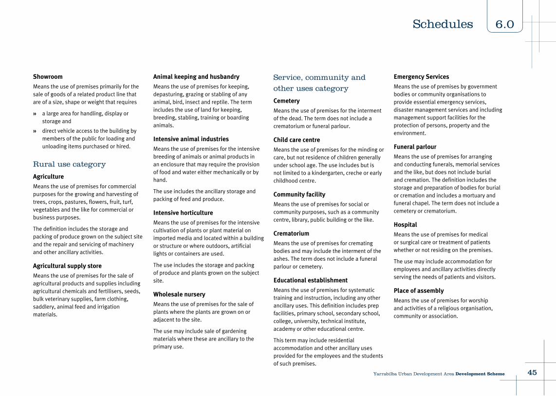
Showroom
Means the use of premises primarily for the sale of goods of a related product line that are of a size, shape or weight that requires
È a large area for handling, display or storage and
È direct vehicle access to the building by members of the public for loading and unloading items purchased or hired.
Rural use category
Agriculture
Means the use of premises for commercial purposes for the growing and harvesting of trees, crops, pastures, flowers, fruit, turf, vegetables and the like for commercial or business purposes.
The definition includes the storage and packing of produce grown on the subject site and the repair and servicing of machinery and other ancillary activities.
Agricultural supply store
Means the use of premises for the sale of agricultural products and supplies including agricultural chemicals and fertilisers, seeds, bulk veterinary supplies, farm clothing, saddlery, animal feed and irrigation materials.
Animal keeping and husbandry
Means the use of premises for keeping, depasturing, grazing or stabling of any animal, bird, insect and reptile. The term includes the use of land for keeping, breeding, stabling, training or boarding animals.
Intensive animal industries
Means the use of premises for the intensive breeding of animals or animal products in an enclosure that may require the provision of food and water either mechanically or by hand.
The use includes the ancillary storage and packing of feed and produce.
Intensive horticulture
Means the use of premises for the intensive cultivation of plants or plant material on imported media and located within a building or structure or where outdoors, artificial lights or containers are used.
The use includes the storage and packing of produce and plants grown on the subject site.
Wholesale nursery
Means the use of premises for the sale of plants where the plants are grown on or adjacent to the site.
The use may include sale of gardening materials where these are ancillary to the primary use.
Service, community and
other uses category
Cemetery
Means the use of premises for the interment of the dead. The term does not include a crematorium or funeral parlour.
Child care centre
Means the use of premises for the minding or care, but not residence of children generally under school age. The use includes but is not limited to a kindergarten, creche or early childhood centre.
Community facility
Means the use of premises for social or community purposes, such as a community centre, library, public building or the like.
Crematorium
Means the use of premises for cremating bodies and may include the interment of the ashes. The term does not include a funeral parlour or cemetery.
Educational establishment
Means the use of premises for systematic training and instruction, including any other ancillary uses. This definition includes prep facilities, primary school, secondary school, college, university, technical institute, academy or other educational centre.
This term may include residential accommodation and other ancillary uses provided for the employees and the students of such premises.
Emergency Services
Means the use of premises by government bodies or community organisations to provide essential emergency services, disaster management services and including management support facilities for the protection of persons, property and the environment.
Funeral parlour
Means the use of premises for arranging and conducting funerals, memorial services and the like, but does not include burial and cremation. The definition includes the storage and preparation of bodies for burial or cremation and includes a mortuary and funeral chapel. The term does not include a cemetery or crematorium.
Hospital
Means the use of premises for medical or surgical care or treatment of patients whether or not residing on the premises.
The use may include accommodation for employees and ancillary activities directly serving the needs of patients and visitors.
Place of assembly
Means the use of premises for worship and activities of a religious organisation, community or association.
4545Yarrabilba Urban Development Area Development Scheme
6.0Schedules

Telecommunications facility
Means the use of premises for systems that carry communications by means of radio, including guided or unguided electromagnetic energy whether such facility is manned or remotely controlled.
The term does not include low impact facilities that are exempt from State planning laws under the Telecommunications Act 1994 and specified in the Telecommunications (Low-impact facilities) Determination 1997.
Utility Installation
Means the use of premises to provide the public with the following services:
È supply of water, hydraulic power, electricity or gas
È sewerage or drainage services
È transport services including road rail or water
È waste management facilities
È network infrastructure.
The use includes maintenance and storage depots and other facilities for the operation of the use.
Veterinary hospital
Means the use of premises for the treatment of sick or injured animals where such animals are accommodated overnight or for long stay periods on the premises. The term does not include animal keeping and husbandry or veterinary clinic.
Sport, recreation and
entertainment use category
Indoor entertainment
Means the use of premises for public entertainment predominantly within a building.
The term includes facilities commonly described as cinema, nightclub, adult entertainment, theatre and hotel.
Indoor sport and recreation
Means the use of premises for leisure, sport, recreation or conducting large scale receptions, displays and functions, predominantly within a building.
The term includes facilities commonly described as sports centre, gymnasium, convention centres, amusement and leisure centres.
Outdoor sport and recreation
Means the use of premises for recreation or sport activity, or other leisure past-time, which is conducted wholly or mainly outside of a building.
The term includes facilities such as (outdoor) public swimming pools, golf courses and driving ranges, outdoor courts and sportsgrounds and the like. The term also includes the provision of a clubhouse and other ancillary facilities.
Park
Means the use of premises by the public for free recreation and enjoyment and may be used for community events.
Facilities may include children's playground equipment, informal sports fields, ancillary vehicle parking and other public conveniences.
Tourism use category
Tourist attraction
Means the use of premises for providing on site entertainment, recreation or similar facilities for the general public.
The use may include provision of food and drink for consumption on site.
Tourist park
Means the use of premises to provide accommodation in caravans, self contained cabins, tents and similar structures for the touring or holidaying public.
The use may include a manager's residence and office, kiosk, amenity buildings and the provision of recreation facilities for the exclusive use of occupants of the tourist park.
Other development
Filling or excavation
Means removal or importation of material to or from a lot that will change the ground level of the land.
Material change of use
As defined in the Urban Land Development Authority Act 2007.
Minor building work or demolition work
Means
È internal building work
È demolition work
È external building work up to 25m2 for roofs over existing decks or paved areas, sun hoods, carports and the like
È demolition where not involving a place of cultural heritage listed building under the Queensland Heritage Act 1992
È building work that increases the approved GFA or lawfully existing GFA at the time of commencement of this scheme by no more that 25m2
È raising a house where the resultant height does not exceed 9m.
Operational work
As defined in the Urban Land Development Authority Act 2007.
Reconfiguring a lot
As defined in the Urban Land Development Authority Act 2007.
46 Yarrabilba Urban Development Area Development Scheme
6.0 Schedules

Administrative definitions
Accessible housing
Housing in accordance with the applicable ULDA guideline.
Affordable housing
Affordable housing1 means private rental housing and home purchase options (including housing aimed at the first home owners market) for low to moderate income households.
Basement
A storey below ground level or where the underside of the ceiling projects no more than one metre above ground level.
Building
As defined in the Building Act 1975.
Building work
As defined in the Urban Land Development Authority Act 2007.
Building height
The maximum vertical distance between the natural ground level and the roof or parapet at any point but not including anything projecting from a building such as an antenna, aerial, chimney, flagpole or the like.
1 Refer to the ULDA Affordable Housing Strategy
Caretaker's accommodation
The residential use of part of a premises where in connection with a non residential use on the same premises.
Community greenspace network
A network of parks and open space that are publicly accessible and deliver recreation and sporting opportunities to the community.
Contaminated Land Register
As defined in the Environmental Protection Act 1994.
Development scheme
As defined in the Urban Land Development Authority Act 2007.
Dwelling unit
Means a building or part of a building used or capable of being used as a self contained residence which must include:
È food preparation facilities
È a bath or shower
È a toilet and wash basin.
The term includes works ancillary to a dwelling.
Environmental Management Register
As defined in the Environmental Protection Act 1994.
Environmentally relevant activities
As defined in the Environmental Protection Act 1994.
Gross floor area (GFA)
The total floor area of all storeys of a building, including mezzanines, measured from the outside of external walls or the centre of a common wall, excluding area used for:
È building services
È ground floor public lobby
È a public mall in a shopping complex
È the parking, loading and manoeuvring of motor vehicles
È private balconies whether roofed or not.
Gross leasable area
Gross leasable area (GLA) of premises means the sum of the floor area of all buildings located on the premises:
È inclusive of the area of any external use area and roofed balcony; and
È exclusive of
È an area used for a building service, a public toilet, a ground floor public lobby and a public mall in a shopping centre and
È an area exclusively used for the parking, loading and manoeuvring of a vehicle.
Ground level
Means:
È the existing level of the site providing it has not been unlawfully altered; or
È where the land has been unlawfully
altered the level of land prior to the alteration; or
È the 'as-constructed' level of the land in accordance with an approval for filling and excavation.
High water mark
Refers to the ordinary high water mark at spring tides.
Interim Uses
Refer to section 3.2.9.
Mezzanine
An intermediate floor within a room.
Neighbourhood centre
Means the use of premises for servicing the convenience needs of the community. The term includes Business, Medical centre, Retail and Community facility which ultimately function as an integrated complex. It may include a key open space area (such as park or plaza).
Net residential density
Net residential density means the total number of dwellings divided by the combined area of residential lots, local parks, internal local roads and half the width of local roads bordering the site. Average net residential density means net residential density calculated for a whole neighbourhood.
4747Yarrabilba Urban Development Area Development Scheme
6.0Schedules

Planning scheme
The planning scheme applying to the former Beaudesert Shire Council.
Plan of Development
See section 3.2.
Plot ratio
The ratio between the gross floor area of a building and the total area of the site.
Premises
As defined in the Urban Land Development Authority Act 2007.
Private open space
An outdoor area for the exclusive use of occupants.
Public benefit
Refers to an outcome that benefits the wider community rather than local, site specific or land ownership desires.
Public housing
As defined in the Sustainable Planning Act 2009.
Public interest
Refers to an outcome that benefits the wider community rather than local, site specific or land ownership desires.
Public realm
Refers to spaces that are used by the general public, including streets, squares, plazas and parks.
Sensitive uses
Means any of the following: Child care centre, Educational establishment, Health care services, Hospital, House, Multiple residential, Other residential, Relocatable home park and Short term accommodation.
Setback
The shortest distance measured horizontally from the wall of the building or structure to the vertical projection of the boundary of the lot (ie. excluding eaves).
Significant vegetation
Means all vegetation, except those listed as pest vegetation by State or local government, that is significant in its:
È ecological value at local, state or national levels including
È vegetation mapped as endangered remnant vegetation on the regional ecosystem maps prepared under the Vegetation Management Act 1999
È vegetation in areas identified in a ULDA guideline as requiring koala habitat offset
È contribution to the preservation of natural landforms
È contribution to the character of the landscape
È cultural or historical value
È amenity value to the general public.
Note: vegetation may be living or dead and the term includes their root zone2.
Site cover
The proportion of the site covered by buildings, including roof overhangs.
Storey
A space within a building which is situated between one floor level and the floor level next above or if there is no floor above, the ceiling or roof above. This does not mean:
È a space that contains only:
È a lift shaft, stairway or meter room
È a bathroom, shower room, laundry, toilet or other sanitary compartment
È accommodation intended for not more than 3 vehicles
È a combination of the above
È a mezzanine
Urban design
Refers to the holistic design of urban environments, including the overall townscape, individual buildings, street networks, streetscapes, parks and other public spaces.
2 The root zone is described by the vertical projection of the foliage to a depth of 1 metre below the surface and including buttress roots on and above the soil surface.
48 Yarrabilba Urban Development Area Development Scheme
6.0 Schedules
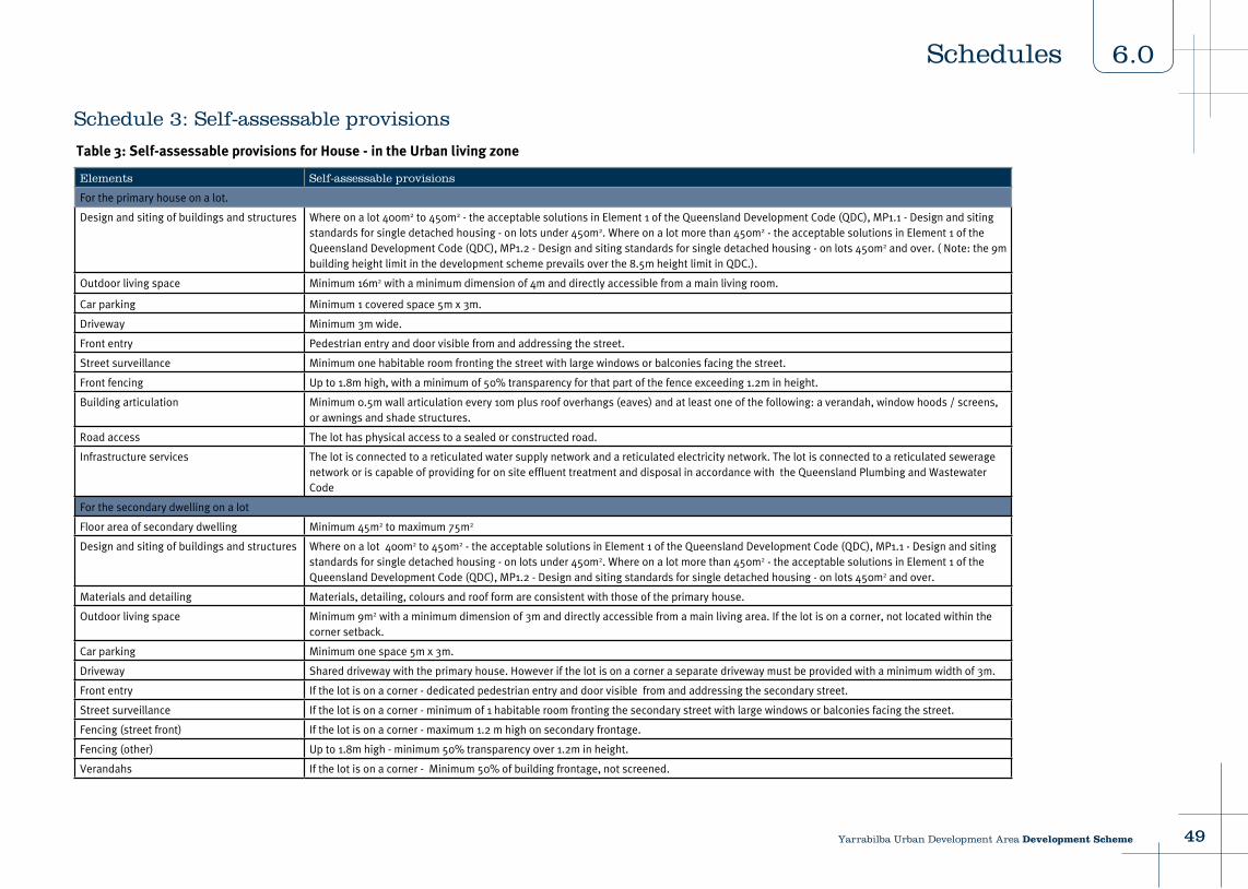
Schedule 3: Self-assessable provisions
Table 3: Self-assessable provisions for House - in the Urban living zone
Elements Self-assessable provisions
For the primary house on a lot.
Design and siting of buildings and structures Where on a lot 400m2 to 450m2 - the acceptable solutions in Element 1 of the Queensland Development Code (QDC), MP1.1 - Design and siting standards for single detached housing - on lots under 450m2. Where on a lot more than 450m2 - the acceptable solutions in Element 1 of the Queensland Development Code (QDC), MP1.2 - Design and siting standards for single detached housing - on lots 450m2 and over. ( Note: the 9m building height limit in the development scheme prevails over the 8.5m height limit in QDC.).
Outdoor living space Minimum 16m2 with a minimum dimension of 4m and directly accessible from a main living room.
Car parking Minimum 1 covered space 5m x 3m.
Driveway Minimum 3m wide.
Front entry Pedestrian entry and door visible from and addressing the street.
Street surveillance Minimum one habitable room fronting the street with large windows or balconies facing the street.
Front fencing Up to 1.8m high, with a minimum of 50% transparency for that part of the fence exceeding 1.2m in height.
Building articulation Minimum 0.5m wall articulation every 10m plus roof overhangs (eaves) and at least one of the following: a verandah, window hoods / screens, or awnings and shade structures.
Road access The lot has physical access to a sealed or constructed road.
Infrastructure services The lot is connected to a reticulated water supply network and a reticulated electricity network. The lot is connected to a reticulated sewerage network or is capable of providing for on site effluent treatment and disposal in accordance with the Queensland Plumbing and Wastewater Code
For the secondary dwelling on a lot
Floor area of secondary dwelling Minimum 45m2 to maximum 75m2
Design and siting of buildings and structures Where on a lot 400m2 to 450m2 - the acceptable solutions in Element 1 of the Queensland Development Code (QDC), MP1.1 - Design and siting standards for single detached housing - on lots under 450m2. Where on a lot more than 450m2 - the acceptable solutions in Element 1 of the Queensland Development Code (QDC), MP1.2 - Design and siting standards for single detached housing - on lots 450m2 and over.
Materials and detailing Materials, detailing, colours and roof form are consistent with those of the primary house.
Outdoor living space Minimum 9m2 with a minimum dimension of 3m and directly accessible from a main living area. If the lot is on a corner, not located within the corner setback.
Car parking Minimum one space 5m x 3m.
Driveway Shared driveway with the primary house. However if the lot is on a corner a separate driveway must be provided with a minimum width of 3m.
Front entry If the lot is on a corner - dedicated pedestrian entry and door visible from and addressing the secondary street.
Street surveillance If the lot is on a corner - minimum of 1 habitable room fronting the secondary street with large windows or balconies facing the street.
Fencing (street front) If the lot is on a corner - maximum 1.2 m high on secondary frontage.
Fencing (other) Up to 1.8m high - minimum 50% transparency over 1.2m in height.
Verandahs If the lot is on a corner - Minimum 50% of building frontage, not screened.
4949Yarrabilba Urban Development Area Development Scheme
6.0Schedules
Contact UsVisit our website at: www.ulda.qld.gov.au
Write to us at:Urban Land Development AuthorityGPO Box 2202Brisbane QLD 4001
Telephone us: 1300 130 215Fax us: (07) 302 44199