Embed Size (px)
Citation preview
KALKALLOTOWNSHIP(Not included in PSP)
DONNYBROOKSTATION
POTENTIAL FUTURELOCKERBIE STATION
StatePrimarySchoolP-6
StatePrimarySchoolP-6
NonGovernmentSchool
NonGovernmentSchool
KalkalloCommon
KalkalloCommon
KalkalloCemetary
NonGovernmentSchool
StatePrimarySchoolP-6
StateSecondarySchool7-12H
UM
E FR
EEW
AY
GUNNS GULLY ROAD
DONNYBROOK ROAD
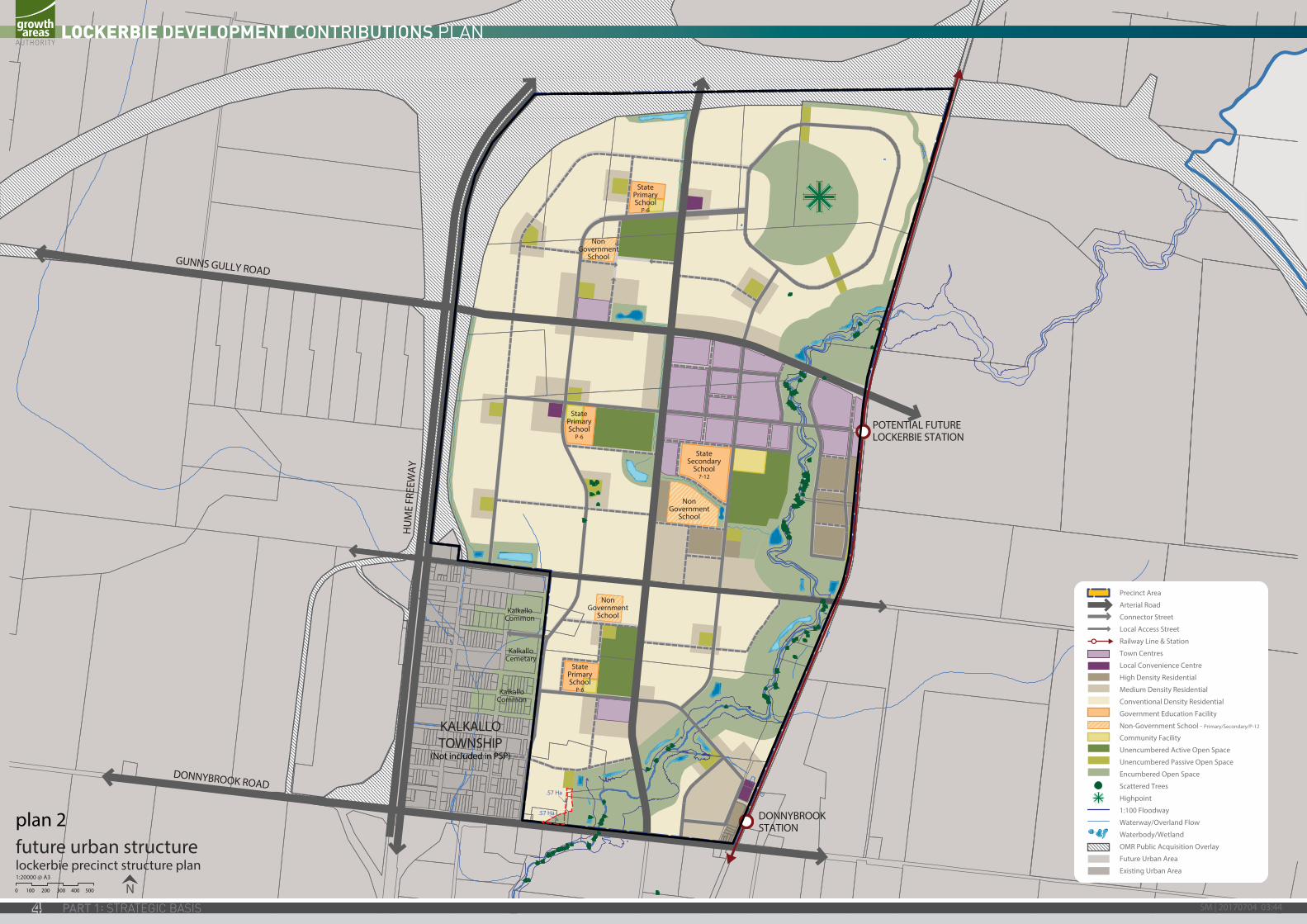
future urban structurelockerbie precinct structure plan
N
1:20000 @ A30 100 200 300 400 500
Precinct AreaArterial Road
Connector StreetLocal Access StreetRailway Line & StationTown CentresLocal Convenience CentreHigh Density ResidentialMedium Density ResidentialConventional Density Residential
Government Education FacilityNon-Government School - Primary/Secondary/P-12
Community FacilityUnencumbered Active Open SpaceUnencumbered Passive Open Space
Encumbered Open SpaceScattered TreesHighpoint1:100 FloodwayWaterway/Overland FlowWaterbody/WetlandOMR Public Acquisition Overlay
Future Urban AreaExisting Urban Area
.57 Ha
.57 Ha
LOCKERBIE DEVELOPMENT CONTRIBUTIONS PLAN MAY 2012 (Amended June 2017)
SM | 20170704 03:44ii
CONTENTSINTRODUCTION 3PURPOSE 3REPORT STRUCTURE 3
1.0 STRATEGIC BASIS 5
1.1 PLANNING AND ENVIRONMENT ACT 1987 5
1.2 PRECINCT STRUCTURE PLAN 5
1.3 THE AREA TO WHICH THE DEVELOPMENT CONTRIBUTIONS PLAN APPLIES 7
1.4 INFRASTRUCTURE PROJECT JUSTIFICATION 11
1.5 INFRASTRUCTURE PROJECTS 13
1.6 PROJECT TIMING 17
1.7 DISTINCTION BETWEEN COMMUNITY AND DEVELOPMENT INFRASTRUCTURE 17
2.0 CALCULATION OF CONTRIBUTIONS 18
2.1 CALCULATION OF NET DEVELOPABLE AREA AND DEMAND UNITS 18
2.2 CALCULATION OF CONTRIBUTION CHARGES 18
3.0 IMPLEMENTATION & ADMINISTRATION 28
3.1 IMPLEMENTATION STRATEGY 28
3.2 ADMINISTRATION OF THE DEVELOPMENT CONTRIBUTIONS PLAN 32
TABLES
Table 1: Summary land budget 8
Table 2: Property specific land budget 9
Table 3: Strategic justification 20
Table 4: Calculation of costs & apportionment 22
Table 5: Project costs recovered by the DCP 24
Table 6: Summary of charges - Community Infrastructure Levy 26
Table 7: Collecting Agency Infrastructure Levies to be collected 29
Table 8: Summary of income vs liability for each council 30
Table 9: Items potentially suitable for Works in Kind 34
PLANS
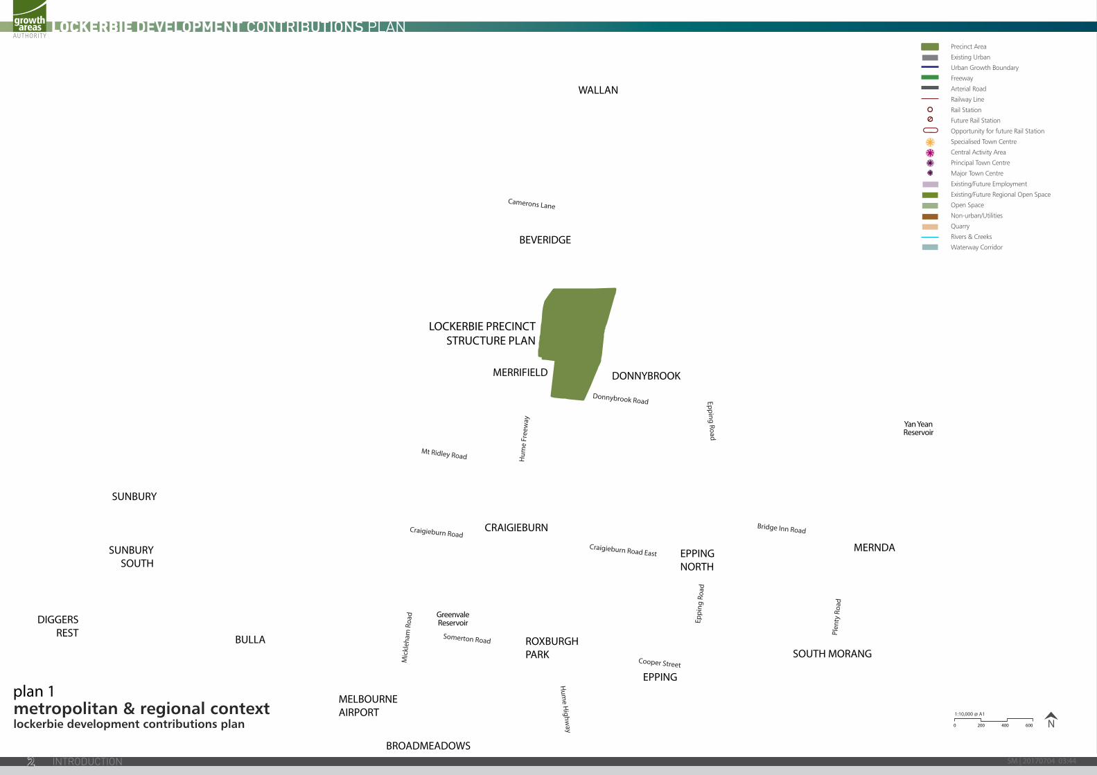
Plan 1: Metropolitan & regional context 2
Plan 2: Future urban structure 4
Plan 3: DCP area 6
Plan 4: Land use budget 10
Plan 5: Road, bridge & intersection projects 12
Plan 6: Open space & active recreation 14
Plan 7: Community Infrastructure 16
Amended by GC75
Version Date Incorporated into the planning scheme by amendment
Description of changes
1 May 2012 C81 - Mitchell
C161 - Hume
C161 - Whittlesea
N/A
2 June 2017 GC75 Incorporated changes associated with Community Infrastructure Levy (CIL) increase.
1
Hum
e Fr
eew
ayH
ume H
ighway
Donnybrook Road Epping Road
Eppi
ng R
oad
Craigieburn Road
Somerton Road
Cooper Street
Plen
ty R
oad
Bridge Inn Road
Mic
kleh
am R
oad
Mt Ridley Road
Craigieburn Road East
Camerons Lane
SUNBURY
SUNBURYSOUTH
DIGGERSREST
BROADMEADOWS
MELBOURNEAIRPORT
EPPING
EPPINGNORTH
SOUTH MORANG
MERNDA
ROXBURGHPARK
CRAIGIEBURN
MERRIFIELD
BEVERIDGE
WALLAN
BULLA
DONNYBROOK
LOCKERBIE PRECINCTSTRUCTURE PLAN
Yan YeanReservoir
GreenvaleReservoir
metropolitan & regional contextlockerbie development contributions plan 0 200 400 600 N
1:10,000 @ A1
Precinct Area
Existing Urban
Urban Growth Boundary
Freeway
Arterial Road
Railway Line
Rail Station
Future Rail Station
Opportunity for future Rail Station
Specialised Town Centre
Central Activity Area
Principal Town Centre
Major Town Centre
Existing/Future Employment
Existing/Future Regional Open Space
Open Space
Non-urban/Utilities
Quarry
Rivers & Creeks
Waterway Corridor
plan 1
SM | 20170704 03:442
PurposeThe Lockerbie Development Contributions Plan (DCP) has been prepared by the Growth Areas Authority with the assistance of Hume City Council, Shire of Mitchell, City of Whittlesea, Government agencies, service authorities and major stakeholders.
The Development Contributions Plan:
• Outlines projects required to ensure that future residents, visitors and workers within the Lockerbie DCP area will be provided with timely access to works, services and facilities necessary to support a quality, affordable lifestyle.
• Details requirements that must be met by future land use and development and provides developers, investors and local communities with certainty about development contribution requirements and how they will be administered; and
• Establishes a framework for development proponents to contribute a fair proportion towards the cost of works, services and facilities for the new community at Lockerbie. It ensures the cost of providing new infrastructure and services is shared equitably. Fairness requires costs to be apportioned according to the projected shared of use of the required infrastructure items.
Report StructureThe Development Contributions Plan document comprises three parts.
INTRODUCTION
1.0 STRATEGIC BASIS
2.0 CALCULATION OF CONTRIBUTIONS
3.0 ADMINISTRATION AND IMPLEMENTATION
Part 1 explains the strategic basis for the Development Contributions Plan, which includes information about the Lockerbie Precinct Structure Plan and justification for the various infrastructure projects included in the Development Contributions Plan.
Part 2 sets out how the development contributions are calculated and costs apportioned.
Part 3 provides for the administration and implementation of the Development Contributions Plan.H
ume
Free
way
Hum
e Highw
ay
Donnybrook Road Epping Road
Eppi
ng R
oad
Craigieburn Road
Somerton Road
Cooper Street
Plen
ty R
oad
Bridge Inn Road
Mic
kleh
am R
oad
Mt Ridley Road
Craigieburn Road East
Camerons Lane
SUNBURY
SUNBURYSOUTH
DIGGERSREST
BROADMEADOWS
MELBOURNEAIRPORT
EPPING
EPPINGNORTH
SOUTH MORANG
MERNDA
ROXBURGHPARK
CRAIGIEBURN
MERRIFIELD
BEVERIDGE
WALLAN
BULLA
DONNYBROOK
LOCKERBIE PRECINCTSTRUCTURE PLAN
Yan YeanReservoir
GreenvaleReservoir
metropolitan & regional contextlockerbie development contributions plan 0 200 400 600 N
1:10,000 @ A1
Precinct Area
Existing Urban
Urban Growth Boundary
Freeway
Arterial Road
Railway Line
Rail Station
Future Rail Station
Opportunity for future Rail Station
Specialised Town Centre
Central Activity Area
Principal Town Centre
Major Town Centre
Existing/Future Employment
Existing/Future Regional Open Space
Open Space
Non-urban/Utilities
Quarry
Rivers & Creeks
Waterway Corridor
3
KALKALLOTOWNSHIP
(Not included in PSP)
DONNYBROOKSTATION
POTENTIAL FUTURELOCKERBIE STATION
StatePrimarySchool
P-6
StatePrimarySchool
P-6
NonGovernment
School
NonGovernment
SchoolKalkallo
Common
KalkalloCommon
KalkalloCemetary
NonGovernment
School
StatePrimarySchool
P-6
StateSecondary
School7-12
HU
ME
FREE
WAY
GUNNS GULLY ROAD
DONNYBROOK ROAD
future urban structurelockerbie precinct structure plan
N1:20000 @ A3
0 100 200 300 400 500
Precinct Area
Arterial Road
Connector Street
Local Access Street
Railway Line & Station
Town Centres
Local Convenience Centre
High Density Residential
Medium Density Residential
Conventional Density Residential
Government Education Facility
Non-Government School - Primary/Secondary/P-12
Community Facility
Unencumbered Active Open Space
Unencumbered Passive Open Space
Encumbered Open Space
Scattered Trees
Highpoint
1:100 Floodway
Waterway/Overland Flow
Waterbody/Wetland
OMR Public Acquisition Overlay
Future Urban Area
Existing Urban Area
.57 Ha
.57 Haplan 2
SM | 20170704 03:444
PART 1: STRATEGIC BASISThe strategic basis for this Development Contributions Plan is established by the State and Local Planning Policy Frameworks of the Hume, Mitchell and Whittlesea Planning Schemes. Key documents inlude Melbourne @ 5 Million, the Municipal Strategic Statement and the Lockerbie Precinct Structure Plan (and supporting documents). These documents set out a broad, long term vision for the sustainable development of the Development Contributions Plan area.
The Lockerbie Precinct Structure Plan has been developed following a comprehensive planning process and has informed the preparation of this Development Contributions Plan area.
1.1 PLANNING AND ENVIRONMENT ACT 1987
This Development Contributions Plan has been prepared in accordance with Part 3B of the Planning and Environment Act 1987 (Act) and has been developed in line with the State and Local Planning Policy Framework of the Hume Mitchell and Whittlesea Planning Schemes as well as Victorian Government Guidelines for the preparation of Development Contributions Plans.
The Development Contributions Plan provides for the charging of a ‘development infrastructure levy’ pursuant to section 46J(a) of the Act towards works, services or facilities. It also provides for the charging of a ‘community infrastructure levy’ pursuant to section 46J(b) of the Act as some items are classified as community infrastructure under the Act.
This Development Contributions Plan forms part of the Hume, Mitchell and Whittlesea Planning Schemes pursuant to section 46I of the Act and is an incorporated document under Clause 81 of each of these planning schemes.
The Development Contributions Plan is implemented in the Hume, Mitchell and Whittlesea Planning Schemes through Schedules 5, 1 and 11 respectively to the Development Contribution Plan Overlay which applies to the area shown in Plan 3.
1.2 PRECINCT STRUCTURE PLAN
The Lockerbie Precinct Structure Plan area is located to the west of the existing Lockerbie Township and applies to parts of each of the Hume, Mitchell and Whittlesea municipal areas.
The Lockerbie Precinct Structure Plan area is expected to:
• Grow by up to 30,000 people, accommodated in approximately 10,000 households; and
• Generate up to 7,000+ jobs in land uses in the Precinct Structure Plan area.
The Lockerbie Precinct Structure Plan establishes the future urban structure of the new community which includes a range of networks including transport, open space and active recreation, social infrastructure, activity centres, residential neighbourhoods and places for local employment (Refer Plan 2).
The need for infrastructure has been determined according to the anticipated development scenario for Lockerbie as described in the Lockerbie Precinct Structure Plan. This Development Contributions Plan has a strong relationship to the Lockerbie Precinct Structure Plan as the Lockerbie Precinct Structure Plan provides the rationale and justification for infrastructure items that have been included within the Development Contributions Plan. Accordingly, the Development Contributions Plan is an implementation based planning tool which identifies the infrastructure items required by the new community and apportions the cost of this infrastructure in an equitable manner across the plan area.
KALKALLOTOWNSHIP
(Not included in PSP)
DONNYBROOKSTATION
POTENTIAL FUTURELOCKERBIE STATION
StatePrimarySchool
P-6
StatePrimarySchool
P-6
NonGovernment
School
NonGovernment
SchoolKalkallo
Common
KalkalloCommon
KalkalloCemetary
NonGovernment
School
StatePrimarySchool
P-6
StateSecondary
School7-12
HU
ME
FREE
WAY
GUNNS GULLY ROAD
DONNYBROOK ROAD
future urban structurelockerbie precinct structure plan
N1:20000 @ A3
0 100 200 300 400 500
Precinct Area
Arterial Road
Connector Street
Local Access Street
Railway Line & Station
Town Centres
Local Convenience Centre
High Density Residential
Medium Density Residential
Conventional Density Residential
Government Education Facility
Non-Government School - Primary/Secondary/P-12
Community Facility
Unencumbered Active Open Space
Unencumbered Passive Open Space
Encumbered Open Space
Scattered Trees
Highpoint
1:100 Floodway
Waterway/Overland Flow
Waterbody/Wetland
OMR Public Acquisition Overlay
Future Urban Area
Existing Urban Area
.57 Ha
.57 Ha
5
KALKALLOTOWNSHIP
(Not included in PSP)
DONNYBROOKSTATION
HU
ME
FREE
WA
Y
GUNNS GULLY ROAD
DONNYBROOK ROAD
DCP arealockerbie development contributions plan
0 200 400 600m
1:20000 @ A4
Precinct Area
Existing Roads
Railway Line & Station
OMRTC Public Acquisition Overlay
Future Urban Area
Existing Urban Area
plan 3
SM | 20170704 03:446
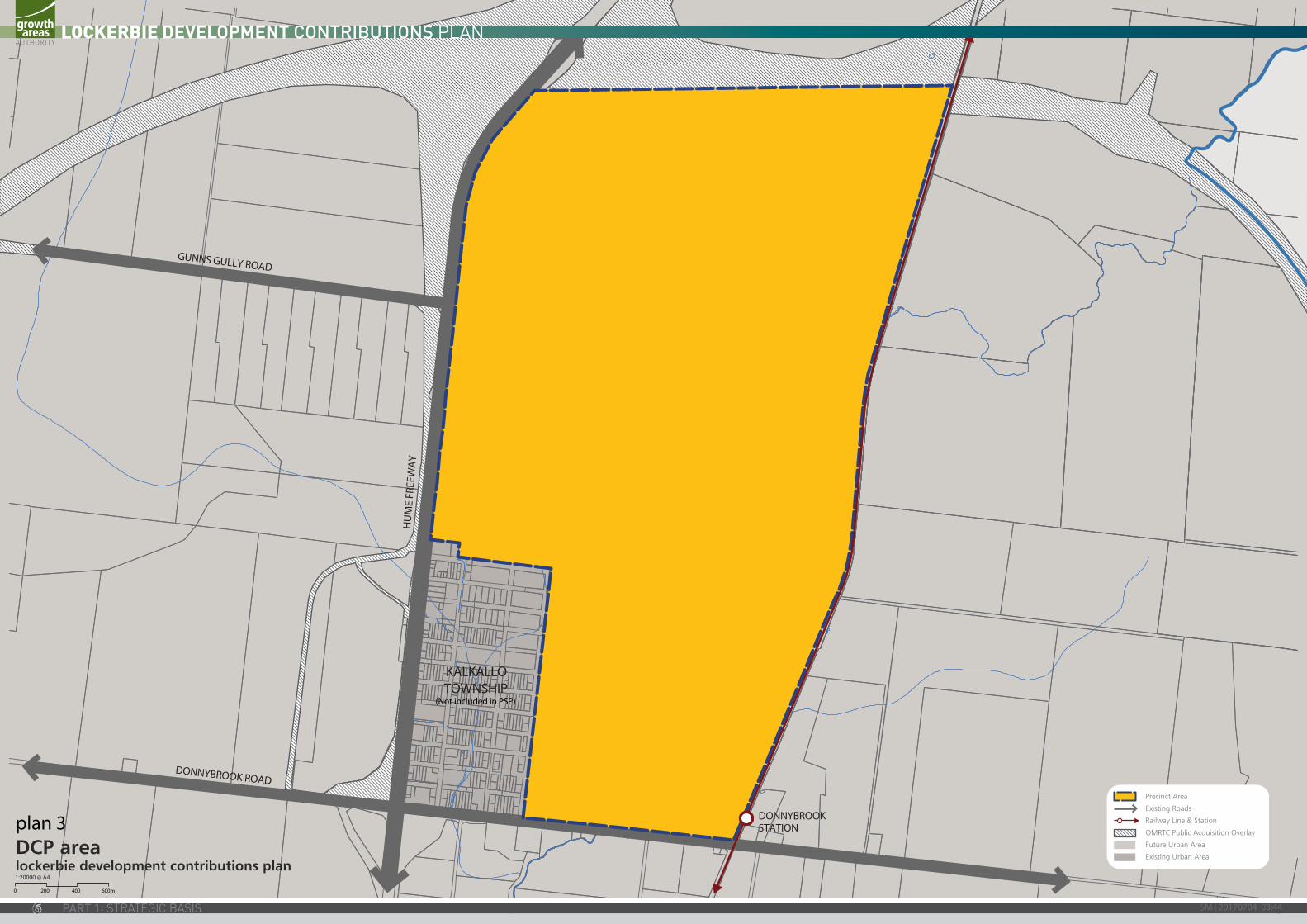
1.3 THE AREA TO WHICH THE DEVELOPMENT CONTRIBUTIONS PLAN APPLIES
The Development Contributions Plan applies to land shown in Plan 3. The area is also clearly shown on Development Contributions Plan Overlay Schedule 5 (DCPO5) in the Hume Planning Scheme, Development Contributions Plan Overlay Schedule 11 (DCPO11) in the Whittlesea Planning Scheme and Development Contributions Plan Overlay Schedule 1 (DCPO1) in the Mitchell Planning Scheme.
The Lockerbie Precinct Structure Plan applies to approximately 1123 hectares of land as shown in Plan 2. The Development Contributions Plan area covers the same area as the Lockerbie Precinct Structure Plan and consists of one common Main Catchment Area (MCA). The MCA defines the main catchment area for the various infrastructure projects required with the Lockerbie Precinct Structure Plan. MCA is the geographic area from which a given item of infrastructure will draw most of its use.
In selecting items, consideration has been given to ensure they are not already wholly funded through another contribution mechanism, such as the Lockerbie Precinct Structure Plan, an existing Development Contributions Plan, an agreement under section 173 of the Act, or as a condition on an existing planning permit.
KALKALLOTOWNSHIP
(Not included in PSP)
DONNYBROOKSTATION
HU
ME
FREE
WA
Y
GUNNS GULLY ROAD
DONNYBROOK ROAD
DCP arealockerbie development contributions plan
0 200 400 600m
1:20000 @ A4
Precinct Area
Existing Roads
Railway Line & Station
OMRTC Public Acquisition Overlay
Future Urban Area
Existing Urban Area
7
OU
TER
MET
ROPO
LITA
N
TRA
NSP
ORT
CO
RRID
OR
(OM
R &
E6)
GRO
SS P
RECI
NC
T A
REA
(GPA
) (H
ECTA
RES)
TRANSPORT COMMUNITY ENCUMBERED LAND UNENCUMBERED LAND FOR RECREATION
TOTA
L N
ET
DEV
ELO
PABL
E A
REA
(H
ECTA
RES)
KEY PERCENTAGES
OPE
N S
PACE
DEL
TA
RGET
%
DIF
FERE
NCE
DIF
FERE
NCE
ARE
A H
A OTHER
TOTA
L N
ET
RESI
DEN
TIA
L A
REA
(H
ECTA
RES)
PRO
PERT
Y N
UM
BER
TOTA
L A
REA
(H
ECTA
RES)
6 LA
NE
ART
ERIA
L R
OA
D /
WID
ENIN
G
4 LA
NE
ART
ERIA
L RO
AD
/ W
IDEN
ING
COM
MU
NIT
Y
FACI
LITI
ES
COM
MU
NIT
Y FA
CILI
TIES
W
ITH
IN P
TC
GO
VER
NM
ENT
EDU
CATI
ON
NO
N-
GO
VER
NM
ENT
EDU
CATI
ON
WAT
ERW
AY /
DRA
INA
GE
LIN
E / W
ETLA
ND
/ RE
TARD
ING
CON
SERV
ATIO
N
ENCU
MBE
RED
PA
SSIV
E O
S (I.
E.
SLO
PE, A
CCES
S)
ACTI
VE O
PEN
SP
ACE
PASS
IVE
OPE
N
SPAC
E
NET
DEV
PT A
REA
%
OF
PRO
PERT
Y
ACIT
VE O
PEN
SP
ACE%
ND
A
PASS
IVE
OPE
N
SPAC
E %
ND
A
TOTA
L PA
SSIV
E
& A
CTIV
E O
PEN
SP
ACE
%
LOCA
L TO
WN
CE
NTR
E
PRIN
CIPA
L TO
WN
CEN
TRE
OTH
ER
1 39.53 26.11 13.42 - - - - - - - - - - 0.82 12.60 93.89% 0.00% 6.51% 6.51% 8.33% -1.83% -0.230 - - - 12.60 2 36.19 9.34 26.85 - - - - - - - - - - - 26.85 100.00% 0.00% 0.00% 0.00% 8.33% -8.33% -2.238 - - - 26.85 3 76.35 9.83 66.52 3.33 - 0.80 - 3.50 - 3.66 - - 4.00 1.00 50.23 75.51% 7.96% 1.99% 9.95% 8.33% 1.62% 0.814 0.88 - - 49.35 4 32.62 3.38 29.24 - - - - - - - - 10.80 - - 18.44 63.06% 0.00% 0.00% 0.00% 8.33% -8.33% -1.537 - - - 18.44 5 75.18 10.67 64.51 - - - - - - 5.30 - 17.76 - 1.21 40.24 62.38% 0.00% 3.01% 3.01% 8.33% -5.33% -2.144 - - - 40.24 6 26.13 3.22 22.91 - - - - - - 1.52 - - - - 21.39 93.37% 0.00% 0.00% 0.00% 8.33% -8.33% -1.783 - - - 21.39
7A 170.84 5.36 165.48 2.67 - - - - 3.00 4.54 17.78 12.02 5.50 3.34 116.63 70.48% 4.72% 2.86% 7.58% 8.33% -0.75% -0.880 3.00 - - 113.63 7B 70.62 1.65 68.97 11.24 - - - - - 1.08 3.84 - - 0.34 52.47 76.08% 0.00% 0.65% 0.65% 8.33% -7.69% -4.033 - 15.21 - 37.26 8 275.06 7.72 267.34 5.13 - 4.20 2.00 11.90 7.00 19.87 17.17 - 24.50 3.73 171.84 64.28% 14.26% 2.17% 16.43% 8.33% 8.09% 13.908 0.81 26.58 - 144.45 9 2.03 - 2.03 0.04 0.03 - - - - - 1.94 - - - 0.02 0.99% 0.00% 0.00% 0.00% 8.33% -8.33% -0.002 - - - 0.02
10 38.15 - 38.15 2.46 - - - - - - 14.25 - - - 21.44 56.20% 0.00% 0.00% 0.00% 8.33% -8.33% -1.787 - 10.78 - 10.66 11 0.74 - 0.74 - - - - - - - 0.20 - - - 0.54 72.97% 0.00% 0.00% 0.00% 8.33% -8.33% -0.045 - - - 0.54 12 20.86 - 20.86 - - - - - - - 11.57 - - 0.47 8.82 42.28% 0.00% 5.33% 5.33% 8.33% -3.01% -0.265 - - - 8.82 13 3.55 - 3.55 - - - - - - - - - - - 3.55 100.00% 0.00% 0.00% 0.00% 8.33% -8.33% -0.296 - - - 3.55 14 80.14 - 80.14 2.11 5.79 - - - 3.00 - 11.28 - 3.94 1.50 52.52 65.54% 7.50% 2.86% 10.36% 8.33% 2.02% 1.063 - - - 52.52 15 0.25 - 0.25 - 0.25 - - - - - - - - - - 0.00% 0.00% 0.00% 0.00% 8.33% -8.33% 0.000 - - - - 16 0.45 - 0.45 - - - - - - - 0.45 - - - - 0.00% 0.00% 0.00% 0.00% 8.33% 0.00% 0.000 - - - - 17 0.35 - 0.35 - - - - - - - 0.35 - - - - 0.00% 0.00% 0.00% 0.00% 8.33% 0.00% 0.000 - - - - 18 2.11 - 2.11 - 0.11 - - - - - 2.00 - - - -0.00 0.00% 0.00% 0.00% 0.00% 8.33% -8.33% 0.000 - - - -0.00 19 2.37 - 2.37 - - - - - - - 2.37 - - - - 0.00% 0.00% 0.00% 0.00% 8.33% -8.33% 0.000 - - - - 20 80.19 - 80.19 3.54 - 0.80 - 3.50 - - 21.51 - 5.56 - 45.28 56.47% 12.28% 0.00% 12.28% 8.33% 3.94% 1.786 3.00 - - 42.28 21 13.19 - 13.19 - - - - - - - 8.51 - - 0.22 4.46 33.81% 0.00% 4.93% 4.93% 8.33% -3.40% -0.152 - - - 4.46 22 8.75 - 8.75 - - - - - - - 7.18 - - - 1.57 17.94% 0.00% 0.00% 0.00% 8.33% -8.33% -0.131 - - - 1.57 23 17.48 - 17.48 - - - - - - - 3.15 - - 0.75 13.58 77.69% 0.00% 5.52% 5.52% 8.33% -2.81% -0.382 - - - 13.58 24 0.21 - 0.21 - - - - - - - - - - - 0.21 100.00% 0.00% 0.00% 0.00% 8.33% -8.33% -0.018 - - - 0.21 25 0.05 - 0.05 - - - - - - - - - - - 0.05 100.00% 0.00% 0.00% 0.00% 8.33% -8.33% -0.004 - - - 0.05 26 1.36 - 1.36 - - - - - - - 0.22 - - - 1.14 83.82% 0.00% 0.00% 0.00% 8.33% -8.33% -0.095 - - - 1.14 27 1.04 - 1.04 - - - - - - - 0.96 - - - 0.08 7.69% 0.00% 0.00% 0.00% 8.33% -8.33% -0.007 - - - 0.08 28 4.23 - 4.23 - - - - - - - 3.91 - - - 0.32 7.57% 0.00% 0.00% 0.00% 8.33% -8.33% -0.027 - - - 0.32 29 36.37 - 36.37 1.05 - - - - - - 14.08 - - 0.64 20.60 56.64% 0.00% 3.11% 3.11% 8.33% -5.23% -1.077 - - - 20.60 30 1.55 - 1.55 - - - - - - - - - - - 1.55 100.00% 0.00% 0.00% 0.00% 8.33% -8.33% -0.129 0.29 - - 1.26 31 0.63 - 0.63 - - - - - - - - - - - 0.63 100.00% 0.00% 0.00% 0.00% 8.33% -8.33% -0.053 0.63 - - - 32 0.73 - 0.73 - - - - - - - - - - - 0.73 100.00% 0.00% 0.00% 0.00% 8.33% -8.33% -0.061 - - - 0.73 33 1.06 - 1.06 - - - - - - - - - - - 1.06 100.00% 0.00% 0.00% 0.00% 8.33% -8.33% -0.088 - - - 1.06 34 0.11 - 0.11 - - - - - - - - - - - 0.11 100.00% 0.00% 0.00% 0.00% 8.33% -8.33% -0.009 - - - 0.11 35 0.10 - 0.10 - - - - - - - - - - - 0.10 100.00% 0.00% 0.00% 0.00% 8.33% -8.33% -0.008 - - - 0.10 36 0.13 - 0.13 - - - - - - - - - - - 0.13 100.00% 0.00% 0.00% 0.00% 8.33% -8.33% -0.011 - - - 0.13 37 0.06 - 0.06 - - - - - - - - - - - 0.06 100.00% 0.00% 0.00% 0.00% 8.33% -8.33% -0.005 - - - 0.06 38 0.06 - 0.06 - - - - - - - - - - - 0.06 100.00% 0.00% 0.00% 0.00% 8.33% -8.33% -0.005 - - - 0.06 39 0.06 - 0.06 - - - - - - - - - - - 0.06 100.00% 0.00% 0.00% 0.00% 8.33% -8.33% -0.005 - - - 0.06 40 0.09 - 0.09 - - - - - - - - - - - 0.09 100.00% 0.00% 0.00% 0.00% 8.33% -8.33% -0.008 - - - 0.09 41 0.08 - 0.08 - - - - - - - - - - - 0.08 100.00% 0.00% 0.00% 0.00% 8.33% -8.33% -0.007 - - - 0.08
Sub-total 1,121.05 77.28 1,043.77 31.57 6.18 5.80 2.00 18.90 13.00 35.97 142.72 40.58 43.50 14.02 689.53 66.06% 6.31% 2.03% 8.342% 8.33% 0.01% 0.053 8.61 52.57 - 628.35
ROAD RESERVER1 0.63 - 0.63 - - - - - - - - - - - 0.63 1.00 - - - 0.08 -0.08 -0.05 - - - 0.63 Sub-total 0.63 - 0.63 - - - - - - - - - - - 0.63 1.00 - - - 0.08 -0.08 -0.05 - - - 0.63
TOTAL 1,121.68 77.28 1,044.40 31.57 6.18 5.80 2.00 18.90 13.00 35.97 142.72 40.58 43.50 14.02 690.16 0.66 0.06 0.02 0.08 8.61 52.57 - 628.98
DESCRIPTIONAREA 1
Hectares % of Total Area % of NDA
TOTAL PRECINCT AREA (ha) 1,121.68Outer Metropolitan Transport Corridor (OMR & E6) 77.28
GROSS PRECINCT AREA (ha) 1,044.40
TRANSPORT6 Lane Arterial Roads 31.57 3.02% 4.57%4 Lane Arterial Roads 6.18 0.59% 0.90%Sub-total 37.75 3.61% 5.47%
COMMUNITY FACILITIESCommunity Services Facilities 5.80 0.56% 0.84%Community Services Facilities (Within PTC) 2.00 0.19% 0.29%Sub-total 7.80 0.75% 1.13%
EDUCATIONGovernment Education 18.90 1.81% 2.74%Non-Government Education 13.00 1.16% 1.88%Subtotal 31.90 3.05% 4.62%
OPEN SPACE
ENCUMBERED LAND AVAILABLE FOR RECREATIONWaterway / Drainage Line / Wetland / Retarding 35.97 3.44% 5.21%Conservation 142.72 13.67% 20.68%Encumbered Passive Open Space (ie. slope, access) 40.58 3.89% 5.88%Sub-total 219.27 20.99% 31.77%
UNENCUMBERED LAND AVAILABLE FOR RECREATIONActive Open Space 43.50 4.2% 6.30%Passive Open Space 14.02 1.3% 2.03%Sub-total 57.52 5.5% 8.33%
TOTALS OPEN SPACE 276.79 26.5% 40.11%
NET DEVELOPABLE AREA (NDA) ha 690.16 66.08%
Table 1: Summary Land BudgetEstimated Residential Lot Yield
DESCRIPTION RESIDENTIAL
RETAIL & EMPLOYMENT Ha
Activity Centre (retail / offi ce / mixed use) 8.61Principal Town Centre 52.57
Subtotal 61.18
RESIDENTIAL NRA (Ha) Dwell / NDHa Dwellings
Residential - Conventional Density Residential 517.77 14 7249Residential - Medium Density 91.98 25 2300Residential - Medium Density - Retirement 0.00 23 0Residential - High Density 19.23 35 673
Subtotal Against Net Residential Area (NRA) 628.98 16.25 10221
COMBINED RES/ RETAIL / EMP / OTHER NDA (HA) Dwell / NDHa Dwellings
TOTALS RESIDENTIAL YIELD AGAINST NDA 690.16 14.81 10221
SM | 20170704 03:448
OU
TER
MET
ROPO
LITA
N
TRA
NSP
ORT
CO
RRID
OR
(OM
R &
E6)
GRO
SS P
RECI
NC
T A
REA
(GPA
) (H
ECTA
RES)
TRANSPORT COMMUNITY ENCUMBERED LAND UNENCUMBERED LAND FOR RECREATION
TOTA
L N
ET
DEV
ELO
PABL
E A
REA
(H
ECTA
RES)
KEY PERCENTAGES
OPE
N S
PACE
DEL
TA
RGET
%
DIF
FERE
NCE
DIF
FERE
NCE
ARE
A H
A OTHER
TOTA
L N
ET
RESI
DEN
TIA
L A
REA
(H
ECTA
RES)
PRO
PERT
Y N
UM
BER
TOTA
L A
REA
(H
ECTA
RES)
6 LA
NE
ART
ERIA
L R
OA
D /
WID
ENIN
G
4 LA
NE
ART
ERIA
L RO
AD
/ W
IDEN
ING
COM
MU
NIT
Y
FACI
LITI
ES
COM
MU
NIT
Y FA
CILI
TIES
W
ITH
IN P
TC
GO
VER
NM
ENT
EDU
CATI
ON
NO
N-
GO
VER
NM
ENT
EDU
CATI
ON
WAT
ERW
AY /
DRA
INA
GE
LIN
E / W
ETLA
ND
/ RE
TARD
ING
CON
SERV
ATIO
N
ENCU
MBE
RED
PA
SSIV
E O
S (I.
E.
SLO
PE, A
CCES
S)
ACTI
VE O
PEN
SP
ACE
PASS
IVE
OPE
N
SPAC
E
NET
DEV
PT A
REA
%
OF
PRO
PERT
Y
ACIT
VE O
PEN
SP
ACE%
ND
A
PASS
IVE
OPE
N
SPAC
E %
ND
A
TOTA
L PA
SSIV
E
& A
CTIV
E O
PEN
SP
ACE
%
LOCA
L TO
WN
CE
NTR
E
PRIN
CIPA
L TO
WN
CEN
TRE
OTH
ER
1 39.53 26.11 13.42 - - - - - - - - - - 0.82 12.60 93.89% 0.00% 6.51% 6.51% 8.33% -1.83% -0.230 - - - 12.60 2 36.19 9.34 26.85 - - - - - - - - - - - 26.85 100.00% 0.00% 0.00% 0.00% 8.33% -8.33% -2.238 - - - 26.85 3 76.35 9.83 66.52 3.33 - 0.80 - 3.50 - 3.66 - - 4.00 1.00 50.23 75.51% 7.96% 1.99% 9.95% 8.33% 1.62% 0.814 0.88 - - 49.35 4 32.62 3.38 29.24 - - - - - - - - 10.80 - - 18.44 63.06% 0.00% 0.00% 0.00% 8.33% -8.33% -1.537 - - - 18.44 5 75.18 10.67 64.51 - - - - - - 5.30 - 17.76 - 1.21 40.24 62.38% 0.00% 3.01% 3.01% 8.33% -5.33% -2.144 - - - 40.24 6 26.13 3.22 22.91 - - - - - - 1.52 - - - - 21.39 93.37% 0.00% 0.00% 0.00% 8.33% -8.33% -1.783 - - - 21.39
7A 170.84 5.36 165.48 2.67 - - - - 3.00 4.54 17.78 12.02 5.50 3.34 116.63 70.48% 4.72% 2.86% 7.58% 8.33% -0.75% -0.880 3.00 - - 113.63 7B 70.62 1.65 68.97 11.24 - - - - - 1.08 3.84 - - 0.34 52.47 76.08% 0.00% 0.65% 0.65% 8.33% -7.69% -4.033 - 15.21 - 37.26 8 275.06 7.72 267.34 5.13 - 4.20 2.00 11.90 7.00 19.87 17.17 - 24.50 3.73 171.84 64.28% 14.26% 2.17% 16.43% 8.33% 8.09% 13.908 0.81 26.58 - 144.45 9 2.03 - 2.03 0.04 0.03 - - - - - 1.94 - - - 0.02 0.99% 0.00% 0.00% 0.00% 8.33% -8.33% -0.002 - - - 0.02
10 38.15 - 38.15 2.46 - - - - - - 14.25 - - - 21.44 56.20% 0.00% 0.00% 0.00% 8.33% -8.33% -1.787 - 10.78 - 10.66 11 0.74 - 0.74 - - - - - - - 0.20 - - - 0.54 72.97% 0.00% 0.00% 0.00% 8.33% -8.33% -0.045 - - - 0.54 12 20.86 - 20.86 - - - - - - - 11.57 - - 0.47 8.82 42.28% 0.00% 5.33% 5.33% 8.33% -3.01% -0.265 - - - 8.82 13 3.55 - 3.55 - - - - - - - - - - - 3.55 100.00% 0.00% 0.00% 0.00% 8.33% -8.33% -0.296 - - - 3.55 14 80.14 - 80.14 2.11 5.79 - - - 3.00 - 11.28 - 3.94 1.50 52.52 65.54% 7.50% 2.86% 10.36% 8.33% 2.02% 1.063 - - - 52.52 15 0.25 - 0.25 - 0.25 - - - - - - - - - - 0.00% 0.00% 0.00% 0.00% 8.33% -8.33% 0.000 - - - - 16 0.45 - 0.45 - - - - - - - 0.45 - - - - 0.00% 0.00% 0.00% 0.00% 8.33% 0.00% 0.000 - - - - 17 0.35 - 0.35 - - - - - - - 0.35 - - - - 0.00% 0.00% 0.00% 0.00% 8.33% 0.00% 0.000 - - - - 18 2.11 - 2.11 - 0.11 - - - - - 2.00 - - - -0.00 0.00% 0.00% 0.00% 0.00% 8.33% -8.33% 0.000 - - - -0.00 19 2.37 - 2.37 - - - - - - - 2.37 - - - - 0.00% 0.00% 0.00% 0.00% 8.33% -8.33% 0.000 - - - - 20 80.19 - 80.19 3.54 - 0.80 - 3.50 - - 21.51 - 5.56 - 45.28 56.47% 12.28% 0.00% 12.28% 8.33% 3.94% 1.786 3.00 - - 42.28 21 13.19 - 13.19 - - - - - - - 8.51 - - 0.22 4.46 33.81% 0.00% 4.93% 4.93% 8.33% -3.40% -0.152 - - - 4.46 22 8.75 - 8.75 - - - - - - - 7.18 - - - 1.57 17.94% 0.00% 0.00% 0.00% 8.33% -8.33% -0.131 - - - 1.57 23 17.48 - 17.48 - - - - - - - 3.15 - - 0.75 13.58 77.69% 0.00% 5.52% 5.52% 8.33% -2.81% -0.382 - - - 13.58 24 0.21 - 0.21 - - - - - - - - - - - 0.21 100.00% 0.00% 0.00% 0.00% 8.33% -8.33% -0.018 - - - 0.21 25 0.05 - 0.05 - - - - - - - - - - - 0.05 100.00% 0.00% 0.00% 0.00% 8.33% -8.33% -0.004 - - - 0.05 26 1.36 - 1.36 - - - - - - - 0.22 - - - 1.14 83.82% 0.00% 0.00% 0.00% 8.33% -8.33% -0.095 - - - 1.14 27 1.04 - 1.04 - - - - - - - 0.96 - - - 0.08 7.69% 0.00% 0.00% 0.00% 8.33% -8.33% -0.007 - - - 0.08 28 4.23 - 4.23 - - - - - - - 3.91 - - - 0.32 7.57% 0.00% 0.00% 0.00% 8.33% -8.33% -0.027 - - - 0.32 29 36.37 - 36.37 1.05 - - - - - - 14.08 - - 0.64 20.60 56.64% 0.00% 3.11% 3.11% 8.33% -5.23% -1.077 - - - 20.60 30 1.55 - 1.55 - - - - - - - - - - - 1.55 100.00% 0.00% 0.00% 0.00% 8.33% -8.33% -0.129 0.29 - - 1.26 31 0.63 - 0.63 - - - - - - - - - - - 0.63 100.00% 0.00% 0.00% 0.00% 8.33% -8.33% -0.053 0.63 - - - 32 0.73 - 0.73 - - - - - - - - - - - 0.73 100.00% 0.00% 0.00% 0.00% 8.33% -8.33% -0.061 - - - 0.73 33 1.06 - 1.06 - - - - - - - - - - - 1.06 100.00% 0.00% 0.00% 0.00% 8.33% -8.33% -0.088 - - - 1.06 34 0.11 - 0.11 - - - - - - - - - - - 0.11 100.00% 0.00% 0.00% 0.00% 8.33% -8.33% -0.009 - - - 0.11 35 0.10 - 0.10 - - - - - - - - - - - 0.10 100.00% 0.00% 0.00% 0.00% 8.33% -8.33% -0.008 - - - 0.10 36 0.13 - 0.13 - - - - - - - - - - - 0.13 100.00% 0.00% 0.00% 0.00% 8.33% -8.33% -0.011 - - - 0.13 37 0.06 - 0.06 - - - - - - - - - - - 0.06 100.00% 0.00% 0.00% 0.00% 8.33% -8.33% -0.005 - - - 0.06 38 0.06 - 0.06 - - - - - - - - - - - 0.06 100.00% 0.00% 0.00% 0.00% 8.33% -8.33% -0.005 - - - 0.06 39 0.06 - 0.06 - - - - - - - - - - - 0.06 100.00% 0.00% 0.00% 0.00% 8.33% -8.33% -0.005 - - - 0.06 40 0.09 - 0.09 - - - - - - - - - - - 0.09 100.00% 0.00% 0.00% 0.00% 8.33% -8.33% -0.008 - - - 0.09 41 0.08 - 0.08 - - - - - - - - - - - 0.08 100.00% 0.00% 0.00% 0.00% 8.33% -8.33% -0.007 - - - 0.08
Sub-total 1,121.05 77.28 1,043.77 31.57 6.18 5.80 2.00 18.90 13.00 35.97 142.72 40.58 43.50 14.02 689.53 66.06% 6.31% 2.03% 8.342% 8.33% 0.01% 0.053 8.61 52.57 - 628.35
ROAD RESERVER1 0.63 - 0.63 - - - - - - - - - - - 0.63 1.00 - - - 0.08 -0.08 -0.05 - - - 0.63 Sub-total 0.63 - 0.63 - - - - - - - - - - - 0.63 1.00 - - - 0.08 -0.08 -0.05 - - - 0.63
TOTAL 1,121.68 77.28 1,044.40 31.57 6.18 5.80 2.00 18.90 13.00 35.97 142.72 40.58 43.50 14.02 690.16 0.66 0.06 0.02 0.08 8.61 52.57 - 628.98
Table 2: Property Specific Land Use Budget
9
1 2 34 5
7A
7B6
8
9
10
11
12
1413
15
1617 1819
20
21
22
23
24 2526 28
2729
30
31
33 32
3534
R1
3637
3839 40
41
KALKALLOTOWNSHIP
(Not included in PSP)
DONNYBROOK STATION
POTENTIAL FUTURE LOCKERBIE STATION
HUM
E FR
EEW
AY
GUNNS GULLY ROAD
DONNYBROOK ROAD
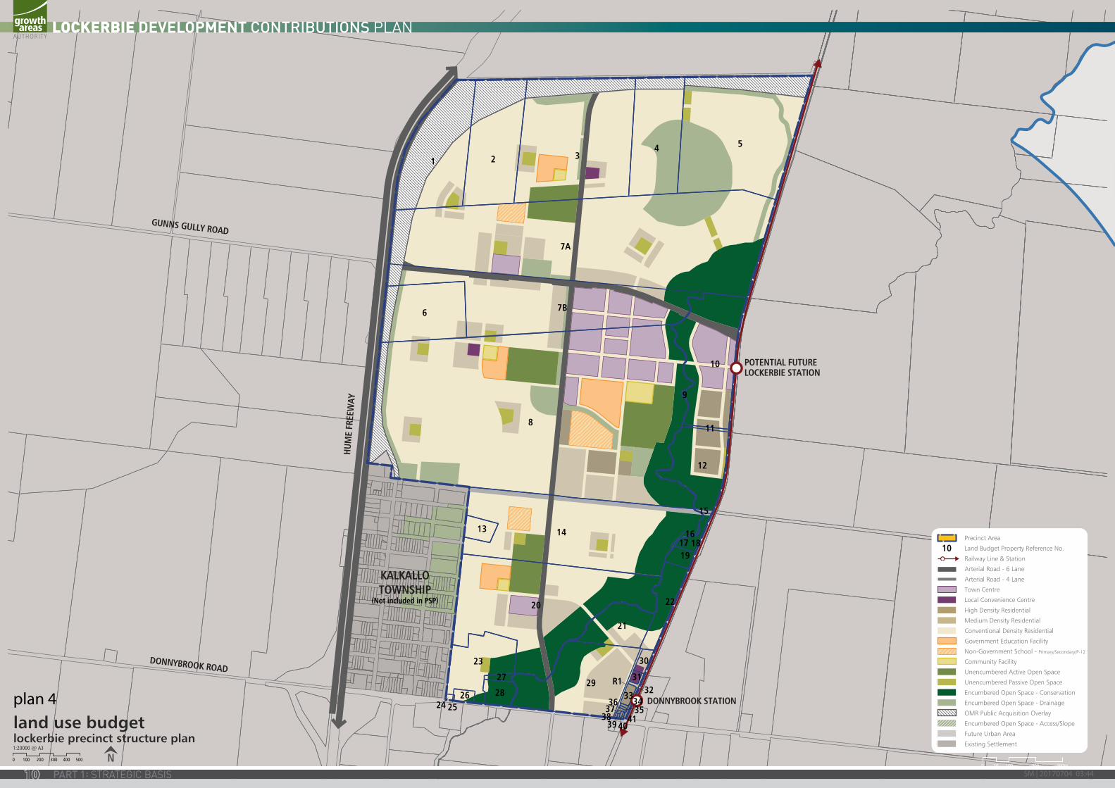
land use budgetlockerbie precinct structure plan
N1:20000 @ A3
0 100 200 300 400 500
Precinct Area
Land Budget Property Reference No.
Railway Line & Station
Arterial Road - 6 Lane
Arterial Road - 4 Lane
Town Centre
Local Convenience Centre
High Density Residential
Medium Density Residential
Conventional Density Residential
Government Education Facility
Non-Government School - Primary/Secondary/P-12
Community Facility
Unencumbered Active Open Space
Unencumbered Passive Open Space
Encumbered Open Space - Conservation
Encumbered Open Space - Drainage
OMR Public Acquisition Overlay
Encumbered Open Space - Access/Slope
Future Urban Area
Existing Settlement
10
plan 4
0 300m20010050
SM | 20170704 03:4410
1.4 INFRASTRUCTURE PROJECT JUSTIFICATION
1.4.1 INTRODUCTIONThe need for infrastructure has been determined according to the anticipated development scenario for Lockerbie as described in the Lockerbie Precinct Structure Plan.
Items can be included in a development contributions plan if the need for infrastructure arises from proposed development of land in the area. Proposed development is levied in line with its projected share of use. An item can be included in a development contributions plan regardless of whether it is within or outside the development contributions plan area.
Before inclusion in this Development Contributions Plan, all items have been assessed to ensure they have a relationship or nexus to proposed development in the Lockerbie Precinct Structure Plan area. The cost apportionment methodology adopted in this Development Contributions Plan relies on the nexus principle. A new development is deemed to have a nexus with an item if it is expected to make use of that item.
The items that have been included in this Development Contributions Plan all have the following characteristics:
• they are essential to the health, safety and well-being of the community;
• they will be used by a broad cross-section of the community;
• they reflect the vision and strategic aspirations as expressed in the Lockerbie Precinct Structure Plan;
• They are not projects for which the State Government is responsible (this is a requirement of Section 46IA of the Act where the land included within the Development Contribution Plan is also subject to the Growth Areas Infrastructure Charge (GAIC) ); and
• they are not recurrent items.
1.4.2 ITEMS NOT INCLUDED IN THE DEVELOPMENT CONTRIBUTIONS PLANThe items listed below are not included in the Development Contributions Plan, as they are not considered to be higher order items. These items must be provided by developers as a matter of course and or pursuant to agreements with service agencies:
• All internal streets and connector streets, and associated traffic management measures. This includes streets on the edge of the Lockerbie Precinct Structure Plan;
• Intersections connecting development to the existing road network, except where specified in the development contribution plan projects;
• Flood mitigation works;
• Local drainage systems;
• Water, sewerage, underground power, gas, telecommunications services;
• Local pathways and connections to the regional and/or district pathway network;
• Basic levelling, water tapping and landscaping of open space;
• Passive public open space and any agreed associated works required by the PSP;
• Council’s plan checking and supervision costs; and
• Bus stops.
Table 3 – “Infrastructure Project Justification” provides an explanation of all projects in the Development Contributions Plan, which are described below.
1 2 34 5
7A
7B6
8
9
10
11
12
1413
15
1617 1819
20
21
22
23
24 2526 28
2729
30
31
33 32
3534
R1
3637
3839 40
41
KALKALLOTOWNSHIP
(Not included in PSP)
DONNYBROOK STATION
POTENTIAL FUTURE LOCKERBIE STATION
HUM
E FR
EEW
AY
GUNNS GULLY ROAD
DONNYBROOK ROAD
land use budgetlockerbie precinct structure plan
N1:20000 @ A3
0 100 200 300 400 500
Precinct Area
Land Budget Property Reference No.
Railway Line & Station
Arterial Road - 6 Lane
Arterial Road - 4 Lane
Town Centre
Local Convenience Centre
High Density Residential
Medium Density Residential
Conventional Density Residential
Government Education Facility
Non-Government School - Primary/Secondary/P-12
Community Facility
Unencumbered Active Open Space
Unencumbered Passive Open Space
Encumbered Open Space - Conservation
Encumbered Open Space - Drainage
OMR Public Acquisition Overlay
Encumbered Open Space - Access/Slope
Future Urban Area
Existing Settlement
10
11

IT09IT08
IT10
BR05
BR01
IT11
IT12
IT06
IT03
IT04
IT05
IT02
IT01
IT07IT13
RD03
RD01
RD02a
RD02c
RD02c
RD02a
RD02a
RD02b
RD01
RD03
BR04
BR02
BR03
road, bridge & intersection projectslockerbie development contributions plan
1:20000 @ A3
0 100 200 300 400 500
1:10000 @ A1
KALKALLOTOWNSHIP
(Not included in PSP)
DONNYBROOKSTATION
POTENTIAL FUTURELOCKERBIE STATION
HUM
E FR
EEW
AY
GUNNS GULLY ROAD
DONNYBROOK ROAD
Precinct Area
DCP Project Reference Number
Road Project
Bridge Project
Signalised Intersection
Railway Line & Station
Future Urban Area
Existing Urban Area
Roundabout
IT01
plan 5
SM | 20170704 03:4412
1.5 INFRASTRUCTURE PROJECTS
1.5.1 TRANSPORT The key transport related projects in the Development Contributions Plan are based on the transport network depicted in Plan 5 which is based on the report “GTA Traffic Modelling, November 2011”.
The transport projects comprise of two categories:
• Road construction/bridges; and
• Construction of major controlled intersections.
The road and intersection projects funded by the Development Contributions Plan include:
DCP PROJECT NUMBER
DESCRIPTION
ROADS
RD01 Land (8.61ha) and construction of one carriageway in each direction, from the Hume Freeway to the Merri Creek (extension of Gunns Gully Rd) for approximately 2.1km
RD02 (a) Land (11.48ha) and construction of one carriageway in each direction from the Merri Creek through to the intersection of Gunns Gully Rd (north south arterial for 2.8km within the City of Hume)
RD02 (b) Land (8200sqm) and construction of one carriageway in each direction from Donnybrook Rd through to the Merri Creek (North south arterial for 200m within the City of Whittlesea)
RD02 (c) Land (6.273ha) and construction of one carriageway in each direction from the intersection of Gunns Gully Rd through to Donovans Lane (north south arterial for 1.53km within the Shire of Mitchell)
RD03 Land (8.16ha) and construction of one carriageway in each direction for approximately 2.4km from the Hume Freeway through to the Merri Creek (mid block east west arterial)
BRIDGES
BR01 Interim 2 lane bridge crossing of the Merri Creek on the north south arterial.
BR02 Interim 2 lane bridge crossing of Merri Creek on Gunns Gully Rd.
BR03 2 lane bridge crossing the Merri Creek accessing the train station precinct
BR04 Interim 2 lane bridge crossing of the Merri Creek and train line on the mid block arterial. Apportionment of 50%
BR05 2 lane bridge crossing of the Merri Creek on the connector street accessing the Donnybrook train station precinct.
INTERSECTIONS
IT01 Construction of an interim signalised intersection on the corner of the north south arterial and east west connector, adjacent active open space
IT02 Construction of an interim signalised intersection on the corner of the north south connector and Gunns Gully Rd
IT03 Construction of an interim signalised intersection on the corner of Gunns Gully Rd and the north south arterial
IT04 Construction of an interim signalised intersection on the corner of Gunns Gully Rd and the Lockerbie Principal Town Centre
IT05 Construction of an interim signalised intersection on the corner of Gunns Gully Rd, accessing the Lockerbie Principal Town Centre between Merri Creek and the rail line
IT06 Construction of an interim signalised intersection on the corner of the north south arterial and the east west connector accessing the Lockerbie Principal Town Centre
IT07 Construction of an interim roundabout on the corner of the mid block east west arterial and the extension of Dwyer Street
IT08 Construction of an interim signalised intersection on the corner of the north south arterial and the mid block east west arterial
IT09 Construction of an interim roundabout on the corner of the mid block east west arterial and the north south connecter
IT10 Construction of an interim signalised intersection on the north south arterial and the east west connector, accessing the Local Town Centre and active open space
IT11 Construction of an interim signalised intersection on the corner of Donnybrook Rd and Dwyer Street
IT12 Construction of an interim signalised intersection on the corner of Donnybrook Rd and the north south arterial
IT13 Construction of an interim roundabout on the corner of East-West arterial and north south connector road (north of Kalkallo Township)
IT09IT08
IT10
BR05
BR01
IT11
IT12
IT06
IT03
IT04
IT05
IT02
IT01
IT07IT13
RD03
RD01
RD02a
RD02c
RD02c
RD02a
RD02a
RD02b
RD01
RD03
BR04
BR02
BR03
road, bridge & intersection projectslockerbie development contributions plan
1:20000 @ A3
0 100 200 300 400 500
1:10000 @ A1
KALKALLOTOWNSHIP
(Not included in PSP)
DONNYBROOKSTATION
POTENTIAL FUTURELOCKERBIE STATION
HUM
E FR
EEW
AY
GUNNS GULLY ROAD
DONNYBROOK ROAD
Precinct Area
DCP Project Reference Number
Road Project
Bridge Project
Signalised Intersection
Railway Line & Station
Future Urban Area
Existing Urban Area
Roundabout
IT01
13
0 300m20010050
KALKALLOTOWNSHIP
(Not included in PSP)
DONNYBROOKSTATION
POTENTIAL FUTURELOCKERBIE STATION
HUM
E FR
EEW
AY
GUNNS GULLY ROAD
DONNYBROOK ROAD
OS04
OS01, AR01,AR02 & AR03
OS02, AR04,AR05 & AR06
OS03, AR07,AR08 & AR09
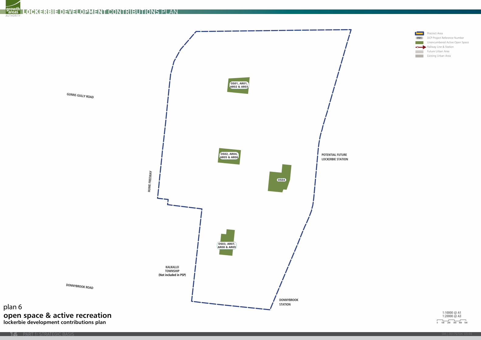
open space & active recreationlockerbie development contributions plan
1:20000 @ A3
0 100 200 300 400 500
1:10000 @ A1
Precinct Area
DCP Project Reference Number
Unencumbered Active Open Space
Railway Line & Station
Future Urban Area
Existing Urban Area
IT01
plan 6
SM | 20170704 03:4414
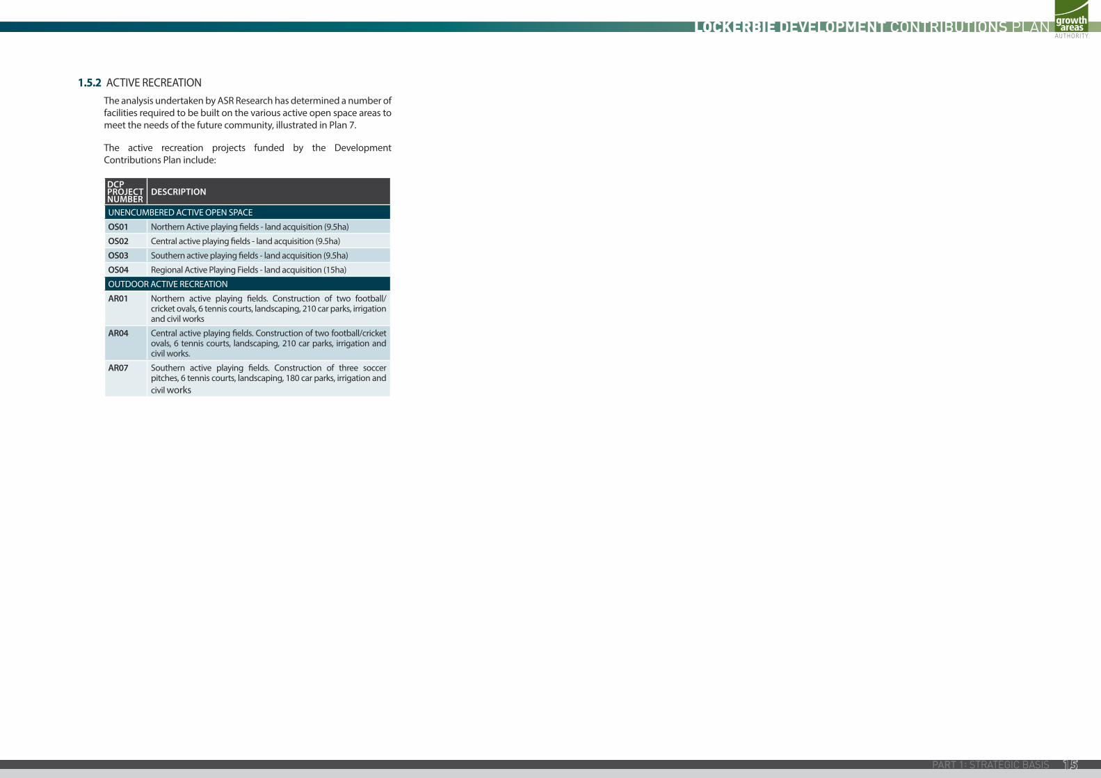
1.5.2 ACTIVE RECREATIONThe analysis undertaken by ASR Research has determined a number of facilities required to be built on the various active open space areas to meet the needs of the future community, illustrated in Plan 7.
The active recreation projects funded by the Development Contributions Plan include:
DCP PROJECT NUMBER
DESCRIPTION
UNENCUMBERED ACTIVE OPEN SPACE
OS01 Northern Active playing fields - land acquisition (9.5ha)
OS02 Central active playing fields - land acquisition (9.5ha)
OS03 Southern active playing fields - land acquisition (9.5ha)
OS04 Regional Active Playing Fields - land acquisition (15ha)
OUTDOOR ACTIVE RECREATION
AR01 Northern active playing fields. Construction of two football/cricket ovals, 6 tennis courts, landscaping, 210 car parks, irrigation and civil works
AR04 Central active playing fields. Construction of two football/cricket ovals, 6 tennis courts, landscaping, 210 car parks, irrigation and civil works.
AR07 Southern active playing fields. Construction of three soccer pitches, 6 tennis courts, landscaping, 180 car parks, irrigation and civil works
KALKALLOTOWNSHIP
(Not included in PSP)
DONNYBROOKSTATION
POTENTIAL FUTURELOCKERBIE STATION
HUM
E FR
EEW
AY
GUNNS GULLY ROAD
DONNYBROOK ROAD
OS04
OS01, AR01,AR02 & AR03
OS02, AR04,AR05 & AR06
OS03, AR07,AR08 & AR09
open space & active recreationlockerbie development contributions plan
1:20000 @ A3
0 100 200 300 400 500
1:10000 @ A1
Precinct Area
DCP Project Reference Number
Unencumbered Active Open Space
Railway Line & Station
Future Urban Area
Existing Urban Area
IT01
15
KALKALLOTOWNSHIP
(Not included in PSP)
DONNYBROOKSTATION
POTENTIAL FUTURELOCKERBIE STATION
HUM
E FR
EEW
AY
GUNNS GULLY ROAD
DONNYBROOK ROAD
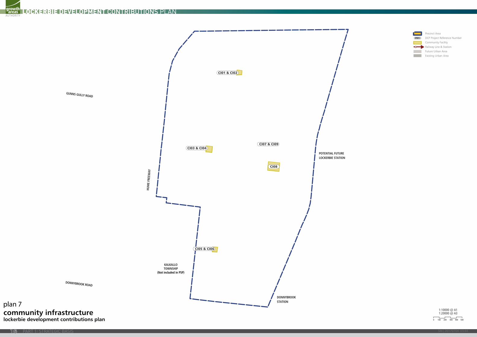
CI08
CI07 & CI09CI03 & CI04
CI05 & CI06
CI01 & CI02
community infrastructurelockerbie development contributions plan
1:20000 @ A3
0 100 200 300 400 500
1:10000 @ A1
Precinct Area
DCP Project Reference Number
Community Facility
Railway Line & Station
Future Urban Area
Existing Urban Area
IT01
plan 7
SM | 20170704 03:4416
1.5.3 COMMUNITY FACILITIESThe needs analysis undertaken by ASR Research has determined the requirement for a range of community facilities which are illustrated in Plan 6.
The community and indoor facility projects funded by the Development Contributions Plan include:
DCP PROJECT NUMBER
DESCRIPTION
CI01 Multi-purpose community facility north - land acquisition (0.8ha)
CI02 Multi-purpose community facility north - construction of a 750sqm building
CI03 Multi-purpose community facility central - land acquisition (1.2ha)
CI04 Multi-purpose community facility central - construction of a 1500sqm building
CI05 Multi-purpose community facility south - land acquisition (0.8ha)
CI06 Multi-purpose community facility south - construction of a 750sqm building
CI07 Land for Library and Learning Centre (2ha)
CI08 Land for Indoor Recreation Precinct (3ha)
CI09 Land for public purpose (1ha)
1.6 PROJECT TIMING
Each item in the Development Contributions Plan has an assumed indicative provision trigger specified in Table 3. The timing of the provision of the items in this Development Contributions Plan is consistent with information available at the time that the Development Contributions Plan was prepared. The Development Agency for each item of infrastructure will monitor and assess the required timing for individual items and may seek an amendment to the Development Contribution Plan to adjust indicative provision triggers as part of the 5 year review.
While indicative provision triggers are estimated these do not preclude the early provision of certain infrastructure to be constructed/provided by development proponents as works or land in-kind, if agreed to by the relevant Collecting Agency.
1.7 DISTINCTION BETWEEN COMMUNITY AND DEVELOPMENT INFRASTRUCTURE
In accordance with the Act and the Ministerial Direction May 2004 on Development Contributions, the Development Contributions Plan makes a distinction between “development” and “community” infrastructure. The timing of payment of contributions is linked to the type of infrastructure in question.
For community infrastructure, the community infrastructure levy must be made paid at the time of building approval. Contributions relating to community infrastructure will be charged at a “per-dwelling” rate. The Act stipulates that the amount that may be contributed under a community infrastructure levy is no more than $1,150 per dwelling.
Variation to the Community Infrastructure Levy (CIL) payable under this Development Contributions Plan (DCP)
If the maximum amount of the CIL which may be collected under an approved DCP is varied under section 46L of the Planning and Environment Act 1987, the collecting agency may adjust the amount of the CIL payable under this DCP in accordance with section 46L of the Planning and Environment Act 1987.
The collecting agency must publish the adjusted amount of the CIL payable under this DCP on its website.
The following infrastructure projects have been classified as community infrastructure:
DCP PROJECT NUMBER
DESCRIPTION
AR02 Northern active playing fields - Construction of Pavilion to serve 2 AFL/Cricket playing fields
AR03 Pavilion to serve 6 tennis courts
AR05 Central active playing fields - Construction of pavilion to serve 2 AFL/Cricket playing fields
AR06 Pavilion to serve 6 tennis courts
AR08 Southern active playing fields - Construction of pavilion to serve soccer pitches
AR09 Pavilion to serve 6 tennis courts
All other infrastructure projects are classified as development infrastructure projects. Contributions relating to development infrastructure are to be made by developers at the time of subdivision or if there is no subdivision then prior to the commencement of buildings and works. Part 3 of this Development Contributions Plan specifies implementation provisions.
KALKALLOTOWNSHIP
(Not included in PSP)
DONNYBROOKSTATION
POTENTIAL FUTURELOCKERBIE STATION
HUM
E FR
EEW
AY
GUNNS GULLY ROAD
DONNYBROOK ROAD
CI08
CI07 & CI09CI03 & CI04
CI05 & CI06
CI01 & CI02
community infrastructurelockerbie development contributions plan
1:20000 @ A3
0 100 200 300 400 500
1:10000 @ A1
Precinct Area
DCP Project Reference Number
Community Facility
Railway Line & Station
Future Urban Area
Existing Urban Area
IT01
Inserted by GC75
Amended by GC75
Deleted by GC75
17
PART 2: CALCULATION OF CONTRIBUTIONSPart 1 sets out the strategic basis for this Development Contributions Plan and identifies infrastructure items to be included in the Development Contributions Plan. Part 2 focuses on the calculation of contributions and apportionment of costs.
The general cost apportionment method includes the following steps:
• Calculation of the net developable area and demand units (refer Tables 1 and 2);
• Calculation of project costs (refer Table 4);
• Identification and allowance for external use (refer Table 4);
• Cost apportionment and catchments (refer Table 4);
• Identification of development types required to pay the levy (Refer to Table 6);
• Summary of costs payable by development type for each infrastructure category (refer Table 6); and
• Finally, a charge per net developable hectare by development type (refer Table 6).
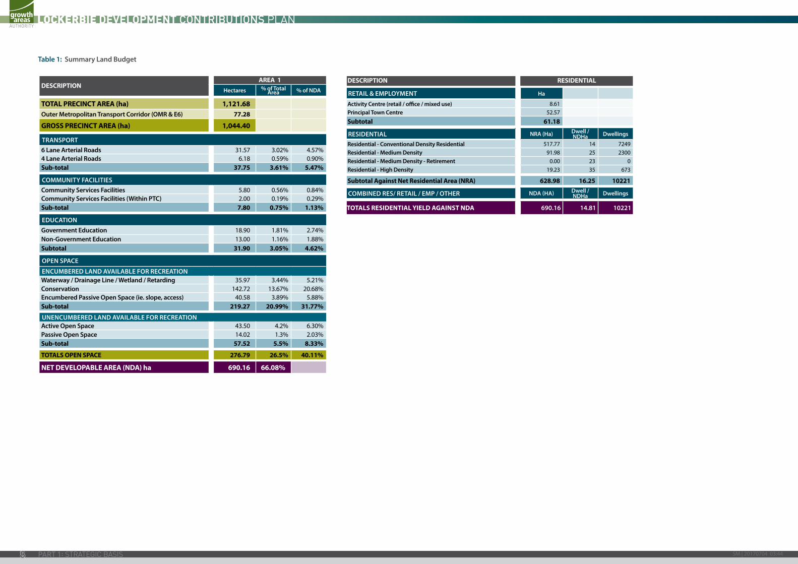
2.1 CALCULATION OF NET DEVELOPABLE AREA AND DEMAND UNITS
2.1.1 INTRODUCTIONThe following section sets out how Net Developable Area is calculated by providing a detailed land budget for every property within the Lockerbie DCP area.
2.1.2 NET DEVELOPABLE AREAIn this Development Contributions Plan, all development infrastructure levies are payable on the basis of Net Developable Area (NDA) on any given development site.
For the purposes of this Development Contributions Plan, NDA is defined as:
“the total amount of land within the area of the Lockerbie Precinct Structure Plan that has been assessed in the detailed land budget contained in this Development Contributions Plan as being available for development of housing and employment buildings, including lots, local and connector streets.”
Put simply, it is the total precinct area minus land for community facilities, schools, educational facilities, open space, encumbered land and arterial roads. Small local parks defined at the subdivision stage are included in the NDA.
The NDA for the Development Contributions Plan has been assessed and is specified in Tables 1 and 2.
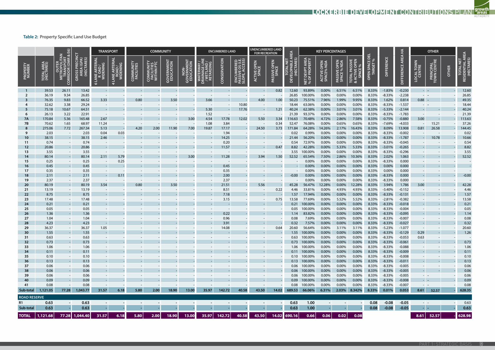
2.1.3 LAND BUDGET AND DEMAND UNITSTables 1 provides a land budget for the entire Lockerbie Precinct Structure Plan. The detailed land budget is then broken down further as set out in Table 2 for each land holding within the Lockerbie Precinct Structure Plan area as (see Plan 4). Table 2 sets the amount of NDA and land required for a public purpose in accordance with the Development Contributions Plan for each land holding. The resulting Net Developable Hectares is the Demand Unit and the basis upon which the development contribution levies are payable.
Based on the Lockerbie Precinct Structure Plan, there is one development type which is “residential” (including local town centres) and the total NDA within the DCP area is assessed as 726 hectares.
2.2 CALCULATION OF CONTRIBUTION CHARGES
2.2.1 CALCULATION OF COSTSEach infrastructure project has been assigned a land and/or construction cost. These costs are listed in Table 3. The costs are expressed in 2012 dollars and will be adjusted annually in accordance with the method specified in Section 3.2.8 of this Development Contributions Plan.
VALUATION OF LAND
The cost of each infrastructure project was initially determined by a land valuer appointed by the Growth Areas Authority, on a market based valuation to determine the current market value of the land required for infrastructure projects within the DCP area.
Where a single land acquisition project includes land to be acquired from more than one property, a valuation was prepared for each individual property and added together to determine the overall cost of the land comprising that infrastructure project.
CALCULATION OF CONSTRUCTION COSTS
All road, intersection and shared path construction costs have been determined by CDCE Consultants (project cost sheets can be obtained from the Growth Areas Authority and Council).
All sports field and community building construction costs have been determined by Meinhardt.
2.2.2 EXTERNAL USEAn allowance has been made for other use external to the MCA for specific projects - that is use that does not emanate from the Lockerbie DCP area. Table 4 quantifies any external demand (as a percentage) for each infrastructure project. Where an external demand has been assessed, a percentage discount has been made to the dollar amount to be recovered in relation to development proposed within the DCP area.
SM | 20170704 03:4418
2.2.3 COST APPORTIONMENTThis Development Contributions Plan has apportioned a charge to new development according to its projected share of use of an identified infrastructure item. Since development and community infrastructure levies are charged ‘up-front’, a measure of actual use by individual development sites is not possible. Therefore costs have been shared in accordance with the estimated share of use.
This Development Contributions Plan cannot and does not require payment from existing or approved Development However, the share of use that existing development receives from these items has been taken into account when calculating the contribution expected from new Development This results in new development paying only its fair share of the estimated cost of new infrastructure and services (and does not pay for the use by existing development).
This Development Contributions Plan calculates what each new development should pay towards provision of the identified infrastructure item. Put simply, this is the total cost of the item (after deducting other funding sources and making allowance for any external demand) divided by total (existing and proposed) Demand Units within its catchment. As stated in Section 1.3, the entire Lockerbie Precinct Structure Plan area constitutes the sole main catchment area within this precinct.
2.2.4 MAIN CATCHMENT AREAThe MCA is the geographic area from which a given item of infrastructure will draw most of its use. The MCA consists of one area covering the entire Lockerbie Precinct Structure Plan area. Given this Development Contribution Plan covers three municipalities, the MCA has been notionally divided into three charge areas that accord with the respective municipal boundaries.
It is important to note that the number of Demand Units (Net Developable Hectares) in each of the notional charge areas is based on the land budgets in Tables 1 and 2.
The contributions must not be amended to respond to minor changes to land budgets that may result from the subdivision process. In other words, the Development Contributions Plan is permanently linked to the detailed Land Budget in Table 2. Allowing subsequent adjustments to net developable area through subdivision will create gaps in the funding of infrastructure and should not be permitted.
Therefore, Table 2 should be used to determine the number of developable hectares on individual parcels.
2.2.5 DEVELOPMENT TYPESThe Development Contribution Plan assumes the class “residential” as the only development type. This does not infer that no other type of development is proposed. However for charging purposes, no distinction is made between different types of uses.
Non- Government Schools
The Land Budget (refer Table 2) specifies a quantum of land for non government schools. The Land Budget contains an ‘Identified non Government School’ column which sets out the properties containing all or part of a preferred non government school site. The column specifies a particular land take for non government school use on these properties.
If a preferred site shown within the Future Urban Structure for a non government school is to be used for non government school use, the development is exempt from the requirement to pay a development infrastructure levy where the land is to be used primarily for the purpose of a non government school.
If any of the preferred non government school sites are not used or developed for the purpose of a non government school, the relevant residential charge rate for the area within which the land is located applies.
2.2.6 SCHEDULE OF COSTSTable 5 shows the contribution per net developable hectare towards each infrastructure project. The total adds up to the total amount of funds recoverable under the Development Contributions Plan.
2.2.7 SUMMARY OF CONTRIBUTIONSTable 8 sets out a summary of contributions estimated to be collected by each municipality.
19
Table 3: Strategic Justification
DCP PROJECT NUMBER
INFRASTRUCTURE CATEGORY DESCRIPTION
ESTIMATED PROJECT COST INDICATIVE PROVISION
TRIGGERSTRATEGIC
JUSTIFICATION LAND CONSTRUCTION TOTAL
ROADS
RD01 Development Land (10ha) and construction of one carriageway in each direction, from the Hume Freeway to the Merri Creek (extension of Gunns Gully Rd) for approximately 2.1km $5,250,000 $1,967,478 $7,217,478
Statement of Compliance for
subdivision
GTA Traffic modelling for the Lockerbie Precinct
Structure Plan
RD02 (a) Development Land (11.48ha) and construction of one carriageway in each direction from the Merri Creek through to the intersection of Gunns Gully Rd (north south arterial for 2.8km within the City of Hume) $6,027,000 $3,869,405 $9,896,405
RD02 (b) Development Land (8200sqm) and construction of one carriageway in each direction from Donnybrook Rd through to the Merri Creek (North south arterial for 200m within the City of Whittlesea) $430,500 $232,932 $663,432
RD02 (c ) Development Land (6.273ha) and construction of one carriageway in each direction from the intersection of Gunns Gully Rd through to Donovans Lane (north south arterial for 1.53km within the Shire of Mitchell) $3,293,325 $2,049,796 $5,343,121
RD03 Development Land (8.16ha) and construction of one carriageway in each direction for approximately 2.4km from the Hume Freeway through to the Merri Creek (mid block east west arterial) $4,284,000 $5,896,751 $10,180,751
BRIDGES
BR01 Development Interim 2 lane bridge crossing of the Merri Creek on the north south arterial. $6,008,429 $6,008,429
Statement of Compliance for
subdivision
GTA Traffic modelling for the Lockerbie Precinct
Structure Plan
BR02 Development Interim 2 lane bridge crossing of Merri Creek on Gunns Gully Rd. $3,029,394 $3,029,394
BR03 Development 2 lane bridge crossing the Merri Creek accessing the train station precinct $3,200,682 $3,200,682
BR04 Development Interim 2 lane bridge crossing of the Merri Creek and train line on the mid block arterial Apportionment of 50% $8,230,234 $8,230,234
BR05 Development 2 lane bridge crossing of the Merri Creek on the connector street accessing the Donnybrook train station precinct. $4,255,722 $4,255,722
SUB-TOTAL $19,284,825 $38,740,823 $58,025,648
INTERSECTIONS
IT01 Development Construction of an interim signalised intersection on the corner of the north south arterial and east west connector, adjacent active open space $4,387,338 $4,387,338
Statement of Compliance for
subdivision
GTA Traffic modelling for the Lockerbie Precinct
Structure Plan
IT02 Development Construction of an interim signalised intersection on the corner of the north south connector and Gunns Gully Rd $3,877,076 $3,877,076
IT03 Development Construction of an interim signalised intersection on the corner of Gunns Gully Rd and the north south arterial $5,110,015 $5,110,015
IT04 Development Construction of an interim signalised intersection on the corner of Gunns Gully Rd and the Lockerbie Principal Town Centre $4,328,023 $4,328,023
IT05 Development Construction of an interim signalised intersection on the corner of Gunns Gully Rd, accessing the Lockerbie Principal Town Centre between Merri Creek and the rail line $2,619,216 $2,619,216
IT06 Development Construction of an interim signalised intersection on the corner of the north south arterial and the east west connector accessing the Lockerbie Principal Town Centre $4,798,644 $4,798,644
IT07 Development Construction of an interim roundabout on the corner of the mid block east west arterial and the extension of Dwyer Street $376,964 $376,964
IT08 Development Construction of an interim signalised intersection on the corner of the north south arterial and the mid block east west arterial $4,026,528 $4,026,528
IT09 Development Construction of an interim roundabout on the corner of the mid block east west arterial and the north south connecter $362,789 $362,789
IT10 Development Construction of an interim signalised intersection on the north south arterial and the east west connector, accessing the Local Town Centre and active open space $4,182,893 $4,182,893
IT11 Development Construction of an interim signalised intersection on the corner of Donnybrook Rd and Dwyer Street $2,107,787 $2,107,787
IT12 Development Construction of an interim signalised intersection on the corner of Donnybrook Rd and the north south arterial $5,110,015 $5,110,015
IT13 Development Construction of an interim roundabout on the corner of East-West arterial and north south connector road (north of Kalkallo Township) $300,778 $300,778
SUB-TOTAL $41,588,066 $41,588,066
SM | 20170704 03:4420
DCP PROJECT NUMBER
INFRASTRUCTURE CATEGORY DESCRIPTION
ESTIMATED PROJECT COST INDICATIVE PROVISION
TRIGGERSTRATEGIC
JUSTIFICATION LAND CONSTRUCTION TOTAL
COMMUNITY & INDOOR RECREATION FACILITIES
Cl01 Development Multi-purpose community facility north - land acquisition (0.8ha) $1,800,000 $1,800,000
Statement of Compliance for
subdivision
ASR Research Lockerbie Precinct Structure Plan Assessment
of Community Infrastructure
Requirements & Opportunities
Cl02 Development Multi-purpose community facility north - construction of a 750sqm building. $3,872,000 $3,872,000
Cl03 Development Multi-purpose community facility central - land acquisition (1.2ha) $1,800,000 $1,800,000
CI04 Development Multi-purpose community facility central - construction of a 1500sqm building $5,826,000 $5,826,000
CI05 Development Multi-pupose community facility south - land acquisition (0.8ha) $1,800,000 $1,800,000
CI06 Development Multi-purpose community facility south - construction of a 750sqm building $3,872,000 $3,872,000
CI07 Development Land for Library and Learning Centre (2ha) $3,500,000 $3,500,000
CI08 Development Land for Indoor Recreation Precinct (3.0ha) $4,500,000 $4,500,000
CI09 Development Land for public purpose (1ha) $525,000 $525,000
SUB-TOTAL $13,925,000 $13,570,000 $27,495,000
UNENCUMBERED ACTIVE OPEN SPACE
OS01 Development Northern Active playing fields - land acquisition (9.5ha) $12,880,000 $12,880,000
Statement of Compliance for
subdivision
ASR Research Lockerbie Precinct Structure Plan Assessment
of Community Infrastructure
Requirements & Opportunities
OS02 Development Central active playing fields - land acquisition (9.5ha) $9,500,000 $9,500,000
OS03 Development Southern active playing fields - land acquisition (9.5ha) $12,860,000 $12,860,000
OS04 Development Regional Active Playing Fields - land acquisition (15ha) $11,250,000 $11,250,000
SUB-TOTAL $46,490,000 $46,490,000
OUTDOOR ACTIVE RECREATION
AR01 Development Northern active playing fields. Construction of two football/cricket ovals, 6 tennis courts, landscaping, 210 car parks, irrigation and civil works $8,298,000 $8,298,000
Statement of Compliance for
subdivision
ASR Research Lockerbie Precinct Structure Plan Assessment
of Community Infrastructure
Requirements & Opportunities
AR02 Community Northern active playing fields - Construction of Pavilion to serve 2 AFL/Cricket playing fields $1,415,000 $1,415,000
AR03 Community Northern active playing fields. Construction of a pavilion to serve 6 tennis courts $1,074,000 $1,074,000
AR04 Development Central active playing fields. Construction of two football/cricket ovals, 6 tennis courts, landscaping, 210 car parks, irrigation and civil works. $8,298,000 $8,298,000
AR05 Community Central active playing fields - Construction of pavilion to serve 2 AFL/Cricket playing fields $1,415,000 $1,415,000
AR06 Community Central active playing fields. Construction of a pavilion to serve 6 tennis courts $1,074,000 $1,074,000
AR07 Development Southern active playing fields. Construction of three soccer pitches, 6 tennis courts, landscaping, 180 car parks, irrigation and civil works. $7,104,000 $7,104,000
AR08 Community Southern active playing fields - Construction of pavilion to serve soccer pitches $1,415,000 $1,415,000
AR09 Community Southern active playing fields. Construction of a pavilion to serve 6 tennis courts $1,074,000 $1,074,000
SUB-TOTAL $31,167,000 $31,167,000
TOTAL $79,699,825 $125,065,889 $204,765,714
21
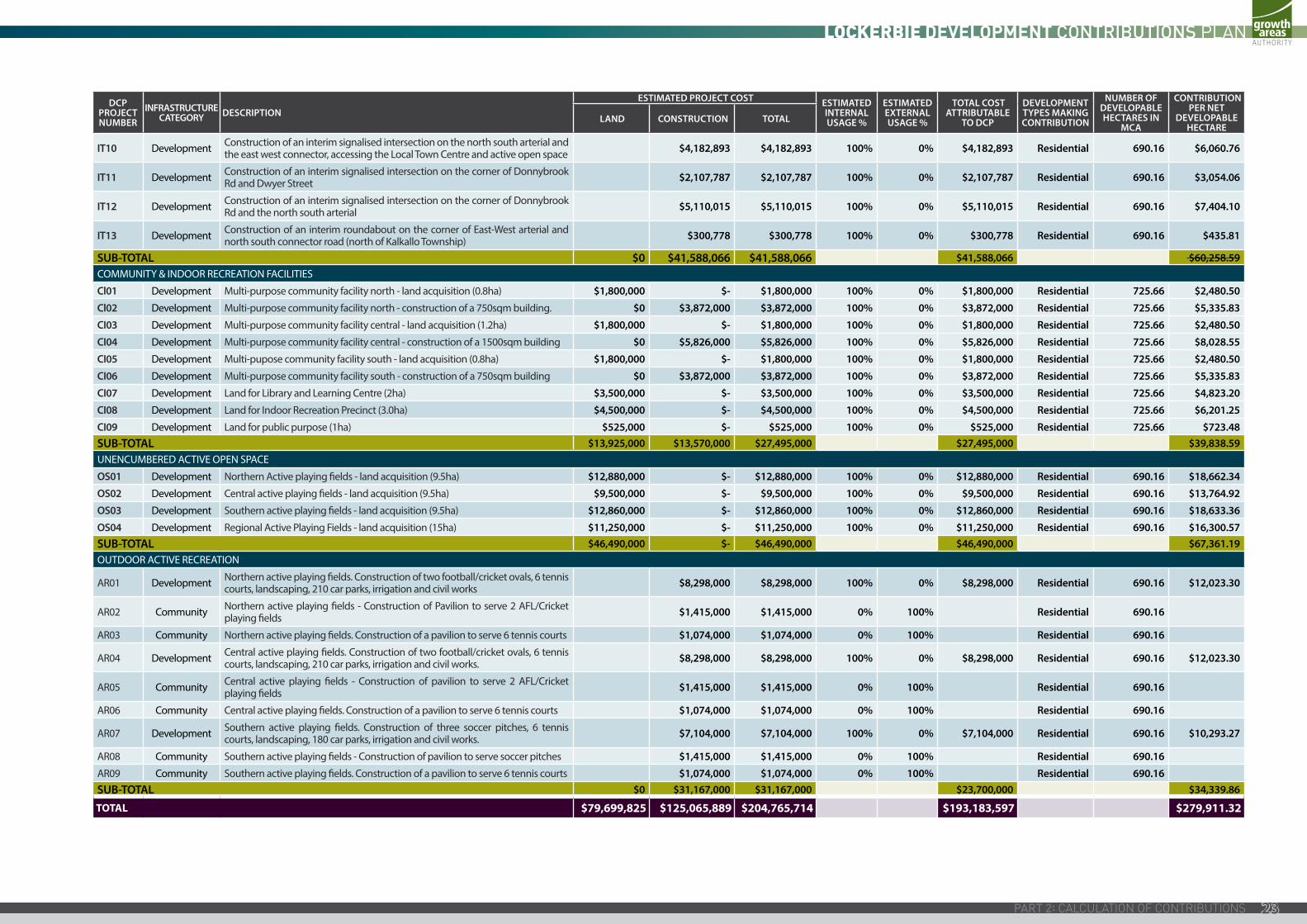
Table 4: Calculation of Costs and Apportionment
DCP PROJECT NUMBER
INFRASTRUCTURE CATEGORY DESCRIPTION
ESTIMATED PROJECT COST ESTIMATED DCP AREA USAGE %
ESTIMATED EXTERNAL USAGE %
TOTAL COST ATTRIBUTABLE
TO DCP
DEVELOPMENT TYPES MAKING CONTRIBUTION
NUMBER OF DEVELOPABLE HECTARES IN
MCA
CONTRIBUTION PER NET
DEVELOPABLE HECTARE
LAND CONSTRUCTION TOTAL
ROADS
RD01 DevelopmentLand (10ha) and construction of one carriageway in each direction, from the Hume Freeway to the Merri Creek (extension of Gunns Gully Rd) for approximately 2.1km
$5,250,000 $1,967,478 $7,217,478 100% 0% $7,217,478 Residential 690.16 $10,457.69
RD02 (a) DevelopmentLand (11.48ha) and construction of one carriageway in each direction from the Merri Creek through to the intersection of Gunns Gully Rd (north south arterial for 2.8km within the City of Hume)
$6,027,000 $3,869,405 $9,896,405 100% 0% $9,896,405 Residential 690.16 $14,339.29
RD02 (b) DevelopmentLand (8200sqm) and construction of one carriageway in each direction from Donnybrook Rd through to the Merri Creek (North south arterial for 200m within the City of Whittlesea)
$430,500 $232,932 $663,432 100% 0% $663,432 Residential 690.16 $961.27
RD02 (c ) DevelopmentLand (6.273ha) and construction of one carriageway in each direction from the intersection of Gunns Gully Rd through to Donovans Lane (north south arterial for 1.53km within the Shire of Mitchell)
$3,293,325 $2,049,796 $5,343,121 100% 0% $5,343,121 Residential 690.16 $7,741.86
RD03 DevelopmentLand (8.16ha) and construction of one carriageway in each direction for approximately 2.4km from the Hume Freeway through to the Merri Creek (mid block east west arterial)
$4,284,000 $5,896,751 $10,180,751 100% 0% $10,180,751 Residential 690.16 $14,751.29
BRIDGES
BR01 Development Interim 2 lane bridge crossing of the Merri Creek on the north south arterial. $6,008,429 $6,008,429 100% 0% $6,008,429 Residential 690.16 $8,705.85
BR02 Development Interim 2 lane bridge crossing of Merri Creek on Gunns Gully Rd. $3,029,394 $3,029,394 100% 0% $3,029,394 Residential 690.16 $4,389.41
BR03 Development 2 lane bridge crossing the Merri Creek accessing the train station precinct $3,200,682 $3,200,682 100% 0% $3,200,682 Residential 690.16 $4,637.59
BR04 Development Interim 2 lane bridge crossing of the Merri Creek and train line on the mid block arterial Apportionment of 50% $8,230,234 $8,230,234 50% 50% $4,115,117 Residential 690.16 $5,962.56
BR05 Development 2 lane bridge crossing of the Merri Creek on the connector street accessing the Donnybrook train station precinct. $4,255,722 $4,255,722 100% 0% $4,255,722 Residential 690.16 $6,166.28
SUB-TOTAL $19,284,825 $38,740,823 $58,025,648 $53,910,531 $78,113.09 INTERSECTIONS
IT01 Development Construction of an interim signalised intersection on the corner of the north south arterial and east west connector, adjacent active open space $4,387,338 $4,387,338 100% 0% $4,387,338 Residential 690.16 $6,356.99
IT02 Development Construction of an interim signalised intersection on the corner of the north south connector and Gunns Gully Rd $3,877,076 $3,877,076 100% 0% $3,877,076 Residential 690.16 $5,617.65
IT03 Development Construction of an interim signalised intersection on the corner of Gunns Gully Rd and the north south arterial $5,110,015 $5,110,015 100% 0% $5,110,015 Residential 690.16 $7,404.10
IT04 Development Construction of an interim signalised intersection on the corner of Gunns Gully Rd and the Lockerbie Principal Town Centre $4,328,023 $4,328,023 100% 0% $4,328,023 Residential 690.16 $6,271.04
IT05 DevelopmentConstruction of an interim signalised intersection on the corner of Gunns Gully Rd, accessing the Lockerbie Principal Town Centre between Merri Creek and the rail line
$2,619,216 $2,619,216 100% 0% $2,619,216 Residential 690.16 $3,795.09
IT06 DevelopmentConstruction of an interim signalised intersection on the corner of the north south arterial and the east west connector accessing the Lockerbie Principal Town Centre
$4,798,644 $4,798,644 100% 0% $4,798,644 Residential 690.16 $6,952.94
IT07 Development Construction of an interim roundabout on the corner of the mid block east west arterial and the extension of Dwyer Street $376,964 $376,964 100% 0% $376,964 Residential 690.16 $546.20
IT08 Development Construction of an interim signalised intersection on the corner of the north south arterial and the mid block east west arterial $4,026,528 $4,026,528 100% 0% $4,026,528 Residential 690.16 $5,834.19
IT09 Development Construction of an interim roundabout on the corner of the mid block east west arterial and the north south connecter $362,789 $362,789 100% 0% $362,789 Residential 690.16 $525.66
SM | 20170704 03:4422
DCP PROJECT NUMBER
INFRASTRUCTURE CATEGORY DESCRIPTION
ESTIMATED PROJECT COST ESTIMATED INTERNAL USAGE %
ESTIMATED EXTERNAL USAGE %
TOTAL COST ATTRIBUTABLE
TO DCP
DEVELOPMENT TYPES MAKING CONTRIBUTION
NUMBER OF DEVELOPABLE HECTARES IN
MCA
CONTRIBUTION PER NET
DEVELOPABLE HECTARE
LAND CONSTRUCTION TOTAL
IT10 Development Construction of an interim signalised intersection on the north south arterial and the east west connector, accessing the Local Town Centre and active open space $4,182,893 $4,182,893 100% 0% $4,182,893 Residential 690.16 $6,060.76
IT11 Development Construction of an interim signalised intersection on the corner of Donnybrook Rd and Dwyer Street $2,107,787 $2,107,787 100% 0% $2,107,787 Residential 690.16 $3,054.06
IT12 Development Construction of an interim signalised intersection on the corner of Donnybrook Rd and the north south arterial $5,110,015 $5,110,015 100% 0% $5,110,015 Residential 690.16 $7,404.10
IT13 Development Construction of an interim roundabout on the corner of East-West arterial and north south connector road (north of Kalkallo Township) $300,778 $300,778 100% 0% $300,778 Residential 690.16 $435.81
SUB-TOTAL $0 $41,588,066 $41,588,066 $41,588,066 $60,258.59 COMMUNITY & INDOOR RECREATION FACILITIES
Cl01 Development Multi-purpose community facility north - land acquisition (0.8ha) $1,800,000 $- $1,800,000 100% 0% $1,800,000 Residential 725.66 $2,480.50
Cl02 Development Multi-purpose community facility north - construction of a 750sqm building. $0 $3,872,000 $3,872,000 100% 0% $3,872,000 Residential 725.66 $5,335.83
CI03 Development Multi-purpose community facility central - land acquisition (1.2ha) $1,800,000 $- $1,800,000 100% 0% $1,800,000 Residential 725.66 $2,480.50
CI04 Development Multi-purpose community facility central - construction of a 1500sqm building $0 $5,826,000 $5,826,000 100% 0% $5,826,000 Residential 725.66 $8,028.55
CI05 Development Multi-pupose community facility south - land acquisition (0.8ha) $1,800,000 $- $1,800,000 100% 0% $1,800,000 Residential 725.66 $2,480.50
CI06 Development Multi-purpose community facility south - construction of a 750sqm building $0 $3,872,000 $3,872,000 100% 0% $3,872,000 Residential 725.66 $5,335.83
CI07 Development Land for Library and Learning Centre (2ha) $3,500,000 $- $3,500,000 100% 0% $3,500,000 Residential 725.66 $4,823.20
CI08 Development Land for Indoor Recreation Precinct (3.0ha) $4,500,000 $- $4,500,000 100% 0% $4,500,000 Residential 725.66 $6,201.25
CI09 Development Land for public purpose (1ha) $525,000 $- $525,000 100% 0% $525,000 Residential 725.66 $723.48 SUB-TOTAL $13,925,000 $13,570,000 $27,495,000 $27,495,000 $39,838.59 UNENCUMBERED ACTIVE OPEN SPACE
OS01 Development Northern Active playing fields - land acquisition (9.5ha) $12,880,000 $- $12,880,000 100% 0% $12,880,000 Residential 690.16 $18,662.34
OS02 Development Central active playing fields - land acquisition (9.5ha) $9,500,000 $- $9,500,000 100% 0% $9,500,000 Residential 690.16 $13,764.92
OS03 Development Southern active playing fields - land acquisition (9.5ha) $12,860,000 $- $12,860,000 100% 0% $12,860,000 Residential 690.16 $18,633.36
OS04 Development Regional Active Playing Fields - land acquisition (15ha) $11,250,000 $- $11,250,000 100% 0% $11,250,000 Residential 690.16 $16,300.57 SUB-TOTAL $46,490,000 $- $46,490,000 $46,490,000 $67,361.19 OUTDOOR ACTIVE RECREATION
AR01 Development Northern active playing fields. Construction of two football/cricket ovals, 6 tennis courts, landscaping, 210 car parks, irrigation and civil works $8,298,000 $8,298,000 100% 0% $8,298,000 Residential 690.16 $12,023.30
AR02 Community Northern active playing fields - Construction of Pavilion to serve 2 AFL/Cricket playing fields $1,415,000 $1,415,000 0% 100% Residential 690.16
AR03 Community Northern active playing fields. Construction of a pavilion to serve 6 tennis courts $1,074,000 $1,074,000 0% 100% Residential 690.16
AR04 Development Central active playing fields. Construction of two football/cricket ovals, 6 tennis courts, landscaping, 210 car parks, irrigation and civil works. $8,298,000 $8,298,000 100% 0% $8,298,000 Residential 690.16 $12,023.30
AR05 Community Central active playing fields - Construction of pavilion to serve 2 AFL/Cricket playing fields $1,415,000 $1,415,000 0% 100% Residential 690.16
AR06 Community Central active playing fields. Construction of a pavilion to serve 6 tennis courts $1,074,000 $1,074,000 0% 100% Residential 690.16
AR07 Development Southern active playing fields. Construction of three soccer pitches, 6 tennis courts, landscaping, 180 car parks, irrigation and civil works. $7,104,000 $7,104,000 100% 0% $7,104,000 Residential 690.16 $10,293.27
AR08 Community Southern active playing fields - Construction of pavilion to serve soccer pitches $1,415,000 $1,415,000 0% 100% Residential 690.16
AR09 Community Southern active playing fields. Construction of a pavilion to serve 6 tennis courts $1,074,000 $1,074,000 0% 100% Residential 690.16SUB-TOTAL $0 $31,167,000 $31,167,000 $23,700,000 $34,339.86
TOTAL $79,699,825 $125,065,889 $204,765,714 $193,183,597 $279,911.32
23
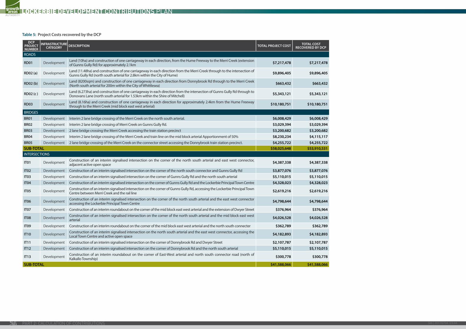
Table 5: Project Costs recovered by the DCP
DCP PROJECT NUMBER
INFRASTRUCTURE CATEGORY DESCRIPTION TOTAL PROJECT COST TOTAL COST
RECOVERED BY DCP
ROADS
RD01 Development Land (10ha) and construction of one carriageway in each direction, from the Hume Freeway to the Merri Creek (extension of Gunns Gully Rd) for approximately 2.1km $7,217,478 $7,217,478
RD02 (a) Development Land (11.48ha) and construction of one carriageway in each direction from the Merri Creek through to the intersection of Gunns Gully Rd (north south arterial for 2.8km within the City of Hume) $9,896,405 $9,896,405
RD02 (b) Development Land (8200sqm) and construction of one carriageway in each direction from Donnybrook Rd through to the Merri Creek (North south arterial for 200m within the City of Whittlesea) $663,432 $663,432
RD02 (c ) Development Land (6.273ha) and construction of one carriageway in each direction from the intersection of Gunns Gully Rd through to Donovans Lane (north south arterial for 1.53km within the Shire of Mitchell) $5,343,121 $5,343,121
RD03 Development Land (8.16ha) and construction of one carriageway in each direction for approximately 2.4km from the Hume Freeway through to the Merri Creek (mid block east west arterial) $10,180,751 $10,180,751
BRIDGES
BR01 Development Interim 2 lane bridge crossing of the Merri Creek on the north south arterial. $6,008,429 $6,008,429
BR02 Development Interim 2 lane bridge crossing of Merri Creek on Gunns Gully Rd. $3,029,394 $3,029,394
BR03 Development 2 lane bridge crossing the Merri Creek accessing the train station precinct $3,200,682 $3,200,682
BR04 Development Interim 2 lane bridge crossing of the Merri Creek and train line on the mid block arterial Apportionment of 50% $8,230,234 $4,115,117
BR05 Development 2 lane bridge crossing of the Merri Creek on the connector street accessing the Donnybrook train station precinct. $4,255,722 $4,255,722SUB-TOTAL $58,025,648 $53,910,531INTERSECTIONS
IT01 Development Construction of an interim signalised intersection on the corner of the north south arterial and east west connector, adjacent active open space $4,387,338 $4,387,338
IT02 Development Construction of an interim signalised intersection on the corner of the north south connector and Gunns Gully Rd $3,877,076 $3,877,076
IT03 Development Construction of an interim signalised intersection on the corner of Gunns Gully Rd and the north south arterial $5,110,015 $5,110,015
IT04 Development Construction of an interim signalised intersection on the corner of Gunns Gully Rd and the Lockerbie Principal Town Centre $4,328,023 $4,328,023
IT05 Development Construction of an interim signalised intersection on the corner of Gunns Gully Rd, accessing the Lockerbie Principal Town Centre between Merri Creek and the rail line $2,619,216 $2,619,216
IT06 Development Construction of an interim signalised intersection on the corner of the north south arterial and the east west connector accessing the Lockerbie Principal Town Centre $4,798,644 $4,798,644
IT07 Development Construction of an interim roundabout on the corner of the mid block east west arterial and the extension of Dwyer Street $376,964 $376,964
IT08 Development Construction of an interim signalised intersection on the corner of the north south arterial and the mid block east west arterial $4,026,528 $4,026,528
IT09 Development Construction of an interim roundabout on the corner of the mid block east west arterial and the north south connecter $362,789 $362,789
IT10 Development Construction of an interim signalised intersection on the north south arterial and the east west connector, accessing the Local Town Centre and active open space $4,182,893 $4,182,893
IT11 Development Construction of an interim signalised intersection on the corner of Donnybrook Rd and Dwyer Street $2,107,787 $2,107,787
IT12 Development Construction of an interim signalised intersection on the corner of Donnybrook Rd and the north south arterial $5,110,015 $5,110,015
IT13 Development Construction of an interim roundabout on the corner of East-West arterial and north south connector road (north of Kalkallo Township) $300,778 $300,778
SUB-TOTAL $41,588,066 $41,588,066
SM | 20170704 03:4424
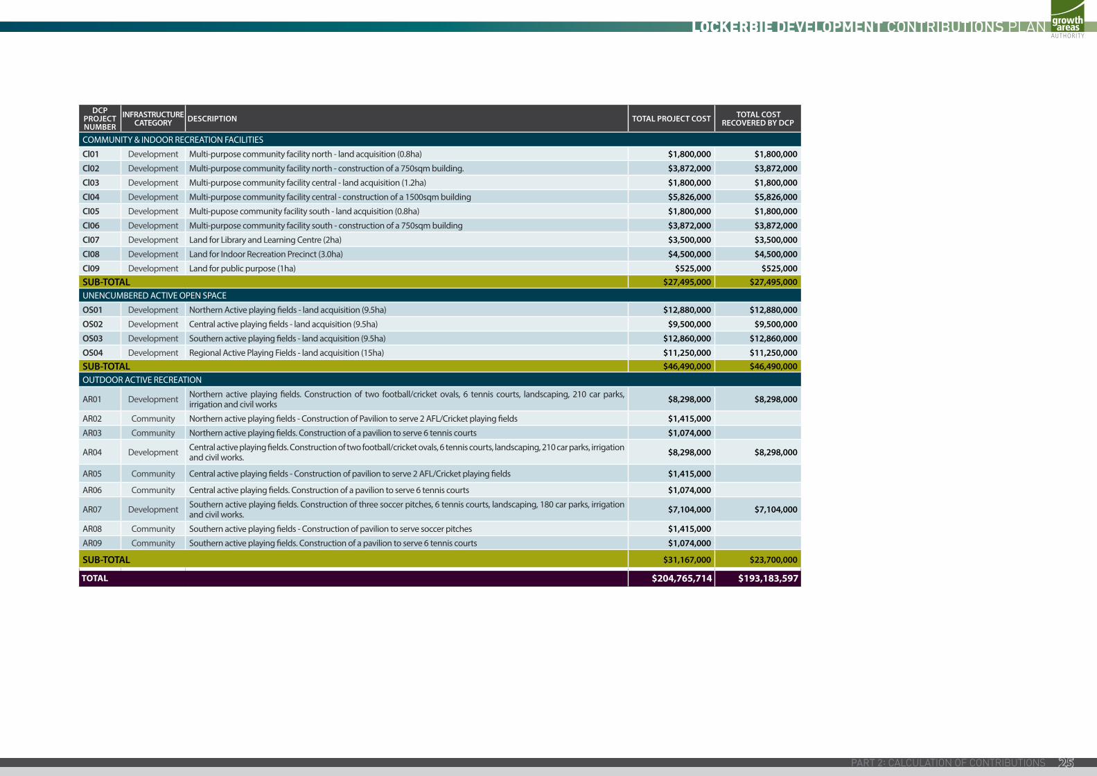
DCP PROJECT NUMBER
INFRASTRUCTURE CATEGORY DESCRIPTION TOTAL PROJECT COST TOTAL COST
RECOVERED BY DCP
COMMUNITY & INDOOR RECREATION FACILITIES
Cl01 Development Multi-purpose community facility north - land acquisition (0.8ha) $1,800,000 $1,800,000
Cl02 Development Multi-purpose community facility north - construction of a 750sqm building. $3,872,000 $3,872,000
Cl03 Development Multi-purpose community facility central - land acquisition (1.2ha) $1,800,000 $1,800,000
CI04 Development Multi-purpose community facility central - construction of a 1500sqm building $5,826,000 $5,826,000
CI05 Development Multi-pupose community facility south - land acquisition (0.8ha) $1,800,000 $1,800,000
CI06 Development Multi-purpose community facility south - construction of a 750sqm building $3,872,000 $3,872,000
CI07 Development Land for Library and Learning Centre (2ha) $3,500,000 $3,500,000
CI08 Development Land for Indoor Recreation Precinct (3.0ha) $4,500,000 $4,500,000
CI09 Development Land for public purpose (1ha) $525,000 $525,000SUB-TOTAL $27,495,000 $27,495,000UNENCUMBERED ACTIVE OPEN SPACE
OS01 Development Northern Active playing fields - land acquisition (9.5ha) $12,880,000 $12,880,000
OS02 Development Central active playing fields - land acquisition (9.5ha) $9,500,000 $9,500,000
OS03 Development Southern active playing fields - land acquisition (9.5ha) $12,860,000 $12,860,000
OS04 Development Regional Active Playing Fields - land acquisition (15ha) $11,250,000 $11,250,000SUB-TOTAL $46,490,000 $46,490,000OUTDOOR ACTIVE RECREATION
AR01 Development Northern active playing fields. Construction of two football/cricket ovals, 6 tennis courts, landscaping, 210 car parks, irrigation and civil works $8,298,000 $8,298,000
AR02 Community Northern active playing fields - Construction of Pavilion to serve 2 AFL/Cricket playing fields $1,415,000
AR03 Community Northern active playing fields. Construction of a pavilion to serve 6 tennis courts $1,074,000
AR04 Development Central active playing fields. Construction of two football/cricket ovals, 6 tennis courts, landscaping, 210 car parks, irrigation and civil works. $8,298,000 $8,298,000
AR05 Community Central active playing fields - Construction of pavilion to serve 2 AFL/Cricket playing fields $1,415,000
AR06 Community Central active playing fields. Construction of a pavilion to serve 6 tennis courts $1,074,000
AR07 Development Southern active playing fields. Construction of three soccer pitches, 6 tennis courts, landscaping, 180 car parks, irrigation and civil works. $7,104,000 $7,104,000
AR08 Community Southern active playing fields - Construction of pavilion to serve soccer pitches $1,415,000
AR09 Community Southern active playing fields. Construction of a pavilion to serve 6 tennis courts $1,074,000
SUB-TOTAL $31,167,000 $23,700,000
TOTAL $204,765,714 $193,183,597
25
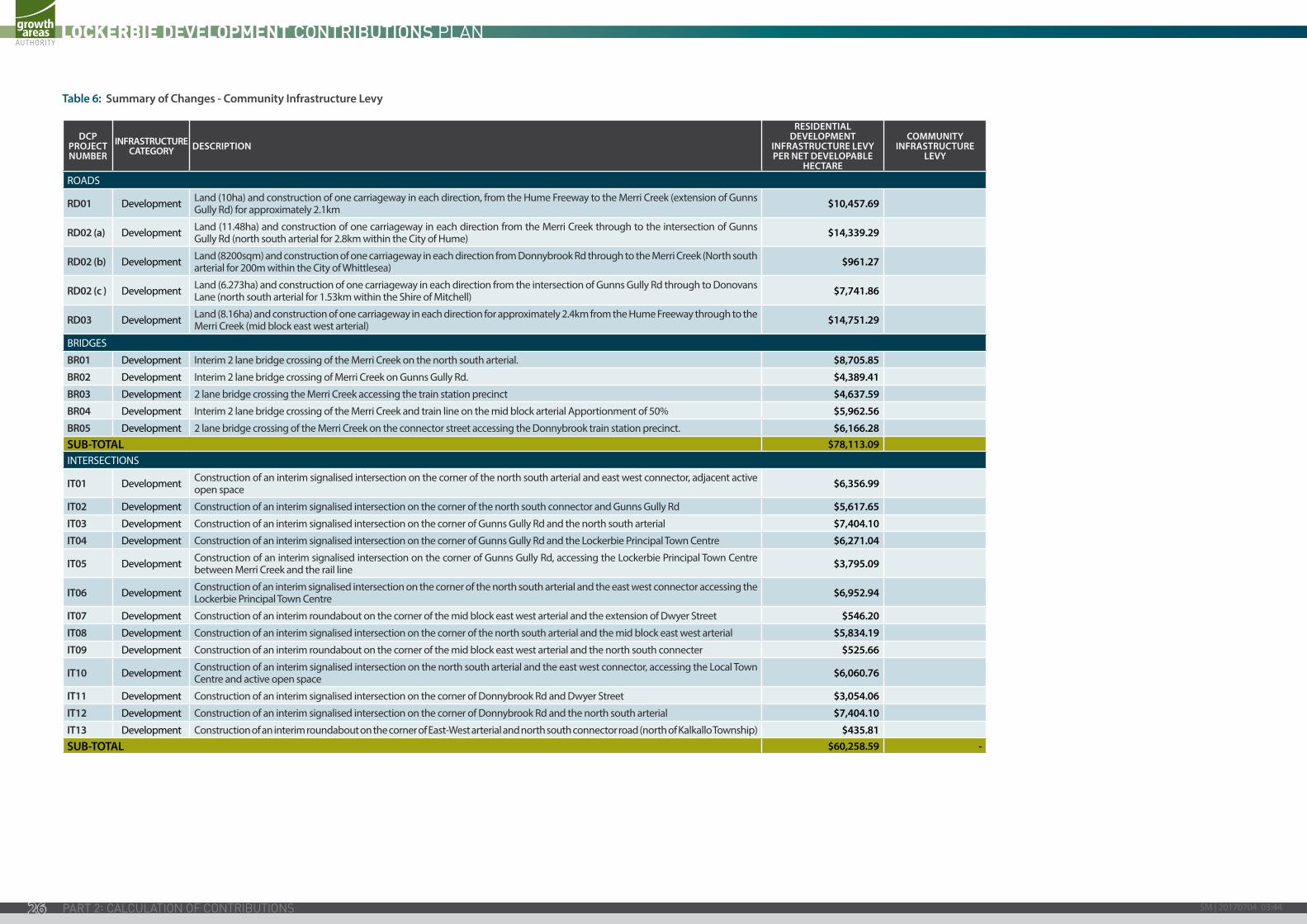
Table 6: Summary of Changes - Community Infrastructure Levy
DCP PROJECT NUMBER
INFRASTRUCTURE CATEGORY DESCRIPTION
RESIDENTIAL DEVELOPMENT
INFRASTRUCTURE LEVY PER NET DEVELOPABLE
HECTARE
COMMUNITY INFRASTRUCTURE
LEVY
ROADS
RD01 Development Land (10ha) and construction of one carriageway in each direction, from the Hume Freeway to the Merri Creek (extension of Gunns Gully Rd) for approximately 2.1km $10,457.69
RD02 (a) Development Land (11.48ha) and construction of one carriageway in each direction from the Merri Creek through to the intersection of Gunns Gully Rd (north south arterial for 2.8km within the City of Hume) $14,339.29
RD02 (b) Development Land (8200sqm) and construction of one carriageway in each direction from Donnybrook Rd through to the Merri Creek (North south arterial for 200m within the City of Whittlesea) $961.27
RD02 (c ) Development Land (6.273ha) and construction of one carriageway in each direction from the intersection of Gunns Gully Rd through to Donovans Lane (north south arterial for 1.53km within the Shire of Mitchell) $7,741.86
RD03 Development Land (8.16ha) and construction of one carriageway in each direction for approximately 2.4km from the Hume Freeway through to the Merri Creek (mid block east west arterial) $14,751.29
BRIDGES
BR01 Development Interim 2 lane bridge crossing of the Merri Creek on the north south arterial. $8,705.85
BR02 Development Interim 2 lane bridge crossing of Merri Creek on Gunns Gully Rd. $4,389.41
BR03 Development 2 lane bridge crossing the Merri Creek accessing the train station precinct $4,637.59
BR04 Development Interim 2 lane bridge crossing of the Merri Creek and train line on the mid block arterial Apportionment of 50% $5,962.56
BR05 Development 2 lane bridge crossing of the Merri Creek on the connector street accessing the Donnybrook train station precinct. $6,166.28 SUB-TOTAL $78,113.09 INTERSECTIONS
IT01 Development Construction of an interim signalised intersection on the corner of the north south arterial and east west connector, adjacent active open space $6,356.99
IT02 Development Construction of an interim signalised intersection on the corner of the north south connector and Gunns Gully Rd $5,617.65
IT03 Development Construction of an interim signalised intersection on the corner of Gunns Gully Rd and the north south arterial $7,404.10
IT04 Development Construction of an interim signalised intersection on the corner of Gunns Gully Rd and the Lockerbie Principal Town Centre $6,271.04
IT05 Development Construction of an interim signalised intersection on the corner of Gunns Gully Rd, accessing the Lockerbie Principal Town Centre between Merri Creek and the rail line $3,795.09
IT06 Development Construction of an interim signalised intersection on the corner of the north south arterial and the east west connector accessing the Lockerbie Principal Town Centre $6,952.94
IT07 Development Construction of an interim roundabout on the corner of the mid block east west arterial and the extension of Dwyer Street $546.20
IT08 Development Construction of an interim signalised intersection on the corner of the north south arterial and the mid block east west arterial $5,834.19
IT09 Development Construction of an interim roundabout on the corner of the mid block east west arterial and the north south connecter $525.66
IT10 Development Construction of an interim signalised intersection on the north south arterial and the east west connector, accessing the Local Town Centre and active open space $6,060.76
IT11 Development Construction of an interim signalised intersection on the corner of Donnybrook Rd and Dwyer Street $3,054.06
IT12 Development Construction of an interim signalised intersection on the corner of Donnybrook Rd and the north south arterial $7,404.10
IT13 Development Construction of an interim roundabout on the corner of East-West arterial and north south connector road (north of Kalkallo Township) $435.81 SUB-TOTAL $60,258.59 -
SM | 20170704 03:4426
DCP PROJECT NUMBER
INFRASTRUCTURE CATEGORY DESCRIPTION
RESIDENTIAL DEVELOPMENT
INFRASTRUCTURE LEVY PER NET DEVELOPABLE
HECTARE
COMMUNITY INFRASTRUCTURE
LEVY
COMMUNITY & INDOOR RECREATION FACILITIES
Cl01 Development Multi-purpose community facility north - land acquisition (0.8ha) $2,608.09
Cl02 Development Multi-purpose community facility north - construction of a 750sqm building. $5,610.29
Cl03 Development Multi-purpose community facility central - land acquisition (1.2ha) $2,608.09
CI04 Development Multi-purpose community facility central - construction of a 1500sqm building $8,441.52
CI05 Development Multi-pupose community facility south - land acquisition (0.8ha) $2,608.09
CI06 Development Multi-purpose community facility south - construction of a 750sqm building $5,610.29
CI07 Development Land for Library and Learning Centre (2ha) $5,071.29
CI08 Development Land for Indoor Recreation Precinct (3.0ha) $6,520.23
CI09 Development Land for public purpose (1ha) $760.69 SUB-TOTAL $39,838.59 - UNENCUMBERED ACTIVE OPEN SPACE
OS01 Development Northern Active playing fields - land acquisition (9.5ha) $18,662.34
OS02 Development Central active playing fields - land acquisition (9.5ha) $13,764.92
OS03 Development Southern active playing fields - land acquisition (9.5ha) $18,633.36
OS04 Development Regional Active Playing Fields - land acquisition (15ha) $16,300.57 SUB-TOTAL $67,361.19 OUTDOOR ACTIVE RECREATION
AR01 Development Northern active playing fields. Construction of two football/cricket ovals, 6 tennis courts, landscaping, 210 car parks, irrigation and civil works $12,023.30
AR02 Community Northern active playing fields - Construction of Pavilion to serve 2 AFL/Cricket playing fields $2,050.25
AR03 Community Northern active playing fields. Construction of a pavilion to serve 6 tennis courts $1,556.16
AR04 Development Central active playing fields. Construction of two football/cricket ovals, 6 tennis courts, landscaping, 210 car parks, irrigation and civil works. $12,023.30
AR05 Community Central active playing fields - Construction of pavilion to serve 2 AFL/Cricket playing fields $2,050.25
AR06 Community Central active playing fields. Construction of a pavilion to serve 6 tennis courts $1,556.16
AR07 Development Southern active playing fields. Construction of three soccer pitches, 6 tennis courts, landscaping, 180 car parks, irrigation and civil works. $10,293.27
AR08 Community Southern active playing fields - Construction of pavilion to serve soccer pitches $2,050.25
AR09 Community Southern active playing fields. Construction of a pavilion to serve 6 tennis courts $1,556.16 SUB-TOTAL $34,339.86 $10,819.23
TOTAL $279,911.32 $10,819.23
27
PART 3: IMPLEMENTATION & ADMINISTRATION
3.1 IMPLEMENTATION STRATEGY
This section details how the Collecting Agencies will implement the Development Contributions Plan.
3.1.1 RATIONALE FOR THE IMPLEMENTATION STRATEGYThis implementation strategy has been included to provide certainty to both the Collecting Agencies and development proponents. The implementation strategy recognises the complexities associated with infrastructure provision and funding and seeks to minimise risk to the Collection Agencies, Development Agencies, development proponents and the future community.
The implementation strategy has been formulated by:
• assessing the risk posed by the Precinct Structure Plan layout (identifying high risk items);
• having regard to the development context;
• assessing the need for finance requirements – upfront financing and pooling of funds;
• agreeing the land value and indexing it appropriately (where possible);
• seeking direct delivery of infrastructure and land by development proponents where appropriate;
• identifying preferred implementation mechanisms to achieve the above outcomes and reducing the risk associated with the Development Contributions Plan to ensure that it will delivered as intended;
• having regard to the provision of adequate resources to administer the Development Contributions Plan; and
• having regard to the fact that the development contributions plan spans three municipalities.
3.1.2 DIVISION OF RESPONSIBILITY BETWEEN HUME, MITCHELL AND WHITTLESEA MUNICIPALITIESThe Development Contributions Plan is complex given it covers three municipalities and one precinct structure plan area. A division of responsibility has been agreed between each of the three municipalities in relation to the delivery of infrastructure projects funded by the Development Contributions Plan. Table 7 sets out which municipal council is the Collecting Agency and Development Agency for each infrastructure project.
Table 7 includes a breakdown of the charge per Net Developable Hectare by municipality. Table 7 shows that of $279,911.32 payable per Net Developable Hectare,
• $204,148 is payable to Hume;
• $53,003 is payable to Mitchell; and
• $21,761 is payable to Whittlesea.
Because this Development Contribution Plan applies across three municipal areas, a developer making payment of its Development Infrastructure Levy liability under this Development Contribution Plan is required to pay a part of the total amount due to each municipality (known as a Collecting Agency). The proportion of each payment due to each Collecting Agency is specified in Table 7.
Based on the portion of the Net Developable Hectares located within each municipality, the levies to be collected by each of the Collecting Agencies ($2012) comprise the following:
SM | 20170704 03:4428
Table 7: Collecting Agency Infrastructure Projects Levies to be Collected ($2012)
PROPERTY NUMBER
TOTAL (HECTARES)
DEVELOPABLE AREA (HECTARES) INCOME 2012
HU
ME
MIT
CHEL
L
WH
ITTL
ESEA
HU
ME
MIT
CHEL
L
WH
ITTL
ESEA
1 39.53 12.60 $3,526,882.63 2 36.19 26.85 $7,515,618.94 3 76.35 50.23 $14,059,945.60 4 32.62 18.44 $5,161,564.74 5 75.18 40.24 $11,263,631.52 6 26.13 21.39 $5,987,303.13
7A 170.84 116.63 $32,646,057.25 7B 70.62 52.47 $14,686,946.96 8 275.06 171.84 $48,099,961.23 9 2.03 0.02 $5,598.23
10 38.15 21.44 $6,001,298.70 11 0.74 0.54 $151,152.11 12 20.86 8.82 $2,468,817.84 13 3.55 3.55 $993,685.19 14 80.14 52.52 $14,700,942.53 15 0.25 0.0016 0.45 0.0017 0.35 0.0018 2.11 0.0019 2.37 0.0020 80.19 45.28 $12,674,384.57 21 13.19 4.46 $1,248,404.49 22 8.75 1.57 $439,460.77 23 17.48 13.58 $3,801,195.73 24 0.21 0.21 $58,781.38 25 0.05 0.05 $13,995.57 26 1.36 1.14 $319,098.90 27 1.04 0.08 $22,392.91 28 4.23 0.32 $89,571.62 29 36.37 20.60 $5,766,173.19 30 1.55 1.55 $433,862.55 31 0.63 0.63 $176,344.13 32 0.73 0.73 $204,335.26 33 1.06 1.06 $296,706.00 34 0.11 0.11 $30,790.25 35 0.10 0.10 $27,991.13 36 0.13 0.13 $36,388.47 37 0.06 0.06 $16,794.68 38 0.06 0.06 $16,794.68 39 0.06 0.06 $16,794.68 40 0.09 0.09 $25,192.02 41 0.08 0.08 $22,392.91
SUB TOTAL 1121.05 362.45 264.99 62.09 $101,453,857.93 $74,173,700.69 $17,379,693.86
ROAD RESERVER1 0.63 0.63 $176,344.13 SUB TOTAL 0.63 0.63 $176,344.13
SUB TOTAL 1121.68 362.45 264.99 62.72 $101,453,857.93 $74,173,700.69 $17,556,037.99
29
Table 8: Summary of Income vs Liability for each Council
DCP PROJECT NUMBER
INFRASTRUCTURE CATEGORY DESCRIPTION
RESIDENTIAL DEVELOPMENT
INFRASTRUCTURE LEVY PER NET DEVELOPABLE
HECTARE
HUME CHARGE PER
NDHA
MITCHELL CHARGE PER
NDHA
WHITTLESEA CHARGE PER
NDHA
TOTAL COST RECOVERED
(HUME, MITCHELL AND WHITTLESEA)
COMMUNITY INFRASTRUCTURE
LEVY DEVELOPMENT
AGENCY
ROADS
RD01 Development Land (10ha) and construction of one carriageway in each direction, from the Hume Freeway to the Merri Creek (extension of Gunns Gully Rd) for approximately 2.1km $10,458 $10,458 $10,458 Hume
RD02 (a) Development Land (11.48ha) and construction of one carriageway in each direction from the Merri Creek through to the intersection of Gunns Gully Rd (north south arterial for 2.8km within the City of Hume) $14,339 $14,339 $14,339 Hume
RD02 (b) Development Land (8200sqm) and construction of one carriageway in each direction from Donnybrook Rd through to the Merri Creek (North south arterial for 200m within the City of Whittlesea) $961 $961 $961 Whittlesea
RD02 (c ) Development Land (6.273ha) and construction of one carriageway in each direction from the intersection of Gunns Gully Rd through to Donovans Lane (north south arterial for 1.53km within the Shire of Mitchell) $7,742 $7,742 $7,742 Mitchell
RD03 Development Land (8.16ha) and construction of one carriageway in each direction for approximately 2.4km from the Hume Freeway through to the Merri Creek (mid block east west arterial) $14,751 $14,751 $14,751 Hume
BRIDGES
BR01 Development Interim 2 lane bridge crossing of the Merri Creek on the north south arterial. $8,706 $8,706 $8,706 Hume
BR02 Development Interim 2 lane bridge crossing of Merri Creek on Gunns Gully Rd. $4,389 $4,389 $4,389 Hume
BR03 Development 2 lane bridge crossing the Merri Creek accessing the train station precinct $4,638 $4,638 $4,638 Whittlesea
BR04 Development Interim 2 lane bridge crossing of the Merri Creek and train line on the mid block arterial Apportionment of 50% $5,963 $5,963 $5,963 Whittlesea
BR05 Development 2 lane bridge crossing of the Merri Creek on the connector street accessing the Donnybrook train station precinct. $6,166 $6,166 $6,166 Hume
SUB-TOTAL $78,113 $58,810 $7,742 $11,561 $78,113 $0INTERSECTIONS
IT01 Development Construction of an interim signalised intersection on the corner of the north south arterial and east west connector, adjacent active open space $6,357 $6,357 $6,357 Mitchell
IT02 Development Construction of an interim signalised intersection on the corner of the north south connector and Gunns Gully Rd $5,618 $5,618 $5,618 Hume
IT03 Development Construction of an interim signalised intersection on the corner of Gunns Gully Rd and the north south arterial $7,404 $7,404 $7,404 Hume
IT04 Development Construction of an interim signalised intersection on the corner of Gunns Gully Rd and the Lockerbie Principal Town Centre $6,271 $6,271 $6,271 Hume
IT05 Development Construction of an interim signalised intersection on the corner of Gunns Gully Rd, accessing the Lockerbie Principal Town Centre between Merri Creek and the rail line $3,795 $3,795 $3,795 Whittlesea
IT06 Development Construction of an interim signalised intersection on the corner of the north south arterial and the east west connector accessing the Lockerbie Principal Town Centre $6,953 $6,953 $6,953 Hume
IT07 Development Construction of an interim roundabout on the corner of the mid block east west arterial and the extension of Dwyer Street $546 $546 $546 Hume
IT08 Development Construction of an interim signalised intersection on the corner of the north south arterial and the mid block east west arterial $5,834 $5,834 $5,834 Hume
IT09 Development Construction of an interim roundabout on the corner of the mid block east west arterial and the north south connecter $526 $526 $526 Hume
IT10 Development Construction of an interim signalised intersection on the north south arterial and the east west connector, accessing the Local Town Centre and active open space $6,061 $6,061 $6,061 Hume
IT11 Development Construction of an interim signalised intersection on the corner of Donnybrook Rd and Dwyer Street $3,054 $3,054 $3,054 Hume
IT12 Development Construction of an interim signalised intersection on the corner of Donnybrook Rd and the north south arterial $7,404 $7,404 $7,404 Whittlesea
IT13 Development Construction of an interim roundabout on the corner of East-West arterial and north south connector road (north of Kalkallo Township) $436 $436 $436 Hume
SUB-TOTAL $60,259 $42,702 $6,357 $11,199 $60,259 $0
SM | 20170704 03:4430
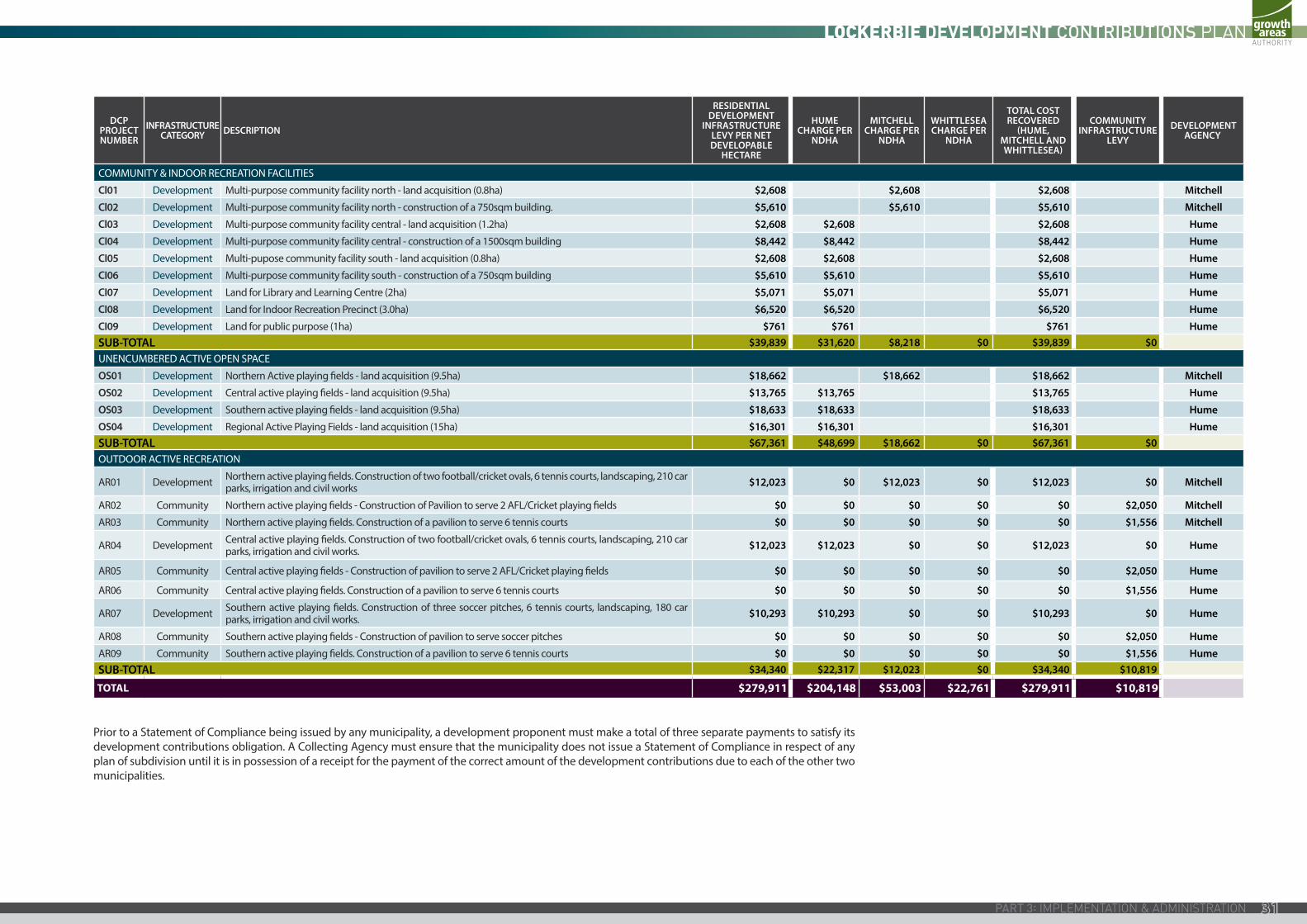
DCP PROJECT NUMBER
INFRASTRUCTURE CATEGORY DESCRIPTION
RESIDENTIAL DEVELOPMENT
INFRASTRUCTURE LEVY PER NET DEVELOPABLE
HECTARE
HUME CHARGE PER
NDHA
MITCHELL CHARGE PER
NDHA
WHITTLESEA CHARGE PER
NDHA
TOTAL COST RECOVERED
(HUME, MITCHELL AND WHITTLESEA)
COMMUNITY INFRASTRUCTURE
LEVY DEVELOPMENT
AGENCY
COMMUNITY & INDOOR RECREATION FACILITIES
Cl01 Development Multi-purpose community facility north - land acquisition (0.8ha) $2,608 $2,608 $2,608 Mitchell
Cl02 Development Multi-purpose community facility north - construction of a 750sqm building. $5,610 $5,610 $5,610 Mitchell
Cl03 Development Multi-purpose community facility central - land acquisition (1.2ha) $2,608 $2,608 $2,608 Hume
CI04 Development Multi-purpose community facility central - construction of a 1500sqm building $8,442 $8,442 $8,442 Hume
CI05 Development Multi-pupose community facility south - land acquisition (0.8ha) $2,608 $2,608 $2,608 Hume
CI06 Development Multi-purpose community facility south - construction of a 750sqm building $5,610 $5,610 $5,610 Hume
CI07 Development Land for Library and Learning Centre (2ha) $5,071 $5,071 $5,071 Hume
CI08 Development Land for Indoor Recreation Precinct (3.0ha) $6,520 $6,520 $6,520 Hume
CI09 Development Land for public purpose (1ha) $761 $761 $761 Hume SUB-TOTAL $39,839 $31,620 $8,218 $0 $39,839 $0UNENCUMBERED ACTIVE OPEN SPACE
OS01 Development Northern Active playing fields - land acquisition (9.5ha) $18,662 $18,662 $18,662 Mitchell
OS02 Development Central active playing fields - land acquisition (9.5ha) $13,765 $13,765 $13,765 Hume
OS03 Development Southern active playing fields - land acquisition (9.5ha) $18,633 $18,633 $18,633 Hume
OS04 Development Regional Active Playing Fields - land acquisition (15ha) $16,301 $16,301 $16,301 Hume SUB-TOTAL $67,361 $48,699 $18,662 $0 $67,361 $0OUTDOOR ACTIVE RECREATION
AR01 Development Northern active playing fields. Construction of two football/cricket ovals, 6 tennis courts, landscaping, 210 car parks, irrigation and civil works $12,023 $0 $12,023 $0 $12,023 $0 Mitchell
AR02 Community Northern active playing fields - Construction of Pavilion to serve 2 AFL/Cricket playing fields $0 $0 $0 $0 $0 $2,050 Mitchell
AR03 Community Northern active playing fields. Construction of a pavilion to serve 6 tennis courts $0 $0 $0 $0 $0 $1,556 Mitchell
AR04 Development Central active playing fields. Construction of two football/cricket ovals, 6 tennis courts, landscaping, 210 car parks, irrigation and civil works. $12,023 $12,023 $0 $0 $12,023 $0 Hume
AR05 Community Central active playing fields - Construction of pavilion to serve 2 AFL/Cricket playing fields $0 $0 $0 $0 $0 $2,050 Hume
AR06 Community Central active playing fields. Construction of a pavilion to serve 6 tennis courts $0 $0 $0 $0 $0 $1,556 Hume
AR07 Development Southern active playing fields. Construction of three soccer pitches, 6 tennis courts, landscaping, 180 car parks, irrigation and civil works. $10,293 $10,293 $0 $0 $10,293 $0 Hume
AR08 Community Southern active playing fields - Construction of pavilion to serve soccer pitches $0 $0 $0 $0 $0 $2,050 Hume
AR09 Community Southern active playing fields. Construction of a pavilion to serve 6 tennis courts $0 $0 $0 $0 $0 $1,556 Hume SUB-TOTAL $34,340 $22,317 $12,023 $0 $34,340 $10,819
TOTAL $279,911 $204,148 $53,003 $22,761 $279,911 $10,819
Prior to a Statement of Compliance being issued by any municipality, a development proponent must make a total of three separate payments to satisfy its development contributions obligation. A Collecting Agency must ensure that the municipality does not issue a Statement of Compliance in respect of any plan of subdivision until it is in possession of a receipt for the payment of the correct amount of the development contributions due to each of the other two municipalities.
31
3.2 ADMINISTRATION OF THE DEVELOPMENT CONTRIBUTIONS PLAN
This section sets how the Development Contributions Plan is to be administered and includes provisions relating to:
• the events triggering payment,
• provision of works and land “in kind”; and
• how the Development Contributions Plan fund will be managed in terms of reporting, indexation and review periods.
3.2.1 PAYMENT OF CONTRIBUTION LEVIES AND TIMINGThe Development Infrastructure Levy specified in this Development Contributions Plan must be paid in respect of the subdivision and development of land.
The Community Infrastructure Levy specified in this Development Contributions Plan must be paid in respect of the construction of a dwelling.
The following requirements as appropriate must be included as conditions on any relevant planning permit pursuant to section 46-N (1) of the Act.
DEVELOPMENT INFRASTRUCTURE LEVY
For subdivision of land
An infrastructure levy must be paid to each of the Collecting Agencies for the land in the subdivision within the following specified time, namely after certification of the relevant plan of subdivision but not more than 21 days prior to the issue of a Statement of Compliance is issued in respect of that plan under the Subdivision Act.
Where the subdivision is to be developed in stages the infrastructure levy for the stage to be developed may only be paid to each of the Collecting Agencies within 21 days prior to the issue of a Statement of Compliance in respect of that stage provided that a Schedule of Development Contributions is submitted with each stage of the plan of subdivision. This Schedule must show the amount of the development contributions payable for each stage and value of the contributions in respect of prior stages to the satisfaction of the Collecting Agency in who’s municipal area the subdivision occurs.
For development of land where no subdivision is proposed
Provided an infrastructure levy has not already been paid in respect of the land, an infrastructure levy must be paid to each of the Collecting Agencies in accordance with the provisions of the Development Contributions Plan for each Demand Unit (net developable hectare) proposed to be developed prior to the commencement of any Development A Collecting Agency may agree to the deferral of the payment of the portion of the infrastructure levy payable to it.
Where no planning permit is required
Where no planning permit is required, the land may only be used and/or developed subject to the following requirements being met.
Unless some other arrangement has been agreed to by each of the relevant Collecting Agencies in a section 173 agreement made under the Act, prior to the commencement of any development, an infrastructure levy calculated in accordance with the provisions of the Development Contribution Plan must be paid to each of the relevant Collecting Agencies for the land.
COMMUNITY INFRASTRUCTURE LEVY
Contributions relating to community infrastructure are to be made by the home-builder prior to issue of a Building Permit. However, development proponents are encouraged to pay the Community Infrastructure levy prior to the issue of a Statement of Compliance to reduce the administrative burden of collection from individual home builders.
The Community Infrastructure Levy for ‘residential buildings’ will be calculated at the rate for a single dwelling. In all other forms of accommodation, the Community Infrastructure Levy is payable for each dwelling included in the Development Corrective Institutions’ are exempt from payment of a Community Infrastructure Levy.
EXEMPT DEVELOPMENT
Non Government Schools
The development of land for a non government school is exempt from the requirement to pay a development infrastructure levy and a community infrastructure levy under this Development Contribution Plan.
Corrective Institution
The development of land for a corrective institution is exempt from the requirement to pay a development infrastructure levy and a community infrastructure levy under this Development Contribution Plan.
Houses on pre-existing lots
A Community Infrastructure Levy is not payable for a dwelling on a lot which was created prior to the date that this Development Contributions Plan was first incorporated into the relevant planning scheme
Where land is subdivided or developed for the purpose of an exempt development and the use of that land is subsequently for a purpose other than for the purposes of an exempt development, the owner of that land must pay to the Collecting Agency development contributions in accordance with the provisions of this Development Contributions Plan. The development infrastructure levy and where applicable, the community infrastructure levy must be paid within 28 days of the date of the commencement of the construction of any buildings or works for that alternative use
SM | 20170704 03:4432
3.2.2 WORKS IN KIND Infrastructure works and land may be provided by developers in return for a credit against their development contribution obligations, subject to the written agreement of the relevant Collecting Agency.
“Works in Kind” are only possible if the relevant Collecting Agency agrees to that method of delivery. In determining whether to agree to the provision of works in kind the relevant Collecting Agency may amongst other things, have regard to the following:
• Only works or land identified in the Development Contributions Plan can be provided in kind ;
• Works must be provided to a standard that generally accords with the Development Contributions Plan unless agreed between the relevant Collecting Agency and the development proponent;
• Detailed design must be approved by the relevant Collecting Agency and generally accord with the standards outlined in the Development Contributions Plan unless agreed by the relevant Collecting Agency and the development proponent;
• The construction of works must be completed to the satisfaction of the relevant Collecting Agency; and
• There is no additional financial impact on the Development Contributions Plan.
Where the relevant Collecting Agency agrees that works are to be provided by a development proponent in kind subject to any agreement with the relevant Collecting Agency:
• The credit for the works provided shall equal the value for that infrastructure project identified in the Development Contributions Plan, taking into account the impact of indexation and adjustments of land values;
• The credit may only be extended by a Collecting Agency in respect of development contributions payable to that Collecting Agency unless another relevant Collecting Agency agrees in writing;
• The amount of the development contributions payable to other Collecting Agencies must not be reduced unless another relevant Collecting Agency agrees in writing.
• The value of works provided in accordance with the principles outlined above, will be offset against the development contributions liable to be paid by the development proponent to the Collecting Agency which agreed to the works in kind; and
• The development proponent will not be required to make cash payments for contributions to that particular Collecting Agency until the agreed value of any credits for the provision of agreed works-in-kind are exhausted/balanced.
3.2.3 CREDIT FOR OVER PROVISIONWhere the relevant Collection Agency agrees that a development proponent can deliver an infrastructure item (either works and/or land) as an in kind contribution, the situation may arise where the developer’s actual contractual liabilities exceed the amounts provided for in the Development Contributions Plan for the individual project. Unless the arrangement with the relevant Collecting Agency allows for it, the actual cost of the project over the amount specified in the Development Contribution Plan is not creditable to the development proponent.
Notwithstanding anything to the contrary in this Development Contribution Plan, a Collecting Agency which agrees to works in kind and a credit for an amount greater than the amount specified for that item of infrastructure in this Development Contribution Plan is itself fully liable to the developer for the additional costs over and above the amount specified in this Development Contributions Plan. A developer/proponent cannot reduce the amount paid or to be paid to the other Collecting Agencies unless that other Collecting Agency has also agreed in writing.
Where a Collecting Agency proposes to enter into an agreement to allow works or land to be delivered in kind and the standard of provision or the specification of the infrastructure project is materially different to what is set out in the Development Contribution Plan, it must obtain the written consent of the other municipal councils.
3.2.4 ITEMS IDENTIFIED AS SUITABLE TO BE PROVIDED IN KINDThe purpose of this section is to provide an indication of which infrastructure items may be provided by developers, the value of the credit that the developer will receive and the method by which the developer will be reimbursed for these credits. By allowing developers to provide infrastructure in return for credits against their development contribution obligation, there is a reduction in the funding risk to the Collecting Agencies while developers are given greater flexibility, certainty and control over the roll-out of infrastructure within or proximate to their development area.
Table 9 provides a summary of the infrastructure items. Developers are required to discuss and come to an agreement with the relevant Collecting Agency as to the potential for provision of works and land to offset their development contribution. A key objective is to ensure that the timing of infrastructure delivery matches the timing of Development
Table 9 provides a starting point for the Collecting Agencies and developers in coming to an agreement on a schedule of land and works that each developer can provide as an offset to their development contribution. Under the Schedule to the Urban Growth Zone, it is envisaged that this will be encapsulated as part of a Public Infrastructure Plan. The Collecting Agencies are proposing to construct the Community Centre items given the need to comply with statutory requirements relating to child care and kindergartens. However, the Collecting Agencies may also consider developers providing this infrastructure on a case by case basis.
33
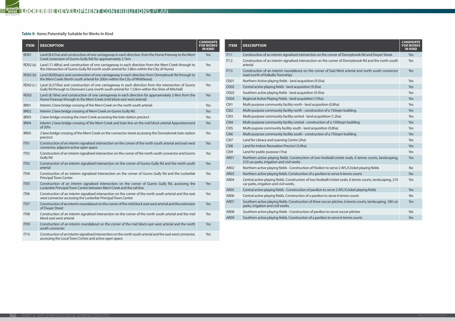
Table 9: Items Potentially Suitable for Works In Kind
ITEM DESCRIPTIONCANDIDATE FOR WORKS
IN KIND
RD01 Land (8.61ha) and construction of one carriageway in each direction, from the Hume Freeway to the Merri Creek (extension of Gunns Gully Rd) for approximately 2.1km
Yes
RD02 (a) Land (11.48ha) and construction of one carriageway in each direction from the Merri Creek through to the intersection of Gunns Gully Rd (north south arterial for 2.8km within the City of Hume)
Yes
RD02 (b) Land (8200sqm) and construction of one carriageway in each direction from Donnybrook Rd through to the Merri Creek (North south arterial for 200m within the City of Whittlesea)
Yes
RD02 (c ) Land (6.273ha) and construction of one carriageway in each direction from the intersection of Gunns Gully Rd through to Donovans Lane (north south arterial for 1.53km within the Shire of Mitchell)
Yes
RD03 Land (8.16ha) and construction of one carriageway in each direction for approximately 2.4km from the Hume Freeway through to the Merri Creek (mid block east west arterial)
Yes
BR01 Interim 2 lane bridge crossing of the Merri Creek on the north south arterial. Yes
BR02 Interim 2 lane bridge crossing of Merri Creek on Gunns Gully Rd. Yes
BR03 2 lane bridge crossing the merri Creek accessing the train station precinct Yes
BR04 Interim 2 lane bridge crossing of the Merri Creek and train line on the mid block arterial Apportionment of 50%
Yes
BR05 2 lane bridge crossing of the Merri Creek on the connector street accessing the Donnybrook train station precinct.
Yes
IT01 Construction of an interim signalised intersection on the corner of the north south arterial and east west connector, adjacent active open space
Yes
IT02 Construction of an interim signalised intersection on the corner of the north south connector and Gunns Gully Rd
Yes
IT03 Construction of an interim signalised intersection on the corner of Gunns Gully Rd and the north south arterial
Yes
IT04 Construction of an interim signalised intersection on the corner of Gunns Gully Rd and the Lockerbie Principal Town Centre
Yes
IT05 Construction of an interim signalised intersection on the corner of Gunns Gully Rd, accessing the Lockerbie Principal Town Centre between Merri Creek and the rail line
Yes
IT06 Construction of an interim signalised intersection on the corner of the north south arterial and the east west connector accessing the Lockerbie Principal Town Centre
Yes
IT07 Construction of an interim roundabout on the corner of the mid block east west arterial and the extension of Dwyer Street
Yes
IT08 Construction of an interim signalised intersection on the corner of the north south arterial and the mid block east west arterial
Yes
IT09 Construction of an interim roundabout on the corner of the mid block east west arterial and the north south connecter
Yes
IT10 Construction of an interim signalised intersection on the north south arterial and the east west connector, accessing the Local Town Centre and active open space
Yes
ITEM DESCRIPTIONCANDIDATE FOR WORKS
IN KIND
IT11 Construction of an interim signalised intersection on the corner of Donnybrook Rd and Dwyer Street Yes
IT12 Construction of an interim signalised intersection on the corner of Donnybrook Rd and the north south arterial
Yes
IT13 Construction of an interim roundabout on the corner of East-West arterial and north south connector road (north of Kalkallo Township)
Yes
OS01 Northern Active playing fields - land acquisition (9.5ha) Yes
OS02 Central active playing fields - land acquisition (9.5ha) Yes
OS03 Southern active playing fields - land acquisition (9.5ha) Yes
OS04 Regional Active Playing Fields - land acquisition (15ha) Yes
Cl01 Multi-purpose community facility north - land acquisition (0.8ha) Yes
Cl02 Multi-purpose community facility north - construction of a 750sqm building. Yes
Cl03 Multi-purpose community facility central - land acquisition (1.2ha) Yes
CI04 Multi-purpose community facility central - construction of a 1500sqm building Yes
CI05 Multi-pupose community facility south - land acquisition (0.8ha) Yes
CI06 Multi-purpose community facility south - construction of a 750sqm building Yes
CI07 Land for Library and Learning Centre (2ha) Yes
CI08 Land for Indoor Recreation Precinct (3.0ha) Yes
CI09 Land for public purpose (1ha) Yes
AR01 Northern active playing fields. Construction of two football/cricket ovals, 6 tennis courts, landscaping, 210 car parks, irrigation and civil works
Yes
AR02 Northern active playing fields - Construction of Pavilion to serve 2 AFL/Cricket playing fields No
AR03 Northern active playing fields. Construction of a pavilion to serve 6 tennis courts No
AR04 Central active playing fields. Construction of two football/cricket ovals, 6 tennis courts, landscaping, 210 car parks, irrigation and civil works.
Yes
AR05 Central active playing fields - Construction of pavilion to serve 2 AFL/Cricket playing fields Yes
AR06 Central active playing fields. Construction of a pavilion to serve 6 tennis courts No
AR07 Southern active playing fields. Construction of three soccer pitches, 6 tennis courts, landscaping, 180 car parks, irrigation and civil works.
Yes
AR08 Southern active playing fields - Construction of pavilion to serve soccer pitches No
AR09 Southern active playing fields. Construction of a pavilion to serve 6 tennis courts No
SM | 20170704 03:4434
3.2.5 PREFERRED IMPLEMENTATION MECHANISMSWhere a Collecting Agency agrees that works in kind can be provided by a development proponent, this should be set out in an agreement pursuant to Section 173 of the Act or another suitable method as agreed by the Collecting Agency.
3.2.6 OPEN SPACE PROVISION This Development Contributions Plan does not provide funding for passive local open space. Local passive open space is dealt with under Clause 52.01 of the relevant planning scheme. The value of any contribution required under Clause 52.01 of the relevant planning scheme is assumed to be made at a rate equal to $525,000 per net developable hectare. The land value is adjusted annually in accordance with the method for adjustment of land value under this Development Contributions Plan.
Unencumbered local active open space must be provided as required in accordance with the Lockerbie Precinct Structure Plan.
3.2.7 FUNDS ADMINISTRATIONThe administration of the contributions made under the Development Contributions Plan will be transparent and development contributions charges will be held until required for provision of the item. Details of funds received and expenditures will be held by the relevant Collecting Agency in accordance with the provisions of the Local Government Act 1993 and the Planning and Environment Act 1987 (the Act).
The administration of contributions made under the Development Contributions Plan will be transparent and demonstrate: -
• the amount and timing of funds collected;
• the source of the funds collected;
• the amount and timing of expenditure on specific projects;
• the project on which the expenditure was made;
• the account balances for individual projects; and
• clearly show any pooling of funds to deliver specific projects where applicable.
Each of the relevant Collecting Agencies must provide for regular monitoring, reporting and review of the monies received and expended in accordance with this Development Contributions Plan.
Each of the Collecting Agencies must establish interest bearing accounts and all monies held in these accounts will be used solely for the provision of infrastructure as itemised in this Development Contributions Plan, as required under Section 46QB(2) of the Act.
If a relevant Collecting Agency resolves to not proceed with any of the infrastructure projects listed in this Development Contributions Plan within its municipal area, the funds collected for these items will be used for the provision of additional works, services or facilities provided that is approved by the Minister responsible for the Act, or will be refunded to owners of land within the area of the Development Contributions Plan.
3.2.8 CONSTRUCTION AND LAND VALUE COSTS AND INDEXATIONCapital costs of all infrastructure items including land set out in this DCP will in 2012 dollars and are adjusted annually for inflation in the following way.
In relation to the costs associated with infrastructure items other than land, the cost are adjusted according to the following method:
• The capital cost for each infrastructure item are adjusted by applying the Building Price Index, as published in the latest edition of Rawlinsons Australian Construction Handbook on 1st January each year.
The Lead Collecting Agency will undertake the adjustments annually.
In relation to the cost of land, the land value is adjusted by adopting a revised value determined according to the following method:
• The land value is adjusted on 1 July each year following site specific land valuations undertaken by a registered valuer. Within 14 days of the adjustments being made, the Lead Collecting Agency will publish the amended contributions on each of the Collecting Agency’s website.
The Lead Collecting Agency will procure the appointment of a registered valuer to undertake the revaluation of all land in each Collecting Agency’s municipal area. The Lead Collecting Agency must obtain the consent of the other Collecting Agencies to the revised land valuations before the publication of a notice advising of the amended contributions.
3.2.9 RESOLUTION OF DISPUTES BETWEEN COUNCILS. If there is a dispute between councils in their capacity as a Collecting Agency or a Development Agency, the Chief Executive Offices of each Council must each use their best endeavours to resolve the dispute.
If a dispute cannot be resolved, the councils may jointly:
• undertake the process and procedures set out in section 9 of the Local Government Act 1989; or
• agree in writing on an alternative process to resolve the dispute except that if the alternative process is not finalised within 60 days of the date the dispute first arose, the parties must undertake the process and procedures set out in section 9 of the Local Government Act1989.
35
3.2.10 DEVELOPMENT CONTRIBUTIONS PLAN REVIEW PERIODThis Development Contributions Plan adopts a long-term outlook for Development It takes into account planned future development in the Lockerbie PSP area. A ‘full development’ horizon of land within the current Urban Growth Boundary to the year 2046 has been adopted for this Development Contributions Plan.
This Development Contributions Plan commences in respect of each municipality on the date when it is incorporated into the Hume Planning Scheme through Amendment C161 to the Hume Planning Scheme, Amendment C81 to the Mitchell Planning Scheme and Amendment C161 to the Whittlesea Planning Scheme.
This Development Contributions Plan will end when development within the Development Contributions Plan area is complete, which is projected to be 2036 as evidenced by the removal of the Development Contributions Plan from the list of incorporated documents in the relevant Planning Scheme.
The Development Contributions Plan is expected to be revised and updated every 5 years (or more if required). This will require an amendment to the Hume, Mitchell and Whittlesea Planning Schemes to replace this document with an alternative, revised document. This review is anticipated to include: -
• Updates to any aspect of the plan as required;
• Review of projects required, as well as their costs and scope (as relevant) and indicative provision trigger;
• Review of estimated net developable area (this will also be required if the Precinct Structure Plan is subject to a substantive amendment); and
• Review of land values for land to be purchased through the plan.
The responsibility for the review of the Development Contributions Plan rests with the Lead Collecting Agency in consultation with the other Collecting Agencies. Each of the Collecting Agencies must work co-operatively to review the Development Contributions Plan.
3.2.11 COLLECTING AGENCY (AGENCY RESPONSIBLE FOR COLLECTING INFRASTRUCTURE LEVY)Hume City Council, Shire of Mitchell and City of Whittlesea are each a Collecting Agency pursuant to section 46K(1)(fa) of the Act in respect of designated infrastructure projects. As a Collecting Agency, Hume City Council, Shire of Mitchell and City of Whittlesea are each responsible for the administration of this Development Contributions Plan and also its enforcement pursuant to section 46QC of the Act.
Hume City Council is the Lead Collecting Agency.
3.2.12 DEVELOPMENT AGENCY (AGENCY RESPONSIBLE FOR WORKS)Hume City Council, Shire of Mitchell or City of Whittlesea are designated as Development Agencies for specific infrastructure projects as set out in Table 7.
In the future the designated Development Agency for several road and intersection infrastructure projects may change from current designated Development Agency to VicRoads. However, any such transfer of responsibility would be dependent upon written agreement from VicRoads.
Summary of key implementation Protocols
• Prior to a Statement of Compliance being issued by any municipality, a development proponent must make a total of three separate payments to satisfy its development contributions obligation. A Collecting Agency must ensure that the municipality does not issue a Statement of Compliance in respect of any plan of subdivision until it is in possession of a receipt for the payment of the correct amount of the development contributions due to each of the other two municipalities.
• Where the relevant Collection Agency agrees that a development proponent can deliver an infrastructure item (either works and/or land) as an in kind contribution, the situation may arise where the developer’s actual contractual liabilities exceed the amounts provided for in the Development Contributions Plan for the individual project. Unless the arrangement with the relevant Collecting Agency allows for it, the actual cost of the project over the amount specified in the Development Contribution Plan is not creditable to the development proponent.
• A credit may only be extended by a Collecting Agency in respect of development contributions payable to that Collecting Agency unless another relevant Collecting Agency agrees in writing;
• The amount of the development contributions payable to other Collecting Agencies must not be reduced unless another relevant Collecting Agency agrees in writing.
• Notwithstanding anything to the contrary in this Development Contribution Plan, a Collecting Agency which agrees to works in kind and a credit for an amount greater than the amount
specified for that item of infrastructure in this Development Contribution Plan is itself fully liable to the developer for the additional costs over and above the amount specified in this Development Contributions Plan. The amount paid or to be paid to the other Collecting Agencies can be reduced by agreement with the Collecting Agency.
• Where a Collecting Agency proposes to enter into an agreement to allow works or land to be delivered in kind and the standard of provision or the specification of the infrastructure project is materially different to what is set out in the Development Contribution Plan, it must obtain the written consent of the other municipal councils.
Growth Areas Authority Level 29, 35 Collins Street MELBOURNE VIC 3000www.gaa.vic.gov.au
partners in creating new communities
SM | 20170704 03:4436

Growth Areas Authority Level 29, 35 Collins Street MELBOURNE VIC 3000www.gaa.vic.gov.au
partners in creating new communities