Embed Size (px)
Citation preview
XI. United K
June, 2013
XI. U
SUMMA
T
resource
northern,
Kingdom
UNITED
ARY
The United K
es within Ca
, central and
Source:
D KINGD
Kingdom ha
arboniferous-
d southern p
Figure
ARI 2013.
X
DOM
as substantia
- and Juras
ortions of th
XI-1 : Shale B
EIA/ARI W
I-1
al volumes
sic-age sha
e country.
Basins in the U
World Shale Gas
of prospect
ale formation
United Kingdo
s and Shale Oil
tive shale g
ns distribute
om
Resource Asses
as and sha
ed broadly i
ssment
ale oil
n the
XI. United K
June, 2013
T
of shale
XI-1 and
place (13
estimates
intervals.
Kingdom
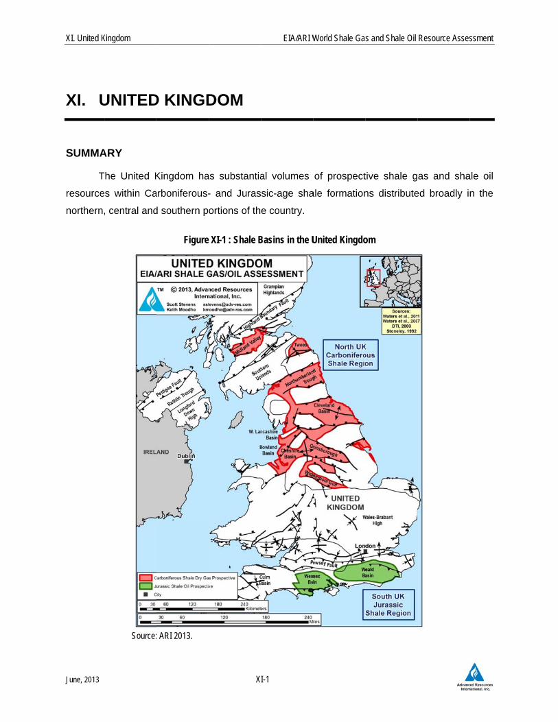
The risked, te
gas and 0.7
XI-2. This
34 Tcf, risk
s reflect on
.
Table XI-1
So
Table XI-2
Reservoir
echnically re
7 billion barre
is based on
ed) and 54
nly the hig
. Shale Gas R
ource: ARI, 2013
2. Shale Oil R
Source: A
Reservoir
Properties Reservoir Pres
Average TOC Thermal MatuClay Content
Resource
Gas Phase
GIP Concentra
Risked GIP (T
Risked Recove
Physical Extent Prospective A
Thickness (ft)
Depth (ft)
Basic Data Basin/
Shale Geol
Deposition
Reservo
ir
Properties
Resource
Physical Exten
tBasic Data
X
ecoverable s
els of shale
n the much la
Bbbl of sh
her-TOC po
Reservoir Pro
Reservoir Prop
ARI, 2013
C
Organically RichNet IntervalAverage
ssure
(wt. %)rity (% Ro)
ation (Bcf/mi2)
Tcf)
erable (Tcf)
Area (mi2)
Gross Area
Formationlogic Age
nal Environment
OrgNetInteAve
Reservoir Pressure
Average TOC (wt. %Thermal Maturity (Clay Content
Oil Phase
OIP Concentration
Risked OIP (B bbl)
Risked Recoverabl
Prospective Area (
Thickness (ft)
Depth (ft)
Basin/Gros
Shale FormGeologic
Depositional En
EIA/ARI W
I-2
shale resour
oil and cond
arger unrisk
ale oil in-pl
ortions of t
perties and Re
perties and Re
North UKCarboniferous Shale
(10,200 mi2)
Carboniferous ShCarboniferous
Marine
5,100
820410
5,000 - 13,0008,500
Normal
3.0%1.30%
Medium
Dry Gas
117.3
125.6
25.1
Ju
ganically Richt ervalerage
e
%)(% Ro)
n (MMbbl/mi2)
)
le (B bbl)
(mi2)
ss Area
mationc Agenvironment
World Shale Gas
rces of the U
densate in tw
ked estimate
ace (17 bill
the Carbon
esources of th
esources of th
RegionSo
Jurassic
(3,
hale LiL.
0 4,0
N
M
As
South UKurassic Shale Regi
(3,470 mi2)
Lias ShaleL. Jurassic
Marine
1,735
165149
4,000 - 6,0005,000
Normal
3.0%0.85%
Medium
Oil
30.9
17.1
0.69
s and Shale Oil
U.K. are est
wo assessed
es of 623 Tc
lion barrels,
iferous and
he United Kin
he United King
outh UKc Shale Region
,470 mi2)
as Shale JurassicMarine
1,735
165149
00 - 6,0005,000
Normal
3.0%0.85%
Medium
soc. Gas
14.5
8.0
0.6
on
Resource Asses
timated at 2
d regions, Ta
cf of shale ga
risked). T
d Jurassic s
gdom
gdom
ssment
6 Tcf
ables
as in-
These
shale
XI. United K
June, 2013
In
in the B
However
EIA/ARI’s
2011 ass
C
complex,
Pennine
wells wh
of the N
southern
S
drilling h
hydraulic
Following
shale ex
Decembe
Cuadrilla
INTROD
W
and sha
industry,
gas pric
condition
shale we
commerc
P
than in F
shale pro
vertical w
shale de
fracturing
Kingdom
nitial explora
owland Sub
r, production
s current es
sessment, w
Compared w
, while drilli
Basin, one
ich cored th
North UK Ca
England in
Shale testing
have not ev
cally stimula
g an 18-mon
xploration a
er 2012, al
a Resources
DUCTION
Within Europ
le oil poten
the UK has
es are high
ns are much
ells are more
cial levels of
Political oppo
France or G
oduction tes
wellbore was
posits in the
g for a period
ation drilling
b-basin in th
n testing has
stimate of the
while new sha
with North A
ing and com
of the coun
he Carbonife
arboniferous
the Wessex
g is still at a
en been at
ated triggere
nth moratori
are small a
beit with st
, IGAS, Dart
pe, the Unite
ntial. Howe
s limited do
h (~$9/MMB
h more comp
e costly to d
f shale produ
osition to sh
Germany. H
st well trigge
s deformed.
e UK (and ge
d of eighteen
X
has confirme
he west po
s not yet occ
e UK’s shale
ale oil poten
America, the
mpletion co
ntry’s most p
erous Bowla
s Shale reg
x and Weald
an early ph
ttempted. I
ed a series
ium, the gov
nd manage
tricter moni
t Energy, an
ed Kingdom
ever, with a
mestic serv
Btu) in the
plex. Faults
drill. While
uction are ye
hale develop
Hydraulic fra
ered small lo
This is per
enerally in E
n months to
EIA/ARI W
I-3
ed the prese
rtion of the
curred and t
e gas resou
tial has bee
e shale geo
sts for shal
prospective a
nd Shale. O
gion and the
basins, Figu
ase in the
n a tempor
of minor e
vernment co
eable. Sha
toring contr
d others.
stands nex
small exis
vice sector c
UK compa
s are numer
the UK’s sh
et to be esta
pment is gre
cturing got
ocal earthqu
rhaps unsurp
Europe). The
better evalu
World Shale Gas
ence of thick
Pennine B
the other sh
rces is abou
n added.
ology of the
le wells are
areas, has b
Other prosp
e liquids-ric
ure XI-1.
UK – flow t
rary setback
earthquakes
oncluded tha
ale drilling w
rols. Curre
xt after Pola
sting onshor
capability for
ared with N
rous, geolog
hale resourc
ablished.
eater in the
off to an ab
akes during
prising given
e governme
uate the risks
s and Shale Oil
k, gas-bearin
Basin of nor
ale regions
ut 10% high
e UK is co
e substantia
been tested
ective areas
ch Jurassic
testing and
k, the first s
s related to
at the enviro
was allowe
ent shale o
nd in pursu
re conventio
r shale expl
North Americ
gic data con
ce base app
UK than in
bysmal start
g fracture sti
n the highly
nt banned o
s.
Resource Asses
ng shale dep
rthwest Eng
remain und
er than our
onsiderably
ally higher.
with five ve
s include the
Shale regio
horizontal s
shale well t
o a nearby
onmental ris
ed to resum
operators in
ing its shale
onal oil and
loration. Na
ca, but geo
trol is weak
pears substa
Poland but
t. The UK’s
mulation an
faulted natu
onshore hyd
ssment
posits
gland.
rilled.
initial
more
The
ertical
e rest
on of
shale
to be
fault.
sks of
me in
clude
e gas
d gas
atural
ologic
k, and
antial,
t less
s first
d the
ure of
raulic
XI. United K
June, 2013
In
to groun
Preese H
mining.
time they
approval
delayed
C
(PEDL) b
types of
developm
Currently
potential
date of w
A
two have
Resource
drilling a
the pres
encounte
nearby,
attempte
Energie,
but have
Kingdom
n January 20
dwater and
Hall-1 well w
What's more
y reach the s
for shale
its plan to re
Companies w
by the UK go
f petroleum
ment is sub
y there are a
. Proprietar
well completi
At least six o
e actually d
es, partly (4
nd coring fo
ence of up
ered active
coring the 1
d in the UK
Dart Energ
n’t yet drilled
012 the Briti
earthquake
were “comp
e, they origi
surface.”1 In
exploration,
esume fractu
which have b
overnment a
m resources
bject to nec
about 334 o
ry shale dat
on.
il and gas co
drilled shale
43%) owned
our shale ex
to 2-km of
faults and h
1,600-ft thic
K, nor have
y, and Eden
d.
X
sh Geologic
es had been
parable in s
nate much d
n December
, albeit with
ure stimulatio
been granted
are permitted
s (conventio
cessary nati
onshore PED
ta typically a
ompanies ar
e wells. A
d by Austral
xploration we
f gas-bearin
high-stress
ck Bowland
flow tests b
n Energy als
EIA/ARI W
I-4
cal Survey n
n exaggerat
size to the f
deeper in th
2012 the U
h strict mon
on until 2014
d a Petroleu
d to explore
onal, coalbe
onal and lo
DLs, of whic
are kept con
re targeting
All wells hav
ian drilling c
ells in the W
ng organic-ri
conditions.
Shale. Ho
been reporte
so are evalu
World Shale Gas
oted that the
ted. Minor
frequent min
e crust so h
K governme
nitoring con
4 at the earli
um Explorati
and develo
ed methane
ocal consen
ch several d
nfidential for
shale gas e
ve been ve
company AJ
West Bowlan
ich shale.
IGAS Ene
orizontal sha
ed. Coasta
uating their
s and Shale Oil
e risks of sh
earthquake
nor quakes
have all but d
ent finally gra
nditions. C
iest.
on and Dev
p shale gas
e, tight ga
nt and plan
ozen have r
r a four-year
exploration in
ertical. UK-
J Lucas, is
nd Sub-basi
However, a
rgy has dril
ale wells ha
al Oil and G
UK shale re
Resource Asses
hale develop
s caused b
caused by
dissipated b
anted condit
Cuadrilla rec
elopment lic
, as well as
as, etc.).
ning permis
recognized s
r period from
n the UK but
-based Cua
the most a
in that confi
at least one
lled a shale
ave not yet
as Ltd., Ce
esource pote
ssment
pment
y the
coal
by the
tional
cently
cense
other
Field
ssion.
shale
m the
t only
adrilla
ctive,
irmed
e well
e well
been
ltique
ential
XI. United K
June, 2013
GEOLO
A
main stra
of Carbo
Geologic
presente
fields an
reservoir
outcrops
B
conducte
estimate
DECC, p
in 2013,
T
conventio
resource
shale exp
NbcBBGa
Sepla
Kingdom
OGIC OVER
As early as t
atigraphic ta
oniferous and
cal Survey (
ed an integra
nd source ro
r.4 In 2010 B
and conven
BGS publish
ed on behalf
was 5.3 Tc
plans to relea
followed eve
The main on
onal or sha
e assessmen
ploration reg
North UK Cabasins and tcontain prosBowland ShBowland, CGainsborougarea to unde
South UK Juextend offshoprone. Whiargest onsho
RVIEW
the late 198
rgets for sha
d Jurassic a
BGS) and p
ated review
ock shales,
BGS publish
ntional petro
ed its preli
f of the Dep
cf (150 Bcm)
ase an upda
entually by a
nshore sedim
ale exploratio
nt groups th
gions:
arboniferoutroughs is prspective orgale. Withinleveland, C
gh, Midland ergo shale ex
urassic Shaore into the ile no shaleore oil field a
X
80s research
ale gas explo
age.2,3 More
published by
w of the geo
although it
hed a compi
leum wells.5
minary eval
partment of
) of recovera
ated evaluati
a more comp
mentary bas
on potential
hese numer
us Shale Reresent acrosganic-rich shn the greateCheshire, W
Valley, as wxploration dr
ale Region.English Cha
e drilling haand appears
EIA/ARI W
I-5
hers at Impe
oration in the
e recently in
y the UK D
ology of Brit
was not as
ilation of sha
5
luation of U
Energy and
able shale g
ion of shale
plete nationa
sins in the
l are shown
rous, typica
egion. A coss northern hales of Car Pennine B
West Lancaswell as otherilling to date
In southernannel. They s occurred
s highly pros
World Shale Gas
erial College
e UK, the m
n 2003, a stu
Department o
tain’s onsho
sked to con
ale-specific
UK shale ga
Climate Ch
gas resource
gas potentia
al estimate.7
UK that pr
n in Figure
lly fault-bou
omplex asseEngland and
arboniferousBasin, indivishire, Northers. The Boe.
n England thcontain Jurhere yet, t
spective for s
s and Shale Oil
e, London h
arine-depos
udy conduct
of Trade an
ore conventi
nsider shale
geologic da
as resource
hange (DEC
es. BGS, in
al of northw
roduce oil a
XI-1. The
unded basin
emblage of isd southern S age, includidual sub-ba
humberland, owland Sub-
he Wessex arassic-age shthe region ishale oil dev
Resource Asses
had identifie
sited black s
ted by the B
nd Industry
onal oil and
as a produ
ata collected
es later in 2
CC).6 BGS’
n association
est England
and gas or
current EIA
ns into two
solated strucScotland. Tding notablyasins include
East Midla-basin is the
and Weald bhales that arncludes Bri
velopment.
ssment
d the
hales
British
(DTI)
d gas
uctive
from
2010,
initial
n with
d later
have
A/ARI
main
ctural These y the e the ands,
e only
asins re oil-tain’s
XI. United K
June, 2013
It
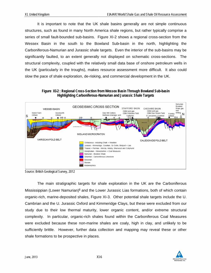
structure
series of
Wessex
Carbonife
significan
structura
the UK (
slow the
Source: Brit
T
Mississip
organic-r
Cambria
study du
complexi
were exc
sufficient
shale for
Kingdom
is importan
es, such as f
f small fault-
Basin in
erous-Namu
ntly faulted,
l complexity
(particularly
pace of sha
Figure XI-2 H
tish Geological S
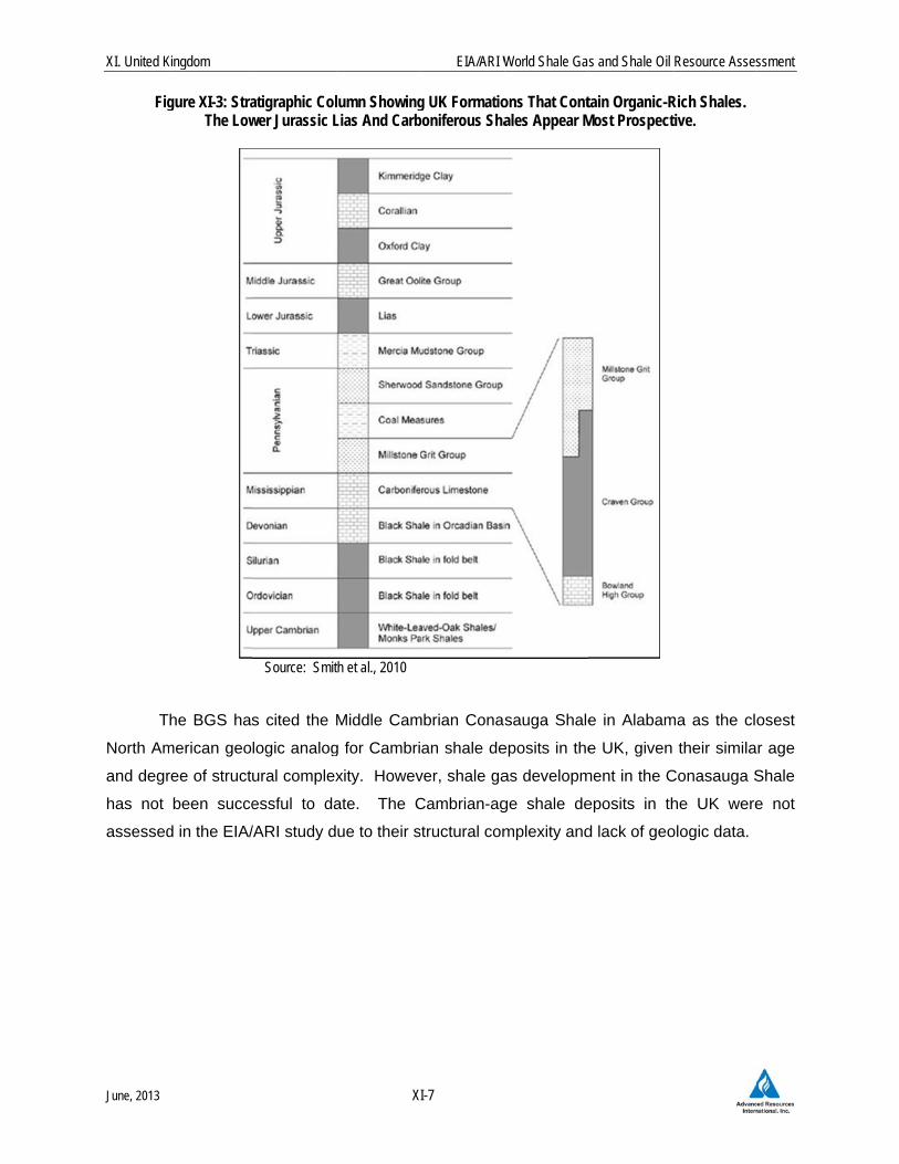
The main str
ppian (Lower
rich, marine-
n and the U
ue to their
ity. In parti
cluded beca
tly brittle. H
rmations to b
nt to note th
found in ma
-bounded su
the south
urian and Ju
to an exte
y, coupled w
in the troug
ale exploratio
: Regional Crighlighting Ca
Survey, 2012
ratigraphic t
r Namurian)
-deposited s
. Jurassic O
low therma
icular, organ
ause these
However, fu
be prospectiv
X
hat the UK
ny North Am
ub-basins. F
to the Bo
rassic shale
nt generally
with the relat
ghs), makes
on, de-risking
oss-Section frarboniferous-N
targets for s
8 and the Lo
shales, Figur
Oxford and K
al maturity,
nic-rich shal
non-marine
urther data c
ve in places
EIA/ARI W
I-6
shale basin
merica shale
Figure XI-2 s
owland Sub
e targets. Ev
y not display
ively small d
s resource a
g, and comm
rom Wessex BNamurian and
shale explor
ower Jurass
re XI-3. Oth
Kimmeridge C
lower orga
les found w
shales are
collection an
.
World Shale Gas
ns generally
e regions, bu
shows a reg
b-basin in
ven the inter
yed on sche
data base o
assessment
mercial deve
Basin Throughd Jurassic Sha
ration in the
ic Lias forma
her potential
Clays, but th
anic content
within the Ca
coaly, high
nd mapping
s and Shale Oil
y are not si
ut rather typ
gional cross-
the north,
rior of the su
ematic cros
f onshore pe
more difficu
elopment in t
h Bowland Suale Targets
e UK are th
ations, both
l shale targe
hese were e
t, and/or ex
arboniferous
h in clay, an
g may revea
Resource Asses
imple contin
ically compr
-section from
highlighting
ub-basins ma
ss-sections.
etroleum we
ult. It also
the UK.
ub-basin
he Carbonife
of which co
ets include th
excluded from
xtreme struc
s Coal Meas
nd unlikely t
al these or
ssment
nuous
rise a
m the
g the
ay be
The
ells in
could
erous
ontain
he U.
m our
ctural
sures
to be
other
XI. United K
June, 2013
Fig
T
North Am
and degr
has not
assessed
Kingdom
gure XI-3: StraThe Low
The BGS has
merican geo
ree of struct
been succe
d in the EIA/
atigraphic Colwer Jurassic L
Source: Smit
s cited the M
logic analog
ural complex
essful to da
/ARI study d
X
lumn ShowingLias And Carb
th et al., 2010
Middle Cam
g for Cambri
xity. Howev
ate. The C
ue to their s
EIA/ARI W
I-7
g UK Formatioboniferous Sha
mbrian Conas
an shale de
ver, shale ga
Cambrian-ag
structural com
World Shale Gas
ons That Contales Appear M
sauga Shale
eposits in the
as developm
ge shale de
mplexity and
s and Shale Oil
tain Organic-RMost Prospect
e in Alabam
e UK, given
ment in the C
eposits in th
d lack of geo
Resource Asses
Rich Shales. tive.
ma as the clo
their simila
Conasauga S
he UK were
ologic data.
ssment
osest
r age
Shale
e not
XI. United K
June, 2013
SEISMIC
T
fracturing
However
North Am
suspecte
In
Preese H
fracture
downhole
continued
relatively
was repo
months t
A
and the f
fault plan
seismic,
running
several h
T
data, wa
Bowland
American
unclear w
C
the hydra
fault to s
caused t
earthqua
considere
Kingdom
C HAZARD
The UK shale
g operation o
r, it is notew
merica durin
ed seismic ev
n August 20
Hall-1 vertica
stimulated d
e injection z
d for severa
y small, mea
orted. How
o determine
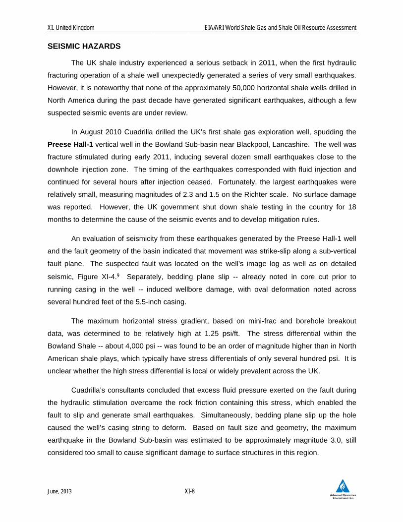
An evaluation
fault geomet
ne. The su
Figure XI-4
casing in th
hundred feet
The maximu
as determine
Shale -- ab
n shale play
whether the
Cuadrilla’s co
aulic stimula
slip and gen
the well’s ca
ake in the B
ed too small
DS
e industry e
of a shale w
orthy that no
g the past d
vents are un
10 Cuadrilla
al well in the
during early
zone. The t
al hours afte
suring magn
wever, the U
e the cause o
n of seismic
try of the ba
spected fau
4.9 Separat
he well -- in
t of the 5.5-in
m horizonta
ed to be re
out 4,000 ps
ys, which typ
high stress d
onsultants c
ation overca
nerate small
asing string
owland Sub
l to cause si
X
experienced
well unexpec
one of the a
decade have
nder review.
a drilled the
e Bowland S
2011, induc
timing of the
er injection c
nitudes of 2.
UK governm
of the seism
ity from thes
asin indicated
ult was locat
tely, beddin
nduced well
nch casing.
al stress gra
elatively high
si -- was fou
pically have
differential is
oncluded th
ame the roc
earthquake
to deform.
b-basin was
gnificant dam
EIA/ARI W
I-8
a serious s
ctedly genera
approximatel
e generated
UK’s first s
Sub-basin ne
cing severa
e earthquake
ceased. Fo
3 and 1.5 on
ent shut do
ic events an
se earthquak
d that move
ted on the w
g plane slip
bore damag
adient, base
h at 1.25 p
und to be an
stress differ
s local or wid
at excess fl
ck friction co
es. Simultan
Based on
estimated t
mage to surf
World Shale Gas
etback in 20
ated a serie
y 50,000 ho
significant e
shale gas ex
ear Blackpoo
l dozen sma
es correspo
ortunately, th
n the Richte
own shale te
nd to develop
kes generat
ment was st
well’s image
p -- already
ge, with ova
ed on mini-
psi/ft. The s
order of ma
rentials of on
dely prevale
uid pressure
ontaining thi
neously, bed
fault size a
to be appro
rface structu
s and Shale Oil
011, when t
es of very sm
orizontal sha
earthquakes
xploration w
ol, Lancashi
all earthqua
nded with fl
he largest e
er scale. No
esting in th
p mitigation
ted by the P
trike-slip alo
e log as we
y noted in c
al deformati
-frac and bo
stress differ
agnitude hig
nly several h
ent across th
e exerted on
s stress, wh
dding plane
and geometr
oximately ma
res in this re
Resource Asses
the first hyd
mall earthqua
ale wells drill
s, although a
well, spuddin
re. The wel
akes close t
luid injection
arthquakes
o surface dam
e country fo
rules.
Preese Hall-1
ong a sub-ve
ell as on det
core cut pri
on noted ac
orehole brea
rential within
her than in N
hundred psi.
he UK.
n the fault d
hich enable
e slip up the
ry, the maxi
agnitude 3.0
egion.
ssment
raulic
akes.
led in
a few
g the
l was
o the
n and
were
mage
or 18
1 well
ertical
tailed
ior to
cross
akout
n the
North
. It is
during
d the
e hole
imum
0, still
XI. United K
June, 2013
Source: de
T
induced f
the thick
report re
seismicit
A
May 201
conducte
health an
Ggtosa
Kingdom
Figu
Pater and Baisc
The consulta
fracture syst
k and imperm
commended
y.10
As a result o
11 until Dec
ed a review
nd safety du
Groundwateroundwater
o identify poshould be moquifers.
ure XI-4: SeismNear The
ch, 2011
ants also infe
tem and did
meable Bow
d monitoring
of the earthq
cember 201
of the risks
ring shale de
er Monitorinahead of shssible naturaonitored and
X
mic Reflection Preese Hall-1
erred that th
not leak into
wland Shale
g during hyd
quakes the g
12. The R
, recommen
evelopment:
ng. The BGShale developal methane c remediated
EIA/ARI W
I-9
n Line Showing Well In The B
he injected f
o the shallow
and overly
raulic fractu
government
oyal Societ
nding the fol
:11
S should conment, while concentratio
d to prevent f
World Shale Gas
g Suspected Bowland Sub-b
frac fluid re
w freshwate
ing Permian
uring operati
halted shal
ty and Roya
llowing three
nduct regionoperators co
ons in groundfracture fluid
s and Shale Oil
Active Faultsbasin
mained con
er aquifer sys
n anhydrites
ons to help
e operations
al Academy
e primary st
nal baseline onduct site-sdwater. Abads from ente
Resource Asses
ntained withi
stem, becau
s. A subseq
mitigate ind
s in the UK
y of Engine
teps for ens
surveys of specific survandoned weering freshwa
ssment
n the
use of
quent
duced
from
eering
suring
veys lls ater
XI. United K
June, 2013
Wmfr
Mstsst
A
shale de
potential
individua
earthqua
should s
time to d
the new
would be
1. N
1.1 In
N
isolated b
These sh
deposited
BGS, the
T
far, is on
Basin. F
Southern
Northum
troughs c
single reg
T
Kingdom
Well Integritymultiple layerreshwater aq
Mitigating Setresses, andite-specific stimulation, w
After conside
evelopment
seismic haz
al well site
akes due to
ignificant ea
drill shale we
shale rules
e delayed un
NORTH UK
ntroduction
Northern Eng
basins and t
hale-prospec
d or has be
ese troughs c
The Bowland
ne such trou
Further to th
n North Se
berland, Eas
containing C
gion for sha
The western
y. Well desrs of steel anquifers.
eismicity. Td seismic hazsurveys. Sewhich should
ering these a
starting De
zards posed
area, and
hydraulic fra
arthquake ris
ells in the U
. Hydraulic
ntil 2014 at th
CARBONI
n and Geo
gland and so
troughs whic
ctive lows a
en eroded.
cover a tota
d Sub-basin
ugh, represe
he east the
ea gas ba
st Midlands,
Carboniferou
le resource
portion of
XI
ign, construcnd cement a
The BGS shzards aheadismicity sho
d be shut dow
and other vie
ecember 20
d by hydraul
propose m
acturing. A
sks arise. T
K. Cuadrilla
c stimulation
he soonest -
IFEROUS S
logic Setti
outhern Scot
ch contain th
are separate
Based on
l area of app
of Lancashi
enting the o
Cleveland
asin. In
, Pennine, G
us-age shale
assessment
the Bowlan
EIA/ARI W
-10
ction, and inre present to
ould survey d of shale deuld be monitwn if seismic
ews, DECC
012. The r
lic fracturing
mitigation ste
real-time trig
These rules a
a’s Anna’s R
of this wel
-- would requ
SHALE RE
ng
tland are cha
hick, organic
ed by structu
mapping of
proximately
re, where sh
onshore ma
Basin is co
between l
Gainsboroug
es. Our stud
t.
nd Sub-bas
World Shale Gas
ntegrity testino preclude le
the regionaevelopment, tored beforec risks beco
put in place
regime requ
g, implement
eps to mini
gger is to be
are expecte
Road-1 well
l -- which C
uire further s
EGION
aracterized
c-rich Carbo
ural highs w
Carbonifero
10,000 mi2.
hale drilling
argin of the
onsidered th
lay the Ch
gh, Midland V
dy grouped
sin has bee
s and Shale Oil
ng should eneakage of flu
al distributionwhile opera
e, during, anme unaccep
e a new regu
uires opera
t seismic mo
imize the c
e installed to
d to add sig
is the first t
Cuadrilla rec
specific appr
by a comple
oniferous sha
where Carbo
ous basins c
has been c
petroliferou
he onshore
heshire, W
Valley, and
these isolat
en the site
Resource Asses
nsure that uids into
n of faults, ators conducd after hydra
ptable.
ulatory regim
tors to eva
onitoring of
chance of f
o cut off inje
gnificant cos
to be spud u
cently annou
rovals.
ex assembla
ales, Figure
niferous wa
conducted b
concentrated
s East Irish
extension o
West Lancas
other basins
ted basins i
of all UK s
ssment
ct aulic
me for
aluate
each
future
ection
st and
under
unced
age of
XI-1.
as not
by the
d thus
h Sea
of the
shire,
s and
nto a
shale

XI. United K
June, 2013
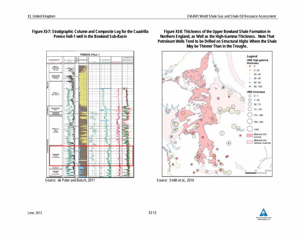
exploratio
about 2.0
XI-6. Cu
Bowland
shale, Fig
as well a
organic-r
Note, ho
tends to
T
control th
basins, F
gamma s
Bowland
E
fields in
overall a
organic-r
mudston
T
The Crav
over 5 k
turbidite
Namuria
of the Pe
Namuria
Kingdom
on drilling to
0 to 2.5 km
uadrilla’s Pr
Shale at a
gure XI-7. T
as its organ
rich shale ra
owever, that
be thinner th
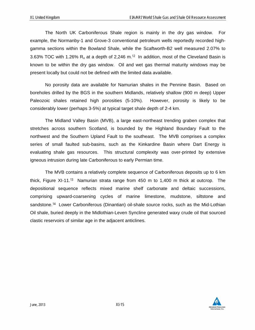
The eastern B
han the wes
Figure XI-9.
shales range
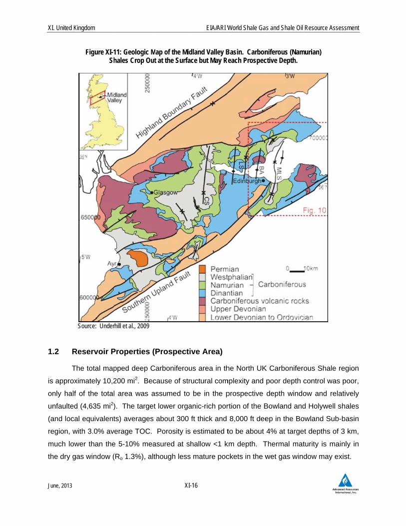
and Holywe
Elsewhere in
the souther
verage TOC
rich portion.
es in the UK
The Pennine
ven Group (
km thick in
and hemip
n shale units
ennine Basi
n marine sha
o date. The
deep acros
reese Hall-1
measured d
The BGS ha
ic-rich (high
anges up to
petroleum w
han in the tro
Bowland Sh
st. Here the
Dart Energ
es up to 110
ell shales wit
the region,
rn East Irish
C of 2.1% (r
Clay conte
K generally a
Basin has r
(Mississippia
the Widmer
elagic envir
s (local nam
n have high
ales genera
XI
Carbonifero
ss the mode
1 well encou
depth of 6,8
s mapped th
h-gamma) se
120 m thick
wells are pr
oughs.
ale play exte
e shale rang
gy reported
0 m thick. I
th TOC up to
the Namur
h Sea as w
range 0.7%
nt is uncerta
average arou
relatively goo
an) ranges f
rpool Gulf.
ronments in
mes Bowland
h TOC and
lly have rich
EIA/ARI W
-11
ous Bowland
rately faulte
untered the
854 ft and pe
he thickness
ection, acro
k but more ty
referentially
ension in the
ges up to 3
that the mo
n the Chesh
o 5% occur a
ian Holywell
well as the F
to 5%) and
ain, although
und 25% Al2
od geologic
from about 1
These mud
relatively n
d, Edale, Ho
are known
TOC in exc
World Shale Gas
d Shale is th
ed Bowland
top of the
enetrated a
s of the Uppe
ss northern
ypically is re
drilled on s
e Gainsboro
00 m thick
ost organic-r
hire Basin th
at depths of
l Shale, sou
Formby oil f
averages 3
h public data
2O3 (range 1
control from
1.5 km thick
dstones we
narrow, dee
olywell shale
to have sou
cess of 4%.
s and Shale Oil
he main targ
Sub-basin,
target Lowe
total 2,411
er Bowland S
England, F
ecorded as 2
structural hig
ough Basin h
in the Dinan
rich portion
he Carbonife
f 1 to 5 km, F
urce rock for
field, is repo
3.0% TOC in
a indicate th
2-38%), mo
m past petrol
k in the Cra
ere deposite
ep depocen
es, top part o
urced hydro
Resource Asses
get, ranging
Figures XI-5
er Carbonife
ft of organic
Shale Forma
Figure XI-8.
20 to 40 m
ghs, where s
has less geo
ntian half-gr
defined by
erous (Namu
Figure XI-10
r convention
orted to hav
n its lower,
hat Carbonife
stly from cla
leum explora
ven sub-bas
d in distal s
nters. The
of Craven G
ocarbons. T
ssment
from
5 and
erous
c-rich
ation,
The
thick.
shale
ologic
raben
high-
urian)
0.
nal oil
ve an
more
erous
ay.
ation.
sin to
slope
early
roup)
These
XI. United K
June, 2013
Source: Sou
FigureB
Source: IGA
Kingdom
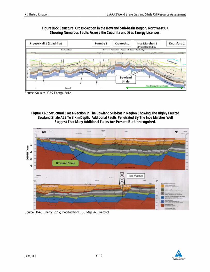
Figure XI-5: Showi
urce: IGAS Ene
e XI-6: StructuBowland Shale
Sug
AS Energy, 2012
Structural Crng Numerous
rgy, 2012
ural Cross-Sece At 2 To 3 Kmggest That Ma
2; modified from
XI
oss-Section ins Faults Acros
ction In The Bm Depth. Addiany Additiona
m BGS Map 96_L
EIA/ARI W
-12
n the Bowland
ss the Cuadrill
Bowland Sub-bitional Faults Pl Faults Are P
Liverpool
World Shale Gas
d Sub-basin Rla and IGas En
basin Region Penetrated By
Present But Un
s and Shale Oil
Region, Northwnergy License
Showing The y The Ince Manrecognized.
Resource Asses
west UK es.
Highly Faultershes Well
ssment
ed
X
J
XI. United Kingdom
June, 2013
Figure XI-7: StrPr
Source:
atigraphic Columnreese Hall-1 well in
de Pater and Baisch
n and Composite n the Bowland Su
h, 2011
Log for the Cuadrb-Basin
XI-13
rilla FiguNorthe
Petroleu
Source: S
EIA/ARI W
re XI-8: Thicknessern England, as Wum Wells Tend to b
May be T
Smith et al., 2010
World Shale Gas and
s of the Upper BoWell as the High-Ga
be Drilled on StruThinner Than in th
d Shale Oil Resource
owland Shale Formamma Thickness. uctural Highs Whehe Troughs.
e Assessment
mation in Note That
ere the Shale
XI. United K
June, 2013
Figure X
Source: Dar
Figure XI-(
Kingdom
XI-9: Schemat
rt Energy, 2013
-10: Geologic (Namurian) Bo
tic Cross-SectAdditional F
Map and Genowland and Ho
Sou
XI
tion Across ThFaults Are Lik
neralized Strucolywell Shales
urce: DECC, 20
EIA/ARI W
-14
he Gainsborokely To Be Pre
ctural Cross-Ss with TOC Up
12
World Shale Ga
ough Trough Sesent But Not S
Section of the p to 5% Occur
s and Shale Oil
Showing ThickShown.
Cheshire Basr at Depths of
Resource Asses
k Bowland Sha
sin. Carbonife 1 to 5 km.
ssment
ale.
erous
XI. United K
June, 2013
T
example
gamma s
3.63% TO
known to
present l
N
borehole
Paleozoi
considera
T
stretches
northwes
series o
evaluatin
igneous
T
thick, Fig
depositio
comprisin
sandston
Oil shale
clastic re
Kingdom
The North U
, the Norma
sections wit
OC with 1.2
o be within
ocally but co
No porosity d
es drilled by
c shales r
ably lower (p
The Midland
s across so
st and the S
f small fau
ng shale ga
intrusion dur
The MVB con
gure XI-11.1
onal sequen
ng upward
ne.14 Lower
e, buried dee
eservoirs of s
UK Carbonif
anby-1 and G
thin the Bow
6% Ro at a
the dry gas
ould not be d
data are av
the BGS in
retained hig
perhaps 3-5
Valley Basi
outhern Sco
Southern Up
ulted sub-ba
as resources
ring late Car
ntains a rela
3 Namurian
nce reflects
-coarsening
Carbonifero
eply in the M
similar age in
XI
ferous Shal
Grove-3 con
wland Shale
depth of 2,2
s window. O
defined with
ailable for N
the souther
gh porositie
%) at typica
in (MVB), a
otland, is b
pland Fault
asins, such
s. This str
rboniferous t
atively comp
n strata ran
s mixed m
g cycles o
ous (Dinanti
Midlothian-Le
n the adjace
EIA/ARI W
-15
e region is
nventional pe
, while the
246 m.12 In
Oil and wet
the limited d
Namurian sh
rn Midlands
es (5-10%).
l target shale
large east-
bounded by
to the south
as the Kin
ructural com
to early Perm
lete sequenc
ge from 45
marine shelf
of marine
an) oil-shale
even Synclin
ent anticlines
World Shale Ga
s mainly in
etroleum we
Scaftworth-
addition, mo
gas therma
data availab
hales in the
, relatively s
However
e depth of 2
northeast tr
the Highla
heast. The
nkardine Ba
mplexity was
mian time.
ce of Carbo
0 m to 1,40
f carbonate
limestone,
e source roc
e generated
s.
s and Shale Oil
the dry ga
ells reported
B2 well mea
ost of the Cl
al maturity w
ble.
e Pennine B
shallow (900
r, porosity
2-4 km.
rending grab
and Bounda
MVB comp
asin where
s over-print
oniferous dep
00 m thick
e and delta
mudstone
cks, such as
d waxy crude
Resource Asses
as window.
ly recorded
asured 2.07
leveland Ba
windows ma
Basin. Base
0 m deep) U
is likely to
ben complex
ary Fault to
prises a com
Dart Energ
ted by exte
posits up to
at outcrop.
aic success
, siltstone
s the Mid-Lo
e oil that sou
ssment
For
high-
7% to
sin is
ay be
ed on
Upper
o be
x that
o the
mplex
gy is
nsive
6 km
The
sions,
and
othian
urced
XI. United K
June, 2013
1.2 R
T
is approx
only half
unfaulted
(and loca
region, w
much low
the dry g
Kingdom
Figure XI-1Sh
Source: Under
Reservoir P
The total map
ximately 10,2
f of the total
d (4,635 mi2)
al equivalent
with 3.0% av
wer than the
as window (
11: Geologic Mhales Crop Ou
rhill et al., 2009
Properties
pped deep C
200 mi2. Be
l area was a
). The targe
ts) averages
verage TOC.
e 5-10% me
(Ro 1.3%), a
XI
Map of the Midut at the Surfa
(Prospecti
Carboniferou
ecause of str
assumed to
et lower orga
s about 300
Porosity is
easured at s
lthough less
EIA/ARI W
-16
dland Valley Bace but May Re
ive Area)
us area in th
ructural com
be in the p
anic-rich por
ft thick and
s estimated t
hallow <1 k
s mature poc
World Shale Ga
Basin. Carboneach Prospec
he North UK
mplexity and
prospective
rtion of the B
8,000 ft dee
to be about
km depth. T
ckets in the w
s and Shale Oil
niferous (Namctive Depth.
K Carbonifero
poor depth c
depth windo
Bowland and
ep in the Bo
4% at targe
Thermal mat
wet gas wind
Resource Asses
murian)
ous Shale re
control was
ow and rela
d Holywell s
owland Sub-
et depths of 3
turity is main
dow may ex
ssment
egion
poor,
atively
hales
basin
3 km,
nly in
xist.
XI. United K
June, 2013
1.3 R
R
Shale reg
1. The
significan
F
in-place
core from
total sha
Cuadrilla
estimate
organic-r
S
area with
eight con
shale ap
licenses
D
32.46 Tc
as well
recovery
reported
on a th
estimated
Broxburn
1.4 R
T
shale exp
totaling 1
(11 licens
Kingdom
Resource A
Risked, tech
gion are est
play has a
nt thickness
or comparis
within its Bo
m two shale
ale gas reso
a’s estimate
is based on
rich section a
Separately, I
hin an avera
nventional p
praisal well
to be about
Dart Energy’s
cf of GIP in u
as 30.55 Tc
estimate w
that the com
ird-party co
d at 115 B
n Shale (Bes
Recent Act
The Bowland
ploration we
1185 km2; 4
ses; 1041 km
Assessmen
nically reco
imated to be
favorable n
of organic-r
son, in Septe
owland Sub-
and three co
ource-in-plac
is that 10%
n the entire
as the prosp
GAS Energ
age 250-m th
petroleum w
last year, IG
9.2 Tcf.
s third-party
unspecified s
cf of shale
was reported
mpany’s PED
onsultant re
cf in the C
st Estimates;
ivity
d Sub-basin
ells drilled to
wells), IGA
m2).
XI
nt
verable sha
e 25 Tcf, out
net resource
ich shale.
ember 2011
-basin licens
onventional
ce concentr
or about 20
shale sectio
pective interv
y’s indepen
hick organic
wells that pe
GAS estimat
consultant
shale forma
gas GIP in
d.16 Finally
DL 133 licen
eport. Rec
arboniferous
; net to Dart)
, the only a
o date. The
AS Resource
EIA/ARI W
-17
ale gas reso
t of a risked
e concentrat
Cuadrilla R
ses to be ap
petroleum w
ration at its
Tcf may be
on, whereas
val.
ndent consu
c-rich interva
enetrated the
ted the shale
NSAI has es
tions in the
n the Chesh
, in Scotlan
nse has an e
coverable p
s Black Me
).
active shale
main operat
es (14 licens
World Shale Ga
ources in th
shale gas i
tion of abou
Resources e
pproximately
wells.15 The
Preese Ha
e recoverable
EIA/ARI co
ltant identifi
al, constrain
e Bowland
e gas in-pla
stimated tha
Gainsborou
hire Basin (
nd’s Midland
estimated 2.5
rospective
etal Shale a
drilling reg
tors are Cua
ses; 1363 km
s and Shale Oil
he North U
n-place of 1
ut 117 Bcf/m
estimated th
y 200 Tcf, ba
e company h
all-1 well to
e. It appear
onsiders only
ed a 1,195-
ed by geoph
Shale. Afte
ce (GIP) res
at Dart’s lice
gh Trough o
(gross, Best
d Valley Bas
5 Tcf of shal
shale gas
and 255 Bcf
ion in the U
adrilla Reso
m2; 1 well),
Resource Asses
K Carbonife
26 Tcf, Tab
mi2, reflecting
e total shale
ased on logs
has estimate
be 539 Bc
rs that Cuad
y the lower,
-km2 prospe
hysical logs
er drilling its
sources with
enses have s
of East Midla
t Estimate).
sin, Dart En
le gas GIP b
resources
f in the Lot
UK, has had
urces (4 lice
and Dart En
ssment
erous
le XI-
g the
e gas
s and
ed the
cf/mi2.
rilla’s
most
ective
from
s first
hin its
some
ands,
No
nergy
based
were
thian-
d five
enses
nergy
XI. United K
June, 2013
In
the Pree
of the ta
6,854 ft.
Bowland
A
stimulate
attempt t
the well
with no g
In
Worston
zones, o
separate
sand pro
typical st
10% of th
C
2010 the
depth int
well logg
C
abandon
in Janua
depth of
IG
and gas
portfolio
Point of
thickness
Kingdom
n August 20
ese Hall-1 ve
arget Lower
The well
is within the
After drilling
ed the well in
to produce s
by the hydra
gas productio
n completing
Shale, and
out of 12 o
ed by bridge
oppant, was
timulation of
he sand volu
Cuadrilla dril
e nearby Gra
terval of 1,2
ed shale fro
Cuadrilla’s m
ed at a dept
ry 2013 and
about 3100
GAS Energy
fields, is ev
of UK coalb
Ayr acreag
s of more th
10 Cuadrilla
ertical well i
Carbonifero
penetrated
e dry gas the
was compl
n early 2011
shale gas. A
aulic fractur
on reported.
g the well, C
Hodder Mu
originally pla
e plugs. The
relatively lar
f a horizonta
ume).
led and cor
ange Hill-1 v
00 m to 3,3
om depths of
most recent s
th of 2,000 f
d completed
m.
y Plc, 24.5%
valuating the
bed methan
ge has shal
an 800 ft. I
XI
a drilled the
n the Bowla
ous Bowland
a total 2,41
ermal maturi
eted on the
1. This oper
As previous
e stimulation
Cuadrilla per
udstone at d
anned, were
e total stimu
rge for a vert
al shale well
red two othe
vertical well
300 m, the t
f 2,450 m to
shale well in
ft due to drill
in about fou
% owned by
e shale gas
ne licenses
e extending
GAS Energy
EIA/ARI W
-18
first shale g
and Sub-bas
d Shale was
1 ft of orga
ity window.
e Preese H
ration repres
ly discussed
n. Operatio
rforated sha
depths rang
e individuall
ulation size,
tical shale w
in North Am
er vertical w
logged over
total depth o
3,100 m, the
n the Bowlan
ing problem
ur weeks, wi
Nexen and
potential of
in March 20
g over the e
y noted that
World Shale Ga
gas explorat
sin near Blac
s encounter
anic-rich sha
all-1, Cuadr
sented the U
d, small eart
ons at the w
le formation
ging from 7,
y stimulated
, over 50,00
well but still c
merica (abou
wells in the
r 2 km of Ca
of the well.
e total depth
nd Sub-bas
ms. The well
ith the top B
the UK’s la
its blocks.
011. The c
entire block
a significan
s and Shale Oil
ion well in t
ckpool, Lanc
red at a me
ale. Natura
rilla comple
UK’s first an
thquakes we
well were hal
ns within the
670 to 8,94
d with a sa
00 bbl of wa
considerably
ut half the w
Bowland Ba
arboniferous
In 2011 the
h of the well.
in, the Anna
l was expect
Bowland Sha
rgest onsho
IGAS had a
company rep
k with an ex
nt proportion
Resource Asses
he UK, spud
cashire. Th
easured dep
ally fractured
eted and fra
nd only conc
ere induced
lted in May
e Bowland S
49 ft. Five s
and/water s
ater and 400
y smaller tha
water volume
asin. Durin
shale acros
e Becconsh
.
a’s Road-1,
ted to be re-
ale predicted
ore operator
acquired Ne
ported that
xpected ave
of its acrea
ssment
dding
e top
pth of
d, the
acture
certed
near
2011
Shale,
shale
slurry,
0 t of
an the
e and
ng 2H
ss the
hall-1
, was
-spud
d at a
of oil
xen’s
at its
erage
age in
XI. United K
June, 2013
the north
the east
In
Bowland
deepene
5,200 ft.
ranging f
window (
D
UK, inclu
the coun
operators
consultan
which ap
Region.
km2. NS
Estimate
horizonta
388 km2
D
announc
Lothian S
M
Gas Ltd
Bristol, a
party con
includes
However
Kingdom
hwest Englan
within PEDL
n 2011-12 I
Sub-basin.
ed and enco
The Bowla
from 1.2% t
(Ro 1.0-1.1%
Dart Energy
uding the we
try. Dart’s
s Composite
nt NSAI has
pproximately
No sh
Dart Energy
SAI has est
). Houston
al well by 20
of shale-pro
Dart Energy,
ed firm plan
Shale interva
Much further
. jointly cont
and Kent. Pr
nsultant to
806 km2 w
r, this region
nd—from El
L 193—is co
GAS drilled
Originally
ountered the
and Shale, e
o 6.9% (ave
%).17
, based in A
estern Penni
14 PEDL’s w
e and Green
s estimated
30.5 Tcf is
hale drilling
y holds the l
timated that
-based eCO
014 to farm
ospective are
, the only
ns for shale
al in this reg
to the south
trol 2100 km
rospective re
be 18.3 Tcf
within 7 PED
was not ass
XI
lesmere Po
nsidered to
the Ince M
y intended a
e upper two-
estimated at
erage 2.7%)
Australia and
ine Basin, b
with shale p
npark Energ
these block
located in th
has occurr
argest land
Dart’s bloc
ORP Interna
into one of
ea in 9 licens
active shale
e drilling. B
ion.
h, Australia-b
m2 of shale g
ecoverable s
f out of a to
DLs in South
sessed by E
EIA/ARI W
-19
rt in the wes
have shale
Marshes-1 w
as a shallow
-thirds of the
t 1,600-ft to
). Thermal
d Singapore,
ut has not y
potential, par
y, total abo
ks hold app
he western P
ed yet on t
position, a t
cks hold abo
ational, LLC
Dart’s block
ses in this re
e operator
G Group re
based Eden
gas and coa
shale gas re
otal 49.8 Tc
h Wales wit
EIA/ARI beca
World Shale Ga
st in PEDL 1
potential.
well to a to
w coalbed
e Bowland
otal thicknes
maturity ap
, holds a sig
yet drilled for
rt of its acqu
ut 3,700 km
roximately 6
Pennine Bas
the eastern
total of 13 lic
out 47.6 Tc
has comm
ks. Separat
egion.
in the Midl
emains a joi
Energy and
albed metha
esources we
cf of GIP (g
th potential
ause of limite
s and Shale Oil
190 to the T
otal depth o
methane te
Shale at de
ss, had gas
peared to b
gnificant sha
r shale there
uisitions of c
m2 in gross a
65 Tcf of to
sin (gross, Be
side of the
censes cove
cf of shale G
itted to drill
tely, IGAS e
land Valley
nt-venture p
d UK-based
ne potential
re estimated
gross; Best
in the Nam
ed publicly a
Resource Asses
Trafford Cen
of 5,714 ft in
st, the well
epths of 4,2
shows and
be in the we
ale position i
e or elsewhe
coalbed met
area. Third-
tal shale GI
est Estimate
e Bowland S
ering about 1
GIP (gross,
ing and cor
estimates it
Basin, has
partner on D
Coastal Oi
in South W
d by Eden’s
Estimate).
murian Meas
available dat
ssment
tre in
n the
was
00 to
TOC
et gas
in the
ere in
thane
-party
IP, of
e).
Shale
1,235
Best
ring a
holds
s not
Dart’s
l and
Wales,
third-
This
sures.
ta.
XI. United K
June, 2013
2. S
2.1 In
T
oil-produ
and Trias
The Wes
onshore
T
and intra
offshore
Sussex,
boundary
depositio
sandston
Cretaceo
F
Jurassic
Wessex
assessed
T
other UK
plays. W
separate
grabens
sediment
depths o
spaced a
strata dip
Kingdom
SOUTH UK
ntroduction
The Wessex
cing area.
ssic clastic
ssex Basin h
field, wherea
The Wessex
a-basinal hig
areas. The
Surrey, and
y is indistin
on. They
nes, and lim
ous Wealden
or the purpo
oil-prone sh
Basin may
d.18
The structura
K shale regi
While not inte
ed by norma
(Pewsey, M
Figure XI-12
tary rocks is
f about 7,00
about 5 to 1
p quite gently
JURASSIC
n and Geo
and Weald
Both basins
and carbon
hosts the 50
as the Weal
Basin comp
ghs, located
Weald Bas
d Kent. The
nct and the
contain rep
estones wh
n Group.
ose of this
hale resourc
exist further
al geology of
ons, althoug
ensively def
al faults. F
ere-Portsdo
2 shows th
s present in
00 ft or more
0 km apart,
y, only a few
XI
C SHALE R
logic Setti
basins regio
s produce oi
ate reservoi
00 million bb
d Basin has
prises a serie
mainly in H
in is a bette
e basins are
e two basin
peating cyc
ich are over
study, the W
ce region.
r to the wes
f the Wesse
gh still more
formed, thes
For example
own, Dorset a
at roughly
n the Weald
e along the b
and seemin
w degrees.
EIA/ARI W
-20
REGION
ng
on of southe
il and some
irs which we
bl Wytch Fa
s several mu
es of post-Va
Hampshire a
r defined an
e separated
s were inte
les of Jura
rlain by larg
Wessex and
Additional J
st (e.g., Bris
x and Weald
e complex a
se basins co
e, the Wess
and Channe
10,000-ft th
d Basin. Lo
basin axis. I
ngly allow a
World Shale Ga
rn England
e natural gas
ere sourced
arm oil field,
ch smaller o
ariscan exte
and Dorset
nd structurall
by the Ham
ermittently c
assic shallo
gely non-ma
d Weald bas
Jurassic sha
stol Channe
d basins is s
and faulted
omprise a se
sex Basin c
el).
ick of Lowe
ower Jurass
nterior faults
mple room
s and Shale Oil
is the UK’s p
s from conv
d by Jurassi
, by far the
oil fields.
ensional sed
and extend
ly simpler sy
mpshire-Diep
connected d
ow-water m
rine sedime
sins are con
ale areas w
l Basin), bu
somewhat s
than North
eries of indiv
comprises fo
er Carbonife
sic organic-r
s appear to
for shale de
Resource Asses
principal ons
entional Jur
c marine sh
country’s la
dimentary tro
ing into adja
yncline locat
ppe High, bu
during Mes
arine mudr
ents of the L
nsidered a s
with affinity to
t these wer
simpler than
American s
vidual sub-b
our smaller
erous to Te
ich shales r
be relatively
evelopment.
ssment
shore
rassic
hales.
argest
oughs
acent
ted in
ut the
ozoic
rocks,
Lower
single
o the
re not
most
shale
asins
half-
ertiary
reach
y few,
The
XI. United K
June, 2013
Source: DT
H
detailed
wells, sh
offshore
located in
T
carbonat
this regio
settings
of northe
Kingdom
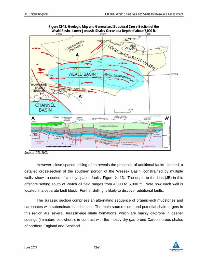
Figure Weal
TI, 2003
However, clo
cross-sectio
ows a serie
setting sout
n a separate
The Jurassic
tes with subo
on are seve
(immature e
ern England
XI-12: Geologld Basin. Low
se-spaced d
on of the so
es of closely
th of Wytch
e fault block.
section com
ordinate san
eral Jurassic
elsewhere),
and Scotlan
XI
gic Map and Gwer Jurassic S
drilling often
outhern port
spaced fau
oil field ran
Further dri
mprises an a
ndstones. T
c-age shale
in contrast w
nd.
EIA/ARI W
-21
Generalized StShales Occur a
reveals the
tion of the W
lts, Figure X
nges from 4,
lling is likely
alternating s
The main sou
e formations
with the mos
World Shale Ga
tructural Crosat a Depth of a
presence o
Wessex Ba
XI-13. The d
,000 to 5,00
y to discover
sequence of
urce rocks a
, which are
stly dry-gas
s and Shale Oil
ss-Section of tabout 7,000 ft
of additional
asin, constra
depth to the
00 ft. Note
r additional f
organic-rich
and potentia
e mainly oil-
prone Carb
Resource Asses
the .
faults. Inde
ained by mu
e Lias (JB) in
how each w
faults.
h mudstones
al shale targe
-prone in de
boniferous s
ssment
eed, a
ultiple
n this
well is
s and
ets in
eeper
hales
XI. United K
June, 2013
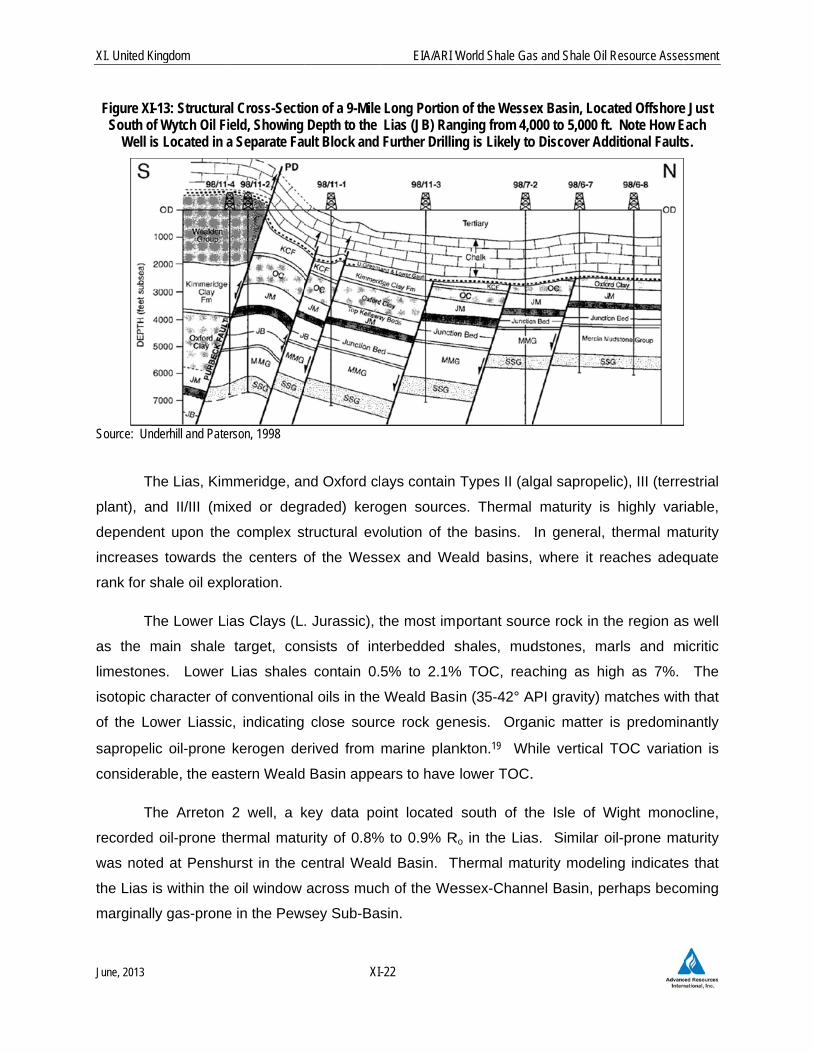
Figure XISouth o
Well i
Source: Un
T
plant), a
depende
increases
rank for s
T
as the m
limestone
isotopic c
of the Lo
sapropel
considera
T
recorded
was note
the Lias
marginal
Kingdom
-13: Structuraof Wytch Oil Fi
s Located in a
nderhill and Pate
The Lias, Kim
nd II/III (mi
ent upon the
s towards th
shale oil exp
The Lower Li
main shale
es. Lower
character of
ower Liassic
ic oil-prone
able, the eas
The Arreton
d oil-prone th
ed at Pensh
is within the
ly gas-prone
al Cross-Sectiield, Showing a Separate Fa
erson, 1998
mmeridge, an
xed or deg
e complex s
he centers o
ploration.
as Clays (L
target, con
Lias shales
conventiona
c, indicating
kerogen de
stern Weald
2 well, a k
hermal matu
urst in the c
e oil window
e in the Pew
XI
on of a 9-Mile Depth to the ult Block and
nd Oxford cl
raded) kero
tructural evo
of the Wess
. Jurassic), t
nsists of int
s contain 0.
al oils in the
close sour
erived from
d Basin appe
key data po
urity of 0.8%
central Wea
across muc
wsey Sub-Ba
EIA/ARI W
-22
Long Portion Lias (JB) Ran Further Drillin
ays contain
ogen source
olution of th
sex and We
the most im
terbedded s
5% to 2.1%
Weald Basi
ce rock gen
marine plan
ears to have
oint located
% to 0.9% R
ld Basin. T
ch of the We
sin.
World Shale Ga
n of the Wessenging from 4,0ng is Likely to
Types II (al
es. Thermal
he basins.
eald basins,
portant sour
shales, mud
% TOC, rea
in (35-42° A
nesis. Orga
nkton.19 Wh
lower TOC.
south of th
Ro in the Lias
Thermal mat
essex-Chann
s and Shale Oil
ex Basin, Loca000 to 5,000 fto Discover Ad
gal saprope
maturity is
In general,
where it re
rce rock in th
dstones, ma
ching as hi
API gravity) m
anic matter
hile vertical
.
he Isle of W
s. Similar o
turity modeli
nel Basin, pe
Resource Asses
ated Offshoret. Note How Editional Faults
elic), III (terre
s highly var
thermal ma
eaches adeq
he region as
arls and m
gh as 7%.
matches with
is predomin
TOC variati
Wight mono
oil-prone ma
ng indicates
erhaps beco
ssment
e Just Each s.
estrial
iable,
aturity
quate
s well
micritic
The
h that
nantly
ion is
cline,
aturity
s that
oming
XI. United K
June, 2013
S
20% TOC
shales (i
sandston
occasion
produced
Clay is c
northernm
organic-r
Kimmerid
P
Carbonife
mudston
30-40%.
porosity,
2.2 R
T
Organic-
in the P
reaches
zone is e
is likely
measure
33°C/km
A
the Wess
coccolith
Bakken S
Kingdom
Secondary po
C) in the Up
ncluding oil
nes and silt
nally even 20
d 1,000 ft3/d
considered t
most axial p
rich, reachin
dge and Oxf
Porosity and
erous beca
es encounte
However,
perhaps 7%
Reservoir P
The Lias sha
rich thicknes
aris Basin,20
6,000 ft in t
estimated to
to be highe
d at shallow
.
Although not
sex and We
ic carbonate
Shale in Nor
otential exis
pper Jurassic
shales), ca
tstones. Th
0%. Britain’
from an uns
thermally im
part of the
ng 10% TO
ford clays we
permeabilit
ause they h
ered in shall
Jurassic sh
%.
Properties
ales averag
ss of the mo
0 is estimat
the Weald B
average 3%
er than olde
w locations
assessed, t
ald basins, i
es which ar
rth Dakota.
XI
ts in the Ox
c. The Upp
alcareous m
he TOC of
’s first natur
stimulated K
mmature in t
Wessex-Ch
OC, but like
ere excluded
ty of the Ju
have not b
ow (<30 m)
ales buried
(Prospecti
e about 60
ost oil-satura
ted at appro
Basin, avera
% but could
er Carbonife
near outcro
the Jurassic
is notable fo
re somewha
EIA/ARI W
-23
xford (up to 1
per Jurassic
udstones, in
some thin
ral gas well,
Kimmeridge
the Wessex
annel Basin
ewise is the
d from our e
urassic shal
een subjec
engineering
at depths o
ive Area)
0 thick (gro
ated and brit
oximately 16
aging about
be consider
erous shales
op.21 The c
c Kimmeridg
or containing
at similar to
World Shale Ga
12% TOC) a
Kimmeridge
nterbedded
black shale
drilled in 18
Clay section
x-Weald reg
n. The Upp
ermally imm
evaluation.
les are like
ct to as m
g boreholes
of 1-5 km ar
oss) in the
ttle zones, b
65 ft, Figure
5,000 ft dee
rably higher
s, but lowe
current aver
ge Clay, ano
g thin limesto
the lithology
s and Shale Oil
and Kimmer
e Clay consi
micritic lime
es frequentl
895 at Heat
n. However
ion, apart p
per Jurassic
mature. Co
ely to be hig
uch compa
have poros
re likely to h
Wessex an
based on an
e XI-14. D
ep. TOC of
. Porosity,
er than the
rage geothe
other potenti
one stringers
y of the car
Resource Asses
ridge clays (
ists of altern
estones, and
ly reaches
thfield in Su
, the Kimme
possibly from
c Oxford Cl
onsequently
gher than in
action. Jur
sities in the r
have much
d Weald ba
alysis of the
Depth to the
f the prospe
estimated a
30-40% po
ermal gradie
al source ro
s. These inc
rbonate-rich
ssment
(up to
nating
d thin
10%,
ssex,
eridge
m the
lay is
y, the
n the
rassic
range
lower
asins.
e Lias
Lias
ective
t 7%,
rosity
ent is
ock in
clude
Mid-
XI. United K
June, 2013
Source: M.
2.3 R
T
The pros
excluded
issues. O
risked, te
0.6 Tcf o
C
ranges f
estimated
125 millio
Kingdom
Fig
Mullen, Realm E
Resource A
The Wessex
spective area
d due to po
Out of a risk
echnically re
of associated
Celtique Ene
from 9,000
d that the L
on barrels of
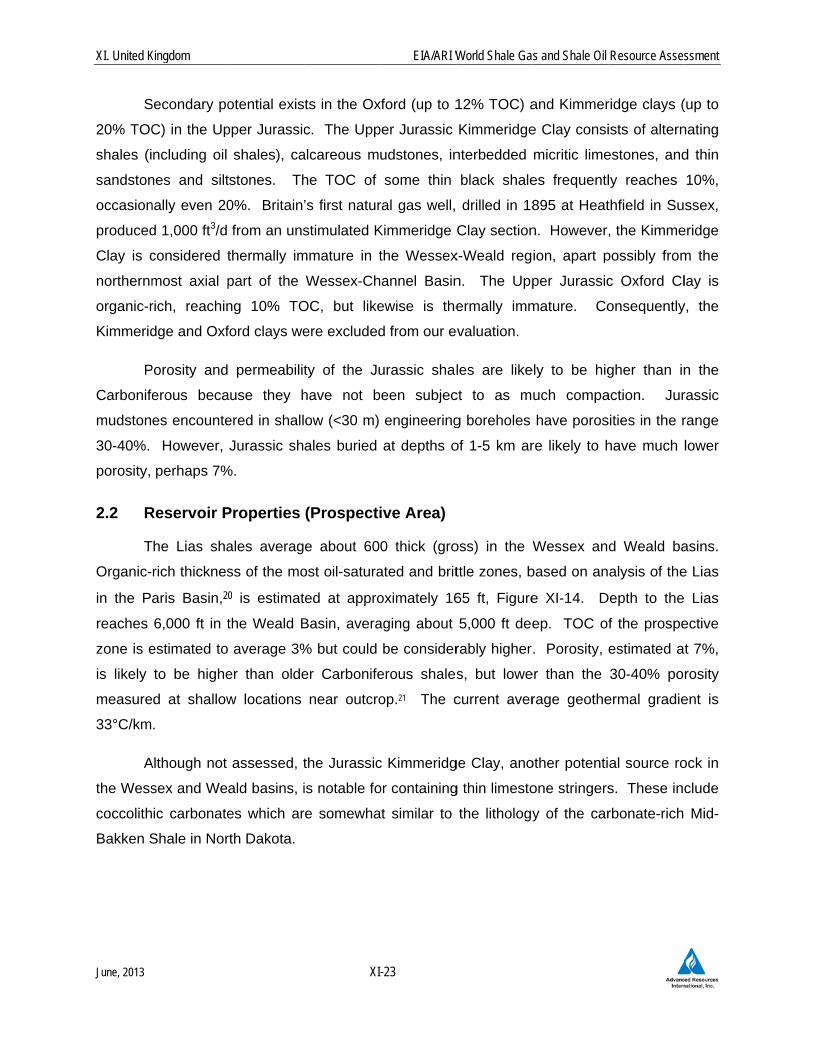
ure XI-14: Logas a Proxy
Energy, 2011
Assessmen
and Weald b
a was estim
otential fault
ked shale oi
ecoverable re
d shale gas,
ergie has re
to 13,000
Liassic could
f oil and 10 T
XI
g Suite Showiy for the Wess
nt
basins exten
ated to be h
ting, shallow
l in-place of
esources ar
Tables XI-1
eported that
ft deep wit
d have mean
Tcf of shale
EIA/ARI W
-24
ng the Jurassex-Weald Sha
nd over an o
half of total a
w depth, ero
f 17 Bbbl an
re estimated
and XI-2.
t the Liassic
thin a 467-
n recoverab
gas.
World Shale Ga
sic Lias In the ale Region in t
onshore area
area (1,740 m
osion of the
nd risked sha
to be 0.7 b
c Shale at
-km2 prospe
ble shale oil
s and Shale Oil
Paris Basin, the UK
a of approxim
mi2), with th
e Lias, and
ale gas in-pl
billion barrels
their Weald
ective area.
and shale g
Resource Asses
mately 3,500
e remaining
d surface ac
lace of 8 Tc
s of shale oi
d Basin lice
The com
gas resourc
ssment
0 mi2.
area
ccess
cf, the
il and
enses
mpany
ces of
XI. United K
June, 2013
2.4 R
P
Basin, Ea
licenses
potential
shale dri
REFERE
1 New Scien
2 Selley, R.C
3 Selley, R.C
4 UK DepartBritish Ge
5 Smith, N.,S.C., eds.Geologica
6 UK DepartBritain’s O
7 Stephenso
8 Waters, CSuccessio
9 De Pater, for Cuadri
10 Green, CMitigation
11 The RoyFracturing
12 Dart Ener
13 UnderhillPetroleum
14 Waters, C
15 AJ Lucas
16 Dart Ener
17 IGas Ene
18 Underhill,Key Struc
Kingdom
Recent Act
Privately held
ast Midlands
covering 1
in the Jura
lling has bee
ENCES
ntist “Fracking R
C., 1987. “Britis
C., 2012. “UK S
tment of Trade aeological Survey,
Turner, P., and., Petroleum Geoal Society of Lon
tment of ClimateOnshore Basins –
on, M., Geologic
C.N., Browne, Mons of Great Brit
D.J. and Baischilla Resources, L
C.A. and Styles,.” Report for Cu
yal Society and g.” June, 76 p.
rgy, Corporate P
l, J.R., Monaghm Prospectivity in
C.N., Browne, M
Group Limited,
rgy, Quarterly Re
rgy, Corporate P
, J.R. and Paterctures along the
ivity
d Celtique E
s, and the W
,000 sq km
assic Liassic
en reported.
isk is Exaggerat
h Shale Gas Pot
Shale Gas – The
and Industry, 200, 93 p.
d Williams, G.. 2ology: From Matdon, p. 1087-10
e Change (DECC– Shale Gas.” R
al Society, Lond
M.A.E., Dean, tain (Onshore).”
, S., 2011. “GeoLtd., November 2
P., 2011. “Pruadrilla Resource
Royal Academy
Presentation, Ma
han, A.A., and n the Midland Va
.A.E., Jones, N.S
News Release,
eport, June 30, 2
Presentation, Jun
rson, S., 1998. Purbeck–Isle of
XI
Energie hol
Weald Basin
m. The com
c shales, as
ted.” 11 January
tential Scrutinize
Story So Far.”
03. “The Hydroc
2010. “UK Datature Basins to N
098.
C), December 2Report prepared
don, Presentation
M.T., and PowBritish Geologic
omechanical Stu2, 71 p.
reese Hall Shalees Ltd., April 201
y of Engineerin
rch 1, 2013.
Browne, M.A.Ealley of Scotland
S., and Somervi
September 22, 2
2012, 18 p.
ne 2012, 22 p.
“Genesis of Tec Wight Disturban
EIA/ARI W
-25
ds licenses
. In the We
mpany claim
well as con
y 2012.
ed.” Oil and Gas
Marine and Petr
carbon Prospect
a and Analysis foew Frontiers. P
2010; updated 20 by the British G
n on Shale Gas,
ell, J.H., 2007. cal Survey, Rese
udy of Bowland S
e Gas Fracturin12, 26 p.
g, 2012. “Shal
E., 2008. “Con.” Marine and P
lle, I.D., 2012. “
2011.
ctonic Inversion nce.” Journal of
World Shale Ga
in three are
eald Basin, C
s to have
nventional p
s Journal, June
roleum Geology
tivity of Britain’s
or Shale Gas PrProceedings of th
012. “The UncoGeological Surve
, 60 minutes.
“Lithostratigraearch Report RR
Shale Seismicity
ng Review & Re
le Gas Extractio
ntrols on StructPetroleum Geolo
“Midland Valley o
Structures: Seis the Geological S
s and Shale Oil
eas of the U
Celtique has
unconventio
potential in t
15, p. 62-64.
, vol. 31, p. 100-
Onshore Basins
rospectivity. In: he 7th Petroleum
onventional Hydry, 40 p.
aphical FramewR/07/01, 60 p.
y: Synthesis Rep
ecommendation
on in the UK: a
tural Styles, Baogy, vol. 25, p. 10
of Scotland.” Ch
smic Evidence fSociety, London
Resource Asses
UK: the Che
s a 50% sha
onal oil and
the Triassic
-109.
s.” Report prepa
Vining, B.A. Picm Geology Confe
rocarbon Resou
work for Carbon
port.” Report pr
s for Induced S
a Review of Hy
asin Developme000-1022.
hapter 14, 10 p.
for the Developmn, vol. 155, p. 97
ssment
eshire
are in
d gas
. No
ared by
ckering, erence,
urces of
niferous
repared
Seismic
ydraulic
ent and
ment of 5-992.

XI. United K
June, 2013
19 Stoneley,
Ussher So
20 Mullen, M
21 Smith et a
Kingdom
R. 1992. “Reviociety, vol. 8, p.
M., Realm Energy
al., 2010.
ew of the Habita1-6.
y, 2011. “Shale
XI
at of Petroleum i
Oil – The Next B
EIA/ARI W
-26
n the Wessex B
Big Play for Tigh
World Shale Ga
Basin: Implication
ht Oil?” January
s and Shale Oil
ns for Exploratio
y 30, 27 p.
Resource Asses
n.” Proceedings
ssment
s of the