Embed Size (px)
Citation preview

842
GAT Project No. 2096
Report No. 842
December, 2009
Wylfa:
Ymddiriedolaeth Archaeolegol Gwynedd
Gwynedd Archaeological TrustCraig Beuno, Ffordd y Garth, Bangor, Gwynedd, LL57 2RT
Anglesey
Archaeological assessment

Report No. 842
Prepared for Eon
December 2009
ByAndrew Davidson
Illustrations by Tanya Berks
Ymddiriedolaeth Archaeolegol Gwynedd
Gwynedd Archaeological TrustCraig Beuno, Ffordd y Garth, Bangor, Gwynedd, LL57 2RT
Wylfa:
Anglesey


1. INTRODUCTION Gwynedd Archaeological Trust was asked by RWE npower to provide an archaeological assessment in advance of a proposed Nuclear Power Station at Wylfa, Cemaes, Anglesey. The study area lies adjacent to Wylfa A, an existing nuclear power station. It is centred on approximately SH 35459328, and occupies 2.33 sq km in area. 2. AIMS AND SPECIFICATION A detailed brief has not been prepared for this work, but an initial archaeological assessment has been requested consisting of a desk-based study and field walk-over. The methodology used follows the guidelines specified in Standard and Guidance for Archaeological Desk-based Assessment (Institute of Field Archaeologists, 1994, rev. 2004). A desk-based assessment is defined as “a programme of assessment of the known or potential archaeological resource within a specified area or site on land, inter-tidal zone or underwater. It consists of a collation of existing written, graphic, photographic and electronic information in order to identify the likely character, extent, quality and worth of the known or potential archaeological resource in a local, regional, national or international context as appropriate” (Standard and Guidance for Archaeological Desk-based Assessment 1994, rev. 2004). The aims of the assessment are: to identify and record the cultural heritage within the defined study area; to evaluate the importance of what has been identified; to recommend ways in which impact upon the cultural heritage can be avoided or minimised. To comply fully with the aims expressed above it can be necessary to undertake a programme of Field Evaluation following the Desktop study and Field Visit. This is because some sites cannot be assessed by desktop or field visit alone, and additional fieldwork is therefore required. This typically takes the form of geophysical survey or trial excavation, although measured survey is also a possible option. A full programme of assessment and evaluation may therefore consist of: Desktop study Field walkover Initial report Field evaluation Draft report Final report This assessment includes the first three phases only, and recommendations will be made for any field evaluation required. 3. METHODOLOGY 3.1 Desk top study The desktop study comprised the consultation of maps, documents, computer records, written records and reference works, which form part of the Historic Environment Record (HER), located at Gwynedd Archaeological Trust (GAT), Bangor. The archives held by the Anglesey Record Office, Llangefni, in particular the tithe and Land Tax records, were consulted. Relevant manuscripts at the archives of Bangor University, including Llwydiarth Esgob and John Elias collections, were examined, as was the Mary Broadhead Collection at the National Library of Wales. Information about Listed Buildings was consulted by means of the CARN (Core Archaeological Index), which is the online index of the Royal Commission
1
on Ancient and Historic Monuments, Wales. Relevant aerial photographs from the collection at RCAHM, Wales were examined. Results of an earlier desk-based assessment (commissioned by Magnox North in support of an application to decommission Wylfa ‘A’ power station) (Longley 2007, GAT Report 670) are incorporated, where relevant, into this report. 3.2 Field Search The site and surrounding area were visited in September and November 2009. Notes were taken, and a photographic record was made. The excavation of soil test pits was also monitored in October 2009, and the results of the field monitoring are included in this report (see Appendix A). 3.3 Report The available information was synthesised to give a summary of the archaeological and historic background and of the assessment and recommendations, as set out below. The separate features, their evaluation and recommendations are listed separately, and a summary of the overall assessment of the area is given at the end. The criteria used for assessing the value of features was based upon those used by the Secretary of State for Wales when considering sites for protection as scheduled ancient monuments, as set out in the Welsh Office circular 60/96. 4. LOCATION AND TOPOGRAPHY The study area is located on the north Anglesey coast approximately 2 km west of the village of Cemaes. The nearest village is Tregele, approximately 1 km to the south-east. An existing power station (Wylfa A) was built here in the 1960’s and has been operating since 1971. The Wylfa headland projects from the north coast of Anglesey into the Irish Sea between the deeply indented bays of Cemlyn to the west and Cemaes to the east. The coastline is further indented at Porth y Pistyll, 1 km east of Cemlyn, and at Porth y Wylfa, 1.2 km west of Cemaes, and it is between these two smaller bays that the headland is defined. The north tip of the headland is further constricted between the bays of Porth Wnal (west) and Porth yr Ogof (east), 400m from its northernmost point. This area is known as Mynydd y Wylfa (Wylfa Mountain) and lies outside the study area. The topography in the immediate vicinity of the headland and southwards has a generally low and rolling aspect, rarely rising above 30m OD. An area of lower ground, at around 10-20m OD, occurs at the neck of the headland, from which the ground rises again to 38m at Mynydd y Wylfa with cliffs to seaward. Low hills, the highest reaching 40m OD, lie to the south and west of the study area. To the east is the low-lying bog of Tre’r Gof, now a SSSI, after which the ground rises to Park Lodge at about 30m OD. The underlying geology is of metamorphic rock, flaggy and laminate green-mica schist of the New Harbour Group of the Mona Complex. The schist contains bands and erins of quartz, jasper and calcite. The bedding planes dip in the northerly direction. Dolerite dykes can be seen outcropping along the coastline. Glacial erosion has reduced the landform to a generally level surface. Hollows are filled with brown clay or gravel. A pre-glacial valley crosses the site from east to west and is filled with overburden to a maximum depth of 7m. The landscape is one of largely dispersed settlement of farms and cottages, though dominated now by Wylfa A. The area, like much of Anglesey, has a windswept appearance, with few natural trees. Field boundaries are largely walls or stone-faced earth banks (in Welsh ‘clawdd’ or ‘cloddiau’ (plural)). Rock outcrops close to the coastline, where there are areas of rough coastal grazing, but otherwise the majority of fields have been ploughed and are largely pasture. The lands immediately around Wylfa A have been landscaped and a new plantation of native and confer trees was planted shortly after construction on the south-east side.
2

5. HISTORICAL CONTEXT 5.1 Prehistory There is no clear evidence of prehistoric activity in the immediate vicinity of the Wylfa headland. In the wider landscape an important group of Neolithic and Early Bronze Age ceremonial monuments are known in the area to the west and north of Llanfechell, 2.5 Km south of Wylfa. These comprise standing stones and, in particular, a remarkable group of three standing stones in a triangular arrangement at Llanfechell (PRN 3047), and a now ruinous chambered tomb nearby (PRN 3046). The tomb, on the basis of an antiquarian illustration, may have been of portal dolmen type. Burial monuments of the Early Bronze Age are known at Rhosbeirio, to the east of Llanfechell. The most prominent, capping a small hill between Rhosbeirio and Llanfechell, is Pen y Morwydd (PRN 3055). A beaker burial, a crouched inhumation in a rectangular cist and apparently lacking the covering of a cairn, is known from the same locality. The visual evidence of later prehistoric activity on Anglesey is very largely represented by defended enclosures and settlements typified by circular houses. The latter can be built of stone, timber or clay. The place-name ‘Cestyll’ (English: ‘castles’) at the western neck of the Wylfa headland at Porth y Pistyll may represent the location of a former coastal promontory fort, although nothing now survives (PRN 3538, 3539). Lewis Morris’ coastal survey of c. 1730 marks ‘Fort’ in comparable locations on the flanks of the headlands which define Cemlyn Bay, 1km to the west (PRN 3532, 3536). A large and prominent headland, 3.5km to the east of Wylfa, at the northernmost extent of the island, is occupied by one of the largest promontory forts on Anglesey called Dinas Gynfor (PRN 3067). Steep cliffs on the seaward side provide a natural defence. The less steep landward side is protected by a wide swathe of marsh. Undefended and lightly defended hut circle settlements occur sporadically in northern Anglesey. However, archaeological excavations in advance of the A55 across Anglesey, and in advance of construction of a business park at Holyhead, have revealed the presence of a much greater density of settlement than was formerly realised, hidden by many years cultivation, but still retaining considerable archaeological evidence. 5.2 Roman period Direct evidence of settlement in the Roman period is absent from the north coast and its hinterland. However, several copper cakes (ingots) have been recovered from the vicinity of the copper mines at Parys Mountain, south of Amlwch. These are good indicators that copper was extracted from the mountain in the Roman period. One copper cake was found close to the south boundary of the study area to the west of Tregele (PRN 3063). 5.3 The Middle Ages Evidence for the early Middle Ages (from the 5th century AD to the 12th century AD) is slight, though a church and community may have been founded during this period at Llanfechell. In an extent of 1352 the lands there are described as being ‘held of St Mechell’ (Carr 1972, 209). This would imply the former existence of a quasi-monastic community of canons (in Welsh claswyr) and the presence of a clas church, that is a church and community headed by an abbot, with its own lands. Clas churches were considered archaic and decadent by the 12th century, and were suppressed in the 13th century. The present church at Llanfechell dates from the 12th century. By this time the Kingdom of Gwynedd, including Anglesey, had been sub-divided into a number of regional districts for purposes of royal administration and the collection of dues and renders. These regional units were called commotes (Welsh cwmwd). There were six on Anglesey and in each commote there was a royal manorial centre (Welsh maerdref) which provided a focus for administration and taxation within the commote. The maerdref would have extensive demesne lands which were worked by estate bondmen who were tied to the land under a restrictive tenure (Welsh tir cyfrif). In the wider landscape of
3

the commote there existed other bond tenants of the king or prince who held their land under a hereditary tenure (tir gwelyog). Tir gwelyog tenure reflects the hereditary nature of the tenure and the term derives from the gwely (= matrimonial bed) which is a shorthand way of defining the relationship, through kinship, of smallholders, free or bond, within the subdivisions of a township (tref). The tref was the principal defining land unit within the commote. In addition to the secular landholders the Bishop of Bangor held lands throughout Anglesey, and certain churches (as we have seen with Llanfechell) held lands of their own. The north-west corner of Anglesey (including the study area) formed the commote of Talybolion. The study area lies within the ecclesiastical parishes of Llanfechell and Llanbadrig. These parishes included several townships, in particular Cemais, Clegyrog, Llanfechell and Caerdegog. Smaller units of land, called hamlets, included Cafnan, Tre’r Gof and Llanddygfael. The commotal maerdref lay at Cemais. The demesne land here extended to over 400 ha. The hall and royal apartments are thought to have stood in the vicinity of the present farms of Neuadd Fawr and Cemaes Fawr, on the east side of the harbour. The free township of Clegyrog lay to the south of Cemais, and was held by nine gwelyau. The lands are largely represented by the farms of Clegyrog Blas, Clegyrog Ganol, Pentreheulyn and Rhosbeirio. A detached hamlet, Tre’r Gof (English: ‘township of the smith’) lay to the north-west, and includes part of the study area. The hamlet was held by two gwelyau, namely Goronwy Wyddel and Ithel ap Dafydd. The name of the former is preserved in the present placenames of Tyddyn Goronwy and Gwyddelyn, which lie within the south part of the study area. The farms of Pentregof, Tre’r Gof Isaf and Tre’r Gof Uchaf denote the location of the remainder of the hamlet. Caerdegog was held by six freeholding gwelyau and included two hamlets (Llanddygfael and Cafnan). Though the identification of lands with former townships is difficult to reconstruct, Caerdegog appears to have included a substantial part of the study area. The present farms of Caerdegog Uchaf and Isaf lie south of the study boundary, however documents preserved within the Llwydiarth Esgob collection at Bangor University record, in 1660, the lands of ‘Rwylfa, Tormain and Tyddyn Madog’ within the township of Caerdegog (Llwydiarth Esgob, 2). In 1663 the lands of ‘Y tu yn y Rwhylfa, Y tormayn, Dryllie porth’r ogo, Pen’r Wylfa, Kay Mawr, Tir Madock, Kay Ucha and Kay Merddyn’ are similarly recorded in a marriage settlement of the daughter of William ap Hugh ap John of Rhwylfa. This tells us that the present farms of Wylfa and probably Nant Orman were considered part of Caerdegog township, and the references to ‘Kay Mawr, Kay Ucha and Kay Merddyn’ (Kay = Cae, in English ‘Field’) hint at former open field systems. The west part of the study area lay largely within the hamlet of Cafnan. In 1352 one third of the hamlet was bond, though it is likely to originally have been freehold, but escheated to the king (lands are escheated if there are no heirs) possibly after the black death, which seems to have had a significant impact in this part of Anglesey (Carr 1982, 303-4). The other two thirds were freehold. 5.4 Post-medieval and Early Modern periods Following the English conquest of Gwynedd in 1283 many aspects of the structure of society changed. The pattern of regional royal administration which applied during the twelfth and thirteenth centuries was not static. After 1283, however, more wide-ranging changes were put in place which were to pave the way for social and landscape change during the succeeding centuries. Lands which were formerly held by the Welsh Prince now accrued to the Crown. Tenures were leased en-bloc as fee-farms to royal favourites and local men of standing. Consolidation took place but, in general, the pattern of landholding held. By the sixteenth century the enclosure of the open fields with banks and ditches had begun and the dispersed arable quillets of an earlier landscape were amalgamated into parcels and closes. The sale of Crown lands during the 17th century created many opportunities for fragmentation and new groupings and greater consolidation of holdings in the creation of large landed estates. Some jumped the gun, as the bemused surveyor of Crown lands, John Fludde, remarked when he arrived at Cemaes in 1608: ‘We find the township of Cemais to have been sometimes the kings majesties manor, and part of ye principality of North Wales: As by a certain reccorde called the Extent book of North Wales, it dooth and
4
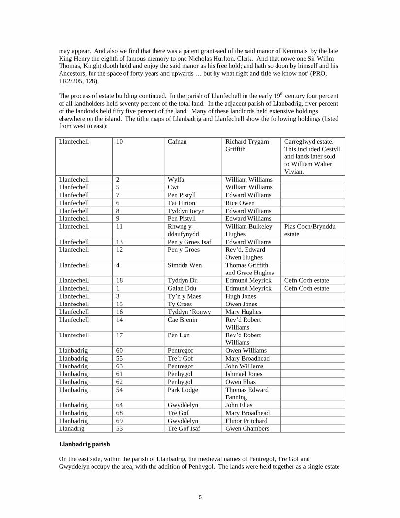
may appear. And also we find that there was a patent granteaed of the said manor of Kemmais, by the late King Henry the eighth of famous memory to one Nicholas Hurlton, Clerk. And that nowe one Sir Willm Thomas, Knight dooth hold and enjoy the said manor as his free hold; and hath so doon by himself and his Ancestors, for the space of forty years and upwards … but by what right and title we know not’ (PRO, LR2/205, 128). The process of estate building continued. In the parish of Llanfechell in the early 19th century four percent of all landholders held seventy percent of the total land. In the adjacent parish of Llanbadrig, fiver percent of the landords held fifty five percent of the land. Many of these landlords held extensive holdings elsewhere on the island. The tithe maps of Llanbadrig and Llanfechell show the following holdings (listed from west to east): Llanfechell 10 Cafnan Richard Trygarn
Griffith Carreglwyd estate. This included Cestyll and lands later sold to William Walter Vivian.
Llanfechell 2 Wylfa William Williams Llanfechell 5 Cwt William Williams Llanfechell 7 Pen Pistyll Edward Williams Llanfechell 6 Tai Hirion Rice Owen Llanfechell 8 Tyddyn Iocyn Edward Williams Llanfechell 9 Pen Pistyll Edward Williams Llanfechell 11 Rhwng y
ddaufynydd William Bulkeley Hughes
Plas Coch/Brynddu estate
Llanfechell 13 Pen y Groes Isaf Edward Williams Llanfechell 12 Pen y Groes Rev’d. Edward
Owen Hughes
Llanfechell 4 Simdda Wen Thomas Griffith and Grace Hughes
Llanfechell 18 Tyddyn Du Edmund Meyrick Cefn Coch estate Llanfechell 1 Galan Ddu Edmund Meyrick Cefn Coch estate Llanfechell 3 Ty’n y Maes Hugh Jones Llanfechell 15 Ty Croes Owen Jones Llanfechell 16 Tyddyn ‘Ronwy Mary Hughes Llanfechell 14 Cae Brenin Rev’d Robert
Williams
Llanfechell 17 Pen Lon Rev’d Robert Williams
Llanbadrig 60 Pentregof Owen Williams Llanbadrig 55 Tre’r Gof Mary Broadhead Llanbadrig 63 Pentregof John Williams Llanbadrig 61 Penhygol Ishmael Jones Llanbadrig 62 Penhygol Owen Elias Llanbadrig 54 Park Lodge Thomas Edward
Fanning
Llanbadrig 64 Gwyddelyn John Elias Llanbadrig 68 Tre Gof Mary Broadhead Llanbadrig 69 Gwyddelyn Elinor Pritchard Llanadrig 53 Tre Gof Isaf Gwen Chambers Llanbadrig parish On the east side, within the parish of Llanbadrig, the medieval names of Pentregof, Tre Gof and Gwyddelyn occupy the area, with the addition of Penhygol. The lands were held together as a single estate
5
in 1678, when they were mentioned in a deed as ‘Welly grono withel otherwise Gwithelyn, Ynys castell, Tyddyn William Prees ap Hugh, Trego Ucha, Trergoe Issa, Ty y brin eithin and Y Torman … in townships of Clegyrock and Caerdegog’ (NLW M. Broadhead Evans, 13). The lands were then owned by Thomas Griffith of Penbedw. The earliest documented link with the Broadhead family is the will of William Broadhead, 1755, who lived at Tre’r Go. He gained the lands through marriage to Catherine Williams of Tre’r Gof. Richard Broadhead inherits, and in 1789 leases the lands of ‘Tre’r Go Ucha, Tre’r Go Issa, Tormaen, Cae Merddyn gwrthyn, Gwyddelyn, Ynys y Castell and Llainhir’ (NLW M. Broadhead Evans, 32). In 1799 Elizabeth Broadhead, daughter of Richard Broadhead, marries John Elias (1774-1841) a Welsh Calvinistic Methodist minister, famous for his preaching. She kept a shop at Llanfechell, and John Elias joined her there. Elizabeth died in 1828, and in 1830 John married a wealthy widow, Ann Bulkeley, and moved to live in Y Fron, Llangefni, though retained lands at Llanbadrig. It is of interest that Richard Broadhead signed articles of agreement in 1791 with several masons, including Owen Jones of Porth y Pistyll and Richard Jones of Cyt, for draining the bog called Cors-Tre’r Gof and Cors’r Wylfa in Llanfechell and Llanbadrig (M Broadhead Evans, 30). Enclosures within the Cors are shown on the tithe map of 1842, though are now barely visible. Park Lodge is first mentioned in 1814, when it was presumably carved out of the lands of Tre’r Gof and/or Gwyddelyn, though the estate was at that time leased to William Hughes of Madyn Dysu, Amlwch, a prominent landholder. In 1814 Thomas Edward Fanning is recorded as living at Park Lodge. He was a Dublin barrister who married Gwen Broadhead, sister of Elizabeth. Their daughter, Mary, married Evan Evans. The next two generations, both called Thomas Fanning-Evans, were managers of the Parys Mines, living at Mona Lodge, Amlwch and Plas Cadnant, Llandegfan. The location of Tormaen is not known with certainty, but it may be the ‘Tyddyn y Torment’ referred to in an exchange of lands in 1576 (UWB, Llwydiarth Esgob, 1). In 1660 it is referred to as Tormain (Llwydiarth Esgob, 2). The present holding known as Nant Orman might take its name from this. The holding was, by the time of the tithe survey in 1842, owned by Ishmael Jones, and an inscription is still clearly inscribed in the barn adjoining the house with his name and the date 1842. Ishmael Jones, who had captained the wherry Mary, became a shipbuilder at Cemais, and was active during the 1830’s and 1840’s, employing up to sixty men and building ships of 100 to 400 tons cargo (Williams 1988, 150; Eames 1973, 271). The house, with hipped roof and façade with central door and windows is typically early Victorian in style, though the woodwork inside is intriguing, being, perhaps, more typical of a shipbuilder than a house builder. The bee boles in the front garden wall are an unusual feature within Anglesey, where only one other set are known. Llanfechell parish The principal land holding to the west was Cafnan, owned by Richard Trygarn Griffith of Carreglwyd Estate in 1840. The estate had been bought by William Griffith, rector of Llanfaethlu, in the mid-16th century. Cafnan is mentioned in the estate records in 1631, and remained part of the estate until the 20th century. The mill, Melin Cafnan, was in separate ownership, owned, by the early 18th century, by Mr Lewis of Cemlyn. This led to access issues with Carreglwyd estate, described by William Bulkeley of Brynddu, brother in law of Lewis, in his diary (Owen and Griffith 1931, 67). The mill is clearly shown on Lewis Morris’s chart of c. 1737-8 (Anglesey Record Office WM/1905/1). The chart also shows anchorages in Porth y Pistyll and Porth yr Ogo, and havens, or harbours, at Cemlyn and Cemais. The mill lies just outside the boundary of the study area, as does the River Cafnan, which forms the parish boundary between Llanfechell and Llanrhwydrys. It was along the banks of the R Cafnan that Violet Vivien created the garden of Cestyll, after the land had been bought by her uncle William Walter Vivian in 1918, and given to his niece as a gift. The former house of Cestyll, which lies some 120m east of the garden, does lie within the study area. The house was demolished in 1991, but the adjoining walled garden and a range of buildings remain, though very overgrown and difficult to access. Other landowners recorded on the tithe survey include Edmund Meyrick of Cefn Coch, who owned Tyddyn Du to the south and Galan Ddu to the north, the latter now under Wylfa A, and outside the present study area. It was bought in the 1930’s by Rosina Buckman, the New Zealand opera singer. Rhwng y Ddau
6

Fynydd was owned by William Bulkeley Hughes of Plas Coch and Brynddu, descendant of William Bulkeley the diarist. Wylfa was the largest of the remaining farms. The name, (derived from ‘gwylfa’ = prominent place or eminence) as we have seen above, is recorded as early as 1660, when it was described as forming part of the Caerdegog township, though it is likely to be much older in origin. Caerdegog was described in 1352 as being occupied by six gwelyau, and Wylfa may well be derived from one of these. The original boundaries are difficult to recreate, but it is likely that Tyn y Maes and Cwt once formed part of the holding, as may have the house and lands of Simdde Wen (originally called Pen y Graig). Wylfa features regularly in the diary of William Bulkeley of Brynddu, who relates a particularly unfortunate accident when William Robinson, owner of Mynachdy, took a boat with several others over to the Skerries. Another boat had also set off from Wylfa with, amongst others, the occupiers of Gwyddelyn and Tyddyn Ronw. A storm blew up towards evening and the company determined to try to sail back through it. All lives were lost and the wreckage of the Wylfa boat was eventually recovered near Whitehaven on the coast of Cumbria. Bulkeley records the boat had been built by John Thomas, nephew and heir of William Hughes of Wylfa, an interesting record of local boat building (Owen and Griffith 1931, 64-5). By the 18th century and during the 19th century several farms are mentioned called Yr Wylfa Wen, Yr Wylfa Newydd and Yr Wylfa Goch. These must be sub-divisions of Wylfa, as shown by a note written by William Williams of Wylfa in 1851 shortly before his death ‘I have been in possession of Wylfa Wen and all the fields belonging there by whatever name or names they are called upwards of seventy years. The house called Wylfa Newydd situate near the house called Wylfa Wen was built by me upwards of twenty years ago. The above lines spoken by me November 6 1851’ (UWB Llwydiarth Esgob, 15). In a similar note he claims ownership of Wylfa Goch. The 1889 OS map shows only the principal house at Wylfa, but after the death of William Williams it had been bought by David Hughes, a local person who made a fortune as a builder in Liverpool, and bought Wylfa where he built a new large house and gardens with entrance lodge. Part of the gardens are still visible, but the house was demolished after construction of Wylfa A. 5.5 The twentieth century The last decades of the 19th century and the early decades of the twentieth century witnessed numerous changes caused, in part, by the desire of the new wealthy classes to own rural homes in addition to their principal homes elsewhere. Up to this time the houses had been largely occupied by the land owners and occupiers who farmed the land. No large estate houses lay within the study area, and the largest farmhouses would have been at Cafnan, Wylfa and Tre’r Gof. Nant Torman was one of the earliest to be developed, in this instance by the boat builder Ishmael Jones. Wylfa, as we have seen, was developed and rebuilt by David Hughes; Rosina Buckman rebuilt Galen Ddu, and Violet Vivien developed the house and gardens at Cestyll. Other houses were rebuilt at this time, typically as large square Victorian houses with walled gardens, sometimes a lodge, and extensive grounds around the house. Simdde Wen was typical of these, rebuilt before 1898, with walled garden, wooded grounds and extensive outbuildings. The house was taken over as offices during construction of Wylfa A and later became the social club, but was recently demolished, though the lodge remains. Tan yr Allt was similarly rebuilt between 1898 and 1900, though on a smaller scale, and to the east of Tan yr Allt a new house ‘The Firs’ was built on the site of Pen y Groes Isaf, also with extensive grounds laid out around the house. During the Second World War a Chain Home radar defence station was established at Wylfa. A 1948 vertical aerial photograph (WAG 541/RAF/206 Frame 4020, Nov 20 1948) shows the installation. Two tall wireless masts stand close to the cliff edge near Porth Gwartheg while a semi-circular ring of low, dome-shaped, bunker-like structures run from Wylfa House to Porth y Pistyll. The staff complement at these stations was large and several other structures in the vicinity are also likely to be associated with the station. The purpose of a chain home station was detection of enemy aircraft by radar or, in some instances, as along the north coast of Wales, the management of shipping in the Liverpool approaches. The radar worked by ‘floodlighting’ the sky with pulsed radio waves. The ‘echo’ from obstacles in the path would be received and displayed at the base station. 5.6 Wylfa A power station
7
The then Central Electricity Generating Board (CEGB) applied for consent to build Wylfa power station in 1960 and a public inquiry commenced in 1961 to consider the application, with consent being given in late 1961. In 1963, following various technical reports and site investigations, work began on the construction of the site and its two Magnox reactors. The main construction phase lasted through the 1960’s. Wylfa was the last and largest of this design of reactor. The power station was officially commissioned in 1972. In 1973 the CEGB received a Financial Times Industrial Architecture Commendation for Industrial Design. The architects for the station were Farmer and Dark, and the landscape architect was Dame Sylvia Crowe. The Reactor building dominates the Wylfa site and is a large concrete structure housing two Magnox type reactors between which is the active effluent treatment plant, the three primary dry store cells and solid waste voids. To the west of the Reactor building are the Secondary Dry Store Cells. The Reactor building includes a large concrete basement some 10m below ground level. The Turbine Hall (including ancillary buildings) occupies the eastern side of the site. The basement level of the building is some 5m below ground level with the reinforced concrete extending to 3m above ground level. South of the Turbine Hall are the main administration buildings, the station canteen and workshops/stores. Adjacent to the offices extensive parking is provided, with overspill at Porth y Gwartheg. A visitor centre stands alongside the approach road to the south-eastern side of the complex, and to the west is the Sport and Leisure club on the site of Simdde Wen. The northern area of the site contains the water treatment plant, to the north of the building are two sets of tanks set within concrete bunds to supply acid and sodium hydroxide for use in the treatment process, two brine tanks and four water holding tanks located across the road to the north, which link to the building via a pipe bridge. The gas turbine plant with its four distinctive exhaust stacks is located adjacent to the water treatment plant. North of the fuel tanks is an open area leading to the main site cooling water outfall. This area is covered in made ground comprising primarily broken bedrock. Adjacent to the outfall are the backup sewage treatment works and holding tanks, where site sewage is stored before being pumped to the main treatment works located to the north-east. The north-western area of the site is occupied by a number of laydown areas, and also contains the active incinerator and the carbon dioxide tanks/plant. North of the carbon dioxide tanks set behind blast walls are two large fuel oil tanks. In the western area of the site is the Pump house and associated plant, which are set within a deep concrete basement excavated into the bedrock at the level of the intake tunnels. The pump house draws water from the sea via the intake tunnels, filters and treats this water before pumping it to the reactor buildings. The southern area of the site is dominated by the contractors compound, which comprise tow storey, temporary prefabricated cabins uses as offices, rest rooms and change rooms. To the east of the site is the 400KV switch house supplying the national grid and the 132 KV switch house which supplied the Anglesey Aluminium Company. Construction of the site was a massive undertaking with deep excavations for the cooling water pump-house, reactor building, turbine hall and overflow. During the early construction phase of the station the site was levelled into two platforms, which involved the removal of material (both drift and rock) from high areas (mainly to the east) and the deposition of material in low areas (mainly to the west and north). The first platform was constructed to the east for the switch-houses at a level of approximately 18m AOD. West of the reactor building, sea walls were constructed and the area backfilled to form a gentle westward dipping slope down to approximately 6m AOD. Excavation for the reactor building would have reached 13m below the existing ground surface and 7m depth for the turbine hall. During the construction period work camps were established in the areas to the south and east of the current Wylfa A site boundary. Following construction, banks of earth were disposed in this area and planted with trees to create a degree of landscaping from the landward viewpoint.
8

6. THE STUDY AREA 6.1 Statutory and non-statutory designations Listed Buildings No Listed Buildings lie within the study area. The following Listed Buildings lie immediately adjacent to the study area: 24416 Corn Mill at Felin Gafnan. Grade II. 24417 Corn drying house at Felin Gafnan. Grade II. 24418 Mill house at Felin Gafnan. Grade II. Scheduled Ancient Monuments There are no scheduled ancient monuments within or immediately adjacent to the study area. Conservation Area The study area does not lie within a Conservation Area. Register of Landscapes, Parks and Gardens of Outstanding or Special Historic Interest in Wales (ICOMOS/Cadw) The study area does not lie within a defined Outstanding or Special historic landscape. Cestyll Garden is included within the Register as a garden of special historic interest. Reference number PG W (GD) 45 (ANG). The garden lies adjacent to the west side of the study area, though the wider setting identified with the site, including the grounds of the house at Cestyll, lie within the study area. Environmental designations AONB The coastline from Porth y Pistyll to the west lies within the Anglesey AONB, as does the coastline east of Cemaes Bay (outside the study area). SSSI Tre’r Gof is a designated site of Special Scientific Interest which lies wholly within the study area. 6.2 Baseline list of sites The sections below list the principal features within the development area, and categorises their importance on a scale of A (National); B (Regional); C (Local); D (Other); E (Unknown). The full definition of the categories is given in Appendix B. The gazetteer is divided into the following categories:
Buried or relict archaeological features and standing buildings Shipwrecks Historic landscapes.
6.2.1 Archaeological sites and features 1. Boat House, Porth y Pistyll SH 3479 9362 Category: C
9

The remains of a small rectangular building. The lower walls only remain to a height of approximately 1m. It is said to have been the boathouse belonging to Cestyll, and used by the Vivians. 2. Limekiln, Porth y Pistyll SH 3480 9357 Category B The remains of a small limekiln located close to the coast edge. It originally appears to have had draw holes on the west and east sides, however the kiln was modified in the early 20th century to create a bathing hut for use by the Vivians out of the west draw hole. This was partly walled-in and a door placed within the remaining part of the entrance. The location of the east draw hole is overgrown, and is not currently visible. The pot is filled in, and the connection between the draw hole and pot has been blocked. There is no obvious quarry alongside, and it is possible that both stone and fuel were brought in by boat. The date of construction is unknown, but it is shown on the 1889 OS map as ‘old limekiln’, so probably dates from the early 19th century. The site is of interest both as a well preserved example of a small rural limekiln, and as part of the landscape associated with the Vivian’s and the garden at Cestyll. 3. Cestyll SH 3466 9338 Category B There is no building shown here on the 1842 tithe map, however there is a small enclosure shown on the manuscript 2” OS map of c. 1830, and this is marked Cestyll on the first edition 1” OS map of c. 1840. The site was originally part of Cafnan farm, owned by the Carreglwyd estate. A substantial square house had been built here by 1889, as it is shown on the OS map of that date, with a large walled garden to the north, and ornamental gardens to the west. Cestyll was bought by William Walter Vivien in 1918, who gave it to his niece Violet Vivien, daughter of Lord Bodmin. Violet Vivien took holidays there, and in time made Cestyll her home. From 1922 onwards she began to construct a garden in the valley of the Cafnan west of the house (and west of the study area boundary, though the site of the house of Cestyll lies within the study area). The garden is described as ‘an informal plantsman’s garden which has many small, separate but linked areas, in many cases defined by the bends and loops of the stream, which give it a very intimate atmosphere’ (Cadw 1999, 15). The house of Cestyll was demolished in 1991. The walled garden is still present, but very overgrown. A south-east range of sheds and a garage may still be seen, though are also very overgrown and difficult to access. The site forms part of the historic garden of Cestyll, and the fields to either side and down to the coast edge form part of the essential setting. 4. Pen Pistyll SH 3489 9352 Category E A small-holding shown on the tithe map of 1842 owned by Edward Williams, who also owned the adjacent Tyddyn Iocyn (later Tan yr Allt). The origins of the plot are not known. A small range of buildings within an enclosure, with another small enclosure to the south, are shown on the OS map of 1889. The site lies above a small stream which feeds into Porth y Pistyll. No upstanding features remain visible, though the ground is rough, and bits of masonry and rubble are visible in the eroding side of the adjacent ditch. 5. Cwt SH 3516 9353 Category E A small-holding shown on the tithe map of 1842 owned by William Williams. It is mentioned in 1735, when it was the home of William Griffith, part owner and master of the ship ‘Cloxan’ (Owen and Griffith 1931, 52). On the 1889 OS map it is shown as a single building. By 1924 a larger house had been built to the west called Skerries View. Both were demolished as part of the construction of Wylfa A, and lie under the grounds of the sports field behind Simdde Wen. 6. Tai Hirion SH 3508 9329 Category E A small farm shown on the tithe map of 1842 owned by Rice Owen. The 1889 OS map shows it as a house to the north with farm buildings to the south. The house and some of the buildings were demolished during the construction of Wylfa A. One range of farm buildings is derelict but still standing to eaves height. It was converted to a milking parlour, sometime in the mid-20th century by the appearance of the concrete used for the stalls, but appears to have been a corn barn originally. Remains of small triangular windows can be seen – a feature of north Anglesey farm buildings.
10
7. Simdde Wen SH3533 9329 Category E The house is shown on the tithe map of 1842 owned by Thomas Griffith and Grace Hughes. It is mentioned in a will of William Hughes of Wylfa dated 1751 (UWB Llwydiarth Esgob 13), when it was also called Pen y Graig. It is shown as a single building in 1842, however by 1889 it is shown as a large square house set in wooded grounds with a range of buildings to the north. A lodge was built by 1900 at the point where the road divided from the Wylfa road, and at the same time the house of Cae’r Brenhin was demolished. The house was used as offices during the construction of Wylfa A, and it subsequently became the social club. The house has recently been demolished, though garden walls remain. 8. Pen y Groes SH 3516 9299 Category E A small-holding shown on the tithe map of 1842 owned by Reverend Edward Owen Hughes (Llysdulas Estate). The site is still shown on the 1924 OS map, but by 1946 it had been demolished, and a new house, Bronydd, had been built to the north. There are no visible remains. 9. Cae’r Brenhin SH 3545 9315 Category E A small-holding shown on the tithe map of 1842 owned by Reverend Robert Williams. It is shown on the OS map of 1889, but by 1900 it had been demolished, and the lodge to Simdde Wen had been built to the east. There are no visible remains. 10. Wylfa SH 3564 9390 Category E The name Wylfa is to be found in documents from the 17th century onwards and almost certainly had earlier origins. It is recorded in 17th century documents as part of the township of Caerdegog. William Hughes, mentioned in William Bulkeley’s diary in the 18th century, lived there, and John Hughes, possibly his father, before him. William Hughes heir is John Thomas according to Bulkeley. By 1741 we hear of Wylfa Goch, and later of Wylfa Wen and Wylfa Newydd. It is possible that Wylfa Goch was on the site of the later gardens and farm buildings of Wylfa. Wylfa Newydd was said by William Williams (died c. 1860) to have been built by him c. 1831, and to have been next to Wylfa Wen. A house called Ty Newydd is shown on the 1” first edition OS map by Ty’n y Maes, so perhaps these two were originally Wylfa Wen and Wylfa Newydd. After the death of William Williams Wylfa was bought by David Hughes, originally from the area, who made a fortune in the building trade in Liverpool. He rebuilt the house at the north edge of the site, and built a walled garden and farm buildings below, as well as a lodge at the entrance. David Hughes died 1904. All the buildings, including the house, were subsequently demolished during the construction of Wylfa A. A carpark lies on the site of the farm buildings. The walled garden partially survives next to the car park. 11. Boat house (former lifeboat station, Porth yr Ogof) SH 3556 9418 Category C A lifeboat station was first opened here in 1872, initially to replace the Cemlyn lifeboat, and then to supplement it when Cemlyn re-opened. The lifeboat was housed in this building until 1907, when a new station was built a short distance to the north. The building still stands with slate roof supported on king-post trusses and rendered walls, though is not used at present. 12. Former lifeboat station (Porth yr Ogof) SH 3564 9423 Category D The second of two Cemaes lifeboats houses, this was built in 1907 to house the ‘Charles Henry Ashley’, a 38ft non-self-righting Watson class lifeboat. The Charles Henry Ashley was in use until 1932. The boat has survived, and has been recently restored. The station was closed in 1932 and was subsequently demolished, only the toe of the slipway and some concrete supports remaining. 13. Chain Home Guard Installation Category E
11
During the Second World War a Chain Home radar defence station was established at Wylfa. A series of contemporary aerial photographs (WAG 541/RAF/206 Frame 4020, Nov 20 1948; WAG 541/69 Box C55; Jul 19 1948 Frame 0056) shows the installation. Two receiver towers, probably of wood, stand close to the cliff edge near Porth Gwartheg, and three thin steel transmitter masts stand further east. A semi-circular ring of low, dome-shaped, bunker-like structures run from Wylfa House to Porth y Pistyll, which would have included transmitter blocks, receiver blocks, electricity sub-station, air raid shelters and watch houses. The staff complement at these stations was large and several other structures in the vicinity are also likely to be associated with the station. The purpose of a chain home station was detection of enemy aircraft by radar or, in some instances, as along the north coast of Wales, the management of shipping in the Liverpool approaches. The radar worked by ‘floodlighting’ the sky with pulsed radio waves. The ‘echo’ from obstacles in the path would be received and displayed at the base station. 13a Structures SH3568 9386 A series of structures and earthworks are visible on aerial photographs south-west of the house of Wylfa. The extent to which these were part of the Chain Home Guard is not known, though it is probable some of the buildings there were requisitioned for use. A small circular feature is visible in the field to the south. No remains are visible on the site, apart from bricks of this period visible close to the location of the circular feature and within the former garden wall to the west. 13b Mounds south-west of Ty’n y Maes SH 3544 9384 Two earth-covered bunkers and other earthworks are visible south-west of Ty’n y Maes. This area is now covered with trees, and has been partly landscaped. No features are visible associated with the WWII installation, though a stone gatepost and remains of a stone wall from the earlier field system survive in the woodland. 13c Mound SH 3539 9365 A square mound with boundary around it is shown in the east corner of a field. The site lies within the woodland belt planted around Wylfa ‘A’. Nothing is visible on the ground other than a round stone gatepost belonging to the former field system. 13d Mound SH 3532 9344 A circular mound with surrounding wall is shown in the east corner of a field. The site now lies under, or immediately alongside, the access road to Wylfa ‘A’. No visible remains survive. 13e Mound SH3509 9356 A mound is shown north of the house ‘Skerries View’. These lie at the north-west end of the playing fields associated with the sports and social club. The area was landscaped during the construction of Wylfa ‘A’, and no visible remains survive. 13f Earthworks SH 3482 9364 An enclosure and mound are shown close to the coast in the west corner of a field. No structures survive here, but remains of concrete and brick can be seen both here and along the coastline to the north. 13g Receiving tower SH 3483 9379 One of two receiving towers which formerly lay close to the coast edge. Concrete and brick visible in the grass may be former remains of anchor points, though these have been partly cleared during landscaping. 13h Receiving tower SH 3492 9387 One of two receiving towers which formerly lay close to the coast edge. The site lies outside the study area under Wylfa ‘A’. 13i Transmitting masts SH 3509 9408; SH 3517 9413; SH 3538 9424; SH 3545; 9429 The site of four transmitting masts close to the coast edge. All lay outside the study area, two under Wylfa ‘A’ and two on Wylfa headland. Concrete anchor blocks are visible at the latter site. 14. Pennant SH 3475 9308
12
Category C A detached house built c. 1940. It was built by the owners of Cafnan when the main farmhouse was taken over for WWII purposes. 15. Tan yr Allt (Tyddyn Iocyn) SH 3494 9314 Category C This small-holding was recorded on the tithe map, when it was called Tyddyn Iocyn and owned by Edward Williams. On the 1889 OS map the site is shown as a cottage and adjoining outbuilding and called Tan yr Allt. On the 1900 OS map a much larger house (the present one) is shown, with new ranges of outbuildings to the west. It consists of a two-storey house with part-gabled dormers and bay window. There are four-pane sash windows in most of the openings, and a later conservatory around part of the house. The walls are rendered, and the chimneys are of red brick. 16. Bronydd SH 3517 9301 Category C This house was built in the mid-20th century north of the original house of Pen y Groes. It is almost square in plan, of one and a half storeys with hipped roof and gabled dormers. Tall chimneys rise from the corners. Black and white timber detail to the dormers, but the remaining walls are rendered, making it difficult to confirm that they are of brick, though this is very likely. 17. The Firs SH 3523 9296 Category C This large house was built in the late 19th century. It is shown on the 1889 OS map within wooded gardens, with a cottage to the north. It is a double pile two-storey house with slate roof and rendered walls. Much of the wooded grounds remain, though two new houses have been built on the west side (Chequers and Bryn Fferen). The house looks as though it has been modernised and altered since its original construction. The cottage to the north has been rebuilt recently as a separate house in its own grounds as a modern two-storey house. 18. Tyddyn Du and Pen y Groes Isaf SH 3542 9289 Category C This is shown on the OS map of 1889 as two ranges of buildings. The eastern range is called Tyddyn Du, whereas the western range is not named, but is shown on the tithe map as Pen y Groes Isaf, and associated with the land to the west. In 1842 Tyddyn Du was owned by Edmund Meyrick of Cefn Coch, and Pen y Groes Isaf by Edward Williams. A 2-storey farmhouse was built at Tyddyn Du in the late 19th/early 20th century. The range of buildings attached to the north-west gable has been converted into domestic accommodation. Pen y Groes Isaf, now called Clonmel, has been modernised and the outbuildings also converted into living accommodation. 19. Rhwng y Ddau Fynydd SH 3506 9282 Category C This farm is shown on the tithe map as belonging to William Bulkeley Hughes of Brynddu. The 1889 OS map shows the present farmhouse with scattered outbuildings to the west. The present house appears mid- to late-19th century in date, and one of the outbuildings, which are now largely derelict, may have been the earlier house. One outbuilding contains an example of a small triangular window – a style peculiar to north and west Anglesey. The farmhouse is a two-storey rendered building with a slate roof. 20. Lodge SH 3549 9312 Category C The lodge was built between 1889 and 1900, presumably to serve the house at Simdda Wen. At the time the lodge is built, the earlier cottage at Cae’r Brenin which lay in the field to the west is demolished. The lodge is single storey, with rendered walls, slate roof with ornate ridge tiles, and red brick chimney. It consists of two wings at right angles to one another, the north wing projects forwards with an angled gable. The door, with a small open porch, lies in the angle between the two wings. A plain shield ornaments the south gable.
13
21. Pen Lon SH 3578 9296 Category C This house, according to the tithe map of 1842, lay across the road in a rectangular enclosure. The enclosure is still shown on the 1889 map, but the house has, by that date, been rebuilt across the road, with a range of farm buildings alongside. The house was owned by the Reverend Robert Williams in 1842. It has recently been modernised, though the outbuildings are largely derelict. 22. Ty’n y Maes SH 3550 9387 Category C This house lies in a block of land west of Wylfa house. A building is marked on the tithe map in this location, though its orientation is different. The 1889 OS map shows two parallel ranges of buildings, with a small enclosed paddock, perhaps an orchard or garden, to the north. The west range has been modernised and is the present Ty’n y Maes, whilst the east range has been rebuilt in modern times and is called Haul y Gwynt. The first edition of the 1” OS map, of approximately 1838, shows a house that may be Wylfa Newydd referred to by William Williams (see above). Ty’n y Maes is of 1½ storeys with gabled dormers. The outbuildings attached to the north end have been converted into part of the house. 23 Ty Croes SH 3561 9348 Category C The small farm of Ty Croes is shown on the tithe map when it was owned by Owen Jones. The 1889 map shows it as a cottage with attached outbuildings, with other scattered outbuildings in the vicinity. The cottage and attached outbuildings have been modernised, and consist of a single storey range with a garage at the south end. The other outbuildings are partially derelict, though two are still roofed. 24. Tyddyn Goronwy SH 3583 9325 Category B The name of this holding preserves a reference to the medieval Gwely Goronwy Wyddel (see 5.3 above), when it formed part of a common holding with Gwyddelyn. A house is shown on the tithe map, when the farm was owned by Mary Hughes. The house is shown on the 1889 map as a single range of house and farm buildings aligned north-south. The house has been modernised and the buildings converted to form part of the house. It is of 1½ storeys with gabled dormer windows, the walls are rendered, and the roof is of slate. 25 Tre’r Gof Uchaf SH 3627 9319 Category B Tre’r Gof was a medieval township (see 5.3 above). It became part of the estate of William Broadhead on his marriage to Catherine Williams in 1730, and was lived in by two successive generations of the Broadhead family. An inscribed stone at the entrance to the new house records the initials B R M and the date 1773 for Richard and Martha Broadhead. Their daughter Elizabeth married John Elias. In 1842 the farm was owned by Mary Broadhead, sister of Elizabeth. The farmyard lies within the study area, and is shown on the 1889 OS map as a yard with farm buildings around the north and west sides, and the house to the south. The house was demolished in recent years, and a new house built closer to the road. 26. Nant Orman SH 3619 9335 Category B The origins of the name Orman may be found in the name ‘Tithin y Torment’ recorded in the 16th century. (UWB Llwydiarth Esgob, 1). In the 17th century ‘Tormain’ is referred to, and this might be translated as ‘stony hill’, referring to the hill east of the present house. However this is speculation only, as the site of Tithin y Torment or Tormain cannot be located with certainty. The tithe map of 1842 shows a small holding surrounded by Tre’r Gof land, as though it had once formed part of the Tre’r Gof township. It was owned then by Ishmael Jones, and his inscription and the date 1843 can still be seen in the building behind the house. The style of the house is typical of this date. It is double pile plan, of two storeys, with a hipped slate roof and tall chimneys rising from the two gable walls. A garden lies east of the house, in the north wall of which is a row of bee boles. These are a row of rectangular openings within the wall in which bee
14
skeps were placed. West of the house are a group of outbuildings, one of which has recently been converted into a dwelling. 27. Park Lodge SH 3642 9351 Category B Park Lodge also gives the appearance of having been carved out of Tre’r Gof lands. Its English name suggests an origin in the 19th century, though it could be earlier. The tithe map of 1842 records the owner as Thomas Edward Fanning, who married Gwen Broadhead, another daughter of Richard and Martha, so perhaps this was Gwen’s inheritance. It is first linked with Thomas Fanning in 1814. The earliest part of the house appears to be the south-west range. In the late 19th and early 20th centuries a large square house was built on the north-east side of the earlier one. This later house has a central door with projecting angled bays either side with large stone mullioned and transomed windows. The corners of the bays carry above the parapet of the flat roof, creating a castellated effect. The out buildings south-west of the house have been converted into living accommodation. 28. Council Depot SH 3530 9291 Category D A plot lying between the Firs and Tyddyn Du called Pen y Groes Isaf on the tithe map (site 18 above). An aerial photograph of 1946 shows considerable activity within the area, possibly related to WWII activities, and the Home Chain Guard. It has subsequently been used as a council yard, and has large modern storage sheds on it. 29. Chequers and Bryn Fferen SH 3519 9297 Category D Two new houses built on land formerly part of, and west of, The Firs. 30. Sylvia Crowe landscaping east of Wylfa ‘A’ Category A Two significant mounds and a plantation of coniferous and broad-leaved trees through which nature trails are laid, as well as the route of the Anglesey Coast path, form the principal elements of this landscape. It largely hides the power station when close to the east side. 6.2.3 Shipwrecks S1. Shipwreck Knight of Malta NPRN 272068 Category E Tug s.s. paddle, of iron construction, and registered in Preston, UK, carrying ballast. Lost 21/9/1891 Anglesey, Wylfa, Cemlyn Beach. (National Monuments Record) S2. Shipwreck Abbotsford NPRN 272014 Category E Steamship of unspecified type, of iron construction, and registered in Liverpool, carrying general cargo. Lost 21/07/1875 Anglesey, Cemaes, Wylfa Head, west side. (National Monuments Record) S3. Shipwreck Excel NPRN 272072 Category E Brigantine of wood construction and registered in Whiehaven, carrying pipe clay. Lost 15/02 1892 Anglesey, Cemlyn Point, Harry Furlongs rocks. (National Monuments Record) S4. Shipwreck Thomas Humphreys NPRN 271978 Category E Barque, of wood construction, and of Norway registry, carrying salt. Lost 12/01/1867, Anglesey, Carmel Head, Cemlyn Point, Furlough Rk. (National Monuments Record)
15
S5. Shipwreck Primrose NPRN 272247 Category E Yacht, general, sail, of wood construction, and registered in Cemaes, UK. Carrying ballast. Lost 20/07/1911, Anglesey, Cemaes Bay. (National Monuments Record) S6. Shipwreck Wilderspool NPRN 272318 Category E Sailing vessel of unspecified type, of wood construction, and of United Kingdom registry, carrying general cargo. Lost 29/09/1823, Anglesey, Wylfa Head, Cemaes Bay. (National Monuments Record) S7. Shipwreck Active NPRN 272352 Category E Smack, of wood construction, and of UK registry, carrying general cargo. Lost 07/03/1835, Anglesey, Cemaes Bay. (National Monuments Record) S8. Shipwreck Robert Bruce NPRN 272354 Category E Paddle steamer, unspecified use, of wood construction, and registered in Greenock, UK, carrying general cargo. Lost 1820, Anglesey, Cemaes Bay. (National Monuments Record) S9. Shipwreck Cruizer NPRN 272342 Category E Sailing vessel of unspecified type, of wood construction and registered in Yarmouth, carrying general cargo. Lost 19/02/1820, Anglesey, near Wylfa. (National Monuments Record) S10. Shipwreck Sarah NPRN 271972 Category E Sloop, of wood construction, and of UK registry, carrying coal. Lost 17/12/1860, Anglesey, near Cemaes (believed). (National Monuments Record) 6.2.4 Historic Landscapes The study area does not lie within a defined historic landscape as identified within the Register of Landscapes of Historic Interest in Wales: Part 2 (Cadw, CCW and Icomos UK 1998 and 2001), though Cestyll is listed as a historic garden in Part 1 (Parks and Gardens) of the register (Cadw and Icomos 1998). Landmap is a national information system, devised by Countryside Council for Wales, for taking landscape into account in decision-making. The landscape is divided into units using four criteria, and on four hierarchical levels, where level four is the most detailed. The criteria are Earth Science; Biodiversity; Visual and Sensory; History and Archaeology; and Culture. The last two criteria are significant to this report. The study area falls within three Historic Landscapes mapped at Level 3, as listed in the table below: Code Name Description YNSMNHL056 Cemlyn
Coastal Strip A disparate and large low-lying coastal area of improved fields and scattered farms on the remote northern coast, including few individual features of historic interest (Cestyll Park and Garden Grade II, an unusual, small and intimate 1920’s garden, well-suited to its rocky seaside site).
YNSMNHL057 Fieldscape, north-west Môn
An elongated strip of small field systems and clusters of nucleated settlement (which) lies between the upland bloc of Mynydd y Garn and the low-lying systems to the north and east. Although characteristic of Anglesey, it is differentiated from other areas by its varied field and settlement patterns.
YNSMNHL055 Wylfa There is no direct evidence of prehistoric activity in this area,
16

although early and late prehistoric occupation within the surrounding landscape has been demonstrated. The place-name Cestyll (castles) the west may represent a promontory fort, although no traces remain, and other defended areas are found in the vicinity of Wylfa. … During the Second World War a Chain Home radar defence station was established to detect eemy aircraft and manage shipping. In 1963 work began on the construction of the nuclear power station, and it was commissioned in 1972.
However the larger divisions identified within the LANDMAP process are less easy to identify in the smaller study area which is the subject of this report. Wylfa ‘A’ and its associated landscaping retains an identity of its own, but the division of the remainder of the study area into an east and west part along a line which approximately follows the Wylfa A access road has less meaning within the context of this study. The whole area is largely defined through a common series of historical processes taking place within a largely coastal landscape. The features and processes which define this landscape include:
coastal location dispersed settlement pattern of farms and cottages system of tracks and roads linking farms fairly regular field pattern of largely 19th century date development in the late 19th/early 20th century of larger country houses and gardens the construction of Wylfa A.
L1. Wylfa A The power station, designed by Farmer and Dark, is completely dominating; however the pastel colours and varied skyline help mitigate this, especially when the site is viewed from a distance. The landscaping and planting by Sylvia Crowe helps mitigate the impact when closer to the site. A large part of Sylvia Crowe’s design, including two low hills created from material excavated during construction of Wylfa A and the planting on and around these, lie within the study area, though the power station at Wylfa A lies outside. Sylvia Crowe was a significant figure in landscape design in the decades after the Second World War, and her earlier work at Trawsfynydd Power Station is a registered II* garden (Cadw 2008). The impact of the construction of Wylfa ‘A’ is wider than its immediate footprint, as it led to improvement in roads, purchase and demolition of property, construction of pylons and power transmission cables and changes in agricultural management. L2. Cemlyn coastal strip and Fieldscape, North-west Môn Historic landscapes are the product of human impact, and they are identified through the recognition of historic processes visible within the landscape. There is little doubt that the dominant forces that shaped the present landscape occurred in the 19th and 20th centuries, though earlier processes can be identified. We have identified above (5.1 and 5.2) that known impact on the historic landscape in prehistoric and Roman times is slight, though may be greater than current evidence allows. The exact location of medieval settlements is not known with certainty, though many place-names remain in use. Similarly the pattern of roads and tracks, though overlain by more modern patterns, is likely to retain a medieval influence, in particular the road linking Cafnan to Tre’r Gof, with its unexpected right-angle bends and high banks. Similarly the route from Caerdegog to Wylfa, through Tyddyn Du, would have allowed necessary communication within the medieval township. Within the Tre’r Gof township, the route linking Gwyddelyn, Tre’r Gof Ucaf, Tre’r Gof Isaf and Penrhyn may also be medieval. The largely straight field boundaries creating relatively regular field patterns are largely of late 18th and early 19th century date. Some boundaries, particularly those between farms, might, however, be earlier in origin. For example the boundary around Tyddyn Goronwy is, on the west, very irregular, whilst on the
17
east it follows the relatively straight parish boundary between Llanfechell and Llanbadrig. Similarly the boundary between Tan yr Allt and Tai Hirion may be early in origin. The remaining field boundaries are mainly of 19th century date, and of these the straight field boundaries around Park Lodge are typical, perhaps denoting the enclosure of an area of previously open rough grazing. The attempt to enclose the marsh at Cors Tre’f Gof has been noted above, but this was less successful, and only faint traces of these boundaries are now visible. The dispersed settlement pattern of farms and smallholdings is still recognisable by the presence of former farmhouses at Rhwng y Ddau Fynydd and Pen yr Allt, but there are no working farms within the study area, and all farm buildings are either converted or semi-derelict. The change from farmhouse to country house, typified by the construction of large houses and gardens at Wylfa, Simdde Wen and Cestyll, is considerably less evident now that it would have been before the demolition of the houses at each of the sites. The Firs and Tan yr Allt are remnants of this, as are the remains of gardens at Cestyll, Wylfa and Simdde Wen. The landscape at Cestyll, because of the preservation of the adjacent garden within the valley of the Afon Cafnan, is of significance. The landscape continues outside the area defined within the register, to include Porth y Pistyll and the limekiln and boathouse. The establishment of the WWII Chain Home Guard, though of historical significance, has left few tangible remains, and has had little lasting impact on the landscape. 7. SUMMARY OF IMPORTANCE 7.1 Introduction This section will summarise the findings given above, and discuss these in relation to potential impact and mitigation. A requirement for further evaluation will be identified if there is insufficient information to identify the importance and appropriate mitigation. 7.2 Buried archaeological features There are no known buried archaeological features of prehistoric or Roman date within the study area. However, developments elsewhere on Anglesey, which include the construction of the A55 dual carriageway, have revealed sites for which there was no previous evidence. There are, as discussed in the historical background above, a number of sites in the vicinity of the study area which indicate the presence of people in prehistoric and Roman times. There is, therefore, reasonable potential for the discovery of archaeological sites within the study area. Medieval settlement is known from documentary evidence, but no settlements have been located. Some of these may lie underneath later farms and cottages, but others may have become deserted and not rebuilt, leaving potential for the survival of medieval buried archaeology. Several post-medieval farms and cottages have been demolished in the 20th century. Whilst there are no or few upstanding remains at these sites, there is good potential for the survival of archaeological evidence which can provide additional information on the nature and date of the settlement. These sites are listed in section 6.2.1 above, and summarised in the table below. There is some cross-over between standing buildings and buried archaeology, particularly where, as at Cestyll, Wylfa and Tre’r Gof, there are sites of demolished buildings alongside standing buildings. In addition there is always the potential for buried archaeology to be preserved alongside or under later buildings. Table 1: List of sites with known destroyed remains Site no. Site name Category of importance
18
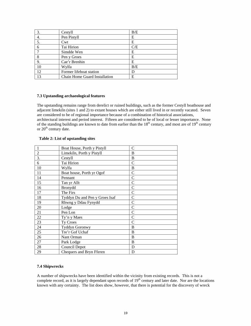
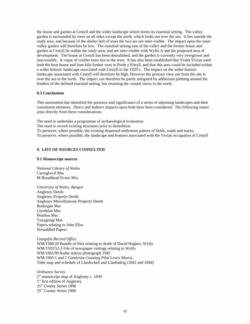
3. Cestyll B/E 4. Pen Pistyll E 5. Cwt E 6 Tai Hirion C/E 7 Simdde Wen E 8 Pen y Groes E 9. Cae’r Brenhin E 10 Wylfa B/E 12 Former lifeboat station D 13 Chain Home Guard Installation E 7.3 Upstanding archaeological features The upstanding remains range from derelict or ruined buildings, such as the former Cestyll boathouse and adjacent limekiln (sites 1 and 2) to extant houses which are either still lived in or recently vacated. Seven are considered to be of regional importance because of a combination of historical associations, architectural interest and period interest. Fifteen are considered to be of local or lesser importance. None of the standing buildings are known to date from earlier than the 18th century, and most are of 19th century or 20th century date. Table 2: List of upstanding sites 1 Boat House, Porth y Pistyll C 2 Limekiln, Porth y Pistyll B 3. Cestyll B 6 Tai Hirion C 10 Wylfa B 11 Boat house, Porth yr Ogof C 14 Pennant C 15 Tan yr Allt C 16 Bronydd C 17 The Firs C 18 Tyddyn Du and Pen y Groes Isaf C 19 Rhwng y Ddau Fynydd C 20 Lodge C 21 Pen Lon C 22 Ty’n y Maes C 23 Ty Croes C 24 Tyddyn Goronwy B 25 Tre’r Gof Uchaf B 26 Nant Orman B 27 Park Lodge B 28 Council Depot D 29 Chequers and Bryn Fferen D 7.4 Shipwrecks A number of shipwrecks have been identified within the vicinity from existing records. This is not a complete record, as it is largely dependant upon records of 19th century and later date. Nor are the locations known with any certainty. The list does show, however, that there is potential for the discovery of wreck
19

remains off the coast. The importance of the remains will be dependant upon their nature, age and condition. 7.5 Historic landscapes Two principal historic landscapes have been identified above. The agricultural landscape of dispersed settlement preserves elements that have evolved over centuries, in particular the patterns of roads, footpaths and farm boundaries. However the majority of surviving buildings and field systems are of 19th century date. This agricultural landscape was partly overlain in the late 19th and early 20th centuries by the construction of larger houses and gardens, but late 20th century change means this impact is less evident today. The gardens at Cestyll are one of the most significant surviving elements from this period. Wylfa ‘A’ physically dominates the landscape, and caused many changes to it. The study area is now largely defined and managed as a result of the construction of the power station. The landscaping designed by Sylvia Crowe, and the nature trails through the woodland, are important elements within this. 8. FIELD EVALUATION AND MITIGATION 8.1.1 Introduction The recommendations discussed within this section are derived from the significance or potential significance of the archaeology and the proposed impact. Where the significance of a site is not understood then further evaluation work is recommended. A programme of field evaluation is also recommended for all undeveloped areas where there is potential for the survival of buried archaeology. 8.1.2 Field Evaluation The definition of archaeological field evaluation is: ‘a limited programme of non-intrusive and/or intrusive fieldwork which determines the presence or absence of archaeological features, structures, deposits, artefacts or ecofacts within a specified area or site on land, inter-tidal zone or underwater. If such archaeological remains are present field evaluation defines their character, extent, quality and preservation, and enables an assessment of their worth in a local, regional, national or international context as appropriate.’ IFA Standard and Guidance for Field Evaluation, 1994, revised October 2008. It has been established above that there is potential for the survival of buried archaeology within areas of proposed development, however it is not possible to mitigate against impact on the buried archaeology without further information. A programme of archaeological evaluation is therefore required to provide the necessary information. This needs to be targeted at known sites which occur where impact is proposed (Sites 1 to 30 above) and within all other areas of proposed impact. This should be a staged process, which will include use of a number of techniques. The following list is derived from the IFA guidelines, and includes non-destructive and destructive techniques. a) Non-destructive • geophysical survey • remote sensing • geochemical survey • earthwork survey • field scanning (i.e. observation and mapping of artefact and other distributions, but not collection of artefacts) • standard building survey b) Destructive Methods (of varying destructive potential) • augering • hand-excavated test pits • hand-excavated trenches
20

• machine-stripped and manually excavated test pits • machine-stripped and manually excavated trenches • probing (frequently used underwater) • surface artefact collection: fieldwalking for collection as opposed to scanning Magnetometer survey is a non-invasive form of geophysical survey which is capable of surveying large areas of land relatively quickly and identifying the presence of buried features. It does not work in all areas, and is less suitable where rock is close to the surface. Nonetheless, magnetometer survey should be considered as one of the principal techniques to be used within the evaluation process at Wylfa. Other forms of geophysical survey which might be relevant include resistivity survey and radar. There are no suitable sites for earthwork surveys, nor is field scanning an option at present, as no fields are currently under cultivation. In order to confirm the results of the magnetometer survey and to investigate known sites it is necessary to carry out invasive or destructive methods of evaluation. Trial excavation involves the controlled excavation of test pits or trial trenches either over features identified during earlier stages of archaeological assessment or within areas of unknown archaeological potential. This technique is capable of locating and assessing the nature and importance of buried archaeological features, and it is recommended that it form a part of the field evaluation process at Wylfa. Other invasive techniques which might be considered include strip, map and sample, where much larger areas are stripped and evaluated in advance of development. This technique is particularly successful at locating sites which consist of dispersed features, and which are therefore difficult to identify in trial trenches. It is usually undertaken following the identification of areas of high archaeological potential by geophysical survey or trial trenching, and at the mitigation stage. 8.1.3 Mitigation The mitigation options for direct impact rely on either avoiding impact or fully investigating and recording the archaeology prior to impact, so that the site is preserved by record. It is recommended that archaeological remains are avoided and preserved wherever it is possible to do so. However where this is not possible a record needs to be made of the upstanding remains, and a watching brief maintained during destruction. Sites of lesser importance or recorded by photographic survey and written description, whilst sites of greater importance require a measured survey in addition. If buried archaeology is located during the evaluation stage which cannot be preserved in situ, then full excavation might be required. 8.2 Indirect Impact Indirect impacts are primarily visual, and need to take into account the setting of any adjacent listed buildings or scheduled ancient monuments and historic landscapes. This section discusses the visual impact upon historic landscapes, and does not constitute a visual landscape assessment. The need to preserve the setting of listed buildings is discussed in Welsh Office Circular 61/96 Planning and the Historic Environment: Historic Buildings and Conservation Areas, and the guidelines for assessing historic landscapes are given in Cadw et al 2007. There are no listed buildings or scheduled ancient monuments within the study area. There will be no significant impact on the setting of any scheduled ancient monuments. The nearest listed buildings are the mill, cottage and kiln at Melin Cafnan. These are tucked into the cove at Porth y Felin and have a limited view of the study area. The potential visual impact from the mill is therefore medium to low. Cestyll is a Grade II registered garden in the Register of Parks and Gardens in Wales (Cadw 1998). The description within the register includes the principal garden within the valley of the Afon Cafnan, as well as
21
the house and garden at Cestyll and the wider landscape which forms its essential setting. The valley garden is surrounded by trees on all sides except the north, which looks out over the sea. It lies outside the study area, and because of the shelter belt of trees the two are not inter-visible. The impact upon the inner valley garden will therefore be low. The essential setting east of the valley and the former house and garden at Cestyll lie within the study area, and are inter-visible with Wylfa A and the proposed area of development. The house at Cestyll has been demolished, and the garden is currently very overgrown and inaccessible. A copse of conifer trees lies to the west. It has also been established that Violet Vivian used both the boat house and lime kiln further west in Porth y Pistyll, and that this area could be included within a wider historic landscape associated with Cestyll in the 1920’s. The impact on the wider historic landscape associated with Cestyll will therefore be high. However the primary view out from the site is over the sea to the north. The impact can therefore be partly mitigated by additional planting around the borders of the defined essential setting, but retaining the coastal views to the north. 8.3 Conclusions This assessment has identified the presence and significance of a series of adjoining landscapes and their constituent elements. Direct and Indirect impacts upon both have been considered. The following issues arise directly from these considerations: The need to undertake a programme of archaeological evaluation The need to record existing structures prior to demolition To preserve, where possible, the existing dispersed settlement pattern of fields, roads and tracks. To preserve, where possible, the landscape and features associated with the Vivian occupation of Cestyll 9. LIST OF SOURCES CONSULTED 9.1 Manuscript sources National Library of Wales Carreglwyd Mss M Broadhead Evans Mss University of Wales, Bangor Anglesey Deeds Anglesey Property Deeds Anglesey Miscellaneous Property Deeds Bodorgan Mss Llysdulas Mss Penrhos Mss Tynygongl Mss Papers relating to John Elias Presaddfed Papers Llangefni Record Office WM/1588/20 Bundle of files relating to death of David Hughes, Wylfa WM/1593/52-3 File of newspaper cuttings relating to Wylfa WM/1865/99 Radar station photograph 1945 WM/1905/1 and 2 Cambrian Coasting Pilot Lewis Morris Tithe map and schedule of Llanfechell and Llanbadrig (1842 and 1844) Ordnance Survey 2” manuscript map of Anglesey c. 1830 1” first edition of Anglesey 25” County Series 1898 25” County Series 1900
22
25” County Series 1924 Aerial photographs 541/RAF/206 Frame 4020, Nov 20 1948 106G/UK655 13 Aug 45, Frames 4402-4 541/69 No’s 0046-98 Box C55 19 Jul 48, Frame 0056 – 60 OS 71 213 No. 537 dated 1972 9.2 Published sources Barnes, F. A., 1982 ‘Land tenure landscape and population in Cemlyn, Anglesey’, Trans. Anglesey Antiquarian Society, 1982, 15-90. Cadw and Icomos UK, 1998 Register of Landscapes, Parks and Gardens in Wales: Conwy, Gwynedd and Isle of Anglesey, Part 1 Parks and Gardens Cadw, CCW and Icomos UK, 1998 Register of Landscapes, Parks and Gardens in Wales: Part 2.1 Landscapes of Outstanding Historic Interest. Cadw, CCW and Icomos UK, 2001 Register of Landscapes, Parks and Gardens in Wales: Part 2.2 Landscapes of Special Historic Interest. Cadw, CCW and WAG, 2007 Guide to Good Practice on using the Register of Landscapes of Historic Interest in Wales in the Planning and Development Process. 2nd edition. Cadw and WAG, 2007 Register of Landscapes, Parks and Gardens of Special Historic Interest in Wales: Part 1: Parks and Gardens; Additional and Revised Entries Vol. 1. Carr, A. D., 1972 ‘The extent of Anglesey 1352’, Trans. Anglesey Antiquarian Society, 1971-2, 150-72 Carr, A. D., 1982 Medieval Anglesey, Anglesey Antiquarian Society: Llangefni Collins, G., 1693 The Great Britain Coasting Pilot Crowe, S., 1962 ‘Site Investigation’, Appendix V, Landscape Report 2 for CEGB Evans, E. N., 1956 ‘Elizabeth Broadhead’, Trans. Anglesey Antiquarian Society, 19356, 46-50 Fenton, R., ‘Tours in Wales 1804-13’, ed. J Fisher, Cambrian Archaeological Association Greenly, E., 1919 Geology of Anglesey, 2 vol’s. Griffith, J. E., 1914 Pedigrees of Anglesey and Caernarfonshire Families. Lewis, S., 1833 A Topographical Dictionary of Wales, 2 vol’s. Owen, H., and Griffith, J. E., 1931 ‘The Diary of William Bulkeley of Brynddu, Anglesey’, Trans. Anglesey Antiquarian Society, 1931, 22-102 Pennant, T., 1781 Journey to Snowdonia, London. Pratt, D., 2005 Wings across the Border: A history of aviation in Wales, Vol. 3. RCAHMW, 1937 Inventory of Ancient Monuments of Anglesey rev. 1968. Skinner, Rev. J. ‘Ten days tour through the Isle of Anglesey December 1802’, Archaeologia Cambrensis supplement 1908, 3-89. Smith, L. T., 1906 The Itinerary in Wales of John Leland in or about the years 1536-1539, London. Steers, J. A., 1964 The Coastline of England and Wales; Cambridge. Walker, P., Linnard, W., 1991 ‘Bee Boles and other beekeeping structures in Wales’, Archaeologia Cambrensis CXXXIX 1990, 56-73.
23
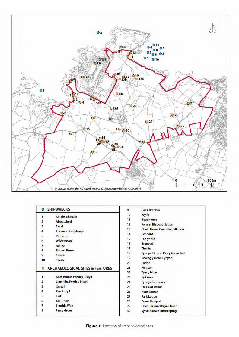
G SHIPWRECKS 9 Cae'r Brenhin
Knight of Malta 10 Wylfa
1 11 Boat house
2 Abbotsford
3 Excel 12 Former lifeboat station
Chain Home Guard Installation Thomas Humphreys
13 4
14 Pennant 5 Primrose
Tan yr Allt Wilderspool
15 6
16 Bronydd 7 Active
8 Robert Bruce 17 The firs
9 Cruizer 18 Tyddyn Du and Pan y Groes lsaf
10 Sarah 19 Rhwng y Ddau Fynydd
20 Lodge
0 ARCHAEOLOGICAL SITES & FEATURES 21 Pen Lon
22 Ty'n yMaes
1 Boat House, Porth y Pi styli 23 TyCroes
2 Limekiln, Porth y Pi styli 24 Tyddyn Goronwy
3 Cestyll 25 Tre'r Gof Uchaf
4 Pen Pi styli 26 NantOrman
5 Cwt 27 Park Lodge
6 Tai Hirion 28 Council depot
7 SimddeWen 29 Chequers and Bryn Fferen
8 Peny Groes 30 Sylvia Crowe landscaping
Figure 1: Location of archaeological sites

Figure 2: Possible reconstruction of the medieval townships and hamlet s in the vicinity of Wylfa headland (Scale 1 :25,000)
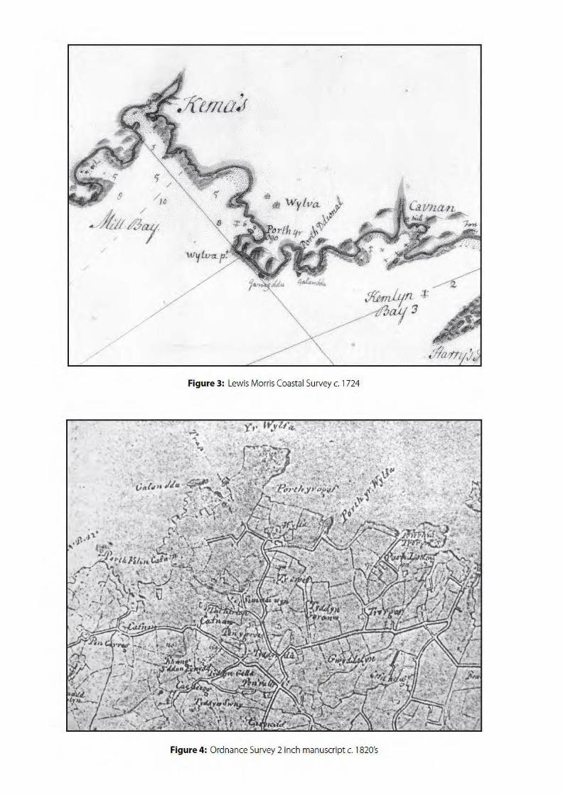
;J(I
~ltl/~1
/
/
Figure 3: Lewis Morris Coastal Survey c. 1724
Figure 4: Ordnance Survey 2 inch manuscript c. 1820's

ID NAME OWNER ID NAME OWNER
1 GalanOdu Edmund Meyrick 61 Penhegol (part of) lshmael Jones
18 Tyddyn Du 53 Tre'r Gof lsaf Gwen Chambers
2 Wylfa William Williams 57 Quill et
5 Cwt 54 Park lodge Thomas Edwards Fanning
3 Ty'nyMaes Hugh Jones 58 Park Lodge (nb qullet7)
4 SimddaWen Thomas Grtffith & Grace Hughes 55 Tre'rGof Mary Broad head
6 TaiHirion RiceOwen 68 Tre'r Gof (part of)
7 Pen Pistyll Edward Williams 56 Quill et John Elias
8 Tyddyn locyn 64 Gwyddelen (part of)
9 Pen Pistyll 65 Gwyddelen (part of)
13 Pen y Groes lsaf 66 Gwyddelen (part of)
10 Cafnan Richard Trygarn Griffith 67 Gwyddelen (part of)
11 Rhwng y ddaufynydd Wllllam Bulkeley Hughes 59 Turberry El ea nor Pritchard
12 PenyGroes Rev'd Edward Owen Hughe 69 Gwyddelen (part of)
14 Cae Brenin Rev'd Robert Williams 70 Gwyddelen (part of)
17 Pen Lon 72 Gwyddelen (part of)
15 TyCroes Owen Jones 60 PentreGof OwenWilliams
16 Tyddyn Ronwy MaryHughes 62 Penhegol (part of) Owen Elias
19 Pen yr Allt 63 Pent re Gof JohnWilliams
24 Ysgubor Odegwm 71 Pentregor (part of)
26 TyddynGele 73 Tre'r Gof lsaf Lord Boston
52 Cottages and gardens lshmael Jones
Figure 5: Tithe Survey and Schedule forWylfa head. 1843

Figure 6: Wylfa west 1889. Ordnance Survey, Anglesey County Series, XX.2, XX.6, XXI.O. Scale 1:8,000

c E 11 ) I
Figure 7: Wylfa east 1889. Ordnance Survey, Anglesey County Series, XX.3, XX.7, XXI.l. Scale 1 :8,000
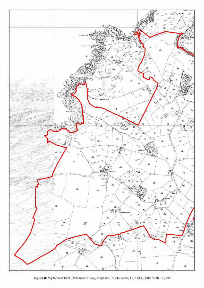
I
~' ,. ""\.
- I
'" .... ,
Figure 8: Wylfa west 1924. Ordnance Survey, Anglesey County Series, XX.2, XX.6, XXI.O. Scale 1 :8,000

Figure 9: Wylfa east 1924. Ordnance Survey, Anglesey County Series, XX.3, XX.?, XXI.1. Scale 1:8,000

Figure 10: Wylfa headland. Vertical aerial photography 1948

Plate 1: Site 2 Limekiln
Plate 2: Site 13 Remains of concrete from Chain Home Installation

Plate 3: Site 6 Tai Hirion
Plate 4: Sites 11 and 12 Porth yr Ogof
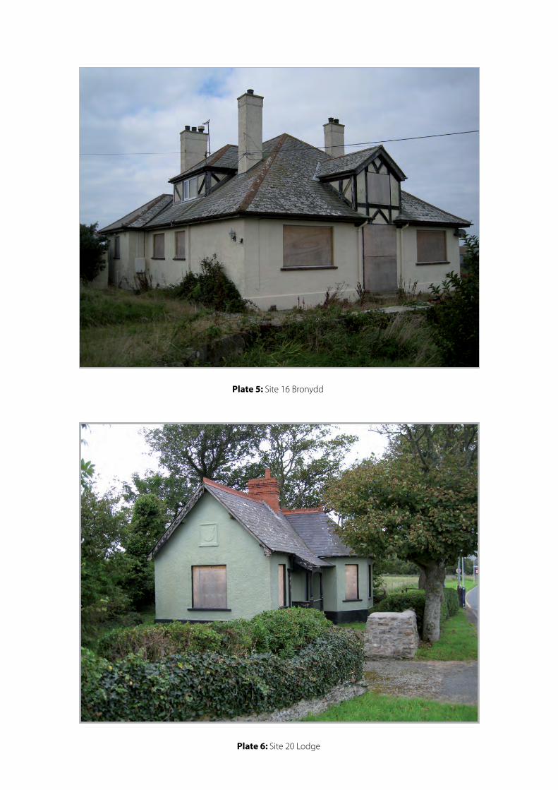
Plate 5: Site 16 Bronydd
Plate 6: Site 20 Lodge
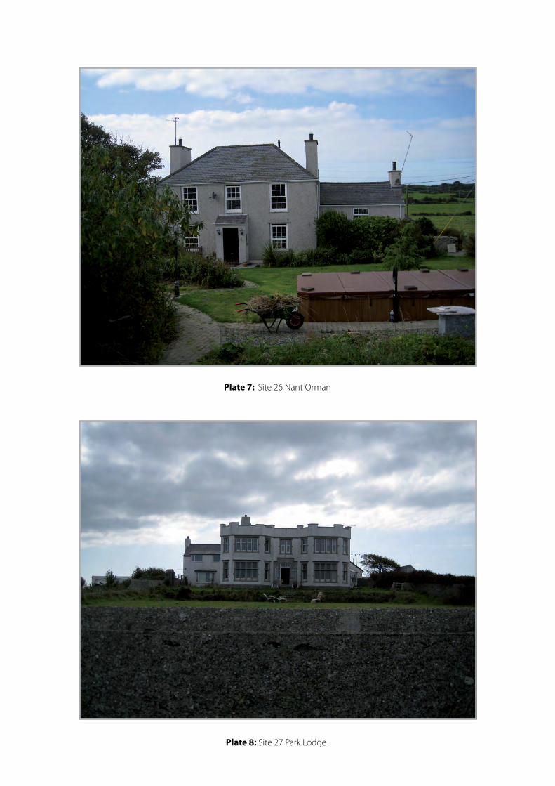
Plate 7: Site 26 Nant Orman
Plate 8: Site 27 Park Lodge
Appendix I Introduction A watching brief was undertaken during the excavation of a series of soil test pits. The results of the watching are given below. Identified deposits and features were recorded photographically and by notes and sketches. The archive is held by GAT under the project number G2096. Each test pit will be described separately. Due to ground conditions Test pit 306 was placed approximately three meters north-west of its original setting. Test Pit 301 (Plate 01,02) Size: 3.00m x 0.70m Depth 1.20m Description The topsoil was extant to a depth of 0.20m and was followed by a deposit of loose ‘Schist’ type stone with a loose mid brown clay silt soil matrix to a depth of 0.40m. Below this there was concrete pad with a thickness ranging between 0.10m 0.23 deep. The concrete pad rested on a mid brown clay silt, with loose medium to large schist inclusions schist 0.70m deep Interpretation The concrete pad forms part of the original works compound constructed in the 1960’s for the construction of Wylfa ‘A’. The test was extended to the west for 3m where the concrete pad was still observed. No other archaeological remains where identified within the pit. Above ground observations indicated the serving remains of a low walled rectangle enclosure, the approximate measurements running North east to South west 29m, South west to North east 100m and South west to North east 31m. The open end appears to have been truncated by the concrete pad building phase. In the north east end of the wall there is a low pile of rubble which could possible be a building or the remains of the wall. Test Pit 302 (Plate 03) Size: 3.00m x 0.70m Depth 1.30m Description The topsoil was extant to a depth of 0.36m and was followed by a deposit of light brown clay silt with frequent small to medium flat and rounded stone to a depth of 0.40m.This rested on a mid brown mottled clay silt with frequent small to medium sub- angular stones with a depth of 0.54m down to shale type natural. Interpretation No archaeological remains were identified in the test pit. Test Pit 303 (Plate 04) Size: 3.00m x 0.70m Depth 1.20m Description The topsoil was extant to a depth of 0.30 and was followed by a mixed light brown clay with gravel and frequent small to medium irregular and rounded stones to a depth of 0.11m. This was followed by a mid brown clay silt with small to medium mixed irregular rounded stones with a depth 0.79m. Interpretation No archaeological remains were identified in the test pit. Test Pit 304 (Plate 05) Size: 3.00m x 0.70m Depth 1.20m
Description The topsoil was extant to a depth of 0.33m and was followed by a brown sand and gravel fine grained with occasional schist inclusions with a depth of 0.17m. This sat on a base of hard, weather natural rock excavated to a depth of 0.70m Interpretation No archaeological remains were identified. Test Pit 306 (Plate 06) Size: 3.00m x 0.70m Depth 1.36m Description The topsoil was extant to a depth of 0.12m. This was followed by a light brown silt clay with occasional flat angular schist to a depth of 0.15m, the concentration of stone increases for a depth of 0.13m. These layers rest on a compact sandy and schist deposit to a depth of 0.66m. Below this was a light brown clay silt ‘relic soil layer’ with rare gravels inclusions to a depth of 0.30m. Interpretation The compact sandy schist layer represents a levelling layer put in place in association with the construction of sports field. Test Pit 307 (Plate 07) Size: 3.00m x 0.70m Depth 0.90m Description The topsoil was extant to a depth of 0.40m. This was followed by a light grey silt gravel to a depth of 0.19m. Below this was a compact gravely brown clay silt with a depth of 0.31m Interpretation No archaeological remains were identified in the test pit. Test Pit 308 (Plate 08) Size: 3.00m x 0.70m Depth 1.20m Description The topsoil was extant to a depth of 0.22m. This was followed by a light brown silt clay gravel to a depth of 0.30m. Below this was a hard stone light grey gravel and schist with a depth of 0.68m. Interpretation No archaeological remains were identified in the test pit. Test Pit 309 (Plate 09) Size: 3.00m x 0.70m Depth 1.20m Description The topsoil was extant to a depth of 0.24m. This was followed by a light grey mottled sandy clay with frequent flat and rounded irregular stones with a depth of 0.32m. Below this was a mottled brown and orange sandy clay with rare small stones with a depth of 0.30m. Under this there was a mottled blacks and yellows clay frequent gravels and small irregular stones with a depth of 0.34m. Interpretation All the deposits seemed to show signs of past water logging, a ditch and low built stone wall surround the immediate area with a marshy area on the other side of these features. This could indicate that this land has been reclaimed and drained.
Plate 1: Test Pit 301. L Shaped Investigation on to Concrete Pad
Plate 2: Test Pit 301. Full depth
Plate 5: Test Pit 304.
Plate 6: Test Pit 306.

Plate 7: Test Pit 309.

YMDDIRIEDOLAETHARCHAEOLEGOL
GWYNEDD
GWYNEDDARCHAEOLOGICALTRUST
Craig Beuno, Ffordd y Garth, Bangor, Gwynedd. LL57 2RT
Ffon: 01248 352535. Ffacs: 01248 370925. email:[email protected]