Embed Size (px)
Citation preview

Fig1.
Fi Fi
Same as 2013, 2014 was a year of rare intense weather events in the French West Indies. The cyclonic activity over all North Atlantic basins, Caribbean Sea and Gulf of Mexico has also proved to be below average.
Actually, only two tropical cyclones impacted West Indies: the first one was the tropical storm Bertha, which went through Lesser Antilles on the 1st of August. The second one was Gonzalo, a tropical cyclone that formed east of the Lesser Antilles and quickly strengthened into a category one hurricane just before moving through the northern Leeward Islands.
Gonzalo:
By 1200 UTC 12 October, the tropical depression which was moving westward between 15 and 16 North and was located at about 400 km east of Guadeloupe became a tropical storm. Gonzalo began to rapidly strengthen late on 12 October. An eye became apparent in the imagery of the radar of Guadeloupe during the early hours of 13 October. Gonzalo became a hurricane around 1200 UTC 13 October when it was located just east southeast of Antigua, at about 40km north of Guadeloupe.
Radar of Guadeloupe: radial speeds, level 500m. Left: 13 oct 12utc; right: 13 oct 14utcA 1-minute sustained wind of 67 kt with a gust to 78 kt was observed at 1244 UTC on Antigua at V.C. Bird International Airport. Radar data of Guadeloupe are quite consistent with the observations

Radar of Guadeloupe; october 13 at 20utc (16 h
Satellite imagery visible channel October 13 at 21utc (17h loc)
Fig4 Fig5
Fig6
RA IV/HC-37/Doc. 4.2 (7), p. 2
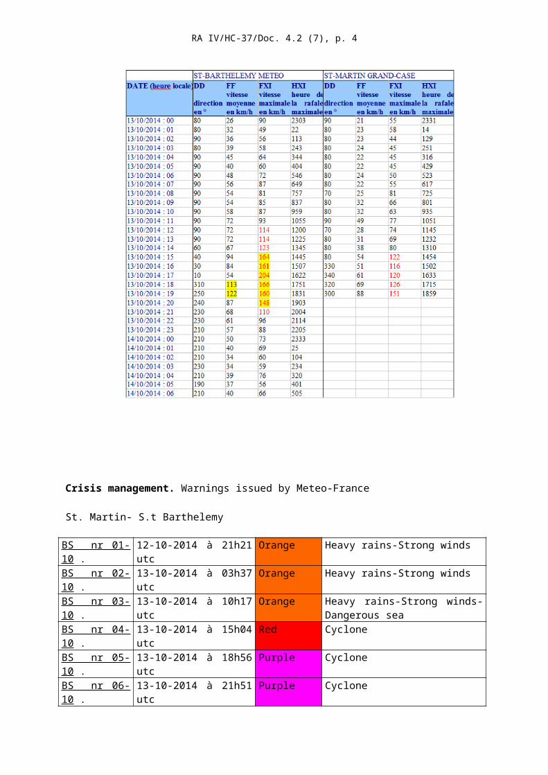
The hurricane continued to strengthen while it passed through the northern Leeward Islands that afternoon. The southwestern portion of the eye moved over St. Barthélemy around 2100 UTC, with the center of the eye crossing just north of the island about an hour later. Gonzalo made landfall on the island of St. Martin at about 23 UTC .
Max wind 1mn , 2mn et 10 minutes sustained winds at St Barthelemy airport .UTC time

RA IV/HC-37/Doc. 4.2 (7), p. 3
This phenomenon caused no casualties on the French islands, but it has caused local damages. Many boats (about one hundred) were destroyed in the port of Gustavia. The latter has been particularly exposed when the winds veered to the southwest sector after the eye moved just north of the island.
Gonzalo management required a shift in red vigilance cyclone in the morning of 13, followed by purple (involving containment measures) 3 hours later.
Crisis management. Warnings issued by Meteo-France
St. Martin- S.t Barthelemy
BS nr 01-10 . 12-10-2014 à 21h21 utc Orange Heavy rains-Strong windsBS nr 02-10 . 13-10-2014 à 03h37 utc Orange Heavy rains-Strong windsBS nr 03-10 . 13-10-2014 à 10h17 utc Orange Heavy rains-Strong winds-
Dangerous seaBS nr 04-10 . 13-10-2014 à 15h04 utc Red CycloneBS nr 05-10 . 13-10-2014 à 18h56 utc Purple CycloneBS nr 06-10 . 13-10-2014 à 21h51 utc Purple CycloneBS nr 07-10 14-10-2014 à 00h36 utc Purple CycloneBS nr 08-10 14-10-2014 à 03h38 utc Purple CycloneBS nr 09-10 14-10-2014 à 07h24 utc Purple CycloneBS nr 10-10 14-10-2014 à 10h04 utc Grey CycloneBS nr 09-10 14-10-2014 à 16h24 utc Vert
Hurricane Tropical stormFig7
RA IV/HC-37/Doc. 4.2 (7), p. 4
Red level (all activities must stop) was issued one hour in advance before gusts reached 100km/h and four hours in advance before gusts reached 160km/h. Purple (level max : containment) was issued only one hour ahead.
Forecasts:
It should be noted that according to the advisory of October 13-12utc, Gonzalo should have moved south of ST Barth at a tropical storm level. Intensity and track forecasts were much better at 18utc but it was a bit late.
Meteo-France had to anticipate a little on this upgrade to hurricane force. And thus there were no complaints from the authorities, it certainly should have been better to issue the purple level of warning at least one hour ahead the time it was actually done.
Anyhow, though the strengthening of Gonzalo was quite underestimated, Meteo-France has been able, on Friday 10 April 2015, and thanks especially to the ensemble prediction of ECMWF, to warn the civil authorities that bad weather was expected on Leeward Islands on Sunday evening or Monday. Even if the matter was more about heavy rain than about strong wind.
BERTHA
This cyclone developed on 1st August at about 450 km in the south-east of Barbados. Then it crossed the Lesser Antilles as a tropical storm. The center passed just north of Martinique late on 1 August. Surface observations in Guadeloupe reported maximum mean winds (10mn) of 35 knots in la Désirade and Petite Terre (2 small islands east of Guadeloupe) with gusts to 50 knots. In Martinique, the maximum mean wind was recorded

Bertha, 1- 08_2015 18utcBertha, 1- 08_2015 12utc
Martinique Radar Reflectivity at 20h45 utc.
Hourly intensity
RA IV/HC-37/Doc. 4.2 (7), p. 5
on the Atlantic coast (Trinité-Caravelle) and reached 33knots. The maximum gust reached 47 knots. Associated rains were locally stormy but did not give any significant amounts (30 to 60 mm in the northern Martinique).
The most significant impacts reported by the media were on Martinique, where power outages affected 150,000 buildings. In fact, the electrical network was already weakened because of a serious technical event that happened in the previous weeks. So, the consequences of the thunderstorms were not exactly related to the actual intensity of the phenomenon.
Visible channel.
Martiniq
Berth
10mn sustained winds
Surface wind speeds recorded in four locations of Martinique
Gusts. In km/h