Embed Size (px)
Citation preview
WORLD METEOROLOGICAL ORGANIZATION AND ECONOMIC AND SOCIAL COMMISSION FOR ASIA AND THE PACIFIC WMO/ESCAP Panel on Tropical Cyclones Fortieth session Colombo, Sri Lanka 25 February to 1 March 2013
FOR PARTICIPANTS ONLY WRD/PTC-40/Doc. 3.2 (4) (22.II.2013) ______________ ENGLISH ONLY
REVIEW OF THE 2012 CYCLONE SEASON
Reports of Members on the impact of tropical cyclones (Submitted by Maldives)
Page | 1
SRILANKA 25 FEB – 1 MARCH 2013
Tropical Cyclone Season – 2012
Severe Weather Situation Report 21 October to 01 November 2012
Low pressure systems/ depressions and cyclonic activity “Murjan” (18 to 21 Oct 2012) and
“Nilam” (21 to 31 Oct 2012) resulted severe weather phenomenon in Maldives and caused
damages at many islands. The drivers, characteristics, impacts of severe weather system are
discussed in the following section.
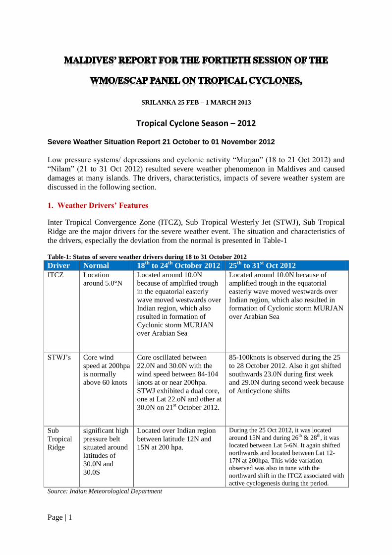
1. Weather Drivers’ Features
Inter Tropical Convergence Zone (ITCZ), Sub Tropical Westerly Jet (STWJ), Sub Tropical
Ridge are the major drivers for the severe weather event. The situation and characteristics of
the drivers, especially the deviation from the normal is presented in Table-1
Table-1: Status of severe weather drivers during 18 to 31 October 2012
Driver Normal 18th
to 24th
October 2012 25th
to 31st Oct 2012
ITCZ Location
around 5.0°N
Located around 10.0N
because of amplified trough
in the equatorial easterly
wave moved westwards over
Indian region, which also
resulted in formation of
Cyclonic storm MURJAN
over Arabian Sea
Located around 10.0N because of
amplified trough in the equatorial
easterly wave moved westwards over
Indian region, which also resulted in
formation of Cyclonic storm MURJAN
over Arabian Sea
STWJ‟s Core wind
speed at 200hpa
is normally
above 60 knots
Core oscillated between
22.0N and 30.0N with the
wind speed between 84-104
knots at or near 200hpa.
STWJ exhibited a dual core,
one at Lat 22.oN and other at
30.0N on 21st October 2012.
85-100knots is observed during the 25
to 28 October 2012. Also it got shifted
southwards 23.0N during first week
and 29.0N during second week because
of Anticyclone shifts
Sub
Tropical
Ridge
significant high
pressure belt
situated around
latitudes of
30.0N and
30.0S
Located over Indian region
between latitude 12N and
15N at 200 hpa.
During the 25 Oct 2012, it was located
around 15N and during 26th
& 28th
, it was
located between Lat 5-6N. It again shifted
northwards and located between Lat 12-
17N at 200hpa. This wide variation
observed was also in tune with the
northward shift in the ITCZ associated with
active cyclogenesis during the period. Source: Indian Meteorological Department
Page | 2
During October 23rd
to 31st Madden Julian Oscillation (MJO) with its enhanced activity in
Indian Ocean region also aggravated severe weather conditions.
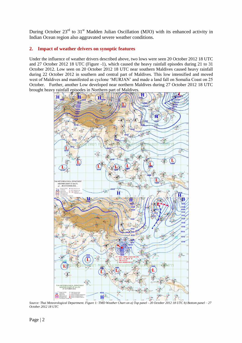
2. Impact of weather drivers on synoptic features
Under the influence of weather drivers described above, two lows were seen 20 October 2012 18 UTC
and 27 October 2012 18 UTC (Figure -1), which caused the heavy rainfall episodes during 21 to 31
October 2012. Low seen on 20 October 2012 18 UTC near southern Maldives caused heavy rainfall
during 22 October 2012 in southern and central part of Maldives. This low intensified and moved
west of Maldives and manifested as cyclone „MURJAN‟ and made a land fall on Somalia Coast on 25
October. Further, another Low developed near northern Maldives during 27 October 2012 18 UTC
brought heavy rainfall episodes in Northern part of Maldives.
Source: Thai Meteorological Department. Figure 1: TMD Weather Chart on a) Top panel - 20 October 2012 18 UTC b) Bottom panel – 27
October 2012 18 UTC
Page | 3
“Depression formed over southeast and adjoining southwest Bay of Bengal at 06:00 UTC of
28 October 2012 near latitude 9.5°N and longitude 86.0°E moved westwards and intensified
into a deep depression in the morning of 29th October over southwest Bay of Bengal near
latitude 9.0°N and longitude 83.0°E, and continued to move westwards and intensified into a
Cyclonic Storm, ‘NILAM’ in the morning of 30th October over southwest Bay of Bengal off
Sri Lanka coast. The Cyclonic Storm, NILAM then moved northwestwards, crossed north
Tamilnadu coast near Mahabalipuram, south of Chennai between 1600 and 1700 hrs IST of
31st October 2012. After the landfall the cyclonic storm, NILAM moved west-northwestwards
and weakened gradually into a deep depression and then into a depression over south
Interior Karnataka in the morning of 01st November 2012” (Source: IMD)
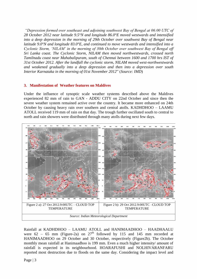
3. Manifestation of Weather features on Maldives
Under the influence of synoptic scale weather systems described above the Maldives
experienced 82 mm of rain to GAN - ADDU CITY on 22nd October and since then the
severe weather system remained active over the country. It became more enhanced on 24th
October by causing heavy rain over southern and central atolls. KADHDHOO – LAAMU
ATOLL received 119 mm of rain on that day. The trough further oscillated south to central to
north and rain showers were distributed through many atolls during next few days.
Figure 2 a): 27 Oct 2012.9:00UTC – CLOUD TOP
TEMPERATURE Figure 2 b): 29 Oct 2012.9:00UTC –CLOUD TOP
TEMPERATURE
Source: Indian Meteorological Department
Rainfall at KADHDHOO – LAAMU ATOLL and HANIMAADHOO – HAADHAALU
were 62 – 65 mm (Figure-2a) on 27th
followed by 115 and 145 mm recorded at
HANIMAADHOO on 29 October and 30 October, respectively (Figure2b). The October
monthly mean rainfall at Hanimaadhoo is 199 mm. Even a much higher intensity/ amount of
rainfall is expected in its neighbourhood. HOARAFUSHI and NOLHIVARANFARU
reported most destruction due to floods on the same day. Considering the impact level and
Page | 4
recorded rainfall nearby (Hanimaadhoo & Kelaa 128mm), Maldives Meteorological Service
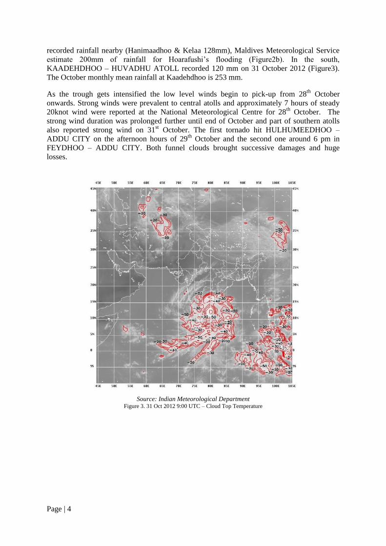
estimate 200mm of rainfall for Hoarafushi‟s flooding (Figure2b). In the south,
KAADEHDHOO – HUVADHU ATOLL recorded 120 mm on 31 October 2012 (Figure3).
The October monthly mean rainfall at Kaadehdhoo is 253 mm.
As the trough gets intensified the low level winds begin to pick-up from 28th
October
onwards. Strong winds were prevalent to central atolls and approximately 7 hours of steady
20knot wind were reported at the National Meteorological Centre for 28th
October. The
strong wind duration was prolonged further until end of October and part of southern atolls
also reported strong wind on 31st October. The first tornado hit HULHUMEEDHOO –
ADDU CITY on the afternoon hours of 29th
October and the second one around 6 pm in
FEYDHOO – ADDU CITY. Both funnel clouds brought successive damages and huge
losses.
Source: Indian Meteorological Department
Figure 3. 31 Oct 2012 9:00 UTC – Cloud Top Temperature
Page | 5
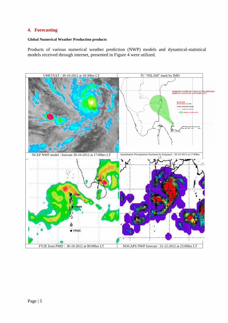
4. Forecasting
Global Numerical Weather Production products
Products of various numerical weather prediction (NWP) models and dynamical-statistical
models received through internet, presented in Figure 4 were utilized.
UMETSAT : 30-10-2012 at 18:30hrs LT TC “NILAM” track by IMD
NCEP NWP model : forecast 30-10-2012 at 17:00hrs LT Quantitative Precipitation Estimate by Kalpana1 : 30-10-2012 at 17:00hrs
LT
FY2E from PMD : 30-10-2012 at 00:00hrs LT NOGAPS NWP forecast : 31-12-2012 at 23:00hrs LT
Page | 6
Figure 4: Global / Regional Forecast Products
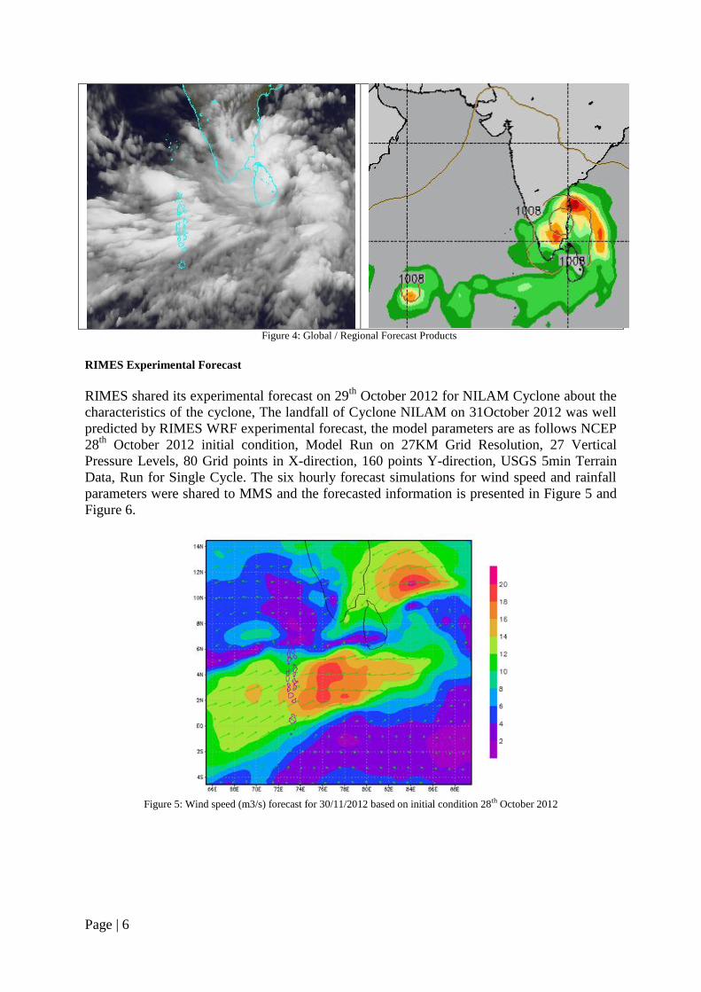
RIMES Experimental Forecast
RIMES shared its experimental forecast on 29th
October 2012 for NILAM Cyclone about the
characteristics of the cyclone, The landfall of Cyclone NILAM on 31October 2012 was well
predicted by RIMES WRF experimental forecast, the model parameters are as follows NCEP
28th
October 2012 initial condition, Model Run on 27KM Grid Resolution, 27 Vertical
Pressure Levels, 80 Grid points in X-direction, 160 points Y-direction, USGS 5min Terrain
Data, Run for Single Cycle. The six hourly forecast simulations for wind speed and rainfall
parameters were shared to MMS and the forecasted information is presented in Figure 5 and
Figure 6.
Figure 5: Wind speed (m3/s) forecast for 30/11/2012 based on initial condition 28th October 2012
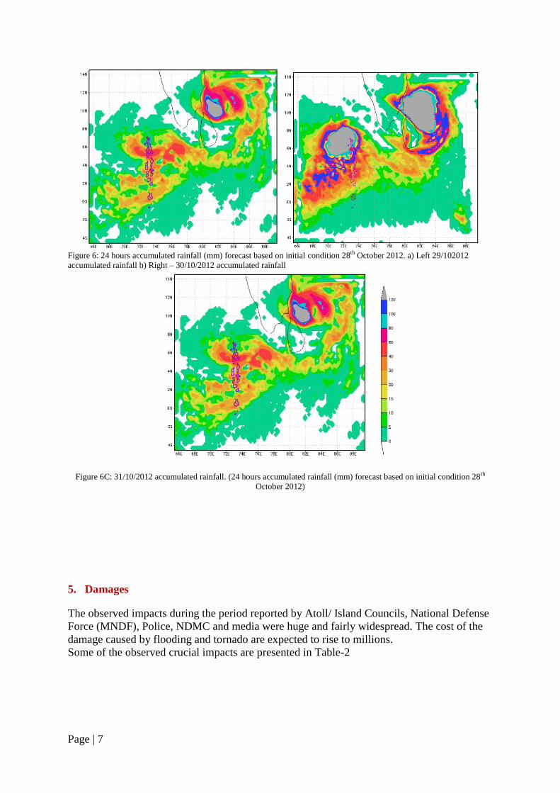
Page | 7
Figure 6: 24 hours accumulated rainfall (mm) forecast based on initial condition 28th October 2012. a) Left 29/102012
accumulated rainfall b) Right – 30/10/2012 accumulated rainfall
Figure 6C: 31/10/2012 accumulated rainfall. (24 hours accumulated rainfall (mm) forecast based on initial condition 28th
October 2012)
5. Damages
The observed impacts during the period reported by Atoll/ Island Councils, National Defense
Force (MNDF), Police, NDMC and media were huge and fairly widespread. The cost of the
damage caused by flooding and tornado are expected to rise to millions.
Some of the observed crucial impacts are presented in Table-2
Page | 8
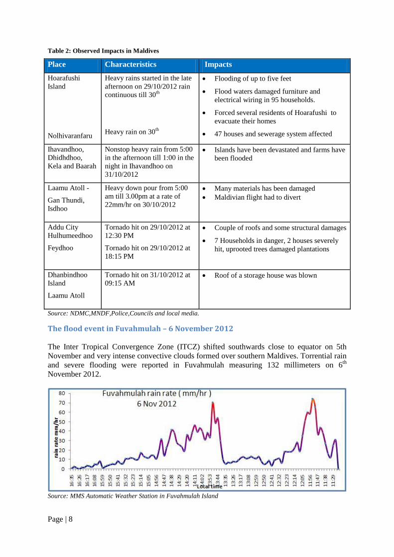
Table 2: Observed Impacts in Maldives
Place Characteristics Impacts
Hoarafushi
Island
Nolhivaranfaru
Heavy rains started in the late
afternoon on 29/10/2012 rain
continuous till 30th
Heavy rain on 30th
Flooding of up to five feet
Flood waters damaged furniture and
electrical wiring in 95 households.
Forced several residents of Hoarafushi to
evacuate their homes
47 houses and sewerage system affected
Ihavandhoo,
Dhidhdhoo,
Kela and Baarah
Nonstop heavy rain from 5:00
in the afternoon till 1:00 in the
night in Ihavandhoo on
31/10/2012
Islands have been devastated and farms have
been flooded
Laamu Atoll -
Gan Thundi,
Isdhoo
Heavy down pour from 5:00
am till 3.00pm at a rate of
22mm/hr on 30/10/2012
Many materials has been damaged
Maldivian flight had to divert
Addu City
Hulhumeedhoo
Feydhoo
Tornado hit on 29/10/2012 at
12:30 PM
Tornado hit on 29/10/2012 at
18:15 PM
Couple of roofs and some structural damages
7 Households in danger, 2 houses severely
hit, uprooted trees damaged plantations
Dhanbindhoo
Island
Laamu Atoll
Tornado hit on 31/10/2012 at
09:15 AM Roof of a storage house was blown
Source: NDMC,MNDF,Police,Councils and local media.
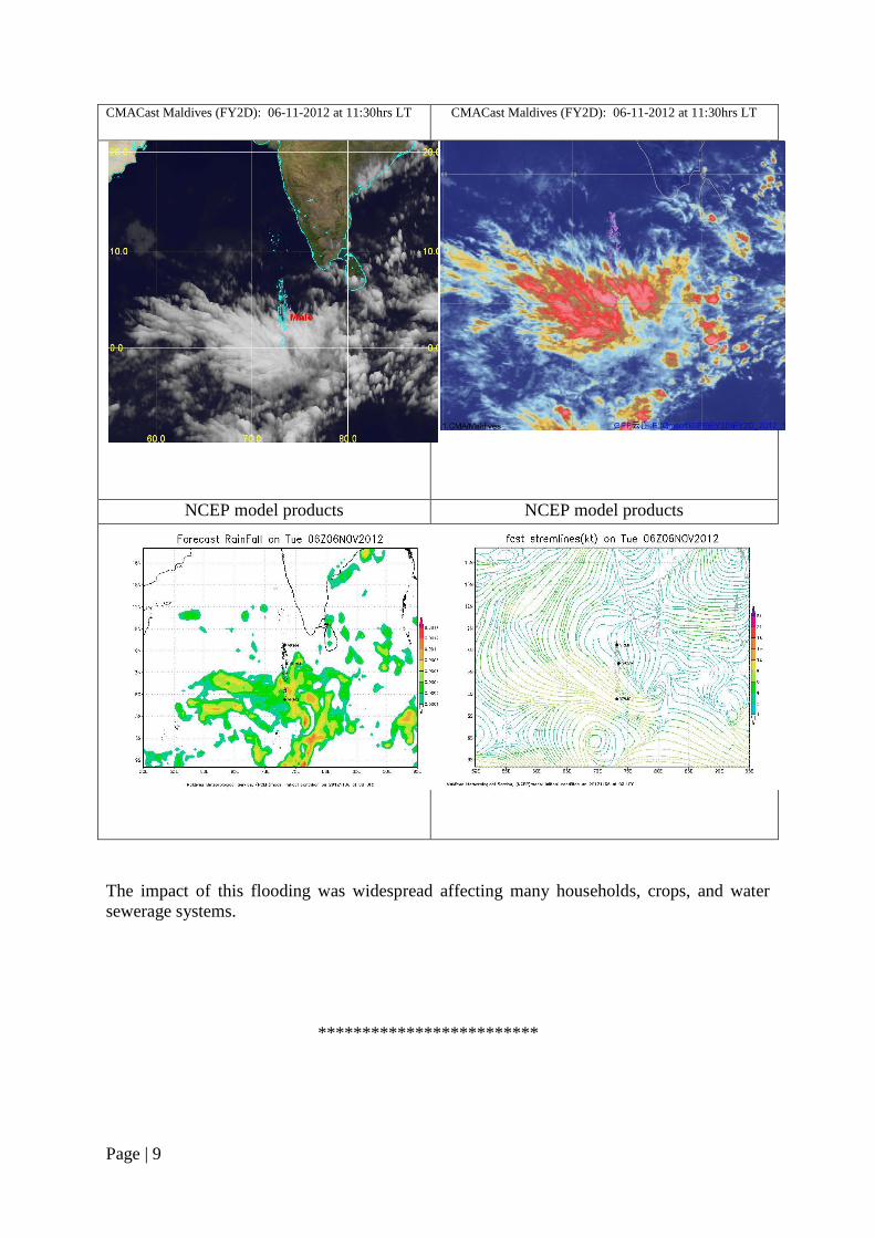
The flood event in Fuvahmulah – 6 November 2012
The Inter Tropical Convergence Zone (ITCZ) shifted southwards close to equator on 5th
November and very intense convective clouds formed over southern Maldives. Torrential rain
and severe flooding were reported in Fuvahmulah measuring 132 millimeters on 6th
November 2012.
Source: MMS Automatic Weather Station in Fuvahmulah Island
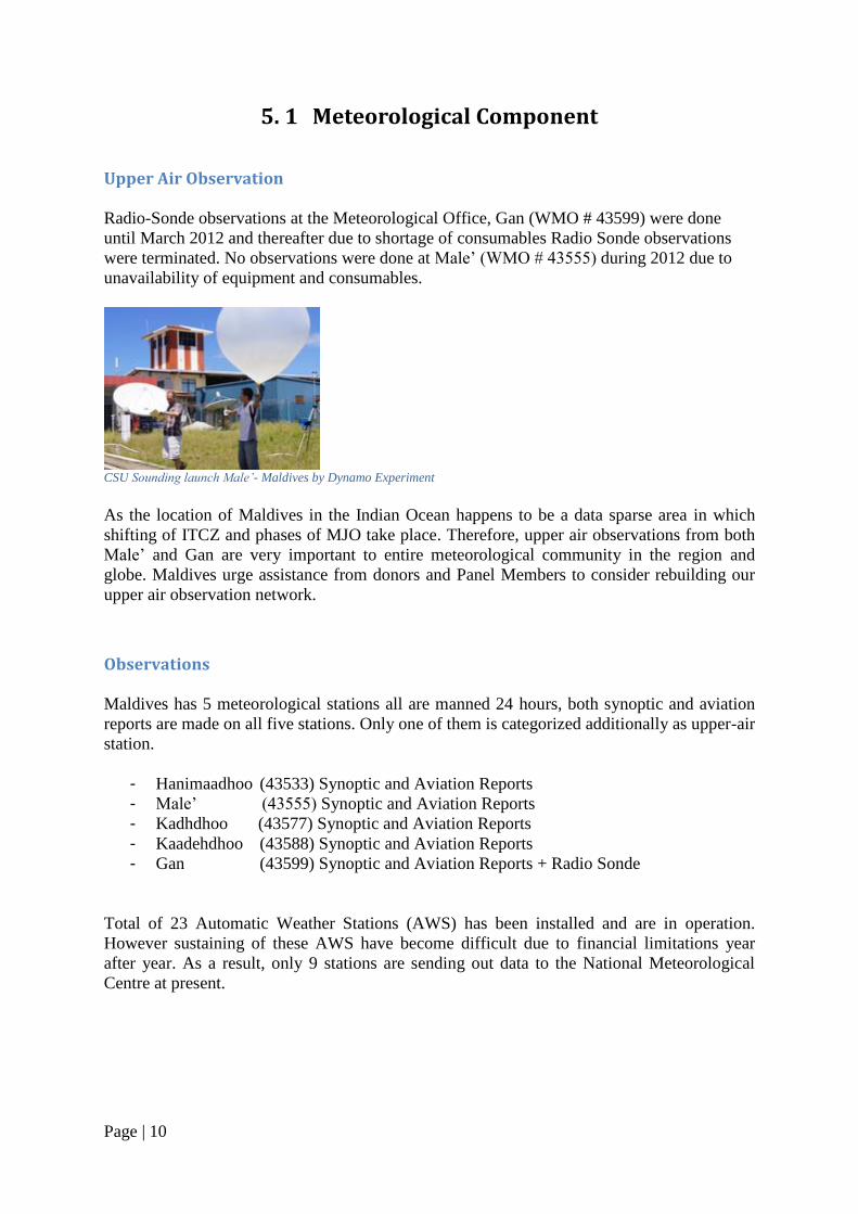
Page | 9
CMACast Maldives (FY2D): 06-11-2012 at 11:30hrs LT CMACast Maldives (FY2D): 06-11-2012 at 11:30hrs LT
NCEP model products NCEP model products
The impact of this flooding was widespread affecting many households, crops, and water
sewerage systems.
*************************
Page | 10
5. 1 Meteorological Component
Upper Air Observation
Radio-Sonde observations at the Meteorological Office, Gan (WMO # 43599) were done
until March 2012 and thereafter due to shortage of consumables Radio Sonde observations
were terminated. No observations were done at Male‟ (WMO # 43555) during 2012 due to
unavailability of equipment and consumables.
CSU Sounding launch Male’- Maldives by Dynamo Experiment
As the location of Maldives in the Indian Ocean happens to be a data sparse area in which
shifting of ITCZ and phases of MJO take place. Therefore, upper air observations from both
Male‟ and Gan are very important to entire meteorological community in the region and
globe. Maldives urge assistance from donors and Panel Members to consider rebuilding our
upper air observation network.
Observations
Maldives has 5 meteorological stations all are manned 24 hours, both synoptic and aviation
reports are made on all five stations. Only one of them is categorized additionally as upper-air
station.
- Hanimaadhoo (43533) Synoptic and Aviation Reports
- Male‟ (43555) Synoptic and Aviation Reports
- Kadhdhoo (43577) Synoptic and Aviation Reports
- Kaadehdhoo (43588) Synoptic and Aviation Reports
- Gan (43599) Synoptic and Aviation Reports + Radio Sonde
Total of 23 Automatic Weather Stations (AWS) has been installed and are in operation.
However sustaining of these AWS have become difficult due to financial limitations year
after year. As a result, only 9 stations are sending out data to the National Meteorological
Centre at present.
Page | 11
Rainfall Stations
Across the country, Maldives has 7 rainfall stations which measure only accumulated rainfall
for 24 hours and reading are collected at 0300UTC for national use only.
- HA. Kela
- Sh. Funadhoo
- B. Dharavandhoo
- M. Muli
- Dh. Kudahuvadhoo
- Th. Veymandoo
- Gn. Fuvanmulah
Meteorological Satellites.
Digital Meteorological Data Dissemination (DMDD) system donated by India
Meteorological Department (IMD) receives WMO coded GTS data, half hourly cloud
imagery from KALPANA and Fax charts in LRIT/HRIT format transmitted by IMD and
display on a high resolution color monitor. Images can be further enhanced using different
image processing functions and can be focused more on the area of interest. This system has
the capability to plot the received met data by values or contours on a specific image. With all
these features it helps forecasters to do more precise predictions. However, this system is
facing signal loss therefore nothing has been received during 2012.
The High Resolution Satellite Image Receiving System GEOSAT 500 has stopped functioning
since 2010. It is required to pay a considerably high amount to the manufacturer to renew its service
agreement.
An integrated satellite receiving system generously donated by China Meteorological Agency was
installed on 25 October 2012. This CMACast system receives Satellite imageries from FY2E and
FY2D series of Chinese geostationary satellites at an interval of 30 minutes. Surface synoptic data,
Upper air sounding data, NWPs of ECMWF, T213: NWPs of CMA global model, NWP accumulation
preci from Germany model and Japan model. Another component of this system is the application
software MICAPS (meteorological data analyzing system) which enables to display satellite
pictures, surface & upper air data and NWP products and overlay different products and analysis of
various weather phenomena.
Doppler Weather Radar
Doppler Weather Radar received as part of Multi-hazard Early Warning System has been
repaired in 2011. However, it needs further calibration of equipment by a professional and local
technicians are unable to do the job. MMS have begun the process of hiring an expert to bring this
system to normal.
Numerical Weather Prediction
The system which runs WRF model gives problems time to time as the hardware become old
and it is impossible to upgrade them due to financial crisis. Maldives Meteorological Service
Page | 12
continues to use NWP output provided by RIMES, ECMWF, IMD and other web based NWP
products.
Telecommunications
The 10mbps internet service and the computer based telecommunication system between the
local Meteorological Offices and the National Meteorological Centre (NMC), functioned
very well.
NMC’s Global Telecommunications System (GTS) and Message Switching System (MSS)
MESSIR-COMM message switching system developed by COROBOR is a TCP/IP based
multi-channel communication link that is capable of handling vast amount of data. Although
this GTS is in operation throughout 2012, Maldives received many complains from other
countries and GCOS of not receiving our SYNOPs, RS observation (TEMP) messages
through GTS. Likewise, the monthly CLIMAT report sent via GTS is also reported not
received by users. Efforts have been made in late 2011 – 2012 in consultation with RTH New
Delhi in this regard and still this matter needed to be taken care of and work closely to arrive
at a sustainable solution.
Meteorological information through internet
The official website of the Maldives Meteorological Service www.meteorology.gov.mv has
served its users with current weather updates, forecasts, warnings, met reports and aviation
weather charts.
*****************************
5. 2 Hydrological Component There are no much hydrological issues in the Maldives; only a few lakes or swamps exist
here.
Page | 13
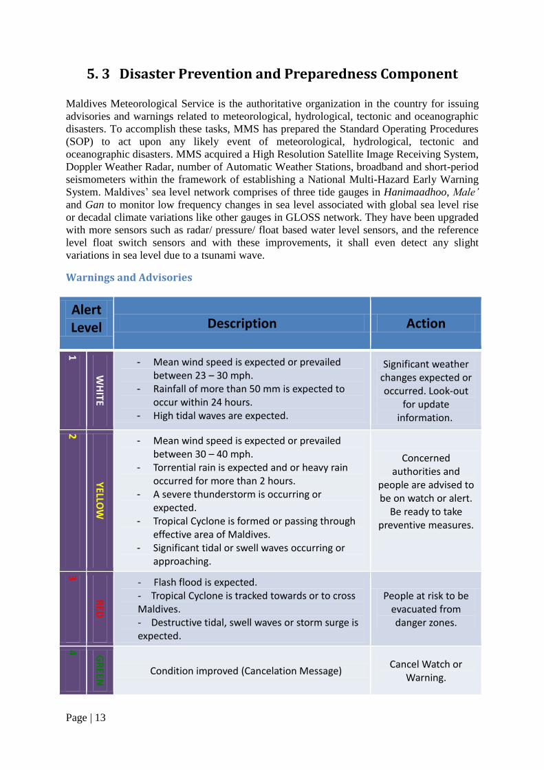
5. 3 Disaster Prevention and Preparedness Component
Maldives Meteorological Service is the authoritative organization in the country for issuing
advisories and warnings related to meteorological, hydrological, tectonic and oceanographic
disasters. To accomplish these tasks, MMS has prepared the Standard Operating Procedures
(SOP) to act upon any likely event of meteorological, hydrological, tectonic and
oceanographic disasters. MMS acquired a High Resolution Satellite Image Receiving System,
Doppler Weather Radar, number of Automatic Weather Stations, broadband and short-period
seismometers within the framework of establishing a National Multi-Hazard Early Warning
System. Maldives‟ sea level network comprises of three tide gauges in Hanimaadhoo, Male’
and Gan to monitor low frequency changes in sea level associated with global sea level rise
or decadal climate variations like other gauges in GLOSS network. They have been upgraded
with more sensors such as radar/ pressure/ float based water level sensors, and the reference
level float switch sensors and with these improvements, it shall even detect any slight
variations in sea level due to a tsunami wave.
Warnings and Advisories
Alert Level Description Action
1
WH
ITE
- Mean wind speed is expected or prevailed between 23 – 30 mph.
- Rainfall of more than 50 mm is expected to occur within 24 hours.
- High tidal waves are expected.
Significant weather changes expected or occurred. Look-out
for update information.
2
YELLO
W
- Mean wind speed is expected or prevailed between 30 – 40 mph.
- Torrential rain is expected and or heavy rain occurred for more than 2 hours.
- A severe thunderstorm is occurring or expected.
- Tropical Cyclone is formed or passing through effective area of Maldives.
- Significant tidal or swell waves occurring or approaching.
Concerned authorities and
people are advised to be on watch or alert.
Be ready to take preventive measures.
3
RED
- Flash flood is expected. - Tropical Cyclone is tracked towards or to cross Maldives. - Destructive tidal, swell waves or storm surge is expected.
People at risk to be evacuated from danger zones.
4 G
REEN
Condition improved (Cancelation Message) Cancel Watch or Warning.
Page | 14
During 2012 Cyclone Season, the severe weather was monitored locally through the 5 Met.
Stations, 9 Automatic Weather Stations and SATELLITE image receiving system. Products of
various numerical weather prediction (NWP) models and dynamical-statistical models received
through internet were utilized to predict the variations in local atmosphere. Experimental
forecast from RIMES and Bulletins from RSMC – New Delhi were used to predict the intensity
and track of the Bay of Bengal System.
Maldives Meteorological Service followed the Standard Operating Procedure (SOP) and issued
42 WHITE Alerts, 7 YELLOW Alerts and 1 RED Alert during 2012 Cyclone Season. Apart
from these, interviews/ personal briefing to sea travelers, fisherman, national defense, police,
disaster management and various media were conducted.
Apart from severe weather or tropical cyclone warnings, earthquake or tsunami warning
bulletin dispatched by Regional Tsunami Service Providers – India, Indonesia, Australia and
other centres like RIMES, JMA and PTWC were received well at MMS. All the advisories
and warnings were disseminated to public satisfactorily in time.
MMS in collaboration with RIMES convened a Monsoon Forum during 2012. This forum
serves as a national platform for its dialogue process between forecast providers and users,
with the following objectives:
1. Ensure that forecasts/ warning information products, including their uncertainties and
limitations, are communicated to and understood by users.
2. Encourage the use of forecasts to mitigate risks in climate-sensitive sectors, including,
but not limited to agriculture, water resources, disaster management, and health.
3. Receive user feedback for improving usability of forecast products.
4. Provide a platform for inter-agency coordination of policies, and sectoral plans and
programs for dealing with potential impacts of hydro-meteorological hazards.
5. Provide a platform for long-term process of understanding risks posed/opportunities
brought about by past, current, and future climate.
The first forum convened in Fuvahmulah proved as a success when the November 2012 flood
event occurred there.
**********************
Page | 15
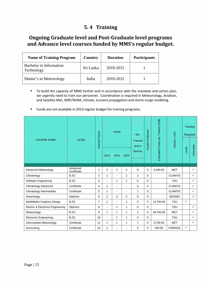
5. 4 Training
Ongoing Graduate level and Post-Graduate level programs and Advance level courses funded by MMS’s regular budget.
Name of Training Program Country Duration Participants
Bachelor in Information
Technology Sri Lanka 2010-2012 1
Master‟s in Meteorology India 2010-2012 1
To build the capacity of MMS further and in accordance with the mandate and action plan,
we urgently need to train our personnel. Coordination is required in Meteorology, Aviation, and Satellite Met, WRF/WAM, climate, tsunami propagation and storm-surge modeling.
Funds are not available in 2013 regular budget for training programs.
COURSE NAME LEVEL
Overa
ll P
rio
rity
YEAR
Fu
nds C
onfirm
ed
Estim
ate
d C
osts
per
Tra
inee (
US
$)
Sectio
n / U
nit
Training
No. Required
Trained
Local
Overs
eas
and in
2013 2014 2015
Service
Advanced Meteorology Advanced Certificate
1 2 2 2 6 0 6,500.00 MET
Climatology B.SC 2 1 - 1 1 0 CLIMATE
Software Engineering B.SC 3 - 1 1 0 0 TSU
Climatology Advanced Certificate 4 1 - - 0 0 CLIMATE
Climatology Intermediate Certificate 5 1 - - 1 0 CLIMATE
Seismology Diploma 6 2 2 2 0 0 SEISMO
MultiMedia/ Graphics Design B.SC 7 1 - 1 0 0 13,700.00 TSU
Electric & Electronic Engineering Diploma 8 - 1 1 0 0 TSU
Meteorology B.SC 9 1 1 1 1 0 48,700.00 MET
Electronic Engineering B.SC 10 - 1 1 0 0 TSU
Intermediate Meteorology Certificate 11 1 1 1 7 0 3,700.00 MET
Accounting Certificate 12 1 - - 0 0 550.00 FINANCE
Page | 16
5. 5 Research
Maldives hosted a Collaborative Climate Research – A scientific Project in the Indian Ocean
to better understand Global Climate & Weather Systems – Endorsed by World Climate
Research Programme.
1 October 2011 – 31 March 2012
MADDEN-JULIAN OSCILLATION
The Madden-Julian Oscillation (MJO) is a 30 to 90 day tropical weather cycle that
alternates between large, strong rain storms and relatively quiet periods, moving from the
Indian Ocean eastward to the Pacific Ocean. The MJO not only plays an important role in
local weather in the tropics, affecting regional monsoon rains, but also impacts weather
and climate in other parts of the world. Improved understanding of this important event
will help short- and long-term weather forecasting and climate predictions across the globe.
The DYNAMO study is being conducted from October-March, which is the most frequent
time for the onset of the MJO.
SIGNIFICANCE OF THE SOUTHERN INDIAN OCEAN
The Indian Ocean is one of the Earth's most sensitive regions where the ocean and
atmosphere interact, thereby affecting global climate. The Maldives-Chagos Archipelago
provides a unique setting for this type of observational research because it is situated in a
k e y f o r m a t i o n region of t h e M J O , a n d provides an excellent location for land- and
aircraft-based measurements in the Indian Ocean.
SCIENTIFIC OBJECTIVES
DYNAMO will provide researchers with vital observations of the MJO, a poorly
understood phenomenon, particularly during the initiation phase. The results will help
researchers to more accurately forecast the weather and climate of the equa to r i a l
In d ian Ocean and a round the world. Large-scale weather events, such as the MJO,
create pulses that have direct effects on regional w e a t h e r patterns around the w o r l d .
Page | 17
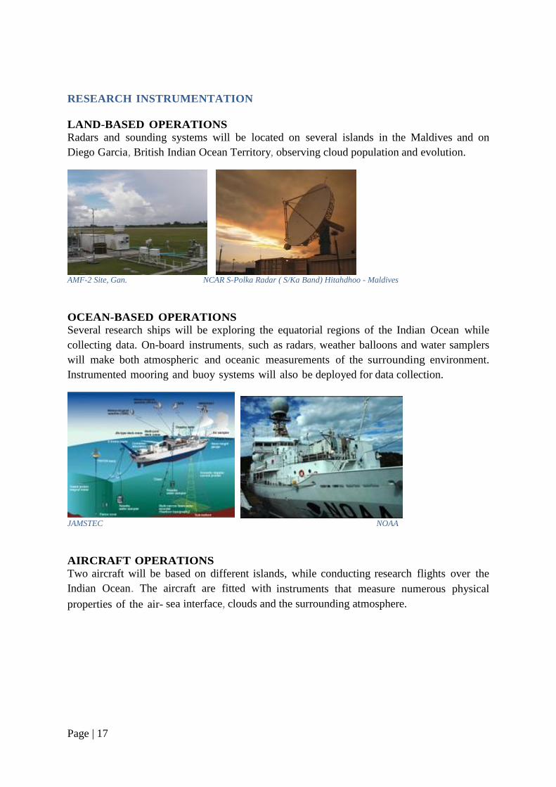
RESEARCH INSTRUMENTATION
LAND-BASED OPERATIONS
Radars and sounding systems will be located on several islands in the Maldives and on
Diego Garcia, British Indian Ocean Territory, observing cloud population and evolution.
AMF-2 Site, Gan. NCAR S-Polka Radar ( S/Ka Band) Hitahdhoo - Maldives
OCEAN-BASED OPERATIONS
Several research ships will be exploring the equatorial regions of the Indian Ocean while
collecting data. On-board instruments, such as radars, weather balloons and water samplers
will make both atmospheric and oceanic measurements of the surrounding environment.
Instrumented mooring and buoy systems will also be deployed for data collection.
JAMSTEC NOAA
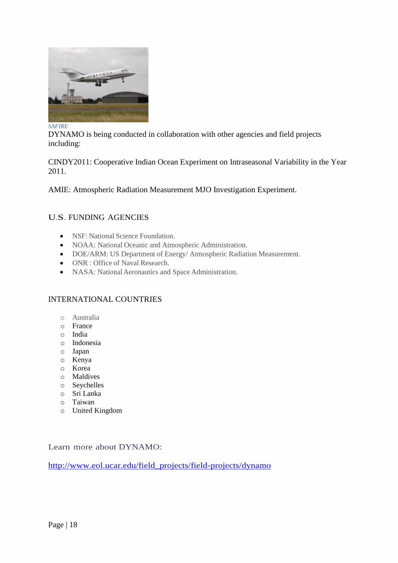
AIRCRAFT OPERATIONS
Two aircraft will be based on different islands, while conducting research flights over the
Indian Ocean. The aircraft are fitted with instruments that measure numerous physical
properties of the air sea interface, clouds and the surrounding atmosphere.
Page | 18
SAFIRE
DYNAMO is being conducted in collaboration with other agencies and field projects
including:
CINDY2011: Cooperative Indian Ocean Experiment on Intraseasonal Variability in the Year
2011.
AMIE: Atmospheric Radiation Measurement MJO Investigation Experiment.
U.S. FUNDING AGENCIES
NSF: National Science Foundation.
NOAA: National Oceanic and Atmospheric Administration.
DOE/ARM: US Department of Energy/ Atmospheric Radiation Measurement.
ONR : Office of Naval Research.
NASA: National Aeronautics and Space Administration.
INTERNATIONAL COUNTRIES
o Australia
o France
o India
o Indonesia
o Japan
o Kenya
o Korea
o Maldives
o Seychelles
o Sri Lanka
o Taiwan
o United Kingdom
Learn more about DYNAMO:
http://www.eol.ucar.edu/field_projects/field-projects/dynamo
Page | 19
5. 6 Publications
Panel News
Maldives contributed information on significant weather and new developments in
the meteorological service to Panel’s News Letters.
Annual Climate Report Maldives Meteorological Service publishes Annual Climate Report every year.
**********************


![A Review of Numerical Modelling of Cyclones and Tsunamis ... · in Bangladesh by the 1991 Cyclone [5]. The deadliest tropical cyclone in Bangladesh was the 1970 Bhola Cyclone, which](https://img.pdfslide.us/doc/110x75/5fa19e80ffcba10c716dea27/a-review-of-numerical-modelling-of-cyclones-and-tsunamis-in-bangladesh-by-the.jpg)