Embed Size (px)
Citation preview
Available online at www.scholarsresearchlibrary.com
Scholars Research Library
Archives of Applied Science Research, 2012, 4 (1):685-695
(http://scholarsresearchlibrary.com/archive.html)
ISSN 0975-508X CODEN (USA) AASRC9
685 Scholars Research Library
A study of thane cyclone and its impacts in Tamil Nadu, India using geographic information system
J. Punithavathi, S. Tamilenthi* and R. Baskaran
Department of Earth Science, Tamil University, Thanjavur
______________________________________________________________________________ ABSTRACT This paper presents an overview of the Thane cyclone, 2011 in Tamil Nadu. It is one of the natural disaster. The cyclone is mainly raised from the North East monsoon period of December. The cyclone was originated on 30th December then the cyclone was passed through Puducherry to Cuddalore, The cyclone damaged much in Puduchery and Cuddalore, district. Every year flood or cyclones affects in Tamil Nadu, The earlier cyclone namely Nisha, Jall, and now Thane. The ‘Thane’ name is given simply by weather reporters so as to reach the people easily. "The very severe damaged cyclonic storm 'THANE' (Dec 30th 2011) over southwest Bay of Bengal moved further westward and crossed north Tamil Nadu coast between Cuddalore and Puducherry between 6.30 and 7.30 am . It had the speed of 140 kph was recorded during this period. Power production at the Lignite Neyveli Corporation was affected as the mines were submerged. Puducherry was cut off from the neighbouring districts of Villupuram and Cuddalore, in Tamil Nadu. It has caused to fell several trees across the roads due to the impact of gale. This study is analyzed the damage occurred by Thane and sustainable development from thane. The cyclone details were collected from secondary sources of information. Key words: Thane, Puducherry&Cuddalore, Disaster Management and Geographical information system. ______________________________________________________________________________
INTRODUCTION Floods are the most common natural disaster in national level and in Tamil Nadu too. During the summer Bay Bengal is subject to intense heat cause to raise the humid and unstable air masses that produce cyclones. The heavy southwest monsoon rain causes the Brahmaputra and other rivers to distend their banks, often flooding in surrounding areas. Though they provide the rice cultivators with a largely dependable source of natural irrigation and fertilization, the floods can
S. Tamilenthi et al Arch. Appl. Sci. Res., 2012, 4 (1):685-695 ______________________________________________________________________________
686 Scholars Research Library
kill thousands and displace millions of people. Excess, erratic or untimely monsoon rainfall may also wash away or otherwise ruin crops. Almost India’s flood-prone region has extreme precipitation events such as flash floods and torrential rains have become increasingly common in central India over the past several decades, coinciding with rising temperatures. Mean annual precipitation totals have remained steady due to the declining frequency of weather systems that generate moderate amounts of rain.
Many powerful cyclones in India including the 1737 Calcutta cyclone , the 1970 Bhola cyclone and the 1991 Bangladesh cyclone have led to widespread devastation along parts of the eastern coast of India and neighboring Bangladesh. Widespread death and property destruction are reported every year in exposed coastal states such as Andhra Pradesh, Orissa, Tamil Nadu, and West Bengal. India's western coast, bordering the more placid Arabian Sea experiences cyclones rarely; these mainly strike in Gujarat and less frequently in Kerala. In terms of damage and loss of life the Super cyclone was struck in Orissa on 29 Oct 1999 was the worst in more than a quarter-century. With peak winds of 160 miles per hour (257 km/h) it was the equivalent of a category- 5 hurricane. Almost two million people were left homeless another 20 million people’s life were disrupted by the cyclone [2]. Officially 9,803 people died from the storm and unofficial estimates place the death toll at over 10,100 persons. The disaster risk scenarios are chronological descriptions of how uncertain events that are more or less related to a sequence of possible hazards can happen. According to recent studies in the cognitive sciences, awareness and understanding of the nature of disaster risks are enhanced when the risks are expressed in the narrative form of risk scenarios or past experiences rather than in the scientific form of risk information, such as the numbers of fatalities, injuries, houses and buildings destroyed and fires [ 6]. The previous study also revealed that iinformal collaborative measures were requested by citizens that supported setting up satellites of the volunteer center in each community as well as establishing a training operation that dealt with shelter management issues associated with handicapped people in emergency situations [ 5].
Aim and objectives of the study: Despite having cyclone warnings and experiences of cyclones every year, why the people have not the steps to protect from such calamities and why the government is not showing adequate measures to teach and make awareness among the fisherman community of coastal villages. This was indented to the researcher to take up this study.
The aim and objectives of the study are:
1.To demarcate the cyclone affected area and vulnerable area. 2.To assess the Agriculture damages in the study area 3.To assess the settlement and road ways damages in the study area. 4.To assess the Biological damages in the study area 5.To assess the Boat damages in the study area II. STUDY AREA
S. Tamilenthi et al Arch. Appl. Sci. Res., 2012, 4 (1):685-695 ______________________________________________________________________________
687 Scholars Research Library
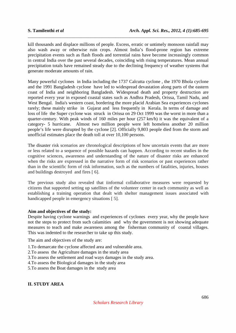
Tamil Nadu, with an area of 1, 30,058 sq.km is situated in the SE part of the Indian peninsula between North Latitudes 080 00’ and 130 30’ East longitudes 760 15’ and 800 18’. It is bounded in the east by the Bay of Bengal, in the south by Indian Ocean, in the west by the Kerala state and Arabian Sea while in the north by Karnataka and Andhra Pradesh. The area of Tamil Nadu is drained by a number of Rivers, such as Palar, Cheyyar, Ponnaiyar, Cauvery, Moyar, Bhavani, Amaravathi, Vaigai, Tamirabarani etc., Pondicherry and its surrounding lie in the drainage basin of the Gingee River. Karaikkal is located in the fertile Cauvery delta and is fed by the waters of Arasalar, Nattar, Vanjiyar and Nandalar. The Pondicherry and Karaikkal districts of the union Territory of Pondicherry encompass a total area of 492 sq.km. The location map of the study area is given below (fig 1).
Fig.1.location of the study area.
Geomorphologically, three major units are recognized from west to east. The western part comprises the western Ghats roughly trending N-S and marked by a continous range of hills, extending from Nagercoil in the south upto Nilgiri Bilgirirangan hills in the north and further northwards through Karnataka. The elevation of these hills ranges between 1275m and 2637m. The prominent hills are Mahendragiri, Agasthiramalai, Annaimalai, Palani and Nilgiris. Doddabetta with an elevation of 2637m is the highest peak in the Nilgiri hills. The east – west trending Palghat gap is a prominent physiographic break in the western ghats. The central part of the state is a vast track of dissected pediments and pediplains. Residual hills in this part viz., Shevaroy, Kalrayan, Chitteri, Kollimalai, Pachchaimalai and Javadi demarcate the extensions of Eastern Ghats, while Karandamalai, Sirumalai and Kodaikanal hills form another set of residual hills, further south. The eastern part of Tamil Nadu and Pondicherry and Karaikkal are marked by a coastal plain with associated landforms like vast tidal flats, continuous beach ridges, estuaries and lagoons and a narrow but fairly continuous beach. The coastline of Tamil Nadu and Pondicherry comprises a number of cusps, spits and wave cut platforms and several palaeo-shorelines. Some of the
S. Tamilenthi et al Arch. Appl. Sci. Res., 2012, 4 (1):685-695 ______________________________________________________________________________
688 Scholars Research Library
palaeo-shorelines extend inland suggesting periods of transgression and regression. The ongoing geodynamic process is generally progradation along the coast, which is modified at several places by erosion and deposition by Aeolian and fluvial agents. The eastern areas of the central part of the state are marked by the depositional regime of many rivers manifested by typical fluvial features like levees, channel bars and palaeochannels, back swamps and vast flood plains. The climate of the state is tropical monsoon type. In the plains, the temperature during winter seldom goes below 180 c while in peak summer it rises to 430 c. Tamil Nadu and Puducherry receive rains from both the northeast and southwest monsoons. Maximum rainfall and occasional cyclones occur during the northeast monsoon. The Nilgiris receive the maximum rainfall while Ramanathapuram and Tirunelveli districts receive low rainfall. The annual rainfall varies between 60cm and 118 cm. The study area is experiencing two monsoon climates. These are Southwest monsoon climate – (June, July, August, and September) and Northeast monsoon climate – (October, November, December). “Thane” cyclone was formed by northeast monsoon period of the Dec 30th in the year of 2011. In Tamil Nadu, North west monsoon gives maximum rainfall of 44cm. But this year ‘THANE cyclone of North east monsoon rainfall reached the limit of 54cms with the increase of 10 cms.
MATERIALS AND METHODS The data is collected from secondary sources of the information. This study comprises of spatial and non spatial data. The researcher applied simple statistics and descriptive. Filed visit to different parts of the cyclone affected area in study area also incorporated for the analysis. Geographical information system is used to demarcate the study area and mapping of cyclone affected area. The analysis of the damages caused by the cyclone is described and given in tabular form.
IV. Analysis Areas affected by THANE cyclone: Thane cyclone was mainly affected into the areas of Cuddalore, Puducherry, Villupuram, Kanjipuram, Thiruvallur, Chennai, Napattinam, Thiruvarur, and Thanjavur. The detailed study of the cyclone related damages of followed. The weather bulletin further warned that extensive damage may be caused to houses with thatched roof and huts along the coast. Tidal wave with height reaching over one meter above astronomical tide could inundate the low lying areas of Chennai, Thiruvallur, Kanchipuram, Cuddalore, Villupuram and Nagapattinam districts of Tamil Nadu and Puducherry, when the storm crosses the coast. Great Danger Signal Number Eleven has been hoisted at Puducherry and Cuddalore ports, while Great Danger Signal number nine has been hoisted at Chennai and Ennoore ports. The velocity of cyclone and the intensity was almost clearly given in advance through the forecasting this is evidence from the following information’s and statements. Cyclone warning with FLAG NUMBERS indicates the flowing information:
S. Tamilenthi et al Arch. Appl. Sci. Res., 2012, 4 (1):685-695 ______________________________________________________________________________
689 Scholars Research Library
1) Low pressures would be forming and the cyclone will occur. 2) Confirmed that the cyclone is formed. 3) The atmospheric condition is sudden wind with rainfall. 4) Not much harmful cyclone may occur in coastal/harbour areas. 5) In the event of cyclone from left side of the harbour area, the weather and atmospheric condition will be severe. 6) In the event of cyclone from right side of the harbour area, the weather and atmospheric condition will be severe. 7) The atmospheric condition caused by the cyclone will affect severally in the harbour area. 8) The port will experience severe weather from a severe cyclone expected to move keeping the port to the left of its track. 9) The port will experience severe weather from a severe cyclone expected to move keeping the port to the right of its track. 10) Cyclone will cause more danger and will be affected severely. 11) The flag hoisting is final. This number is warning for disconnecting the weather forecast and telecommunications.
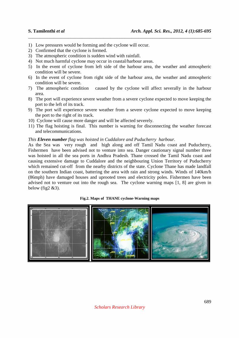
This Eleven number flag was hoisted in Cuddalore and Puducherry harbour. As the Sea was very rough and high along and off Tamil Nadu coast and Puducherry, Fishermen have been advised not to venture into sea. Danger cautionary signal number three was hoisted in all the sea ports in Andhra Pradesh. Thane crossed the Tamil Nadu coast and causing extensive damage to Cuddalore and the neighbouring Union Territory of Puducherry which remained cut-off from the nearby districts of the state. Cyclone Thane has made landfall on the southern Indian coast, battering the area with rain and strong winds. Winds of 140km/h (86mph) have damaged houses and uprooted trees and electricity poles. Fishermen have been advised not to venture out into the rough sea. The cyclone warning maps [1, 8] are given in below (fig2 &3).
Fig.2. Maps of THANE cyclone-Warning maps
S. Tamilenthi et al Arch. Appl. Sci. Res., 2012, 4 (1):685-695 ______________________________________________________________________________
690 Scholars Research Library
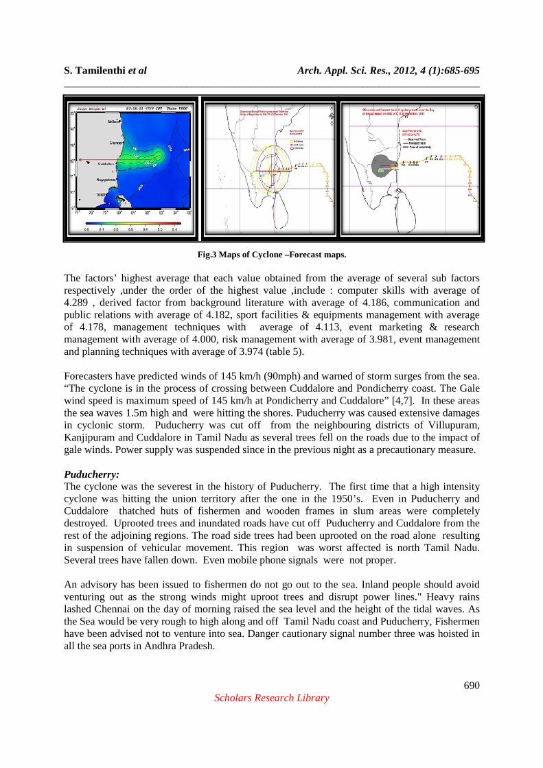
Fig.3 Maps of Cyclone –Forecast maps. The factors’ highest average that each value obtained from the average of several sub factors respectively ,under the order of the highest value ,include : computer skills with average of 4.289 , derived factor from background literature with average of 4.186, communication and public relations with average of 4.182, sport facilities & equipments management with average of 4.178, management techniques with average of 4.113, event marketing & research management with average of 4.000, risk management with average of 3.981, event management and planning techniques with average of 3.974 (table 5). Forecasters have predicted winds of 145 km/h (90mph) and warned of storm surges from the sea. “The cyclone is in the process of crossing between Cuddalore and Pondicherry coast. The Gale wind speed is maximum speed of 145 km/h at Pondicherry and Cuddalore” [4,7]. In these areas the sea waves 1.5m high and were hitting the shores. Puducherry was caused extensive damages in cyclonic storm. Puducherry was cut off from the neighbouring districts of Villupuram, Kanjipuram and Cuddalore in Tamil Nadu as several trees fell on the roads due to the impact of gale winds. Power supply was suspended since in the previous night as a precautionary measure. Puducherry: The cyclone was the severest in the history of Puducherry. The first time that a high intensity cyclone was hitting the union territory after the one in the 1950’s. Even in Puducherry and Cuddalore thatched huts of fishermen and wooden frames in slum areas were completely destroyed. Uprooted trees and inundated roads have cut off Puducherry and Cuddalore from the rest of the adjoining regions. The road side trees had been uprooted on the road alone resulting in suspension of vehicular movement. This region was worst affected is north Tamil Nadu. Several trees have fallen down. Even mobile phone signals were not proper. An advisory has been issued to fishermen do not go out to the sea. Inland people should avoid venturing out as the strong winds might uproot trees and disrupt power lines." Heavy rains lashed Chennai on the day of morning raised the sea level and the height of the tidal waves. As the Sea would be very rough to high along and off Tamil Nadu coast and Puducherry, Fishermen have been advised not to venture into sea. Danger cautionary signal number three was hoisted in all the sea ports in Andhra Pradesh.

S. Tamilenthi et al Arch. Appl. Sci. Res., 2012, 4 (1):685-695 ______________________________________________________________________________
691 Scholars Research Library
Fig.4.Thane cyclone affected areas.
Thane crossed the Tamil Nadu coast and causing extensive damage to Cuddalore and the neighbouring Union Territory of Puducherry which remained cut-off from the nearby districts of
S. Tamilenthi et al Arch. Appl. Sci. Res., 2012, 4 (1):685-695 ______________________________________________________________________________
692 Scholars Research Library
the state. Cyclone Thane has made landfall on the southern Indian coast, battering the area with rain and strong winds. The cyclone damaged areas and details have given (fig.4).
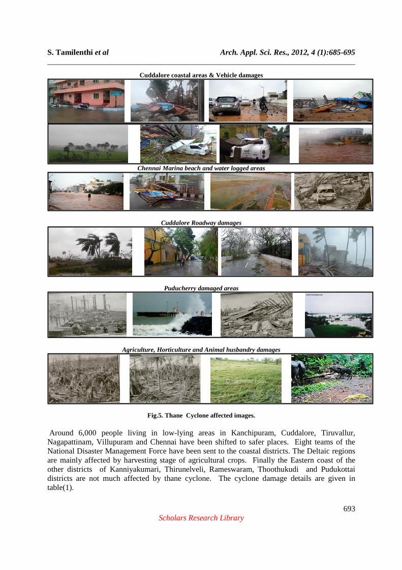
Cuddalore district: Cuddalore district of Tamil Nadu is spread over 3,678 Sq. km of Tamil Nadu. As per 2001 census, the district has the population of 22, 85,395, comprising of 11, 50,908 male and 11,34,487 female population. Major food crops grown in Cuddalore district are paddy, groundnut, sugarcane, cholam, cambu, red gram, tapacoa, greengram, black gram, coriander, banana, maize, varagu, and cashewnut. Some other crops that are grown in the region are gingelly, cotton, groundnut, and coconut. An official said around 400 trees had been uprooted on the Cuddalore-Chidambaram roads, resulting in suspension of vehicular movement. Power production at the Lignite Neyveli Corporation was affected as the mines were submerged. Cuddalore district in Tamil Nadu was the most affected, with damaged roads rendering it difficult for rescue teams including those from National Disaster Response Force and Fire and Rescue Services to reach the cyclone hit fishing hamlets. Cuddalore district is highly affected into agriculture, settlements, boat damages, electrical goods damages and transportation damages was caused. The region worst affected is northern Tamil Nadu. Chennai: Chennai flight services were also disrupted due to the cyclonic storm with four international services, including those bound for Kuwait and Kuala Lumpur were cancelled. The cyclonic storm brought in copious overnight rainfall coupled with squally winds uprooting trees in some places of Chennai and elsewhere. The railway management announced around two hour delay in the arrival of some trains to Chennai Egmore station. In many places of Chennai city were highly surrounded water and human normal life was highly affected. In Chennai the Marina beach area 500mts of water’s was surrounding and many boats were damaged. Traffic on the East Coast Road was disrupted due to uprooted trees. Thousands of people reached relief camps in Cuddalore as the strong wind blew off the thatched roofs of houses. The high speed wind also uprooted hundreds of trees, electric poles, traffic signal poles and mobile phone towers and damaged standing crops across the coastal districts in Tamil Nadu and Puducherry. The cyclone ‘THANE’ affected field photos have given below (Fig.5).
Deltaic Regions: The Deltaic region of the Thiruvarur, Nagapattinam, and Thanjavur region also the cyclone affect by harvesting stage of the agricultural crops have damaged. Standing paddy crop on the Cauvery delta region is estimated to have been damaged due the high speed cyclonic wind. In the deltaic regions , the cyclone was travelled the whole day it was rained. In Nagapattinam coastal lands are eroded and fisherman boats have highly damaged. The residents of Cuddalore and Nagapattinam district, the Cyclone Thane brought back memories of the 2004 Tsunami, when giant tidal waves swept aside entire habitations, killing thousands of people. Ironically, that had also happened towards the end of December [3].
S. Tamilenthi et al Arch. Appl. Sci. Res., 2012, 4 (1):685-695 ______________________________________________________________________________
693 Scholars Research Library
Cuddalore coastal areas & Vehicle damages
Chennai Marina beach and water logged areas
Cuddalore Roadway damages
Puducherry damaged areas
Agriculture, Horticulture and Animal husbandry damages
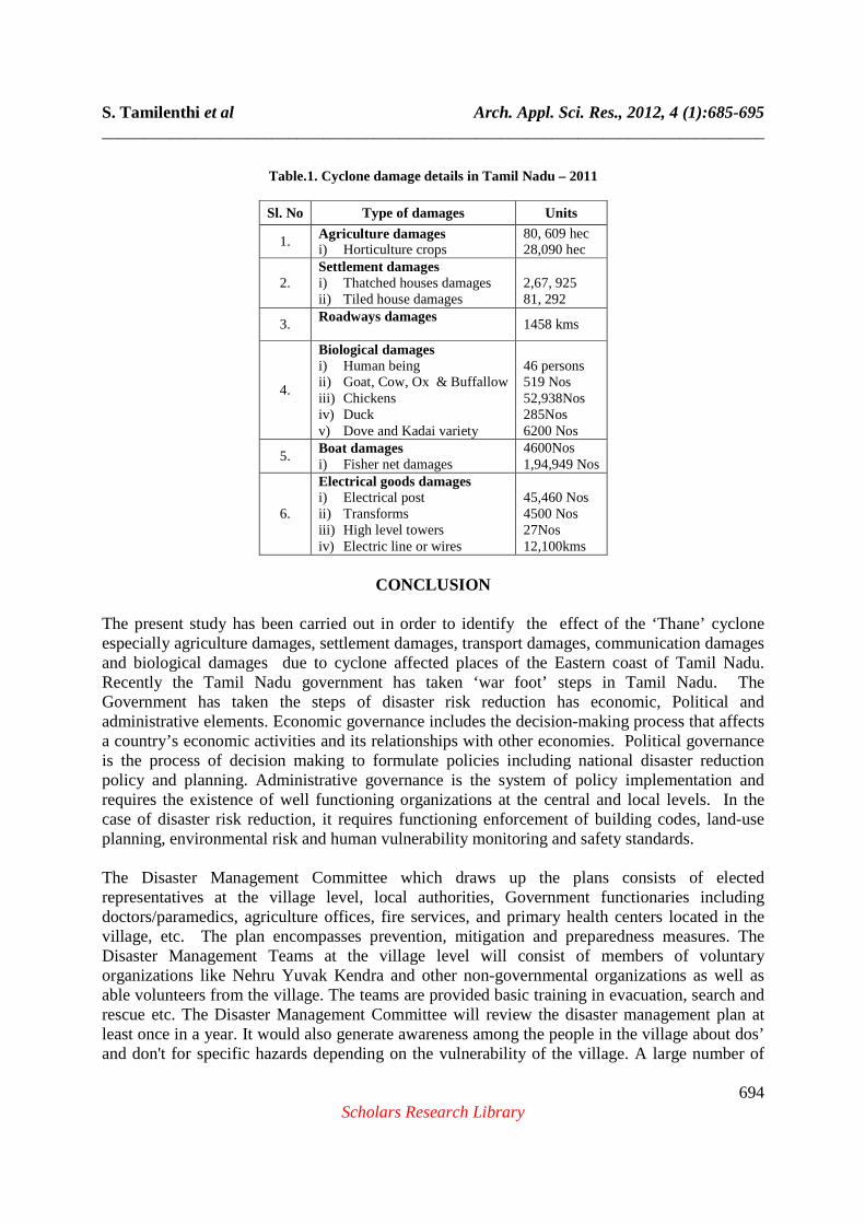
Fig.5. Thane Cyclone affected images. Around 6,000 people living in low-lying areas in Kanchipuram, Cuddalore, Tiruvallur, Nagapattinam, Villupuram and Chennai have been shifted to safer places. Eight teams of the National Disaster Management Force have been sent to the coastal districts. The Deltaic regions are mainly affected by harvesting stage of agricultural crops. Finally the Eastern coast of the other districts of Kanniyakumari, Thirunelveli, Rameswaram, Thoothukudi and Pudukottai districts are not much affected by thane cyclone. The cyclone damage details are given in table(1).
S. Tamilenthi et al Arch. Appl. Sci. Res., 2012, 4 (1):685-695 ______________________________________________________________________________
694 Scholars Research Library
Table.1. Cyclone damage details in Tamil Nadu – 2011
Sl. No Type of damages Units
1. Agriculture damages i) Horticulture crops
80, 609 hec 28,090 hec
2. Settlement damages i) Thatched houses damages ii) Tiled house damages
2,67, 925 81, 292
3. Roadways damages
1458 kms
4.
Biological damages i) Human being ii) Goat, Cow, Ox & Buffallow iii) Chickens iv) Duck v) Dove and Kadai variety
46 persons 519 Nos 52,938Nos 285Nos 6200 Nos
5. Boat damages i) Fisher net damages
4600Nos 1,94,949 Nos
6.
Electrical goods damages i) Electrical post ii) Transforms iii) High level towers iv) Electric line or wires
45,460 Nos 4500 Nos 27Nos 12,100kms
CONCLUSION
The present study has been carried out in order to identify the effect of the ‘Thane’ cyclone especially agriculture damages, settlement damages, transport damages, communication damages and biological damages due to cyclone affected places of the Eastern coast of Tamil Nadu. Recently the Tamil Nadu government has taken ‘war foot’ steps in Tamil Nadu. The Government has taken the steps of disaster risk reduction has economic, Political and administrative elements. Economic governance includes the decision-making process that affects a country’s economic activities and its relationships with other economies. Political governance is the process of decision making to formulate policies including national disaster reduction policy and planning. Administrative governance is the system of policy implementation and requires the existence of well functioning organizations at the central and local levels. In the case of disaster risk reduction, it requires functioning enforcement of building codes, land-use planning, environmental risk and human vulnerability monitoring and safety standards. The Disaster Management Committee which draws up the plans consists of elected representatives at the village level, local authorities, Government functionaries including doctors/paramedics, agriculture offices, fire services, and primary health centers located in the village, etc. The plan encompasses prevention, mitigation and preparedness measures. The Disaster Management Teams at the village level will consist of members of voluntary organizations like Nehru Yuvak Kendra and other non-governmental organizations as well as able volunteers from the village. The teams are provided basic training in evacuation, search and rescue etc. The Disaster Management Committee will review the disaster management plan at least once in a year. It would also generate awareness among the people in the village about dos’ and don't for specific hazards depending on the vulnerability of the village. A large number of
S. Tamilenthi et al Arch. Appl. Sci. Res., 2012, 4 (1):685-695 ______________________________________________________________________________
695 Scholars Research Library
village level Disaster Management Committees and Disaster Management Teams have already been constituted.
Recommendations
1) The government should take the steps to erect the walls for preventing from the flood prone area and sea level rise. 2)The deltaic regions are highly experienced the agricultural loss, hence the government should announce to removal of agricultural loans. 3) The government should provide the aid to people to built up and other basic needs to into normal life to the severely affected areas of the Cuddalore and Pondicherry area
4) The plan should be based on an integrated approach covering all relevant aspects of water management, infrastructural facilities, physical planning, land use, agriculture, transport and urban development, nature conservation at all levels (national, regional and local). 5)In the development of a management plan, decision makers at all levels (local, regional, national and international) as well as stakeholders and civil society should be involved. Acknowledgments The authors are thankful to the Department of Earth science, Tamil University, Thanjavur, Tamil Nadu, India to carry out this research work. The authours also thankful to the meteorological department, Chennai and NRSA, Hyderabad for using the published information and maps for this research.
REFERENCES
[1] http://thewatchers.adorraeli.com/2011/12/30/tropical-cyclone-thane-striking-southern-india/ [2] http://www.fsi.org.in/fsi_projects/assessment_of_damage.pdf [3] http://www.google.co.in/search?q=thane+cyclone+in+Tamil+nadu+puducherry+damage+ images&hl=en&biw=1366&bih=639&tbm=isch&prmd=imvns&ei=nP4aT6aeIsmohAe F9cyqDA&start=60&SA=N [4] Joint Typhoon Warning Center. Tropical Cyclone 06B (Thane) Warning. Accessed December 28, [2011]. [5] Lee, T., H. Tsubokawa, and T. Nagasaka. Re-Organizing of Local Disaster Prevention Capabilities through Scenario-Based Risk Communication: A Case Study of Tsukuba City in Japan. Proceedings of 3rd Global Disaster and Risk Conference, Davos [2011]. [6] Schank, R. C. 1990. Tell me a Story: A New Look at Real and Artificial Memory. New York: John Brockman Associates Inc,[1990]. [7] Unisys. (2011, December 28). Thane Tracking Information. Accessed on December 28, [2011]. [8] Very Severe Cyclonic Storm “THANE” over the Bay of Bengal (25-31 December,2011): A Report, India meteorological department, Ministry of Earth Sciences Government of India Cyclone Warning Division, New Delhi, Dec[2011].


![A Review of Numerical Modelling of Cyclones and Tsunamis ... · in Bangladesh by the 1991 Cyclone [5]. The deadliest tropical cyclone in Bangladesh was the 1970 Bhola Cyclone, which](https://img.pdfslide.us/doc/110x75/5fa19e80ffcba10c716dea27/a-review-of-numerical-modelling-of-cyclones-and-tsunamis-in-bangladesh-by-the.jpg)


![1737 - micromatic.com · 1737-l long shanks 1737-s short shanks 1738-l long shanks 1738-s short shanks 1066.8 [42.0] 76.2 [3.0] 990.6 [39.0] (13) spaces 76.2 [3.0] apart ref. 38.1](https://img.pdfslide.us/doc/110x75/5f8352f9a944be5a795c3526/1737-1737-l-long-shanks-1737-s-short-shanks-1738-l-long-shanks-1738-s-short-shanks.jpg)