Embed Size (px)
Citation preview
Regional Committee of United Nations Global Geospatial Information Management for Asia and the Pacific
(UN-GGIM-AP)
Working Group 3 on Regional SDI
Activity Report
for
The Sixth Plenary Meeting
Kumamoto, Japan
October 16-19 2017
Chair
Ms. Jie Jiang, China – [email protected]
Vice Chairs
Mr. Simon Costello, Australia, [email protected]
Mr. Lee Sangho, Korea, [email protected]
Ms. Bayarmaa Enkhtur, Mongolia, [email protected]
Mr. Alireza Vafaee Nejad, Iran, [email protected]
1. BRIEF OF WORKING GROUP3
1.1 Background
Regional sustainable development must aim at a high level of taking into account the
diversity of situations in the various regions of the UNGGIM-AP members. The balanced
developed, interoperable and sharable Geo-spatial information in the region is essential
for the regional sustainable development.
Many NSDIs have been established in the member countries. But a number of problems
exist regarding the availability, quality, uniformity, accessibility and sharing of spatial
information.
It is necessary to promote the common understanding of establishing a regional SDI by
using unified data standards, and to share or interoperate the SDI for location-based
services.
1.2 Timeline
The work began 2015 and continued through 2018.
1.3 Membership of the Working Group
Chair:
Ms. jiang Jie
Director & Chief Engineer, Dept. of Geoinformation Service Platform
National Geomatics Center of China
E-mail:[email protected]
Vice-Chairs:
Mr. Simon Costello
Branch Head, National Location Information
Environmental Geoscience Division, Geoscience Australia
Email: [email protected]
Mr. Lee Sangho
Geographic Information Department
National Geographic Information Institute
Email: [email protected], [email protected]
Ms. Bayarmaa Enkhtur
Head of Geospatial information and technology Department, ALAGaC, Mongolia
Email:[email protected]
Dr. Alireza Vafaee Nejad
General Manager of GIS and SDI in National Cartographic Center of Iran (NCC)
Email:[email protected]
2. RESOLUTIONS ADOPTED AT THE 20th UNRCC-AP (corresponds to WG3)
The Conference:
Noting
• the increasing regional issues and location based services require the access and sharing of geo-spatial information among countries for regional sustainable development;
• the increasing demand for effective on-line location-based services from government, professional agencies and public;
• the establishment of national geospatial data infrastructures in some countries; while there are different levels of development of NSDI among the countries;
• national geospatial portals have been established in some countries to improve the accessibility and application of the data; while the interoperability among these portals may not be achieved;
• the problems regarding availability, quality, interoperability, accessibility and sharing of geospatial data among the countries;
• the need to keep the efforts technical in nature so as not to raise political concerns.
Recommends that
• Conduct a survey to investigate and assess the current status of NSDI development of the member countries, with focus on access, management,
update, web-based services and sharing of data/service;
• Identify the common data standards, including data themes, specifications and metadata catalogue for regional SDI as well as common service standards, including interfaces and specifications for the interoperability of portals; draft data and service sharing rules;
• Conduct pilot project with some countries to test the mechanisms of sharing data under pre-drafted rules and integrate web-based services/portals for the interoperation of the NSDIs;
• Refine the data/service standards and data/service sharing rules based on the results of the pilot projects; develop guidelines on the use of these standards and rules for regional SDI; disseminate these guidelines to the countries of the region;
• Develop joint action programs for the provision of educational and training for the data sharing, portal construction, and application for regional SDI.
3. WORK PLAN OF WG3
No Activities/Steps Period Targeted goals
1 Conduct a survey to investigate and assess the current status of NSDI development of the member countries, with focus on access, management, update, web-based services and sharing of data/service
2015-2018 1st draft report in the middle of 2016; 2nd draft report in the end of 2017; final report in the middle of 2018
2 Identify the common data standards, including data themes, specifications and metadata catalogue for regional SDI as well as common service standards, including interfaces and specifications for the interoperability of portals; draft data and service sharing rules;
2015-2018 1st draft in the middle of 2016; 2nd draft in the end of 2017; final report in the middle of 2018
3 Conduct pilot project with some countries to test the mechanisms of sharing data under pre-drafted rules and integrate web-based services/portals for the interoperation of the NSDIs;
2016-2018 As soon as the cooperation established among countries including China, Korea, Indonesia, Mongolia, Viet Nam
Pilot projects be finished by the middle of 2018
5 Training courses on regional SDI, portal/platform and application
2016-2018 Pending on the availability of the fund, should be conducted before the ending of the pilot projects

6 Workshops, seminars co-organized with other International organizations
2016-2018 2017, co-organized with ISPRS
4. ACTIONS TAKEN BY WG3 SINCE The 5th UN-GGIM-AP Plenary Meeting
• Continue to receive and analysis the questionnaire on the status of NSDI
development of the member countries(as shown in Annex A).
• Continue to establish the pilot portal for Regional SDI Service Interoperation. New functions for adding map layers have been developed, with which users can overlay their own maps with the data from the SDI (as shown in Annex B).
• As the member of the UNGGIM Working Group on Global Fundamental Geospatial Data, communicate with the WG to share the activities and achievements of UNGGIM-AP WG3 on promote regional SDI interoperation (as shown in Annex C).
• Organize the International Seminar on Construction and Application of Spatial Data Infrastructure (Sept. 15-22, 2017, China). (as shown in Annex D).
• Co-preparing the ISPRS Technical Commission Symposium on ‘Developments, Technilogies and Applications in Remote Sensing’, May 7-10,
2018, Beijing (as shown in Annex E)
Annex A
Elementary Analysis to the Questionnaire on the Current Status of Spatial Data
Infrastructure in AP Region
The Questionnaire was designed by UN-GGIM-AP WG 3 on “Regional SDI”, with
focus on access, management, update, web-based services and sharing of
data/service. The questionnaire has been distributed to member countries by the
Secretariat of UN-GGIM-AP in June 2016. Ten replies have been received by March
2017, including Bangladesh, Brunei, China, HKSAR, Japan, Laos, Mongolia, Nepal,
Australia, Viet Nam. Analysis was made to these 10 replies, some preliminary
conclusions were made and reported to the Fifth Plenary Meeting and EB meeting.
The WG has involved in the ISPRS-UNGGIM Project on the Status of Topographic
Mapping in the World which has led to interesting results. ISPRS has decided to
launch another questionnaire “The Current Status of Mapping in the World 2017” send
through the UN Secretariat to the UN Member States. WG3 will do further analysis
based on the replies to this new questionnaire from UNGGIM-AP members.
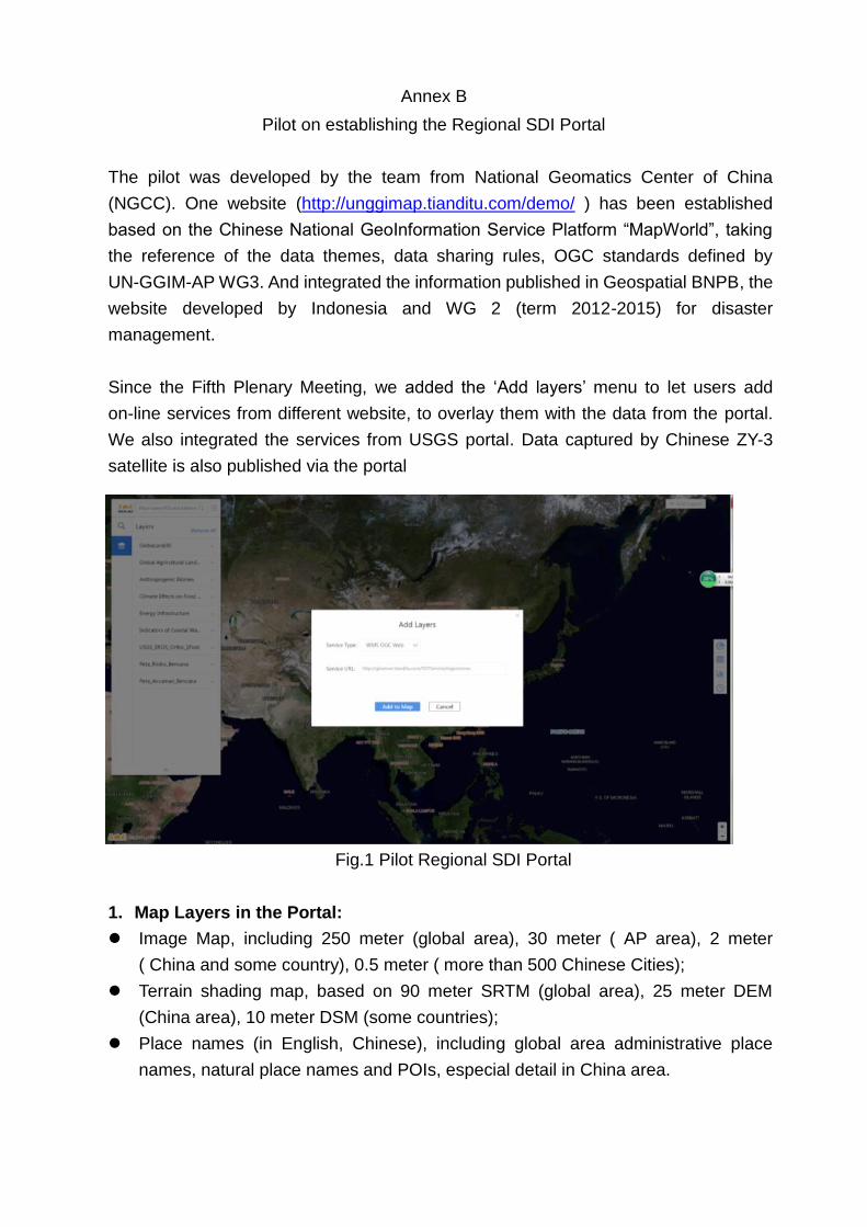
Annex B
Pilot on establishing the Regional SDI Portal
The pilot was developed by the team from National Geomatics Center of China
(NGCC). One website (http://unggimap.tianditu.com/demo/ ) has been established
based on the Chinese National GeoInformation Service Platform “MapWorld”, taking
the reference of the data themes, data sharing rules, OGC standards defined by
UN-GGIM-AP WG3. And integrated the information published in Geospatial BNPB, the
website developed by Indonesia and WG 2 (term 2012-2015) for disaster
management.
Since the Fifth Plenary Meeting, we added the ‘Add layers’ menu to let users add
on-line services from different website, to overlay them with the data from the portal.
We also integrated the services from USGS portal. Data captured by Chinese ZY-3
satellite is also published via the portal
Fig.1 Pilot Regional SDI Portal
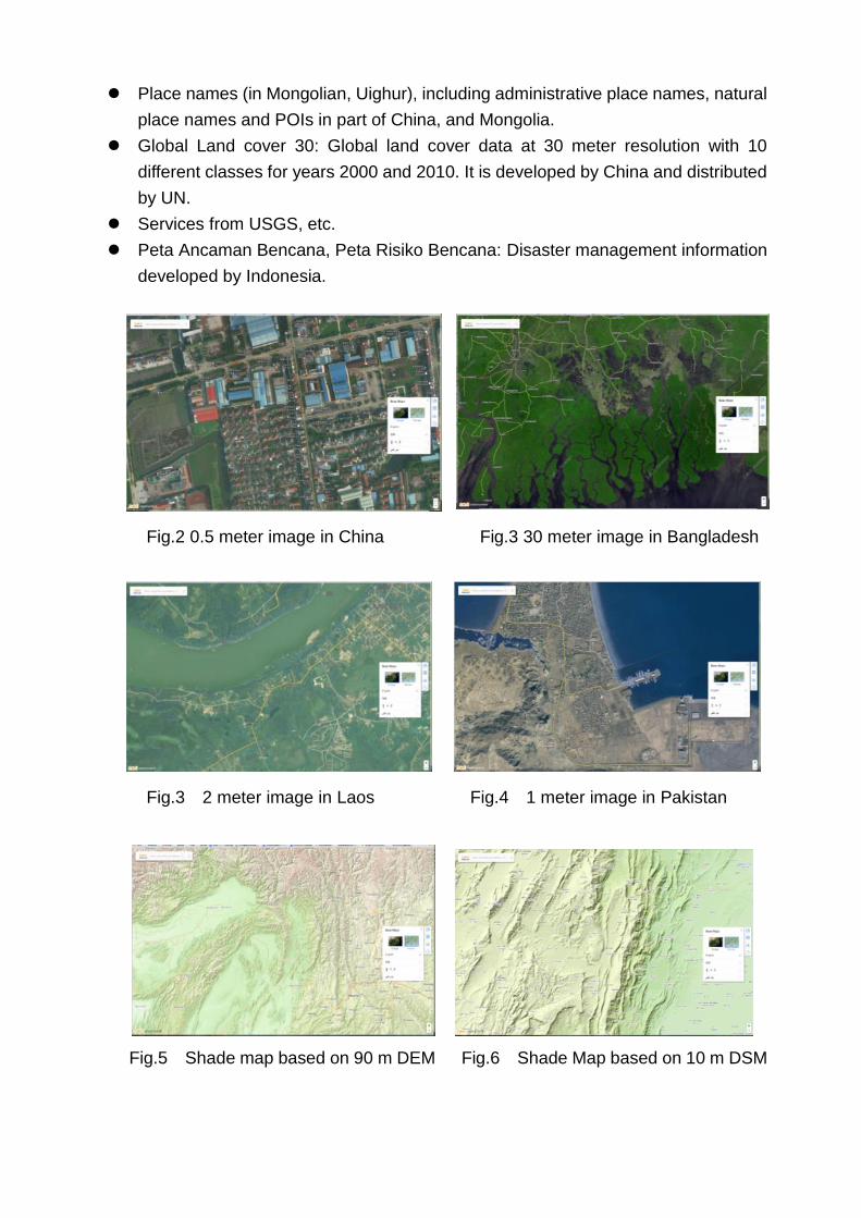
1. Map Layers in the Portal:
Image Map, including 250 meter (global area), 30 meter ( AP area), 2 meter
( China and some country), 0.5 meter ( more than 500 Chinese Cities);
Terrain shading map, based on 90 meter SRTM (global area), 25 meter DEM
(China area), 10 meter DSM (some countries);
Place names (in English, Chinese), including global area administrative place
names, natural place names and POIs, especial detail in China area.
Place names (in Mongolian, Uighur), including administrative place names, natural
place names and POIs in part of China, and Mongolia.
Global Land cover 30: Global land cover data at 30 meter resolution with 10
different classes for years 2000 and 2010. It is developed by China and distributed
by UN.
Services from USGS, etc.
Peta Ancaman Bencana, Peta Risiko Bencana: Disaster management information
developed by Indonesia.
Fig.2 0.5 meter image in China Fig.3 30 meter image in Bangladesh
Fig.3 2 meter image in Laos Fig.4 1 meter image in Pakistan
Fig.5 Shade map based on 90 m DEM Fig.6 Shade Map based on 10 m DSM
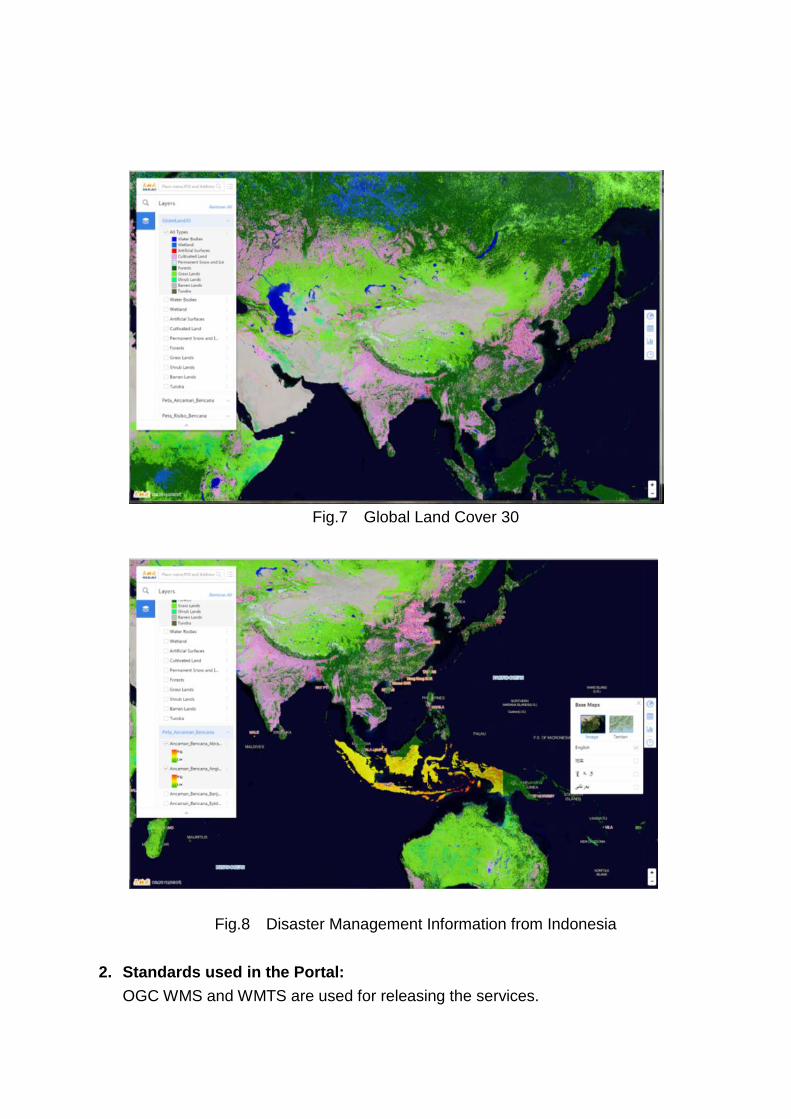
Fig.7 Global Land Cover 30
Fig.8 Disaster Management Information from Indonesia
2. Standards used in the Portal:
OGC WMS and WMTS are used for releasing the services.
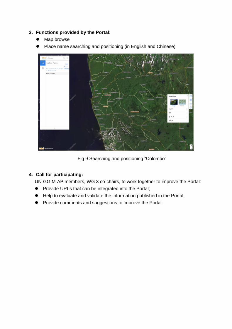
3. Functions provided by the Portal:
Map browse
Place name searching and positioning (in English and Chinese)
Fig 9 Searching and positioning “Colombo”
4. Call for participating:
UN-GGIM-AP members, WG 3 co-chairs, to work together to improve the Portal:
Provide URLs that can be integrated into the Portal;
Help to evaluate and validate the information published in the Portal;
Provide comments and suggestions to improve the Portal.

Annex C
Connection with UNGGIM WG on Global Fundamental Geospatial Data
As the member of the UNGGIM Working Group on Global Fundamental Geospatial
Data, Dr. JIANG Jie communicate with the WG to share the activities and
achievements of UNGGIM-AP WG3 on promote regional SDI interoperation.
The establishment a Working Group on Global Fundamental Geospatial Data Themes
was requested by the UN-GGIM Committee of Experts at its Fifth Session in August
2015 as per decision 5/103 Determination of global fundamental geospatial data
themes. The overall objective of the Working Group is to bring together differing
information on fundamental geospatial data themes with a view to developing an
agreed minimum set of global fundamental geospatial data themes. The Working
Group will produce a first draft of a Resolution on Global Fundamental Geospatial
Data Themes for the Committee of Experts to consider taking to the General
Assembly.
Some investigation has been done and the draft list of the data themes has been
made. Summaries of the scope of each theme have been drafted. WG3 of
UNGGIM-AP join the reviewing of the themes.
Annex D
Organize the International Seminar on Construction and Application of SDI
The International Seminar on Construction and Application of Spatial Data
Infrastructure is sponsored by the Special Funding for Regional Cooperation in Asia,
Established by the Chinese government. It is organized by the National Geomatics
Center of China, supported by NASG (National Administration of Surveying, Mapping
and Geoinformation of China), UNGGIM-AP and ISPRS TC III.
The Seminar held in Beijing (Sept. 15-17, 2017) and Wuhan (Sept. 18-22, 2017). The
agenda of Beijing period focused on practices aspects by lectures on construction,
maintenance and application of SDI, and technical visit to some company with related
techniques/software/hardware, while the Wuhan period focused on academic aspects
via 10 high-level International Workshops organized by ISPRS.
More than 80 participants from 10 countries/regions participated the Seminar, among
them 21 came from Surveying and Mapping Agencies of Association of Southeast
Asian Nations (ASEAN) and other developing countries, including Bangladesh,
Cambodia, Egypt, HK China, Kenya, Malaysia, Mongolia, Pakistan and Sri Lanka. The
organizer of the Seminar provided financial support to overseas participant, including
the accommodations and meals during Sept. 13-23, 2017, travels between Beijing and
Wuhan, registration fee for the 10 ISPRS workshops, and airport pick-up in Beijing.
The financial support is provided based on the application and reviewing and arranged
on a first-come-first-served basis.
During the Beijing period, we invited 12 top-level experts and scholars to give lectures,
for example, ‘National System for Surveying, Mapping and Geoinformation Quality
Management’ by Prof. ZHANG Jixian (Director General of National Quality Inspection
and Testing Center for Surveying and Mapping Products), ‘National Geodetic Datum
Construction and Services’ by Dr. DANG Yamin (Director, Institute of Geodesy and
Geodynamics, Chinese Academy of Surveying and Mapping), ‘National
Geo-information Database Construction and Updating’ by Dr.DU Xiao (Senior
Engineer, National Geomatics Center of China), ‘Web-based GeoInformation Service
and Interoperation’ by Dr.JIANG Jie (Division Director, National Geomatics Center of
China), ‘Global Land Cover Validation: Methodology and Practice’ by Mr. PENG Shu
(Senior Engineer, National Geomatics Center of China). Policy to Support the Foreign
Students Studying in Beijing was also introduced by Dean, School of International
Education, Beijing University of Civil Engineering and Architecture.

Technical visit to 3 companies with the abilities for overseas service were arranged.
Products and techniques from 5 companies on SDI construction, maintenance, and
application were exhibited.
The Seminar is quite successful and all participants are satisfied with the academic
contents and the logistics arrangement. They also made friends, shared the
experience and technologies from different countries/regions, and discussed ideas on
international collaborations.
Experiences will be analyzed and we are planning further Seminar/Tutorials next year.
Annex E
Co-preparing the ISPRS Technical Commission Symposium, 2018
As the President of ISPRS Technical Commission on Remote Sensing, Dr. Jiang Jie is
organizing the ISPRS Symposium on “Developments, Technologies and Applications
in Remote Sensing”, May 7-10, 2018, in Beijing. More than 400 participants are
expected and high level presentations and exhibitions will be arranged.
We are planning ISPRS-UNGGIM-AP joint technical sessions and another
Seminar/Tutorial during the Symposium. Travel Grants will be provided by ISPRS on
application. Participants from the member countries are mostly welcome.