Embed Size (px)
Citation preview

UN-GGIM Expanded Bureau Meeting
7-9 December 2016, UN Headquarters, New York
UN-GGIM: Arab States Activities

• The establishment of the UN-GGIM: Arab States came in fulfillment
of Decision 4/111 of the Fourth session of United Nations
Committee of Experts on Global Geospatial Information
Management (UN-GGIM), held in New York in August 2014.
• UN-GGIM: Arab States held three Meetings
1. Riyadh 1st Meeting Feb 2015
2. Algeria 2nd Meeting July 2015
3. Abu Dhabi 3rd Meeting Feb 2016
2
UN-GGIM: Arab States Background
2

1. WG1: Institutional Arrangements , Legal and Policy Issues, Awareness and Capacity Building (Chair: United Arab Emirates and Vice-Chair: Morocco)
2. WG2: Fundamental Data and Geo-Standards (Chair: Tunisia and Vice-Chair: Qatar)
3. WG3: Geodetic Reference Frame (Chair: Algeria and Vice-Chairs: Lebanon and Saudi Arabia)
4. WG4: Integration of Geospatial & Statistical Information (Chair: Oman and Vice-Chairs: Egypt and Kuwait)
3
UN-GGIM: Arab States Background
Four Working Groups
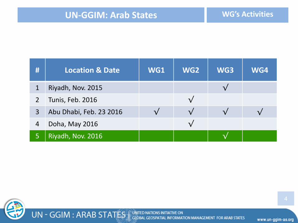
# Location & Date WG1 WG2 WG3 WG4
1 Riyadh, Nov. 2015 √
2 Tunis, Feb. 2016 √
3 Abu Dhabi, Feb. 23 2016 √ √ √ √
4 Doha, May 2016 √
5 Riyadh, Nov. 2016 √
4
UN-GGIM: Arab States WG’s Activities

• Agree to re-assess the priorities for the activities
• Create a mutually acceptable action plan for all member states.
• Increase the cooperation with UNGGIM NIA
• Re-circulate the existing UNGGIM NIA-questionnaire through Member States
6
Institutional Arrangements , Legal and Policy Issues,
Awareness and Capacity Building
WG 1

• Present National experiences in building Geospatial Information Infrastructure
• Agree on the Importance of Geospatial Information Infrastructure for decision-making at all levels
• Develop the Geospatial Information Infrastructure components according to best practices
• Analyze the Themes / Layers Questioners
• Agree to start with 11 Themes by the members to be used as Fundamental Data Themes
• Adopt and implement international standards to develop the national fundamental data infrastructure
7
Fundamental Data and Geo-Standards WG 2
8
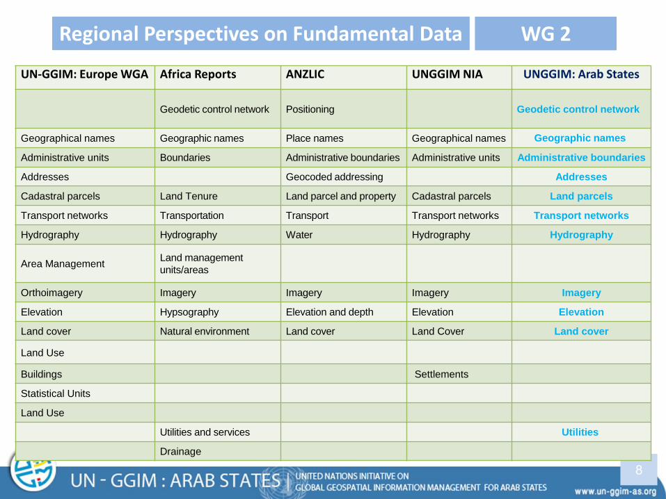
Regional Perspectives on Fundamental Data WG 2
UN-GGIM: Europe WGA Africa Reports ANZLIC UNGGIM NIA UNGGIM: Arab States
Geodetic control network Positioning Geodetic control network
Geographical names Geographic names Place names Geographical names Geographic names
Administrative units Boundaries Administrative boundaries Administrative units Administrative boundaries
Addresses Geocoded addressing Addresses
Cadastral parcels Land Tenure Land parcel and property Cadastral parcels Land parcels
Transport networks Transportation Transport Transport networks Transport networks
Hydrography Hydrography Water Hydrography Hydrography
Area Management Land management
units/areas
Orthoimagery Imagery Imagery Imagery Imagery
Elevation Hypsography Elevation and depth Elevation Elevation
Land cover Natural environment Land cover Land Cover Land cover
Land Use
Buildings Settlements
Statistical Units
Land Use
Utilities and services Utilities
Drainage

UN-GGIM: Arab States Fundamental Data Themes / Layers
Geodetic control network
Addresses
Land Parcels
Geographic Names
Hydrography
Adm. Boundaries
Transport Network
Utilities
Land Cover
Elevation
Imagery
9
Fundamental Data Themes WG 2
Hydrography
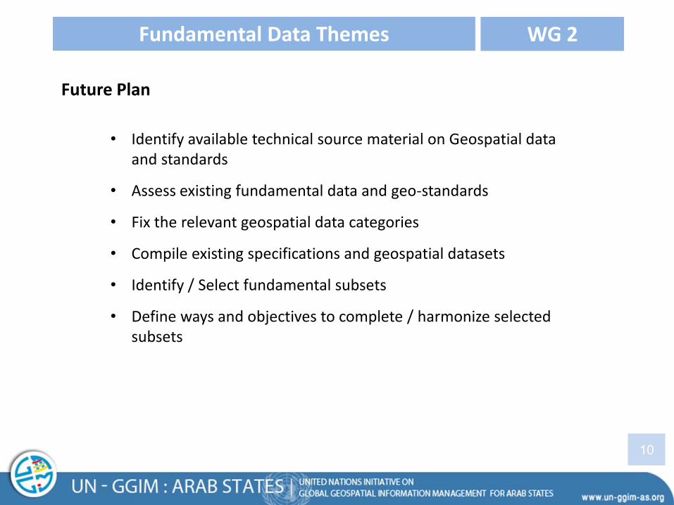
Future Plan
10
Fundamental Data Themes WG 2
• Identify available technical source material on Geospatial data and standards
• Assess existing fundamental data and geo-standards
• Fix the relevant geospatial data categories
• Compile existing specifications and geospatial datasets
• Identify / Select fundamental subsets
• Define ways and objectives to complete / harmonize selected subsets

11
Geodetic Reference Frame WG3
GRF WG 3rd meeting held in Riyadh from 22nd to 24th November 2016
• 20 representatives of 10 Arab countries: Algeria, Egypt, Jordan, Lebanon, Morocco, Oman, Qatar, Saudi Arabia, Sudan, and Tunisia.
• Meeting Agenda
• Discuss Questionnaires Analysis results
• Establishing Data Center
• Establishing Analysis Center
• CORS for ARABREF
• Geospatial Information exchange Protocol
• Capacity Building Program in Geodetic Reference frame
• Arab Countries achievements
• Geodetic Reference Frame Road Map

12
Geodetic Reference Frame WG3
GRF WG 3rd meeting held in Riyadh from 22nd to 24th November 2016
pmldtJJvcOcqlAEnodOQ9zqFpZX8drv.ms/f/s!Aj1https://

13
Geodetic Reference Frame WG3
General Commission for Survey(GCS) - Saudi Arabia, organized GRF symposium on 24 Nov 2017 as Regional Practice includes:
pmldtJJvcOcqlAEnodOQ9zqFpZX8drv.ms/f/s!Aj1https://
• Geodetic Activities in GCS, (Eng.Othman Alkoryief)
• The International Terrestrial Reference Frame (ITRF) for science and societal applications, (Dr.Zuhier Al-Tamimi, IGN)
• Developing improved geoid model for KSA ,(Prof.Rene Forsberg,DTU)
• Towards a modern reference frame for the KSA, (Dr.Julia Talaya, ICGC)
• A Preliminary Vertical Datum Definition for KSA ,(Dr.Mehmet Emin,GCS)
• Satellite altimetry and GOCE contribution to the pre-definition of KSA national vertical reference frame –SANVRF, (Dr.Georgios Vergos, Geodesy & Surveying)
• Geodetic activities towards definition of KSA spatial reference system, (Dr.Rossen Grebenitcharsky ,GCS advisor)
• Toward a Nationl Strategy for Goespatial Information , (Dr.Saad Al-Hamlan, NCGIS)

14
Geodetic Reference Frame WG3
GRF WG 3rd meeting Recommendations
pmldtJJvcOcqlAEnodOQ9zqFpZX8drv.ms/f/s!Aj1https://
REC-I Main Recommendation
REC-01 Encourage UN-GGIM-AS members to coordinate their
contribution to ARABREF at the national level
REC-02
Approval of the need to establish ARABREF: an Arab common
geodetic reference frame for cross-boundary geodetic, geospatial,
geophysical, and other applications
REC-03 Approve the principle, importance and spirit of data sharing to
support the realization of ARABREF
REC-04
Define two phases for building the ARABREF:
• Phase 1: GNSS data analysis of ARABREF CORS
network
• Phase 2: physical geodesy data analysis of ARABREF
vertical network (e.g. Geoid, gravity, leveling, tide
gauges)
• Adopt and start with Phase 1
15
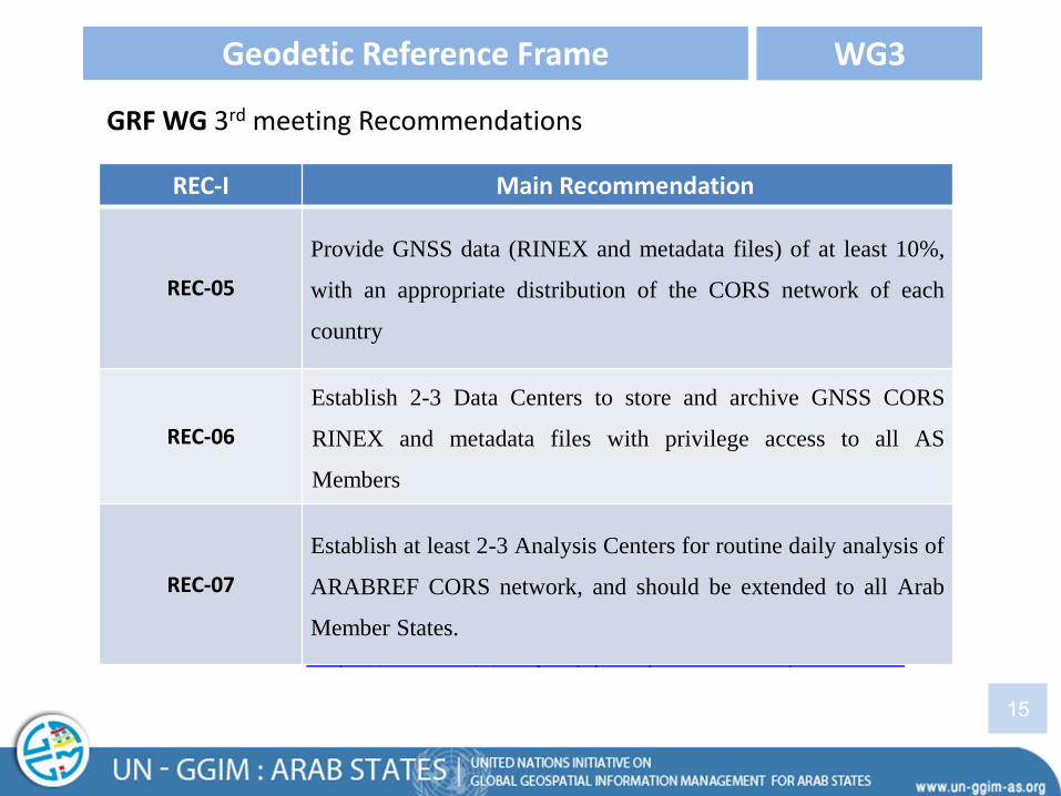
Geodetic Reference Frame WG3
GRF WG 3rd meeting Recommendations
pmldtJJvcOcqlAEnodOQ9zqFpZX8drv.ms/f/s!Aj1https://
REC-I Main Recommendation
REC-05
Provide GNSS data (RINEX and metadata files) of at least 10%,
with an appropriate distribution of the CORS network of each
country
REC-06
Establish 2-3 Data Centers to store and archive GNSS CORS
RINEX and metadata files with privilege access to all AS
Members
REC-07
Establish at least 2-3 Analysis Centers for routine daily analysis of
ARABREF CORS network, and should be extended to all Arab
Member States.

16
Integration of Geos. & Statis. Information WG4
• Exchange of statistical data and geographic information among the Member States
• Develop plans for the improvement of the use of geographic information systems and technology in the field of spatial statistical information to support various statistical sectors and benefit from the available data
• Develop the human resources and expertise in the use of statistical data and geographic information in different sectors
• Encourage all Member States to have assessment report for their current status regarding integration of statistical and geospatial information against the global Statistical Geospatial Framework

Draft Agenda for the 4th Meeting on 21-23 February 2017 in Qatar
• Integrate and align with the activities of the UN-GGIM to adopt international standards, policies, criteria and methodologies for management of geospatial information
• Introduce the International Best practices by International Experts
• Introduce the National practices of Member States
• Develop the framework for the on-going Program for all WGs to achieve the desired objectives of UN-GGIM
17
UN-GGIM: Arab States Next Meeting
• Coordinating with committee members about “The initiative on Land Governance Arab Region” by Land Administration and Management Group (Mr.Willi Zimmermann request to join the UN-GGIM: Arab state next Meeting (Qatar ,Feb2017))
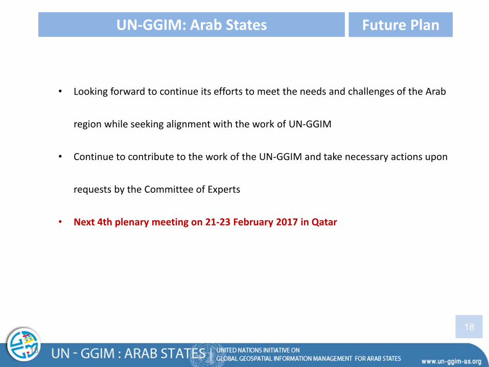
• Looking forward to continue its efforts to meet the needs and challenges of the Arab
region while seeking alignment with the work of UN-GGIM
• Continue to contribute to the work of the UN-GGIM and take necessary actions upon
requests by the Committee of Experts
• Next 4th plenary meeting on 21-23 February 2017 in Qatar
18
UN-GGIM: Arab States Future Plan
18

Thank You!