Embed Size (px)
Citation preview

8/3/2019 WLW Day 4: Collaboration Between Spatial Planning with Water Resources Management
http://slidepdf.com/reader/full/wlw-day-4-collaboration-between-spatial-planning-with-water-resources-management 1/18
Collaboration Between Spatial Planning with
M I N I S T R Y O F P U B L I C W O R K S
D I R E C T O R AT E G E N E R A L O F S PAT I A L P L A N N I N G
8/3/2019 WLW Day 4: Collaboration Between Spatial Planning with Water Resources Management
http://slidepdf.com/reader/full/wlw-day-4-collaboration-between-spatial-planning-with-water-resources-management 2/18
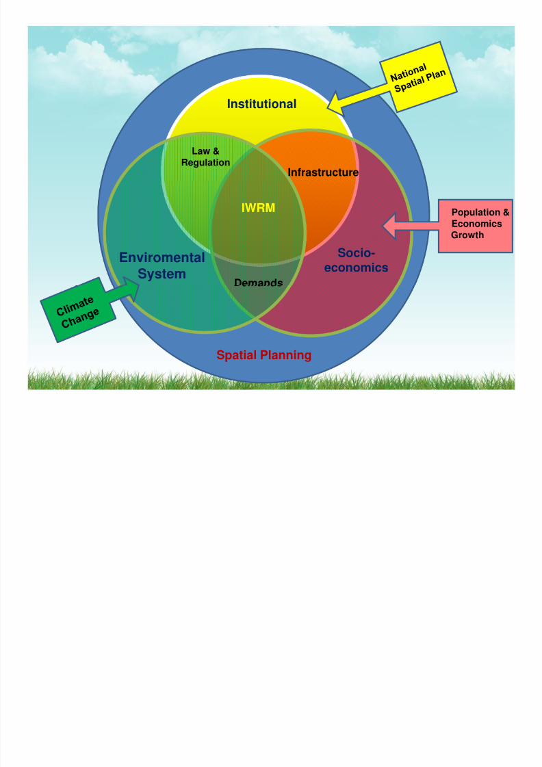
Institutional
Infrastructure
Law &Regulation
IWRM Population &Economics
EnviromentalSystem
Socio-economics
Demands
Spatial Planning
8/3/2019 WLW Day 4: Collaboration Between Spatial Planning with Water Resources Management
http://slidepdf.com/reader/full/wlw-day-4-collaboration-between-spatial-planning-with-water-resources-management 3/18
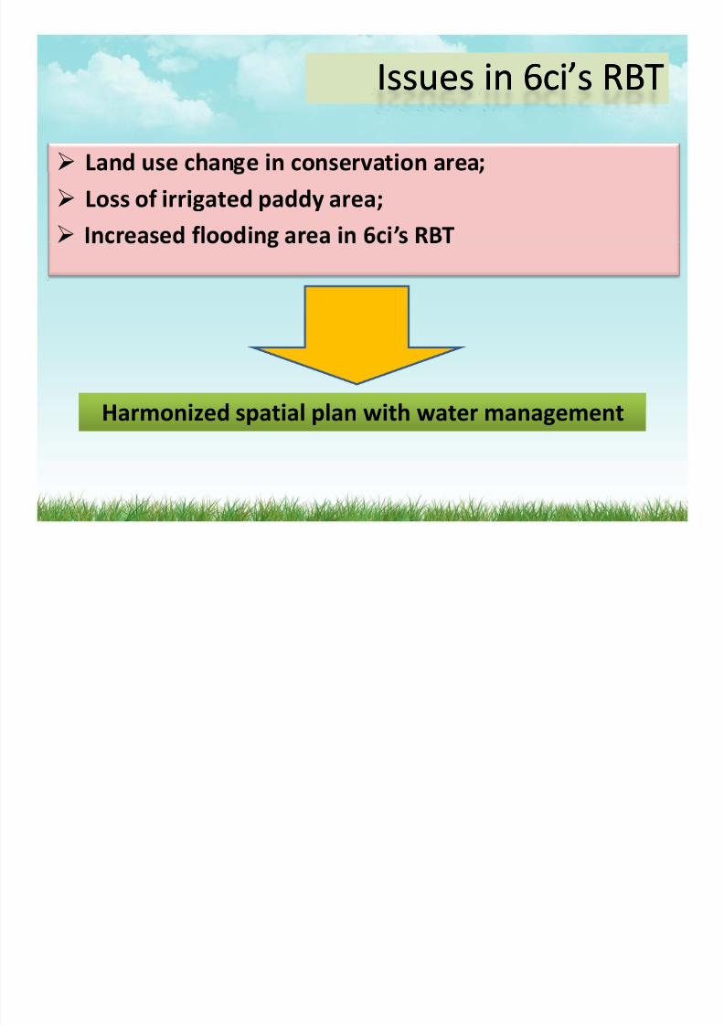
Issues in 6ci’s RBTIssues in 6ci’s RBT
Land use chan e in conservation area
Loss of irrigated paddy area;’
Harmonized spatial plan with water management

8/3/2019 WLW Day 4: Collaboration Between Spatial Planning with Water Resources Management
http://slidepdf.com/reader/full/wlw-day-4-collaboration-between-spatial-planning-with-water-resources-management 4/18
The study will be based on the Java Spatial Model developed The study will be based on the Java Spatial Model developed
under the “Space and Water” project under the “Space and Water” project ‐‐ a spatial planning a spatial planning initiative covering all of Java;initiative covering all of Java;
The model is used to provide internally consistent future The model is used to provide internally consistent future projections of: projections of:
•• the spatial distribution at village level of the population and employment; the spatial distribution at village level of the population and employment; •• the urban area growth needed to accommodate human activities; and the urban area growth needed to accommodate human activities; and •• the landthe land ‐‐use changes caused by the urban area growth, use changes caused by the urban area growth,

8/3/2019 WLW Day 4: Collaboration Between Spatial Planning with Water Resources Management
http://slidepdf.com/reader/full/wlw-day-4-collaboration-between-spatial-planning-with-water-resources-management 5/18
urban/rural landurban/rural land ‐‐use with important consequences for total use with important consequences for total water demand: water demand:
SocioSocio ‐‐economic projection of population/employment at district economic projection of population/employment at district ((kabupatenkabupaten) level based on economic growth scenarios. ) level based on economic growth scenarios.
Spatial allocation of population and landSpatial allocation of population and land ‐‐use for Java at village (use for Java at village (desadesa) ) eve , eve ,
Post processing module to calculate water indicators, such as water Post processing module to calculate water indicators, such as water demands, and pollutant emissions at water district level within the basin demands, and pollutant emissions at water district level within the basin
, , . , , .
8/3/2019 WLW Day 4: Collaboration Between Spatial Planning with Water Resources Management
http://slidepdf.com/reader/full/wlw-day-4-collaboration-between-spatial-planning-with-water-resources-management 6/18
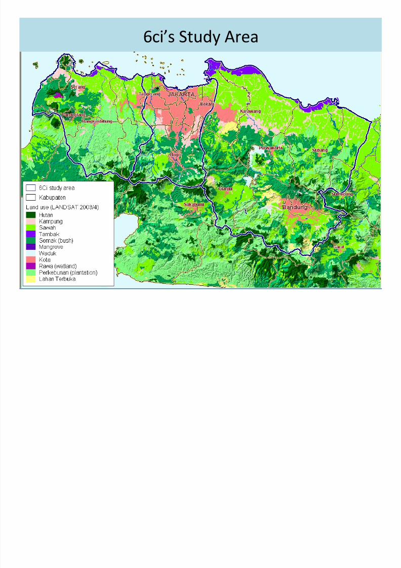
6ci’s Study Area
8/3/2019 WLW Day 4: Collaboration Between Spatial Planning with Water Resources Management
http://slidepdf.com/reader/full/wlw-day-4-collaboration-between-spatial-planning-with-water-resources-management 7/18
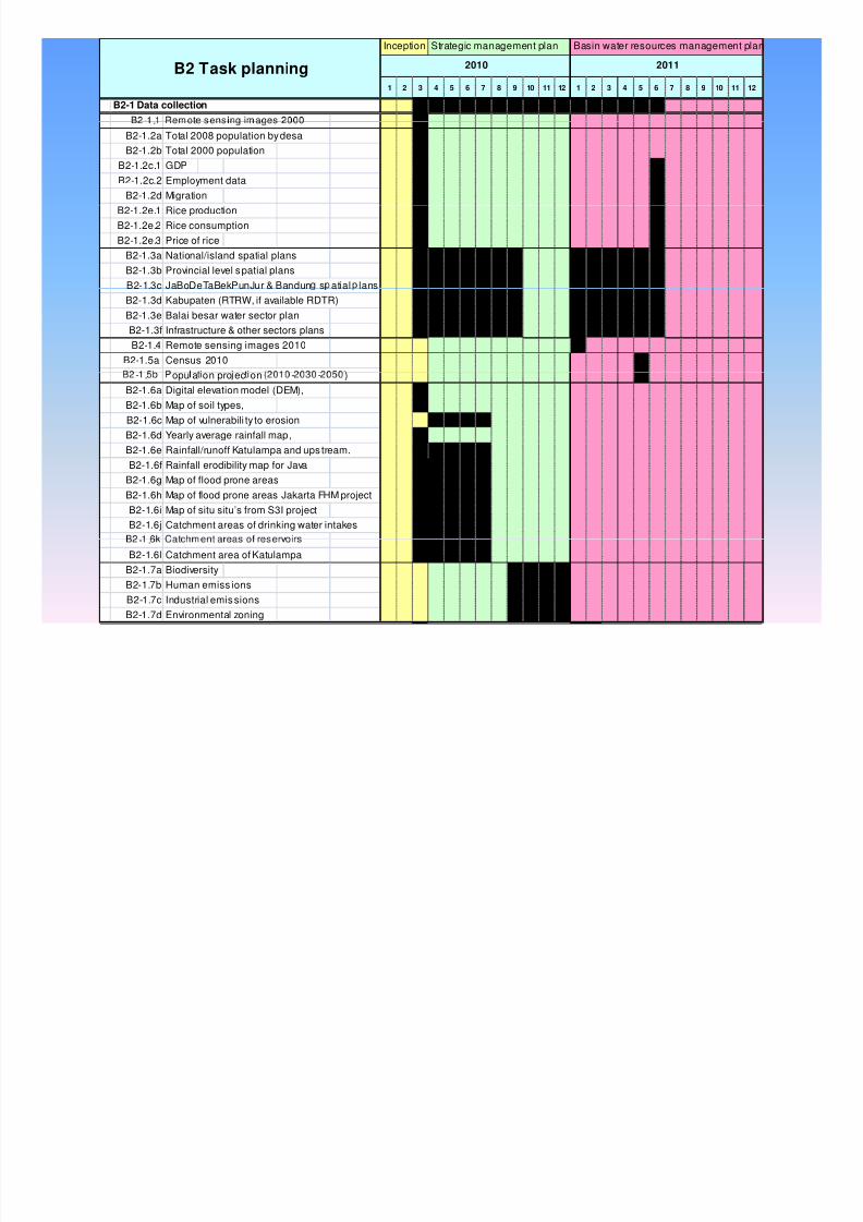
JSM Model Basic1 2 3 4 5 6 7 8 9 10 11 12 1 2 3 4 5 6 7 8 9 10 11 12
-
B2-1 Data collection
B2 Task planning
Inception Strategic management plan Basin water resources management plan
2010 2011
.B2-1.2a Total 2008 population by desaB2-1.2b Total 2000 population
B2-1.2c.1 GDPB2-1.2c.2 Employment data
B2-1.2d MigrationB2-1.2e.1 Rice productionB2-1.2e.2 Rice consumptionB2-1.2e.3 Price of rice
B2-1.3a National/island spatial plansB2-1.3b Provincial level s patial plansB2-1.3c JaBoDeTaBekPunJur & Bandun s atial lansB2-1.3d Kabupaten (RTRW, if available RDTR)B2-1.3e Balai besar water sector planB2-1.3f Infrastructure & other sectors plans
B2-1.4 Remote sensing images 2010B2-1.5a Census 2010- . opu a on pro ec on - - )
B2-1.6a Digital elevation model (DEM),B2-1.6b Map of soil types,B2-1.6c Map of vulnerabili ty to erosionB2-1.6d Yearly average rainfall map,B2-1.6e Rainfall/runoff Katulampa and ups tream.
B2-1.6f Rainfall erodibility map for JavaB2-1.6g Map of flood prone areasB2-1.6h Map of flood prone areas Jakarta FHM projectB2-1.6i Map of situ situ’s from S3I projectB2-1.6j Catchment areas of drinking water intakes
- .B2-1.6l Catchment area of Katulampa
B2-1.7a Biodiversity
B2-1.7b Human emiss ionsB2-1.7c Industrial emis sionsB2-1.7d Environmental zoning

8/3/2019 WLW Day 4: Collaboration Between Spatial Planning with Water Resources Management
http://slidepdf.com/reader/full/wlw-day-4-collaboration-between-spatial-planning-with-water-resources-management 8/18
m m
Populationgrowth
Populationgrowth
Increasing drinking water demands
s
t e
s
t e
Household size reduction
Household size reduction Land useChange:
urbanisationIncreasing waste load
emissions r
s
r
s
o s ze growo s ze growIncreased flooding
a
t e
a
t e
Decrease in sustainable Economic
growthEconomic
growth
r a c t i o n
W
W
e t c . e t c .
GW yield
Increased subsidence
Economic structure change
Economic structure change time
L a n d u s e
f
Reduced food supply
Loss of biodiversity
E c o l o g y
E c o l o g y

8/3/2019 WLW Day 4: Collaboration Between Spatial Planning with Water Resources Management
http://slidepdf.com/reader/full/wlw-day-4-collaboration-between-spatial-planning-with-water-resources-management 9/18
Integrated Planning for Space and Water
Water Mana ementWater Mana ement River Basin Water LawWater LawPlanning o. 7/2005o. 7/2005
Input from spatial
Strategic Land Use
and
planning to WRM plan
ater one Projection
Spatial ManagementSpatial ManagementSpatial
Planning
SpatialManagement
Law
SpatialManagement
LawInput from
water zoning to
Document ooConflict resolution; valuation
of alternative land-use
spatial planning
8/3/2019 WLW Day 4: Collaboration Between Spatial Planning with Water Resources Management
http://slidepdf.com/reader/full/wlw-day-4-collaboration-between-spatial-planning-with-water-resources-management 10/18
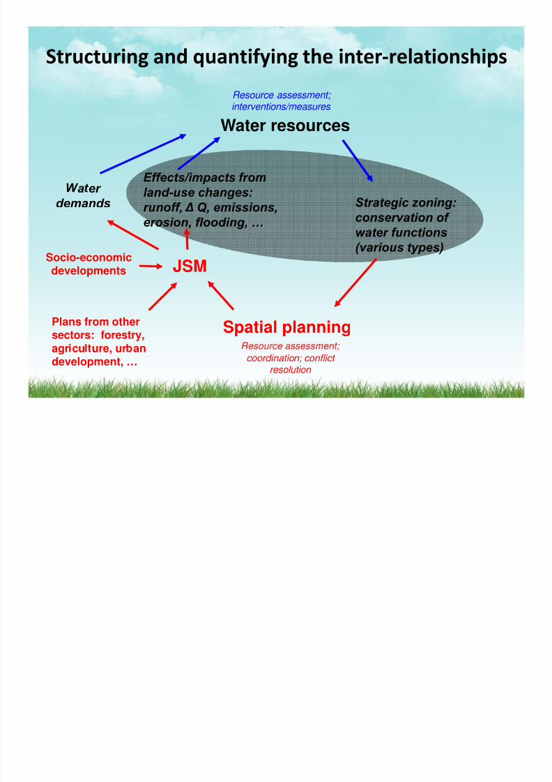
Structuring and quantifying the inter ‐relationships
Water resources
Resource assessment; interventions/measures
Effects/impacts fromland-use changes:runoff, Δ Q, emissions,
erosion, flooding, …
Strategic zoning:conservation of water functions
a er demands
JSMSocio-economic
developments
(various types)
Spatial planningPlans from othersectors: forestry,
coordination; conflict
resolution
agr cu ure, ur andevelopment, …
8/3/2019 WLW Day 4: Collaboration Between Spatial Planning with Water Resources Management
http://slidepdf.com/reader/full/wlw-day-4-collaboration-between-spatial-planning-with-water-resources-management 11/18
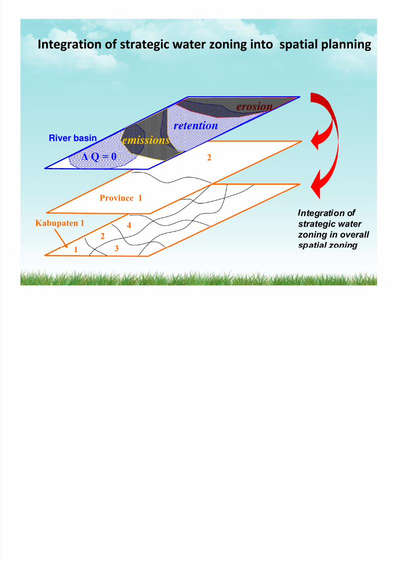
Integration of strategic water zoning into spatial planning
erosion retention
2
emissions
ΔQ = 0
River basin
Province 1
Kabupaten 1
24
ntegrat on ostrategic water zoning in overall s atial zonin
8/3/2019 WLW Day 4: Collaboration Between Spatial Planning with Water Resources Management
http://slidepdf.com/reader/full/wlw-day-4-collaboration-between-spatial-planning-with-water-resources-management 12/18
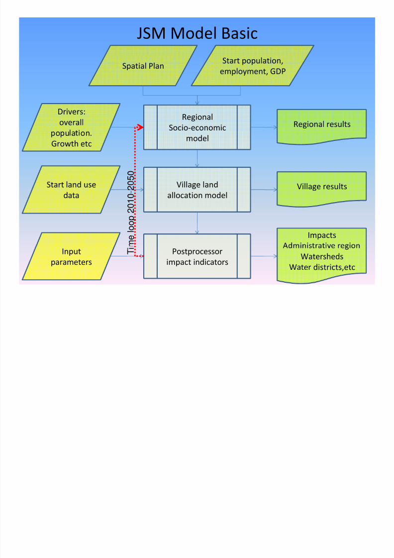
JSM Model Basic
Spatial PlanStart population,
employment, GDP
RegionalSocio ‐economic
Drivers:overall Regional results
modelpopu a on. Growth etc
Village land allocation model
Start land use data
Village results
0 1 0 - 2 0 5 0
Impacts m e
l o o p 2
Postprocessor impact indicators
Input parameters
Watersheds
Water districts,etc
T i

8/3/2019 WLW Day 4: Collaboration Between Spatial Planning with Water Resources Management
http://slidepdf.com/reader/full/wlw-day-4-collaboration-between-spatial-planning-with-water-resources-management 13/18
• POL A SDA • RENCANA

8/3/2019 WLW Day 4: Collaboration Between Spatial Planning with Water Resources Management
http://slidepdf.com/reader/full/wlw-day-4-collaboration-between-spatial-planning-with-water-resources-management 14/18
Case Scenario Example
Trend Measures / notes
Improved governance leads to better enforcement of conservation
p ans an - e c ency o - .
7% economy growth
Implementation of agricultural law 41/2009 on Food security
Agriculture Provides extra protection for irrigated paddy area and other crop
areas.
7% economic rowth
Water ZoningProtection according to water zoning principles: standstill of urban
development in area with slope >18%;
7% economic growth
Sustainable Growth Combination of the good governance, agriculture and water zoning;
7% economic growth

8/3/2019 WLW Day 4: Collaboration Between Spatial Planning with Water Resources Management
http://slidepdf.com/reader/full/wlw-day-4-collaboration-between-spatial-planning-with-water-resources-management 15/18
Scenario Result : Urban Area Growth
180%
190%
160%
170%
140%
150%
120%
130% CurrentTrend
GoodGovernance
Agriculture
100%
110% WaterZoningSustainableGrowth

8/3/2019 WLW Day 4: Collaboration Between Spatial Planning with Water Resources Management
http://slidepdf.com/reader/full/wlw-day-4-collaboration-between-spatial-planning-with-water-resources-management 16/18
Sustainable Growth Scenario : Urban Area
Jabodetabekpunjur

8/3/2019 WLW Day 4: Collaboration Between Spatial Planning with Water Resources Management
http://slidepdf.com/reader/full/wlw-day-4-collaboration-between-spatial-planning-with-water-resources-management 17/18

8/3/2019 WLW Day 4: Collaboration Between Spatial Planning with Water Resources Management
http://slidepdf.com/reader/full/wlw-day-4-collaboration-between-spatial-planning-with-water-resources-management 18/18