Embed Size (px)
DESCRIPTION
Still in the planning stages, the Wisconsin Lake Michigan Water Trail -- the Wisconsin segment of a Great Lakes Water Trail Project --aims at improving public access to the shoreline and waters of Lake Michigan. View maps, proposed access points and a plan overview compiled through joint efforts of The WI Dept of Natural Resources, Bay-Lake Regional Planning Commission, WI State Forests and Parks, the National Park Service, the WI Coastal Management Program, the National Oceanic and Atmospheric Administration, the Office of Ocean and Coastal Resource Management under the Coastal Zone Management Act.
Citation preview
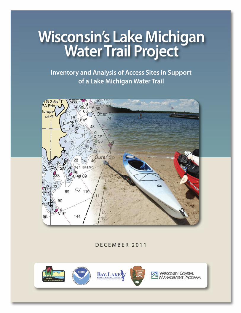
Wisconsin’s Lake Michigan Water Trail Project
Inventory and Analysis of Access Sites in Support of a Lake Michigan Water Trail
D E C E M B E R 2 0 1 1
Wisconsin’s Lake Michigan Water Trail Project | December 20112
Cathy Stepp, Secretary
Kurt Thiede, Land Division Administrator
Dan Schuller, Director – Bureau of Parks and Recreation
A S S E S S M E N T T E A M
Jeff Prey, Wisconsin Department of Natural Resources
Angie Tornes, National Park Service, Rivers, Trails andConservation Assistance Program
Angela Pierce, Bay-Lake Regional Planning Commission
Austin Outhavong, Wisconsin Department ofNatural Resources
Photo Credits:
Door County Kayak Tours
Door County Visitor Bureau, Sturgeon Bay, WI
Angie Tornes
C O N T E N T S
Summary ............................................................................. 3
Goals/Objectives ................................................................. 3
Purpose ............................................................................. 4
What Is a Water Trail?................................................. 4
What Is the Wisconsin Lake Michigan Water Trail Segment? ...................... 4
Benefits of the Wisconsin Lake Michigan Water Trail Segment ........................................................... 5
Planning | Phase I ................................................................ 7
Site Inventory ............................................................. 7
Access Classification.................................................. 7
— Green Bay West Shore .......................................... 9
— Green Bay East Shore ........................................... 13
— Northern Door County ......................................... 16
— Sturgeon Bay to Two Creeks Buried Forest ....... 21
— Point Beach to Sheboygan .................................. 24
— Kohler-Andrae to North Metro Milwaukee ....... 27
— Southern Metro Milwaukee to Illinois ............... 30
Enhancement Zone Analysis .................................... 34
Public Engagement.................................................... 35
Implementation | Phase II ................................................. 39
Funded in part by the Wisconsin CoastalManagement Program and the NationalOceanic and Atmospheric Administration,Office of Ocean and Coastal ResourceManagement under the Coastal ZoneManagement Act, Grant # NA09NOS4190107.
These goals and objectives serve as the philosophical framework for the
development and management of the Wisconsin segment of the Lake
Michigan Water Trail.
GOAL
To secure and increase public access to Lake
Michigan, encourage public stewardship of the
Lake Michigan ecosystem, promote outdoor
recreation, and promote tourism in communities
near Lake Michigan.
Wisconsin’s Lake Michigan Water Trail Project | December 2011 3
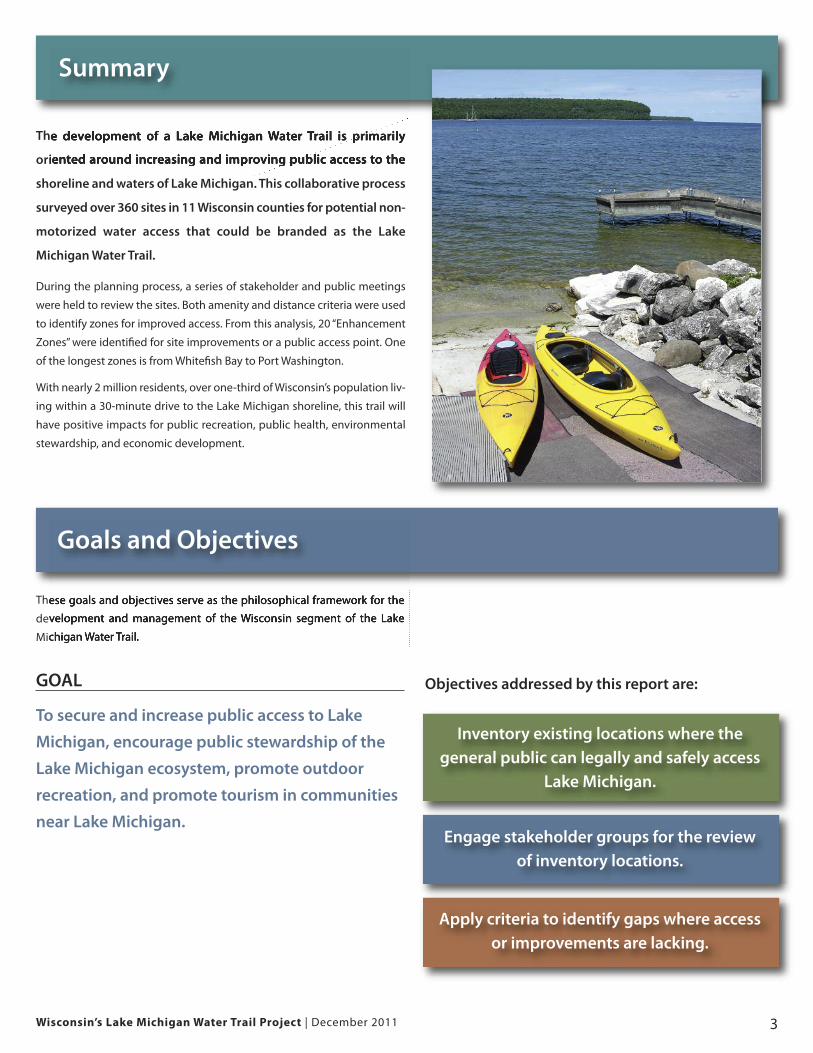
The development of a Lake Michigan Water Trail is primarily
oriented around increasing and improving public access to the
shoreline and waters of Lake Michigan. This collaborative process
surveyed over 360 sites in 11 Wisconsin counties for potential non-
motorized water access that could be branded as the Lake
Michigan Water Trail.
During the planning process, a series of stakeholder and public meetings
were held to review the sites. Both amenity and distance criteria were used
to identify zones for improved access. From this analysis, 20 “Enhancement
Zones” were identified for site improvements or a public access point. One
of the longest zones is from Whitefish Bay to Port Washington.
With nearly 2 million residents, over one-third of Wisconsin’s population liv-
ing within a 30-minute drive to the Lake Michigan shoreline, this trail will
have positive impacts for public recreation, public health, environmental
stewardship, and economic development.
Summary
Goals and Objectives
Inventory existing locations where thegeneral public can legally and safely access
Lake Michigan.
Engage stakeholder groups for the reviewof inventory locations.
Apply criteria to identify gaps where accessor improvements are lacking.
Objectives addressed by this report are:
Wisconsin’s Lake Michigan Water Trail Project | December 20114
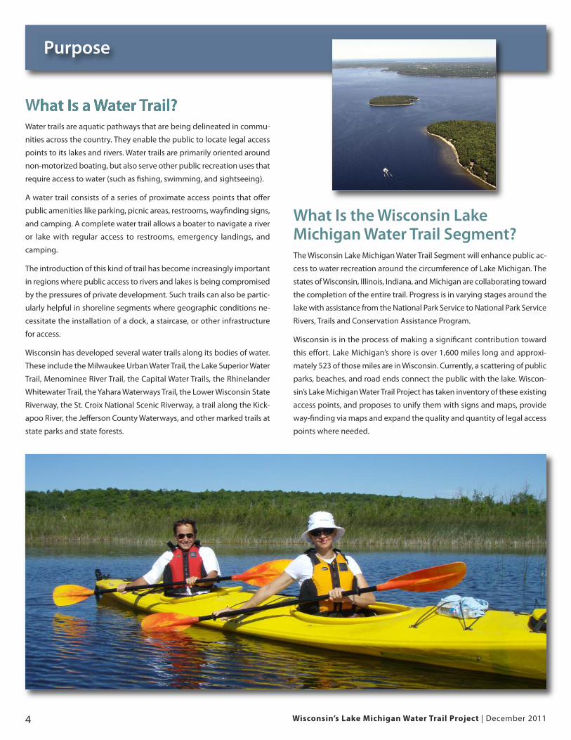
What Is a Water Trail?Water trails are aquatic pathways that are being delineated in commu-
nities across the country. They enable the public to locate legal access
points to its lakes and rivers. Water trails are primarily oriented around
non-motorized boating, but also serve other public recreation uses that
require access to water (such as fishing, swimming, and sightseeing).
A water trail consists of a series of proximate access points that offer
public amenities like parking, picnic areas, restrooms, wayfinding signs,
and camping. A complete water trail allows a boater to navigate a river
or lake with regular access to restrooms, emergency landings, and
camping.
The introduction of this kind of trail has become increasingly important
in regions where public access to rivers and lakes is being compromised
by the pressures of private development. Such trails can also be partic-
ularly helpful in shoreline segments where geographic conditions ne-
cessitate the installation of a dock, a staircase, or other infrastructure
for access.
Wisconsin has developed several water trails along its bodies of water.
These include the Milwaukee Urban Water Trail, the Lake Superior Water
Trail, Menominee River Trail, the Capital Water Trails, the Rhinelander
Whitewater Trail, the Yahara Waterways Trail, the Lower Wisconsin State
Riverway, the St. Croix National Scenic Riverway, a trail along the Kick-
apoo River, the Jefferson County Waterways, and other marked trails at
state parks and state forests.
What Is the Wisconsin LakeMichigan Water Trail Segment?The Wisconsin Lake Michigan Water Trail Segment will enhance public ac-
cess to water recreation around the circumference of Lake Michigan. The
states of Wisconsin, Illinois, Indiana, and Michigan are collaborating toward
the completion of the entire trail. Progress is in varying stages around the
lake with assistance from the National Park Service to National Park Service
Rivers, Trails and Conservation Assistance Program.
Wisconsin is in the process of making a significant contribution toward
this effort. Lake Michigan’s shore is over 1,600 miles long and approxi-
mately 523 of those miles are in Wisconsin. Currently, a scattering of public
parks, beaches, and road ends connect the public with the lake. Wiscon-
sin’s Lake Michigan Water Trail Project has taken inventory of these existing
access points, and proposes to unify them with signs and maps, provide
way-finding via maps and expand the quality and quantity of legal access
points where needed.
Purpose
Wisconsin’s Lake Michigan Water Trail Project | December 2011 5
Benefits of the Wisconsin Lake Michigan Water Trail Segment
Public Recreation BenefitsA water trail offers public recreation benefits by accommodating a form
of recreation that is growing in popularity, addressing environmental
barriers to recreation, and addressing recreation needs as expressed by
the regional population.
A water trail around Lake Michigan increases the opportunities for lake
kayaking. Kayaking has grown in popularity among Wisconsin residents.
Three recent surveys of Wisconsinites over the last 15 years indicate in-
creasing participation rates (National Survey on Recreation and the En-
vironment). Another recent survey polled kayakers across the country
and found that the number one factor limiting kayaking participation
was lack of time (A Special Report on Paddlesports 2009, Outdoor Foun-
dation). A water trail network partially addresses this factor by decreas-
ing distances between paddlers and access points.
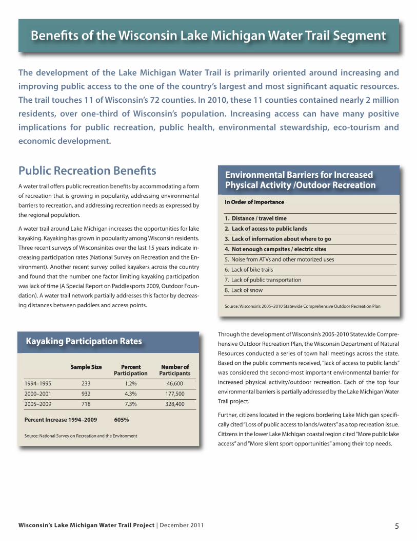
Through the development of Wisconsin’s 2005-2010 Statewide Compre-
hensive Outdoor Recreation Plan, the Wisconsin Department of Natural
Resources conducted a series of town hall meetings across the state.
Based on the public comments received, “lack of access to public lands”
was considered the second-most important environmental barrier for
increased physical activity/outdoor recreation. Each of the top four
environmental barriers is partially addressed by the Lake Michigan Water
Trail project.
Further, citizens located in the regions bordering Lake Michigan specifi-
cally cited “Loss of public access to lands/waters” as a top recreation issue.
Citizens in the lower Lake Michigan coastal region cited “More public lake
access” and “More silent sport opportunities” among their top needs.
The development of the Lake Michigan Water Trail is primarily oriented around increasing and
improving public access to the one of the country’s largest and most significant aquatic resources.
The trail touches 11 of Wisconsin’s 72 counties. In 2010, these 11 counties contained nearly 2 million
residents, over one-third of Wisconsin’s population. Increasing access can have many positive
implications for public recreation, public health, environmental stewardship, eco-tourism and
economic development.
Sample Size Percent Number ofParticipation Participants
1994–1995 233 1.2% 46,600
2000–2001 932 4.3% 177,500
2005–2009 718 7.3% 328,400
Percent Increase 1994–2009 605%
Source: National Survey on Recreation and the Environment
Kayaking Participation Rates
In Order of Importance
1. Distance / travel time
2. Lack of access to public lands
3. Lack of information about where to go
4. Not enough campsites / electric sites
5. Noise from ATVs and other motorized uses
6. Lack of bike trails
7. Lack of public transportation
8. Lack of snow
Source: Wisconsin’s 2005–2010 Statewide Comprehensive Outdoor Recreation Plan
Environmental Barriers for IncreasedPhysical Activity /Outdoor Recreation
Wisconsin’s Lake Michigan Water Trail Project | December 20116
Benefits
Public Health BenefitsBy enhancing Wisconsin’s outdoor recreation inventory, the Lake Michi-
gan Water Trail offers public health benefits related to physical activity
and exposure to the outdoors.
Survey data from the 2009 Behavioral Risk Factor Surveillance System
(BRFSS) indicates that the physical activity behaviors of 47% of Wiscon-
sinites fall short of federal guidelines. Further, survey results suggest that
over 20% of Wisconsinites are not exercising at all (2010 BRFSS).
Enhancing public access to shoreline accommodates low intensity out-
door recreation oriented around viewing and learning. A water trail proj-
ect also offers the mental health benefits associated with these activities.
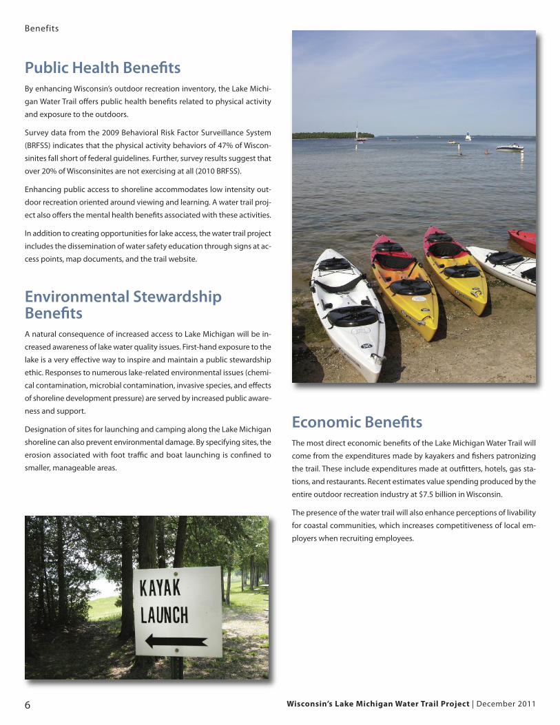
In addition to creating opportunities for lake access, the water trail project
includes the dissemination of water safety education through signs at ac-
cess points, map documents, and the trail website.
Environmental Stewardship BenefitsA natural consequence of increased access to Lake Michigan will be in-
creased awareness of lake water quality issues. First-hand exposure to the
lake is a very effective way to inspire and maintain a public stewardship
ethic. Responses to numerous lake-related environmental issues (chemi-
cal contamination, microbial contamination, invasive species, and effects
of shoreline development pressure) are served by increased public aware-
ness and support.
Designation of sites for launching and camping along the Lake Michigan
shoreline can also prevent environmental damage. By specifying sites, the
erosion associated with foot traffic and boat launching is confined to
smaller, manageable areas.
Economic BenefitsThe most direct economic benefits of the Lake Michigan Water Trail will
come from the expenditures made by kayakers and fishers patronizing
the trail. These include expenditures made at outfitters, hotels, gas sta-
tions, and restaurants. Recent estimates value spending produced by the
entire outdoor recreation industry at $7.5 billion in Wisconsin.
The presence of the water trail will also enhance perceptions of livability
for coastal communities, which increases competitiveness of local em-
ployers when recruiting employees.
Wisconsin’s Lake Michigan Water Trail Project | December 2011 7
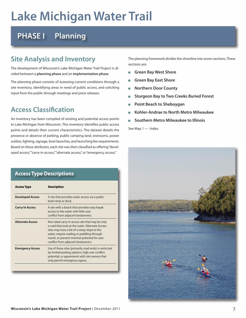
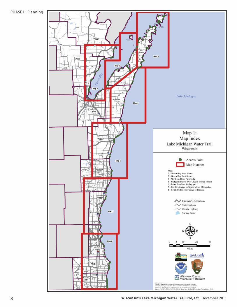
The planning framework divides the shoreline into seven sections. These
sections are:
� Green Bay West Shore
� Green Bay East Shore
� Northern Door County
� Sturgeon Bay to Two Creeks Buried Forest
� Point Beach to Sheboygan
� Kohler-Andrae to North Metro Milwaukee
� Southern Metro Milwaukee to Illinois
See Map 1 — Index.
PHASE I Planning
Site Analysis and InventoryThe development of Wisconsin’s Lake Michigan Water Trail Project is di-
vided between a planning phase and an implementation phase.
The planning phase consists of assessing current conditions through a
site inventory, identifying areas in need of public access, and soliciting
input from the public through meetings and press releases.
Access ClassificationAn inventory has been compiled of existing and potential access points
to Lake Michigan from Wisconsin. This inventory identifies public access
points and details their current characteristics. The dataset details the
presence or absence of parking, public camping land, restrooms, power
outlets, lighting, signage, boat launches, and launching fee requirements.
Based on these attributes, each site was then classified as offering “devel-
oped access,” “carry-in access,” “alternate access,” or “emergency access.”
Lake Michigan Water Trail
Access Type Description
Developed Access A site that provides water access via a publicboat ramp or dock.
Carry-In Access A site with a beach that provides easy kayak access to the water with little user conflict from adjacent landowners.
Alternate Access Non-ideal carry-in access site that may be onlya road that ends at the water. Alternate Accesssites may have a bit of a steep slope to thewater, require wading or paddling throughmarsh, or present minimal potential for user conflict from adjacent landowners.
Emergency Access Use of these sites (primarily road ends) is restricted by limited parking options, high user conflict potential, or agreements with site owners that only permit emergency egress.
Access Type Descriptions
PHASE I Planning
Wisconsin’s Lake Michigan Water Trail Project | December 20118
Wisconsin’s Lake Michigan Water Trail Project | December 2011 9
PHASE I Planning
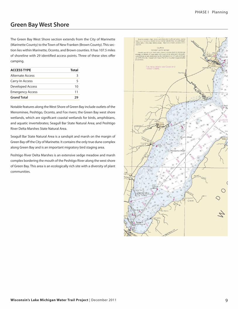
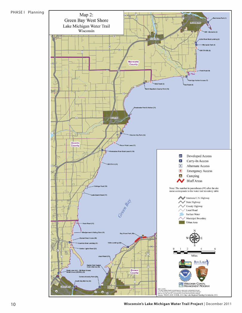
Green Bay West Shore
The Green Bay West Shore section extends from the City of Marinette
(Marinette County) to the Town of New Franken (Brown County). This sec-
tion lies within Marinette, Oconto, and Brown counties. It has 107.5 miles
of shoreline with 29 identified access points. Three of these sites offer
camping.
ACCESS TYPE Total
Alternate Access 3
Carry-In Access 5
Developed Access 10
Emergency Access 11
Grand Total 29
Notable features along the West Shore of Green Bay include outlets of the
Menominee, Peshtigo, Oconto, and Fox rivers; the Green Bay west shore
wetlands, which are significant coastal wetlands for birds, amphibians,
and aquatic invertebrates; Seagull Bar State Natural Area; and Peshtigo
River Delta Marshes State Natural Area.
Seagull Bar State Natural Area is a sandspit and marsh on the margin of
Green Bay off the City of Marinette. It contains the only true dune complex
along Green Bay and is an important migratory bird staging area.
Peshtigo River Delta Marshes is an extensive sedge meadow and marsh
complex bordering the mouth of the Peshtigo River along the west shore
of Green Bay. This area is an ecologically rich site with a diversity of plant
communities.
Wisconsin’s Lake Michigan Water Trail Project | December 201110
PHASE I Planning
Support for the Great Outdoors America 11
PHASE I Planning
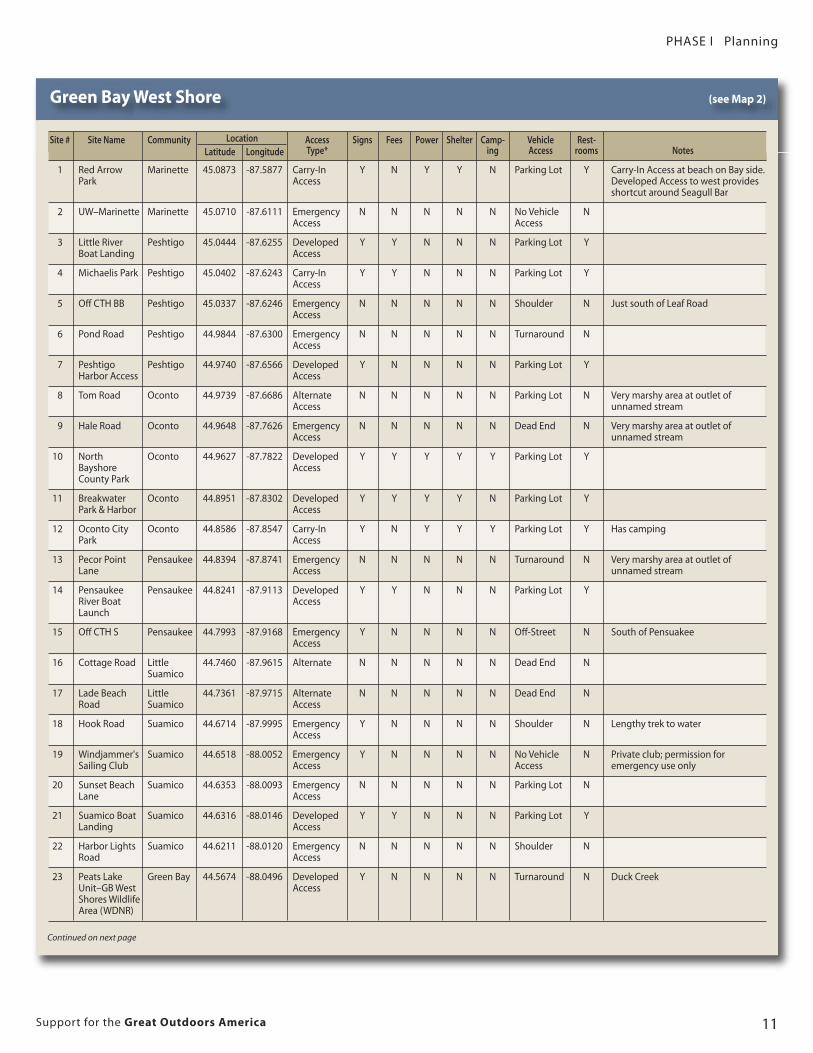
Green Bay West Shore (see Map 2)
Location
Continued on next page
Site # Site Name Community Access Signs Fees Power Shelter Camp- Vehicle Rest-Latitude Longitude Type* ing Access rooms Notes
1 Red Arrow Marinette 45.0873 -87.5877 Carry-In Y N Y Y N Parking Lot Y Carry-In Access at beach on Bay side.Park Access Developed Access to west provides
shortcut around Seagull Bar
2 UW–Marinette Marinette 45.0710 -87.6111 Emergency N N N N N No Vehicle NAccess Access
3 Little River Peshtigo 45.0444 -87.6255 Developed Y Y N N N Parking Lot YBoat Landing Access
4 Michaelis Park Peshtigo 45.0402 -87.6243 Carry-In Y Y N N N Parking Lot YAccess
5 Off CTH BB Peshtigo 45.0337 -87.6246 Emergency N N N N N Shoulder N Just south of Leaf RoadAccess
6 Pond Road Peshtigo 44.9844 -87.6300 Emergency N N N N N Turnaround NAccess
7 Peshtigo Peshtigo 44.9740 -87.6566 Developed Y N N N N Parking Lot YHarbor Access Access
8 Tom Road Oconto 44.9739 -87.6686 Alternate N N N N N Parking Lot N Very marshy area at outlet of Access unnamed stream
9 Hale Road Oconto 44.9648 -87.7626 Emergency N N N N N Dead End N Very marshy area at outlet of Access unnamed stream
10 North Oconto 44.9627 -87.7822 Developed Y Y Y Y Y Parking Lot YBayshore AccessCounty Park
11 Breakwater Oconto 44.8951 -87.8302 Developed Y Y Y Y N Parking Lot YPark & Harbor Access
12 Oconto City Oconto 44.8586 -87.8547 Carry-In Y N Y Y Y Parking Lot Y Has campingPark Access
13 Pecor Point Pensaukee 44.8394 -87.8741 Emergency N N N N N Turnaround N Very marshy area at outlet of Lane Access unnamed stream
14 Pensaukee Pensaukee 44.8241 -87.9113 Developed Y Y N N N Parking Lot YRiver Boat Access Launch
15 Off CTH S Pensaukee 44.7993 -87.9168 Emergency Y N N N N Off-Street N South of PensuakeeAccess
16 Cottage Road Little 44.7460 -87.9615 Alternate N N N N N Dead End NSuamico
17 Lade Beach Little 44.7361 -87.9715 Alternate N N N N N Dead End NRoad Suamico Access
18 Hook Road Suamico 44.6714 -87.9995 Emergency Y N N N N Shoulder N Lengthy trek to waterAccess
19 Windjammer's Suamico 44.6518 -88.0052 Emergency Y N N N N No Vehicle N Private club; permission for Sailing Club Access Access emergency use only
20 Sunset Beach Suamico 44.6353 -88.0093 Emergency N N N N N Parking Lot NLane Access
21 Suamico Boat Suamico 44.6316 -88.0146 Developed Y Y N N N Parking Lot YLanding Access
22 Harbor Lights Suamico 44.6211 -88.0120 Emergency N N N N N Shoulder NRoad Access
23 Peats Lake Green Bay 44.5674 -88.0496 Developed Y N N N N Turnaround N Duck CreekUnit–GB West AccessShores Wildlife Area (WDNR)
Wisconsin’s Lake Michigan Water Trail Project | December 201112
PHASE I Planning
Location
Green Bay West Shore (continued) (see Map 2)
Site # Site Name Community Access Signs Fees Power Shelter Camp- Vehicle Rest-Latitude Longitude Type* ing Access rooms Notes
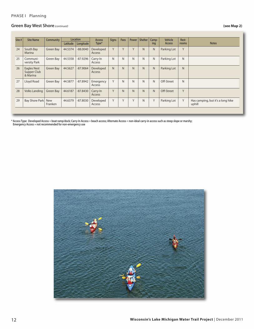
24 South Bay Green Bay 44.5374 -88.0040 Developed Y Y Y N N Parking Lot YMarina Access
25 Communi- Green Bay 44.5358 -87.9296 Carry-In N N N N N Parking Lot Nversity Park Access
26 Eagles Nest Green Bay 44.5627 -87.9064 Developed N N N N N Parking Lot NSupper Club Access & Marina
27 Lloyd Road Green Bay 44.5877 -87.8942 Emergency Y N N N N Off-Street NAccess
28 Volks Landing Green Bay 44.6187 -87.8430 Carry-In Y N N N N Off-Street YAccess
29 Bay Shore Park New 44.6379 -87.8030 Developed Y Y Y N Y Parking Lot Y Has camping, but it's a long hike Franken Access uphill
* Access Type: Developed Access = boat ramp/dock; Carry-In Access = beach access; Alternate Access = non-ideal carry-in access such as steep slope or marshy; Emergency Access = not recommended for non-emergency use
Wisconsin’s Lake Michigan Water Trail Project | December 2011 13
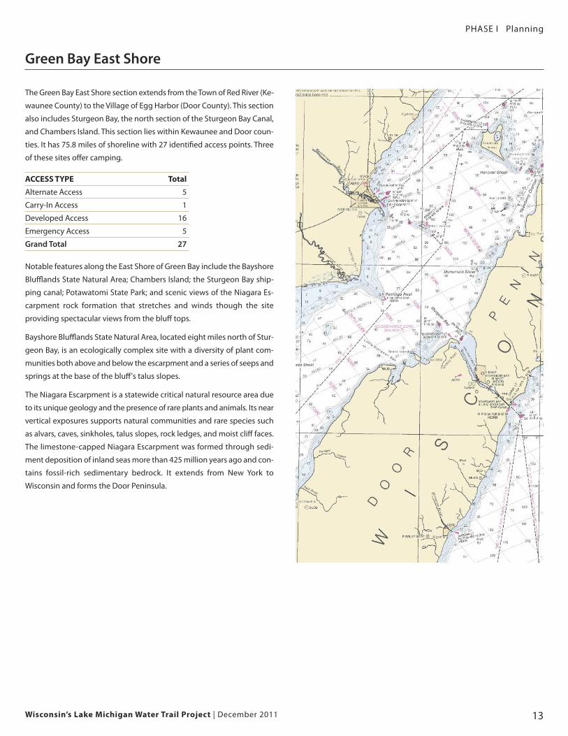
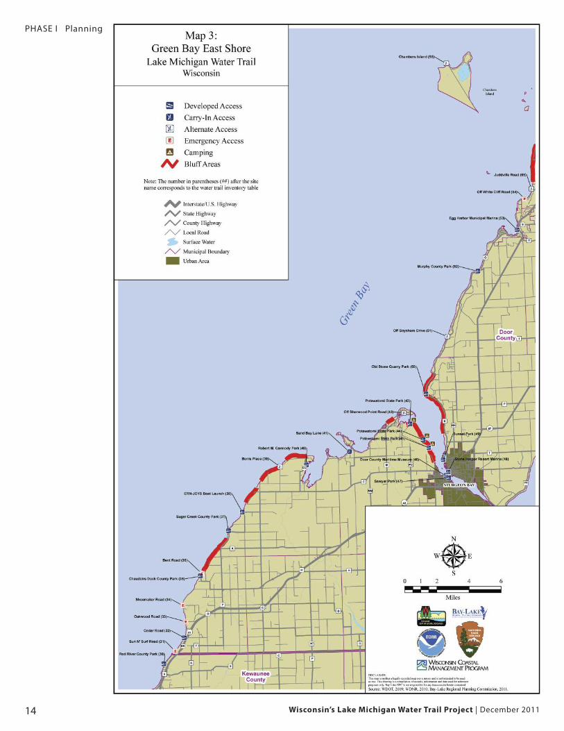
Green Bay East Shore
PHASE I Planning
The Green Bay East Shore section extends from the Town of Red River (Ke-
waunee County) to the Village of Egg Harbor (Door County). This section
also includes Sturgeon Bay, the north section of the Sturgeon Bay Canal,
and Chambers Island. This section lies within Kewaunee and Door coun-
ties. It has 75.8 miles of shoreline with 27 identified access points. Three
of these sites offer camping.
ACCESS TYPE Total
Alternate Access 5
Carry-In Access 1
Developed Access 16
Emergency Access 5
Grand Total 27
Notable features along the East Shore of Green Bay include the Bayshore
Blufflands State Natural Area; Chambers Island; the Sturgeon Bay ship-
ping canal; Potawatomi State Park; and scenic views of the Niagara Es-
carpment rock formation that stretches and winds though the site
providing spectacular views from the bluff tops.
Bayshore Blufflands State Natural Area, located eight miles north of Stur-
geon Bay, is an ecologically complex site with a diversity of plant com-
munities both above and below the escarpment and a series of seeps and
springs at the base of the bluff's talus slopes.
The Niagara Escarpment is a statewide critical natural resource area due
to its unique geology and the presence of rare plants and animals. Its near
vertical exposures supports natural communities and rare species such
as alvars, caves, sinkholes, talus slopes, rock ledges, and moist cliff faces.
The limestone-capped Niagara Escarpment was formed through sedi-
ment deposition of inland seas more than 425 million years ago and con-
tains fossil-rich sedimentary bedrock. It extends from New York to
Wisconsin and forms the Door Peninsula.
PHASE I Planning
Wisconsin’s Lake Michigan Water Trail Project | December 201114
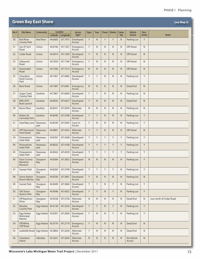
Green Bay East Shore (see Map 3)
LocationSite # Site Name Community Access Signs Fees Power Shelter Camp- Vehicle Rest-Latitude Longitude Type* ing Access rooms Notes
30 Red River Red River 44.6683 -87.7475 Developed Y N Y Y N Parking Lot YCounty Park Access
31 Sun N' Surf Union 44.6796 -87.7327 Emergency Y N N N N Off-Street NRoad Access
32 Cedar Road Union 44.6914 -87.7209 Developed Y N N N N Off-Street NAccess
33 Oakwood Union 44.7059 -87.7184 Emergency Y N N N N Off-Street NRoad Access
34 Shoemaker Union 44.7206 -87.7215 Emergency N N N N N Off-Street NRoad Access
35 Chaudoirs Union 44.7467 -87.6982 Developed Y Y N N N Parking Lot YDock County AccessPark
36 Bent Road Union 44.7487 -87.6961 Emergency N N N N N Dead End NAccess
37 Sugar Creek Gardner 44.7867 -87.6609 Developed Y Y N N N Parking Lot NCounty Park Access
38 ERN-JOYS Gardner 44.8032 -87.6427 Developed Y N N N N Dead End NBoat Launch Access
39 Bonis Place Gardner 44.8431 -87.5934 Alternate N N N N N Parking Lot NAccess
40 Robert M. Gardner 44.8440 -87.5598 Developed Y Y N N N Parking Lot YCarmody Park Access
41 Sand Bay Lane Nasewau- 44.8549 -87.5045 Carry-In Y N N N N Parking Lot Ypee Access
42 Off Sherwood Nasewau- 44.8881 -87.4342 Alternate Y Y N N N Off-Street NPoint Road pee Access
43 Potawatomi Nasewau- 44.8781 -87.4268 Developed Y Y Y Y Y Parking Lot YState Park pee Access
44 Potawatomi Nasewau- 44.8635 -87.4108 Developed Y Y Y Y Y Parking Lot YState Park pee Access
45 Potawatomi Nasewau- 44.8562 -87.4039 Developed Y Y Y Y Y Parking Lot YState Park pee Access
46 Door County Sturgeon 44.8306 -87.3832 Developed N N N N N Parking Lot YMaritime Bay AccessMuseum
47 Sawyer Park Sturgeon 44.8283 -87.3799 Developed Y Y Y Y N Parking Lot YBay Access
48 Stone Harbor Sturgeon 44.8336 -87.3801 Developed Y N N N N Parking Lot NResort Marina Bay Access
49 Sunset Park Sturgeon 44.8449 -87.3860 Developed Y Y N Y N Parking Lot YBay Access
50 Old Stone Sturgeon 44.9046 -87.4052 Developed Y Y N Y N Parking Lot YQuarry Park Bay Access
51 Off Bayshore Sturgeon 44.9558 -87.3756 Alternate N N N N N Dead End N Just north of Cedar RoadDrive Bay Access
52 Murphy Egg Harbor 45.0138 -87.3343 Developed Y Y N Y N Parking Lot YCounty Park Access
53 Egg Harbor Egg Harbor 45.0501 -87.2826 Developed Y N N Y N Parking Lot YMunicipal AccessMarina
54 Off White Egg Harbor 45.0776 -87.2718 Emergency Y N N N N Dead End NCliff Road Access
55 Juddville Road Egg Harbor 45.0864 -87.2626 Alternate Y N N N N Dead End NAccess
56 Chambers Gibraltar 45.2021 -87.3659 Alternate N N N N N No Vehicle NIsland Access Access
Wisconsin’s Lake Michigan Water Trail Project | December 2011 15
PHASE I Planning
Wisconsin’s Lake Michigan Water Trail Project | December 201116
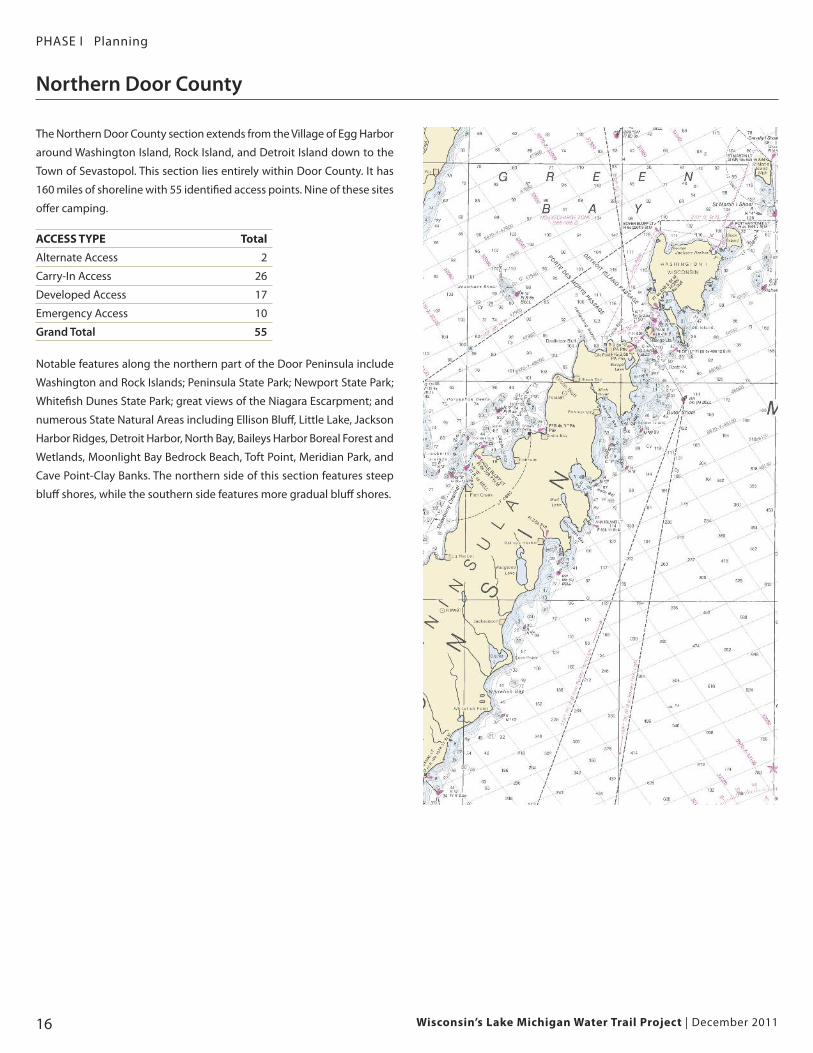
PHASE I Planning
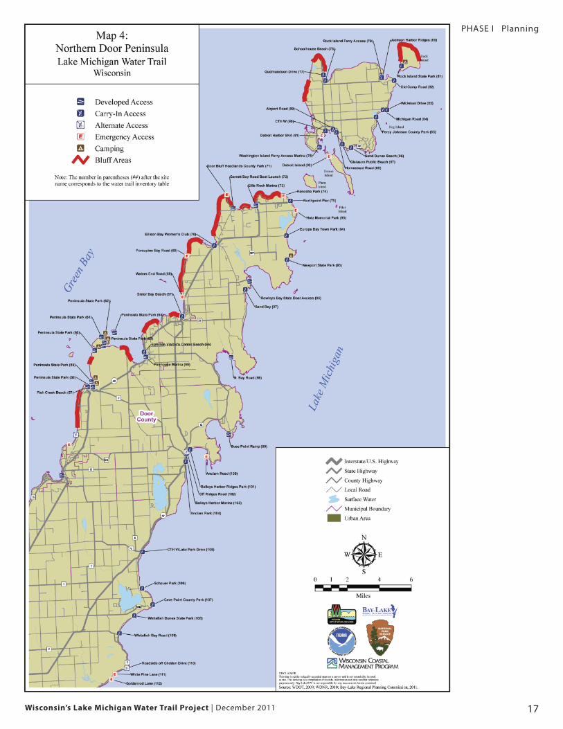
The Northern Door County section extends from the Village of Egg Harbor
around Washington Island, Rock Island, and Detroit Island down to the
Town of Sevastopol. This section lies entirely within Door County. It has
160 miles of shoreline with 55 identified access points. Nine of these sites
offer camping.
ACCESS TYPE Total
Alternate Access 2
Carry-In Access 26
Developed Access 17
Emergency Access 10
Grand Total 55
Notable features along the northern part of the Door Peninsula include
Washington and Rock Islands; Peninsula State Park; Newport State Park;
Whitefish Dunes State Park; great views of the Niagara Escarpment; and
numerous State Natural Areas including Ellison Bluff, Little Lake, Jackson
Harbor Ridges, Detroit Harbor, North Bay, Baileys Harbor Boreal Forest and
Wetlands, Moonlight Bay Bedrock Beach, Toft Point, Meridian Park, and
Cave Point-Clay Banks. The northern side of this section features steep
bluff shores, while the southern side features more gradual bluff shores.
Northern Door County
Wisconsin’s Lake Michigan Water Trail Project | December 2011 17
PHASE I Planning
Wisconsin’s Lake Michigan Water Trail Project | December 201118
PHASE I Planning
Continued on next page
Northern Door County (see Map 4)
Location
Continued on next page
Site # Site Name Community Access Signs Fees Power Shelter Camp- Vehicle Rest-Latitude Longitude Type* ing Access rooms Notes
57 Fish Creek Fish Creek 45.1292 -87.2457 Developed Y Y Y N N Parking Lot YBeach Access
58 Peninsula Gibraltar 45.1289 -87.2390 Developed Y Y Y Y Y Parking Lot YState Park Access
59 Peninsula Gibraltar 45.1339 -87.2404 Developed Y Y Y Y Y Parking Lot YState Park Access
60 Peninsula Gibraltar 45.1619 -87.2351 Developed Y Y Y Y Y Parking Lot YState Park Access
61 Peninsula Gibraltar 45.1738 -87.2259 Developed Y Y Y Y Y Parking Lot YState Park Access
62 Peninsula Gibraltar 45.1687 -87.2226 Developed Y Y Y Y Y Parking Lot YState Park Access
63 Peninsula Gibraltar 45.1656 -87.2236 Developed Y Y Y Y Y Parking Lot YState Park Access
64 Peninsula Gibraltar 45.1773 -87.2088 Developed Y Y Y Y Y Parking Lot YAccess
65 Firehouse Ephraim 45.1544 -87.1701 Developed Y Y N N N Parking Lot Y Has kayak storageMarina Access
66 Ephraim Ephraim 45.1589 -87.1722 Carry-In Y N Y N N Off-Street N Kayak rentalsVisitor’s Center AccessBeach
67 Sister Bay Sister Bay 45.1899 -87.1219 Carry-In Y N N Y N Parking Lot Y Silent launch at SW end of Beach Access beach – discouraged elsewhere
68 Waters End Sister Bay 45.2074 -87.1207 Emergency N N N N N Dead End NRoad Access
69 Porcupine Bay Liberty 45.2446 -87.1132 Emergency N N N N N Turnaround NRoad Grove Access
70 Ellison Bay Liberty 45.2530 -87.0776 Carry-In Y N N N N Parking Lot NWomen's Club Grove AccessPark
71 Door Bluff Liberty 45.2985 -87.0594 Emergency Y N N N N Turnaround Y Undeveloped natural area with aHeadlands Grove Access number of resting areas along shoreCounty Park
72 Garrett Bay Liberty 45.2859 -87.0512 Developed Y Y N N N Parking Lot NRoad Boat Grove AccessLaunch
73 Gills Rock Liberty 45.2876 -87.0225 Developed Y Y N N N Parking Lot YMarina Grove Access
74 Kenosha Park Liberty 45.2957 -86.9868 Emergency Y N N N N Shoulder NGrove Access
75 Northport Pier Liberty 45.2908 -86.9779 Carry-In Y N N N N Parking Lot N Launch at beach south of pier. Grove Access Use “Lot B” for overnight/extended
parking.
76 Washington Washington 45.3382 -86.9382 Developed Y N N Y N Parking Lot YIsland Ferry Island AccessAccess Marina
77 Gudmundson Washington 45.4036 -86.9296 Carry-In N N N N N Dead End NDrive Island Access
78 Schoolhouse Washington 45.3982 -86.9274 Carry-In Y N N N N Parking Lot YBeach Island Access
79 Rock Island Washington 45.3995 -86.8547 Developed Y N Y Y N Parking Lot YFerry Access Island Access
80 Jackson Washington 45.3988 -86.8550 Carry-In Y N N N N Parking Lot NHarbor Ridges Island Access
Wisconsin’s Lake Michigan Water Trail Project | December 2011 19
PHASE I Planning
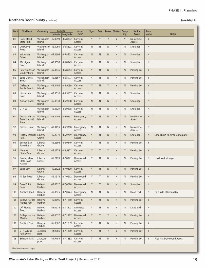
Northern Door County (continued) (see Map 4)
LocationSite # Site Name Community Access Signs Fees Power Shelter Camp- Vehicle Rest-Latitude Longitude Type* ing Access rooms Notes
81 Rock Island Washington 45.4090 -86.8292 Carry-In Y Y Y Y Y No Vehicle YState Park Island Access Access
82 Old Camp Washington 45.3960 -86.8393 Carry-In N N N N N Shoulder NRoad Island Access
83 Wickman Washington 45.3696 -86.8501 Carry-In N N N N N Shoulder NDrive Island Access
84 Michigan Washington 45.3698 -86.8549 Carry-In N N N N N Shoulder NRoad Island Access
85 Percy Johnson Washington 45.3636 -86.8643 Carry-In Y N N N N Parking Lot YCounty Park Island Access
86 Sand Dunes Washington 45.3367 -86.8977 Carry-In Y N N N N Parking Lot YBeach Island Access
87 Gislason Washington 45.3403 -86.9089 Carry-In Y N Y Y N Parking Lot YPublic Beach Island Access
88 Homestead Washington 45.3510 -86.9157 Carry-In N N N N N Shoulder NRoad Island Access
89 Airport Road Washington 45.3538 -86.9198 Carry-In N N N N N Shoulder NIsland Access
90 CTH W Washington 45.3529 -86.9298 Carry-In N N N N N Shoulder NIsland Access
91 Detroit Harbor Washington 45.3486 -86.9351 Emergency Y N N N N No Vehicle NState Natural Island Access AccessArea
92 Detroit Island Washington 45.3295 -86.9268 Emergency N N N N N No Vehicle NIsland Access Access
93 Hotz Memorial Liberty 45.2819 -86.9719 Emergency Y N N N N Shoulder N Small bluff to climb up to parkPark Grove Access
94 Europe Bay Liberty 45.2594 -86.9849 Carry-In Y N N N N Parking Lot YTown Park Grove Access
95 Newport Liberty 45.2378 -86.9852 Carry-In Y Y Y Y Y Parking Lot YState Park Grove Access
96 Rowleys Bay Liberty 45.2193 -87.0341 Developed Y N N N N Parking Lot N Has kayak storageState Boat Grove AccessAccess
97 Sand Bay Liberty 45.2122 -87.0400 Carry-In Y N N N N Parking Lot YGrove Access
98 N. Bay Road Liberty 45.1514 -87.0612 Developed Y Y N N N Parking Lot NGrove Access
99 Bues Point Baileys 45.0817 -87.0678 Developed Y Y N N N Shoulder NRamp Harbor Access
100 Anclam Road Baileys 45.0625 -87.0974 Emergency N N N N N Dead End N East side of Green BayHarbor Access
101 Baileys Harbor Baileys 45.0695 -87.1180 Carry-In Y N N N N Parking Lot YRidges Park Harbor Access
102 Off Ridges Baileys 45.0674 -87.1223 Alternate Y N N N N Dead End NRoad Harbor Access
103 Baileys Harbor Baileys 45.0657 -87.1227 Developed Y Y Y N N Parking Lot YMarina Harbor Access
104 Anclam Park Baileys 45.0587 -87.1239 Carry-In Y N N N N Parking Lot YHarbor Access
105 CTH V/Lake Jackson- 44.9786 -87.1830 Carry-In Y N Y Y N Parking Lot YPark Drive port Access
106 Schauer Park Jackson- 44.9454 -87.1852 Carry-In Y N N N N Parking Lot Y Also has Developed Accessport Access
Continued on next page
Wisconsin’s Lake Michigan Water Trail Project | December 201120
PHASE I Planning
Northern Door County (continued) (see Map 4)
Location
* Access Type: Developed Access = boat ramp/dock; Carry-In Access = beach access; Alternate Access = non-ideal carry-in access such as steep slope or marshy; Emergency Access = not recommended for non-emergency use
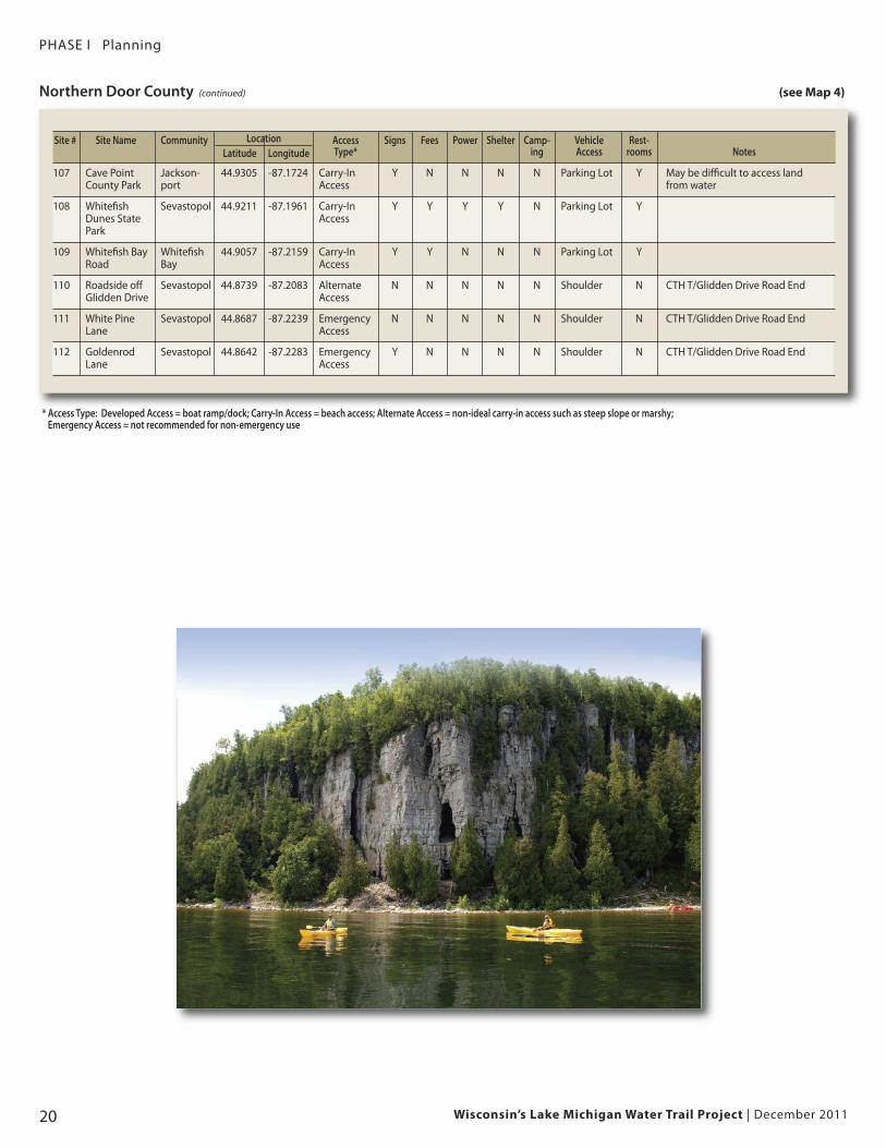
Site # Site Name Community Access Signs Fees Power Shelter Camp- Vehicle Rest-Latitude Longitude Type* ing Access rooms Notes
107 Cave Point Jackson- 44.9305 -87.1724 Carry-In Y N N N N Parking Lot Y May be difficult to access land County Park port Access from water
108 Whitefish Sevastopol 44.9211 -87.1961 Carry-In Y Y Y Y N Parking Lot YDunes State AccessPark
109 Whitefish Bay Whitefish 44.9057 -87.2159 Carry-In Y Y N N N Parking Lot YRoad Bay Access
110 Roadside off Sevastopol 44.8739 -87.2083 Alternate N N N N N Shoulder N CTH T/Glidden Drive Road EndGlidden Drive Access
111 White Pine Sevastopol 44.8687 -87.2239 Emergency N N N N N Shoulder N CTH T/Glidden Drive Road EndLane Access
112 Goldenrod Sevastopol 44.8642 -87.2283 Emergency Y N N N N Shoulder N CTH T/Glidden Drive Road EndLane Access
Wisconsin’s Lake Michigan Water Trail Project | December 2011 21
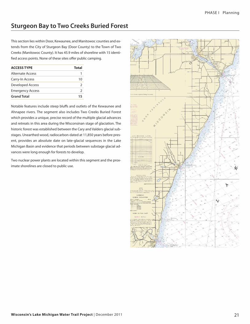
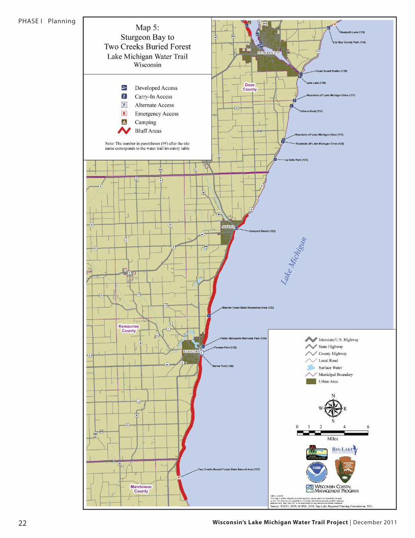
Sturgeon Bay to Two Creeks Buried Forest
PHASE I Planning
This section lies within Door, Kewaunee, and Manitowoc counties and ex-
tends from the City of Sturgeon Bay (Door County) to the Town of Two
Creeks (Manitowoc County). It has 45.9 miles of shoreline with 15 identi-
fied access points. None of these sites offer public camping.
ACCESS TYPE Total
Alternate Access 1
Carry-In Access 10
Developed Access 2
Emergency Access 2
Grand Total 15
Notable features include steep bluffs and outlets of the Kewaunee and
Ahnapee rivers. The segment also includes Two Creeks Buried Forest
which provides a unique, precise record of the multiple glacial advances
and retreats in this area during the Wisconsinan stage of glaciation. The
historic forest was established between the Cary and Valders glacial sub-
stages. Unearthed wood, radiocarbon-dated at 11,850 years before pres-
ent, provides an absolute date on late-glacial sequences in the Lake
Michigan Basin and evidence that periods between substage glacial ad-
vances were long enough for forests to develop.
Two nuclear power plants are located within this segment and the prox-
imate shorelines are closed to public use.
Wisconsin’s Lake Michigan Water Trail Project | December 201122
PHASE I Planning
Wisconsin’s Lake Michigan Water Trail Project | December 2011 23
PHASE I Planning
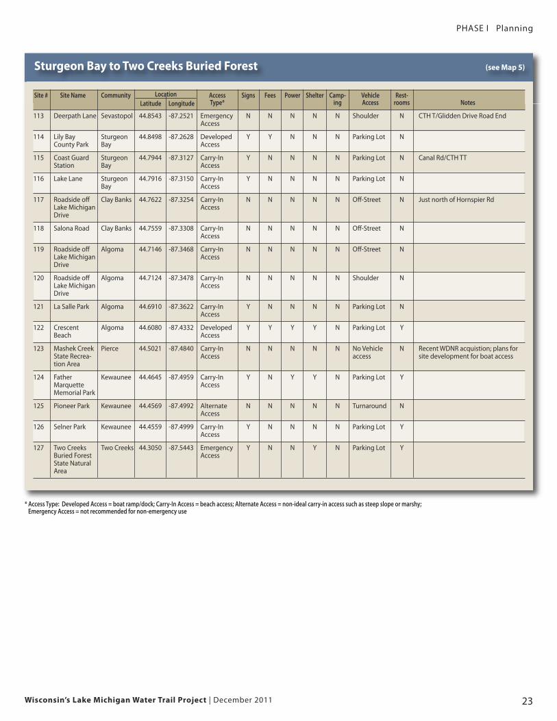
Sturgeon Bay to Two Creeks Buried Forest (see Map 5)
Location
* Access Type: Developed Access = boat ramp/dock; Carry-In Access = beach access; Alternate Access = non-ideal carry-in access such as steep slope or marshy; Emergency Access = not recommended for non-emergency use
Site # Site Name Community Access Signs Fees Power Shelter Camp- Vehicle Rest-Latitude Longitude Type* ing Access rooms Notes
113 Deerpath Lane Sevastopol 44.8543 -87.2521 Emergency N N N N N Shoulder N CTH T/Glidden Drive Road EndAccess
114 Lily Bay Sturgeon 44.8498 -87.2628 Developed Y Y N N N Parking Lot NCounty Park Bay Access
115 Coast Guard Sturgeon 44.7944 -87.3127 Carry-In Y N N N N Parking Lot N Canal Rd/CTH TTStation Bay Access
116 Lake Lane Sturgeon 44.7916 -87.3150 Carry-In Y N N N N Parking Lot NBay Access
117 Roadside off Clay Banks 44.7622 -87.3254 Carry-In N N N N N Off-Street N Just north of Hornspier RdLake Michigan Access Drive
118 Salona Road Clay Banks 44.7559 -87.3308 Carry-In N N N N N Off-Street NAccess
119 Roadside off Algoma 44.7146 -87.3468 Carry-In N N N N N Off-Street NLake Michigan Access Drive
120 Roadside off Algoma 44.7124 -87.3478 Carry-In N N N N N Shoulder NLake Michigan AccessDrive
121 La Salle Park Algoma 44.6910 -87.3622 Carry-In Y N N N N Parking Lot NAccess
122 Crescent Algoma 44.6080 -87.4332 Developed Y Y Y Y N Parking Lot YBeach Access
123 Mashek Creek Pierce 44.5021 -87.4840 Carry-In N N N N N No Vehicle N Recent WDNR acquistion; plans forState Recrea- Access access site development for boat accesstion Area
124 Father Kewaunee 44.4645 -87.4959 Carry-In Y N Y Y N Parking Lot YMarquette Access Memorial Park
125 Pioneer Park Kewaunee 44.4569 -87.4992 Alternate N N N N N Turnaround NAccess
126 Selner Park Kewaunee 44.4559 -87.4999 Carry-In Y N N N N Parking Lot YAccess
127 Two Creeks Two Creeks 44.3050 -87.5443 Emergency Y N N Y N Parking Lot YBuried Forest Access State Natural Area
Wisconsin’s Lake Michigan Water Trail Project | December 201124
PHASE I Planning
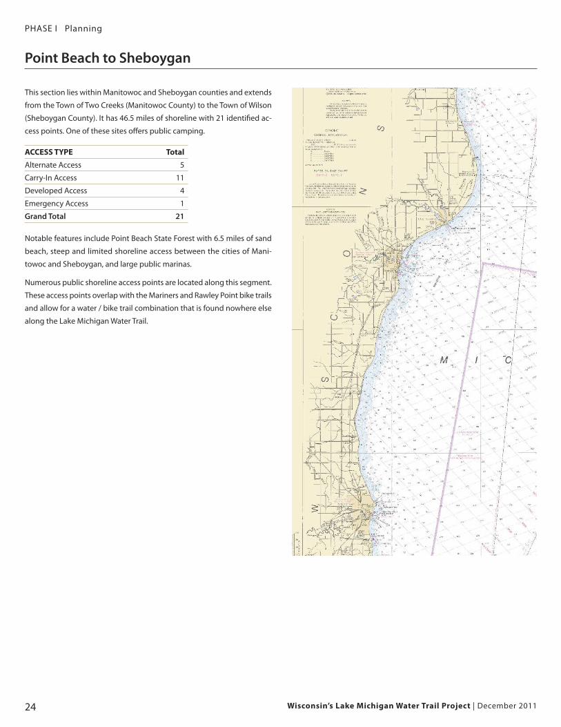
This section lies within Manitowoc and Sheboygan counties and extends
from the Town of Two Creeks (Manitowoc County) to the Town of Wilson
(Sheboygan County). It has 46.5 miles of shoreline with 21 identified ac-
cess points. One of these sites offers public camping.
ACCESS TYPE Total
Alternate Access 5
Carry-In Access 11
Developed Access 4
Emergency Access 1
Grand Total 21
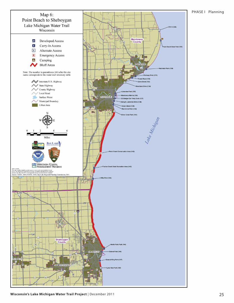
Notable features include Point Beach State Forest with 6.5 miles of sand
beach, steep and limited shoreline access between the cities of Mani-
towoc and Sheboygan, and large public marinas.
Numerous public shoreline access points are located along this segment.
These access points overlap with the Mariners and Rawley Point bike trails
and allow for a water / bike trail combination that is found nowhere else
along the Lake Michigan Water Trail.
Point Beach to Sheboygan
Wisconsin’s Lake Michigan Water Trail Project | December 2011 25
PHASE I Planning
Wisconsin’s Lake Michigan Water Trail Project | December 201126
PHASE I Planning
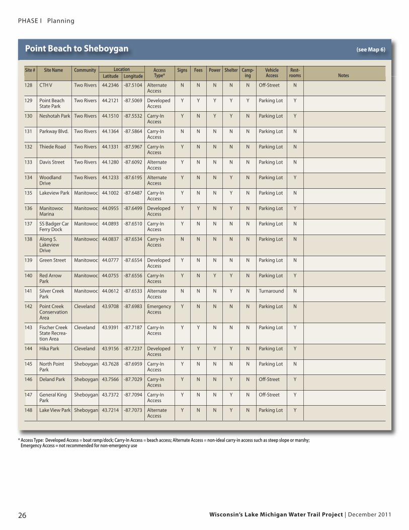
Point Beach to Sheboygan (see Map 6)
Location
* Access Type: Developed Access = boat ramp/dock; Carry-In Access = beach access; Alternate Access = non-ideal carry-in access such as steep slope or marshy; Emergency Access = not recommended for non-emergency use
Site # Site Name Community Access Signs Fees Power Shelter Camp- Vehicle Rest-Latitude Longitude Type* ing Access rooms Notes
128 CTH V Two Rivers 44.2346 -87.5104 Alternate N N N N N Off-Street NAccess
129 Point Beach Two Rivers 44.2121 -87.5069 Developed Y Y Y Y Y Parking Lot YState Park Access
130 Neshotah Park Two Rivers 44.1510 -87.5532 Carry-In Y N Y Y N Parking Lot YAccess
131 Parkway Blvd. Two Rivers 44.1364 -87.5864 Carry-In N N N N N Parking Lot NAccess
132 Thiede Road Two Rivers 44.1331 -87.5967 Carry-In Y N N N N Parking Lot NAccess
133 Davis Street Two Rivers 44.1280 -87.6092 Alternate Y N N N N Parking Lot NAccess
134 Woodland Two Rivers 44.1233 -87.6195 Alternate Y N N Y N Parking Lot YDrive Access
135 Lakeview Park Manitowoc 44.1002 -87.6487 Carry-In Y N N Y N Parking Lot NAccess
136 Manitowoc Manitowoc 44.0955 -87.6499 Developed Y Y N Y N Parking Lot YMarina Access
137 SS Badger Car Manitowoc 44.0893 -87.6510 Carry-In Y N N N N Parking Lot NFerry Dock Access
138 Along S. Manitowoc 44.0837 -87.6534 Carry-In N N N N N Parking Lot NLakeview Access Drive
139 Green Street Manitowoc 44.0777 -87.6554 Developed Y N N N N Parking Lot NAccess
140 Red Arrow Manitowoc 44.0755 -87.6556 Carry-In Y N Y Y N Parking Lot YPark Access
141 Silver Creek Manitowoc 44.0612 -87.6533 Alternate N N N Y N Turnaround NPark Access
142 Point Creek Cleveland 43.9708 -87.6983 Emergency Y N N N N Parking Lot NConservation AccessArea
143 Fischer Creek Cleveland 43.9391 -87.7187 Carry-In Y Y N N N Parking Lot YState Recrea- Accesstion Area
144 Hika Park Cleveland 43.9156 -87.7237 Developed Y Y Y Y N Parking Lot YAccess
145 North Point Sheboygan 43.7628 -87.6959 Carry-In Y N N N N Parking Lot NPark Access
146 Deland Park Sheboygan 43.7566 -87.7029 Carry-In Y N N Y N Off-Street YAccess
147 General King Sheboygan 43.7372 -87.7094 Carry-In Y N N Y N Off-Street YPark Access
148 Lake View Park Sheboygan 43.7214 -87.7073 Alternate Y N N Y N Parking Lot YAccess
Wisconsin’s Lake Michigan Water Trail Project | December 2011 27
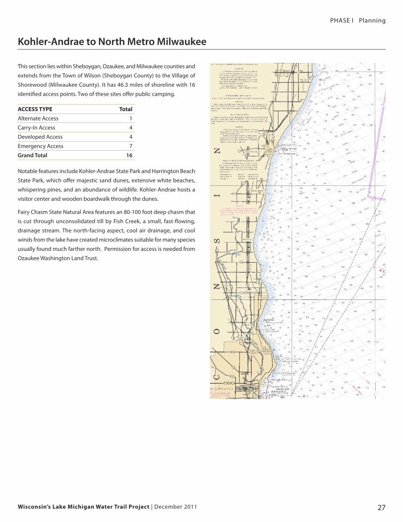
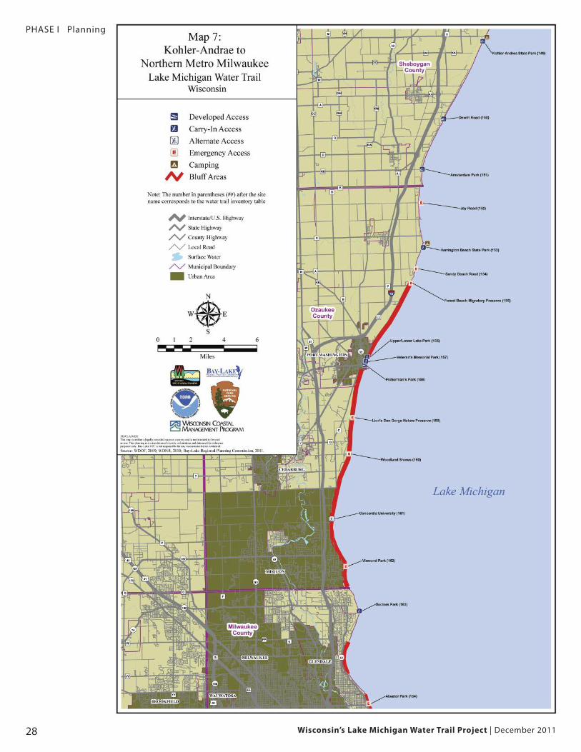
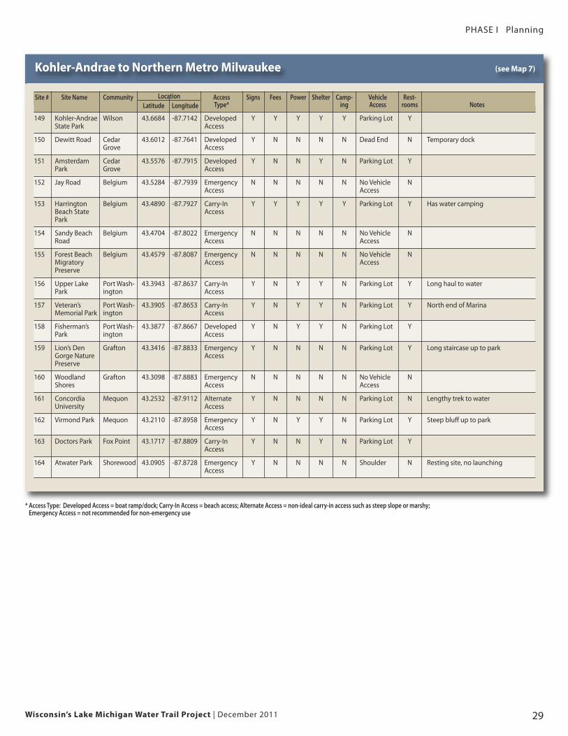
Kohler-Andrae to North Metro Milwaukee
PHASE I Planning
This section lies within Sheboygan, Ozaukee, and Milwaukee counties and
extends from the Town of Wilson (Sheboygan County) to the Village of
Shorewood (Milwaukee County). It has 46.3 miles of shoreline with 16
identified access points. Two of these sites offer public camping.
ACCESS TYPE Total
Alternate Access 1
Carry-In Access 4
Developed Access 4
Emergency Access 7
Grand Total 16
Notable features include Kohler-Andrae State Park and Harrington Beach
State Park, which offer majestic sand dunes, extensive white beaches,
whispering pines, and an abundance of wildlife. Kohler-Andrae hosts a
visitor center and wooden boardwalk through the dunes.
Fairy Chasm State Natural Area features an 80-100 foot deep chasm that
is cut through unconsolidated till by Fish Creek, a small, fast-flowing,
drainage stream. The north-facing aspect, cool air drainage, and cool
winds from the lake have created microclimates suitable for many species
usually found much farther north. Permission for access is needed from
Ozaukee Washington Land Trust.
Wisconsin’s Lake Michigan Water Trail Project | December 201128
PHASE I Planning
Wisconsin’s Lake Michigan Water Trail Project | December 2011 29
Kohler-Andrae to Northern Metro Milwaukee (see Map 7)
Location
* Access Type: Developed Access = boat ramp/dock; Carry-In Access = beach access; Alternate Access = non-ideal carry-in access such as steep slope or marshy; Emergency Access = not recommended for non-emergency use
Site # Site Name Community Access Signs Fees Power Shelter Camp- Vehicle Rest-Latitude Longitude Type* ing Access rooms Notes
149 Kohler-Andrae Wilson 43.6684 -87.7142 Developed Y Y Y Y Y Parking Lot YState Park Access
150 Dewitt Road Cedar 43.6012 -87.7641 Developed Y N N N N Dead End N Temporary dockGrove Access
151 Amsterdam Cedar 43.5576 -87.7915 Developed Y N N Y N Parking Lot YPark Grove Access
152 Jay Road Belgium 43.5284 -87.7939 Emergency N N N N N No Vehicle NAccess Access
153 Harrington Belgium 43.4890 -87.7927 Carry-In Y Y Y Y Y Parking Lot Y Has water campingBeach State AccessPark
154 Sandy Beach Belgium 43.4704 -87.8022 Emergency N N N N N No Vehicle NRoad Access Access
155 Forest Beach Belgium 43.4579 -87.8087 Emergency N N N N N No Vehicle NMigratory Access AccessPreserve
156 Upper Lake Port Wash- 43.3943 -87.8637 Carry-In Y N Y Y N Parking Lot Y Long haul to waterPark ington Access
157 Veteran’s Port Wash- 43.3905 -87.8653 Carry-In Y N Y Y N Parking Lot Y North end of MarinaMemorial Park ington Access
158 Fisherman’s Port Wash- 43.3877 -87.8667 Developed Y N Y Y N Parking Lot YPark ington Access
159 Lion’s Den Grafton 43.3416 -87.8833 Emergency Y N N N N Parking Lot Y Long staircase up to parkGorge Nature AccessPreserve
160 Woodland Grafton 43.3098 -87.8883 Emergency N N N N N No Vehicle NShores Access Access
161 Concordia Mequon 43.2532 -87.9112 Alternate Y N N N N Parking Lot N Lengthy trek to waterUniversity Access
162 Virmond Park Mequon 43.2110 -87.8958 Emergency Y N Y Y N Parking Lot Y Steep bluff up to parkAccess
163 Doctors Park Fox Point 43.1717 -87.8809 Carry-In Y N N Y N Parking Lot YAccess
164 Atwater Park Shorewood 43.0905 -87.8728 Emergency Y N N N N Shoulder N Resting site, no launchingAccess
PHASE I Planning
Wisconsin’s Lake Michigan Water Trail Project | December 201130
PHASE I Planning
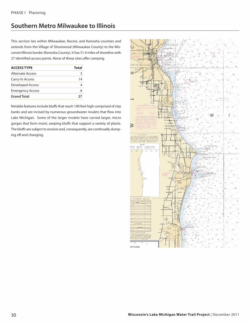
This section lies within Milwaukee, Racine, and Kenosha counties and
extends from the Village of Shorewood (Milwaukee County) to the Wis-
consin/Illinois border (Kenosha County). It has 51.4 miles of shoreline with
27 identified access points. None of these sites offer camping.
ACCESS TYPE Total
Alternate Access 3
Carry-In Access 14
Developed Access 4
Emergency Access 6
Grand Total 27
Notable features include bluffs that reach 100 feet high comprised of clay
banks and are incised by numerous groundwater rivulets that flow into
Lake Michigan. Some of the larger rivulets have carved larger, micro
gorges that form moist, seeping bluffs that support a variety of plants.
The bluffs are subject to erosion and, consequently, are continually slump-
ing off and changing.
Southern Metro Milwaukee to Illinois
Wisconsin’s Lake Michigan Water Trail Project | December 2011 31
PHASE I Planning
Wisconsin’s Lake Michigan Water Trail Project | December 201132
PHASE I Planning
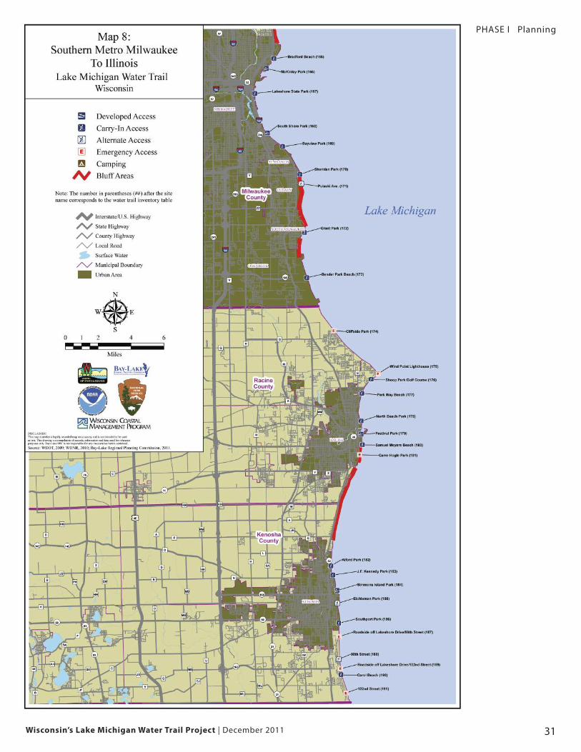
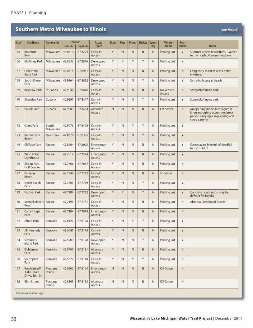
Southern Metro Milwaukee to Illinois (see Map 8)
Location
Continued on next page
Site # Site Name Community Access Signs Fees Power Shelter Camp- Vehicle Rest-Latitude Longitude Type* ing Access rooms Notes
165 Bradford Milwaukee 43.0619 -87.8723 Carry-In Y N N N N Parking Lot Y Summer access restrictions – launch Beach Access to the north off swimming beach
166 McKinley Park Milwaukee 43.0533 -87.8816 Developed Y Y Y Y N Parking Lot YAccess
167 Lakeshore Milwaukee 43.0315 -87.8961 Carry-In Y N N N N Parking Lot N Long carry to car. Visitor Center State Park Access in future.
168 South Shore Milwaukee 42.9964 -87.8822 Developed Y N N Y N Parking Lot Y Carry-In Access at beachPark Access
169 Bayview Park St. Fancis 42.9840 -87.8646 Carry-In Y N N N N No Vehicle N Steep bluff up to parkAccess Access
170 Sheridan Park Cudahy 42.9591 -87.8447 Carry-In Y N N Y N Parking Lot Y Steep bluff up to parkAccess
171 Pulaski Ave. Cudahy 42.9509 -87.8434 Alternate N N N N N Off-Street N An opening in the access gate isAccess large enough to accommodate a
person carrying a kayak; long andsteep carry-in
172 Grant Park South 42.9076 -87.8408 Carry-In Y N Y Y N Parking Lot YMilwaukee Access
173 Bender Park Oak Creek 42.8678 -87.8395 Carry-In Y N N Y N Parking Lot YBeach Access
174 Cliffside Park Racine 42.8204 -87.8092 Emergency Y N N N N Parking Lot Y Steep ravine hike full of deadfall Access to top of bluff
175 Wind Point Racine 42.7812 -87.7574 Emergency Y N N N N Parking Lot YLighthouse Access
176 Shoop Park Racine 42.7766 -87.7654 Carry-In Y N N N N Parking Lot NGolf Course Access
177 Parkway Racine 42.7644 -87.7772 Carry-In Y N N N N Shoulder NBeach Access
178 North Beach Racine 42.7401 -87.7789 Carry-In Y N N Y N Parking Lot YPark Access
179 Festival Park Racine 42.7284 -87.7792 Developed Y Y N Y N Parking Lot Y Concrete boat ramps may be Access difficult for kayaks
180 Samuel Meyers Racine 42.7191 -87.7781 Carry-In Y N N N N Parking Lot N Also has Developed AccessBeach Access
181 Carre-Hogle Racine 42.7104 -87.7819 Emergency Y N N N N Parking Lot NPark Access
182 Alford Park Kenosha 42.6127 -87.8196 Carry-In Y N Y Y N Parking Lot YAccess
183 J.F. Kennedy Kenosha 42.6047 -87.8176 Carry-In Y N N N N Parking Lot YPark Access
184 Simmons Kenosha 42.5909 -87.8128 Developed Y N N Y N Parking Lot YIsland Park Access
185 Eichleman Kenosha 42.5797 -87.8131 Alternate Y N N N N Parking Lot NPark Access
186 Southport Kenosha 42.5622 -87.8118 Carry-In Y N Y Y N Parking Lot NPark Access
187 Roadside off Pleasant 42.5502 -87.8124 Emergency N N N N N Off-Street NLake Shore Prairie AccessDrive/86th St.
188 98th Street Pleasant 42.5303 -87.8132 Alternate N N N N N Off-Street NPrairie Access
Wisconsin’s Lake Michigan Water Trail Project | December 2011 33
Southern Metro Milwaukee to Illinois (continued) (see Map 8)
LocationSite # Site Name Community Access Signs Fees Power Shelter Camp- Vehicle Rest-Latitude Longitude Type* ing Access rooms Notes
189 Roadside off Pleasant 42.5218 -87.8116 Emergency N N N N N Off-Street Noff Lake Shore AccessDrive/102nd Street
190 Carol Beach Pleasant 42.5166 -87.8109 Carry-In Y N N N N Off-street NPrairie Access
191 122nd Street Pleasant 42.5001 -87.8058 Emergency N N N N N Off-Street NPrairie
* Access Type: Developed Access = boat ramp/dock; Carry-In Access = beach access; Alternate Access = non-ideal carry-in access such as steep slope or marshy; Emergency Access = not recommended for non-emergency use
PHASE I Planning
Wisconsin’s Lake Michigan Water Trail Project | December 201134
PHASE I Planning
Enhancement Zone AnalysisThe existing inventory of public access points has been analyzed to
identify gaps or additional needs of access or public camping.
The goal of this analysis is to identify which segments of the trail
should be targeted for site acquisition and/or improvement. The
built-out Lake Michigan Water Trail should have no more than five
miles between sites with restroom access and no more than ten
miles between sites with public camping.
The inventory of existing sites was analyzed for its capacity to pro-
vide public access to water, public access to the shoreline from the
water, and access to public camping sites. As the previous maps
show, there are already many locations along Wisconsin’s Lake
Michigan shoreline that are suitable launching points for day trips.
Over 190 sites offer some level of lake access. However, there are
many portions of the coastline that would benefit from improve-
ments.
Overall, the greatest need is for more public camping sites. There-
fore, the gaps of most concern are these access gaps and the large
segments without camping availability. Map 9 (Enhancement
Zones) shows segments that should be targeted for trail develop-
ment. Each segment is described in the table at the right.
Length(miles) Description
A 8.7 This gap is on the west shore of Green Bay, just south of Marinetteand stretches from Site #4 to Site #7, just north of the outlet of thePeshtigo River.
B 6.1 This gap is on the west shore of Green Bay, just south of the outletof the Peshtigo River and stretches from Site #8 to Site #10, northof Oconto.
C 7.6 This gap is on the west shore of Green Bay, south of Oconto andstretches from Site #14 to Site #16, north of Oconto.
D 25.6 This is the longest gap in access along the west shore of Green Bay.Addressing this gap would link the facilities of Suamico/Green Bayto Oconto. The gap stretches from Site #17 to Site #23.
E 6.9 This gap is on the east shore of Green Bay, northeast of the City ofGreen Bay and stretches from Site #26 to Site #28.
F 9.7 This gap is on the east shore of Green Bay near Sturgeon Bay andstretches from Site #41 to Site #42.
G 6.6 This gap is along the Green Bay side of the Northern Door Penin-sula and stretches from Site #67 in Sister Bay to Site #70 in EllisonBay. This gap runs along a stretch of bluff that can make public ac-cess difficult without a staircase.
H 4.0 This gap is less than five miles but has significant needs and oppor-tunities for providing safe passage across “Death’s Door” to Wash-ington Island or Detroit Island.
I 10.6 This gap is along the west shore of Washington Island from Site #76to Site #77. This gap includes some bluff areas.
J 29.3 This gap is the only gap along the Lake Michigan side of DoorCounty. It is the lengthiest gap along the water trail, stretchingfrom Site #97 to Site #101. However, there are two sites, Site #98and #99 that break-up this gap somewhat, but still with more thanfive miles remaining between each site along this gap. Addressingthis gap would extend a relatively long series of access.
K 6.8 Public access is available within this segment, but public campingis limited. This gap extends from Site #104 to Site #105.
L 14.9 This gap overlaps a bluff area and connects Algoma to Kewaunee.This gap extends from Site #121 to Site #123.
M 16.2 This gap lies south of Kewaunee and along high bluffs. Access development here would link Kewaunee with the campgrounds atPoint Beach State Park. This gap extends from Site #126 to Site#128.
N 9.2 Bluff area connecting Manitowoc and Sheboygan. This gap extendsfrom Site #141 to Site #143.
O 11.2 Bluff area connecting Manitowoc and Sheboygan. This gap extendsfrom Site #144 to Site #145.
P 5.4 Public access is available within this segment, but public campingis limited. This gap extends from Site #149 to Site #150.
Q 7.5 Much of this segment is comprised of steep bluffs in which a fewemergency access sites exist. This gap extends from Site #153 toSite #156.
R 25.8 This is one of the longest gaps that a northbound paddler wouldencounter. There are no primary launch sites for over 12 miles. Thisarea contains bluffs that can make public access difficult without astaircase. This gap extends from Site #158 to Site #165.
S 8.3 While the length of this gap is smaller than many others, it is lo-cated along the most populous city in Wisconsin. This gap extendsfrom Site #173 to Site #176.
T 7.9 This 7+ mile gap sits between the cities of Kenosha and Racine.This gap extends from Site #180 to Site #182.
Total 228.3
Segments Targeted for Trail Development
Wisconsin’s Lake Michigan Water Trail Project | December 2011 35
PHASE I Planning
Wisconsin’s Lake Michigan Water Trail Project | December 201136
Public EngagementThe planning phase of this water trail project included multiple engage-
ments of the non-motorized boating community and the general public.
Three stakeholder meetings were held in October and November 2010 to
share the details of the project with the kayaking community. In addition,
two formal public meetings were held in 2011 for review of all materials.
Thus far, general public engagement has included:
• Stakeholder meeting in Green Bay (10/14/2010)
• Stakeholder meeting in Milwaukee (11/9/2010)
• Stakeholder meeting in Green Bay (11/10/2010)
• Public meeting in Milwaukee (4/28/11)
• Public meeting in Green Bay (5/3/11)
• Public website hosted by DNR (live as of 2011)
• News release issued by the DNR (April 2011)
• Project outreach at Canoecopia and Sheboygan HarborFest.
PHASE I Planning
“What fantastic news, this is!! I, along
with many other kayak enthusiasts,
will no doubt be paddlin' it. Thanks for
your leadership.”
“I circumnavigated Lake Michigan in
2006 and was challenged by the lack
of camping and landing possibilities.
Your maps would have been
extremely helpful back then!
Thanks for all your work….”
Wisconsin’s Lake Michigan Water Trail Project | December 2011 37
PHASE I Planning
“The Lake Michigan Water trail idea is
great and makes good sense. In
addition to residents, the proximity to
Chicago makes it convenient for
kayakers from IL to spend tourism
dollars in WI and paddle the route….. “
“I love any activity that can be done
outdoors: running, biking, hiking,
camping, kiteboarding, kayaking,
stand up paddle boarding, swimming,
fishing, stargazing, etc. It is wonderful
to hear that we will soon have the
privilege of even more access points
and information to assist anyone
wishing to explore the shoreline.”
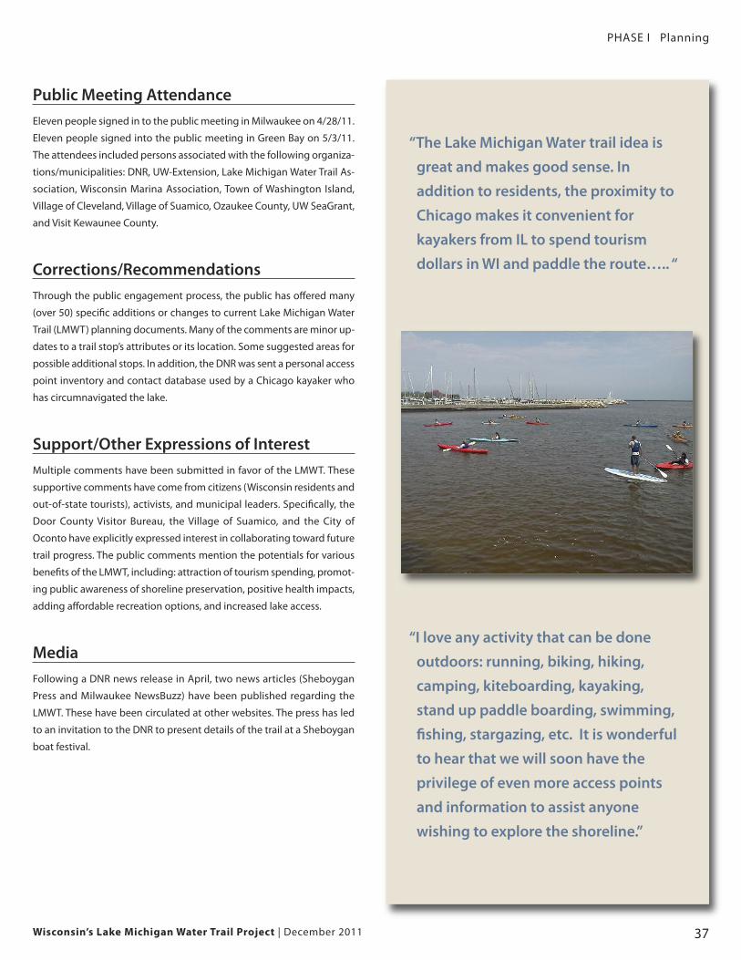
Public Meeting AttendanceEleven people signed in to the public meeting in Milwaukee on 4/28/11.
Eleven people signed into the public meeting in Green Bay on 5/3/11.
The attendees included persons associated with the following organiza-
tions/municipalities: DNR, UW-Extension, Lake Michigan Water Trail As-
sociation, Wisconsin Marina Association, Town of Washington Island,
Village of Cleveland, Village of Suamico, Ozaukee County, UW SeaGrant,
and Visit Kewaunee County.
Corrections/RecommendationsThrough the public engagement process, the public has offered many
(over 50) specific additions or changes to current Lake Michigan Water
Trail (LMWT) planning documents. Many of the comments are minor up-
dates to a trail stop’s attributes or its location. Some suggested areas for
possible additional stops. In addition, the DNR was sent a personal access
point inventory and contact database used by a Chicago kayaker who
has circumnavigated the lake.
Support/Other Expressions of InterestMultiple comments have been submitted in favor of the LMWT. These
supportive comments have come from citizens (Wisconsin residents and
out-of-state tourists), activists, and municipal leaders. Specifically, the
Door County Visitor Bureau, the Village of Suamico, and the City of
Oconto have explicitly expressed interest in collaborating toward future
trail progress. The public comments mention the potentials for various
benefits of the LMWT, including: attraction of tourism spending, promot-
ing public awareness of shoreline preservation, positive health impacts,
adding affordable recreation options, and increased lake access.
MediaFollowing a DNR news release in April, two news articles (Sheboygan
Press and Milwaukee NewsBuzz) have been published regarding the
LMWT. These have been circulated at other websites. The press has led
to an invitation to the DNR to present details of the trail at a Sheboygan
boat festival.
“Count me among outdoor enthusiasts
who endorse the Lake Michigan Water
Trail. I am a St. Louis-based sea kayaker
who gets away to bigger water
whenever time and money allow. I've
made numerous kayaking and
camping trips to Wisconsin. I've
kayaked Lake Michigan, having to deal
with the shortage of suitable public
access points. Please do whatever you
can to make this trail a reality….”
Wisconsin’s Lake Michigan Water Trail Project | December 201138
PHASE I Planning
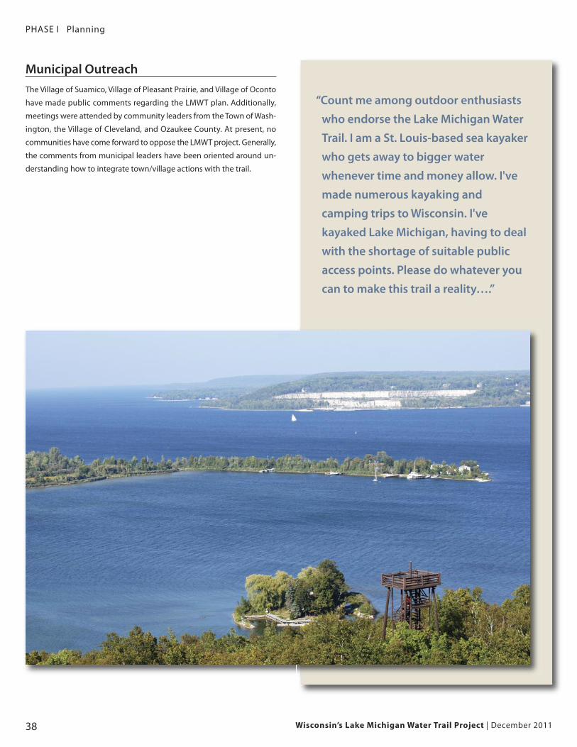
Municipal OutreachThe Village of Suamico, Village of Pleasant Prairie, and Village of Oconto
have made public comments regarding the LMWT plan. Additionally,
meetings were attended by community leaders from the Town of Wash-
ington, the Village of Cleveland, and Ozaukee County. At present, no
communities have come forward to oppose the LMWT project. Generally,
the comments from municipal leaders have been oriented around un-
derstanding how to integrate town/village actions with the trail.
Wisconsin’s Lake Michigan Water Trail Project | December 2011 39
PHASE II Implementation
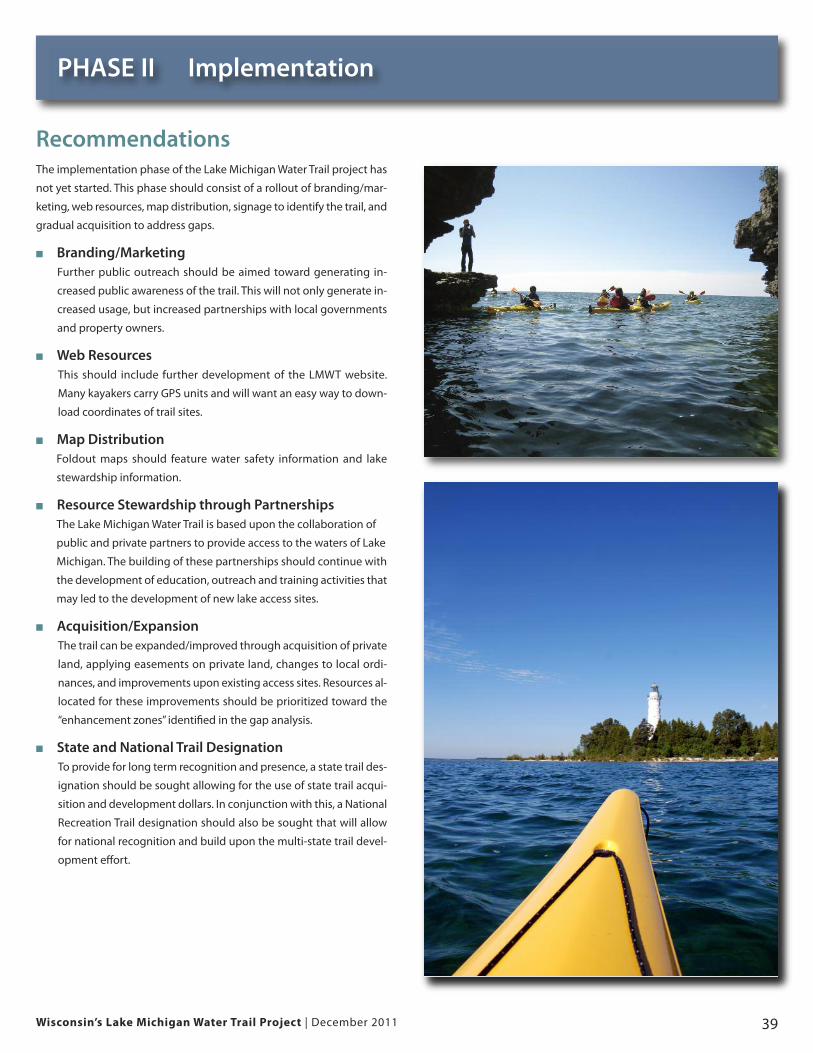
RecommendationsThe implementation phase of the Lake Michigan Water Trail project has
not yet started. This phase should consist of a rollout of branding/mar-
keting, web resources, map distribution, signage to identify the trail, and
gradual acquisition to address gaps.
� Branding/MarketingFurther public outreach should be aimed toward generating in-
creased public awareness of the trail. This will not only generate in-
creased usage, but increased partnerships with local governments
and property owners.
� Web ResourcesThis should include further development of the LMWT website.
Many kayakers carry GPS units and will want an easy way to down-
load coordinates of trail sites.
� Map DistributionFoldout maps should feature water safety information and lake
stewardship information.
� Resource Stewardship through PartnershipsThe Lake Michigan Water Trail is based upon the collaboration of
public and private partners to provide access to the waters of Lake
Michigan. The building of these partnerships should continue with
the development of education, outreach and training activities that
may led to the development of new lake access sites.
� Acquisition/ExpansionThe trail can be expanded/improved through acquisition of private
land, applying easements on private land, changes to local ordi-
nances, and improvements upon existing access sites. Resources al-
located for these improvements should be prioritized toward the
“enhancement zones” identified in the gap analysis.
� State and National Trail DesignationTo provide for long term recognition and presence, a state trail des-
ignation should be sought allowing for the use of state trail acqui-
sition and development dollars. In conjunction with this, a National
Recreation Trail designation should also be sought that will allow
for national recognition and build upon the multi-state trail devel-
opment effort.