Embed Size (px)
Citation preview

2011
Bureau of Aeronautics
Wisconsin Department of Transportation
6/1/2011
Wisconsin Airport Land Use Guidebook

ii
Wisconsin Airport Land Use Guidebook June 2011
This page intentionally left blank

Wisconsin Department of Transportation Wisconsin Airport Land Use Guidebook
iii
Wisconsin Airport Land Use Guidebook June 2011
Preface
Welcome to the Wisconsin Airport Land Use Guidebook (2011 edition). This revised guidebook is
designed to help communities and airports work cooperatively to plan for and establish compatible land
use around airports and work towards mitigating existing incompatible conditions. Land use
compatibility is a significant, yet often unrecognized, factor in aviation safety. When asked to describe
an airport safety-related matter, many people refer to the perimeter fencing or the security checkpoint
within an air carrier airport. Seldom does the average citizen recognize that bright lights, residential
developments, wetlands, and tall towers pose hazards to airports, their users, and nearby residents.
The goal of this guidebook is to protect communities and airports from incompatible land use that could
negatively affect the safe operation of airports and pose hazardous consequences to the public. In this
guidebook, stakeholders will find information and resources that may help them direct the future
development of their communities and airports. Stakeholders who might find this guidebook useful
include airport and community planners; airport owners and managers; zoning administrators; local,
state, and regional agency officials; developers; legislators; and the general public.

iv
Wisconsin Airport Land Use Guidebook June 2011
Contents List of Figures ............................................................................................................................................... vi
Chapter 1 Introduction ................................................................................................................................. 1
Purpose of this Guidebook ........................................................................................................................ 2
Importance of the Aviation Industry ......................................................................................................... 3
Classification and Distribution of Wisconsin’s Airports ............................................................................ 5
Summary ................................................................................................................................................... 8
Chapter 2 The Importance of Establishing Compatible Land Use around Airports .................................... 10
Safety Concerns ...................................................................................................................................... 10
FAA Safety Standards .............................................................................................................................. 17
Noise Concerns ....................................................................................................................................... 24
FAA Noise Standards ............................................................................................................................... 26
Summary ................................................................................................................................................. 27
Chapter 3 Land Use Incompatibility Concerns ............................................................................................ 28
Safety-Related Concerns ......................................................................................................................... 28
Noise-Related Concerns .......................................................................................................................... 32
Summary ................................................................................................................................................. 32
Chapter 4 Land Use Regulations and Guidance .......................................................................................... 34
Federal Laws and Policies ....................................................................................................................... 34
State Laws and Policies ........................................................................................................................... 37
Summary ................................................................................................................................................. 42
Chapter 5 Roles and Responsibilities for Establishing Compatible Land Use ............................................. 43
Federal Government ............................................................................................................................... 43
State Government and Regional Organizations ...................................................................................... 45
Local Governments ................................................................................................................................. 46
Airport Owners and Managers ............................................................................................................... 47
Airport Users ........................................................................................................................................... 47
Citizens .................................................................................................................................................... 48
Summary ................................................................................................................................................. 49
Chapter 6 Techniques for Establishing Compatible Land Use .................................................................... 50
Planning and Zoning Tools ...................................................................................................................... 50
Natural Feature Techniques .................................................................................................................... 52

Wisconsin Department of Transportation Wisconsin Airport Land Use Guidebook
v
Wisconsin Airport Land Use Guidebook June 2011
Land Acquisition and Agreement Techniques ........................................................................................ 57
Noise Mitigation ...................................................................................................................................... 61
Summary ................................................................................................................................................. 62
Summary ..................................................................................................................................................... 66
Appendix A: Additional Land Use Regulations and Guidance ..................................................................... 67
Planning-Related Regulations and Guidance .......................................................................................... 67
Environment-Related Regulations and Guidance ................................................................................... 68
Land Acquisition-Related Regulations and Guidance ............................................................................. 73
Noise-Related Regulations and Guidance ............................................................................................... 74
Case Law .................................................................................................................................................. 75
Appendix B: Sample Land Use Ordinances ................................................................................................. 76
Appendix C: Agency Contacts ..................................................................................................................... 78
Glossary ....................................................................................................................................................... 81
Acronyms .................................................................................................................................................... 92
Reference .................................................................................................................................................... 93
vi
Wisconsin Airport Land Use Guidebook June 2011
List of Tables Table 1-1: Total 2002 Economic Significance of the Aviation Industry in Wisconsin ................................... 5
Table 1-2: NPIAS Airport Functional Categories ........................................................................................... 6
Table 1-3: Wisconsin Airports in the National Plan of Integrated Airport Systems (NPIAS) ........................ 7
Table 1-4: Wisconsin Airport Functional Categories ..................................................................................... 8
Table 2-1: General Aviation and Commercial Aircraft Accident Data ......................................................... 12
Table 2-2: Accidents by Phase of Operation: U.S. General Aviation Aircraft .............................................. 13
Table 2-3: Accidents by Phase of Operation: Air Carriers ........................................................................... 13
Table 2-4: Most Common Causes of Commercial Service Aviation Accidents ........................................... 17
Table 2-5: FAR Part 77 Dimensional Requirements .................................................................................... 19
Table 2-6: Runway Safety Area and Object Free Area Dimension Requirements ...................................... 24
Table 3-1: Population Densities by Building Type ....................................................................................... 31
Table 3-2: Compatible Land Uses within FAR Part 77 Surfaces and FAA Safety Areas ............................... 33
Table 6-1: Compatible Tree Heights ........................................................................................................... 53
Table 6-2: Wisconsin Tree Height Index ..................................................................................................... 54
Table 6-3: Land Acquisition Options for Establishing Compatible Land Use .............................................. 58
Table 6-4: Techniques for Establishing Compatible Land Uses Around Airports ........................................ 63
Table 6-5: Stakeholder Communication Directory ..................................................................................... 64
List of Figures Figure 1-1: Outagamie County Regional Airport, Appleton, WI ................................................................... 1
Figure 1-2: Burnett County Airport, Siren, WI .............................................................................................. 2
Figure 1-3: Sawyer County Airport, Hayward, WI ......................................................................................... 4
Figure 1-4: Wisconsin Airport System ........................................................................................................... 9
Figure 2-1: Typical Airport Traffic Pattern .................................................................................................. 11
Figure 2-2: Proximity of Aviation Accidents to Nearest Airport ................................................................. 12
Figure 2-3: Arrival Accidents ....................................................................................................................... 14
Figure 2-4: Take-off Accidents .................................................................................................................... 16
Figure 2-5: FAR Part 77 Surfaces- Profile View ........................................................................................... 20
Figure 2-6: FAR Part 77 Surfaces- Plan View ............................................................................................... 21
Figure 2-7: Runway Protection Zone .......................................................................................................... 23
Figure 2-8: Runway Safety Areas and Object Free Areas ............................................................................ 23
Figure 3-1: Man-Made Pond Near End of Runway ..................................................................................... 30
Figure 5-1: Park Falls Municipal Airport, Park Falls, WI .............................................................................. 49
Figure 6-1: Tall trees surround the Manitowish Waters Airport, Manitowish Waters, WI ........................ 53
Figure 6-2: Land Use Compatibility Planning Steps .................................................................................... 65

Wisconsin Department of Transportation Wisconsin Airport Land Use Guidebook
1
Wisconsin Airport Land Use Guidebook June 2011
Chapter 1 Introduction Wisconsin has a diverse aviation system of more than 130 public use airports. With the growth of the
global market, transportation of goods and passengers is increasingly becoming a key element of
Wisconsin’s economy. The aviation system provides a variety of services for state residents and plays an
important role in attracting business and industry to the state. Airport sponsors in Wisconsin, as well as in
other states, need to maintain and develop the existing aviation infrastructure to ensure that the aviation
system is preserved to meet future needs.
Figure 1-1: Outagamie County Regional Airport, Appleton, WI
One of the primary concerns facing the aviation industry today is the increasing pressure of incompatible
land use near airports. Incompatible land uses are those that constrain safe and efficient operation or
expose people living or working nearby to noise or other aviation hazards. In recent years, Wisconsin’s
airports have felt the increasing demand for developable space adjacent to airports, both in the air and on
the ground. Without proper planning, incompatibilities are likely to increase as the demand for
developable land and air travel grows.
Airport compatible land use planning is essential for a number of reasons. Foremost, it enhances the
safety of those in the aircraft and on the ground by mitigating factors that may contribute to aircraft
accidents. Secondly, compatible land use planning protects airport viability and development potential by
correcting and restricting land uses that could limit the airport’s growth. Compatible land use planning
also increases the quality of life for airport neighbors and the surrounding communities by alleviating the
negative impacts of aircraft and airport operations. For these reasons, compatible land use planning is an
important component of Wisconsin’s aviation industry.

2 Chapter 1: Introduction
Wisconsin Airport Land Use Guidebook June 2011
Purpose of this Guidebook The main purpose of this guidebook is to provide informational and educational guidance to airport and
government officials, planners, and residents. It is intended to help airport stakeholders establish
compatible land uses around their airports to improve public welfare and safety by employing and
incorporating the most effective tools available. It also provides helpful resources for local officials to
incorporate airport compatible land needs into their comprehensive planning process. Through this
process, communities can work cooperatively with airports to reach the mutually beneficial goal of
compatible land use and economic vitality.
Figure 1-2: Burnett County Airport, Siren, WI
The first chapter of this guidebook discusses the importance of the aviation industry and provides a brief
snapshot of airports in Wisconsin. Chapter 2 highlights the importance of establishing compatible land
uses around Wisconsin airports by outlining the impact of safety and noise hazards resulting from
incompatible land use and discussing FAA safety and noise standards.
Chapter 3 discusses land use compatibility concerns in greater detail. The least compatible land uses
around airports include structures with large densities of people, streetlamps and buildings that emit
bright light, dust-producing smokestacks that cause visual and physical obstructions, and ponds and large
wetlands that attract wildlife hazards. More compatible land uses include farmland, low density
residential development, and small office buildings.
Chapter 4 presents a brief summary of state and federal land use regulations and guidance, providing a
legal snapshot of the issues concerning land use compatibility surrounding airports. This section of the
document includes Section 114.135-6, Wis. Stats, which grants airport owners the legal authority to
protect airspace and formulate ordinances regulating the height of buildings, structures, and objects of
natural growth within three miles of the airport. Additionally, this section of the document discusses

Wisconsin Department of Transportation Wisconsin Airport Land Use Guidebook
3
Wisconsin Airport Land Use Guidebook June 2011
Wisconsin’s comprehensive planning law, which requires all zoning, subdivisions and official maps of a
community to be consistent with its adopted comprehensive plan. As one of nine required comprehensive
plan elements, the ―Transportation‖ element provides an avenue for unprecedented coordination among
airports, airport managers, commissions and their host communities.
Chapter 5 discusses the roles and responsibilities of stakeholders involved in the compatible land use
planning process on the federal, state, and local levels. Finally, Chapter 6 identifies techniques for
establishing compatible land use within the areas of planning and zoning, natural features mitigation, land
acquisition and agreements, and noise mitigation. This chapter serves as a pivotal starting point for
airports and their communities, but it is important to be mindful that all airports and localities are unique
and land use compatibility issues and solutions will vary.
Web links to useful resources, such as guidance documents and existing plans and programs for various
preventive, corrective and mitigation practices, can be found throughout this document.
Users of this guidebook should be aware that the information contained within may not be inclusive of all
of the relevant regulations, resources, problems, and solutions; rather, it is meant to be a summary of the
primary issues that need to be considered. Interested parties should consult with the Bureau of
Aeronautics (BOA) at WisDOT and other relevant agencies for specific guidance regarding aviation
planning.
Importance of the Aviation Industry For a better understanding of the importance of regulating incompatible land uses, it is essential to
understand the value of Wisconsin’s aviation system.
National Level The United States has an extensive network of airports that move people and cargo, as well as supports
national defense objectives. Aviation is an essential mode of transportation in the U.S; over 1.9 million
passengers rely on U.S. airports for business and leisure travel each day.1 Similarly, business development
relies on airports for air cargo and general aviation services. The relationship between airports, aviation,
and industry is interconnected and all work to sustain each other’s growth and development. The nation’s
civil aviation industry employs more than 11 million people, with earnings of more than $396 billion and
direct, indirect, and induced outputs of more than $1.3 trillion.2 Airports are essential for job retention and
economic development in communities across the nation and protecting their viability is crucial for the
national economy.
State Level Aviation is an important industry in Wisconsin which provides transportation, economic development,
and recreational educational opportunities for the citizens of the state and its visitors. The Wisconsin
airport system not only links businesses and residents regionally, but also to the rest of the nation and the
world. Commercial air carrier airports and general aviation airports are both important resources for
1 Airport Cooperative Research Program. Report 27: Enhancing Airport Land Use Compatibility, Vol. 1. 2010. 2 Federal Aviation Administration, The Economic Impact of Civil Aviation on the U.S. Economy, December 2009, http://www.faa.gov/air_traffic/publications/media/FAA_Economic_Impact_Rpt_2009.pdf.

4 Chapter 1: Introduction
Wisconsin Airport Land Use Guidebook June 2011
corporations seeking to expand or locate in the state. In addition to commercial air service and general
aviation facilities, the Wisconsin aviation system also provides ―quality of life‖ amenities such as
emergency medical services, flight training, and environmental management.
Figure 1-3: Sawyer County Airport, Hayward, WI
Airports and their associated activities are themselves economic engines for communities, providing
employment, purchasing goods and services from other businesses, and generating income as aviation-
related spending circulates through the economy. The Wisconsin Bureau of Aeronautics measured the
economic value of aviation in Wisconsin in the 2002 Economic Significance of the Aviation Industry in
Wisconsin.
Economic Significance of the Aviation Industry in Wisconsin can be found here:
http://www.dot.wisconsin.gov/library/publications/topic/air/economic-sum.pdf
The study found that the total economic significance for 2002 (direct, indirect, and induced economic
impact of the aviation industry) was significant, with a total output of $2.8 billion. The economic
significance in 2002 is presented in Table 1-1.

Wisconsin Department of Transportation Wisconsin Airport Land Use Guidebook
5
Wisconsin Airport Land Use Guidebook June 2011
Table 1-1: Total 2002 Economic Significance of the Aviation Industry in Wisconsin
Output Personal Income Jobs
Direct $1.1 Billion $541 Million 13,590
Indirect $1.2 Billion $443 Million 24,106
Induced $0.5 Billion $117 Million 4,042
Total $2.8 Billion $1.1 Billion 41,738 Note: results have been rounded; Source: WisDOT BOA
Wisconsin’s 90 general aviation (GA) airports in the state system and the businesses they support
generated more than $1.5 billion in output, 16,827 jobs, and $488 million in personal income in direct,
indirect, and induced economic impacts in 2002.
Airports in eight cities in Wisconsin offer regularly scheduled commercial airline service to the rest of the
nation and the world. In addition to their vital air service roles, these airports are centers of economic
activity that generate a large share of aviation’s total economic impact in Wisconsin. In 2002, these
commercial airports generated a direct economic impact of nearly $120 million to the Wisconsin
economy, 2,832 jobs, and $154 million in personal income to Wisconsin residents; whereas the total
economic impact, including direct, indirect, and induced impacts of the commercial service airports in
Wisconsin exceeded $1 billion in output, 19,720 in jobs, and over $480 million in personal income.
Local Level The value of local airports to their host communities is far greater than the economic value generated by
fuel sales, hangar rentals or airport-related business employee payrolls. The importance of aviation to
host communities is three-pronged:
Direct benefits from the provision of aviation services and activities, including increased
transportation opportunities for passengers, cargo, aviation businesses, and flight training.
The provision of special services such as emergency search and rescue, emergency medical
service, emergency evacuation, forest fire control, and crop dusting.
Indirect economic benefits from the improved accessibility and mobility that attracts visitors and
other parties such as entrepreneurial businesses to locate themselves in the community.
All of these benefits combine to create the overall value of an airport to its community, the region, state,
and the national economy. However, the vivacity of the aviation system is threatened by the
encroachment of incompatible land uses on airports and the increasing demand for developable property.
This is a national issue facing aviation facilities ranging from small general aviation airports in rural
communities to large international airports in metropolitan areas.
Classification and Distribution of Wisconsin’s Airports Airports, aviation and aviation-related industries play a significant role in the economic success of
Wisconsin communities, in part because each airport is part of a greater aviation system. Both the state
and federal governments have identified and classified airports which have particular importance within
state and national aviation systems. National and state airport system plans provide a framework for the
preservation and enhancement of a system of public-use airports able to meet current and future aviation
needs.

6 Chapter 1: Introduction
Wisconsin Airport Land Use Guidebook June 2011
National Plan of Integrated Airport Systems (NPIAS)
The Federal Aviation Administration (FAA) maintains a National Plan of Integrated Airport Systems
(NPIAS) to provide the public with reasonable access to a safe and adequate system of public-use
airports. In order to be eligible for federal improvement funds, an airport must be included in the NPIAS.
For an airport to be included in the NPIAS, it must function as a public-use airport and meet the criteria
specified in one of the categories outlined in Table 1-2.
Table 1-2: NPIAS Airport Functional Categories
Category Significant function
Primary Commercial Service Must have scheduled air carrier service and enplane 10,000 or more passengers
annually.
Non-Primary Commercial
Service Airports
Must have scheduled air carrier service and enplane between 2,500 and 10,000
passengers annually.
Reliever Airports General aviation airports which are intended to reduce congestion at large
commercial service airports by providing general aviation pilots with alternative
landing areas. They also provide the surrounding areas with access to air
transportation.
General Aviation Airports Included in an accepted state and/or regional airport system plan; serve a
community located at least 20 miles from the nearest existing or proposed airport
included in the NPIAS; have 10 or more based aircraft; and have an eligible sponsor
willing to own and develop the airport.
Source: Wisconsin State Airport System Plan 2020, WisDOT BOA
The FAA has identified 89 airports in Wisconsin that play a pivotal role in the U.S. aviation system and
qualify for federal improvement grants. These airports are listed in Table 1-3 on the following page.
Wisconsin State Airport System Plan (SASP)
Wisconsin’s airport system plan is called the Wisconsin State Airport System Plan 2020 (SASP), and the
primary purpose of the plan is to provide for the orderly and timely development of a system of airports
able to meet the future aviation needs of the state over a 20-year period.
Wisconsin State Airport System Plan 2020 can be accessed here:
http://www.dot.wisconsin.gov/projects/state/docs/air2020-plan.pdf
Wisconsin State Airport System Plan Airport Classification Review and Update can be found here:
http://www.dot.wisconsin.gov/projects/state/docs/air-classification-update.pdf
As part of the SASP, the current and future role of each airport in the system is identified and categorized
to assist in the allocation of federal and state funds and identification of development priorities. Most
recently, the Wisconsin State Airport System Plan Airport Classification Review and Update revised the
classifications to four categories of airports based on functional criteria developed by the Bureau of
Aeronautics (BOA) (see Figure 1-4). Classification is based on the facility’s ability to serve a particular

Wisconsin Department of Transportation Wisconsin Airport Land Use Guidebook
7
Wisconsin Airport Land Use Guidebook June 2011
segment of the aviation community and the parameters of each category are illustrated in Table 1-4,
found on the following page.
Table 1-3: Wisconsin Airports in the National Plan of Integrated Airport Systems (NPIAS)
Primary Commercial Service Airports Austin Straubel International Airport Central Wisconsin Airport Chippewa Valley Regional Airport
Dane County Regional Airport General Mitchell International La Crosse Municipal Airport
Outagamie County Regional Airport Rhinelander-Oneida County Airport
Non-Primary Commercial Service Airports Lakeland Airport/Noble Lee Field Manitowoc County Airport Southern Wisconsin Regional Airport
Wittman Regional Airport
Reliever Airports
Capitol Drive Airport Hartford Municipal Airport John H. Batten Airport
Kenosha Regional Airport Lawrence J. Timmerman Field Middleton Municipal – Morey Field
Waukesha County Airport West Bend Municipal
General Aviation Airports
Adams County Legion Field Alexander Field- South Wood County Amery Municipal Airport
Baraboo-Wisconsin Dells Airport Barron Municipal Airport Black River Falls Airport
Boscobel Airport Boyceville Municipal Airport Burlington Municipal Airport
Burnett County Airport Cable Union Airport Clintonville Municipal Airport
Crandon Municipal Airport Crivitz Municipal Airport Cumberland Municipal Airport
Dodge County Airport Door County Cherryland Airport Eagle River Union Airport
East Troy Municipal Airport Ephraim-Fish Creek Airport Fond du Lac County Airport
Fort Atkinson Municipal Airport Grantsburg Municipal Airport Iowa County Airport
J. Douglas Bake Memorial Airport John F. Kennedy Memorial Airport Joshua Sanford Field Airport
King’s Land O Lakes Airport L.O. Simenstad Municipal Airport Lancaster Municipal Airport
Langlade County Airport Madeline Island Airport Manitowish Waters Airport
Marshfield Municipal Airport Mauston-New Lisbon Union Airport Menomonie Municipal Airport
Merrill Municipal Airport Monroe Municipal Airport Neillsville Airport
New Holstein Municipal Airport New Richmond Regional Airport Palmyra Municipal Airport
Platteville Municipal Airport Park Falls Municipal Airport Portage Municipal Airport
Prairie du Chien Airport Price County Airport Reedsburg Municipal Airport Rice Lake Regional Airport Richard I. Bong Airport Richland Airport Rusk County Airport Sauk Prairie Airport Sawyer County Airport
Shawano Municipal Airport Sheboygan County Memorial Airport Shell Lake Municipal Airport
Solon Springs Municipal Airport Sparta/ Fort McCoy Airport Stevens Point Municipal Airport
Taylor County Airport Tri-County Regional Airport Tomahawk Regional Airport
Viroqua Municipal Airport Washington Island Airport Watertown Municipal Airport
Waupaca Municipal Airport Wausau Downtown Airport Wautoma Municipal Airport

8 Chapter 1: Introduction
Wisconsin Airport Land Use Guidebook June 2011
Figure 1-4 (found on the following page) shows all public use airports in Wisconsin, based on BOA
categories, as listed in the Wisconsin State Airport System Plan Airport Classification Review and
Update. It illustrates that a large share of airports in the state are smaller, community-based general
aviation airports. The largest categories of airports are medium general aviation (42.9 percent), followed
by small general aviation (34.7 percent). Large general aviation and commercial service airports represent
the smallest proportion of public airports in Wisconsin, with 14.3 percent and 8.2 percent, respectively.
Table 1-4: Wisconsin Airport Functional Categories
Category Significant function
Commercial Service Support regularly scheduled year-round commercial airline service and support the
full range of general aviation activity to domestic and international destinations.
Large General Aviation Support all general aviation aircraft that include daily operations of all types of
business jets. These airports generally serve as domestic transportation centers and
may support international business activity.
Medium General Aviation Support most single and multi-engine general aviation aircraft, including those
aircraft commonly used by businesses. These airports support regional and in-state
air transportation needs.
Small General Aviation Primarily support single-engine general aviation aircraft, but may also
accommodate small twin-engine general aviation aircraft and occasionally business
aircraft activity.
Source: Wisconsin State Airport System Plan 2020, WisDOT BOA
Summary This chapter highlights the importance of the aviation industry for national, state, and local economies
and the value Wisconsin airports play in maintaining the viability of the state and national systems of
airports. For this reason, it is important to protect each airport in Wisconsin from incompatible land uses.
The remainder of this guidebook will discuss compatible land use planning in greater detail.

Wisconsin Department of Transportation Wisconsin Airport Land Use Guidebook
9
Wisconsin Airport Land Use Guidebook June 2011
Figure 1-4: Wisconsin Airport System

10 Chapter 2: The Importance of Establishing Compatible Land Use around Airports
Wisconsin Airport Land Use Guidebook June 2011
Chapter 2 The Importance of Establishing Compatible Land Use around
Airports Establishing compatible land uses around airports reduces impacts on airport operations and persons
located in close proximity to the airport. Two main categories of concern are safety and noise. This
chapter discusses safety and noise concerns in greater detail and provides a justification for establishing
compatible land uses near airports. Additionally, this chapter discusses FAA safety and noise standards,
which play an important role in compatible land use planning.
Safety Concerns All modes of transportation have risks and safety concerns associated with them and aviation is no
different. A small number of accidents are inevitable in the area in or around an airport, but the primary
goal of airport land use compatibility planning is to temper some of this risk by reducing or eliminating
safety hazards surrounding airports. Not only are accidents dangerous to those in the aircraft, they are
also dangerous to people on the ground. To minimize accidents, safety risks must be identified and
diminished.
Basics of Aircraft Operation
In order to fully comprehend the hazards of incompatible land use, it is important to understand some
basics about the operation of an airport and aircraft. During normal operations, aircraft traffic in or near
the airport includes arrivals, departures and over flights of aircraft passing through the area. During these
activities, pilots usually focus on scanning the surrounding airspace for other aircraft. Distracting
obstructions in the airspace can impede pilots from identifying other aircraft or potential dangers.
Additionally, emergency situations can take place anytime. Aircraft emergency situations involve factors
that can generally be divided into two broad categories: those under the pilot’s control and those outside
of the pilot’s control. Factors within a pilot’s control include the safe operation of an aircraft within FAA
guidelines and within the operational capabilities of the aircraft, such as maintaining sufficient flying
speed and maintaining proper spacing between multiple flying aircraft. Factors outside of the pilot’s
control include adverse wind and weather conditions, loss of power, terrain and wildlife hazards.
Airport Traffic Patterns
A typical airport traffic pattern without an operating air traffic control tower (ATCT) is a rectangular
circuit around an airport that aircraft fly while waiting for clearance to land. Figure 2-1 depicts clockwise
and counter-clockwise traffic patterns; direction is usually dictated by traffic levels. A counter-clockwise
pattern is standard operating procedure. Clockwise traffic patterns are not standard procedure but can be
used as part of a noise mitigation program to avoid land uses that may be under the normal counter-
clockwise pattern. Entry (1) begins when an aircraft enters the "downwind" leg of the traffic pattern. The
aircraft then begins to turn (2) onto the "base" leg (3). After flying the base leg, the aircraft begins its
"final approach" (4). If the landing has been aborted, or the aircraft has to maintain the traffic pattern to
allow preceding aircraft to land, the pilot turns onto the "crosswind" leg (5, 6) and follows the downwind
and base legs once more, or many times, until landing can take place. The crosswind, downwind, base
and final approach legs are typically flown between 500 feet and 1,000 feet above the ground. The
pattern footprint size depends on the length of the runway. All of the on-ground area included within the

Wisconsin Department of Transportation Wisconsin Airport Land Use Guidebook
11
Wisconsin Airport Land Use Guidebook June 2011
footprint of a traffic pattern should be evaluated for compatible land uses since this is the predominant
area affected by aircraft operations.
Accident Statistics
Perhaps the most critical factor in determining which areas around an airport should be protected is the
knowledge of where aircraft accidents occur. From a safety perspective, there are several factors that
determine the areas in need of protection around an airport. These factors include the location of
accidents relative to the airport, the phase of operation during which aircraft accidents most frequently
occur, and the cause of the accidents.
Accidents Are More Common On and Near Airports
The National Transportation Safety Board (NTSB) maintains extensive data on commercial aircraft and
general aviation accidents and their causes. Specific data regarding the location of general aviation
aircraft accidents relative to existing airport locations are available from the NTSB. Data compiled by the
NTSB indicate that the highest number of aircraft accidents occur on airport property. However, the vast
majority of the "off-airport" accidents occur within five miles of the airport runway, most of which occur
within one mile of the airport. Because lower altitude decreases the chances of successful recovery from
unexpected conditions, accidents can be expected to be more common closer to the runway end than at
points farther away.
Figure 2-1: Typical Airport Traffic Pattern

12 Chapter 2: The Importance of Establishing Compatible Land Use around Airports
Wisconsin Airport Land Use Guidebook June 2011
As shown in Table 2-1, the NTSB data from 2003 to 2005
reveal that only 34 percent of general aviation and 25 percent
of commercial aviation are ―en route‖ accidents (more than
five miles from an airport). Conversely, over 75 percent of
accidents occur either on the airport or within one mile of the
airport (as demonstrated in Figure 2-2).
More specifically, a great majority of general aviation aircraft
landing accidents take place on or immediately adjacent to a
runway. Accidents on or near the runway vary between 64
percent for air carrier operations, 51 percent for commuter
operations, and 58 percent for commercial air taxi operations.
Accidents Common at Take-Off and Touchdown Phases
When assessing accident data, it is important to identify the phase of flight in which accidents are most
common. Table 2-2 and Table 2-3 illustrate aircraft accidents reported according to phase of operation
from 1990 to 2000 for general aviation airports and commercial service airports. These figures indicate
Table 2-1: General Aviation and Commercial Aircraft Accident Data
General aviation
Commercial aviation
On the ground 4% 22%
En route 34% 25%
Take Off, Approach & Landing
62% 53%
100% 100%
Source: NTSB Aviation Accident Database, 2003 - 2005
Source: Data compiled from NTSB Aviation Accident Databases: General Aviation- Calendar Years 1990- 2000
Source: Data compiled from NTSB Aviation Accident Database: General Aviation – Calendar years 1990-2000
Figure 2-2: Proximity of Aviation Accidents to Nearest Airport

Wisconsin Department of Transportation Wisconsin Airport Land Use Guidebook
13
Wisconsin Airport Land Use Guidebook June 2011
that more than 50 percent of accidents occurred during takeoff and landing for general aviation aircraft
and over 30 percent occurred during takeoff and landing for air carrier aircraft.
Table 2-2: Accidents by Phase of Operation: U.S. General Aviation Aircraft
Phase of operation Percent of total Proportion fatal/serious
Standing 1.1 34.6 Taxi 3.5 11.0 Takeoff 18.2 28.9 In flight
Climb 2.8 46.3
Cruse 11.8 41.5
Descent 4.9 58.9
Maneuver 12.5 58.4
Total 32.1 46.3
Landing
Approach 10.0 42.5
Landing 33.9 11.3
Go-round 0.3 27.3
Total 44.2 42.5
Other/unknown 0.9 83.6
All accidents 100.0 31.4
Table 2-3: Accidents by Phase of Operation: Air Carriers
Federal Aircraft Regulations Part 121
Operations (Air Carriers)
Scheduled FAR Part 135 Operations
(9 or fewer passengers on regularly scheduled routes)
Nonscheduled FAR Part 135 Operations
(9 or fewer passengers on personally arranged flights)
Phase of Operation
Percent of total
Proportion fatal/serious
Percent of total
Proportion fatal/serious
Percent of total
Proportion fatal/serious
Standing 10.3 11.4 7.0 4.3 2.3 2.3 Taxi 16.2 11.4 14.6 0.0 5.1 0.0 Takeoff 12.2 25.0 14.6 8.7 21.0 15.8 In flight
Climb 7.4 4.5 3.8 4.3 4.7 6.8 Cruise 18.5 13.6 9.7 23.9 21.8 30.6 Descent 10.3 0.0 5.9 4.3 3.0 4.9 Maneuver 1.1 0.0 5.9 13.0 8.1 12.8
Total 37.3 18.1 25.3 45.5 37.6 55.1 Landing
Approach 7.0 15.9 16.8 37.0 13.3 21.5 Landing 12.2 4.5 17.8 0.0 18.7 2.6 Total 19.2 20.4 34.6 37.0 32.0 24.1
Other/unknown 4.8 11.4 3.8 4.3 1.9 26 All accidents 100.0 100.0 100.0

14 Chapter 2: The Importance of Establishing Compatible Land Use around Airports
Wisconsin Airport Land Use Guidebook June 2011
Arrival Accidents
When analyzing arrival accidents, the landing threshold, whether it is the actual runway end or a
displaced threshold (a landing point that is designated farther in from the paved runway end), is the
relevant point.
Figure 2-3 illustrates a typical representation of aircraft accidents attributed to a landing aircraft. The
landing threshold of the runway is depicted at axis point 0 feet, 0 feet and the accident dots are relative to
the location of the landing threshold. The figure demonstrates that arriving aircraft accidents are clustered
at the landing threshold of the runway and become less common further away from the landing threshold.
Figure 2-3: Arrival Accidents
Source: California Airport Land Use Planning Handbook (January 2002)

Wisconsin Department of Transportation Wisconsin Airport Land Use Guidebook
15
Wisconsin Airport Land Use Guidebook June 2011
The spatial distribution of arrival accidents occurring within 25,000 feet, or approximately five miles, of
the runway landing threshold shows a significant concentration within 5,000 feet, or approximately one
mile of the landing threshold.
Takeoff Accidents
In analyzing takeoff accidents, there are two common reference points: the beginning point of the takeoff
roll and the departure end of the runway. The runway length represents the difference between the two
points. As shown in Figure 2-4, data from the period 1974 to 1989 indicate that the greatest proportion
of general aviation takeoff and/or departure accidents (approximately 65 percent) took place during the
initial climb phase. This finding is consistent with three factors:
Aircraft engines are under maximum stress during the initial climb phase and are thus somewhat
more susceptible to mechanical problems than at other times.
Once an aircraft has begun to climb, it is often too late to make an emergency landing and stop on
the runway without overshooting the far end.
Low altitudes offer few options for gliding and making a successful forced landing.
Aircraft Type Is an Important Variable in Accidents
Single-engine propeller plane accidents tend to be clustered close to the runway ends
and relatively near the runway centerline. For approach accidents, the median
distance is 520 feet from the landing threshold, or the point at which the aircraft
touches down. For takeoff accidents, the median distance is 500 feet from the
departure end and 4,177 feet from the start of the takeoff roll. Also, almost 90
percent of the departure accident points lay within 9,000 feet of a takeoff roll.
Multi-engine airplanes, including jets, experience the majority of approach accidents
within 500 feet of both sides of the runway centerline, but the median distance is
more than 2,200 feet from the landing threshold. Departure accidents are widely
scattered, although the median accident site distance is 1,100 feet from the
departure end of the runway. Sites are spread evenly in the 5,000 to 10,000 foot
range measured from the start of the aircraft roll for takeoff.

16 Chapter 2: The Importance of Establishing Compatible Land Use around Airports
Wisconsin Airport Land Use Guidebook June 2011
Source: California Airport Land Use Planning Handbook (January 2002)
Figure 2-4: Take-off Accidents

Wisconsin Department of Transportation Wisconsin Airport Land Use Guidebook
17
Wisconsin Airport Land Use Guidebook June 2011
Pilot Distractions Cause Accidents
In addition to identifying the location and phase of operation during which aircraft accidents are most
likely to occur, it is important to understand the most prevalent causes of accidents. Table 2-4 identifies
the various causes of accidents that occurred between 1999 and 2001 and indicates that commercial
aviation aircraft accidents are most often attributed to personnel, followed closely by environment, which
includes natural terrain or natural or built obstructions. For this reason, it is vital to limit pilot distractions
and hazards. It is important to note that in some cases, more than one factor contributed to an accident and
the assignment of accident cause can be, to some degree, subjective.
The accident data presented above illustrates the three most important areas that should be considered
when addressing land uses adjacent to airports:
Land uses located under the airport traffic pattern
Land uses located within one-quarter mile of an airport
Land uses located in the areas off the approaching ends of the runway, which include areas
ranging from one-quarter to five miles from the end of each runway at an airport
FAA Safety Standards The accident data presented in this chapter reveals that most aircraft accidents occur during the landing or
takeoff portions of flight. For this reason, it is vital to protect the approach and departure ends of each
runway. The FAA "required safety areas" and design requirements also provide critical support in the
area of compatible land use by requiring areas be clear of structures, both built and natural, on and near
the airport environs. This section focuses on specific land use consideration at and around airports as
defined by two primary FAA criteria: Federal Aviation Regulation (FAR) Part 77 – Objects Affecting
Navigable Airspace and FAA Advisory Circular 150/5300-13 Airport Design Standards. These two
Table 2-4: Most Common Causes of Commercial Service Aviation Accidents
Causes or Factor
Part 121 Part 135 Non-Sch. Part 135
Total Accidents
No
n-f
atal
A
ccid
ent
Fata
l A
ccid
ent
No
n-f
atal
A
ccid
ent
Fata
l A
ccid
ent
No
n-f
atal
A
ccid
ent
Fata
l A
ccid
ent
No
n-f
atal
A
ccid
ent
Fata
l A
ccid
ent
Personnel 1 24 2 6 1 70 20 100 23
Environment 2 16 0 3 1 50 12 69 13
Aircraft 3 11 3 4 0 34 10 49 13
Other 4 0 0 0 0 0 0 0 0 Notes 1Pilot, others (aboard), others (not aboard) 2Weather, light conditions, objects (trees, wires, etc.) airport, airways facilities and aids, terrain and runway conditions 3Propulsion systems and controls, flight control systems, landing system, equipment, and instruments 4All other factors Source: Tables 13, 33 and 51 of NTSB Report: PB99-156374, NTSB/ACR-99/01

18 Chapter 2: The Importance of Establishing Compatible Land Use around Airports
Wisconsin Airport Land Use Guidebook June 2011
Types of Runway Approach Procedures
Visual approach: the pilot must visually see the airport environment and use only visual cues and internal
aircraft equipment (airspeed, altitude, etc.) to maneuver and control the aircraft in order to complete the
approach and landing. Visual approaches also include instances where the existing or planned
instrument approach is a circling rather than a straight-in approach. A circling approach requires the pilot
to have visual contact with the runway while aligning the aircraft for landing.
Non-precision instrument approach: uses air navigational facilities with only horizontal guidance for
aircraft, aligning them with the runway for straight-in approaches.
Near-precision instrument approach: uses navigation information from the Global Positioning Satellite
(GPS) system to provide vertical and horizontal information similar to ILS. Vertical guidance comes from
the Wide-Area Augmentation System (WAAS) and the approaches are called LPV approaches (localizer
performance with vertical guidance). LPV approaches provide no ground navigation equipment near the
airport.
Precision instrument approach: uses an Instrument Landing System (ILS), a Precision Approach Radar
(PAR), or a Microwave Landing System (MLS). These approach systems provide both vertical and
horizontal alignment for aircraft to a particular runway. Airports with scheduled commercial passenger
traffic and heavily-used general aviation airports usually have existing or have planned for the installation
of precision instrument approaches.
primary references provide the safety foundation for delineating the environs affected by aircraft near
airports.
FAR Part 77 Surfaces
FAR Part 77 surfaces were devised by the FAA to protect specific airspace areas. FAR Part 77 is codified
under Subchapter C, Aircraft, of Title 14 of the Code of Federal Regulations and establishes standards for
determining and defining which structures pose potential obstructions to air navigation.
A copy of FAR Part 77 can be found here: http://ecfr.gpoaccess.gov/cgi/t/text/text-
idx?c=ecfr&rgn=div5&view=text&node=14:2.0.1.2.9&idno=14
The airspace areas of concern are referred to as ―imaginary surfaces.‖ The imaginary surfaces outlined in
FAR Part 77 include:
Primary surface
Transitional surface
Horizontal surface
Conical surface
Approach surface
The dimensions of FAR Part 77 surfaces vary depending on the type of runway approach. See the box
below for an explanation of the different runway approach procedures. Table 2-5 outlines the dimensions
of the Part 77 surfaces by approach type.

Wisconsin Department of Transportation Wisconsin Airport Land Use Guidebook
19
Wisconsin Airport Land Use Guidebook June 2011
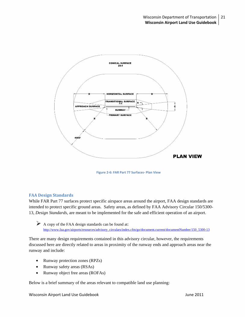
The primary FAR Part 77 surfaces related to land use compatibility include the following:
Primary surface – The primary surface is longitudinally centered on the runway. When the runway has a
specially prepared hard surface, the primary surface extends 200 feet beyond each end of that runway.
When the runway does not have a specially prepared hard surface, or planned hard surface, the primary
surface terminates at each end of the runway. The width of a primary surface ranges from 250 to 1,000
feet depending on the existing or planned approach and runway type (i.e., visual, non-precision, or
precision). The primary surface must be clear of all obstructions except those fixed by their function,
such as runway edge lights, navigational aids or airport signage.
Transitional and horizontal surface – The transitional surfaces extend outward and upward at right
angles to the runway centerline, and are extended at a slope of seven feet horizontally for each one foot
vertically (7:1) from the sides of the primary and approach surfaces. The transitional surfaces extend to
the point at which they intercept the horizontal surface at a height of 150 feet above the runway elevation.
For precision approach surfaces that project through and beyond the limits of the conical surface, the
transitional surface also extends 5,000 feet horizontally from the edge of the approach surface and at right
angles to the runway centerline.
Conical surface – The conical surface is one that extends upward and outward from the periphery of the
horizontal surface at a slope of one foot for every 20 feet (20:1) for a horizontal distance of 4,000 feet.
Approach surface – The approach surface is longitudinally centered on the extended runway centerline,
the approach surface extends outward and upward from the end of the primary surface. An approach
Table 2-5: FAR Part 77 Dimensional Requirements
Dim Item Dimensional standards (feet)
Visual runway Non-precision instrument runway
Precision instrument runway A B A B
C D
A Width of primary surface and approach surface width at inner end
250 500 500 500 1,000 1,000
B Radius of horizontal surface 5,000 5,000 5,000 10,000 10,000
10,000
C Approach surface width at end 1,250 1,500 2,000 3,500 4,000 16,000
D Approach surface length 5,000 5,000 5,000 10,000 10,000
*
E Approach slope 20:1 20:1 20:1 34:1 34:1 *
A – Utility runways B – Runways larger than utility C – Visibility minimums greater than ¾ mile D – Visibility minimums as low as ¾ mile * – Precision instrument approach slope is 50:1 for inner 10,000 feet and 40:1 for an additional 40,000 feet

20 Chapter 2: The Importance of Establishing Compatible Land Use around Airports
Wisconsin Airport Land Use Guidebook June 2011
surface is applied to the end of each runway based upon the type of approach. The approach slope of a
runway is a ratio of 20:1, 34:1, or 50:1, depending on the sophistication of the approach. The length of
the approach surface varies from 5,000 to 50,000 feet. The inner edge of the approach surface is the same
width as the primary surface and expands uniformly to a width ranging from 1,250 feet to 16,000 feet,
depending on the type of runway and approach.
Figure 2-5 and Figure 2-6 illustrate the FAR Part 77 ―imaginary surfaces‖ in both plan view and profile
view representations and provide the dimensional requirements for each of the FAR Part 77 surfaces. A
visual approach runway has relatively small imaginary surfaces, with approach and horizontal surfaces
extending 5,000 feet from the primary surface, at an approach slope of 20:1. For a non-precision
approach runway, both the approach and horizontal surfaces extend either 5,000 or 10,000 feet from the
primary surface, depending on the design category of the runway. The imaginary surfaces for precision
approach runways are similar to those for non-precision approach runways except that the approach
surface extends 50,000 feet from the primary surface, and the feet from the primary surface.
Although the FAA can determine if structures are hazards to air navigation, the FAA is not authorized to
regulate tall structures. FAA conducts an aeronautical study to determine whether the structure in
question would be a hazard to air navigation; however, there is no specific authorization in any statute
that permits the FAA to limit structure heights or determine which structures should be lighted or marked.
In fact, in every aeronautical study determination, the FAA acknowledges that state or local authorities
control the appropriate use of property beneath an airport’s airspace.
Figure 2-5: FAR Part 77 Surfaces- Profile View
Wisconsin Department of Transportation Wisconsin Airport Land Use Guidebook
21
Wisconsin Airport Land Use Guidebook June 2011
FAA Design Standards
While FAR Part 77 surfaces protect specific airspace areas around the airport, FAA design standards are
intended to protect specific ground areas. Safety areas, as defined by FAA Advisory Circular 150/5300-
13, Design Standards, are meant to be implemented for the safe and efficient operation of an airport.
A copy of the FAA design standards can be found at: http://www.faa.gov/airports/resources/advisory_circulars/index.cfm/go/document.current/documentNumber/150_5300-13
There are many design requirements contained in this advisory circular, however, the requirements
discussed here are directly related to areas in proximity of the runway ends and approach areas near the
runway and include:
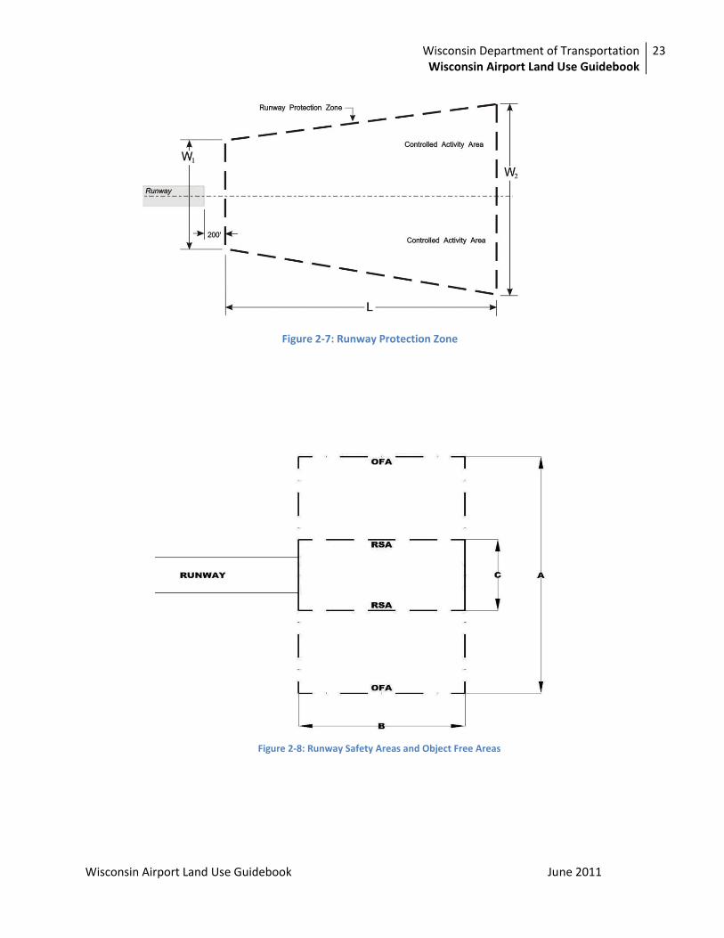
Runway protection zones (RPZs)
Runway safety areas (RSAs)
Runway object free areas (ROFAs)
Below is a brief summary of the areas relevant to compatible land use planning:
Figure 2-6: FAR Part 77 Surfaces- Plan View

22 Chapter 2: The Importance of Establishing Compatible Land Use around Airports
Wisconsin Airport Land Use Guidebook June 2011
Runway Protection Zones (RPZ) – Formerly known as clear zones, RPZs were originally established to
define land areas underneath aircraft approach paths. Allowing airport operators to control these areas
was important in preventing the creation of
airport hazards or the development of
incompatible land use. Clear zones were
first recommended in a 1952 report by the
President’s Airport Commission entitled The
Airport and Its Neighbors, and the intent was
to prevent potentially hazardous obstructions
to aircraft and to control building
construction for the protection of people on
the ground. The U.S. Department of
Commerce concurred with the
recommendation of clear zones on the basis
that the area was ―primarily for the purpose
of safety for people on the ground.‖ The
FAA adopted clear zones with dimensional
standards to implement the commission’s
recommendation. Recommended guidelines
included clear zones being kept free of structures and developments that would create a place of public
assembly. Today, clear zones are referred to as Runway Protection Zones (RPZs) and their function is
still to protect aircraft and people on the ground.
An RPZ is a trapezoidal area that begins at a point 200 feet beyond the end of the runway. The length of
the RPZ extends 1,000, 1,700 or 2,500 feet, depending on the category of runway and type of approach
(visual, non-precision, or precision). The inner width of an RPZ is located closest to the runway end with
the outer width extending out beyond the runway end. The inner width ranges from 250 to 1,000 feet, and
the outer width ranges from 450 feet to 1,750 feet. As with the length of the RPZ, the inner and outer
widths are dependent on the runway category and approach type. Figure 2-7 illustrates these dimensions.
The outer triangular area of the RPZ is referred to as the Controlled Activity Area. Land use in this area
is federally restricted. However, the FAA can review and approve certain types of land use such as
parking lots.
Runway Safety Area (RSA) – The RSA, shown in Figure 2-8, is a rectangular two-dimensional area that
starts at the runway threshold and surrounds the runway. RSAs should be cleared, graded, properly
drained, and free of potentially hazardous surface variations. RSAs should also be capable of supporting
snow removal equipment, aircraft rescue and fire fighting (ARFF) equipment, or an aircraft that
overshoots the runway without causing damage to that aircraft. Taxiways also have similar safety area
requirements. The actual size of an RSA is dependent upon the FAA classification of the runway (A-I, B-
II, C-III, etc). This surface ranges from 120 feet to 500 feet in width and from 240 feet to 1,000 feet in
length beyond each end of the runway. Table 2-6 illustrates the dimensions of RSA lengths and widths
according to airplane design groups.
Runway protection zones (RPZs) are a trapezoidal areas
“off the end of the runway end that serves to enhance
the protection of people and property on the ground” in
the event an aircraft lands or crashes beyond the
runway end.
Many people have confused the RPZ with the need for
Object Free Areas (OFA), Obstacle Free
Zones (OFZ), Object clearing criteria, and Part 77
requirements. While the RPZ also has limitations on
obstructions (because it lies below the approach surface
and because it includes safety areas and obstacle free
areas) the primary purpose of the RPZ is the protection
of people and property on the ground.
Wisconsin Department of Transportation Wisconsin Airport Land Use Guidebook
23
Wisconsin Airport Land Use Guidebook June 2011
Figure 2-7: Runway Protection Zone
Figure 2-8: Runway Safety Areas and Object Free Areas

24 Chapter 2: The Importance of Establishing Compatible Land Use around Airports
Wisconsin Airport Land Use Guidebook June 2011
Runway Object Free Area (OFA) – The Object Free Area (OFA) is a two-dimensional ground area
surrounding the runway where all aboveground objects must be removed unless fixed by their function,
such as runway lights. FAA standards prohibit objects and parked aircraft from being located within the
runway OFA. Taxiways also have OFAs. Table 2-6 depicts the dimensions of OFA widths and lengths,
ranging from 240 feet to 800 feet in width and 240 feet to 1,000 feet in length, depending on airplane
design group. Figure 2-8 illustrates the proximity of OFAs to the runway.
Table 2-6: Runway Safety Area and Object Free Area Dimension Requirements
The RSAs and OFAs are almost always contained within airport property. The RPZ, however, can extend
beyond airport property. Therefore, from an off-airport land use compatibility planning perspective, the
critical safety zone, identified by the design standards, is the RPZ. The FAA recommends that, whenever
possible, the entire RPZ be owned by the airport and be clear of all obstructions, if practicable.
Noise Concerns In addition to safety, compatible land use planning is important to help mitigate noise-related concerns.
Historically, airports were constructed on the outskirts of communities and the significant distance from
developed areas diminished the impact of aircraft sounds. Through the years, many communities have
sprawled and land uses more sensitive to aircraft sound developed closer to airports. This development,
coupled with increases in air traffic volume, has intensified the noise concerns related to land use in the
airport environs in recent years. Noise is often a primary issue raised by communities when airport
development or expansion is proposed. For this reason, it is important for airports and communities to
understand noise in order to develop land uses that are compatible.
Dimension Item Dimensional Standards (feet)
Smallest Airplane Design Group
Largest Airplane Design Group
A Runway Object Free Area width 250 800
B Runway Object Free Area length 240 1,000
B Runway Safety Area length 240 1,000
C Runway Safety Area width 120 500
Note: These dimensions are presented as a general range. Exact dimensions vary according to runway approach type
and approach visibility- FAA AC 150/5300-13 should be referenced.
Source: FAA AC 150/5300-13 Change 6

Wisconsin Department of Transportation Wisconsin Airport Land Use Guidebook
25
Wisconsin Airport Land Use Guidebook June 2011
Understanding Noise
In order to adequately address noise concerns, it is important to understand the terms and metrics related
to noise. While sound is defined as transmitted vibrations that can be detected by the human ear, noise is
defined as any sound that is undesirable or interferes with one’s hearing of other things.
The following are commonly used to describe aircraft noise:
Decibel (dB): The ratio of the sound pressure of the sound source of interest (e.g. aircraft
overflight) to a reference pressure (e.g. the quietest sound we can hear), expressed in a logarithm.
Most people perceive a 10 dB increase to be about a doubling in loudness and changes of less
than 3dB are not easily detected outside of a laboratory.
Weighted Decibel (dB(A)): Human ears are less sensitive to low and high frequencies (or
―pitches‖) and the A-weighting is designed to assess the relative loudness of variations as heard
by humans.
Day-Night Average Sound Level (DNL): A 24-hour measure of total noise, with events
occurring at night (10 p.m. to 7 a.m.) treated as 10 dB louder than they really are. This dB penalty
is designed to account for the fact that events at night are often perceived to be more intrusive
because nighttime ambient noise is less than daytime ambient noise. The FAA utilizes the DNL
as the primary metric of noise measurement and is widely accepted as a useful measure of noise
and land use compatibility.
It is important to be mindful that people perceive
aircraft sounds in different ways. Concerns about
aircraft sound often reflect the degree to which
aircraft sounds intrude on existing background
noise. Generally speaking, where ambient sounds
are lower, aircraft sound is perceived as ―noise,‖
and therefore, as a problem. For example, in an
urban area, sound generated by aircraft is muffled
by noise produced by cars, trucks, and industry. In
quiet, less developed areas, the sound generated by
a small aircraft can be annoying to nearby residents.
Aircraft noise has implications on airport
neighbors. A number of studies have attempted to
capture the effects of aircraft noise and some of the
primary effects of aircraft noise include:
Speech interference: Aircraft flying
overhead can produce prolonged loud noises which can overwhelm normal voice levels and make
conversations difficult.
Difficulty learning: Aviation noise can affect learning abilities, including reading, speech,
memory, and motivation. Speech interference is likely the cause for learning difficulties.
Each airport is likely to have particular noise
problem that requires a solution tailored to
its specific site. Some common factors that
have an impact on the tolerance of noise
around the airport area include:
Number of aircraft operations
Type of aircraft using the airport
Location of the airport relative to
development
Size of the airport, commercial
services vs. general aviation
Airfield layout
Patterns of surrounding land use
Time of the day

26 Chapter 2: The Importance of Establishing Compatible Land Use around Airports
Wisconsin Airport Land Use Guidebook June 2011
Sleep interference: Aircraft noise could cause people to shift to a lighter stage of sleep or
awaken and therefore interfere with the sleep patterns of some people. It is important to note that
sleep interference varies from person to person based on a number of factors.
Health Effects: Some studies suggest that chronic exposure to high levels of noise can have
adverse effects on one’s health, including hearing loss. However, research is largely inconclusive
at this time.
House vibrations: Evidence suggests that aircraft can create house vibrations for residences near
airports.
FAA Noise Standards In an effort to address some of the noise-related compatible land use concerns, FAA has created guidance
for the development of plans for areas affected by aircraft noise. Some of the notable guidelines are
discussed below.
FAR Part 150- Airport Noise Compatibility Planning
FAR Part 150 contains many regulations found in the Aviation Safety and Noise Abatement Act of 1979
and focuses solely on noise compatibility issues.
A copy of FAR Part 150 can be found here: http://ecfr.gpoaccess.gov/cgi/t/text/text-
idx?c=ecfr&tpl=/ecfrbrowse/Title14/14cfr150_main_02.tpl
AC 150/5020-1 Noise Control and Compatibility Planning for Airports provides additional guidance and
can be found here:
http://www.faa.gov/airports/resources/advisory_circulars/index.cfm/go/document.current/documentNumbe
r/150_5020-1
It stipulates that local jurisdictions can prepare and submit a Noise Exposure Map (NEM) for the
airport’s environs and a Noise Compatibility Plan (NCP) to the FAA. The program is open to all
publicly owned, public-use airports included in the NPIAS. Although FAR Part 150 is voluntary,
airports must participate if they wish to obtain federal funding for noise-abatement measures.
Notable provisions of FAR 150 include:
Establishing the weighted decibel (dBA) scale as the universal noise measurement tool
Establishing the Day-Night Level (DNL) as the universal noise contour measure
Identifying land uses which are normally compatible or incompatible with various levels of noise
Noise impact areas for an airport are identified by noise contours. The basic methodology used to define
aircraft noise levels involves the FAA’s mathematical model, Integrated Noise Model (INM). The INM
contains a database that relates noise levels to each specific type of aircraft. On an irregular three-
dimensional grid around the airport, the INM computes the noise exposure level for a specific aircraft and
engine thrust used at that point along the aircraft’s flight route. Noise levels are then indicated by a series
of contour lines superimposed on a map of the airport and its environs. Although lines on a map tend to
be viewed as definitive, the INM is only a planning tool. By developing a set of noise contours for an

Wisconsin Department of Transportation Wisconsin Airport Land Use Guidebook
27
Wisconsin Airport Land Use Guidebook June 2011
airport, a community or airport planner can identify areas that are most likely to be impacted by aircraft
noise and can plan accordingly.
Additional information on
FAA’s Integrated Noise
Model can be found here:
http://www.faa.gov/about/off
ice_org/headquarters_offices/
apl/research/models/inm_mo
del/
After DNL noise contours are
developed for an airport area, three
basic impact areas can be
identified (also known as Noise
Corridor Zones):
Severe Noise Impact
Areas- 70 DNL and above
contour
Substantial Noise Impact
Areas- 65 DNL to 70 DNL contour
Moderate Noise Impact Area- 55 DNL to 65 DNL contour
From a noise perspective, areas exposed to 55 DNL or less are not considered to be seriously impacted.
Summary
This chapter discussed the safety and noise concerns related to incompatible land use and the FAA criteria
that have been established to combat these issues. The accident data, FAR Part 77 surfaces, FAA design
criteria, and noise research outline the importance of protecting the areas around the airport, particularly
those in the runway approaches and Runway Protection Zones, from incompatible land uses.
The FAA provides additional guidance for the development of plans
for areas affected by aircraft noise in several FARs, including:
FAR Part 36 – Noise Standards
http://ecfr.gpoaccess.gov/cgi/t/text/text-
idx?c=ecfr&rgn=div5&view=text&node=14:1.0.1.3.19&idno
=14
FAR Part 91 – Transition to all Stage 3 fleet operating in the
48 contiguous United States and the District of Columbia
http://ecfr.gpoaccess.gov/cgi/t/text/text-
idx?c=ecfr&rgn=div5&view=text&node=14:2.0.1.3.10&idno
=14
FAR Part 161 – Notice and approval of airport noise and
access restrictions
http://www.faa.gov/airports/environmental/airport_noise/
part_161/

28 Chapter 3: Land Use Incompatibility Concerns
Wisconsin Airport Land Use Guidebook June 2011
Chapter 3 Land Use Incompatibility Concerns As Chapter 2 demonstrates, establishing compatible land uses around airports fits into the larger context
of public safety and well-being. This chapter outlines common land use compatibility issues, including
tall structures, visual obstructions and electronic interference, wildlife attractants, large densities of
people, and residential areas. However, please be mindful that the issues addressed in this chapter is not
intended to be an exhaustive list, but represent diverse land use issues that planners, airport
representatives, and government officials need to understand when developing an airport master plan, a
local comprehensive plan, or ordinances.
Safety-Related Concerns As outlined in Chapter 2, safety is a primary goal in establishing compatible land uses near airports.
Safety-related concerns fall into two categories: land use characteristics that create hazards to flight,
which can cause or contribute to aircraft accidents, and land use characteristics that affect the severity of
accidents when they occur. This section identifies land uses that can create safety hazards.
Tall Structures
As discussed in Chapter 2, FAR Part 77, Objects Affecting Navigable Airspace provides basic guidance
regarding the airspace in the vicinity of an airport that should be protected from tall structures. However,
tall objects in the approach corridors may pose risks even if they do not penetrate the defined Part 77
surface and they can adversely affect minimum instrument approach altitudes. While the most critical
locations are beneath the airport approach surfaces, the siting of tall facilities, such as multi-story
structures, power lines, telecommunication towers, wind turbines, and meteorological (met) towers,
should be carefully considered whenever it is near an airport. Areas beneath aircraft traffic patterns,
adjacent to a runway, off the runway ends, and even far away from an airport, can prove hazardous sites
for tall structures. Additionally, it is important to be mindful that height hazards are not limited to
buildings and other structures: trees, high terrain, temporary objects such as construction cranes, and
mobile objects such as vehicles on the road can also be height hazards in some situations.
Visual Obstructions and Electronic Interference
Similar to the obstructions that tall structures can create, there are several land uses that can create visual
obstructions and interference for pilots.
Light and Glare
Lights that shine upward, such as those found in commercial areas or parking lots, are potentially
hazardous since they can interfere with a pilot’s ability to identify an airport at night. A pilot could
wrongly perceive such adjacent lights, especially those with a linear layout such as street lights in
subdivisions, as part of the airport or as runway lights. Bright lights can also pose a safety concern at
night by causing pilots to experience a moment of night blindness as they pass from dark areas into well-
lit areas and back into darkness as they approach an airport. Similarly, reflective surfaces can produce a
blinding glare, which can distract pilots. Water surfaces, such as storm water detention ponds, light-
colored or mirrored building materials, and some solar panels can produce glare.

Wisconsin Department of Transportation Wisconsin Airport Land Use Guidebook
29
Wisconsin Airport Land Use Guidebook June 2011
Dust, Smoke, and Steam
Dust, smoke, and steam can create severe visual difficulties when a pilot is looking to land or preparing to
take off. Potential land uses which may generate dust include nearby construction, gravel extraction, and
farming. Those land uses that can create smoke or steam include agricultural operations (field burning),
manufacturing, utilities, and others. Similarly, thermal plumes potentially associated with these types of
buildings can cause air turbulence that could be hazardous to aircraft.
Electronic Interference
Land uses that generate electronic transmissions are detrimental to airport operations because they can
interfere with radio communication between aircraft and airport. Thus, this type of land use should not be
allowed near airports. There are no Federal Aviation Administration (FAA) standards for specific
electronic hazards; however, this kind of hazard generally includes telecommunication devices and power
stations. Coordination between airport owners/managers and municipalities is essential to address this
area of concern.
Wildlife Attractants
An increased number of birds and wildlife around airports amplify the possibility of collisions with
aircraft. Damage to an aircraft and injury to crew
and/or passengers from a bird strike – with gulls, geese,
or birds of prey (hawks, eagles, etc.) – can be
devastating. White-tail deer and even smaller
mammals, such as dogs and rabbits, also pose a risk for
on-ground collisions. FAA Advisory Circular (AC)
150/5200-33B, Hazardous Wildlife Attractants on or
near Airports provides guidance on certain land uses
that have the potential to attract hazardous wildlife on
or near public-use airports.
FAA AC 150/5200-33B, Hazardous Wildlife Attractants on or near Airports can be found here:
http://www.faa.gov/documentLibrary/media/advisory_circular/150-5200-33B/150_5200_33b.pdf
It states that it is inadvisable to locate such wildlife attractants within 5,000 feet of air operation areas
accommodating piston-type aircraft and within 10,000 feet of air operation areas accommodating turbine-
powered aircraft. All proposed land uses that could potentially increase wildlife attractants should be
examined within 5 miles of the airport. Attractants can include agricultural features, landscaping, waste
disposal sites, wastewater treatment facilities, agricultural or aquacultural activities, surface mining,
wetlands, or airport development projects (construction, expansion, renovation). The following are some
common land use categories that have potential to attract wildlife that could be hazardous to aircraft.
Water
Water impoundments, wetlands, ponds, sewage lagoons, fountains, and other water sources can be
attractive to wildlife. Permanent water sources should be managed by removal, physical exclusion, or
alteration of appearance. Underground facilities such as French drains or buried rock fields are examples
of successful retention/detention designs, while temporary holding (detention) basins that drain within 24-
Airports are required to report all bird and
other wildlife strikes to the FAA, as it is
important in the study of this issue.
The FAA provides a website for
reporting: http://wildlife-
mitigation.tc.faa.gov/public_html/ind
ex.html.
Airports should become familiar with this site.

30 Chapter 3: Land Use Incompatibility Concerns
Wisconsin Airport Land Use Guidebook June 2011
48 hours are also an option. If drains and ditches cannot be removed, their banks should be mowed
regularly to control bird nesting and perching. Rip rap along banks can also deter waterfowl from
―loafing‖ near the water feature.
Agriculture and Flora/Fauna
The proximity of agricultural operations, including farmland, to airports can cause unwanted interactions
between wildlife and aircraft, especially if the crops are highly attractive to birds or wildlife for their
nutritive or nesting value. Similarly, certain species of flora and fauna included in nearby landscaping or
natural environment have the potential to attract unwanted wildlife. These include certain woody plants,
upland weed and shrubs, marsh plants, cultivated plants, and ornamental plants. USDA bulletin ―Plants
Attractive to Wildlife,‖ discussed in Chapter 6, outlines specific species to avoid. These species can create
problems for departing and approaching aircraft if birds and mammals congregate to eat or nest in farm
areas.
Figure 3-1: Man-Made Pond Near End of Runway
Landfills and Sewage Treatment Plants
FAA Order 5200.5B, Airport Safety during FAA-Funded Airport Construction and FAA Facilities
Maintenance states that sanitary landfills, because of their bird attractant qualities, are considered to be an
incompatible land use if located within specified distances. FAA Order 5050.4B, Airport Environmental
Handbook and FAA Advisory Circular (AC) 150/5200-34A, Construction or Establishment of Landfills
near Public Use Airports provide important guidance regarding landfills around airports. These
documents are discussed further in Chapter 6.

Wisconsin Department of Transportation Wisconsin Airport Land Use Guidebook
31
Wisconsin Airport Land Use Guidebook June 2011
Large Densities of People
The land use characteristic that most closely relates to the severity of aircraft accidents, if and when they
occur, is the number of people concentrated in the accident area. Limiting the number of dwellings or
people in areas close to the airport is the most direct method for reducing the potential severity of an
aircraft accident.
Accident probabilities increase in closer proximity to runway ends because the traffic flow of aircraft is
more concentrated and at a lower altitude in these areas. A primary means of limiting the risk of damage
and personal injury from accidents that occur near the airport is to limit population density in the areas
adjacent to the airport. Table 3-1 describes general population densities (people per acre) in
developments that are typically found in the vicinity of airports.
Based on the degree of risk to which adjacent areas are subjected, the best measure of development
density in this context is the number of persons per
acre. Some communities have specific
development density limitations ranging from 25 to
100 people for different parts of a runway approach
corridor. In general, high density residential
development and places of public assembly should
not be permitted in the airports approach corridors.
Common methods of estimating allowable density
include: analysis of parking requirements
designated in the local zoning ordinance, maximum occupancy levels set in accordance with building
codes, and surveys of similar uses. Land uses that support higher population densities are less compatible
than those that support lower population densities. In determining specific numbers of people per acre for
inclusion in a compatibility plan, all local zoning ordinances should be addressed.
Open Areas
Another factor to consider is the risk to airplane occupants in the event of an emergency landing. Even in
an emergency descent, pilots can normally control the aircraft to a certain extent, and will head for the
best available open space if he or she cannot reach the airport runway. However, in an emergency during
the departure or approach phase of the flight, the pilot’s ability to select an emergency landing site is
limited because of the low altitude of the aircraft. Thus, preserving open areas of land along the
approach/departure corridors is highly desirable in order to improve the chance of successfully executing
an emergency landing without injury, loss of life or loss of property. However, the actual land use of the
open area should be considered since agricultural fields can increase as wildlife attractants in certain
seasons, posing other safety concerns for pilots in non-emergency and emergency situations.
Residential Areas
Historically, airports have been located on the outskirts of towns and cities, however, residential areas
have spread further into what was once open space near airports, creating an increased threat to public
safety on many levels. Distractions like street lighting at night and storm water and residential ponds that
Table 3-1: Population Densities by Building Type Building Type People per Acre
Light industrial uses 35-50
Two-story motel 35-50
Single-story shopping center 75-125
Single-story office 50-100
Sit-down restaurant 100
Fast food restaurant 150 Source: California Airport Land Use Planning Handbook, 2002

32 Chapter 3: Land Use Incompatibility Concerns
Wisconsin Airport Land Use Guidebook June 2011
could attract waterfowl to the area pose threats to aircraft operations. Additionally, residential areas near
airports increase the population density and decrease the amount of open space near airports, thus
increasing the severity of any potential aircraft accident. The successful control of residential site
development near airports can help alleviate many incompatible land uses. The 1998 court case of
Northwest Properties v. Outagamie County, WI provides legal precedence for the municipal control of
minimum residential lot sizes in the name of airport protection. Appendix B provides some additional
information on case law related to airport compatible land use issues.
Noise-Related Concerns In addition to safety, noise is a driver for establishing compatible land uses near airports, as it is a
considerable factor affecting or limiting airport operations. As discussed in Chapter 2, aircraft operations
can create sound levels which are annoying and can produce effects which negatively impact the quality
of life for residents located near airports, including speech interference, sleep disturbance, and affected
classroom learning. For these reasons, noise issues have the potential to create animosity between the
community and the airport.
Residential areas, schools, hospitals, churches, certain types of offices, outside activities, and other noise-
sensitive indoor activities should be minimized near airports.
As discussed in Chapter 2, FAR Part 150 addresses many of the noise concerns related to airports and
their neighbors. It also describes acceptable types of land use for each DNL sound level. For those areas
impacted by the 70 DNL or greater contour, FAA recommends that the land be acquired by the airport
owner. Typically, this level of noise impact beyond airport property is associated with large, high activity
airports. For airports with low activity, noise contours of 70 DNL and above are usually contained within
airport property. For small airports, the 65 SNL will often fall within the existing airport property line.
For larger airports, the 65 DNL contour may extend beyond airport property. Mitigation steps include the
reduction of indoor noise levels by 25 or 30 decibels. NLR, or noise level reduction, is recommended by
FAA when construction of noise sensitive institutions must be allowed within a noise contour area of
above 65 decibels.
Summary This chapter discussed the importance of establishing compatible land uses in terms of safety and noise
concerns and highlighted some incompatible land uses around airports. Table 3-2 summarizes
compatible land uses within FAR Part 77 surfaces and FAA safety areas. The table shows compatible
land use, incompatible land uses, and land uses that need additional review under different categories of
surface.

Wisconsin Department of Transportation Wisconsin Airport Land Use Guidebook
33
Wisconsin Airport Land Use Guidebook June 2011
Table 3-2: Compatible Land Uses within FAR Part 77 Surfaces and FAA Safety Areas Land Uses Primary
Surface Transitional Surface
Horizontal Surface
Conical Surface
Approach Surface
Runway Protection Zone
Residential
Residential NC NC ■ C ■ NC
Public use
Places of public assembly –schools, hospitals, churches, auditoriums
NC NC ■ C NC NC
Government services NC ■ C C ■ NC
Transportation – parking, highways, terminals, railroads
NC ■ C C ■ ■
Commercial use
Office, business, and professional NC ■ C C ■ NC
Wholesale and retail – building materials, hardware, and farm equipment
■ ■ C C ■ NC
Retail trade – general NC ■ C C ■ NC
Utilities NC ■ ■ ■ ■ ■
Communication NC ■ ■ ■ ■ NC
Manufacturing and production
Manufacturing – general NC ■ ■ ■ ■ NC
Agricultural (except livestock) and forestry
NC ■ C C ■ C
Livestock farming and breeding NC ■ ■ C ■ NC
Mining and fishing, resource production, and extraction
NC NC ■ ■ ■ NC
Recreational
Outdoor sports arenas, spectator sports, nature exhibits, and zoos
NC NC ■ C NC NC
Amusement parks, resorts, camps, and golf courses
NC NC C C NC NC
Parks NC ■ ■ ■ ■ ■
Open water
Naturally occurred stormwater ponds (i.e. lakes, ponds, wetlands)
NC ■ C C NC NC
Man made water bodies (i.e. mining and extraction, water detention ponds)
NC ■ ■ ■ NC NC
Note:
C Generally compatible land use
NC Incompatible land use
■ Not clearly compatible or incompatible, requires specific study, consideration for location-specific issues
Criteria for compatibility in specific study:
1 Does not exceed height standards
2 Does not attract dense concentrations of people
3 Does not create a bird attractant
4 Does not cause a distracting light and/or glare
5 Does not cause a source of smoke
6 Does not cause electrical interference
7 Does meet compatible Day-Night Level (DNL) sound levels

34 Chapter 4: Land Use Regulations and Guidance
Chapter 4 Land Use Regulations and Guidance There are many laws, policies, and procedures that have been enacted at both the federal and state levels
which play important roles in land use compatibility. Many of these items were instituted by agencies
such as the Federal Aviation Administration (FAA) and the Wisconsin Department of Transportation
(WisDOT). The primary rules and regulations related to land use planning are discussed in this chapter
and a discussion of additional rules, regulations, policies, and guidance related to land use can be found in
Appendix A.
The following descriptions are not meant to be all-inclusive, but rather a summary of the primary rules
and regulations related to land use issues around airports. Additional coordination or involvement with
other federal or state agencies may be required on a project-specific basis. Early coordination with the
Bureau of Aeronautics (BOA) is recommended in order to identify the potential involvement of these
agencies as soon as possible in the planning process.
Federal Laws and Policies Laws and non-regulatory procedures, provided in the federal statutes, the Code of Federal Regulations
(CFRs) or in Advisory Circulars (ACs) by the FAA, are important legal frameworks related to
incompatible land uses around airports. These CFRs and ACs lay the foundation for the creation of an
airport planning process and provide tools for implementation. These regulations cover a wide range of
topics ranging from airspace issues to the content of airport master plans.
Federal Grant Assurances (Airport and Airway Improvement Act of 1982, US Code, Title 49)
Upon the acceptance of federal funds, airport owners are obligated under this code to operate and
maintain the airport and comply with specific assurances. These obligations are outlined in the grant
documents, which are signed by airport owners when they accept federal funds for a development project.
For a complete list of FAA grant assurance, please consult
http://www.faa.gov/airports/aip/grant_assurances/media/airport_sponsor_assurances.pdf
FAA Order 5190.6B, Airport Compliance Manual provides some guidance on federal grant assurances and
can be found here: http://www.faa.gov/airports/resources/publications/orders/compliance_5190_6/
Some land use-related assurances are:
Compliance with all applicable federal laws, regulations, executive orders, policies, guidelines,
standards, specifications and requirements as they relate to the project
Consistency with local plans
Public access to project information and planning process
More specifically, Grant Assurance 21 requires all airports accepting federal funds to take appropriate
action, to the extent reasonable, against incompatible land uses in the immediate vicinity of the airport.
Such actions include the adoption of zoning laws and zoning changes that will increase airport land use
compatibility.
Wisconsin Department of Transportation Wisconsin Airport Land Use Guidebook
35
Wisconsin Airport Land Use Guidebook June 2011
Additionally, Grant Assurance 20, Hazard Removal and Mitigation, requires airports accepting federal
funds to mitigate existing airport hazards and prevent the establishment or creation of future airport
hazards by removal, lowering, relocation, marking, lighting or other means.
FAR Part 77, Objects Affecting Navigable Airspace (CFR Title 14)
FAR Part 77 is discussed in further detail in Chapter 2. It establishes methods for identifying surfaces that
must be free from penetrations (i.e., buildings, cranes, cell towers, etc.) and sets forth requirements for the
construction or alteration of structures. It also provides for studies of obstructions to determine their
effect on the safe and efficient use of airspace as well as public hearings regarding these obstructions.
Implementation and enforcement of FAR Part 77 is a cooperative effort between the FAA and the
Wisconsin BOA. For additional information, please consult Chapter 2 or FAR Part 77.
A copy of FAR Part 77 can be found here:
http://www.access.gpo.gov/nara/cfr/waisidx_10/14cfr77_10.html
Proposed Construction or Alteration of Objects that may affect the Navigable Airspace, FAA AC
70/7460-2J (Form 7460-1)
Form 7460-1, Notice of Proposed Construction or Alteration works within the requirements of FAR Part
77 and is required at all federally obligated airports to assess each proposed construction project or
temporary construction equipment in the vicinity of the airport. In the event that construction or
improvements projects taking place in or around a public use airport exceed FAA standards, Form 7460
must be submitted to the FAA. The form should be filed using FAA’s Obstruction Evaluation/Airport
Airspace Analysis (OE/AAA) website at least 45 days prior to the beginning of the process.
FAA’s OE/AAA website can be accessed here: https://oeaaa.faa.gov/oeaaa/external/portal.jsp
Form 7460 must be submitted if the project meets or exceeds any of the following standards:
A structure that will be 200 feet above ground level
A structure that breaks the plane greater than a 100 horizontal feet to one vertical foot (100:1)
slope within 20,000 feet of a runway longer than 3,200 feet
A structure that breaks the plane greater than a 50 horizontal feet to one vertical foot (50:1) slope
within 10,000 feet of a runway no longer than 3,200 feet
All towers and antennas transmitting radio frequency. The Federal Communications Commission
(FCC) will not grant a transmitting license without an FAA determination.
The FAA’s notice criteria tool can assist in determining whether or not Form 7460 must be submitted and
can be accessed here:
https://oeaaa.faa.gov/oeaaa/external/gisTools/gisAction.jsp?action=showNoNoticeRequiredToolForm
The FAA conducts an aeronautical study and issues a determination to the airport operator which
identifies whether or not the proposed development is a hazard to airspace. The FAA will likely provide
a ―determination of no hazard to air navigation‖ or a ―determination of hazard to air navigation.‖ A
―determination of no hazard to air navigation‖ indicates that the structure does not impact the airspace.
However, if a ―determination of hazard to air navigation‖ is returned, additional steps may be required

36 Chapter 4: Land Use Regulations and Guidance
Wisconsin Airport Land Use Guidebook June 2011
prior to the beginning of construction. Specifics related to each airspace case should be addressed with
the FAA.
It is important to note that time is necessary for FAA’s review and local governments will need to hold on
the final approval of land use applications until both FAA and BOA comments are received.
FAA Airport Design Standards, AC 150/5300-13 (09-29-1989)
As discussed in Chapter 2, AC 150/5300-13, Airport Design, provides the basic standards and
recommendations for airport design, including Runway Safety Areas (RSAs), Runway Object Free Areas
(OFAs), and Runway Protection Zones (RPZs). The criteria contained in this AC are the primary spatial
standards for on-airport development. For additional information, please consult Chapter 2 or AC
150/5300-13, Airport Design.
AC 150/5300-13, Airport Design can be found here:
http://www.faa.gov/regulations_policies/advisory_circulars/index.cfm/go/document.information/documentI
D/23182
FAR Part 150, Noise Compatibility Program, (CFR Title 14)
As discussed in Chapter, 2, this document establishes the measures required by the Aviation Safety and
Noise Abatement Act (ASNA), which requires that a single system be developed for measuring noise and
determining the level of noise exposure caused by airport operations and identification of land uses
normally compatible with exposure to noise. For additional information, please consult Chapter 2 or FAR
Part 150.
Additional resources on FAR Part 150 can be found here:
http://www.faa.gov/airports/environmental/airport_noise/
Airport Master Plan, FAA AC 150/5070-6B (05-01-2007)
The airport master plan serves as the foundation for future airport development. This updated advisory
circular provides an outline and detailed guidance for the preparation of master plans. It covers the range
in size and function of airports, from small general aviation to large commercial service facilities. The
intent of this AC is to foster a flexible approach to master planning that directs attention and resources to
critical issues. The scope of each master plan must be tailored to the individual airport under evaluation.
A copy of AC 150/5070-6B, Airport Master Plan can be found here:
http://www.faa.gov/airports/resources/advisory_circulars/media/150-5070-6B/150_5070_6b_chg1.pdf
Additional Federal Laws and Policies
The federal laws and policies outlined above represent a brief snapshot of the federal regulatory
framework for compatible land use planning. However, Appendix A provides additional resources related
to planning and design, environmental, land acquisition, and noise-related regulations and policies. These
include:
Planning and Design
FAA AC 150/5190- 4A, A Model Zoning Ordinance to Limit Height of Objects around Airports

Wisconsin Department of Transportation Wisconsin Airport Land Use Guidebook
37
Wisconsin Airport Land Use Guidebook June 2011
FAA Order 18, U.S. Standards for Terminal Instrument Procedures and FAA Order 8260.3B,
Change 14
Environmental
National Environmental Policy Act of 1969 (NEPA) and FAA Order 5050.4B, NEPA
Implementing Instructions for Airport Projects
FAA AC 150/5200-33B, Hazardous Wildlife Attractants on or Near Airports
FAR Part 139.337, Wildlife Hazard Management Plan
CFR Title 40, Part 258, Subpart B, Criteria for Municipal Solid Waste Landfills
Land Acquisition
The Federal Aviation Authorization Act of 1994
FAA AC 150/5100-17, Land Acquisition and Relocation Assistance for Airport Improvement
Program Assisted Projects
Noise
CFR Title 14, FAR Part 91, General Operating and Flight Rules
Airport Noise and Capacity Act of 1990 (National Noise Policy)
CFR Title 14, FAR Part 161, Notice and Approval of Airport Noise and Access Restrictions
FAA AC 150/5320-14, Airport Landscaping for Noise Control
Please see Appendix A for a more comprehensive discussion of federal laws and policies related to
compatible land use planning.
State Laws and Policies State policies related to compatible land use planning are spread across a wide range of state
administrative codes and statutes affecting aviation and airports. Much of the discussion below is an
outline of the rights and responsibilities of airports and local communities as it relates to land use
planning. Case-by-case coordination with the BOA is suggested in order to address specific issues or
concerns.
Chapter 114, Wis. Stats. – Aeronautics
Wis. Stats., Chapter. 114 is a comprehensive outline of Wisconsin’s airport authorizations. The state
airport system, landowner rights, land condemnation, land purchasing, advance land acquisition loan
program, approach protection, appropriation of federal, state, and local aid, and taxation for airports are
authorized by Chapter 114. The following is a summary of the provisions of Chapter 114 that are most
relevant to compatible land use planning.
For the complete text of Chapter 114, Wis. Stats., please see:
http://legis.wisconsin.gov/statutes/Stat0114.pdf

38 Chapter 4: Land Use Regulations and Guidance
Wisconsin Airport Land Use Guidebook June 2011
Wis. Stats. §114.135. – Airspace Protection
This section of the statute provides for airspace protection in two areas: the immediate vicinity of the
airport and all navigable airspace over the state. Subparagraphs 1 through 5 provide for the protection of
aerial approaches to all public-use airports. This protection is achieved through actions by the airport
owner and may extend into adjoining municipalities, known as extraterritorial zoning. Subparagraphs 6
through 10 require anyone proposing a tall structure to apply for a permit and receive approval from the
Secretary of Transportation before starting construction, specifically structures that will be more than 500
feet above the lowest point within one mile of the structure’s base, or structures that are 150 feet or higher
and exceed a forty to one (40:1) slope from the nearest boundary of a public use airport. TRANS 56
(discussed later in this chapter) contains additional information.
Wis. Stats. §114.136 – Approach Protection Plans
This section of the statute allows any county, city, village, or town to protect the aerial approaches to
airports with ordinances regulating, restricting, and determining the use, location, height, number of
stories, and size of buildings, structures, and objects of natural growth in the vicinity of the airport.
Governments may also divide the territory to be protected into several areas and impose different
regulations and restrictions with respect to each area. This is the most critical statute for airport approach
protection, and provides the authority for airport sponsors to establish airport zoning overlay districts.
Wis. Stats. §114.136 (2) – Formulation of Ordinances
§114.136 (2), Wis. Stats. allows any airport-owning entity to formulate an ordinance that shall include
provisions for the limitation of the height of buildings, structures and objects of natural growth located
not more than three miles from the boundaries of the airport site. Wis. Stats §16.195 authorizes funding
for those proposed planning grants that address the interests of neighboring jurisdictions, promote the
redevelopment of land, protect natural areas, encourage efficient development patterns, promote the
economic base, and provide an efficient transportation system.
Wis. Stats. §85.02, § 85.15.– Department of Transportation
Chapter 85, Wis. Stats., authorizes WisDOT to plan, promote, and protect aeronautical activities with
state and federal aid. All state, regional, and municipal agencies and commissions must follow the
recommendations of the WisDOT secretary. WisDOT is authorized department use, maintenance, or
leasing of land acquired for airport use until the property is needed for such a purpose. The following are
chapters from Wisconsin Administrative Code related to airports and compatible land use.
Chapter 85 Wis. Stats. can be found here:
http://nxt.legis.state.wi.us/nxt/gateway.dll?f=templates&fn=default.htm&d=stats&jd=top
TRANS Wisconsin Administrative Code can be found here:
http://nxt.legis.state.wi.us/nxt/gateway.dll?f=templates&fn=default.htm&d=code&jd=top
Chapter TRANS 55, Wis. Adm. Code – Conditions of State Aid for Airport Improvement
This chapter identifies the conditions necessary to grant state aid for airport improvements, as required in
§114.31, Wis. Stats., in order to protect public investment and to maximize public benefits. The request
for state aid may come from a resolution of the airport board of directors or by an agreement between the
WisDOT secretary and airport owner to acquire property and to administer the project. For the duration
of the state aid conditions, the owner must maintain good title to the property or dispose of it only after

Wisconsin Department of Transportation Wisconsin Airport Land Use Guidebook
39
Wisconsin Airport Land Use Guidebook June 2011
approval by the secretary. TRANS 55 requires that the owner safely operate and maintain all facilities,
maintain clear and safe approaches, cooperate in conducting surveys, provide suitable aircraft parking
areas, maintain a current layout plan, and preserve airport rights and powers unless granted approval by
the secretary to modify such rights. Under this law, airports are specifically required to adopt and
maintain a height limitation zoning ordinance (HLZO) and a vehicle/pedestrian ordinance in order to
procure state aid for airport improvements.
Chapter TRANS 56, Wis. Adm. Code – Erection of Tall Structures
This chapter prescribes procedures for the permitting of tall structures or other objects affecting airspace
in Wisconsin. A permit is required from the Secretary for any structure that exceeds the limitations in
§114.135 (7) Wis. Stats. Applications for permits must include, but are not limited to, owner information,
location, proposed height, distance to nearest runway, and lighting plans. The construction can
commence once a permit is granted and federal, state, and local requirements are met.
Additional information regarding permits can be found on the BOA website, accessed here:
http://www.dot.wisconsin.gov/travel/air/airport-ops.htm
Chapter TRANS 57, Wis. Adm. Code – Standards for Airport Siting
This chapter interprets and implements §114.134 (3) to (5), Wis. Stats., providing procedures and
standards for airport site approval. The WisDOT secretary may issue a certificate of airport site approval
for a new airport upon determination that the location is compatible with existing and planned
transportation facilities in the area. Standards for airport siting are detailed for both airports open to the
public and those not open to the public. These standards include the determination of objects in the
approach areas and the marking of displaced thresholds. The site application will also be reviewed for its
compatibility with other area transportation facilities and regional, county, and local plans. The issuance
of a site certificate by the Secretary does not waive or preempt compliance with any applicable
ordinances, laws or regulations of any other governmental body or agency.
§59.52, §59.58, §59.69, Wis. Stats. – Counties
These sections of the statute authorize counties to acquire property and plan for and zone county airports.
§59.58, Wis. Stats. addresses land acquisition for airports and their allowable construction, maintenance,
and improvement by a county board, all of which can be funded through the issuance of revenue bonds.
§59.69, Wis. Stats. details the purpose of county planning and zoning and calls for the adoption of a
master plan (comprehensive plan) and official map of the county. Airports and their affected areas must
be included in the county’s development plan (comprehensive plan).
Section.60.61, Wis. Stats. – Towns
This section of the statute outlines the powers and duties of a town planning commission including the
appointment of members to the airport commission. It also defines the zoning authority for towns if the
county has not enacted its own zoning ordinance. This authority includes the right to regulate the
location, height, and size of structures and natural objects in the vicinity of a town or privately-owned
airport. By eminent domain, a town can remove or alter any structure or object that does not meet the
restrictions.

40 Chapter 4: Land Use Regulations and Guidance
Wisconsin Airport Land Use Guidebook June 2011
§62.23, Wis. Stats. – Cities
This section of the statute authorizes the creation of a city planning commission and calls for the
development of a master (comprehensive) plan that includes recommendations for airports. The city
planning commission has the authority to consider the location, use, abandonment, and sale of land for
any airport. An official city map depicting the airport and the affected areas is also required as stated in
Chapter 62, Wis. Stats.
§66.1001, Wis. Stats. – Comprehensive Planning
Wisconsin’s comprehensive planning law requires towns, villages, cities, and counties to prepare, adopt,
and amend comprehensive plans. The Wisconsin legislature enacted legislation that greatly expanded the
scope and significance of comprehensive plans within the state. The legislation, often referred to as the
state’s ―Smart Growth‖ law states that ―old law‖ plans will only remain viable until January 1, 2010.
After that date, all community land use decisions, e.g., zoning, must be based on an adopted
comprehensive plan. Statutes require a plan update at least every 10 years.
The Department of Administration’s guidance to Wisconsin’s comprehensive planning law can be found
here: http://www.doa.state.wi.us/docview.asp?docid=5436&locid=9 and here:
http://www.doa.state.wi.us/section.asp?linkid=128&locid=9
The Wisconsin Department of Transportation’s Transportation Planning Resource Guide provides valuable
information for preparing the transportation element of a comprehensive plan and can be found here:
http://www.dot.wisconsin.gov/localgov/docs/planningguide.pdf
Southeast Wisconsin Regional Planning Commission has compiled a summary on comprehensive planning
requirements, which can be accessed here:
http://www.sewrpc.org/smartgrowth/pdfs/summary_of_wisconsin_comp_plan_requirements.pdf
The comprehensive plan includes nine elements, of which the land use and transportation elements are
extremely important for airport compatible land use planning. The land use element of a comprehensive
plan identifies what is needed in the future and where it should be located. Within the land use element,
the future plan should show the land needed for airport purposes and designate uses for surrounding land
that are compatible with the airport.
The transportation element is ―a compilation of objectives, policies, goals, maps and programs to guide
the future development of the various modes of transportation, including highways, transit, transportation
systems for persons with disabilities, bicycles, electric personal assistive mobility devices, walking,
railroads, air transportation, trucking and water transportation.‖ The element must compare the
community's objectives, policies, goals and programs to state and regional transportation plans. The
element must also identify highways within the community and incorporate state, regional and other
applicable transportation plans, including transportation corridor plans, county highway functional and
jurisdictional studies, urban and rural area transportation plans, airport master plans, and rail plans, that
apply in the community.

Wisconsin Department of Transportation Wisconsin Airport Land Use Guidebook
41
Wisconsin Airport Land Use Guidebook June 2011
A comprehensive plan includes maps, charts, and text that explain goals and objectives regarding future
development, past and present conditions, and locations of resources within the community. The
comprehensive planning law has undergone several significant updates in the last few years and
legislative efforts are still actively being made to reflect and address new issues encountered by
communities throughout the state. The latest update added language to the intergovernmental cooperation
element of the state statute which called for joint planning and decision making, analysis of the
relationship with adjacent local governmental units, incorporation of plans or agreements, identification
of existing or potential conflicts and description of processes to resolve those conflicts. Because airport
land use compatibility issues often involve multiple communities, intergovernmental cooperation is a
significant component that should be considered.
Additional State Laws and Policies
The state laws and policies outlined above represent a brief snapshot of the state legal framework for
compatible land use planning. However, Appendix A provides additional resources related to planning
and design, noise, environmental, and land acquisition-related regulations and policies, including the
following:
Planning and Design
§30.12, Wis. Stats., Navigable Waters
§66.1009, Wis. Stats., General Municipality Law
Environmental
§101.142 and §101.143, Wis. Stats., Petroleum Product Storage Tanks
Chapter 285, Wis. Stats., Air Pollution
§29.604, Wis. Stats., Wisconsin Endangered Species Law
Chapter TRANS 401, Wis. Admin Code- Construction Site Erosion Control and Storm Water
Management Procedures for Department Actions
Chapter NR 216, Wis. Admin Code- Storm Water Discharge Permits
Chapter COMM. 2.17, Wis. Admin Code- Mines Pits and Quarries
Chapter NR 152, Wis. Admin Code- Model Ordinances for Construction Site Erosion Control
and Post Construction Storm Water Management
Chapter 281, Subchapter III, Wis. Stats., Wetlands
Chapters 30 and 31, Wis. Stats., Navigable Waters Protection
§59.692, §61.351, and §62.231, Wis. Stats., Shoreland Zoning Oversight
Chapters NR 115 and NR 117, Wis. Admin Code
§ 66.1111, Wis. Stats., Historic Preservation
Chapter 44, Wis. Stats., Archeological Preservation
SARA Title III, Hazardous Materials- The Emergency Planning and Community Right-to-Know
Act of 1986
Land Acquisition
§32.05, Wis. Stats., Eminent Domain

42 Chapter 4: Land Use Regulations and Guidance
Wisconsin Airport Land Use Guidebook June 2011
Chapter COMM 202 and 222, Wis. Admin Code, Relocation Rights
Chapter TRANS 54, Wis. Admin Code, Advance Land Acquisition Loan Program for Airports
§ 27.05, Wis. Stats., Public Parks and Places of Recreation
§350- 10(1)(L) Wis. Stats., Snowmobiles
Please see Appendix A for a more comprehensive discussion of state laws and policies related to
compatible land use planning.
Summary The federal and state laws and guidance discussed in this chapter and in Appendix A provide information
to use as the foundation for an airport plan or a local comprehensive plan. These laws offer numerous
avenues for land use control at the federal and state levels. This guide provides a broad framework of
information that should be utilized in a comprehensive and complementary manner in order to achieve
effective land use compatibility. However, each airport and community has specific issues and need to
employ various techniques to address land use issues within their own community. This guide is not an
exhaustive list of laws and policies, nor can it address all of the planning questions that a community
might encounter. It is the responsibility of each community to identify where conflicting land uses exist
in the airport environs and to determine what strategies are most appropriate to prevent further
encroachment and to mitigate existing problems. Additional research is recommended in creating a land
use program specifically tailored to your community. Cooperation between the airport manager and
community stakeholders is highly recommended during the process of developing an airport plan and the
transportation element of a comprehensive plan.

43 Chapter 5: Roles and Responsibilities for Establishing Compatible Land Use
Chapter 5 Roles and Responsibilities for Establishing Compatible Land Use Communities, airport stakeholders and users, and citizens share the responsibility of ensuring compatible
land use around airports. Each group represents a vital element in the overall success of land use
compatibility planning and development strategy. This chapter discusses the roles and responsibilities of
federal, state, and local governments, airport owners and managers, airport users, and citizens related to
land use issues. It is important to be mindful that while federal and state agencies can provide guidance
and fill a supportive role, the local entities are pivotal in crafting compatible land uses near their airports.
Developing and implementing compatible land uses will enhance the environmental friendliness of the
aviation system and environmental stewardship of parties of different interests and local citizens alike.
Both the Federal Aviation Administration (FAA) and the Federal Highway Administration (FHWA) list
three principles of environmental justice that must be maintained before, during, and after transportation
project developments:
Avoiding, minimizing, or mitigating disproportionately high and adverse human health and
environmental effects, including social and economic effects on minority and low-income
populations.
Ensuring that all potentially affected communities fully and fairly participate in the transportation
decision-making process.
Preventing the denial, reduction, or significant delay in the receipt of benefits to minority and
low-income populations.
Consequently, it is important that these responsibilities be applied consistently at each airport within
Wisconsin. In an effort to build cooperation, it is vital to identify and involve stakeholders in the process
of planning for airport compatible land uses. Stakeholders interested in the preservation of the local
aviation system may include persons or groups directly involved in transportation and related industries.
Stakeholders:
Depend on the airport for product transport
Influence the community planning process
Are transportation and airport professionals
Are airport users or pilots
Are community decision makers
Are impacted by airport projects
Are located near airport property
The following is a discussion of some of the common stakeholders in airport land use compatibility
planning.
Federal Government At the federal level, the Federal Aviation Administration (FAA) is the primary agency responsible for
aviation-related land use planning. Other federal departments, such as the Federal Communication

44 Chapter 5: Roles and Responsibilities for Establishing Compatible Land Use
Wisconsin Airport Land Use Guidebook June 2011
Commission (FCC), the U.S. Fish and Wildlife Service (USFWS), and the U.S. Army Corps of Engineers
(USACE) have regulatory review of various aspects of airport development and off-airport land issues.
Federal Aviation Administration: www.faa.gov
Federal Communication Commission: www.fcc.gov
U.S. Fish and Wildlife Service: www.fws.gov
U.S. Army Corps of Engineers: www.usace.army.mil
A Memorandum of Understanding (MOU) exists among the FAA, U.S. Air Force, U.S. Army,
Environmental Protection Agency (EPA), USFWS, and U.S. Department of Agriculture to coordinate to
more effectively address existing and future environmental conditions contributing to aircraft wildlife
strikes throughout the United States.
A copy of the MOU among these federal agencies can be found here:
http://www.afpmb.org/pubs/misc/MOA.SIGNATURE.VERSION.pdf
The FAA is responsible for federal laws and regulations affecting the national aviation industry. Federal
Aviation Regulations (FARs), FAA Orders, and FAA Advisory Circulars (ACs) are the primary tools
used for national oversight. Additionally, the FAA is responsible for the expansion and safe operation of
airports and aviation-related activities, the preservation of national airspace, and the control of aircraft
while in flight. The FAA is also the primary funding source for airport construction, airport master plans,
noise studies, land use studies, and other issues related to land use compatibility.
As the national representative for aviation related issues, the FAA is a complex organization with
numerous branches, departments, and offices for overseeing the aviation industry. Each branch has a
specific area of aviation expertise or interest; however, there can be overlap among offices and branches.
Careful coordination is essential to the comprehensive assessment of land use issues. Wisconsin’s access
to the majority of these branches is available on a local level through the FAA Airports District Office
(ADO) in Minneapolis and the Great Lakes Regional Office in Chicago.
Specific FAA regulations that impact land use issues provide a foundation for airport owners to build on
when constructing a compatible land use strategy. These regulations have historically focused on on-
airport safety and land use. However, as land use issues continue to play a large part in the preservation
of the nation’s airports, the FAA has become more proactive in developing FAA Orders and ACs to
address land use concerns such as wetlands, wildlife attractants, and telecommunication towers. Chapter
6 discusses these issues in greater detail.
The FAA is the primary funding source for capital improvement projects at airports nationwide. Funding
opportunities related to land use issues apply to two areas: land acquisition to provide open space around
airports and noise related mitigation measures. The primary funding focus is to acquire clear runway
safety and approach areas in proximity to the airport. The secondary funding emphasis is to acquire
avigation or clear zone easements to ensure height controls over properties near the airport. When
warranted by a noise study, the FAA will fund noise mitigation measures. These measures may include
soundproofing structures, construction of noise barriers, or acquisition to remove or relocate a noise-

Wisconsin Department of Transportation Wisconsin Airport Land Use Guidebook
45
Wisconsin Airport Land Use Guidebook June 2011
sensitive development. Additionally, funds are available for the development of an airport’s master plan,
which serves as the foundation for the airport’s future development.
State Government and Regional Organizations At the state level, the Wisconsin Department of Transportation (WisDOT) is responsible for providing
leadership in developing and operating a safe and efficient transportation system. The Wisconsin Bureau
of Aeronautics (BOA) is responsible for implementing the WisDOT mission as it relates to aviation. The
BOA mission includes improving aviation security and safety, developing air transportation facilities, and
providing aviation information and technical expertise to clients.
Wisconsin Department of Transportation (WisDOT): www.dot.wisconsin.gov
WisDOT Bureau of Aeronautics: www.dot.wisconsin.gov/modes/air.htm
BOA provides the coordination and communication linkage between state agencies, the FAA, local
governments, and the associations representing the aviation industry. Other state departments and
agencies, such as the Department of Natural Resources (DNR), provide input on various activities
proposed at airports on issues such as storm water management and air quality and often work closely
with BOA in those endeavors. BOA and DNR have signed a cooperative agreement pledging to consult
and cooperate with each other on projects. For a copy of the cooperative agreement, please contact BOA.
WisDOT, Bureau of Aeronautics
To help coordinate and assist federal, state, and local efforts, the BOA has four sections that offer various
services and have distinct responsibilities. These sections include:
Director’s Office
Aeronautical and Technical Services Section
Airport Engineering Section
Airport Program and Finance Section
The staff in these four sections provide Wisconsin with a tremendous resource for aviation information
and technical expertise. Resources are available to promote the safe and efficient development of airports
within the state, including programs to review and issue permits for airport sites and tall structures.
Guidance on land use planning, environmental impacts and airport operations are other areas promoted by
the BOA through this guidebook, additional publications, educational seminars, and conference
presentations.
For a complete list of publications developed by BOA, please refer to:
http://www.dot.wisconsin.gov/library/publications/topic/aviation-publications.htm
Additionally, BOA staff provide assistance on the various elements of federal and state laws and policies
which present methods for establishing compatible land uses around airports. The first step to
implementing any of these options is to contact BOA staff and discuss the options that are appropriate for
a particular airport.

46 Chapter 5: Roles and Responsibilities for Establishing Compatible Land Use
Wisconsin Airport Land Use Guidebook June 2011
Metropolitan Planning Organizations
Wisconsin has 14 metropolitan planning organizations (MPOs) that share responsibility for transportation
planning in 17 metropolitan areas. WisDOT works closely with MPOs to ensure a comprehensive,
coordinated approach to local, regional and state transportation planning in Wisconsin's urbanized areas.
An MPO has a two-pronged purpose with regard to transportation planning:
To develop a long-range transportation plan that will provide a multi-modal investment strategy
for meeting the mobility needs of people and businesses throughout a metropolitan area.
To develop a short-range transportation improvement program that prioritizes improvement
projects for federal funding purposes. MPOs ensure that provisions of state and federal laws
pertaining to regional transportation planning are implemented in each metropolitan ―planning
area.‖ The ―planning area‖ is defined as the
existing urbanized area plus the projected 20-
year growth area.
Regional Planning Commissions
Wisconsin has nine Regional Planning Commissions
(RPCs). All but five counties in the state (Columbia,
Dodge, Jefferson, Rock, Sauk) are served by an RPC. In
Wisconsin, RPCs are formed by executive order of the
governor and provide intergovernmental planning and
coordination for the physical, social and economic
development of a region. A board, typically appointed by
county boards and the governor, directs commission activities.
Specific examples of RPC services to local governments include:
Comprehensive plan development
Zoning ordinance development
Subdivision ordinance development
Grant writing
Geographic information system support
Map production
Revolving loan fund administration
Economic development planning
Socio-economic data collection and dissemination
Public policy advocacy on issues affecting a region
Local Governments Local governments are on the front line in planning for airport compatible land uses. While federal and
state agencies create the guidelines and enabling regulations related to land use issues, local units of
government are charged with implementing and enforcing these measures. Land use zoning and other
methods to control issues such as noise impacts, tall structures, landfills, and wildlife issues are the
responsibility of local planners and elected officials. Local governments are also required to develop
A map of Wisconsin’s MPO and RPC can
be found here:
http://www.dot.wisconsin.gov/projects
/planorg/docs/map.pdf
Detailed contact information for each
MPO and RPC can be found here:
http://www.dot.wisconsin.gov/projects
/planorg/docs/contacts.pdf

Wisconsin Department of Transportation Wisconsin Airport Land Use Guidebook
47
Wisconsin Airport Land Use Guidebook June 2011
plans and regulations that comply with federal and state-mandated airport and transportation-related rules
and also with many other, sometimes conflicting, federal and state agency requirements. Coordination and
communication is vital in order to ensure effective implementation and subsequent enforcement of land
use compatibility initiatives.
Local planning and regulatory tools such as comprehensive plans, zoning ordinances, and plat and survey
review work together to provide the structure for successful preservation of airport environs and the
protection of surrounding properties from any negative impacts that an airport may have, such as noise
levels or aircraft safety. These tools are discussed in greater detail in Chapter 6.
Zoning regulations must reflect the future vision outlined in a community’s comprehensive plan. The
vision of the comprehensive plan is, in fact, brought to the implementation phase year by year through
zoning regulations. Cooperation among neighboring jurisdictions in the development of comprehensive
plans is very important, especially when creating a plan that respects the needs of local airports.
Airport Owners and Managers Airport owners and managers are responsible for being the ambassadors to local governments and citizens
to inform them of the importance of compatible land use planning around airports. Airport owners and
managers should be vigilant in their efforts to stay informed about their local communities’ actions
regarding land use issues in proximity to the airport. They should also be closely involved with local
governments and their officials in developing comprehensive plans and zoning regulations that:
Preserve the viability of the airport
Minimize and/or mitigate potential noise impacts on surrounding areas
Preserve adequate space for airport operations, future expansion, and safety zones
Protect airports and airport environs from encroachment and incompatible land uses (through
state-mandated comprehensive planning, local zoning codes and local height limitation zoning
ordinances)
Airport owners and managers can play an
active role in the comprehensive planning
process by providing an airport inventory.
Once all inventories are gathered, they can
help the community identify the types of
aircraft operations that are available at both
the local and regional levels. Airport-specific
information provides the community with a
good foundation from which to develop the
transportation element of the comprehensive
plan to include airport issues.
Airport Users General aviation users, airlines, and cargo carriers are equally responsible for their own awareness of
matters relating to land use compatibility. Airlines and air cargo carriers are required to replace or retrofit
existing aircraft to meet the most current noise level requirements. Both commercial service and general
An airport inventory should include the following information:
Location map of the airport (including noise contours)
Description of the type of airport involved
Description of the airport classification
Description of the runways, activity levels, based
aircraft, enplanements, and cargo
Compilation of all applicable zoning ordinances
Description of approach clearance considerations
Copy and explanation of the airport master plan along
with any future development expected at the airport
Opportunities to develop links to other transportation
modes

48 Chapter 5: Roles and Responsibilities for Establishing Compatible Land Use
Wisconsin Airport Land Use Guidebook June 2011
aviation pilots are responsible for operating their aircraft in a prudent manner to reduce noise impacts on
local land uses. They must operate in accordance with standard operating procedures that include
adhering to local noise abatement procedures and following posted traffic patterns during approach and
departure operations. Additionally, airport users are responsible for being aware of any hazards, such as
wildlife, in and around airports and should report any and all wildlife strikes to the airport.
Citizens Enhancing citizens’ awareness about the necessity of compatible land uses around airports is essential to
the viability of the aviation system. Individuals influence the decisions of the local planners, elected
officials, and policy-makers who are directly responsible for implementing the planning techniques
required for compatible land uses. Public involvement plays an important role in the Wisconsin
comprehensive planning law as well as FAA’s federal grant assurances.
It is essential to include the public in the planning process in order to enhance awareness and
understanding of the importance of compatible land use near the local airport. Public involvement efforts
raise public awareness about the detrimental impacts of incompatible land uses and build the commitment
to create a safe environment for the airport and residents. Through the process of engaging and educating
the public about the two primary land use compatibility topics, safety and noise, communities can build
mutual trust and gain the support of citizens.
Citizens are also an important part of the planning process because they are often the ones most affected
by the techniques used to develop compatible land use and thus, their support is essential for the
successful implementation of those techniques. For example, a homeowner whose residence is located in
a runway protection zone of a local airport should be aware of the need for clear airspace within this zone,
which may include the need for an avigation easement or purchase of the property.

Wisconsin Department of Transportation Wisconsin Airport Land Use Guidebook
49
Wisconsin Airport Land Use Guidebook June 2011
Figure 5-1: Park Falls Municipal Airport, Park Falls, WI
Summary When establishing compatible land uses near airports, a number of stakeholders should be involved in the
process, including multiple levels of governments, airport personnel and users, and citizens. However, it
is important to keep in mind that the stakeholders listed in this chapter are a starting point; communities
may have additional stakeholders that should be involved in planning processes.

Wisconsin Department of Transportation Wisconsin Airport Land Use Guidebook
50
Chapter 6 Techniques for Establishing Compatible Land Use Many communities have some form of incompatible land use in proximity to the airport. Developing
strategies to address these incompatibilities is an important step in preserving airports throughout the
state.
Most Wisconsin airports have three distinct challenges with regard to land use compatibility issues:
Reduce the number of existing incompatible land uses
Implement strategies that prevent future incompatibilities
Undertake activities that will mitigate adverse impacts of incompatible land use
It is always more effective and efficient to prevent incompatible land uses than to correct them later. This
chapter outlines a matrix of widely used methods for achieving compatible land use. It is recommended
that communities combine applicable methods to meet their specific needs. Techniques for establishing
compatible land uses can be divided among four main areas: planning and zoning, natural features
mitigation, land acquisition, and noise techniques.
Planning and Zoning Tools Understanding planning techniques is an important first step in developing compatible land uses around
an airport. Planning techniques need to focus on site-specific issues and planning documents should
guide the use of preventive, corrective, or mitigating measures to be implemented for the airport’s
existing development and future growth. Additional coordination or involvement with other federal or
state agencies may be required on a project-specific basis. Early communication with the Bureau of
Aeronautics (BOA) is recommended to identify the potential involvement of agencies as soon in the
planning process as possible and to help in the coordination efforts that may be necessary.
Airport Layout Plans
An airport layout plan is a planning document that guides the growth and development of an airport over
a 20-year planning period. This plan is typically developed by the airport owner and its governing body
and should also be supported by the local government. This document should be provided to the local
land use decision makers when they are evaluating development proposals close to the airport so they can
ensure compatibility with the future of the airport.
Airport Approach Protection
As discussed in Chapter 3, Chapter 114, Wis. Stats., requires airports to protect their runway approach
areas. Municipal maps must include the approach areas for publicly owned airports and the designation
on the municipal map should illustrate the areas that lie beneath the runway approach zone. These areas
must be protected from incompatible land uses and local zoning authorities are required to notify the
airport of any proposed zoning changes in the airport’s vicinity. Likewise, airport managers are urged to
share airport protection maps with community stakeholders. The airport can contest proposed changes
either verbally or in writing.

Wisconsin Department of Transportation Wisconsin Airport Land Use Guidebook
51
Wisconsin Airport Land Use Guidebook June 2011
Comprehensive Planning
As discussed in Chapter 3, the comprehensive planning law provides a framework for the development,
adoption, and implementation of comprehensive plans by regional planning commissions and by county,
city, village, and town units of government. The transportation element provides the perfect foundation
and opportunity for communities to recognize the importance of their local airport by planning for
compatible land uses near the airport. Communities are encouraged to work within the comprehensive
planning framework to deter incompatible land uses near airports. For additional information and
resources on comprehensive planning, please consult Chapter 3.
Zoning Ordinances
Ordinances are local laws developed by communities which can be used to regulate land use. Ordinances
typically reflect what is written in the comprehensive plan and are effective tools to reduce incompatible
land uses around airports. They are most effective when implemented early in the development of an
airport and its environs. Airport zoning controls on- and off- site uses, including airport hangars, parking
areas, vehicle and pedestrian accessibility and height and land uses. When developing a zoning code, a
community should consider other existing local zoning and approval actions required by state agencies to
determine whether or not they need assistance from an outside consultant, or if in-house analysis is
sufficient.
Height Limitation Zoning Ordinances and FAA Regulation
As discussed in Chapters 2 and 3, a Height Limitation Zoning Ordinance (HLZO) dictates the height
limitations for structures and vegetation in the vicinity of the airport and helps to preserve navigable
airspace. Height provisions in an HLZO supersede zoning in all municipalities within three miles of an
airport; this concept is known as "extraterritoriality." All airports receiving aid from the Wisconsin
Bureau of Aeronautics must adopt a Height Limitation Zoning Ordinance (HLZO). In the event that there
is not a Height Limitation Zoning Ordinance and a new structure’s top will be more than 500 feet above
the lowest point within a mile of a structure’s base, or the structure is 150 feet or higher and exceeds a 40-
to-1 slope from the nearest boundary of the closest public use airport, then Wis. Stat. 114.135 mandates
that a permit must be applied for at WisDOT.
Also discussed in Chapters 2 and 3, FAA’s Federal Aviation Regulation (FAR) Part 77 – Objects
Affecting Navigable Airspace outlines ―imaginary surfaces.‖ Any object or structure that penetrates these
surfaces is considered to be an obstruction to air navigation. FAR Part 77 should form the basis of height
restrictions identified in an HLZO and specific height restrictions should be included in the development
of zoning ordinances. For additional information and guidance on FAA height regulations, please consult
Chapter 2.
FAA Form 7460, Notice of Proposed Construction
As discussed in Chapter 3, airspace is protected at the federal level by the use of FAA Form 7460, Notice
of Proposed Construction. In the event that construction or improvement projects taking place in or
around a public use airport exceed FAA standards, Form 7460 must be submitted to the FAA at least 45
days prior to the date on which construction will begin. The FAA conducts an aeronautical study and
issues a determination to the airport operator which identifies whether or not the proposed development is
a hazard to airspace. It is imperative that local planners be aware of the various critical safety

52 Chapter 6: Techniques for Establishing Compatible Land Use
Wisconsin Airport Land Use Guidebook June 2011
considerations when positioning developments around airports. The BOA can provide information on this
form and the submittal process.
Airport Overlay Zoning
An Airport Overlay Zone (AOZ) is a tool that promotes compatible land uses within a three-mile radius
of an airport. This type of zoning applies additional review, conditions and/or restrictions to a specified
area while retaining the existing base zoning classification. As mentioned above, airport sponsors have
the authority to extraterritorially zone, thus an AOZ supersedes zoning ordinances in those municipalities
within a 3-mile radius of the airport. The AOZ can be highly effective in addressing a number of potential
incompatibilities relative to airports and airport operations, which are often difficult to address in the
general zoning ordinance. For example, the AOZ may limit the height of objects surrounding an airport
within three miles, restrict land uses that produce conditions potentially hazardous to air navigation (e.g.,
smoke and glare), sound-sensitive, or attract hazardous wildlife. AOZs can take a variety of forms
depending on the needs of the airport and surrounding community. Sample ordinances can be found in
Appendix B. It is important to recognize that there is no one-size-fits-all zoning ordinance and an
ordinance that works for one community may not work for another. Each community should structure
their ordinance to meet their individual needs. The BOA has resources for AOZ projects, including an
AOZ ordinance funding program, and should be contacted before a community begins their zoning
endeavor.
Subdivision Plat and Certified Survey Map Review
Another tool for establishing compatible land use involves plan review. Local subdivision ordinances
identify requirements for the layout of parcels; certified survey map (CSM) and subdivision plat review is
required before construction is allowed to begin on a site. Sites that are set for development must first be
analyzed by local planning commissions to verify that the proposed development meets all related zoning
requirements and are subject to change based on the approval of the local planning commission. As part
of the review process, local commissions have the opportunity to examine population and development
density for airport compatibility and ensure that developments of higher density are not allowed in or near
airport approach zones.
The layout of property boundaries should also be reviewed to preserve aircraft safety when adjacent or
within one mile of the airport. This review guarantees that land use decisions are discussed between local
officials and developers before the development is allowed to begin. Plat and CSM review are important
tools in preserving airport environs. On parcels adjacent to airports, deed restrictions are also important as
they are the legal authority for development or restriction thereof. A successful example of plat review is
at the Dane County Regional Airport where there is an avigation covenant held on nearby properties that
requires plat approval.
Natural Feature Techniques Natural features are important considerations when establishing compatible land uses near airports. As
discussed in Chapter 3, navigable airspace can be threatened by tall trees and hazardous wildlife.
Therefore, it is essential for airports and surrounding communities to effectively plan and undertake
mitigation techniques which can minimize or eliminate these threats.

Wisconsin Department of Transportation Wisconsin Airport Land Use Guidebook
53
Wisconsin Airport Land Use Guidebook June 2011
Figure 6-1: Tall trees surround the Manitowish Waters Airport, Manitowish Waters, WI
Tall Trees Mitigation
A large part of height limitation zoning and airport planning involves the impact that tall trees can have
on runway approaches. An inventory of existing trees in the approach zone is recommended in order to
make knowledgeable decisions about protecting airspace. Table 6-1 shows tree species and respective
heights that are acceptable in runway approach zones due to their shorter maximum heights. This list
does not include every type of vegetation that is specifically native to Wisconsin; however, Table 6-2
depicts common tree species of Wisconsin and their heights for use during the development of an airport
plan. Measures should be outlined in the height limitation zoning ordinance that will control the heights
of trees allowed near runway approaches. Trees with a maximum height of more than 50 feet should be
avoided in runway approach zones, where possible.
For additional information on vegetation management to reduce wildlife hazard at airports please refer to:
http://www.aphis.usda.gov/wildlife_damage/nwrc/publications/04pubs/washburn042.pdf.
Table 6-1: Compatible Tree Heights Tree Species Height Habitat Type
Prairie Crabapple 20 – 35 feet Dry uplands
Cockspur Hawthorn 20 – 35 feet Floodplains, rocky pastures
Dotted Hawthorn 20 – 35 feet Rich, moist soil, open hillsides
Downy Hawthorn 35 – 50 feet Rocky hillsides and hilltops
American Hophornbeam 35 – 50 feet Upland, moist to dry
American Hornbeam 35 – 50 feet Wet lowlands and uplands
Showy Mountainash 20 – 35 feet Wet lowlands and uplands
American Plum 20 – 35 feet Dry Uplands
Eastern Wahoo 20 – 35 feet Wet lowlands
Common Witchhazel 20 – 35 feet Uplands, moist areas Source: Hightshoe, Gary: Native Trees, Shrubs, and Vines for Urban and Rural America, 1988.

54 Chapter 6: Techniques for Establishing Compatible Land Use
Wisconsin Airport Land Use Guidebook June 2011
Table 6-2: Wisconsin Tree Height Index Tree species Maximum height Habitat type
American Elm 90 feet Rich lowlands or moist hill areas
Balsam Fir 60 feet Cool, moist, shaded places
Balsam Poplar 80 feet Northern wetlands
Basswood 80 feet Statewide loamy soil
Beech 75 feet Eastern Wisconsin, fertile well-drained soil
Bitternut Hickory 75 feet Southern, well drained fertile soils
Black & Honey Locusts 50 feet Wide variety of soils
Black Ash 75 feet Cold locations, stream banks
Black Cherry 70 feet Statewide better soils
Black Oak 75 feet Southern uplands, gravel slopes and ridges
Black Spruce 60 feet Swamps
Black Walnut 100 feet Lowlands and fertile hillsides
Box Elder 50 feet Statewide wetland areas
Bur Oak 80 feet Statewide, moist soil
Butternut 80 feet Southern Wisconsin uplands
Chinkapin Oak 100 feet Lowlands, rocky banks, limestone ridges
Eastern Cottonwood 90 feet Statewide along waterways
Green Ash 60 feet Wetlands
Hackberry 75 feet Rich, alluvial soil
Hemlock 100 feet Northeastern Wisconsin, moist soils
Jack Pine 70 feet Sandy soil
Large-Tooth Aspen 80 feet Sandy or moist, rich soils
Northern Pin Oak 50 feet Statewide, sandy soils
Northern White Cedar 60 feet Southern moist soil or northern dry soil
Paper Birch 70 feet Statewide sand and gravel soils
Quaking Aspen 70 feet Sandy, gravel soils
Red Maple 65 feet Statewide, moist soils
Red Oak 90 feet Statewide, better soils
Red Pine 90 feet Northern Wisconsin
River Birch 60 feet Valley wetlands
Rock Elm 100 feet Well-drained soils
Shagbark Hickory 100 feet Southern, moist soils or well-drained hills
Silver Maple 100 feet Southern lowlands
Slippery Elm 70 feet Stream banks and fertile hills
Sugar Maple 100 feet Statewide, on better soils
Swamp White Oak 80 feet Southern lowlands
Tamarack 60 feet Swamps
White Ash 90 feet Fertile, well-drained sites
White Oak 100 feet Southern, better soils
White Pine 150 feet Ridges, sandy or fertile soil
White Spruce 80 feet Northern Wisconsin, moist soils
Willow 50 feet Statewide, variety of soils
Yellow Birch 85 feet Northern, rich, moist upland soil Source: Wisconsin Department of Natural Resources

Wisconsin Department of Transportation Wisconsin Airport Land Use Guidebook
55
Wisconsin Airport Land Use Guidebook June 2011
Hazardous Wildlife Mitigation and Planning
According to the FAA, wildlife-aircraft strikes have resulted in the loss of hundreds of lives worldwide,
and billions of dollars in aircraft and property damage over the past century. Hazardous wildlife
attractants on and near airports can jeopardize safety, making proper wildlife hazards mitigation and
planning essential. Most airports have wildlife problems and it is unlikely that wildlife hazards will ever
completely be extinguished. What is important is for airports to understand what their hazards are and
take steps to address those hazards. FAA Advisory Circular 150/5200-33B, Hazardous Wildlife
Attractants on or Near Airports provides guidance on certain land uses that have the potential to attract
hazardous wildlife on or near public-use airports and discusses airport development projects (including
airport construction, expansion, and renovation) affecting hazardous wildlife attractants. Additionally, the
following are important resources in hazardous wildlife mitigation and planning.
FAA Advisory Circular 150/5200- 33B, Hazardous Wildlife Attractants on or Near Airports can be found
here: http://www.faa.gov/documentLibrary/media/advisory_circular/150-5200-33B/150_5200_33b.pdf
FAA Order 5050.4B NEPA Implementing Instructions for Airport Projects can be found here:
http://www.faa.gov/airports/resources/publications/orders/environmental_5050_4/
Wildlife Hazard Management at Airports: A Manual for Airport Personnel addresses mostly commercial
service airports and can be found here: http://wildlife-
mitigation.tc.faa.gov/wildlife/downloads/2005_FAA_Manual_complete.pdf
Airport Cooperative Research Program Report 32: Guidebook for Addressing Aircraft/Wildlife Hazards at
General Aviation Airports can be found here: http://onlinepubs.trb.org/onlinepubs/acrp/acrp_rpt_032.pdf
For example, constructed or natural areas—such as poorly drained locations, detention/retention ponds,
roosting habitats on buildings, landscaping, odor-causing rotting organic matter (putrescible waste)
disposal operations, wastewater treatment plants, landfills, agricultural or aquaculture activities, surface
mining, or wetlands—can provide wildlife with ideal locations for feeding, loafing, reproduction, and
escape. Even small facilities, such as fast food restaurants, taxicab staging areas, rental car facilities,
aircraft viewing areas, and public parks, can produce substantial attractions for hazardous wildlife. Such
facilities, if located near airports, are defined as ―hazardous wildlife attractants‖ and thus should be
eliminated or techniques should be employed to minimize the hazard potential. The following tools can
help to mitigate the impact of hazardous wildlife.
Strike Reporting and Wildlife Logs
Monitoring wildlife activity on or near the airport is an important first step in determining how to protect
the airport from wildlife hazards. It is essential for airports and airport users to report wildlife strikes to
the FAA, including the type of strike and type of animal.
Wildlife Strike Reporting can be done using FAA Form 5200-7, found here:
http://www.faa.gov/forms/index.cfm/go/document.information/documentID/185872
In addition to reporting wildlife strikes, airports should keep a wildlife log to document the types of
wildlife prevalent on and near the airport, where wildlife have been spotted, and techniques that have
been used to address wildlife issues. Compiling this information helps airports identify wildlife
population changes and alerts the airports to mitigation techniques that are more or less successful.

56 Chapter 6: Techniques for Establishing Compatible Land Use
Wisconsin Airport Land Use Guidebook June 2011
Wildlife Hazard Assessments and Wildlife Hazard Management Plans
A Wildlife Hazard Assessment (WHA) can be conducted by a wildlife management biologist (typically
USDA wildlife service staff) to identify the wildlife species observed at an airport and document the
numbers, locations, local movements, and daily and seasonal occurrences. For additional information on
WHAs, please contact BOA.
A Wildlife Hazard Management Plan (WHMP) is a comprehensive tool that includes control techniques
and habitat modifications on airport property, identifies the parties responsible for implementing these
techniques, and creates a schedule for implementation. A WHA can provide the scientific basis for the
development, implementation, and refinement of a Wildlife Hazard Management Plan, if needed. A
Wildlife Hazard Committee can be helpful in implementing the plan and evaluating the success of the
plan’s techniques and can vary in size and format, depending on each individual airport’s needs. In
Wisconsin, the United States Department of Agriculture (USDA) Animal and Plant Health Inspection
Service (APHIS) is available to conduct wildlife consultations at airports. For additional information,
please contact the BOA.
USDA APHIS Wildlife Services Wisconsin
http://www.aphis.usda.gov/wildlife_damage/state_office/wisconsin_info.shtml
Habitat Identification and Modification
Identifying and modifying habitats that are attractive to hazardous wildlife is the most effective and long
term solution to wildlife problems. Plants that should be minimized near airports include:
Woody plants such as oaks, firs, pines, maples, and cedars
Upland weeds and shrubs such as oats, sunflower and crabgrass
Marsh plants such as water lily, wild celery, and wild rice
Cultivated or ornamental plants such as alfalfa, barley, corn, birch trees, and dogwoods
Other plants that have large seeds or fruits that may provide food for wildlife
Agricultural leases should follow guidelines regarding location as well as type of crops permitted on the
airport.
Additional habitat modification techniques include spacing non-fruit and non-nut bearing trees, mowing
grass to less than 10 inches, eliminating standing water and nesting/perching sites, and removing
abandoned facilities. These methods make habitats less attractive to wildlife, particularly birds.
In addition to lessening the attractiveness of wildlife habitat, there are several options for discouraging or
removing wildlife. These include repellents, gates, grids, nets, sirens, horns, egg/nest destruction,
pyrotechnics, and propane canons. Shooting and trapping can also be options, however, please keep in
mind that permits may be required for certain species. Please consult the BOA or a wildlife permitting
authority before undertaking shooting or trapping techniques.
Project Review
Airport managers and the surrounding community must be mindful of the impact on- airport and near-
airport projects can have on wildlife. As mentioned previously, construction projects and community
facilities such as landfills and sewage treatment plants can attract wildlife and negatively impact the

Wisconsin Department of Transportation Wisconsin Airport Land Use Guidebook
57
Wisconsin Airport Land Use Guidebook June 2011
airport. It is important to review all projects for potential wildlife impacts on the airport. The BOA can
assist in project review.
FAA Order 5200.5B, Airport Safety During FAA-Funded Airport Construction and FAA Facilities
Maintenance
http://www.faa.gov/regulations_policies/orders_notices/index.cfm/go/document.information/documentID/2
065
FAA Advisory Circular (AC) 150/5200-34A, Construction or Establishment of Landfills near Public Use
Airports
http://www.faa.gov/airports/resources/advisory_circulars/index.cfm/go/document.current/documentNumbe
r/150_5200-34
Land Acquisition and Agreement Techniques Land acquisition is the primary tool used for corrective or preventive measures to ensure land use
compatibility. As a corrective technique, land acquisition can be used to remove, lower, or control
existing land uses. As a preventive tool, acquisition of property and easements can take place prior to the
development of a conflicting land use or to prevent future undesirable changes to the property.
Acquisition typically has two forms: fee simple acquisition and acquisition of easements. Covenants,
transfers of development rights (TDRs), and purchases of development rights (PDRs) are additional land
control techniques. Each of these methods is discussed in this section and shown in Table 6-3.
Please consult the Bureau of Aeronautics’ Airport Owner’s Guide to Land Acquisition, found here:
http://www.dot.wisconsin.gov/localgov/docs/airport-guide.pdf and be sure to utilize the supplements to the
guide, found here:
o http://www.dot.wisconsin.gov/business/engrserv/airports/documents/pdf/enviroinvest-guide-
landacq.pdf
o http://www.dot.wisconsin.gov/business/engrserv/airports/documents/pdf/survmap-guide-
landacq.pdf
o http://www.dot.wisconsin.gov/business/engrserv/airports/documents/pdf/appraisrev-guide-
landacq.pdf
It is important to be mindful of the complexity of land acquisition, especially as it relates to airport
development. Airport sponsors should contact BOA before undertaking a land acquisition project.

58 Chapter 6: Techniques for Establishing Compatible Land Use
Wisconsin Airport Land Use Guidebook June 2011
Fee Simple Acquisition
Fee simple acquisition is the process by which the airport purchases adjacent property from the existing
property owner in its entirety. This includes the land with its accompanying interests, rights and benefits
(such as air rights), as well as all structures and improvements on the land. This is the most effective
means of protection because it places sole ownership of the property into the hands of the airport, which
allows the airport to maintain the property in a compatible manner. The FAA recommends airport
sponsors own the property under the runway approach and departure areas which include, as a minimum,
the limits of the Runway Protection Zones (RPZs).
Table 6-3: Land Acquisition Options for Establishing Compatible Land Use Technique Description Key value Primary
shortcoming When to use
Fee simple acquisition
Purchase of land and all interests, benefits, and rights. Included as airport property.
Allow complete control over future and pre-existing land use; not reversible
May be costly with possible legal opposition; may take land off the tax roles
To protect critical Runway Protection Zones (RPZ's) and areas subject to high levels of noise impact. Most effective for resolving existing problems, also use to avoid problems. May be eligible for FAA funding.
Easements An interest held in the property of another; allows the right to use or restrict use in a specified manner
Can provide more positive control than zoning; less expensive than acquisitions, land remains on active tax roles
Does not completely alter existing incompatible land uses
Can be used to compensate land owner for substantial noise impacts and can be used to gain right to remove existing and prevent future obstructions (i.e. trim trees)
Transfer of development rights
Property development rights transferred to alternative location
Less costly than fee simple acquisition
Applicable in very limited situations, requires the creation of a TDR "market." not suitable to large areas, requires coordination
Transfer of Development Rights (TDR) opportunities may substantially differ between cities and counties. Coordination with the U.S. Department of Agriculture and Land and Water Conservation Department is suggested if this action is considered
Purchase of development rights
Property development rights are purchased by the local government and held in perpetuity
Less costly than fee simple acquisition
Requires coordination; taxpayer money
PDR opportunities may substantially differ between cities and counties. Coordination with the BOA and the local community is suggested if this action is considered
Hold Harmless Agreements, Non-Suit Covenants, and Disclosure Notices
A legal agreement between an airport and a land owner
Acknowledges incompatible land uses and releases the airport from lawsuits pertaining to complaints
Does not completely alter the existing incompatible land uses
Can be used to compensate land owner for airspace rights, and protects the airport from nuisance lawsuits
Source: Airport Land Use Compatibility Guide, Oregon Department of Aviation, 2003, with 2009 edits.

Wisconsin Department of Transportation Wisconsin Airport Land Use Guidebook
59
Wisconsin Airport Land Use Guidebook June 2011
The federal process outlined in FAA Advisory Circular (AC) 150/5100-17 change 3 – Land Acquisition
and Relocation Assistance for Airport Improvement Program Assisted Projects and the Uniform
Relocation Assistance and Real Property Acquisition Policies Act of 1970 (P.L. 91-646) must be adhered
to when purchasing property with federal funds. The FAA has developed a useful information brochure
entitled Land Acquisition for Public Airports, which summarizes the required process for land acquisition.
The Uniform Relocation Assistance and Real Property Acquisition Policies Act of 1970 can be found here:
http://ecfr.gpoaccess.gov/cgi/t/text/text-
idx?c=ecfr&sid=a592e75ef03f421aa9ef4452b3f0606a&rgn=div5&view=text&node=15:1.1.1.1.16&idno=1
5
FAA Order 5100.37B, Land Acquisition and Relocation Assistance for Airport Projects can be found here:
http://www.faa.gov/airports/resources/publications/orders/media/environmental_5100_37b.pdf
FAA AC 15-/5300-17 Chg 3, Land Acquisition and Relocation Assistance for Airport Improvement
Program Assisted Projects can be accessed here:
http://rgl.faa.gov/Regulatory_and_Guidance_Library/rgAdvisoryCircular.nsf/0/a5e60a3a816f625786256d8
70070385b/$FILE/150-5100-17.pdf
Additional FAA information on land acquisition, including Land Acquisition for Public Airports, can be
found here: http://www.faa.gov/airports/environmental/relocation_assistance/
If federal funding is anticipated for an acquisition, guidance should be sought from the BOA to ensure
that the proper process is
followed.
Property acquisition does
include taxpayer funding;
however, it is a positive, long-
term investment to acquire
property prior to development
rather than after development
creates incompatible land uses.
As airport expansion becomes
imminent, the value of land
adjacent to the airport often
increases due to development
potential. Land acquisition
prior to cost increases
represents potential savings for
the airport owner and taxpayers.
Easements
An easement is a right or privilege that one party has over the property of another party. Easements are
often bought by a land trust or a government and used in order to protect a property from a use that is
detrimental to the community. An easement is a legal interest which restricts, but does not nullify, the fee
owner’s rights. An easement may benefit a specific person or entity, such as a public utility easement, or
may ―run with the land,‖ and remain in effect when the property is sold. Easements are typically a less
RPZs and Land Acquisition
As discussed in Chapter 2, the Runway Protection Zones (RPZs) are trapezoidal
areas off the end of the runway end that provide protection to people and
property in the event an aircraft lands or crashes beyond the runway end.
Under FAA design criteria, the airport owner is required to have a sufficient
interest in the RPZ to protect it from both obstructions and incompatible land
use. Sufficient interest in the RPZ can be accomplished in three primary ways.
The preferred method is for the airport to purchase the approach areas in fee
simple; however, alternative options include adequate zoning and the
purchase of an easement (or a combination of easement and zoning).
Ownership in fee is preferred because it provides maximum control for the
airport and is generally less expensive in the long run than acquiring an
easement due to the fact that an easement must be very restrictive in order
to provide adequate control.

60 Chapter 6: Techniques for Establishing Compatible Land Use
Wisconsin Airport Land Use Guidebook June 2011
expensive method of land use control but are governed by the same rules as the fee simple process,
including the Uniform Relocation Assistance and Real Property Acquisition Policies Act of 1970, and
associated FAA Advisory Circulars (ACs).
Easements may be used as an effective method of land use control to reduce incompatible land uses in the
airport environs, but should be used in concert with a broader land use plan. It is important to note that
easements must be enforced to be effective. Common easements related to airports include:
A conservation easement allows for restrictions to be placed on the type of land uses that can be
developed on a specific parcel of property and are typically used to protect land from certain
development types.
An avigation easement can be used to mitigate existing incompatible land uses that are
hazardous to airports and aircraft operations, such as trimming natural vegetation back to
appropriate heights or preventing structures from exceeding certain heights.
A clearzone easement grants the right to remove growth above a specified surface, generally
ground level, but does not address aviation or right-of-flight. A combined clearzone/avigation
easement is recommended when clearance rights are required.
For additional information on easements, please consult:
http://www.dot.wisconsin.gov/library/publications/topic/air/avigation-easements.pdf
Transfer of Development Rights
The Transfer of Development Rights (TDR) involves separate ownership and the use of ―rights‖
associated with a parcel of land. Under the TDR concept, a property’s development rights (sending zone)
are transferred to an alternate location (receiving zone) where they may be used to strengthen allowable
development. For example, land identified by a community within the approach to an airport could be
defined in the master plan as open space or agricultural use, and its development rights for residential use
will be purchased by developers and transferred to locations outside the approach area. Landowners are
fairly compensated for the transferred rights. In areas where future development is planned, the
developers can benefit from purchasing development rights where development would be incompatible or
costly and applying those to their own residential or commercial developments. In order to be a viable
option, the TDR approach must be fully coordinated with the comprehensive planning and zoning
processes. The TDR ―market‖ may substantially differ among municipalities.
Purchase of Development Rights
The Purchase of Development Rights program (PDR) is another tool in which a community purchases the
development rights of parcels. Landowners voluntarily apply for this program, which is funded typically
through community taxing. The governing entity that purchases the land holds onto the development
rights in perpetuity, thereby restricting the development that would otherwise take place. Successful PDR
programs include those that target farmland, scenic viewsheds, historic areas, and environmentally
sensitive lands. PDR may be a cost-effective way to protect airports through the acquisition of
development rights on adjacent land areas that are not yet developed.
Land Agreements and Notifications
In addition to the land acquisition techniques outlined above, there are several agreements and notices that
can protect the airport from incompatible land use issues. These include:

Wisconsin Department of Transportation Wisconsin Airport Land Use Guidebook
61
Wisconsin Airport Land Use Guidebook June 2011
A hold harmless agreement is a legal contract between a property owner and an airport sponsor
in which the property owner acknowledges the potential for incompatible land use issues.
A non-suit covenant, typically used in conjunction with an avigation easement, is a legal
agreement between an airport and a landowner. Under a covenant, the land owner has agreed not
to sue the airport if noise issues should arise because the land owner has acknowledged that he or
she is aware of the noise levels and has been monetarily compensated for the easement.
Disclosure notices are recorded legal documents that follow specific parcels of property in
perpetuity and notify future property owners of the proximity to an airport or area impacted by
aircraft use. Disclosure notices can be established as part of a site plan review, local zoning
ordinance, or as a standalone process for properties near airport environs.
Noise Mitigation Aircraft sound is an important concern regarding land use compatibility around airports. The land
acquisition techniques discussed in this chapter are one option to mitigate noise concerns around airports.
Additional techniques include sound barriers and soundproofing.
Sound Barriers
Sound barriers are one mitigation option with a very specific focus. Since sound barriers have limited
applications, they are typically used on airport property to shield noise-sensitive areas from the most
intense levels of airport noise. For example, when aircraft depart an airport they must do a ―run-up,‖
meaning the engine(s) of the aircraft are brought to full power and then tested. The action creates a high
decibel noise level and is normally done at the end of the runway just prior to takeoff. If an airport has a
noise-sensitive area near the run-up area, then a sound barrier may be considered to shield it from the
noise. This also applies to airports that have aircraft repair or maintenance facilities. Since these
facilities often test the engines, a specific location for engine run-ups may be necessary. A sound barrier
can surround the specific area in an effort to contain aircraft noise.
Sound barriers take many different forms. Coniferous trees and shrubs, for example, provide limited
sound reduction, but also act as visual barriers and are thus perceived as sound barriers. However, it is
important to be mindful that if vegetative sound barriers are not properly managed, they can become
wildlife attractants or height obstructions. Topographic features can also be used as barriers. Earthen
berms are the most common of these features since they are easy and fairly inexpensive to construct and
maintain.
Man-made barriers such as fences and masonry walls are the most costly option. Fences are the most
common type of noise barrier because they screen out both views and sound. Masonry walls also are
used in areas where there is a specific point of sound generation, such as the engine run-up areas.
Soundproofing
Soundproofing is a mitigation measure for addressing a noise issue within an indoor environment. If a
structure such as a home is determined to be within an area experiencing a high level of aircraft noise, the
building can be improved to reduce the levels of noise within the structure. The installation of windows
and doors with denser materials, air conditioning units or a central air system (which reduces the need to
open windows), and additional insulation can deaden the outside noise. Building codes regulating new
construction, alterations, remodeling, repairs, maintenance, and changes within homes or structures

62 Chapter 6: Techniques for Establishing Compatible Land Use
Wisconsin Airport Land Use Guidebook June 2011
impacted by aircraft noise can serve as a tool to ensure proper soundproofing measures are undertaken.
However, all of these measures, though helpful to the indoor setting, do not lower the outdoor noise
levels. For example, soundproofing will do nothing to mitigate a complaint that comes from a resident
who is entertaining guests in a backyard. It is therefore important to recognize the limitations of this
mitigation technique.
Sound barriers and soundproofing are typical methods of addressing sound-related land use issues;
however, both may have limited applications depending upon the nature of complaints around each
airport. Often, land acquisition may be the most viable option since it addresses the heart of the problem
– incompatible land uses in proximity to the airport.
Summary This chapter outlined several techniques for establishing compatible land uses near an airport, some of
which are summarized in Table 6-4. The techniques described above may be used as part of a larger
comprehensive plan or can be used as independent methods to establish land use compatibility. Common
to all of the techniques for correcting or mitigating incompatible land use is the need for both an updated
airport master plan and a local comprehensive plan that details the needs of the airport. If an overall
airport plan is not in place to guide the selection, implementation, and maintenance of these techniques,
they may not be effective. Using a combination of these techniques offers an airport a wide range of
opportunities to ensure compatible land uses within its vicinity.

Wisconsin Department of Transportation Wisconsin Airport Land Use Guidebook
63
Wisconsin Airport Land Use Guidebook June 2011
Table 6-4: Techniques for Establishing Compatible Land Uses Around Airports
Technique Description Key value Primary shortcoming When to use Airport layout plan
A 20-year plan that shows the ultimate footprint of airport development
Graphically depicts airport development plans including property needs
Reflects future growth on the airport only
Should be adopted by the airport, developed with surrounding communities, and updated as development occurs
Airport approach protection
A layout that depicts runway approach areas and outline of the controls that are required within those areas
Zoning and height restrictions can be controlled within three miles of an airport
Can be undermined if local zoning authorities do not include these plans during development and zoning reviews
When land use compatibility in runway approach areas is or may become an issue for the airport
Comprehensive plan
Wisconsin statutes planning requirements and overall guidelines for local governments
Low cost and less controversy if airport is not in a developed area
Not effective when existing, incompatible development has encroached on the airport
Required by 2010; updating a plan is important to the tool’s effectiveness
Height limitation zoning ordinances
A safety ordinance that protects navigable airspace
Prevents the location of tall objects that are violations of Part 77
Only prevents new construction; may not be effective when existing terrain or trees are issues
Should be adopted and implemented as part of zoning; required for airports receiving state aid
Airport overlay zoning
Places additional conditions on land near an airport; underlying zone is unchanged
Reduces hazards and incompatible land use
Does not necessarily fix incompatible uses that are currently allowed by underlying zone
Use to provide additional review criteria; especially effective in areas of growth.
Plat and Certified Survey Map review
Local planning commissions can review proposed development near airports
Allows restrictions to be placed on developments near airports
Not effective for developments that already exists near airports
When development threatens to encroach on open/ low population density areas near airport
Wildlife hazard mitigation and planning
An inventory and plan for mitigating wildlife occurrences in airport environs
Mitigation tools can be immediate; plans can decrease future wildlife
May not be effective on off-airport wildlife attractants without support of community
When deer and bird strikes are seen as a threat to aircraft and passengers
Fee Simple Acquisition
Purchase of land and all interests, benefits, and rights
Airport property; allows complete control forever
May be costly; possible legal opposition
To protect RPZs and areas subject to noise impact
Easements An interest held in property of another; allows right to use/limit use in specified manner
Can provide more control than zoning; less expensive than acquisitions
Does not completely alter existing incompatible land uses
Can be used to compensate land owner for substantial noise impacts and right to remove obstructions
PDRs and TDRs Property development rights purchased by government (PDR) or transferred to another location (TDR)
Less costly than fee simple acquisition
Taxpayer money (PDR); applicable in limited situations, requires creation of TDR market (TDR); requires coordination
Opportunities may differ substantially among cities and counties; coordination with BOA, USDA, etc if action is being considered
Agreements/ Notification
A legal agreement between airport and land owner
Acknowledges and releases airport from complaints/ lawsuits
Does not alter the existing compatible land uses
Can be used to compensate land owner for airspace rights, protects airport from lawsuits
Sound barriers Tools that protect existing land uses from aircraft sound decibels
Helps mitigate conflicts between the airport and surrounding properties
Is a reactive tool; does not proactively prevent incompatibility issues
When sound complaints have been made by local residents, or when a noise-sensitive development exists
Soundproofing Installation of sound proofing materials better shield the interior of a structure from noise
Provides interior relief from noise
Does not solve underlying problem of having noise-sensitive development near the airport; not effective for outdoor noise control
When sound complaints have been made by residents, or when a noise-sensitive development exists

64 Chapter 6: Techniques for Establishing Compatible Land Use
Wisconsin Airport Land Use Guidebook June 2011
Communication between all stakeholders is essential for the successful implementation of these
techniques. Table 6-5 identifies some key stakeholders, including the Federal Aviation Administration
(FAA), the BOA, the local planning commission, and local zoning administrator. In some cases, the
county and regional planning commissions, Wisconsin Department of Natural Resources (WDNR), the
U.S. Fish and Wildlife Service (USFWS), the state historic preservation office, and land trusts should be
involved as well. BOA can help identify which stakeholders should be involved in each particular case
and thus, should be the first point of contact when implementing these techniques.
Table 6-5: Stakeholder Communication Directory
Groups
Tools A
irp
ort
ap
pro
ach
p
rote
ctio
n a
nd
layo
ut
pla
nn
ing
Co
mp
reh
ensi
ve
pla
nn
ing
Air
po
rt o
verl
ay a
nd
h
eigh
t lim
itat
ion
zon
ing
Wild
life
haz
ard
m
itig
atio
n a
nd
pla
nn
ing
Fee
sim
ple
acq
uis
itio
n
Ease
men
ts
Pu
rch
ase
and
tra
nsf
er
of
dev
elo
pm
ent
righ
ts
Sou
nd
bar
rier
s an
d
sou
nd
pro
ofi
ng
Airport owners and managers X X X X X X X X
Local zoning administrator/Planner X X X X X X X X
Local planning commission X X X X X X X X
Bureau of Aeronautics X X X X X X X X
Federal Aviation Administration X X X X X X X
State Historic Preservation Office X X X X
County Planning Commission X X X X X
Regional Planning Commission X X X X
Department of Natural Resources X X X X
US Fish and Wildlife Service X X X
Land trust (where present) X An “x” notes groups who should communicate during the implementation and use of various tools listed above

Wisconsin Department of Transportation Wisconsin Airport Land Use Guidebook
65
Wisconsin Airport Land Use Guidebook June 2011
BOA is always a valuable resource for airports and their surrounding communities when developing
compatible land use techniques. Figure 6-2 presents an example of a compatible land use planning
process; however, processes can vary among airports. It is important to be mindful that each community
has its own unique set of issues which should be managed on a case-by-case basis.
Contact BOA and local planning agencies for assistance
Develop alternative land control and protection techniques for plan implementation
Catalogue existing land use and review existing ordinances
Delineate noise zones and crash hazard areas
Identify existing and future incompatible uses
Project future characteristics: 1. Operations 2. Land Requirements
Evaluate potential effects of alternative land use plans with regulation techniques
Continue to monitor development and revise plans as necessary
Select plan and techniques that best achieve goals
Figure 6-2: Land Use Compatibility Planning Steps

66 Summary
Summary Given the importance of the aviation industry for the national, state, and local economies, the viability of
airports must be protected by mitigating incompatible land uses. Establishing compatible land uses
around airports increases the safety of those in the air and on the ground and alleviates some of the
negative impacts of airport operations and aircraft sounds on the surrounding community. Airport and
government officials, planners, residents, and state and federal agencies are all stakeholders in the airport
land use compatibility planning process. These groups should work together to limit tall structures, visual
obstructions, electronic interference, wildlife attractants, large densities of people, and residential
development near airports using the techniques and guidance outlined in this guidebook. However, it is
important for stakeholders to be aware that the guidance and information in this guidebook may not be
inclusive of all relevant regulations, resources, problems, and solutions; rather it is meant serve as a
foundation. Each airport and community is different and each will have unique problems and solutions to
their land use compatibility issues; there is no one-size-fits-all approach to compatible land use planning.
Early coordination with relevant agencies, including the Wisconsin Bureau of Aeronautics, is advisable
when issues related to aviation planning arise.
New Richmond Regional Airport, New Richmond, WI

Wisconsin Department of Transportation Wisconsin Airport Land Use Guidebook
67
Appendix A: Additional Land Use Regulations and Guidance This appendix complements Chapter 4 and provides additional information regarding rules, regulations,
policies, and guidance related to land use. The discussion is separated into four primary categories,
planning, environmental issues, land acquisition, and sound, and discusses both federal and state
regulations and guidance.
The Wisconsin State Statutes that are referenced in this appendix can be accessed at the following site:
http://nxt.legis.state.wi.us/nxt/gateway.dll?f=templates&fn=default.htm&d=stats&jd=top
Planning-Related Regulations and Guidance The following are some of the federal and state regulations and guidance related to planning. Please be
mindful that this is not an exhausted list of planning documents and each airport project sponsor should
work with their local municipal planners and BOA on issues related to their airports.
Federal
A Model Zoning Ordinance to Limit Height of Objects around Airports, FAA AC
150/5190-4A (12-14-1987) This advisory circular discusses the adoption of zoning ordinances to control the height of objects. It is
based upon the surfaces described in Subpart C of FAR Part 77, Objects Affecting Navigable Airspace
and provides sample language and model ordinances for use by local airports.
A copy of AC 150/5190-4A can be found here:
http://www.faa.gov/regulations_policies/advisory_circulars/index.cfm/go/document.information/documentI
D/22826
FAA Order 18, November, 1999, US Standards for Terminal Instrument Procedures
and FAA Order 8260.3 B, Change 14 (April 7, 1976 with changes January 19
through May 2002) This document contains standards for establishing and designing Terminal Instrument Flight Procedures
(TERPS). The criteria are applicable at any location over which the United States has jurisdiction.
Similar to FAR Part 77, TERPS places constraints on the airspace in the vicinity of the airport that may
have an impact on the allowable land uses beneath those surfaces.
TERPS tools can be found here:
http://www.faa.gov/about/office_org/headquarters_offices/avs/offices/afs/afs400/afs420/terps_tools/
State
§30.12, Wis. Stats. – Navigable Waters This section of the statute defines the navigability of various types of water bodies in Wisconsin and the
legal framework for building structures over or in said water bodies. The powers and duties of harbor
commissions are also defined in this chapter along with guidelines for harbor improvements,

68 Appendix A: Additional Land Use Regulations and Guidance
Wisconsin Airport Land Use Guidebook June 2011
maintenance, and leasing. In addition, the regulation of seaplanes by municipal ordinance is described in
Chapter 30, Wis. Stats, which states requirements for safety guidelines and prescribes all takeoff and
landing areas.
§66.1009, Wis. Stats. – General Municipality Law This section of the statute authorizes any city, village, or town to purchase or lease land for the use as an
aerial landing field by the public. It also releases the municipality from any liability if an accident should
occur on the field. The transportation element in §66.1001, Wis. Stats calls for a local comprehensive
plan that blends state and regional transportation plan goals with its own.
Environment-Related Regulations and Guidance This section is a general guide for the review of environmental impacts, however, is not a complete list. It
illustrates the diverse range of issues that may be impacted by or create an impact upon airport
development. Each airport project sponsor should work with BOA on site-specific and project-related
environmental issues.
Federal
National Environmental Policy Act of 1969 The NEPA resulted in the development of guidelines for the application of a national policy to consider
impacts of proposed action on the environment. The
act specifically states that ―governments, and other
public and private organizations, use all practical
means and measures to create and maintain
conditions under which man and nature can exist in
harmony.‖ When an airport sponsor proposes a
project or action requiring federal approval, all
actions are reviewed to determine their impacts on
the environment.
National Environmental Policy Act
(NEPA) Implementing Instructions for
Airport Projects, FAA Order 5050.4B This order establishes the instructions and guidance
for preparing and processing an Environmental
Assessment (EA), Finding-of-No-Significant-Impacts
(FONSI), and an Environmental Impact Statement
(EIS) for airport development proposals requiring
federal environmental approval.
This order, updated in 2009, can be accessed
online at:
http://www.faa.gov/airports/resources/publication
s/orders/environmental_5050_4/
Categories of impact regulated by NEPA include:
Noise
Compatible land uses
Social impacts
Induced socioeconomic impacts
Environmental justice
Air quality
Water quality
Historical, architectural, archaeological,
and cultural resources
Biotic communities
Endangered and threatened species of
flora and fauna
Wetlands
Floodplain
Coastal zone management
Coastal barriers
Wild and scenic rivers
Farmland
Energy supply and natural resources
Light emissions
Solid waste impacts
Construction impacts
Design, art, and architectural application

Wisconsin Department of Transportation Wisconsin Airport Land Use Guidebook
69
Wisconsin Airport Land Use Guidebook June 2011
Hazardous Wildlife Attractants on or near Airports, FAA AC 150/5200 -33B (08-
28-2007) This document provides guidance on land uses that are wildlife attractants, and thus incompatible near
airports. These include, but are not limited to, wastewater treatment facilities, wetlands, dredge spoil
containment areas, and solid waste landfills. Typically, these uses should be located at least 5,000 feet
away from an airport runway end if the airport serves piston-type aircraft; and at least 10,000 feet away
from an airport runway end if the airport serves turbine powered aircraft. However, airport sponsors
should review all potential wildlife hazards proposed within 5 miles of the airport.
AC 150/5200-33B Hazardous Wildlife Attractants on or near Airports can be found here:
http://www.faa.gov/documentLibrary/media/advisory_circular/150-5200-33B/150_5200_33b.pdf
Criteria for Municipal Solid Waste Landfills, CFR Title 40, Part 258, Subpart B This subpart establishes criteria for the expansion of existing and/or development of new landfills with
regard to airports. In part, it states: ―Owners or operators of new Municipal Solid Waste Landfills
(MSWLF) units and lateral expansions located within 10,000 feet (3,048 meters) of any airport runway
end used by turbojet aircraft, or within 5,000 feet (1,524 meters) of any airport runway end used by
piston-type aircraft only, must demonstrate that the units are designed and operated in such a way that the
MSWLF unit does not pose a bird hazard to aircraft.‖
Owners or operators proposing to site new MSWLF units and lateral expansions within a five-mile radius
of any airport runway end used by turbojet or piston-type aircraft must notify the affected airport and the
FAA.
CFR Title 40, Part 258 can be accessed here: http://ecfr.gpoaccess.gov/cgi/t/text/text-
idx?c=ecfr&tpl=/ecfrbrowse/Title40/40cfr258_main_02.tpl
State
Like many other states, environmental regulations related to compatible land use are spread over a
multitude of departments and statutes. Those airports not included in the Wisconsin State Airport
System Plan (SASP) may not be covered by WisDOT requirements. Additionally, some airports may be
located in an area with more stringent local regulations than state requirements. These airports should
contact and work with their local governments.
Wis. Stats., §29.604 – Wisconsin Endangered Species Law This section indicates that while no one is exempt from the implementation of these laws, an endangered
or threatened species permit can allow certain activities under specified conditions. Permitted species and
records relating to them are subject to inspection at any time. Permit holders are also required to submit
annual reports (holders of non-living specimens submit reports every three years) and therefore should
keep accurate records of any actions pertaining to the endangered or threatened species the permit holder
possesses. Accurate up-to-date records are to be maintained at all times in the event of an inspection and
for the annual report.

70 Appendix A: Additional Land Use Regulations and Guidance
Wisconsin Airport Land Use Guidebook June 2011
An applicant can request an Endangered Resources Review be conducted through the Natural Heritage
Inventory (NHI). An applicant must submit an Endangered Resources Review Form 1700-047 to find out
whether there is potential for a proposed project to impact rare species. This review provides a letter to
the applicant explaining what rare species, natural communities, or natural features tracked in the NHI
database are found in or near the proposed project area. The letter will also explain whether additional
steps should be followed to ensure compliance with the Wisconsin Endangered Species Law. This letter
may be necessary for other WDNR permits, since it is illegal to take, transport, possess, process, or sell
any wild animal that is included on Wisconsin Endangered and Threatened Species List. In addition, it is
illegal to remove, transport, carry away, cut root up, sever, injure, or destroy a wild plant on the
Wisconsin Endangered and Threatened Species List on public lands.
Wis. Stats. Chapters 30 and 31– Navigable Waters Protection Regulations for construction and waterway alteration in and adjacent navigable waters, including dams,
filling, water diversion, grading, and dredging are outlined in this chapter. Alteration of non-navigable
waterways, such as dredging, is also regulated. This chapter is relevant to aviation land uses because it
provides guidance on work that may be performed on navigable waters, but which may be incompatible
with an airport.
Wis. Stats. Chapter 44– Archaeological Preservation Wisconsin statutes state that archaeological sites can be protected during the course of state agency
activities (e.g., grants, funding, permits, ground disturbing projects) if the sites have been recorded with
the Office of the State Archaeologist. Archaeological sites may also be protected during the course of
village, city, county, and other political subdivision projects (e.g. building, road construction, etc.) but,
only if the site is listed on the National Register of Historic Places (§44.43 Wis. Stats.). All human burial
sites, including cemeteries and Indian mounds, are protected under §157.70, Wis. Stats. This law applies
to both public and private lands. Owners of burial sites may receive property tax exemptions and the law
is administered by the Wisconsin Historical Society (WHS) Burial Sites Program.
Wis. Stats. §59.692, §61.351, and §62.231– Shoreland Zoning Oversight
These sections require the WDNR to provide technical assistance to local zoning officials, oversight of
local decisions, and general development and wetland protection standards for ―shorelands‖ adjacent to
navigable waters, which are administered by local government.
Wis. Stats. §66.1111– Historic Preservation §66.1111 enables any city, village, town, or county to acquire by gift, purchase or condemnation any
property rights in any real or personal historic property. It enables such political subdivisions to preserve
or rehabilitate any historic property that it owns, construct buildings on that property, own and maintain
that property for public purposes, or lease or convey that property. The statute directs any political
subdivision to determine in the earliest stage of planning whether any of its proposed actions will affect
any property listed in the national or state registers of historic places or are on the list of locally
designated historic places under §44.31, Wis. Stats. The statute also requires the political subdivision to
notify the state historic preservation officer of any proposed action that the political subdivision
determines will affect any historic property.

Wisconsin Department of Transportation Wisconsin Airport Land Use Guidebook
71
Wisconsin Airport Land Use Guidebook June 2011
Wis. Stats. §101.142, and §101.143 – Petroleum Product Storage Tanks Chapter 101 of the Wis. Stats. calls for an inventory of any above-ground and underground petroleum
product storage tanks, regulated by the Wisconsin Department of Commerce. This section authorizes
remedial action planning and activities, financial assistance, and inter-departmental coordination.
Wis. Stats. Chapter 285 – Air Pollution This chapter of the statute requires and authorizes the Wisconsin Department of Natural Resources
(WDNR) to organize a comprehensive and integrated program to enhance the quality, management, and
protection of the state's air resources and develop plans for the prevention, abatement, and control of air
pollution.
Wis. Stats. Chapter 281, Subchapter III– Wetlands This chapter explains that the presence of wetlands may affect where and whether or not an airport can be
built or improved. In Wisconsin and throughout the United States, wetlands are protected on public and
private property. Contact should be made with local or regional zoning offices for general guidance and
information, application forms for local zoning programs, review of wetland maps, assistance with
wetland boundary determinations, and explanation of permitted uses. Call the municipal office in cities,
villages, or counties to reach the zoning administrator or building inspector.
Wis. Admin Code, Chapter TRANS 401– Construction Site Erosion Control and
Storm Water Management Procedures for Department Actions This chapter presents basic principles and performance standards for erosion control during construction
and post-construction. The requirements for developing an erosion control plan stated in TRANS 401.07,
To fulfill these responsibilities WisDNR has developed the air pollution control rules of the Wisconsin
Administration Code, NR 400-499. The key provisions of these rules are:
The state ambient air quality standards – NR 404
Construction and operation permit requirements – NR 405 to 409 and 411
Required fees – NR 410
Control requirements for particulate matter – NR 415
Control requirements for sulfur – primarily sulfur dioxide – NR 417 and 418
Control requirements for organic compounds – primarily volatile organic compounds – NR 419 to 425
Emission reporting requirements – NR 438
Methods and procedures for compliance determination – NR 439
Control requirements for hazardous air pollutants – NR 445 to 469
Requirements for motor vehicle inspection and/or maintenance program – NR 485
The largest chapter, NR 440, reflects the state-implemented requirements of the federal new source performance
standards program of 40 CFR Part 60. Chapters NR 460 to 469 reflect the state-implemented requirements of the
federal Maximum Achievable Control Technology (MACT) standards most relevant to Wisconsin from 40 CFR Part
63.

72 Appendix A: Additional Land Use Regulations and Guidance
Wisconsin Airport Land Use Guidebook June 2011
as well as the maintenance of Best Management Practices (BMPs) in TRANS 401.09. BMPs are activities
or structural controls that prevent or reduce pollutants from entering water bodies. Criteria for the release
of water from detention ponds is addressed in TRANS 401, as are tools for mitigating "wet ponds" to
avoid waterfowl hazards.
Wis. Admin. Code, Chapter COMM 2.17 - Mines Pits and Quarries. Mines, pits, and quarries located near airports can pose detrimental effects to the airport’s operation.
Holes left by mines, gravel pits and quarries often store storm water or fill with groundwater, potentially
creating hazardous wildlife attractants. Although no state statute addresses this problem specifically, this
chapter of Wisconsin Administer Code
(http://nxt.legis.state.wi.us/nxt/gateway.dll/?f=templates&fn=default.htm) provides a certain level of
regulation to these entities. Basically, the code requires that the person or firm operating the crushing,
screening or washing equipment shall submit the following items, with the fee specified in sub. (2): the
name of the mine, pit or quarry; the name of the company; the mailing address; the telephone number;
and the type of product to be mined, such as ore, stone, clay, lime or aggregate to the Wisconsin
Department of Commerce.
Wis. Admin. Code, Chapters NR 115 and NR 117, Counties, cities and villages are required by state statues to adopt shoreland-wetland zoning ordinances to
regulate activities in shoreland-wetlands. Communities may decide to also zone those wetlands which are
smaller than five acres or outside the shoreland zone.
Wis. Admin. Code, Chapter NR 152– Model Ordinances for Construction Site
Erosion Control and Post Construction Storm Water Management This chapter provides sample erosion control and storm water management ordinances for use by local
governments in protecting groundwater from erosion and other runoff pollution.
The minimum standards for counties are found in Chapter NR 115, Wis. Admin. Code and in Chapter NR
117, Wis. Admin. Code for cities and villages. The shoreland zone is land located with 1,000 feet of the
ordinary high water mark of a lake, pond or flowage; or within 300 feet of the ordinary high water mark
of a rive or stream; or to the landward side of the flood plain, whichever distance is greater. Shoreland-
wetlands are five acres in size or larger and are located in the shoreland zone.
Wis. Admin. Code, Chapter NR 216– Storm Water Discharge Permits This chapter establishes criteria defining storm water discharges needing Wisconsin Pollutant Discharge
Elimination Systems (WPDES) in order to lessen erosion and other polluting runoff on construction and
post-construction sites. BMPs are also defined in this chapter.
Hazardous Materials – The Emergency Planning and Community Right-to-Know
Act of 1986(SARA Title III) The intent of this legislation is to bring industry, government, and the general public together to address
emergency planning for accidental chemical releases. It requires communities to prepare for hazardous
chemical releases through emergency planning. It also provides essential information for emergency
responders
Wisconsin Department of Transportation Wisconsin Airport Land Use Guidebook
73
Wisconsin Airport Land Use Guidebook June 2011
Wisconsin Emergency Management (WEM) is responsible for implementing the Emergency Planning
and Community Right-to-Know Act (EPCRA) at the state and local levels. Each of the 72 counties in
Wisconsin have Local Emergency Planning Committees (LEPCs) that are set up in accordance with the
federal legislation and are responsible for implementing the EPCRA at the county level. The county
emergency management director is a member of the LEPC to ensure continuity and coordination of
emergency response planning.
Land Acquisition-Related Regulations and Guidance Laws related to land acquisition are primarily focused on the fair and equitable treatment of land owners.
The following are some pertinent land acquisition documents; however, this list is not meant to be all-
inclusive and each airport should work with BOA on land acquisition projects.
Federal
The Federal Aviation Authorization Act of 1994 This act authorizes the Airport Improvement Program (AIP), which provides federal assistance for airport
development and noise compatibility programs. Title 49, CFR Part 24 implements the ―Uniform
Relocation Assistance and Real Property Acquisition for Federal and Federally Assisted Programs.‖
The Uniform Relocation Assistance and Real Property Acquisition for Federal and Federally Assisted
Programs can be found here: http://www.access.gpo.gov/nara/cfr/waisidx_06/49cfr24_06.html
State
Wis. Stats. §27.05 – Public Parks and Places of Recreation This section of the statute empowers a county park commission or general manager to acquire the land
necessary for aircraft landings, maintenance, takeoffs, and storage through purchase, land contract, or
condemnation, etc. The park commission or manager may also lease the land for such purposes. Income
received must be paid into the county park fund.
Wis. Stats. §32.05– Eminent Domain This section of the statute sets forth standards for acquiring private land for public purposes, without the
consent of private owners, otherwise known as the power of eminent domain (granted by the State
Constitution, Art. IX, WS3). Transportation projects are included as legally acceptable reasons for
municipalities to undertake eminent domain actions. Standards include the requirement for a property
appraisal and environmental or agricultural impact statements, the need for a relocation order, and
negotiations with the property owner before condemnation is allowed.
Wis. Stats. §350-10(1)(L)– Snowmobiles This section of the statute declares that no person can operate a snowmobile on the lands of an operating
airport or landing facility except for personnel in performance of their duties or with consent.
Wis. Admin. Code, Chapter COMM 202 and 222– Relocation Rights

74 Appendix A: Additional Land Use Regulations and Guidance
Wisconsin Airport Land Use Guidebook June 2011
These chapters outline the rights of property owners in the event of displacement due to a public project,
such as airport improvements or construction. Relocation services and replacement housing payment
guidelines for owner-occupants and tenant-occupants are presented as well.
Wis. Adm. Code, Chapter TRANS 54– Advance Land Acquisition Loan Program for
Airports
The Advance Land Acquisition Loan Program for Airports establishes policies and procedures necessary
to implement the advance land acquisition loan fund for airports as provided for in. §114.37, Wis. Stats.
Land to be purchased must be part of a planned airport improvement project, included in the State Airport
System Plan, and have an approved airport layout plan in compliance with state and federal
environmental laws. The airport owner must pay the cost of any loan initiation plan, execute a contract of
responsibility and petition for the relocation order to acquire land if condemnation of adjacent property is
required. The BOA may loan up to 80 percent of the land acquisition costs, including plans and
environmental studies and may retain a security interest in the land until the loan is repaid. The primary
source of repayment may include any federal, state, or airport owner share of funds received for the land
acquisition or income derived from the sale of surplus land. Repayment periods cannot exceed five
budget years, and interest will be at four percent of the unpaid balance.
Noise-Related Regulations and Guidance
Federal
The following regulations provide federal guidelines for two primary areas: The measurement of noise
and methods of noise mitigation. This section is not meant to present an all-inclusive list; rather, a
summary of primary federal laws related to noise issues.
General Operating and Flight Rules – CFR Title 14, FAR Part 91 This federal regulation establishes general rules for the operation of aircraft for diverse aircraft and airport
types. This includes various flight conditions, such as Instrument Flight Rules (IFR) or Visual Flight
Rules (VFR), maintenance, special flight operations, foreign aircraft operations, and operating noise
limits. FAR Part 91 is specifically concerned with planning regulations.
Additional information related to FAR Part 91 can be found here:
http://www.faa.gov/library/manuals/aircraft/amt_handbook/media/FAA-8083-30_Ch12.pdf
Airport Noise and Capacity Act of 1990 (National Noise Policy) Increasing public outcry against aircraft noise required the establishment of a procedure to eliminate
Stage I (the noisiest) and Stage II aircraft from operating in the United States. As of December 31, 1999,
all turbojet aircraft must meet Stage III (the quietest) noise levels or cease operations. These
requirements are predominantly focused on aircraft used by the airline industry.
Additional information related to National Noise Policy can be found here:
http://www.law.cornell.edu/uscode/49/usc_sup_01_49_10_VII_20_B_40_475_50_II.html
Notice and Approval of Airport Noise and Access Restrictions, CFR Title 14, FAR
Part 161
Wisconsin Department of Transportation Wisconsin Airport Land Use Guidebook
75
Wisconsin Airport Land Use Guidebook June 2011
FAR Part 161 established the implementation of the Airport Noise and Capacity Act of 1990 (Title 49,
US Code App. 2153, 2154, 2155 and 2156), which requires notification and creation of procedures for the
operation of Stage II and Stage III aircraft noise restrictions.
Airport Landscaping for Noise Control, FAA AC 150/5320 -14 This document establishes guidance for the implementation of landscaping for noise control purposes. It
also recommends a variety of vegetative species to use for such purposes.
State
Wisconsin does not currently have a state statute or administrative code that specifically oversees
aviation-related noise. However, the state does recognize noise-overlay zones that are implemented at the
local level. Noise overlays are placed over existing zoning districts and dictate airport compatible land
uses based upon noise levels. If a noise overlay coincides with a high-density residential district adjacent
to an airport, any new development in the district must be restricted to low-density where airport noise
would be most intense.
Case Law The following samples of federal and state case law provide the legal background for various
compatibility issues.
City of Burbank v. Lockheed Air Terminal (1973) This is the key decision on the issue of whether local government can regulate aircraft noise. The court
held that the general police powers of state and local authorities do not extend to aircraft noise because of
federal preemption (authority vested in the FAA and EPA). However, the court left open what limits, if
any, should be applied to the exercise of the proprietary rights of municipalities and counties that own and
operate airports. This question was later addressed in National Aviation v. City of Hayward (N.D. Cal,).
(411 U.S. 624, 93 S.Ct. 1854, 36 L.Ed.2d 547)
Clausen and Thompson v. City of Kenosha (1997) From the State of Wisconsin Court of Appeals District II: §114.136 Stats. This case law grants
municipality’s extraterritorial zoning power to ensure the safety of aerial approaches to airports. Pursuant
to this statute, the City of Kenosha enacted such an ordinance. Certain landowners affected by the
ordinance, but residing outside the corporate limits of the city, claim that §114.136, Wis. Stats.,
unconstitutionally infringed upon their right to participate in the political process which culminated in the
ordinance.
Northwest Properties v. Outagamie County (1998) In this Wisconsin case, a developer, Northwest Properties, sought a judgment against Outagamie County,
requesting that a trial court find the county ordinance's residential density restriction invalid and
unenforceable. After Circuit Court granted a summary judgment to the developer, the County appealed,
and the Court of Appeals held that (1) under statute authorizing zoning for protection of aerial approach
to airport runways, the municipality was permitted to limit residential units to minimum lot size, and (2)
the ordinance did not violate the equal protection clause.
Wisconsin Department of Transportation Wisconsin Airport Land Use Guidebook
76
Appendix B: Sample Land Use Ordinances The following are examples of land use ordinances used at Wisconsin airports. Airport owners should be
mindful that there is no one-size-fits-all land use ordinance and what works for one community might not
work for the next. Each airport sponsor should work to develop a land use ordinance that accommodates
the needs of their community.
Austin Straubel International Airport Zoning Ordinance
http://www.co.brown.wi.us/departments/page_7a3bf12a8389/?department=2f6d7cc8e7df&subdepartment=
0b1a72f8f956
In 1986, Austin Straubel International Airport enacted an ordinance that established noise zone, crash
hazard, over flight, and height districts. Limitations on land uses and densities in the airport affected
areas were authorized by the airport ordinance in order to meet the requirements of the various districts.
Chippewa Valley Regional Airport Zoning Ordinance
http://www.chippewavalleyairport.com/index.php/about/C4/
The Chippewa Valley Regional Airport enacted an airport ordinance that established noise control, over
flight, and height limitation districts.
Iowa County Airport Zoning Ordinance
http://iowacounty.org/DOCUMENTS/pdf/airportzoning2007.pdf
Iowa County Airport enacted a ordinance to regulate the use of property and to regulate and restrict the
height of structures in the vicinity of the airport.
Kenosha Regional Airport Area Land Use Study
http://www.co.kenosha.wi.us/plandev/smart_growth/documents/KenoCoChIMJAC.pdf
This study established a comprehensive plan designed to provide for the orderly growth of the area
surrounding the Kenosha Regional Airport. The recommendations in this study were intended to
minimize the public’s exposure to excessive noise and safety hazards. In formulating this plan,
provisions were established for the regulation of land use, building height, safety, and noise insulation
within areas adjacent the Kenosha Regional Airport.
City of Kenosha Airport Overlay Zoning Ordinance
http://www.kenosha.org/departments/neighborhood/zoning/chpt13.pdf
The City of Kenosha enacted an ―airport overlay district‖ that promotes a compatible relationship
between airport operations and other land uses in the vicinity of these operations.

Wisconsin Department of Transportation Wisconsin Airport Land Use Guidebook
77
Wisconsin Airport Land Use Guidebook June 2011
Taylor County Airport Zoning Ordinance
http://www.co.taylor.wi.us/code/Chapter35.pdf
Taylor County enacted an airport ordinance that establishes height, noise, approach and departure zones,
and over flight districts.
Southern Wisconsin Regional Airport Land Use Plan & Zoning Ordinance
http://www.co.rock.wi.us/images/web_documents/departments/planning_development/airport_overlay_zon
ing_chapter_29.pdf
The Airport Overlay Zoning District Ordinance established five airport overlay zones which govern land
uses within a three-mile jurisdictional boundary of the airport. Compatible land uses within the airport
overlay zones were based upon the proposed development location and land use in relationship to the
airport, more specifically the proximity to runway ends and extended runway centerlines. In addition to
the five airport overlay zones, the AOZD regulates both the height limitations and noise contours that are
associated with the Airport.

Wisconsin Department of Transportation Wisconsin Airport Land Use Guidebook
78
Appendix C: Agency Contacts There are a multitude of state and federal agencies that have various interests in compatible land use
planning related to airports. It is suggested that you begin your search for answers with the BOA. The
BOA web page, listed below, has a staff roster with telephone extensions to help you reach the correct
person. Additionally, there are many other state and federal agencies that may serve as resources for land
use issues. A brief summary of function and contact information for these various agencies is included in
this chapter.
Wisconsin Department of Transportation (WisDOT) , Bureau of Aeronautics
www.dot.wisconsin.gov/modes/air.htm
WisDOT is responsible for planning, building and maintaining Wisconsin's transportation system and
plans, promotes and financially supports statewide air, rail and water transportation, as well as bicycle and
pedestrian facilities. The department works closely with other state, federal and local agencies to meet
changing and growing travel needs. The Bureau of Aeronautics aims at providing leadership to maintain
and develop a safe and is an important first resource for issues on and near airports.
Federal Aviation Administration (FAA)
www.faa.gov
The Federal Aviation Administration (FAA) provides aid to communities and their airports in meeting
federal requirements for airspace protection and airport development. As a national governing body, the
FAA provides regional officials that can help local airports meet these requirements.
FAA Community and Environmental Needs Division
http://www.faa.gov/about/office_org/headquarters_offices/arp/offices/app/app400/environmental/
The Community and Environmental Needs Division in FAA provide guidance and assistance to airports
in implementing the National Environmental Policy Act (NEPA) and other federal environmental laws
and regulations. This entails administering the program for environmental review and approval of airport
development, airport noise compatibility planning (Part 150), airport noise and access restrictions (Part
161), and other airport program activities relating to environmental issues. The division also reviews draft
and final environmental impact statements and administers the application of the Uniform Relocation
Assistance and Real Property Acquisition Policies Act of 1970 to airport improvement projects receiving
federal financial assistance. The FAA has developed valuable resources for airport sponsors and their
communities to plan and manage land use compatibility and airport noise.
FAA Advisory Circulars
http://www.faa.gov/airports/resources/advisory_circulars/

Wisconsin Department of Transportation Wisconsin Airport Land Use Guidebook
79
Wisconsin Airport Land Use Guidebook June 2011
Advisory Circulars are the FAA's means of providing non-regulatory guidance to the public through the
publication of instructional documents. They have a comprehensive library of these circulars addressing
aviation issues.
Wisconsin Department of Natural Resources (WisDNR)
www.dnr.state.wi.us
The Department of Natural Resources is dedicated to the preservation, protection, effective management,
and maintenance of Wisconsin's natural resources. It is responsible for implementing the laws of the state
and, where applicable, the laws of the federal government that protect and enhance the natural resources
of our state. It is the one agency charged with full responsibility for coordinating the many disciplines and
programs necessary to provide a clean environment and a full range of outdoor recreational opportunities
for Wisconsin citizens and visitors.
United States Department of Agriculture (USDA)
www.aphis.usda.gov/ws/statereports/wisconsin.html
In addition to the resources available from the WDNR regarding wildlife issues, the Animal and Plant
Health Inspection Service (APHIS) Wildlife Services Division of the US Department of Agriculture
(USDA) can provide guidance when wildlife and waterfowl issues are affecting an airport. According to
its Wisconsin State Report of 2002, one of APHIS's top assistance activities in Wisconsin is in protecting
passengers and aircraft from collisions with wildlife.
United States Army Corps of Engineers
http://www.usace.army.mil/Pages/default.aspx
The Army Corps of Engineers provides engineering services across the country. As part of the
Memorandum of Understanding among FAA, U.S. Air Force, U.S. Army, Environmental Protection
Agency (EPA), U.S. Fish and Wildlife Services, and the U.S. Department of Agriculture, they are
committed to addressing existing and future environmental conditions contributing to aircraft wildlife
strikes.
Metropolitan Planning Organizations (MPOs) and Regional Planning Commissions
(RPCs)
http://www.dot.wisconsin.gov/projects/planorg/mpo.htm
http://www.dot.wisconsin.gov/projects/planorg/rpc.htm
Wisconsin has 14 metropolitan planning organizations (MPOs) that share responsibility for transportation
planning in 17 metropolitan areas and eight Regional Planning Commissions (RPCs). All but six counties
in the state (Columbia, Dane, Dodge, Jefferson, Rock, and Sauk) are served by an RPC. WisDOT works
closely with MPOs and RPCs to ensure a comprehensive, coordinated approach to local, regional and
state issues affecting transportation planning.

80 Appendix C: Agency Contacts
Wisconsin Airport Land Use Guidebook June 2011
University of Wisconsin – Extension (UWEX)
www.uwex.edu/ces/cty
University of Wisconsin – Extension programs in Community, Natural Resource and Economic
Development (CNRED) help Wisconsin communities deal with their own unique challenges in areas of
land use and smart growth initiatives, natural resource and water quality issues, local government
operations and finance, economic development including labor force issues, community decision-making
and leadership issues.
Wisconsin Chapter of the American Planning Association
www.wisconsinplanners.org
The Wisconsin Chapter of the American Planning Association (WAPA) contributes to public forums for
teaching, exchanging information, sharing professional experience regarding planning issues, and
promoting decision-making processes based on sound planning and community development principles,
to effectively resolve land use, natural resource, and development issues.

Wisconsin Department of Transportation Wisconsin Airport Land Use Guidebook
81
Glossary A-weighted Sound Level (also referred to as dBA) – The sound pressure level which has been filtered or
weighted to reduce the influence of the low and high frequency noise; designed to approximate the
manner in which the human ear responds to sounds.
Advisory Circular (AC) – A document published by the Federal Aviation Administration (FAA) giving
guidance on aviation issues and which becomes binding on those airports receiving federal grant funding.
Acoustical – Relating to the deadening or absorbing of sound.
Aeronautical Study – A study performed pursuant to FAR Part 77 ―Objects Affecting Navigable
Airspace‖ concerning the effect of proposed construction or alternation on the use of air navigation
facilities or navigable airspace by aircraft. The conclusion of each study is normally a determination as to
whether the specific proposal studied would be a hazard to air navigation and/or a determination for
marking and/or lighting.
Aircraft Operation – An aircraft arrival or departure from an airport. There are two types of operations:
local and itinerant.
Air Traffic Control – Control of the airspace by an appropriate authority to promote the safe, orderly and
expeditious movement of terminal air traffic.
Airport – Any area of land or water, within or without this state, that is used, or intended for use, for the
landing and take–off of aircraft, and any appurtenant areas that are used, or intended for use, for airport
buildings or other airport facilities or rights of way, together with all airport buildings and facilities
located thereon.
Airport Approach Safety Zone – An element of either an Airport Impact Zone or an Airport Overlay
Zone which consists of a portion of the Airport Approach surface as defined in FAR Part 77. The actual
boundaries and land use provisions are determined by the local jurisdiction.
Airport Development Zone – A zone which replaces the existing zoning for the airport property
encompassing the land presently owned by the airport and, if feasible, areas identified for future purchase,
clear zones and areas with noise levels greater than DNL 70.
Airport Elevation – The highest point on an airport’s usable runway(s) expressed in feet above mean sea
level.
Airport Environs – The land use and people in the areas surrounding an airport which can be directly
affected by the operation of the airport.
Airport Hazard – Any structure or object of man-made or natural growth located on or near the airport,
or any use of land near the airport that obstructs the airspace required for the flight of aircraft in landing
or taking off, or is otherwise hazardous to such landing and taking off.

82 Glossary
Wisconsin Airport Land Use Guidebook June 2011
Airport Impact Zones – A zone used to place land use conditions on land impacted by airport
operations. It establishes a new zone and provisions which replaces an existing zone and standards.
Airport Improvement Program (AIP) – The AIP is authorized by the Airport and Airway Improvement
Act of 1982 (P.L. 97-248, as amended). The act’s broad objective is to assist in the development of a
nationwide system of public-use airports adequate to meet the current and projected growth of civil
aviation. The act provides funding for airport planning and development projects at airports included in
the National Plan of Integrated Airport Systems. The act also authorizes funds for noise compatibility
planning and to carry out noise compatibility programs as set forth in the Aviation Safety and Noise
Abatement Act (ASNA) of 1979 (P.L. 96-143).
Airport Layout Plan (ALP) – A scaled drawing of existing and proposed airside and landside facilities
necessary for the operation and development of the airport. The ALP shows (1) boundaries and proposed
additions to areas owned or controlled by the sponsor, (2) the location and nature of existing and proposed
airport facilities and structures and (3) the location on the airport of existing and proposed non-aviation
areas and improvements. The ALP may also depict those properties adjacent to the airport ownership that
may have legal access to the airport.
Airport Layout Plan Set – This document typically contains a set of drawings which illustrate the
existing and future development of the airport. An ALP set may often contain the following: (1) Airport
Layout Drawing (Plan), (2) Airport Airspace Drawing, (3) Inner Portion of the Approach Surface
Drawing, (4) Terminal Area Drawing, (5) Land Use Drawing and (6) Airport Property Map. The
drawings depict existing and proposed airport facilities, land uses, approach zones and other defined areas
of airspace, and environmental features that may influence airport usage and expansion capabilities.
Airport Manager – The person authorized by the airport sponsor to exercise administrative control of the
airport.
Airport Master Plan – Long-term development plan for the airport adopted by the airport proprietor and
local jurisdictions.
Airport Noise Abatement Program – A program designed to reduce noise around an airport through
changes in the manner in which aircraft are flown, or changes in the operation or layout of the airport.
Airport Noise and Capacity Act of 1990 – This act required the establishment of a National Noise
Policy and a requirement to eliminate Stage 2 aircraft weighing 75,000 pounds or greater operating in the
contiguous United States by the year 2000.
Airport Obstruction Zoning Ordinance – A local height restriction ordinance which follows FAR Part
77, implements a local community’s comprehensive plan and provides specific height standards for the
area beneath the airport imaginary surface.
Airport Owner – Any person or authority having the operational control of an airport as defined in the
ASNA Act. (See OAR 660-113)
Airport Overlay Zone – A zone intended to place additional land use conditions on land impacted by the
airport while retaining the existing underlying zone.

Wisconsin Department of Transportation Wisconsin Airport Land Use Guidebook
83
Wisconsin Airport Land Use Guidebook June 2011
Airport Reference Code (ARC) – The ARC is an FAA coding system used to relate airport design
criteria to the operational and physical characteristics of the airplanes intended to operate at the airport.
Airport Reference Point – The latitude and longitude of the approximate center of the airport, based
upon the runway facilities.
Airport Sponsor – The airport owner or tax-supported organization such as an airport authority, that is
authorized to own and operate, to obtain property interests, to obtain funds, and to legally, financially and
otherwise able to meet all applicable requirements of current laws and regulations related to the operation
of an airport. (See OAR 660-13)
Airside – That portion of the airport facility where aircraft movements take place, airline operations
areas, and areas that directly serve the aircraft, such as taxiway, runway, maintenance and fueling areas.
Airspace – Space above the ground in which aircraft travel. Often airspace is divided into corridors,
routes, and restricted zones.
Ambient Noise – All encompassing noise associated with a given environment, being usually a
composite of sounds from many sources near and far.
Approach and Runway Protection Zone Map – The approach and Runway Protection Zone Map is
compiled from the criteria in FAR Part 77, Objects Affecting Navigable Airspace. It shows the area
affected by the Airport Obstructions Zoning Ordinance, and includes the layout of runways, airport
boundaries, elevations, and area topography. Applicable height limitation areas are shown in detail.
Approach Slopes – The ratios of horizontal to vertical distance indicating the degree of inclination of the
Approach Surface. The various ratios include:
20:1 – For all utility and visual runways extended from the primary surface a distance of 5,000
feet.
34:1 – For all non-precision instrument runways extended from the primary surface for a distance
of 10,000 feet.
50:1/40:1 – For all precision instrument runways extending from the primary surface for a
distance of 10,000 feet at an approach slope of 50:1 and an additional 40,000 feet beyond this at a
40:1 Approach Slope.
Approach Surface – A surface defined by FAR Part 77 ―Objects Affecting Navigable Airspace, ―that is
longitudinally centered on the runway centerline and extends outward and upward from each end of the
primary surface. An approach surface is applied to each end of each runway based on the type of
approach available or planned for that runway end.
Attainment Area – An area in which the federal or state standards for ambient air quality are being
achieved.
Attenuation – The lessening of the magnitude.
ASNA Act – The Aviation Safety and Noise Abatement Act of 1979, as amended (49 USC 2101 et seq.).

84 Glossary
Wisconsin Airport Land Use Guidebook June 2011
Average Sound Level – The level in decibels of the mean square, A-weighted sound pressure during a
specified period, with reference to the square of the standard reference sound pressure of 20 micropascals.
Average Day-Night Sound Level (DNL) – Average day-night sound level (DNL) is the FAA standard
metric for determining the cumulative exposure of individuals to noise. DNL is the equivalent of noise
levels produced by aircraft operations during a 24-hour period, with a ten decibel penalty applied to the
level measured during nighttime hours (10:00 pm to 7:00 am).
Avigation Easement – A grant of a property interest in land over which a right of unobstructed flight in
the airspace is established; which prohibits any structures, growth, or other obstructions from penetrating
the approach surface; and which provides a right of entry to remove, mark, or light any structure or any
such obstruction.
Based Aircraft – An aircraft permanently stationed at an airport by agreement between the aircraft owner
and the airport management.
Building Codes – Codes, either local or state, that control the functional and structural aspects of
buildings and/or structures. Local ordinances typically require proposed buildings to comply with zoning
requirements before building permits can be issued under the building codes.
Commercial Service Airport – A public airport that has at least 2,500 passenger boardings each year
and is receiving scheduled passenger aircraft service.
Compatibility – The degree to which land uses or types of development can coexist or integrate.
Compatible Land Use – As defined in FAR 150: The use of land (e.g. commercial, industrial,
agricultural) that is normally compatible with aircraft and airport operations, or sound insulated land uses
(e.g. sound insulated homes, schools, nursing homes, hospitals, libraries) that would otherwise be
considered incompatible with aircraft and airports operations.
Comprehensive Plan – Similar to a master plan, the comprehensive plan is a governmental entity’s
official statement of its plans and policies for long-term development. The plan includes maps, graphics
and written proposals, which indicate the general location for streets, parks, schools, public buildings,
airports and other physical development of the jurisdiction.
Conditional Zoning – The imposition or exaction of conditions or promises upon the grant of zoning by
the zoning authority.
Conformity (Air Quality) – No department, agency or instrumentality of the federal government shall
engage in, support in any way or provide financial assistance for, license, or permit, or approve, any
activity which does not conform to a State Implementation Plan (SIP). There are two types of Air Quality
Conformity: General Conformity and Transportation Conformity:
Conformity (General) – All federal actions (except those involving highways and transit projects) within
non-attainment and maintenance areas that result in a net increase in emissions above specified de
minimis levels.

Wisconsin Department of Transportation Wisconsin Airport Land Use Guidebook
85
Wisconsin Airport Land Use Guidebook June 2011
Conformity (Transportation) – Federally funded or approved highway or transit projects; (and
regionally significant non-federal highway and transit projects) within non-attainment and maintenance
areas.
Decibel (dB) – A unit for describing the intensity or level of sound, equal to 20 times the logarithm to the
base 10 of the ratio of the pressure of the sound measured to a standard reference pressure.
Easement – A grant of one or more of the property rights by the property owner to and/or for the use by
the public, a corporation or another person or entity.
Enplanement – A passenger boarding of a commercial flight.
Environmental Assessment (EA) – A concise document that assesses the environmental impacts of a
proposed federal action. The EA discusses the need for and environmental impacts of the proposed action
and alternative actions. An EA should provide sufficient evidence and analysis for a federal
determination whether to prepare an Environmental Impact Statement or a Finding of No Significant
Impact.
Environmental Impact Statement (EIS) – A document that provides full and fair discussion of the
significant environmental impacts that would occur as a result of a proposed project and informs decision
makers and the public of the reasonable alternatives that would avoid or minimize adverse impacts.
Euclidean Zoning – A traditional legislative method or device for controlling land use by establishing
districts with boundaries and providing for specific uniform regulations as to type of permitted land use,
height, bulk and lot coverage of structure, setback and similar building restrictions. (Reference from 1929
US Supreme Court landmark decision upholding zoning as a means of land use control in ―City of Euclid,
Ohio v. Ambler Realty)
Federal Aviation Administration (FAA) – A federal agency charged with regulating air commerce to
promote its safety and development; encourage and develop civil aviation, air traffic control, and air
navigation; and promoting the development of a national system of airports.
Federal Aviation Regulations (FAR) – Regulations established and administered by the FAA that
govern civil aviation and aviation-related activities.
FAR Part 36 – Regulation establishing noise standards for the civil aviation fleet.
FAR Part 91 – Regulation pertaining to air traffic and general operating rules, including operating noise
limits.
FAR Part 150 – Regulation pertaining to airport noise compatibility planning.
FAR Part 161 – Regulation pertaining to notice and approval of airport noise and access restrictions.
FAR Part 77 – Objects Affecting Navigable Airspace - Part 77 (a) establishes standards for determining
obstructions in navigable airspace; (b) defines the requirements for notice to the FAA Administrator of
certain proposed construction or alteration; (c) provides for aeronautical studies of obstructions to air
navigation to determine their effect on the safe and efficient use of airspace; (d) provides for public

86 Glossary
Wisconsin Airport Land Use Guidebook June 2011
hearings on the hazardous effect of proposed construction or alteration on air navigation; and (e) provides
for establishing antenna farm areas.
Federal Grant Assurance – The terms and conditions of accepting Airport Improvement Program (AIP)
grants from the FAA for carrying out the provisions of Title 49 United State Code. The terms and
conditions become applicable when the airport sponsor accepts a grant offer from the FAA.
General Aviation – Refers to all civil aircraft and operations that are not classified as air carrier,
commuter or regional. The types of aircraft used in general aviation activities cover a wide spectrum
from corporate multi-engine jet aircraft piloted by professional crews to amateur-built single engine
piston acrobatic planes, balloons and dirigibles.
Hold Harmless Agreement – An agreement which holds airport sponsors or jurisdictions harmless for
alleged damages resulting from airport operations. Such agreements are recorded in deeds or permits as a
condition of approval of a regulatory land use decision.
Housing Codes – The codes that usually apply to both existing and future living units. The codes include
minimum standards of occupancy, and usually govern spatial, ventilation, wiring, plumbing, structural
and heating requirements.
Imaginary Surfaces – Those areas established in relation to the airport and to each runway consistent
with FAR Part 77 in which any object extending above these imaginary surfaces, by definition, is an
obstruction.
Incompatible Land Use – The use of land (which is defined in Appendix A, Table 1 of FAR Part 150)
which is normally incompatible with the aircraft and airport operations (such as homes, schools, nursing
homes, hospitals, and libraries).
Infrastructure – A community’s built elements that establish the community’s foundation for
maintaining existing populations, activities, future growth and development. Infrastructure elements
include airports, roads, highways, bridges, water and sewer systems, waste disposal facilities, utilities,
telecommunications systems, schools, and governmental and community facilities.
Instrument Approach – A series of predetermined maneuvers for the orderly transfer of an aircraft
under instrument flight conditions from the beginning of the initial approach to a landing or to a point
from which a landing may be made visually.
Instrument Flight Rules (IFR) – Rules by which aircraft are operated without visual reference to the
ground. These rules are in effect when cloud ceilings are equal to or less than 1,000 feet, or visibility is
less than three miles.
Instrument Landing System (ILS) – The instrument landing system is designed to provide electronic
instrument guidance to the pilot to permit exact alignment and angle of descent of a properly equipped
aircraft on final approach for landing.
Integrated Noise Model (INM) – FAA’s computer model used by the civilian aviation community for
evaluating aircraft noise impacts near airports. The INM uses a standard database of aircraft
characteristics and applies them to an airport’s average operational day to produce noise contours.

Wisconsin Department of Transportation Wisconsin Airport Land Use Guidebook
87
Wisconsin Airport Land Use Guidebook June 2011
Itinerant Operation – Any aircraft arrival and/or departure other than a local operation.
Land Banking – The purchase of property by the government to be held for future use and development
either by the government or for resale for the development of compatible uses.
Land Use Compatibility – The coexistence of land uses surrounding the airport with airport-related
activities.
Land Use Controls – Measures established by state or local government that are designed to carry out
land use planning. The controls include: zoning, subdivision regulations, planned acquisition, easements,
covenants or conditions in building codes and capital improvement programs, such as the establishment
of sewer, water, utilities or their service facilities.
Land Use Management Measures – Land use management techniques that consist of both remedial and
preventive measures. Remedial, or corrective, measures typically include sound insulation or land
acquisition. Preventive measures typically involve land use controls that amend or update the local
zoning ordinance, comprehensive plan, subdivision regulations, and building code.
Landside – That part of an airport uses for activities other than the movement of aircraft, such as
vehicular access roads and parking.
Lighting and Marking of Hazards to Air Navigation – Installation of appropriate lighting fixtures,
painted markings or other devices to such objects or structures that constitute hazards to air navigation.
Limited Avigation Easement – An easement which provides right of flight above approach slope
surfaces, prohibits any obstruction penetrating the approach slope surface, and provides right of entry to
remove any structure or growth penetrating the approach slope surface.
Local Operation – Any operation performed by an aircraft that (a) operates in the local traffic pattern or
within sight of the tower or airport, or (b) is known to be departing for, or arriving from, flight in local
practice areas located within a 20-mile radius of the control tower or airport, or (c) executes a simulated
instrument approach or low pass at the airport.
Maintenance Area – a geographical area which was once designated as nonattainment, but in which the
pollution levels have met the National Ambient Air Quality standards for two consecutive years and has
an approved maintenance plan that outlines how the geographical area will continue to meet these
standards.
Mediation – The use of a mediator or co-mediators to facilitate open discussion between disputants and
assist them to negotiate a mutually agreeable resolution. Mediation is a method of alternative dispute
resolution that provides an initial forum to informally settle disputes prior to regulatory intervention on
the part of the FAA.
Mitigation – The avoidance, minimization, reduction, elimination or compensation for adverse
environmental effects of a proposed action.
Mitigation Measure – An action taken to alleviate adverse impacts.

88 Glossary
Wisconsin Airport Land Use Guidebook June 2011
National Environmental Policy Act of 1969 (NEPA) – The original legislation establishing the
environmental review process.
National Plan of Integrated Airport Systems (NPIAS) – A primary purpose of the NPIAS is to identify
the airports that are important to national transportation and are eligible to receive grants under the
Airport Improvement Program (AIP). The NPIAS is composed of all commercial service airports, all
reliever airports, and selected general aviation airports.
Nautical Mile – A measure of distance equal to one minute of arc on the earth’s surface, which is
approximately 6,080 feet.
Navigation Aids (NAVAIDs) – Any facility used by an aircraft for guiding or controlling flight in the air
or the landing or take-off of an aircraft.
Noise – Defined subjectively as unwanted sound, the measurement of noise evaluates three characteristics
of sound: intensity, frequency, and duration.
Noise Abatement Procedures – Changes in runway usage, flight approach and departure routes and
procedures, and vehicle movement, such as ground maneuvers or other air traffic procedures that shift
aviation impacts away from noise sensitive areas.
Noise Compatibility Plan (NCP) – The NCP consists of an optimum combination of preferred noise
abatement and land use management measures, and a plan for implementation of the measures. For
planning purposes, the implementation plan also includes the estimated cost for each of the recommended
measures to the airport sponsor, the FAA, airport users, and the local units of government.
Noise Compatibility Program – See ―Part 150 Study‖
Noise Exposure Contours – Lines drawn around a noise source indicating constant energy levels of
noise exposure. DNL is the measure used to describe community exposure to noise.
Noise Exposure Map (NEM) – The NEM is a scaled map of the airport, its noise contours and
surrounding land uses. The NEM depicts the levels of noise exposure around the airport, both for the
existing conditions and forecasts for the five-year planning period. The area of noise exposure is
designated using the DNL (Day-Night Average Sound Level) noise metric.
Noise Impact – A condition that exists when the noise levels that occur in an area exceed a level
identified as appropriate for the activities in that area.
Noise Level Reduction (NLR) – The amount of noise level reduction in decibels achieved through
incorporation of noise attenuation (between outdoor and indoor levels) in the design and construction of a
structure.
Noise-Sensitive Area – Areas where aircraft noise may interfere with existing or planned use of the land.
Whether noise interferes with a particular use depends upon the level of noise exposure and the types of
activities that are involved. Residential neighborhoods, educational, health, and religious structures and
sites, outdoor recreational, cultural and historic sites may be noise sensitive areas.

Wisconsin Department of Transportation Wisconsin Airport Land Use Guidebook
89
Wisconsin Airport Land Use Guidebook June 2011
Non-attainment – Areas that exceeded the national ambient air quality standards for any of six pollutants
(ozone or smog, carbon monoxide, lead, particulate matter, PM-10 or nitrogen dioxide).
Non-conforming Use – Any pre-existing structure, tree, or use of land that is inconsistent with the
provisions of the local land use or airport master plans.
Non-Precision Instrument Runway – A runway having an existing or planned instrument approach that
is essentially aligned with the runway centerline, has horizontal information for guidance of the aircraft
on course, and relays altimeter and intermediate fixes for descent to the touchdown point on the runway.
Off-Airport Property – Property that is beyond the boundary of land owned by the airport sponsor.
Official Map – A legally adopted map that conclusively shows the locations and width of proposed
streets, public facilities, public areas, and drainage rights-of-way.
On-Airport Property – Property that is within the boundary of land owned by the airport sponsor.
Overlay Zone – A mapped zone that imposes a set of requirements in addition to those of the underlying
zoning district.
Part 150 Study – Part 150 is the abbreviated name for the airport noise compatibility planning process
outlined in Part 150 of the Federal Aviation Regulation (FAR) that allows airport owners to voluntarily
submit noise exposure maps and noise compatibility programs to the FAA for review and approval. See
―Noise Compatibility Plan.‖
Passenger Facility Charge (PFC) Program – The PFC Program, first authorized by the Aviation Safety
and Capacity Expansion Act of 1990 and now codified under Section 40117 of Title 49 USC provides a
source of additional capital to improve, expand and repair the nation’s airport infrastructure. The
legislation allows public agencies controlling commercial service airports to charge enplaning passengers
using the airport a facility charge. The FAA must approve any facility charges imposed on enplaning
passengers.
Performance Standards – Minimum acceptable levels of performance, imposed by zoning that must be
met by each land use.
Precision Instrument Runway – A runway having an existing or planned instrument approach that is
essential aligned with the runway centerline and has horizontal information for guidance of the descent of
the aircraft to the touchdown point of the runway.
Primary Surface – A primary surface is longitudinally centered on a runway. When the runway has a
specially prepared hard surface, the primary surface extends 200 feet beyond each end of that runway.
When the runway has no specially prepared hard surface, or planned hard surface, the primary surface
terminates at each end of the runway. The width of a primary surface ranges from 250 feet to 1,000 feet,
depending on the existing or planned approach system. The elevation of any point on the primary surface
is the same as the elevation of the nearest point on the runway centerline.

90 Glossary
Wisconsin Airport Land Use Guidebook June 2011
Primary Runway – The runway used for the majority of airport operations. Large, high-activity airports
may operate two or more parallel primary runways.
Proponent – Any person who proposes to erect or construct any object or structure that exceeds certain
minimum altitudes that may be a potential hazard to air navigation and who may be responsible for
lighting and marking such object or structure.
Public Use Airport – A publicly or privately owned airport that offers the use of its facilities to the
public without prior notice or special invitation or clearance.
Reliever Airport – An airport that meets certain FAA criteria and relieves the aeronautical demand on a
busier air carrier airport.
Runway Protection Zone (RPZ) – A trapezoid-shaped area centered about the extended runway
centerline that is used to enhance the protection of people and property on the ground. It begins 200 feet
beyond the end of the runway or area usable for takeoff or landing. The RPZ dimensions are functions of
the design aircraft, type of operation, and visibility minimums.
Sound Attenuation – Acoustical phenomenon whereby a reduction of sound energy is experienced
between the noise source and the receiver. This energy loss can be attributed to atmospheric conditions,
terrain, vegetation, constructed features (e.g., sound insulation) and natural features.
Sound Exposure Level (SEL) – A measure of the physical energy of the noise event that takes into
account both intensity and duration. By definition SEL values are referenced to a duration of one second.
SEL is higher than the average and the maximum noise levels as long as the event is longer than one
second. Sound exposure level is expressed in decibels (dB). People do not hear SEL.
Sound Transmission Class (STC) – A number rating of the sound that indicates the amount of noise
attenuation in tested acoustical materials.
Special Exceptions – Land uses that are not specifically permitted as a matter of right, but can be
permitted in accordance with performance standards and other local criteria, also known as ―conditional
use.‖
Stage 2 Aircraft – Aircraft that meet the noise levels prescribed by FAR Part 36 and are less stringent
than noise levels established for the quieter designation Stage 3 aircraft. The Airport Noise and Capacity
Act requires the phase-out of all Stage 2 aircraft by December 31, 1999, with case-by-case exceptions
through the year 2003.
Stage 3 Aircraft – Aircraft that meet the most stringent noise levels set forth in FAR Part 36.
Statute Mile – A measure of distance equal to 5,280 feet.
Terminal Area – A general term used to describe airspace in which airport traffic control or approach
control service is provided.

Wisconsin Department of Transportation Wisconsin Airport Land Use Guidebook
91
Wisconsin Airport Land Use Guidebook June 2011
Transfer of Development Rights (TDR) – The removal of the right to develop or build, expressed in
dwelling units per acre, from land in one location to land in another location where such transfer is
permitted.
Transitional Surface – An element of the Imaginary Surfaces extending outward and upward at right
angles to the runway centerline and runway centerline extended at a slope of 7:1 from the sides of the
primary and approach surfaces to where they intersect the horizontal and conical surfaces.
Turbofan Aircraft – A turbofan is a type of aircraft gas turbine engine that provides propulsion using a
combination of a ducted fan and a jet exhaust nozzle. Part of the airstream from the ducted fan passes
through the core, providing oxygen to burn fuel to create power. However, the rest of the air flow
bypasses the engine core and mixes with the faster stream from the core.
Turbojet Aircraft – Aircraft operated by jet engines incorporating a gas turbine-driven air compressor to
take in and compress the air for the combustion of fuel, the gases of combustion (or the heated air) being
used both to rotate the turbine and to create a thrust-producing jet.
Turboprop Aircraft – Aircraft in which the main propulsive force is supplied by a gas turbine driven
conventional propeller. Additional propulsion may be supplied from the discharged turbine exhaust gas.
Variance – An authorization for the construction or maintenance of a building or structure, or for the
establishment or maintenance of a use of land that is prohibited by a zoning ordinance. A lawful
exception from specific zoning ordinance standards and regulations predicated on the practical difficulties
and/or unnecessary hardships on the petitioner being required to comply with those regulations and
standards from which an exemption or exception is sought.
Visual Approach – An approach to an airport conducted with visual reference to the terrain.
Visual Approach Runway – A runway intended for visual approaches only, with no straight-in
instrument approach procedure either existing or planned for that runway.
Visual Flight Rules (VFR) – FAA rules that govern procedures for flight under visual conditions.
Wetland Mitigation Banking – involves consolidating fragmented wetland mitigation projects into one
large contiguous site. Unites of restored, created enhanced or preserved wetlands are expressed as
―credits‖ which may be withdrawn to offset ―debits‖ incurred at a project development site.
Yearly Day-Night Average Sound Level (YDNL) – The 365-day average, in decibels, day-night
average sound level. The symbol for YDNL is also Ldn.
Zoning – The partitioning of land parcels in a community by ordinance into zones and the establishment
of regulations in the ordinance to govern the land use and the location, height, use and land coverage of
buildings within each zone. The zoning ordinance usually consists of text and zoning map.
Zoning Ordinance – Primarily a legal document that allows a local government effective and legal
regulation of uses of property while protecting and promoting the public interest.

92 Acronyms
Wisconsin Airport Land Use Guidebook June 2011
Acronyms The following list identifies some commonly used acronyms in aviation land use planning:
AGL Above Ground Level
AIP Airport Improvement Program
ALP Airport Layout Plan
BOA Bureau of Aeronautics
CBD Central Business District
DNL Average Day-Night Sound Level
DOD Department of Defense
EPA Environmental Protection Agency
FAA Federal Aviation Administration
FHWA Federal Highway Administration
GA General Aviation
HIRL High Intensity Runway lighting
HUD Housing and Urban Development
LCDC Land Conservation and Development Commission
LIRL Low Intensity Runway Lighting
MIRL Medium Intensity Runway Lighting
MSL Mean Sea Level
UBC Uniform Building Code
UGB Urban Growth Boundary
WisDOT Wisconsin Department of Transportation

Wisconsin Department of Transportation Wisconsin Airport Land Use Guidebook
93
Wisconsin Airport Land Use Guidebook June 2011
Reference Numerous references were used to create this document. In the interest of brevity, the following sources
are listed as the primary references:
Airport Cooperative Research Program (Transportation Research Board): Report 27: Enhancing
Airport Land Use Compatibility: 2010
Iowa Department of Transportation, Office of Aviation: Iowa Airport Land Use Guidebook: 2007
California Department of Transportation, Division of Aeronautics: California Airport Land Use
Guidebook: January, 2002
Federal Aviation Administration: Hazardous Wildlife Attractants on or Near Airports, FAA AC
150/5200-33B
Federal Aviation Administration: Airport Environmental Handbook, FAA Order 5050.4A: 1985
Federal Aviation Administration: Airport Land Use Compatibility Planning: FAA AC 150/5050-6
National Transportation Safety Board: Annual Review of Aircraft Accident Data: US Air Carrier
Operations: 1996
National Transportation Safety Board: Annual Review of Aircraft Accident Data: US General
Aviation: 1997
Oregon Department of Aviation: Airport Compatibility Planning: Recommended Guidelines and
Procedures for Airport Land Use Planning and Zoning. Salem, Oregon: 1978
Wisconsin Department of Transportation, Bureau of Aeronautics: The 2002 Economic Significance of
the Aviation Industry in Wisconsin, 2006
Wisconsin Department of Transportation, Bureau of Aeronautics: A Guide for Land Use Planning
Around Airports in Wisconsin