Embed Size (px)
Citation preview

Wireless Site Maps Overview Cisco Prime Infrastructure 3.2
Job Aid

Core Software Group
Wireless Site Maps Overview Job Aid i
Copyright Page
THE SPECIFICATIONS AND INFORMATION REGARDING THE PRODUCTS IN THIS MANUAL ARE SUBJECT TO CHANGE WITHOUT NOTICE. ALL STATEMENTS, INFORMATION, AND RECOMMENDATIONS IN THIS MANUAL ARE BELIEVED TO BE ACCURATE BUT ARE PRESENTED WITHOUT WARRANTY OF ANY KIND, EXPRESS OR IMPLIED. USERS MUST TAKE FULL RESPONSIBILITY FOR THEIR APPLICATION OF ANY PRODUCTS.
THE SOFTWARE LICENSE AND LIMITED WARRANTY FOR THE ACCOMPANYING PRODUCT ARE SET FORTH IN THE INFORMATION PACKET THAT SHIPPED WITH THE PRODUCT AND ARE INCORPORATED HEREIN BY THIS REFERENCE. IF YOU ARE UNABLE TO LOCATE THE SOFTWARE LICENSE OR LIMITED WARRANTY, CONTACT YOUR CISCO REPRESENTATIVE FOR A COPY.
The Cisco implementation of TCP header compression is an adaptation of a program developed by the University of California, Berkeley (UCB) as part of UCB’s public domain version of the UNIX operating system. All rights reserved. Copyright © 1981, Regents of the University of California.
NOTWITHSTANDING ANY OTHER WARRANTY HEREIN, ALL DOCUMENT FILES AND SOFTWARE OF THESE SUPPLIERS ARE PROVIDED “AS IS” WITH ALL FAULTS. CISCO AND THE ABOVE-NAMED SUPPLIERS DISCLAIM ALL WARRANTIES, EXPRESSED OR IMPLIED, INCLUDING, WITHOUT LIMITATION, THOSE OF MERCHANTABILITY, FITNESS FOR A PARTICULAR PURPOSE AND NONINFRINGEMENT OR ARISING FROM A COURSE OF DEALING, USAGE, OR TRADE PRACTICE.
IN NO EVENT SHALL CISCO OR ITS SUPPLIERS BE LIABLE FOR ANY INDIRECT, SPECIAL, CONSEQUENTIAL, OR INCIDENTAL DAMAGES, INCLUDING, WITHOUT LIMITATION, LOST PROFITS OR LOSS OR DAMAGE TO DATA ARISING OUT OF THE USE OR INABILITY TO USE THIS MANUAL, EVEN IF CISCO OR ITS SUPPLIERS HAVE BEEN ADVISED OF THE POSSIBILITY OF SUCH DAMAGES.
Cisco and the Cisco Logo are trademarks of Cisco Systems, Inc. and/or its affiliates in the U.S. and other countries. A listing of Cisco's trademarks can be found at www.cisco.com/go/trademarks. Third party trademarks mentioned are the property of their respective owners. The use of the word partner does not imply a partnership relationship between Cisco and any other company. (1005R)
THIS DOCUMENT IS CONSIDERED CISCO PROPERTY AND COPYRIGHTED AS SUCH. NO PORTION OF COURSE CONTENT OR MATERIALS MAY BE RECORDED, REPRODUCED, DUPLICATED, DISTRIBUTED OR BROADCAST IN ANY MANNER WITHOUT CISCO’S WRITTEN PERMISSION.
Any Internet Protocol (IP) addresses and phone numbers used in this document are not intended to be actual addresses and phone numbers. Any examples, command display output, network topology diagrams, and other figures included in the document are shown for illustrative purposes only. Any use of actual IP addresses or phone numbers in illustrative content is unintentional and coincidental.
Wireless Site Maps Overview Job Aid
© Copyright 2017 Cisco Systems, Inc. All rights reserved.

Core Software Group
Wireless Site Maps Overview Job Aid ii
Contents Basics ................................................................................................................................. 1
Overview ....................................................................................................................... 1 Introduction ......................................................................................................................... 1 Map Organization and Hierarchy ......................................................................................... 3
Skills ............................................................................................................................. 3 Basic ................................................................................................................................... 3 Proficient ............................................................................................................................. 3
Terms ............................................................................................................................ 4 Building ............................................................................................................................... 4 Fault .................................................................................................................................... 4 Floor or Basement ............................................................................................................... 5 Outdoor Area ....................................................................................................................... 5 Site or Campus ................................................................................................................... 6 Virtual Domain ..................................................................................................................... 6
Navigating Wireless Site Maps ........................................................................................ 7 The Location Level View .............................................................................................. 7
Layout and Features ........................................................................................................... 7 Layout Overview .......................................................................................................... 7 Changing the Location Level View Layout ................................................................... 9 Changing Reporting Preferences ............................................................................... 10 Geographical Map Features ....................................................................................... 11
Navigating Sites and Site Details ...................................................................................... 11 By Using the Domain Navigator ................................................................................. 11 By Using the Site Search ........................................................................................... 12 By Using Site Summary Dashlets .............................................................................. 12
Navigating Outdoor Areas or Buildings at a Site ........................................................ 14 Navigating the Building Level View ............................................................................ 16 Navigating an Outdoor Area or a Building Floor or Basement ................................... 17
Features and Tools ........................................................................................................... 17 Reviewing Access Point (AP) Radio Details ...................................................................... 22
Overview Video ............................................................................................................... 27 Navigating Wireless Site Maps ................................................................................... 27
Watch the Video ......................................................................................................... 27 Links ................................................................................................................................. 28
To Product Information ............................................................................................... 28 To Training ................................................................................................................. 28 To Contact Us ............................................................................................................. 28

Core Software Group Basics
Wireless Site Maps Overview Job Aid 1
Basics Overview
Introduction
Wireless site maps illustrate wireless network devices based on their physical relationships in geographical and hierarchical contexts, making maps an important tool for monitoring and troubleshooting the wireless network, including:
Wireless access points.
Cisco wireless LAN controllers.
Wired routers.
Client devices, such as laptops, tablets, and mobile phones.
When you open wireless site maps, the system opens a location level view that includes all of the sites that system users have configured by using wireless map functions.
Note: The sites that you see depend on the virtual domains to which you have access and the virtual domain in which you are currently working.
Active virtual domain

Core Software Group Basics
Wireless Site Maps Overview Job Aid 2
Wireless maps report faults by using visual indicators, so you can identify and respond to current or potential issues and identify the areas of the network that could be affected more efficiently.
You access wireless site maps on the Maps menu under Wireless Maps.
This job aid introduces you to the Site Maps (New!) navigation, layout, and tools for monitoring and interacting with the wireless network for those locations that system users have configured.
Note: When you make changes to site maps, those changes appear on both the new and deprecated site map types.
Click the Site Maps (New!) link.
Core Software Group Basics
Wireless Site Maps Overview Job Aid 3
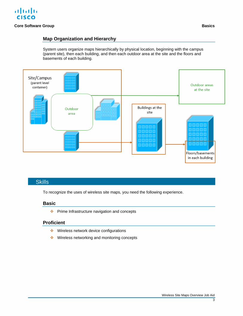
Map Organization and Hierarchy
System users organize maps hierarchically by physical location, beginning with the campus (parent site), then each building, and then each outdoor area at the site and the floors and basements of each building.
Skills
To recognize the uses of wireless site maps, you need the following experience.
Basic Prime Infrastructure navigation and concepts
Proficient Wireless network device configurations
Wireless networking and monitoring concepts

Core Software Group Basics
Wireless Site Maps Overview Job Aid 4
Terms
Building
In the hierarchy structure, a level below the site or campus, which can contain floors or basements
Fault
Indicator of conditions that are falling outside of acceptable health metric or alarm thresholds
Location display color-code to indicate the highest severity level fault or faults that are occurring at that location level. Device icons indicate fault severity at the device and radio levels.

Core Software Group Basics
Wireless Site Maps Overview Job Aid 5
Floor or Basement
In the hierarchy structure, the level below a building and belonging to the building, which can include access points, clients, chokepoints, and WiFi Time Delay on Arrival (TDOA) receivers
Outdoor Area
In the hierarchy structure, a level below the site or campus and outside of buildings, which can include access points, clients, chokepoints, and WiFi Time Delay on Arrival (TDOA) receivers
Outdoor areas are most commonly associated with a building or buildings.

Core Software Group Basics
Wireless Site Maps Overview Job Aid 6
Site or Campus
In the hierarchy structure, the container that defines the top, or parent level, of a physical location, which can include buildings and outdoor areas
In some instances, the system uses the terms site and campus interchangeably.
Virtual Domain
Administrators configure virtual domains as a method of limiting system users’ accesses to only those devices with which or areas of the application in which they need to work.
Depending on your role, you can have access to one or more virtual domains.

Core Software Group Navigating Wireless Site Maps
Wireless Site Maps Overview Job Aid 7
Navigating Wireless Site Maps The Location Level View
Layout and Features
Layout Overview
The parent site level layout includes:
The Domain Navigator, which lists all of the available wireless sites and provides navigation to those sites or their dependent locations.
The site level search and sort toolbar.
The view toolbar.
Site level dashlets.
The visual representation of the sites:
When the system has connectivity to the Internet, an interactive geographical map layout
Domain Navigator section
Visual representation (interactive geographical map)
Site level search and sort toolbar
View toolbar
Site level dashlets

Core Software Group Navigating Wireless Site Maps
Wireless Site Maps Overview Job Aid 8
When system users have uploaded image files, the applicable image.
When the system does not have Internet connectivity or an uploaded image file, a blank layout with highlight boxes to illustrate locations and dimensions.
Wireless maps display sites by using icons and report conditions by color-coding the icons.
To see icon and color code definitions: On the view toolbar, click Legend.
Legend button

Core Software Group Navigating Wireless Site Maps
Wireless Site Maps Overview Job Aid 9
Changing the Location Level View Layout
By using the toolbar, you can toggle the view so that it displays sites:
In a visual representation, referred to as a map view, which is the default view and can show the sites in their geographical context when maps or map images are available.
In a grid view, which provides a zoomed view of each geographical location.
In a table view, which list the sites.
The system highlights the button for the view that is active.
Each view provides summary data for each site, including the numbers of each of the following by default:
Buildings
Outdoor areas
Floors and basements
Access point radios and whether any access point radios are reporting critical alarms (faults)
Wireless clients currently associated with the site
Map view button, which indicates it is the active view
Grid view button
Table view button

Core Software Group Navigating Wireless Site Maps
Wireless Site Maps Overview Job Aid 10
In the table view, you also can include or remove list items.
Changing Reporting Preferences
You can control how the wireless maps functions present and report data.
Note: For detailed information on each of the preference settings, refer to the Edit Map Properties topic in the Cisco Prime Infrastructure 3.2 User Guide.
c

Core Software Group Navigating Wireless Site Maps
Wireless Site Maps Overview Job Aid 11
Geographical Map Features
Depending on the zoom level of the map, the map presents location groups that are geographically close together in a single icon that indicates the number of sites that are grouped.
When you zoom in to a specific area, the icons update to represent each site individually.
The icon color-code at individual and grouped site levels represents the most critical alarm (fault) occurring on one or more devices associated with the site or sites.
To zoom the map in more closely on a location:
Click a site icon.
Navigating Sites and Site Details
The location level view provides several ways to navigate to or open site details.
By Using the Domain Navigator
The Domain Navigator lists all of the sites that users have added, including those that do not include geographical coordinates.
When sites include dependent sites, an expand icon is available beside the site name. You can expand entries to see its dependent locations.
Sites grouped together based on zoom level
Individual site

Core Software Group Navigating Wireless Site Maps
Wireless Site Maps Overview Job Aid 12
By Using the Site Search
A site search feature is available in all views that contain dependent locations, below the Sites heading. This function is helpful when you are managing large numbers of sites.
As you type, the page updates to display those sites with names containing the string that you are typing.
By Using Site Summary Dashlets
In the map view, the system lists summary data by site in dashlets on the left side of the page. You can navigate to the next level of dependent locations by clicking a link in a summary.

Core Software Group Navigating Wireless Site Maps
Wireless Site Maps Overview Job Aid 13
When you navigate to a dependent level location, the Sites heading becomes a link, so that you can navigate to a higher level location efficiently. The site summary links also update when additional site levels are available.
As you continue to open dependent locations, the higher level site names become links.
In the grid view, you can click a site summary panel to open dependent locations.

Core Software Group Navigating Wireless Site Maps
Wireless Site Maps Overview Job Aid 14
In the table list view, you can click a site name link to open dependent locations.
Navigating Outdoor Areas or Buildings at a Site
In the maps hierarchy, system users can add outdoor areas or buildings at a site level or, most often as dependent locations associated with a site. At this point, outdoor areas and buildings present the same features and functions.
System users can upload images of locations, which are visible when the map view is active. When a site contains more than one defined location, the map outlines and shades those locations. You can point to a location outline to see its name.
At this level, the page layout and features are the same as those available at the location level.
The screenshot below illustrates a site layout with one outdoor area and with a site image.
You can apply the grid or list view when there are dependent locations.
Highlighted outdoor area
Point to identify location

Core Software Group Navigating Wireless Site Maps
Wireless Site Maps Overview Job Aid 15
The screenshot below illustrates a site layout with buildings and with the map available with Internet connectivity.
When there are multiple locations at a site level, system users can navigate to an individual location level, a single outdoor area, or a building.
At this level, system users also can upload images, which are visible when the map view is active. The map indicates the individual outdoor area or building with a highlight.
The page layout and functions are the same as those at a site level.
To monitor and manage the devices at each of these individual areas, system users add outdoor area layouts or floors and basements to buildings.
Highlighted building location
You can apply the grid or list view when there are dependent locations.
Highlighted building locations

Core Software Group Navigating Wireless Site Maps
Wireless Site Maps Overview Job Aid 16
Navigating the Building Level View
When you open the view for a single building, the system displays dashlets for each floor or basement configured for it.
The dashlets display a thumbnail of the floor layout and indicate the number of AP radios, connected clients, and access points reporting faults.
You can see the configuration or edit the configuration details, or delete the floor, by using the dashlet tools.
To open a floor view:
Click the floor dashlet.
Numbers of AP radios, connected clients, and faults Dashlet tools

Core Software Group Navigating Wireless Site Maps
Wireless Site Maps Overview Job Aid 17
Navigating an Outdoor Area or a Building Floor or Basement
Features and Tools
System users can add assets and overlays on the outdoor area, floor, or basement, which helps system users remain oriented during monitoring and troubleshooting activities.
At the level, the page features and tools are the same for outdoor areas, floors, and basements.
The following screenshot illustrates an outdoor area with its access point radios. The map displays the coverage heat map by default, which indicates the signal strength of each radio.
You can refer to the legend on the left to determine the strength values.

Core Software Group Navigating Wireless Site Maps
Wireless Site Maps Overview Job Aid 18
The following screenshot illustrates a floor with its access point radios and coverage heat map.

Core Software Group Navigating Wireless Site Maps
Wireless Site Maps Overview Job Aid 19
When you open an individual outdoor area or floor, the Display Settings tools are visible by default, indicated by the highlighted button on the toolbar.
Using the Display Settings tools, you can control the assets and types of data that appear on the map.
To control how the map presents the item: Expand the item panel to
access and enable additional presentation features.
To display an item on the map, select the associated check box.
Display Settings button

Core Software Group Navigating Wireless Site Maps
Wireless Site Maps Overview Job Aid 20
The toolbar provides access to display and data controls, and monitoring and editing tools.
The following screenshots describe the uses of the tools on the toolbar.
Note: When you select the setting that includes both radio frequencies, the map overlays the heat maps for each. You can select a single frequency in the drop-down list to see its associated heat map.
When the view of the map is affected, the map displays a notification indicator.
To review the notification: Point to the notification indicator.
The screenshots below show indicators for unpositioned access point and filters that are restricting the information appearing on the map.
Various map management tools
Filter the display of map elements
Change the data type that the map is reporting
Calculate the heat map manually for current readings
Update the map to display the current positions of all items that can move, such as clients or interferers
Change the radio frequency the map is reporting
In floor views, click the link to open other floor views in the building.
As you type, the map updates to display all of the items with matching criteria, and the map emphasizes the matching items.
Add, position, or remove map items or edit floor properties

Core Software Group Navigating Wireless Site Maps
Wireless Site Maps Overview Job Aid 21
The layout provides zoom tools and….
…to read the map effectively, access to a detailed legend.
To open the legend:
Click the Get Help button.
The access point device is in FlexConnnect mode and reports the AP status based on the most critical fault occurring on the device or one if its radio bands.
In this case, the most critical fault is minor.
The 8.2.11 b/g/n radio band is reporting a radio status of a minor fault.
The 8.2.11 a/n/c radio band is not reporting issues.
Additional wireless network components that the layout can display and on which it can report.

Core Software Group Navigating Wireless Site Maps
Wireless Site Maps Overview Job Aid 22
Reviewing Access Point (AP) Radio Details
Access point (AP) radio icons are interactive, providing additional details about the specific device. You can access summary and detailed information about the device.
To open a pop-up window with summary information: Point to an AP radio icon.
The pop-up window opens and provides summary detail about the radio. You can click an option button to see related information.
Information option buttons

Core Software Group Navigating Wireless Site Maps
Wireless Site Maps Overview Job Aid 23
To open detailed information about the AP radio:
Click the AP radio icon.
The icon displays a highlight and detailed information opens to the right of the map.

Core Software Group Navigating Wireless Site Maps
Wireless Site Maps Overview Job Aid 24
Device level information is available and you can take actions to monitor or configure the device.
You also can see the total alarm count and navigate to alarm details, which helps you to address alarms efficiently.
To evaluate or act on device alarms:
Beside Alarms, click the number link.
The system navigates to an Alarms page that lists the alarm or alarms that are associated with the device or its radios.

Core Software Group Navigating Wireless Site Maps
Wireless Site Maps Overview Job Aid 25
Below the device level information, radio level information is organized on tabs.
You can scroll to see information about neighboring radios and interferers.

Core Software Group Navigating Wireless Site Maps
Wireless Site Maps Overview Job Aid 26
You can open detailed device information by clicking the link icon.
The system navigates to and opens the access point’s device details.

Core Software Group Overview Video
Wireless Site Maps Overview Job Aid 27
Overview Video Watching Videos
To watch a video:
Click the link below, which opens an MP4 file.
Based on your system and configuration, you might need to start the video manually.
Note: Video download and streaming times can vary.
Navigating Wireless Site Maps
Watch the Video
To review the layout, navigation, and tools available on new wireless site maps, watch the Navigating Wireless Site Maps video. Approximate runtime: 8:00

Core Software Group Links
Wireless Site Maps Overview Job Aid 28
Links To Product Information
Visit the Cisco Web site to learn more about Cisco© Prime Infrastructure.
Visit the Cisco Web site to review or download technical documentation.
To Training
Visit the Cisco Web site to access other Cisco© Prime Infrastructure learning opportunities.
Visit the Cisco Web site to access learning opportunities for other Cisco products.
To Contact Us
Send us a message with questions or comments about this job aid.
Note: Please send messages that address the content of this job aid or other training questions only. Follow your regular business process to request technical support or address technical or application-related questions.