Embed Size (px)
Citation preview

4/19/2019
1
Why Planners need to know about it
Today:
Basics of groundwater system
Land-use and groundwater
World Fresh Water Supply

4/19/2019
2
Why is groundwater important to Planners?
• Our largest readily available source of freshwater is groundwater– Approx. 20% of all fresh water on Earth
• In the U.S., 40% of all fresh water comes from groundwater– Nearly half the states obtaining half their water from groundwater
• Currently, groundwater supplies:– 50% of all water used for drinking
– 40% of water used for irrigation and crop growth
– 25% of fresh water demands for industtry
• Groundwater provides ~66% of the water to streams, lakes and wetlands
Urban water cycle• This graphic illustrates
the impact of human activity on groundwater. It shows that groundwater is obtained from periurban wellfields and urban wells, then used and disposed of as wastewater through pluvial drainage, piped sewage and on-site sanitation and industrial effluent disposal. It also shows that wastewater is treated and then reused for irrigation, with excess flows re-entering the aquifers.

4/19/2019
3
Hydrologic or Water Cycle
• Moves water back and forth between the earth’s surface (biosphere, hydrosphere and lithosphere) and the earth’s atmosphere
• 91,000 cubic miles of water evaporates into the atmosphere from the earth’s surface each year (84% from the oceans and 16% from land)
• 75% of atmospheric water falls to oceans and 25% falls to land
Hydrologic/Water cycle

4/19/2019
4
Groundwater recharge• GW recharge (or deep drainage) is a hydrologic process
that is part of the hydrologic cycle where water moves downward from surface water to groundwater
• Human activity can impede recharge due to development activities such as;– Paving (creating impervious surfaces)
– Logging
– Grading• All of which can decrease GW recharge and increase SW runoff
• GW recharge is related to other processes such as;– Evaporation
– Transpiration
– Infiltration
Infiltration - Definitions
• Infiltration – rain and snow melt entering the soil through the soil surface
– f : infiltration rate (in/hr)
– F : total infiltration amount over some time (in)
• Infiltration Capacity – maximum infiltration rate

4/19/2019
5
Infiltration - Dependencies
• Surface– Type of vegetative cover
– Type of landuse practice (compaction)
– Rainfall Intensity
• Subsurface– Soil type
– Moisture content
– Root systems
Infiltration - Measurement
• Ring Infiltrometer
• Sprinkling

4/19/2019
6
Percentage of total water use that is from groundwater and amount of groundwater used in PA, by county, 1990
PA
DC
NR
–T
he g
eolo
gy o
f Pen
nsyl
vani
a’s
grou
ndw
ater
, 199
9. I
llust
ratio
n by
J. H
. Dol
impi
o
Average annual precipitation in Pennsylvania, inches
PA
DC
NR
–T
he g
eolo
gy o
f Pen
nsyl
vani
a’s
grou
ndw
ater
, 199
9. I
llust
ratio
n by
J. H
. Dol
impi
oIndiana County receives the highest amount of rainfall per year

4/19/2019
7
Why does Indiana get so much precipitation? One reason is orographic lifting

4/19/2019
8
The Groundwater System
Aquifers• Are formations that contain enough water and have
sufficient permeability to be used as water supply sources
• An aquiclude (such as clay) us usually porous and may contain groundwater but transmits is slowly and is not a good source
• An aquifuge (such as rock) neither stores nor transmits water
• Aquicludes and aquifuges can serve as confining layers, known as aquitards

4/19/2019
9
The Groundwater System
Unconfined and confined aquifers• Unconfined, or free, aquifers have direct vertical contact with the
atmosphere through open pores in the soil, and recharge from the infiltration above– The top of an unconfined aquifer is the groundwater table
– Below the table is the saturated zone
– Above the table is the unsaturated zone, a.k.a. vadose zone
• Unconfined aquifers that are perched produce seeps and springs, where the underlying layers force water to spill out of the ground– Primary recharge usually occurs directly above the aquifer
– Secondary recharge occurs from runoff of nearby slopes to primary area
• Confined aquifers are overlain by some geologic layer which water cannot move– Recharge is influenced by stratigraphy and structure

4/19/2019
10
Recharge Zones (surface)A group of aquifers linked together in a large flow system is
called a ground water basin
Types of Recharge Zones
1. Topographic Depression (wetland)
2. Highly permeable surface material (alluvial fan)
3. Exposed Aquifer (escarpment)

4/19/2019
11
Unconfined Perched (hanging) Aquifers
• One of largest in the world (unconfined)
• 174,000 square miles
•Primarily sandstone
• Provides 30% of nations irrigation water
• Could dry up in 25 years??
Regional Aquifer (Ogallala)

4/19/2019
12
Storage of groundwater in consolidated rocks and in unconsolidated sediments
PA
DC
NR
–T
he g
eolo
gy o
f Pen
nsyl
vani
a’s
grou
ndw
ater
, 199
9. I
llust
ratio
n by
J. H
. Dol
impi
o
Unconsolidated AquiferUnconsolidated aquifers in PA have significant porosity and permeability;
Composed of mainly sand and gravelP
AD
CN
R –
The
geo
logy
of P
enns
ylva
nia’
s gr
ound
wat
er, 1
999.
Illu
stra
tion
by J
. H. D
olim
pio

4/19/2019
13
Groundwater Protection
• It is important to recognize three critical areas of concern in regards to groundwater protection:
– Groundwater recharge areas• Rock outcrops, depressions, wetlands
– Groundwater emergent areas• Seeps and springs
– Aquifer material composition• Seeking no decrease in permeability
Groundwater vs. Surface water• Groundwater chemistry varies from location to location
– Due to the minerals with which the water comes in contact with, and
– How long (duration) the water is in the groundwater system
• As groundwater flows, it dissolves minerals in the soil and rock– Resulting in various amounts of dissolved solids, measured mg/L
• Most of the springs in PA have only flowed through
weathered rock where minerals have already leached
• Spring water in PA, therefore, is not much
different from surface water
PA
DC
NR
–T
he g
eolo
gy o
f Pen
nsyl
vani
a’s
grou
ndw
ater
, 199
9. I
llust
ratio
n by
J. H
. Dol
impi
o

4/19/2019
14
Groundwater flow rates
• Changing the composition of soil material will affect groundwater flow and, eventually, supply
• Protection of groundwater permeability can be regulated via ordinances
PA
DC
NR
–T
he g
eolo
gy o
f Pen
nsyl
vani
a’s
grou
ndw
ater
, 199
9. I
llust
ratio
n by
J. H
. Dol
impi
o
Pore sizes affect groundwater flow rates

4/19/2019
15
Waltham A. C. and Fookes P. G. 2005
Karst• Karst landscapes are shaped
by the dissolution of a layer or layers of soluble bedrock, usually carbonate rock such as limestone or dolomite
• Due to subterranean drainage, surface water is limited or absent
• Thus, protection of groundwater resources is even more crucial

4/19/2019
16
Karstclass
Locations Sinkholes Rockhead Fissuring CavesGroundinvestigation
Foundations
kI Juvenile Only in deserts and periglacial zones, or on impure carbonates
RareNSH <0.001
Almost uniform;minor fissures
Minimal;low secondary permeability
Rare and small;some isolated relict features
Conventional Conventional
kII Youthful The minimum in temperate regions
Small suffusion or dropout sinkholes;Open stream sinksNSH 0.001-0.05
Many small fissures
Widespread in the few metres nearest surface
Many small caves; most <3m across
Mainly conventional,probe rock to 3 m,check fissures in rockhead
Grout open fissures;control drainage
kIII Mature Common in temperate regions; the minimum in the wet tropics
Many suffosion and dropout sinkholes;large dissolution sinkholes;small collapse and buried sinkholesNSH 0.05 - 1.0
Extensive fissuring;relief of <5m;loose blocks in cover soil
Extensive secondary opening of most fissures
Many <5m acrossat multiple levels
Probe to rockhead,probe rock to 4m,microgravity survey
Rafts or ground beams,consider geogrids,driven piles to rockhead;control drainage
kIV Complex Localized in temperate regions;normal intropical regions
Many large dissolution sinkholes; numerous subsidence sinkholes; scattered collapse and& buried sinkholesNSH 0.5 – 2.0
Pinnacled;relief of 5-20m;loose pillars
Extensive large dissolutional openings, on and away from major fissures
Many >5m acrossat multiple levels
Probe to rockhead,Prove rock to 5mwith splayed probes,microgravity survey
Bored piles to rockhead,or cap grouting at rockhead;control drainage and abstraction
kV Extreme Only in wet tropics
Very large sinkholesof all types; remanent arches;soil compaction in buried sinkholesNSH >>1
Tall pinnacles;relief of >20m;loose pillarsundercut between deep soil fissures
Abundant and very complex dissolution cavities
Numerous complex 3-D cave systems; galleriesand chambers>15m across
Make individualground investigationfor everypile site
Bear in soils with geogrid, load on proven pinnacles,or on deep bored piles;control all drainageand control abstractionWaltham A. C. and Fookes P. G. 2005
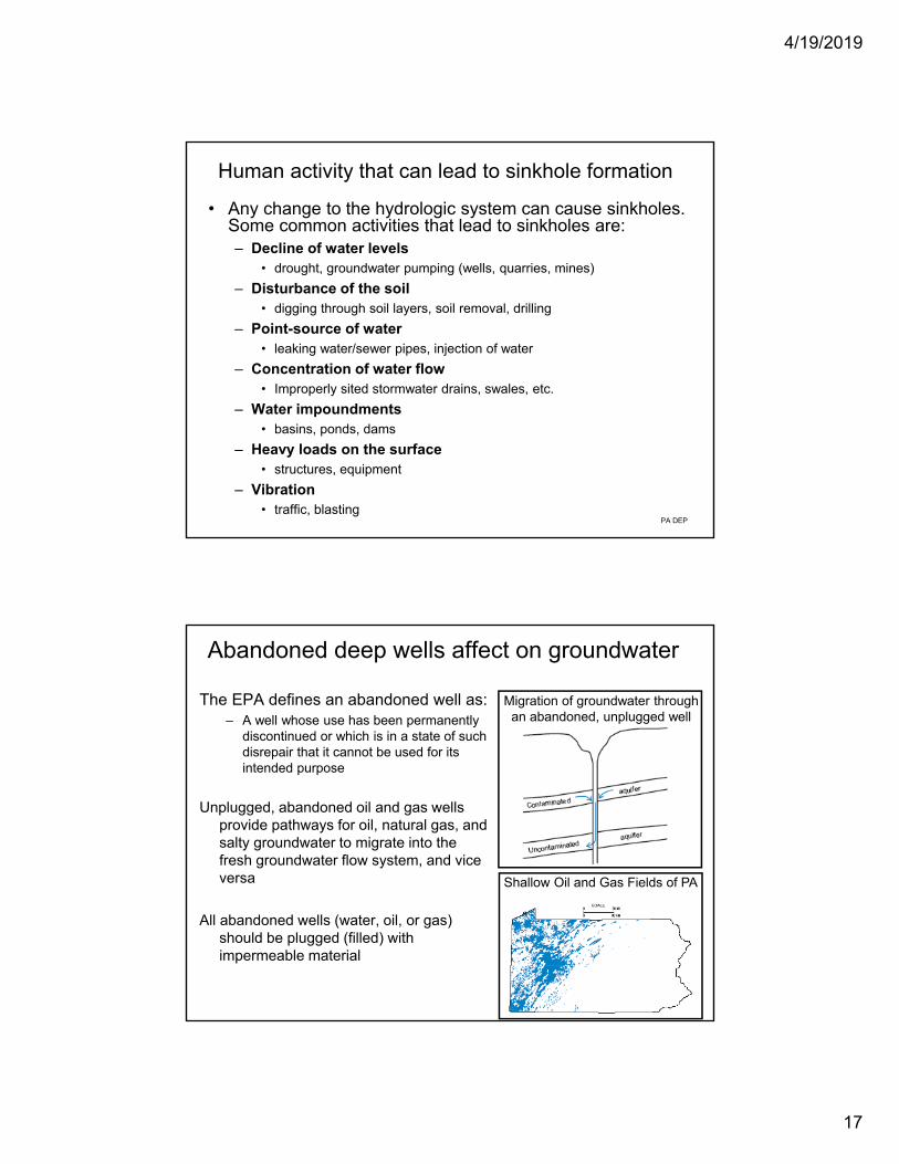
Sinkholes
Occur naturally in karst landscapes
Sinkholes occur outside of karst areas when water weathers, or dissolves, minerals in the underlying rock structure
Human activity, however, will cause sinkholes to develop due to poor surface water management and/or permitting of land-uses unsuitable for soil conditions
PA DEP
4/19/2019
17
Human activity that can lead to sinkhole formation
• Any change to the hydrologic system can cause sinkholes. Some common activities that lead to sinkholes are:– Decline of water levels
• drought, groundwater pumping (wells, quarries, mines)
– Disturbance of the soil• digging through soil layers, soil removal, drilling
– Point-source of water• leaking water/sewer pipes, injection of water
– Concentration of water flow• Improperly sited stormwater drains, swales, etc.
– Water impoundments• basins, ponds, dams
– Heavy loads on the surface• structures, equipment
– Vibration• traffic, blasting
PA DEP
Abandoned deep wells affect on groundwater
The EPA defines an abandoned well as:– A well whose use has been permanently
discontinued or which is in a state of such disrepair that it cannot be used for its intended purpose
Unplugged, abandoned oil and gas wells provide pathways for oil, natural gas, and salty groundwater to migrate into the fresh groundwater flow system, and vice versa
All abandoned wells (water, oil, or gas) should be plugged (filled) with impermeable material
Shallow Oil and Gas Fields of PA
Migration of groundwater throughan abandoned, unplugged well

4/19/2019
18
Cones of Depression
• Cones of depression, which result from the tapping of wells near surface waters, can turn a gaining stream – a stream gaining water
from groundwater
to a losing stream– a stream losing
groundwater and surface water subterraineanly

4/19/2019
19
Delineation of Wellhead Protection Areas (WHPA)
Must determine 2 zones (sometimes 3)
Zone of Influence – the surface projection of the boundaries of the cone of depression around the well
Zone of Contribution – the surface projection of the boundaries of the portion of the aquifer recharge area that contributes to the well
- this normally extends up the upflow side and to a portion of the CofD on the downflow side
In PA, a 3rd zone is required, and is the area beyond Zone II that contributes recharge to the aquifer within the capture zone
ZOI ZOC
Groundwaterdivide
Direction of groundwater flow
A
A
A`
A`
PROFILE VIEW
PLAN VIEW
Cone ofdepression