Embed Size (px)
Citation preview

Introduction to Groundwater 2Centre for Groundwater Studies
Why is Groundwater Important?
When many Australians think ofwater, they tend to think of surfacewater and issues such as riversalinity. Surface water in reservoirsis probably the water that mostpeople are conscious of in theireveryday lives and most capitalcities in Australia are reliant onsurface catchments for their dailywater. There is however anotherwater resource that is just as vitalbut not as visible, this isgroundwater. In Australia use hasincreased by 40% since 1983, and in NSW, Victoria and Western Australia by over 200% over thisperiod Many people in regional areas depend on groundwater for stock and domestic uses.
Approximately 97% of water onEarth is found within the oceans.Of the world’s freshwater,approximately 75% is frozen inice-caps and glaciers, whileapproximately 25% is stored asgroundwater. Surface waterrepresents less than 1% of theworld’s fresh water.
Introduction to Groundwater 3Centre for Groundwater Studies
If all groundwater was removed from under the surface and placed on the face of the Earth, it wouldcover the land to a depth of 300 metres.To almost every individual in Australia, groundwater is the closest free water. In Australia only 37%of our fresh and marginal water supplies and 14% of water use is from groundwater. Groundwaterresources are under exploited in comparison to surface water resources, with only 3% of the availablegroundwater used, compared with 13% of surface water. However, our semi-arid climate has resultedin much of our groundwater being too saline to use.
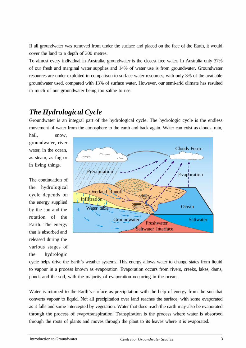
The Hydrological CycleGroundwater is an integral part of the hydrological cycle. The hydrologic cycle is the endlessmovement of water from the atmosphere to the earth and back again. Water can exist as clouds, rain,hail, snow,groundwater, riverwater, in the ocean,as steam, as fog orin living things.
The continuation ofthe hydrologicalcycle depends onthe energy suppliedby the sun and therotation of theEarth. The energythat is absorbed andreleased during thevarious stages ofthe hydrologiccycle helps drive the Earth’s weather systems. This energy allows water to change states from liquidto vapour in a process known as evaporation. Evaporation occurs from rivers, creeks, lakes, dams,ponds and the soil, with the majority of evaporation occurring in the ocean.
Water is returned to the Earth’s surface as precipitation with the help of energy from the sun thatconverts vapour to liquid. Not all precipitation over land reaches the surface, with some evaporatedas it falls and some intercepted by vegetation. Water that does reach the earth may also be evaporatedthrough the process of evapotranspiration. Transpiration is the process where water is absorbedthrough the roots of plants and moves through the plant to its leaves where it is evaporated.
Overland Runoff
Clouds Form-
Evaporation
Ocean
SaltwaterFreshwater
Saltwater Interface
Groundwater
Infiltration
Water table
Precipitation

Introduction to Groundwater 4Centre for Groundwater Studies
Once on the surface, water that is not evaporated from the surface can proceed in two ways. It cansoak into the ground, fall into a body of water or it can runoff over land. Water soaks into the soil ina process known as infiltration. Water that is not evaporated in the soil zone will move through thesubsurface to the watertable where it will travel as groundwater to rivers, creeks, lakes, springs,wells or the ocean. Runoff is surface water that can be evaporated or move overland to rivers,creeks, lakes, dams and the ocean. The amount of runoff depends on the slope of the land surfaceand the porosity of the surface.
In terms of water, this planet is a closed system.
The water that is available to ourplanet now is the same water that wasavailable three billion years ago, andthe only water that will be availablein the future. We depend on water tosurvive. The population of Earth isexpanding rapidly and so are thedemands on water, but our supply ofwater does not expand. This is whythere is a need to conserve water andkeep it clean.
The total amount of water in thehydrologic cycle has beenestimated as over one billioncubic kilometres. To gain someidea of how immense this volumeis, one cubic kilometre would fill300 Olympic stadiums(Environment Canada).
Introduction to Groundwater 5Centre for Groundwater Studies
What Is Groundwater?
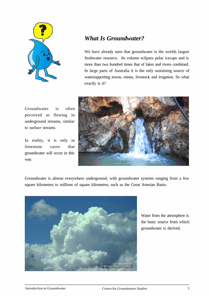
We have already seen that groundwater is the worlds largestfreshwater resource. Its volume eclipses polar icecaps and ismore than two hundred times that of lakes and rivers combined.In large parts of Australia it is the only sustaining source ofwatersupporting towns, mines, livestock and irrigation. So whatexactly is it?
Groundwater is oftenperceived as flowing inunderground streams, similarto surface streams.
In reality, it is only inlimestone caves thatgroundwater will occur in thisway.
Groundwater is almost everywhere underground, with groundwater systems ranging from a fewsquare kilometres to millions of square kilometres, such as the Great Artesian Basin.
Water from the atmosphere isthe basic source from whichgroundwater is derived.
Introduction to Groundwater 6Centre for Groundwater Studies
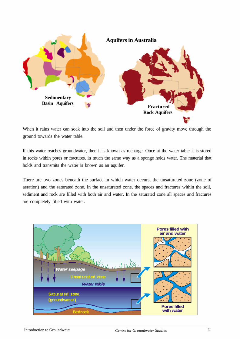
When it rains water can soak into the soil and then under the force of gravity move through theground towards the water table.
If this water reaches groundwater, then it is known as recharge. Once at the water table it is storedin rocks within pores or fractures, in much the same way as a sponge holds water. The material thatholds and transmits the water is known as an aquifer.
There are two zones beneath the surface in which water occurs, the unsaturated zone (zone ofaeration) and the saturated zone. In the unsaturated zone, the spaces and fractures within the soil,sediment and rock are filled with both air and water. In the saturated zone all spaces and fracturesare completely filled with water.
Water table
Unsaturated zone
Bedrock
Pores filled withair and water
Pores filled with water
Saturated zone(groundwater)
Water seepage
Aquifers in Australia
SedimentaryBasin Aquifers
FracturedRock Aquifers
Introduction to Groundwater 7Centre for Groundwater Studies
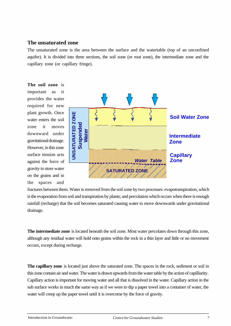
The unsaturated zoneThe unsaturated zone is the area between the surface and the watertable (top of an unconfinedaquifer). It is divided into three sections, the soil zone (or root zone), the intermediate zone and thecapillary zone (or capillary fringe).
The soil zone isimportant as itprovides the waterrequired for newplant growth. Oncewater enters the soilzone it movesdownward undergravitational drainage.However, in this zonesurface tension actsagainst the force ofgravity to store wateron the grains and inthe spaces andfractures between them. Water is removed from the soil zone by two processes: evapotranspiration, whichis the evaporation from soil and transpiration by plants; and percolation which occurs when there is enoughrainfall (recharge) that the soil becomes saturated causing water to move downwards under gravitationaldrainage.
The intermediate zone is located beneath the soil zone. Most water percolates down through this zone,although any residual water will hold onto grains within the rock in a thin layer and little or no movementoccurs, except during recharge.
The capillary zone is located just above the saturated zone. The spaces in the rock, sediment or soil inthis zone contain air and water. The water is drawn upwards from the water table by the action of capilliarity.Capillary action is important for moving water and all that is dissolved in the water. Capillary action in thesub surface works in much the same way as if we were to dip a paper towel into a container of water, thewater will creep up the paper towel until it is overcome by the force of gravity.
Soil Water Zone
UN
SA
TUR
AT
ED
ZO
NE
Su
spen
ded
Wat
er
IntermediateZone
CapillaryZone
SATURATED ZONE
Water Table
Introduction to Groundwater 8Centre for Groundwater Studies
Wetlands
Runoff
WINTER SUMMER
Winter watertable
Summer watertable
Transpirationfrom plants
Evaporationfrom soil
Evaporationfrom wetlands
Recharge to groundwater
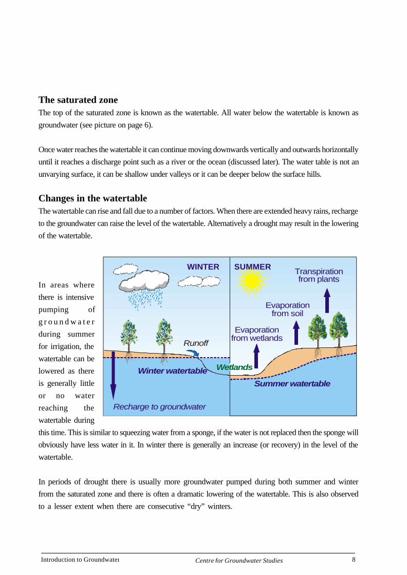
The saturated zoneThe top of the saturated zone is known as the watertable. All water below the watertable is known asgroundwater (see picture on page 6).
Once water reaches the watertable it can continue moving downwards vertically and outwards horizontallyuntil it reaches a discharge point such as a river or the ocean (discussed later). The water table is not anunvarying surface, it can be shallow under valleys or it can be deeper below the surface hills.
Changes in the watertableThe watertable can rise and fall due to a number of factors. When there are extended heavy rains, rechargeto the groundwater can raise the level of the watertable. Alternatively a drought may result in the loweringof the watertable.
In areas wherethere is intensivepumping ofg r o u n d w a t e rduring summerfor irrigation, thewatertable can belowered as thereis generally littleor no waterreaching thewatertable duringthis time. This is similar to squeezing water from a sponge, if the water is not replaced then the sponge willobviously have less water in it. In winter there is generally an increase (or recovery) in the level of thewatertable.
In periods of drought there is usually more groundwater pumped during both summer and winterfrom the saturated zone and there is often a dramatic lowering of the watertable. This is also observedto a lesser extent when there are consecutive “dry” winters.
Introduction to Groundwater 9Centre for Groundwater Studies
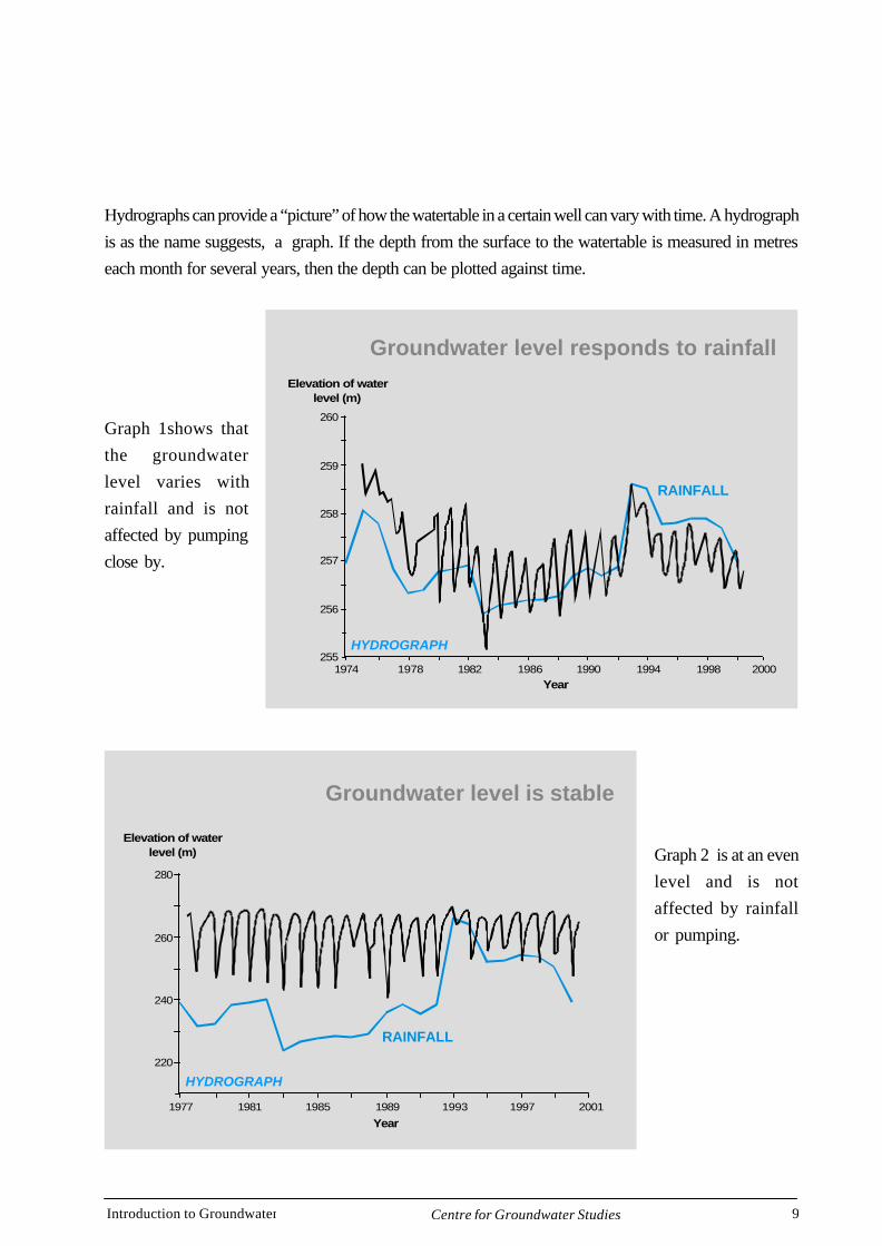
Hydrographs can provide a “picture” of how the watertable in a certain well can vary with time. A hydrographis as the name suggests, a graph. If the depth from the surface to the watertable is measured in metreseach month for several years, then the depth can be plotted against time.
Graph 1shows thatthe groundwaterlevel varies withrainfall and is notaffected by pumpingclose by.
Graph 2 is at an evenlevel and is notaffected by rainfallor pumping.
Groundwater level responds to rainfall
259
260
258
257
256
2551974 1978 1982 1986
Year
Elevation of waterlevel (m)
1990 1994 1998 2000
RAINFALL
HYDROGRAPH
Groundwater level is stable
280
260
240
220
1977 1981 1985 1989
Year
Elevation of waterlevel (m)
1993 1997 2001
RAINFALL
HYDROGRAPH
Introduction to Groundwater 10Centre for Groundwater Studies
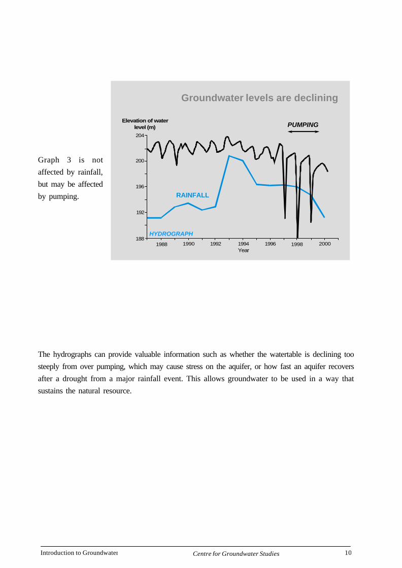
Graph 3 is notaffected by rainfall,but may be affectedby pumping.
The hydrographs can provide valuable information such as whether the watertable is declining toosteeply from over pumping, which may cause stress on the aquifer, or how fast an aquifer recoversafter a drought from a major rainfall event. This allows groundwater to be used in a way thatsustains the natural resource.
Groundwater levels are declining
204
200
196
192
1881988 1990 1992 1994
Year
Elevation of waterlevel (m)
1996 1998 2000
RAINFALL
PUMPING
HYDROGRAPH
Introduction to Groundwater 11Centre for Groundwater Studies
Aquifer
Groundwater is found in an aquifer. An aquifer is defined as a saturated geological material, thatwhen a well is drilled, can yield a useable quantity of groundwater. A geological material may besandstone, limestone, basalt, granite or any number of rock types. Although the saturated zone iscompletely saturated below the watertable, it is only geological materials with certain propertiesthat are classed as aquifers.
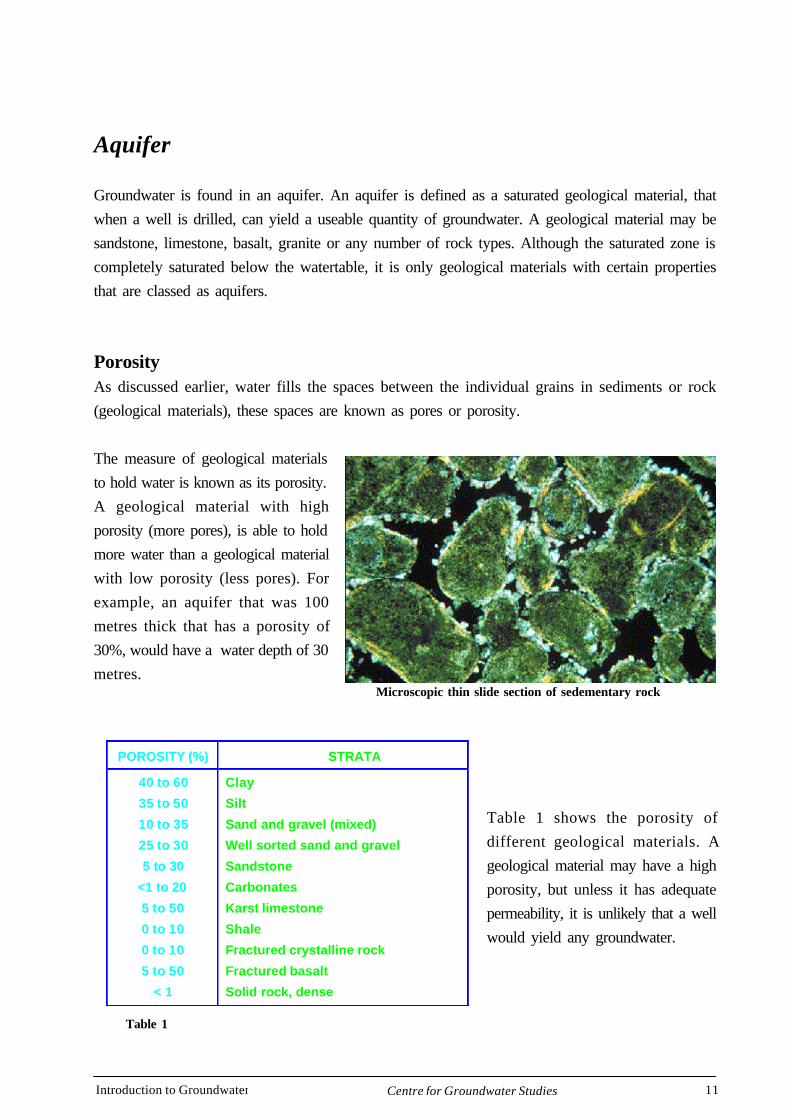
PorosityAs discussed earlier, water fills the spaces between the individual grains in sediments or rock(geological materials), these spaces are known as pores or porosity.
The measure of geological materialsto hold water is known as its porosity.A geological material with highporosity (more pores), is able to holdmore water than a geological materialwith low porosity (less pores). Forexample, an aquifer that was 100metres thick that has a porosity of30%, would have a water depth of 30metres.
Table 1 shows the porosity ofdifferent geological materials. Ageological material may have a highporosity, but unless it has adequatepermeability, it is unlikely that a wellwould yield any groundwater.
Microscopic thin slide section of sedementary rock
POROSITY (%) STRATA
40 to 60
35 to 50
10 to 35
25 to 30
5 to 30
<1 to 20
5 to 50
0 to 10
0 to 10
5 to 50
< 1
Clay
Silt
Sand and gravel (mixed)
Well sorted sand and gravel
Sandstone
Carbonates
Karst limestone
Shale
Fractured crystalline rock
Fractured basalt
Solid rock, dense
Table 1

Introduction to Groundwater 12Centre for Groundwater Studies
PermeabilityPermeability is a measure of the interconnecting spaces or cracks between pores that allow water to movefrom one pore to the next. In order to gain an adequate yield the spaces and cracks must be abundant.
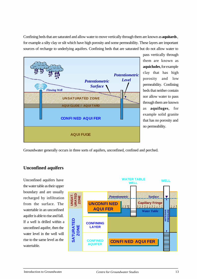
Confining bedSince geological material usually occurs in beds or layers, an aquifer may be overlain or underlain by alayer of geological material which is saturated but has poor porosity and/or permeability and can notprovide a useable yield. This type of geological material is known as a confining bed.
To gain a better understanding of a confining bed, picture two sponges one on top of the other. Whenwater is poured into the top sponge you would expect it to drain down under the force of gravity into thesecond sponge. If a confining layer in the form of a piece of plastic was to be placed between the twosponges,then you can see that water poured continuously and slowly into the top sponge would saturatethe sponge and the water would leak sideways from the sponge onto the plastic. The bottom spongeremaining dry. There are three different types of confining beds.
Water movesthrough porestoward a well ordischarge area
If pores are large,water movesmore easily
Introduction to Groundwater 13Centre for Groundwater Studies
Confining beds that are saturated and allow water to move vertically through them are known as aquitards ,for example a silty clay or silt which have high porosity and some permeability. These layers are importantsources of recharge to underlying aquifers. Confining beds that are saturated but do not allow water to
pass vertically throughthem are known asaquicludes, for exampleclay that has highporosity and lowpermeability. Confiningbeds that neither containnor allow water to passthrough them are knownas aquifuges, forexample solid granitethat has no porosity andno permeability.
Groundwater generally occurs in three sorts of aquifers, unconfined, confined and perched.
Unconfined aquifers
Unconfined aquifers havethe water table as their upperboundary and are usuallyrecharged by infiltrationfrom the surface. Thewatertable in an unconfinedaquifer is able to rise and fall.If a well is drilled within aunconfined aquifer, then thewater level in the well willrise to the same level as thewatertable.
AQUIFUGE
CONFINED AQUIFER
AQUICLUDE / AQUITARD
UNSATURATED ZONE
PotentiometricSurface
Flowing Well
PotentiometricLevel
CONFININGLAYER
CONFINEDAQUIFER
Water Table
SurfacePotentiometric
SA
TU
RA
TE
DZ
ON
E
UN
SA
T-
UR
ATE
DZO
NE
WATER TABLEWELL
WELL
AR
TE
SIA
NP
RE
SS
UR
E
LAND SURFACE
Capillary FringeUNCONFINEDAQUIFER
UNCONFINEDAQUIFER
CONFINED AQUIFERCONFINED AQUIFER
Introduction to Groundwater 14Centre for Groundwater Studies
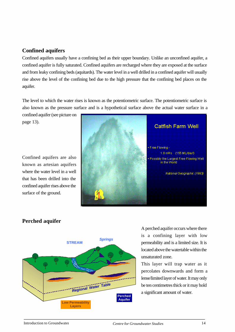
Confined aquifersConfined aquifers usually have a confining bed as their upper boundary. Unlike an unconfined aquifer, aconfined aquifer is fully saturated. Confined aquifers are recharged where they are exposed at the surfaceand from leaky confining beds (aquitards). The water level in a well drilled in a confined aquifer will usuallyrise above the level of the confining bed due to the high pressure that the confining bed places on theaquifer.
The level to which the water rises is known as the potentiometric surface. The potentiometric surface isalso known as the pressure surface and is a hypothetical surface above the actual water surface in aconfined aquifer (see picture onpage 13).
Confined aquifers are alsoknown as artesian aquiferswhere the water level in a wellthat has been drilled into theconfined aquifer rises above thesurface of the ground.
Perched aquiferA perched aquifer occurs where thereis a confining layer with lowpermeability and is a limited size. It islocated above the watertable within theunsaturated zone.This layer will trap water as itpercolates downwards and form alense/limited layer of water. It may onlybe ten centimetres thick or it may holda significant amount of water.
STREAMSprings
Regional Water Table
PerchedAquifer
Low PermeabilityLayers
Introduction to Groundwater 15Centre for Groundwater Studies
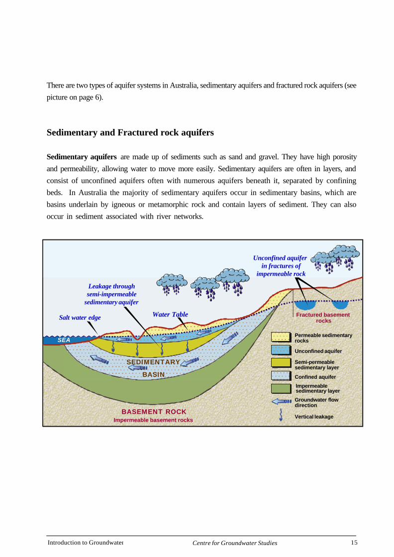
There are two types of aquifer systems in Australia, sedimentary aquifers and fractured rock aquifers (seepicture on page 6).
Sedimentary and Fractured rock aquifers
Sedimentary aquifers are made up of sediments such as sand and gravel. They have high porosityand permeability, allowing water to move more easily. Sedimentary aquifers are often in layers, andconsist of unconfined aquifers often with numerous aquifers beneath it, separated by confiningbeds. In Australia the majority of sedimentary aquifers occur in sedimentary basins, which arebasins underlain by igneous or metamorphic rock and contain layers of sediment. They can alsooccur in sediment associated with river networks.
Leakage throughsemi-impermeable
sedimentary aquifer
SEA
SEDIMENTARY
BASIN
BASEMENT ROCK
Permeable sedimentaryrocks
Unconfined aquifer
Semi-permeable sedimentary layer
Confined aquifer
Impermeable sedimentary layer
Impermeable basement rocks
Groundwater flowdirection
Vertical leakage
Water TableSalt water edge
Unconfined aquifer in fractures of
impermeable rock
Fractured basementrocks
Introduction to Groundwater 16Centre for Groundwater Studies
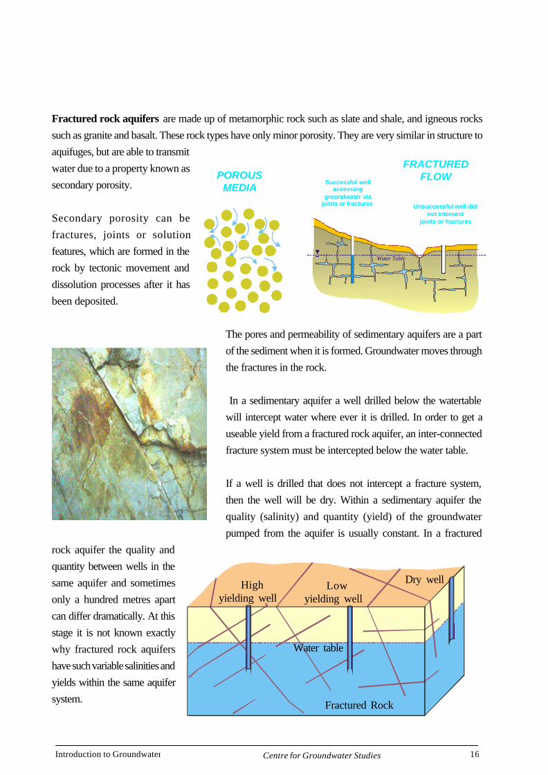
Fractured rock aquifers are made up of metamorphic rock such as slate and shale, and igneous rockssuch as granite and basalt. These rock types have only minor porosity. They are very similar in structure toaquifuges, but are able to transmitwater due to a property known assecondary porosity.
Secondary porosity can befractures, joints or solutionfeatures, which are formed in therock by tectonic movement anddissolution processes after it hasbeen deposited.
The pores and permeability of sedimentary aquifers are a partof the sediment when it is formed. Groundwater moves throughthe fractures in the rock.
In a sedimentary aquifer a well drilled below the watertablewill intercept water where ever it is drilled. In order to get auseable yield from a fractured rock aquifer, an inter-connectedfracture system must be intercepted below the water table.
If a well is drilled that does not intercept a fracture system,then the well will be dry. Within a sedimentary aquifer thequality (salinity) and quantity (yield) of the groundwaterpumped from the aquifer is usually constant. In a fractured
rock aquifer the quality andquantity between wells in thesame aquifer and sometimesonly a hundred metres apartcan differ dramatically. At thisstage it is not known exactlywhy fractured rock aquifershave such variable salinities andyields within the same aquifersystem.
Successful wellaccessing
groundwater viajoints or fractures Unsuccessful well did
not intersectjoints or fractures
POROUSMEDIA
FRACTUREDFLOW
Water Table
Highyielding well
Lowyielding well
Water table
Fractured Rock
Dry well
Introduction to Groundwater 17Centre for Groundwater Studies
Groundwater Flow
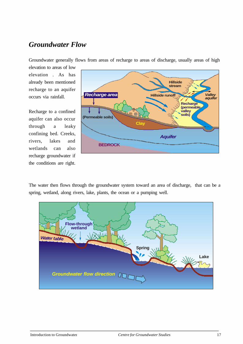
Groundwater generally flows from areas of recharge to areas of discharge, usually areas of highelevation to areas of lowelevation . As hasalready been mentionedrecharge to an aquiferoccurs via rainfall.
Recharge to a confinedaquifer can also occurthrough a leakyconfining bed. Creeks,rivers, lakes andwetlands can alsorecharge groundwater ifthe conditions are right.
The water then flows through the groundwater system toward an area of discharge, that can be aspring, wetland, along rivers, lake, plants, the ocean or a pumping well.
Hillsidestream
Valleyaquifer
Recharge(permeablevalleysoils)
Hillside runoff
BEDROCK
(Permeable soils)
Aquifer
Clay
Recharge area
Groundwater flow direction
Flow-throughwetland
Water table
Spring
Lake
Introduction to Groundwater 18Centre for Groundwater Studies
LOSING STREAM THAT IS DISCONNECTEDFROM THE WATER TABLE
Unsaturatedzone
Flowdirection
Water bleta
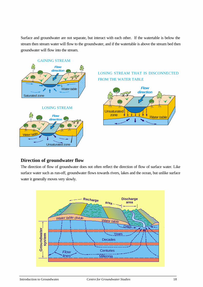
Surface and groundwater are not separate, but interact with each other. If the watertable is below thestream then stream water will flow to the groundwater, and if the watertable is above the stream bed thengroundwater will flow into the stream.
Direction of groundwater flowThe direction of flow of groundwater does not often reflect the direction of flow of surface water. Likesurface water such as run-off, groundwater flows towards rivers, lakes and the ocean, but unlike surfacewater it generally moves very slowly.
GAINING STREAM
Saturated zone
Flowdirection
Water table
LOSING STREAM
Unsaturated zone
Water table
Flowdirection
Dischargeareaarea
Water table divide
Years
Decades
Flowlines
Centuries
Millennia
Water table
Gro
und
wat
ersy
stem
Recharge
Days
LOSING STREAM THAT IS DISCONNECTED
FROM THE WATER TABLE
GAINING STREAM
LOSING STREAM
Introduction to Groundwater 19Centre for Groundwater Studies
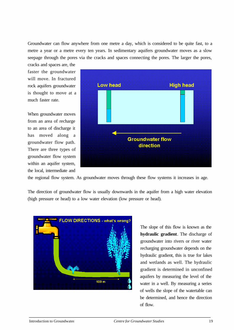
Groundwater can flow anywhere from one metre a day, which is considered to be quite fast, to ametre a year or a metre every ten years. In sedimentary aquifers groundwater moves as a slowseepage through the pores via the cracks and spaces connecting the pores. The larger the pores,cracks and spaces are, thefaster the groundwaterwill move. In fracturedrock aquifers groundwateris thought to move at amuch faster rate.
When groundwater movesfrom an area of rechargeto an area of discharge ithas moved along agroundwater flow path.There are three types ofgroundwater flow systemwithin an aquifer system,the local, intermediate andthe regional flow system. As groundwater moves through these flow systems it increases in age.
The direction of groundwater flow is usually downwards in the aquifer from a high water elevation(high pressure or head) to a low water elevation (low pressure or head).
The slope of this flow is known as thehydraulic gradient. The discharge ofgroundwater into rivers or river waterrecharging groundwater depends on thehydraulic gradient, this is true for lakesand wetlands as well. The hydraulicgradient is determined in unconfinedaquifers by measuring the level of thewater in a well. By measuring a seriesof wells the slope of the watertable canbe determined, and hence the directionof flow.
Introduction to Groundwater 20Centre for Groundwater Studies
HIGH FLOWRATE
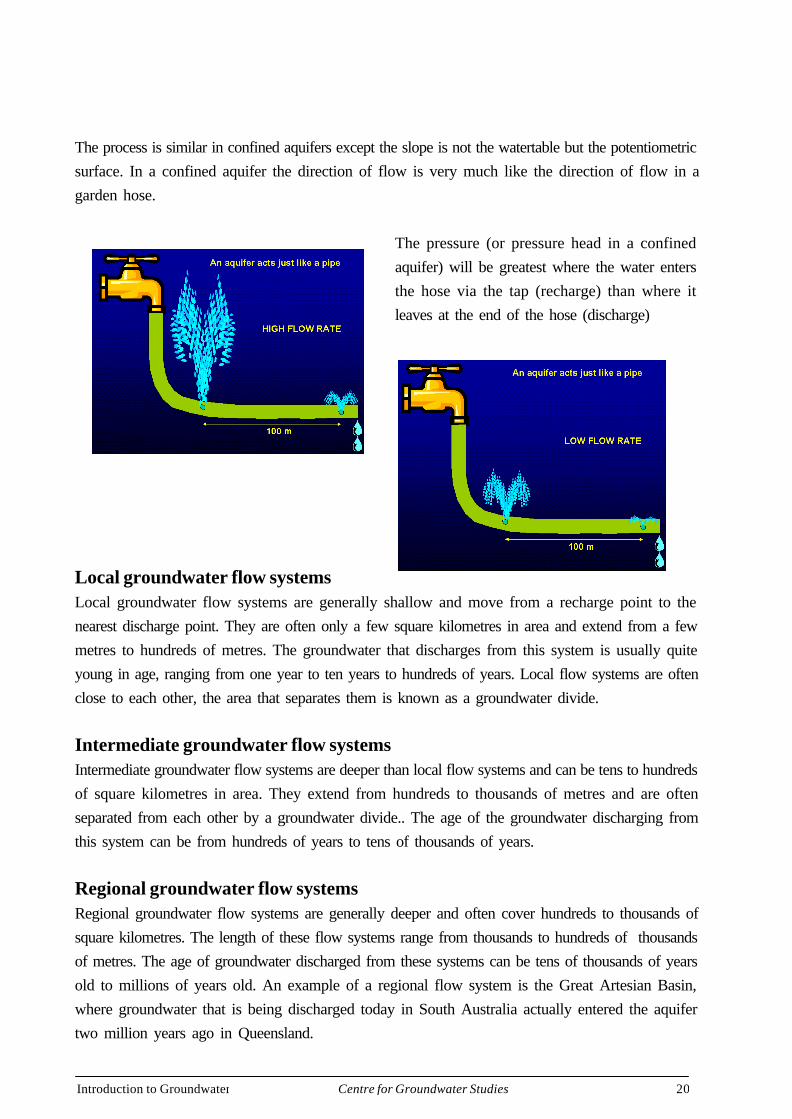
The process is similar in confined aquifers except the slope is not the watertable but the potentiometricsurface. In a confined aquifer the direction of flow is very much like the direction of flow in agarden hose.
The pressure (or pressure head in a confinedaquifer) will be greatest where the water entersthe hose via the tap (recharge) than where itleaves at the end of the hose (discharge)
Local groundwater flow systemsLocal groundwater flow systems are generally shallow and move from a recharge point to thenearest discharge point. They are often only a few square kilometres in area and extend from a fewmetres to hundreds of metres. The groundwater that discharges from this system is usually quiteyoung in age, ranging from one year to ten years to hundreds of years. Local flow systems are oftenclose to each other, the area that separates them is known as a groundwater divide.
Intermediate groundwater flow systemsIntermediate groundwater flow systems are deeper than local flow systems and can be tens to hundredsof square kilometres in area. They extend from hundreds to thousands of metres and are oftenseparated from each other by a groundwater divide.. The age of the groundwater discharging fromthis system can be from hundreds of years to tens of thousands of years.
Regional groundwater flow systemsRegional groundwater flow systems are generally deeper and often cover hundreds to thousands ofsquare kilometres. The length of these flow systems range from thousands to hundreds of thousandsof metres. The age of groundwater discharged from these systems can be tens of thousands of yearsold to millions of years old. An example of a regional flow system is the Great Artesian Basin,where groundwater that is being discharged today in South Australia actually entered the aquifertwo million years ago in Queensland.
Introduction to Groundwater 21Centre for Groundwater Studies
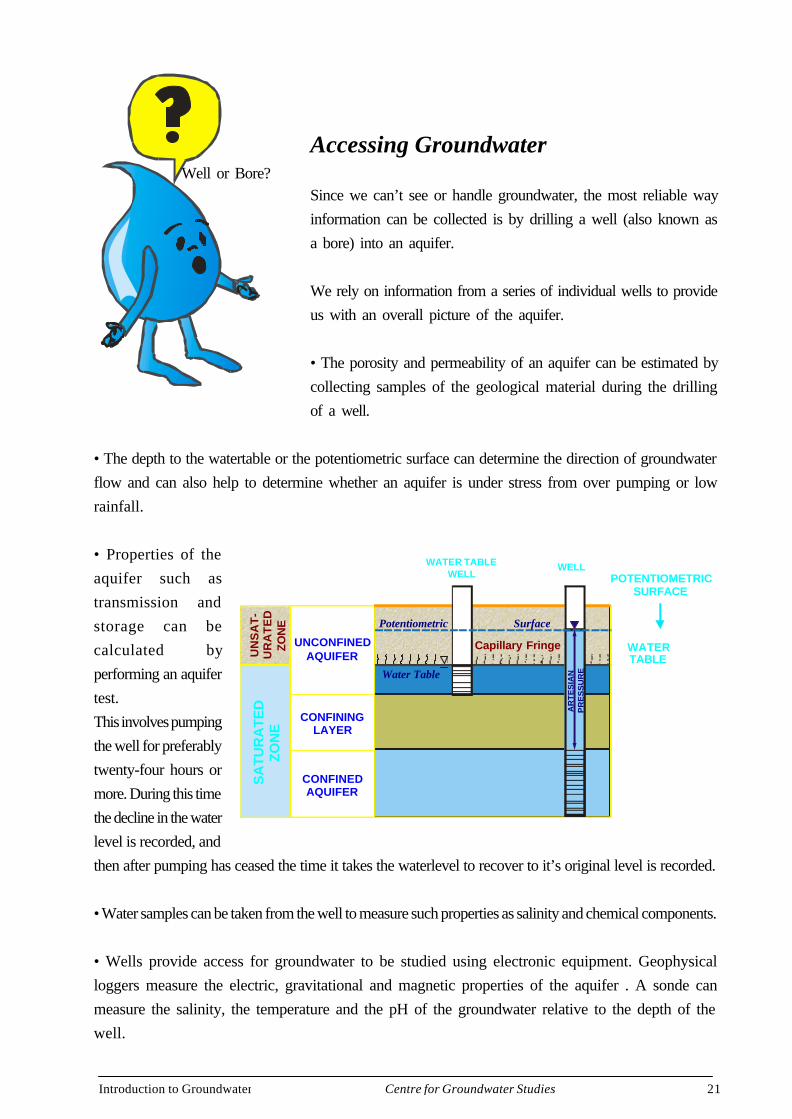
Accessing Groundwater
Since we can’t see or handle groundwater, the most reliable wayinformation can be collected is by drilling a well (also known asa bore) into an aquifer.
We rely on information from a series of individual wells to provideus with an overall picture of the aquifer.
• The porosity and permeability of an aquifer can be estimated bycollecting samples of the geological material during the drillingof a well.
• The depth to the watertable or the potentiometric surface can determine the direction of groundwaterflow and can also help to determine whether an aquifer is under stress from over pumping or lowrainfall.
• Properties of theaquifer such astransmission andstorage can becalculated byperforming an aquifertest.This involves pumpingthe well for preferablytwenty-four hours ormore. During this timethe decline in the waterlevel is recorded, andthen after pumping has ceased the time it takes the waterlevel to recover to it’s original level is recorded.
• Water samples can be taken from the well to measure such properties as salinity and chemical components.
• Wells provide access for groundwater to be studied using electronic equipment. Geophysicalloggers measure the electric, gravitational and magnetic properties of the aquifer . A sonde canmeasure the salinity, the temperature and the pH of the groundwater relative to the depth of thewell.
Well or Bore?
CONFININGLAYER
UNCONFINEDAQUIFER
CONFINEDAQUIFER
Water Table
SurfacePotentiometric
SA
TUR
ATE
DZO
NE
UN
SA
T-
UR
AT
ED
ZON
E
WATER TABLEWELL
WELLA
RT
ES
IAN
PR
ES
SU
RE
LAND SURFACE
Capillary Fringe WATERTABLE
POTENTIOMETRICSURFACE
Introduction to Groundwater 22Centre for Groundwater Studies
Drilling a Well
Position of wellThe position of a well must be considered carefully before drilling begins. Drilling rigs are oftenmounted on large vehicles so it is important to take into consideration whether the drilling rig canactually reach the site. Due to the height that the drilling rig extends, it is important that the site isat least five metres away from power lines. To avoid any possibility of contamination the well mustbe sited at least five metres away from septic tanks and wastewater treatment units, and at least fiftymetres from septic tank outfall or surface irrigation disposal of effluent. The position of telecomand electricity cables and water pipes should be checked.The new well should be positioned so thatsurface water drains away from it. It is also important that the proximity of existing wells beconsidered when siting a well. When a well is pumped, water levels surrounding the well are lowered.If the well is too close to an existing well, then the existing well may have it’s water level dramaticallyreduced. This process is known as interference.
Water Resources acts in several states require that all water wells deeperthan 2.5 metres be drilled by a licensed driller, except for the owner ofthe land who can drill up to 15 metres on his own property.
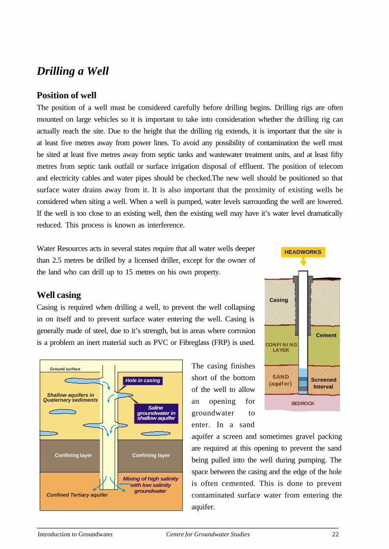
Well casingCasing is required when drilling a well, to prevent the well collapsingin on itself and to prevent surface water entering the well. Casing isgenerally made of steel, due to it’s strength, but in areas where corrosionis a problem an inert material such as PVC or Fibreglass (FRP) is used.
The casing finishesshort of the bottomof the well to allowan opening forgroundwater toenter. In a sandaquifer a screen and sometimes gravel packingare required at this opening to prevent the sandbeing pulled into the well during pumping. Thespace between the casing and the edge of the holeis often cemented. This is done to preventcontaminated surface water from entering theaquifer.
HEADWORKS
Casing
Cement
ScreenedInterval
SAND(aquifer)
CONFININGLAYER
BEDROCK
Confined Tertiary aquifer
Confining layer Confining layer
Ground surface
Shallow aquifers in Quaternary sediments
Mixing of high salinitywith low salinity
groundwater
Hole in casing
Salinegroundwater inshallow aquifer
Introduction to Groundwater 23Centre for Groundwater Studies
It protects the casing from corrosive water and soils. Where the well passes through multiple aquiferswith differing salinities cementing prevents mixing of the different quality groundwaters. It mayprotect the fresh water aquifer the well is sourcing from above saline aquifers by sealing them off.Headworks are often placed over the top of the aquifer to prevent material and small animals fromgetting into the well. In artesian wells headworks are used to prevent groundwater from flowing outof the well and being lost to waste when the well is not in use.
Perparing the well for useOnce a well is completed two processes need to be carried out before the bore can be used.
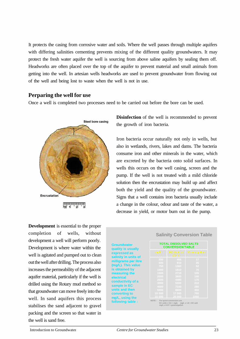
Disinfection of the well is recommended to preventthe growth of iron bacteria.
Iron bacteria occur naturally not only in wells, butalso in wetlands, rivers, lakes and dams. The bacteriaconsume iron and other minerals in the water, whichare excreted by the bacteria onto solid surfaces. Inwells this occurs on the well casing, screen and thepump. If the well is not treated with a mild chloridesolution then the encrustation may build up and affectboth the yield and the quality of the groundwater.Signs that a well contains iron bacteria usually includea change in the colour, odour and taste of the water, adecrease in yield, or motor burn out in the pump.
Development is essential to the propercompletion of wells, withoutdevelopment a well will perform poorly.Development is where water within thewell is agitated and pumped out to cleanout the well after drilling. The process alsoincreases the permeability of the adjacentaquifer material, particularly if the well isdrilled using the Rotary mud method sothat groundwater can move freely into thewell. In sand aquifers this processstabilises the sand adjacent to gravelpacking and the screen so that water inthe well is sand free.
Salinity Conversion Table
Groundwaterquality is usuallyexpressed assalinity in units ofmilligrams per litre(mg/L). This valueis obtained bymeasuring theelectricalconductivity of asample in ECunits and thenconverting tomg/L, using thefollowing table :
TOTAL DISSOLVED SALTSCONVERSION TABLE
mg/L EC Units at25° C
Grains/gallon
250500750
1000150020002500300040005000
10 00015 000
455910
13601810271036004480530071008800
17 00025 000
17355270
105140175210280350700
1050NOTE : For quick conversion use
EC units x 0.6 = mg/L mg/L x 1.8 = EC unitmg/L x 0.07 = grains/gallon

Introduction to Groundwater 24Centre for Groundwater Studies
Of course the well may only be of use if the salinity is in the range for the intended use of the bore.Groundwater quality is usually expressed as salinity in units of milligrams per litre (mg/L), whichis known as the total dissolved solids (TDS).
This value is obtained bymeasuring the electricalconductivity of a sample in ECunits and then converting to mg/L, using the provided table. Thedominant ions (or salts) found ingroundwater are sodium andchloride, it is the combination ofthese two ions that causes waterto taste salty. When present inlarge quantities, sodium andchloride cause groundwater tobecome corrosive. Corrosivegroundwater may damageinfrastructure. Other importantions are calcium, magnesium, iron, fluoride and manganese. A high level of calcium and magnesiumcarbonates results in hardness that makes soap difficult to lather and leaves scaly deposits to form
in water heaters and pipes.
A high level of iron andmanganese in groundwater cancause discolouration of thewater and staining of anythingthat the water comes intocontact with. Sulphates causegroundwater to have a bittertaste and may have a laxativeeffect if drunk. It is importantwhen using groundwater to testfor the full chemicalcomposition, especially if thewater is for humanconsumption.
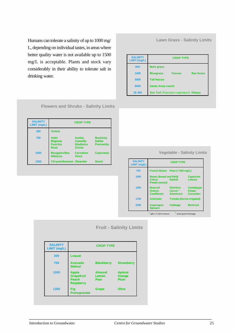
Crop and Pasture - Salinity Limits
SALINITYLIMIT (mg/L)
CROP TYPE
850 Field peas and beans
1000 Broad beans
1200 Clover * Groundnut Rice (paddy)
2000 Berseem clover * Corn (forage)* LucerneMillet Soy bean SafflowerSudax
2800 Phaalaria * Sorgham Sunflower *
3200 Fescue * Perennial rye grass *Sudan grass *
3700 Barley Cotton Sugar beet
* Relative yields for salinity figures is approximately 75%
Livestock
• Stock vary considerably in their ability totolerate salt in drinking water.
Enterprise Max. Forhealthy growth
(mg/L)
Max to maintaincondition (mg/L)
Maximumtolerated
(mg/L)
PoultryPigsHorsesDairy cattleBeef cattleSheep
200020004000300040006000
30003000600040005000
13 000
3500400070006000
10 000*
* Depends on type of feed available (e.g. Green feed, dry feed or saltbush)
Introduction to Groundwater 25Centre for Groundwater Studies
Humans can tolerate a salinity of up to 1000 mg/L, depending on individual tastes, in areas wherebetter quality water is not available up to 1500mg/L is acceptable. Plants and stock varyconsiderably in their ability to tolerate salt indrinking water.
SALINITYLIMIT (mg/L)
CROP TYPE
300 Violets
700 Aster Azelea BauhiniaBegonia Camellia DahliaFuschia Gladiolus PoinsettiaRose Zinnia
1000 Bougainvillea Carnation CoprosmaHibiscus Vinca
1350 Chrysanthemum Oleander Stock
Flowers and Shrubs - Salinity Limits
Fruit - Salinity Limits
SALINITYLIMIT (mg/L)
CROP TYPE
300 Loquat
700 Avocado Blackberry StrawberryWalnut
1000 Apple Almond ApricotGrapefruit Lemon OrangePeach Pear PlumRaspberry
1350 Fig Grape OlivePomegranate
SALINITYLIMIT (mg/L)
CROP TYPE
700 French Beans Peas (< 500 mg/L)
1000 Beans (broad and field) CapsicumCelery Radish LettucePotato (sweet)
1350 Broccoli Gherkins CantaloupeOnions Carrot * Potato
†
Cauliflower Sweetcorn Cucumber
1750 Artichoke Tomato (furrow irrigated)
2100 Asparagus Cabbage BeetrootSpinach
Vegetable - Salinity Limits
* after 3-4 fern leaves † need good drainage
SALINITYLIMIT (mg/L)
CROP TYPE
800 Bent grass
1200 Bluegrass Fescue Rye Grass
3000 Tall fescue
5000 Santa Anna couch
25 000 Sun Turf (Papsalum vaginatum) Kikuyu
Lawn Grass - Salinity Limits
Introduction to Groundwater 26Centre for Groundwater Studies
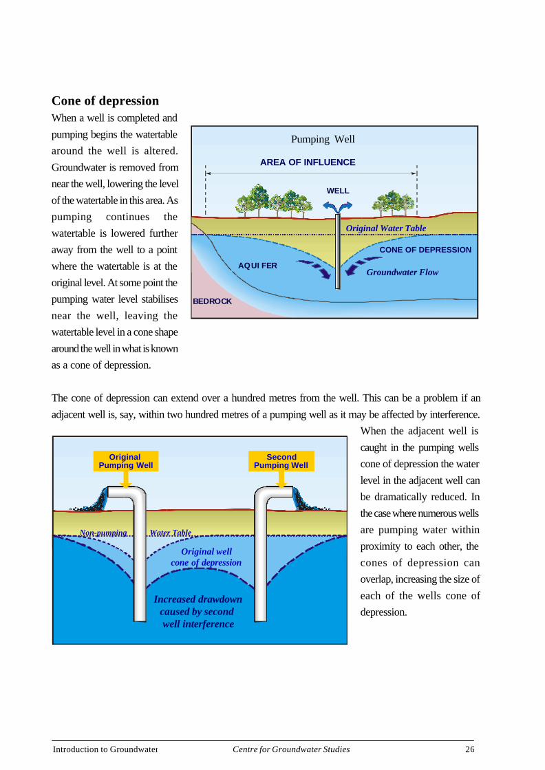
Cone of depressionWhen a well is completed andpumping begins the watertablearound the well is altered.Groundwater is removed fromnear the well, lowering the levelof the watertable in this area. Aspumping continues thewatertable is lowered furtheraway from the well to a pointwhere the watertable is at theoriginal level. At some point thepumping water level stabilisesnear the well, leaving thewatertable level in a cone shapearound the well in what is knownas a cone of depression.
The cone of depression can extend over a hundred metres from the well. This can be a problem if anadjacent well is, say, within two hundred metres of a pumping well as it may be affected by interference.
When the adjacent well iscaught in the pumping wellscone of depression the waterlevel in the adjacent well canbe dramatically reduced. Inthe case where numerous wellsare pumping water withinproximity to each other, thecones of depression canoverlap, increasing the size ofeach of the wells cone ofdepression.
AREA OF INFLUENCE
BEDROCK
Groundwater Flow
WELL
AQUIFER
Original Water Table
CONE OF DEPRESSION
Pumping Well
Second Pumping Well
Original Pumping Well
Non-pumping Water Table
Original wellcone of depression
Increased drawdowncaused by second well interference
Introduction to Groundwater 27Centre for Groundwater Studies
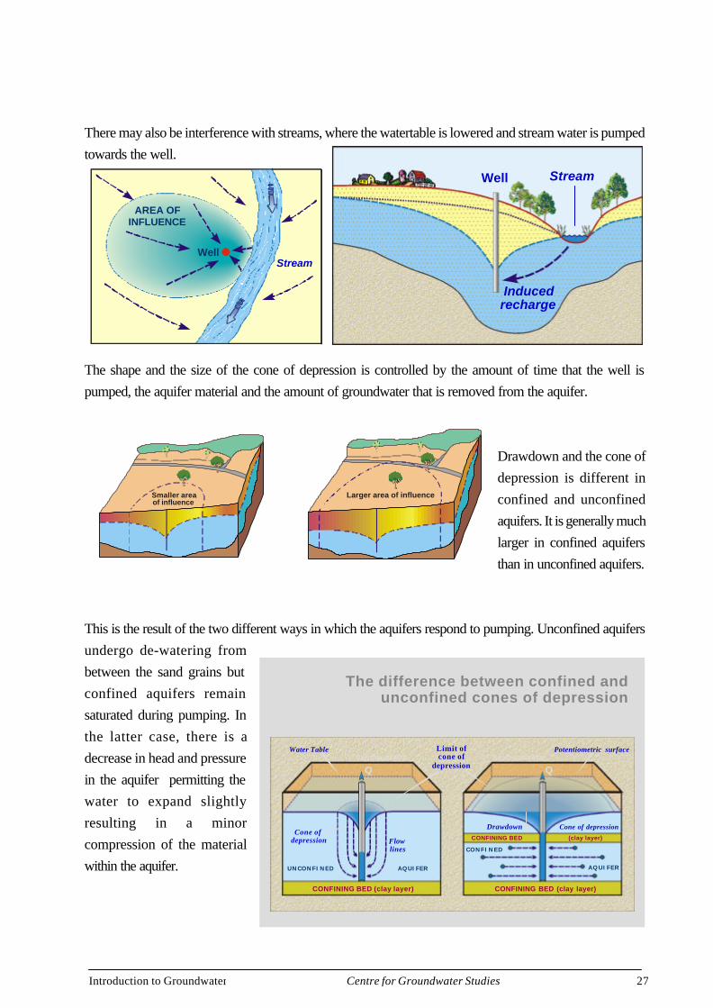
There may also be interference with streams, where the watertable is lowered and stream water is pumpedtowards the well.
The shape and the size of the cone of depression is controlled by the amount of time that the well ispumped, the aquifer material and the amount of groundwater that is removed from the aquifer.
Drawdown and the cone ofdepression is different inconfined and unconfinedaquifers. It is generally muchlarger in confined aquifersthan in unconfined aquifers.
This is the result of the two different ways in which the aquifers respond to pumping. Unconfined aquifersundergo de-watering frombetween the sand grains butconfined aquifers remainsaturated during pumping. Inthe latter case, there is adecrease in head and pressurein the aquifer permitting thewater to expand slightlyresulting in a minorcompression of the materialwithin the aquifer.
Smaller areaof influence
Larger area of influence
AREA OFINFLUENCE
WellStream
Stream
Inducedrecharge
Well
The difference between confined andunconfined cones of depression
Cone of depression Flow
lines
Limit ofcone of
depression
Water Table Potentiometric surface
CONFINING BED (clay layer)CONFINING BED (clay layer)
CONFINING BED (clay layer)
UNCONFINED AQUIFER
CONFINED
AQUIFER
LAND SURFACE LAND SURFACE
Cone of depressionDrawdown
Introduction to Groundwater 28Centre for Groundwater Studies
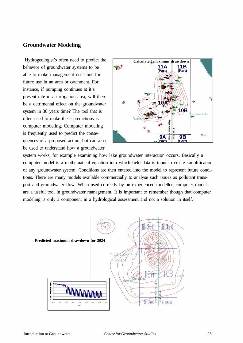
Groundwater Modeling
Hydrogeologist’s often need to predict thebehavior of groundwater systems to beable to make management decisions forfuture use in an area or catchment. Forinstance, if pumping continues at it’spresent rate in an irrigation area, will therebe a detrimental effect on the groundwatersystem in 30 years time? The tool that isoften used to make these predictions iscomputer modeling. Computer modelingis frequently used to predict the conse-quences of a proposed action, but can alsobe used to understand how a groundwatersystem works, for example examining how lake groundwater interaction occurs. Basically acomputer model is a mathematical equation into which field data is input to create simplificationof any groundwater system. Conditions are then entered into the model to represent future condi-tions. There are many models available commercially to analyse such issues as pollutant trans-port and groundwater flow. When used correctly by an experienced modeller, computer modelsare a useful tool in groundwater management. It is important to remember though that computermodeling is only a component in a hydrological assessment and not a solution in itself.
11A 11B
10A10B
9A(Part)
9B(Part)
(Part) (Part)
Calculated maximun drawdown
5
1 0
1 5
20
25
30
35
Jan-88 Jan-93 Jan-98 Jan-03 Jan-08 Jan-13 Jan-18 Jan-23 Jan-28
Year
Predicted maximum drawdown for 2024
Introduction to Groundwater 29Centre for Groundwater Studies
MANAGING GROUNDWATER:
Groundwater is a natural resource
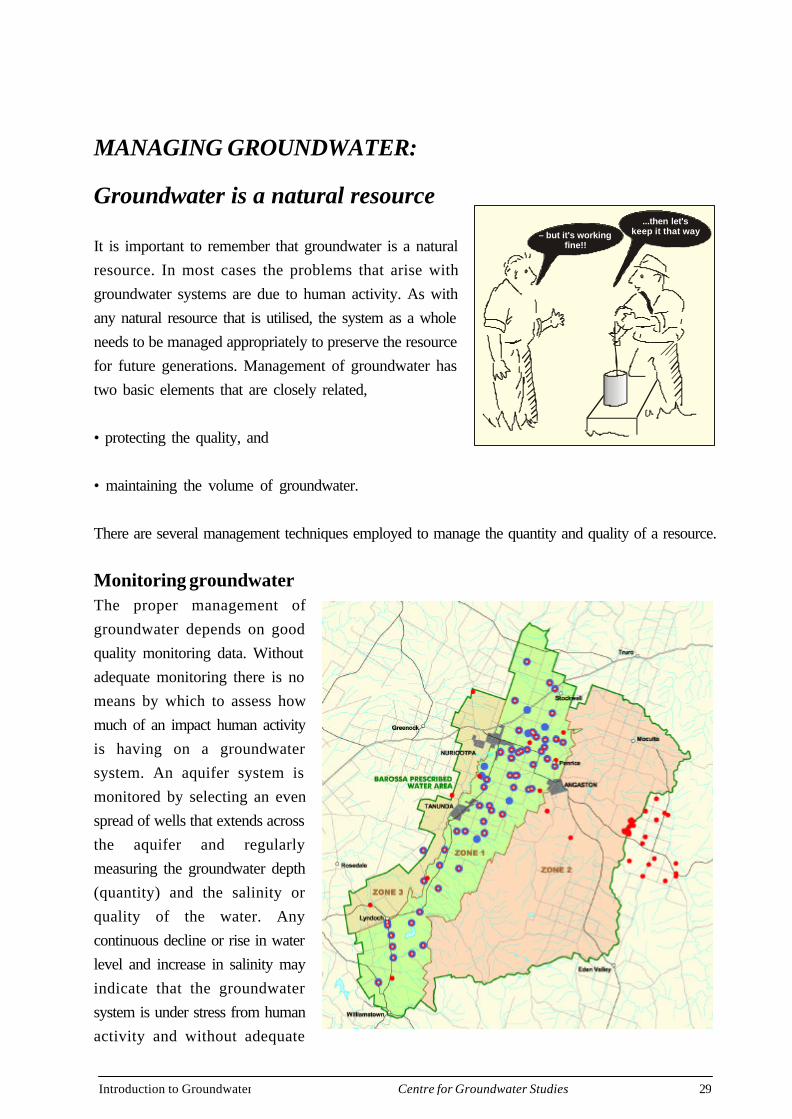
It is important to remember that groundwater is a naturalresource. In most cases the problems that arise withgroundwater systems are due to human activity. As withany natural resource that is utilised, the system as a wholeneeds to be managed appropriately to preserve the resourcefor future generations. Management of groundwater hastwo basic elements that are closely related,
• protecting the quality, and
• maintaining the volume of groundwater.
There are several management techniques employed to manage the quantity and quality of a resource.
Monitoring groundwaterThe proper management ofgroundwater depends on goodquality monitoring data. Withoutadequate monitoring there is nomeans by which to assess howmuch of an impact human activityis having on a groundwatersystem. An aquifer system ismonitored by selecting an evenspread of wells that extends acrossthe aquifer and regularlymeasuring the groundwater depth(quantity) and the salinity orquality of the water. Anycontinuous decline or rise in waterlevel and increase in salinity mayindicate that the groundwatersystem is under stress from humanactivity and without adequate
– but it's workingfine!!
...then let'skeep it that way
Introduction to Groundwater 30Centre for Groundwater Studies
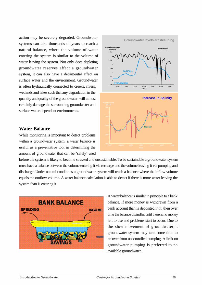
action may be severely degraded. Groundwatersystems can take thousands of years to reach anatural balance, where the volume of waterentering the system is similar to the volume ofwater leaving the system. Not only does depletinggroundwater reserves affect a groundwatersystem, it can also have a detrimental affect onsurface water and the environment. Groundwateris often hydraulically connected to creeks, rivers,wetlands and lakes such that any degradation in thequantity and quality of the groundwater will almostcertainly damage the surrounding groundwater andsurface water dependent environments.
Water BalanceWhile monitoring is important to detect problemswithin a groundwater system, a water balance isuseful as a preventative tool in determining theamount of groundwater that can be ‘safely’ usedbefore the system is likely to become stressed and unsustainable. To be sustainable a groundwater systemmust have a balance between the volume entering it via recharge and the volume leaving it via pumping anddischarge. Under natural conditions a groundwater system will reach a balance where the inflow volumeequals the outflow volume. A water balance calculation is able to detect if there is more water leaving thesystem than is entering it.
A water balance is similar in principle to a bankbalance. If more money is withdrawn from abank account than is deposited in it, then overtime the balance dwindles until there is no moneyleft to use and problems start to occur. Due tothe slow movement of groundwater, agroundwater system may take some time torecover from uncontrolled pumping. A limit ongroundwater pumping is preferred to noavailable groundwater.
Groundwater levels are declining
204
200
196
192
1881988 1990 1992 1994
Year
Elevation of waterlevel (m)
1996 1998 2000
RAINFALL
PUMPING
HYDROGRAPH
Increase in Salinity
2000
1900
1800
1700
16001987 198989 1991 1993 1995 1997 1999
Year
Conductivity(ECU)
Rainfall
Introduction to Groundwater 31Centre for Groundwater Studies
Control of Human ActivityIf it can be shown that there is a rapid increase in the number of new wells being drilled in and/or there isstress within the aquifers, then a moritorium can be placed on the basin or fractured rock aquifer. Amoritorium is a period of time in which no additional water can be pumped in order for hydrogeologistsand hydrologists to determine whether the area needs to be prescribed or not. In a prescribed area all newirrigation wells are licensed and a license is only issued if certain conditions are met. Such as;
• that a well can not be drilled within a certain distance of an existing well, unless an aquifer testproves that pumping from the well will not interfere with the existing well.
• Or that no new licenses are to be issued in a certain area and only the transfer of a license canoccur. Monitoring still plays an important role in a prescribed area as it may highlight areas ofstress where useage needs to be reduced for the aquifer to survive.
Issues with Groundwater Quality and Quantity
A sedimentary basin or fractured rock aquifer are not only susceptible to poor salinity and lowgroundwater levels, aquifers are also at risk from such processes as pollution, dryland salinity andsalt water intrusion. Any impacts in the groundwater section of the hydrological cycle will have animpact on other parts of the cycle.
Human development and activity has increased the number of contaminants that can enter an aquiferduring recharge. A contaminant is considered to be any substance that degrades the water quality sothat it can no longer be used by plants animals and humans (Waters and Rivers Commission).
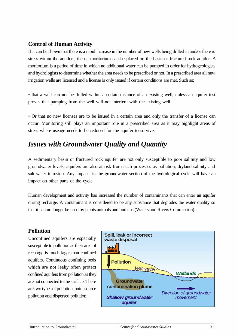
PollutionUnconfined aquifers are especiallysusceptible to pollution as their area ofrecharge is much lager than confinedaquifers. Continuous confining bedswhich are not leaky often protectconfined aquifers from pollution as theyare not connected to the surface. Thereare two types of pollution, point sourcepollution and dispersed pollution.
PollutionWatertable
Direction of groundwatermovement
Groundwatercontamination plume
Wetlands
Shallow groundwateraquifer
Spill, leak or incorrectwaste disposal
Introduction to Groundwater 32Centre for Groundwater Studies
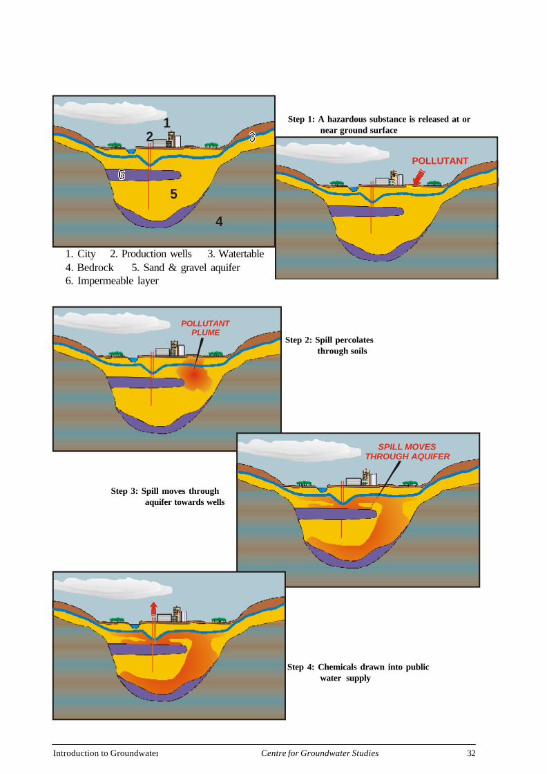
1. City2. Production wells3. Watertable
4. Bedrock5. Sand and gravel aquifer6. Impermeable layer
12
4
5
1. City 2. Production wells 3. Watertable4. Bedrock 5. Sand & gravel aquifer6. Impermeable layer
POLLUTANT
POLLUTANTPLUME
SPILL MOVESTHROUGH AQUIFER
Step 1: A hazardous substance is released at or near ground surface
Step 2: Spill percolates through soils
Step 3: Spill moves through aquifer towards wells
Step 4: Chemicals drawn into public water supply
Introduction to Groundwater 33Centre for Groundwater Studies
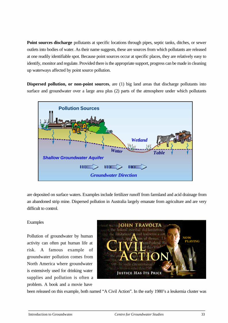
Point sources discharge pollutants at specific locations through pipes, septic tanks, ditches, or seweroutlets into bodies of water. As their name suggests, these are sources from which pollutants are releasedat one readily identifiable spot. Because point sources occur at specific places, they are relatively easy toidentify, monitor and regulate. Provided there is the appropriate support, progress can be made in cleaningup waterways affected by point source pollution.
Dispersed pollution, or non-point sources, are (1) big land areas that discharge pollutants intosurface and groundwater over a large area plus (2) parts of the atmosphere under which pollutants
are deposited on surface waters. Examples include fertilizer runoff from farmland and acid drainage froman abandoned strip mine. Dispersed pollution in Australia largely emanate from agriculture and are verydifficult to control.
Examples
Pollution of groundwater by humanactivity can often put human life atrisk. A famous example ofgroundwater pollution comes fromNorth America where groundwateris extensively used for drinking watersupplies and pollution is often aproblem. A book and a movie havebeen released on this example, both named “A Civil Action”. In the early 1980’s a leukemia cluster was
Shallow Groundwater Aquifer
Wetland
Pollution Sources
Groundwater Direction
TableWater
Introduction to Groundwater 34Centre for Groundwater Studies
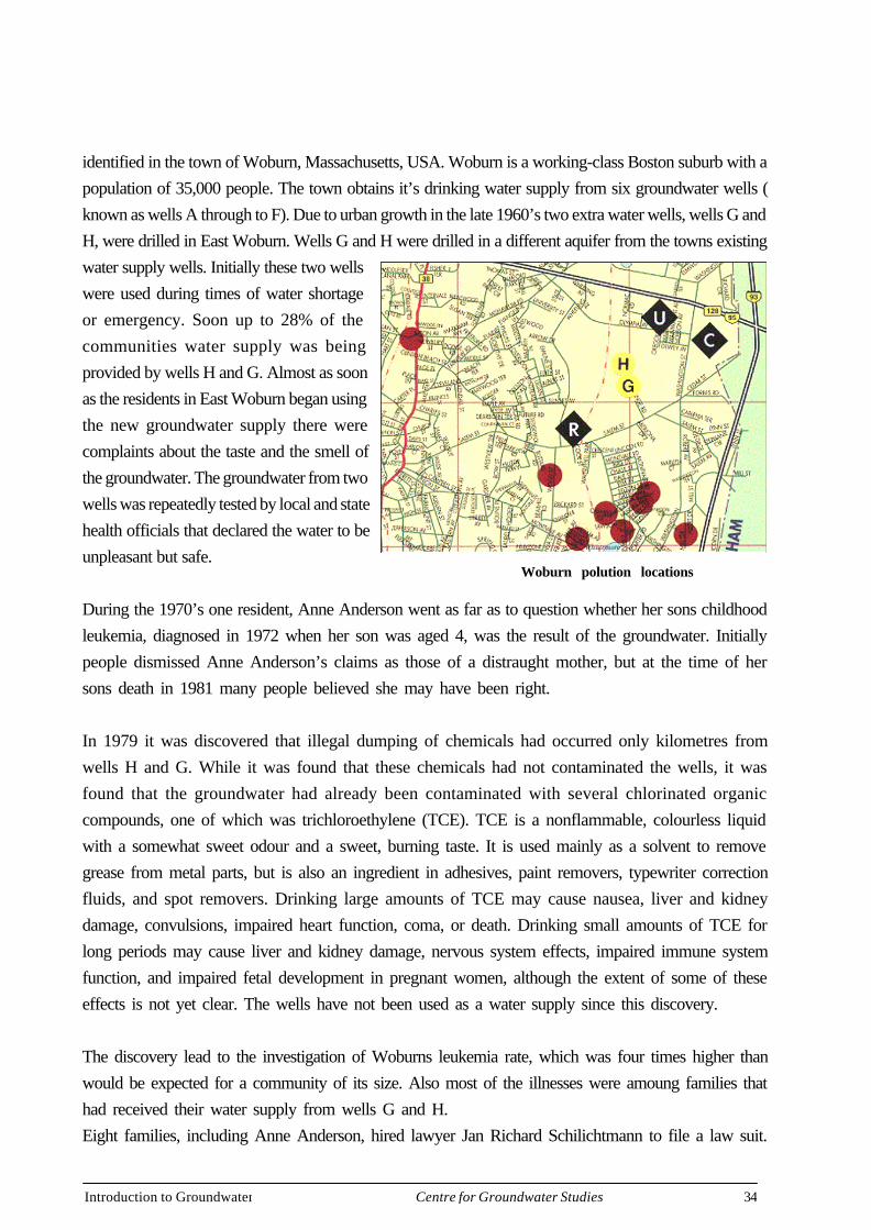
identified in the town of Woburn, Massachusetts, USA. Woburn is a working-class Boston suburb with apopulation of 35,000 people. The town obtains it’s drinking water supply from six groundwater wells (known as wells A through to F). Due to urban growth in the late 1960’s two extra water wells, wells G andH, were drilled in East Woburn. Wells G and H were drilled in a different aquifer from the towns existingwater supply wells. Initially these two wellswere used during times of water shortageor emergency. Soon up to 28% of thecommunities water supply was beingprovided by wells H and G. Almost as soonas the residents in East Woburn began usingthe new groundwater supply there werecomplaints about the taste and the smell ofthe groundwater. The groundwater from twowells was repeatedly tested by local and statehealth officials that declared the water to beunpleasant but safe.
During the 1970’s one resident, Anne Anderson went as far as to question whether her sons childhoodleukemia, diagnosed in 1972 when her son was aged 4, was the result of the groundwater. Initiallypeople dismissed Anne Anderson’s claims as those of a distraught mother, but at the time of hersons death in 1981 many people believed she may have been right.
In 1979 it was discovered that illegal dumping of chemicals had occurred only kilometres fromwells H and G. While it was found that these chemicals had not contaminated the wells, it wasfound that the groundwater had already been contaminated with several chlorinated organiccompounds, one of which was trichloroethylene (TCE). TCE is a nonflammable, colourless liquidwith a somewhat sweet odour and a sweet, burning taste. It is used mainly as a solvent to removegrease from metal parts, but is also an ingredient in adhesives, paint removers, typewriter correctionfluids, and spot removers. Drinking large amounts of TCE may cause nausea, liver and kidneydamage, convulsions, impaired heart function, coma, or death. Drinking small amounts of TCE forlong periods may cause liver and kidney damage, nervous system effects, impaired immune systemfunction, and impaired fetal development in pregnant women, although the extent of some of theseeffects is not yet clear. The wells have not been used as a water supply since this discovery.
The discovery lead to the investigation of Woburns leukemia rate, which was four times higher thanwould be expected for a community of its size. Also most of the illnesses were amoung families thathad received their water supply from wells G and H.Eight families, including Anne Anderson, hired lawyer Jan Richard Schilichtmann to file a law suit.
Woburn polution locations
Introduction to Groundwater 35Centre for Groundwater Studies
Three companies were suspected of contaminating the groundwater,
• W.R. Grace and company, that owned a manufacturing plant located 732 metres northeast of thewells. The company manufactured equipment for the food packing industry and used solvents toclean and cool tools, cut grease, and dilute paint.
• Beatrice Foods Company which had owned a tannery 213 metres from the wells. It was allegedthat the company had dumped chemicals on adjacent land which it had owned.
• UniFirst Corporation, that operated an industrial dry-cleaning business 610 metres north of thewells. The company used solvents as part of it’s business and these solvents were found on theproperty in large quantities in the soil and the groundwater.
W.R. Grace and company settled out of court in the late 1980’s for $US 8 million dollars withoutadmitting responsibility. Beatrice Foods Company won their court battle. UniFirst settled prior totrial in 1985 for $US 1.05 million without admitting responsibility. The US Environmental ProtectionAgency clean up is still continuing.
A place in Australia where groundwater is used extensively for drinking water in an Urbanenvironment, is Perth. Approximately 70% of Perth’s water comes from the unconfined aquifersin the Perth Basin. The watertable here is shallow (close to the surface) and the soils have a highpermeability, which would allow a potential contaminants to move very quickly over the shortdistance to the watertable (Nelson et al, 1999). According to researchers (Hirschberg, 1991) thereare potentially 1200 sources of groundwater point source and dispersed contamination in thePerth Basin with approximately 700 of these sources in the Perth metropolitan area. The WesternAustralian Waters and Rivers Commission has recently, with National Heritage funding, set up aseries of procedures and a database which is designed to provide further strategic assessment ofcontamination issues in the Perth Basin (Nelson et al, 1999). This is a good example of howgroundwater in a high risk area can be appropriately managed.
Groundwater is the gallery of 18 million graffiti artists, most of whom are unaware that their idledoodling, will be judged by future critics. The soil above aquifers is for their own protection, but soil hasa limited capacity to attenuate contaminants. It is very important to remember that it is not only industry,mining and agricultural activity that can unintentionally pollute groundwater, but also the way we disposeof products in our own yards. For example, emptying car oil on our lawns has the potential tocontaminate the underlying groundwater. We can all contribute to keeping groundwater clean byassessing our own waste disposal practises.
Introduction to Groundwater 36Centre for Groundwater Studies
Salinisation
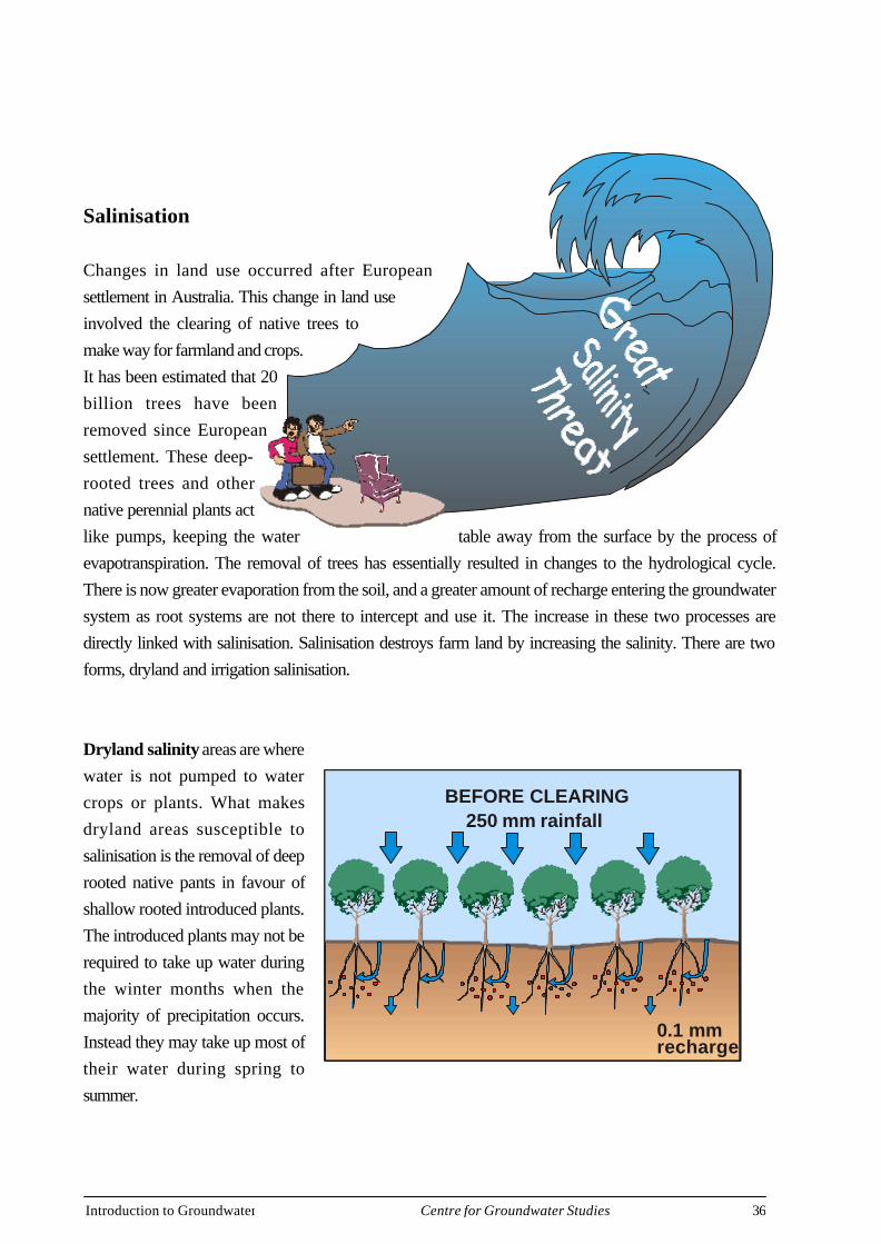
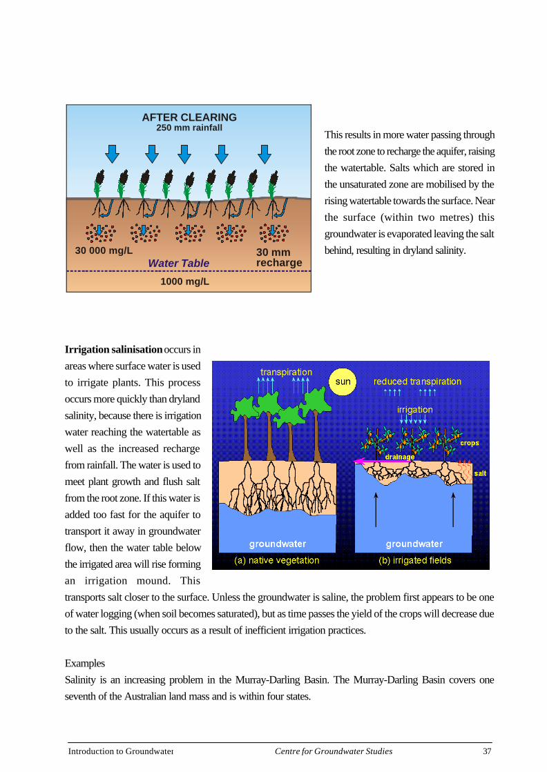
Changes in land use occurred after Europeansettlement in Australia. This change in land useinvolved the clearing of native trees tomake way for farmland and crops.It has been estimated that 20billion trees have beenremoved since Europeansettlement. These deep-rooted trees and othernative perennial plants actlike pumps, keeping the water table away from the surface by the process ofevapotranspiration. The removal of trees has essentially resulted in changes to the hydrological cycle.There is now greater evaporation from the soil, and a greater amount of recharge entering the groundwatersystem as root systems are not there to intercept and use it. The increase in these two processes aredirectly linked with salinisation. Salinisation destroys farm land by increasing the salinity. There are twoforms, dryland and irrigation salinisation.
Dryland salinity areas are wherewater is not pumped to watercrops or plants. What makesdryland areas susceptible tosalinisation is the removal of deeprooted native pants in favour ofshallow rooted introduced plants.The introduced plants may not berequired to take up water duringthe winter months when themajority of precipitation occurs.Instead they may take up most oftheir water during spring tosummer.
BEFORE CLEARING250 mm rainfall
0.1 mmrecharge
Introduction to Groundwater 37Centre for Groundwater Studies
This results in more water passing throughthe root zone to recharge the aquifer, raisingthe watertable. Salts which are stored inthe unsaturated zone are mobilised by therising watertable towards the surface. Nearthe surface (within two metres) thisgroundwater is evaporated leaving the saltbehind, resulting in dryland salinity.
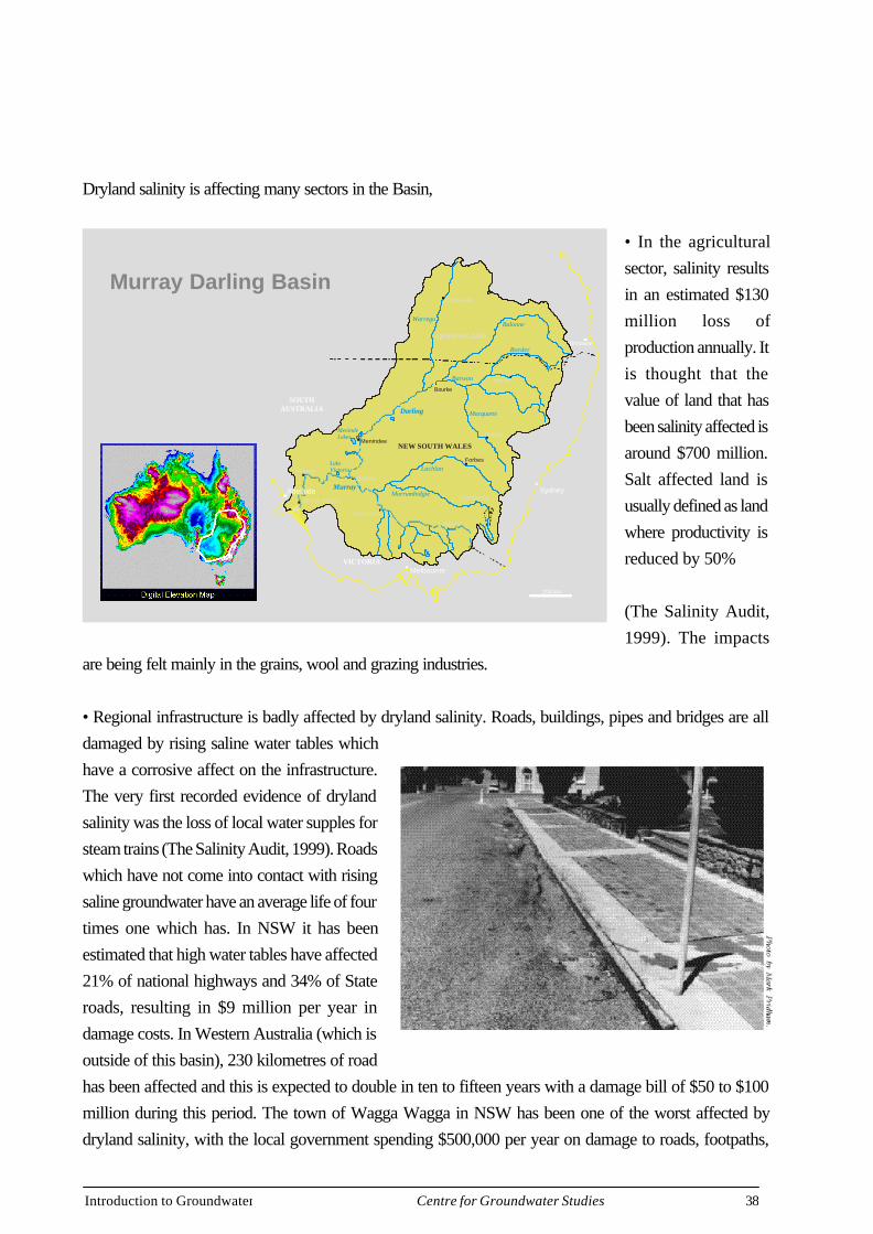
Irrigation salinisation occurs inareas where surface water is usedto irrigate plants. This processoccurs more quickly than drylandsalinity, because there is irrigationwater reaching the watertable aswell as the increased rechargefrom rainfall. The water is used tomeet plant growth and flush saltfrom the root zone. If this water isadded too fast for the aquifer totransport it away in groundwaterflow, then the water table belowthe irrigated area will rise formingan irrigation mound. Thistransports salt closer to the surface. Unless the groundwater is saline, the problem first appears to be oneof water logging (when soil becomes saturated), but as time passes the yield of the crops will decrease dueto the salt. This usually occurs as a result of inefficient irrigation practices.
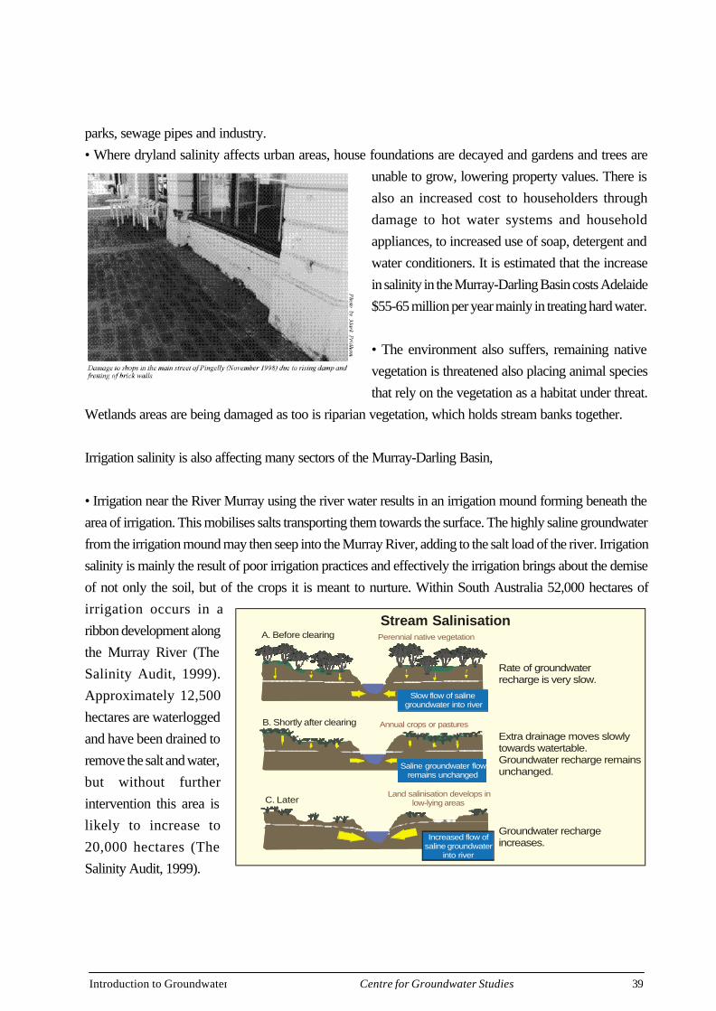
ExamplesSalinity is an increasing problem in the Murray-Darling Basin. The Murray-Darling Basin covers oneseventh of the Australian land mass and is within four states.
AFTER CLEARING250 mm rainfall
30 mmrecharge
30 000 mg/L
1000 mg/L
Water Table
Introduction to Groundwater 38Centre for Groundwater Studies
Dryland salinity is affecting many sectors in the Basin,
• In the agriculturalsector, salinity resultsin an estimated $130million loss ofproduction annually. Itis thought that thevalue of land that hasbeen salinity affected isaround $700 million.Salt affected land isusually defined as landwhere productivity isreduced by 50%
(The Salinity Audit,1999). The impacts
are being felt mainly in the grains, wool and grazing industries.
• Regional infrastructure is badly affected by dryland salinity. Roads, buildings, pipes and bridges are alldamaged by rising saline water tables whichhave a corrosive affect on the infrastructure.The very first recorded evidence of drylandsalinity was the loss of local water supples forsteam trains (The Salinity Audit, 1999). Roadswhich have not come into contact with risingsaline groundwater have an average life of fourtimes one which has. In NSW it has beenestimated that high water tables have affected21% of national highways and 34% of Stateroads, resulting in $9 million per year indamage costs. In Western Australia (which isoutside of this basin), 230 kilometres of roadhas been affected and this is expected to double in ten to fifteen years with a damage bill of $50 to $100million during this period. The town of Wagga Wagga in NSW has been one of the worst affected bydryland salinity, with the local government spending $500,000 per year on damage to roads, footpaths,
Murray Darling Basin
Sydney
Brisbane
NEW SOUTH WALES
QUEENSLAND
VICTORIA
SOUTHAUSTRALIA
Melbourne
Swan Hill
MilduraMorgan
Menindee
MenindeLakes
LakeVictoria
Albury
Forbes
Dubbo
Moree
Charleville
Bourke
MurrayMurrumbidgie
Lachlan
Darling Macquarie
Border
Balonne
Barwon
Warrego
Adelaide
200 km
Murray Bridge Canberra
Introduction to Groundwater 39Centre for Groundwater Studies
parks, sewage pipes and industry.• Where dryland salinity affects urban areas, house foundations are decayed and gardens and trees are
unable to grow, lowering property values. There isalso an increased cost to householders throughdamage to hot water systems and householdappliances, to increased use of soap, detergent andwater conditioners. It is estimated that the increasein salinity in the Murray-Darling Basin costs Adelaide$55-65 million per year mainly in treating hard water.
• The environment also suffers, remaining nativevegetation is threatened also placing animal speciesthat rely on the vegetation as a habitat under threat.
Wetlands areas are being damaged as too is riparian vegetation, which holds stream banks together.
Irrigation salinity is also affecting many sectors of the Murray-Darling Basin,
• Irrigation near the River Murray using the river water results in an irrigation mound forming beneath thearea of irrigation. This mobilises salts transporting them towards the surface. The highly saline groundwaterfrom the irrigation mound may then seep into the Murray River, adding to the salt load of the river. Irrigationsalinity is mainly the result of poor irrigation practices and effectively the irrigation brings about the demiseof not only the soil, but of the crops it is meant to nurture. Within South Australia 52,000 hectares ofirrigation occurs in aribbon development alongthe Murray River (TheSalinity Audit, 1999).Approximately 12,500hectares are waterloggedand have been drained toremove the salt and water,but without furtherintervention this area islikely to increase to20,000 hectares (TheSalinity Audit, 1999).
B. Shortly after clearing
Groundwater rechargeincreases.
A. Before clearing
C. Later
Extra drainage moves slowlytowards watertable.Groundwater recharge remains unchanged.
Rate of groundwaterrecharge is very slow.
Increased flow ofsaline groundwater
into river
Perennial native vegetation
Annual crops or pastures
Land salinisation develops inlow-lying areas
Saline groundwater flowremains unchanged
Slow flow of salinegroundwater into river
Stream Salinisation
Introduction to Groundwater 40Centre for Groundwater Studies
What can we do?In terms of dryland salinity the keyis to focus on the cause, which isthe hydrologic imbalance and notthe symptoms. This is proving tobe difficult even in developedcountries with short-termsocioeconomic and political considerationsproviding a constraint. Some farmers arehelping to repair the hydrologic imbalanceby setting aside some of their land for treefarming. An example is of a farmer inVictoria who has leased his land for 20years at $170 hectare per year to acompany which is growing Tasmanian bluegums. The company provided, planted andmaintains the trees and will harvest the treestwice in the next two decades, using theshort sturdy fibres for it’s high grade paper(The Bulletin). Companies in the Northern Hemisphere gain carbon credits for growing plantations inAustralia. A recent example is the Tokyo Electric power company, who made a $120 million deal withNSW State Forests to plant thousands of hectares to be grown for carbon credits (The Bulletin). In someareas though there is no other alternative than to live with the salt. In terms of irrigation salinity, efficientirrigation practices need to be adopted.
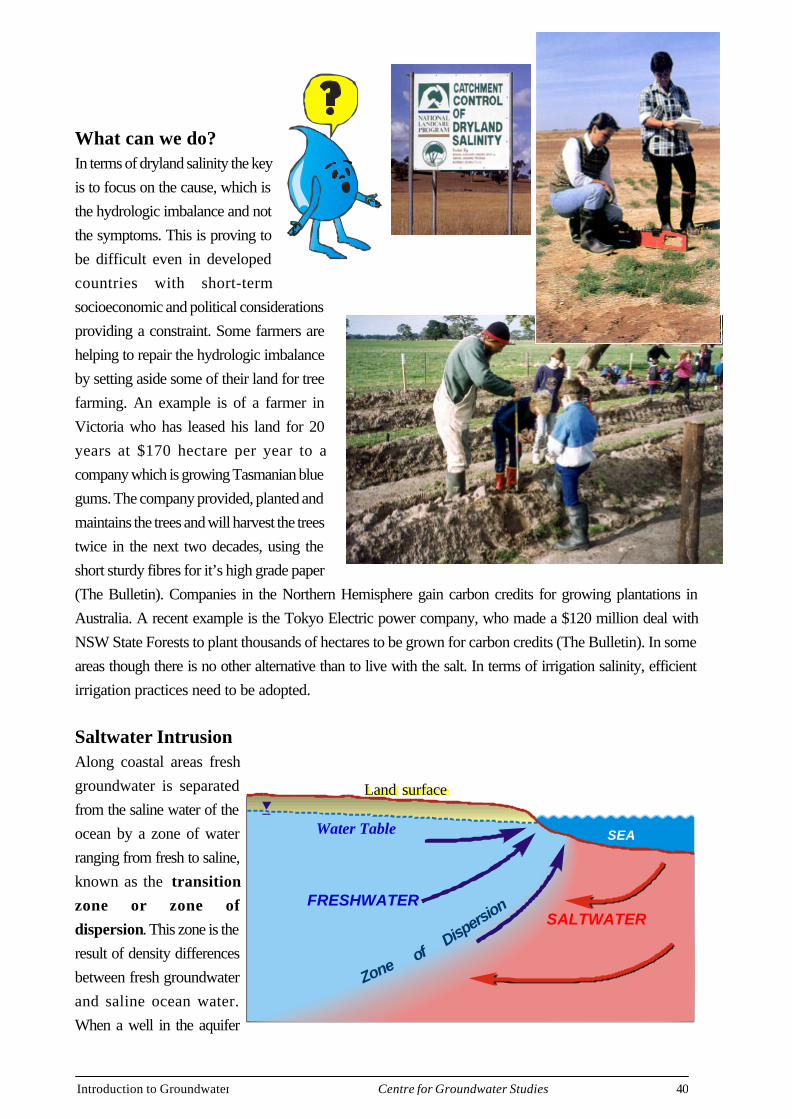
Saltwater IntrusionAlong coastal areas freshgroundwater is separatedfrom the saline water of theocean by a zone of waterranging from fresh to saline,known as the transitionzone or zone ofdispersion. This zone is theresult of density differencesbetween fresh groundwaterand saline ocean water.When a well in the aquifer
Land Surface
Water Table
FRESHWATERSALTWATER
Zoneof
Dispersion
SEA
Land surface
Introduction to Groundwater 41Centre for Groundwater Studies
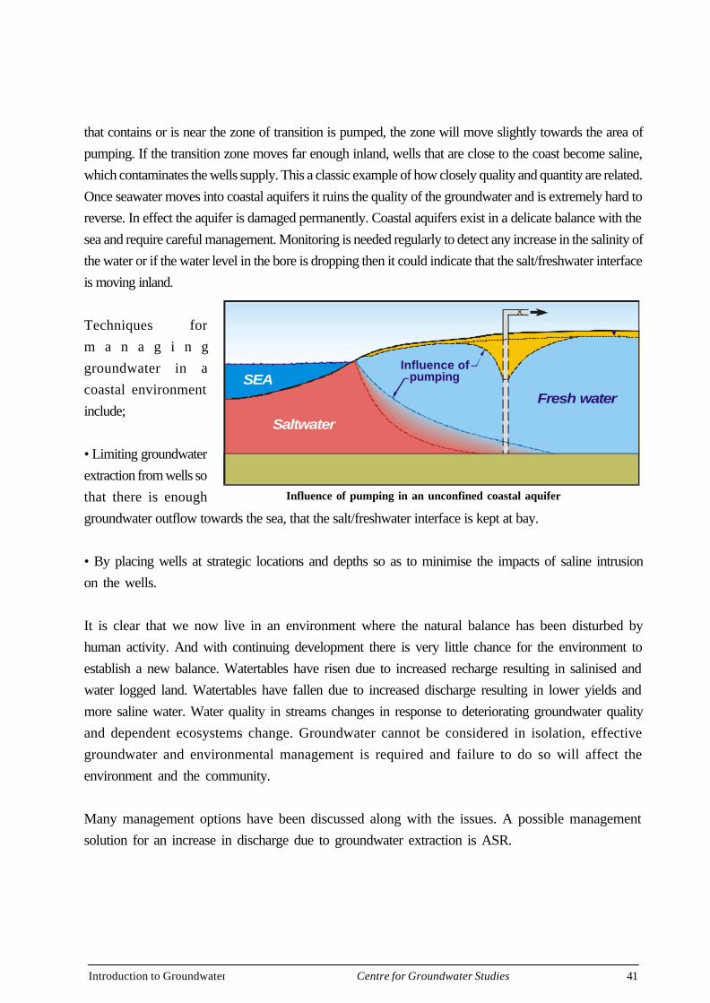
that contains or is near the zone of transition is pumped, the zone will move slightly towards the area ofpumping. If the transition zone moves far enough inland, wells that are close to the coast become saline,which contaminates the wells supply. This a classic example of how closely quality and quantity are related.Once seawater moves into coastal aquifers it ruins the quality of the groundwater and is extremely hard toreverse. In effect the aquifer is damaged permanently. Coastal aquifers exist in a delicate balance with thesea and require careful management. Monitoring is needed regularly to detect any increase in the salinity ofthe water or if the water level in the bore is dropping then it could indicate that the salt/freshwater interfaceis moving inland.
Techniques form a n a g i n ggroundwater in acoastal environmentinclude;
• Limiting groundwaterextraction from wells sothat there is enoughgroundwater outflow towards the sea, that the salt/freshwater interface is kept at bay.
• By placing wells at strategic locations and depths so as to minimise the impacts of saline intrusionon the wells.
It is clear that we now live in an environment where the natural balance has been disturbed byhuman activity. And with continuing development there is very little chance for the environment toestablish a new balance. Watertables have risen due to increased recharge resulting in salinised andwater logged land. Watertables have fallen due to increased discharge resulting in lower yields andmore saline water. Water quality in streams changes in response to deteriorating groundwater qualityand dependent ecosystems change. Groundwater cannot be considered in isolation, effectivegroundwater and environmental management is required and failure to do so will affect theenvironment and the community.
Many management options have been discussed along with the issues. A possible managementsolution for an increase in discharge due to groundwater extraction is ASR.
Influence ofpumping
X
SEA
Saltwater
Fresh water
Influence of pumping in an unconfined coastal aquifer
Introduction to Groundwater 42Centre for Groundwater Studies
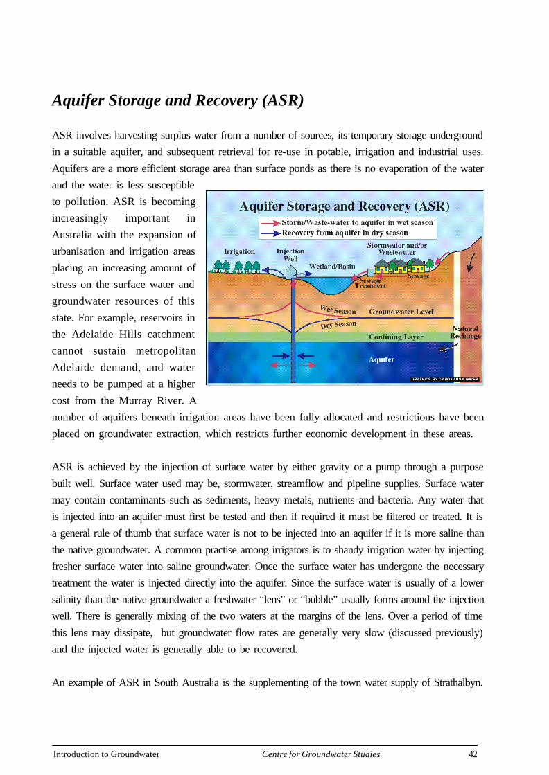
Aquifer Storage and Recovery (ASR)
ASR involves harvesting surplus water from a number of sources, its temporary storage undergroundin a suitable aquifer, and subsequent retrieval for re-use in potable, irrigation and industrial uses.Aquifers are a more efficient storage area than surface ponds as there is no evaporation of the waterand the water is less susceptibleto pollution. ASR is becomingincreasingly important inAustralia with the expansion ofurbanisation and irrigation areasplacing an increasing amount ofstress on the surface water andgroundwater resources of thisstate. For example, reservoirs inthe Adelaide Hills catchmentcannot sustain metropolitanAdelaide demand, and waterneeds to be pumped at a highercost from the Murray River. Anumber of aquifers beneath irrigation areas have been fully allocated and restrictions have beenplaced on groundwater extraction, which restricts further economic development in these areas.
ASR is achieved by the injection of surface water by either gravity or a pump through a purposebuilt well. Surface water used may be, stormwater, streamflow and pipeline supplies. Surface watermay contain contaminants such as sediments, heavy metals, nutrients and bacteria. Any water thatis injected into an aquifer must first be tested and then if required it must be filtered or treated. It isa general rule of thumb that surface water is not to be injected into an aquifer if it is more saline thanthe native groundwater. A common practise among irrigators is to shandy irrigation water by injectingfresher surface water into saline groundwater. Once the surface water has undergone the necessarytreatment the water is injected directly into the aquifer. Since the surface water is usually of a lowersalinity than the native groundwater a freshwater “lens” or “bubble” usually forms around the injectionwell. There is generally mixing of the two waters at the margins of the lens. Over a period of timethis lens may dissipate, but groundwater flow rates are generally very slow (discussed previously)and the injected water is generally able to be recovered.
An example of ASR in South Australia is the supplementing of the town water supply of Strathalbyn.

Introduction to Groundwater 43Centre for Groundwater Studies
Groundwater Ecosystems
It is believed that the one important element yet to be factored into the way we manage the environmentis groundwater (Cribb, J 1998). Without the role of groundwater many native vegetation, animal and birdspecies would be unable to survive. This is particularly true in central Australia where surface water soondries up and groundwater is essential in supporting ecosystems. Even though we cannot see the water atthe surface, if the watertable is lowered, or the groundwater becomes polluted or saline then vegetationwill die adversely affecting plant, animal and bird species. Yet how much or to what extent the rolegroundwater plays in supporting these ecosystems is still poorly understood.
Many native trees in the Australian landscapedepend on shallow groundwater systems tokeep them alive during the dry season. Anexample of groundwater dependentvegetation are river red gums, which areusually found along river beds throughoutAustralia. In South Australia the Marne RiverCatchment has been under investigation afterrecording record low groundwater levels.The area has experienced three belowaverage rainfall seasons in a row. Hydrogeologist Steve Barnett and his team were investigating where thegroundwater in the catchment was going as irrigation did not appear to represent the amount of groundwaterextraction. After a detailed investigation including computer modelling it was discovered that the river redgums along the Marne River were extracting approximately twice the amount of groundwater throughtheir root systems than the groundwater users in the region were extracting. This finding is a first of it’skind in terms of determining how much groundwater contributes to ecosystems.
Another example is the Great Artesian Basin. In the Great Artesian Basin mound springs support diverseecosystems which are under threat from human activity. Mound springs are formed by artesian wells, asthe groundwater flows onto the surface the water is evaporated and salts are left behind. Wind bournsediments are deposited onto these moist soils and gradually a mound builds up around the spring. InSouth Australia the mound springs form an arc of about 400 km along the south-western edge of thebasin The mound springs are home to a combination of plants and animals that are found nowhere else inthe world. The environment supports many types of rare and even unique plant life, animals, fish andfreshwater snails. Many species only exist in a certain spring. These ecosystems are under threat fromhuman activity, bores used for stock can lower the pressure in the aquifer to the extent that natural springscan dry up. In the last 100 years many springs have dried up, destroying various species even before they
Introduction to Groundwater 44Centre for Groundwater Studies
could be discovered. Stock are also a hazard, trampling the environment.
As has been previously discussed, groundwater and surface water are interconnected, makinggroundwater an important factor in supporting ecosystems in rivers and streams. Also, aquifersthemselves contain forms of life and biological processes, some of which are new to scientists(Cribb, J, 1998).
Clearly groundwater is a very important component in the environment and any plans to extractgroundwater should take into account any detrimental effects on dependent ecosystems.
Groundwater Resources exist within social constructs
In most parts of Australia the management of groundwater is the province of the various stategovernments. In South Australia groundwater is managed predominantly by the Groundwater Sectionof the Department for Water Resources. The formation of the new Department for Water Resourceshas seen the bringing together the management of surface water and groundwater into the samedepartment. Where a basin covers several states, the relevant government agencies will work together.
Groundwater in Australia is legislated under state Water Resources Act. These require that certainconditions are met when using the states groundwater. Licensing can be required in prescribedareas. Licenses are the property of the holder and are not linked with the land. A licensed drillermust be used where a well is deeper than 2.5 metres although a landholder can drill a well up to 15metres deep on his/her own property. A permit is required to drill or deepen any well or the casingwithin a well deeper than 2.5m. Drillers are required to provide information on depth, casing, watercuts and lithology to the relevant government agency. Where a person has lawful access to a well,that person has a right to take water from it provided that it does not interfere with another personsright to take water from their well. A well owner is also responsible for maintaining a well on his/her property and may be required to undertake remedial work.
Often, groundwater is considered available for consumptive use only after environmental needshave been assessed. The impact of the well on other water resources must also be considered. Onlythen an allocation is issued. Where water has been over allocated the appropriate state Minister hasthe power to reduce the size of allocations.
Introduction to Groundwater 45Centre for Groundwater Studies
What can you do?
There are many examples of how a community orindividual may become involved.
So what can you do?
• Join a local action group in your area
• Education – go to workshops and seminarsto learn about the issues and understand how youmay help
• Look up the WWW for information andresources – see following page for places to start
• See following list of issues/problems ‘What Activities can I do?’ andexamples of community activities to address them
• TAKE ACTION!
There are many groups doing much to help already.
Much is happening overseas where groundwater is a main source ofdrinking water – example - The Groundwater Foundation, U.S. is anexample of how communities can be effective.
Introduction to Groundwater 46Centre for Groundwater Studies
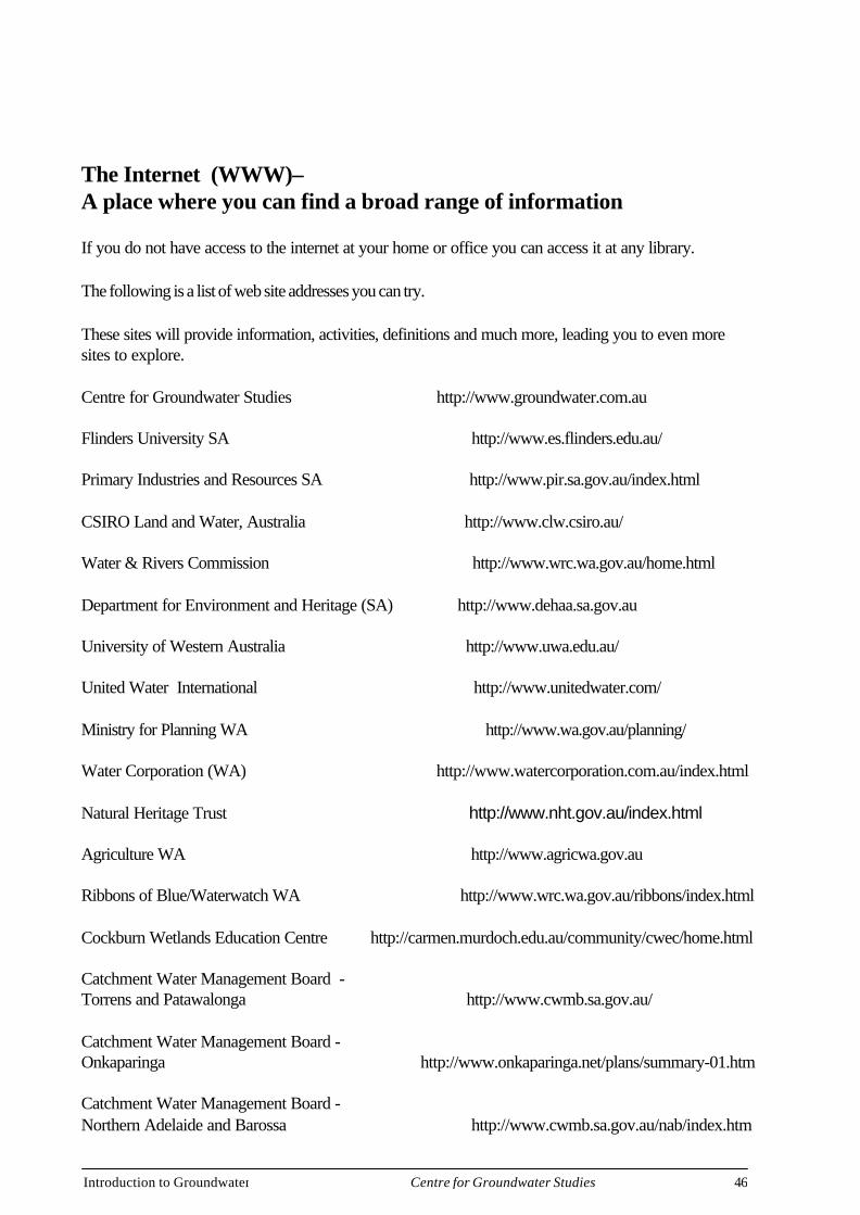
The Internet (WWW)–A place where you can find a broad range of information
If you do not have access to the internet at your home or office you can access it at any library.
The following is a list of web site addresses you can try.
These sites will provide information, activities, definitions and much more, leading you to even moresites to explore.
Centre for Groundwater Studies http://www.groundwater.com.au
Flinders University SA http://www.es.flinders.edu.au/
Primary Industries and Resources SA http://www.pir.sa.gov.au/index.html
CSIRO Land and Water, Australia http://www.clw.csiro.au/
Water & Rivers Commission http://www.wrc.wa.gov.au/home.html
Department for Environment and Heritage (SA) http://www.dehaa.sa.gov.au
University of Western Australia http://www.uwa.edu.au/
United Water International http://www.unitedwater.com/
Ministry for Planning WA http://www.wa.gov.au/planning/
Water Corporation (WA) http://www.watercorporation.com.au/index.html
Natural Heritage Trust http://www.nht.gov.au/index.html
Agriculture WA http://www.agricwa.gov.au
Ribbons of Blue/Waterwatch WA http://www.wrc.wa.gov.au/ribbons/index.html
Cockburn Wetlands Education Centre http://carmen.murdoch.edu.au/community/cwec/home.html
Catchment Water Management Board -Torrens and Patawalonga http://www.cwmb.sa.gov.au/
Catchment Water Management Board -Onkaparinga http://www.onkaparinga.net/plans/summary-01.htm
Catchment Water Management Board -Northern Adelaide and Barossa http://www.cwmb.sa.gov.au/nab/index.htm

Introduction to Groundwater 47Centre for Groundwater Studies
Waterwatch Australia http://www.waterwatch.org.au/welcome.htm
Urrbrae Wetlands - Activities http://www.denr.sa.gov.au/wrg/watercare/ database/activity/urbanact.htm
Environment Protection Agency (SA) http://www.dehaa.sa.gov.au/epa/water.html
South Australian Murray Darling Basin web site http://www.lm.net.au/~sacare/
Belair Primary School Eco Schools Page http://ee.environment.gov.au/ecoschools/belair.htm
Watercare III http://www.watercare.sa.gov.au/sitemap.htm
WSAA - Water Services Association of Australia http://www.wsaa.asn.au/
Welcome to Environment Australia http://www.environment.gov.au/
Land & Water Resources Research &Development Corporation http://www.lwrrdc.gov.au/
National Dryland Salinity Program http://www.senet.com.au./~bcmunday/1home.htm
South Australian Water Industry http://www.sa.waterindustry.net.au/mainmenu.htm
Australian Water & Wastewater Association http://www.awwa.asn.au/
ARMCANZ Home Page http://www.dpie.gov.au/dpie/armcanz
Masters Program in Hydrology and Water Resources http://www.scieng.flinders.edu.au/teaching/ Hydrology/Hydrology.htm
CSIRO Land and Water - Scientific Publications http://www.clw.csiro.au/publications/scientific.htm
Environment Australia http://www.erin.gov.au
Groundwater Centre - Faculty Centres - Facultyof Engineering Handbook – UNSW http://www.publications.unsw.edu.au/ handbooks/engineer/18201312.htm
Urban Water Resources Centre http://www.unisa.edu.au/uwrc/project.htm
National Centre for Groundwater management http://www.uts.edu.au/oth/ncgm/
Cooperative Research Centre for Catchment Hydrology http://www.catchment.crc.org.au/
Indonesian Governmental Links Page http://www.dfa-deplu.go.id/english/govern1.htm
Introduction to Groundwater 48Centre for Groundwater Studies
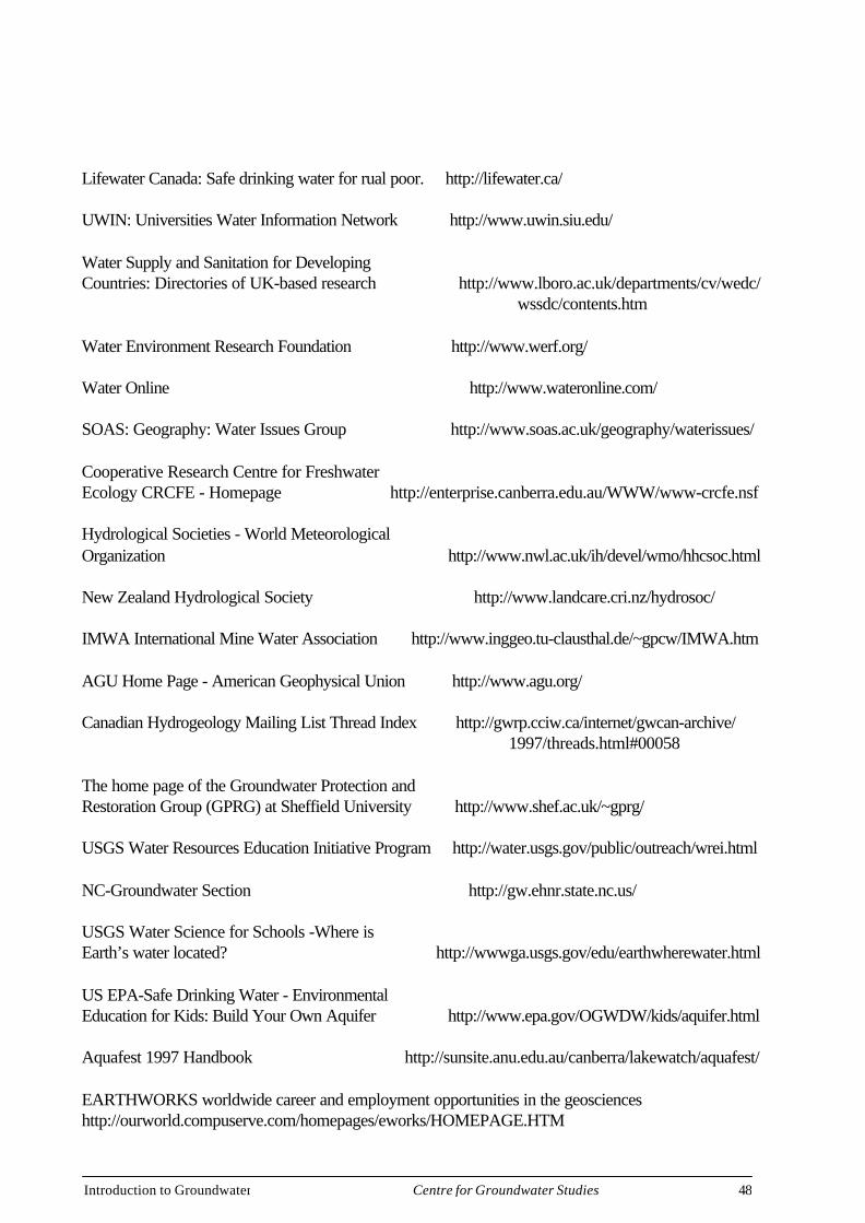
Lifewater Canada: Safe drinking water for rual poor. http://lifewater.ca/
UWIN: Universities Water Information Network http://www.uwin.siu.edu/
Water Supply and Sanitation for DevelopingCountries: Directories of UK-based research http://www.lboro.ac.uk/departments/cv/wedc/ wssdc/contents.htm
Water Environment Research Foundation http://www.werf.org/
Water Online http://www.wateronline.com/
SOAS: Geography: Water Issues Group http://www.soas.ac.uk/geography/waterissues/
Cooperative Research Centre for FreshwaterEcology CRCFE - Homepage http://enterprise.canberra.edu.au/WWW/www-crcfe.nsf
Hydrological Societies - World MeteorologicalOrganization http://www.nwl.ac.uk/ih/devel/wmo/hhcsoc.html
New Zealand Hydrological Society http://www.landcare.cri.nz/hydrosoc/
IMWA International Mine Water Association http://www.inggeo.tu-clausthal.de/~gpcw/IMWA.htm
AGU Home Page - American Geophysical Union http://www.agu.org/
Canadian Hydrogeology Mailing List Thread Index http://gwrp.cciw.ca/internet/gwcan-archive/ 1997/threads.html#00058
The home page of the Groundwater Protection andRestoration Group (GPRG) at Sheffield University http://www.shef.ac.uk/~gprg/
USGS Water Resources Education Initiative Program http://water.usgs.gov/public/outreach/wrei.html
NC-Groundwater Section http://gw.ehnr.state.nc.us/
USGS Water Science for Schools -Where isEarth’s water located? http://wwwga.usgs.gov/edu/earthwherewater.html
US EPA-Safe Drinking Water - EnvironmentalEducation for Kids: Build Your Own Aquifer http://www.epa.gov/OGWDW/kids/aquifer.html
Aquafest 1997 Handbook http://sunsite.anu.edu.au/canberra/lakewatch/aquafest/
EARTHWORKS worldwide career and employment opportunities in the geoscienceshttp://ourworld.compuserve.com/homepages/eworks/HOMEPAGE.HTM

Introduction to Groundwater 49Centre for Groundwater Studies
What Activities Can I Do?
The following are examples of issues that may occur in your area and aselection of activities that a community may undertake to address them.
Of course you are not restricted to these activities and in many casesdifferent types of activities may be more appropriate for your group.
This list will get you thinking about what you and your community maydo!
Some of the activities may also require skills and cooperation fromgovernment agencies, local council and other expertise to achieve yourgoal.
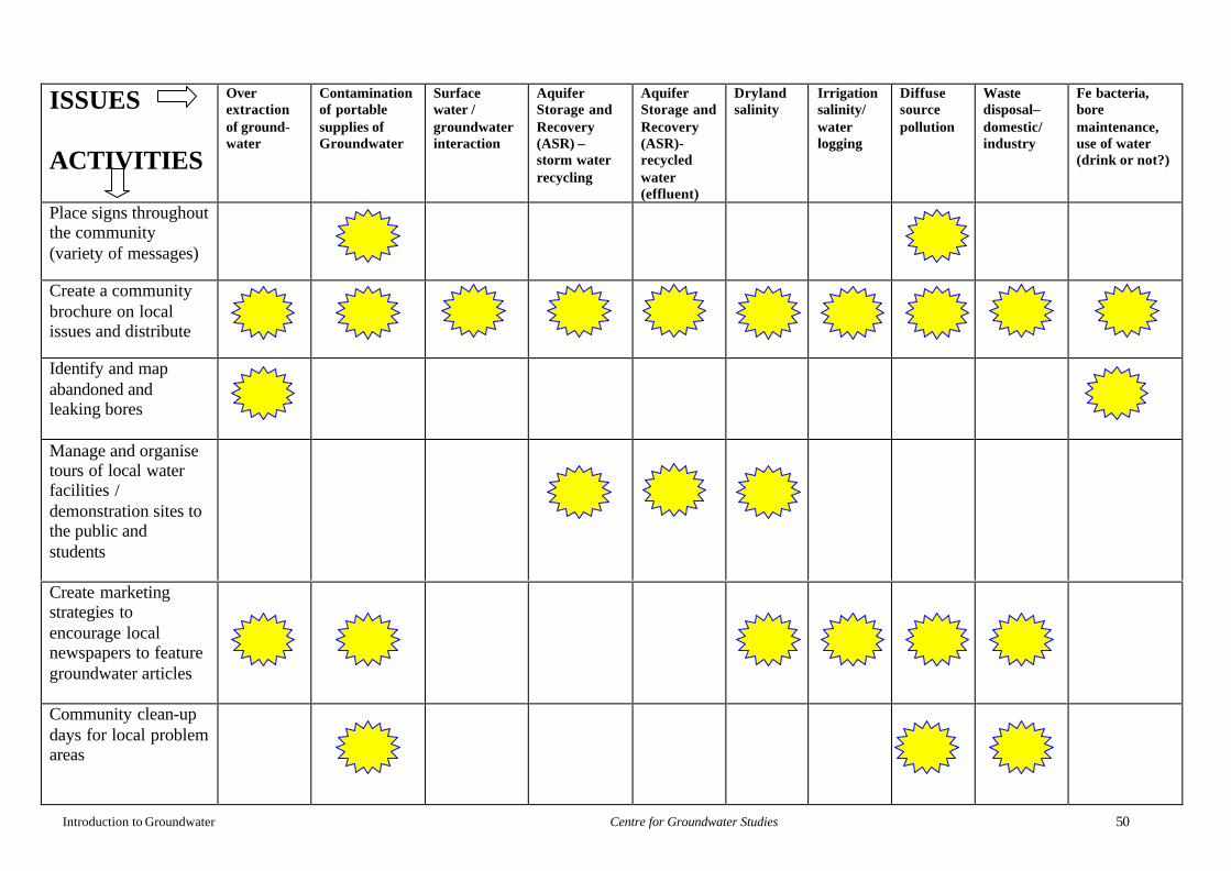
Introduction to Groundwater Centre for Groundwater Studies 50
ISSUES
ACTIVITIES
Overextractionof ground-water
Contaminationof portablesupplies ofGroundwater
Surfacewater /groundwaterinteraction
AquiferStorage andRecovery(ASR) –storm waterrecycling
AquiferStorage andRecovery(ASR)-recycledwater(effluent)
Drylandsalinity
Irrigationsalinity/waterlogging
Diffusesourcepollution
Wastedisposal–domestic/industry
Fe bacteria,boremaintenance,use of water(drink or not?)
Place signs throughoutthe community(variety of messages)
Create a communitybrochure on localissues and distribute
Identify and mapabandoned andleaking bores
Manage and organisetours of local waterfacilities /demonstration sites tothe public andstudents
Create marketingstrategies toencourage localnewspapers to featuregroundwater articles
Community clean-updays for local problemareas
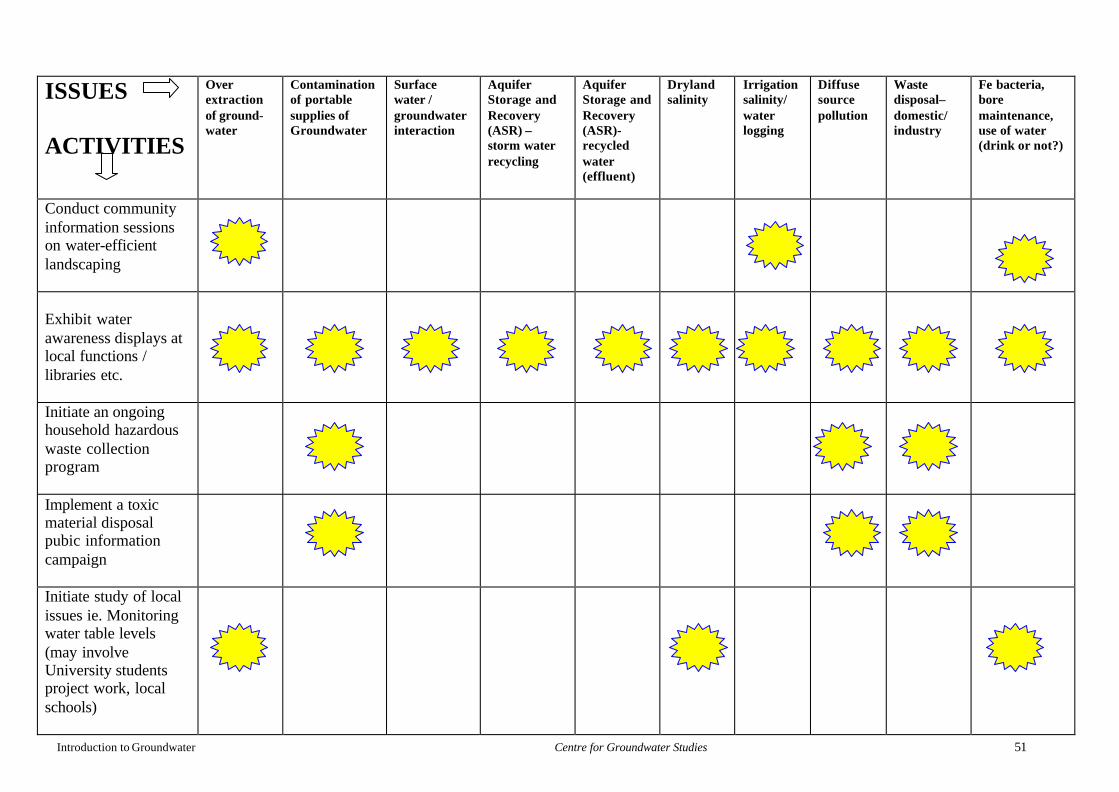
Introduction to Groundwater Centre for Groundwater Studies 51
ISSUES
ACTIVITIES
Overextractionof ground-water
Contaminationof portablesupplies ofGroundwater
Surfacewater /groundwaterinteraction
AquiferStorage andRecovery(ASR) –storm waterrecycling
AquiferStorage andRecovery(ASR)-recycledwater(effluent)
Drylandsalinity
Irrigationsalinity/waterlogging
Diffusesourcepollution
Wastedisposal–domestic/industry
Fe bacteria,boremaintenance,use of water(drink or not?)
Conduct communityinformation sessionson water-efficientlandscaping
Exhibit waterawareness displays atlocal functions /libraries etc.
Initiate an ongoinghousehold hazardouswaste collectionprogram
Implement a toxicmaterial disposalpubic informationcampaign
Initiate study of localissues ie. Monitoringwater table levels(may involveUniversity studentsproject work, localschools)
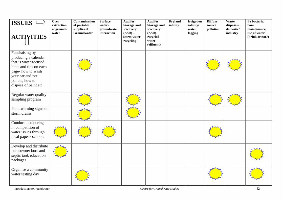
Introduction to Groundwater Centre for Groundwater Studies 52
ISSUES
ACTIVITIES
Overextractionof ground-water
Contaminationof portablesupplies ofGroundwater
Surfacewater /groundwaterinteraction
AquiferStorage andRecovery(ASR) –storm waterrecycling
AquiferStorage andRecovery(ASR)-recycledwater(effluent)
Drylandsalinity
Irrigationsalinity/waterlogging
Diffusesourcepollution
Wastedisposal–domestic/industry
Fe bacteria,boremaintenance,use of water(drink or not?)
Fundraising byproducing a calendarthat is water focused –hints and tips on eachpage- how to washyour car and notpollute, how todispose of paint etc.
Regular water qualitysampling program
Paint warning signs onstorm drains
Conduct a colouring-in competition ofwater issues throughlocal paper / schools
Develop and distributehomeowner bore andseptic tank educationpackages
Organise a communitywater testing day
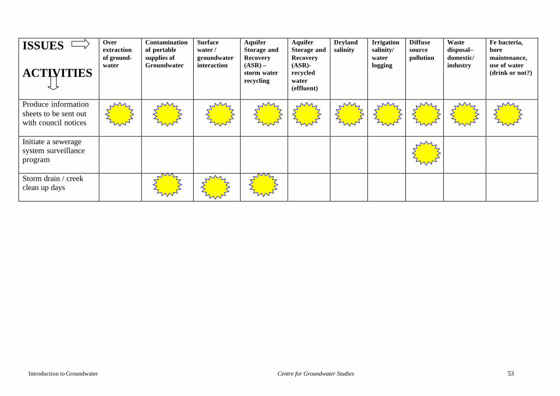
Introduction to Groundwater Centre for Groundwater Studies 53
ISSUES
ACTIVITIES
Overextractionof ground-water
Contaminationof portablesupplies ofGroundwater
Surfacewater /groundwaterinteraction
AquiferStorage andRecovery(ASR) –storm waterrecycling
AquiferStorage andRecovery(ASR)-recycledwater(effluent)
Drylandsalinity
Irrigationsalinity/waterlogging
Diffusesourcepollution
Wastedisposal–domestic/industry
Fe bacteria,boremaintenance,use of water(drink or not?)
Produce informationsheets to be sent outwith council notices
Initiate a seweragesystem surveillanceprogram
Storm drain / creekclean up days
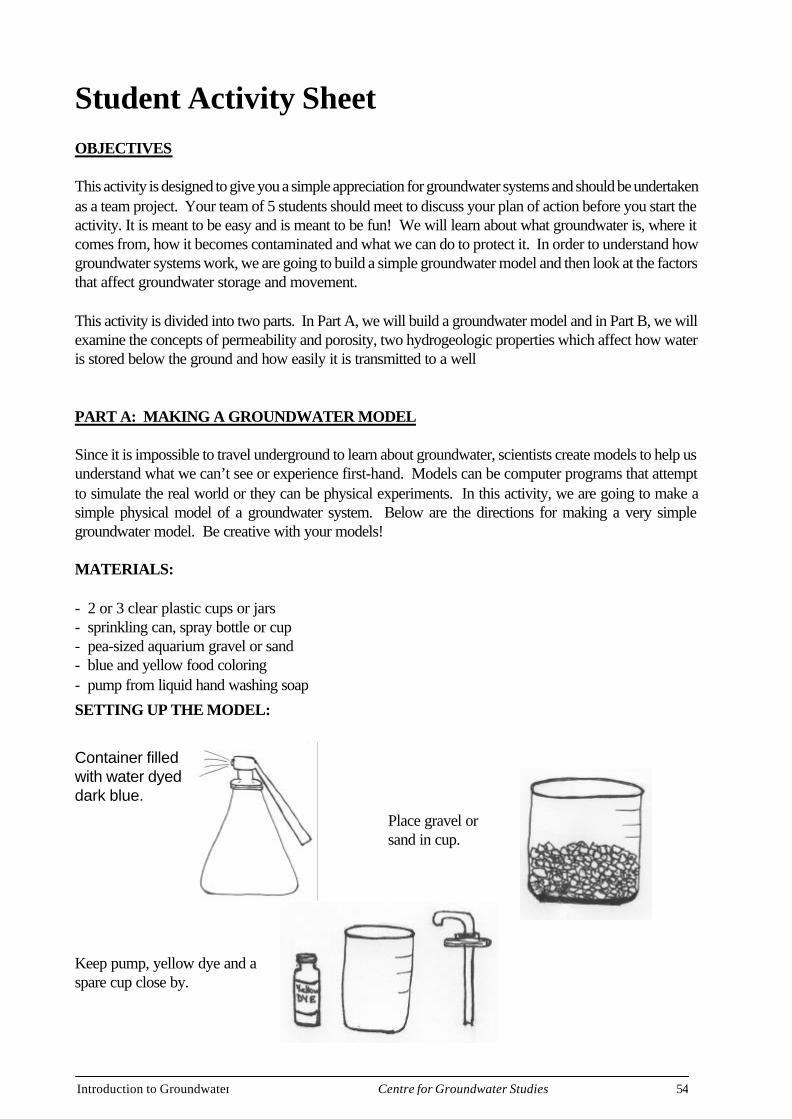
Introduction to Groundwater 54Centre for Groundwater Studies
Student Activity SheetOBJECTIVES
This activity is designed to give you a simple appreciation for groundwater systems and should be undertakenas a team project. Your team of 5 students should meet to discuss your plan of action before you start theactivity. It is meant to be easy and is meant to be fun! We will learn about what groundwater is, where itcomes from, how it becomes contaminated and what we can do to protect it. In order to understand howgroundwater systems work, we are going to build a simple groundwater model and then look at the factorsthat affect groundwater storage and movement.
This activity is divided into two parts. In Part A, we will build a groundwater model and in Part B, we willexamine the concepts of permeability and porosity, two hydrogeologic properties which affect how wateris stored below the ground and how easily it is transmitted to a well
PART A: MAKING A GROUNDWATER MODEL
Since it is impossible to travel underground to learn about groundwater, scientists create models to help usunderstand what we can’t see or experience first-hand. Models can be computer programs that attemptto simulate the real world or they can be physical experiments. In this activity, we are going to make asimple physical model of a groundwater system. Below are the directions for making a very simplegroundwater model. Be creative with your models!
MATERIALS:
- 2 or 3 clear plastic cups or jars- sprinkling can, spray bottle or cup- pea-sized aquarium gravel or sand- blue and yellow food coloring- pump from liquid hand washing soap
SETTING UP THE MODEL:
Container filledwith water dyeddark blue.
Place gravel orsand in cup.
Keep pump, yellow dye and aspare cup close by.
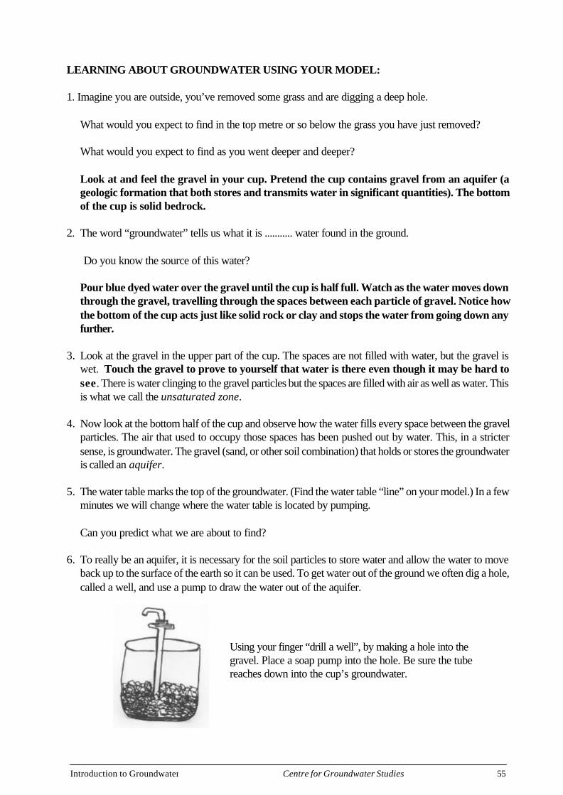
Introduction to Groundwater 55Centre for Groundwater Studies
LEARNING ABOUT GROUNDWATER USING YOUR MODEL:
1. Imagine you are outside, you’ve removed some grass and are digging a deep hole.
What would you expect to find in the top metre or so below the grass you have just removed?
What would you expect to find as you went deeper and deeper?
Look at and feel the gravel in your cup. Pretend the cup contains gravel from an aquifer (ageologic formation that both stores and transmits water in significant quantities). The bottomof the cup is solid bedrock.
2. The word “groundwater” tells us what it is ........... water found in the ground.
Do you know the source of this water?
Pour blue dyed water over the gravel until the cup is half full. Watch as the water moves downthrough the gravel, travelling through the spaces between each particle of gravel. Notice howthe bottom of the cup acts just like solid rock or clay and stops the water from going down anyfurther.
3. Look at the gravel in the upper part of the cup. The spaces are not filled with water, but the gravel iswet. Touch the gravel to prove to yourself that water is there even though it may be hard tosee. There is water clinging to the gravel particles but the spaces are filled with air as well as water. Thisis what we call the unsaturated zone.
4. Now look at the bottom half of the cup and observe how the water fills every space between the gravelparticles. The air that used to occupy those spaces has been pushed out by water. This, in a strictersense, is groundwater. The gravel (sand, or other soil combination) that holds or stores the groundwateris called an aquifer.
5. The water table marks the top of the groundwater. (Find the water table “line” on your model.) In a fewminutes we will change where the water table is located by pumping.
Can you predict what we are about to find?
6. To really be an aquifer, it is necessary for the soil particles to store water and allow the water to moveback up to the surface of the earth so it can be used. To get water out of the ground we often dig a hole,called a well, and use a pump to draw the water out of the aquifer.
Using your finger “drill a well”, by making a hole into thegravel. Place a soap pump into the hole. Be sure the tubereaches down into the cup’s groundwater.
Introduction to Groundwater 56Centre for Groundwater Studies
7. Begin pumping groundwater out of your aquifer. Pump it into another cup.
What happens to the water table as you pump?What would happen if you kept pumping?
Keep the system going by adding a little more water to the aquifer by “raining” on it withyour sprinkling can.
8. So far we have used our model to help us understand the concepts of groundwater, aquifer, water tableand well. You will now see how groundwater is sometimes made unfit to use when it is contaminated.Squirt several drops of yellow food coloring onto the gravel. “Rain” on it again to make itseep down into the groundwater. The dye represents a chemical that can be dissolved in water andcarried down to the aquifer with rain or snow. Some of the contaminants that have been found ingroundwater include;· wastewater from a kitchen, bathroom, or laundry that went into a septic system,· petrol leaking from an underground storage tank,· spilled and buried waste (e.g. used car oil or poorly constructed landfill),· fertiliser that was put on farm crops or animal waste from a poorly maintained animal feedlot,· lawn and garden projects especially if applied at the wrong time, wrong way, or in the wrong
amount;· and oil-based paints, strong cleaning supplies, insect or weed killers that were not disposed of
properly.
9. Begin pumping again. Pretend the water is from your home well or the city well that supplies drinkingwater to your house.
What is happening to the yellow contamination as you pump?Is it in your drinking water yet?
The water being pumped out will turn green as the “contaminant” comes through. In “real life” it isn’t soeasy to spot a contamination problem. Contaminated water might not look, smell or taste bad. Inaddition, it may be hard to find the source of the contamination. Groundwater moves much slower thanit did in our model. (Sometimes only centimeters a year). It may be years before the contaminationbecomes known. By then it may be too late to make the responsible people clean it up.
APPLICATION TO REAL LIFE
Groundwater clean-up is expensive (sometimes millions of dollars). It can also take many, many years.What we must do is to try and prevent contamination from occurring in the first place! Conserve water,properly use, store and dispose of fertilizers and pesticides, clean and maintain septic systems, checkunderground storage tanks for leaks, properly dispose of used car oil and other household hazardousproducts, reduce, reuse and recycle. (The making, transporting, and disposing of products cause manywater pollution problems as well as other environmental problems.)
PART B: GROUNDWATER MOVEMENT - POROSITY & PERMEABILITY
OBJECTIVE: To discover the rates at which water moves through different types of soils and todemonstrate that water percolates through soils with different grain sizes at different rates.
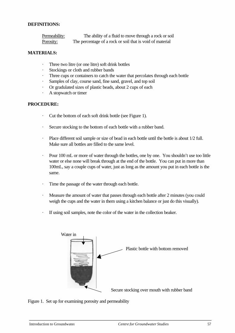
Introduction to Groundwater 57Centre for Groundwater Studies
DEFINITIONS:
Permeability: The ability of a fluid to move through a rock or soilPorosity: The percentage of a rock or soil that is void of material
MATERIALS:
· Three two litre (or one litre) soft drink bottles· Stockings or cloth and rubber bands· Three cups or containers to catch the water that percolates through each bottle· Samples of clay, course sand, fine sand, gravel, and top soil· Or gradulated sizes of plastic beads, about 2 cups of each· A stopwatch or timer
PROCEDURE:
· Cut the bottom of each soft drink bottle (see Figure 1).
· Secure stocking to the bottom of each bottle with a rubber band.
· Place different soil sample or size of bead in each bottle until the bottle is about 1/2 full.Make sure all bottles are filled to the same level.
· Pour 100 mL or more of water through the bottles, one by one. You shouldn’t use too littlewater or else none will break through at the end of the bottle. You can put in more than100mL, say a couple cups of water, just as long as the amount you put in each bottle is thesame.
· Time the passage of the water through each bottle.
· Measure the amount of water that passes through each bottle after 2 minutes (you couldweigh the cups and the water in them using a kitchen balance or just do this visually).
· If using soil samples, note the color of the water in the collection beaker.
Water in
Secure stocking over mouth with rubber band
Plastic bottle with bottom removed
Figure 1. Set up for examining porosity and permeability
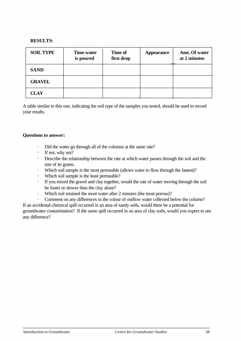
Introduction to Groundwater 58Centre for Groundwater Studies
RESULTS:
SOIL TYPE Time water Time of Appearance Amt. Of water is poured first drop at 2 minutes
SAND
GRAVEL
CLAY
A table similar to this one, indicating the soil type of the samples you tested, should be used to recordyour results.
Questions to answer:
· Did the water go through all of the columns at the same rate?· If not, why not?· Describe the relationship between the rate at which water passes through the soil and the
size of its grains.· Which soil sample is the most permeable (allows water to flow through the fastest)?· Which soil sample is the least permeable?· If you mixed the gravel and clay together, would the rate of water moving through the soil
be faster or slower than the clay alone?· Which soil retained the most water after 2 minutes (the most porous)?· Comment on any differences in the colour of outflow water collected below the column?
If an accidental chemical spill occurred in an area of sandy soils, would there be a potential forgroundwater contamination? If the same spill occurred in an area of clay soils, would you expect to seeany difference?
Introduction to Groundwater 59Centre for Groundwater Studies
GLOSSARY
Aquifer, is a saturated geological material, that when drilled, can yield a useable quantity ofgroundwater.
Aquiclude , this is a confining bed where all the pores in the geological material are full of water(saturated), and water may move vertically through the geological material.
Aquifuge, this is a confining bed where none of the pores in the geological material containwater and the confining bed does not allow any groundwater to flow vertically through it.
Aquitard, this is a confining bed where all the pores in the geological material are full of water(saturated), but no groundwater can pass vertically through the confining bed. Also known as aleaky confining bed.
Capillary Zone , where water is drawn up above the watertable by capillarity.
Capillarity, the affects of surface tension drawing water up into narrow pores against the forceof gravity.
Cone of Depression, is a depression in the water table or potentiometric surface in the shape ofan inverted cone, forming in response to pumping from a single well.
Confined Aquifer, is an aquifer that is bound above and below by a confining bed. The pressurein confined aquifers is usually greater than atmosheric pressure resulting in water levels in wellsbeing above the elevation of the top of the aquifer.
Confining Bed, geological material usually occurs in beds or layers, a bed that cannot produce auseable yield is known as a confining bed. There are three types of confining beds, aquitards,aquicludes and aquifuges.
Contamination, a contaminant is considered to be any substance that degrades the groundwaterquality so that it can no longer be used by plants, animals and humans (Water and Rivers Com-mission, Western Australia)
Discharge, when water enters groundwater it will flow through the aquifer to a point of exitknown as a discharge point such as a river, a spring, or the ocean.

Introduction to Groundwater 60Centre for Groundwater Studies
Evaporation, the conversion of liquid into vapour driven by the energy from the sun.
Evapotranspiration, the process that returns water to the atmosphere via evaporation andtranspiration.
Fractured Rock Aquifer, is an aquifer where the groundwater moves through secondary poros-ity.
Geological material, is rock or sediments in a group of formations or layers.
Glaciers , are a large mass of ice formed on land by the recrystallization of snow, and movesdown slopes due to its own mass.
Groundwater, is considered to be water in the saturated zone.
Fractures, see secondary porosity.
Hydraulic Gradient, in an unconfined aquifer is the watertable gradient (slope) in the directionof flow and in a confined aquifer is the pressure gradient (slope) in the direction of flow.
Hydrogeologist, is a scientist who works with groundwater.
Hydrographs , are graphs of groundwater levels or salinity values measured from one well atregular intervals (such as once a month) over a period of many years (decades). The graph showsa property of groundwater as a function of time.
Hydrological Cycle, is the endless movement of water from the atmosphere to the earth andback to the atmosphere via precipitation, evaporation, transpiration, runoff, and infiltration.
Hydrologist, is a scientist who works with surface water.
Infiltration, the process of surface water soaking into the unsaturated zone.
Interference, is where the cones of depression of two wells that are located too close to eachother and they interact resulting in the lowering of the groundwater levels within the wells.
Intermediate Zone , is located between the soil zone and the capillary zone.
Introduction to Groundwater 61Centre for Groundwater Studies
Perched Aquifer, is located in the unsaturated zone, where there are discontinuous confiningmaterial and infiltrating water becomes “stranded” on these layers forming a “lense” of water.
Percolation, see infiltration.
Permeability, is the interconnectedness of pores such that water can move through the porestoward a well or a discharge area. The larger the pores the more easily the water will flowthrough the aquifer.
Potentiometric Surface, is also known as the pressure surface, it is an imaginary surface repre-senting the height to which the groundwater level will rise when a well is drilled into a confinedaquifer. It is the hypothetical surface that the groundwater would equilibrate to if not confined.
Pores, are the voids between the grains in a sedimentary geological material in which water isstored.
Porosity, refers to the number of pores present in a geological material and the amount of waterthat can be stored in the material.
Precipitation, the conversion of vapour into liquid driven by the energy from the sun.
Primary Porosity, the porosity that was present within the sediment at the time of deposition.
Recharge, is the process of replenishment to an aquifer due to the infiltration/percolation fromrainfall. Recharge to groundwater may also occur from surface water bodies such as lakes andstreams.
Runoff, is the water that reaches streams after a rainfall event.
Saturated Zone , is the zone in the subsurface where all pores are saturated with water at apressure that is greater than atmospheric pressure. The watertable borders the upper boundary ofthe saturated zone.
Secondary Porosity, the porosity that occurred after the geological material was formed due tosuch geological processes as weathering and fracturing.
Introduction to Groundwater 62Centre for Groundwater Studies
Sedimentary Aquifer, is an aquifer where groundwater is stored and moves through primary porosity.
Sedimentary Basin, is a topographic low that contains layers of sediment.
Soil Zone , is the first section in the unsaturated zone directly below the surface. Water moves throughthis zone under gravitational drainage, but water retained by surface tension is used by plants.
Storage, the amount of groundwater held in an aquifer.
Subsurface, is the area under the ground surface.
Surface Tension, is the property of a liquid surface to behave like a stretched elastic film due to themolecular attraction between air and water.
Surface Water, is any body of water on the surface, such as streams and lakes.
Transmission, is the rate at which groundwater moves through an aquifer.
Transpiration, is the process where water is absorbed through the roots of plants and moves throughthe plant to its leaves where it is evaporated.
Unconfined Aquifer, is an aquifer has the watertable as its upper boundary and a confining bed as itslower boundary.
Unsaturated Zone , is where the pores in the geological material is filled with both air and water. Thereare three zones within this zone, the soil zone, the intermediate zone and the capillary zone.
Watertable, is the surface in an unconfined aquifer where the pore water is at atmospheric pressure, isalso known as the free atmospheric pressure surface. It is the height to which the water level will rise ina well drilled in an unconfined aquifer
Yield, is the amount of water pumped from a well, measured in litres per second.
Introduction to Groundwater 63Centre for Groundwater Studies
Acknowledgments
Some of the pictures contained in this document have been adapted for use from the following;Environment Canada- web siteRaymond, L S Jrn, Cornell University- web siteWaters and Rivers Commission, WA – web sitePublished by Community Groundwater Protection Project Massachusetts AudubonSociety- web siteUSGS- web siteDENR Victoria- web siteFocus- Australian Salinity Newsletter- web siteTECHSALT – web site