Embed Size (px)
Citation preview

Montgomery County Department of Environmental Protection Page 1 [email protected] 255 Rockville Pike, Suite 120 Rockville, MD 20850
The purpose of this document is to show how the Department of Environmental Protection calculates the amount of water treated by stormwater management practices and how WQPC credits are calculated for single-family residences. To assist with understanding this document, please have downloaded the Residential Credit Application.
Why Does the County Care about Stormwater Management on My Property?
Stormwater has been extremely harmful to our rivers and streams. As rainfall runoff flows over asphalt, concrete, building and roads (impervious surfaces) it picks up trash, oils and other pollutants. In addition, large amounts of fast moving stormwater erodes the sides of streams and creates flood conditions that could pose a danger to private property. Although the County is implementing stormwater management practices on public land, such as libraries, recreation centers and public streets, much of the County is in private hands. The Department of Environmental Protection needs your help to reduce stormwater runoff and protect our rivers and streams. An important way you can help protect our streams is by implementing Environmental Site Design on your property. And you’ll receive a credit off your Water Quality Protection Charge too!
What is Environmental Site Design? Environmental Site Design is an assortment of techniques, structures and practices that work together to minimize stormwater runoff. It is also frequently referred to as stormwater management practices. The goal of environmental site design is not to replace developed land, but make development in balance with natural water cycles. A key part of this effort is to have developed land mimic “woods in good condition”. “Woods in good condition” is a term the state of Maryland uses to represent a natural state before development. Land with “woods in good condition” capture and treat stormwater much better than typical residential land, because the ground is able to store, soak in, filter, evaporate and consume water.
A Garrett Park house with conservation landscaping
Enjoying a rain garden

Montgomery County Department of Environmental Protection Page 2 [email protected] 255 Rockville Pike, Suite 120 Rockville, MD 20850
The difference between “woods in good condition” land and developed land is demonstrated by the Water Balance Figure below. The image was taken from Page 1.3 of the Maryland Department of the Environment (MDE) Manual.
Maryland Environmental Design Manual
The MDE Stormwater Design Manual (2010 Revision), Volume I, Chapter 5, “Environmental Site Design” describes the technical requirements of the “Stormwater Management Act of 2007” (the Act). The Act’s goal is to apply stormwater standards on an equal basis for all sites and best mimic pre-developed conditions. The Act requires implementation of Environmental Site Design to the maximum extent practicable (MEP).
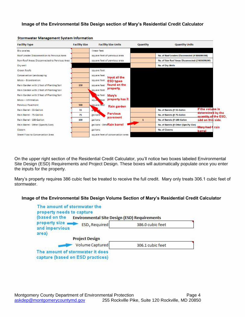
Environmental site design practices accepted in the Single-family Residential Credit Application are listed in the Credit Calculator under Stormwater Management System Information.
I Have Environmental Site Design on My Property. How Do I Get My Credit?
Single-family residential property owners with Environmental Site Design, must complete the Single-Family Residential Credit Application to receive the credit. It is an Excel document with multiple tabs at the bottom. One of the tabs is the Residential Credit Calculator.
The calculator asks for basic information about your property as well as details about the Environmental Site Design techniques on your property. Residential Credit Calculator inputs include:
The size of your property
How much impervious area is on your property
Your pre-credit WQPC
Types of Environmental Site Design
Size of Environmental Site Design
Montgomery County Department of Environmental Protection Page 3 [email protected] 255 Rockville Pike, Suite 120 Rockville, MD 20850
After inputting basic information about your property and the types of Environmental Site Design, the
Calculator will determine the amount of your credit.
Environmental Site Design Calculation Example
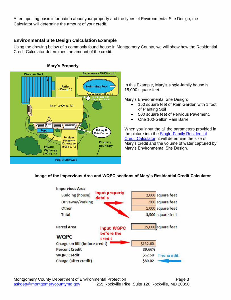
Using the drawing below of a commonly found house in Montgomery County, we will show how the Residential Credit Calculator determines the amount of the credit.
Mary’s Property In this Example, Mary’s single-family house is 15,000 square feet. Mary’s Environmental Site Design:
150 square feet of Rain Garden with 1 foot of Planting Soil
500 square feet of Pervious Pavement,
One 100-Gallon Rain Barrel. When you input the all the parameters provided in the picture into the Single-Family Residential Credit Calculator, it will determine the size of Mary’s credit and the volume of water captured by Mary’s Environmental Site Design.
Image of the Impervious Area and WQPC sections of Mary’s Residential Credit Calculator
Montgomery County Department of Environmental Protection Page 4 [email protected] 255 Rockville Pike, Suite 120 Rockville, MD 20850
On the upper right section of the Residential Credit Calculator, you’ll notice two boxes labeled Environmental Site Design (ESD) Requirements and Project Design. These boxes will automatically populate once you enter the inputs for the property. Mary’s property requires 386 cubic feet be treated to receive the full credit. Mary only treats 306.1 cubic feet of stormwater.
Image of the Environmental Site Design Volume Section of Mary’s Residential Credit Calculator
Image of the Environmental Site Design section of Mary’s Residential Credit Calculator
Montgomery County Department of Environmental Protection Page 5 [email protected] 255 Rockville Pike, Suite 120 Rockville, MD 20850
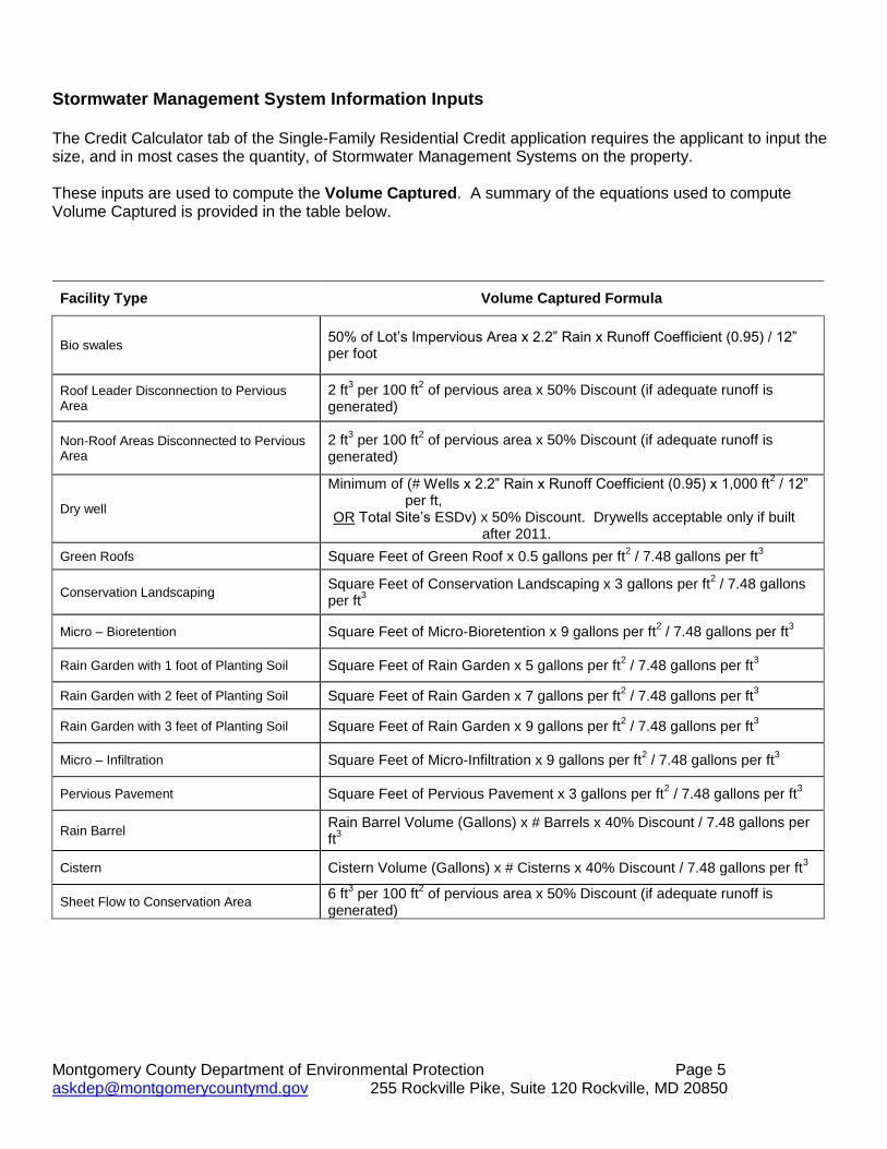
Stormwater Management System Information Inputs The Credit Calculator tab of the Single-Family Residential Credit application requires the applicant to input the size, and in most cases the quantity, of Stormwater Management Systems on the property. These inputs are used to compute the Volume Captured. A summary of the equations used to compute Volume Captured is provided in the table below.
Facility Type Volume Captured Formula
Bio swales 50% of Lot’s Impervious Area x 2.2” Rain x Runoff Coefficient (0.95) / 12” per foot
Roof Leader Disconnection to Pervious Area
2 ft3 per 100 ft
2 of pervious area x 50% Discount (if adequate runoff is
generated)
Non-Roof Areas Disconnected to Pervious Area
2 ft3 per 100 ft
2 of pervious area x 50% Discount (if adequate runoff is
generated)
Dry well
Minimum of (# Wells x 2.2” Rain x Runoff Coefficient (0.95) x 1,000 ft2 / 12”
per ft, OR Total Site’s ESDv) x 50% Discount. Drywells acceptable only if built
after 2011.
Green Roofs Square Feet of Green Roof x 0.5 gallons per ft2 / 7.48 gallons per ft
3
Conservation Landscaping Square Feet of Conservation Landscaping x 3 gallons per ft
2 / 7.48 gallons
per ft3
Micro – Bioretention Square Feet of Micro-Bioretention x 9 gallons per ft2 / 7.48 gallons per ft
3
Rain Garden with 1 foot of Planting Soil Square Feet of Rain Garden x 5 gallons per ft2 / 7.48 gallons per ft
3
Rain Garden with 2 feet of Planting Soil Square Feet of Rain Garden x 7 gallons per ft2 / 7.48 gallons per ft
3
Rain Garden with 3 feet of Planting Soil Square Feet of Rain Garden x 9 gallons per ft2 / 7.48 gallons per ft
3
Micro – Infiltration Square Feet of Micro-Infiltration x 9 gallons per ft2 / 7.48 gallons per ft
3
Pervious Pavement Square Feet of Pervious Pavement x 3 gallons per ft2 / 7.48 gallons per ft
3
Rain Barrel Rain Barrel Volume (Gallons) x # Barrels x 40% Discount / 7.48 gallons per ft
3
Cistern Cistern Volume (Gallons) x # Cisterns x 40% Discount / 7.48 gallons per ft3
Sheet Flow to Conservation Area 6 ft
3 per 100 ft
2 of pervious area x 50% Discount (if adequate runoff is
generated)
Montgomery County Department of Environmental Protection Page 6 [email protected] 255 Rockville Pike, Suite 120 Rockville, MD 20850
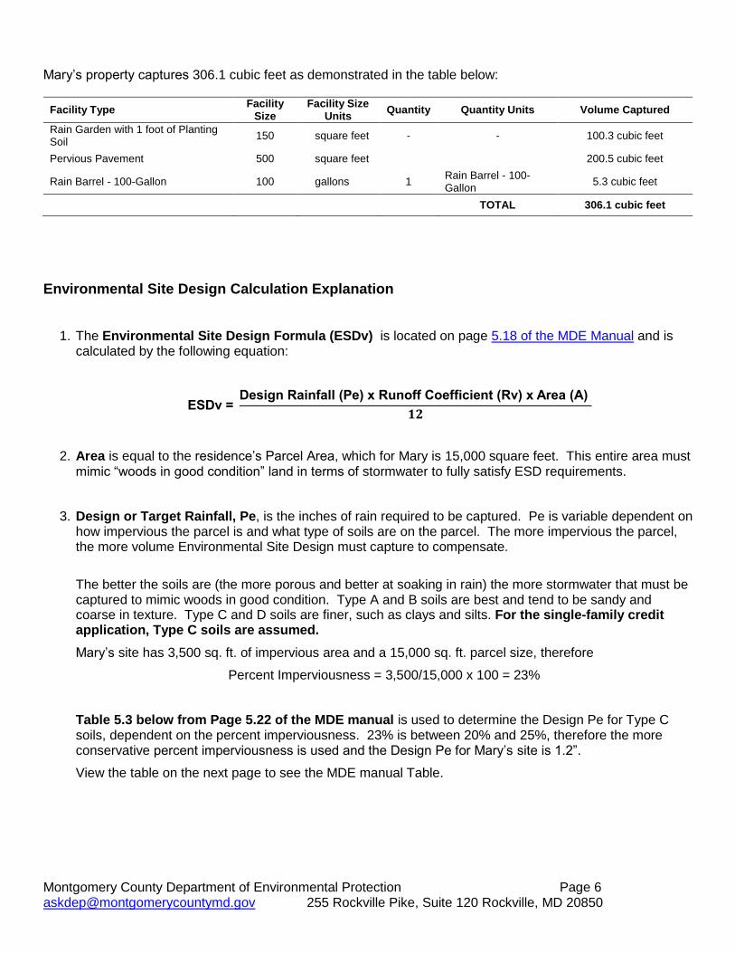
Mary’s property captures 306.1 cubic feet as demonstrated in the table below:
Facility Type Facility
Size Facility Size
Units Quantity Quantity Units Volume Captured
Rain Garden with 1 foot of Planting Soil
150 square feet - - 100.3 cubic feet
Pervious Pavement 500 square feet
200.5 cubic feet
Rain Barrel - 100-Gallon 100 gallons 1 Rain Barrel - 100-Gallon
5.3 cubic feet
TOTAL 306.1 cubic feet
Environmental Site Design Calculation Explanation
1. The Environmental Site Design Formula (ESDv) is located on page 5.18 of the MDE Manual and is calculated by the following equation:
ESDv Design Rainfall Pe Runoff Coefficient Rv Area A
2. Area is equal to the residence’s Parcel Area, which for Mary is 15,000 square feet. This entire area must mimic “woods in good condition” land in terms of stormwater to fully satisfy ESD requirements.
3. Design or Target Rainfall, Pe, is the inches of rain required to be captured. Pe is variable dependent on how impervious the parcel is and what type of soils are on the parcel. The more impervious the parcel, the more volume Environmental Site Design must capture to compensate.
The better the soils are (the more porous and better at soaking in rain) the more stormwater that must be captured to mimic woods in good condition. Type A and B soils are best and tend to be sandy and coarse in texture. Type C and D soils are finer, such as clays and silts. For the single-family credit application, Type C soils are assumed.
Mary’s site has 3,500 sq. ft. of impervious area and a 15,000 sq. ft. parcel size, therefore
Percent Imperviousness = 3,500/15,000 x 100 = 23%
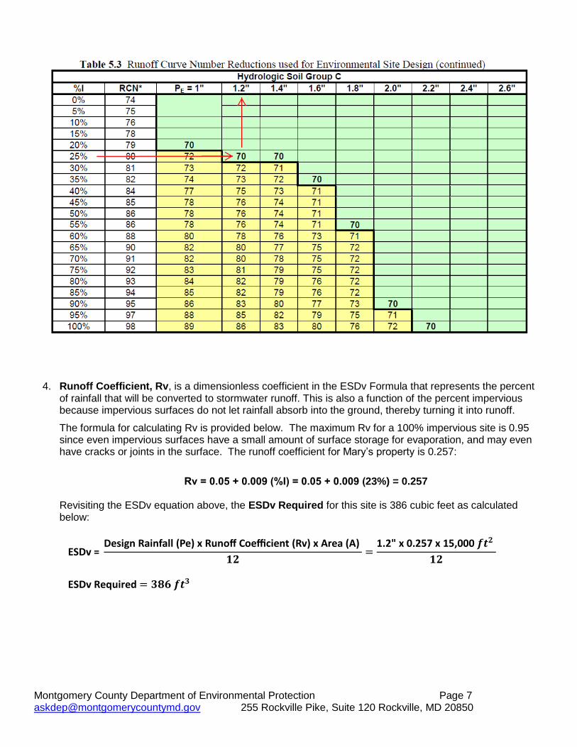
Table 5.3 below from Page 5.22 of the MDE manual is used to determine the Design Pe for Type C soils, dependent on the percent imperviousness. 23% is between 20% and 25%, therefore the more conservative percent imperviousness is used and the Design Pe for Mary’s site is 1.2”.
View the table on the next page to see the MDE manual Table.
Montgomery County Department of Environmental Protection Page 7 [email protected] 255 Rockville Pike, Suite 120 Rockville, MD 20850
4. Runoff Coefficient, Rv, is a dimensionless coefficient in the ESDv Formula that represents the percent of rainfall that will be converted to stormwater runoff. This is also a function of the percent impervious because impervious surfaces do not let rainfall absorb into the ground, thereby turning it into runoff.
The formula for calculating Rv is provided below. The maximum Rv for a 100% impervious site is 0.95 since even impervious surfaces have a small amount of surface storage for evaporation, and may even have cracks or joints in the surface. The runoff coefficient for Mary’s property is 0.257:
Rv I 23%) = 0.257
Revisiting the ESDv equation above, the ESDv Required for this site is 386 cubic feet as calculated below:
ESDv Required

Montgomery County Department of Environmental Protection Page 8 [email protected] 255 Rockville Pike, Suite 120 Rockville, MD 20850
Volume Captured and Credit Calculation
1. Volume Captured is the sum of the volume captured from the property’s ESD stormwater management systems. For Mary’s property, the Volume Captured is the sum of what is captured from the Rain Garden, Pervious Pavement Driveway, and 100-Gallon Rain Barrel, totaling to 306.14 cubic feet.
2. The WQPC Credit is calculated by the ratio of the Volume Captured to the ESDv Required times the maximum Single-family Residential Credit of 50%. In this example the parcel receives a 39.66% WQPC Credit:
WQPC Credit Volume Provided
ESDv Re uired Ma imum Credit