Embed Size (px)
Citation preview
WGC©08_Zikes_TP_878387-9 3/20/07 5:29 PM Page i
Copyright © by The McGraw-Hill Companies, Inc. All rights reserved. Permission is granted to reproduce the material contained herein on the condition that such material be reproduced only for classroom use; be provided to students, teachers, and families without charge; and be used solely in conjunction with World Geography and Cultures. Any other reproduction, for use or sale, is prohibited without prior written permission of the publisher.
Send all inquiries to:Glencoe/McGraw-Hill8787 Orion PlaceColumbus, OH 43240-4027
ISBN: 978-0-07-878387-6MHID: 0-07-878387-9
Printed in the United States of America
1 2 3 4 5 6 7 8 9 10 047 10 09 08 07
ii-42_RSGF_878387 3/20/07 6:39 PM Page ii
Letter From Dinah Zike . . . . . . . . . . . . . . . . . . . . . . . . 1
Introduction to FoldablesWhy Use Foldables in World Geography? . . . . . . . . . 2Foldable Basics . . . . . . . . . . . . . . . . . . . . . . . . . . . . . . . 3
Folding InstructionsBasic Foldable Shapes . . . . . . . . . . . . . . .5Half-Book . . . . . . . . . . . . . . . . . . . . . . . . .6Folded Book . . . . . . . . . . . . . . . . . . . . . . .7Three-Quarter Book . . . . . . . . . . . . . . . . .8Bound Book . . . . . . . . . . . . . . . . . . . . . . .9Picture-Frame Book . . . . . . . . . . . . . . . .10Two-Tab Book . . . . . . . . . . . . . . . . . . . . .11Pocket Book . . . . . . . . . . . . . . . . . . . . . .12Matchbook . . . . . . . . . . . . . . . . . . . . . . .13Shutter Fold . . . . . . . . . . . . . . . . . . . . . .14Forward-Backward Book . . . . . . . . . . . .15Three-Tab Book . . . . . . . . . . . . . . . . . . . .16Three-Tab Book Variations . . . . . . . . . .17Pyramid Fold . . . . . . . . . . . . . . . . . . . . .18Trifold Book . . . . . . . . . . . . . . . . . . . . . .19Three-Pocket Book . . . . . . . . . . . . . . . . .20Four-Tab Book . . . . . . . . . . . . . . . . . . . .21Standing Cube . . . . . . . . . . . . . . . . . . . .22
Four-Door Book . . . . . . . . . . . . . . . . . . .23Envelope Fold . . . . . . . . . . . . . . . . . . . . .24Layered-Look Book . . . . . . . . . . . . . . . .25Top-Tab Book . . . . . . . . . . . . . . . . . . . . .26Folding a Circle into Tenths . . . . . . . . .28Circle Graph . . . . . . . . . . . . . . . . . . . . . .29Folding into Fifths . . . . . . . . . . . . . . . . .30Folded Table or Chart . . . . . . . . . . . . . .31Accordion Book . . . . . . . . . . . . . . . . . . .32Pop-Up Book . . . . . . . . . . . . . . . . . . . . .33Four-Door Diorama . . . . . . . . . . . . . . . .34Concept-Map Book . . . . . . . . . . . . . . . .35Project Board with Tabs . . . . . . . . . . . . .36Billboard Project . . . . . . . . . . . . . . . . . . .37Vocabulary Book . . . . . . . . . . . . . . . . . .38Sentence Strips . . . . . . . . . . . . . . . . . . . .39Sentence-Strip Holder . . . . . . . . . . . . . .40
Table of Contents
iii
ii-42_RSGF_878387 3/20/07 6:39 PM Page iii

iv
Chapter-Specific Foldables1 How Geographers Look at the World . . . . . . . . . . . . . . . . . .432 The Physical World . . . . . . . . . . . . . . . . . . . . . . . . . . . . . . . . .443 Climates of the Earth . . . . . . . . . . . . . . . . . . . . . . . . . . . . . . .454 The Human World . . . . . . . . . . . . . . . . . . . . . . . . . . . . . . . . .465 Physical Geography of
the United States and Canada . . . . . . . . . . . . . . . . . . . . . . .476 Cultural Geography of
the United States and Canada . . . . . . . . . . . . . . . . . . . . . . .487 The Region Today: The United States and Canada . . . . . . .498 Physical Geography of Latin America . . . . . . . . . . . . . . . . . .509 Cultural Geography of Latin America . . . . . . . . . . . . . . . . .51
10 The Region Today: Latin America . . . . . . . . . . . . . . . . . . . . .5211 Physical Geography of Europe . . . . . . . . . . . . . . . . . . . . . . .5312 Cultural Geography of Europe . . . . . . . . . . . . . . . . . . . . . . .5413 The Region Today: Europe . . . . . . . . . . . . . . . . . . . . . . . . . . .5514 Physical Geography of Russia . . . . . . . . . . . . . . . . . . . . . . . .5615 Cultural Geography of Russia . . . . . . . . . . . . . . . . . . . . . . . .5716 The Region Today: Russia . . . . . . . . . . . . . . . . . . . . . . . . . . .5817 Physical Geography of North Africa,
Southwest Asia, and Central Asia . . . . . . . . . . . . . . . . . . . .5918 Cultural Geography of North Africa,
Southwest Asia, and Central Asia . . . . . . . . . . . . . . . . . . . .6019 The Region Today: North Africa, Southwest Asia,
and Central Asia . . . . . . . . . . . . . . . . . . . . . . . . . . . . . . . . . .6120 Physical Geography of Africa South of the Sahara . . . . . . .6221 Cultural Geography of Africa South of the Sahara . . . . . . .6322 The Region Today: Africa South of the Sahara . . . . . . . . . . .6423 Physical Geography of South Asia . . . . . . . . . . . . . . . . . . . .6524 Cultural Geography of South Asia . . . . . . . . . . . . . . . . . . . .6625 The Region Today: South Asia . . . . . . . . . . . . . . . . . . . . . . . .6726 Physical Geography of East Asia . . . . . . . . . . . . . . . . . . . . . .6827 Cultural Geography of East Asia . . . . . . . . . . . . . . . . . . . . . .6928 The Region Today: East Asia . . . . . . . . . . . . . . . . . . . . . . . . .7029 Physical Geography of Southeast Asia . . . . . . . . . . . . . . . . .7130 Cultural Geography of Southeast Asia . . . . . . . . . . . . . . . . .7231 The Region Today: Southeast Asia . . . . . . . . . . . . . . . . . . . .7332 Physical Geography of Australia, Oceania,
and Antarctica . . . . . . . . . . . . . . . . . . . . . . . . . . . . . . . . . . . .7433 Cultural Geography of Australia and Oceania . . . . . . . . . .7534 The Region Today: Australia and Oceania . . . . . . . . . . . . . .76
TABLE OF CONTENTS
ii-42_RSGF_878387 3/20/07 6:39 PM Page iv
1
Dear Teacher,What’s a Foldable?
A Foldable is a three-dimensional, student-made, interactivegraphic organizer based upon a skill. Making a Foldable givesstudents a fast, kinesthetic activity that helps them organize andretain information. Every chapter of the textbook begins with a noteto use a Foldable as a study organizer. Each chapter’s Foldables inthis booklet are designed to be used as study guides for the mainideas and key points presented in sections of the chapter. Foldablescan also be used for a more in-depth investigation of a concept, idea,opinion, event, person, or place studied in a chapter. The purpose of this ancillary is to showyou how to create various types of Foldables and provide chapter-specific Foldables examples.With this information, you can individualize Foldables to meet your curriculum needs.
This book is divided into two sections. The first section presents step-by-step instructions,illustrations, and photographs of 34 Foldables. I’ve included more than 100 photographs to helpyou visualize ways in which they might enhance instruction. The second section presents ideason how to use Foldables for each chapter in the textbook. You can use the instruction section todesign your own Foldables or alter the Foldables presented in each chapter. I suggest makingthis book available as a resource for students who wish to learn new and creative ways to makestudy guides, present projects, or do extra-credit work.
Who Am I?You may have seen Foldables featured in this book used in supplemental programs or staff-
development workshops. Today my Foldables are used internationally. I present workshops andkeynote addresses to more than fifty thousand teachers and parents a year, sharing Foldablesthat I began inventing, designing, and adapting over thirty-five years ago. Students of all agesare using them for daily work, note-taking activities, student-directed projects, as forms ofalternative assessment, journals, graphs, charts, tables, and more.
Have fun using and adapting Foldables,
For more information on Foldables, visit http://www.dinah.com or call 1-800-99DINAH.
FROM DINAH ZIKE
ii-42_RSGF_878387 3/20/07 6:39 PM Page 1
2
Why Use Foldables in World Geography?When teachers ask me why they should take time to use the Foldables featured in this book, I
explain that they
. . . quickly organize, display, and arrange data, making it easier for students to graspgeography concepts, theories, facts, opinions, questions, research, and ideas. They alsohelp sequence events as outlined in the content standards.
. . . result in student-made study guides that are compiled as students listen for main ideas,read for main ideas, or conduct research.
. . . provide a multitude of creative formats in which students can present projects, research,interviews, and inquiry-based reports instead of typical poster board formats.
. . . replace teacher-generated writing or photocopied sheets with student-generated print.
. . . incorporate the use of such skills as comparing and contrasting, recognizing cause andeffect, and finding similarities and differences into daily work and long-term projects. Forexample, these Foldables can be used to compare and contrast student explanationsand/or opinions to explanations and/or opinions currently accepted by experts in the fieldof geography.
. . . continue to “immerse” students in previously learned vocabulary, concepts, information,generalizations, ideas, and theories, providing them with a strong foundation that they canbuild upon with new observations, concepts, and knowledge.
. . . can be used by students or teachers to easily communicate data through graphs, tables,charts, models, and diagrams, including Venn diagrams.
. . . allow students to make their own journals for recording observations, researchinformation, primary and secondary source data, surveys, and more.
. . . can be used as alternative assessment tools by teachers to evaluate student progress or bystudents to evaluate their own progress.
. . . integrate language arts, science, mathematics, and social studies into the study ofgeography.
. . . provide a sense of student ownership or investment in the geography curriculum.
INTRODUCTION TO FOLDABLES
ii-42_RSGF_878387 3/20/07 6:39 PM Page 2

Venn Diagram used for assessmentVenn Diagram used as a study guide
3
Foldable BasicsWhat to Write and WhereTeach students to write general information such as titles, vocabulary words, concepts, questions,main ideas, and dates on the front tabs of their Foldables. This way students can easily recognizemain ideas and important concepts. Foldables help students focus on and remember key pointswithout being distracted by other print.
Ask students to write specific information such as supporting ideas, student thoughts, answersto questions, research information, class notes, observations, and definitions under the tabs.
As you teach, demonstrate different ways in which Foldables can be used. Soon you will findthat students make their own Foldables and use them independently for study guides andprojects.
With or Without TabsFoldables with flaps or tabs create study guides that students can use to self check what theyknow about the general information on the front of tabs. Use Foldables without tabs forassessment purposes or projects where information is presented for others to view quickly.
INTRODUCTION TO FOLDABLESCo
pyrig
ht ©
Gle
ncoe
/McG
raw
-Hill
, a d
ivis
ion
of T
he M
cGra
w-H
ill C
ompa
nies
, Inc
.
ii-42_RSGF_878387 3/20/07 6:39 PM Page 3
4
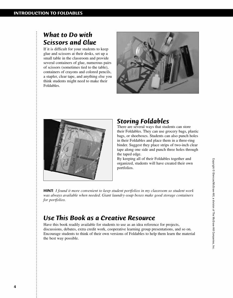
What to Do with Scissors and GlueIf it is difficult for your students to keepglue and scissors at their desks, set up asmall table in the classroom and provideseveral containers of glue, numerous pairsof scissors (sometimes tied to the table),containers of crayons and colored pencils,a stapler, clear tape, and anything else youthink students might need to make theirFoldables.
Storing FoldablesThere are several ways that students can storetheir Foldables. They can use grocery bags, plasticbags, or shoeboxes. Students can also punch holesin their Foldables and place them in a three-ringbinder. Suggest they place strips of two-inch cleartape along one side and punch three holes throughthe taped edge.By keeping all of their Foldables together andorganized, students will have created their ownportfolios.
HINT: I found it more convenient to keep student portfolios in my classroom so student workwas always available when needed. Giant laundry-soap boxes make good storage containersfor portfolios.
Use This Book as a Creative ResourceHave this book readily available for students to use as an idea reference for projects,discussions, debates, extra credit work, cooperative learning group presentations, and so on.Encourage students to think of their own versions of Foldables to help them learn the materialthe best way possible.
INTRODUCTION TO FOLDABLESCopyright ©
Glencoe/M
cGraw
-Hill, a division of The M
cGraw
-Hill Com
panies, Inc.
ii-42_RSGF_878387 3/20/07 6:39 PM Page 4

5
Basic Foldable ShapesThe following figures illustrate the basic folds that are referred to throughout the followingsection of this book
FOLDING INSTRUCTIONSCo
pyrig
ht ©
Gle
ncoe
/McG
raw
-Hill
, a d
ivis
ion
of T
he M
cGra
w-H
ill C
ompa
nies
, Inc
.
Taco Fold Hamburger Fold
Hot Dog Fold
Shutter Fold
Burrito Fold
Valley Fold
Mountain Fold
ii-42_RSGF_878387 3/20/07 6:39 PM Page 5
6
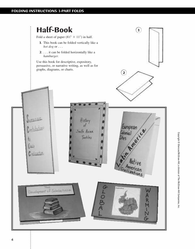
Half-BookFold a sheet of paper (81⁄2" � 11") in half.
1. This book can be folded vertically like a hot dog or . . .
2. . . . it can be folded horizontally like ahamburger.
Use this book for descriptive, expository,persuasive, or narrative writing, as well as forgraphs, diagrams, or charts.
FOLDING INSTRUCTIONS: 1-PART FOLDSCopyright ©
Glencoe/M
cGraw
-Hill, a division of The M
cGraw
-Hill Com
panies, Inc.
2
1
ii-42_RSGF_878387 3/20/07 6:39 PM Page 6

1
2
When folded, the worksheet becomes abook for recording notes and questions.
7
Folded Book1. Make a half-book.
2. Fold it in half again like a hamburger. Thismakes a ready-made cover with two smallpages for information on the inside.
You can make this Foldable with a previouslygraded work sheet. One sheet of paper will haveserved for two graded activities.
FOLDING INSTRUCTIONS: 1-PART FOLDSCo
pyrig
ht ©
Gle
ncoe
/McG
raw
-Hill
, a d
ivis
ion
of T
he M
cGra
w-H
ill C
ompa
nies
, Inc
.
ii-42_RSGF_878387 3/20/07 6:39 PM Page 7

Copyright © G
lencoe/McG
raw-H
ill, a division of The McG
raw-H
ill Companies, Inc.
8
Three-Quarter Book1. Take a two-tab book and raise the left-hand
tab.
2. Cut the tab off at the top fold line.
3. A larger book of information can be made bygluing several three-quarter books side-by-side.
Sketch or glue a graphic onto the left, write one ormore questions on the right, and record answersand information under the right tab.
FOLDING INSTRUCTIONS: 1-PART FOLDS
1
2
ii-42_RSGF_878387 3/20/07 6:39 PM Page 8
9
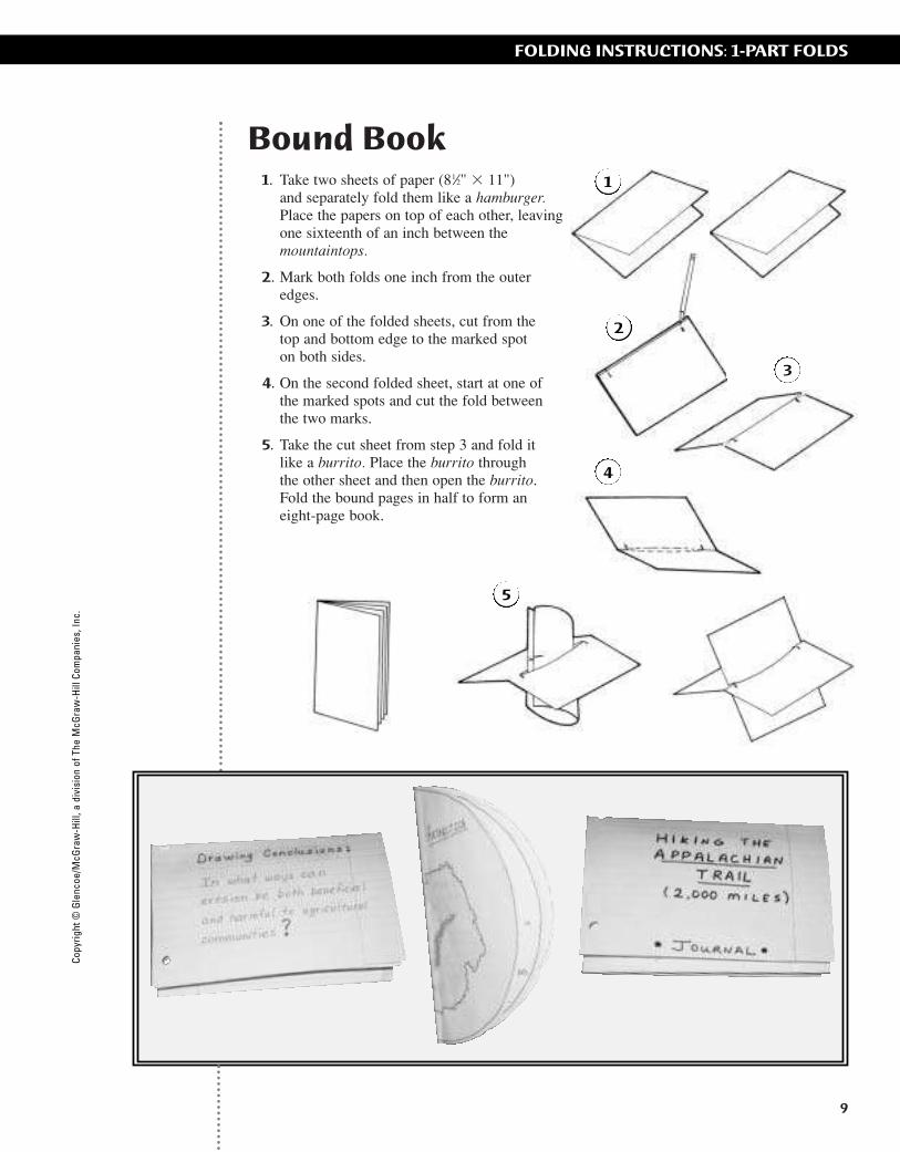
Bound Book1. Take two sheets of paper (81⁄2" � 11")
and separately fold them like a hamburger.Place the papers on top of each other, leavingone sixteenth of an inch between themountaintops.
2. Mark both folds one inch from the outeredges.
3. On one of the folded sheets, cut from the top and bottom edge to the marked spot on both sides.
4. On the second folded sheet, start at one ofthe marked spots and cut the fold betweenthe two marks.
5. Take the cut sheet from step 3 and fold it like a burrito. Place the burrito through the other sheet and then open the burrito.Fold the bound pages in half to form aneight-page book.
FOLDING INSTRUCTIONS: 1-PART FOLDSCo
pyrig
ht ©
Gle
ncoe
/McG
raw
-Hill
, a d
ivis
ion
of T
he M
cGra
w-H
ill C
ompa
nies
, Inc
.
1
2
4
5
3
2
ii-42_RSGF_878387 3/20/07 6:39 PM Page 9
Copyright © G
lencoe/McG
raw-H
ill, a division of The McG
raw-H
ill Companies, Inc.
10
FOLDING INSTRUCTIONS: 1-PART FOLDS
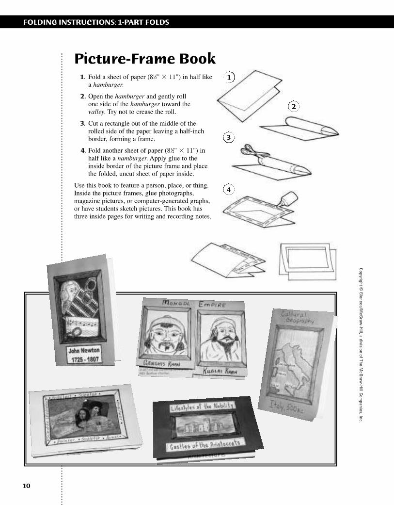
Picture-Frame Book1. Fold a sheet of paper (81⁄2" � 11") in half like
a hamburger.
2. Open the hamburger and gently roll one side of the hamburger toward the valley. Try not to crease the roll.
3. Cut a rectangle out of the middle of therolled side of the paper leaving a half-inchborder, forming a frame.
4. Fold another sheet of paper (81⁄2" � 11") inhalf like a hamburger. Apply glue to theinside border of the picture frame and placethe folded, uncut sheet of paper inside.
Use this book to feature a person, place, or thing.Inside the picture frames, glue photographs,magazine pictures, or computer-generated graphs,or have students sketch pictures. This book hasthree inside pages for writing and recording notes.
1
2
3
4
ii-42_RSGF_878387 3/20/07 6:39 PM Page 10
Copy
right
© G
lenc
oe/M
cGra
w-H
ill, a
div
isio
n of
The
McG
raw
-Hill
Com
pani
es, I
nc.
11
FOLDING INSTRUCTIONS: 2-PART FOLDS
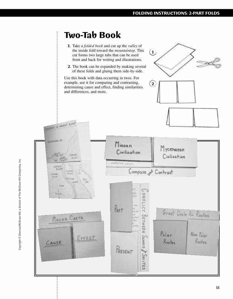
Two-Tab Book1. Take a folded book and cut up the valley of
the inside fold toward the mountaintop. Thiscut forms two large tabs that can be usedfront and back for writing and illustrations.
2. The book can be expanded by making severalof these folds and gluing them side-by-side.
Use this book with data occurring in twos. Forexample, use it for comparing and contrasting,determining cause and effect, finding similaritiesand differences, and more.
1
2
ii-42_RSGF_878387 3/20/07 6:39 PM Page 11
Copyright © G
lencoe/McG
raw-H
ill, a division of The McG
raw-H
ill Companies, Inc.
12
FOLDING INSTRUCTIONS: 2-PART FOLDS
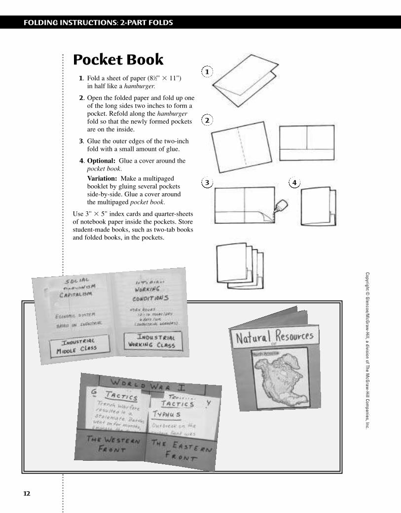
Pocket Book1. Fold a sheet of paper (81⁄2" � 11")
in half like a hamburger.
2. Open the folded paper and fold up oneof the long sides two inches to form a pocket. Refold along the hamburgerfold so that the newly formed pocketsare on the inside.
3. Glue the outer edges of the two-inch fold with a small amount of glue.
4. Optional: Glue a cover around the pocket book.
Variation: Make a multipaged booklet by gluing several pockets side-by-side. Glue a cover around the multipaged pocket book.
Use 3" � 5" index cards and quarter-sheets of notebook paper inside the pockets. Store student-made books, such as two-tab books and folded books, in the pockets.
1
2
3 4
ii-42_RSGF_878387 3/20/07 6:39 PM Page 12

Copy
right
© G
lenc
oe/M
cGra
w-H
ill, a
div
isio
n of
The
McG
raw
-Hill
Com
pani
es, I
nc.
Matchbook1. Fold a sheet of paper (81⁄2" � 11")
like a hamburger, but fold it so that one side is one inch longer than the other side.
2. Fold the one-inch tab over the short sideforming an envelope-like fold.
3. Cut the front flap in half toward the mountaintop to create two flaps.
Use this book to report on one thing, such as one person, place, or thing, or for reporting on twothings.
1
2
3
13
FOLDING INSTRUCTIONS: 2-PART FOLDS
ii-42_RSGF_878387 3/20/07 6:39 PM Page 13

Copyright © G
lencoe/McG
raw-H
ill, a division of The McG
raw-H
ill Companies, Inc.
14
FOLDING INSTRUCTIONS: 2-PART FOLDS
Shutter Fold1. Begin as if you were going to make a
hamburger, but instead of creasing the paper,pinch it to show the midpoint.
2. Fold the outer edges of the paper to meet atthe pinch, or mid-point, forming a shutterfold.
Use this book for data occurring in twos. Or, makethis fold using 11" � 17" paper and smallerbooks—such as the half-book, journal, and two-tab book—that can be glued inside to create alarge project full of student work.
1
2
ii-42_RSGF_878387 3/20/07 6:39 PM Page 14
Copy
right
© G
lenc
oe/M
cGra
w-H
ill, a
div
isio
n of
The
McG
raw
-Hill
Com
pani
es, I
nc.
15
FOLDING INSTRUCTIONS: 2-PART FOLDS
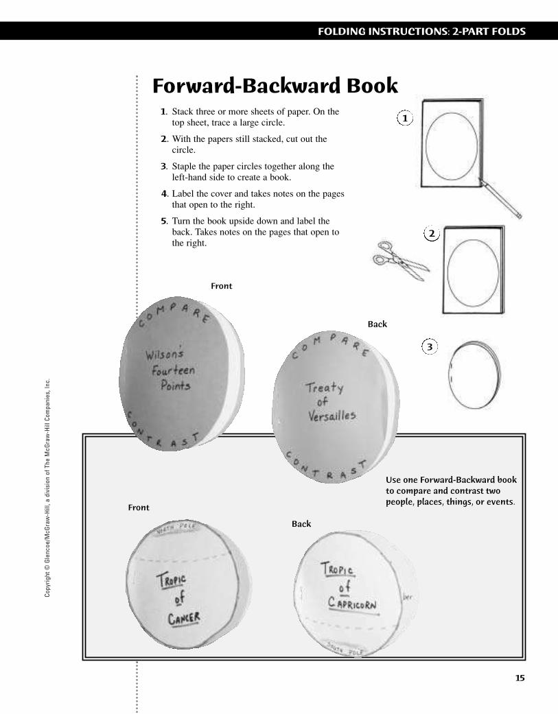
Forward-Backward Book1. Stack three or more sheets of paper. On the
top sheet, trace a large circle.
2. With the papers still stacked, cut out thecircle.
3. Staple the paper circles together along theleft-hand side to create a book.
4. Label the cover and takes notes on the pagesthat open to the right.
5. Turn the book upside down and label theback. Takes notes on the pages that open tothe right.
1
2
3
Front
Back
Use one Forward-Backward bookto compare and contrast two people, places, things, or events.
Front
Back
ii-42_RSGF_878387 3/20/07 6:39 PM Page 15
Copyright © G
lencoe/McG
raw-H
ill, a division of The McG
raw-H
ill Companies, Inc.
16
FOLDING INSTRUCTIONS: 3-PART FOLDS
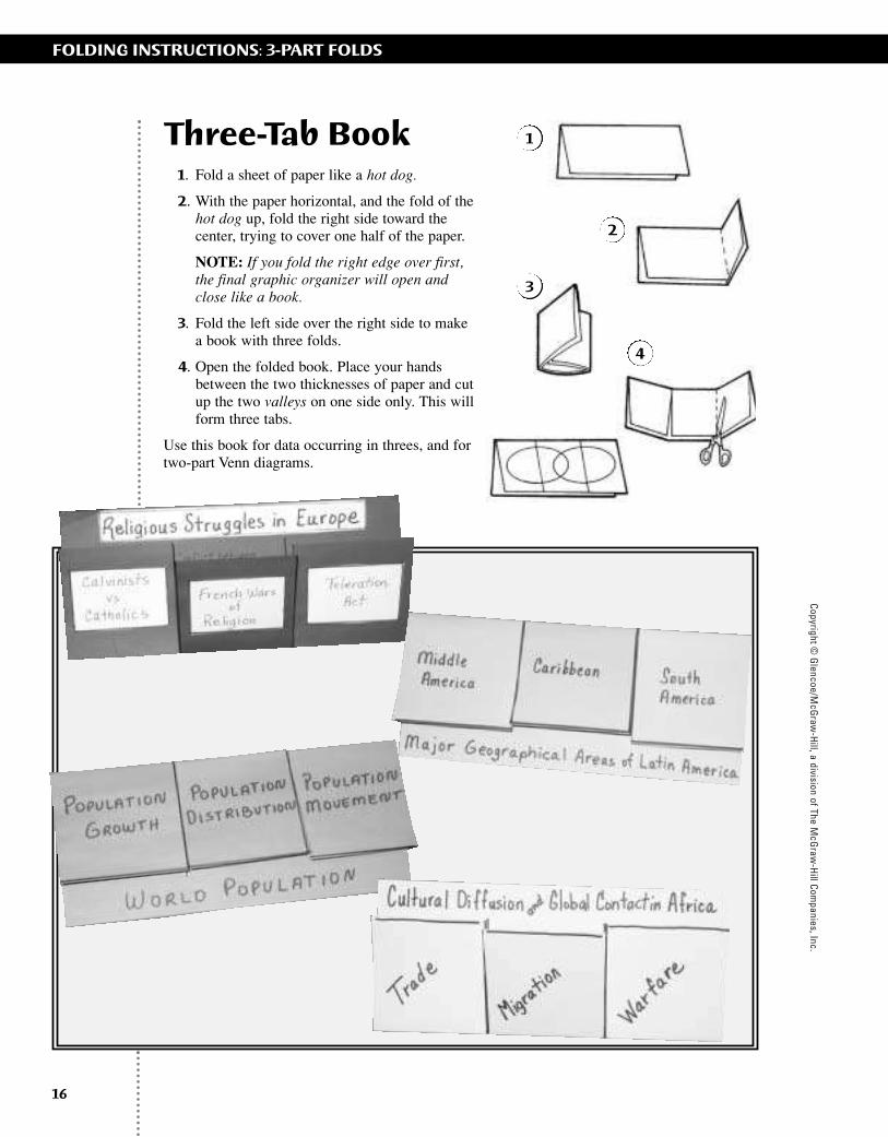
Three-Tab Book1. Fold a sheet of paper like a hot dog.
2. With the paper horizontal, and the fold of thehot dog up, fold the right side toward thecenter, trying to cover one half of the paper.
NOTE: If you fold the right edge over first,the final graphic organizer will open andclose like a book.
3. Fold the left side over the right side to makea book with three folds.
4. Open the folded book. Place your handsbetween the two thicknesses of paper and cutup the two valleys on one side only. This willform three tabs.
Use this book for data occurring in threes, and fortwo-part Venn diagrams.
1
2
3
4
ii-42_RSGF_878387 3/20/07 6:39 PM Page 16
Copy
right
© G
lenc
oe/M
cGra
w-H
ill, a
div
isio
n of
The
McG
raw
-Hill
Com
pani
es, I
nc.
17
FOLDING INSTRUCTIONS: 3-PART FOLDS
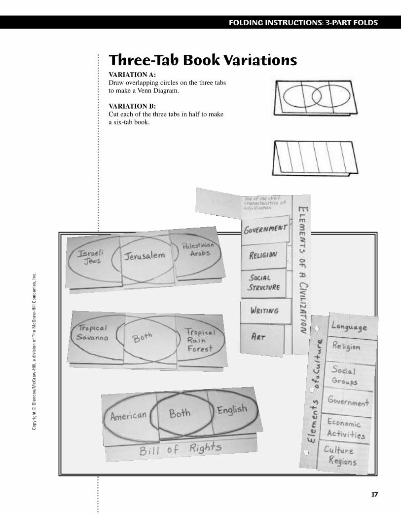
Three-Tab Book VariationsVARIATION A:Draw overlapping circles on the three tabsto make a Venn Diagram.
VARIATION B:Cut each of the three tabs in half to makea six-tab book.
ii-42_RSGF_878387 3/20/07 6:39 PM Page 17
Copyright © G
lencoe/McG
raw-H
ill, a division of The McG
raw-H
ill Companies, Inc.
18
FOLDING INSTRUCTIONS: 3-PART FOLDS
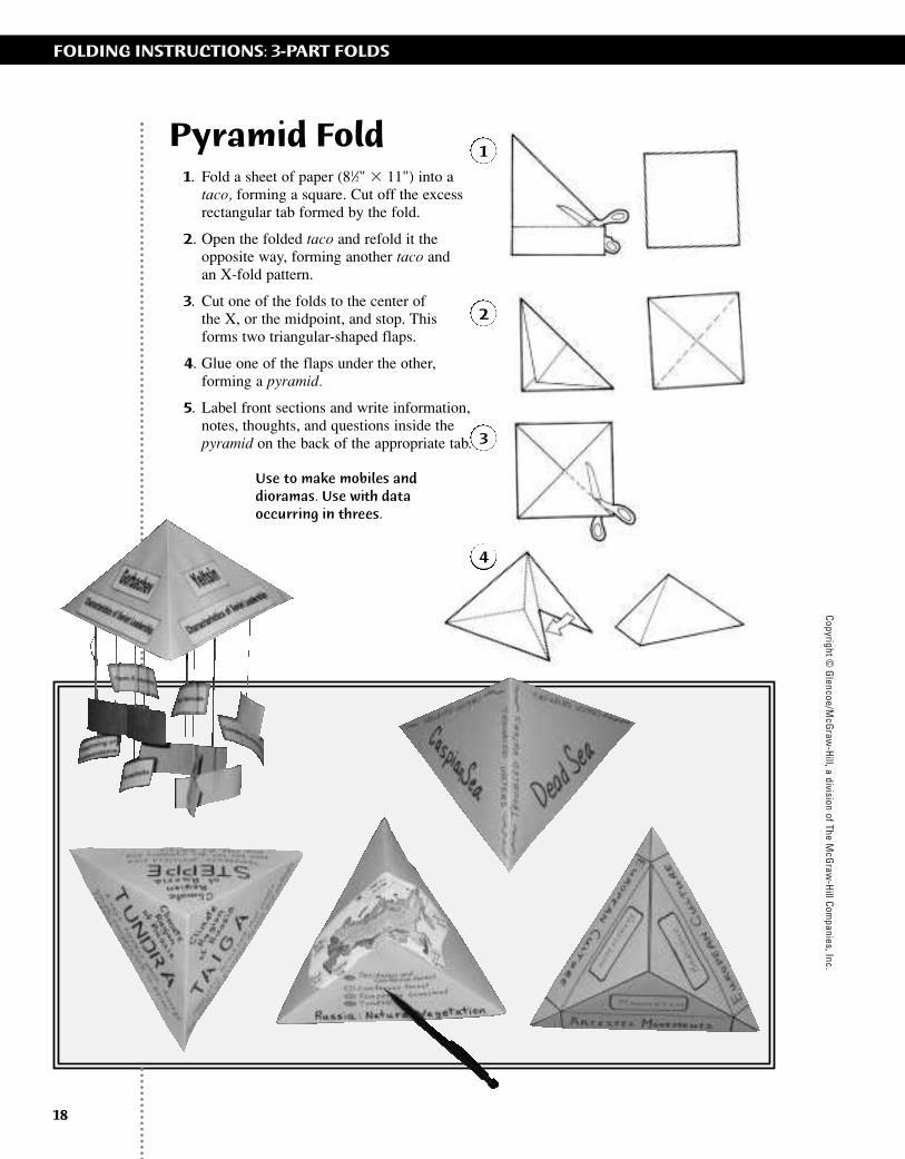
Pyramid Fold1. Fold a sheet of paper (81⁄2" � 11") into a
taco, forming a square. Cut off the excessrectangular tab formed by the fold.
2. Open the folded taco and refold it theopposite way, forming another taco and an X-fold pattern.
3. Cut one of the folds to the center of the X, or the midpoint, and stop. This forms two triangular-shaped flaps.
4. Glue one of the flaps under the other,forming a pyramid.
5. Label front sections and write information,notes, thoughts, and questions inside thepyramid on the back of the appropriate tab.
1
2
3
4
Record data insidethe pyramid.
Use to make mobiles anddioramas. Use with dataoccurring in threes.
ii-42_RSGF_878387 3/20/07 6:39 PM Page 18

Copy
right
© G
lenc
oe/M
cGra
w-H
ill, a
div
isio
n of
The
McG
raw
-Hill
Com
pani
es, I
nc.
19
FOLDING INSTRUCTIONS: 3-PART FOLDS
Trifold Book1. Fold a sheet of paper (81⁄2" � 11") into thirds.
2. Use this book as is, or cut into shapes. If thetrifold is cut, leave plenty of fold on bothsides of the designed shape, so the book willopen and close in three sections.
Use this book to make charts with three columnsor rows, large Venn diagrams, and reports on dataoccurring in threes.
1
2
ii-42_RSGF_878387 3/20/07 6:39 PM Page 19

Copyright © G
lencoe/McG
raw-H
ill, a division of The McG
raw-H
ill Companies, Inc.
20
FOLDING INSTRUCTIONS: 3-PART FOLDS
Three-Pocket Book1. Fold a horizontal sheet of paper (11" � 17")
into thirds.
2. Fold the bottom edge up two inches andcrease well. Glue the outer edges of the two-inch tab to create three pockets.
3. Label each pocket. Use to hold notes takenon index cards or quarter sheets of paper.
1
2
3
ii-42_RSGF_878387 3/20/07 6:39 PM Page 20
Copy
right
© G
lenc
oe/M
cGra
w-H
ill, a
div
isio
n of
The
McG
raw
-Hill
Com
pani
es, I
nc.
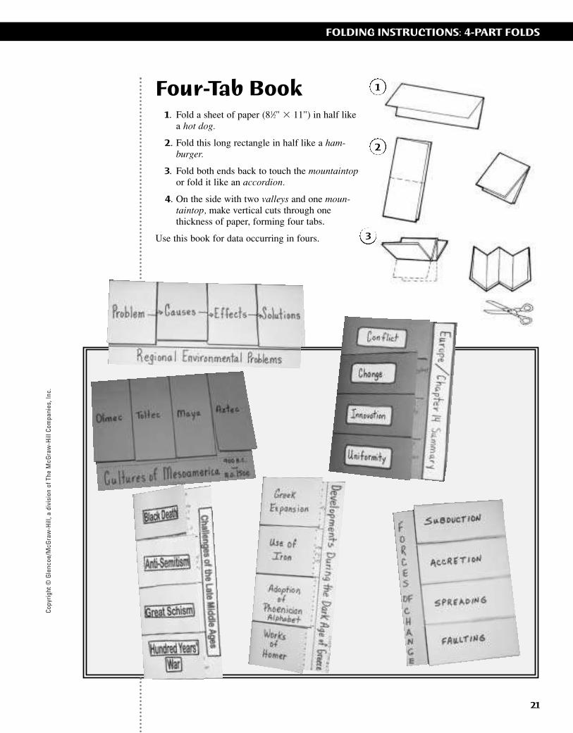
Four-Tab Book1. Fold a sheet of paper (81⁄2" � 11") in half like
a hot dog.
2. Fold this long rectangle in half like a ham-burger.
3. Fold both ends back to touch the mountaintopor fold it like an accordion.
4. On the side with two valleys and one moun-taintop, make vertical cuts through onethickness of paper, forming four tabs.
Use this book for data occurring in fours.
21
FOLDING INSTRUCTIONS: 4-PART FOLDS
1
2
3
ii-42_RSGF_878387 3/20/07 6:39 PM Page 21

Copyright © G
lencoe/McG
raw-H
ill, a division of The McG
raw-H
ill Companies, Inc.
22
FOLDING INSTRUCTIONS: 4-PART FOLDS
Standing Cube1. Use two sheets of the same size paper. Fold
each like a hamburger. However, fold oneside one-half inch shorter than the other side.This will make a tab that extends out one-half inch on one side.
2. Fold the long side over the short side of bothsheets of paper, making tabs.
3. On one of the folded papers, place a smallamount of glue along the the small foldedtab, next to the valley but not in it.
4. Place the non-folded edge of the second sheet of paper square into the valley and fold the glue-covered tab over this sheet of paper. Press flat until the glue holds.Repeat with the other side.
5. Allow the glue to dry completely beforecontinuing. After the glue has dried, the cubecan be collapsed flat to allow students towork at their desks. The cube can also befolded into fourths for easier storage, or formoving it to a display area.
Use with data occurring in fours or make it into a project. Make a small display cube using 81⁄2" � 11" paper. Use 11" � 17" paper to makelarge project cubes that you can glue other booksonto for display. Notebook paper, photocopiedsheets, magazine pictures, and current events alsocan be displayed on the large cube.
1
2
3
4
5
This large cube project can be stored in plastic bag portfolios.
ii-42_RSGF_878387 3/20/07 6:39 PM Page 22

Copy
right
© G
lenc
oe/M
cGra
w-H
ill, a
div
isio
n of
The
McG
raw
-Hill
Com
pani
es, I
nc.
23
FOLDING INSTRUCTIONS: 4-PART FOLDS
Four-Door Book1. Make a shutter fold using 11" � 17" or
12" � 18" paper.
2. Fold the shutter fold in half like a hamburger. Crease well.
3. Open the project and cut along the two inside valley folds.
4. These cuts will form four doors on the inside of the project.
Use this fold for data occurring in fours. When folded in half like a hamburger, a finished four-door book can be glued inside a large (11" � 17") shutter fold as part of a larger project.
1
3
4
2
ii-42_RSGF_878387 3/20/07 6:39 PM Page 23

Copyright © G
lencoe/McG
raw-H
ill, a division of The McG
raw-H
ill Companies, Inc.
24
FOLDING INSTRUCTIONS: 4-PART FOLDS
Envelope Fold1. Fold a sheet of paper (81⁄2" � 11") into a taco
forming a square. Cut off the excess paperstrip formed by the square.
2. Open the folded taco and refold it the oppo-site way, forming another taco and an X-foldpattern.
3. Open the taco fold and fold the cornerstoward the center point of the X, forming asmall square.
4. Trace this square on another sheet of paper.Cut and glue it to the inside of the envelope.Pictures can be placed under or on top of thetabs, or can be used to teach fractional parts.
Use this book for data occurring in fours.4
1
2
3
ii-42_RSGF_878387 3/20/07 6:39 PM Page 24
Copy
right
© G
lenc
oe/M
cGra
w-H
ill, a
div
isio
n of
The
McG
raw
-Hill
Com
pani
es, I
nc.
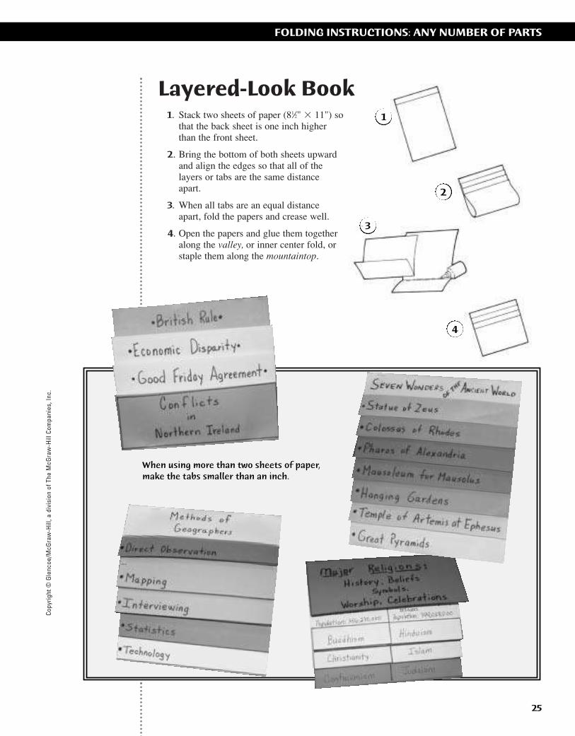
Layered-Look Book1. Stack two sheets of paper (81⁄2" � 11") so
that the back sheet is one inch higherthan the front sheet.
2. Bring the bottom of both sheets upward and align the edges so that all of thelayers or tabs are the same distanceapart.
3. When all tabs are an equal distanceapart, fold the papers and crease well.
4. Open the papers and glue them togetheralong the valley, or inner center fold, or staple them along the mountaintop.
25
FOLDING INSTRUCTIONS: ANY NUMBER OF PARTS
When using more than two sheets of paper,make the tabs smaller than an inch.
1
2
3
4
ii-42_RSGF_878387 3/20/07 6:39 PM Page 25

Copyright © G
lencoe/McG
raw-H
ill, a division of The McG
raw-H
ill Companies, Inc.
26
FOLDING INSTRUCTIONS: ANY NUMBER OF PARTS
Top-Tab Book1. Fold a sheet of paper (81⁄2" � 11") in
half like a hamburger. Cut the centerfold, forming two half sheets.
2. Fold one of the half sheets fourtimes. Begin by folding in half like a hamburger, fold again like a hamburger, and finally again like ahamburger. This folding has formedyour pattern of four rows and fourcolumns, or 16 small squares.
3. Fold two sheets of paper (81⁄2" �11") in half like a hamburger. Cutthe center folds, forming four halfsheets.
4. Hold the pattern vertically and placeon a half sheet of paper under thepattern. Cut the bottom right handsquare out of both sheets. Set thisfirst page aside.
5. Take a second half sheet of paperand place it under the pattern. Cutthe first and second right-handsquares out of both sheets. Place thesecond page on top of the first page.
1
2
4
5
3
ii-42_RSGF_878387 3/20/07 6:39 PM Page 26
Copy
right
© G
lenc
oe/M
cGra
w-H
ill, a
div
isio
n of
The
McG
raw
-Hill
Com
pani
es, I
nc.
27
FOLDING INSTRUCTIONS: ANY NUMBER OF PARTS
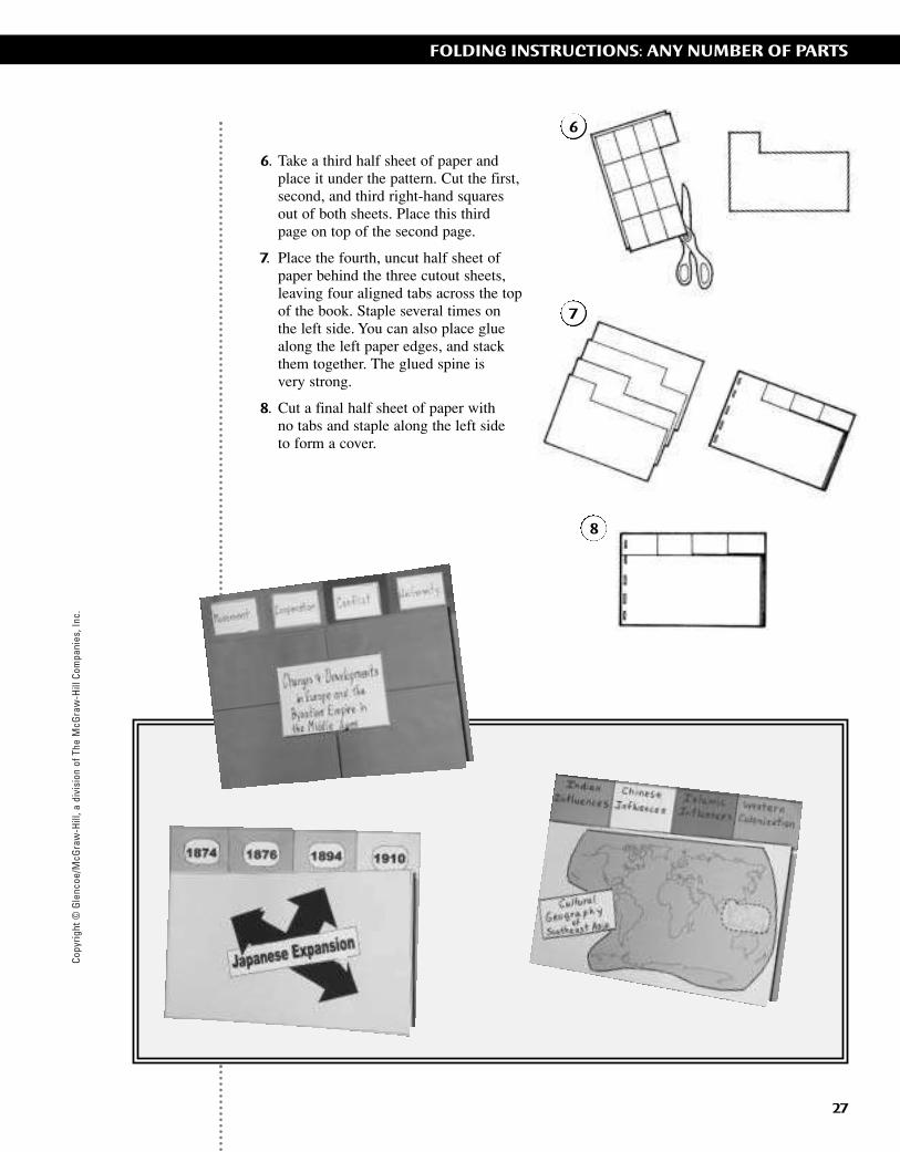
6. Take a third half sheet of paper and place it under the pattern. Cut the first,second, and third right-hand squares out of both sheets. Place this third page on top of the second page.
7. Place the fourth, uncut half sheet of paper behind the three cutout sheets,leaving four aligned tabs across the top of the book. Staple several times on the left side. You can also place glue along the left paper edges, and stack them together. The glued spine is very strong.
8. Cut a final half sheet of paper with no tabs and staple along the left side to form a cover.
6
7
8
ii-42_RSGF_878387 3/20/07 6:39 PM Page 27
Copyright © G
lencoe/McG
raw-H
ill, a division of The McG
raw-H
ill Companies, Inc.
28
FOLDING INSTRUCTIONS: ANY NUMBER OF PARTS
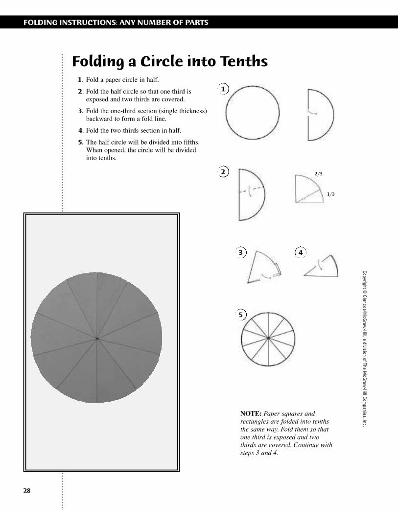
Folding a Circle into Tenths1. Fold a paper circle in half.
2. Fold the half circle so that one third isexposed and two thirds are covered.
3. Fold the one-third section (single thickness)backward to form a fold line.
4. Fold the two-thirds section in half.
5. The half circle will be divided into fifths.When opened, the circle will be divided into tenths.
NOTE: Paper squares andrectangles are folded into tenthsthe same way. Fold them so thatone third is exposed and twothirds are covered. Continue withsteps 3 and 4.
2/3
1/3
1
2
3 4
5
ii-42_RSGF_878387 3/20/07 6:39 PM Page 28
Copy
right
© G
lenc
oe/M
cGra
w-H
ill, a
div
isio
n of
The
McG
raw
-Hill
Com
pani
es, I
nc.
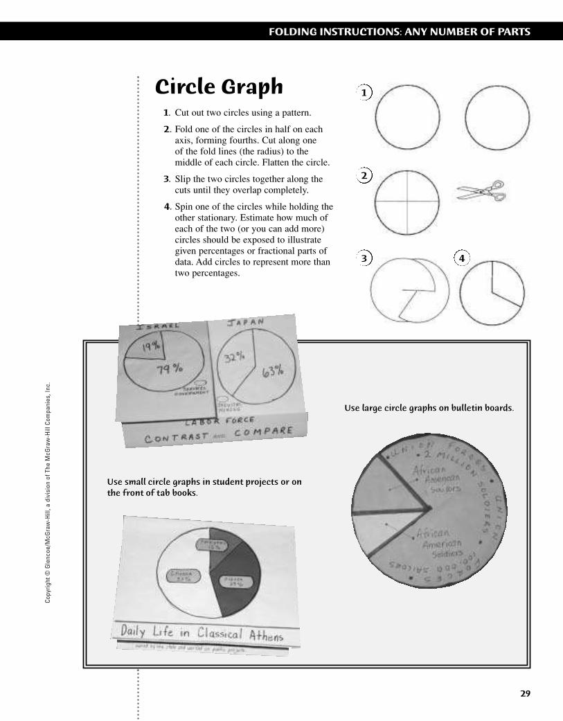
Circle Graph1. Cut out two circles using a pattern.
2. Fold one of the circles in half on each axis, forming fourths. Cut along one of the fold lines (the radius) to the middle of each circle. Flatten the circle.
3. Slip the two circles together along the cuts until they overlap completely.
4. Spin one of the circles while holding theother stationary. Estimate how much of each of the two (or you can add more) circles should be exposed to illustrate given percentages or fractional parts of data. Add circles to represent more than two percentages.
Use small circle graphs in student projects or onthe front of tab books.
Use large circle graphs on bulletin boards.
1
2
3 4
29
FOLDING INSTRUCTIONS: ANY NUMBER OF PARTS
ii-42_RSGF_878387 3/20/07 6:39 PM Page 29
Copyright © G
lencoe/McG
raw-H
ill, a division of The McG
raw-H
ill Companies, Inc.
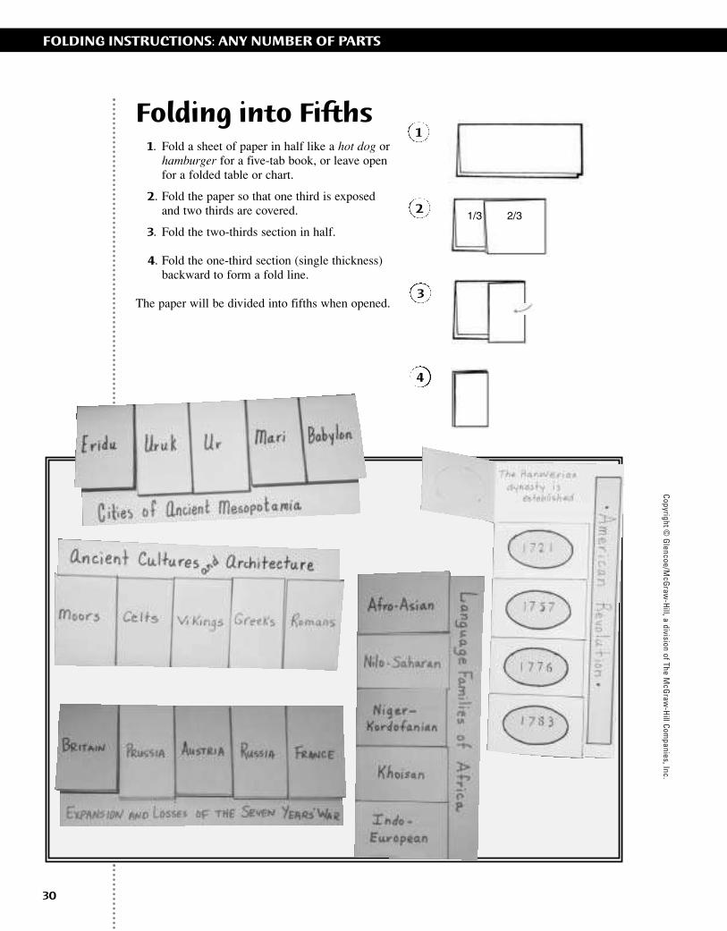
Folding into Fifths1. Fold a sheet of paper in half like a hot dog or
hamburger for a five-tab book, or leave openfor a folded table or chart.
2. Fold the paper so that one third is exposedand two thirds are covered.
3. Fold the two-thirds section in half.
4. Fold the one-third section (single thickness)backward to form a fold line.
The paper will be divided into fifths when opened.
30
FOLDING INSTRUCTIONS: ANY NUMBER OF PARTS
1
2
3
4
1/3 2/3
ii-42_RSGF_878387 3/20/07 6:39 PM Page 30
Copy
right
© G
lenc
oe/M
cGra
w-H
ill, a
div
isio
n of
The
McG
raw
-Hill
Com
pani
es, I
nc.
31
FOLDING INSTRUCTIONS: ANY NUMBER OF PARTS
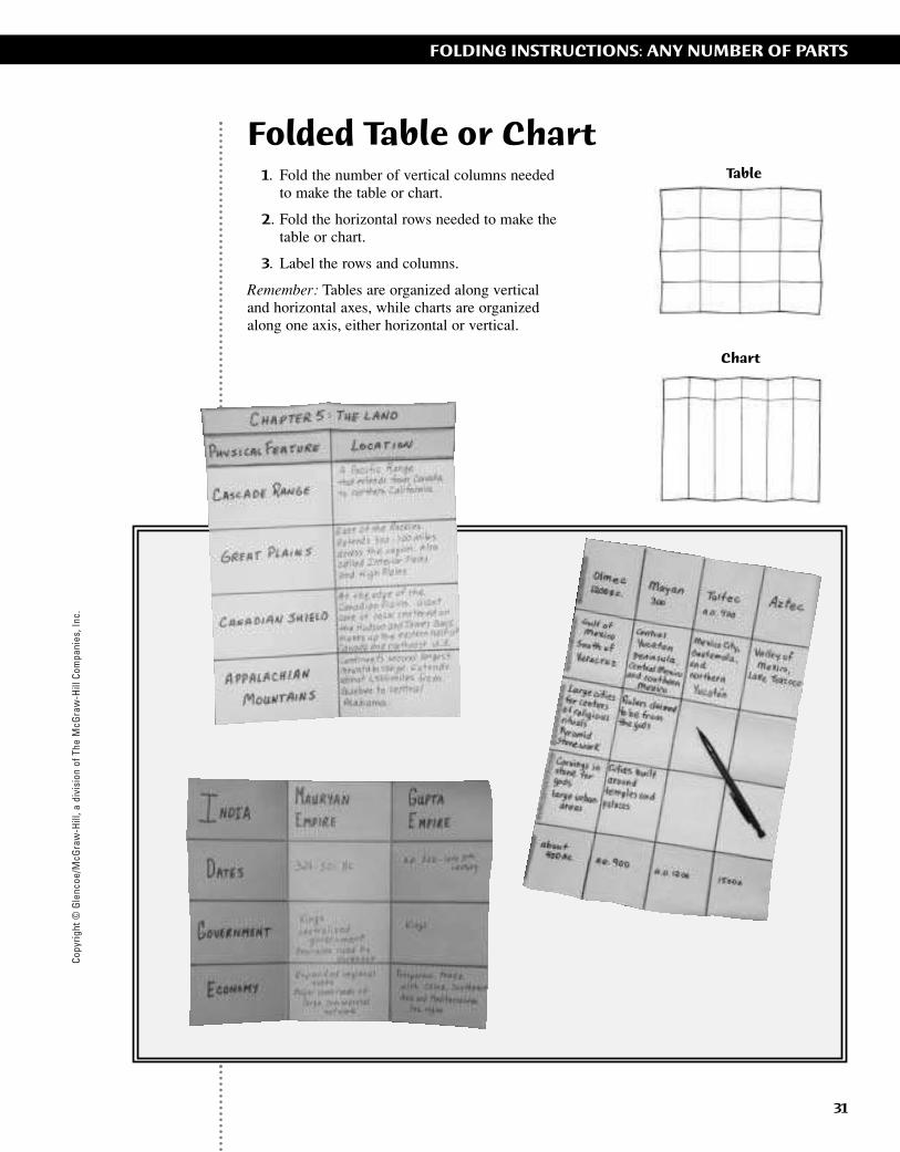
Folded Table or Chart1. Fold the number of vertical columns needed
to make the table or chart.
2. Fold the horizontal rows needed to make thetable or chart.
3. Label the rows and columns.
Remember: Tables are organized along verticaland horizontal axes, while charts are organizedalong one axis, either horizontal or vertical.
Table
Chart
ii-42_RSGF_878387 3/20/07 6:39 PM Page 31
Copyright © G
lencoe/McG
raw-H
ill, a division of The McG
raw-H
ill Companies, Inc.
32
FOLDING INSTRUCTIONS: ANY NUMBER OF PARTS
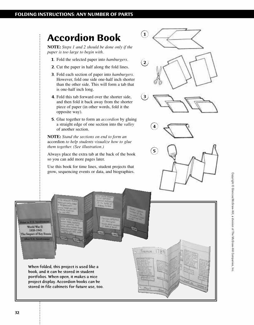
Accordion BookNOTE: Steps 1 and 2 should be done only if thepaper is too large to begin with.
1. Fold the selected paper into hamburgers.
2. Cut the paper in half along the fold lines.
3. Fold each section of paper into hamburgers.However, fold one side one-half inch shorterthan the other side. This will form a tab thatis one-half inch long.
4. Fold this tab forward over the shorter side,and then fold it back away from the shorterpiece of paper (in other words, fold it theopposite way).
5. Glue together to form an accordion by gluinga straight edge of one section into the valleyof another section.
NOTE: Stand the sections on end to form anaccordion to help students visualize how to gluethem together. (See illustration.)
Always place the extra tab at the back of the bookso you can add more pages later.
Use this book for time lines, student projects thatgrow, sequencing events or data, and biographies.
When folded, this project is used like abook, and it can be stored in studentportfolios. When open, it makes a niceproject display. Accordion books can bestored in file cabinets for future use, too.
1
2
4
5
3
ii-42_RSGF_878387 3/20/07 6:39 PM Page 32
Copy
right
© G
lenc
oe/M
cGra
w-H
ill, a
div
isio
n of
The
McG
raw
-Hill
Com
pani
es, I
nc.
33
FOLDING INSTRUCTIONS: ANY NUMBER OF PARTS
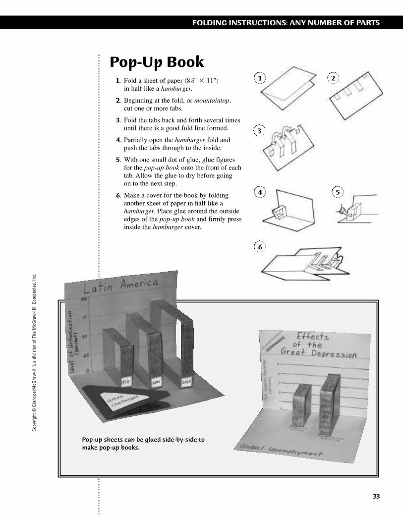
Pop-Up Book1. Fold a sheet of paper (81⁄2" � 11")
in half like a hamburger.
2. Beginning at the fold, or mountaintop,cut one or more tabs.
3. Fold the tabs back and forth several timesuntil there is a good fold line formed.
4. Partially open the hamburger fold and push the tabs through to the inside.
5. With one small dot of glue, glue figures for the pop-up book onto the front of each tab. Allow the glue to dry before going on to the next step.
6. Make a cover for the book by folding another sheet of paper in half like ahamburger. Place glue around the outsideedges of the pop-up book and firmly pressinside the hamburger cover.
Pop-up sheets can be glued side-by-side tomake pop-up books.
1 2
3
4 5
6
ii-42_RSGF_878387 3/20/07 6:39 PM Page 33
Copyright © G
lencoe/McG
raw-H
ill, a division of The McG
raw-H
ill Companies, Inc.
34
FOLDING INSTRUCTIONS: ANY NUMBER OF PARTS
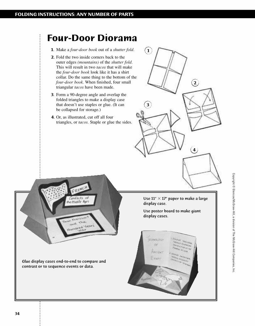
Four-Door Diorama1. Make a four-door book out of a shutter fold.
2. Fold the two inside corners back to the outer edges (mountains) of the shutter fold.This will result in two tacos that will makethe four-door book look like it has a shirtcollar. Do the same thing to the bottom of thefour-door book. When finished, four smalltriangular tacos have been made.
3. Form a 90-degree angle and overlap thefolded triangles to make a display case that doesn’t use staples or glue. (It can be collapsed for storage.)
4. Or, as illustrated, cut off all four triangles, or tacos. Staple or glue the sides.
Use 11” � 17” paper to make a largedisplay case.
Use poster board to make giant display cases.
Glue display cases end-to-end to compare andcontrast or to sequence events or data.
1
2
3
4
ii-42_RSGF_878387 3/20/07 6:39 PM Page 34
Copy
right
© G
lenc
oe/M
cGra
w-H
ill, a
div
isio
n of
The
McG
raw
-Hill
Com
pani
es, I
nc.
35
FOLDING INSTRUCTIONS: ANY NUMBER OF PARTS
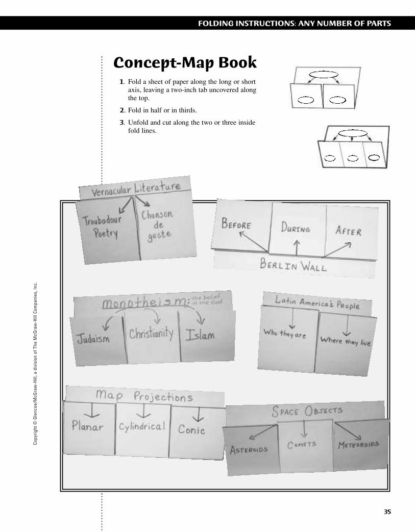
Concept-Map Book1. Fold a sheet of paper along the long or short
axis, leaving a two-inch tab uncovered alongthe top.
2. Fold in half or in thirds.
3. Unfold and cut along the two or three insidefold lines.
ii-42_RSGF_878387 3/20/07 6:39 PM Page 35
Copyright © G
lencoe/McG
raw-H
ill, a division of The McG
raw-H
ill Companies, Inc.
36
FOLDING INSTRUCTIONS: ANY NUMBER OF PARTS
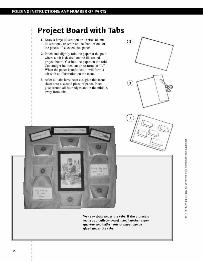
Project Board with Tabs1. Draw a large illustration or a series of small
illustrations, or write on the front of one ofthe pieces of selected-size paper.
2. Pinch and slightly fold the paper at the pointwhere a tab is desired on the illustratedproject board. Cut into the paper on the fold.Cut straight in, then cut up to form an “L.”When the paper is unfolded, it will form atab with an illustration on the front.
3. After all tabs have been cut, glue this frontsheet onto a second piece of paper. Placeglue around all four edges and in the middle,away from tabs.
1
2
3
Write or draw under the tabs. If the project ismade as a bulletin board using butcher paper,quarter- and half-sheets of paper can beglued under the tabs.
ii-42_RSGF_878387 3/20/07 6:39 PM Page 36

Copy
right
© G
lenc
oe/M
cGra
w-H
ill, a
div
isio
n of
The
McG
raw
-Hill
Com
pani
es, I
nc.
37
FOLDING INSTRUCTIONS: ANY NUMBER OF PARTS
Billboard Project1. Fold all pieces of the same size of paper in
half like hamburgers.
2. Place a line of glue at the top and bottom ofone side of each folded billboard section andglue them edge-to-edge on a backgroundpaper or project board. If glued correctly, alldoors will open from right to left.
3. Pictures, dates, words, etc., go on the front ofeach billboard section. Writing or drawingscan be seen on the inside left of each sectionwhen opened. The base, or the part glued tothe background, is perfect for more in-depthinformation or definitions.
Use for time lines or sequencing data.
1
2
3
ii-42_RSGF_878387 3/20/07 6:39 PM Page 37
Copyright © G
lencoe/McG
raw-H
ill, a division of The McG
raw-H
ill Companies, Inc.
38
FOLDING INSTRUCTIONS: ANY NUMBER OF PARTS
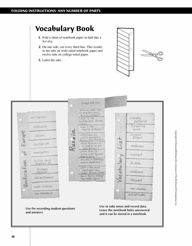
Vocabulary Book1. Fold a sheet of notebook paper in half like a
hot dog.
2. On one side, cut every third line. This resultsin ten tabs on wide-ruled notebook paper andtwelve tabs on college-ruled paper.
3. Label the tabs.
Use to take notes and record data. Leave the notebook holes uncoveredand it can be stored in a notebook.
Use for recording student questionsand answers.
ii-42_RSGF_878387 3/20/07 6:39 PM Page 38
Copy
right
© G
lenc
oe/M
cGra
w-H
ill, a
div
isio
n of
The
McG
raw
-Hill
Com
pani
es, I
nc.
39
FOLDING INSTRUCTIONS: ANY NUMBER OF PARTS
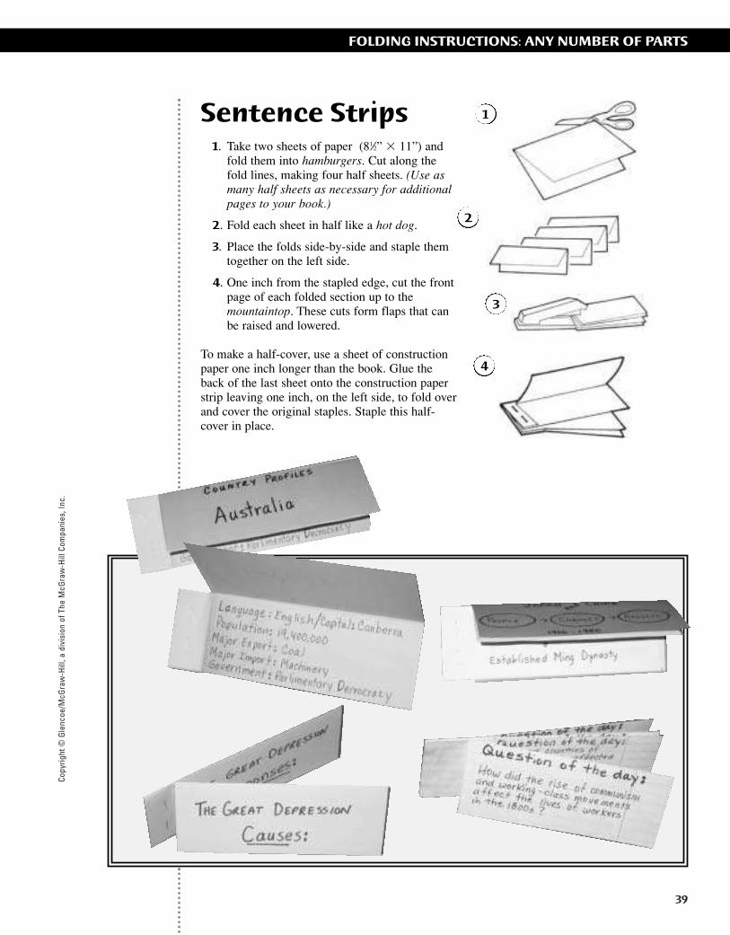
Sentence Strips1. Take two sheets of paper (81⁄2” � 11”) and
fold them into hamburgers. Cut along thefold lines, making four half sheets. (Use asmany half sheets as necessary for additionalpages to your book.)
2. Fold each sheet in half like a hot dog.
3. Place the folds side-by-side and staple themtogether on the left side.
4. One inch from the stapled edge, cut the frontpage of each folded section up to themountaintop. These cuts form flaps that canbe raised and lowered.
To make a half-cover, use a sheet of constructionpaper one inch longer than the book. Glue theback of the last sheet onto the construction paperstrip leaving one inch, on the left side, to fold overand cover the original staples. Staple this half-cover in place.
1
2
3
4
ii-42_RSGF_878387 3/20/07 6:39 PM Page 39
Copyright © G
lencoe/McG
raw-H
ill, a division of The McG
raw-H
ill Companies, Inc.
40
FOLDING INSTRUCTIONS: ANY NUMBER OF PARTS
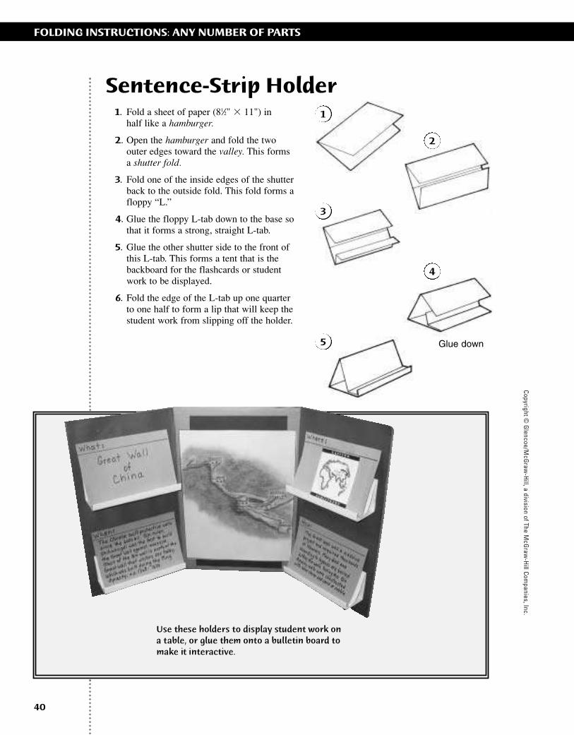
Sentence-Strip Holder1. Fold a sheet of paper (81⁄2" � 11") in
half like a hamburger.
2. Open the hamburger and fold the two outer edges toward the valley. This forms a shutter fold.
3. Fold one of the inside edges of the shutterback to the outside fold. This fold forms afloppy “L.”
4. Glue the floppy L-tab down to the base sothat it forms a strong, straight L-tab.
5. Glue the other shutter side to the front of this L-tab. This forms a tent that is thebackboard for the flashcards or student work to be displayed.
6. Fold the edge of the L-tab up one quarter to one half to form a lip that will keep thestudent work from slipping off the holder.
Glue down
1
2
3
4
5
Use these holders to display student work ona table, or glue them onto a bulletin board tomake it interactive.
ii-42_RSGF_878387 3/20/07 6:39 PM Page 40

Copy
right
© G
lenc
oe/M
cGra
w-H
ill, a
div
isio
n of
The
McG
raw
-Hill
Com
pani
es, I
nc.
41
1 How Geographers Look at the World 2 The Physical World 3 Climates of the Earth4 The Human World5 Physical Geography of the United
States and Canada6 Cultural Geography of the United
States and Canada7 The Region Today: The United States
and Canada8 Physical Geography of Latin America9 Cultural Geography of
Latin America10 The Region Today: Latin America11 Physical Geography of Europe12 Cultural Geography of Europe13 The Region Today: Europe14 Physical Geography of Russia15 Cultural Geography of Russia16 The Region Today: Russia 17 Physical Geography of
North Africa, Southwest Asia, and Central Asia
18 Cultural Geography of North Africa, Southwest Asia, and Central Asia
19 The Region Today: North Africa,Southwest Asia, and Central Asia
20 Physical Geography of Africa South of the Sahara
21 Cultural Geography of Africa South of the Sahara
22 The Region Today: Africa South of the Sahara
23 Physical Geography of South Asia24 Cultural Geography of South Asia25 The Region Today: South Asia26 Physical Geography of East Asia27 Cultural Geography of East Asia28 The Region Today: East Asia29 Physical Geography of
Southeast Asia30 Cultural Geography of
Southeast Asia31 The Region Today: Southeast Asia 32 Physical Geography of
Australia, Oceania, and Antarctica33 Cultural Geography of
Australia and Oceania34 The Region Today: Australia and
Oceania
T he pages that follow contain Foldable activities to use in studying thechapters of World Geography and Cultures—starting with general topics
such as How Geographers Look at the World and continuing with a region-by-region survey of the world's geography.
For each chapter, there is a summary and three Foldable activities, withinstructions and illustrations for students. Students review subject materialas they create the Foldables. Students can then use their Foldables to preparefor classroom and standardized tests.
ii-42_RSGF_878387 3/20/07 6:39 PM Page 41

ii-42_RSGF_878387 3/20/07 6:39 PM Page 42
Copy
right
© G
lenc
oe/M
cGra
w-H
ill, a
div
isio
n of
The
McG
raw
-Hill
Com
pani
es, I
nc.
CHAPTER 1
43
How Geographers Look at the World
SUMMARYGeographers use different ways of looking at the world. They describe the world in spatial
terms, identify places and regions, analyze physical and human systems, and study the con-nection between environment and society. Physical geography and human geography are thetwo major branches of geography. Geographers use research methods and tools to study placesand human activity, including direct observation, mapping, interviewing, statistics, and tech-nology. Scientific instruments, such as satellites and computers, help geographers gather andorganize data used by government, business, and other planners.
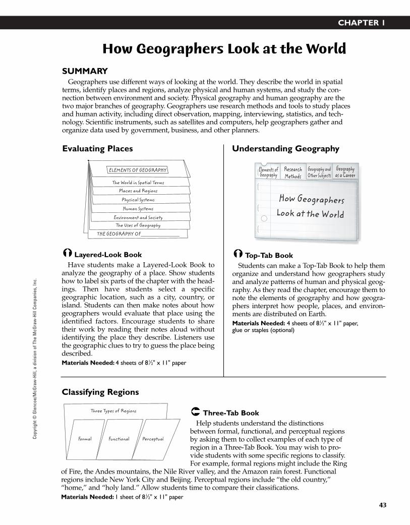
Three-Tab BookHelp students understand the distinctions
between formal, functional, and perceptual regionsby asking them to collect examples of each type ofregion in a Three-Tab Book. You may wish to pro-vide students with some specific regions to classify.For example, formal regions might include the Ring
of Fire, the Andes mountains, the Nile River valley, and the Amazon rain forest. Functionalregions include New York City and Beijing. Perceptual regions include “the old country,”“home,” and “holy land.” Allow students time to compare their classifications.Materials Needed: 1 sheet of 81⁄2" x 11" paper
Top-Tab BookStudents can make a Top-Tab Book to help them
organize and understand how geographers studyand analyze patterns of human and physical geog-raphy. As they read the chapter, encourage them tonote the elements of geography and how geogra-phers interpret how people, places, and environ-ments are distributed on Earth.Materials Needed: 4 sheets of 81⁄2" x 11" paper,glue or staples (optional)
Layered-Look BookHave students make a Layered-Look Book to
analyze the geography of a place. Show studentshow to label six parts of the chapter with the head-ings. Then have students select a specificgeographic location, such as a city, country, orisland. Students can then make notes about howgeographers would evaluate that place using theidentified factors. Encourage students to sharetheir work by reading their notes aloud withoutidentifying the place they describe. Listeners usethe geographic clues to try to guess the place beingdescribed.Materials Needed: 4 sheets of 81⁄2" x 11" paper
ELEMENTS OF GEOGRAPHY
The World in Spatial Terms
Places and Regions
Physical Systems
Human Systems
Environment and SocietyyThe Uses of Geography
THE GEOGRAPHY OF________________
Formal Functional
Three Types of Regions
Perceptual
Evaluating Places
Classifying Regions
Understanding Geography
Elements ofGeography
ResearchMethods
How GeographersLook at the World
Geography andOther Subjects
Geographyas a Career
43-76_RSGF_878387 3/20/07 6:34 PM Page 43

CHAPTER 2
44
The Physical World
SUMMARYPlanet Earth is part of the solar system, which is made up of the sun and the many objects
that revolve around it. Earth is composed of layers—a super-hot, solid inner core surroundedby a liquid outer core, a layer of dense rock, called the mantle, and a relatively thin, rocky shellat the surface. Both internal and external forces change the Earth. Although the total amount ofwater on the Earth does not change, water is constantly moving and changing form. Most ofEarth’s water is salt water in seas, gulfs, and bays. Most freshwater is frozen in glaciers and icecaps.
Three-Pocket BookHave students create a Three-Pocket Book labeled The
Physical World and label the pockets Planet Earth,Forces of Change, and Earth’s Water. As they read thechapter, have them write information on index cardsabout the structure of planet Earth and its place in thesolar system, the natural forces that affect Earth’s physi-
cal systems, and Earth’s water. Have them place each card in the correct pocket.Materials Needed: 1 sheet of 11" x 17" paper, glue, or staples (optional)
Shutter FoldStudents can create a Shutter Fold to help them
describe and review the forces that change Earth’sgeography. On the left side of the Foldable, stu-dents can illustrate Earth’s interior. Encouragethem to label the crust, mantle, inner core, andouter core. Inside the flap, students can take notesabout internal forces, including colliding andspreading plates, folds and faults, earthquakes,and volcanic eruptions. On the right side of theFoldable, students can sketch Earth’s exterior andthen describe external forces of change, includingweathering and erosion by wind, glaciers, andwater.Materials Needed: 1 sheet of 81⁄2" x 11" or 11" x 17"paper
Four-Door BookAsk students to make a Four-Door Book and
label the doors with the four zones introduced inthis chapter: hydrosphere, lithosphere, atmos-phere, and biosphere. Behind each door, studentscan write definitions and examples of each zone.Students can also use this Foldable to illustrate theconnections between the zones. For example,Earth’s biosphere includes parts of the hydros-phere, atmosphere, and lithosphere. Have studentssuggest ways to show this connection using theirFour-Door Book. Materials Needed: 1 sheet of 81⁄2" x 11" paper
Internal Forces
External Forces
Hydrosphere Atmosphere
Lithosphere Biosphere
Planet Earth Forces of Change Earth’s Water
rldhe Physical WorTh
Investigating Earth’s Zones
Organizing Earth’s Physical Systems
Describing Forces of Change
Copyright © G
lencoe/McG
raw-H
ill, a division of The McG
raw-H
ill Companies, Inc.
43-76_RSGF_878387 3/20/07 6:34 PM Page 44

CHAPTER 3
45
Climates of the Earth
SUMMARYClimate refers to weather patterns that occur in a place over time. Although Earth’s climates
are influenced by many factors, the most important is Earth’s position in relation to the sun.Other factors include the latitude and altitude of a place, wind patterns, ocean currents, andlandforms. World climate regions vary greatly, and each supports characteristic vegetation.Human activity may be contributing to the cycle of climate change.
Layered-Look BookAfter students have completed the chapter, ask them
to create a Layered-Look Book to review the five cate-gories of climate regions. Students should identify thekey elements of each climate region and provide severalexamples of each. Encourage students to read theirexamples to the class and ask listeners to explain howthe region should be classified.Materials Needed: 3 sheets of 81⁄2" x 11" paper
Vocabulary BookStudents can make a Vocabulary Book to help
them remember how to define and spell vocabu-lary words that are introduced. Have them notewords that they may never have encounteredbefore, such as steepe and doldrums. To add somecreativity, allow students to color or illustratevisual terms, such as rain shadow or Coriolis effect.Students can also create sentences that use eachterm accurately.Materials Needed: 1 sheet of 81⁄2" x 11" paper, scissors
Shutter FoldStudents can use a Shutter Fold to diagram
Earth’s rotation and revolution. Under each dia-gram, ask students to describe some of the effectsof each movement. For example, Earth’s rotationresults in the alternation between night and day;and the tilt of its axis creates different temperaturezones (because regions receive different amountsof sunlight). Earth’s revolution around the sunresults in seasons. Suggest that student teams worktogether to create annotated Shutter Fold diagramsfor classroom display.Materials Needed: 1 sheet of 81⁄2" x 11" paper; or 11" x 17" paper for displays
equinox
Cont
ent
Voc
abula
ry
solsticegreenhouse effect
global warmingprevailing wind
doldrumswindwardleeward
natural vegetationpermafrost
Sun
rotation
revolution
Earth
HighlandsHigh LatitudeMidlatitude
DryTropical
CLIMATE REGIONS
Understanding Earth’s Movements
Reviewing Climate Regions
Identifying Important Terms
Copy
right
© G
lenc
oe/M
cGra
w-H
ill, a
div
isio
n of
The
McG
raw
-Hill
Com
pani
es, I
nc.
43-76_RSGF_878387 3/20/07 6:34 PM Page 45
CHAPTER 4
46
The Human World
SUMMARYGeographers study how the Earth’s features influence human life and how humans affect the
Earth. Population studies focus on growth, distribution, and migration. Culture regions aredefined by many elements including language, religion, government, and economic activity.Political regions are established by the governments of the world’s nearly 200 independentcountries. Economic systems include traditional, market, and command economies. The eco-nomic activity of a place is affected by available resources.
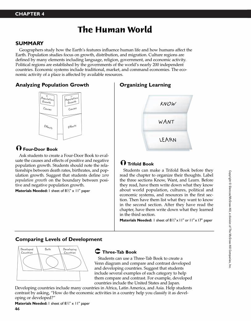
Three-Tab BookStudents can use a Three-Tab Book to create a
Venn diagram and compare and contrast developedand developing countries. Suggest that studentsinclude several examples of each category to helpthem compare and contrast. For example, developedcountries include the United States and Japan.
Developing countries include many countries in Africa, Latin America, and Asia. Help studentscontrast by asking, “How do the economic activities in a country help you classify it as devel-oping or developed?”Materials Needed: 1 sheet of 81⁄2" x 11" paper
Trifold BookStudents can make a Trifold Book before they
read the chapter to organize their thoughts. Labelthe three sections Know, Want, and Learn. Beforethey read, have them write down what they knowabout world population, cultures, political andeconomic systems, and resources in the first sec-tion. Then have them list what they want to knowin the second section. After they have read thechapter, have them write down what they learnedin the third section.Materials Needed: 1 sheet of 81⁄2" x 11" or 11" x 17" paper
Four-Door BookAsk students to create a Four-Door Book to eval-
uate the causes and effects of positive and negativepopulation growth. Students should note the rela-tionships between death rates, birthrates, and pop-ulation growth. Suggest that students define zeropopulation growth on the boundary between posi-tive and negative population growth. Materials Needed: 1 sheet of 81⁄2" x 11" paper
KNOW
WANT
LEARN
Population GrowthPopulation
Growth
Effects Effects
Populatio
Causes Causes
DevelopedCountries
DevelopingCountries
Both
Analyzing Population Growth
Comparing Levels of Development
Organizing Learning
Copyright © G
lencoe/McG
raw-H
ill, a division of The McG
raw-H
ill Companies, Inc.
43-76_RSGF_878387 3/20/07 6:34 PM Page 46

Copy
right
© G
lenc
oe/M
cGra
w-H
ill, a
div
isio
n of
The
McG
raw
-Hill
Com
pani
es, I
nc.
CHAPTER 5
47
Physical Geography of the United States and Canada
SUMMARYThe United States and Canada share the northern part of the North American continent. The
physical geography, the natural resources, and the climate and vegetation of this large and spa-cious region are tremendously diverse. Two mountain ranges dominate the West—the PacificRange and the Rocky Mountains. The Great Plains extend from 300 to 700 miles across the cen-tral part of the region. The Canadian Shield anchors the continent in the northeast, and theAppalachian Mountains run from Quebec to central Alabama. Lakes and rivers provide mostof the region with an abundant supply of water. Climates vary greatly, depending on latitude,elevation, ocean currents, rainfall, and location.
Layered-Look BookStudents can make a Layered-Look Book to take notes
as they read about the climate regions of the UnitedStates and Canada. Remind students to include the specific climate types identified for each region. Alsoencourage students to define vocabulary terms thatrelate to specific climate regions, such as timberline, chinook, supercells, hurricanes, and blizzards.Materials Needed: 3 sheets of 81⁄2" x 11" paper
Three-Tab BookSuggest that students compare the physical
geography of Canada and the United States by cre-ating a Venn diagram by adding ovals and labels toa Three-Tab Book. Encourage students to considerthe border between the two countries as they con-sider features they have in common. Then look atregions far from the border to identify ways inwhich the two countries are unique.Materials Needed: 1 sheet of 81⁄2" x 11" paper
Folded ChartHave students create a Folded Chart to organize
notes about the physical geography of the UnitedStates and Canada. Fold the paper into fourths toform columns and thirds to form rows. Studentsmight punch holes along one 11-inch side to storetheir chart in a notebook. Encourage students toidentify specific examples in each table cell, as wellas general descriptions written as complete sen-tences. Materials Needed: 1 sheet of 11" x 17" paper
BothCanada United States
NaturalResources
WaterwaysLandformsCH 5
United States
Canada
CLIMATES
THE UNITED STATESAND CANADA
Northern Climates
Western Climates
Interior ClimatesEastern Climates
Tropical Climates
Organizing Geographic Data
Identifying Climate Regions
Comparing Physical Features
43-76_RSGF_878387 3/20/07 6:34 PM Page 47

Copyright © G
lencoe/McG
raw-H
ill, a division of The McG
raw-H
ill Companies, Inc.
CHAPTER 6
48
Cultural Geography of the United States and Canada
SUMMARYCanada and the United States share common features in their patterns of settlement, their
democratic forms of government, and their agricultural and industrial development. BothCanada and the United States have been shaped by immigration. For thousands of years,North America was inhabited by Native Americans, who irrigated deserts for farming, huntedin forests, developed trade networks, and built ceremonial mounds. Immigrants in Canadaand the United States have left a legacy of multicultural communities. While much of their her-itage and culture is shared, each country still retains many individual characteristics.
Folded ChartHave students create a Folded Chart to
organize notes about the population pat-terns, history and government, and cultureof the United States and Canada. Fold thepaper into fourths to form columns andthirds to form rows. Students might punchholes along one 11-inch side to store theirchart in a notebook. Each cell in the chart
can include abbreviated notes or complete sentences. Use completed charts to support a discus-sion comparing culture in the United States and Canada. Materials Needed: 1 sheet of 11" x 17" paper
Accordion BookStudents can make an Accordion Book to create a
time line that notes important events in the historyof the United States and Canada. Some studentsmight choose to draw the time line in the center ofthe page and note Canadian events above the lineand United States events below. Others mightrecord specific events for both countries above thetime line and general eras below. Completed timelines can be folded for easy storage; punch holes tostore the time line in a notebook.Materials Needed: 3 or 4 sheets of 81⁄2" x 11" paper
Concept-Map BookAsk students to create a Concept-Map Book to
identify and compare coastal and inland cities inCanada and the United States. Students shouldinclude examples in both categories and add writ-ten explanations of why urban centers developedin each region. Emphasize that many coastal citiesare important trade centers. Inland cities are oftenlocated near rivers, lakes, and inland waterways. Materials Needed: 1 sheet of 81⁄2" x 11" paper
1600 16
50
1700 17
50
180000
190018
50
CoastalCities
Canadian and U.S. Cities
InlandCities
PopulationPatternsChapter
6UnitedStates
Canada
History andGovernment Culture
Studying Urbanization Patterns
Looking at Culture
Reviewing Chronology of Events
43-76_RSGF_878387 3/20/07 6:34 PM Page 48

CHAPTER 7
49
The Region Today: The United States and Canada
SUMMARYLike many other developed nations, the United States and Canada are moving toward a
postindustrial economy, one that places less emphasis on manufacturing and agricultural pro-duction and more emphasis on service and high-tech industries. However, manufacturing andfarming are still vital economic activities. Pollution in the region includes acid rain, smog, andwater pollution.
Folded ChartHave students create a Folded Chart to
organize notes about the causes and effectsof pollution in Canada and the UnitedStates. Fold the paper into fourths to formcolumns and thirds to form rows. Studentsmight punch holes along one 11-inch side tostore their chart in a notebook. Remind stu-dents that environmental pollution spreads
beyond political boundaries, so that pollution created in one region can affect neighboringregions as well. Students interested in the subject might create a third row to present possiblesolutions that could prevent or limit each type of pollution.Materials Needed: 1 sheet of 11" x 17" paper
Three-Tab BookStudents can create a Venn diagram using a
Three-Tab Book to help them compare and contrasttrade partners of the United States and Canada.Explain that the overlapping region of the diagramshould present facts and conclusions about tradebetween Canada and the United States. The out-side regions should present information abouttrade between Canada and the United States andother countries. Materials Needed: 1 sheet of 81⁄2" x 11" paper
Four-Door BookStudents can create a Four-Door Book to help
them remember the key details from this chapter.Have them label the doors of the book EconomicActivities, Trade and Interdependence, Transporta-tion and Communications, and Managing Resources.As they read the chapter, have them write underthe appropriate door what they learn about theUnited States and Canada.Materials Needed: 1 sheet of 81⁄2" x 11" paper.
UnitedStates
CanadaTrade
with EachOther
Trade Partners
Trade and
Interdependence
EconomicActivities
Transportationand CommunicationsManaging
Resources
WaterPollution
SmogAcid Rain
CAUSES
EFFECTS
Remembering Key Details
Evaluating Environmental Impact
Comparing Trade Relationships
Copy
right
© G
lenc
oe/M
cGra
w-H
ill, a
div
isio
n of
The
McG
raw
-Hill
Com
pani
es, I
nc.
43-76_RSGF_878387 3/20/07 6:34 PM Page 49

CHAPTER 8
50
Physical Geography of Latin America
SUMMARYLatin America is divided into three geographic regions: Middle America, which consists of
Mexico and Central America; the Caribbean Islands; and the continent of South America. Theregion’s physical geography features mountain ranges, broad highlands, coastal plains, vastgrasslands, volcanic islands, and the longest river in the Western Hemisphere. Much of LatinAmerica lies between the Tropic of Cancer and the Tropic of Capricorn, resulting in tropicalclimates with hot temperatures and heavy rainfall. Smaller areas of desert and steppe climatesreceive little rainfall.
Layered-Look BookSuggest that students create a Layered-Look Book to
review the major climates found in Latin America.Remind students to refer to Chapter 3 for more informa-tion about specific climates. After students completetheir notes, teams might work together using 11" x 17"paper to create a large climate book for a classroom dis-play. Remind students to double-check all informationfor accuracy before including it in the presentation copy.
Materials Needed: 3 sheets of 81⁄2" x 11" paper (or 11" x 17" for classroom display)
Three-Pocket BookStudents can create a Three-Pocket Book to help
them learn about the physical geography of LatinAmerica. They should label the pockets PhysicalFeatures, Climate, and Vegetation. Have them gluethe outer edges of the tabs to form pockets. As theyread the chapter, they should write the details theylearn on index cards and put them in the appropri-ate pockets.Materials Needed: 1 sheet of 11" x 17" paper, glue,index cards
Three-Tab BookHave students create a Three-Tab Book to record
notes about the physical geography of LatinAmerica. For each of the three areas (MiddleAmerica, Caribbean, South America), students canbriefly describe the mountains, lowlands, watersystems, and natural resources. Students might usea similar Three-Tab Book to identify the countrieslocated within each area. Materials Needed: 1 sheet of 81⁄2" x 11" paper
VegetationPhysical
FeaturesClimate
Latin Amer eographyica:Physical G
Caribbean
Middle
America
South
America
Latin
Am
eric
a: G
eogr
aphy
HighlandsDesert and steppeHumid subtropicalTropical savanna
Tropical wet
Latin AmericaCLIMATE REGIONS
Reviewing the Physical Geography ofLatin America
Looking at Latin American Climates
Learning Physical Geography
Copyright © G
lencoe/McG
raw-H
ill, a division of The McG
raw-H
ill Companies, Inc.
43-76_RSGF_878387 3/20/07 6:35 PM Page 50
CHAPTER 9
51
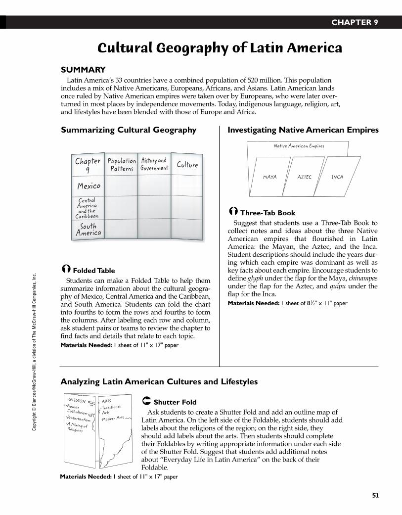
Cultural Geography of Latin America
SUMMARYLatin America’s 33 countries have a combined population of 520 million. This population
includes a mix of Native Americans, Europeans, Africans, and Asians. Latin American landsonce ruled by Native American empires were taken over by Europeans, who were later over-turned in most places by independence movements. Today, indigenous language, religion, art,and lifestyles have been blended with those of Europe and Africa.
Shutter FoldAsk students to create a Shutter Fold and add an outline map of
Latin America. On the left side of the Foldable, students should addlabels about the religions of the region; on the right side, theyshould add labels about the arts. Then students should completetheir Foldables by writing appropriate information under each sideof the Shutter Fold. Suggest that students add additional notesabout “Everyday Life in Latin America” on the back of theirFoldable.
Materials Needed: 1 sheet of 11" x 17" paper
Three-Tab BookSuggest that students use a Three-Tab Book to
collect notes and ideas about the three NativeAmerican empires that flourished in LatinAmerica: the Mayan, the Aztec, and the Inca.Student descriptions should include the years dur-ing which each empire was dominant as well askey facts about each empire. Encourage students todefine glyph under the flap for the Maya, chinampasunder the flap for the Aztec, and quipu under theflap for the Inca. Materials Needed: 1 sheet of 81⁄2" x 11" paper
Folded TableStudents can make a Folded Table to help them
summarize information about the cultural geogra-phy of Mexico, Central America and the Caribbean,and South America. Students can fold the chartinto fourths to form the rows and fourths to formthe columns. After labeling each row and column,ask student pairs or teams to review the chapter tofind facts and details that relate to each topic.Materials Needed: 1 sheet of 11" x 17" paper
Native American Empires
AZTEC INCAMAYA
PopulationPatterns
Chapter9
Mexico
SouthAmerica
CentralAmericaand the
Caribbean
History andGovernment Culture
RELIGION•Catholicism
•Religions
ARTS
••Arts
•Modern Arts
Summarizing Cultural Geography
Analyzing Latin American Cultures and Lifestyles
Investigating Native American Empires
Copy
right
© G
lenc
oe/M
cGra
w-H
ill, a
div
isio
n of
The
McG
raw
-Hill
Com
pani
es, I
nc.
43-76_RSGF_878387 3/20/07 6:35 PM Page 51
CHAPTER 10
52
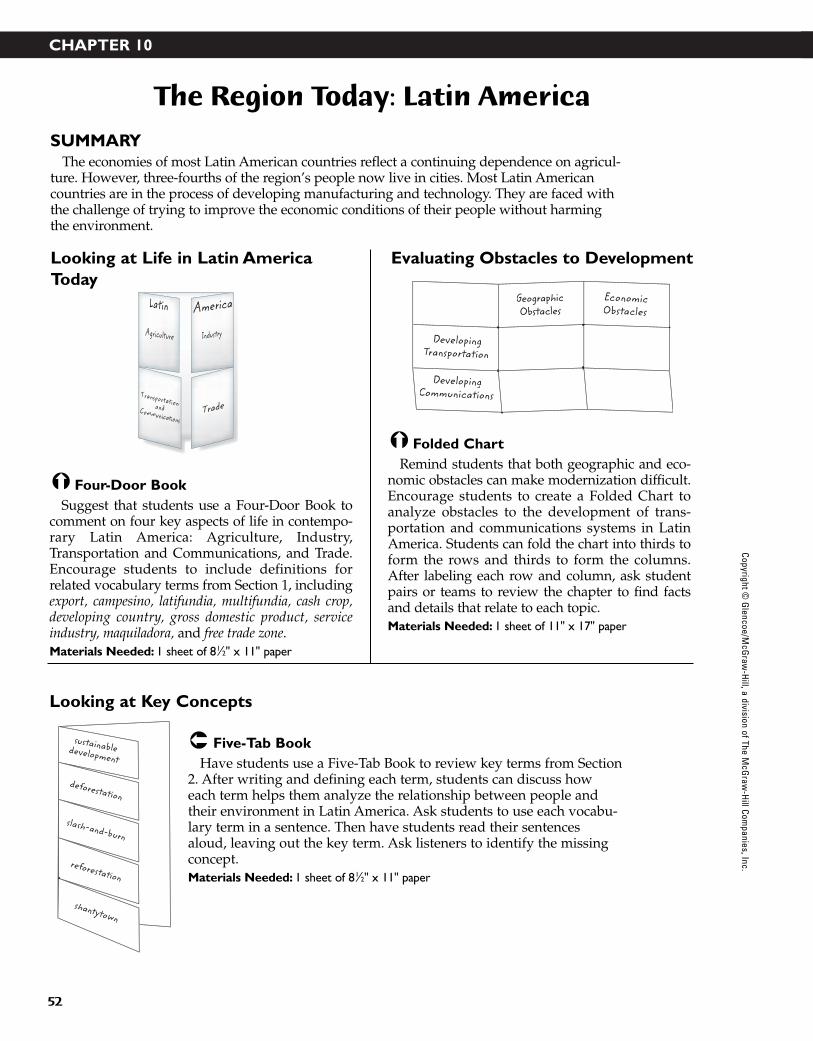
The Region Today: Latin America
SUMMARYThe economies of most Latin American countries reflect a continuing dependence on agricul-
ture. However, three-fourths of the region’s people now live in cities. Most Latin Americancountries are in the process of developing manufacturing and technology. They are faced withthe challenge of trying to improve the economic conditions of their people without harmingthe environment.
Five-Tab BookHave students use a Five-Tab Book to review key terms from Section
2. After writing and defining each term, students can discuss howeach term helps them analyze the relationship between people andtheir environment in Latin America. Ask students to use each vocabu-lary term in a sentence. Then have students read their sentencesaloud, leaving out the key term. Ask listeners to identify the missingconcept.Materials Needed: 1 sheet of 81⁄2" x 11" paper
Folded ChartRemind students that both geographic and eco-
nomic obstacles can make modernization difficult.Encourage students to create a Folded Chart toanalyze obstacles to the development of trans-portation and communications systems in LatinAmerica. Students can fold the chart into thirds toform the rows and thirds to form the columns.After labeling each row and column, ask studentpairs or teams to review the chapter to find factsand details that relate to each topic. Materials Needed: 1 sheet of 11" x 17" paper
Four-Door BookSuggest that students use a Four-Door Book to
comment on four key aspects of life in contempo-rary Latin America: Agriculture, Industry,Transportation and Communications, and Trade.Encourage students to include definitions forrelated vocabulary terms from Section 1, includingexport, campesino, latifundia, multifundia, cash crop,developing country, gross domestic product, serviceindustry, maquiladora, and free trade zone. Materials Needed: 1 sheet of 81⁄2" x 11" paper
EconomicObstacles
GeographicObstacles
DevelopingTransportation
DevelopingCommunications
Industry
America
Agriculture
Latin
TransportationandCommunicationsTrade
slash-and-burn
deforestation
shantytown
reforestation
sustainabledevelopment
Looking at Life in Latin AmericaToday
Looking at Key Concepts
Evaluating Obstacles to Development
Copyright © G
lencoe/McG
raw-H
ill, a division of The McG
raw-H
ill Companies, Inc.
43-76_RSGF_878387 3/20/07 6:35 PM Page 52
CHAPTER 11
53
Physical Geography of Europe
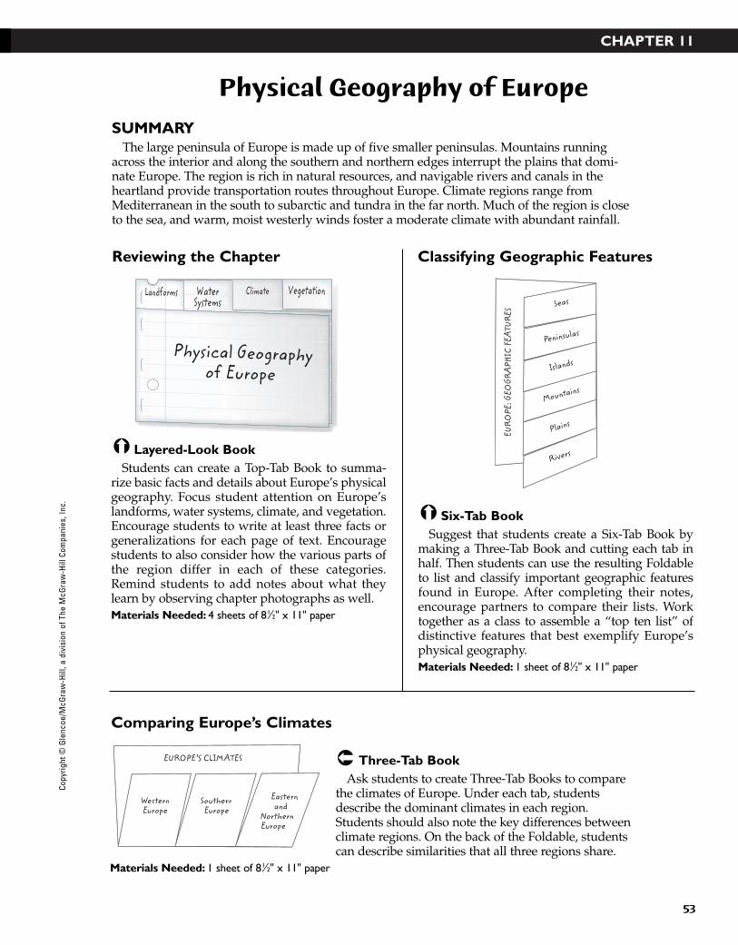
SUMMARYThe large peninsula of Europe is made up of five smaller peninsulas. Mountains running
across the interior and along the southern and northern edges interrupt the plains that domi-nate Europe. The region is rich in natural resources, and navigable rivers and canals in theheartland provide transportation routes throughout Europe. Climate regions range fromMediterranean in the south to subarctic and tundra in the far north. Much of the region is closeto the sea, and warm, moist westerly winds foster a moderate climate with abundant rainfall.
Three-Tab BookAsk students to create Three-Tab Books to compare
the climates of Europe. Under each tab, studentsdescribe the dominant climates in each region.Students should also note the key differences betweenclimate regions. On the back of the Foldable, studentscan describe similarities that all three regions share.
Materials Needed: 1 sheet of 81⁄2" x 11" paper
Six-Tab BookSuggest that students create a Six-Tab Book by
making a Three-Tab Book and cutting each tab inhalf. Then students can use the resulting Foldableto list and classify important geographic featuresfound in Europe. After completing their notes,encourage partners to compare their lists. Worktogether as a class to assemble a “top ten list” ofdistinctive features that best exemplify Europe’sphysical geography.Materials Needed: 1 sheet of 81⁄2" x 11" paper
Layered-Look BookStudents can create a Top-Tab Book to summa-
rize basic facts and details about Europe’s physicalgeography. Focus student attention on Europe’slandforms, water systems, climate, and vegetation.Encourage students to write at least three facts orgeneralizations for each page of text. Encouragestudents to also consider how the various parts ofthe region differ in each of these categories.Remind students to add notes about what theylearn by observing chapter photographs as well. Materials Needed: 4 sheets of 81⁄2" x 11" paper
Islands
Mountains
Peninsulas
Seas
Plains
Rivers
EUR
OPE
: GEO
GRA
PHIC
FEA
TURE
S
Landforms WaterSystems
Physical Geographyof Europe
Climate Vegetation
WesternEurope
SouthernEurope
EUROPE’S CLIMATES
Easternand
NorthernEurope
Reviewing the Chapter
Comparing Europe’s Climates
Classifying Geographic Features
Copy
right
© G
lenc
oe/M
cGra
w-H
ill, a
div
isio
n of
The
McG
raw
-Hill
Com
pani
es, I
nc.
43-76_RSGF_878387 3/20/07 6:35 PM Page 53
CHAPTER 12
54
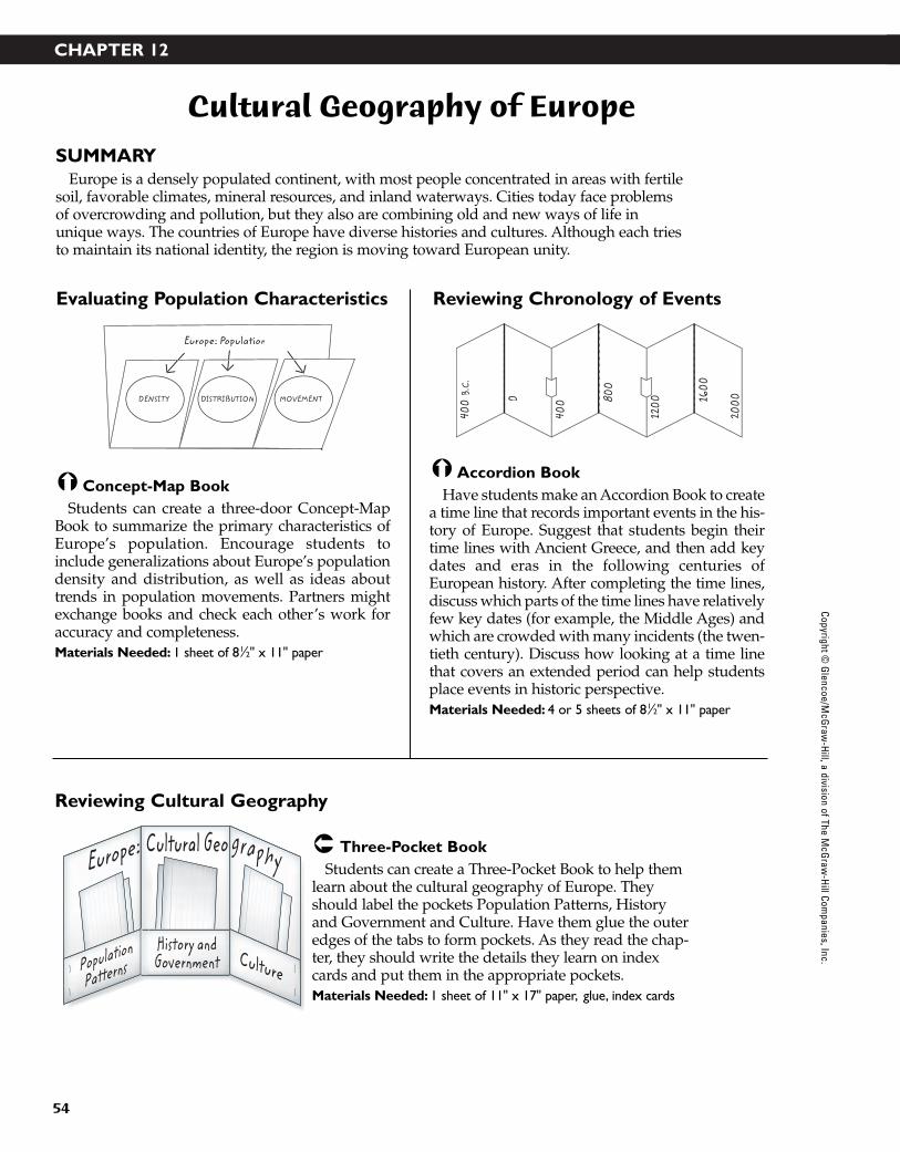
Cultural Geography of Europe
SUMMARYEurope is a densely populated continent, with most people concentrated in areas with fertile
soil, favorable climates, mineral resources, and inland waterways. Cities today face problemsof overcrowding and pollution, but they also are combining old and new ways of life inunique ways. The countries of Europe have diverse histories and cultures. Although each triesto maintain its national identity, the region is moving toward European unity.
Three-Pocket BookStudents can create a Three-Pocket Book to help them
learn about the cultural geography of Europe. Theyshould label the pockets Population Patterns, Historyand Government and Culture. Have them glue the outeredges of the tabs to form pockets. As they read the chap-ter, they should write the details they learn on indexcards and put them in the appropriate pockets.Materials Needed: 1 sheet of 11" x 17" paper, glue, index cards
Accordion BookHave students make an Accordion Book to create
a time line that records important events in the his-tory of Europe. Suggest that students begin theirtime lines with Ancient Greece, and then add keydates and eras in the following centuries ofEuropean history. After completing the time lines,discuss which parts of the time lines have relativelyfew key dates (for example, the Middle Ages) andwhich are crowded with many incidents (the twen-tieth century). Discuss how looking at a time linethat covers an extended period can help studentsplace events in historic perspective.Materials Needed: 4 or 5 sheets of 81⁄2" x 11" paper
Concept-Map BookStudents can create a three-door Concept-Map
Book to summarize the primary characteristics ofEurope’s population. Encourage students toinclude generalizations about Europe’s populationdensity and distribution, as well as ideas abouttrends in population movements. Partners mightexchange books and check each other’s work foraccuracy and completeness.Materials Needed: 1 sheet of 81⁄2" x 11" paper
400
B.C.
0
400 80
0
1200
200016
00
DENSITY DISTRIBUTION MOVEMENT
Europe: Population
CulturePopulation
PatternsHistory andGovernment
Europe: graphyCultural Geo
Evaluating Population Characteristics
Reviewing Cultural Geography
Reviewing Chronology of Events
Copyright © G
lencoe/McG
raw-H
ill, a division of The McG
raw-H
ill Companies, Inc.
43-76_RSGF_878387 3/20/07 6:35 PM Page 54
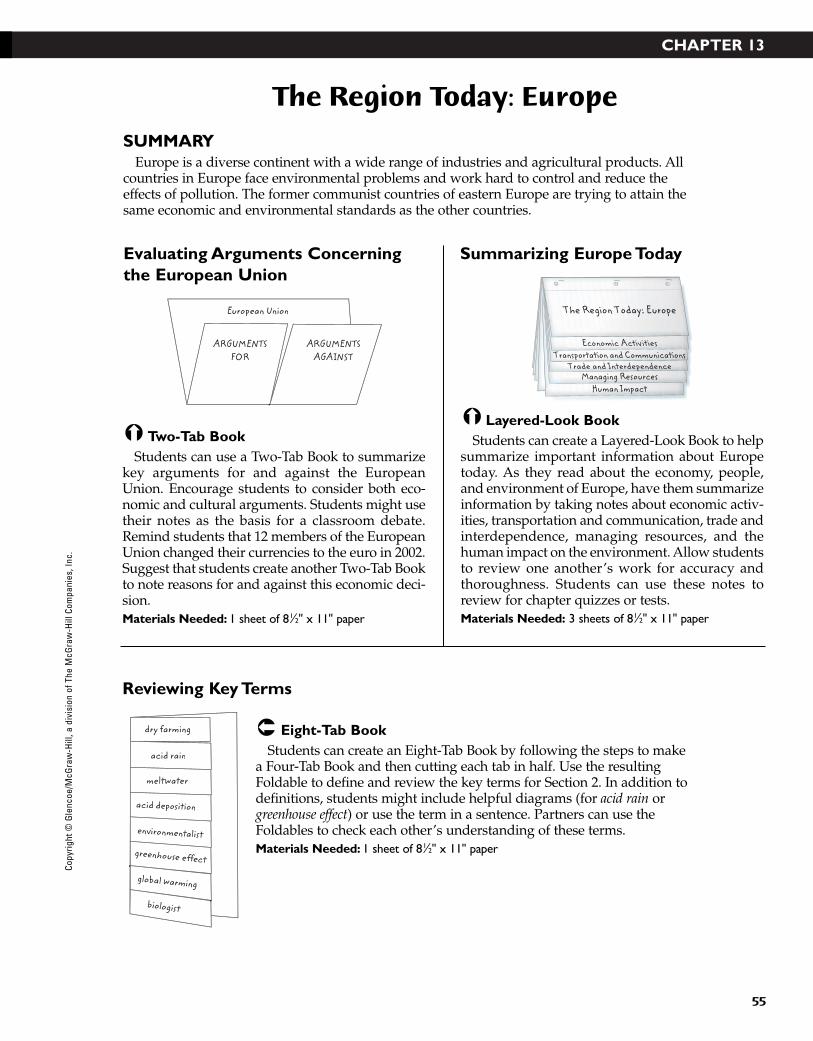
CHAPTER 13
55
The Region Today: Europe
SUMMARYEurope is a diverse continent with a wide range of industries and agricultural products. All
countries in Europe face environmental problems and work hard to control and reduce theeffects of pollution. The former communist countries of eastern Europe are trying to attain thesame economic and environmental standards as the other countries.
Eight-Tab BookStudents can create an Eight-Tab Book by following the steps to make
a Four-Tab Book and then cutting each tab in half. Use the resultingFoldable to define and review the key terms for Section 2. In addition todefinitions, students might include helpful diagrams (for acid rain orgreenhouse effect) or use the term in a sentence. Partners can use theFoldables to check each other’s understanding of these terms.Materials Needed: 1 sheet of 81⁄2" x 11" paper
Layered-Look BookStudents can create a Layered-Look Book to help
summarize important information about Europetoday. As they read about the economy, people,and environment of Europe, have them summarizeinformation by taking notes about economic activ-ities, transportation and communication, trade andinterdependence, managing resources, and thehuman impact on the environment. Allow studentsto review one another’s work for accuracy andthoroughness. Students can use these notes toreview for chapter quizzes or tests.Materials Needed: 3 sheets of 81⁄2" x 11" paper
Two-Tab BookStudents can use a Two-Tab Book to summarize
key arguments for and against the EuropeanUnion. Encourage students to consider both eco-nomic and cultural arguments. Students might usetheir notes as the basis for a classroom debate.Remind students that 12 members of the EuropeanUnion changed their currencies to the euro in 2002.Suggest that students create another Two-Tab Bookto note reasons for and against this economic deci-sion.Materials Needed: 1 sheet of 81⁄2" x 11" paper
Human ImpactManaging Resources
Trade and InterdependenceTransportation and Communications
Economic Activities
The Region Today: Europe
ARGUMENTSFOR
European Union
ARGUMENTSAGAINST
meltwater
acid deposition
environmentalist
greenhouse effect
global warming
biologist
dry farming
acid rain
Evaluating Arguments Concerningthe European Union
Reviewing Key Terms
Summarizing Europe Today
Copy
right
© G
lenc
oe/M
cGra
w-H
ill, a
div
isio
n of
The
McG
raw
-Hill
Com
pani
es, I
nc.
43-76_RSGF_878387 3/20/07 6:35 PM Page 55
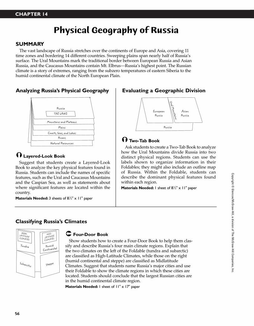
CHAPTER 14
56
Physical Geography of Russia
SUMMARYThe vast landscape of Russia stretches over the continents of Europe and Asia, covering 11
time zones and bordering 14 different countries. Sweeping plains span nearly half of Russia’ssurface. The Ural Mountains mark the traditional border between European Russia and AsianRussia, and the Caucasus Mountains contain Mt. Elbrus—Russia’s highest point. The Russianclimate is a story of extremes, ranging from the subzero temperatures of eastern Siberia to thehumid continental climate of the North European Plain.
Four-Door BookShow students how to create a Four-Door Book to help them clas-
sify and describe Russia’s four main climate regions. Explain thatthe two climates on the left of the Foldable (tundra and subarctic)are classified as High-Latitude Climates, while those on the right(humid continental and steppe) are classified as MidlatitudeClimates. Suggest that students name Russia’s major cities and usetheir Foldable to show the climate regions in which these cities arelocated. Students should conclude that the largest Russian cities arein the humid continental climate region.Materials Needed: 1 sheet of 11" x 17" paper
Two-Tab BookAsk students to create a Two-Tab Book to analyze
how the Ural Mountains divide Russia into twodistinct physical regions. Students can use thelabels shown to organize information in theirFoldables; they might also include an outline mapof Russia. Within the Foldable, students candescribe the dominant physical features foundwithin each region.Materials Needed: 1 sheet of 81⁄2" x 11" paper
Layered-Look BookSuggest that students create a Layered-Look
Book to analyze the key physical features found inRussia. Students can include the names of specificfeatures, such as the Ural and Caucasus Mountainsand the Caspian Sea, as well as statements aboutwhere significant features are located within thecountry. Materials Needed: 3 sheets of 81⁄2" x 11" paper
EuropeanRussia
Russia
Ural Mountains
AsianRussia
Russia
THE LAND
Mountains and Plateaus
Plains
Coasts, Seas, and LakesRivers
Natural Resources
HIGH- LATITUDE CLIMATES
MID-
LATITUDE
CLIMATES
Subarctic Steppe
Tundra HumidContinental
Analyzing Russia’s Physical Geography
Classifying Russia’s Climates
Evaluating a Geographic Division
Copyright © G
lencoe/McG
raw-H
ill, a division of The McG
raw-H
ill Companies, Inc.
43-76_RSGF_878387 3/20/07 6:35 PM Page 56

CHAPTER 15
57
Cultural Geography of Russia
SUMMARYMore than 100 ethnic groups live in Russia, making it a country with one of the widest vari-
eties of ethnic groups. More than 80 percent, however, are ethnic Russians, part of the largerethnic group of Slavs. Many non-Russians have formed independent countries since thebreakup of the Soviet Union. Others are seeking greater autonomy or independence fromRussia. Today religion and the arts are making a comeback, while education and the healthcare system are struggling.
Folded ChartStudents can create a Folded
Chart to compare past and presentcultures and lifestyles in Russia.Fold the page into sixths to formthe columns and thirds to formrows. Then label the charts asshown and add notes to completeeach cell. Suggest that students
include key terms in the appropriate column. For example, under Religion, students mightdefine atheism, patriarch, icon, and pogrom.Materials Needed: 1 sheet of 11" x 17" paper
Three-Tab BookAsk students to create a Three-Tab Book to help
them organize information about the culturalgeography of Russia. As students read the chapter,encourage them to use the Foldable to take notesabout the population patterns, culture, and historyand government of Russia.Materials Needed: 1 sheet of 81⁄2" x 11" paper
Accordion BookHave students make an Accordion Book to create
a time line that records important events in the his-tory of Russia. Students may wish to vary the scaleof their time lines as shown to accommodate moreevents of the nineteenth and twentieth centuries.Allow partners to compare their work, focusing onwhich events they selected and how each event isdescribed. Students may wish to punch holes in theleft side of their time line to store it in a notebook.Materials Needed: 3 or 4 sheets of 81⁄2" x 11" paper
Cultu
ral G
eogr
aphy
of R
ussia
Population
Patterns
Culture
History and
Government
600 10
00
1500 18
00
1900
200019
50
HealthCare
Life andLeisure
EducationReligion The Arts
PAST
PRESENT
Reviewing Chronology of Events
Looking at Cultures and Lifestyles
Summarizing Cultural Geography
Copy
right
© G
lenc
oe/M
cGra
w-H
ill, a
div
isio
n of
The
McG
raw
-Hill
Com
pani
es, I
nc.
43-76_RSGF_878387 3/20/07 6:35 PM Page 57
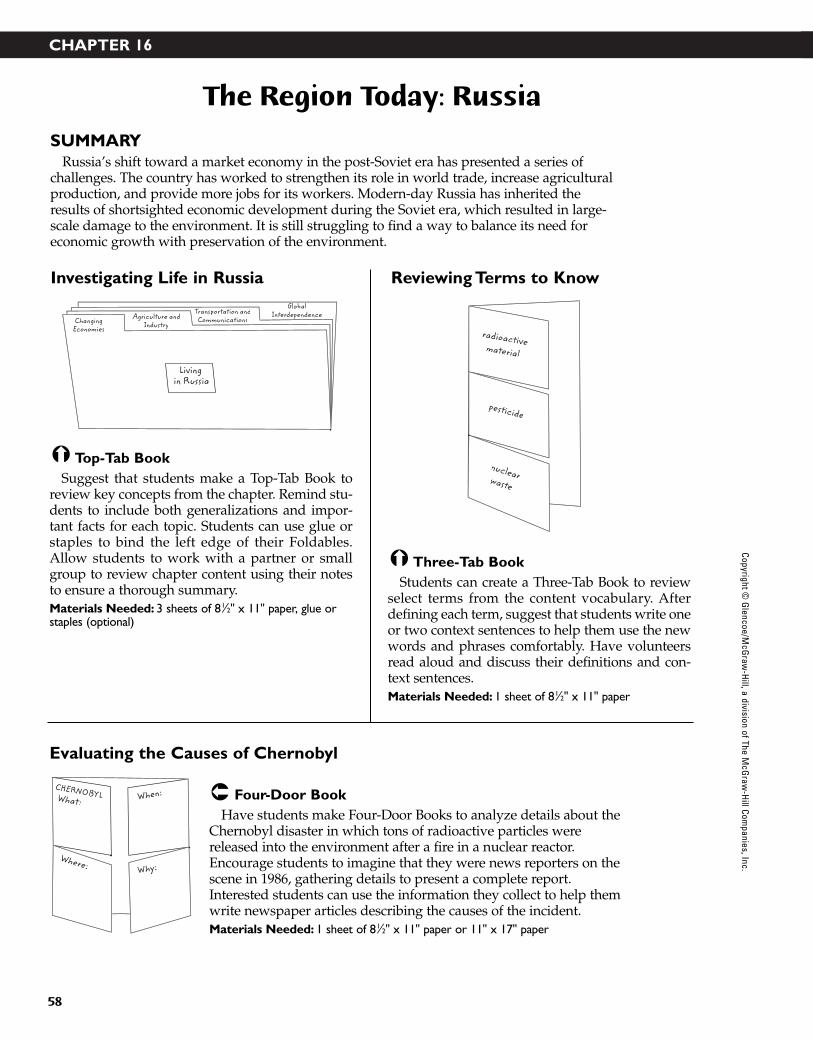
CHAPTER 16
58
The Region Today: Russia
SUMMARYRussia’s shift toward a market economy in the post-Soviet era has presented a series of
challenges. The country has worked to strengthen its role in world trade, increase agriculturalproduction, and provide more jobs for its workers. Modern-day Russia has inherited theresults of shortsighted economic development during the Soviet era, which resulted in large-scale damage to the environment. It is still struggling to find a way to balance its need for economic growth with preservation of the environment.
Four-Door BookHave students make Four-Door Books to analyze details about the
Chernobyl disaster in which tons of radioactive particles werereleased into the environment after a fire in a nuclear reactor.Encourage students to imagine that they were news reporters on thescene in 1986, gathering details to present a complete report.Interested students can use the information they collect to help themwrite newspaper articles describing the causes of the incident.Materials Needed: 1 sheet of 81⁄2" x 11" paper or 11" x 17" paper
Three-Tab BookStudents can create a Three-Tab Book to review
select terms from the content vocabulary. Afterdefining each term, suggest that students write oneor two context sentences to help them use the newwords and phrases comfortably. Have volunteersread aloud and discuss their definitions and con-text sentences. Materials Needed: 1 sheet of 81⁄2" x 11" paper
Top-Tab BookSuggest that students make a Top-Tab Book to
review key concepts from the chapter. Remind stu-dents to include both generalizations and impor-tant facts for each topic. Students can use glue orstaples to bind the left edge of their Foldables.Allow students to work with a partner or smallgroup to review chapter content using their notesto ensure a thorough summary.Materials Needed: 3 sheets of 81⁄2" x 11" paper, glue orstaples (optional)
pesticide
nuclearwaste
radioactivematerial
ChangingEconomies
Agriculture andIndustry
Living in Russia
Transportation andCommunications
GlobalInterdependence
What:
Where:
CHERNOBYL When:
Why:
Investigating Life in Russia
Evaluating the Causes of Chernobyl
Reviewing Terms to Know
Copyright © G
lencoe/McG
raw-H
ill, a division of The McG
raw-H
ill Companies, Inc.
43-76_RSGF_878387 3/20/07 6:35 PM Page 58

CHAPTER 17
59
Physical Geography of North Africa, Southwest Asia, and Central Asia
SUMMARYThe continents of Europe, Africa, and Asia meet in this region, which has been a crossroads
for travelers and traders for centuries. Deserts and mountains dominate the region, but riversflow through fertile valleys that once were the birthplaces of early civilizations. Major petro-leum, natural gas, and other mineral deposits have enriched the region. A desert climate predominates in the region, and scarcity makes water a precious resource. The vast expanseof the Sahara covers most of North Africa.
Four-Door BookHave students collect information about the climate regions in
North Africa, Southwest Asia, and Central Asia by creating a Four-Door Book. Students should label each door with a climate typefound in this region: desert, steppe, Mediterranean, highlands.Students can describe where each climate region is located and theconditions present in this climate. Materials Needed: 1 sheet of 81⁄2" x 11" or 11" x 17" paper
Three-Tab BookStudents can create a Three-Tab Book to study
select vocabulary terms for Section 2. In addition tothe definition of each term, students can write oneor two sentences that use the term correctly.Students can quiz each other by reading examplesentences aloud, leaving out the vocabulary term.Listeners try to guess which word correctly com-pletes the sentence. Students can add illustrationsor diagrams to their Three-Tab Books to help themrecall word meanings.Materials Needed: 1 sheet of 81⁄2" x 11" paper
Layered-Look BookHave students prepare a Layered-Look Book to
review Section 1: The Land. Create tab labels read-ing: Seas and Peninsulas; Rivers; Plains, Plateaus,and Mountains; Earthquakes; Natural Resources.Students can write key ideas associated with eachheading. Remind students to include essentialideas in their notes, including useful generaliza-tions and relevant examples. After completingtheir books, student groups can compare theirnotes to evaluate their note-taking skills. Materials Needed: 3 sheets of 81⁄2" x 11" paper
oasis pastoralism cereal
Chapter 17, Section 2 TERMSand Central Asia
Seas and Peninsulas
Rivers
Plains, Plateaus, and Mountains
Earthquakes
Natural Resources
THE LAND
Desert
Mediterranean
CLIMATEREGIONS
Steppe
Highlands
Reviewing Key Ideas
Understanding Climate Regions
Defining Terms
Copy
right
© G
lenc
oe/M
cGra
w-H
ill, a
div
isio
n of
The
McG
raw
-Hill
Com
pani
es, I
nc.
43-76_RSGF_878387 3/20/07 6:35 PM Page 59
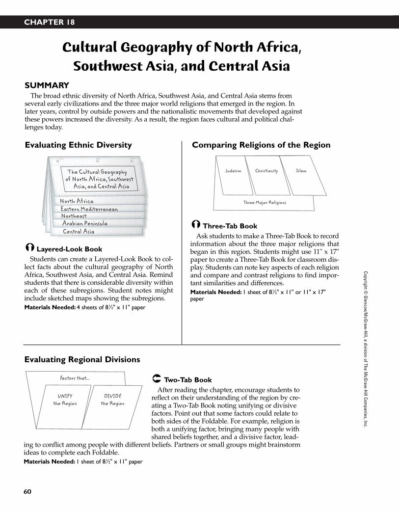
CHAPTER 18
60
Cultural Geography of North Africa, Southwest Asia, and Central Asia
SUMMARYThe broad ethnic diversity of North Africa, Southwest Asia, and Central Asia stems from
several early civilizations and the three major world religions that emerged in the region. Inlater years, control by outside powers and the nationalistic movements that developed againstthese powers increased the diversity. As a result, the region faces cultural and political chal-lenges today.
Two-Tab BookAfter reading the chapter, encourage students to
reflect on their understanding of the region by cre-ating a Two-Tab Book noting unifying or divisivefactors. Point out that some factors could relate toboth sides of the Foldable. For example, religion isboth a unifying factor, bringing many people withshared beliefs together, and a divisive factor, lead-
ing to conflict among people with different beliefs. Partners or small groups might brainstormideas to complete each Foldable.Materials Needed: 1 sheet of 81⁄2" x 11" paper
Three-Tab BookAsk students to make a Three-Tab Book to record
information about the three major religions thatbegan in this region. Students might use 11" x 17"paper to create a Three-Tab Book for classroom dis-play. Students can note key aspects of each religionand compare and contrast religions to find impor-tant similarities and differences.Materials Needed: 1 sheet of 81⁄2" x 11" or 11" x 17"paper
Layered-Look BookStudents can create a Layered-Look Book to col-
lect facts about the cultural geography of NorthAfrica, Southwest Asia, and Central Asia. Remindstudents that there is considerable diversity withineach of these subregions. Student notes mightinclude sketched maps showing the subregions.Materials Needed: 4 sheets of 81⁄2" x 11" paper
Judaism IslamChristianity
Three Major Religions
Central AsiaArabian PeninsulaNortheastEastern MediterraneanNorth Africa
The Cultural Geographyof North Africa, Southwest
Asia, and Central Asia
UNIFYthe Region
Factors that...
DIVIDEthe Region
Evaluating Ethnic Diversity
Evaluating Regional Divisions
Comparing Religions of the Region
Copyright © G
lencoe/McG
raw-H
ill, a division of The McG
raw-H
ill Companies, Inc.
43-76_RSGF_878387 3/20/07 6:35 PM Page 60
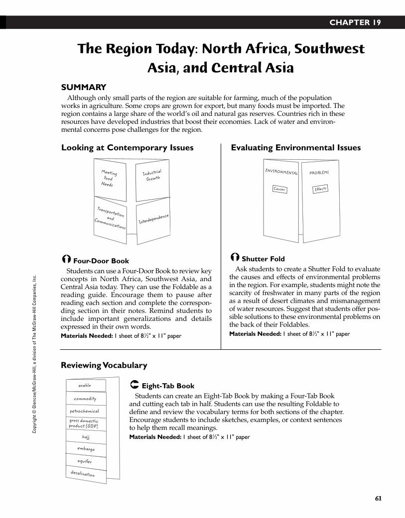
CHAPTER 19
61
The Region Today: North Africa, SouthwestAsia, and Central Asia
SUMMARYAlthough only small parts of the region are suitable for farming, much of the population
works in agriculture. Some crops are grown for export, but many foods must be imported. Theregion contains a large share of the world’s oil and natural gas reserves. Countries rich in theseresources have developed industries that boost their economies. Lack of water and environ-mental concerns pose challenges for the region.
Eight-Tab BookStudents can create an Eight-Tab Book by making a Four-Tab Book
and cutting each tab in half. Students can use the resulting Foldable todefine and review the vocabulary terms for both sections of the chapter.Encourage students to include sketches, examples, or context sentencesto help them recall meanings. Materials Needed: 1 sheet of 81⁄2" x 11" paper
Shutter FoldAsk students to create a Shutter Fold to evaluate
the causes and effects of environmental problemsin the region. For example, students might note thescarcity of freshwater in many parts of the regionas a result of desert climates and mismanagementof water resources. Suggest that students offer pos-sible solutions to these environmental problems onthe back of their Foldables. Materials Needed: 1 sheet of 81⁄2" x 11" paper
Four-Door BookStudents can use a Four-Door Book to review key
concepts in North Africa, Southwest Asia, andCentral Asia today. They can use the Foldable as areading guide. Encourage them to pause afterreading each section and complete the correspon-ding section in their notes. Remind students toinclude important generalizations and detailsexpressed in their own words. Materials Needed: 1 sheet of 81⁄2" x 11" paper
PROBLEMSENVIRONMENTAL
Causes Effects
TransportationandCommunications
MeetingFood
Needs
Industrial
Growth
Interdependence
petrochemical
gross domesticproduct (GDP)g s
hajj
embargo
aquifer
desalination
arable
commodity
Looking at Contemporary Issues
Reviewing Vocabulary
Evaluating Environmental Issues
Copy
right
© G
lenc
oe/M
cGra
w-H
ill, a
div
isio
n of
The
McG
raw
-Hill
Com
pani
es, I
nc.
43-76_RSGF_878387 3/20/07 6:35 PM Page 61

CHAPTER 20
62
Physical Geography of AfricaSouth of the Sahara
SUMMARYHigh plateaus cover much of Africa South of the Sahara, rising in elevation from the coast
going inland and from west to east. Shifting tectonic plates formed the Great Rift Valley, whichruns from Syria to Mozambique. The valley’s striking landscape contains volcanic mountainsand deep lakes. Near the Equator, orchids and ferns grow among the branches of the canopyof trees that tower high above the floor of tropical rain forests. Tropical grasslands, known assavanna, cover nearly half of the continent.
Four-Door BookAsk students to create a Four-Door Book to review the four most
common climate regions in Africa South of the Sahara. After stu-dents complete their notes, ask them to describe the climate regionsthat are not included in their work. Point out that some moderateclimate regions exist in the region, including coastal areas of SouthAfrica and highlands regions in East Africa. Students might describethese additional climates on the back of their Foldables.Materials Needed: 1 sheet of 81⁄2" x 11" or 11" x 17" paper
Three-Tab BookStudents can use a Three-Tab Book to make a
Venn diagram for comparing two major riverbasins in Africa South of the Sahara: the NigerRiver and the Zambezi River. Encourage studentsto compare the rivers in terms of length, directionof flow, and uses. Students might define the keyterms delta and estuary at the bottom or on the backof their diagrams. Materials Needed: 1 sheet of 81⁄2" x 11" paper
Layered-Look BookHave students create a Layered-Look Book to
review the key geographic features of Africa Southof the Sahara. Partners or groups might begin bybrainstorming a list of noteworthy geographic fea-tures of the region, such as Kilimanjaro, LakeVictoria, the Cape of Good Hope, and the NigerRiver. Then students can add each feature to thecorresponding area in their Foldable. Continueadding details as they review the chapter. Materials Needed: 2 sheets of 81⁄2" x 11" paper
NigerRiver
ZambeziRiver
Both
AFRICAN RIVER BASINS
THE LAND
Africa South of the Sahara
LandformsWater Systems
Natural Resources
Savanna
Tropicalwet
Steppe
TROPICALCLIMATESDRY
CLIMATES
Desert
Looking at the Land South of theSahara
Reviewing Climate Regions
Comparing River Basins
Copyright © G
lencoe/McG
raw-H
ill, a division of The McG
raw-H
ill Companies, Inc.
43-76_RSGF_878387 3/20/07 6:35 PM Page 62
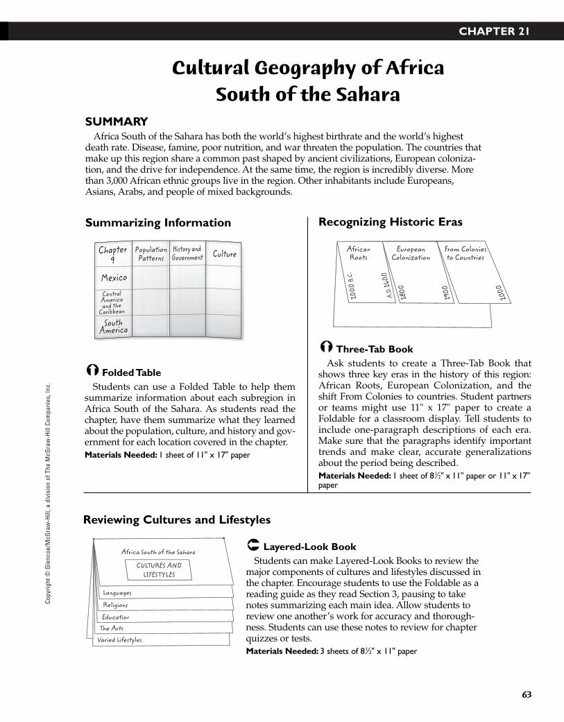
Copy
right
© G
lenc
oe/M
cGra
w-H
ill, a
div
isio
n of
The
McG
raw
-Hill
Com
pani
es, I
nc.
CHAPTER 21
63
Cultural Geography of Africa South of the Sahara
SUMMARYAfrica South of the Sahara has both the world’s highest birthrate and the world’s highest
death rate. Disease, famine, poor nutrition, and war threaten the population. The countries thatmake up this region share a common past shaped by ancient civilizations, European coloniza-tion, and the drive for independence. At the same time, the region is incredibly diverse. Morethan 3,000 African ethnic groups live in the region. Other inhabitants include Europeans,Asians, Arabs, and people of mixed backgrounds.
Layered-Look BookStudents can make Layered-Look Books to review the
major components of cultures and lifestyles discussed inthe chapter. Encourage students to use the Foldable as areading guide as they read Section 3, pausing to takenotes summarizing each main idea. Allow students toreview one another’s work for accuracy and thorough-ness. Students can use these notes to review for chapterquizzes or tests. Materials Needed: 3 sheets of 81⁄2" x 11" paper
Folded TableStudents can use a Folded Table to help them
summarize information about each subregion inAfrica South of the Sahara. As students read thechapter, have them summarize what they learnedabout the population, culture, and history and gov-ernment for each location covered in the chapter.Materials Needed: 1 sheet of 11" x 17" paper
PopulationPatterns
Chapter9
Mexico
SouthAmerica
CentralAmericaand the
Caribbean
History andGovernment Culture
Africa South of the Sahara
Languages
Religions
Education
The Arts
Varied Lifestyles
CULTURES ANDLIFESTYLES
Summarizing Information
Reviewing Cultures and Lifestyles
Three-Tab BookAsk students to create a Three-Tab Book that
shows three key eras in the history of this region:African Roots, European Colonization, and theshift From Colonies to countries. Student partnersor teams might use 11" x 17" paper to create aFoldable for a classroom display. Tell students toinclude one-paragraph descriptions of each era.Make sure that the paragraphs identify importanttrends and make clear, accurate generalizationsabout the period being described.Materials Needed: 1 sheet of 81⁄2" x 11" paper or 11" x 17"paper
AfricanRoots
From Coloniesto Countries
EuropeanColonization
2000
B.C
.
A.D
. 160
0
1800
1900
2000
Recognizing Historic Eras
43-76_RSGF_878387 3/20/07 6:35 PM Page 63

CHAPTER 22
64
The Region Today: Africa South of the Sahara
SUMMARYToday, Africa south of the Sahara is making the slow transition from an economy based on
subsistence agriculture to one that is a part of the global economy. More than two-thirds of theregion’s working population makes a living in some form of agriculture. The people of theregion are working to resolve human-made conflicts and environmental challenges that haveinterrupted the supply of food and endangered plant and animal life.
Four-Door BookHave students create a Four-Door Book to identify four problems
facing Africa South of the Sahara today. After naming and describingeach problem on the front of each door, students can present possi-ble solutions inside the Foldable. Suggest that students describe thefour problems shown above or use ideas of their own to completetheir Foldables. Allow students to share their work by reading prob-lems and solutions aloud, or by posting their work in a classroom orschool display. Materials Needed: 1 sheet of 81⁄2" x 11" or 11" x 17" paper
Two-Tab BookStudents can use a Two-Tab Book to analyze
important trends in politics and economics inAfrica South of the Sahara. You may wish to intro-duce the topic in a class or small group discussion.Students can use the Foldable to guide a discussionor jot down interesting ideas generated during theconversation. Encourage students to use their com-pleted notes to help them make predictions aboutthe political and economic outlook for this regionin 10, 50, and 100 years. Materials Needed: 1 sheet of 81⁄2" x 11" paper
Eight-Tab BookStudents can use notebook paper to create an
Eight-Tab Book by following the directions formaking a Four-Tab Book and then cutting each tabin half. They can then use the Foldable to reviewvocabulary terms for Section 1. Encourage studentsto note the similarities and differences between thetypes of farming defined in this section. Materials Needed: 1 sheet of 81⁄2" x 11" paper
Politicalstability
Working toward...
Economicindependencesedentary farming
commercial farming
cash crop
conservation farming
infrastructure
e-commerce
subsistence farming
shifting farming
Desertification
Hunger andMalnutrition
PROBLEMS
Destruction
of the
Rain Forest
Endangered
Animals
Reviewing Vocabulary
Assessing Regional Problems and Solutions
Making Generalizations about Trends
Copyright © G
lencoe/McG
raw-H
ill, a division of The McG
raw-H
ill Companies, Inc.
43-76_RSGF_878387 3/20/07 6:35 PM Page 64

CHAPTER 23
65
Physical Geography of South Asia
SUMMARYSeparated from the rest of Asia by some of the world’s highest mountains, the subcontinent
of South Asia forms a distinct landmass. Three bodies of water—the Arabian Sea, the IndianOcean, and the Bay of Bengal—border the subcontinent, and three major river systems fanout across the northern part of the region. Much of South Asia has tropical and subtropical climates with diverse vegetation, including rain forests and savannas.
Four-Door BookEncourage students to create Four-Door Books to answer ques-
tions about the monsoon cycle in South Asia. Remind students toanswer the questions for both summer and winter seasons, describ-ing how the direction of the wind affects the climate and weather.Students may use 11" x 17" paper to create Four-Door Books forclassroom display.Materials Needed: 1 sheet of 81⁄2" x 11" or 11" x 17" paper
Trifold BookStudents can make a two-sided Trifold Book to
summarize the major climate regions found inSouth Asia. On one side of the Foldable, studentsshould sketch a map of South Asia to show themain climate regions. On the other side, theyshould describe these three climate categories:highlands, tropical, and desert. Encourage studentsto use colored pencils or markers to make the dis-tinctions between zones clear. Materials Needed: 1 sheet of 81⁄2" x 11" or 11" x 17"paper
Concept-Map BookHave students create a three-tab Concept-Map
Book to classify major geographic features of SouthAsia. Suggest that they begin by viewing a PhysicalMap of South Asia and noting the features shown.Then, encourage students to use their Foldables asreading guides, paying particular attention toinformation in the text about river systems. Aftercompleting their notes, students might use them tocompare South Asia with another region they havealready studied. Materials Needed: 1 sheet of 81⁄2" x 11" paper
Highlands
Tropical
Desert
LAND WATER NATURALRESOURCES
South Asia
What?
When?
MONSOON
Where?
How?/Why?
Classifying Geographic Features
Recognizing the Monsoon Cycle
Summarizing Climate Regions
Copy
right
© G
lenc
oe/M
cGra
w-H
ill, a
div
isio
n of
The
McG
raw
-Hill
Com
pani
es, I
nc.
43-76_RSGF_878387 3/20/07 6:35 PM Page 65
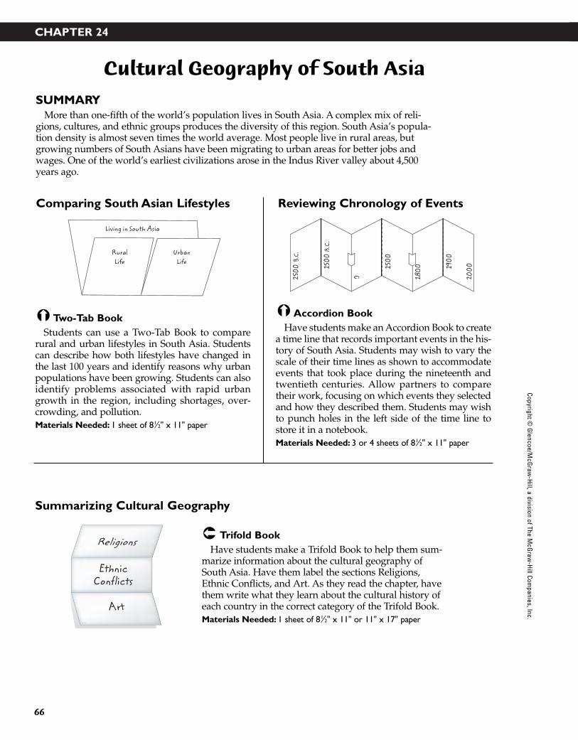
CHAPTER 24
66
Cultural Geography of South Asia
SUMMARYMore than one-fifth of the world’s population lives in South Asia. A complex mix of reli-
gions, cultures, and ethnic groups produces the diversity of this region. South Asia’s popula-tion density is almost seven times the world average. Most people live in rural areas, butgrowing numbers of South Asians have been migrating to urban areas for better jobs andwages. One of the world’s earliest civilizations arose in the Indus River valley about 4,500years ago.
Trifold BookHave students make a Trifold Book to help them sum-
marize information about the cultural geography ofSouth Asia. Have them label the sections Religions,Ethnic Conflicts, and Art. As they read the chapter, havethem write what they learn about the cultural history ofeach country in the correct category of the Trifold Book.Materials Needed: 1 sheet of 81⁄2" x 11" or 11" x 17" paper
Accordion BookHave students make an Accordion Book to create
a time line that records important events in the his-tory of South Asia. Students may wish to vary thescale of their time lines as shown to accommodateevents that took place during the nineteenth andtwentieth centuries. Allow partners to comparetheir work, focusing on which events they selectedand how they described them. Students may wishto punch holes in the left side of the time line tostore it in a notebook.Materials Needed: 3 or 4 sheets of 81⁄2" x 11" paper
Two-Tab BookStudents can use a Two-Tab Book to compare
rural and urban lifestyles in South Asia. Studentscan describe how both lifestyles have changed inthe last 100 years and identify reasons why urbanpopulations have been growing. Students can alsoidentify problems associated with rapid urbangrowth in the region, including shortages, over-crowding, and pollution. Materials Needed: 1 sheet of 81⁄2" x 11" paper
2500
B.C
.
1500
B.C
.
0
1500
180000
200019
00
RuralLife
Living in South Asia
UrbanLife
Religions
Art
Comparing South Asian Lifestyles
Summarizing Cultural Geography
Reviewing Chronology of Events
Copyright © G
lencoe/McG
raw-H
ill, a division of The McG
raw-H
ill Companies, Inc.
43-76_RSGF_878387 3/20/07 6:35 PM Page 66
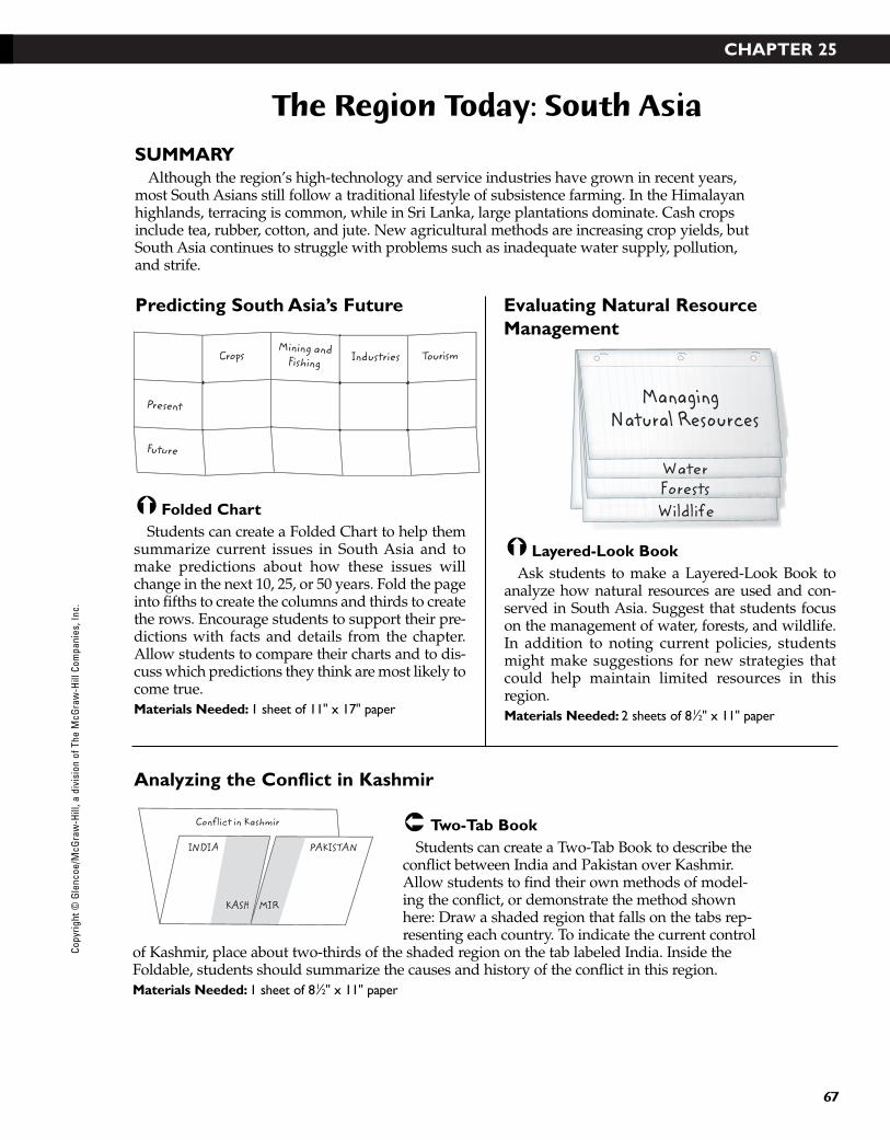
CHAPTER 25
67
The Region Today: South Asia
SUMMARYAlthough the region’s high-technology and service industries have grown in recent years,
most South Asians still follow a traditional lifestyle of subsistence farming. In the Himalayanhighlands, terracing is common, while in Sri Lanka, large plantations dominate. Cash cropsinclude tea, rubber, cotton, and jute. New agricultural methods are increasing crop yields, butSouth Asia continues to struggle with problems such as inadequate water supply, pollution,and strife.
Two-Tab BookStudents can create a Two-Tab Book to describe the
conflict between India and Pakistan over Kashmir.Allow students to find their own methods of model-ing the conflict, or demonstrate the method shownhere: Draw a shaded region that falls on the tabs rep-resenting each country. To indicate the current control
of Kashmir, place about two-thirds of the shaded region on the tab labeled India. Inside theFoldable, students should summarize the causes and history of the conflict in this region.Materials Needed: 1 sheet of 81⁄2" x 11" paper
Layered-Look BookAsk students to make a Layered-Look Book to
analyze how natural resources are used and con-served in South Asia. Suggest that students focuson the management of water, forests, and wildlife.In addition to noting current policies, studentsmight make suggestions for new strategies thatcould help maintain limited resources in thisregion. Materials Needed: 2 sheets of 81⁄2" x 11" paper
Folded ChartStudents can create a Folded Chart to help them
summarize current issues in South Asia and tomake predictions about how these issues willchange in the next 10, 25, or 50 years. Fold the pageinto fifths to create the columns and thirds to createthe rows. Encourage students to support their pre-dictions with facts and details from the chapter.Allow students to compare their charts and to dis-cuss which predictions they think are most likely tocome true.Materials Needed: 1 sheet of 11" x 17" paper
WildlifeForestsWater
ManagingNatural Resources
IndustriesMining and
FishingCrops Tourism
Present
Future
INDIA
KASH MIR
Conflict in Kashmir
PAKISTAN
Predicting South Asia’s Future
Analyzing the Conflict in Kashmir
Evaluating Natural ResourceManagement
Copy
right
© G
lenc
oe/M
cGra
w-H
ill, a
div
isio
n of
The
McG
raw
-Hill
Com
pani
es, I
nc.
43-76_RSGF_878387 3/20/07 6:35 PM Page 67
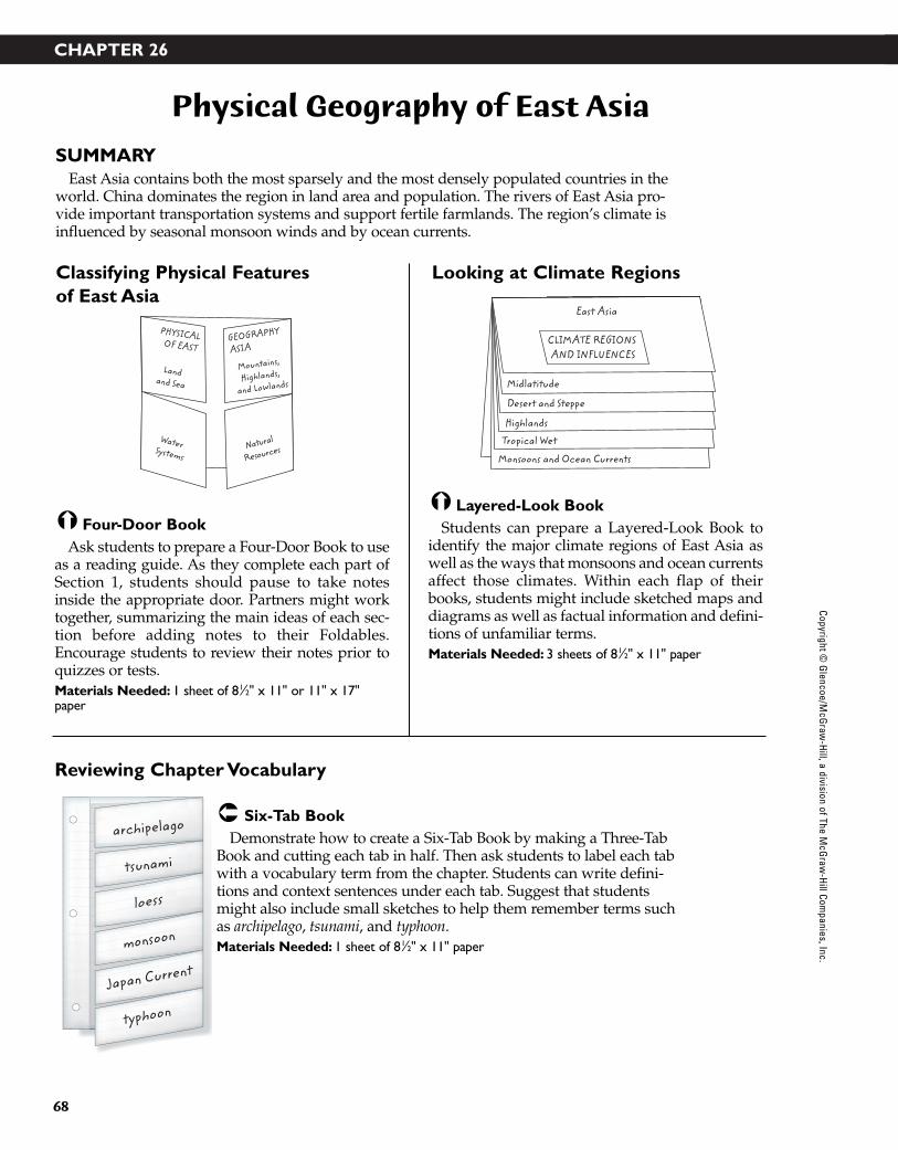
CHAPTER 26
68
Physical Geography of East Asia
SUMMARYEast Asia contains both the most sparsely and the most densely populated countries in the
world. China dominates the region in land area and population. The rivers of East Asia pro-vide important transportation systems and support fertile farmlands. The region’s climate isinfluenced by seasonal monsoon winds and by ocean currents.
Six-Tab BookDemonstrate how to create a Six-Tab Book by making a Three-Tab
Book and cutting each tab in half. Then ask students to label each tabwith a vocabulary term from the chapter. Students can write defini-tions and context sentences under each tab. Suggest that studentsmight also include small sketches to help them remember terms suchas archipelago, tsunami, and typhoon. Materials Needed: 1 sheet of 81⁄2" x 11" paper
Layered-Look BookStudents can prepare a Layered-Look Book to
identify the major climate regions of East Asia aswell as the ways that monsoons and ocean currentsaffect those climates. Within each flap of theirbooks, students might include sketched maps anddiagrams as well as factual information and defini-tions of unfamiliar terms. Materials Needed: 3 sheets of 81⁄2" x 11" paper
Four-Door BookAsk students to prepare a Four-Door Book to use
as a reading guide. As they complete each part ofSection 1, students should pause to take notesinside the appropriate door. Partners might worktogether, summarizing the main ideas of each sec-tion before adding notes to their Foldables.Encourage students to review their notes prior toquizzes or tests. Materials Needed: 1 sheet of 81⁄2" x 11" or 11" x 17"paper
East Asia
Midlatitude
Desert and Steppe
Highlands
Tropical Wet
Monsoons and Ocean Currents
CLIMATE REGIONS AND INFLUENCES
Water Systems
Landand Sea
Mountains,
Highlands,
and Lowlands
PHYSICALOF EAST
GEOGRAPHY
ASIA
Natural
Resources
loess
monsoon
tsunami
archipelago
Japan Current
typhoon
Classifying Physical Features of East Asia
Reviewing Chapter Vocabulary
Looking at Climate Regions
Copyright © G
lencoe/McG
raw-H
ill, a division of The McG
raw-H
ill Companies, Inc.
43-76_RSGF_878387 3/20/07 6:35 PM Page 68
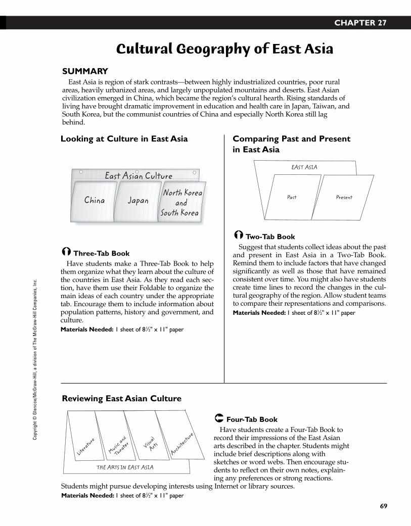
CHAPTER 27
69
Cultural Geography of East Asia
SUMMARYEast Asia is region of stark contrasts—between highly industrialized countries, poor rural
areas, heavily urbanized areas, and largely unpopulated mountains and deserts. East Asiancivilization emerged in China, which became the region’s cultural hearth. Rising standards ofliving have brought dramatic improvement in education and health care in Japan, Taiwan, andSouth Korea, but the communist countries of China and especially North Korea still lagbehind.
Four-Tab BookHave students create a Four-Tab Book to
record their impressions of the East Asianarts described in the chapter. Students mightinclude brief descriptions along withsketches or word webs. Then encourage stu-dents to reflect on their own notes, explain-ing any preferences or strong reactions.
Students might pursue developing interests using Internet or library sources.Materials Needed: 1 sheet of 81⁄2" x 11" paper
Two-Tab BookSuggest that students collect ideas about the past
and present in East Asia in a Two-Tab Book.Remind them to include factors that have changedsignificantly as well as those that have remainedconsistent over time. You might also have studentscreate time lines to record the changes in the cul-tural geography of the region. Allow student teamsto compare their representations and comparisons.Materials Needed: 1 sheet of 81⁄2" x 11" paper
Three-Tab BookHave students make a Three-Tab Book to help
them organize what they learn about the culture ofthe countries in East Asia. As they read each sec-tion, have them use their Foldable to organize themain ideas of each country under the appropriatetab. Encourage them to include information aboutpopulation patterns, history and government, andculture.Materials Needed: 1 sheet of 81⁄2" x 11" paper
Past
EAST ASIA
PresentChina JapanNorth Korea
andSouth Korea
East Asian Culture
Literature
Visual
Arts
Architecture
AAMusic and
Theater
THE ARTS IN EAST ASIA
Looking at Culture in East Asia
Reviewing East Asian Culture
Comparing Past and Present in East Asia
Copy
right
© G
lenc
oe/M
cGra
w-H
ill, a
div
isio
n of
The
McG
raw
-Hill
Com
pani
es, I
nc.
43-76_RSGF_878387 3/20/07 6:35 PM Page 69
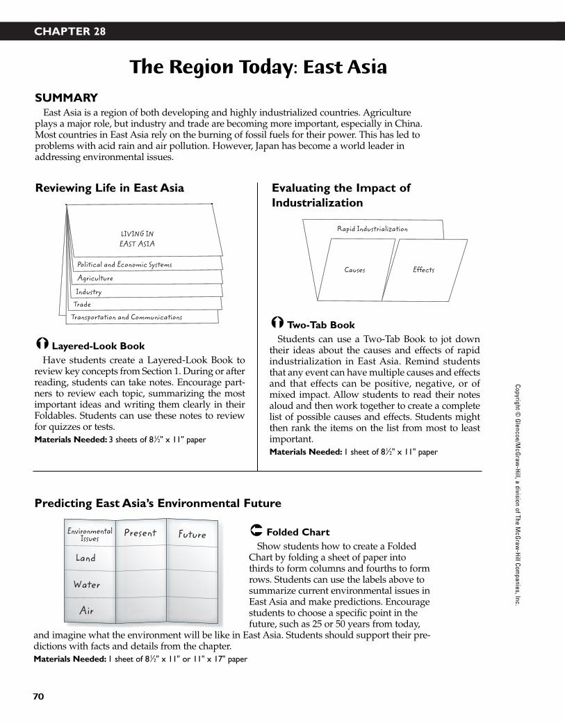
CHAPTER 28
70
The Region Today: East Asia
SUMMARYEast Asia is a region of both developing and highly industrialized countries. Agriculture
plays a major role, but industry and trade are becoming more important, especially in China.Most countries in East Asia rely on the burning of fossil fuels for their power. This has led toproblems with acid rain and air pollution. However, Japan has become a world leader inaddressing environmental issues.
Folded ChartShow students how to create a Folded
Chart by folding a sheet of paper intothirds to form columns and fourths to formrows. Students can use the labels above tosummarize current environmental issues inEast Asia and make predictions. Encouragestudents to choose a specific point in thefuture, such as 25 or 50 years from today,
and imagine what the environment will be like in East Asia. Students should support their pre-dictions with facts and details from the chapter.Materials Needed: 1 sheet of 81⁄2" x 11" or 11" x 17" paper
Two-Tab BookStudents can use a Two-Tab Book to jot down
their ideas about the causes and effects of rapidindustrialization in East Asia. Remind studentsthat any event can have multiple causes and effectsand that effects can be positive, negative, or ofmixed impact. Allow students to read their notesaloud and then work together to create a completelist of possible causes and effects. Students mightthen rank the items on the list from most to leastimportant.Materials Needed: 1 sheet of 81⁄2" x 11" paper
Layered-Look BookHave students create a Layered-Look Book to
review key concepts from Section 1. During or afterreading, students can take notes. Encourage part-ners to review each topic, summarizing the mostimportant ideas and writing them clearly in theirFoldables. Students can use these notes to reviewfor quizzes or tests.Materials Needed: 3 sheets of 81⁄2" x 11" paper
Causes
Rapid Industrialization
EffectsPolitical and Economic Systems
Agriculture
Industry
Trade
Transportation and Communications
LIVING INEAST ASIA
EnvironmentalIssues
Land
Water
Air
Present Future
Reviewing Life in East Asia
Predicting East Asia’s Environmental Future
Evaluating the Impact ofIndustrialization
Copyright © G
lencoe/McG
raw-H
ill, a division of The McG
raw-H
ill Companies, Inc.
43-76_RSGF_878387 3/20/07 6:35 PM Page 70
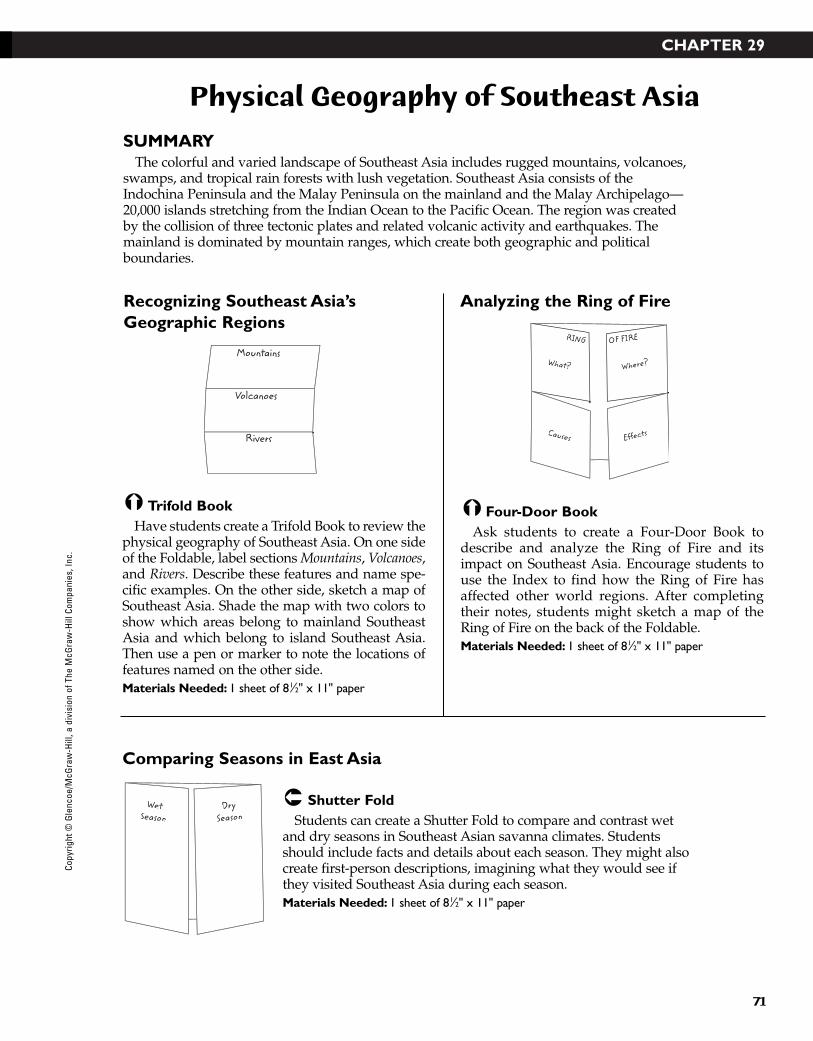
CHAPTER 29
71
Physical Geography of Southeast Asia
SUMMARYThe colorful and varied landscape of Southeast Asia includes rugged mountains, volcanoes,
swamps, and tropical rain forests with lush vegetation. Southeast Asia consists of theIndochina Peninsula and the Malay Peninsula on the mainland and the Malay Archipelago—20,000 islands stretching from the Indian Ocean to the Pacific Ocean. The region was createdby the collision of three tectonic plates and related volcanic activity and earthquakes. Themainland is dominated by mountain ranges, which create both geographic and politicalboundaries.
Shutter FoldStudents can create a Shutter Fold to compare and contrast wet
and dry seasons in Southeast Asian savanna climates. Studentsshould include facts and details about each season. They might alsocreate first-person descriptions, imagining what they would see ifthey visited Southeast Asia during each season. Materials Needed: 1 sheet of 81⁄2" x 11" paper
Four-Door BookAsk students to create a Four-Door Book to
describe and analyze the Ring of Fire and itsimpact on Southeast Asia. Encourage students touse the Index to find how the Ring of Fire hasaffected other world regions. After completingtheir notes, students might sketch a map of theRing of Fire on the back of the Foldable. Materials Needed: 1 sheet of 81⁄2" x 11" paper
Trifold BookHave students create a Trifold Book to review the
physical geography of Southeast Asia. On one sideof the Foldable, label sections Mountains, Volcanoes,and Rivers. Describe these features and name spe-cific examples. On the other side, sketch a map ofSoutheast Asia. Shade the map with two colors toshow which areas belong to mainland SoutheastAsia and which belong to island Southeast Asia.Then use a pen or marker to note the locations offeatures named on the other side.Materials Needed: 1 sheet of 81⁄2" x 11" paper
What?
Causes
RING OF FIRE
Where?
Effects
Mountains
Volcanoes
Rivers
WetSeason
DrySeason
Recognizing Southeast Asia’sGeographic Regions
Comparing Seasons in East Asia
Analyzing the Ring of Fire
Copy
right
© G
lenc
oe/M
cGra
w-H
ill, a
div
isio
n of
The
McG
raw
-Hill
Com
pani
es, I
nc.
43-76_RSGF_878387 3/20/07 6:35 PM Page 71

CHAPTER 30
72
Cultural Geography of Southeast Asia
SUMMARYSoutheast Asia’s population is made up of descendants of indigenous peoples, Indians,
Chinese, Arabs, and European colonists. The region’s diverse cultural traditions have resultedfrom thousands of years of Chinese, Indian, Islamic, European, and American influences.Southeast Asia’s main religions include Buddhism, Islam, Christianity, and indigenous reli-gions. The region’s cities are growing rapidly as people migrate from rural to urban areas.
Two-Tab BookStudents can use a Two-Tab Book to compare the cultures
of mainland and island Southeast Asia. As students readthe chapter, encourage them to write notes in their Foldableabout the population patterns, history and government, andculture of each subregion.Materials Needed: 1 sheet of 81⁄2" x 11" paper
Accordion BookHave students make an Accordion Book to create
a time line that notes important events in the his-tory of Southeast Asia. Students may wish to varythe scale of their time lines as shown to accommo-date more events of the nineteenth and twentiethcenturies. Encourage students to use shadedbands, colors, or other visual methods to showspecific eras of history, such as the Funan, Khmer,and Srivijaya Empires.Materials Needed: 3 or 4 sheets of 81⁄2" x 11" paper
Two-Tab BookStudents can use a Two-Tab Book to analyze
migration patterns in Southeast Asia. Encouragestudents to describe the rural population andexplain the reasons for the growing trend towardurbanization. Suggest that students also define pri-mate city and give several examples. On the back ofthe Foldable, students might describe outwardmigrations, including migration from SoutheastAsia to the United States.Materials Needed: 1 sheet of 81⁄2" x 11" paper
0
500
1500 18
00
1900
200019
50
From rural
Migration in Southeast Asia
to urban
MainlandCountries
Island Countries
Southeast Asia
Looking at Migration Patterns
Comparing Cultures
Reviewing Chronology of Events
Copyright © G
lencoe/McG
raw-H
ill, a division of The McG
raw-H
ill Companies, Inc.
43-76_RSGF_878387 3/20/07 6:35 PM Page 72
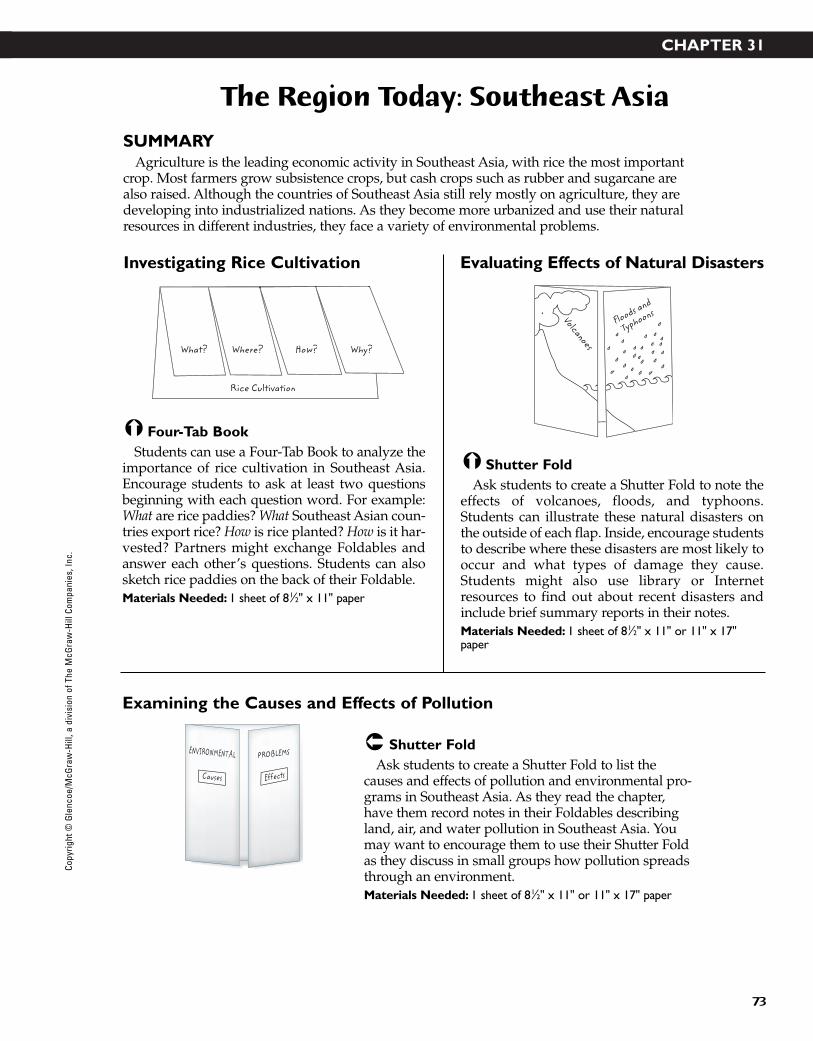
CHAPTER 31
73
The Region Today: Southeast Asia
SUMMARYAgriculture is the leading economic activity in Southeast Asia, with rice the most important
crop. Most farmers grow subsistence crops, but cash crops such as rubber and sugarcane arealso raised. Although the countries of Southeast Asia still rely mostly on agriculture, they aredeveloping into industrialized nations. As they become more urbanized and use their naturalresources in different industries, they face a variety of environmental problems.
Shutter FoldAsk students to create a Shutter Fold to list the
causes and effects of pollution and environmental pro-grams in Southeast Asia. As they read the chapter,have them record notes in their Foldables describingland, air, and water pollution in Southeast Asia. Youmay want to encourage them to use their Shutter Foldas they discuss in small groups how pollution spreadsthrough an environment.Materials Needed: 1 sheet of 81⁄2" x 11" or 11" x 17" paper
Shutter FoldAsk students to create a Shutter Fold to note the
effects of volcanoes, floods, and typhoons.Students can illustrate these natural disasters onthe outside of each flap. Inside, encourage studentsto describe where these disasters are most likely tooccur and what types of damage they cause.Students might also use library or Internetresources to find out about recent disasters andinclude brief summary reports in their notes.Materials Needed: 1 sheet of 81⁄2" x 11" or 11" x 17"paper
Four-Tab BookStudents can use a Four-Tab Book to analyze the
importance of rice cultivation in Southeast Asia.Encourage students to ask at least two questionsbeginning with each question word. For example:What are rice paddies? What Southeast Asian coun-tries export rice? How is rice planted? How is it har-vested? Partners might exchange Foldables andanswer each other’s questions. Students can alsosketch rice paddies on the back of their Foldable.Materials Needed: 1 sheet of 81⁄2" x 11" paper
Floods and
TyphoonsVolcanoesWhat? Where? How? Why?
Rice Cultivation
PROBLEMSENVIRONMENTAL
Causes Effects
Investigating Rice Cultivation
Examining the Causes and Effects of Pollution
Evaluating Effects of Natural Disasters
Copy
right
© G
lenc
oe/M
cGra
w-H
ill, a
div
isio
n of
The
McG
raw
-Hill
Com
pani
es, I
nc.
43-76_RSGF_878387 3/20/07 6:35 PM Page 73

Copyright © G
lencoe/McG
raw-H
ill, a division of The McG
raw-H
ill Companies, Inc.
CHAPTER 32
Physical Geography of Australia, Oceania, and Antarctica
SUMMARYThe region of Australia, Oceania, and Antarctica is one of the most diverse in the world. It
spans the tropical islands of the Pacific, the deserts and reefs of Australia, the mountains, lushvalleys, and beaches of New Zealand, and the ice and snow of Antarctica. In Australia, theGreat Dividing Range separates the flat, dry land of the “outback” from the fertile east coast.The islands of Oceania are divided into three clusters—Melanesia, Micronesia, and Polynesia.New Zealand’s two main islands have rich soil and a marine west coast climate.
Six-Tab BookHave students create a Six-Tab Book by making a Three-Tab Book and
cutting each tab in half. Then use the resulting Foldable to list anddefine the vocabulary terms for Section 2. Encourage students to addsketches to help them remember the meanings of terms such as manuka,wattle, and doldrums. Students can also include context sentences thatuse each term accurately.Materials Needed: 1 sheet of 81⁄2" x 11" paper
Three-Tab BookSuggest that students use a Three-Tab Book to
classify the physical features of Australia, Oceania,and Antarctica. Have them to write the name ofeach region on each of the tabs. As they read thechapter, have them write notes about each subre-gion under the appropriate tab. Encourage them toinclude vocabulary words from each section intheir notes. Remind students to use their Three-TabBook to review the material for tests.Materials Needed: 1 sheet of 81⁄2" x 11" paper
Folded ChartStudents can use a Folded Chart to review the
major physical features of Australia, Oceania, andAntarctica. Fold the paper into thirds to form thecolumns and fifths to form the rows. Use the labelsshown above. Encourage students to complete thechart as they read Section 1. Chart cells can containdescriptions as well as small sketches or outlinemaps. Teams might work together to create aposter-sized chart for classroom display. Materials Needed: 1 sheet of 11" x 17" paper
Australia Oceania Antarctica
Physical Geography
PhysicalGeography
yLocation
Australia
Oceania
Antarctica
NewZealand
typhoon
manuka
doldrums
wattle
liche
crevasse
Reviewing Physical Geography
Reviewing Vocabulary
Identifying Features of Australia,Oceania, and Antarctica
74
43-76_RSGF_878387 3/20/07 6:35 PM Page 74
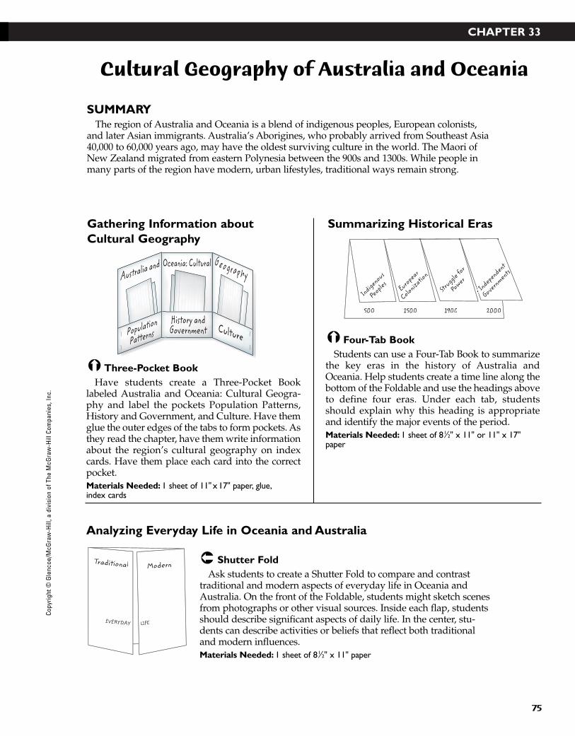
CHAPTER 33
75
Cultural Geography of Australia and Oceania
SUMMARYThe region of Australia and Oceania is a blend of indigenous peoples, European colonists,
and later Asian immigrants. Australia’s Aborigines, who probably arrived from Southeast Asia40,000 to 60,000 years ago, may have the oldest surviving culture in the world. The Maori ofNew Zealand migrated from eastern Polynesia between the 900s and 1300s. While people inmany parts of the region have modern, urban lifestyles, traditional ways remain strong.
Shutter FoldAsk students to create a Shutter Fold to compare and contrast
traditional and modern aspects of everyday life in Oceania andAustralia. On the front of the Foldable, students might sketch scenesfrom photographs or other visual sources. Inside each flap, studentsshould describe significant aspects of daily life. In the center, stu-dents can describe activities or beliefs that reflect both traditionaland modern influences.Materials Needed: 1 sheet of 81⁄2" x 11" paper
Four-Tab BookStudents can use a Four-Tab Book to summarize
the key eras in the history of Australia andOceania. Help students create a time line along thebottom of the Foldable and use the headings aboveto define four eras. Under each tab, studentsshould explain why this heading is appropriateand identify the major events of the period.Materials Needed: 1 sheet of 81⁄2" x 11" or 11" x 17"paper
Three-Pocket BookHave students create a Three-Pocket Book
labeled Australia and Oceania: Cultural Geogra-phy and label the pockets Population Patterns,History and Government, and Culture. Have themglue the outer edges of the tabs to form pockets. Asthey read the chapter, have them write informationabout the region’s cultural geography on indexcards. Have them place each card into the correctpocket.Materials Needed: 1 sheet of 11" x 17" paper, glue,index cards
Indigenous
PeoplesStr
uggle for
PowerI In
dependent
IIGove
rnments
European
Colonizatio
n
500 1500 1900 2000
CulturePopulation
PatternsHistory andGovernment
Australia and GeographyOceania: Cultural
ModernTraditional
EVERYDAY LIFE
Gathering Information aboutCultural Geography
Analyzing Everyday Life in Oceania and Australia
Summarizing Historical Eras
Copy
right
© G
lenc
oe/M
cGra
w-H
ill, a
div
isio
n of
The
McG
raw
-Hill
Com
pani
es, I
nc.
43-76_RSGF_878387 3/20/07 6:35 PM Page 75

CHAPTER 34
76
The Region Today: Australia and Oceania
SUMMARYAlthough the region has some mineral resources, agriculture and service industries play the
most important economic role. Both Australia and New Zealand export large quantities ofagricultural products such as wool, dairy products, and lamb. The lack of arable soil limitsagriculture in Oceania largely to subsistence farming, but some areas grow cash crops such ascopra, coffee, and ginger. The region has many unique animal and plant species, but the envi-ronment is threatened by pollution, including fallout from nuclear testing decades ago.
Four-Door BookStudents can create a Four-Door Book to identify
environmental problems and possible solutions inAustralia and Oceania. Encourage students to iden-tify at least two problems or solutions. Share thework in a class discussion. Ask students to predictwhich solutions will be most effective.Materials Needed: 1 sheet of 11" x 17" paper
Six-Tab BookStudents can create a Six-Tab Book by making a
Three-Tab Book and cutting each tab in half. Theycan use the resulting Foldable to list and define thevocabulary for Section 2. Encourage students toadd sketches or diagrams of terms such as food weband diatom. Students might also write context sen-tences to help them remember these terms. Materials Needed: 1 sheet of 81⁄2" x 11" paper
Layered-Look BookHave students create a Layered-Look Book to
guide their reading of Section 1. After reading eachheading, students should pause to take notes andreflect. Remind students to include accurate gener-alizations and significant details in their notes.Partners can check each other’s work for accuracyand completeness. Materials Needed: 3 sheets of 81⁄2" x 11" paper
food web
ozone layer
introduced species
marsupial
El Niño-Southern
diatom
Agriculture
Mining and Manufacturing
Service Industries
Transportation and Communications
Trade and Interdependence
Living inAustralia
and Oceania
EnvironmentalProblems
Oceania
EnvironmentalProblems
Australia
Solutions Solutions
Examining Life in the Region
Identifying Environmental Problems and Solutions
Reviewing Vocabulary
Copyright © G
lencoe/McG
raw-H
ill, a division of The McG
raw-H
ill Companies, Inc.
43-76_RSGF_878387 3/20/07 6:35 PM Page 76