Embed Size (px)
Citation preview
Differentiated Instruction for the World Geography
Classroom
WGC©08_DIWGC_TP_878566-9.indd 1WGC©08_DIWGC_TP_878566-9.indd 1 3/6/07 12:57:52 PM3/6/07 12:57:52 PM
Copyright © by the McGraw-Hill Companies, Inc. All rights reserved. Permission is granted to reproduce the material contained herein on the condition that such material be reproduced only for classroom use; be provided to students, teachers, and families without charge; and be used solely in conjunction with World Geography and Cultures. Any other reproduction, for use or sale, is prohibited without written permission from the publisher.
Send all inquiries to:Glencoe/McGraw-Hill8787 Orion PlaceColumbus, OH 43240-4027
ISBN: 978-0-07-878566-5MHID: 0-07-878566-9
Printed in the United States of America
1 2 3 4 5 6 7 8 9 10 047 10 09 08 07
0ii-0iv_DIGC_878566.indd ii0ii-0iv_DIGC_878566.indd ii 3/6/07 12:53:42 PM3/6/07 12:53:42 PM
Copy
right
© G
lenc
oe/M
cGra
w-Hi
ll Co
mpa
nies
, a d
ivis
ion
of T
he M
cGra
w-Hi
ll Co
mpa
nies
, Inc
.
To the Teacher . . . . . . . . . . . . . . . . . . . . . . . . . . . . . . . . . . . . . . . . . . . . . . . . . . . . . . ivACTIVITIESChapter 1 How Geographers Look at the World . . . . . . . . . . . . . . . . . . . . . . . . . . . . . . . 1Chapter 2 The Physical World . . . . . . . . . . . . . . . . . . . . . . . . . . . . . . . . . . . . . . . . . . . . . 5Chapter 3 Weather and Climate . . . . . . . . . . . . . . . . . . . . . . . . . . . . . . . . . . . . . . . . . . . . 9Chapter 4 The Human World . . . . . . . . . . . . . . . . . . . . . . . . . . . . . . . . . . . . . . . . . . . . 13Chapter 5 Physical Geography of the United States and Canada . . . . . . . . . . . . . . . . . . 17Chapter 6 Cultural Geography of the United States and Canada . . . . . . . . . . . . . . . . . . 21Chapter 7 The Region Today: The United States and Canada . . . . . . . . . . . . . . . . . . . . 25Chapter 8 Physical Geography of Latin America . . . . . . . . . . . . . . . . . . . . . . . . . . . . . . 29Chapter 9 Cultural Geography of Latin America . . . . . . . . . . . . . . . . . . . . . . . . . . . . . . 33Chapter 10 The Region Today: Latin America . . . . . . . . . . . . . . . . . . . . . . . . . . . . . . . . 37Chapter 11 Physical Geography of Europe . . . . . . . . . . . . . . . . . . . . . . . . . . . . . . . . . . . 41Chapter 12 Cultural Geography of Europe . . . . . . . . . . . . . . . . . . . . . . . . . . . . . . . . . . . 45Chapter 13 The Region Today: Europe . . . . . . . . . . . . . . . . . . . . . . . . . . . . . . . . . . . . . 49Chapter 14 Physical Geography of Russia . . . . . . . . . . . . . . . . . . . . . . . . . . . . . . . . . . . 53Chapter 15 Cultural Geography of Russia . . . . . . . . . . . . . . . . . . . . . . . . . . . . . . . . . . . 57Chapter 16 The Region Today: Russia . . . . . . . . . . . . . . . . . . . . . . . . . . . . . . . . . . . . . . 61Chapter 17 Physical Geography of North Africa, Southwest Asia, and Central Asia . . . . 65Chapter 18 Cultural Geography of North Africa, Southwest Asia, and Central Asia . . . 69Chapter 19 The Region Today: North Africa, Southwest Asia, and Central Asia. . . . . . . 73Chapter 20 Physical Geography of Africa South of the Sahara . . . . . . . . . . . . . . . . . . . . 77Chapter 21 Cultural Geography of Africa South of the Sahara . . . . . . . . . . . . . . . . . . . . 81Chapter 22 The Region Today: Africa South of the Sahara . . . . . . . . . . . . . . . . . . . . . . 85Chapter 23 Physical Geography of South Asia . . . . . . . . . . . . . . . . . . . . . . . . . . . . . . . . 89Chapter 24 Cultural Geography of South Asia . . . . . . . . . . . . . . . . . . . . . . . . . . . . . . . . 93Chapter 25 The Region Today: South Asia . . . . . . . . . . . . . . . . . . . . . . . . . . . . . . . . . . . 97Chapter 26 Physical Geography of East Asia . . . . . . . . . . . . . . . . . . . . . . . . . . . . . . . . 101Chapter 27 Cultural Geography of East Asia . . . . . . . . . . . . . . . . . . . . . . . . . . . . . . . . 105Chapter 28 The Region Today: East Asia . . . . . . . . . . . . . . . . . . . . . . . . . . . . . . . . . . . 109Chapter 29 Physical Geography of Southeast Asia . . . . . . . . . . . . . . . . . . . . . . . . . . . . 113Chapter 30 Cultural Geography of Southeast Asia . . . . . . . . . . . . . . . . . . . . . . . . . . . . 117Chapter 31 The Region Today: Southeast Asia . . . . . . . . . . . . . . . . . . . . . . . . . . . . . . . 121Chapter 32 Physical Geography of Australia, Oceania, and Antarctica . . . . . . . . . . . . . 125Chapter 33 Cultural Geography of Australia and Oceania . . . . . . . . . . . . . . . . . . . . . . 129Chapter 34 The Region Today: Australia and Oceania . . . . . . . . . . . . . . . . . . . . . . . . . 133
Contents
Differentiated Instruction for the Geography Classroom iii
0ii-0iv_DIGC_878566.indd iii0ii-0iv_DIGC_878566.indd iii 3/6/07 12:53:42 PM3/6/07 12:53:42 PM
Copyright © Glencoe/M
cGraw-Hill Companies, a division of The M
cGraw-Hill Companies, Inc.
iv Differentiated Instruction for the Geography Classroom
To the Teacher
Guide to Using the Differentiated Instruction
for the Geography Classroom
This Differentiated Instruction for the Geography Classroom booklet accompanies the
World Geography and Cultures student textbook. These Strategies and Activities are designed to give
you additional resources to differentiate your instruction, addressing the different types of learners
in your classroom. For each Strategy and Activity, the following information is provided to you in
the outer margin.
General PurposeEach Strategy and Activity is labeled as to its general type—Interdisciplinary Activity,
Cooperative Learning, Enrichment, and Classroom Discussion, for example.
Skill The skill being learned and/or exhibited in the activity is highlighted. For example, students
may be identifying central issues, creating a chart, conducting research, making connections, writing
a dramatic scene, analyzing literature, or making a map.
Recommended UseA recommended use for each Strategy and Activity is suggested—for example, Team-Teaching
Activity, Reinforcement, Independent Practice, Chapter Review, and so on. The recommendations
may help you plan the point at which to have students complete the activity.
LevelTo help you plan for the varying levels of your students, each Strategy and Activity is also
leveled. These levels include Below Grade Level (BL), On Grade Level (OL), and Advanced Learners
(AL). An additional level is noted for those activities that would be helpful for English Learners.
Additional FeaturesThis booklet also includes short, high-interest items interspersed with Strategies and Activities.
These include Learn More About . . . activities that provide skill practice in researching the history or
explanation of a place, event, or person(s). Launching questions or activities may be included, which
help students connect information already learned to the new information to be researched.
People and Places and Internet Learning are activities that provide background information and/
or Web sites to help students clarify main ideas, apply comprehension through visuals, and practice
kinesthetic skills to learn more about historical events.
0ii-0iv_DIGC_878566.indd iv0ii-0iv_DIGC_878566.indd iv 3/6/07 12:53:42 PM3/6/07 12:53:42 PM
Copy
right
© G
lenc
oe/M
cGra
w-Hi
ll Co
mpa
nies
, a d
ivis
ion
of T
he M
cGra
w-Hi
ll Co
mpa
nies
, Inc
.
Differentiated Instruction for the Geography Classroom 1
CHAPTER1
Key Terms and ReinforcementStrategy and Activity
Compile a list of key terms for this chapter. Include words such as:map Northern Hemisphere situationcartographers Southern Hemisphere placemap projection Eastern Hemisphere regionplanar Western Hemisphere formal regioncylindrical scale functional regionconic relative location perceptual regionlocation physical map ecosystemgrid system topography movementlatitude human-made human-environmentabsolute location thematic maps interactionlongitude qualitative maps cartographyPrime Meridian flow-line maps geographic informationhemisphere site systems (GIS)Ask students to complete a word web. Demonstrate for students the structure
of a word web that includes the following components:
• word history• related words• synonyms• antonyms• part of speech• dictionary definition • original sentence using the word• how it relates to the chapterAs students encounter the word in the text, they should add to their word webs
the sentence from the text that uses the word. Supply college-level dictionaries, thesauri, and word origin dictionaries. Provide a model of the word web using the overhead projector.
Absolute and Relative LocationStrategy and Activity
Review with students the difference between absolute and relative location, and then practice this concept with their school’s location. Remind them that the absolute location would include the latitude and longitude and the school’s address. Then, as a whole class or with partners, come up with a list of at least 10 ways to describe the school’s location relative to other places (next to the mall, across the street from the post office, ten miles from the rival high school, etc.). Discuss the merits and use of both absolute location and relative location in describing a place. This skill can be practiced using other locations (the mall, the movie theater, the fire station, etc.).
1
CHAPTER1
Key Terms and ReinforcementIndependent Practice Skill: Use Word Webs to Analyze Important TermsRecommended Use: ReinforcementOL
Absolute and Relative LocationClass DiscussionRecommended Use: PracticeOL
HOW GEOGRAPHERS LOOK AT THE WORLD
001-052_DIGC_878566.indd 1001-052_DIGC_878566.indd 1 3/5/07 4:03:26 PM3/5/07 4:03:26 PM
Copyright © Glencoe/M
cGraw-Hill Companies, a division of The M
cGraw-Hill Companies, Inc.
Human-Environment InteractionStrategy and Activity
Introduce the concept of human-environment interaction and provide students with examples of how this happens throughout the world (building dams, clearing forests, etc.). Then, as a whole class or in partners, ask students to apply this concept to their community. Have students brainstorm as many examples as they can think of where human-environment interaction can be found in their own community. List examples on the board and ask students to discuss whether they think they have a positive or negative effect on the environment. Are there any examples where people have had to adapt to the environment more than they have adapted the envi-ronment to their own purposes?
Latitude and LongitudeStrategy and Activity
It can be difficult for some students to remember the difference between latitude and longitude. On their own or with partners, ask students to come up with their own way to remember the difference and record their ideas on the board. Students can then choose the strategy that works best for them.
Geography as a CareerStrategy and Activity
Students may wonder how learning geography might be of use to them in their careers. Have students read the final section of the chapter and make a list of the ways that geography can be useful in a variety of careers. Then, have them design a brochure for your class that promotes the usefulness of the class to incoming students.
Internet Learning
Using Satellite Images
Have students visit www.geographynetwork.com or another Web site that shows what your town, city, or state looks like using satellite imagery. Describe ways that this kind of tool might help a geographer learn more about a place by seeing it from space.
Upside Down MapsStrategy and Activity
Students are usually surprised to learn that some countries use maps or globes that seem to be “upside down.” Have students do an Internet search (for example, a Google image search using “upside down maps”) to find examples. Discuss with stu-dents why certain countries such as Australia, South Africa, or Argentina might pre-fer to view their countries this way as opposed to the traditional view. Ask students what they think of this idea and remind them that on a globe there is no correct way to view a country. Have students look at the United States on an “upside down” map and talk about how they may notice different aspects of the country this way. Continue the discussion using different map projections to illustrate how different maps portray countries depending on the purpose of the map.
Human-Environment InteractionGuided Practice
Recommended Use: Enrichment
BL
Human-Environment InteractionGuided Practice
Recommended Use: Enrichment
BL
Latitude and LongitudeGuided Practice
Recommended Use: Reinforcement
BL
Latitude and LongitudeGuided Practice
Recommended Use: Reinforcement
BL
Geography as a CareerCreate a Brochure
Recommended Use: Chapter Introduction
or Conclusion BL or OL
Geography as a CareerCreate a Brochure
Recommended Use: Chapter Introduction
or Conclusion BL or OL
Upside Down MapsRecommended Use:
Chapter PreviewBL or OL
Upside Down MapsRecommended Use:
Chapter PreviewBL or OL
How Geographers Look at the World, continued
2 Differentiated Instruction for the Geography Classroom
001-052_DIGC_878566.indd 2001-052_DIGC_878566.indd 2 3/5/07 4:03:27 PM3/5/07 4:03:27 PM

Copy
right
© G
lenc
oe/M
cGra
w-Hi
ll Co
mpa
nies
, a d
ivis
ion
of T
he M
cGra
w-Hi
ll Co
mpa
nies
, Inc
.
Mapping Your SchoolBackground
Maps are used to communicate information about a place. Cartographers make decisions about what to include on the map depending on the purpose and the intended audience. Maps also include other important information to help the reader interpret the map. These include a title, a scale bar, a compass rose, and a key. The title indicates the purpose of the map. The scale bar shows the relationship between the map measurements and the actual distance represented. The compass rose shows cardinal directions. The key, sometimes called a legend, explains the symbols used on the map.
StrategyAsk students to decide whether they want to map their classroom or the school
cafeteria. The purpose of the map is to help a new student locate everything he or she needs to know about. Using either place, have students identify the important items and locations to be shown on the map. The map should have a minimum of ten important items or locations, such as the emergency exits and instructions, the supply closet in the classroom, the vending machines in the cafeteria, etc.
Next, have students create a rough draft showing the outline of the room and the location of each identified item or location. Students should use a tape measure to accurately measure the room and the distance between items or locations in feet or meters. Help students convert the actual measurements into a scale that can be represented on the map. Next, have students begin drawing their map. It may be helpful for students to use grid paper. Maps should include a title, compass rose, a scale, and a key. The key may contain symbols for items or locations, or it may be color coded to show things that are more important than others or things that are off limits to students.
ActivitiesUsing their maps, ask students to discuss or write answers to the following
questions.
1. What was the most challenging part about creating a map? What challenges do you think cartographers face when they are creating a map?
2. Have another student review your map from the point of view of a new student. Is your map easily understood or did you leave out important information?
3. Describe the relative locations of items on your map. For example, is the pencil sharpener east of the exit?
4. Challenge. Have advanced students expand this map to include the entire school.
How Geographers Look at the World, continued
Differentiated Instruction for the Geography Classroom 3
Mapping Your SchoolClass Activity Skill: Create a MapRecommended Use: Guided PracticeOL
001-052_DIGC_878566.indd 3001-052_DIGC_878566.indd 3 3/5/07 4:03:27 PM3/5/07 4:03:27 PM

001-052_DIGC_878566.indd 4001-052_DIGC_878566.indd 4 3/5/07 4:03:27 PM3/5/07 4:03:27 PM
Copy
right
© G
lenc
oe/M
cGra
w-Hi
ll Co
mpa
nies
, a d
ivis
ion
of T
he M
cGra
w-Hi
ll Co
mpa
nies
, Inc
.
Differentiated Instruction for the Geography Classroom 5
Key Terms and ReinforcementStrategy and Activity
Compile a list of key terms for this chapter. Include such words as:hydrosphere lithosphereatmosphere continental driftplate tectonics subductionaccretion erosionprecipitation desalinationgroundwater aquiferAsk students to complete a word web. Demonstrate for students the structure
of a word web that includes the following components:• word history• related words• synonyms• antonyms• part of speech• dictionary definition• original sentence using the word• how it relates to the chapterAs students encounter the word in the text, they should add to their word webs
the sentence from the text that uses the word. Supply college-level dictionaries, thesauri, and word origin dictionaries. Provide a model of the word web using the overhead projector.
Internet Learning
How Geographers Look at the World
Visit www.usgs.gov to see all the different ways geographers look at your state. You will find examples of the highest elevation, climate, water usage, etc. Look at five different facts about your home state and record your findings on a small poster.
Earth’s Physical FeaturesStrategy and Activity
Organize the class into six groups. Assign each group an inhabited continent. Give each group construction paper or newsprint and research materials to create a map and chart about the continent’s important land and water features. The groups should draw a map of the continent with a chart below it, listing the names of major landforms, water features, and their locations, such as the highest elevation, deepest lake, longest river, largest desert, and so on. The group may also indicate important measurements. Each feature shown in the chart should be located and identified on the map.
Key Terms and ReinforcementIndependent Practice Skill: Use Word Web to Analyze Important Terms Recommended Use: ReinforcementOL
Key Terms and ReinforcementIndependent Practice Skill: Use Word Web to Analyze Important Terms Recommended Use: ReinforcementOL
Earth’s Physical FeaturesResearch and Create a Map and ChartRecommended Use: Guided PracticeBL
Earth’s Physical FeaturesResearch and Create a Map and ChartRecommended Use: Guided PracticeBL
THE PHYSICAL WORLD
5
CHAPTER2
001-052_DIGC_878566.indd 5001-052_DIGC_878566.indd 5 3/5/07 4:03:27 PM3/5/07 4:03:27 PM
Learn More About
Plate Tectonics and Mountain Ranges
Ask students to identify the major mountain ranges in the world and investigate the different ways plate tectonics formed those ranges (subduction, etc.) Have the students present their findings in an oral report to the class using visuals.
Describing LandformsStrategy and Activity
It can be difficult for students to get a feel for identifying landforms using only one or two examples. Have students do an online image search for different land-forms on a list, including more obscure examples such as butte, alluvial fan, delta, isthmus, etc. Ask students to find three to five different pictures of each example and describe what each group of images has in common. Compare these descriptions to the standard definition of each landform and ask students to accurately describe each landform in their own words.
DesalinationStrategy and Activity
On their own or with a partner, ask students to research the step by step process used in desalination. Have students explain in a presentation to the class exactly how the process works and what is involved. Include in their presentations where desalination occurs, a discussion of the costs involved, and what the future holds for making this technology available to more people.
Identifying Physical FeaturesStrategy and Activity
Have students look at a photo taken from an airplane or some other vantage point high above the earth. Ask students to identify the physical features that they see. (Answers may vary, but should include clouds, water, land, roads, and buildings.) Ask students what they can see from the perspective of the air that they cannot easily see on the ground. (Answers may vary, but may include coastlines, layout of buildings and roads, and landforms that appear below the water’s surface.) Tell students that as they study geography they will learn many new perspectives that will help them bet-ter understand the world in which they live.
Learn More About
Create a Time Line
Ask students to research the tools that geographers and scientists have used over the centuries to create maps, measure changes in climate, and determine the earth’s position in the solar system. Use the students’ information to create a classroom time line showing the progress of geographers’ tools.
Describing LandformsSynthesizing Information
Recommended Use: Independent Practice
BL or OL
Describing LandformsSynthesizing Information
Recommended Use: Independent Practice
BL or OL
DesalinationAnalyze and Present Information
Recommended Use: Research
AL
DesalinationAnalyze and Present Information
Recommended Use: Research
AL
Identifying Physical FeaturesClassroom Discussion
Recommended Use: Chapter Introduction
BL
Identifying Physical FeaturesClassroom Discussion
Recommended Use: Chapter Introduction
BL
Copyright © Glencoe/M
cGraw-Hill Companies, a division of The M
cGraw-Hill Companies, Inc.
The Physical World, continued
6 Differentiated Instruction for the Geography Classroom
001-052_DIGC_878566.indd 6001-052_DIGC_878566.indd 6 3/5/07 4:03:28 PM3/5/07 4:03:28 PM
Copy
right
© G
lenc
oe/M
cGra
w-Hi
ll Co
mpa
nies
, a d
ivis
ion
of T
he M
cGra
w-Hi
ll Co
mpa
nies
, Inc
.
Water Sources and Water ConservationBackground
Many of us do not think about where our water comes from. We turn on the tap and assume it will be there. We often assume that the water from the tap is safe to drink. Students may be surprised to discover that their tap water is safe for cooking and bathing, but may contain contaminants that are not safe to drink. They may also be surprised to discover their community’s water source. Local municipalities can provide citizens with reports about the source of water in the community and the quality of that water. Students can obtain these reports and, based on what they learn, can consider alternative water sources and ways to conserve water use in their daily lives.
StrategyUsing a local and state map, have students guess where their town or city gets
its drinking water. Remind them that drinking water can come from lakes, rivers, underground aquifers, or wells. Ask them whether they believe the water is safe to drink and how water safety is determined. In preparation for this activity, have students obtain a report analyzing their community’s water supply. You may wish to provide students with a copy of this report instead. On their own or with a part-ner, have students confirm their community’s water source and compare it to their original guess. Next, have them read and highlight important information about the quality of the water, including possible contaminants and their amounts. Finally, have students refer to a map to locate other possible sources of water in the event that their community lost access to its main source.
ActivitiesHave students choose one of the following activities to complete based on their
research. Have students share their research and projects with the rest of the class.
1. Create a chart that shows your community’s source of water and the quality of that water, including possible contaminants.
2. Record all the ways you see water being used throughout the day in a water jour-nal. Observe and record all the ways you see water being wasted. Come up with three ideas to conserve water in your community.
3. Based on what you learned about your community’s source and quality of water, create a poster or write an article for the school or local newspaper. Include examples of how water is wasted in your community and proposals for conserva-tion. Be sure to include ideas for alternative sources of water or discuss the fact that there may not be any other water sources available to your community.
4. Challenge. Have advanced students further investigate possible alternative water sources and future plans their community has for obtaining or conserving water. Ask students to report their findings in a letter or report to local government officials.
The Physical World, continued
Differentiated Instruction for the Geography Classroom 7
Water Sources and Water ConservationClass Activity Skill: Investigate and Consider AlternativesRecommended Use: EnrichmentBL or OL
001-052_DIGC_878566.indd 7001-052_DIGC_878566.indd 7 3/5/07 4:03:28 PM3/5/07 4:03:28 PM

001-052_DIGC_878566.indd 8001-052_DIGC_878566.indd 8 3/5/07 4:03:28 PM3/5/07 4:03:28 PM
CHAPTER1
Copy
right
© G
lenc
oe/M
cGra
w-Hi
ll Co
mpa
nies
, a d
ivis
ion
of T
he M
cGra
w-Hi
ll Co
mpa
nies
, Inc
.
9
Key Terms and ReinforcementStrategy and Activity
Compile a list of key terms for this chapter. Include such words as:weather climategreenhouse effect global warmingprevailing wind El Niñorain shadow coniferousdeciduous permafrostAsk students to complete a word web. Demonstrate for students the structure
of a word web that includes the following components:• word history• related words• synonyms• antonyms• part of speech• dictionary definition• original sentence using the word• how it relates to the chapterAs students encounter the word in the text, they should add to their word webs
the sentence from the text that uses the word. Supply college-level dictionaries, thesauri, and word origin dictionaries. Provide a model of the word web using the overhead projector.
Natural DisastersStrategy and Activity
Ask students which of the following natural disasters are most likely to occur in their communities: tornadoes, droughts, hurricanes, or floods. As a class, discuss the likely effects of such disasters on the community and what students can do to prepare for such disasters.
TropicsStrategy and Activity
It can sometimes be difficult for students to remember the location and differ-ence between the Tropics of Cancer and Capricorn. On their own or with a partner, have students come up with a way to remember the difference between the two and where each is located. List the different ideas on the board and have students choose the strategy that works best for them.
Learn More About
Brainstorm Ideas
Ask students the following question: How does the weather in our community affect the way you live? Create a list of the student responses on the board.
Key Terms and ReinforcementIndependent Practice Skill: Use Word Web to Analyze Important Terms Recommended Use:ReinforcementOL
Key Terms and ReinforcementIndependent Practice Skill: Use Word Web to Analyze Important Terms Recommended Use:ReinforcementOL
Natural DisastersClassroom DiscussionRecommended Use: Lesson IntroductionBL
Natural DisastersClassroom DiscussionRecommended Use: Lesson IntroductionBL
TropicsBuild Study SkillsRecommended Use: Guided PracticeBL
TropicsBuild Study SkillsRecommended Use: Guided PracticeBL
CLIMATES OF THE EARTHCHAPTER
3
001-052_DIGC_878566.indd 9001-052_DIGC_878566.indd 9 3/5/07 4:03:28 PM3/5/07 4:03:28 PM
Classifying VegetationStrategy and Activity
Collect and display pictures of various forms of vegetation. Be sure to include forms with which the students are familiar, as well as unusual forms of vegetation. As you discuss each of the climate regions, decide which forms of vegetation shown in the pictures would likely be found in that climate region. Beside or below each picture, write the likely climate regions. Note that some forms of vegetation, such as grass, may be common to more than one climate region.
Reviewing Climate RegionsStrategy and Activity
Organize the class into 12 groups. Assign each group one of the climate regions introduced in the text. Have each group create a fact sheet about their assigned climate region. Tell students that the sheets should include facts about the climate, the amount of rainfall, and the vegetation types. Compile the 12 fact sheets into a small booklet and distribute to the class for their use throughout the course.
Internet Activity
Rivers
Geology Labs On-Line www.sciencecourseware.org/VirtualRiver contains interactive exercises to help students learn the processes of river discharge, flooding, and flooding frequency. Students can print out a certificate of completion after they successfully complete each exercise.
The Greenhouse EffectStrategy and Activity
Assign to two debate teams the resolution: Resolved: Human activity has altered Earth’s climates. Have each team research their position and conduct the debate using conventional debate rules. After the debate, have the class discuss the merits of each position and determine which is more plausible.
Drawing ConclusionsStrategy and Activity
Have interested students find the temperature of a sidewalk or other paved sur-face and the ground in a yard or park. The readings should be taken at the same time. Have students also record the weather on the day the readings were taken. Have students repeat the process for five days. Students should use the data to chart their findings. Ask students to use the information from their charts to draw conclusions about the impact of humans on their environment.
Learn More About
Avalanche Specialist
Tell students that geographers may work to help the U.S. National Forests or other government agencies predict and prevent avalanches. Ask interested students to learn more about this career.
Classifying VegetationDisplay Information Visually
Recommended Use: Guided Practice
BL
Classifying VegetationDisplay Information Visually
Recommended Use: Guided Practice
BL
Reviewing Climate ZonesCreate Fact Sheet
Recommended Use: Chapter Review
BL
Reviewing Climate ZonesCreate Fact Sheet
Recommended Use: Chapter Review
BL
The Greenhouse EffectEvaluate Conflicting Theories
Recommended Use: Enrichment
AL
The Greenhouse EffectEvaluate Conflicting Theories
Recommended Use: Enrichment
AL
Drawing ConclusionsConduct an Experiment
Recommended Use: Enrichment
AL
Drawing ConclusionsConduct an Experiment
Recommended Use: Enrichment
AL
Copyright © Glencoe/M
cGraw-Hill Companies, a division of The M
cGraw-Hill Companies, Inc.
Climates of the Earth, continued
10 Differentiated Instruction for the Geography Classroom
001-052_DIGC_878566.indd 10001-052_DIGC_878566.indd 10 3/5/07 4:03:28 PM3/5/07 4:03:28 PM
Copy
right
© G
lenc
oe/M
cGra
w-Hi
ll Co
mpa
nies
, a d
ivis
ion
of T
he M
cGra
w-Hi
ll Co
mpa
nies
, Inc
.
El Niño and YouBackground
The term “El Niño” is frequently heard, but many people do not really understand what it means. El Niño is a periodic change in water temperatures, ocean currents, and weather patterns in the Pacific Ocean. El Niño has been linked to increased rainfall and catastrophic flooding in some areas and drought in others. Some studies conclude that El Niño may be caused by global warming. By understanding the mechanism of this weather pattern, students can gain a better understanding of its impact on the environment and on their lives.
StrategyRefer students to Chapter 3, Section 2, about El Niño. Have students read all
four paragraphs, either on their own or using a paired reading out loud strategy with a partner. Next, have students number each sentence beginning with the second paragraph and continuing through the end of the fourth paragraph. Alone, with a partner, or as a class, have students go back and read each numbered sentence. Then, have students summarize and restate the sentence in their own words.
Using a map, have students locate any place mentioned in the sentence they have read. Or, help students locate these areas by indicating each place on a class-room map. Finally, have students revisit each step of El Niño, locate, and label where each step happens on an outline map. It may be helpful to incorporate one or both of the following strategies to help students grasp the concept of El Niño:
• Have students draw arrows on a map to indicate the change in atmospheric pressure, wind pattern, direction of warm water, and places where rainfall increases or decreases. Each arrow should be labeled. This can be done with a partner or as a whole class activity using an overhead projector with the teacher’s direction.
• Have students physically demonstrate the changes in atmospheric pressure, wind pattern, direction of warm water, and increased or decreased rainfall by moving their hands up or down to show these changes. This can be done with a partner or as a whole class activity with the guidance of the teacher.
ActivitiesHave students choose one of the following activities to complete based on their
research. Have students share their research and projects with the rest of the class.
1. In groups of three, present the steps of El Niño to the class. One person can point out map locations, one student can narrate the steps, and another student can act out the changes using hand motions as described above.
2. Using your numbered sentences and a map, draw and summarize each step in a comic book format. There should be a minimum of ten comic strip cells.
3. Demonstrate the El Niño process in a PowerPoint presentation using additional research to illustrate and provide examples of the effects of El Niño.
El Niño and YouPartner and Group WorkSkill: Reading Strategies and ComprehensionRecommended Use: Guided PracticeBL or OL
El Niño and YouPartner and Group WorkSkill: Reading Strategies and ComprehensionRecommended Use: Guided PracticeBL or OL
Climates of the Earth, continued
Differentiated Instruction for the Geography Classroom 11
001-052_DIGC_878566.indd 11001-052_DIGC_878566.indd 11 3/5/07 4:03:29 PM3/5/07 4:03:29 PM

001-052_DIGC_878566.indd 12001-052_DIGC_878566.indd 12 3/5/07 4:03:29 PM3/5/07 4:03:29 PM
Copy
right
© G
lenc
oe/M
cGra
w-Hi
ll Co
mpa
nies
, a d
ivis
ion
of T
he M
cGra
w-Hi
ll Co
mpa
nies
, Inc
.
Differentiated Instruction for the Geography Classroom 13
THE HUMAN WORLDKey Terms and ReinforcementStrategy and Activity
Compile a list of key terms for this chapter. Include such words as:migration demographic transitionpopulation density ethnic groupcultural diffusion autocracymonarchy oligarchydemocracy market economycommand economy Ask students to complete a word web. Demonstrate for students the structure
of a word web that includes the following components:• word history• related words• synonyms• antonyms• part of speech• dictionary definition• original sentence using the word• how it relates to the chapterAs students encounter the word in the text, they should add to their word webs
the sentence from the text that uses the word. Supply college-level dictionaries, thesauri, and word origin dictionaries. Provide a model of the word web using the overhead projector.
Beliefs and CustomsStrategy and Activity
Put the following words on the board: beliefs and customs. Make sure that students understand the meaning of each word by giving examples of each. Have students state either a belief or a custom with which they are familiar. Have another student classify the statement as either a belief or a custom. Compile a list of these on the board.
Learn More About
Cultural Change
Ask students: What cultural changes have you noticed in your community? Have these changes improved or harmed the population? (Answers will vary. Encourage students to identify positive, as well as negative, cultural changes.)
Key Terms and ReinforcementIndependent PracticeSkill: Use Word Web to Analyze Important Terms Recommended Use:ReinforcementOL
Key Terms and ReinforcementIndependent PracticeSkill: Use Word Web to Analyze Important Terms Recommended Use:ReinforcementOL
Beliefs and CustomsClassify InformationRecommended Use: Chapter IntroductionBL
Beliefs and CustomsClassify InformationRecommended Use: Chapter IntroductionBL
CHAPTER4
001-052_DIGC_878566.indd 13001-052_DIGC_878566.indd 13 3/5/07 4:03:29 PM3/5/07 4:03:29 PM
Copyright © Glencoe/M
cGraw-Hill Companies, a division of The M
cGraw-Hill Companies, Inc.
14 Differentiated Instruction for the Geography Classroom
People and Places
Population Growth
Have students find five countries with low population growth and five with the high population growth and report on any factors that might account for the high or low population growth rates.
Market vs. Command EconomyStrategy and Activity
Have students re-read the section comparing and contrasting economic systems. Instruct students to create at T-chart and record the positive and negative aspects of both a market and command economy. With a partner, have students create an advertisement for each system. The advertisement should include three positive aspects of the economic system and should include at least one negative aspect of the other economic system. Above-level students can propose a new economic system that blends the best aspects of each and can create an advertisement for the new system.
Types of GovernmentStrategy and Activity
Using the descriptions of autocracy, monarchy, oligarchy, and democracy in Chapter 4, have students create a chart describing the positive and negative aspects of each. Create a symbol to illustrate the main idea each form of government rep-resents and include it on the chart. To expand this activity, students can create a brochure describing the positive and negative aspects of each form of government aimed at a new country trying to decide which form of government to adopt. Have students include the symbol they created for each form of government to illustrate the brochure.
Economic DevelopmentStrategy and Activity
Using the descriptions of each level of economic system described in Section 3,have students create a chart or poster that visually represents each system and examples of each. A chart can include lists of examples, while a poster can include pictures taken from magazines or the internet.
Cultural DiffusionStrategy and Activity
Bring to class an assortment of food items that have come into our diets from other cultures. Have students identify the culture from which the items came. Tell students that incorporating foods from other cultures is an example of cultural dif-fusion. Ask for other specific examples of cultural diffusion.
Market vs. Command EconomyCreate an Advertisement
Recommended Use: Guided Practice
OL or AL
Market vs. Command EconomyCreate an Advertisement
Recommended Use: Guided Practice
OL or AL
Types of GovernmentCompare and Contrast
Recommended Use: Guided Practice
BL or OL
Types of GovernmentCompare and Contrast
Recommended Use: Guided Practice
BL or OL
Economic DevelopmentVisual Representation
Recommended Use: Independent Practice
BL or OL
Economic DevelopmentVisual Representation
Recommended Use: Independent Practice
BL or OL
Cultural DiffusionClassroom Demonstration
Recommended Use: Introduction
BL
Cultural DiffusionClassroom Demonstration
Recommended Use: Introduction
BL
The Human World, continued
001-052_DIGC_878566.indd 14001-052_DIGC_878566.indd 14 3/5/07 4:03:29 PM3/5/07 4:03:29 PM
Copy
right
© G
lenc
oe/M
cGra
w-Hi
ll Co
mpa
nies
, a d
ivis
ion
of T
he M
cGra
w-Hi
ll Co
mpa
nies
, Inc
.
Differentiated Instruction for the Geography Classroom 15
The Human World, continued
Population DensityBackground
Population density is calculated by dividing the number of people who live in a particular area by the square mileage of that area. The resulting figure represents peo-ple per square mile or kilometer. Population density gives students an understanding not only of how many people live in an area, but also how crowded the area may be. Students can use population density figures to consider the effects of overcrowding on housing, transportation, cultural practices, health concerns, and quality of life. Population density figures can also used when calculating how many people live on land available to support the population, not simply total land area. This enhanced figure can give students an even more accurate understanding of population density in a given area.
StrategyProvide students with population density figures for their community. Or,
model the method for calculating this figure and have students determine their community’s population density. Discuss the meaning of population density and give students comparisons of surrounding communities or countries to illustrate the point.
Next, use a piece of paper to represent one square mile and pieces of confetti of uniform size, paper punch dots of uniform size, or dots made with a pencil or marker to represent each person who lives within the area. Using the population density numbers students calculated for their town or city, have students visually represent this data with a dot for each person.
Next, have students visually represent the population density of Canada and Bangladesh using statistics cited in Section 1. Rather than drawing more than 2,000 dots for Bangladesh, have students create a scale that represents the population den-sity while also illustrating how the density compares with other countries. Compare and contrast the three pieces of paper by displaying them side by side.
ActivitiesHave students choose one of the following activities to complete based on their
research. Have students share their research and projects with the rest of the class.
1. Discuss or predict the impact of population density on a town, city, or country. Discussions should include such issues as traffic, water use, land use, public health, schools, and cultural practices. Discuss the impact of population density in your own town or city. Give specific examples such as crowding, schools, traffic patterns, public behavior, etc. If your community is not very crowded, predict how an increase in population might change things.
2. Why do some places have higher population densities than others? Discuss how climate, geography, and cultural practices have an impact on population density.
3. Challenge. Have advanced students chart or map where most people live in their town or city. Ask them to present their findings to demonstrate the concept of land available to support population rather than “total land area” in order to more accurately describe population density.
Population DensityVisual Representation Skill: Concept ApplicationRecommended Use: Guided PracticeOL
Population DensityVisual Representation Skill: Concept ApplicationRecommended Use: Guided PracticeOL
001-052_DIGC_878566.indd 15001-052_DIGC_878566.indd 15 3/5/07 4:03:29 PM3/5/07 4:03:29 PM

001-052_DIGC_878566.indd 16001-052_DIGC_878566.indd 16 3/5/07 4:03:29 PM3/5/07 4:03:29 PM
Copy
right
© G
lenc
oe/M
cGra
w-Hi
ll Co
mpa
nies
, a d
ivis
ion
of T
he M
cGra
w-Hi
ll Co
mpa
nies
, Inc
.
Differentiated Instruction for the Geography Classroom 17
Key Terms and ReinforcementStrategy and Activity
Compile a list of key terms for this chapter. Include such words as:divide headwaterstributary fossil fuelfall line aquaculturechaparral prairiesupercell chinookAsk students to complete a word web. Demonstrate for students the structure
of a word web that includes the following components:• word history• related words• synonyms• antonyms• part of speech• dictionary definition• original sentence using the word• how it relates to the chapterAs students encounter the word in the text, they should add to their word webs
the sentence from the text that uses the word. Supply college-level dictionaries, thesauri, and word origin dictionaries. Provide a model of the word web using the overhead projector.
Identifying Physical FeaturesStrategy and Activity
Organize students into small groups. Tell students to imagine that they are liv-ing in the early 1800s. Assign each group a region of the country to explore such as the Northwest Territory, the Louisiana Purchase, or an inland route to the Pacific Ocean. Tell the groups to create a display in which they show with annotated maps, drawings, and other visual and written descriptions the land as it would have been found at that time.
Local GeographyStrategy and Activity
Have students form teams to study a small local region. The teams should decide what geographic elements to observe and analyze, such as relative location, size, land-forms, bodies of water, land use, economic development, population density, cultural makeup, environmental challenges, and so on. The teams should also determine how they will gather the data. Each team should prepare an oral presentation, along with visuals and a written summary of their findings.
Key Terms and ReinforcementIndependent PracticeSkill: Use Word Web to Analyze Important Terms Recommended Use:ReinforcementOL
Key Terms and ReinforcementIndependent PracticeSkill: Use Word Web to Analyze Important Terms Recommended Use:ReinforcementOL
Identifying Physical FeaturesCreate a DisplayRecommended Use: Chapter IntroductionBL
Identifying Physical FeaturesCreate a DisplayRecommended Use: Chapter IntroductionBL
Local GeographyConduct FieldworkRecommended Use: EnrichmentOL
Local GeographyConduct FieldworkRecommended Use: EnrichmentOL
PHYSICAL GEOGRAPHY OF THE UNITED STATES AND CANADA
CHAPTER5
001-052_DIGC_878566.indd 17001-052_DIGC_878566.indd 17 3/5/07 4:03:29 PM3/5/07 4:03:29 PM
Copyright © Glencoe/M
cGraw-Hill Companies, a division of The M
cGraw-Hill Companies, Inc.
18 Differentiated Instruction for the Geography Classroom
Physical Geography of the United States and Canada, continued
Common Bodies of WaterStrategy and Activity
With a partner or in small groups, have students study a map and locate the five Great Lakes and the St. Lawrence River. Ask students to think of concerns that both the United States and Canada might have about these bodies of water and ways both countries would need to cooperate to make sure those concerns are addressed. How might the actions of one country affect the other? Record concerns and ideas on the board.
Identifying Landforms and Bodies of WaterStrategy and Activity
Project or display a large outline map of the United States with state boundaries shown. Have one student name a landform or body of water. For example, a student might say “the Rocky Mountains.” Have another student write the name of the landform on the map in its approximate location. If necessary, students can use their textbooks to help them identify the placement of the landforms or bodies of water. The activity could be extended to the names of the states.
Internet Learning
Internet Geographic Network
Geography Network, www.geographynetwork.com, is a network of agencies com-mitted to making geographic data available online. Have students use the net-work’s satellite imagery to see what their town, city, or area looks like from space.
Length of CoastlineStrategy and Activity
Tell students that Canada has the longest coastline in the world, measuring more than 150,000 miles (243,000 kilometers). Have students look at a map of Canada. Ask them to identify the three oceans on which Canada has coastlines. Then ask students how they think advances in technology such as GPS and satellite data may have helped Canada’s provinces determine accurately the length of the coast-line. (Students should note that much of Canada’s coastline is inaccessible by land and is covered with ice for most of the year. Technology helps geographers “see” the coastline from above and accurately measure it.)
Learn More About
Doing the “Impossible”
At one time, it was thought that the Grand Canyon was impossible to survey. Have students discover the name of the man who first surveyed the Grand Canyon and the year in which he and his crew did so. (American geologist John Wesley Powell mapped the Grand Canyon in 1869.)
Common Bodies of WaterClass Discussion
Recommended Use: Introductory Activity
BL
Common Bodies of WaterClass Discussion
Recommended Use: Introductory Activity
BL
Identifying Landforms and Bodies of Water
Create an Annotated MapRecommended Use:
Chapter ReviewBL
Identifying Landforms and Bodies of Water
Create an Annotated MapRecommended Use:
Chapter ReviewBL
Length of CoastlineClassroom Discussion
Recommended Use: Bellringer
BL
Length of CoastlineClassroom Discussion
Recommended Use: Bellringer
BL
001-052_DIGC_878566.indd 18001-052_DIGC_878566.indd 18 3/5/07 4:03:30 PM3/5/07 4:03:30 PM
Copy
right
© G
lenc
oe/M
cGra
w-Hi
ll Co
mpa
nies
, a d
ivis
ion
of T
he M
cGra
w-Hi
ll Co
mpa
nies
, Inc
.
Differentiated Instruction for the Geography Classroom 19
Physical Geography of the United States and Canada, continued
Comparing and Contrasting ClimateBackground
Geographically, the United States and Canada are very much the same. If stu-dents were to remove the political boundary between the two countries they might find very few differences between them. Each shares the Rocky Mountains, the Great Plains, access to four of the five Great Lakes, and similar seasonal patterns. Yet each country also contains geographic and climate zones that are quite distinct. In this activity, students will compare and contrast climate as a way to become more familiar with both the similarities and differences between the United States and Canada.
StrategyReview and model the concept of how to use a Venn diagram to illustrate simi-
larities and differences. Next, refer students to the Venn diagram exercise described in the Section 2 review. In this exercise, students are asked to note the climate features of the United States and Canada to show what is the same and what is dif-ferent. Alone, with a partner, or as a class, have students read and review Section 2 and make notes about each country’s climate. Then, have students plot these facts on a Venn diagram.
Using this information, direct students to a map of the United States and Canada. Discuss the similarities and differences while referring to the map. Ask stu-dents: If you were a Canadian and you wanted to visit a completely different place in the U.S., where would you go? What kind of clothing would you need to bring? If you were an American and you wanted to visit a completely different place in Canada, where would you go? What would you need to bring? Finally, ask students why they think Canada and the U.S. are different countries, given their geographic similarities.
ActivitiesHave students choose one of the following activities to complete based on their
research. Have students share their research and projects with the rest of the class.
1. Using the Venn diagram, write a fictional e-mail conversation between Canadian and American high school students who plan to visit each other. After discussion of the climates that you have in common, talk about places that are completely different. Then, choose one of those places from each other’s country to visit. In your conversation, describe the places and talk about what each visitor should bring to wear. Also talk about things to do in the place where each of you will visit.
2. Research the areas you and your e-mail partner will visit. Include pictures, tourist attractions, and information about local culture. Present your findings in a speech, a PowerPoint presentation, or a brochure you might send to your visitor.
Comparing and Contrasting ClimateClass Activity Skill: Compare and ContrastRecommended Use: Section SummaryBL or OL
Comparing and Contrasting ClimateClass Activity Skill: Compare and ContrastRecommended Use: Section SummaryBL or OL
001-052_DIGC_878566.indd 19001-052_DIGC_878566.indd 19 3/5/07 4:03:30 PM3/5/07 4:03:30 PM

001-052_DIGC_878566.indd 20001-052_DIGC_878566.indd 20 3/5/07 4:03:30 PM3/5/07 4:03:30 PM
Copy
right
© G
lenc
oe/M
cGra
w-Hi
ll Co
mpa
nies
, a d
ivis
ion
of T
he M
cGra
w-Hi
ll Co
mpa
nies
, Inc
.
Differentiated Instruction for the Geography Classroom 21
CULTURAL GEOGRAPHY OF THE UNITED STATES AND CANADA
Key Terms and ReinforcementStrategy and Activity
Compile a list of key terms for this chapter. Include such words as:immigration urbanizationmegalopolis bilingualprovince InuitParliament separatismLoyalist dominionAsk students to complete a word web. Demonstrate for students the structure
of a word web that includes the following components:• word history• related words• synonyms• antonyms• part of speech• dictionary definition• original sentence using the word• how it relates to the chapterAs students encounter the word in the text, they should add to their word webs
the sentence from the text that uses the word. Supply college-level dictionaries, thesauri, and word origin dictionaries. Provide a model of the word web using the overhead projector.
Urban CentersStrategy and Activity
Have students use an almanac or other resource to identify the 50 largest cities in the United States and Canada. Have students locate and label these cities on a map, placing a number beside each city name to indicate its ranking. Tell students that they may abbreviate the names of the cities on the map, as long as they maintain a separate list showing the full name and abbreviation. Then, as a class, discuss the geographic reasons for the location of these cities. Explore why there are more large cities in certain regions of the country.
As an extension to this activity, you could have interested students find the 50 largest cities in 1950 and create a similar map. Then have them compare the changes over time.
Learn More About
Understanding French Influence in the United States
Have students locate on a map five large cities in the United States that have French names. What does the location of these cities tell us about the presence of French explorers and colonies in our history?
Key Terms and ReinforcementIndependent PracticeSkill: Use Word Web to Analyze Important Terms Recommended Use:ReinforcementOL
Key Terms and ReinforcementIndependent PracticeSkill: Use Word Web to Analyze Important Terms Recommended Use:ReinforcementOL
Urban CentersCreate a MapRecommended Use: Guided PracticeBL
Urban CentersCreate a MapRecommended Use: Guided PracticeBL
CHAPTER6
001-052_DIGC_878566.indd 21001-052_DIGC_878566.indd 21 3/5/07 4:03:30 PM3/5/07 4:03:30 PM
Copyright © Glencoe/M
cGraw-Hill Companies, a division of The M
cGraw-Hill Companies, Inc.
22 Differentiated Instruction for the Geography Classroom
Cultural Geography of the United States and Canada, continued
The Healing FundStrategy and Activity
Research how the Canadian government apologized for its mistreatment of native peoples and established the “healing fund.” Report on groups that benefited from reparations and focus on how the Inuit people won the right to their own ter-ritory, Nunavut.
Comparing and Contrasting GovernmentsStrategy and Activity
Have students read about and take notes on the forms of government in the United States and Canada in Chapter 6. Tell students to underline or circle ideas they do not understand and have them ask questions to clarify. Using their notes, including corrections or clarifications, have students create informational posters that describe and illustrate the similarities and differences between the governments of Canada and the United States.
Canadians on the BorderStrategy and Activity
Have students study political and climate maps of the United States and Canada. Remind students that most of Canada’s population lives within 100 miles of the border with the United States. Ask students to look for clues on both maps to guess why this is so. What effect might this have on the cultures of Canada and the United States and their relationship with each other?
Learn More About
Bilingualism
Canada has two official languages, English and French. Signs and labels on con-sumer goods are written in both languages. Have students find examples of signs or labels in the United States that are written in both English and Spanish. Ask them to discuss how this reflects two major cultures and have them talk about the idea of having two official languages in the United States.
French PhrasesStrategy and Activity
Have interested students work in pairs to create a list of five phrases that a tour-ist would likely use. Then have them contact a person who speaks French for help in translating the phrases into French. The pair should work together to develop a pronunciation guide that would be useful in helping the tourist say the phrase cor-rectly. Have students test their pronunciation guides on several people and make improvements as needed.
As an extension, you could compile all the phrases into a book.
The Healing FundResearch and ReportRecommended Use:
EnrichmentAL
The Healing FundResearch and ReportRecommended Use:
EnrichmentAL
Comparing and Contrasting GovernmentsCreate a Poster
Recommended Use: Independent Practice
OL
Comparing and Contrasting GovernmentsCreate a Poster
Recommended Use: Independent Practice
OL
Canadians on the BorderRecommended Use:
Introductory ActivityBL
Canadians on the BorderRecommended Use:
Introductory ActivityBL
French PhrasesCreate a Tourist Phrase Book
Recommended Use: Independent Practice
AL
French PhrasesCreate a Tourist Phrase Book
Recommended Use: Independent Practice
AL
001-052_DIGC_878566.indd 22001-052_DIGC_878566.indd 22 3/5/07 4:03:30 PM3/5/07 4:03:30 PM
Copy
right
© G
lenc
oe/M
cGra
w-Hi
ll Co
mpa
nies
, a d
ivis
ion
of T
he M
cGra
w-Hi
ll Co
mpa
nies
, Inc
.
Differentiated Instruction for the Geography Classroom 23
Cultural Geography of the United States and Canada, continued
Comparing and Contrasting Culture in the U.S. and CanadaBackground
The United States and Canada share many similar aspects of culture, includ-ing language, religion, education, health care, the arts, and family life. The differ-ences between the two are subtle but significant. These differences include average age, access to education and health care, and the stability of marriage. The role of the government is a factor to consider as well. Both countries attract immigrants from similar places around the world. In this exercise, students will compare the similarities of the U.S. and Canada side by side in order to consider the merits of each country’s culture, as well as to discover the subtle differences between the two countries. Students will consider the countries from the perspective of an immigrant trying to decide which country to call home.
StrategyReview with students how to use a T-chart to compare and contrast two dif-
ferent things. Ask students about their travel experiences in Canada or the United States, and have them recall what was the same and what was different. Then, using the information provided in Chapter 6, have students record cultural similarities and differences under the categories of language, religion, education, health care, the arts, and family life. Students can do this alone or with a partner.
As a class, discuss the results of the T-chart. For each category, discuss what might account for the differences. Ask students to comment on whether they think things in each category are better in the U.S. or Canada and to talk about the mer-its and demerits of each. For example, Canadians have better access to health care; however, they also pay higher taxes and may have to wait longer for specialized treat-ment. Encourage students to consider each side of what they discuss. The average age in the United States is younger than in Canada. What are the advantages and disadvantages of this statistic?
Have students choose one of the following activities to complete based on their research. Have students share their research and projects with the rest of the class.
ActivitiesHave students choose one of the following activities to complete based on their
research. Have students share their research and projects with the rest of the class.
1. Using the T-chart developed from Chapter 6, create a brochure, a T.V. commer-cial, or an advertisement targeting a person from another country who wishes to emigrate but who cannot decide between the U.S. or Canada. Be sure to include facts and statistics describing cultural features you read about. The brochure, commercial, or ad can pitch either country as being better or can take an objec-tive stance, allowing the immigrant to decide. Have other students review the materials created by classmates and, playing the role of the immigrant, make a decision based on the presentation.
2. Conduct in-depth research to find out more about the reasons behind the facts and statistics you learned in comparing the U.S. and Canada. Report on your findings in the form of an essay, a speech, or a PowerPoint presentation.
Comparing and Contrasting Culture in the U.S. and CanadaClass Activity and Discussion/Prepare a PresentationSkill: Compare and ContrastRecommended Use: Chapter ReviewOL
Comparing and Contrasting Culture in the U.S. and CanadaClass Activity and Discussion/Prepare a PresentationSkill: Compare and ContrastRecommended Use: Chapter ReviewOL
001-052_DIGC_878566.indd 23001-052_DIGC_878566.indd 23 3/5/07 4:03:31 PM3/5/07 4:03:31 PM

001-052_DIGC_878566.indd 24001-052_DIGC_878566.indd 24 3/5/07 4:03:31 PM3/5/07 4:03:31 PM
Copy
right
© G
lenc
oe/M
cGra
w-Hi
ll Co
mpa
nies
, a d
ivis
ion
of T
he M
cGra
w-Hi
ll Co
mpa
nies
, Inc
.
Differentiated Instruction for the Geography Classroom 25
THE REGION TODAY: THE UNITED STATES AND CANADA
Key Terms and ReinforcementStrategy and Activity
Compile a list of key terms for this chapter. Include such words as:market economy postindustrialcommodity arablemonopoly trade deficittrade surplus tariffclear-cutting acid rainAsk students to complete a word web. Demonstrate for students the structure
of a word web that includes the following components:• word history• related words• synonyms• antonyms• part of speech• dictionary definition• original sentence using the word• how it relates to the chapterAs students encounter the word in the text, they should add to their word webs
the sentence from the text that uses the word. Supply college-level dictionaries, thesauri, and word origin dictionaries. Provide a model of the word web using the overhead projector.
U.S.–Canadian InterdependenceStrategy and Activity
Ask students to study the chart in Chapter 7 illustrating U.S. and Canadian interdependence. Before answering the two questions on movement, have students examine each two-way arrow and summarize the information in a statement (i.e., More people from Canada visit the United States than the other way around, but the numbers are very close.). Have students create study questions for each two-way arrow (i.e., Which country invests more in the other country?). Ask students to conclude what the chart tells us about the interdependent relationship of the United States and Canada.
Border CrossingsStrategy and Activity
Give students a highway map of the United States and Canada. Alone or with a partner, have students locate and list every major highway that crosses the border of the two countries. How many places would need to be staffed with border patrols and checkpoints? Given the cooperative relationship enjoyed by the United States and Canada, ask students to discuss whether they think there is a need to monitor border crossings between the two countries and how easy or difficult they think it should be to move between them.
Key Terms and ReinforcementIndependent PracticeSkill: Use Word Web to Analyze Important Terms Recommended Use:ReinforcementOL
Key Terms and ReinforcementIndependent PracticeSkill: Use Word Web to Analyze Important Terms Recommended Use:ReinforcementOL
U.S.–Canadian InterdependenceBuilding Study SkillsRecommended Use: Guided PracticeOL
U.S.–Canadian InterdependenceBuilding Study SkillsRecommended Use: Guided PracticeOL
Border CrossingsClassroom DiscussionRecommended Use: Chapter IntroductionBL or OL
Border CrossingsClassroom DiscussionRecommended Use: Chapter IntroductionBL or OL
CHAPTER7
001-052_DIGC_878566.indd 25001-052_DIGC_878566.indd 25 3/5/07 4:03:31 PM3/5/07 4:03:31 PM
Copyright © Glencoe/M
cGraw-Hill Companies, a division of The M
cGraw-Hill Companies, Inc.
26 Differentiated Instruction for the Geography Classroom
The Region Today: The United States and Canada, continued
Regional Flag or QuiltStrategy and Activity
Using the information from the chapter to support the idea that the United States and Canada are interrelated, as well as any additional research, have students design a regional flag or quilt. The flag or quilt should include at least ten symbols that illustrate the ways in which the U.S. and Canada are connected to each other. Have students present and display their flag or quilt in the classroom.
Exports and ImportsStrategy and Activity
Direct students to the section in Chapter 7 comparing exports and imports in United States and Canada. Review definitions of export, import, trade deficit, trade surplus, and tariff to make sure students understand these concepts. Point out that the United States has a trade deficit while Canada has a trade surplus. Have students write down reasons for each situation. Ask students to report their findings and record them on the board. Discuss reasons why the United States has a trade deficit and ask students what this might mean for the country. Have students suggest ways the United States could move from a trade deficit to a trade surplus.
Learn More About
The Smart Border Plan
Have students use the Internet to research the Smart Border Plan created by the United States and Canada to combat terrorism. They can describe the technology involved to make the plan work and report on specific plans for conducting ter-rorism that were prevented by the plan.
Economic DisparityStrategy and Activity
As a class, list various economic problems or challenges that occur in your local community, state, or region. Have students select one of these challenges and research the causes and possible solutions to the problem. Based on their research, have them write an editorial expressing their opinion about how to meet the chal-lenge that is being confronted. Encourage students to suggest concrete ways to improve the problem.
Internet Learning
Canadian Media
Have students conduct an Internet search and find the Web pages for Canadian television stations and major newspapers. They should find the major stories that talk about issues and events in Canada and compile a list of the ten most important news stories that illustrate life in that country.
Regional Flag or QuiltVisual Representation
Recommended Use: Chapter Summary
OL
Regional Flag or QuiltVisual Representation
Recommended Use: Chapter Summary
OL
Exports and ImportsReview and ReportRecommended Use:
Guided PracticeBL
Exports and ImportsReview and ReportRecommended Use:
Guided PracticeBL
Economic DisparityWrite an EditorialRecommended Use:
EnrichmentAL
Economic DisparityWrite an EditorialRecommended Use:
EnrichmentAL
001-052_DIGC_878566.indd 26001-052_DIGC_878566.indd 26 3/5/07 4:03:31 PM3/5/07 4:03:31 PM
Copy
right
© G
lenc
oe/M
cGra
w-Hi
ll Co
mpa
nies
, a d
ivis
ion
of T
he M
cGra
w-Hi
ll Co
mpa
nies
, Inc
.
Differentiated Instruction for the Geography Classroom 27
The Region Today: The United States and Canada, continued
Environmental Report CardBackground
The United States and Canada share many environmental concerns. Regardless of the source, environmental problems affects both countries. Chapter 7 discusses several issues, including acid rain, smog, water pollution, and global warming. The U.S. and Canada have entered into cooperative agreements to reduce chemical emissions and to protect the Great Lakes. Each country is working on ways to develop alternative sources of fuel and to protect its waterways, but much work remains. In this activity, students will analyze and rate the efforts made thus far to protect the environment in an environmental report card.
StrategyHave students review maps of the United States and Canada to identify common
waterways, weather and wind patterns, and the location of major cities. Instruct students to re-read the section on human impact in Chapter 7. Have students create a chart documenting environmental concerns, including a description of each problem, efforts made by the United States and Canada to solve each problem, and results. Using individual responses, create a chart as a class to check for accuracy and completeness.
Then, have students form small groups to grade the countries on their efforts and the effectiveness of those efforts. First, have groups come up with a grading rubric. Assessment items may include effort and results but could also include other things groups decide are important. The rubric should also describe what constitutes an A, B, etc. Then, have group members review their charts and the chapter for details and issue a grade to each country as well as a combined grade.
ActivitiesHave students choose one of the following activities to complete based on their
research. Have students share their research and projects with the rest of the class.
1. What grade did your group issue to each country and why? Discuss or write about your decision. Include information you used to assess how the U.S. and Canada have dealt with environmental issues so far as well as recommendations for future progress.
2. Research one environmental issue mentioned in the chapter to learn more about it in detail. For example, you may want to learn more about how global warming is affecting the Inuit people in Alaska and Northern Canada. Present your findingsin an oral report or in an article for the school newspaper.
3. Continue your research to include issues discussed in the section on manag-ing resources. Report your findings on such problems as clear-cutting forests, destroying wetlands, and overfishing.
Environmental Report CardGroup or Individual AnalysisSkill: Reading for Content and Assessing InformationRecommended Use: Group ActivityOL
Environmental Report CardGroup or Individual AnalysisSkill: Reading for Content and Assessing InformationRecommended Use: Group ActivityOL
001-052_DIGC_878566.indd 27001-052_DIGC_878566.indd 27 3/5/07 4:03:31 PM3/5/07 4:03:31 PM

001-052_DIGC_878566.indd 28001-052_DIGC_878566.indd 28 3/5/07 4:03:32 PM3/5/07 4:03:32 PM
Copy
right
© G
lenc
oe/M
cGra
w-Hi
ll Co
mpa
nies
, a d
ivis
ion
of T
he M
cGra
w-Hi
ll Co
mpa
nies
, Inc
.
Differentiated Instruction for the Geography Classroom 29
PHYSICAL GEOGRAPHY OF LATIN AMERICA
Key Terms and ReinforcementStrategy and Activity
Compile a list of key terms for this chapter. Include such words as:cordillera altiplanoescarpment llanopampa tierra heladapuna tierra fríatierra templada tierra calienteAsk students to complete a word web. Demonstrate for students the structure
of a word web that includes the following components:• word history• related words• synonyms• antonyms• part of speech• dictionary definition• original sentence using the word• how it relates to the chapterAs students encounter the word in the text, they should add to their word webs
the sentence from the text that uses the word. Supply college-level dictionaries, thesauri, and word origin dictionaries. Provide a model of the word web using the overhead projector.
SuperlativesStrategy and Activity
Tell students that Latin America contains many impressive physical features. Ask the following questions: What mountain range lies in Bolivia, Chile, Colombia, Ecuador, and Peru? (Andes) What large river system flows from the Andes to the Atlantic Ocean? (Amazon River) What is the large desert found in Chile? (Atacama Desert) What vegetation fills the Amazon Basin? (tropical rain forest) After students answer the questions, tell them that the Andes is the world’s longest mountain range, the Amazon River is the world’s longest river, the Atacama Desert is the world’s driest desert, and the tropical rain forest found in the Amazon Basin is the world’s largest rain forest.
Geography QuizStrategy and Activity
Organize students into small groups. Assign each group a country or countries in Latin America. Have each group write 10 true/false questions about their assigned coun-try, including answers. As you study the specific countries, have students in the appropriate group read the questions to the class. Students should write their answers on a sheet of paper. After all the questions have been read, have the answers read and allow students to score their own quizzes. Also, allow students to challenge any answers that they find questionable. Have the groups be prepared to defend their answers.
Internet Learning
Panama Canal
To view an animation demonstrating how a ship passes through the Panama Canal, visit www.ared.com/kora/java/pcc/javaani.html
Key Terms and ReinforcementIndependent Practice Skill: Use Word Web to Analyze Important Terms Recommended Use: ReinforcementOL
Key Terms and ReinforcementIndependent Practice Skill: Use Word Web to Analyze Important Terms Recommended Use: ReinforcementOL
SuperlativesGuided PracticeRecommended Use: IntroductionBL
SuperlativesGuided PracticeRecommended Use: IntroductionBL
Geography QuizReview ConceptsRecommended Use: Chapter ReviewBL
Geography QuizReview ConceptsRecommended Use: Chapter ReviewBL
CHAPTER8
001-052_DIGC_878566.indd 29001-052_DIGC_878566.indd 29 3/5/07 4:03:32 PM3/5/07 4:03:32 PM
Copyright © Glencoe/M
cGraw-Hill Companies, a division of The M
cGraw-Hill Companies, Inc.
30 Differentiated Instruction for the Geography Classroom
Physical Geography of Latin America, continued
Geographical and Climate FeaturesStrategy and Activity
In partners or on their own, instruct students to review Chapter 8 and record the ten most interesting features about Latin America’s climate and geography. Have students create a slide show or poster presentation about their list, using pictures to illustrate and including additional facts they have found by conducting research. Following the presentations, have students decide on a class list of the five most interesting features about Latin America’s geography and climate.
Cattle FarmingStrategy and Activity
Have students read about cattle farming and the llanero culture in South America. Instruct students to conduct additional research about this topic and pres-ent their findings to the class. In their report, have students compare and contrast llanero culture with the culture of the cowboy in the United States. Ask students to investigate and report on the environmental consequences of large scale cattle farm-ing in Latin America.
Natural ResourcesStrategy and Activity
Instruct students to read the section in the chapter on natural resources. Have students make a note of each resource listed and where it is found. Then have stu-dents draw these resources on a political map of Latin America using a symbol for each resource. Instruct students to create a key or legend explaining the meaning of each symbol.
People and Places
The Puna
Have students investigate the climate and culture of the people who live in the puna zone of South America. Ask them to include how people adapted to their climate conditions and how climate has affected their culture. Have students present their findings in an oral report to the class using pictures and illustra-tions to paint a picture of life in the puna zone.
Explore Native American GroupsStrategy and Activity
Tell students that in addition to the Incan, Mayan, and Aztec civilizations, there were other large Native American groups that lived in Latin America. Have them use library or Internet resources to identify one of these groups (such as the Toltec, Olmec, Totonac, Mixtec, or Zapotec) and prepare a written report on the group. Have students share their reports, or a summary of their reports, with the class.
Geography and Climate FeaturesCreate a Presentation
Recommended Use: Enrichment
OL
Geography and Climate FeaturesCreate a Presentation
Recommended Use: Enrichment
OL
Cattle FarmingResearch and ReportRecommended Use:
EnrichmentAL
Cattle FarmingResearch and ReportRecommended Use:
EnrichmentAL
Natural ResourcesCreate a Map
Recommended Use: Guided Practice
BL
Natural ResourcesCreate a Map
Recommended Use: Guided Practice
BL
Explore Native American GroupsResearch a Topic
Recommended Use: Enrichment
OL
Explore Native American GroupsResearch a Topic
Recommended Use: Enrichment
OL
001-052_DIGC_878566.indd 30001-052_DIGC_878566.indd 30 3/5/07 4:03:32 PM3/5/07 4:03:32 PM
Copy
right
© G
lenc
oe/M
cGra
w-Hi
ll Co
mpa
nies
, a d
ivis
ion
of T
he M
cGra
w-Hi
ll Co
mpa
nies
, Inc
.
Differentiated Instruction for the Geography Classroom 31
Physical Geography of Latin America, continued
Documentary Story Board and PresentationBackground
Chapter 8 begins: “Latin America is a region of startling geographic contrasts.” The region is known for such features as:
• the rugged Andes Mountains• the rain forests of Central America • the 4,000 mile long Amazon River• the altiplano of Peru and Bolivia• the vast pampas and llanos grasslands of South America • the world’s highest navigable lake. Climate zones are as varied as the physical geography. In order to help students
who have never visited the region gain an appreciation of these features, this activity asks them to research and design a documentary highlighting fascinating facts and pictures of Latin America’s geography.
StrategyStudents may complete this activity alone, with a partner, or with a small group.
Ask students to imagine they have been hired to create and present a documentary on Latin America’s geographical features. Before they can film the documentary they are required to create a story board which will be reviewed by the production company for content, design, and interest. Have students review Chapter 8 and record notes about at least ten different landforms, water features, and climate regions in Latin America, along with reasons why these features might be particularly fascinating.
Next, have them complete and turn in a rough draft of a story board for the documentary. The story board should include at least ten cells in which students sketch the place or climate to be filmed and give a brief description of what the script should say about it. Students should focus on highlighting the extraordinary nature of each feature they select.
ActivitiesHave students choose one of the following activities to complete based on their
research. Have students share their research and projects with the rest of the class.
1. Conduct additional research to include facts and pictures to illustrate what the camera people should film or photograph. Write a one-paragraph script for each story board cell communicating additional facts and features.
2. Convert your story board cells, photographs, and script into a PowerPoint pre-sentation aimed at the production company that has hired you to prepare the documentary script. Be prepared to answer questions from other students who will play the part of the production company as they view your presentation.
Documentary Story Board and PresentationClass Presentation Skill: Research and AnalysisRecommended Use: EnrichmentAL
Documentary Story Board and PresentationClass Presentation Skill: Research and AnalysisRecommended Use: EnrichmentAL
001-052_DIGC_878566.indd 31001-052_DIGC_878566.indd 31 3/5/07 4:03:32 PM3/5/07 4:03:32 PM

001-052_DIGC_878566.indd 32001-052_DIGC_878566.indd 32 3/5/07 4:03:32 PM3/5/07 4:03:32 PM
Copy
right
© G
lenc
oe/M
cGra
w-Hi
ll Co
mpa
nies
, a d
ivis
ion
of T
he M
cGra
w-Hi
ll Co
mpa
nies
, Inc
.
Differentiated Instruction for the Geography Classroom 33
CULTURAL GEOGRAPHY OF LATIN AMERICA
Key Terms and ReinforcementStrategy and Activity
Compile a list of key terms for this chapter. Include such words as:indigenous mestizochinampas caudillosyncretism mosaicdialect patoismatriarchal hierarchicalAsk students to complete a word web. Demonstrate for students the structure
of a word web that includes the following components:• word history• related words• synonyms• antonyms• part of speech• dictionary definition• original sentence using the word• how it relates to the chapterAs students encounter the word in the text, they should add to their word webs
the sentence from the text that uses the word. Supply college-level dictionaries, thesauri, and word origin dictionaries. Provide a model of the word web using the overhead projector.
Acrostic PoemStrategy and Activity
Tell students that they are to create an acrostic poem to summarize the major cultural characteristics of Latin America. Model how to write an acrostic poem using information from Chapter 8 on the physical geography of the region. After modeling a few examples, have the class participate in completing the acrostic poem in order to practice the idea. Point out that an acrostic poem can use words or phrases but that they must be accurate and should highlight major ideas. Then, have students begin working on their acrostic poem about Latin American culture. Students should start by reviewing the chapter and writing down major ideas about culture in the region. Students who experience difficulty with the activity can work with a partner.
People and Places
Mexican Holiday
Many people consider the Day of the Dead celebration in Mexico to be similar to Halloween. Have the students research the Day of the Dead and then create a Venn diagram to show the similarities and differences between the Day of the Dead religious celebration in Mexico and Halloween in the United States.
Key Terms and ReinforcementIndependent Practice Skill: Use Word Web to Analyze Important Terms Recommended Use: ReinforcementOL
Key Terms and ReinforcementIndependent Practice Skill: Use Word Web to Analyze Important Terms Recommended Use: ReinforcementOL
Acrostic PoemWrite a PoemRecommended Use: Chapter SummaryOL
Acrostic PoemWrite a PoemRecommended Use: Chapter SummaryOL
CHAPTER9
001-052_DIGC_878566.indd 33001-052_DIGC_878566.indd 33 3/5/07 4:03:32 PM3/5/07 4:03:32 PM
Copyright © Glencoe/M
cGraw-Hill Companies, a division of The M
cGraw-Hill Companies, Inc.
34 Differentiated Instruction for the Geography Classroom
Cultural Geography of Latin America, continued
Who’s Who in Sports or MusicStrategy and Activity
Have students conduct an Internet search and create a brief report on the top sports or sports stars, music or music stars in Latin America. Students can report their findings in a magazine article or a poster. Encourage students to follow their interests and to include as much information as they can find about the country where the sport or music comes from, a description of the sport or music, song titles, sports statistics, pictures, etc.
Elect a LeaderStrategy and Activity
Have three students become candidates for the presidency in an imaginary Latin American country. Give the candidates the following instructions: You are a progres-sive leader who desires to help your country develop high technology industries to bring better jobs to the people. Prepare a three-minute campaign speech showing the electorate that you are the person to bring improved jobs to the country. Describe the country’s current problems and what you will do to solve them. Explain how the people’s lives will be better if they elect you.
Have students give the speeches in front of the class. Then hold a class election. After votes are counted and the president is announced, ask students who voted for and against the winning candidate and to explain why they voted as they did.
Holidays and FestivalsStrategy and Activity
Provide students a list of the common holidays and festivals in a Latin American country. Have students select one of the holidays and festivals to research. Based on the research, have students create an advertising poster announcing special events that will occur during the celebration.
Learn More About
Music and Culture
Reggae is the name of a popular music form that originated in the West Indies. Ask students to research the musical roots of reggae, the musical elements that affected its development, its major artists, and its themes. Ask students to explain its worldwide popularity.
FamiliesStrategy and Activity
Encourage interested students to learn more about family life in a Latin American country. Have students pretend that they are part of a Latin American family. Ask students to answer the following questions:
• Do you live with your extended or nuclear family?• How much contact do you have with your extended family?• How large is your family?• What are your responsibilities to your family?• How does your family celebrate festive occasions?Based on the answers to these questions, have students create a fictitious family
album for their Latin American family. Suggest that they include drawings, memo-rabilia, and other things that are important to the family.
Who’s Who in Sports or MusicResearch and ReportRecommended Use:
EnrichmentBL
Who’s Who in Sports or MusicResearch and ReportRecommended Use:
EnrichmentBL
Elect a LeaderCampaign SpeechesRecommended Use:
Guided PracticeAL
Elect a LeaderCampaign SpeechesRecommended Use:
Guided PracticeAL
Holidays and FestivalsCreate a Poster
Recommended Use: Lesson Introduction
BL
Holidays and FestivalsCreate a Poster
Recommended Use: Lesson Introduction
BL
FamiliesCreate a Family Album
Recommended Use: Enrichment
AL
FamiliesCreate a Family Album
Recommended Use: Enrichment
AL
001-052_DIGC_878566.indd 34001-052_DIGC_878566.indd 34 3/5/07 4:03:33 PM3/5/07 4:03:33 PM
Copy
right
© G
lenc
oe/M
cGra
w-Hi
ll Co
mpa
nies
, a d
ivis
ion
of T
he M
cGra
w-Hi
ll Co
mpa
nies
, Inc
.
Differentiated Instruction for the Geography Classroom 35
Cultural Geography of Latin America, continued
Study Abroad: Great Cities and Universities of Latin AmericaBackground
Mexico, Central America, and South America all have rich cultural heritages, vibrant cities, and respected universities. High school students may have considered the possibility of studying abroad in Europe but may not have thought of Latin America. Considering the growing cultural and economic relationships of this region with North America, students may find that visiting and studying in Latin America could give them an edge in whatever career choice they make in the future. This activity encourages students to research the great cities and universities of Latin America in order to educate themselves and others about the advantages of looking south for a study-abroad program.
StrategyAsk students where they have thought about going to college and whether they
have ever considered spending some of their time in college studying in another country. Take an informal poll to see which countries students would consider and why. Review the three regions of Latin America and major cities in those regions and tell students that they are to design a product that will promote the great cities and universities of Latin America.
Have students make a list of at least two cities in each of the three sub-regions, then create a list of things they would want to know about before going to school there. The list should include things like major cultural features, colleges and univer-sities and the degrees they offer, nightlife, crime rates, and other factors that deter-mine the quality of life. Have students research these factors on the Internet. They might also want to investigate study-abroad offices at a local college or university to access materials and information. You may instead assign each student one city to research and have him or her report the findings to the rest of the class.
ActivitiesHave students choose one of the following activities to complete based on their
research. Have students share their research and projects with the rest of the class.
1. Convert your research into a product promoting a study-abroad program in Latin America. The targeted audience is high school students considering a college or university that offers such a program, or a college student trying to decide where to study abroad. The product can take the form of a brochure, a PowerPoint presentation, a Web page, a travel documentary story board, or an advertisement. The promotional product should include facts about cities, universities, and quality of life from each of the sub-regions of Latin America.
2. Choose one city and university to research in depth. Prepare a display for a con-vention aimed at promoting study-abroad programs in Latin America. In your display, be sure to include brochures, photographs, and other visuals promoting your particular city and university to potential students from North America. Be prepared to answer questions from other students who visit your display booth at a convention.
Study Abroad: Great Cities and Universities of Latin AmericaClass Presentation Skill: Research and Creatively Present a TopicRecommended Use: EnrichmentAL
Study Abroad: Great Cities and Universities of Latin AmericaClass Presentation Skill: Research and Creatively Present a TopicRecommended Use: EnrichmentAL
001-052_DIGC_878566.indd 35001-052_DIGC_878566.indd 35 3/5/07 4:03:33 PM3/5/07 4:03:33 PM

001-052_DIGC_878566.indd 36001-052_DIGC_878566.indd 36 3/5/07 4:03:33 PM3/5/07 4:03:33 PM
Copy
right
© G
lenc
oe/M
cGra
w-Hi
ll Co
mpa
nies
, a d
ivis
ion
of T
he M
cGra
w-Hi
ll Co
mpa
nies
, Inc
.
Differentiated Instruction for the Geography Classroom 37
THE REGION TODAY: LATIN AMERICAKey Terms and ReinforcementStrategy and Activity
Compile a list of key terms for this chapter. Include such words as:export campesinolatifundia minifundiamaquiladora free trade zonedeforestation sustainable developmentshantytown gross domestic product Ask students to complete a word web. Demonstrate for students the structure
of a word web that includes the following components:• word history• related words• synonyms• antonyms• part of speech• dictionary definition• original sentence using the word• how it relates to the chapterAs students encounter the word in the text, they should add to their word webs
the sentence from the text that uses the word. Supply college-level dictionaries, thesauri, and word origin dictionaries. Provide a model of the word web using the overhead projector.
The Pan-American HighwayStrategy and Activity
Have students conduct an Internet search or use other map sources to find the route of the Pan-American Highway. Have them draw the route on a political map of North and South America and label the major cities they could drive through along the way. Using a map scale, have students calculate the approximate mileage of the trip. Ask students to discuss what they think they would need to bring and what they would need to know in order to successfully make the entire trip.
Biodiversity at RiskStrategy and Activity
Instruct students to read the section on biodiversity at risk in Chapter 10. Ask students to define “biodiversity” and locate the tropical rainforest in Brazil. Have students make a list of all the reasons that deforestation is destructive. Then, using these reasons, have students create a full-page newspaper advertisement or prepare and deliver a short speech against deforestation. Encourage students to use as many facts as they can in order to build a persuasive argument against deforestation and in favor of preserving biodiversity in the tropical rainforest.
People and Places
El Salvador
During the 1970s and 1980s, El Salvador experienced a very destructive civil war. What is the country like today? What is the political relationship like between El Salvador and the United States? Have students research life in the country since the end of the war and provide an update in the form of a news story, slide show, or informative speech.
Key Terms and ReinforcementIndependent Practice Skill: Use Word Web to Analyze Important Terms Recommended Use: ReinforcementOL
Key Terms and ReinforcementIndependent Practice Skill: Use Word Web to Analyze Important Terms Recommended Use: ReinforcementOL
The Pan-American HighwayPlan a TripRecommended Use: EnrichmentBL
The Pan-American HighwayPlan a TripRecommended Use: EnrichmentBL
Biodiversity at RiskPersuasive WritingRecommended Use: Guided PracticeBL
Biodiversity at RiskPersuasive WritingRecommended Use: Guided PracticeBL
CHAPTER10
001-052_DIGC_878566.indd 37001-052_DIGC_878566.indd 37 3/5/07 4:03:33 PM3/5/07 4:03:33 PM
Copyright © Glencoe/M
cGraw-Hill Companies, a division of The M
cGraw-Hill Companies, Inc.
38 Differentiated Instruction for the Geography Classroom
The Region Today: Latin America, continued
Poverty in Latin AmericaStrategy and Activity
Remind students that although many places in Latin America have experienced tremendous economic growth, many people remain desperately poor. Have students research the life of poor people in such cities as Mexico City, São Paulo, or Rio de Janeiro. Encourage students to act like investigative reporters in order to discover specific facts and examples about the life of the poor, including:
• Types and location of housing• Health problems, health care, and life expectancy• Education • Contrasts between rich and poor• What life is like for childrenHave students present their research as an investigative report using facts and
images to illustrate their findings.
Brazil: A Rising World PowerStrategy and Activity
Brazil is quickly developing into a center for economic growth in the world. Have students investigate Brazil’s major industries and exports. Encourage them to find statistics and specific examples supporting the idea that Brazil will be a major economic power in the 21st century. Remind students to include negative conse-quences of this growth, including the impact on the environment. Ask students to investigate whether Brazil’s economic growth is evenly distributed within the country. Finally, challenge students to suggest ways that the United States can benefit from Brazil’s economic growth and development.
People and Places
Mexico City
Have students conduct an Internet search in order to create a travel brochure for Mexico City. Ask them to include climate, geography, and major cultural attractions, along with any essential information visitors should know, including customs, lan-guage, and money. Pictures of places mentioned in the brochure should be added, along with any first-hand knowledge they might have about Mexico City.
NAFTAStrategy and Activity
Direct students to the section on trade and interdependence. Define NAFTA and check for understanding. Then, instruct students to read the section which discusses NAFTA. Ask students to make a T-chart and record the arguments for and against it. As a class, complete a T-chart using notes students have recorded. Have students add or correct any arguments they need to make their T-chart complete and accurate. Then, discuss NAFTA with the class and ask why they think it is or is not a good idea. Students can use their updated T-chart to make a brief speech or poster in favor of or against the trade agreement, or they can present both sides of the issue from a neutral point of view.
Poverty in Latin AmericaResearch and ReportRecommended Use:
EnrichmentAL
Poverty in Latin AmericaResearch and ReportRecommended Use:
EnrichmentAL
Brazil: A Rising World PowerInvestigation
Recommended use: Enrichment
AL
Brazil: A Rising World PowerInvestigation
Recommended use: Enrichment
AL
NAFTAOrganizing Information
Recommended Use: Guided Practice
BL
NAFTAOrganizing Information
Recommended Use: Guided Practice
BL
001-052_DIGC_878566.indd 38001-052_DIGC_878566.indd 38 3/5/07 4:03:33 PM3/5/07 4:03:33 PM
Copy
right
© G
lenc
oe/M
cGra
w-Hi
ll Co
mpa
nies
, a d
ivis
ion
of T
he M
cGra
w-Hi
ll Co
mpa
nies
, Inc
.
Differentiated Instruction for the Geography Classroom 39
The Region Today: Latin America, continued
Maquiladoras: Positive or Negative Development?Background
Maquiladoras are factories built along the border of Mexico and the United States. Corporations from the United States and Japan have built these factories, with the cooperation of Mexico, in an established free trade zone. Corporations can pay workers low wages and export goods without paying duties. Maquiladoras create jobs for more than one million workers and bring investment into Mexico. However, this arrangement does not come without a cost. Critics point to unsafe working and living conditions as well as unregulated environmental damage. Students will learn more about the positive and negative aspects of maquiladoras and will decide whether the one side outweighs the other.
StrategyAsk students whether they have ever been in a factory or know someone who
works in one. Discuss what they know about working conditions in factories, how much factory workers get paid, and what rights factory workers do and do not have. Also ask whether they have witnessed pollution caused by a factory. If students do not have any experience with this, provide them with pictures of factories or tell them about the nature of working on an assembly line.
Next, tell students that they are going to find out about factories in Mexico along the U.S. border. Explain the idea of a maquiladora and the idea of a free trade zone. Review the concept of export and import duties. Have students locate cities such as Tijuana and Ciudad Juárez on a map.
Then, direct students to the part of Section 1 on industry and the paragraph on maquiladoras. Guide students as they read the paragraph and instruct them to record the positive and negative things about maquiladoras on a T-chart. This can be done as a class or with a partner. Partners can report their findings and the class can complete a T-chart on the board or an overhead. Based on the chart, ask students whether they think these factories are mostly a good or a bad thing and why they think so. Have students discuss what could be done to make maquiladoras a more positive idea.
ActivitiesHave students choose one of the following activities to complete based on their
research. Have students share their research and projects with the rest of the class.
1. Using your T-chart, make a poster that shows both the positive and negative things about maquiladoras. Find pictures on the Internet to illustrate your poster. Try to make your poster as balanced as possible so that readers can make up their own minds. Present your poster to the class.
2. Using your T-chart, make a full page newspaper advertisement for or against maquiladoras depending on how you feel. Be sure to include specific reasons to support your opinion. Also be sure to address arguments from the other side but give reasons why those arguments are wrong. Include pictures of maquiladoras from the Internet. Present your advertisement to the class.
Maquiladoras: Positive or Negative Development?Class Activity Skill: Reading Comprehension and AnalysisRecommended Use: Guided PracticeBL
Maquiladoras: Positive or Negative Development?Class Activity Skill: Reading Comprehension and AnalysisRecommended Use: Guided PracticeBL
001-052_DIGC_878566.indd 39001-052_DIGC_878566.indd 39 3/5/07 4:03:34 PM3/5/07 4:03:34 PM

001-052_DIGC_878566.indd 40001-052_DIGC_878566.indd 40 3/5/07 4:03:34 PM3/5/07 4:03:34 PM
Copy
right
© G
lenc
oe/M
cGra
w-Hi
ll Co
mpa
nies
, a d
ivis
ion
of T
he M
cGra
w-Hi
ll Co
mpa
nies
, Inc
.
Differentiated Instruction for the Geography Classroom 41
PHYSICAL GEOGRAPHY OF EUROPEKey Terms and ReinforcementStrategy and Activity
Compile a list of key terms for this chapter. Include such words as:glaciation polderfjord permafrostloess foehntimberline avalancheAsk students to complete a word web. Demonstrate for students the structure
of a word web that includes the following components:• word history• related words• synonyms• antonyms• part of speech• dictionary definition• original sentence using the word• how it relates to the chapterAs students encounter the word in the text, they should add to their word webs
the sentence from the text that uses the word. Supply college-level dictionaries, thesauri, and word origin dictionaries. Provide a model of the word web using the overhead projector.
Compare the ClimateStrategy and Activity
Have students work in pairs. Give each pair of students the names of a Western European city such as London, Edinburgh, Dublin, Paris, Amsterdam, Munich, and Brussels. Have each group find the latitude of their assigned city. Then have them locate a city in North America with the same latitude. Have students create a climo-graph for each city. Then have students compare the climates in the two cities. Have students explain the similarities or differences that they find.
Learn More About
Peninsulas
Ask students to define what a peninsula is. Then ask them to tell you the three Northern European countries that are located on peninsulas (Denmark, Norway, Sweden). Discuss what influence being a peninsula might have on a country’s economy. Name other European peninsulas.
Natural ResourcesStrategy and Activity
Direct students to the map in Chapter 11 showing the location of energy reserves in Europe. Alone, with a partner, or as a class, ask students to locate coal, natural gas, and petroleum on the map. Using a political map, ask students to locate and name the countries that only have one resource. Then, ask students to locate and name the countries that have all three. Discuss what having many or few natural resources might mean for a country and how it might affect its relationship with neighboring countries.
Key Terms and ReinforcementIndependent Practice Skill: Use Word Web to Analyze Important Terms Recommended Use: ReinforcementOL
Key Terms and ReinforcementIndependent Practice Skill: Use Word Web to Analyze Important Terms Recommended Use: ReinforcementOL
Compare the ClimateCreate ClimographsRecommended Use: Chapter IntroductionOL
Compare the ClimateCreate ClimographsRecommended Use: Chapter IntroductionOL
ResourcesReading a MapRecommended Use: IntroductionBL
ResourcesReading a MapRecommended Use: IntroductionBL
CHAPTER11
001-052_DIGC_878566.indd 41001-052_DIGC_878566.indd 41 3/5/07 4:03:34 PM3/5/07 4:03:34 PM
Copyright © Glencoe/M
cGraw-Hill Companies, a division of The M
cGraw-Hill Companies, Inc.
42 Differentiated Instruction for the Geography Classroom
Physical Geography of Europe, continued
Read-Along MapStrategy and Activity
This activity can be used at the beginning of the chapter but can also be used as a review. Using a blank map, students should draw and label major rivers and water features, mountains, cities, peninsulas, islands, etc. as they are mentioned through-out the chapter. Maps should include a compass, key, and scale. Or, using an existing map with numbers, students should make a list of features and places that correctly correspond to those numbers. Students may work with a partner as they skim the chapter, locate, and label features and cities. Have students then go back and reread the chapter using their map as a reference as each place is mentioned.
People and Places
Flood Control in the Netherlands
In the context of Hurricane Katrina and its effect on New Orleans, have students investigate how engineers have developed a series of dikes and pumps, called the Delta Plan, to prevent flooding in the Netherlands. Ask them to compare and contrast the systems of flood control in New Orleans with those in the Netherlands. From the point of view of urban planners for New Orleans, ask them to report what they have found about how well the Delta Plan has worked and why.
Clues from a Relief MapStrategy and Activity
Have students study a relief map of Europe. Based on the location of mountains and rivers, students should predict which countries would likely have similar cultures and which ones would have cultures that are more distinct, explaining their reasons. As the class reads Chapter 12 on the cultural geography of Europe, they can see how well their predictions held up. Discuss any discrepancies between what the students predicted and what they discovered and formulate theories about why cultures were more or less alike than they predicted.
Peoples and Places
Name the Body of Water
Many ideals and ideas of western civilization sprang from the lands of Greece and Italy. Ask students to name the body of water that separates these two countries. (Ionian Sea)
Read-Along MapCreate a Map
Recommended Use: Guided Practice
BL
Read-Along MapCreate a Map
Recommended Use: Guided Practice
BL
Clues from a Relief MapMaking Inferences
Recommended Use: Introduction
AL
Clues from a Relief MapMaking Inferences
Recommended Use: Introduction
AL
001-052_DIGC_878566.indd 42001-052_DIGC_878566.indd 42 3/5/07 4:03:34 PM3/5/07 4:03:34 PM
Copy
right
© G
lenc
oe/M
cGra
w-Hi
ll Co
mpa
nies
, a d
ivis
ion
of T
he M
cGra
w-Hi
ll Co
mpa
nies
, Inc
.
Differentiated Instruction for the Geography Classroom 43
Physical Geography of Europe, continued
The Grand Tour: A Trip to EuropeBackground
During the 19th century, wealthy young men (and sometimes women) were not considered fully educated or cultured until they had completed a Grand Tour of Europe. Tours included visiting the major cities and cultural attractions, including monuments, theatre, and elegant parties. Travelers arrived with trunks packed with casual and formal clothing to accommodate the various climates and social engage-ments they might attend. Additional items could easily be purchased along the way. Today’s young visitors to Europe often travel with a backpack filled with everything they need and a very limited budget. This activity challenges students to learn about the various geographic and climate zones in Europe by imagining that they are going to travel for an entire year with only what they can carry on their backs.
StrategyAsk students whether they have ever visited Europe and, if so, what the weather
was like when they went. Have them look at a map of the world and predict, com-paring Europe’s location to the U.S., what the weather might be like year round. Remind students that Europe is divided into high-latitude, midlatitude, and dry regions. Have students read Chapter ll and record notes about climate and weather patterns in the different countries and regions of Europe. Also have them take notes on major geographical features in all of the regions. Finally, have them locate at least three countries within each of the climate regions of Europe and make a list.
Tell students that they are to plan a year long trip to all of the climate regions of Europe and that they can only pack enough clothes to fit in a backpack. Because their budget will be very limited, they will only be able to purchase one additional item in each region. Using this information, have students generate a list of ques-tions they would want to ask a person who lives in each climate region such as what to pack, what kind of weather to expect for each season, and what the place looks like.
ActivitiesHave students choose one of the following activities to complete based on their
research. Have students share their research and projects with the rest of the class.
1. Prepare for your Grand Tour of Europe on a budget. Make a list of items you will need to pack and what one item you plan to purchase, if necessary, in each climate region. List the countries you will visit (three per region) and plan an itinerary of which countries you plan to visit and when. Research any geographical features, such as rivers or mountains, that you plan to explore on your Grand Tour.
2. Create an e-mail dialogue between yourself and a person you plan to visit in each of the countries (three per region) on your year long stay. Describe your plans. Based on additional research, have your host describe the climate and what you should pack.
The Grand Tour: A Trip to EuropeIndividual Research Skill: Research and WritingRecommended Use: EnrichmentAL
The Grand Tour: A Trip to EuropeIndividual Research Skill: Research and WritingRecommended Use: EnrichmentAL
001-052_DIGC_878566.indd 43001-052_DIGC_878566.indd 43 3/5/07 4:03:34 PM3/5/07 4:03:34 PM

001-052_DIGC_878566.indd 44001-052_DIGC_878566.indd 44 3/5/07 4:03:34 PM3/5/07 4:03:34 PM
Copy
right
© G
lenc
oe/M
cGra
w-Hi
ll Co
mpa
nies
, a d
ivis
ion
of T
he M
cGra
w-Hi
ll Co
mpa
nies
, Inc
.
Differentiated Instruction for the Geography Classroom 45
CULTURAL GEOGRAPHY OF EUROPEKey Terms and ReinforcementStrategy and Activity
Compile a list of key terms for this chapter. Include such words as:refugee feudalismcommunism Industrial RevolutionCold War European Unionwelfare state reparationsHolocaust BalkanizationRenaissance ethnic cleansingcity-stateAsk students to complete a word web. Demonstrate for students the structure
of a word web that includes the following components:• word history• related words• synonyms• antonyms• part of speech• dictionary definition• original sentence using the word• how it relates to the chapterAs students encounter the word in the text, they should add to their word webs
the sentence from the text that uses the word. Supply college-level dictionaries, thesauri, and word origin dictionaries. Provide a model of the word web using the overhead projector.
Speaking More Than One LanguageStrategy and Activity
Tell students that large numbers of Europeans are bilingual or multilingual. Ask students what they think those terms mean. (Bilingual—speaks two languages; multi-lingual—speaks three or more languages) Have students look at a map of Europe that indicates the languages spoken. Ask students why they think it is common for people in Europe to speak more than one language. (Since so many languages are spoken in Europe, people find it useful to learn another language to communicate with people in neighboring countries.)
Greek and Roman EmpiresStrategy and Activity
Make two columns on the board labeled Greek Contributions and Roman Contributions. Have students identify Greek and Roman contributions to European civilization that can still be observed today. For example, Latin, the language of the Roman Empire, is the basis for several European languages, including French, Spanish, and Italian. After the lists are complete, discuss why contributions by the Greeks and Romans have influenced other parts of the world as well.
Key Terms and ReinforcementIndependent Practice Skill: Use Word Web to Analyze Important Terms Recommended Use: ReinforcementOL
Key Terms and ReinforcementIndependent Practice Skill: Use Word Web to Analyze Important Terms Recommended Use: ReinforcementOL
Speaking More Than One LanguageSynthesize InformationRecommended Use: IntroductionBL
Speaking More Than One LanguageSynthesize InformationRecommended Use: IntroductionBL
Greek and Roman EmpiresCompare and ContrastRecommended Use: EnrichmentAL
Greek and Roman EmpiresCompare and ContrastRecommended Use: EnrichmentAL
CHAPTER12
001-052_DIGC_878566.indd 45001-052_DIGC_878566.indd 45 3/5/07 4:03:34 PM3/5/07 4:03:34 PM
Copyright © Glencoe/M
cGraw-Hill Companies, a division of The M
cGraw-Hill Companies, Inc.
46 Differentiated Instruction for the Geography Classroom
Cultural Geography of Europe, continued
The European UnionStrategy and Activity
Tell students that the European Union and its common currency, the euro, were widely debated among European countries. Have students find or draw a cartoon expressing the opinions of people about the European Union or about the adoption of the euro.
Tiny CountriesStrategy and Activity
Tell students that Europe includes several very small countries including Luxem-bourg, Liechtenstein, Andorra, Monaco, San Marino, and Vatican City. Assign students one of these small countries and have them write a report that answers the following questions: How did the country form? Why has it not been swallowed up by the larger countries around it?
Belgium: A BattlegroundStrategy and Activity
Have students select one of the following wars: the Napoleonic Wars, World War I, or World War II. Tell students that in all these wars, Belgium saw invaders march through their land. Have students create a historic map of Belgium and sur-rounding countries that shows the battles that were fought in Belgium and identifies the invaders who overran the land. Have students display their maps, and as a class discuss why Belgium’s location and geography have made it both attractive and vul-nerable to invaders.
People and Places
Identify Historic Borders
For most of the last half of the twentieth century, the country of Germany was divided into two countries, West Germany and East Germany. Give students a blank map of Germany and ask them to label the following:
• The border that separated West Germany from East Germany• Berlin• Bonn
Ask students when Germany was divided into two countries, and when it was reunited. Discuss why the country was divided in the first place and what events led to its reunification.
Great ArtistsStrategy and Activity
Organize students into small groups. Assign each group a European country or countries. Have each group identify the painters, composers, and writers from their assigned country or countries who made major contributions to their art. Tell groups to create a Hall of Fame display for their artists showing examples of their work, a picture of them, or a description of their work. The display should also include a brief biographical sketch of the artists. Encourage groups to divide the research, writ-ing, design, and production tasks among group members.
The European UnionInterpret a Political Cartoon
Recommended Use: Enrichment
AL
The European UnionInterpret a Political Cartoon
Recommended Use: Enrichment
AL
Tiny CountriesWrite a Report
Recommended Use: Independent Practice
OL
Tiny CountriesWrite a Report
Recommended Use: Independent Practice
OL
Belgium: A BattlegroundCreate Historical Maps
Recommended Use: Independent Practice
AL
Belgium: A BattlegroundCreate Historical Maps
Recommended Use: Independent Practice
AL
Great ArtistsCreate a Display
Recommended Use: Independent Practice
BL
Great ArtistsCreate a Display
Recommended Use: Independent Practice
BL
001-052_DIGC_878566.indd 46001-052_DIGC_878566.indd 46 3/5/07 4:03:35 PM3/5/07 4:03:35 PM
Copy
right
© G
lenc
oe/M
cGra
w-Hi
ll Co
mpa
nies
, a d
ivis
ion
of T
he M
cGra
w-Hi
ll Co
mpa
nies
, Inc
.
Differentiated Instruction for the Geography Classroom 47
Indo-European Languages: What Does This Mean?Background
Nearly all of Europe’s 50 different languages belong to the “Indo-European” lan-guage family. Other languages, such as Greek, Latin, and Russian, are also considered to be Indo-European. The term can be confusing. Where do these languages come from, and how can so many different languages come from the same source? This Internet activity will help students learn more about Indo-European languages and look at examples to see common forms and pronunciations among them. Students will consider whether they agree with the theory and will discuss reasons why lan-guages change over time.
StrategyUsing the Proto-Indo-European Web source, http://colfa.utsa.edu/drinka/pie/ ,
find three or four examples of languages students may be familiar with and display a few examples of words that have similar spelling or pronunciation. The languages should include French, English, German, or Spanish. Words should be commonly used, such as father, mother, brother, as well as examples of numbers. Display these examples on an overhead and ask students whether they see any similarities among them.
Next, introduce the idea that many different languages may have developed from a single language that is no longer used. Show students on a map the gen-eral area where this language, from which the family of Indo-European languages evolved, may have originated. Then ask students to consider factors that would cause a language to change over time.
ActivitiesHave students choose one of the following activities to complete based on their
research. Have students share their research and projects with the rest of the class.
1. Using the school’s computer lab, visit http://colfa.utsa.edu/drinka/pie/ and view numerous examples of what the site refers to as Proto-Indo-European languages. Choose and record ten examples of different languages with similar spellings or pronunciations to support the theory that these languages came from one lan-guage. Then find and record ten examples that are so different from each other that they do not seem to support this theory. Do you agree or disagree with the theory? Why?
2. Given the idea that more than 50 different languages may have originated from one source, consider the reasons that may have caused the language to change in so many different ways. Examine maps that show where Indo-European languages are spoken. Propose three different reasons why you think languages changed over thousands of years. Share your ideas with your class or present them in an essay.
Indo-European Languages: What Does This Mean?Internet ResearchSkill: Analyzing factsRecommended Use: EnrichmentOL
Indo-European Languages: What Does This Mean?Internet ResearchSkill: Analyzing factsRecommended Use: EnrichmentOL
Cultural Geography of Europe, continued
001-052_DIGC_878566.indd 47001-052_DIGC_878566.indd 47 3/5/07 4:03:35 PM3/5/07 4:03:35 PM

001-052_DIGC_878566.indd 48001-052_DIGC_878566.indd 48 3/5/07 4:03:35 PM3/5/07 4:03:35 PM
Copy
right
© G
lenc
oe/M
cGra
w-Hi
ll Co
mpa
nies
, a d
ivis
ion
of T
he M
cGra
w-Hi
ll Co
mpa
nies
, Inc
.
Differentiated Instruction for the Geography Classroom 49
THE REGION TODAY: EUROPEKey Terms and ReinforcementStrategy and Activity
Compile a list of key terms for this chapter. Include such words as:organic farming genetically modified foodheavy industry light industrymixed farming farm cooperative acid rain meltwaterAsk students to complete a word web. Demonstrate for students the structure
of a word web that includes the following components:• word history• related words• synonyms• antonyms• part of speech• dictionary definition• original sentence using the word• how it relates to the chapterAs students encounter the word in the text, they should add to their word webs
the sentence from the text that uses the word. Supply college-level dictionaries, thesauri, and word origin dictionaries. Provide a model of the word web using the overhead projector.
Train TravelStrategy and Activity
Tell students that one of the better ways to travel among the countries of Europe is by train. Organize students into small groups. Assign each group two or three countries in Europe that they will visit. Tell students that they have 10 days to visit various cities and see the sights. Tell them that they will travel between the cities by train. Have the groups create a travel itinerary including, if possible, the trains that they will take between cities. (Note: Ask a local travel agency to provide a sample itinerary for students to use as a model for their own itineraries.) Recommend that students visit www.eurorailways.com or similar Web sites as a starting point for their research on European train travel.
Environmental ChallengesStrategy and Activity
As a class discuss the environmental challenges facing the Northern European countries. Examples include acid rain and overfishing. Brainstorm ways in which the countries might deal with these problems.
People and Places
Industrial Output in Western Europe
Western Europe is highly industrialized. Ask the students to create a bar graph that ranks the five Western European countries with the highest industrial output.
Key Terms and ReinforcementIndependent Practice Skill: Use Word Web to Analyze Important Terms Recommended Use: ReinforcementOL
Key Terms and ReinforcementIndependent Practice Skill: Use Word Web to Analyze Important Terms Recommended Use: ReinforcementOL
Train TravelCreate an ItineraryRecommended Use: Independent PracticeAL
Train TravelCreate an ItineraryRecommended Use: Independent PracticeAL
Environmental ChallengesClass DiscussionRecommended Use: Guided PracticeOL
Environmental ChallengesClass DiscussionRecommended Use: Guided PracticeOL
CHAPTER13
001-052_DIGC_878566.indd 49001-052_DIGC_878566.indd 49 3/5/07 4:03:35 PM3/5/07 4:03:35 PM
Copyright © Glencoe/M
cGraw-Hill Companies, a division of The M
cGraw-Hill Companies, Inc.
50 Differentiated Instruction for the Geography Classroom
The Region Today: Europe, continued
Comparing the EU to StatesStrategy and Activity
Explain to students that some people in Europe were opposed to joining the European Union because they feared it would affect their country’s culture and heritage. Ask students to talk about different states they have visited or lived in and to give any examples of cultural differences. Then, provide examples of laws from different states that are not the same but reflect local customs, such as speed limits, drinking ages, marriage age, etc. Discuss which laws or customs students think should be the same in all states and which ones they agree should be different, and why. What are the positive and negative effects of having states that are more alike than they are different? Ask students to apply this discussion to their reading about the European Union and to consider why some people may have been or may still be opposed to joining.
Bring Your Business to EuropeStrategy and Activity
Instruct students to take notes or create a list from the chapter about all of the positive aspects of industry, agriculture, transportation, and communication systems in Europe. The goal of these notes is to create a print ad, TV commercial, or promotional brochure to convince American entrepreneurs to do business in Europe. Students can work in groups or partners to advertise one positive aspect (for example, industry or agriculture) or they can create a group project including all the positive aspects. Students can vote on the most effective promotional tool or they can display their projects in the room.
Learn More About
The Autobahn
Using the Internet, have students research the German highway system known as the Autobahn and find out facts about how it was built, where it goes, how fast cars can travel, how motorists drive, and whether there are many accidents. Then, students can compare their findings with highways they know about in the United States.
Major Ports in EuropeStrategy and Activity
Direct students to the section in Chapter 13 on seaports and waterways. Have students imagine that they have a job on an ocean liner that is scheduled to stop at each port listed in the section. They should find and label these ports on a political map and label the countries. Students should use arrows to show the most direct route from the beginning of their trip to the end, indicating the order in which they would visit the cities on the list.
Learn More About
The TGV
Have students research the TGV (Train à Grande Vitesse, or “high-speed train”) system in France. They should find out top speeds, routes, safety, and facts about comfort and convenience. Then, students should research, compare, and contrast the TGV with major commuter rail systems in the United States and report their findings in an oral presentation or informational poster or brochure.
Comparing the EU to StatesMaking Connections
Recommended Use: Introductory
BL or OL
Comparing the EU to StatesMaking Connections
Recommended Use: Introductory
BL or OL
Bring Your Business to EuropeCreate an Advertisement
Recommended Use: Enrichment
OL
Bring Your Business to EuropeCreate an Advertisement
Recommended Use: Enrichment
OL
Major Ports in EuropeCreate a Map
Recommended Use: Guided Practice
BL
Major Ports in EuropeCreate a Map
Recommended Use: Guided Practice
BL
001-052_DIGC_878566.indd 50001-052_DIGC_878566.indd 50 3/5/07 4:03:35 PM3/5/07 4:03:35 PM
Copy
right
© G
lenc
oe/M
cGra
w-Hi
ll Co
mpa
nies
, a d
ivis
ion
of T
he M
cGra
w-Hi
ll Co
mpa
nies
, Inc
.
Differentiated Instruction for the Geography Classroom 51
The Region Today: Europe, continued
The European Union Background
Ever since the end of World War II, European nations have taken steps to strengthen their economies and foster cooperation among each other. These steps were formalized with the establishment of the European Union in 1992. The EU ended trade restrictions among member countries and established a single currency, the euro, to facilitate economic cooperation. The road to the EU has not been with-out controversy. Citizens of member countries have expressed concern about losing their distinct national and cultural identities. Efforts to create an EU Constitution have faced opposition by France and the Netherlands. New members of the EU from the former Soviet bloc have experienced a painful transition away from government-sponsored social benefits, as well as difficulties competing with more productive member countries and meeting EU standards on environmental issues.
StrategyShow students a political map of Europe and explain that, prior to 1992, each
country used its own currency which had to be converted each time someone did business in another country. Demonstrate how trade barriers between countries in Europe added cost and competition among the countries. Ask students to consider what it would be like to have to pay a tax on items imported from another state or to have to use a different currency each time they visited a different state. Finally, remind students that twice in the 20th century, during World War I and World War II, the countries of Europe fought each other with catastrophic results, including the deaths of millions of people.
Next, tell students that they are to assemble facts about the European Union in order to teach others. Instruct them to read the pages in Section 1 dealing with trade and interdependence and the European Union. Have them take notes to describe the EU, to summarize why it exists, and to illustrate the challenges the EU faces.
ActivitiesHave students choose one of the following activities to complete based on their
research. Have students share their research and projects with the rest of the class.
1. Using information from your textbook, along with additional research, prepare a script for a TV news special on the European Union. You may choose to do this with a group. Imagine the news special will be viewed by high school students around the country to help them understand what the EU is and why it exists. Your script should also cover problems facing the EU and concerns people have had about joining. Present your script in a live newscast in front of your class-room audience.
2. Using information from your textbook and additional research, write a paper which discusses the formation of the EU. Formulate a thesis about whether the EU is a more positive or negative development and support your argument with facts about how the EU was formed, the benefits it has created, and the challenges experienced by some members.
The European UnionGroup Presentation or Individual Writing Skills: Research and presentationRecommended Use: EnrichmentAL
The European UnionGroup Presentation or Individual Writing Skills: Research and presentationRecommended Use: EnrichmentAL
001-052_DIGC_878566.indd 51001-052_DIGC_878566.indd 51 3/5/07 4:03:36 PM3/5/07 4:03:36 PM

001-052_DIGC_878566.indd 52001-052_DIGC_878566.indd 52 3/5/07 4:03:36 PM3/5/07 4:03:36 PM
Key Terms and ReinforcementStrategy and Activity
Compile a list of key terms for this chapter. Include such words as:chernozempermafrostcontinentalitytundrataigasteppeAsk students to complete a word web. Demonstrate for students the structure
of a word web that includes the following components:• word history• related words• synonyms• antonyms• part of speech• dictionary definition• original sentence using the word• how it relates to the chapterAs students encounter the word in the text, they should add to their word webs
the sentence from the text that uses the word. Supply college-level dictionaries, thesauri, and word origin dictionaries. Provide a model of the word web using the overhead projector.
Relative LocationStrategy and Activity
Explain that one way to locate places on Earth is relative location, or the posi-tion of a place relative to another place. For example, the United States is north of Mexico. Have students use maps in their textbooks or their own knowledge of geography to describe the relative location of Russia. Use this description to launch a discussion about how location affects the climate of Russia.
People and Places
Make a Map
To help students understand how weather affects all of life in Russia, have them work in groups to produce a map of Russia that shows population density, climate zones, and major industrial centers. Discuss the relationship among climate, population density, and manufacturing.
EurasiaStrategy and Activity
Tell students that European mapmakers in the sixteenth century established Europe and Asia as separate continents. Tell students that they are the only two continents not completely separated by water. Ask students to look at a map and identify the body of water that partially separates the two continents. (Caspian Sea) Then begin a class discussion by saying: Some geographers think that the landmass should be considered one continent named Eurasia. Do you agree or disagree with these geographers? Explain your reasoning.
Relative LocationClass DiscussionRecommended Use: Chapter Introduction BL
Relative LocationClass DiscussionRecommended Use: Chapter Introduction BL
EurasiaClass DiscussionRecommended Use: Lesson IntroductionBL
EurasiaClass DiscussionRecommended Use: Lesson IntroductionBL
Differentiated Instruction for the Geography Classroom 53
CHAPTER14
Key Terms and ReinforcementIndependent Practice Skill: Use Word Webs to Analyze Important TermsRecommended Use: Reinforcement OL
PHYSICAL GEOGRAPHY OF RUSSIACo
pyrig
ht ©
Gle
ncoe
/McG
raw-
Hill
Com
pani
es, a
div
isio
n of
The
McG
raw-
Hill
Com
pani
es, I
nc.
053-140_DIGC_878566.indd 53053-140_DIGC_878566.indd 53 3/5/07 4:07:38 PM3/5/07 4:07:38 PM
Copyright © Glencoe/M
cGraw-Hill Companies, a division of The M
cGraw-Hill Companies, Inc.
Describe Russia’s Climate and VegetationStrategy and Activity
Organize the class into two teams. Write Climate on the board. Have the teams take turns providing one piece of information that relates to Russia’s climate. Go back and forth between the teams until no more ideas are forthcoming. Keep score by assign ing one point for each piece of information contributed. Then write Vegetation on the board and repeat the process. Recognize the team with the largest number of contributions.
Siberia: A Cold, Harsh LandStrategy and Activity
Have interested students compose a poem that describes life in Siberia. Encourage students to use words and phrases that convey the geographic realities of the region. Also encourage students to look at positive aspects of life in Siberia and include appropriate descriptions in the poem.
Peoples and Places
Rivers in Western Russia
Three of the world’s longest rivers are in Russia, east of the Ural Mountains. Ask students to locate these three rivers on a map (the Ob River, the Yenisey River, and the Lena River). Then have them identify the direction each of the rivers flows.
Access the Natural ResourcesStrategy and Activity
Tell students that most of the industry of Russia is found in the large Russian cities of Europe. Tell them that many of the natural resources in the European por-tion of Russia have been used, but that Russia has vast reserves of natural resources in the Asian portion of the country, primarily in Siberia. Remind students of the dif-ficulties that exist in gaining access to these resources because of the harsh climate. As a class, brainstorm ways in which Russia could access and use these natural resources to help improve the economy.
People and Places
East Meets West
The Far East of Russia stretches across northern Asia. At its most easterly point it touches the Bering Sea. Ask students to measure the distance between the east-ernmost point of Russia and the westernmost point of the United States.
Describe Russia’s Climate and VegetationList Information
Recommended Use: Guided Practice
BL
Describe Russia’s Climate and VegetationList Information
Recommended Use: Guided Practice
BL
Siberia: A Cold, Harsh LandWrite a Poem
Recommended Use: Enrichment
AL
Siberia: A Cold, Harsh LandWrite a Poem
Recommended Use: Enrichment
AL
Access the Natural ResourcesBrainstorm Ideas
Recommended Use: Lesson Introduction
BL
Access the Natural ResourcesBrainstorm Ideas
Recommended Use: Lesson Introduction
BL
Physical Geography of Russia, continued
54 Differentiated Instruction for the Geography Classroom
053-140_DIGC_878566.indd 54053-140_DIGC_878566.indd 54 3/5/07 4:07:39 PM3/5/07 4:07:39 PM
Copy
right
© G
lenc
oe/M
cGra
w-Hi
ll Co
mpa
nies
, a d
ivis
ion
of T
he M
cGra
w-Hi
ll Co
mpa
nies
, Inc
.
The Boreal: The Other RainforestBackground
Boreal forests are called the “other rainforests” because, while they are at least as vast as those in the Amazon or in Africa, they are sometimes forgotten. Consequently they don’t receive the level of attention they deserve. However, boreal forests are just as necessary to Earth’s ecosystem as the equatorial rainforests.
According to the Web site www.borealforest.org/index.php, “boreal forests ring the regions immediately south of the Arctic Circle in a vast expanse that easily rivals the rainforest regions of the world. The northern boreal eco-region accounts for about one-third of this planet’s total forest area. This broad circumpolar band runs through most of Canada, Russia and Scandinavia.”
StrategyHave students think about billboards and pictorial advertisements that they
have seen recently. Invite them to recall the elements of the picture that made them stop and notice it. Have them consider how the picture was set up to get their atten-tion and why it was compelling.
Visual appeals can be the strongest ways to compel people to take an action. Governments and organizations around the world know this. One effective and affordable way to make an appeal is by producing posters and billboards to com-municate a message.
ActivitiesHave students use the map of Deforestation in Russia on page 359 of their text
to create a poster for the “other rainforest.” The poster should inspire viewers to take some action to help save Russia’s boreal forests.
Students’ posters should also answer the following questions:• What is a boreal forest?• Where can a boreal forest be found?• Why is the boreal forest so important to Earth’s environment?• What problem(s) do boreal forests face?Remember, the poster can communicate a positive or negative message.
Encourage students to use a picture of vast panorama of evergreen trees, or the equally shocking scenes of boreal forests that have been destroyed.
Invite students to expand the project to make the poster a part of an appeal to 2004 Nobel Peace Prize Winner Wangari Maathai from South Africa. Have students invite her to integrate their poster as part of her plan to plant a bil-lion trees. Additional research can be done about Maathai on the Internet at www.unep.org/billiontreecampaign.
Invite students to investigate boreal forests further by logging onto www.borealforest.org/index.php.
Physical Geography of Russia, continued
55
The Boreal: The Other RainforestClass Presentation Skill: Research and Creatively Present a TopicRecommended Use: Enrichment OL
053-140_DIGC_878566.indd 55053-140_DIGC_878566.indd 55 3/5/07 4:07:39 PM3/5/07 4:07:39 PM

053-140_DIGC_878566.indd 56053-140_DIGC_878566.indd 56 3/5/07 4:07:39 PM3/5/07 4:07:39 PM
Copy
right
© G
lenc
oe/M
cGra
w-Hi
ll Co
mpa
nies
, a d
ivis
ion
of T
he M
cGra
w-Hi
ll Co
mpa
nies
, Inc
.
Key Terms and ReinforcementStrategy and Activity
Compile a list of key terms for this chapter. Include such words as:ethnic group atheismSoviet era intelligentsianationality socialist realismsovereignty czarserf perestroikaRussification glasnostsocialism satelliteBolshevik communismpogrom Cold WarAsk students to complete a word web. Demonstrate for students the structure
of a word web that includes the following components:• word history• related words• synonyms• antonyms• part of speech• dictionary definition• original sentence using the word• how it relates to the chapterAs students encounter the word in the text, they should add to their word webs
the sentence from the text that uses the word. Supply college-level dictionaries, thesauri, and word origin dictionaries. Provide a model of the word web using the overhead projector.
Great Russian WritersStrategy and Activity
Tell students that Russia has a rich history of great writers who often wrote about the suffering of the Russian people and their deep desires for freedom. Examples include Anton Chekhov, Fyodor Dostoyevsky, Aleksandr Pushkin, Boris Pasternak, Anna Akhma tova, Count Leo Tolstoy, and Aleksandr Solzhenitsyn. Have interested students research the life of one of these writers to find out when they wrote, what forms of writing they were best known for, what were their best known works, and what common themes they wrote about. Have students present their biographies in either written or oral form.
Learn More About
The Cold War
The phrase “Cold War” does not refer to a war fought in the winter. Gather students in groups and ask them to find the following information about the Cold War:
• What was the Cold War?• When did it start and end?• Who was the American president when the Cold War started?• Who was the Russian leader who introduced glasnost or “openness” and
how did he contribute to ending the Cold War?
Great Russian WritersCreate a BiographyRecommended Use: EnrichmentOL
Great Russian WritersCreate a BiographyRecommended Use: EnrichmentOL
CULTURAL GEOGRAPHY OF RUSSIACHAPTER
15
Key Terms and ReinforcementIndependent Practice Skill: Use Word Webs to Analyze Important TermsRecommended Use: Reinforcement OL
Differentiated Instruction for the Geography Classroom 57
053-140_DIGC_878566.indd 57053-140_DIGC_878566.indd 57 3/5/07 4:07:39 PM3/5/07 4:07:39 PM
ProverbsStrategy and Activity
Tell students that most cultures create proverbs that express views on life. As you read each of the following Russian proverbs, have students comment on how the proverb may have expressed people’s feelings about living under communism.
• Don't be so smart; smarter ones than you are in jail.• A bad peace is better than a good war.• Life is unbearable, but death is not so pleasant either.• Be friends with a wolf, but keep one hand on your axe.
Russia and the Soviet UnionStrategy and Activity
Provide students an outline map of Europe and Asia with country borders. Have students shade Russia one color. Then have students shade all other countries that were part of the Soviet Union another color. Also have students write in the names of these countries. Have students create an appropriate key for their map. Ask students to look at maps in their textbooks to identify important resources that Russia lost upon the collapse of the Soviet Union. (Possibilities include rich farmland in the Ukraine, access to ports on the Black Sea, cotton from southwestern Asia, and human resources.)
Education and LiteracyStrategy and Activity
Have students determine the literacy rate and the level of education of men and women in Russia. Have students create a chart comparing either the literacy rate or the level of education for each gender. Based on the chart, have students comment on the access and availability of education to Russia’s people.
Capital CitiesStrategy and Activity
Provide students an outline map of Russia that also includes the Ukraine, Belarus, and Moldova. Tell students to locate and label the three cities that have served as Russia’s capital. (Kiev, Moscow, St. Petersburg) Then tell students to anno-tate the map by adding the following information about each city: when it served as Russia’s capital, the group or individual that made it the capital, and why it was chosen as the capital.
Learn More About
Understanding Russia’s Past
St. Petersburg is Russia’s second largest city and its former capital. Tracing the name of the city during the twentieth century reveals a great deal about Russia’s political and cultural history. Ask students to identify the names the city has been called and when and why the name changed.
ProverbsSynthesize Information
Recommended Use: Introduction
BL
ProverbsSynthesize Information
Recommended Use: Introduction
BL
Russia and the Soviet UnionCreate a Map
Recommended Use: Guided Practice
BL
Russia and the Soviet UnionCreate a Map
Recommended Use: Guided Practice
BL
Education and LiteracyAnalyze Information
Recommended Use: Independent Practice
OL
Education and LiteracyAnalyze Information
Recommended Use: Independent Practice
OL
Capital CitiesCreate an Annotated Map
Recommended Use: Independent Practice
BL
Capital CitiesCreate an Annotated Map
Recommended Use: Independent Practice
BL
Copyright © Glencoe/M
cGraw-Hill Companies, a division of The M
cGraw-Hill Companies, Inc.
Cultural Geography of Russia, continued
58 Differentiated Instruction for the Geography Classroom
053-140_DIGC_878566.indd 58053-140_DIGC_878566.indd 58 3/5/07 4:07:39 PM3/5/07 4:07:39 PM
Copy
right
© G
lenc
oe/M
cGra
w-Hi
ll Co
mpa
nies
, a d
ivis
ion
of T
he M
cGra
w-Hi
ll Co
mpa
nies
, Inc
.
My Pen Pal Lives in St. Petersburg Background
In this age of e-mail and instant messaging, writing letters can seem outdated to teenagers and adults alike. However, receiving a letter in the mail, particularly from the other side of the world, can be exhilarating. Despite technological advances that have reduced letter-writing to the press of a “send” button, people are still excited by opening a hand-written letter. This is perhaps why pen-pal programs (or e-pal, for e-mailers) have never dwindled and thrive to this day.
StrategyRefer to the column, “Teen Life in Russia,” on page 374 of the text. Invite
students to read the “Did You Know” section about teens in Russia. Students should think about similarities between themselves and Russian teens. Discuss with stu-dents the similarities and differences between life in the United States and in Russia. Encourage them to think about the differences in everyday life that have occurred since the previous generation of Russian teens grew up in the Soviet Union.
Sports are another rich topic for letters. Explain to students that hockey, figure skating, and gymnastics are very popular sports in Russia. Remind students that during the Cold War, the Soviet Union had dominated these sports at the Olympics and only rarely did the United States best their teams in competition. Tell students Russia continues to maintain a competitive edge in these sports.
ActivitiesAsk students to make a list of similarities between life in the United States and
Russia. Encourage students who are having difficulty thinking about what to write to conduct an Internet search to find out about top recording artists or sports figures in Russia.
Additional topics may include other aspects of popular culture, such as movies, television shows, and books. Have students compare and contrast Russian recording artists with American. Encourage students to locate and bring in CDs of Russian recording artists or videos of Russian athletes.
Ask students to write a letter to a teen in Russia. Letters should focus on everyday living in the United States and Russia. Ask students to expand their letters to include details from chapter sections on culture, such as language and religion, education and health care, the arts, and family life.
Cultural Geography of Russia, continued
Differentiated Instruction for the Geography Classroom 59
My Pen Pal Lives in St. Petersburg Class Presentation Skill: Research and Creatively Present a TopicRecommended Use: Enrichment AL
053-140_DIGC_878566.indd 59053-140_DIGC_878566.indd 59 3/5/07 4:07:40 PM3/5/07 4:07:40 PM

053-140_DIGC_878566.indd 60053-140_DIGC_878566.indd 60 3/5/07 4:07:40 PM3/5/07 4:07:40 PM
Copy
right
© G
lenc
oe/M
cGra
w-Hi
ll Co
mpa
nies
, a d
ivis
ion
of T
he M
cGra
w-Hi
ll Co
mpa
nies
, Inc
.
Differentiated Instruction for the Geography Classroom 61
Key Terms and ReinforcementStrategy and Activity
Compile a list of key terms for this chapter. Include such words as:command economy radioactive materialconsumer good pesticideblack market nuclear wastemarket economyprivatizationkolkhozsovkhozAsk students to complete a word web. Demonstrate for students the structure
of a word web that includes the following components:• word history• related words• synonyms• antonyms• part of speech• dictionary definition• original sentence using the word• how it relates to the chapterAs students encounter the word in the text, they should add to their word webs
the sentence from the text that uses the word. Supply college-level dictionaries, thesauri, and word origin dictionaries. Provide a model of the word web using the overhead projector.
Struggling EconomyStrategy and Activity
As you study the Russian economy, have students clip or photocopy newspaper or magazine articles or print Internet news articles about the economy of Russia. Have students highlight the main ideas in the various articles. Based on these main ideas, have students write one or two paragraphs summarizing Russia’s economy today.
Environmental IssuesStrategy and Activity
Tell students to locate a recent magazine or newspaper article about an environ-mental issue in Russia. After students have read the article, have them create a poster that offers suggestions for ways to reduce or eliminate the environmental problem. Encourage students to be creative in the way they express their ideas.
Peoples and Places
Distances in Russia
Russia is an immense country. To give students an idea of its width, have them measure the distances between the following Russian cities:
• St. Petersburg and Yakutsk• Moscow and Vladivostok• Astrakhan and Irkutsk
Key Terms and ReinforcementIndependent Practice Skill: Use Word Webs to Analyze Important TermsRecommended Use: Reinforcement OL
Key Terms and ReinforcementIndependent Practice Skill: Use Word Webs to Analyze Important TermsRecommended Use: Reinforcement OL
Struggling EconomyWrite a SummaryRecommended Use: Independent PracticeBL
Struggling EconomyWrite a SummaryRecommended Use: Independent PracticeBL
Environmental IssuesCreate a PosterRecommended Use: Independent PracticeOL
Environmental IssuesCreate a PosterRecommended Use: Independent PracticeOL
THE REGION TODAY: RUSSIACHAPTER
16
053-140_DIGC_878566.indd 61053-140_DIGC_878566.indd 61 3/5/07 4:07:40 PM3/5/07 4:07:40 PM
Learn More About
Create a Map
Give students a blank map of Russia and ask them to work in pairs to trace the Trans-Siberian Railroad. Ask them to label the following on their map:
• Moscow• Yekaterinburg• Omsk• Irkutsk• Lake Baikal• Vladivostok
Discuss the importance of having a railroad that connects Russia’s Far East to the more populous west.
Ethnic GroupsStrategy and Activity
Provide students the following information about Russia’s ethnic groups. Have them create a circle graph, reminding them that the pieces of the graph must add up to near 100 percent, taking into account that the figures are rounded.
Russian 79.8%
Tatar 3.8%
Ukrainian 2.0%
Bashkir 1.2%
Chuvash 1.1%
Other 12.1%
Source: CIA World Factbook, 2006
WorkforceStrategy and Activity
Tell students that of Russia’s 146,519,000 people, 66 million are part of the labor force. Ask students to explain why there is a difference between the number of people and the number of people in the labor force. (Students should recognize that the total population includes infants, children, unemployed persons, disabled persons, and retired persons. You might have interested students find the size of the labor force in the United States and compare the percentage of the labor force to the entire population for the two countries.)
Free SpeechStrategy and Activity
Tell students that the Russian government continues to struggle with the concept of free speech, especially when people criticize the government’s activities. Write an editorial that could be placed in a Russian newspaper either supporting the government’s point of view that speech that criticizes government actions should be regulated or supporting the viewpoint that free speech should be allowed even when people criticize the government. Tell students that their editorial should be aimed at convincing Russian citizens of their point of view. Remind them that Russians have no history and limited experience with the concept of free speech.
Ethnic GroupsCreate a Circle Graph
Recommended Use: Introduction
BL
Ethnic GroupsCreate a Circle Graph
Recommended Use: Introduction
BL
WorkforceAnalyze Statistics
Recommended Use: Introduction
OL
WorkforceAnalyze Statistics
Recommended Use: Introduction
OL
Free SpeechWrite an EditorialRecommended Use:
EnrichmentOL
Free SpeechWrite an EditorialRecommended Use:
EnrichmentOL
Copyright © Glencoe/M
cGraw-Hill Companies, a division of The M
cGraw-Hill Companies, Inc.
The Region Today: Russia, continued
62 Differentiated Instruction for the Geography Classroom
053-140_DIGC_878566.indd 62053-140_DIGC_878566.indd 62 3/5/07 4:07:40 PM3/5/07 4:07:40 PM
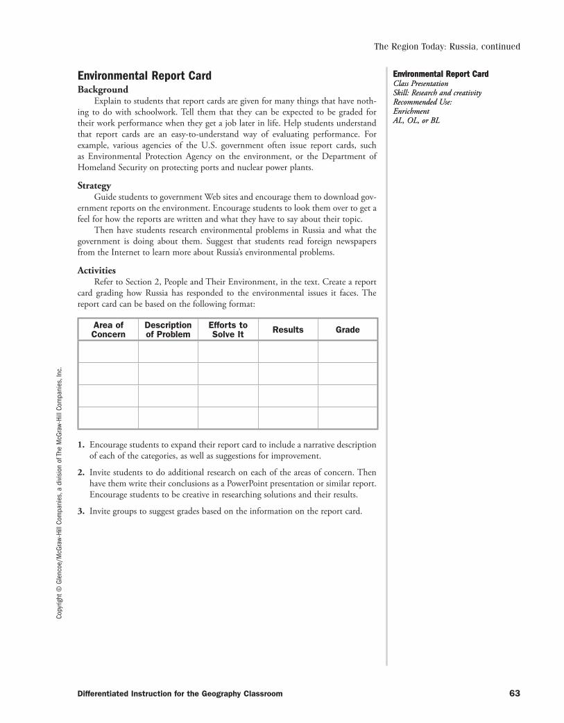
Copy
right
© G
lenc
oe/M
cGra
w-Hi
ll Co
mpa
nies
, a d
ivis
ion
of T
he M
cGra
w-Hi
ll Co
mpa
nies
, Inc
.
Environmental Report CardBackground
Explain to students that report cards are given for many things that have noth-ing to do with schoolwork. Tell them that they can be expected to be graded for their work performance when they get a job later in life. Help students understand that report cards are an easy-to-understand way of evaluating performance. For example, various agencies of the U.S. government often issue report cards, such as Environmental Protection Agency on the environment, or the Department of Homeland Security on protecting ports and nuclear power plants.
StrategyGuide students to government Web sites and encourage them to download gov-
ernment reports on the environment. Encourage students to look them over to get a feel for how the reports are written and what they have to say about their topic.
Then have students research environmental problems in Russia and what the government is doing about them. Suggest that students read foreign newspapers from the Internet to learn more about Russia’s environmental problems.
ActivitiesRefer to Section 2, People and Their Environment, in the text. Create a report
card grading how Russia has responded to the environmental issues it faces. The report card can be based on the following format:
Area of Concern
Descriptionof Problem
Efforts to Solve It Results Grade
1. Encourage students to expand their report card to include a narrative description of each of the categories, as well as suggestions for improvement.
2. Invite students to do additional research on each of the areas of concern. Then have them write their conclusions as a PowerPoint presentation or similar report. Encourage students to be creative in researching solutions and their results.
3. Invite groups to suggest grades based on the information on the report card.
Environmental Report Card Class Presentation Skill: Research and creativityRecommended Use: Enrichment AL, OL, or BL
Environmental Report Card Class Presentation Skill: Research and creativityRecommended Use: Enrichment AL, OL, or BL
The Region Today: Russia, continued
Differentiated Instruction for the Geography Classroom 63
053-140_DIGC_878566.indd 63053-140_DIGC_878566.indd 63 3/5/07 4:07:40 PM3/5/07 4:07:40 PM

053-140_DIGC_878566.indd 64053-140_DIGC_878566.indd 64 3/5/07 4:07:41 PM3/5/07 4:07:41 PM
Copy
right
© G
lenc
oe/M
cGra
w-Hi
ll Co
mpa
nies
, a d
ivis
ion
of T
he M
cGra
w-Hi
ll Co
mpa
nies
, Inc
.
Differentiated Instruction for the Geography Classroom 65
PHYSICAL GEOGRAPHY OF NORTH AFRICA, SOUTHWEST ASIA, AND CENTRAL ASIA
Key Terms and ReinforcementStrategy and Activity
Compile a list of key terms for this chapter. Include such words as:kum oasisalluvial soil pastoralismwadi cerealphosphate
Ask students to complete a word web. Demonstrate for students the structure of a word web that includes the following components:
• word history• related words• synonyms• antonyms• part of speech• dictionary definition• original sentence using the word• how it relates to the chapterAs students encounter the word in the text, they should add to their word webs
the sentence from the text that uses the word. Supply college-level dictionaries, thesauri, and word origin dictionaries. Provide a model of the word web using the overhead projector.
Straits and CanalsStrategy and Activity
Tell students that there are four straits and one canal that influence the economies, politics, and history of the region. Provide students an outline map that includes North Africa, Europe, Southwest Asia, and Central Asia. The map should include country borders in the region, although the country borders for Europe are not needed. Have students locate and label the following: Strait of Gibraltar, Dardanelles, Bosporous, Suez Canal, and Strait of Hormuz. Also have students label the countries that border these bodies of water. Ask students to use their maps to answer the following questions.
• At its narrowest point, what body of water separates North Africa and Europe? (Strait of Gibraltar)
• What country controls access to the Black Sea? (Turkey)• What are the similarities and differences between the Suez Canal and the four
straits in the region? (Similarities: They all serve the same function—connecting two larger bodies of water and allowing shipping to move efficiently; Differences: The canal is man-made while the straits are natural.)
• How do you think the Strait of Hormuz was important to the United Nations forces involved in the Persian Gulf War? (The troops were able to travel on ship to reach Saudi Arabia and Kuwait. If the strait had been controlled by Iraq, the UN forces would have had to travel overland across deserts or unfriendly territory to reach Iraq.)
Key Terms and ReinforcementIndependent Practice Skill: Use Word Webs to Analyze Important TermsRecommended Use: Reinforcement OL
Key Terms and ReinforcementIndependent Practice Skill: Use Word Webs to Analyze Important TermsRecommended Use: Reinforcement OL
Straits and CanalsCreate and Use a MapRecommended Use: Unit Wrap-UpBL
Straits and CanalsCreate and Use a MapRecommended Use: Unit Wrap-UpBL
CHAPTER17
053-140_DIGC_878566.indd 65053-140_DIGC_878566.indd 65 3/5/07 4:07:41 PM3/5/07 4:07:41 PM
Copyright © Glencoe/M
cGraw-Hill Companies, a division of The M
cGraw-Hill Companies, Inc.
66 Differentiated Instruction for the Geography Classroom
Learn More About
Identify a Body of Water
Ask students to locate and name the body of water that formed behind the Aswan High Dam. After whom was the reservoir named?
What Do You Think Of?Strategy and Activity
Write on the board Nile River and Sahara. Ask students to write three to five words or phrases that come to mind for each of the places on the board. Next write categories on the board such as People, Climate, History, Vegetation, Landforms, and Economics. Have students take turns saying the words or phrases they wrote down. As each student contributes a word or phrase, have another student say which category it should be listed under.
Identify Physical FeaturesStrategy and Activity
Have students look at a physical map of Southwest Asia and North Africa to help them answer the following questions:
• Why do you think the Nile Valley and the Fertile Crescent, rather than other areas of the region, became cradles of civilization? (abundance of water and land that could be cultivated)
• Between what continents does Southwest Asia lie? (Africa and Asia, some students may also mention Europe)
• Based on its location, what cultural and trade influences do you think this region has had on these continents? (Ideas will vary. Students should note that historically the region was part of major trade routes between Asia and Africa. Products, ideas, and cultures flowed along these routes.)
Learn More About
Living Near Water
Discuss with students why most of the population of North Africa lives within 50 miles of the Mediter ran ean Sea, Atlantic Ocean, or Nile River.
Facts About North AfricaStrategy and Activity
Organize the class into teams based on the number of sections in the chapter. Assign each group one section of the text for which they will create a series of mul-tiple choice questions. To review the chapter, have the groups compete by reading their questions and seeing which groups can identify the correct answers. You may either have groups take turns answering the questions and scoring points, or you can have the groups write their answers to the questions and determine which group has answered the most questions correctly.
What Do You Think Of?Categorizing Information
Recommended Use: Chapter Introduction
BL
What Do You Think Of?Categorizing Information
Recommended Use: Chapter Introduction
BL
Identify Physical FeaturesClass Discussion
Recommended Use: Lesson Introduction
OL
Identify Physical FeaturesClass Discussion
Recommended Use: Lesson Introduction
OL
Facts About North AfricaTrivia Challenge
Recommended Use: Chapter Review
BL
Facts About North AfricaTrivia Challenge
Recommended Use: Chapter Review
BL
Physical Geography of North Africa, Southwest Asia, and Central Asia, continued
053-140_DIGC_878566.indd 66053-140_DIGC_878566.indd 66 3/5/07 4:07:41 PM3/5/07 4:07:41 PM
Copy
right
© G
lenc
oe/M
cGra
w-Hi
ll Co
mpa
nies
, a d
ivis
ion
of T
he M
cGra
w-Hi
ll Co
mpa
nies
, Inc
.
Differentiated Instruction for the Geography Classroom 67
Physical Geography of North Africa, Southwest Asia, and Central Asia, continued
Read-Along MapBackground
When cartographers design maps, they do more than chart distances between land forms or other bodies of water. They also populate their maps with geographical features that enable readers to fully understand the region, from political boundaries to natural and economic resources. Some maps are dedicated to just one subject. For example, a political map might only show political boundaries of a region, along with the capitol or major cities. To draw a stronger distinction between political regions, such maps might also color the regions in contrasting colors.
Mapmakers use various symbols to signify the size of cities, economic resources, and other natural or manmade landmarks. Below are some examples of things that might be included on a map:
� Capital � Mine� Major City � Petroleum� Minor City � Uranium Deposit
StrategyInvite students to research map symbols on the Internet. Have groups come up
with various geographical landforms and features that would appear on a map. One group could design the symbols, while another writes their definitions.
Draw students’ attention to the common features of maps, such as the compass, scale, and legend. Explain to students the importance of these features. Tell students, for example, a scale reveals the distances between geographic features and a compass tells which way is north. If necessary, review Unit 1 for additional information on map features.
Activities1. Have students read Chapter 17, having at hand a political map of the region, as
well as a globe or atlas. As each geographical feature is named or described, have students find and label it on their maps.
2. As students read Chapter 17, have them complete the map with major cities, a compass, a scale, and a legend. Encourage students to use appropriate colors to signify various landforms, such as lakes, rivers, forests, and deserts.
3. Have students present their maps to the class in the form of an oral report. Remind students that they may also use desktop publishing software to create their maps, which can be imported into a PowerPoint presentation.
Read-Along Map Class Presentation Skill: Research and Creatively Present a TopicRecommended Use: Enrichment BL
Read-Along Map Class Presentation Skill: Research and Creatively Present a TopicRecommended Use: Enrichment BL
053-140_DIGC_878566.indd 67053-140_DIGC_878566.indd 67 3/5/07 4:07:41 PM3/5/07 4:07:41 PM

053-140_DIGC_878566.indd 68053-140_DIGC_878566.indd 68 3/5/07 4:07:41 PM3/5/07 4:07:41 PM
Copy
right
© G
lenc
oe/M
cGra
w-Hi
ll Co
mpa
nies
, a d
ivis
ion
of T
he M
cGra
w-Hi
ll Co
mpa
nies
, Inc
.
Differentiated Instruction for the Geography Classroom 69
Key Terms and ReinforcementStrategy and Activity
Compile a list of key terms for this chapter. Include such words as:Berber monotheism ziggurat exclavenomad prophet sheikhdom mujahideenbedouin mosque shari’ahinfrastructure culture hearths emirdomesticate cuneiform hajjhieroglyphics qanats Ibadhismgeometric boundary natural boundary Pashtunnationalism embargo enclaveAsk students to complete a word web. Demonstrate for students the structure
of a word web that includes the following components:• word history• related words• synonyms• antonyms• part of speech• dictionary definition• original sentence using the word• how it relates to the chapterAs students encounter the word in the text, they should add to their word webs
the sentence from the text that uses the word. Supply college-level dictionaries, thesauri, and word origin dictionaries. Provide a model of the word web using the overhead projector.
Life in Southwest AsiaStrategy and Activity
Organize students into groups of four. Have the groups prepare an oral presen-tation of what family life is like in one of the following places: an Israeli kibbutz, the Empty Quarter, a large city such as Istanbul, or a country under strict religious rule such as Afghanistan under the Taliban. Encourage groups to use creative methods, props, or visual aids during their presentations. Also, encourage all members of the group to participate in some way during the oral presentations.
Learn More About
Moroccan Proverbs
Read the Moroccan proverbs below. Ask the students to state what they think each of these proverbs means.
• “You are a prince. I am a prince. Who’s going to drive the donkeys?” (This is a way of someone saying that he is above manual labor.)
• “You went to the peppermint fields and caught a cold.” (Things do not always turn out the way you want them to.)
• “If you don’t have any money, your words are bitter.” (This is a way of commenting on someone’s economic status.)
Key Terms and ReinforcementIndependent Practice Skill: Use Word Webs to Analyze Important TermsRecommended Use: Reinforcement OL
Key Terms and ReinforcementIndependent Practice Skill: Use Word Webs to Analyze Important TermsRecommended Use: Reinforcement OL
Life in Southwest AsiaPrepare an Oral PresentationRecommended Use: Independent PracticeBL
Life in Southwest AsiaPrepare an Oral PresentationRecommended Use: Independent PracticeBL
CULTURAL GEOGRAPHY OF NORTH AFRICA, SOUTHWEST ASIA, AND CENTRAL ASIA
CHAPTER18
053-140_DIGC_878566.indd 69053-140_DIGC_878566.indd 69 3/5/07 4:07:41 PM3/5/07 4:07:41 PM
Copyright © Glencoe/M
cGraw-Hill Companies, a division of The M
cGraw-Hill Companies, Inc.
70 Differentiated Instruction for the Geography Classroom
Cultural Geography of North Africa, Southwest Asia, and Central Asia, continued
Ethnic MinoritiesStrategy and Activity
Explain to students that many ethnic groups are minorities in several countries in Southwest Asia. Ask the following questions.
• What factors help ethnic groups such as Armenians, Kurds, and Palestinians maintain their ethnic loyalties and identities when they are surrounded by other ethnic groups?
• What potential consequences does the presence of several large minority groups pose for a country?
• What rights do you think such minority groups should have?• What long-term solutions would you propose to solve the ethnic conflicts
that occur in the region?
Countries of Central AsiaStrategy and Activity
Have students create a table in which the columns are the eight countries of Central Asia. Label the rows with the following categories: Population, Major Religion, Cultural Influences, Ethnic Majority, Ethnic Minority Groups. As you examine the countries in the region, have students fill in the chart and use it as a study tool.
Learn More About
Identify Location
Remind students that Islam is the dominant religion in Southwest Asia. Ask students to identify the large city in Saudi Arabia where each year millions of Muslim pilgrims gather. (Makkah)
Learn More About
Three Religions, One City
Ask students to identify the city in Southwest Asia that Muslims, Jews, and Christians consider sacred (Jerusalem). As a class, discuss what problems this designation might have for the city and its people.
Cultural DifferencesStrategy and Activity
Tell students that ongoing conflicts in Southwest Asia occur partly because of a clash of cultures. Have students research the cultural differences between Israel and its neighbors. Based on their research, have students write a research report that describes the Hebrew culture and the Arab culture, and explores the similarities and differences between the cultures.
Ethnic MinoritiesMake Reasoned Judgments
Recommended Use: Guided Practice
AL
Ethnic MinoritiesMake Reasoned Judgments
Recommended Use: Guided Practice
AL
Countries of Central AsiaCreate a Table
Recommended Use: Guided Practice
BL
Countries of Central AsiaCreate a Table
Recommended Use: Guided Practice
BL
Cultural DifferencesWrite a Research Report
Recommended Use: Independent Practice
OL
Cultural DifferencesWrite a Research Report
Recommended Use: Independent Practice
OL
053-140_DIGC_878566.indd 70053-140_DIGC_878566.indd 70 3/5/07 4:07:42 PM3/5/07 4:07:42 PM
Copy
right
© G
lenc
oe/M
cGra
w-Hi
ll Co
mpa
nies
, a d
ivis
ion
of T
he M
cGra
w-Hi
ll Co
mpa
nies
, Inc
.
Differentiated Instruction for the Geography Classroom 71
Cultural Geography of North Africa, Southwest Asia, and Central Asia, continued
Judaism, Christianity, and IslamBackground
Though they sometimes seem as if they are wholly alien to one another, Judaism, Christianity, and Islam actually share common theological roots. As the oldest of the monotheistic faiths, Judaism forms the basis for both Christianity and Islam. Jews believe in one God, Yahweh, who pledged to protect and bless Abraham and his descendants. For Christians, Jesus Christ is believed to be the living son of the Jewish God, who had pledged to send a messiah to save the Jews. For Muslims, Islam is the belief in the teachings of Muhammad, who is believed to be the one true prophet of God, and the last of a line of prophets sent by God, which included Moses and Jesus.
Understanding these three religions is crucial to understanding the geography and history of North Africa and Central Asia, as well as world history. Furthermore, knowledge of these religions is crucial to understanding daily events in the news and the global economy.
StrategyResearch the basic beliefs of each of these religions. Find out what they have
in common and their differences. If possible, arrange an interview with a Catholic priest or Protestant reverend, a Jewish rabbi, and an imam. Invite students to prepare a list of questions to ask about the respective beliefs. The questions should cover dif-ferences and similarities, as well as origins and major schools of thought within each. (For example, students should be able to explain the differences between Reform, Conservative, and Orthodox Judaism; Sunni or Shiite Muslims; or Catholic and Protestant Christians.)
ActivitiesHave students choose one of the following activities to complete based on their
research. Have students share their research and projects with the rest of the class.
1. Report on your findings in a paper, an oral presentation using PowerPoint, or a poster. The poster could take the form of personal “I believe” statements from a Christian, Muslim, and Jewish teenager. Beliefs held in common could take the form of “we all believe” statements.
2. Have students prepare a geographical report on various Holy Lands for each reli-gion. Students should be prepared to point out major religious cites and sites and explain the significance of each site. Students should also be prepared to explain how the three faiths have had conflicts over sites. (For example, students might discuss how the Dome of the Rock came to be constructed above the Western Wall.)
Judaism, Christianity, and Islam Class Presentation Skill: Research and Creatively Present a TopicRecommended Use: Enrichment AL
Judaism, Christianity, and Islam Class Presentation Skill: Research and Creatively Present a TopicRecommended Use: Enrichment AL
053-140_DIGC_878566.indd 71053-140_DIGC_878566.indd 71 3/5/07 4:07:42 PM3/5/07 4:07:42 PM

053-140_DIGC_878566.indd 72053-140_DIGC_878566.indd 72 3/5/07 4:07:42 PM3/5/07 4:07:42 PM
Copy
right
© G
lenc
oe/M
cGra
w-Hi
ll Co
mpa
nies
, a d
ivis
ion
of T
he M
cGra
w-Hi
ll Co
mpa
nies
, Inc
.
Differentiated Instruction for the Geography Classroom 73
THE REGION TODAY: NORTH AFRICA, SOUTHWEST ASIA, AND CENTRAL ASIA
Key Terms and ReinforcementStrategy and Activity
Compile a list of key terms for this chapter. Include such words as:arable landlockedcommodity embargocrude oil aquiferpetrochemical desalinationAsk students to complete a word web. Demonstrate for students the structure
of a word web that includes the following components:• word history• related words• synonyms• antonyms• part of speech• dictionary definition• original sentence using the word• how it relates to the chapterAs students encounter the word in the text, they should add to their word webs
the sentence from the text that uses the word. Supply college-level dictionaries, thesauri, and word origin dictionaries. Provide a model of the word web using the overhead projector.
Cities in Southwest AsiaStrategy and Activity
Organize students into pairs. Assign each pair one of the following cities in Southwest Asia: Tehran, Iran; Baghdad, Iraq; Beirut, Lebanon; Jerusalem, Israel; Am man, Jordan; Ankara, Turkey, Damascus, Syria; and Riyadh, Saudi Arabia. After researching the city’s history, culture, and economy, have the pairs prepare and present an oral report to the class.
Internet Learning
Satellite Photos
The ecological devastation wrought by the rapid draining of the Aral Sea is docu-mented with satellite photographs at edcwww.cr.usgs.gov/earthshots/slow/Aral/Aral
Key Terms and ReinforcementIndependent Practice Skill: Use Word Webs to Analyze Important TermsRecommended Use: Reinforcement OL
Key Terms and ReinforcementIndependent Practice Skill: Use Word Webs to Analyze Important TermsRecommended Use: Reinforcement OL
Cities in Southwest AsiaPresent an Oral ReportRecommended Use: Independent PracticeOL
Cities in Southwest AsiaPresent an Oral ReportRecommended Use: Independent PracticeOL
CHAPTER19
053-140_DIGC_878566.indd 73053-140_DIGC_878566.indd 73 3/5/07 4:07:42 PM3/5/07 4:07:42 PM
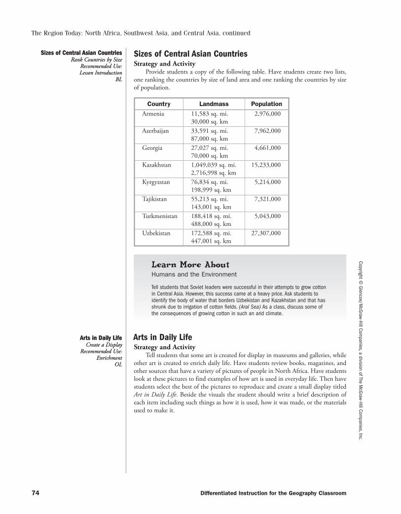
Copyright © Glencoe/M
cGraw-Hill Companies, a division of The M
cGraw-Hill Companies, Inc.
74 Differentiated Instruction for the Geography Classroom
The Region Today: North Africa, Southwest Asia, and Central Asia, continued
Sizes of Central Asian CountriesStrategy and Activity
Provide students a copy of the following table. Have students create two lists, one ranking the countries by size of land area and one ranking the countries by size of population.
Country Landmass PopulationArmenia 11,583 sq. mi.
30,000 sq. km2,976,000
Azerbaijan 33,591 sq. mi.87,000 sq. km
7,962,000
Georgia 27,027 sq. mi.70,000 sq. km
4,661,000
Kazakhstan 1,049,039 sq. mi.2,716,998 sq. km
15,233,000
Kyrgyzstan 76,834 sq. mi.198,999 sq. km
5,214,000
Tajikistan 55,213 sq. mi.143,001 sq. km
7,321,000
Turkmenistan 188,418 sq. mi.488,000 sq. km
5,043,000
Uzbekistan 172,588 sq. mi.447,001 sq. km
27,307,000
Learn More About
Humans and the Environment
Tell students that Soviet leaders were successful in their attempts to grow cotton in Central Asia. However, this success came at a heavy price. Ask students to identify the body of water that borders Uzbekistan and Kazakhstan and that has shrunk due to irrigation of cotton fields. (Aral Sea) As a class, discuss some of the consequences of growing cotton in such an arid climate.
Arts in Daily LifeStrategy and Activity
Tell students that some art is created for display in museums and galleries, while other art is created to enrich daily life. Have students review books, magazines, and other sources that have a variety of pictures of people in North Africa. Have students look at these pictures to find examples of how art is used in everyday life. Then have students select the best of the pictures to reproduce and create a small display titled Art in Daily Life. Beside the visuals the student should write a brief description of each item including such things as how it is used, how it was made, or the materials used to make it.
Sizes of Central Asian CountriesRank Countries by Size
Recommended Use: Lesson Introduction
BL
Sizes of Central Asian CountriesRank Countries by Size
Recommended Use: Lesson Introduction
BL
Arts in Daily LifeCreate a Display
Recommended Use: Enrichment
OL
Arts in Daily LifeCreate a Display
Recommended Use: Enrichment
OL
053-140_DIGC_878566.indd 74053-140_DIGC_878566.indd 74 3/5/07 4:07:42 PM3/5/07 4:07:42 PM
Copy
right
© G
lenc
oe/M
cGra
w-Hi
ll Co
mpa
nies
, a d
ivis
ion
of T
he M
cGra
w-Hi
ll Co
mpa
nies
, Inc
.
Differentiated Instruction for the Geography Classroom 75
The Region Today: North Africa, Southwest Asia, and Central Asia, continued
Water, Water Everywhere?Background
Water is our most precious resource, and experts claim that there might not be enough for a growing global population. According to Peter Aldhous, writing in Nature magazine:
The water crisis is real. If action isn’t taken, millions of people will be con-demned to a premature death. According to the World Water Development Report, a UN survey prepared for the forum, population growth, pollution and climate change are conspiring to exacerbate the situation. Over the next two decades, the average supply of water per person will drop by a third. Heightened hunger and disease will follow. Humanity’s demands for water also threaten natural ecosystems, and may bring nations into conflicts that—although they may not lead to war—will test diplomats’ skills to the limit.
Clearly, the problem of providing enough water is going to be a great challenge for the 21st century. Economic, political, military, and diplomatic resources will be applied toward acquiring water tomorrow to a degree that they are applied to oil today.
StrategyInvite students to research the problem of the dwindling water supply.
Encourage students to use the Internet and library research. Students should be prepared to answer the following questions:
1. What is the estimated global water supply?
2. What is the estimated water use, per capita?
3. What is the estimated rate of population growth?
In gathering this data, students should begin calculating when the global water supply will be unable to sustain all human life. Encourage students to discuss what measures might be taken to preserve the water supply. Alternatively, discuss with students what changes in lifestyle might slow our water usage.
ActivityUsing the section of the chapter titled “Managing Resources,” make a chart of
each major heading (Water Resources, Desalination, etc.). Pretend you are a reporter for a TV news magazine. Jot down notes about the major ideas discussed in each subsection so that a news anchor can present a program about water in the region.
Water, Water Everywhere? Class Presentation Skill: Research and Creatively Present a TopicRecommended Use: Enrichment AL
Water, Water Everywhere? Class Presentation Skill: Research and Creatively Present a TopicRecommended Use: Enrichment AL
053-140_DIGC_878566.indd 75053-140_DIGC_878566.indd 75 3/5/07 4:07:42 PM3/5/07 4:07:42 PM

053-140_DIGC_878566.indd 76053-140_DIGC_878566.indd 76 3/5/07 4:07:43 PM3/5/07 4:07:43 PM
Copy
right
© G
lenc
oe/M
cGra
w-Hi
ll Co
mpa
nies
, a d
ivis
ion
of T
he M
cGra
w-Hi
ll Co
mpa
nies
, Inc
.
Differentiated Instruction for the Geography Classroom 77
PHYSICAL GEOGRAPHY OF AFRICA SOUTH OF THE SAHARA
Key Terms ReinforcementStrategy and Activity
Compile a list of key terms for this chapter. Include words such as:rift valley deltafault estuaryescarpment leachcataract savannadesertification harmattanAsk students to complete a word web. Demonstrate for students the structure
of a word web that includes the following components:• word history• related words• synonyms• antonyms• part of speech• dictionary definition• original sentence using the word• how it relates to the chapterAs students encounter the word in the text, they should add to their word webs
the sentence from the text that uses the word. Supply college-level dictionaries, thesauri, and word origin dictionaries. Provide a model of the word web using the overhead projector.
Climate and Landforms of East AfricaStrategy and Activity
Assign students one of the countries of East Africa. Give students outline maps of their assigned country or of the entire region of East Africa. Tell students to use their textbook, an atlas, or other library or Internet resources to research and draw landforms and climate zones on their maps. Have students annotate their maps with a brief description of each climate region and the people who live there.
People and Places
Place Location Activity
Have students refer to maps in their textbook to answer the following questions:
• Which country is farther north, Nigeria or Burkina Faso? (Burkina Faso)• Lake Chad borders which West African countries? (Chad, Niger, and Nigeria)• Cape Verde borders which West African countries? (None. It is an island nation.)
Key Terms and ReinforcementIndependent Practice Skill: Use Word Webs to Analyze Important TermsRecommended Use: ReinforcementOL
Key Terms and ReinforcementIndependent Practice Skill: Use Word Webs to Analyze Important TermsRecommended Use: ReinforcementOL
Climate and Landforms of East AfricaCreate a Thematic MapRecommended Use: Independent PracticeOL
Climate and Landforms of East AfricaCreate a Thematic MapRecommended Use: Independent PracticeOL
CHAPTER20
053-140_DIGC_878566.indd 77053-140_DIGC_878566.indd 77 3/5/07 4:07:43 PM3/5/07 4:07:43 PM
Copyright © Glencoe/M
cGraw-Hill Companies, a division of The M
cGraw-Hill Companies, Inc.
78 Differentiated Instruction for the Geography Classroom
Physical Geography of Africa South of the Sahara, continued
Shrinking Lake ChadStrategy and Activity
Have interested students use the text, library, and Internet to research the causes of the shrinking of Lake Chad. Next, have students hypothesize ways in which this process can be slowed, stopped, or reversed and summarize them in a memo to be presented to environmental officials in west-central Africa.
Crossing a DesertStrategy and Activity
Provide students an outline map of Africa South of the Sahara. Have students locate and label the major landforms of Namibia, Botswana, and South Africa. Have students locate and label the following cities: Windhoek, Cape Town, Johannesburg, Gaborone, and Francistown. Then have students research the major transportation routes (rail, road, and water routes) between the cities. Have them use either differ-ent colors or different patterns to label the transportation routes between these cities. Have students use their maps to answer the following questions:
• What types of transportation would you most likely use to travel between Windhoek and Cape Town?
• What is the best route from Windhoek to Gaborone?• What landforms do you pass through on a trip from Francistown to Cape
Town?• Using the most likely route to travel from Johannesburg to Windhoek, what
is the approximate distance you would travel?• If you could travel in a straight line between Johannesburg and Windhoek,
what is the approximate distance you would travel?
Facts About West AfricaStrategy and Activity
Tell students that the people of Ghana developed a form of handwoven textiles known as adinkra. The cloth is decorated with pictures known as ideographs. Write the letters A-D-I-N-K-R-A vertically down the board. Have students think of one or more words that relate to the geography of West Africa that begin with each letter. Write students’ contributions on the board.
People and Places
Economic Activity Table
Have students create a table that lists natural resources available in Central African countries.
DesertificationStrategy and Activity
Have students work in small groups to learn about the causes of desertification by creating a two-panel display. One panel should explore the geographic causes of desertification such as drought and strong winds that blow away soil. The other panel should explore human actions that contribute to the process of desertification.
Shrinking Lake ChadResearch and Creatively
Present a TopicRecommended Use:
Independent PracticeAL
Shrinking Lake ChadResearch and Creatively
Present a TopicRecommended Use:
Independent PracticeAL
Crossing a DesertCreate a Thematic Map
Recommended Use: Independent Practice
OL
Crossing a DesertCreate a Thematic Map
Recommended Use: Independent Practice
OL
Facts About West AfricaMake an Acrostic
Recommended Use: Introduction
BL
Facts About West AfricaMake an Acrostic
Recommended Use: Introduction
BL
DesertificationCreate a Display
Recommended Use: Independent Practice
or Chapter ReviewOL
DesertificationCreate a Display
Recommended Use: Independent Practice
or Chapter ReviewOL
053-140_DIGC_878566.indd 78053-140_DIGC_878566.indd 78 3/5/07 4:07:43 PM3/5/07 4:07:43 PM
Copy
right
© G
lenc
oe/M
cGra
w-Hi
ll Co
mpa
nies
, a d
ivis
ion
of T
he M
cGra
w-Hi
ll Co
mpa
nies
, Inc
.
Differentiated Instruction for the Geography Classroom 79
Physical Geography of Africa South of the Sahara, continued
A Million PlacesBackground
Sub-Saharan Africa is a huge region with many different landforms, climate regions, varieties of vegetation, and types of natural resources. Climates include tropical wet, steppe, desert, mediterranean, humid subtropical, and marine west coast. The Great Rift Valley, Lake Victoria, and the Niger River are just three of many significant landforms in the region.
StrategyRefer to the quote at the beginning of Chapter 20 by science writer David
Quammen: “Africa isn’t really a place; it’s a million places.” Engage your students in a discussion about this statement using the following questions:
• What climate regions are found in Africa south of the Sahara?• What are some of sub-Saharan Africa’s landforms?• What kinds of natural resources are found in this region?• What sort of vegetation is found in the region?• How would life be different depending on where in sub-Saharan Africa
a person lived?
ActivitiesHave students choose one of the following activities to complete based on your
discussion and their research. They can work alone or in small groups. Have students share their research and projects with the rest of the class.
1. In a short persuasive essay, support Quammen’s thesis with specific examples from the text. Use additional Internet research if you would like.
2. Create a poster-sized collage made up of words and images that represent the various countries, landforms, and cultures in Africa. Find these images in old magazines and be prepared to explain to your classmates why you chose to include each of them.
3. Starting with a blank line map of the African continent, draw in at least twelve major features of the continent’s geography or climate regions. Use dramatic colors and shapes to represent rivers, mountains, lakes, and forests. Present your physical map to the rest of the class, explaining each of the features you included.
A Million PlacesClass Presentation Skill: Research and Creatively Present a TopicRecommended Use: ReviewBL
A Million PlacesClass Presentation Skill: Research and Creatively Present a TopicRecommended Use: ReviewBL
053-140_DIGC_878566.indd 79053-140_DIGC_878566.indd 79 3/5/07 4:07:43 PM3/5/07 4:07:43 PM

053-140_DIGC_878566.indd 80053-140_DIGC_878566.indd 80 3/5/07 4:07:43 PM3/5/07 4:07:43 PM
Copy
right
© G
lenc
oe/M
cGra
w-Hi
ll Co
mpa
nies
, a d
ivis
ion
of T
he M
cGra
w-Hi
ll Co
mpa
nies
, Inc
.
Differentiated Instruction for the Geography Classroom 81
CULTURAL GEOGRAPHY OF AFRICASOUTH OF THE SAHARA
Key Terms ReinforcementStrategy and Activity
Compile a list of key terms for this chapter. Include words such as:indigenous pidgin service centersdomesticate coup d’etat Ashantesanitation apartheidoral tradition universalpatriarchal suffrageclan Hausanuclear family Yorubalingua franca urbanizationAsk students to complete a word web. Demonstrate for students the structure
of a word web that includes the following components:• word history• related words• synonyms• antonyms• part of speech• dictionary definition• original sentence using the word• how it relates to the chapterAs students encounter the word in the text, they should add to their word webs
the sentence from the text that uses the word. Supply college-level dictionaries, thesauri, and word origin dictionaries. Provide a model of the word web using the overhead projector.
Historical EventsStrategy and Activity
Organize students into five groups. Assign each group one of the following countries: Cameroon, Central African Republic, Republic of Congo, Democratic Republic of the Congo, and Gabon. Tell the groups that they are to create a time line of important events in the history of their assigned country. The time lines should include a minimum of 10 events and may stretch from prehistory to the present day. Remind students that the time lines should show the passage of time by the space that is left between events.
Learn More About
Colonial Effects
Remind students that the countries of Central Africa were under colonial rule for many years. One lasting effect of the colonial presence is the continued use of non-African languages. Ask students to identify the European language that is still commonly used in all of the Central African countries.
Key Terms and ReinforcementIndependent Practice Skill: Use Word Webs to Analyze Important TermsRecommended Use: ReinforcementOL
Key Terms and ReinforcementIndependent Practice Skill: Use Word Webs to Analyze Important TermsRecommended Use: ReinforcementOL
Historical EventsCreate a Time LineRecommended Use: Independent PracticeOL
Historical EventsCreate a Time LineRecommended Use: Independent PracticeOL
CHAPTER21
053-140_DIGC_878566.indd 81053-140_DIGC_878566.indd 81 3/5/07 4:07:43 PM3/5/07 4:07:43 PM
Copyright © Glencoe/M
cGraw-Hill Companies, a division of The M
cGraw-Hill Companies, Inc.
82 Differentiated Instruction for the Geography Classroom
Cultural Geography of Africa South of the Sahara, continued
MasksStrategy and Activity
Discuss with the class the psychological effects of wearing a mask. Begin with the following questions: What does wearing a mask do to or for someone? (Possible answers: give anonymity, give another personality, represent other beings) Tell students that many African cultures have a rich tradition in creating elaborate masks. Masks are used in many ways, but their primary use is for religious or ritual ceremonies. Conclude the discussion by asking students to compare the use of masks in Africa with their uses in American culture.
DevelopmentStrategy and Activity
Write the following sentence on the board: The basic aim of development is to improve the quality of life. Ask students what characteristics determine the quality of life one enjoys. (Possible answers include adequate food and shelter, good health, adequate income, education, safety and security, freedom and equality.) List student responses on the board. For each characteristic listed, ask the class to conclude why many Africans have not widely attained it. (Responses should note the effects of population growth, agricultural policies, drought, civil war, refugees, national economic crisis, and repressive governments.)
People and Places
Place Location Activity
Ask students to use maps in their textbooks to answer the following questions.
• Which capital is farther north, Mogadishu or Kampala? (Mogadishu)
• Lake Victoria borders which East African countries? (Kenya, Uganda, and Tanzania)
• In which East African country do the White Nile and Blue Nile Rivers converge? (Sudan)
• What capital in East Africa is also the name of the country? (Djibouti)
Human Rights and ApartheidStrategy and Activity
Organize the class into four groups and assign each a racial classification of apartheid—African, White, Colored, Asian. Have each group explore the effects of apartheid on the people under its classification. Then have the members of each group create a poster illustrating their daily lives in South Africa before and after apartheid. Have the groups display their posters. After students have had a chance to review all the posters, discuss as a class the challenges that South Africa is facing today because of the legacy of apartheid.
MasksAnalyze Concepts
Recommended Use: Lesson Introduction
BL
MasksAnalyze Concepts
Recommended Use: Lesson Introduction
BL
DevelopmentClassroom Discussion
Recommended Use: Chapter Introduction
BL
DevelopmentClassroom Discussion
Recommended Use: Chapter Introduction
BL
Human Rights and ApartheidCreate a Poster
Recommended Use: Guided Practice
OL
Human Rights and ApartheidCreate a Poster
Recommended Use: Guided Practice
OL
053-140_DIGC_878566.indd 82053-140_DIGC_878566.indd 82 3/5/07 4:07:44 PM3/5/07 4:07:44 PM
Copy
right
© G
lenc
oe/M
cGra
w-Hi
ll Co
mpa
nies
, a d
ivis
ion
of T
he M
cGra
w-Hi
ll Co
mpa
nies
, Inc
.
Differentiated Instruction for the Geography Classroom 83
Cultural Geography of Africa South of the Sahara, continued
Divided by Ethnic ConflictBackground
Africa South of the Sahara has been plagued by several ethnic conflicts, includ-ing instances of significant bloodshed in the Darfur region of Sudan, Rwanda, and in Eritrea/Ethiopia.
Just three years before independence was achieved from Belgium, the seeds of ethnic conflict were sown in Rwanda. The Hutus, the majority ethnic group, over-threw the ruling Tutsi king and in the years that followed exiled or killed thousands of Tutsis. By 1990, the children of the Tutsi exiles returned to Rwanda and initi-ated a civil war under the banner of the Rwandan Patriotic Front. The political and economic crisis resulted in genocide of roughly 800,000 Tutsis and moderate Hutus in April 1994.
In Sudan’s western region of Darfur, a conflict has been raging since 2003. The conflict has been responsible for the death of more than 200,000 people and forced 2 million more into refugee camps.
StrategyVisit www.nationalgeographic.com and scroll to People and Places. Type in
Sudan. Find the video clip Darfur: Divided by Ethnic Conflict. First, view the video clip without the sound and have students write down their impressions of who they see and what they see happening. Then, read the section of the chapter entitled “Sudan Today” together aloud. Based on the reading discuss what happened, why it happened, and the effects of the war and efforts to stop the killing.
Next, watch the clip with the sound. The goal is to have a good understanding of who is fighting and why, as well as how the fighting has caused great suffering. Have each student write down one or two facts during this second viewing. Then, make a flow chart or write bullet points to describe what is happening in Darfur, why it is happening, and what effects the war is having on people. Give the students the information about Rwanda provided above and have them compare and contrast the two situations using the following questions:
• How is the situation in Darfur different than what occurred in Rwanda?• How is the situation in Darfur similar to what occurred in Rwanda?• Do you think this kind of conflict will happen again in the region?
Why or why not?
ActivitiesHave students choose one of the following activities to complete based on their
research. Have students share their research and projects with the rest of the class.
1. Now that you know what is going on, what do you think is the best way to solve the problem of ethnic conflict in Africa? In groups of two, prepare a short speech in which you address this question. Present it to the class, pretending they are world leaders at a United Nations summit.
2. Conduct research on other instances of ethnic conflict in Africa South of the Sahara or in the world. Summarize the conflict in a one-page essay and explain to your classmates how it compares to the violence in Darfur.
3. Preventing ethnic conflict is undoubtedly better than solving it once it is already occurring. In groups of three or four, brainstorm five ideas for preventing vio-lence among ethic groups. Arrange your ideas on a poster and explain to your classmates your program for peace.
Divided by Ethnic ConflictClass Presentation Skills: Conduct Research, Analyze Historical Information, Recommended Use: EnrichmentOL
Divided by Ethnic ConflictClass Presentation Skills: Conduct Research, Analyze Historical Information, Recommended Use: EnrichmentOL
053-140_DIGC_878566.indd 83053-140_DIGC_878566.indd 83 3/5/07 4:07:44 PM3/5/07 4:07:44 PM

053-140_DIGC_878566.indd 84053-140_DIGC_878566.indd 84 3/5/07 4:07:44 PM3/5/07 4:07:44 PM
Copy
right
© G
lenc
oe/M
cGra
w-Hi
ll Co
mpa
nies
, a d
ivis
ion
of T
he M
cGra
w-Hi
ll Co
mpa
nies
, Inc
.
Differentiated Instruction for the Geography Classroom 85
THE REGION TODAY: AFRICA SOUTH OF THE SAHARA
Key Terms ReinforcementStrategy and Activity
Compile a list of key terms for this chapter. Include words such as:subsistence farming e-commerceshifting cultivation carrying capacitysedentary farming habitatcommercial farming extinctioncash crop poachingconservation farming ecotourisminfrastructureAsk students to complete a word web. Demonstrate for students the structure
of a word web that includes the following components:• word history• related words• synonyms• antonyms• part of speech• dictionary definition• original sentence using the word• how it relates to the chapterAs students encounter the word in the text, they should add to their word webs
the sentence from the text that uses the word. Supply college-level dictionaries, thesauri, and word origin dictionaries. Provide a model of the word web using the overhead projector.
Talking DrumsStrategy and Activity
Have interested students learn about the talking drums of West Africa. After they have explained to the class what the drums are and how they were used, orga nize the class into groups. Have each group work out a code for talking drums. Suggest using different tones and/or number of beats to mean different things such as words or letters. Have each group explain its code to the class and then send a message for the rest of the class to “read.”
Learn More About
Identifying Dominant Religions
Ask students to identify the two dominant religions of East Africa. (Islam and Christianity) Ask them which of these two religions are indigenous, or native to that region. (neither) Discuss how Islam and Christianity came to East Africa. (Both religions were introduced by missionaries.)
Key Terms and ReinforcementIndependent Practice Skill: Use Word Webs to Analyze Important TermsRecommended Use: ReinforcementOL
Key Terms and ReinforcementIndependent Practice Skill: Use Word Webs to Analyze Important TermsRecommended Use: ReinforcementOL
Talking DrumsPresent a DemonstrationRecommended Use: EnrichmentAL
Talking DrumsPresent a DemonstrationRecommended Use: EnrichmentAL
CHAPTER22
053-140_DIGC_878566.indd 85053-140_DIGC_878566.indd 85 3/5/07 4:07:44 PM3/5/07 4:07:44 PM
Copyright © Glencoe/M
cGraw-Hill Companies, a division of The M
cGraw-Hill Companies, Inc.
86 Differentiated Instruction for the Geography Classroom
The Region Today: Africa South of the Sahara, continued
Preventing PoachingStrategy and Activity
Tell students that countries in Africa with large wildlife populations such as Tan zania face choices about how to deal with the declining populations of many species of animals such as elephants, zebras, and lions. Have students learn about the problem posed by poachers and what Tanzania and other countries are doing to decrease poaching. Based on their research, have students create a poster to be used to deter poaching.
Learn More About
Wealth Variance in Africa South of the Sahara
Direct students to look at an economic activity map of Africa South of the Sahara. Ask them to identify the centers of manufacturing in southern Africa and the areas with the most natural resources. Discuss the correlation between abun-dant natural resources, centers of manufacturing, and standard of living
EnclavesStrategy and Activity
Ask students to identify the two countries in southern Africa that are enclaves—small countries located within a larger country. (Lesotho and Swaziland are inside South Africa.) Discuss when and how these two countries gained their independence and what reasons they may have for remaining independent. Ask interested students to learn more about these enclaves, why they exist, and how they are governed. You may have students report their findings to the entire class.
Analyzing ChangeStrategy and Activity
Tell students to imagine that they have just moved to a rapidly growing African city. Have them write a letter to their families who either live in the desert, on the savanna, or in a rain forest explaining why they migrated, their observations and experiences in the city, how their life has changed, and the feelings they have about their new home.
Music StylesStrategy and Activity
Have interested students use library or Internet resources to research the soukous, the modern popular music style of the Democratic Republic of the Congo. Have them learn the music style’s origins, instruments used, and leading artists. Have them locate examples of the music style and prepare a demonstration for the class. The demonstration should include an overview of their research and the playing of a sample of soukous music. Depending on the musical talents of the students preparing the demonstration, they may either perform the music or play a recording.
Preventing PoachingCreate a Poster
Recommended Use: Independent Practice
OL
Preventing PoachingCreate a Poster
Recommended Use: Independent Practice
OL
EnclavesResearch and Discuss
Recommended Use: Guided Practice
BL
EnclavesResearch and Discuss
Recommended Use: Guided Practice
BL
Analyzing ChangeWrite a Letter
Recommended Use: Unit Wrap-Up
OL
Analyzing ChangeWrite a Letter
Recommended Use: Unit Wrap-Up
OL
Music StylesGive a Demonstration
Recommended Use: Enrichment
OL
Music StylesGive a Demonstration
Recommended Use: Enrichment
OL
053-140_DIGC_878566.indd 86053-140_DIGC_878566.indd 86 3/5/07 4:07:44 PM3/5/07 4:07:44 PM
Copy
right
© G
lenc
oe/M
cGra
w-Hi
ll Co
mpa
nies
, a d
ivis
ion
of T
he M
cGra
w-Hi
ll Co
mpa
nies
, Inc
.
Differentiated Instruction for the Geography Classroom 87
The Region Today: Africa South of the Sahara, continued
Leadership Summit on AIDS in AfricaBackground
Some facts and statistics about AIDS in Africa South of the Sahara:
“World Health Organization (WHO) estimates that AIDS has caused the life expectancy in Southern Africa to drop from 59 years in the early 1990s to 45 years after 2005. In the year 2000, 10% of the population between the ages of 15 and 49 has HIV/AIDS in 16 African countries, while in 7 African countries, infection rates reach 20%. The UN estimates that, around the world during 2001, there were 3 million deaths from AIDS, of which 2.3 million were in Sub-Saharan Africa. Africa has the most infected (more than 16 million). AIDS has lowered the life expectancy in Botswana, Malawi, Mozambique, and Swaziland by 20 years, to under 40 years of age. In 2004, a study finds that the rate of HIV prevalence in Uganda has dropped 70% since the early 1990s, due to local prevention efforts.” ~Timeline: AIDS Epidemic by David Johnson and Shmuel Ross.
StrategyAs a class, list the names of the countries in Africa South of the Sahara. Then,
visit www.cia.gov/cia/publicatons/factbook. Have students find the name of the leader of each country in Africa South of the Sahara. Create a guest list for a sum-mit meeting about the challenge of fighting AIDS in the region. As the leaders of this summit, have students record facts and statistics they find about AIDS in their textbooks and online. To guide preparation for this activity, discuss the following questions as a class before breaking into small groups to conduct research:
• In what nations is AIDS most prevalent?• Why is preventing the spread of the disease so difficult for health officials?• What progress has been made to fight AIDS in the region?• What are some of the effects of the spread of AIDS in the region?
Specifically, how has it impacted the economy of affected nations?• In what ways are Western nations like the United States involved in the fight
against AIDS in Africa? How much responsibility do they have to help solve the problem? Why?
ActivitiesHave students choose one of the following activities to complete based on their
research. Have students share their research and projects with the rest of the class.
1. Prepare an illustrated map of Africa using additional AIDS statistics you find by doing Internet research in small groups. Include information such as the number of persons infected in each country and the number being regularly treated.
2. Create a two-page newspaper with at least three feature stories about AIDS in Africa. Include news about how people are trying to fight AIDS, how people are suffering from the effects of AIDS, and what people in the U.S. can do to help.
3. Design a persuasive invitation for the summit addressing the AIDS crisis. List the major issues created by AIDS (examples include “helping patients afford medica-tion,” “prevention measures,” and “caring for AIDS orphans”). Choose a city that is most convenient for all of the leaders you would like to invite and include this information on the invitation.
Leadership Summit on AIDS in AfricaWriting Activity Skill: Analyze DataRecommended Use: EnrichmentAL
Leadership Summit on AIDS in AfricaWriting Activity Skill: Analyze DataRecommended Use: EnrichmentAL
053-140_DIGC_878566.indd 87053-140_DIGC_878566.indd 87 3/5/07 4:07:44 PM3/5/07 4:07:44 PM

053-140_DIGC_878566.indd 88053-140_DIGC_878566.indd 88 3/5/07 4:07:45 PM3/5/07 4:07:45 PM
Copy
right
© G
lenc
oe/M
cGra
w-Hi
ll Co
mpa
nies
, a d
ivis
ion
of T
he M
cGra
w-Hi
ll Co
mpa
nies
, Inc
.
Differentiated Instruction for the Geography Classroom 89
PHYSICAL GEOGRAPHY OF SOUTH ASIA
Key Terms ReinforcementStrategy and Activity
Compile a list of content vocabulary and key terms for this chapter. Include words such as:
subcontinent cyclonealluvial plain tsunamimonsoonAsk students to complete a word web. Demonstrate for students the structure
of a word web that includes the following components:• word history• related words• synonyms• antonyms• part of speech• dictionary definition• original sentence using the word• how it relates to the chapterAs students encounter the word in the text, they should add to their word webs
the sentence from the text that uses the word. Supply college-level dictionaries, thesauri, and word origin dictionaries. Provide a model of the word web using the overhead projector.
Physical GeographyStrategy and Activity
Draw a triangle pointing south on the board. Indicate mountains along the top of the triangle, and oceans on its east and west sides. Tell students that the triangle represents South Asia. Ask which way they think rivers flow in South Asia. (from the mountains to the oceans) Have students check their predictions by tracing the Indus, Ganges, and Brahmaputra Rivers on a map in their textbook. Have them speculate why these rivers do not flow directly south. (blocked by the Deccan Plateau) Draw a smaller triangle inside the South Asia triangle.
MonsoonsStrategy and Activity
To make sure that all students understand how the seasonal monsoons affect many of the countries of South Asia, ask the following questions.
• What are the two monsoon seasons and when do they occur? (winter mon-soon occurs from November to March; summer monsoon occurs from June to September)
• What is the difference between these two seasons? (During the winter monsoon cool, dry air blows over the land bringing little rain. During the summer mon-soon, warm, moist winds blow over the land bringing heavy rains.)
• How do monsoons affect farming in South Asia? (Answers will vary. Monsoons allow crops such as rice to flourish. When monsoons are late in arriving, crops may fail from lack of rain. When they are too heavy, fields may flood and crops may be destroyed. The floods, however, bring valuable silt to the land.)
Key Terms and ReinforcementIndependent Practice Skill: Use Word Webs to Analyze Important TermsRecommended Use: ReinforcementOL
Key Terms and ReinforcementIndependent Practice Skill: Use Word Webs to Analyze Important TermsRecommended Use: ReinforcementOL
Physical GeographyMake PredictionsRecommended Use: Lesson IntroductionBL
Physical GeographyMake PredictionsRecommended Use: Lesson IntroductionBL
MonsoonsAnalyze InformationRecommended Use: BellringerBL
MonsoonsAnalyze InformationRecommended Use: BellringerBL
CHAPTER23
053-140_DIGC_878566.indd 89053-140_DIGC_878566.indd 89 3/5/07 4:07:45 PM3/5/07 4:07:45 PM
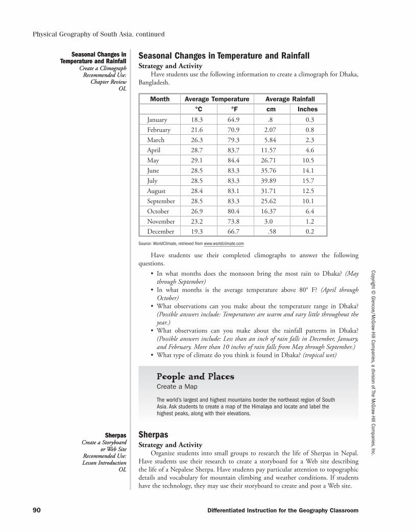
Copyright © Glencoe/M
cGraw-Hill Companies, a division of The M
cGraw-Hill Companies, Inc.
90 Differentiated Instruction for the Geography Classroom
Physical Geography of South Asia, continued
Seasonal Changes in Temperature and RainfallStrategy and Activity
Have students use the following information to create a climograph for Dhaka, Bangladesh.
Month Average Temperature Average Rainfall
°C °F cm Inches
January 18.3 64.9 .8 0.3February 21.6 70.9 2.07 0.8March 26.3 79.3 5.84 2.3April 28.7 83.7 11.57 4.6May 29.1 84.4 26.71 10.5June 28.5 83.3 35.76 14.1July 28.5 83.3 39.89 15.7August 28.4 83.1 31.71 12.5September 28.5 83.3 25.62 10.1October 26.9 80.4 16.37 6.4November 23.2 73.8 3.0 1.2December 19.3 66.7 .58 0.2
Source: WorldClimate, retrieved from www.worldclimate.com
Have students use their completed climographs to answer the following questions.
• In what months does the monsoon bring the most rain to Dhaka? (May through September)
• In what months is the average temperature above 80° F? (April through October)
• What observations can you make about the temperature range in Dhaka? (Possible answers include: Temperatures are warm and vary little throughout the year.)
• What observations can you make about the rainfall patterns in Dhaka? (Possible answers include: Less than an inch of rain falls in December, Jan uary, and February. More than 10 inches of rain falls from May through September.)
• What type of climate do you think is found in Dhaka? (tropical wet)
People and Places
Create a Map
The world’s largest and highest mountains border the northeast region of South Asia. Ask students to create a map of the Himalaya and locate and label the highest peaks, along with their elevations.
SherpasStrategy and Activity
Organize students into small groups to research the life of Sherpas in Nepal. Have students use their research to create a storyboard for a Web site describing the life of a Nepalese Sherpa. Have students pay particular attention to topographic details and vocabulary for mountain climbing and weather conditions. If students have the technology, they may use their storyboard to create and post a Web site.
Seasonal Changes in Temperature and Rainfall
Create a ClimographRecommended Use:
Chapter ReviewOL
Seasonal Changes in Temperature and Rainfall
Create a ClimographRecommended Use:
Chapter ReviewOL
SherpasCreate a Storyboard
or Web SiteRecommended Use: Lesson Introduction
OL
SherpasCreate a Storyboard
or Web SiteRecommended Use: Lesson Introduction
OL
053-140_DIGC_878566.indd 90053-140_DIGC_878566.indd 90 3/5/07 4:07:45 PM3/5/07 4:07:45 PM
Copy
right
© G
lenc
oe/M
cGra
w-Hi
ll Co
mpa
nies
, a d
ivis
ion
of T
he M
cGra
w-Hi
ll Co
mpa
nies
, Inc
.
Differentiated Instruction for the Geography Classroom 91
Physical Geography of South Asia, continued
River Personalities Background
The three great river systems in India are the Ganges, the Indus, and the Brahmaputra. All three rise in the Himalayas and all have extensive deltas. The Indus is approximately 1,800 miles (2,897 km) long and flows into the Arabian Sea through the contested Kashmir region. The Ganges, named for the Hindu goddess Ganga, is 1,557 miles (2,506 km) long and empties into the Bay of Bengal. Finally, the Brahmaputra, which discharges enormous amounts of water during monsoon season, is also 1,800 miles (2,897 km) long and flows into the Ganges river.
StrategyRead the section on water systems and have each student in the class write down
three main ideas about the Ganges, the Brahmaputra, and the Indus Rivers. Then, turn these facts into “I Am” statements so that the river can tell the world a little something about itself. Before you have the class break up to do the activities, have a discussion about the rivers using the following questions:
• Why are the rivers so important to people in India?• How do the rivers change throughout the year?• Has the way in which people use the rivers changed over time? If so, how?• How are each of the three rivers unique from each other and from other
significant rivers of the world?
ActivitiesHave students choose one of the following activities to complete based on the
readings from the text and additional research.
1. Present your river personalities in a three-fold brochure that includes the loca-tion of each river on a map. Include pictures and descriptions of the rivers in the brochure.
2. Write a short story about someone who lives on the banks of one of India’s riv-ers. Describe how the characters feel about the river and how they rely on it for different things in their daily lives.
3. In small groups, write a short skit about one of India’s rivers. The skit can be about conservation efforts, how the river got its name, or about something else. After your script is complete, collect or make a few props and perform the skit for the class.
River PersonalitiesClass Presentation Skills: Creative Writing and PerformanceRecommended Use: EnrichmentBL
River PersonalitiesClass Presentation Skills: Creative Writing and PerformanceRecommended Use: EnrichmentBL
053-140_DIGC_878566.indd 91053-140_DIGC_878566.indd 91 3/5/07 4:07:45 PM3/5/07 4:07:45 PM

053-140_DIGC_878566.indd 92053-140_DIGC_878566.indd 92 3/5/07 4:07:45 PM3/5/07 4:07:45 PM
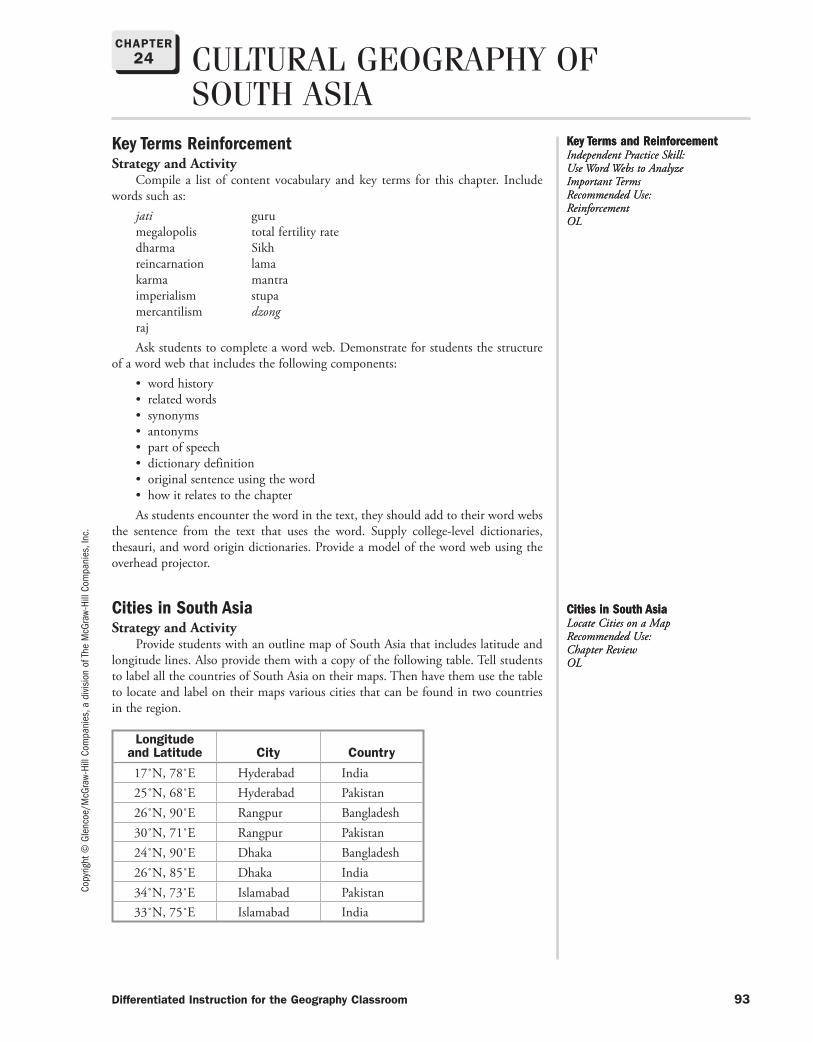
Copy
right
© G
lenc
oe/M
cGra
w-Hi
ll Co
mpa
nies
, a d
ivis
ion
of T
he M
cGra
w-Hi
ll Co
mpa
nies
, Inc
.
Differentiated Instruction for the Geography Classroom 93
CULTURAL GEOGRAPHY OF SOUTH ASIA
Key Terms ReinforcementStrategy and Activity
Compile a list of content vocabulary and key terms for this chapter. Include words such as:
jati gurumegalopolis total fertility ratedharma Sikhreincarnation lamakarma mantraimperialism stupamercantilism dzongrajAsk students to complete a word web. Demonstrate for students the structure
of a word web that includes the following components:• word history• related words• synonyms• antonyms• part of speech• dictionary definition• original sentence using the word• how it relates to the chapterAs students encounter the word in the text, they should add to their word webs
the sentence from the text that uses the word. Supply college-level dictionaries, thesauri, and word origin dictionaries. Provide a model of the word web using the overhead projector.
Cities in South AsiaStrategy and Activity
Provide students with an outline map of South Asia that includes latitude and longitude lines. Also provide them with a copy of the following table. Tell students to label all the countries of South Asia on their maps. Then have them use the table to locate and label on their maps various cities that can be found in two countries in the region.
Longitude and Latitude City Country
17˚N, 78˚E Hyderabad India25˚N, 68˚E Hyderabad Pakistan26˚N, 90˚E Rangpur Bangladesh30˚N, 71˚E Rangpur Pakistan24˚N, 90˚E Dhaka Bangladesh26˚N, 85˚E Dhaka India34˚N, 73˚E Islamabad Pakistan33˚N, 75˚E Islamabad India
Key Terms and ReinforcementIndependent Practice Skill: Use Word Webs to Analyze Important TermsRecommended Use: ReinforcementOL
Key Terms and ReinforcementIndependent Practice Skill: Use Word Webs to Analyze Important TermsRecommended Use: ReinforcementOL
Cities in South AsiaLocate Cities on a MapRecommended Use: Chapter ReviewOL
Cities in South AsiaLocate Cities on a MapRecommended Use: Chapter ReviewOL
CHAPTER24
053-140_DIGC_878566.indd 93053-140_DIGC_878566.indd 93 3/5/07 4:07:46 PM3/5/07 4:07:46 PM
Copyright © Glencoe/M
cGraw-Hill Companies, a division of The M
cGraw-Hill Companies, Inc.
94 Differentiated Instruction for the Geography Classroom
Cultural Geography of South Asia, continued
People and Places
Independence Time Line
Have pairs of students create a time line that shows when the following South Asian countries gained their independence:
• India• Sri Lanka• Maldives• Bangladesh
Pakistan and BangladeshStrategy and Activity
Tell students that from 1947 to 1971, Pakistan and Bangladesh were one coun-try identified as West Pakistan and East Pakistan. Tell students that they will write a report that explains why the countries separated from India and what caused the conflict between them that eventually resulted in them becoming two countries.
Social IdentityStrategy and Activity
Suggest to students that an individual’s identity in a society is based not only on his or her personal characteristics but also on the groups to which he or she belongs. Then ask students to suggest groups that identify people. Start by noting that the entire class belongs to a group labeled “teenagers.” As students list categories, write their responses on the board. (Responses should include grouping by race or ethnicity, religion, social class, gender, occupation, and so on.)
Tell students that in India religion is a major means of social identification. For most Indians, Hinduism determines the people with whom they associate, the cloth-ing they wear, the food they eat, and who they marry. Followers of other religions also hold beliefs that affect the social, economic, and political life of India.
Transportation in IndiaStrategy and Activity
Show students a photograph of a crowded street scene in a large Indian city such as Mumbai or Kolkata. Have students name the various modes of transporta-tion shown in the photo as you list them on the board. (Remind students to include walking as a mode of transportation.) Based on this one photograph, have students rank the modes of transportation from those used by most people to those used by fewest people. Have students discuss possible reasons that some modes of transporta-tion are more available to some people and not others.
Many ReligionsStrategy and Activity
Organize students into seven groups. Assign each group a religion that is found in India—Islam, Sikhism, Buddhism, Hinduism, Jainism, Christianity, and Zoro-astri anism. Have students use library or Internet resources to identify the following: founder, where founded, date religion arrived in India, beliefs, values, practices, and number of followers. Create a chart on the board with columns for each religion and have the groups fill in the information that they discovered. As a class, discuss how these various religions influence the culture of India today.
Pakistan and BangladeshWrite a Report
Recommended Use: Enrichment
AL
Pakistan and BangladeshWrite a Report
Recommended Use: Enrichment
AL
Social IdentityCategorize Information
Recommended Use: Guided Practice
OL
Social IdentityCategorize Information
Recommended Use: Guided Practice
OL
Transportation in IndiaSynthesize Information
Recommended Use: Guided Practice
BL
Transportation in IndiaSynthesize Information
Recommended Use: Guided Practice
BL
Many ReligionsCreate a Table
Recommended Use: Independent Practice
OL
Many ReligionsCreate a Table
Recommended Use: Independent Practice
OL
053-140_DIGC_878566.indd 94053-140_DIGC_878566.indd 94 3/5/07 4:07:46 PM3/5/07 4:07:46 PM
Copy
right
© G
lenc
oe/M
cGra
w-Hi
ll Co
mpa
nies
, a d
ivis
ion
of T
he M
cGra
w-Hi
ll Co
mpa
nies
, Inc
.
Differentiated Instruction for the Geography Classroom 95
Cultural Geography of South Asia, continued
Look for Clues: Daily Life in IndiaBackground
For most Indians, daily life is centered around the family. It is mot uncommon for extended families to live together, with two or more adult generations, or broth-ers, sharing a house. Usually, a woman who marries moves to her husband’s village from her home village.
In rural areas and villages, families rely on staple grains—either rice or wheat—that they have cultivated themselves. These are served with stir-fried vegetables, cooked lentils, and yogurt. Cuisine varies regionally, and urban areas offer more variety in terms of vegetables and meat.
Leisure activities include sports such as soccer and cricket, which has been a popular pastime since its introduction by the British. Chess, which originated in India, is still played, mainly by men. For those who can afford it, films and television also capture wide audiences.
StrategyHave students imagine that they are detectives trying to gather as much infor-
mation about daily life in India as possible. Provide resources such as relevant maga-zines, encyclopedias, and Internet sites for this purpose. As a class, create a list of questions that the “detectives” will answer in their research:
• What is family structure like in India?• How has the role of women and children changed in India?• What do typical houses look like in rural and urban areas?• How do people dress in different parts of the country?• How is food prepared?• In what way do Indian people practice their religions?• How has the caste system affected daily life? How is this changing?
ActivityEncourage students to work in pairs to complete one of the following activities.
1. Look at the pictures throughout Chapter 24. Write down as many details about what you see as you can. Look for things like population density, housing, forms of transportation, family structure, the changing roles of women, and how people are living. Then, for each clue you find, write a sentence that describes life in an Indian city. Compete with a partner to see who can come up with more clues.
2. Working in pairs, pretend one person is Indian and the other is an American interviewer. Conduct a dialogue about daily life in India in front of the class using facts you learned during your research. You can write a script or conduct the talk spontaneously.
Look for Clues: Daily Life in IndiaCompare and Contrast Skill: ResearchRecommended Use: Chapter ReviewBL
Look for Clues: Daily Life in IndiaCompare and Contrast Skill: ResearchRecommended Use: Chapter ReviewBL
053-140_DIGC_878566.indd 95053-140_DIGC_878566.indd 95 3/5/07 4:07:46 PM3/5/07 4:07:46 PM

053-140_DIGC_878566.indd 96053-140_DIGC_878566.indd 96 3/5/07 4:07:46 PM3/5/07 4:07:46 PM
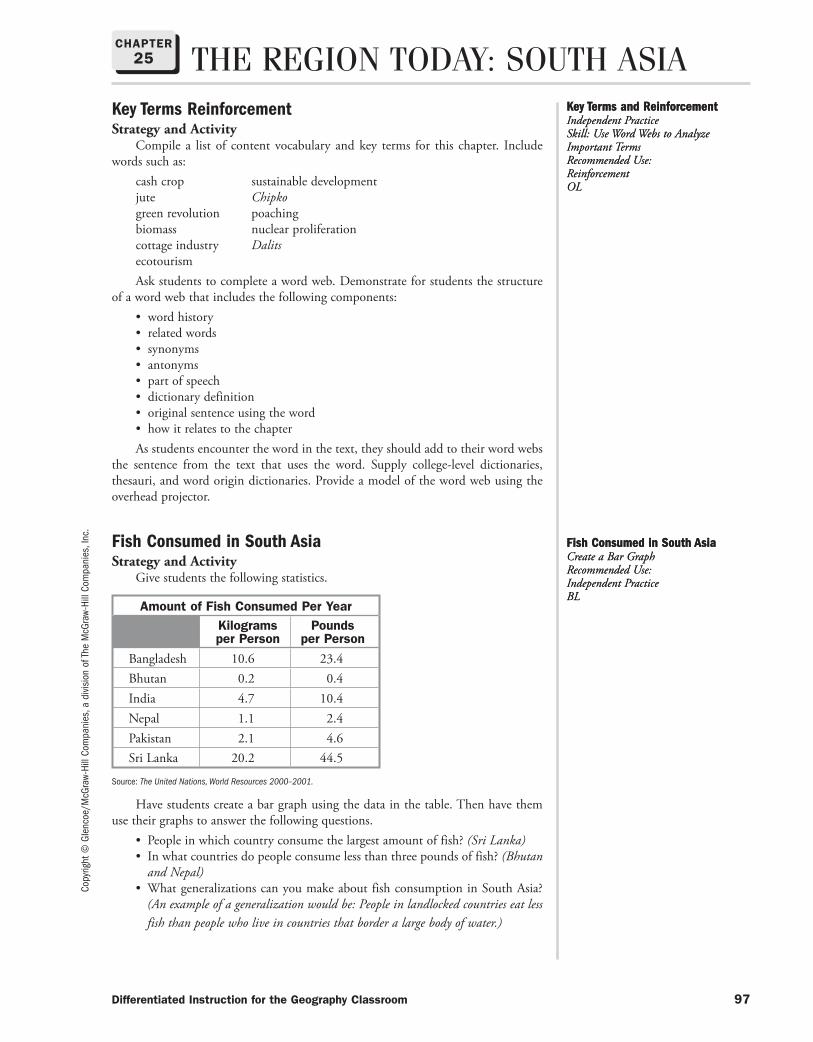
Copy
right
© G
lenc
oe/M
cGra
w-Hi
ll Co
mpa
nies
, a d
ivis
ion
of T
he M
cGra
w-Hi
ll Co
mpa
nies
, Inc
.
Differentiated Instruction for the Geography Classroom 97
THE REGION TODAY: SOUTH ASIAKey Terms ReinforcementStrategy and Activity
Compile a list of content vocabulary and key terms for this chapter. Include words such as:
cash crop sustainable developmentjute Chipkogreen revolution poachingbiomass nuclear proliferationcottage industry DalitsecotourismAsk students to complete a word web. Demonstrate for students the structure
of a word web that includes the following components:• word history• related words• synonyms• antonyms• part of speech• dictionary definition• original sentence using the word• how it relates to the chapterAs students encounter the word in the text, they should add to their word webs
the sentence from the text that uses the word. Supply college-level dictionaries, thesauri, and word origin dictionaries. Provide a model of the word web using the overhead projector.
Fish Consumed in South AsiaStrategy and Activity
Give students the following statistics.
Amount of Fish Consumed Per YearKilograms per Person
Pounds per Person
Bangladesh 10.6 23.4Bhutan 0.2 0.4India 4.7 10.4Nepal 1.1 2.4Pakistan 2.1 4.6Sri Lanka 20.2 44.5
Source: The United Nations, World Resources 2000–2001.
Have students create a bar graph using the data in the table. Then have them use their graphs to answer the following questions.
• People in which country consume the largest amount of fish? (Sri Lanka)• In what countries do people consume less than three pounds of fish? (Bhutan
and Nepal)• What generalizations can you make about fish consumption in South Asia?
(An example of a generalization would be: People in landlocked countries eat less fish than people who live in countries that border a large body of water.)
Key Terms and ReinforcementIndependent Practice Skill: Use Word Webs to Analyze Important TermsRecommended Use: ReinforcementOL
Key Terms and ReinforcementIndependent Practice Skill: Use Word Webs to Analyze Important TermsRecommended Use: ReinforcementOL
Fish Consumed in South AsiaCreate a Bar GraphRecommended Use: Independent PracticeBL
Fish Consumed in South AsiaCreate a Bar GraphRecommended Use: Independent PracticeBL
CHAPTER25
053-140_DIGC_878566.indd 97053-140_DIGC_878566.indd 97 3/5/07 4:07:46 PM3/5/07 4:07:46 PM
Copyright © Glencoe/M
cGraw-Hill Companies, a division of The M
cGraw-Hill Companies, Inc.
98 Differentiated Instruction for the Geography Classroom
The Region Today: South Asia, continued
People and Places
Cause-and-Effect Chart
Organize students into groups and ask them to create a cause-and-effect chart that shows the relationship between the green agricultural revolution and India’s increased food supply.
Use of Natural ResourcesStrategy and Activity
Provide students an outline map of South Asia. Have students use their text-books and library or Internet resources to locate and label the region’s major mineral deposits, large dams and hydroelectric projects, and nuclear power plants. Tell stu-dents to also label the large cities in each country. Based on the maps, discuss as a class the main sources of energy used by each country.
Learn More About
Identifying Economic Zones
Ask students to tell you the average population density of South Asia. Then ask students to calculate, at its present rate of growth, when South Asia’s population will double. Students can also gather this information for individual countries in the region and compare growth rates.
Daily Life in PakistanStrategy and Activity
Organize students into small groups. Have the groups find pictures that tell about the daily life of men, women, and children in Pakistan. Have students arrange their photos in an essay. With each photo, have the groups compose two paragraphs. With a focus on economic activities, one paragraph should describe the scene and the other contrast it to life in the United States.
A New RoadStrategy and Activity
Tell students to imagine that they are Indian villagers. Tell them that a new paved road has been constructed connecting their village to a large city. Further, tell them that there will be regular bus service along the road that will allow many vil-lagers to travel to the large city for the first time. Have them write a letter to a friend in the United States telling how their lives and the environment might be changed by this event. Ask volun teers to read their letters to the class.
Use of Natural ResourcesCreate a Thematic Map
Recommended Use: Independent Practice
BL
Use of Natural ResourcesCreate a Thematic Map
Recommended Use: Independent Practice
BL
Daily Life in PakistanCreate a Photo Essay
Recommended Use: Independent Practice
OL
Daily Life in PakistanCreate a Photo Essay
Recommended Use: Independent Practice
OL
A New RoadWrite a Letter
Recommended Use: Enrichment
AL
A New RoadWrite a Letter
Recommended Use: Enrichment
AL
053-140_DIGC_878566.indd 98053-140_DIGC_878566.indd 98 3/5/07 4:07:46 PM3/5/07 4:07:46 PM
Copy
right
© G
lenc
oe/M
cGra
w-Hi
ll Co
mpa
nies
, a d
ivis
ion
of T
he M
cGra
w-Hi
ll Co
mpa
nies
, Inc
.
Differentiated Instruction for the Geography Classroom 99
Hurray for BollywoodBackground
Bollywood is the name given to the center of the Hindi film. The term is a com-bination of Bombay and Hollywood. India turns out more motion pictures each year than any other country in the world. Recent films released by Bollywood producers that enjoyed wide distribution in the United States include Bride and Prejudice and Monsoon Wedding. Bollywood films are popular around the world. The Indian film industry is centered in Mumbai.
StrategyResearch the film and music video industry in India, often called “Bollywood.”
Find examples of films or music videos and screen them for the class, encouraging discussion using the following questions:
• What are some characteristics of all the clips you’ve watched?• How are Bollywood movies different than typical Hollywood fare? How are
they similar?• What do Bollywood films communicate about life in India? Do you think the
portrayal is accurate? Why or why not?• Why do you think Bollywood is so popular around the world?• How do the budgets and earnings for an average Bollywood film compare to
those of a Hollywood movie?
ActivitiesAfter the discussion, have each student choose one of the following activities to
complete individually.
1. Write a review of Bollywood film clips. Include in your review your impressions of life in India today. How is it similar or different to life in the United States?
2. Research one of the major Bollywood film stars and write a one-page bio of him or her in the style of a magazine feature story. Compare your star’s experiences to that of an American celebrity.
3. Pretend you are a Bollywood film producer. You have an idea for a film and must convince a Bollywood studio to give you funding to make your movie. Write up a one-page description of your idea, including a projected budget, and explain why your project would appeal to audiences in India and around the world. Think about the clips you watched with the class and make sure your project shares at least one or two characteristics with what you’ve seen.
Hurray for BollywoodInterdisciplinary Skills: Research, Finance, and Creative WritingRecommended Use: EnrichmentAL
Hurray for BollywoodInterdisciplinary Skills: Research, Finance, and Creative WritingRecommended Use: EnrichmentAL
The Region Today: South Asia, continued
053-140_DIGC_878566.indd 99053-140_DIGC_878566.indd 99 3/5/07 4:07:47 PM3/5/07 4:07:47 PM

053-140_DIGC_878566.indd 100053-140_DIGC_878566.indd 100 3/5/07 4:07:47 PM3/5/07 4:07:47 PM

Copy
right
© G
lenc
oe/M
cGra
w-Hi
ll Co
mpa
nies
, a d
ivis
ion
of T
he M
cGra
w-Hi
ll Co
mpa
nies
, Inc
.
Differentiated Instruction for the Geography Classroom 101
PHYSICAL GEOGRAPHY OF EAST ASIA
Key Terms and ReinforcementStrategy and Activity
Compile a list of content vocabulary and key terms for this chapter. Include words such as:
archipelago tsunami loess layerdramatic rangemonsoon currenttyphoon significantvariation interactionAsk students to complete a word web. Demonstrate for students the structure
of a word web that includes the following components:• word history• related words• synonyms• antonyms• part of speech• dictionary definition• original sentence using the word• how it relates to the chapterAs students encounter the word in the text, they should add to their word webs
the sentence from the text that uses the word. Supply college-level dictionaries, thesauri, and word origin dictionaries. Provide a model of the word web using the overhead projector.
Illustrated Maps of East AsiaStrategy and Activity
Organize the students into six groups, one for each of the following countries: China, Mongolia, Taiwan, North Korea, South Korea, and Japan. (Note: You may choose to have five groups and combine the two countries on the Korean peninsula.) Select an appropriate map scale that all groups will use. Have the groups construct a wall map of their assigned country. Each country’s map should include major cities, rivers, and major physical features. Have students border their maps with magazine photographs that depict the unique physical features of each country. Tell them to connect each illustration to the appropriate place on their map. Have the groups place their wall maps in the correct relative location.
Learn More About
Make Comparisons
Tell students that most of the countries in East Asia are either peninsulas or islands. Ask students to name the two East Asian countries that are not islands or peninsulas. (China and Mongolia)
Key Terms and ReinforcementIndependent Practice Skill: Use Word Webs to Analyze Important TermsRecommended Use: ReinforcementOL
Key Terms and ReinforcementIndependent Practice Skill: Use Word Webs to Analyze Important TermsRecommended Use: ReinforcementOL
Illustrated Maps of East AsiaCreate a MapRecommended Use: Unit Wrap-UpOL
Illustrated Maps of East AsiaCreate a MapRecommended Use: Unit Wrap-UpOL
CHAPTER26
053-140_DIGC_878566.indd 101053-140_DIGC_878566.indd 101 3/5/07 4:07:47 PM3/5/07 4:07:47 PM
Copyright © Glencoe/M
cGraw-Hill Companies, a division of The M
cGraw-Hill Companies, Inc.
102 Differentiated Instruction for the Geography Classroom
Physical Geography of East Asia, continued
Mount FujiStrategy and Activity
Mt. Fuji is “an important spiritual symbol to Japan’s people.” Conduct a Google Image search and find several pictures of Mt. Fuji. Based on these images, think about why the Japanese feel this way about the mountain. Write or talk about your ideas based on the images. Is there a geographical feature where you live that is very impor-tant to you? Talk about this place with a partner or present it to a small group.
Learn More About
Typhoons
Japan suffers from violent storms called typhoons. Ask students to explain what a typhoon is and why Japan is so susceptible to them.
An Island NationStrategy and Activity
As a class, discuss ways that the sea influences life in Japan, including climate, economy, and transportation. Tell students that by U.S. standards, the Japanese consume very little milk and red meat. Have students speculate why this is the case, relating answers to Japan’s natural environment. (Answers should focus on the country’s terrain, limited farmland, and abundant sea resources.)
Learn More About
Make Comparisons
Much of the land of East Asia is barren and mountainous; yet this region is densely populated. Ask students to identify the areas in East Asian countries where most of the population lives. (in fertile valleys and along the coasts)
East Asian Place-NamesStrategy and Activity
Tell students that songs can be an excellent way to help them remember facts such as the names of places. Explain that existing tunes can often be used with new words. Have students compose a song, either with an original tune or with a familiar tune, to help them remember the names of one of the following.
• the names of major islands• the names of major cities in East Asia• the names of landforms in East AsiaAsk volunteers to perform their songs for the class.
Mount FujiInterpret Images
Recommended Use: Enrichment
BL
Mount FujiInterpret Images
Recommended Use: Enrichment
BL
An Island NationClass Discussion
Recommended Use: Lesson Introduction
OL
An Island NationClass Discussion
Recommended Use: Lesson Introduction
OL
East Asian Place-NamesCompose a Song
Recommended Use: Independent Practice
AL
East Asian Place-NamesCompose a Song
Recommended Use: Independent Practice
AL
053-140_DIGC_878566.indd 102053-140_DIGC_878566.indd 102 3/5/07 4:07:47 PM3/5/07 4:07:47 PM
Copy
right
© G
lenc
oe/M
cGra
w-Hi
ll Co
mpa
nies
, a d
ivis
ion
of T
he M
cGra
w-Hi
ll Co
mpa
nies
, Inc
.
Differentiated Instruction for the Geography Classroom 103
Physical Geography of East Asia, continued
Weather Patterns in East AsiaBackground
East Asia’s huge size, varying geography, and proximity to oceans produce a variety of climate regions. Many of these regions have seasonal weather patterns that are influenced by ocean currents and prevailing winds.
StrategyAsk the students to name some physical features of the Earth that influence
climate and weather. Write these features on the board. Divide the class into small groups of 3 or 4 students. Give each group a blank political map of East Asia. Ask the students to work together to label the countries on the map. Also have the students add important physical features, such as mountains, that are listed on the board.
Ask each group to think about the weather patterns that might affect each country on the map. Have them come up with symbols that would represent those weather patterns. As they work together, have the groups consider the following questions:
• How close is the country to the equator?• Does the ocean affect weather in this country?• Do mountains affect the weather in this country?• Does the country experience seasons?Have students label each country on the map with their weather symbols. Also
have them create a key to the weather symbols on the map.
ActivitiesAsk students to read the sections on climate regions and seasonal weather pat-
terns. Then, have students get back into their small groups to complete the activities listed below.
1. Compare the predicted weather patterns on your map with the information in the chapter. How close were your predictions? Make any changes to the map to reflect any new information you learned about weather patterns. Create new weather symbols, if necessary.
2. Different climate regions have different types of vegetation. Use colored pencils to mark the major types of vegetation in East Asia on your map. Write a short paragraph explaining how weather patterns affect vegetation type.
Weather Patterns in East AsiaGroup Project Skill: Make and Check Predictions Recommended Use: Section IntroductionBL
Weather Patterns in East AsiaGroup Project Skill: Make and Check Predictions Recommended Use: Section IntroductionBL
053-140_DIGC_878566.indd 103053-140_DIGC_878566.indd 103 3/5/07 4:07:47 PM3/5/07 4:07:47 PM

053-140_DIGC_878566.indd 104053-140_DIGC_878566.indd 104 3/5/07 4:07:48 PM3/5/07 4:07:48 PM
Copy
right
© G
lenc
oe/M
cGra
w-Hi
ll Co
mpa
nies
, a d
ivis
ion
of T
he M
cGra
w-Hi
ll Co
mpa
nies
, Inc
.
Differentiated Instruction for the Geography Classroom 105
CHAPTER27 CULTURAL GEOGRAPHY OF
EAST ASIAKey Terms and ReinforcementStrategy and Activity
Compile a list of content vocabulary and key terms for this chapter. Include words such as:
aborigine dynasty hearth ideogramatheist designphilosophy restrictionhomogeneous convergenceclan shogunhaiku samuraiacculturation documentglobal expert divergence jobideologyAsk students to complete a word web. Demonstrate for students the structure
of a word web that includes the following components:• word history• related words• synonyms• antonyms• part of speech• dictionary definition• original sentence using the word• how it relates to the chapterAs students encounter the word in the text, they should add to their word webs
the sentence from the text that uses the word. Supply college-level dictionaries, thesauri, and word origin dictionaries. Provide a model of the word web using the overhead projector.
IsolationStrategy and Activity
Form two panels of interested students to research and prepare a panel discus-sion related to Japanese centuries of isolation. Have one panel defend the idea that isolation was the best policy for Japan, and the other defend the position that it was the worst policy. Give the panels time to develop their arguments. Then have each present its views. After both have presented their views to the class, allow the rest of the class to ask questions, with both panels defending their positions. Have the class vote on which policy they think was right for Japan.
People and Places
Great Wall Map
Explain to students that the Great Wall of China is one of the world’s longest structures. Ask pairs of students to draw the Qin Dynasty wall on a map and include a map scale measuring distance in both miles and kilometers.
IsolationPresent a Panel DiscussionRecommended Use: Independent PracticeAL
IsolationPresent a Panel DiscussionRecommended Use: Independent PracticeAL
Key Terms and ReinforcementIndependent Practice Skill: Use Word Webs to Analyze Important TermsRecommended Use: ReinforcementOL
053-140_DIGC_878566.indd 105053-140_DIGC_878566.indd 105 3/5/07 4:07:48 PM3/5/07 4:07:48 PM
Copyright © Glencoe/M
cGraw-Hill Companies, a division of The M
cGraw-Hill Companies, Inc.
106 Differentiated Instruction for the Geography Classroom
Cultural Geography of East Asia, continued
Chinese DynastiesStrategy and Activity
Provide students an outline map of Asia with no country borders. Tell students that for nearly 4,000 years China was ruled by emperors in six major dynasties: the Xia, Zhou, Han, Tang, Mongol, and Qing dynasties. Explain that the borders of China varied depending on the strength of the emperors. Assign students one of the six dynasties that ruled China between 1994 .. and .. 1912. Have students research their dynasty to discover the largest land area that it controlled. Have stu-dents draw the boundaries of the dynasty on the outline map and shade the area. Then have them label the map with the name of the dynasty and the approximate dates of the empire. Have students share their maps with the class as you discuss the history of China.
Politics in ChinaStrategy and Activity
Have students use library or Internet resources to learn more about the Com-munist revolution in China in 1949, and the student demonstrations for democracy in 1989. Based on their research, have students answer the following questions.
• How did the Communist revolution change China? (Answers may vary. Under Communist rule, the lives of most people were largely controlled by the govern-ment. The government decided who would be educated, where people would work, and what industries and farms would produce. Students may also note that the Nation al ists set up their own government on the island of Taiwan.)
• Who was the first and strongest Communist leader of China? (Mao Zedong)• What led to the student demonstrations in 1989? (Possible answers include
anger over limited freedom, frustration about not being able to decide where to work and live, and hope to improve the Chinese standard of living.)
• How did the Chinese government respond to the student protests? (Eventu-ally, the government sent the army in to quell the demonstrations. Thousands were killed or arrested. The Communist government remained in control and only limited changes were made.)
People and Places
Two Koreas
Tell students that North and South Korea share the Korean peninsula. Although these two Koreas share a common language, culture, and heritage, there are sig-nificant differences between the two countries. Ask students to name several of these differences as you list student responses on the board.
Mongolia and TaiwanStrategy and Activity
Organize the class into two teams. Assign one team Mongolia and the other team Taiwan. Have each team prepare a series of 10 true/false questions about their assigned country. Have the teams compete to see which team can answer the most questions correctly. Tell them that if they believe the statement is false, they must be able to state what makes the statement false. Complete this activity by having students make generalizations about the similarities and differences between these two countries.
Chinese DynastiesCreate Historic Maps
Recommended Use: Enrichment
OL
Chinese DynastiesCreate Historic Maps
Recommended Use: Enrichment
OL
Politics in ChinaSynthesize Information
Recommended Use: Guided Practice
OL
Politics in ChinaSynthesize Information
Recommended Use: Guided Practice
OL
Mongolia and TaiwanMake Generalizations
Recommended Use: Chapter Review
BL
Mongolia and TaiwanMake Generalizations
Recommended Use: Chapter Review
BL
053-140_DIGC_878566.indd 106053-140_DIGC_878566.indd 106 3/5/07 4:07:48 PM3/5/07 4:07:48 PM
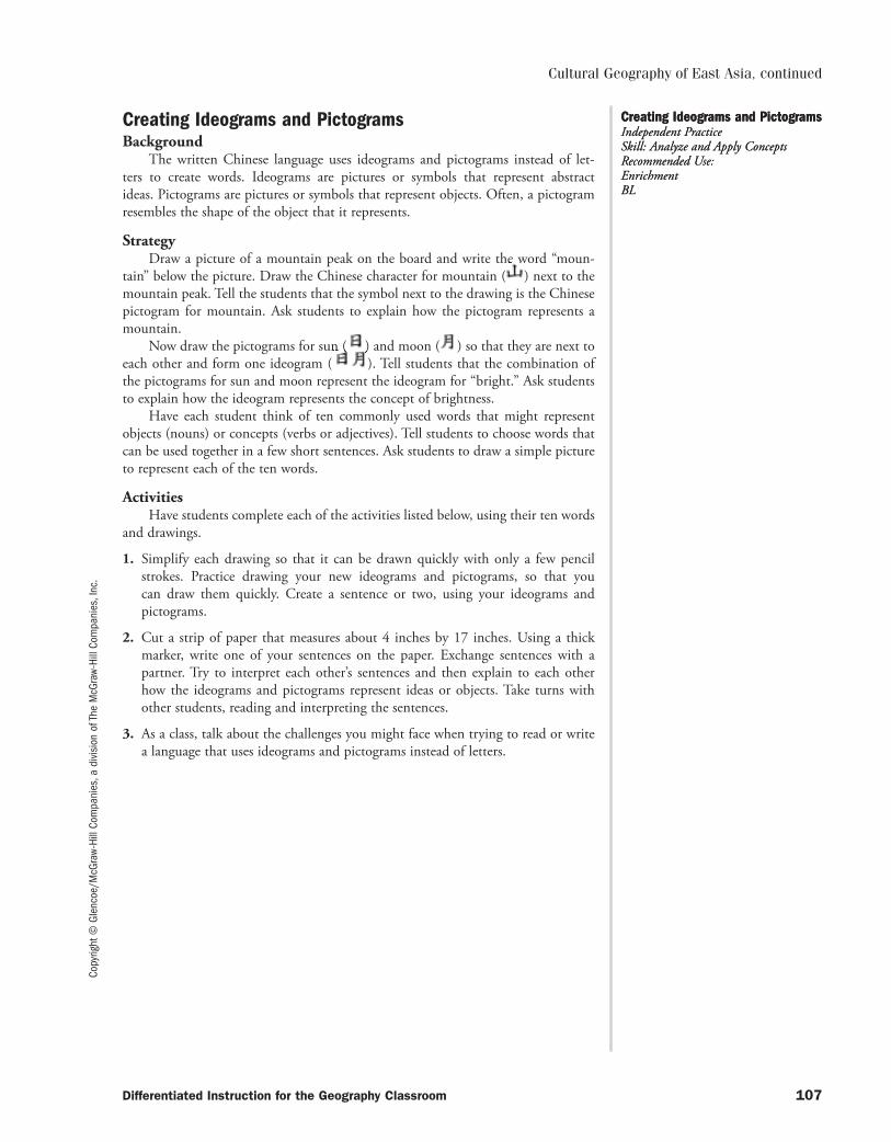
Copy
right
© G
lenc
oe/M
cGra
w-Hi
ll Co
mpa
nies
, a d
ivis
ion
of T
he M
cGra
w-Hi
ll Co
mpa
nies
, Inc
.
Differentiated Instruction for the Geography Classroom 107
Cultural Geography of East Asia, continued
Creating Ideograms and PictogramsBackground
The written Chinese language uses ideograms and pictograms instead of let-ters to create words. Ideograms are pictures or symbols that represent abstract ideas. Pictograms are pictures or symbols that represent objects. Often, a pictogram resembles the shape of the object that it represents.
StrategyDraw a picture of a mountain peak on the board and write the word “moun-
tain” below the picture. Draw the Chinese character for mountain ( ) next to the mountain peak. Tell the students that the symbol next to the drawing is the Chinese pictogram for mountain. Ask students to explain how the pictogram represents a mountain.
Now draw the pictograms for sun ( ) and moon ( ) so that they are next to each other and form one ideogram ( ). Tell students that the combination of the pictograms for sun and moon represent the ideogram for “bright.” Ask students to explain how the ideogram represents the concept of brightness.
Have each student think of ten commonly used words that might represent objects (nouns) or concepts (verbs or adjectives). Tell students to choose words that can be used together in a few short sentences. Ask students to draw a simple picture to represent each of the ten words.
ActivitiesHave students complete each of the activities listed below, using their ten words
and drawings.
1. Simplify each drawing so that it can be drawn quickly with only a few pencil strokes. Practice drawing your new ideograms and pictograms, so that you can draw them quickly. Create a sentence or two, using your ideograms and pictograms.
2. Cut a strip of paper that measures about 4 inches by 17 inches. Using a thick marker, write one of your sentences on the paper. Exchange sentences with a partner. Try to interpret each other’s sentences and then explain to each other how the ideograms and pictograms represent ideas or objects. Take turns with other students, reading and interpreting the sentences.
3. As a class, talk about the challenges you might face when trying to read or write a language that uses ideograms and pictograms instead of letters.
Creating Ideograms and PictogramsIndependent Practice Skill: Analyze and Apply ConceptsRecommended Use: EnrichmentBL
Creating Ideograms and PictogramsIndependent Practice Skill: Analyze and Apply ConceptsRecommended Use: EnrichmentBL
053-140_DIGC_878566.indd 107053-140_DIGC_878566.indd 107 3/5/07 4:07:48 PM3/5/07 4:07:48 PM

053-140_DIGC_878566.indd 108053-140_DIGC_878566.indd 108 3/5/07 4:07:49 PM3/5/07 4:07:49 PM
Copy
right
© G
lenc
oe/M
cGra
w-Hi
ll Co
mpa
nies
, a d
ivis
ion
of T
he M
cGra
w-Hi
ll Co
mpa
nies
, Inc
.
Differentiated Instruction for the Geography Classroom 109
THE REGION TODAY: EAST ASIACHAPTER
28
Key Terms and ReinforcementStrategy and Activity
Compile a list of content vocabulary and key terms for this chapter. Include words such as:
aquaculture Asia-Pacific Economic Cooperation Group (APEC)cooperative chlorofluorocarbons (CFCs)commune dissidenteconomic sanction merchant marinenewly industrialized trade deficit country World Trade Organization (WTO)trade surplusAsk students to complete a word web. Demonstrate for students the structure
of a word web that includes the following components:• word history• related words• synonyms• antonyms• part of speech• dictionary definition• original sentence using the word• how it relates to the chapterAs students encounter the word in the text, they should add to their word webs
the sentence from the text that uses the word. Supply college-level dictionaries, thesauri, and word origin dictionaries. Provide a model of the word web using the overhead projector.
Internet Learning
Natural Disasters
Located on the Ring of Fire, most countries in East Asia are vulnerable to a variety of natural disasters. Ask students to consult online resources such as www.infoplease.com/sci.html to research tsunamis, earthquakes, and floods that have affected the region and its residents.
Economic OpportunityStrategy and Activity
Have students work in pairs to interview an owner of a small business in their community. Tell them to ask questions such as: Is there much opportunity for small businesses in the United States today? How is your business affected by government regulations? What should the government’s role be with regard to small business? How important to the entire economy is it that small companies are successful? Have students summarize their findings in a brief report. Ask volunteers to share their reports. Then discuss as a class how government changes in China are helping small businesses in that country.
Key Terms and ReinforcementIndependent Practice Skill: Use Word Webs to Analyze Important TermsRecommended Use: ReinforcementOL
Key Terms and ReinforcementIndependent Practice Skill: Use Word Webs to Analyze Important TermsRecommended Use: ReinforcementOL
Economic OpportunityConduct an InterviewRecommended Use: Independent PracticeOL
Economic OpportunityConduct an InterviewRecommended Use: Independent PracticeOL
053-140_DIGC_878566.indd 109053-140_DIGC_878566.indd 109 3/5/07 4:07:49 PM3/5/07 4:07:49 PM
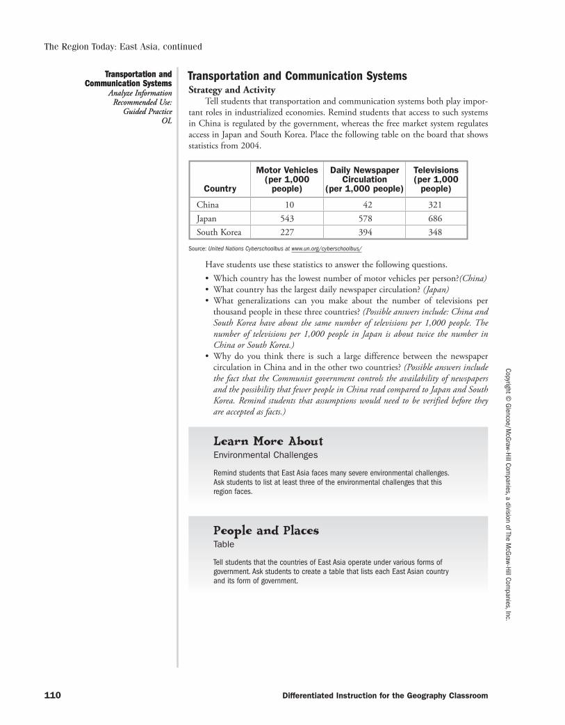
Copyright © Glencoe/M
cGraw-Hill Companies, a division of The M
cGraw-Hill Companies, Inc.
110 Differentiated Instruction for the Geography Classroom
The Region Today: East Asia, continued
Transportation and Communication SystemsStrategy and Activity
Tell students that transportation and communication systems both play impor-tant roles in industrialized economies. Remind students that access to such systems in China is regulated by the government, whereas the free market system regulates access in Japan and South Korea. Place the following table on the board that shows statistics from 2004.
Country
Motor Vehicles (per 1,000
people)
Daily Newspaper Circulation
(per 1,000 people)
Televisions(per 1,000
people)
China 10 42 321Japan 543 578 686South Korea 227 394 348
Source: United Nations Cyberschoolbus at www.un.org/cyberschoolbus/
Have students use these statistics to answer the following questions.• Which country has the lowest number of motor vehicles per person?(China)• What country has the largest daily newspaper circulation? (Japan)• What generalizations can you make about the number of televisions per
thousand people in these three countries? (Possible answers include: China and South Korea have about the same number of televisions per 1,000 people. The number of televisions per 1,000 people in Japan is about twice the number in China or South Korea.)
• Why do you think there is such a large difference between the newspaper circulation in China and in the other two countries? (Possible answers include the fact that the Communist government controls the availability of newspapers and the possibility that fewer people in China read compared to Japan and South Korea. Remind students that assumptions would need to be verified before they are accepted as facts.)
Learn More About
Environmental Challenges
Remind students that East Asia faces many severe environmental challenges. Ask students to list at least three of the environmental challenges that this region faces.
People and Places
Table
Tell students that the countries of East Asia operate under various forms of government. Ask students to create a table that lists each East Asian country and its form of government.
Transportation and Communication Systems
Analyze InformationRecommended Use:
Guided PracticeOL
Transportation and Communication Systems
Analyze InformationRecommended Use:
Guided PracticeOL
053-140_DIGC_878566.indd 110053-140_DIGC_878566.indd 110 3/5/07 4:07:49 PM3/5/07 4:07:49 PM
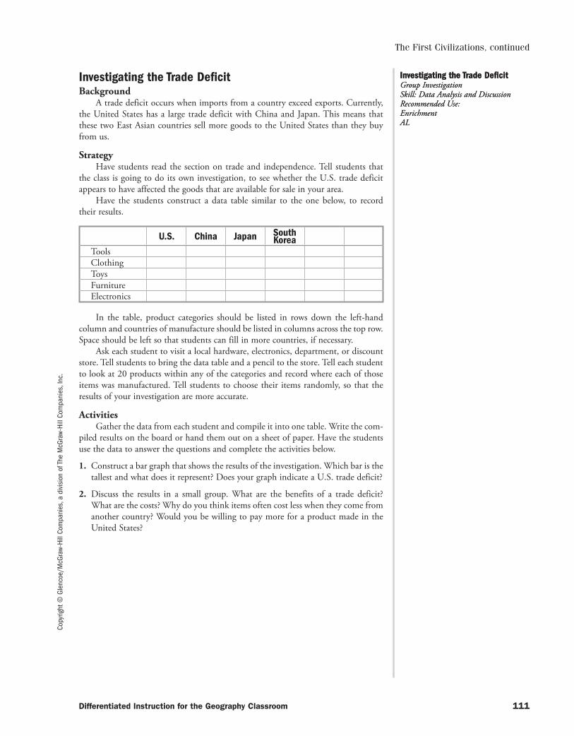
Copy
right
© G
lenc
oe/M
cGra
w-Hi
ll Co
mpa
nies
, a d
ivis
ion
of T
he M
cGra
w-Hi
ll Co
mpa
nies
, Inc
.The First Civilizations, continued
Differentiated Instruction for the Geography Classroom 111
Investigating the Trade DeficitBackground
A trade deficit occurs when imports from a country exceed exports. Currently, the United States has a large trade deficit with China and Japan. This means that these two East Asian countries sell more goods to the United States than they buy from us.
StrategyHave students read the section on trade and independence. Tell students that
the class is going to do its own investigation, to see whether the U.S. trade deficit appears to have affected the goods that are available for sale in your area.
Have the students construct a data table similar to the one below, to record their results.
U.S. China Japan South Korea
ToolsClothingToysFurnitureElectronics
In the table, product categories should be listed in rows down the left-hand column and countries of manufacture should be listed in columns across the top row. Space should be left so that students can fill in more countries, if necessary.
Ask each student to visit a local hardware, electronics, department, or discount store. Tell students to bring the data table and a pencil to the store. Tell each student to look at 20 products within any of the categories and record where each of those items was manufactured. Tell students to choose their items randomly, so that the results of your investigation are more accurate.
ActivitiesGather the data from each student and compile it into one table. Write the com-
piled results on the board or hand them out on a sheet of paper. Have the students use the data to answer the questions and complete the activities below.
1. Construct a bar graph that shows the results of the investigation. Which bar is the tallest and what does it represent? Does your graph indicate a U.S. trade deficit?
2. Discuss the results in a small group. What are the benefits of a trade deficit? What are the costs? Why do you think items often cost less when they come from another country? Would you be willing to pay more for a product made in the United States?
Investigating the Trade DeficitGroup Investigation Skill: Data Analysis and DiscussionRecommended Use: EnrichmentAL
Investigating the Trade DeficitGroup Investigation Skill: Data Analysis and DiscussionRecommended Use: EnrichmentAL
053-140_DIGC_878566.indd 111053-140_DIGC_878566.indd 111 3/5/07 4:07:49 PM3/5/07 4:07:49 PM

053-140_DIGC_878566.indd 112053-140_DIGC_878566.indd 112 3/5/07 4:07:50 PM3/5/07 4:07:50 PM
Copy
right
© G
lenc
oe/M
cGra
w-Hi
ll Co
mpa
nies
, a d
ivis
ion
of T
he M
cGra
w-Hi
ll Co
mpa
nies
, Inc
.
Differentiated Instruction for the Geography Classroom 113
PHYSICAL GEOGRAPHY OF SOUTHEAST ASIA
CHAPTER29
Key Terms and ReinforcementStrategy and Activity
Compile a list of content vocabulary and key terms for this chapter. Include words such as:
cordillera insularfauna archipelagopredominantly resource endemic floracompound alternateAsk students to complete a word web. Demonstrate for students the structure
of a word web that includes the following components:• word history• related words• synonyms• antonyms• part of speech• dictionary definition• original sentence using the word• how it relates to the chapterAs students encounter the word in the text, they should add to their word webs
the sentence from the text that uses the word. Supply college-level dictionaries, thesauri, and word origin dictionaries. Provide a model of the word web using the overhead projector.
People and Places
Measuring Distances in Southeast Asia
Ask students to use a physical map of Southeast Asia to determine the distances between the following landforms:
• Mekong River Delta, Vietnam and Singapore• Bali and Jaya Peak • Luzon, Philippines and Arakan Yoma, Myanmar
VolcanoesStrategy and Activity
Tell students that many of the countries of Southeast Asia, including Indonesia, Malaysia, and the Philippines, lie on the Ring of Fire. Provide students with an outline map of all the areas bordering the Pacific Ocean. Have students use colors to shade the area geographers call the Ring of Fire. Have students label all the countries included in this area. Around the map, have students write interesting facts about volcanoes.
Key Terms and ReinforcementIndependent Practice Skill: Use Word Webs to Analyze Important TermsRecommended Use: ReinforcementOL
Key Terms and ReinforcementIndependent Practice Skill: Use Word Webs to Analyze Important TermsRecommended Use: ReinforcementOL
VolcanoesCreate a MapRecommended Use: Independent PracticeOL
VolcanoesCreate a MapRecommended Use: Independent PracticeOL
053-140_DIGC_878566.indd 113053-140_DIGC_878566.indd 113 3/5/07 4:07:50 PM3/5/07 4:07:50 PM
Copyright © Glencoe/M
cGraw-Hill Companies, a division of The M
cGraw-Hill Companies, Inc.
114 Differentiated Instruction for the Geography Classroom
Physical Geography of Southeast Asia, continued
Climate RegionsStrategy and Activity
Have students compare and contrast the two extremes of the climate regions found in Southeast Asia—the tropical wet climate and the highland climate—by answering the following questions.
• In what countries of Southeast Asia is the tropical wet climate region found? (Myanmar, Thailand, Malaysia, Indonesia, Cambodia, and the Philippines)
• In what countries of Southeast Asia is the highland climate region found? (Malaysia and Indonesia)
• Why do you think both climate regions are found on the same island in Malaysia? (The highland climate is found at higher elevations. The island has both lowlands and highlands.)
• Many people think that it is warm year-round at or near the Equator. Is that always true? Why or why not? (While that is generally true, highland climates exist at higher elevations at many latitudes. Therefore, it is not always true.)
Learn More About
Identification
Tell students that Southeast Asia, as a region, has many islands. Ask students to identify the island nation in this region that borders both the Pacific and Indian Oceans. (Indonesia)
Eco-TourismStrategy and Activity
Remind students that eco-tourists travel to locations to enjoy the natural won-ders of the locations. Have students select one of the countries of Southeast Asia and plan an itinerary for an eco-tourist. Students will need to use travel brochures, Internet, or library resources to identify possible destinations. Ask volunteers to share their itineraries with the class. Have the class ask questions about the itinerary, play-ing the role of the eco-tourist.
Learn More About
Indonesia’s Volcanoes
Ask students how they think the Ring of Fire got its name.
Climate RegionsCompare and Contrast
Recommended Use: Lesson Introduction
OL
Climate RegionsCompare and Contrast
Recommended Use: Lesson Introduction
OL
Eco-TourismPlan a Trip
Recommended Use: Independent Practice
OL
Eco-TourismPlan a Trip
Recommended Use: Independent Practice
OL
053-140_DIGC_878566.indd 114053-140_DIGC_878566.indd 114 3/5/07 4:07:50 PM3/5/07 4:07:50 PM
Copy
right
© G
lenc
oe/M
cGra
w-Hi
ll Co
mpa
nies
, a d
ivis
ion
of T
he M
cGra
w-Hi
ll Co
mpa
nies
, Inc
.
Differentiated Instruction for the Geography Classroom 115
Physical Geography of Southeast Asia, continued
Natural TreasuresBackground
The natural resources of Southeast Asia are plentiful. Deposits of minerals, such as tin and copper, are found in many countries. Southeast Asian countries also produce beautiful gemstones, such as rubies. Flora and fauna living in Southeast Asia include spectacular tropical plants and distinctive animals, such as tigers and elephants.
StrategyInstruct students to read the section on Southeast Asia’s natural resources. Have
each student make a list of the minerals, gemstones, plants, and animals found in Southeast Asia.
Ask each student to choose two minerals, two gemstones, two plants, and two animals from the list. Have students find pictures and information about each of their chosen resources in the library or on the Internet. Make sure that students can answer the following questions about each resource:
• What are the physical characteristics of the resource?• What kinds of environmental conditions help the resource to develop (gems
and minerals) or allow the resource to grow and thrive (plants and animals)?• Where is the resource found in Southeast Asia?• What makes the resource important to the country or region where it is
found?
ActivitiesHave students use pictures and information about their chosen natural resources
to complete one of the following activities.
1. Create a treasure box of natural resources. Cover a shoebox in colorful construc-tion paper or wallpaper. Glue a printed photo of each resource onto construction paper, or draw a picture of each resource on thick drawing paper. On the back of each photo or drawing, write a short paragraph describing characteristics of the resource, where it is found, and why it is important. Include a brief description of how the resource is extracted (exploited) or if it should be protected. Place the photos or drawings in the box and share the treasure box with classmates.
2. Create an album of natural resources. Include a photo or drawing of each resource on each page. Write a short paragraph for each page describing characteristics of each resource, where it is found, and why it is important. Include a brief descrip-tion of how the resource is extracted (exploited) or if it should be protected. Share the album with classmates.
Natural TreasuresIndependent Practice Skill: Research and Creatively Present a Topic Recommended Use: EnrichmentOL
Natural TreasuresIndependent Practice Skill: Research and Creatively Present a Topic Recommended Use: EnrichmentOL
053-140_DIGC_878566.indd 115053-140_DIGC_878566.indd 115 3/5/07 4:07:50 PM3/5/07 4:07:50 PM

053-140_DIGC_878566.indd 116053-140_DIGC_878566.indd 116 3/5/07 4:07:50 PM3/5/07 4:07:50 PM
Copy
right
© G
lenc
oe/M
cGra
w-Hi
ll Co
mpa
nies
, a d
ivis
ion
of T
he M
cGra
w-Hi
ll Co
mpa
nies
, Inc
.
Differentiated Instruction for the Geography Classroom 117
CULTURAL GEOGRAPHY OF SOUTHEAST ASIA
CHAPTER30
Key Terms and ReinforcementStrategy and Activity
Compile a list of content vocabulary and key terms for this chapter. Include words such as:
primate buffermaritime martialsphere influencewat channelsinstituted urbanizationconcept grantedAsk students to complete a word web. Demonstrate for students the structure
of a word web that includes the following components:• word history• related words• synonyms• antonyms• part of speech• dictionary definition• original sentence using the word• how it relates to the chapterAs students encounter the word in the text, they should add to their word webs
the sentence from the text that uses the word. Supply college-level dictionaries, thesauri, and word origin dictionaries. Provide a model of the word web using the overhead projector.
Countries of Southeast AsiaStrategy and Activity
Organize the class into groups of five to explore the culture and history of Myanmar, Thailand, Laos, Cambodia, and Vietnam. Assign a country to each of the group members. Tell the group members that they are to become “experts” on the culture and history of their assigned country. Encourage students to do some research in addition to reading the text. Have each group member teach the other group members about their assigned country. Allow the other group members to ask ques-tions. Any questions that cannot be answered should be written down. The person assigned to the country about which questions are asked, but not answered, should do additional research to discover the answers.
Learn More About
Who Ruled Vietnam?
Explain to students that before the United States fought in a military conflict in Vietnam, it was a French colony. Ask students to discuss what effects France’s presence had on Vietnamese culture.
Key Terms and ReinforcementIndependent Practice Skill: Use Word Webs to Analyze Important TermsRecommended Use: ReinforcementOL
Key Terms and ReinforcementIndependent Practice Skill: Use Word Webs to Analyze Important TermsRecommended Use: ReinforcementOL
Countries of Southeast AsiaBecome an ExpertRecommended Use: Guided PracticeOL
Countries of Southeast AsiaBecome an ExpertRecommended Use: Guided PracticeOL
053-140_DIGC_878566.indd 117053-140_DIGC_878566.indd 117 3/5/07 4:07:50 PM3/5/07 4:07:50 PM
Copyright © Glencoe/M
cGraw-Hill Companies, a division of The M
cGraw-Hill Companies, Inc.
118 Differentiated Instruction for the Geography Classroom
Cultural Geography of Southeast Asia, continued
Aung San Suu KyiStrategy and Activity
Have interested students research the life of Nobel laureate Aung San Suu Kyi and her struggles for freedom in Myanmar. Have students create a table that com-pares her life, work, and struggles to another prominent woman in history. Encourage students to select another woman from history or let them choose from the follow-ing: Golda Meir, Indira Gandhi, or Eva Peron.
KulintangStrategy and Activity
Tell students that gongs are used in music and for ceremonies in Southeast Asia. In the Philippines, as well as in other Southeast Asian countries, the kulint-ang, or a row of eight gongs, is played as a solo instrument or as part of a larger group of instruments. Have interested students learn more about the kulintang and then create a model that represents the kulintang. Have students use the model to demonstrate how the instrument is played. (Note: Tell students that the models do not necessarily have to produce the same tones as the kulintang, but they should demonstrate how the individual gongs are grouped together.)
History of Philippine and U.S. RelationsStrategy and Activity
Tell students that they will use library or Internet resources to explore the unique relationship that has existed between the Philippines and the United States since the Spanish-American War. Have students write a research report about the varying relationship between the Philippines and the United States. Encourage students to find sources that explain why the United States became involved in the Philippines and what views people had on that involvement. Suggest that students may want to include a time line with their reports.
People and Places
Construct a Time Line
Ask students to create a time line that shows when the various countries of Southeast Asia were colonized, by what country they were colonized, and when each country achieved its independence.
WatercolorsStrategy and Activity
Tell students that Chin Konyit is a contemporary Malaysian painter who works primarily in watercolors. Then read the following statement from Konyit.
“Malaysia is a paradise for artists as her beauty and wealth provide endless sources of inspiration for painters. To me, the colonial architecture and the rustic shophouses in towns and the rural areas are fascinating subjects. With progress and development they are fast disappearing….
For sentimental reasons, bicycles and tricycles/trishaws also occupy a major portion of my paintings. These vehicles carried me to and fro from school during my childhood and I treat these subjects with a sense of nostalgia.”
Have interested students plan and paint a watercolor picture that captures either the beauty of their world or features their main mode of transportation.
Aung San Suu KyiCompare and Contrast
Recommended Use: Enrichment
OL
Aung San Suu KyiCompare and Contrast
Recommended Use: Enrichment
OL
KulintangCreate a Model
Recommended Use: Enrichment
AL
KulintangCreate a Model
Recommended Use: Enrichment
AL
History of Philippine and U.S. Relations
Write a Research ReportRecommended Use:
Chapter ReviewAL
History of Philippine and U.S. Relations
Write a Research ReportRecommended Use:
Chapter ReviewAL
WatercolorsPaint a Picture
Recommended Use: Enrichment
AL
WatercolorsPaint a Picture
Recommended Use: Enrichment
AL
053-140_DIGC_878566.indd 118053-140_DIGC_878566.indd 118 3/5/07 4:07:51 PM3/5/07 4:07:51 PM
Copy
right
© G
lenc
oe/M
cGra
w-Hi
ll Co
mpa
nies
, a d
ivis
ion
of T
he M
cGra
w-Hi
ll Co
mpa
nies
, Inc
.
Differentiated Instruction for the Geography Classroom 119
Angkor WatBackground
Angkor Wat is part of the largest religious complex on Earth. Its towers preside over hundreds of acres that include other temples, a monastery, and an ancient walled city. Angkor Wat is so important to Cambodia that its image is found on the Cambodian flag. Officials hope that this ancient temple will help to attract tourists to Cambodia.
StrategyHave students imagine that they have been assigned to tutor younger students
that are learning geography. They will be helping these students to learn about Angkor Wat and other important religious structures in Cambodia.
Have students visit National Geographic at www.nationalgeographic.com. They should click on “People and Places” on the sidebar, then choose “Cambodia” on the Quick Browse menu. Finally, they should click on “Video” to view a video about the temples of Angkor.
Instruct students to take notes that cover the main points of the video. Tell students that they will be organizing the video’s most important ideas into a lesson for younger students. Tell students that they should be able to answer the following questions after viewing the video:
• Who began to build the temples of Angkor and why?• Which religions are represented by the carvings in the temples?• What threatens the structures of Angkor?• How are these structures being protected?
ActivitiesHave students choose one of the following activities to complete based on their
notes.
1. Create a detailed outline that could be used to teach younger students about Angkor Wat and its adjoining temples. Use this outline to teach a younger stu-dent or group of students about Angkor.
2. Create a poster or picture book that includes information about the religious complex of Angkor. Share the poster or picture book with younger students.
3. Create a computer slide show about the religious complex that includes Angkor Wat. Use images from the Internet for the slide show. Use the information from your notes to write text for each slide.
Angkor WatIndependent Practice Skill: Organize InformationRecommended Use: EnrichmentBL
Angkor WatIndependent Practice Skill: Organize InformationRecommended Use: EnrichmentBL
Cultural Geography of Southeast Asia, continued
053-140_DIGC_878566.indd 119053-140_DIGC_878566.indd 119 3/5/07 4:07:51 PM3/5/07 4:07:51 PM

053-140_DIGC_878566.indd 120053-140_DIGC_878566.indd 120 3/5/07 4:07:51 PM3/5/07 4:07:51 PM
Copy
right
© G
lenc
oe/M
cGra
w-Hi
ll Co
mpa
nies
, a d
ivis
ion
of T
he M
cGra
w-Hi
ll Co
mpa
nies
, Inc
.
Differentiated Instruction for the Geography Classroom 121
THE REGION TODAY: SOUTHEAST ASIA
CHAPTER31
Key Terms and ReinforcementStrategy and Activity
Compile a list of content vocabulary and key terms for this chapter. Include words such as:
paddy interdependentsickle lodeport alternativepromote sustainabledevelopment cyclonetyphoon cultivationdiminished unstableAsk students to complete a word web. Demonstrate for students the structure
of a word web that includes the following components:• word history• related words• synonyms• antonyms• part of speech• dictionary definition• original sentence using the word• how it relates to the chapterAs students encounter the word in the text, they should add to their word webs
the sentence from the text that uses the word. Supply college-level dictionaries, thesauri, and word origin dictionaries. Provide a model of the word web using the overhead projector.
Tall BuildingsStrategy and Activity
Tell students that the tallest building in the world, the Petronas Towers, is located in Kuala Lumpur, Malaysia. Have students find a list of the 10 tallest office build ings in the world and create a bar graph showing the names and heights of these buildings.
Learn More About
Pollution in Southeast Asian Countries
Explain to students that one of the effects of expanding economies in Southeast Asia is the rise in pollution. Discuss with students some of the more harmful types of pollution facing the region.
Learn More About
Use of Spanish for Names in the Philippines
Tell students that most surnames and many given names in the Philippines are Spanish in origin. Ask students to discuss what historical factors contributed to this fact.
Tall BuildingsCreate a Bar GraphRecommended Use: Guided PracticeOL
Key Terms and ReinforcementIndependent Practice Skill: Use Word Webs to Analyze Important TermsRecommended Use: Reinforcement OL
053-140_DIGC_878566.indd 121053-140_DIGC_878566.indd 121 3/5/07 4:07:51 PM3/5/07 4:07:51 PM
Copyright © Glencoe/M
cGraw-Hill Companies, a division of The M
cGraw-Hill Companies, Inc.
122 Differentiated Instruction for the Geography Classroom
The Region Today: Southeast Asia, continued
Terraced FieldsStrategy and Activity
Have interested students use library or Internet resources to research how ter-raced fields are made, why they are used, how people work these fields, and what crops are grown on the fields. Based on the research, have students create a model of terraced fields that are common in countries such as the Philippines and Vietnam. As students show their models, have them describe what they have learned during their research. Then as a class discuss what challenges are faced in bringing modern farm technology to terraced fields.
Learn More About
Popularity of Southeast Asian Cuisine in U.S.
Today Thai, Vietnamese, and Cambodian restaurants are sprouting up in large and small cities across the United States. Ask students why they think these ethnic restaurants are growing in popularity.
Poor Working ConditionsStrategy and Activity
Tell students that in many countries in Southeast Asia workers labor long hours for low wages in horrible working conditions. Explain that “sweatshops” have been outlawed in the United States and in many other countries. Ask students to discuss what the United States could or should do to have countries in Southeast Asia improve the working conditions of laborers. (Remind students that there are no easy answers to the problem. Improved working conditions would mean higher prices for goods and may result in many of those workers losing jobs.)
Learn More About
Identifying Transportation Systems
Tell students that the fact that Southeast Asia is surrounded by water affects every aspect of life. Discuss with students how the people of this region have adapted their transportation systems to accommodate living around so much water.
Learn More About
Religious Diversity in Southeast Asia
Tell students that Southeast Asia is a diverse region. One area in which this diversity is most evident is religion. Ask students to identify the major religions of this region.
Terraced FieldsCreate a Model
Recommended Use: Enrichment
AL
Poor Working ConditionsClassroom Discussion
Recommended Use: Bellringer
OL
053-140_DIGC_878566.indd 122053-140_DIGC_878566.indd 122 3/5/07 4:07:51 PM3/5/07 4:07:51 PM
Copy
right
© G
lenc
oe/M
cGra
w-Hi
ll Co
mpa
nies
, a d
ivis
ion
of T
he M
cGra
w-Hi
ll Co
mpa
nies
, Inc
.
Differentiated Instruction for the Geography Classroom 123
The Region Today: Southeast Asia, continued
Aftermath of the TsunamiBackground
On December 26, 2004, an earthquake in the Indian Ocean generated a deadly tsunami that hit many coastal areas of Southeast Asia. As the wall of water hit the beaches, more than 150,000 people were swept away. Millions of people lost their homes. Many people in Indonesia, Sri Lanka, Thailand, and India are still recovering from this natural disaster.
StrategyDivide the class into small groups. Have each group research the cause of the
tsunami of 2004 and its effects on Indonesia and other Southeast Asian countries. Tell each group to visit the Center for International Disaster Information at
www.globalgiving.com. On the site, have groups click on “Updates from the Field” listed under “Tsunami” on the sidebar. Ask groups to review the listed projects that have been designed to help tsunami survivors. Have each group write a short sum-mary of current relief efforts in the region.
Have groups choose “Help Now” on the sidebar under “Tsunami,” to view projects that are still in need of funding. Have each group choose one project that they think might be a good cause for the school to support.
ActivitiesHave groups use the information they have gathered to complete the following
activities.
1. Prepare a statement that describes why the cause your group chose would be the best one to support. Have one of your group members read the statement to the class.
2. Organize a class vote to choose the project that should be supported by the school.
3. Work together as a class to create a presentation to be made at a student council meeting in support of a tsunami aid project. The class should be divided into small groups to create the following parts of this presentation:
• A poster on the cause of the tsunami and its effects• A speech that explains why the school should support aid to tsunami victims• A report summarizing possible fundraising ideas for the project
Aftermath of the TsunamiClass Project Skill: Research and Creatively Present a TopicRecommended Use: EnrichmentAL
053-140_DIGC_878566.indd 123053-140_DIGC_878566.indd 123 3/5/07 4:07:51 PM3/5/07 4:07:51 PM

053-140_DIGC_878566.indd 124053-140_DIGC_878566.indd 124 3/5/07 4:07:52 PM3/5/07 4:07:52 PM
Copy
right
© G
lenc
oe/M
cGra
w-Hi
ll Co
mpa
nies
, a d
ivis
ion
of T
he M
cGra
w-Hi
ll Co
mpa
nies
, Inc
.
Differentiated Instruction for the Geography Classroom 125
PHYSICAL GEOGRAPHY OF AUSTRALIA, OCEANIA, AND ANTARCTICA
CHAPTER32
Key Terms and ReinforcementStrategy and Activity
Compile a list of content vocabulary and key terms for this chapter. Include words such as:
artesian well atolllagoon coralvirtually displaywattle typhoon doldrums manukaframework occupyAsk students to complete a word web. Demonstrate for students the structure
of a word web that includes the following components:• word history• related words• synonyms• antonyms• part of speech• dictionary definition• original sentence using the word• how it relates to the chapterAs students encounter the word in the text, they should add to their word webs
the sentence from the text that uses the word. Supply college-level dictionaries, thesauri, and word origin dictionaries. Provide a model of the word web using the overhead projector.
Great Barrier ReefStrategy and Activity
Provide students an outline map of Australia and Oceania. Have students research the Great Barrier Reef so that they can shade the areas off the coast of Australia that are part of the Great Barrier Reef. Have student also include the major cities on the eastern side of Australia. Then have students surround the map with interesting facts about the Great Barrier Reef.
People and Places
Australia’s Rivers
Two major rivers, the Darling and the Murray, flow through Australia. Have students find the mouths of these two rivers and estimate their lengths.
Key Terms and ReinforcementIndependent Practice Skill: Use Word Webs to Analyze Important TermsRecommended Use: ReinforcementOL
Great Barrier ReefCreate a Thematic MapRecommended Use: Guided PracticeBL
053-140_DIGC_878566.indd 125053-140_DIGC_878566.indd 125 3/5/07 4:07:52 PM3/5/07 4:07:52 PM
Copyright © Glencoe/M
cGraw-Hill Companies, a division of The M
cGraw-Hill Companies, Inc.
126 Differentiated Instruction for the Geography Classroom
Physical Geography of Australia, Oceania, and Antarctica, continued
Island FormationStrategy and Activity
Tell students that there are three types of islands found in Oceania. Some islands are continental islands, others are high islands, and others are low islands. Ask volunteers to find definitions of each type of island in their textbooks and read the definitions aloud to the class. Provide students a map of Oceania that includes at least part of Asia and Australia. Have students draw a line around the area known as Melanesia. Tell students that most of the islands of Melanesia are continental islands. Ask students to speculate what continent these islands split off from.
Internet Learning
Live From Antarctica
Antarctica is a formidable yet fascinating place. Tell students that they can discover answers to many of their questions about this continent by visiting quest.arc.nasa. gov/antarctica/
Population LocationStrategy and Activity
Have students study the Australian maps in their textbooks and form a hypoth-esis about why all major cities in the country are located near a coast. (Answers may vary, but students should recognize that most of the inland areas of the country are desert and are not favorable for large populations.)
Learn More About
The Ring of Fire
The thousands of islands in the region of Australia and Oceania are part of the Ring of Fire. Ask students to identify the geological activity that is common to this region and to the Ring of Fire in general. (volcanoes)
Geothermal EnergyStrategy and Activity
Tell students that many geysers exist in New Zealand and that the hot water found in the geysers can be used to supply electricity. Have interested students use library or Internet resources to learn more about geothermal energy and how New Zealanders use geothermal energy to supply some of their electricity needs.
Island FormationPlace Location Activity
Recommended Use: Lesson Introduction
BL
Population LocationForm a HypothesisRecommended Use:
BellringerBL
Geothermal EnergyWrite a Report
Recommended Use: Enrichment
AL
053-140_DIGC_878566.indd 126053-140_DIGC_878566.indd 126 3/5/07 4:07:52 PM3/5/07 4:07:52 PM
Copy
right
© G
lenc
oe/M
cGra
w-Hi
ll Co
mpa
nies
, a d
ivis
ion
of T
he M
cGra
w-Hi
ll Co
mpa
nies
, Inc
.
Differentiated Instruction for the Geography Classroom 127
Physical Geography of Australia, Oceania, and Antarctica, continued
Physical Geography Photo AlbumBackground
Diverse landscapes characterize the regions of Australia and Oceania. Vast deserts and dry grasslands cover the continent of Australia. A string of 2,500 coral reefs, called the Great Barrier Reef, lines Australia’s northeastern coast. Thousands of islands make up Oceania. High islands and continental islands contain mountains, forests, rivers, and lakes. Low islands have lagoons and little soil.
StrategyAsk students to take notes on the unique physical features of Australia and
Oceania as they read the chapter. Tell students to include:• distinctive landforms, such as islands, mountains, volcanoes, and plains• distinctive biomes, such as deserts and tropical forests• natural resources, such as mineral deposits• water features, such as lakes, rivers, and lagoonsHave students download photographs of some of the physical features of
Australia and Oceania that they have listed. Instruct students to use the National Geographic site at www.nationalgeographic.com. On that site, have students choose “People and Places” on the sidebar and then click on “Places Directory.” They can then choose “Australia and Oceania” under the “Continents and Regions” header. Students may also find pictures using Google images.
ActivitiesHave students complete one of the following activities using the photographs
they have downloaded.
1. Create a PowerPoint presentation of the physical geography of Australia and Oceania. Add descriptive text to each photograph that you have downloaded. Organize the slides by feature or geographic region. Show your presentation to the class.
2. Create a photo album of the physical geography of Australia and Oceania. Insert each photograph into a word processing document. Add descriptive text next to each photograph. Organize the album by feature or geographic region. Share your album with classmates.
Physical Geography Photo AlbumIndependent Practice Skill: Create a Photo AlbumRecommended Use: ReinforcementBL or OL
053-140_DIGC_878566.indd 127053-140_DIGC_878566.indd 127 3/5/07 4:07:52 PM3/5/07 4:07:52 PM

053-140_DIGC_878566.indd 128053-140_DIGC_878566.indd 128 3/5/07 4:07:52 PM3/5/07 4:07:52 PM
Copy
right
© G
lenc
oe/M
cGra
w-Hi
ll Co
mpa
nies
, a d
ivis
ion
of T
he M
cGra
w-Hi
ll Co
mpa
nies
, Inc
.
Differentiated Instruction for the Geography Classroom 129
CULTURAL GEOGRAPHY OF AUSTRALIA AND OCEANIA
CHAPTER33
Key Terms and ReinforcementStrategy and Activity
Compile a list of content vocabulary and key terms for this chapter. Include words such as:
clan dominionboomerang Strineestablishing structurehorticulture subsistencetrust territory pidgin Englishgenerations temporaryAsk students to complete a word web. Demonstrate for students the structure
of a word web that includes the following components:• word history• related words• synonyms• antonyms• part of speech• dictionary definition• original sentence using the word• how it relates to the chapterAs students encounter the word in the text, they should add to their word webs
the sentence from the text that uses the word. Supply college-level dictionaries, thesauri, and word origin dictionaries. Provide a model of the word web using the overhead projector.
Strategic Battles of World War IIStrategy and Activity
Tell students that several important battles of World War II were fought in Oceania. Have interested students create one of the following historic maps.
• A map of the Japanese empire at its height in 1942• A map showing the movements of Japanese and U.S. forces during the battle
of Guadalcanal• A map showing troop movements as the U.S. takes control of the Solomon
Islands• A map showing troop movements as the U.S. takes control of the Marshall
Islands• A map showing how the islands of Oceania were divided after World War II
Learn More About
Aborigines and the Land
Tell students that some Aborigines feel that they have not been adequately compensated for all the tribal lands that were taken by the European colonial governments. Ask students how they think the Australian government should resolve the issue.
Strategic Battles of World War IICreate a Historical MapRecommended Use: EnrichmentAL
Key Terms and ReinforcementIndependent Practice Skill: Use Word Webs to Analyze Important TermsRecommended Use: ReinforcementOL
053-140_DIGC_878566.indd 129053-140_DIGC_878566.indd 129 3/5/07 4:07:52 PM3/5/07 4:07:52 PM
Copyright © Glencoe/M
cGraw-Hill Companies, a division of The M
cGraw-Hill Companies, Inc.
130 Differentiated Instruction for the Geography Classroom
Cultural Geography of Australia and Oceania, continued
Many LanguagesStrategy and Activity
Give students the following facts about Papua New Guinea.• More than 700 languages are spoken in Papua New Guinea. • Many of these languages have no written form.• Some of the languages are spoken by a relatively small group of people. In fact
some language groups have as few as 500 people.Have students refer to a climate or vegetation map of Papua New Guinea as they
answer the following questions.• What geographic features may have contributed to the development of a large
number of languages? (Students should note that a tropical wet climate and vegetation covers much of the country. They should be able to conclude that small groups of people could live isolated from other groups because of the dense forests. In addition, the highland areas have mountains that could also serve to isolate groups of people. Different languages developed among these different groups over centuries.)
• What challenges do you think the government and economy of Papua New Guinea face as a result of so many language groups? (Possible answers include misunderstandings among language groups, inability to work together on eco-nomic development projects, and difficulty in educating the population because some of the languages have no written language.)
BoomerangsStrategy and Activity
Have interested students obtain a boomerang and learn how to throw it. Have students conduct a demonstration of boomerang throwing. (Note: You will need to plan to conduct the demonstration outdoors, in a gymnasium, or in another large, open room.)
Learn More About
Samoan Proverbs
Write these Samoan proverbs on the board and ask students to explain what they mean or to find equivalents in English.
• “When a crab is caught it is pierced with its own leg.”• “A careless person will be taken by surprise by his watchful enemy.”• “In every generation there are some outstanding chiefs.”• “Having foolishly got into trouble he is asking for help.”
The Cultures of Australia and New ZealandStrategy and Activity
Have students create a Venn diagram to compare the cultures of Australia and New Zealand. As students are studying these two countries have them fill in the diagram. The diagram can then be used as a study tool.
Many LanguagesSynthesize Information
Recommended Use: Guided Practice
BL
BoomerangsConduct a Demonstration
Recommended Use: Enrichment
OL
The Cultures of Australia and New Zealand
Create a Venn DiagramRecommended Use: Lesson Introduction
OL
053-140_DIGC_878566.indd 130053-140_DIGC_878566.indd 130 3/5/07 4:07:53 PM3/5/07 4:07:53 PM
Copy
right
© G
lenc
oe/M
cGra
w-Hi
ll Co
mpa
nies
, a d
ivis
ion
of T
he M
cGra
w-Hi
ll Co
mpa
nies
, Inc
.
Differentiated Instruction for the Geography Classroom 131
Cultural Geography of Australia and Oceania, continued
Dreamtime CreationBackground
Australian Aborigines believe in Dreamtime, a time when all things on Earth were created by wandering spirits. The Aborigines also believe that humans, ani-mals, plants, and features of the land have interconnected spirits. Aboriginal beliefs strongly tie humans to the natural world.
StrategyHave students conduct an Internet search to learn more about the Aboriginal
belief in Dreamtime. Tell them to visit the Indigenous Australia Web site at www.dreamtime.net.au to watch videos or hear traditional stories of Aboriginal Dreamtime. Students can also find text versions of these stories on the Web site.
Ask students to write a paragraph describing what they have learned about Dreamtime from their research.
ActivitiesHave students choose one of the following activities to complete based on their
research. Tell students to use their imaginations, but also tell them that the proj-ects should reflect Aboriginal beliefs about Dreamtime. Have students share their projects with the rest of the class.
1. Write an original Dreamtime creation story that tells how a certain animal, plant, or landform in Australia came to be. Use the Internet to get ideas for your story. Illustrate the story with original drawings.
2. Write a diary entry from the point of view of someone who believes that spirits inhabit all living beings and natural objects in the world. Describe the interac-tions that this person has with spirits during a typical day.
3. Create a drawing or painting that represents one or more of the ideas associated with Dreamtime. The drawing or painting can be representational or abstract. Write a short paragraph describing how your artwork relates to Dreamtime.
4. Write a play script based on one of the traditional Dreamtime stories. Create an original set, costumes, and props for the play. Cast other students in the play and conduct rehearsals. Put on a performance of the Dreamtime play for your class.
5. Write an original Dreamtime creation story. Record the story as a radio drama. Incorporate music and appropriate sound effects into the drama. Play the record-ing for your class.
Dreamtime CreationInterdisciplinary Skill: Research and Creatively Present a TopicRecommended Use: EnrichmentAL
053-140_DIGC_878566.indd 131053-140_DIGC_878566.indd 131 3/5/07 4:07:53 PM3/5/07 4:07:53 PM

053-140_DIGC_878566.indd 132053-140_DIGC_878566.indd 132 3/5/07 4:07:53 PM3/5/07 4:07:53 PM
Copy
right
© G
lenc
oe/M
cGra
w-Hi
ll Co
mpa
nies
, a d
ivis
ion
of T
he M
cGra
w-Hi
ll Co
mpa
nies
, Inc
.
Differentiated Instruction for the Geography Classroom 133
THE REGION TODAY: AUSTRALIA AND OCEANIA
CHAPTER34
Key Terms and ReinforcementStrategy and Activity
Compile a list of content vocabulary and key terms for this chapter. Include words such as:
station copragrazier devoted involved marsupialintroduced species ozonediatom restoreposesAsk students to complete a word web. Demonstrate for students the structure
of a word web that includes the following components:• word history• related words• synonyms• antonyms• part of speech• dictionary definition• original sentence using the word• how it relates to the chapterAs students encounter the word in the text, they should add to their word webs
the sentence from the text that uses the word. Supply college-level dictionaries, thesauri, and word origin dictionaries. Provide a model of the word web using the overhead projector.
Describe PlacesStrategy and Activity
Tell students that they have won an all-expenses paid trip to either Australia or New Zealand. Have them select a specific place or physical feature in the coun-try that they would be sure to include on their trips. Examples might include the Sydney Opera House, Ayers Rock, the Great Barrier Reef, or fjords. Tell students to research the place that they have selected using travel brochures or library or Internet resources. Then tell them to imagine that they are visiting the selected location and that they are writing a letter home to the United States explaining what life is like there and how life is influenced by geography. Ask volunteers to read their letters to the class.
Learn More About
Overcoming Communication Difficulties
Tell students that most people outside the cities in Oceania live without electric-ity or telephones. Have students speculate what modern technologies may help people in this region have more regular contact with the outside world. (Possible answers: solar energy and cellular telephones)
Describe PlacesWrite a LetterRecommended Use: Unit Wrap-UpOL
Key Terms and ReinforcementIndependent Practice Skill: Use Word Webs to Analyze Important TermsRecommended Use: ReinforcementOL
053-140_DIGC_878566.indd 133053-140_DIGC_878566.indd 133 3/5/07 4:07:53 PM3/5/07 4:07:53 PM
Copyright © Glencoe/M
cGraw-Hill Companies, a division of The M
cGraw-Hill Companies, Inc.
134 Differentiated Instruction for the Geography Classroom
The Region Today: Australia and Oceania, continued
Unique AnimalsStrategy and Activity
Tell students that they should select one of the animals that are found only in Australia such as the kangaroo, koala, or emu. Have students research the animal and create a two-panel display that illustrates the animal and its natural habitat. Tell students that the display should include explanations to accompany the illustrations. You may also have students explore how the natural habitats of some of these animals are being threatened.
Ozone Strategy and Activity
Have students use library or Internet resources to research one of the following questions.
• What is ozone?• How do scientists measure ozone?• How does the ozone layer change in thickness throughout the year?• Why do scientists monitor the ozone layer from Antarctica?Have students prepare a two to three minute oral presentation to answer their
assigned question. Encourage students to use visuals such as charts, graphs, or photos during their presentations.
Learn More About
Identifying Transportation Systems
The fact that the region of Oceania is surrounded by water affects every aspect of life. Discuss with students how the people of this region have adapted their transportation systems to accommodate living around so much water.
Sources of EnergyStrategy and Activity
Provide students an outline map of Australia. Have students label the following cities: Brisbane, Sydney, Melbourne, Canberra, Adelaide, Perth, and Darwin. Then have students use the maps in their textbooks or from other sources to locate the energy resources that are available in Australia. Students should use symbols or dif-ferent colors to indicate each of the following resources: coal, hydroelectric power, natural gas, and petroleum. Have students create a map key that explains their sym-bols or the colors they have used. Then ask students to use the map to answer the following questions.
• Which of these sources of energy is renewable? (hydroelectric power)• Which are nonrenewable? (coal, natural gas, and petroleum)• Do you think Australia depends more on renewable or nonrenewable sources
of energy? (It depends on nonrenewable sources. In fact, more than 90 percent of its electricity was supplied by nonrenewable sources of energy in 1999.)
Unique AnimalsCreate a Display
Recommended Use: Independent Practice
OL
OzonePrepare an Oral Presentation
Recommended Use: Independent Practice
OL
Sources of EnergyCreate a Thematic Map
Recommended Use: Independent Practice
OL
053-140_DIGC_878566.indd 134053-140_DIGC_878566.indd 134 3/5/07 4:07:53 PM3/5/07 4:07:53 PM
Copy
right
© G
lenc
oe/M
cGra
w-Hi
ll Co
mpa
nies
, a d
ivis
ion
of T
he M
cGra
w-Hi
ll Co
mpa
nies
, Inc
.
Differentiated Instruction for the Geography Classroom 135
The Region Today: Australia and Oceania, continued
Tourist SpotsBackground
The regions of Australia and Oceania contain countless island paradises, coral reefs with bright fish, lush tropical rainforests, vast deserts with ancient rock forma-tions, and booming metropolitan centers. These varied and fascinating geographic features make Australia and Oceania attractive tourist spots.
StrategyAs students read the chapter, have them list every place that they would like to
visit as a tourist. After they have finished reading the chapter, have students review information about the places they have listed. Tell them to write down several details about each location, which could include the following:
• interesting geological formations• important cultural history• agricultural or mining information• important economic activities• interesting modes of transportation• unique plants or animalsHave students use the information they have gathered to rank the spots on the
list, from most interesting to least interesting destination.
ActivitiesHave students complete the following activities, using the information they
have gathered about tourist sites.
1. Pretend you are a travel agent. Create a travel brochure about the tourist spot that you think is the most interesting. Use the Internet to find pictures and more information about the spot. Add persuasive text to the brochure, designed to convince people to travel to this destination. Print several copies of your brochure to share with classmates.
2. Pretend you are a traveler, visiting the destination that you identified as the least interesting on your list. Use the Internet to discover more about this location. Then, write a travel diary describing the places you saw when you visited this spot. Write about some of your favorite and least favorite experiences on a trip to this destination.
Tourist SpotsChapter Review Skill: Review and Summarize InformationRecommended Use: Reinforcement AL
053-140_DIGC_878566.indd 135053-140_DIGC_878566.indd 135 3/5/07 4:07:53 PM3/5/07 4:07:53 PM

053-140_DIGC_878566.indd 136053-140_DIGC_878566.indd 136 3/5/07 4:07:53 PM3/5/07 4:07:53 PM

053-140_DIGC_878566.indd 137053-140_DIGC_878566.indd 137 3/5/07 4:07:54 PM3/5/07 4:07:54 PM

053-140_DIGC_878566.indd 138053-140_DIGC_878566.indd 138 3/5/07 4:07:54 PM3/5/07 4:07:54 PM

053-140_DIGC_878566.indd 139053-140_DIGC_878566.indd 139 3/5/07 4:07:54 PM3/5/07 4:07:54 PM

053-140_DIGC_878566.indd 140053-140_DIGC_878566.indd 140 3/5/07 4:07:54 PM3/5/07 4:07:54 PM