Embed Size (px)
Citation preview

WG2 MeetingEdimburgh 13-14 october 2011
COST TUD 1002 Accessibility measures for transport-land use planning
Enrica PapaDipartimento di Pianificazione e Scienza del Territorio DiPiST Facoltà di Ingegneria Università degli Studi di Napoli Federico [email protected]
Pierluigi CoppolaDipartimento di Ingegneria CivileUniversità degli Studi di Roma Tor [email protected]

Contents
• i. Concept (theoretical background)• ii. Indicators used• iii. Inputs and outputs• iv. Usefulness in practice

Concept (theoretical background)
• The transportation system: a set of elements and the interactions between them that produce both the demand for travel within a given area and the provision of transportation services to satisfy this demand (Cascetta, 2009 Transportation System Analysis)
• The relative accessibility of different zones of urban areas is influenced by the by performance of the transportation system determining, for each zone the generalized cost (disutility) of reaching other zones, or of being reached from other zones.
• Accessibility indicators may be sensitive to the following dimensions: origins, destinations, impedance, constraints, barriers, type of transport, modes, spatial scale, equity and dynamics

Concept (theoretical background)In general terms, accessibility is a construct of two functions, one representing
the activities or opportunities to be reached and one representing the effort, time, distance or cost needed to reach them:
Where:
• Ai is the accessibility of area i,
• Wj is the activity W to be reached in area j
• cij is the generalised cost of reaching area j from area i.
The functions g(Wij) and f(cij) are called activity functions and impedance functions, respectively.

Concept (theoretical background)
Relationship between the transportation system and activities system

Concept (theoretical background)• Several feedback cycles can be identified in a urban transportation system
– The innermost cycle is the interaction between facility flows, the performance due to congestion and transportation costs (in particular those connected with road transportation).
– Outer cycles affect the split of trips among the alternative modes and the distribution of these trips among the alternative modes and the distribution among the possible destinations.
– Interactions between activity location choices and travel demand
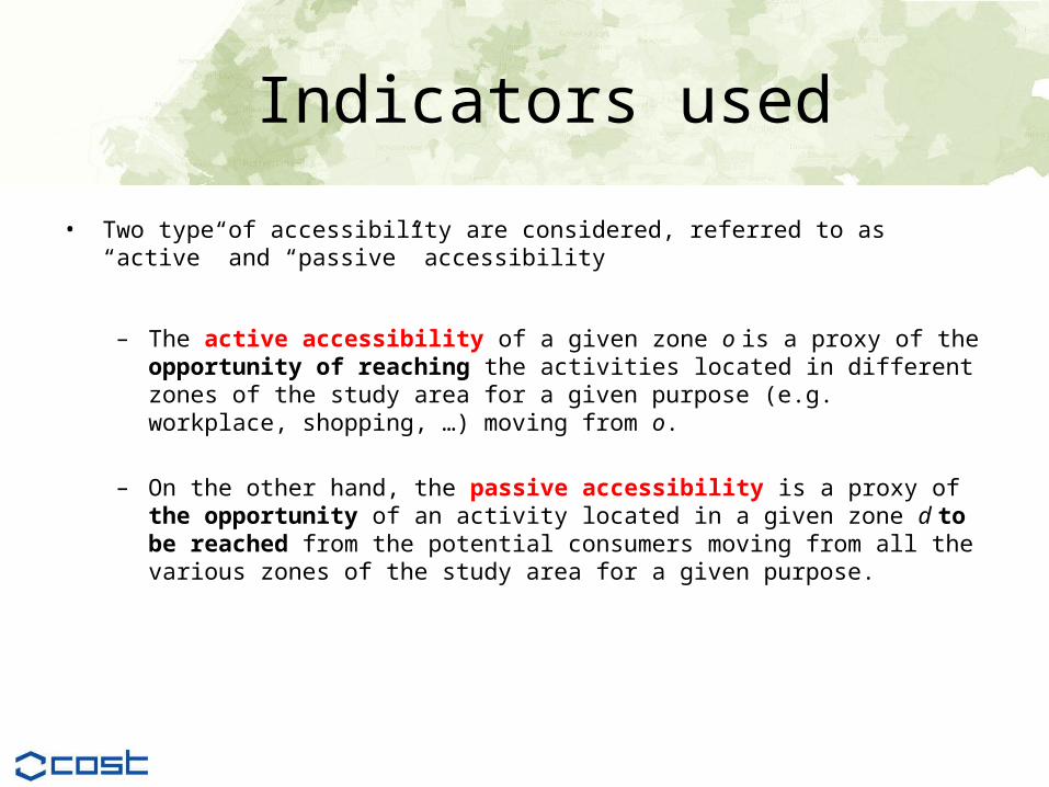
Indicators used
• Two type of accessibility are considered, referred to as “active” and “passive” accessibility
– The active accessibility of a given zone o is a proxy of the opportunity of reaching the activities located in different zones of the study area for a given purpose (e.g. workplace, shopping, …) moving from o.
– On the other hand, the passive accessibility is a proxy of the opportunity of an activity located in a given zone d to be reached from the potential consumers moving from all the various zones of the study area for a given purpose.

Indicators used
The “active” accessibility of the residents of zone o to the workplaces in the whole study area is given by:
where:• E(i) is the number of workplaces in the zone i;• C(o,i) is the generalized travel cost (i.e. weighed sum of the travel time and travel
costs) between zone o and zone i;
• a1 a2 are calibrated parameters.

Indicators used
The “passive” accessibility of the economic activities in a given zone d with respect to residents in all the zones of the study area, is given by:
where:• Res(i) is the number of people residing in zone i (i.e. the potential costumers of the
economic activities in d);• C(i,d) is the generalized travel cost (sum of the travel time and travel costs) on the
transport network between zone i and zone d;
• γ1 γ2 calibrated parameters.
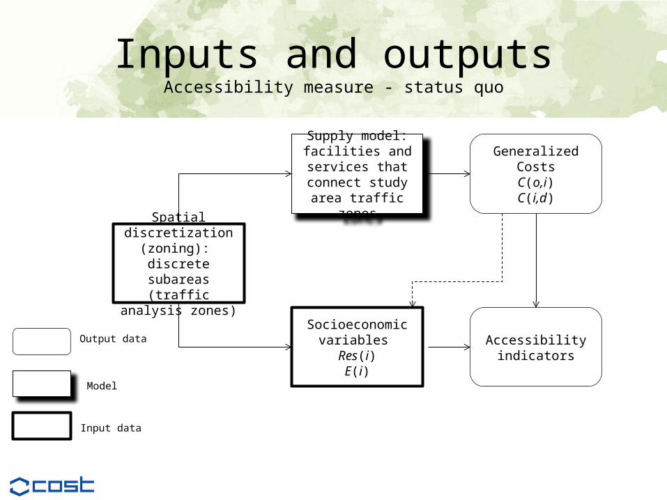
Inputs and outputsAccessibility measure - status quo
Supply model: facilities and services
that connect study area traffic zones
Socioeconomic variables Res(i)E(i)
Spatial discretization (zoning): discrete subareas (traffic analysis zones)
Generalized CostsC(o,i)C(i,d)
Accessibilityindicators
Output data
Model
Input data

Inputs and outputs
Input: socioeconomic data (Nuzzolo A., Coppola P. (2007)
Inputs and outputs
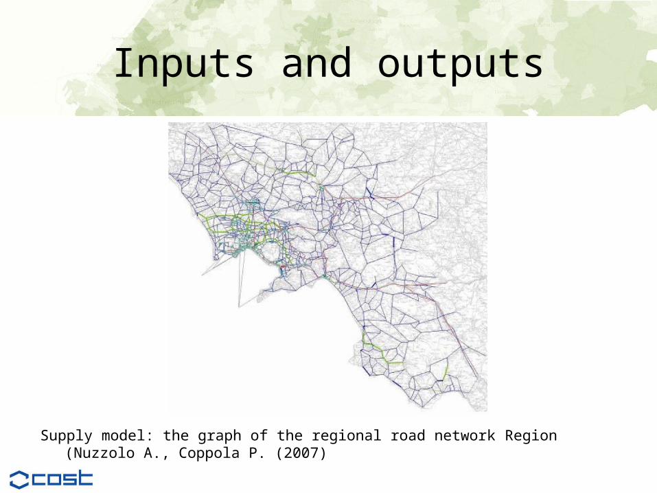
Supply model: the graph of the regional road network Region (Nuzzolo A., Coppola P. (2007)
Inputs and outputs
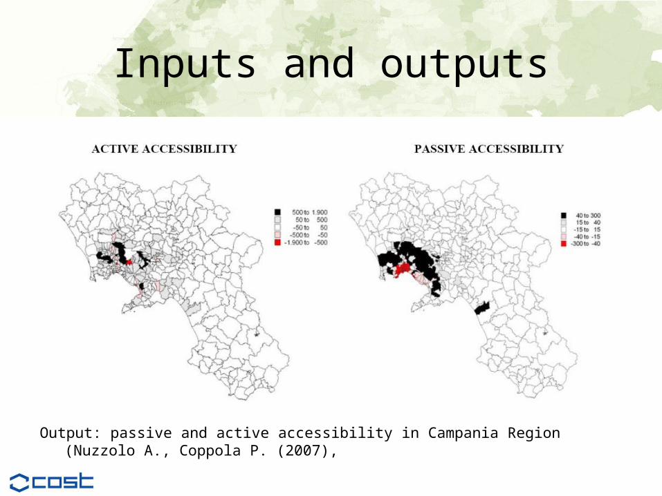
Output: passive and active accessibility in Campania Region (Nuzzolo A., Coppola P. (2007),

Inputs and outputsAccessibility measure – simulation in a future scenario

Inputs and outputs
Usefulness in practicePrevious applications of this instrument in planning practice
This Accessibility measures have been used in several applications in Campania Region planning processes, in
– different feasibility studies for transport infrastructures assessment, – transport and master plan at different scales (urban, provincial and regional). One of the latest application
regards the Regional Metro System plan - RMS, which is an integrated land-use, infrastructure and operational plan, including Naples and the whole Campania Region.
Relevance and the usefulness of this instrument for planning practice• The simulation of accessibility measure is aimed at
– implementing large-scale projects, in terms of both infrastructure and transportation services– simulating impacts on users’ behavior (i.e. travel demand) in terms of the quantity and spatial distribution of
trips and of modal share and network flows, as well as on residential and economic activity spatial distribution, as a result of the accessibility conditions of the different zones change.
• In this way the model framework, where accessibility measure has a central role, is useful in the transport – land use decision making process to identify an interrelation between the variation of accessibility and the variation of population and economic activities in such zones.

Usefulness in practicehow the instrument can be improved• theoretical basis: the described instrument has a strong theoretical base, which is well accepted
in transport planning field. Furthermore the framework model takes into account the spatial interaction between the distribution of the demand and the accessibility level of opportunities (competition effects). However this accessibility measure, as all gravity measures, neglects the variations across individuals; in other words the measure does not account for the characteristics of individuals for whom the accessibility is being estimated.
• interpretability and communicability, the complexity of the model framework makes difficult the interpretability of results by urban planners and the DSS should be improved with a more clear visualization module. However in the Campania case, aggregate and synthesis result of the DSS had a good feedback in the consultation process with local authorities, as well as with economic stakeholders.
• operationalisation and data requirements : The data collection for this type of accessibility instruments remains the major effort. However, in many cases the introduction of computers in local government has generated a pool of collected and updated data that can be used as the information base for it; in any case the parameters of the function should be estimated using recent empirical data of spatial travel behavior in the study area. The operationalisation is quite complex and requires a transport network simulation software.
• usability in social and economic evaluations The usability of this instrument is mainly for economic evaluation while not for social (individuals or group of individuals) analysis and in this sense the instrument has to be improved, also in order to ensure a wider application. assure more application fields.

references• Cascetta, E. (2005) The transport challenge in Campania: an integrated system for sustainable mobility (La sfida
dei trasporti in Campania: un sistema integrato per la mobilità sostenibile). Electa, Naples.• Cascetta E. Coppola P. (2004) The Regional Metro System of Campania Region: from planning to operations.
Proceedings of the European Transport Conference 2004, © Association for EuropeanTransport, Strasbourg, France.
• Cascetta E. Pagliara F (2008) Integrated railways-based policies: The Regional Metro System (RMS) project of Naples and Campania Transport Policy Volume 15, Issue 2, March 2008, Pages 81-93
• Cascetta E. Pagliara F and Coppola P (2008) The Regional Metro System project of Campania: design methodology and impacts evaluation proceedings of the 3rd Conference of Funding Transport Infrastructure. Parigi.
• Nuzzolo A., Coppola P. (2007), Regional accessibility and socioeconomic activities location: from empirical evidences towards a modelling framework. In Proceedings of World Conference on Transportation Research WCTR 2007, Berkeley CA
• Papa, E. and Pagliara, F.(2006) Rail network for mobility and city planning: the case of Naples. Proceedings of the 3rd International Symposium Networks for Mobility, Stuttgart, October.
• Papa, E. and Pagliara, F (2010) Urban rail systems investments: an analysis of the impacts on property values and residents’ location Journal of Transport Geography, doi:10.1016/j.jtrangeo.2010.02.006