Embed Size (px)
DESCRIPTION
(Balimtore, MD w/ZGF) A Transit-Centered Community Development Strategy for the West Baltimore MARC Station Area.
Citation preview
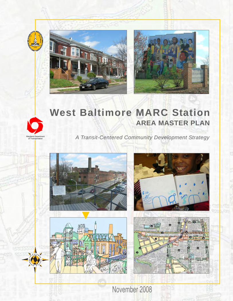
AREA MASTER PLAN
Maryland Department of Transportation A Transit-Centered Community Development Strategy
West Baltimore MARC Station
DEPARTMENT OF PLANNING MISSION STATEMENT To provide the highest level services and leadership in urban and strategic planning, historical, and architectural preservation, zoning, design, development, and capital
budgeting to promote the sustained economic, social, and community development of the City of Baltimore
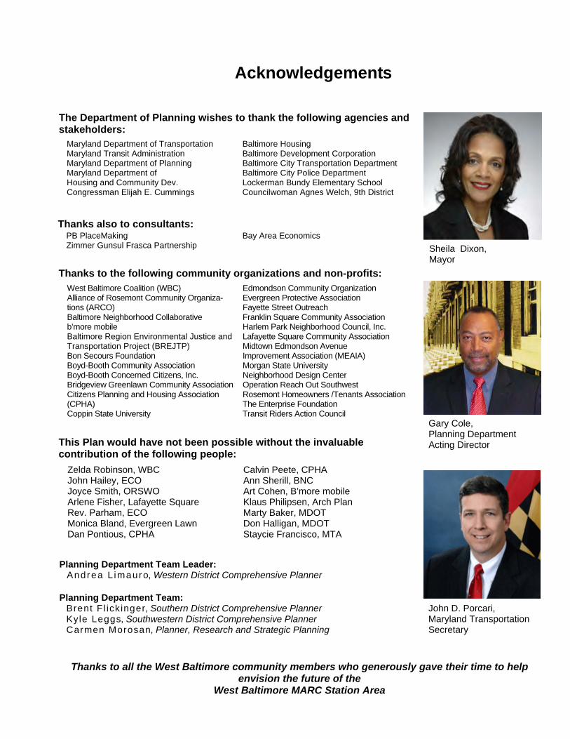
Acknowledgements
Sheila Dixon, Mayor
John D. Porcari, Maryland Transportation Secretary
Gary Cole, Planning Department Acting Director
Thanks to all the West Baltimore community members who generously gave their time to help envision the future of the
West Baltimore MARC Station Area
Zelda Robinson, WBC John Hailey, ECO Joyce Smith, ORSWO Arlene Fisher, Lafayette Square Rev. Parham, ECO Monica Bland, Evergreen Lawn Dan Pontious, CPHA
Calvin Peete, CPHA Ann Sherill, BNC Art Cohen, B’more mobile Klaus Philipsen, Arch Plan Marty Baker, MDOT Don Halligan, MDOT Staycie Francisco, MTA
This Plan would have not been possible without the invaluable contribution of the following people:
West Baltimore Coalition (WBC) Alliance of Rosemont Community Organiza-tions (ARCO) Baltimore Neighborhood Collaborative b’more mobile Baltimore Region Environmental Justice and Transportation Project (BREJTP) Bon Secours Foundation Boyd-Booth Community Association Boyd-Booth Concerned Citizens, Inc. Bridgeview Greenlawn Community Association Citizens Planning and Housing Association (CPHA) Coppin State University
Edmondson Community Organization Evergreen Protective Association Fayette Street Outreach Franklin Square Community Association Harlem Park Neighborhood Council, Inc. Lafayette Square Community Association Midtown Edmondson Avenue Improvement Association (MEAIA) Morgan State University Neighborhood Design Center Operation Reach Out Southwest Rosemont Homeowners /Tenants Association The Enterprise Foundation Transit Riders Action Council
Thanks to the following community organizations and non-profits:
Planning Department Team Leader: Andrea L imauro, Western District Comprehensive Planner Planning Department Team: Brent Fl ick inger, Southern District Comprehensive Planner Kyle Leggs, Southwestern District Comprehensive Planner Carmen Morosan, Planner, Research and Strategic Planning
Maryland Department of Transportation Maryland Transit Administration Maryland Department of Planning Maryland Department of Housing and Community Dev. Congressman Elijah E. Cummings
Baltimore Housing Baltimore Development Corporation Baltimore City Transportation Department Baltimore City Police Department Lockerman Bundy Elementary School Councilwoman Agnes Welch, 9th District
The Department of Planning wishes to thank the following agencies and stakeholders:
PB PlaceMaking Zimmer Gunsul Frasca Partnership
Bay Area Economics Thanks also to consultants:
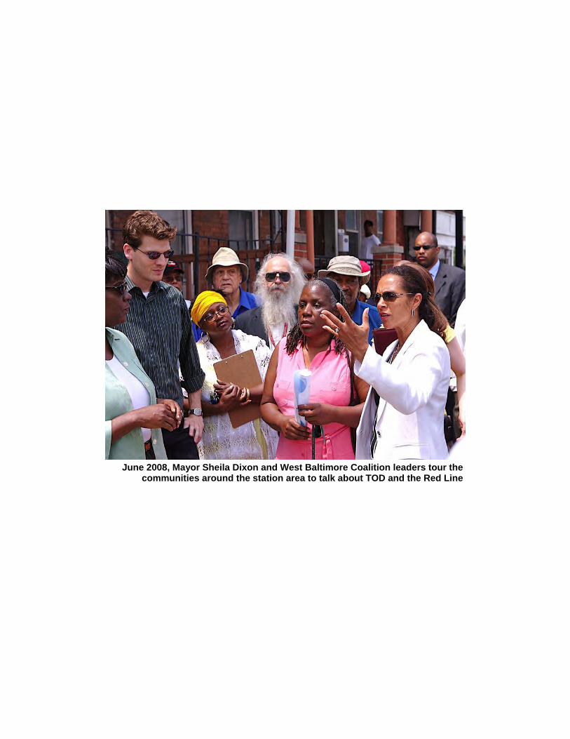
June 2008, Mayor Sheila Dixon and West Baltimore Coalition leaders tour the communities around the station area to talk about TOD and the Red Line
Maryland Department of TransportationThe Secretary's Office
Martin O'MalleyGovernor
Anthony G. BrownLt. Governor
John D. PorcariSecretary
Beverley K. Swaim-StaleyDeputy Secretary
September 2, 2008
I am pleased to join the communities of West Baltimore in introducing the West BaltimoreMARC Station Area Transit-Centered Community Development Strategy. This Strategydocument reflects the successful outcome of an intensive collaborationbetween the residents ofWest Baltimore, the City of Baltimore, and Maryland State agencies led by the Department ofTransportation (MDOT). It is our hope that it will guide future investment in West Baltimore fordecades to come, to help achieve the community's ambitious vision.
Transit Oriented Development (TOD) is a major policy priority for MDOT and West Baltimoreis a key location to focus this policy. This area's strong bus ridership, as well as the current MARC Station and plans to develop the"Red Line," makes transit a significant element of theWest Baltimore landscape. It is all the more important, therefore, that transit be designed as anamenity to the area, and that land use planning reflect the needs and opportunities that transitinvestment can bring. The citizens of West Baltimore not only understand this, but with courageand energy have re-emphasized that transportation planning should look beyond systemefficiencies to support the community development needs and opportunitiesof current residents.It is for this reason that the Strategy document outlines recommended actions not merely topromote"TOD," but to achieve"Transit-Centered Community Development"for and with theresidents of West Baltimore.
This Strategy document is symbolic of the unique partnershipand energetic leadership of thoseinvolved in its production. Committed residents and area stakeholderspartnered with a broadarray of State and City agencies, to create a process that was not only for the community, but bythe community. On behalf of the Maryland Department of Transportation, I congratulateandthank the leaders of this effort for the creativity, energy and commitment they have demonstratedover the course of this interactive process. This collective spirit is testimony to the potential ofthe area and marks a brave step forward toward a better future for West Baltimore.
Sincerely,
Toll Free Number 1-888-713-1414, TTY Users Call Via MD Relay 7201 Corporate Center Drive, Hanover, Maryland 21076
i
TABLE OF CONTENTS
CHAPTER 4 PHASING 70 Pre-Development Phase – First 5 to 10 years 73 Phase I – Next 10 years 75 Phase II – Next 15 years 77 Phase III – Beyond 78 IMPLEMENTING THE COMMUNITY DEVELOPMENT STRATEGY 79 Obstacles and Challenges to Implementation 87 Organizational Milestones and Next Steps 88 WEST BALTIMORE 10-YEAR ACTION STRATEGY 91 Quality of Life Action Items 92 Housing Action Items 96 Economic Development Action Items 98 Transportation Action Items 101
APPENDICES APPENDIX A: Housing Tools and Resources 104 APPENDIX B: Economic Development Tools and Resources 107 APPENDIX C: Acronym and Abbreviations List for Appendices A & B 113 APPENDIX D: Historic Ice House Images 115 APPENDIX E: Related Resources 116 APPENDIX F: Sample Community Benefits Agreement 119 APPENDIX G: Form-Based Code Recommendations 120
4
West Balt imore MARC Transit-Centered Community Development Strategy �
ES
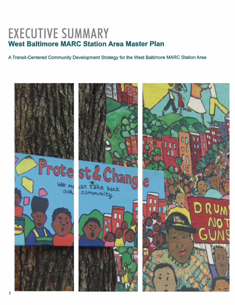
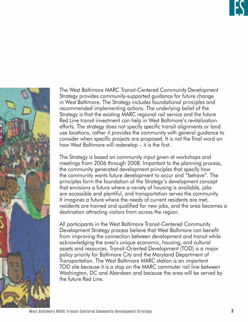
The West Baltimore MARC Transit-Centered Community Development Strategy provides community-supported guidance for future change in West Baltimore. The Strategy includes foundational principles and recommended implementing actions. The underlying belief of the Strategy is that the existing MARC regional rail service and the future Red Line transit investment can help in West Baltimore’s revitalization efforts. The strategy does not specify specific transit alignments or land use locations, rather it provides the community with general guidance to consider when specific projects are proposed. It is not the final word on how West Baltimore will redevelop – it is the first.
The Strategy is based on community input given at workshops and meetings from 2006 through 2008. Important to the planning process, the community generated development principles that specify how the community wants future development to occur and “behave”. The principles form the foundation of the Strategy’s development concept that envisions a future where a variety of housing is available, jobs are accessible and plentiful, and transportation serves the community. It imagines a future where the needs of current residents are met, residents are trained and qualified for new jobs, and the area becomes a destination attracting visitors from across the region.
All participants in the West Baltimore Transit-Centered Community Development Strategy process believe that West Baltimore can benefit from improving the connection between development and transit while acknowledging the area’s unique economic, housing, and cultural assets and resources. Transit-Oriented Development (TOD) is a major policy priority for Baltimore City and the Maryland Department of Transportation. The West Baltimore MARC station is an important TOD site because it is a stop on the MARC commuter rail line between Washington, DC and Aberdeen and because the area will be served by the future Red Line.
�
ES
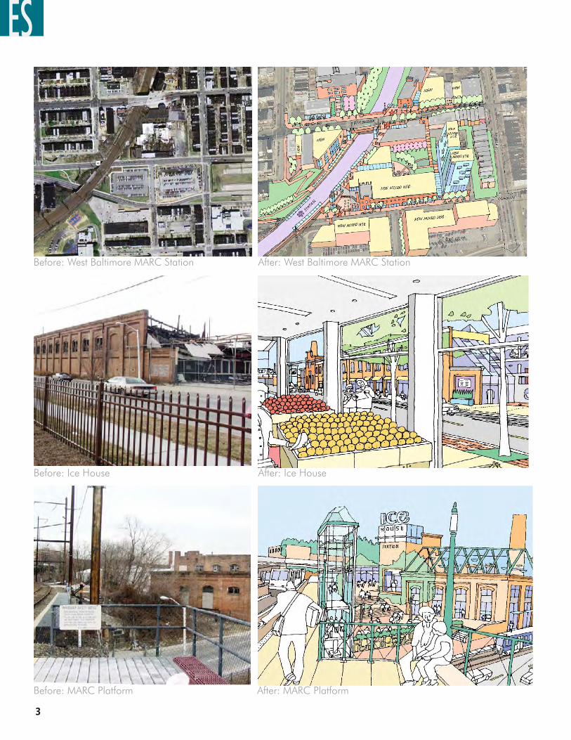
After: West Baltimore MARC StationBefore: West Baltimore MARC Station
After: Ice HouseBefore: Ice House
After: MARC PlatformBefore: MARC Platform
West Balt imore MARC Transit-Centered Community Development Strategy �
ES
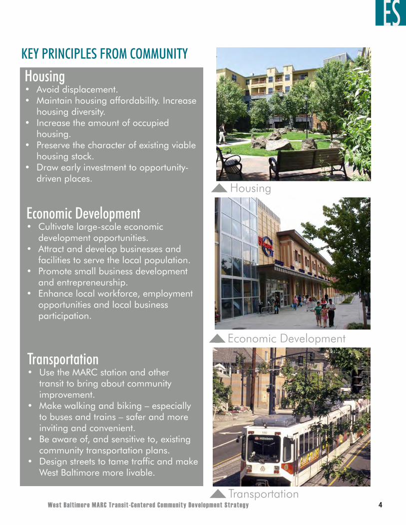
TransportationUse the MARC station and other transit to bring about community improvement.Make walking and biking – especially to buses and trains – safer and more inviting and convenient.Be aware of, and sensitive to, existing community transportation plans.Design streets to tame traffic and make West Baltimore more livable.
•
•
•
•
HousingAvoid displacement.Maintain housing affordability. Increase housing diversity.Increase the amount of occupied housing.Preserve the character of existing viable housing stock.Draw early investment to opportunity-driven places.
••
•
•
•
Economic DevelopmentCultivate large-scale economic development opportunities.Attract and develop businesses and facilities to serve the local population.Promote small business development and entrepreneurship.Enhance local workforce, employment opportunities and local business participation.
•
•
•
•
Housing
Economic Development
Transportation
KEY PRINCIPLES FROM COMMUNITY
�
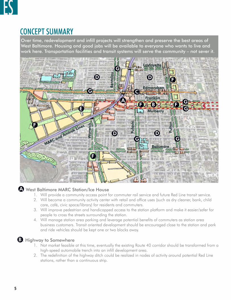
CONCEPT SUMMARY Over time, redevelopment and infill projects will strengthen and preserve the best areas of West Baltimore. Housing and good jobs will be available to everyone who wants to live and work here. Transportation facilities and transit systems will serve the community – not sever it.
Warw
ick
MARC and Amtrak Lines
Ben
talo
u
Franklin
Mulberry
Edmondson
Baltimore
Pula
ski
Layfayette
Fulto
n
A. West Baltimore MARC Station/Ice HouseWill provide a community access point for commuter rail service and future Red Line transit service. Will become a community activity center with retail and office uses (such as dry cleaner, bank, child care, café, civic space/library) for residents and commuters. Will improve pedestrian and handicapped access to the station platform and make it easier/safer for people to cross the streets surrounding the station. Will manage station area parking and leverage potential benefits of commuters as station area business customers. Transit oriented development should be encouraged close to the station and park and ride vehicles should be kept one or two blocks away.
B. Highway to SomewhereNot market feasible at this time, eventually the existing Route 40 corridor should be transformed from a high-speed automobile trench into an infill development area.The redefinition of the highway ditch could be realized in nodes of activity around potential Red Line stations, rather than a continuous strip.
1.2.
3.
4.
1.
2.
A
B
G
GG
G
F
F
E
D
C
BA
D
D D
GG
FF
F
ES
West Balt imore MARC Transit-Centered Community Development Strategy �
C. Edmondson AvenueRevitalize Edmondson Avenue with mixed-use development, similar to its function in the past. Design speed and speed limit posting should not exceed 25 mph. Residents should accept some traffic congestion in this area, as it will be an indication of the street’s desirability!This is traditionally an on-street, parallel parking environment and new or additional parking should follow best management practices such as: putting parking behind, above, or to the side of buildings; sharing surface parking areas between uses and managing them communally; and keeping unsecured parking areas in clear view of active, adjacent uses.
D. Residential NeighborhoodsSupport and enhance West Baltimore’s many existing owner-occupied residential areas.Enhance neighborhood character by aesthetic, recreational, and personal safety improvements. Vacant housing should be sensitively renovated and/or redeveloped, respecting the character of adjacent buildings and uses, although a more diverse housing stock is encouraged.Some local serving retail or commercial development should be allowed, as long as it respects the residential qualities of the neighborhood. Work with Bon Secours, Coppin State, and OROSW to improve facilities and connections to community.
E. Southwest Industrial AreaThe triangular piece of land bounded by Franklin Street to the north, the railroad tracks to the south, and the cemetery and Gwynns Falls to the west (currently low-density industrial uses).Because of the area’s proximity to the MARC Station and Gwynns Falls, the area should transition from primarily industrial to more mixed-use character, with higher intensity uses closest to the station. Enhance the character by creating an internal street network, providing a linear path or greenway connection to the Gwynns Fall Trail, and providing personal safety improvements.
F. Parks and Open SpaceA variety of parks and open spaces are envisioned for West Baltimore. These spaces will provide important recreational, social, environmental, and wildlife benefits. The comprehensive open space concept includes a pedestrian promenade, improved steetscapes, parks, and open spaces trails, including a link to the Gwynns Falls Trail.
G. Improved StreetsMany of West Baltimore’s streets (Franklin/Mulberry, Fulton, Pulaski, Layfayette, Bentalou and Warwick) could benefit from traffic that has been calmed by the provision of wider sidewalks, more pedestrian amenities, and greening with trees and landscaping.New construction should create and support active corners and ground level uses. This means creating active, well-lit streets that are fronted by uses that provide “eyes on the street” at all times to deter crime and improve the safety and security of residents and visitors.West Baltimore’s streets should function appropriate to their context. That is, residential streets should be designed differently than a transit boulevard which is designed differently from a city
1.2.
3.
1.2.
3.
4.
5.
1.
2.
3.
1.
2.
1.
2.
3.
C
D
E
F
G
ES
�
Revitalization - First 5-10 yrs.
Phasing and Action Diagram
Phase I - Next 10 yrs.
Phase II - Next 15yrs.
Phase III - 2038 and beyond
The Strategy proposes a comprehensive implementation approach that requires the involvement and coordination of many stakeholders. Multiple issues, such as criminal activity, building and property code violations, deteriorating infrastructure, and MARC operations, will need to be addressed. Although complex, the Strategy provides tools that identify numerous action items and potential responsible parties to help the community realize the Strategy vision.
Initially, a period focused on revitalization needs to occur. This phase will set the stage for attracting development. Key issues to address initially include crime and safety; building code violations and dangerous conditions of property; improving public infrastructure (such as streets); beautification and image improvement; local organizational capacity building; and public/public and public/private partnerships.
Phase I (2013-2028): This is the first phase of major development activity. Key sites of focused mixed-use development include the City-owned land that currently serves as MTA commuter lots, and the site of the former Ice House (due to the limited number of land owners, parcel size, and direct access to MARC).
Phase II (2023-2043): Development in this phase begins to stretch northward along both sides of the tracks from the MARC station. Key sites include the Acme Industrial Complex, small infill sites, and the “Highway to Somewhere” closest to the MARC station.
Phase III (2038 and beyond): Later phases include the Southwest Industrial Area and the “Highway to Somewhere” parcels further from the MARC station.
Keep in mind that this is a complex, long-term effort requiring the cooperation of multiple stakeholders and strong local, City and State leadership. However, it is important to begin the process with a focus on improving the station area and streets immediately adjacent to it.
PHASING AND ACTION STRATEGY
ES
West Balt imore MARC Transit-Centered Community Development Strategy �
West Baltimore MARC/Ice House
Edmondson Avenue
Mount Street Housing
Institutions– Coppin State & Bon Secours
Operation Reach-Out Southwest (OROSW) Community Improvements
West Side of MARC Station and North/South along alignment
First 2 blocks of Highway to Somewhere
Shipley Hill/ Southwest Town Center (OROSW)
Green connections through industrial/ Gwynns Falls Vista Park (OROSW)
Franklin Mulberry Corridor (Future Red Line)
Industrial property
Highway to Somewhere
•
•
•
•
•
•
•
•
•
•
•
•
1
2
3
4
5
6
7
8
9
1
10
11
23
4
67
8
9
10
1112
4
Phase 1
Phase 2
Phase 3
12
5
5
5
ES
�
CHAPTER 1INTRODUCTION
West Balt imore MARC Transit-Centered Community Development Strategy �0
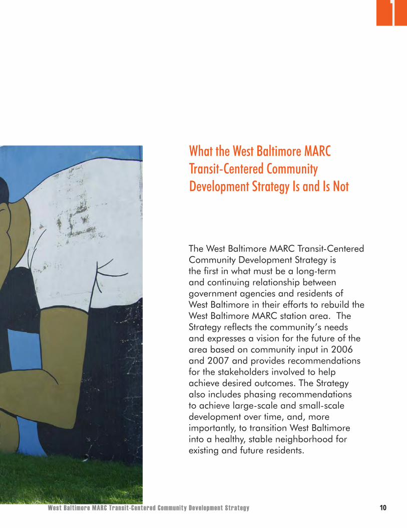
What the West Baltimore MARC Transit-Centered Community Development Strategy Is and Is Not
1
The West Baltimore MARC Transit-Centered Community Development Strategy is the first in what must be a long-term and continuing relationship between government agencies and residents of West Baltimore in their efforts to rebuild the West Baltimore MARC station area. The Strategy reflects the community’s needs and expresses a vision for the future of the area based on community input in 2006 and 2007 and provides recommendations for the stakeholders involved to help achieve desired outcomes. The Strategy also includes phasing recommendations to achieve large-scale and small-scale development over time, and, more importantly, to transition West Baltimore into a healthy, stable neighborhood for existing and future residents.
��
1
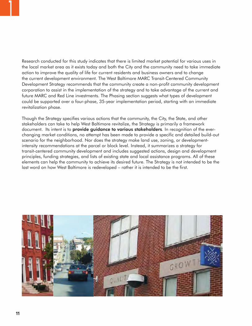
Research conducted for this study indicates that there is limited market potential for various uses in the local market area as it exists today and both the City and the community need to take immediate action to improve the quality of life for current residents and business owners and to change the current development environment. The West Baltimore MARC Transit-Centered Community Development Strategy recommends that the community create a non-profit community development corporation to assist in the implementation of the strategy and to take advantage of the current and future MARC and Red Line investments. The Phasing section suggests what types of development could be supported over a four-phase, 35-year implementation period, starting with an immediate revitalization phase.
Though the Strategy specifies various actions that the community, the City, the State, and other stakeholders can take to help West Baltimore revitalize, the Strategy is primarily a framework document. Its intent is to provide guidance to various stakeholders. In recognition of the ever-changing market conditions, no attempt has been made to provide a specific and detailed build-out scenario for the neighborhood. Nor does the strategy make land use, zoning, or development-intensity recommendations at the parcel or block level. Instead, it summarizes a strategy for transit-centered community development and includes suggested actions, design and development principles, funding strategies, and lists of existing state and local assistance programs. All of these elements can help the community to achieve its desired future. The Strategy is not intended to be the last word on how West Baltimore is redeveloped – rather it is intended to be the first.
West Balt imore MARC Transit-Centered Community Development Strategy ��
1
Community History West Baltimore underwent dramatic changes in the 20th century. In the 1940s and 1950s, at its peak size, the area was a vibrant neighborhood full of rowhouses and community businesses. The years that followed were not as good to the neighborhood, and vacancies and abandoned homes have been common in past the 40 years. Major population losses resulted in part from changes that affected the rest of the City, including increased suburbanization, white flight, loss of urban jobs, racial discrimination in housing, and drugs and crime. In both central West and East Baltimore, there were also civil disturbances in April 1968 as a reaction to the killing of the Reverend Martin Luther King Jr.
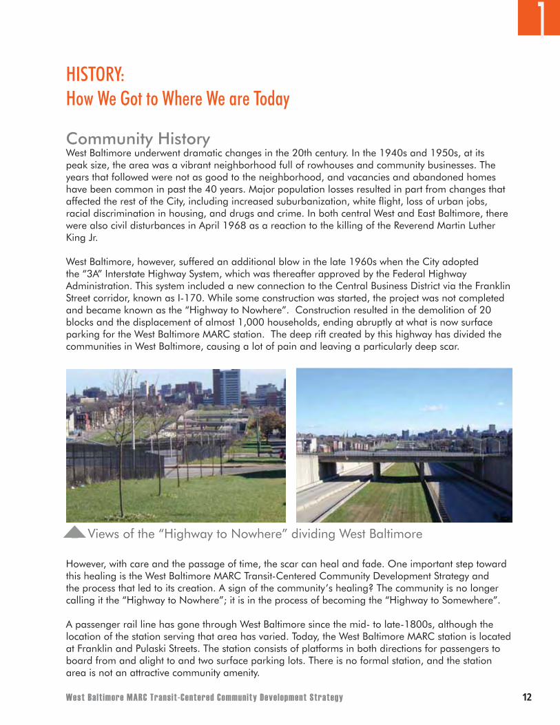
West Baltimore, however, suffered an additional blow in the late 1960s when the City adopted the “3A” Interstate Highway System, which was thereafter approved by the Federal Highway Administration. This system included a new connection to the Central Business District via the Franklin Street corridor, known as I-170. While some construction was started, the project was not completed and became known as the “Highway to Nowhere”. Construction resulted in the demolition of 20 blocks and the displacement of almost 1,000 households, ending abruptly at what is now surface parking for the West Baltimore MARC station. The deep rift created by this highway has divided the communities in West Baltimore, causing a lot of pain and leaving a particularly deep scar.
However, with care and the passage of time, the scar can heal and fade. One important step toward this healing is the West Baltimore MARC Transit-Centered Community Development Strategy and the process that led to its creation. A sign of the community’s healing? The community is no longer calling it the “Highway to Nowhere”; it is in the process of becoming the “Highway to Somewhere”.
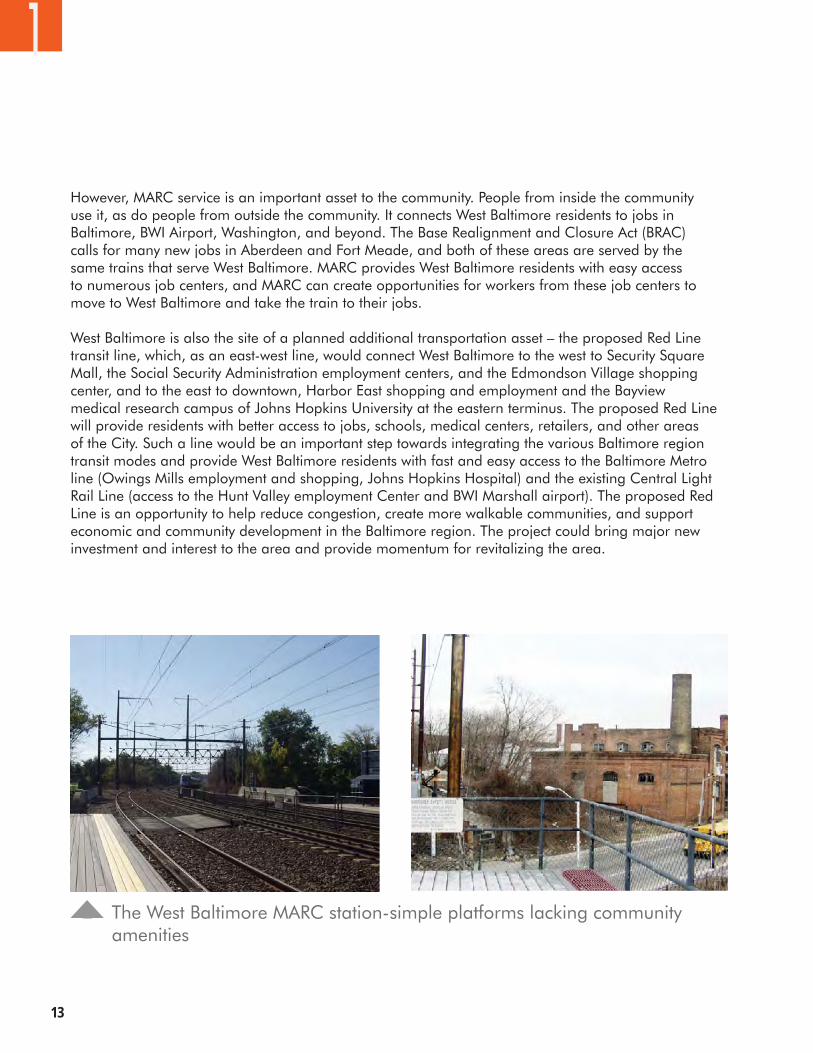
A passenger rail line has gone through West Baltimore since the mid- to late-1800s, although the location of the station serving that area has varied. Today, the West Baltimore MARC station is located at Franklin and Pulaski Streets. The station consists of platforms in both directions for passengers to board from and alight to and two surface parking lots. There is no formal station, and the station area is not an attractive community amenity.
Views of the “Highway to Nowhere” dividing West Baltimore
HISTORY: How We Got to Where We are Today
��
However, MARC service is an important asset to the community. People from inside the community use it, as do people from outside the community. It connects West Baltimore residents to jobs in Baltimore, BWI Airport, Washington, and beyond. The Base Realignment and Closure Act (BRAC) calls for many new jobs in Aberdeen and Fort Meade, and both of these areas are served by the same trains that serve West Baltimore. MARC provides West Baltimore residents with easy access to numerous job centers, and MARC can create opportunities for workers from these job centers to move to West Baltimore and take the train to their jobs.
West Baltimore is also the site of a planned additional transportation asset – the proposed Red Line transit line, which, as an east-west line, would connect West Baltimore to the west to Security Square Mall, the Social Security Administration employment centers, and the Edmondson Village shopping center, and to the east to downtown, Harbor East shopping and employment and the Bayview medical research campus of Johns Hopkins University at the eastern terminus. The proposed Red Line will provide residents with better access to jobs, schools, medical centers, retailers, and other areas of the City. Such a line would be an important step towards integrating the various Baltimore region transit modes and provide West Baltimore residents with fast and easy access to the Baltimore Metro line (Owings Mills employment and shopping, Johns Hopkins Hospital) and the existing Central Light Rail Line (access to the Hunt Valley employment Center and BWI Marshall airport). The proposed Red Line is an opportunity to help reduce congestion, create more walkable communities, and support economic and community development in the Baltimore region. The project could bring major new investment and interest to the area and provide momentum for revitalizing the area.
1
The West Baltimore MARC station-simple platforms lacking community amenities
West Balt imore MARC Transit-Centered Community Development Strategy 14
The transportation modes being studied for the Red Line are Light Rail Transit (LRT), Bus Rapid Transit (BRT), and Enhanced Bus Service. There are three major phases of the project that must be completed prior to construction. The Planning/Draft Environmental Impact Statement phase is scheduled to be completed in 2008, the Preliminary Engineering/Final Environmental Impact Statement phase in 2010, and the Final Design/Right of Way acquisition phase in 2012. Construction could be initiated in 2012, but this timeline is contingent upon both federal and state funds being available for the project.
The West Baltimore Coalition has requested that a community benefits agreement be formulated in conjunction with this project. A community benefits agreement would ensure that area benefits, as outlined in this report, would be leveraged through the realization of the Red Line project. Benefits would range from employment opportunities during construction and operation (particularly if a maintenance facility for the line is placed in West Baltimore as indicated in options of the current Red Line plans) to a transformation of the US 40 freeway to streetscape improvements and transit oriented development.
It can be assumed that the Red Line as an additional transit mode will transform West Baltimore into a true multi-modal transit hub which could add significant value to the area and could stimulate the changes envisioned by the Transit Centered Community Development Strategy.
An alignment for the future Red Line has not yet been selected by the MTA, and the Transit Centered Community Development Strategy does not advocate a particular alignment. The Strategy’s maps and graphics show all the alignments when possible. It is up to community residents to decide which alignments they prefer and to express their opinions to the MTA through the Red Line process. Chapter 4’s “Implementing the Community Development Strategy” section provides residents with additional information to consider as they participate in the MTA’s Red Line project.
1
The map on the following page shows the MTA Red Line Corridor Transit Study alignments examined in the September 2008 Alternatives Analysis/Draft Environmental Impact Statement (AA/DEIS).
��
1
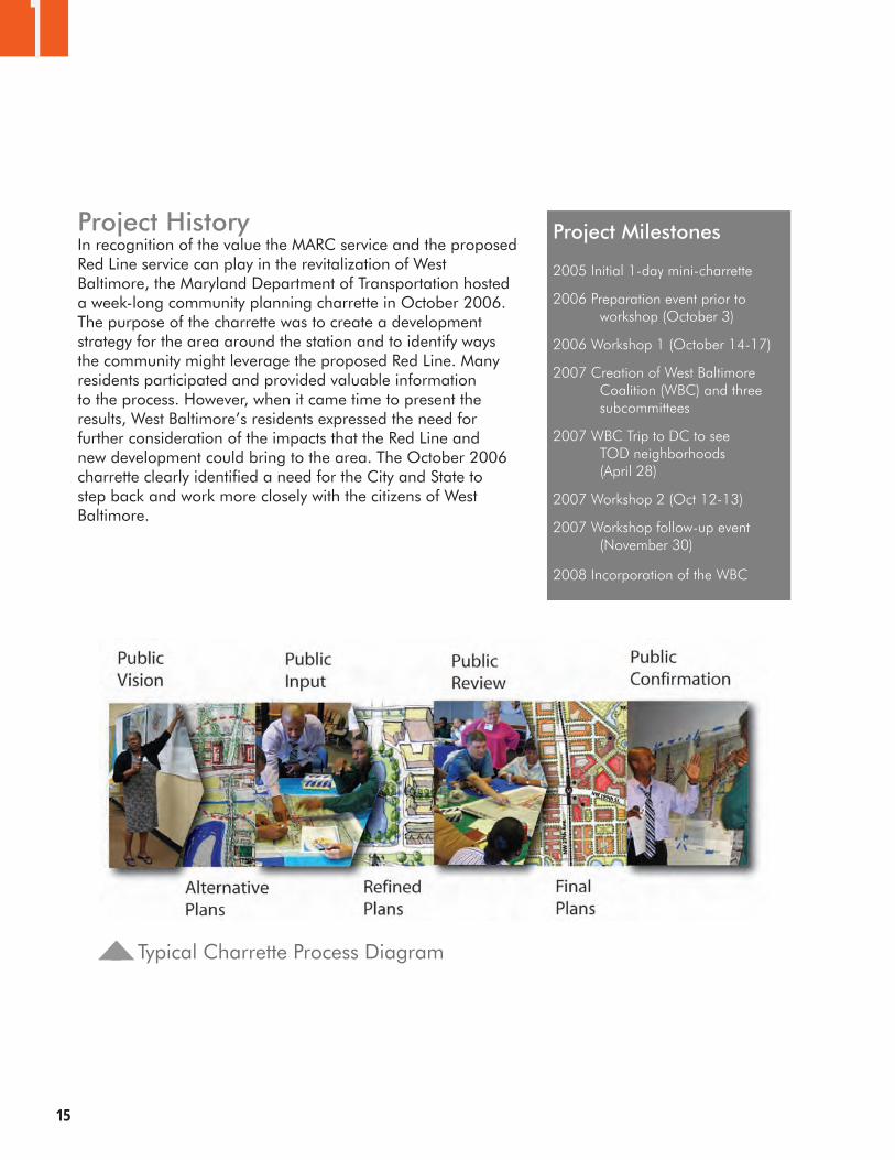
Project HistoryIn recognition of the value the MARC service and the proposed Red Line service can play in the revitalization of West Baltimore, the Maryland Department of Transportation hosted a week-long community planning charrette in October 2006. The purpose of the charrette was to create a development strategy for the area around the station and to identify ways the community might leverage the proposed Red Line. Many residents participated and provided valuable information to the process. However, when it came time to present the results, West Baltimore’s residents expressed the need for further consideration of the impacts that the Red Line and new development could bring to the area. The October 2006 charrette clearly identified a need for the City and State to step back and work more closely with the citizens of West Baltimore.
Typical Charrette Process Diagram
Project Milestones
2005 Initial 1-day mini-charrette
2006 Preparation event prior to workshop (October 3)
2006 Workshop 1 (October 14-17)
2007 Creation of West Baltimore Coalition (WBC) and three subcommittees
2007 WBC Trip to DC to see TOD neighborhoods (April 28)
2007 Workshop 2 (Oct 12-13)
2007 Workshop follow-up event (November 30)
2008 Incorporation of the WBC
West Balt imore MARC Transit-Centered Community Development Strategy ��
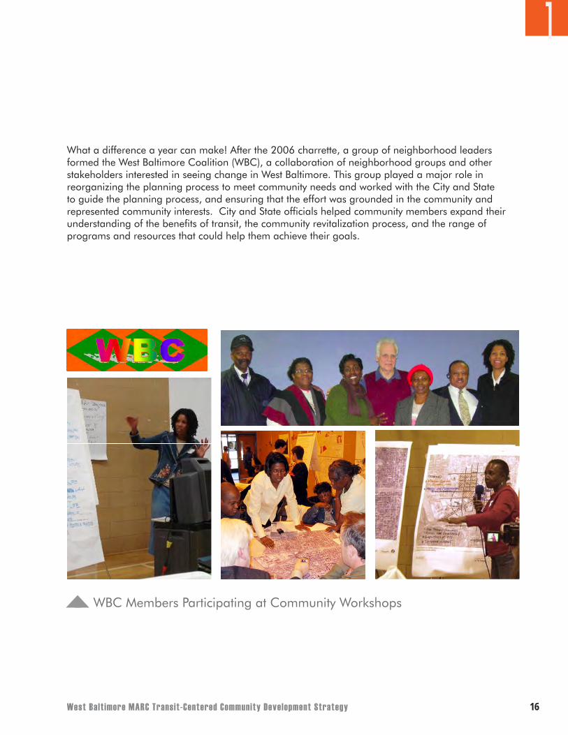
What a difference a year can make! After the 2006 charrette, a group of neighborhood leaders formed the West Baltimore Coalition (WBC), a collaboration of neighborhood groups and other stakeholders interested in seeing change in West Baltimore. This group played a major role in reorganizing the planning process to meet community needs and worked with the City and State to guide the planning process, and ensuring that the effort was grounded in the community and represented community interests. City and State officials helped community members expand their understanding of the benefits of transit, the community revitalization process, and the range of programs and resources that could help them achieve their goals.
1
WBC Members Participating at Community Workshops
��
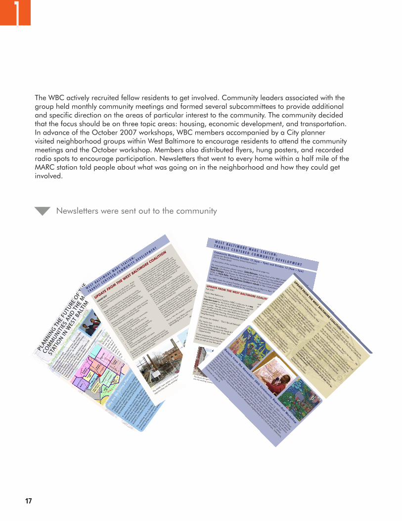
The WBC actively recruited fellow residents to get involved. Community leaders associated with the group held monthly community meetings and formed several subcommittees to provide additional and specific direction on the areas of particular interest to the community. The community decided that the focus should be on three topic areas: housing, economic development, and transportation. In advance of the October 2007 workshops, WBC members accompanied by a City planner visited neighborhood groups within West Baltimore to encourage residents to attend the community meetings and the October workshop. Members also distributed flyers, hung posters, and recorded radio spots to encourage participation. Newsletters that went to every home within a half mile of the MARC station told people about what was going on in the neighborhood and how they could get involved.
1
You A
reIn
vited
All of t
he resid
ents,
busines
ses,
churc
hes, a
nd schoo
ls
near
the
Wes
tBa
ltim
ore
MARC
statio
nar
ebein
g
aske
dto
partic
ipat
ewith
the
Cityof
Balti
mor
ean
d
the
Mar
yland
Depar
tmen
tof
Tran
spor
tatio
nin
a
com
munity
plannin
gstu
dyof
the
area
arou
ndth
e
Wes
t Balti
mor
e MARC
Sta
tion. Th
is p
roce
ss b
egan
with a
5 day
wor
kshop
in O
ct. 2
006
and n
ow a
serie
s
of m
eetin
gs are
bein
g held
to
pre
pare
for
anot
her
majo
r wor
kshop
May
2007
, dat
es an
d loc
atio
n stil
l
to b
e det
erm
ined
.
.
The
purpos
eof
this
newsle
tter is
tosp
read
the
word
abou
t the
study
and
toas
kfo
r your help
incr
aftin
g
a visio
nan
dstr
ateg
y for th
efu
ture
ofth
isim
porta
nt
part o
f the c
ity. W
e wan
t you
to p
artic
ipat
e!
Howyo
u can st
ay in
form
ed
You
can
conta
ctZe
lda Ro
binso
n, Chair
ofth
e Wes
t Balti
mor
eCoa
litio
nat
zeld
a888
@msn
.com
, and p
artic
ipat
e in th
eir n
ext m
eetin
gs held
on th
e
seco
nd and fo
urth Tu
esday
of e
ach m
onth
from
6.30
-8pm
at Ed
mon
dson
Comm
unity C
ente
r, 21
14 Ed
mon
dson A
ve.
You
may
also
conta
ctyo
ur Compre
hensiv
eDist
rict Pl
anner
for fu
rther
info
rmat
ion.
Ifyo
uliv
eNor
thof
Route
40an
dM
ulber
rySt
reet
your Pl
anner
isAndre
a
Limau
ro: (4
10) 3
96-5
934 o
r Andre
a.Lim
auro
@Balti
mor
eCity
.Gov
Ifyo
uliv
eSo
uthof
Route
40an
dM
ulber
rySt
reet
your Pl
anner
isBr
ent
Flick
inger
: (410
) 396-
5936
orBr
ento
n.Flick
inger
@Balti
mor
eCity
.Gov
and
your c
omm
unity u
mbre
llagro
up is O
ROSW
at (4
10) 3
62-3
239
For m
ore
info
rmat
ion
onth
eRe
dLin
eyo
um
ayco
ntact
MTA
’sPr
ojec
t
Man
ager
, Lor
enzo
Brya
nt at(4
10) 76
7-37
54or
Tony
Brow
nat
(410
) 767-
3597
. If yo
uwou
ldlik
eth
eM
TAto
com
ean
dsp
eak
toyo
ur com
munity
abou
tth
eRe
dLin
e,plea
seca
llM
r.Anth
ony
Brow
n, Red
Line
Public
Invo
lvem
ent C
oord
inat
or at
(410
) 533
-977
7 and re
quest a
spea
ker.
Asp
ecial
note
ofth
anks
toth
esc
ores
of
com
munity
mem
bers
whogen
erou
sly
gave
their
time
atth
eOct
ober
2006
works
hop!
PLANNIN
GTH
EFU
TURE
OF
THE
COM
MUNIT
IES
ANDTH
E M
ARC
STATI
ON IN
WES
T BALT
IMO
RE
Why
Are
We D
oing a
Plan
ning St
udy?
Public
transit
can
prom
ote
econ
omic
revit
aliza
tion, j
obcr
eatio
n, and
quality
develo
pmen
t whenit
iswell
-
planned
within
put from
the
com
munity
. The
Citywan
tsto
work
inpar
tner
ship
withth
ere
siden
tsof
Wes
t
Balti
mor
e toad
dress
the lo
nghist
ory of
neglec
t and
disinv
estm
ent by under
takin
ga pro
cess
toex
plore
how
t the c
omm
unity.
Inad
dition
toth
ecu
rrent M
ARCsta
tion, t
here
isa
study bein
gco
nducted
for th
epos
sible
constr
uctio
nof
a
newea
st-wes
t transit
line.
The Re
dLin
e,as
this
proje
ctis
calle
d, wou
ldfo
llow
the I-4
0co
rridor
and
inclu
de a
statio
nth
atse
rves
Wes
t Balti
mor
ean
dco
nnects
toM
ARC. M
any dec
ision
s rem
ain, h
owev
er, a
s towhat
kind
ofse
rvice
itsh
ould
enta
il (sp
ecial
bus and
light ra
il are
underco
nsider
atio
n), and
how
itwou
ldbes
t ser
veth
e
com
munity
. You
r opin
ion
onsu
chques
tions is
impor
tant a
t this
early
stage – to
helpen
sure
that
if the pro
ject
is built
, it co
ntribute
s to th
e ove
rall v
ision
for t
he are
a.rst
atte
mpt by
the
proje
ctte
amto
intro
duceth
emse
lves
toth
e
com
munity
, disc
ussth
e oppor
tunity
toutil
izepublic
transit
for c
omm
unityre
vitali
zatio
n,lis
ten to
the co
ncern
s
and id
eas o
f the r
esid
ents,
and d
eter
min
e whet
her th
ere i
s public
suppor
t to
contin
ue the s
tudy.
Mary
land D
epart
ment o
f
Tran
spor
tation
City of
Balt
imor
e
Wes
t Balt
imor
e
Coalit
ionWBC
Picture
d from
right t
o left:
Mid
tow
n Edm
onst
on A
ve. Im
prm’t
Assoc
. - M
r. Joh
n Hai
ley,
Lafa
yette
Squar
e Ass
ocia
tion, In
c. - M
s. Arle
ne Fi
sher
,
May
or D
ixon
’s Tr
ansit
ion Te
am -
Ms.
Bett
y Bl
and-T
homas
,
B’mor
e M
obile
- M
r. Art
Coh
en,
Wes
t Bal
timor
e Coa
litio
n - M
s. Ze
lda
Robin
son,
Counci
lwom
an A
gnes W
elch
’s O
ffice
- M
r. Bill
Wel
ch, a
nd
Wes
t Bal
timor
e Coa
litio
n - M
s. M
onic
a Bl
and.
See la
st p
age for a
com
plete
list o
f com
munity
gro
ups and p
artner
stake
holder
s.
The W
est B
altim
ore C
oaliti
on (W
BC) W
elcom
es Yo
u!
Addition
al W
est B
altim
ore
Coalit
ion M
ember
s:
Balti
mor
e Neig
hborhoo
d Col
labor
ative
Boyd
Boo
th C
omm
unity A
ssoc
iatio
n
Centra
l Wes
t Balt
imor
e Col
labor
ative
Churches
in A
ctio
n
Citize
ns Plan
ning an
d Hou
sing A
ssoc
.
Edm
onsto
n Com
munity
Org
aniza
tion
Ente
rpris
e Com
munity
Partn
ers
Ever
green
Prot
ectio
n Ass
ociat
ion
Faye
tte St
reet
Outre
ach
Lafa
yette
Squar
e Com
munity
Ass
oc.
Life C
elebra
tion C
ente
r
Mich
ael M
annin
g
Operat
ion O
utreac
h South
west
Rognel
Heights
Comm
unity A
ssoc
.
Rose
mon
t Com
munity
South
Wes
t Dev
elopm
ent
Tran
sit Ri
ders A
ctio
n Cou
ncil
Wall
ace F
arm
er
http
://www.b
altim
orer
edlin
e.com
/index
.htm
WE NEED YOUR H
ELP
At the J
une 12 W
est Baltim
ore Coalitio
n meet
ing, mem
bers
voted th
at the u
pcoming community
planning workshop be
held on O
ctober
12 and 13, 2007 at th
e Locke
rman Bundy
Elementary S
chool, 301 N. Pu
laski Str
eet. Th
e works
hop will
be organize
d to addres
s three
key th
emes:
Transporta
tion,
Housing, a
nd Economic D
evelopment.
The WBC has fo
rmed th
ree su
bcommittees,
which inclu
de
repres
entatives fr
om the c
ommunity and City
and State
agencies, t
o furth
er exa
mine these
issues
before
the
October
workshop. Th
e three
subcommitte
es will m
eet on
a regular b
asis over
the n
ext th
ree m
onths and are
open
to all. Plea
se atten
d a West
Baltimore
Coalition m
eeting
(which are
held th
e seco
nd Tuesd
ay of th
e month at
6:30pm at the E
CO building at 2114 Ed
mondson Avenue)
or contact A
ndrea Lim
auro (Baltim
ore City
Planner)
at (410)
396-5934 or Andrea
.Limauro@Baltim
oreCity.
gov if yo
u’d
like to
participate.
Marylan
d Department of
Transportat
ion
West Balti
more
Coalition
City of
Baltimore
Special th
anks to Bon Se
cours sta
ff,
Life Cele
bration Church, Edmondson
Community Organiza
tion, Opera
tion
Reach Out S
outh W
est (O
ROSW), a
nd
all West
Baltimore
Coalition mem
bers.
Mark your ca
lendars f
or the F
riday O
ctober
12 and
Saturday Octo
ber 13 W
orkshop. Fr
iday even
ing will
include w
elcoming re
marks fro
m key fi
gures and W
BC
members
and an overvie
w sessio
n with updates on
work done to
date. The a
ll-day S
aturday sess
ion will
involve re
sidents,
agency rep
resentative
s, and other
key
stakeh
olders workin
g collaborative
ly in sm
all groups to
develop a str
ong vision fo
r the a
rea around th
e three
key th
emes
(Transporta
tion, Economic D
evelopment,
and Housing). T
his work
will be p
ut togeth
er into an
overarch
ing strateg
y for th
e area
that w
ill be p
resented
for
comment at a
follow-up pres
entation curre
ntly sch
eduled
for Saturday N
ovember
10, 2007.
Watch fo
r an upcoming new
sletter
and announcement fo
r
more deta
ils on th
e Octo
ber 2007 works
hop. Or b
etter
yet: Get i
nvolved with th
e West
Baltimore
Coalition! Yo
ur
involvement is
key to
makin
g good things h
appen in your
neighborhood and to
building a strateg
y for th
e area
’s
long term su
ccess.
SUMMER 2007
A new day is
dawning for th
e west
side o
f town. A
t last,
opportunity
has come fo
r this p
art of th
e city
to regain
and have an im
proved quality
of life fo
r its re
maining
residents.
Recognizin
g the p
otential fo
r deve
lopment around th
e
MARC Train Sta
tion, we in
the s
urrounding co
mmunities
have come to
collaborate w
ith interest
ed agencies,
real es
tate inter
est (fo
r example,
the pers
on that h
as
purchased
the Ic
e House)
and regional en
vironmental
justice g
roups.
We have
participated
in the “
charrette”
where co
mmunity
members
articulated
our quality
of life,
social, h
ousing,
transporta
tion and enviro
nmental needs:
Community rec
ognition
Entrepren
eurial o
pportunity
for communitie
s
Affordable h
ousing owners
hip
Senior ca
re provisi
ons (seniors t
hat live
independently)
Transit
consistent w
ith community
needs
Employm
ent and sk
ills tra
ining opportunity
Educational facili
ties im
provements
consistent w
ith redeve
lopment
Recreational a
nd community
facilities
Safety
Community beautific
ation
Greening neig
hborhoods and sp
aces
Our desi
re is f
or a sta
ble and su
stainable e
nvironment;
require
d for h
aving beautifie
d neighborhoods a
nd a type
of economic g
rowth and development th
at is appropria
te
to meet
our entre
preneuria
l needs.
••
••
••
•
••
••
The resi
dents have
expres
sed em
phatically
that
rather than be d
isplaced
or replaced
by growth and
development th
ey have
a desire
to participate a
s the
recipien
ts and dire
ctors o
f the n
eighborhood’s g
rowth
and development.
As such, w
e do not ex
pect to
see
another “Road to
No Where
”. We e
xpect to
see o
ur
community that h
as been
negatively i
mpacted in th
e
past by p
lanning policies
and administrative
practices,
become,
as they
were neig
hborhood models
of
affordable l
iving and so
cial a
menities.
We need
one hundred
per cen
t (100%) p
articipation in
the upcoming “c
harrette”
. It is
mandated if
you want
maximum ex
posure. Fr
om a community
perspect
ive, w
e
are rea
dy to re
build and strengthen ev
ery neig
hborhood
in our community,
to innovative
ly defin
e new
land-uses
for underu
tilized and wastin
g properties
and to do so
in
a professio
nally acce
pted way.
In keeping with th
e goals a
nd objective
s of th
e West
Baltimore
Coalition’s
concep
t – Tra
nsit Center
ed
Community Deve
lopment – the c
harrette
emphasize
s
the use
of innovative
community
involvement p
rocesses
in collaboration with rig
orous but a
ppropriate a
nalysis
of the is
sues and so
lutions as w
e rebuild and re
store
the
neighborhoods in
the W
est Baltim
ore area
.”
This is a
“Win W
in situation”.
Collective
ly, One V
oice makin
g our request
known and
demanding what w
e want.
-West
Baltimore
Coalition
The MARC tra
in station is
a development o
pportunity
that could
bring jobs, s
ervice
s, and re
sidential
opportunitie
s into th
e exis
ting community.
W E S T B A L T I M O R E M A R C S T A T I O N :
T R A N S I T C E N T E R E D C O M M U N I T Y D E V E L O P M E N T
UPDATE FR
OM THE W
EST B
ALTIMORE C
OALITIO
N
Severa
l mem
bers of th
e West
Baltimore
Coalition partic
ipated in a to
ur, sponsored
by the C
itizens P
lanning and Housing
Associa
tion and Baltimore
Neighborhood Collaborative
, of se
veral Tr
ansit-Orie
nted Deve
lopment sites
in Washington, D
.C .
An overvie
w of the to
ur and les
sons learned will b
e featured
in the n
ext new
sletter
. For m
ore inform
ation, plea
se contact D
an
Pontious at (4
10) 539-1369, e
xt 107.
DC TOD To
ur
Maryland Department ofTransportation West BaltimoreCoalition City ofBaltimore
W E S T B A L T I M O R E M A R C S T A T I O N :
T R A N S I T C E N T E R E D C O M M U N I T Y D E V E L O P M E N T
In April 2007, West Baltimore residents, city and state officials, and non-profit representatives toured Washington, DC’s
Columbia-Heights, Petworth-Georgia Avenue, U Street/Shaw, and the H Street neighborhoods. The West Baltimore Coalition’s
tour of other TOD sites offered a look at how similar projects helped
strengthen neighborhoods. While the District of Columbia’s transit system
is more extensive than Baltimore’s, these communities offer examples of
successful community organizations capitalizing on change.
The tour gave West Baltimore residents a chance to see “on-the-ground”
transit oriented development success stories and to talk with the people
involved to learn from them what worked and what didn’t.
DC Transit Oriented Development (TOD) Tour
Lessons Learned • Seeing results from the planning process can take a long time and
markets change so the plan needs flexibility.
• Charrette or workshop findings can not detail everything. The
community must focus on what is most important and tell developers
and land owners the community’s needs and wants.
• Public ownership of land offers a better bargaining position because
control of the land isn’t left up to a private developer.
• Having formal community leadership can be very helpful in the
implementation phase as it provides a structured way to keep lines of
communication open between the developer and community.
• The DC groups visited could give the West Baltimore Coalition advice
on how to become more influential.
The Route 40 right-of-way is a development opportunity that could bring jobs, and residential opportunities
into the existing community
West Baltimore Coalition members visiting
successful transit oriented development sites
in Washington D.C.
UPDATE FROM THE WEST BALTIMORE COALITION
Fall 2007Hello West Baltimore - The West Baltimore Coalition (WBC) invites you to a very
important event for the future of West Baltimore: a major
public workshop to plan for the West Baltimore MARC
Station area. We see options and opportunities as we
plan together to build a new West Baltimore Commu-
nity with Affordable Housing, Economic Empowerment/
Employment/Entrepreneurship, and Healthy and Safe
Neighborhoods.All voices are needed: “Don’t Be Left Behind!”
Our topics are:• Housing: New, In-fill & Rehabs
• Transportation: Community Needs & Potential Benefits
• Economic Development: Large, Small, Existing & New
Opportunities Come prepared to actively participate. Get your ques-
tions answered concerning the who, where, when, and
what as well as how this process of renewal,
redevelopment and planning affects your future. Bring
your ideas about how YOUR neighborhood should look
and feel.Young people we need your presence as well. We
want to hear the voices of our future who desire to live
in West Baltimore. Who are you? What do you want?
When do you want what you want? How do you pro-
pose that we make your dreams a reality? We want
your voice to answer these questions.
“This time we do it our way!” We, the community of
West Baltimore, are going to turn around The Road
to Nowhere to Our Road to a Great Future that goes
SOMEWHERE….Again, 100% participation is our goal and ONE VOICE
is what will be heard.The West Baltimore Coalition expresses its thanks to all
who are participating in this historical, radical, forward-
moving, planning event for the neighborhoods and
communities in this West Baltimore corridor.
Communi ty Workshop Oc tober 12 (6pm – 9pm) and Oc tober 13 (9am – 5pm)
Lockerman Bundy Elementary School Gymnasium
301 N. Pulaski StreetA description of the workshop activities can be found on page two.
For more information please contact: Zelda Robinson, Acting Chair of the WBC at [email protected]; Andrea
Limauro, City Planner for West Baltimore North of I-40 at [email protected] or (410) 396-5934;
Brent Flickinger, City Planner for West Baltimore South of I-40 at [email protected] or (410) 396-
5936; or Marty Baker, Planner for the Maryland Dept of Transportation at [email protected] or (410)
865-1294. Or visit the West Baltimore Coalition’s website at http://westbaltomarc.googlepages.com/home.
The WBC meets the second Tuesday of each month from 6:30pm to 8pm. The location varies, so please check with
Zelda Robinson or the WBC website for the meeting location.
Maryland Department of
Transportation
West Baltimore
Coalition
City of
Baltimore
WEST B
AL T I M
OR
E M
AR
C S
T AT I O
N:
T RAN
S I T CEN
T E RED
CO
MM
UN
I T Y D
E VE LO
PM
ENT
WHERE W
E GO FRO
M HERE
West Baltimore
MARC
station vision
discussed at
November
30, 2007
Report-Out
Meeting
Details from
the Novem
ber 30th Comm
unity Report-Out W
orkshop
The residents of West Baltim
ore have had a very busy Fall! On O
ctober 12 and 13, 2007 it was standing
room only at Lockerm
an Bundy Elementary School as residents packed the school’s gym
nasium to hear about
comm
unity efforts to create a development and revitalization strategy for the M
ARC station area and to provide
their ideas and thoughts about what should be included. The two-day event provided lots of time to talk about
what worked and what didn’t and to offer suggestions about how to make needed im
provements. The sessions
also provided opportunities for both long-time residents and newly-arrived, to sit together and share their
visions for the future. In most cases, everyone had the sam
e goal for West Baltim
ore: use the MARC station
and other transportation improvem
ents to create an affordable neighborhood that is full of shops, restaurants,
residents, and families.
Continues on page 3:
Next Steps
The final product of the comm
unity planning sessions that were held in
October and Novem
ber is a Transit Oriented Com
munity Developm
ent
Strategy for the area around the West Baltim
ore MARC station. The
document, to be finalized in March/April 2008, will discuss ways the
comm
unity, the City, the State, and private individuals can implem
ent
the vision expressed at the comm
unity planning sessions. These
recomm
endations will be given to the City who refine and strengthen
them in coordination with the com
munity to create a docum
ent that can
be adopted by the City’s Planning Comm
ission. This process will further
clarify and solidify stakeholder comm
itment to a long term
vision, and
allow the City to begin planning capital resources towards implem
enting
the strategic program. In addition, the Strategy will lay out som
e very
short term (within one year) action item
s that the comm
unity and different
City and State agencies can take to set West Baltim
ore’s revitalization in
motion.
How to get involved
Come to a W
est Baltimore Coalition m
eeting! The WBC m
eets on the
second Tuesday of the month from
6:30pm to 8:00pm
. Contact Zelda
Robinson, Chair of the West Baltim
ore Coalition at zelda888@m
sn.com
or (410) 566-1615 to learn where the meeting will be held.
The WBC’s website can be found at:
http://westbaltomarc.googlepages.com
/home.
For more inform
ation you can also contact your
Baltimore City Com
prehensive District Planner.
• If you live North of Route 40 and Mulberry Street,
your planner is Andrea Limauro. He can be reached at:
(410) 396-5934 or Andrea.Limauro@
BaltimoreCity.gov.
• If you live South of Route 40 and Mulberry Street, your
planner is Brent Flickinger. He can be reached at (410)
396-5936 or Brenton.Flickinger@Baltim
oreCity.gov.
For information on the Red Line project you can contact
the MTA’s project m
anager, Lorenzo Bryant, at (410)
767-3754, and you can also visit the project’s website
at http://www.baltimoreredline.com
/index.htm.
Plan – what does that look like?); How the Community
benefits from the $900,000.00; The Zoning Code Rewrite
participation, and more.
We do not expect to see another “Road to No Where”. We
will see a “Road that Goes Somewhere”.
Our economic life goes beyond the multiplying of goods and
profits. Public dollars and public resources must be used
for the good of the public within frameworks of community
redevelopment, education, and economic empowerment.
We support development-planning processes that
are inclusive and heed the voices of those impacted
economically and socially.
Become a part of this historical event that is taking place
right before our very eyes. Join the West Baltimore
Coalition. We need to be a collective voice of victory.
Contact West Baltim
ore Coalition (410) 566-1615 for
more inform
ation.
Zelda Robinson, Chair
West Baltimore Coalition
UPDATE FROM
THE WEST BALTIM
ORE CO
ALITION
Happy New Year and Congratulations West Baltimore -
“Community Participation from the Bottom-Up”
revolutionized and began the healing process for West
Baltimore residents.
We have accomplished much but the best is still ahead.
WBC’s platform mandate of “O
ne Voice” will continue as
we galvanize our future direction with development and
revitalization in and around West Baltimore. Affordable
Inclusionary Housing (home ownership and rentals),
Economic Development/Education, and Transportation
our major goals and additional benefits with community
amenities are looming on the horizon.
2008, is the year of galvanizing our communities and
strengthening our “One Voice”. A positive sustainable
future growth will result from a well thought out planned
process and implementation.
Items for consideration are - Community Benefits
Agreements; Strategic Planning and Development (a
comprehensive look at what is currently taking place in
West Baltimore in line with the Comprehensive Master
Winter 2008
Newsletters were sent out to the community
West Balt imore MARC Transit-Centered Community Development Strategy 18
The community’s hard work paid off, and the October and November 2007 workshops were a rousing success. On October 12 and 13, it was standing room only at the Lockerman Bundy Elementary School as residents packed the school’s gymnasium to hear about community efforts to create a development and revitalization strategy for the MARC station area and to provide their ideas and thoughts about what should be included. The two-day event provided lots of time to talk about what worked and what didn’t and to offer suggestions about how to make needed improvements. The sessions also provided opportunities for both long-term and newly-arrived residents to sit together and share their visions for the future. In most cases, everyone had the same goal for West Baltimore: use the MARC station and other transportation improvements to create an affordable neighborhood that is full of residents, shops, restaurants, civic amenities, parks, and other recreational opportunities.
On November 30, 2007 Lockerman Bundy’s gymnasium was again filled as residents gathered to see preliminary land use concepts and implementation strategies that came out of the October work sessions. The meeting began with a presentation of overall concepts, and the bulk of the time was spent with people gathered around posters showing the concepts and talking about the concepts with their neighbors. Agency representatives and members of the consultant team were available to answer questions, provide clarification, or take note of any concerns. The response back from the residents was clear, “This process has captured our vision, now let’s get moving and start making something happen.”
The West Baltimore MARC Transit-Centered Community Development Strategy is the first step toward making “something happen.” It reflects the outcome of the intense community engagement over the 2006-2007 time period, including the culminating public workshops of October and November 2007. The Strategy is not a comprehensive list of all efforts that should be pursued in West Baltimore; rather it summarizes concerns and opportunities as expressed by participating community members. It is one of many steps that will be needed to make West Baltimore a better place to Live, Earn, Play a n d L e a r n.
1
��
1PLANNING CONTEXT
In the Baltimore/Washington Metropolitan Region, Transit-Oriented Development (TOD) has become one of the primary strategies for spurring economic revitalization, sparking job creation, and encouraging mixed-use development. Historically, Baltimore has been under-recognized as a target for this type of development activity. However, this attitude is changing as more development is starting to occur around Baltimore’s transit stations.
Interest in TOD has grown for several reasons: • Maryland has invested a great deal of money into creating an extensive transit infrastructure,
and it is in the best interest of the State to see its investments maximized; • TOD can increase the number of people who ride transit, which will allow the system to get a
better return on investment; • Creating places that make it easier to use transit can help relieve road congestion by making
it easier for people to leave their cars at home; and• Putting a variety of land uses around transit stations can stimulate community reinvestment,
boost property values, increase access to jobs, develop community culture, and improve quality of life.
The City’s Comprehensive Master Plan 2007-2012 outlines a TOD Strategy for implementing projects around transit stations that meet TOD objectives. The Plan calls for transit station areas to be an important focus for future capital investment. Additionally, the city’s Development Guidebook contains a checklist for Transit Oriented Development that is intended to guide Baltimore City agencies in reviewing proposed projects near transit stations and in assessing the transit-friendliness of land-use plans, codes, and ordinances.
Several State agencies, led by the Maryland Department of Transportation (MDOT) and the Maryland Department of Planning (MDP), together with the City of Baltimore have been working to identify TOD opportunities within the City. MDOT and Baltimore City have identified West Baltimore as an important TOD site because the area is currently served by the MARC commuter train between Washington, D.C., and Aberdeen and because the area will be served by the planned Red Line transit project.
West Balt imore MARC Transit-Centered Community Development Strategy �0
City agencies, in consultation with the Maryland Department of Transportation and area residents, identified West Baltimore as an area that could substantially benefit from TOD. The City recognizes that it is important to honor the West Baltimore neighborhoods’ unique economic, housing, and cultural assets and values, while encouraging TOD opportunities at this location. The City also recognizes that it will need to work with residents and neighborhood leaders to achieve local goals as part of the City’s promotion of transit use, bicycling, and walking as alternatives to automobile travel. This is why the City has supported community visioning, since it is vital to ensuring that future projects meet the desires of residents, businesses, transit riders, and local governments.
As TOD projects are identified, the City should continue to work with West Baltimore residents and MTA to ensure that they have opportunities to participate in the planning and development process. This support could take the form of detailed timelines, assistance from appropriate City agencies, identification of additional actions required to further the community’s objectives, and negotiation and implementation of community benefits agreements between West Baltimore communities and developers. The coordinated approach would entail continued regular (quarterly or semi-annual) meetings with neighborhood organizations such as the WBC to review the City’s and the neighborhoods’ obligations and successes regarding TOD and revitalization. (More information on community benefits agreements can be found in Appendix F.)
1
21
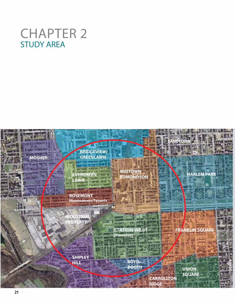
CHAPTER 2
MOSHERBRIDGEVIEW/GREENLAWN
EVERGREENLAWN
MIDTOWNEDMONDSON
ROSEMONTHomeowners/Tenants
HARLEM PARK
PENROSE FRANKLIN SQUARE
SHIPLEYHILL BOYD-
BOOTH
CARROLLTON RIDGE
UNIONSQUARE
STUDY AREA
STATION WEST(Penrose)
SANDTOWN
West Balt imore MARC Transit-Centered Community Development Strategy ��
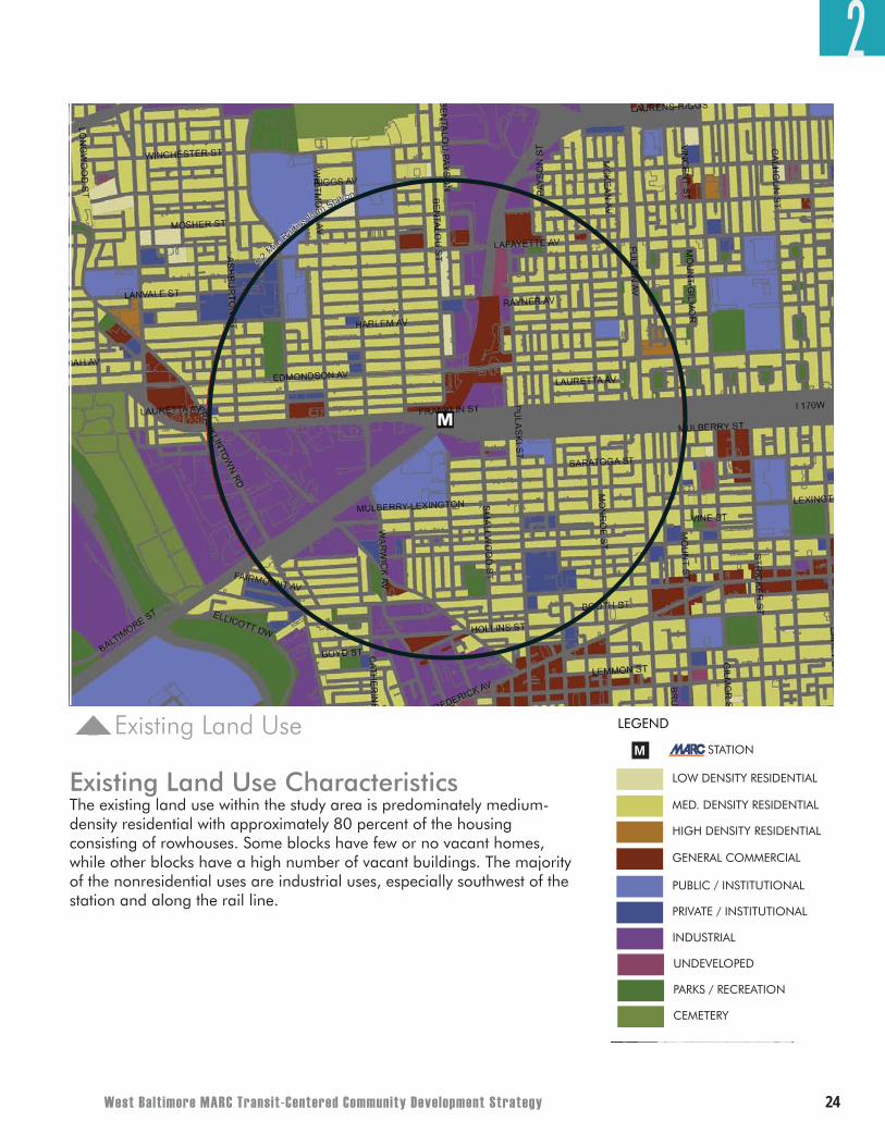
Site Context
The principal study area is roughly a half-mile circle around the West Baltimore MARC station. This distance was chosen because it represents approximately a 10-minute walk from the station to the furthest point, which is considered the longest time and furthest distance most people will walk to transit. The study area provides a guide for focusing planning efforts. However, it is recognized that community improvements are needed beyond this distance and that many neighborhoods – particularly east of the half mile circle identify the MARC Station and transit as a major focus of their revitalization potential. Even though the Strategy lays out land use alternatives for the study area, many of the recommended processes and implementation tools can and should be applied to other areas beyond the half mile radius.
2
23
Neighborhoods Within the Focus AreaBaltimore is a city of neighborhoods, and within the focus area there are many neighborhoods:
• Harlem Park/Lafayette Square• Midtown Edmondson• Rosemont Homeowners/Tenants• Evergreen Lawn • Bridgeview/Greenlawn
Some neighborhoods are fully encompassed in the focus area; other neighborhoods have only pieces of their community within the focus area. All are in the West Baltimore Coalition’s Communities of Neighborhoods. The success of the Strategy is dependent on the various groups coming together with a common vision for how to use the MARC station to spark West Baltimore’s revitalization.
Socioeconomic and Demographic CharacteristicsIn 2000 (according to the 2000 Census), the total population of the ten neighborhoods was approximately 25,000 people. Since the late 1950s Baltimore City as a whole experienced consistent population and household loss over time due to urban flight to the suburbs. Unlike many urban areas, neighborhoods in West Baltimore are mostly families rather than single people or childless couples. Nearly one-third of the total neighborhood population in 2000 was comprised of those 19 and younger as compared to 28 percent for the City.
West Baltimore contains nearly 12,290 housing units of which 75 percent are occupied, according to the 2000 U.S. Census. Note that this total housing unit count has changed due to some new development and housing demolition occurring since 2000. Of the total occupied housing units, 45 percent were owner-occupied, while 55 percent were renter-occupied. Boyd-Booth, Franklin Square, and Harlem Park/Lafayette Square had very high renter-occupied percentages – at least 70 percent. Evergreen and Rosemont had the lowest renter occupied percentage – 23 percent. The 1999 median household income for the ten neighborhoods was $23,500, which was lower than Baltimore City’s median income of $30,000. Approximately 30 percent of West Baltimore residents were classified as being below the poverty line compared to 23 percent in Baltimore City.
2
• Mosher• Station West (Penrose)• Franklin Square• Boyd-Booth• Shipley Hill
West Balt imore MARC Transit-Centered Community Development Strategy ��
Existing Land Use
EXISTING LAND USE
LEGEND
WEST BALTIMORE MARC STATION
LOW DENSITY RESIDENTIAL
0 2000
MARC STATIONM
1000500
MED. DENSITY RESIDENTIAL
HIGH DENSITY RESIDENTIAL
GENERAL COMMERCIAL
PUBLIC / INSTITUTIONAL
PRIVATE / INSTITUTIONAL
INDUSTRIAL
UNDEVELOPED
PARKS / RECREATION
CEMETERY
FEET
OCTOBER 2007
EXISTING LAND USE
LEGEND
WEST BALTIMORE MARC STATION
LOW DENSITY RESIDENTIAL
0 2000
MARC STATIONM
1000500
MED. DENSITY RESIDENTIAL
HIGH DENSITY RESIDENTIAL
GENERAL COMMERCIAL
PUBLIC / INSTITUTIONAL
PRIVATE / INSTITUTIONAL
INDUSTRIAL
UNDEVELOPED
PARKS / RECREATION
CEMETERY
FEET
OCTOBER 2007
Existing Land Use CharacteristicsThe existing land use within the study area is predominately medium-density residential with approximately 80 percent of the housing consisting of rowhouses. Some blocks have few or no vacant homes, while other blocks have a high number of vacant buildings. The majority of the nonresidential uses are industrial uses, especially southwest of the station and along the rail line.
2
��
Significant Physical Assets and Liabilities West Baltimore has a number of significant assets that it should use to leverage new development. The MARC station provides residents with access to job centers in BWI Airport and the District of Columbia and to future job growth areas such as at the expanding military bases at Fort Meade and Aberdeen Proving Ground. The MTA has a long-term vision to expand MARC service. The planned Red Line transit project could expand access to include quick connections to Baltimore’s central business district, the Social Security Administration and Centers for Medicare and Medicaid Services, as well as to growing job centers on Baltimore’s East side.
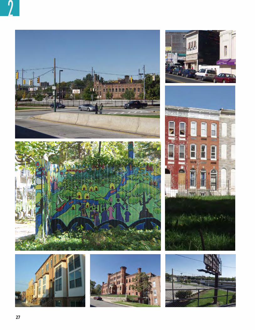
The Gwynns Falls and the newly opened trail following it provide recreational activities not before available. West Baltimore should look for ways to increase access to this significant natural resource.
The historic Ice House and strong, stable residential streets are other assets that should be built upon. Even the area’s liabilities – the Highway to Nowhere (now to be called the Highway to Somewhere) and the vacant homes – provide exciting development opportunities.
Institutional Players with Influence in the AreaWest Baltimore has several nearby institutions that can serve as valuable partners for its revitalization. Large landowners within the study area include Coppin State University (Lutheran Hospital and Hebrew Orphanage: 28 acres northwest of the MARC station), Baltimore City (parking lots adjacent to the MARC station, Acme Industrial Complex, the Route 40 right-of-way ,a.k.a. “the Highway to Somewhere”, and scattered neighborhood sites), and Bon Secours Hospital and Foundation (scattered neighborhood sites). Potential also exists to leverage nearby educational institutions for partnerships in development, workforce training, and job creation. Though the Maryland Transit Administration (MTA) does not own any land other than the MARC train platform, it will have significant influence on decisions made about MARC station improvements, the Red Line, and commuter parking.
2
West Balt imore MARC Transit-Centered Community Development Strategy ��
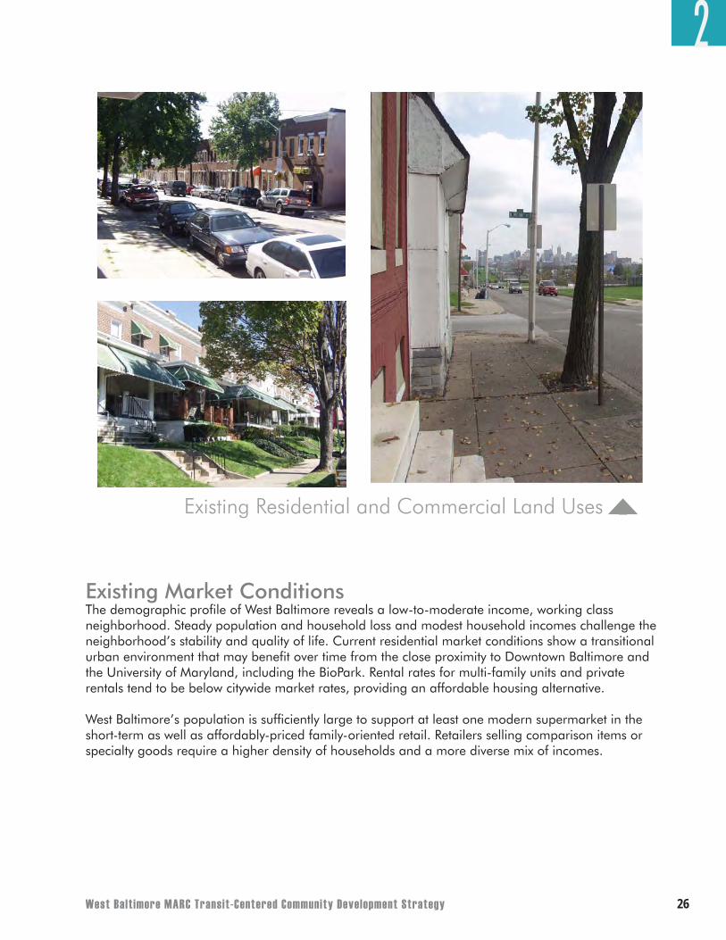
Existing Market ConditionsThe demographic profile of West Baltimore reveals a low-to-moderate income, working class neighborhood. Steady population and household loss and modest household incomes challenge the neighborhood’s stability and quality of life. Current residential market conditions show a transitional urban environment that may benefit over time from the close proximity to Downtown Baltimore and the University of Maryland, including the BioPark. Rental rates for multi-family units and private rentals tend to be below citywide market rates, providing an affordable housing alternative.
West Baltimore’s population is sufficiently large to support at least one modern supermarket in the short-term as well as affordably-priced family-oriented retail. Retailers selling comparison items or specialty goods require a higher density of households and a more diverse mix of incomes.
Existing Residential and Commercial Land Uses
2
��
2
West Balt imore MARC Transit-Centered Community Development Strategy ��
2PRINCIPLES
One of the most important products to come from the City and State’s collaboration with the WBC was the creation of explicit development principles. The principles are the “rules” that the community would like the City, State, WBC, and private developers to live by. The principles will guide the WBC in their discussions with the City, State, and private developers about what they – the residents of West Baltimore – want to have happen in their neighborhoods. The principles describe those issues that are most important to the community and form the foundation of this Strategy.
Housing PrinciPlesThe housing issues of primary concern to WBC members and various stakeholders are related to preventing resident displacement, maintaining affordability, expanding housing diversity, eliminating prevalent housing vacancy, and providing opportunities for new housing. There is excitement about the opportunities the MARC station and the future Red Line can bring, but there are also fears about the potential impacts they will have on neighborhood affordability. Community consensus centers on providing existing and new households with housing options that meet a variety of needs and lifestyles. The housing principles reflect these desires for West Baltimore and should serve as guidelines for future development. The Action Strategy at the end of this document identifies specific actions necessary to achieve these principles.
Principle 1: Avoid Displacement – Too many revitalizing communities face the threat of existing residents being priced out of their neighborhoods. West Baltimore is no exception. While new households should be embraced, the plan must protect the current residents’ ability to remain. Mechanisms such as property tax controls and increases in homestead exemptions for fixed-income residents can lessen the impact of property tax increases and rising home prices. The Action Strategy cites more tasks to be considered to prevent displacement.
Principle 2: Maintain Housing Affordability – Continuing to offer affordable housing options in West Baltimore is critical as the neighborhood revitalizes. Regulatory tools requiring new housing projects to include affordable units are key to ensuring an adequate supply of new moderately-priced housing. In addition, the City and State have several programs designed to assist qualified individuals financially with home purchases, home rehabilitation, and home repair (see Appendix A for specific information on housing tools and resources). Environmentally-friendly home improvements that improve energy efficiency can also decrease monthly housing costs, which can help residents to continue to afford housing.
Principle 3: Increase Housing Diversity – Neighborhoods with an assortment of housing types typically thrive because they meet the needs of a range of households with different lifestyles. While singles and childless couples may prefer condominiums for ease of maintenance and limited space needs, families with children may prefer larger single-family homes with private backyards. Seniors may favor multi-level apartments with convenient ground floor retail options. To maximize interest and feasibility of living in West Baltimore that could be generated by the MARC station and the future Red Line, the area should offer a variety of housing options. In addition, the ability to serve a mix of households with housing types of various densities and price points greatly contributes to a community’s stability. The Development Strategy presents several potential sites to introduce a diversity of housing choices within West Baltimore.
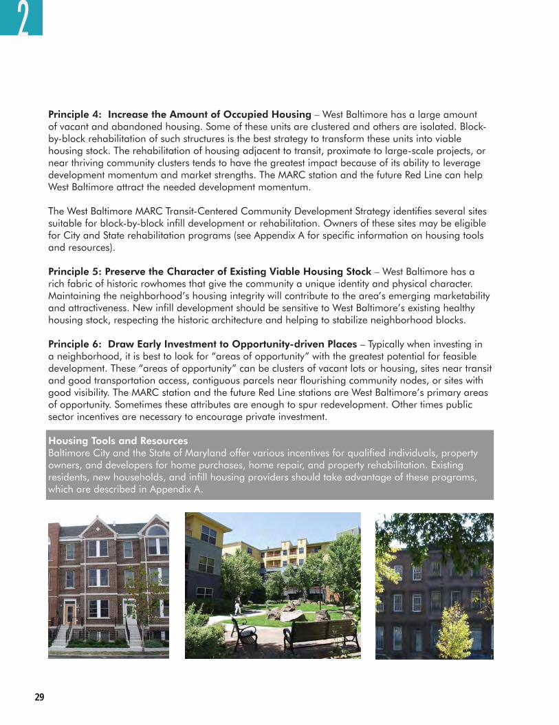
��
Principle 4: Increase the Amount of Occupied Housing – West Baltimore has a large amount of vacant and abandoned housing. Some of these units are clustered and others are isolated. Block-by-block rehabilitation of such structures is the best strategy to transform these units into viable housing stock. The rehabilitation of housing adjacent to transit, proximate to large-scale projects, or near thriving community clusters tends to have the greatest impact because of its ability to leverage development momentum and market strengths. The MARC station and the future Red Line can help West Baltimore attract the needed development momentum.
The West Baltimore MARC Transit-Centered Community Development Strategy identifies several sites suitable for block-by-block infill development or rehabilitation. Owners of these sites may be eligible for City and State rehabilitation programs (see Appendix A for specific information on housing tools and resources).
Principle 5: Preserve the Character of Existing Viable Housing Stock – West Baltimore has a rich fabric of historic rowhomes that give the community a unique identity and physical character. Maintaining the neighborhood’s housing integrity will contribute to the area’s emerging marketability and attractiveness. New infill development should be sensitive to West Baltimore’s existing healthy housing stock, respecting the historic architecture and helping to stabilize neighborhood blocks.
Principle 6: Draw Early Investment to Opportunity-driven Places – Typically when investing in a neighborhood, it is best to look for “areas of opportunity” with the greatest potential for feasible development. These “areas of opportunity” can be clusters of vacant lots or housing, sites near transit and good transportation access, contiguous parcels near flourishing community nodes, or sites with good visibility. The MARC station and the future Red Line stations are West Baltimore’s primary areas of opportunity. Sometimes these attributes are enough to spur redevelopment. Other times public sector incentives are necessary to encourage private investment.
Housing Tools and ResourcesBaltimore City and the State of Maryland offer various incentives for qualified individuals, property owners, and developers for home purchases, home repair, and property rehabilitation. Existing residents, new households, and infill housing providers should take advantage of these programs, which are described in Appendix A.
2
West Balt imore MARC Transit-Centered Community Development Strategy �0
economic DeveloPment PrinciPlesEconomic development – large-scale business creation and retention, small business development and entrepreneurship, job creation and workforce training – forms the basic foundation for neighborhood revitalization. The West Baltimore MARC station, the future Red Line, and the associated riders can help attract the large and small businesses needed to spark the neighborhood’s revitalization. The economic development principles for West Baltimore address all of these issues as well as the importance of education as a fundamental factor for entrepreneurship and enhancing employment. A key purpose of this study is also to identify key areas where these principles could be put into practice. The Action Strategy at the end of this plan identifies specific actions and partnerships necessary to achieve these principles.
Principle 1: Cultivate Large-Scale Economic Development Opportunities – West Baltimore suffers from a lack of services, jobs, and amenities for residents. New mixed-use development within the neighborhood would serve the current population and attract new households. Strategic focus on providing large-scale economic catalysts near the MARC station or along the future Red Line or on publicly-owned land could spur additional investment in other parts of the neighborhood, as the area population and retail spending grow. A marketing strategy for West Baltimore that highlights emerging positive trends could also encourage further revitalization.
The West Baltimore MARC Transit-Centered Community Development Strategy shows several areas as potential reinvestment opportunities, including the MARC station parking lots, the Ice House, and the Southwest Industrial Area (a.k.a. the Warwick Triangle). Their connection to the MARC station, the future Red Line and other points outward make them prime locations for large-scale economic development.
These sites vary in terms of their readiness for development. Because there are multiple property owners within the Warwick Triangle, development at this location would require extensive acquisition and assemblage of land. The MARC Station parking lots offer the advantage of available public land under sole ownership and could be developed sooner, although short-term accommodations for replacement commuter parking are necessary. The Ice House offers the advantage of single private ownership, adjacency to publicly-owned land, and the preservation of an historic façade. Weak market conditions coupled with the high cost of construction pose as challenges for all these sites.
There are many factors that determine whether a specific market area and site will attract private investment – ultimately determining development readiness. In order to attract private investment into a specific area there must be favorable market conditions, regulatory environment and community support. In addition to these area specific needs the site itself must be unencumbered by environment constraints, supported by adequate infrastructure and accessible for vehicles, public transportation and/or pedestrian access.
Developers always consider the degree of risk associated with a new project and evaluate its potential for success. To attract developers to West Baltimore, the community and the City must work together to encourage positive change and, thereby, reduce risks. Examples of positive change include infrastructure and streetscape improvements, beautification efforts, increased police presence, stricter property code enforcement, and evidence of population and household growth. In addition, facilitating development through public subsidy, faster project permitting, and effective public-private
2
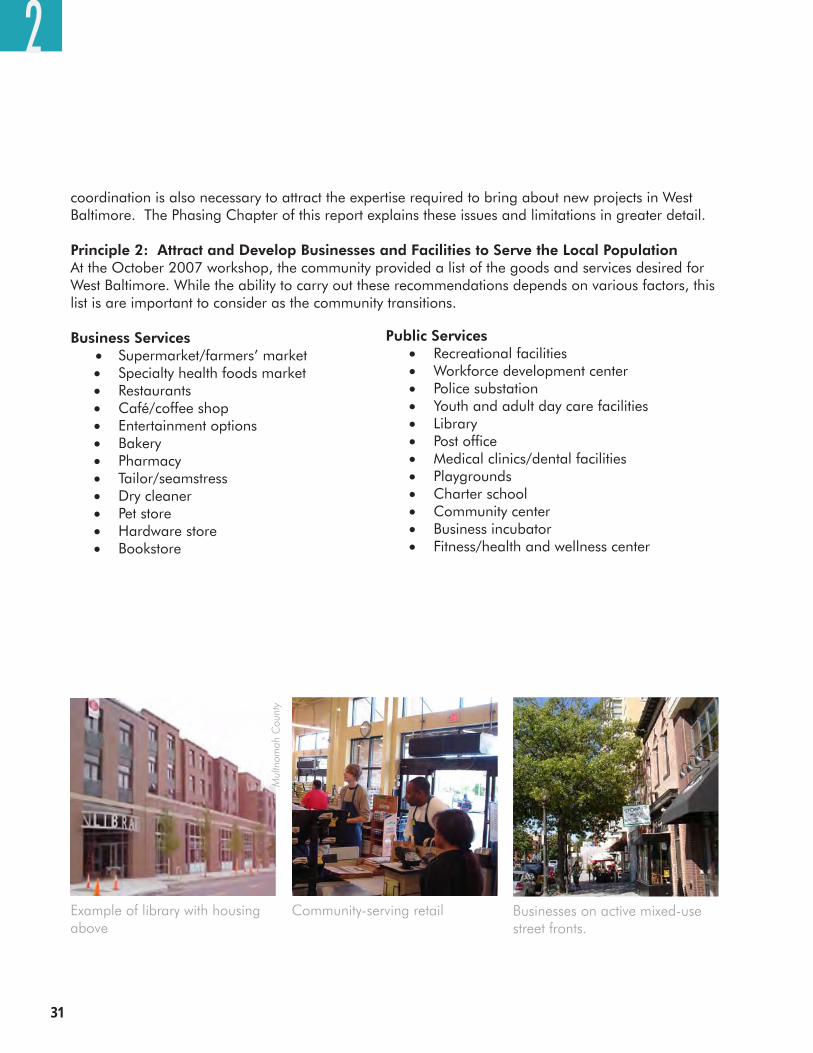
��
coordination is also necessary to attract the expertise required to bring about new projects in West Baltimore. The Phasing Chapter of this report explains these issues and limitations in greater detail.
Principle 2: Attract and Develop Businesses and Facilities to Serve the Local PopulationAt the October 2007 workshop, the community provided a list of the goods and services desired for West Baltimore. While the ability to carry out these recommendations depends on various factors, this list is are important to consider as the community transitions. Business Services• Supermarket/farmers’ market
• Specialty health foods market• Restaurants• Café/coffee shop• Entertainment options• Bakery• Pharmacy• Tailor/seamstress• Dry cleaner• Pet store• Hardware store• Bookstore
2
Example of library with housing above
Mul
tnom
ah C
ount
y
Businesses on active mixed-use street fronts.
Community-serving retail
Public Services• Recreational facilities• Workforce development center• Police substation• Youth and adult day care facilities• Library• Post office• Medical clinics/dental facilities• Playgrounds• Charter school• Community center• Business incubator• Fitness/health and wellness center
West Balt imore MARC Transit-Centered Community Development Strategy ��
Principle 3: Promote Small Business Development and Entrepreneurship – In addition to large-scale economic development, small business development and entrepreneurship are critical for a healthy and stable local economy. Not only can small businesses support large-scale economic development, they also provide unique services and retail options to a community. Edmondson Avenue’s many empty storefronts offer opportunities for clusters of small businesses at certain intersections. The ability to leverage large-scale development at the MARC station site could create initial positive spillover northward onto Edmondson Avenue by attracting more pedestrians and new residents to patronize local stores. As with housing, an important strategy for small business infill is focused block-by-block improvements to buildings and streetscape.
West Baltimore is home to a multitude of talented individuals, some of whom may desire to start their own businesses within the neighborhood. The City and State offer many incentives and tools for budding entrepreneurs and existing business owners (see Appendix B for specific information on economic development tools and resources). These programs range from gap financing for facility improvements and operations to securing tax credits for job creation.
Principle 4: Enhance Local Workforce, Employment Opportunities and Local Business Participation – Neighborhood stability typically relies on residents’ economic health. Better jobs and better wages allow residents to invest more in their homes, while removing some of the impetus for crime. Attracting new businesses that create jobs for local residents will be important. Equally important is to ensure that local residents have the skills required for those new jobs. The neighborhood should foster partnerships with the Mayor’s Office of Employment Development (MOED), Baltimore City, local institutions, and area developers and contractors to assist unemployed, working-age youth and adults in obtaining viable skills and connecting with potential employers. The community is very committed to that residents receiving skill training and access to jobs generated by West Baltimore development as well as possible employment opportunities created elsewhere in the biotech industry, green technology manufacturing, and construction trades. Appendix B highlights some programs available to the local labor force.
In the long run, the neighborhood’s vitality will also depend on the ability of today’s children to compete for future jobs. Public education must help West Baltimore students gain the skills they need and challenge them to reach their full potential.
The participation of local businesses, particularly minority- and women-owned businesses, in West Baltimore’s revitalization is of particular importance to the community. The community and the City of Baltimore’s Minority- and -Women-Owned Business Development Office should work together to ensure that local businesses know about the benefits of minority certification and get registered. The WBC and the City of Baltimore should also work together to evaluate the City’s current minority- and women-owned procurement goals for publicly-owned sites and capital projects and determine how these goals can be enhanced for projects within West Baltimore. The City should continue to promote minority- and women-owned participation at all contracting levels.
2
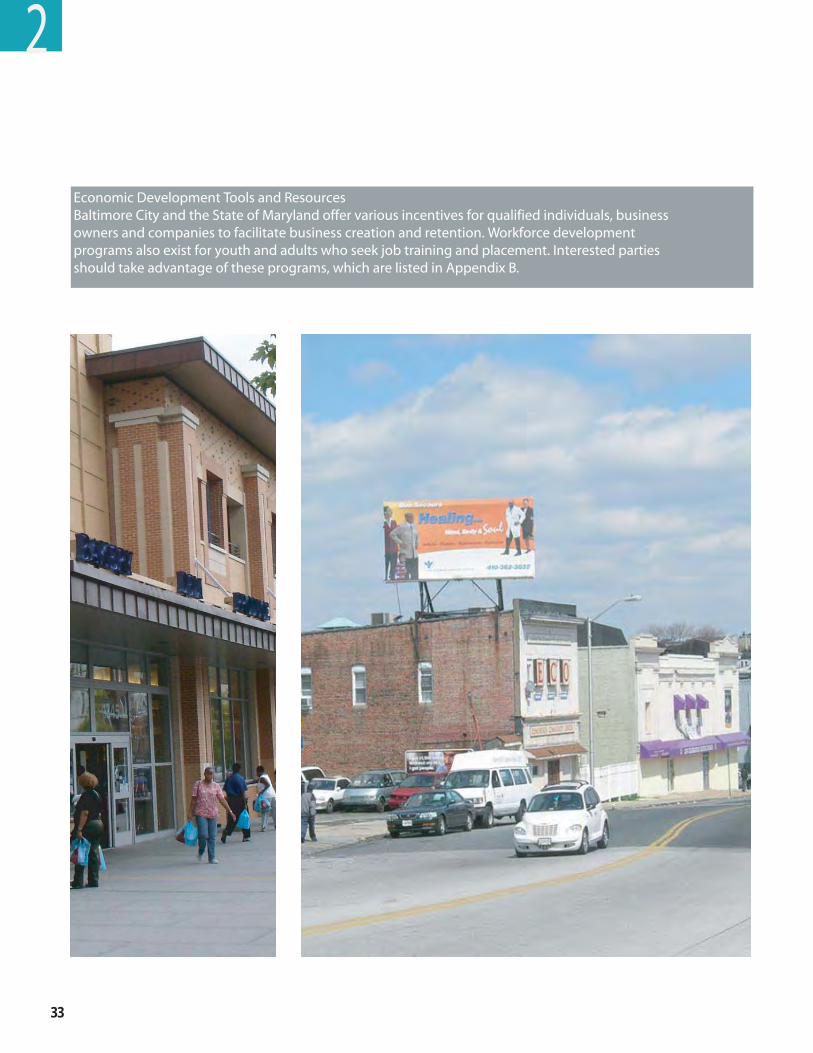
33
Economic Development Tools and Resources Baltimore City and the State of Maryland offer various incentives for qualified individuals, business owners and companies to facilitate business creation and retention. Workforce development programs also exist for youth and adults who seek job training and placement. Interested parties should take advantage of these programs, which are listed in Appendix B.
2
West Balt imore MARC Transit-Centered Community Development Strategy ��
transPortation PrinciPlesWest Baltimore has a variety of transportation modes running through it – commuter trains, buses, local roads, highways, and, in the future, the Red Line. These assets, combined with its location, provide the area with many benefits, including quick and convenient access to job centers in downtown Baltimore, BWI Airport, and Washington, D.C. Indeed, the MTA has been studying parking improvements that might provide additional benefit to the community.
However, access can also bring negatives such as high speed traffic on local roads and commuter parking on residential streets. West Baltimore will thrive when it has taken advantage of the positive qualities its location makes available to it. Following the transportation principles listed below will help future development plans maximize the benefits and minimize the burdens that the current transportation infrastructure has brought to the area.
Principle 1: Use the MARC station and other transit to bring about community improvement– The West Baltimore MARC station and other transit infrastructure can provide West Baltimore with a competitive advantage for redevelopment and revitalization efforts. Currently the MARC station is underutilized as a community asset and mainly serves commuters who drive in from neighborhoods outside of the area. There are approximately 600 people who use the station each day, but only a small percentage of those people live in West Baltimore. The station draws people into West Baltimore, but captures very little value from them. Station upgrades would increase the station’s functionality and strengthen the community’s view of the station as an amenity. Both the West Baltimore MARC Station and the future Red Line could be important tools that draw people to the community and encourage them to utilize the resources available within the community, providing benefit to West Baltimore neighborhoods. Consequently, station upgrades are especially important because deteriorated transportation infrastructure sends a message to residents and those who travel through that nobody cares. Working to develop a sense of place around the station will make it easier to attract investment and bring improvements to the community. Additionally, partnering with the City, other agencies, and the private sector to develop the property around the station will provide community residents with the needed leverage to attract even more funding sources and development to West Baltimore and lay the framework for future private investment. As planning for the Red Line moves forward, designs should emphasize how the Red Line will support other principles and enhance the community.
In addition, the MTA has outlined an aggressive 28-year improvement plan for the MARC system. Ridership is at record levels, and the demand for service is partly driven by Baltimore City’s revitalization. The MARC Growth and Investment Plan’s goals are to increase passenger carrying capacity threefold and increase the share of trips made by MARC during rush hour. For the Penn Line, the line that serves the West Baltimore MARC station, proposed improvements include decreasing the amount of time between trains from 25 minutes to 15 minute headways during rush hour, decreasing the amount of time between trains from once an hour to every 30 minutes in non-rush hour times, and providing late evening and weekend service. MTA has also identified that the West Baltimore Station has exceeded its parking capacity and plans call for the construction of additional parking in future phases of investment. By 2035, the MTA would like MARC to provide “transit-like” service through Baltimore and to provide connections to the planned subway extension from Johns Hopkins Hospital to the vicinity of Morgan State University/Good Samaritan Hospital (the Green Line). In
2
��
addition, the MARC Growth and Investment Plan identifies the West Baltimore MARC Station as being under capacity for parking and has set 2010 as a milestone for parking expansion. This expansion will improve West Baltimore’s access to various locations and make it a more attractive place for people to live and businesses to locate.
Principle 2: Make walking and biking – especially to buses and trains – safer and more inviting and convenient – An improved pedestrian, bicycle, and transit environment is an important component of a revitalized West Baltimore. Improvements that create a safe environment for pedestrians and cyclists would encourage MARC patrons who live in the neighborhood to walk or bike to the station rather than drive and park. This could reduce the need for additional MARC parking and make the area more desirable. Similarly, as the neighborhood redevelops, a safer pedestrian environment could encourage commuter parkers to venture beyond the parking lot and to go into the neighborhood to pick up dry cleaning, groceries, or dinner. Because West Baltimore’s pedestrian environment is so important to the area’s success, making the necessary improvements should be top priorities for the City, the State, and the communities of West Baltimore. Improving the area’s safety is a critical step in promoting revitalization of the West Baltimore area. To help further this goal, there needs to be increased involvement and coordination by the police, security personnel, and residents in the development of strategies to increase neighborhood safety and security. Buses play an important role in the neighborhood that should be respected and promoted. Approximately 60 percent of area residents do not have access to private vehicles, and many people take transit to get to and from jobs, shopping, and recreational activities. Upgrading bus stops with benches, shelters, trash receptacles, and additional lighting would enhance the travel experience for current patrons and could attract new riders. In recognition of Baltimore communities’ reliance on bus transportation, the City and MTA must work cooperatively with communities to ensure strong connections between existing and proposed transit options. The MTA will need to work closely with neighborhood organizations on current and future bus service plans through West Baltimore and to plan for connectivity to the future Red Line and MARC. Finally, creating improved pedestrian and bicycle connections to important destinations in the community such as the Gwynns Falls Trail would also have a positive impact on the neighborhood. This natural resource is a valuable asset and improving its visibility and accessibility to West Baltimore could be a benefit to existing residents and an attractor to new ones.
2
West Balt imore MARC Transit-Centered Community Development Strategy ��
2
Principle 3: Be aware of, and sensitive to, existing community transportation plans –West Baltimore is made up of many neighborhoods. Some of these neighborhoods have created their own redevelopment plans or have identified priority improvements. In recognition of these efforts, it is important to support the individual desires recommended in these neighborhood plans. Individual neighborhoods could feel the impacts of redevelopment around the MARC and future Red Line stations differently and should retain the autonomy to make decisions that will be the most appropriate for their neighborhood while serving the overall goals of the West Baltimore area. For example, decisions about the need for residential parking permits could be made at a neighborhood level without adversely affecting the overall goals of the West Baltimore MARC Transit-Centered Community Development Strategy. Some neighborhoods involved in the WBC have created infrastructure upgrade, pedestrian, and bicycle plans and the Strategy is sensitive to these existing initiatives. The Strategy is not isolated from other planning efforts, and it is important that the planning process inform and be informed by other planning efforts that are occurring. This includes planning efforts for the Red Line, which propose a transit alignment from downtown Baltimore to the West Baltimore MARC station and beyond. In these instances, it is important for community members to clearly identify their priorities and use them as a guide for other plans, as applicable to their community.
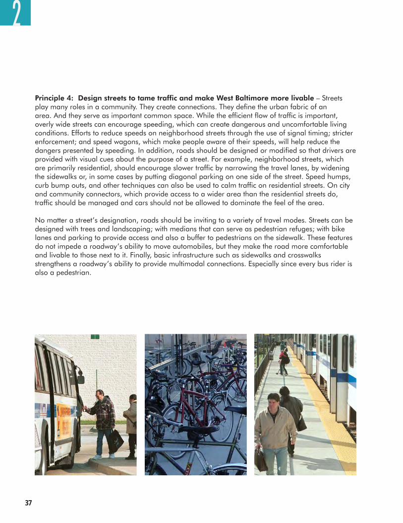
��
2
Principle 4: Design streets to tame traffic and make West Baltimore more livable – Streets play many roles in a community. They create connections. They define the urban fabric of an area. And they serve as important common space. While the efficient flow of traffic is important, overly wide streets can encourage speeding, which can create dangerous and uncomfortable living conditions. Efforts to reduce speeds on neighborhood streets through the use of signal timing; stricter enforcement; and speed wagons, which make people aware of their speeds, will help reduce the dangers presented by speeding. In addition, roads should be designed or modified so that drivers are provided with visual cues about the purpose of a street. For example, neighborhood streets, which are primarily residential, should encourage slower traffic by narrowing the travel lanes, by widening the sidewalks or, in some cases by putting diagonal parking on one side of the street. Speed humps, curb bump outs, and other techniques can also be used to calm traffic on residential streets. On city and community connectors, which provide access to a wider area than the residential streets do, traffic should be managed and cars should not be allowed to dominate the feel of the area.
No matter a street’s designation, roads should be inviting to a variety of travel modes. Streets can be designed with trees and landscaping; with medians that can serve as pedestrian refuges; with bike lanes and parking to provide access and also a buffer to pedestrians on the sidewalk. These features do not impede a roadway’s ability to move automobiles, but they make the road more comfortable and livable to those next to it. Finally, basic infrastructure such as sidewalks and crosswalks strengthens a roadway’s ability to provide multimodal connections. Especially since every bus rider is also a pedestrian.
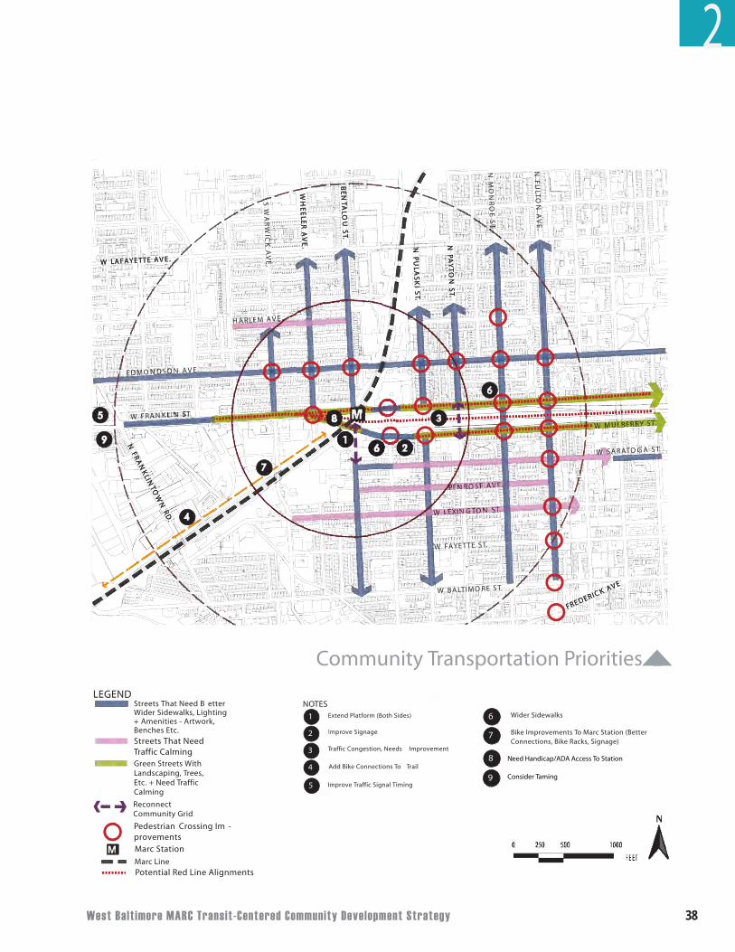
West Balt imore MARC Transit-Centered Community Development Strategy 38
4
2
5
1
.TS EROMITLAB WEVA KCIREDERF
.
.EVA ETTEYAFAL W
.TS
IK
SAL
UP
N
.D
R N
WOT
NIL
KN
ARF
N
.TS
UOL
ATN
EB
.E
VA
REL
EE
HW
.TS
NO
TY
AP
N
7
6
8
69
3
EVA KCIREDERF
.
.EVA ETTEYAFAL W
.EVA NOSDNOMDE
.TKNARF W
.E
VA
NO
TLU
F N
.TS
IK
SAL
UP
N
.E
VA
KCI
WR
AW
S
.D
R N
WOT
NIL
KN
ARF
N
.TS
UOL
ATN
EB
.TS AGOTARAS W
.EVA ESORNE
.TS NOTGNIXEL W
S E
OR
NO
M N
.E
VA
REL
EE
HW
.TS
NO
TY
AP
N
EVA MELRAH
.TS YRREBLUM W
.TS ETTEYAF W
M
Community Transportation Priorities
Marc StationM
Streets That NeedTraffic Calming
Pedestrian Crossing Im -provements
Potential Red Line Alignments
LEGEND
Marc Line
Streets That Need B etter Wider Sidewalks, Lighting+ Amenities - Artwork, Benches Etc.
Green Streets With Landscaping, Trees, Etc. + Need Traffic Calming
Reconnect Community Grid
6
7
8
9
Wider Sidewalks
Bike Improvements To Marc Station (Better Connections, Bike Racks, Signage)
Need Handicap/ada Access To Station
Tame Traffic With Roundabout
2
Improve Signage
1
2
3
4
Extend Platform (Both Sides)
NOTES
Traffic Congestion, Needs Improvement
Add Bike Connections To Trail
Improve Traffic Signal Timing 5
g
Need Handicap/ADA Access To Station
Consider Taming
��
CHAPTER 3DEVELOPMENT CONCEPTS
West Balt imore MARC Transit-Centered Community Development Strategy �0
3
Opportunity Is Coming To West Baltimore
West Baltimore residents have signaled that they are ready for change in their neighborhoods. The key question, however, is what form the change will take. There are many “unknowns” facing the area, and every possibility holds major land use implications. Where will the Red Line go? How will the need for additional MARC parking be accommodated? What will happen to the industrial land southwest of the MARC station? What will happen to the Highway to Somewhere?
So that the community can be prepared for a range of possible futures, the West Baltimore MARC Transit-Centered Community Development Strategy is intended to provide guidance as to how the community can work toward their vision as these questions are answered, rather than try to predict a specific future. It outlines different methods for achieving community goals and principles in key areas and reflects residents’ input on how development should “behave” and strengthen the community.
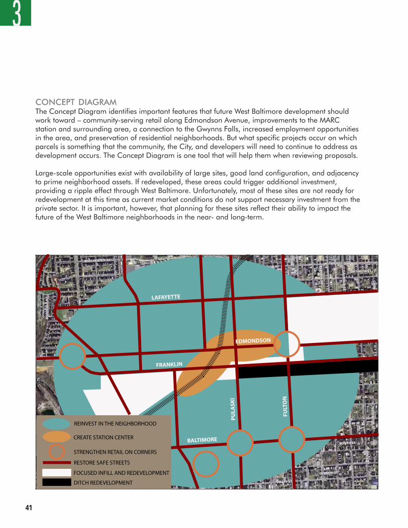
��
3
concePt DiagramThe Concept Diagram identifies important features that future West Baltimore development should work toward – community-serving retail along Edmondson Avenue, improvements to the MARC station and surrounding area, a connection to the Gwynns Falls, increased employment opportunities in the area, and preservation of residential neighborhoods. But what specific projects occur on which parcels is something that the community, the City, and developers will need to continue to address as development occurs. The Concept Diagram is one tool that will help them when reviewing proposals.
Large-scale opportunities exist with availability of large sites, good land configuration, and adjacency to prime neighborhood assets. If redeveloped, these areas could trigger additional investment, providing a ripple effect through West Baltimore. Unfortunately, most of these sites are not ready for redevelopment at this time as current market conditions do not support necessary investment from the private sector. It is important, however, that planning for these sites reflect their ability to impact the future of the West Baltimore neighborhoods in the near- and long-term.
BALTIMORE
FRANKLIN
EDMONDSON
LAFAYETTE
PU
LASK
I
FULT
ON
REINVEST IN THE NEIGHBORHOOD
CREATE STATION CENTER
STRENGTHEN RETAIL ON CORNERS
RESTORE SAFE STREETS
FOCUSED INFILL AND REDEVELOPMENT
DITCH REDEVELOPMENT
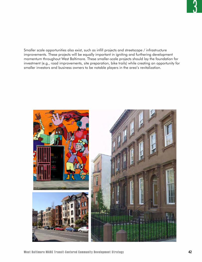
West Balt imore MARC Transit-Centered Community Development Strategy ��
3
Smaller scale opportunities also exist, such as infill projects and streetscape / infrastructure improvements. These projects will be equally important in igniting and furthering development momentum throughout West Baltimore. These smaller-scale projects should lay the foundation for investment (e.g., road improvements, site preparation, bike trails) while creating an opportunity for smaller investors and business owners to be notable players in the area’s revitalization.
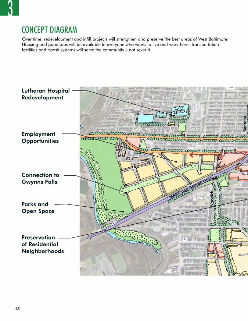
��
Warw
ick
MARC and Amtrak Lines
3CONCEPT DIAGRAM
Lutheran Hospital Redevelopment
Connection to Gwynns Falls
Parks and Open Space
Employment Opportunities
Over time, redevelopment and infill projects will strengthen and preserve the best areas of West Baltimore. Housing and good jobs will be available to everyone who wants to live and work here. Transportation facilities and transit systems will serve the community – not sever it.
Preservation of Residential Neighborhoods
Ben
talo
u
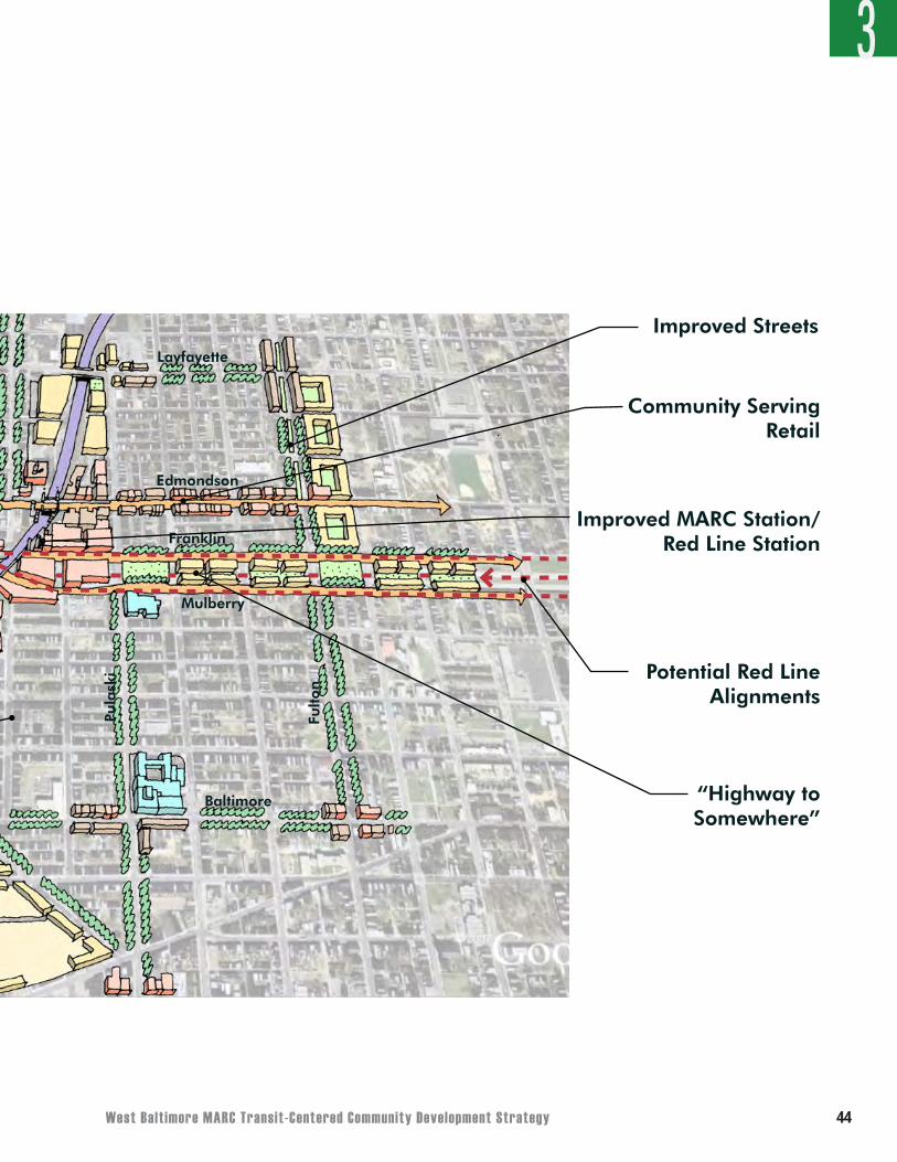
West Balt imore MARC Transit-Centered Community Development Strategy ��
Ben
talo
u
Franklin
Mulberry
Edmondson
Baltimore
Pula
ski
Layfayette
Fulto
nImproved Streets
3
Potential Red LineAlignments
Community Serving Retail
Improved MARC Station/Red Line Station
“Highway to Somewhere”
45
3
WEST BALTIMORE MARC STATION/ICE HOUSEThe West Baltimore MARC station will continue to provide commuter rail transit access and could grow in importance by serving as a key connection point to the future Red Line. However, it should also evolve into a community activity center. The character of the station is envisioned as improving aesthetically and in terms of safety with the development of adjacent, active, complementary uses and station-focused renovations.
Land Use: Although the existing station is currently transportation focused, over time mutually-supportive uses such as retail or office should be incorporated. These may be as simple as the short-term addition of a newsstand and/or food cart vendors or the longer-term pursuit of redevelopment of the MARC station surface parking lots into mixed-use buildings. Based on input received at the October 12-13, 2007 public workshops, additional uses that may fit well with station improvements could include:
Business Services• Dry cleaner/tailor/seamstress• Bank/ATM• Café/ coffee shop• Convenience market
Circulation: The existing station provides commuter rail patrons with minimal amenities aside from parking and rail transit access. There are a number of circulation improvements that would be of benefit:
• Pedestrian and handicapped access improvements including an elevator and accessible paths.
• Street crossing improvements including signage and crosswalk striping. • Measures to calm traffic on Franklin and Mulberry. • Bus transit improvements including additions of shelters, signage, lighting, and pedestrian
paving. • Platform improvements including signage, lighting, seating and weather protection. • Incorporation of bicycle facilities including: striped on-street lanes and/or off street paths
connecting the station to the adjacent neighborhoods; and ample, secure, covered bicycle parking at the station.
• Visual and functional integration with any future Red Line transit project, facilitating seamless pedestrian connectivity.
Public Services • Child care • Small police substation
• Civic space/library • Small post office

West Balt imore MARC Transit-Centered Community Development Strategy ��
Parking: Station area parking needs to be more effectively managed. Some parking related improvements include:
• Adding parking area aesthetic improvements including decorative paving, landscaping, signing, and lighting.
• Providing parking area functional improvements including signage, lighting, seating, and weather protection.
• Addressing short-and longer-term parking needs through limited expansion/extension of existing lots that will ultimately be replaced by parking garages as part of larger redevelopment program.
• Institute a residential parking permit and enforcement program (for example, free on-street parking for neighborhood residents, metered or time-limited for non-residents).
Urban Design: The existing station is aging, unattractive, and functionally inadequate. The station could be remade as a more positive addition to the public realm, supporting the creation of great station area neighborhoods. There are many potential improvements that would be of benefit:
• Renovation of platform and adjacent structures with an eye toward their roles as “civic infrastructure” and the scale and aesthetic experience of pedestrians.
• Architectural improvements (site and structure design, material selection, colors) that elevate the station’s status to that of a community landmark.
• Incorporation of public art.• Incorporation of activating, supportive mixed uses.• Strengthening pedestrian connections to adjacent neighborhoods.
Parks and Open Space: Since the station functions as a place for people to gather, the opportunity exists to provide a small plaza near the station entry. This could serve multiple functions in terms of providing a gateway for West Baltimore, aesthetic improvements, waiting areas for transit patrons, a community recreational asset, and/or a stormwater management device.
3
Ice House History
The American Ice Company, Franklin Street Plant, is one of two surviving artificial ice manufacturing plants in Baltimore. From the mid-19th century to WWII, businesses and households relied on ice to prevent foods from spoiling. With the technological ability to produce ice, the American Ice Company of New York built at least five plants in Baltimore. The Franklin Street Plant, built in 1911 by New York architects, Mortimer and Company, cost $225,000. It was the largest ice manufacturing plant in Baltimore and consisted of a boiler room, engine room, tank house, and warehouse. A large two-story stable (now demolished) was built across Franklin Street from the plant, and a two-story office building (now demolished) sat directly east of the plant. This complex produced approximately 40 tons of ice annually. Between 1914 and 1951, the American Ice Company modernized the plant. Sometime after the 1960s, the American Ice Company sold the property to the Baltimore American Ice Company which manufactured ice until a devastating fire in 2004.
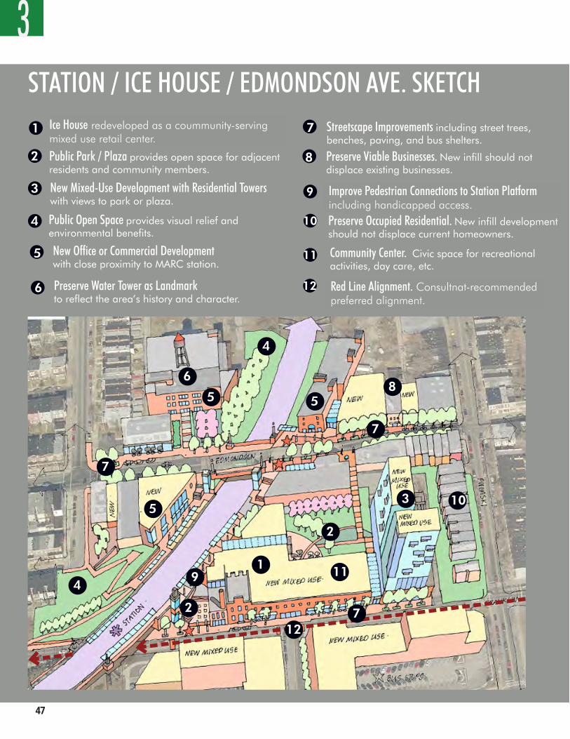
��
3
44 WORKING DRAFT
STATION / ICE HOUSE / EDMONDSON AVE. SKETCHIce House redeveloped as a community serving mixed use retail center
Public Park / Plaza provides open space for adjacent residents and community members.
1
2
3
4
6
5
7
1
2
3 New Mixed-Use Development with Residential Towerswith views to park or plaza.
4
6
5
7
Public Open Space provides visual relief and environmental benefits.
New Office or Commercial Developmentwith close proximity to MARC station.
Preserve Water Tower as Landmarkto reflect the area’s history and character.
Streetscape Improvements including street trees, benches, paving, and bus shelters.
8 Preserve Viable Businesses. New infill should not displace existing businesses.
9 Improved Pedestrian Connections to Station Platformincluding handicapped access.
5
4
5
7
8
10 Preserve Occupied Residential. New infill development should not displace current homeowners.
10
9
2
11
11 Community Center. Civic space for recreational activities, day care, etc.
3
Red Line Alignment. Consultant recommendedpreferred alignment.
12
712
Ice House redeveloped as a coummunity-serving mixed use retail center.
Red Line Alignment. Consultnat-recommended preferred alignment.
Improve Pedestrian Connections to Station Platform including handicapped access.
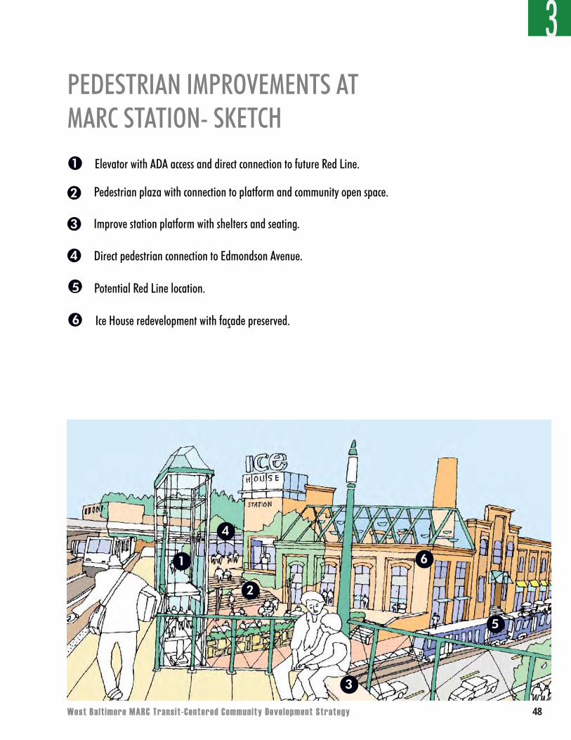
West Balt imore MARC Transit-Centered Community Development Strategy ��
3
1
2
3
4
6
5
Elevator with ADA access and direct connection to future Red Line.
Pedestrian plaza with connection to platform and community open space.
Improve station platform with shelters and seating.
Direct pedestrian connection to Edmondson Avenue.
Potential Red Line location.
Ice House redevelopment with façade preserved.
1
2
3
4
5
6
PEDESTRIAN IMPROVEMENTS AT MARC STATION- SKETCH
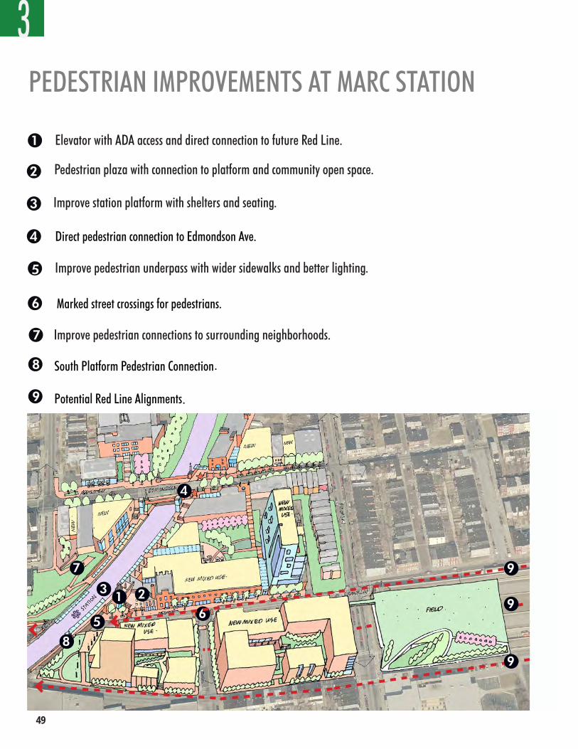
��
3
46 WORKING DRAFT
1
2
3
4
6
5
1 23
6
7
5
4
7
Elevator provides ADA access and direct connection to future Red Line.
Pedestrian plaza provides connection to platform and community open space.
Improved station platform with shelters and seating.
Direct pedestrian connection to Edmondson Ave.
Improved pedestrian underpass with wider sidewalks and better lighting.
Marked street crossings for pedestrians.
Improved pedestrian connections to surrounding neighborhoods.
PEDESTRIAN IMPROVEMENTS AT MARC STATION
3
8
8 South Platform Pedestrian Connection
Potential Red Line Alignments9
4
7
31 2
5
8
6
9
9
9
Elevator with ADA access and direct connection to future Red Line.
Pedestrian plaza with connection to platform and community open space.
.
.
Improve station platform with shelters and seating.
Improve pedestrian underpass with wider sidewalks and better lighting.
Improve pedestrian connections to surrounding neighborhoods.
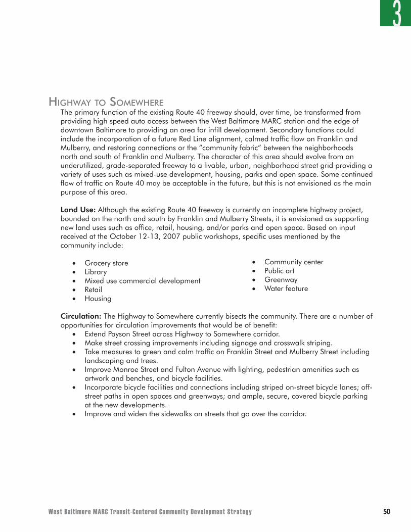
West Balt imore MARC Transit-Centered Community Development Strategy �046 WORKING DRAFT
1
2
3
4
6
5
1 23
6
7
5
4
7
Elevator provides ADA access and direct connection to future Red Line.
Pedestrian plaza provides connection to platform and community open space.
Improved station platform with shelters and seating.
Direct pedestrian connection to Edmondson Ave.
Improved pedestrian underpass with wider sidewalks and better lighting.
Marked street crossings for pedestrians.
Improved pedestrian connections to surrounding neighborhoods.
PEDESTRIAN IMPROVEMENTS AT MARC STATION
3
8
8 South Platform Pedestrian Connection
Potential Red Line Alignments9
HigHWay to someWHereThe primary function of the existing Route 40 freeway should, over time, be transformed from providing high speed auto access between the West Baltimore MARC station and the edge of downtown Baltimore to providing an area for infill development. Secondary functions could include the incorporation of a future Red Line alignment, calmed traffic flow on Franklin and Mulberry, and restoring connections or the “community fabric” between the neighborhoods north and south of Franklin and Mulberry. The character of this area should evolve from an underutilized, grade-separated freeway to a livable, urban, neighborhood street grid providing a variety of uses such as mixed-use development, housing, parks and open space. Some continued flow of traffic on Route 40 may be acceptable in the future, but this is not envisioned as the main purpose of this area.
Land Use: Although the existing Route 40 freeway is currently an incomplete highway project, bounded on the north and south by Franklin and Mulberry Streets, it is envisioned as supporting new land uses such as office, retail, housing, and/or parks and open space. Based on input received at the October 12-13, 2007 public workshops, specific uses mentioned by the community include:
• Grocery store• Library• Mixed use commercial development• Retail• Housing
Circulation: The Highway to Somewhere currently bisects the community. There are a number of opportunities for circulation improvements that would be of benefit:
• Extend Payson Street across Highway to Somewhere corridor. • Make street crossing improvements including signage and crosswalk striping.• Take measures to green and calm traffic on Franklin Street and Mulberry Street including
landscaping and trees.• Improve Monroe Street and Fulton Avenue with lighting, pedestrian amenities such as
artwork and benches, and bicycle facilities.• Incorporate bicycle facilities and connections including striped on-street bicycle lanes; off-
street paths in open spaces and greenways; and ample, secure, covered bicycle parking at the new developments.
• Improve and widen the sidewalks on streets that go over the corridor.
• Community center• Public art• Greenway• Water feature
3
��
Parking: As the Route 40 corridor is redeveloped, parking for the new uses is envisioned as being accommodated in a combination of on-site and on-street facilities. Since this corridor will likely contain the future Red Line transit project, parking ratios should be kept as low as possible (such as one space per dwelling unit or lower) to support walking and transit use. In response to immediate community concerns about MARC commuters parking in the neighborhood the MTA is currently looking at different short-term and longer-term parking solutions. Appendix D provides information about the different sites the MTA is considering. The MTA should work with the community to evaluate the alternatives to ensure that parking investments further the community’s longer term goal of creating active, mixed-use development around the station area.
Other recommended best management practices for parking include:• Put parking behind, above, or to the side of buildings.• Divide large parking areas and design them as an integral part of the community. Avoid
large continuous lots of parking that make areas less appealing for pedestrians.• Share surface parking areas between uses, and manage them communally.• Promote on-street parking for visitors and short-term users.• Charge visitors/non-residents for on-street parking and invest the returns into the
neighborhood.• Keep unsecured parking in clear view of active, adjacent uses.• Soften, screen, and/or provide active uses along ground floor frontages of multistory
parking structures.• Locate single-family home parking at the side or service from rear alleys – driveways and
garage doors should not be allowed in front of single-family homes.
Urban Design: In addition to being functionally incomplete, the existing Route 40 freeway is an unattractive “no man’s land” for pedestrians and adjacent properties. The opportunity exists to remake this area into a more positive element relating to the adjacent neighborhoods. There are many potential improvements that could have benefit, including:
• Incorporate a large-scale (temporary or permanent) public art project.• Take advantage of investment opportunities connected to the Red Line project to redefine
the highway into blocks ready for new neighborhood infill development.• Break down the overwhelming scale of the right-of-way by small, coordinated
interventions that work toward achieving a larger, complete redevelopment vision.
Parks and Open Space: As part of the plan for reclaiming the Route 40 right of way for infill development, locations for parks and open spaces should be identified to provide recreational opportunities and visual relief.
3
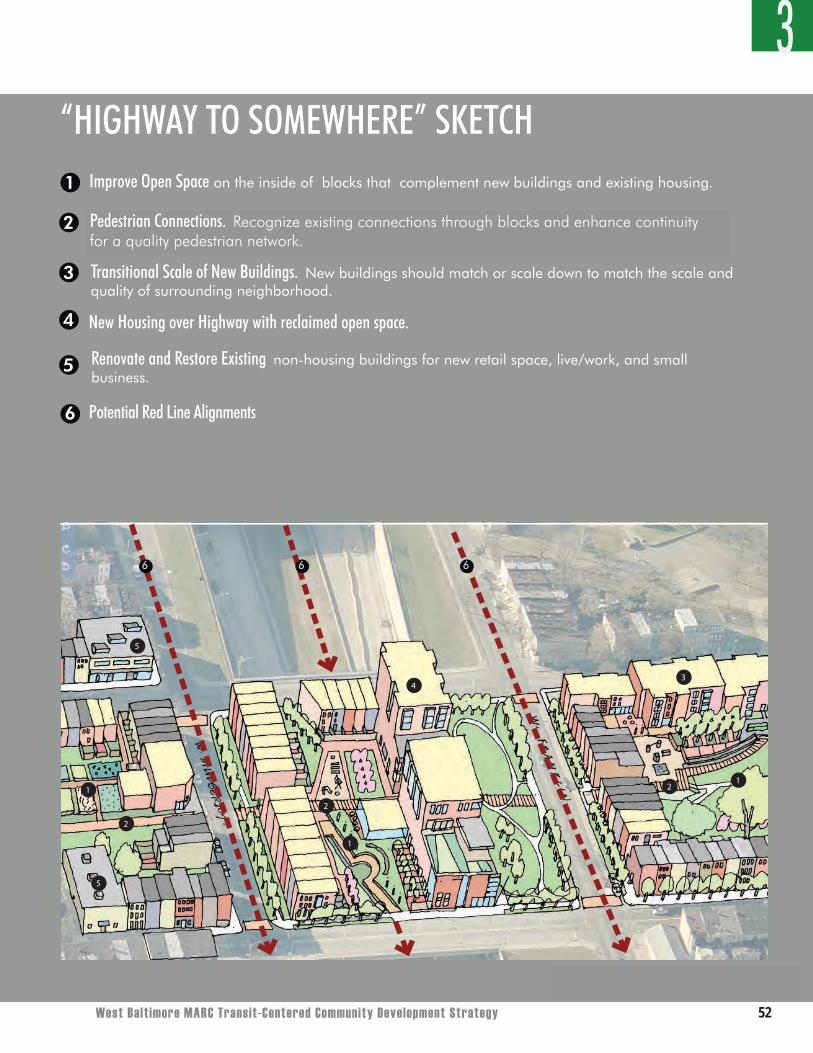
West Balt imore MARC Transit-Centered Community Development Strategy ��
3
West Balt imore MARC Transit Centered Community Development WORKING DRAFT 49
3
12
4
5
2
2
3
5
1
1
tunties for the continuity
“HIGHWAY TO SOMEWHERE” SKETCHImprove Open Space on the inside of blocks that complement new buildings and existing housing.
Pedestrian Connection. Recognize existing connections through blocks and enhance continuity for a quality pedestrian network.
1
2
3 Transitional Scale of New Buildings. New buildings should match or scale down to match the scale and quality of surrounding neighborhood.
4
5
New Housing over Highway with reclaimed open space.
Renovate and Restore Existing non-housing buildings for new retail space, live/work, and small business.
Potential Red Line
Potential Red Line Alignments6
6 6 6
Pedestrian Connections. Recognize existing connections through blocks and enhance continuity for a quality pedestrian network.
��
soutHWest inDustrial area (“WarWick triangle”)The triangular piece of land bounded by Franklin Street to the north, the railroad tracks to the south, and the cemetery and Gwynns Falls to the west is currently low-density industrial uses. Because of the area’s proximity to the MARC Station (which is located in the northeast corner of the triangle) and the Gwynns Falls, the long-term function of The Warwick Triangle area should transition from primarily industrial to more mixed-use in nature, with higher intensity uses closest to the station. The character of The Triangle will be enhanced by creating an internal street network, providing a linear path or greenway connection to the Gwynns Fall Trail, and providing personal safety enhancements.
As part of the Red Line project, the MTA is currently considering the area closest to the station for a yard and shop facility. The yard and shop facility is where the Red Line vehicles would be stored, maintained, and repaired. A potential benefit of the facility is that it could provide West Baltimore residents with skilled jobs close to home and provide the area with an increased number of employees who may take advantage of local services. A potential disadvantage of the facility is that it may not maximize the development potential presented by the MARC station. However, it may be possible to locate and design the facility so that there is still development potential in addition to providing the MTA with its needed facility. It is important to note that a final yard and shop location decision has not been made, and the City and other interested stakeholders need to weigh in with their opinions about what is best for the neighborhood, the City, and the operation of the Red Line.
Land Use:The site is zoned for, and occupied by, low-density industrial uses. However, given the proximity to the station area, this not the highest and best use for the land. The area should have a mix of uses including those that provide more jobs for area residents. Redevelopment of the Triangle should include a focus on uses that create as many jobs as possible. With more efficient use of land, there is an opportunity to introduce additional uses, including commercial, residential, and public space with access to both the MARC station and Gwynns Falls. The area should be rezoned to reflect these goals.
3
West Balt imore MARC Transit-Centered Community Development Strategy ��
Circulation:• Large site redevelopment will provide opportunities to re-configure the existing large
blocks (blocks with perimeters greater than 1600 feet) with the addition of more local streets to improve access and pedestrian connectivity.
• Street crossing improvements including signage and crosswalk striping.• Improved pedestrian crossings with pavers and cobblestones at intersection of Franklin
Street at Mulberry Street.• Improved (widened) sidewalks along Franklin Street and Mulberry Street.• Measures to calm and green Franklin Street and Mulberry Street, including landscaping
and trees.• Intersection improvements along Franklin Street, including traffic signal timing
improvements. Potential roundabout at the intersection of Franklin Street at Franklintown Road.
• Bus transit improvements including addition of shelters, signage, lighting, and pedestrian paving.
• Incorporation of bicycle facilities including: striped on-street bicycle lanes and/or off-street paths connecting the station to the adjacent neighborhoods and the Gwynns Falls Trail; and ample, secure, covered bicycle parking at the station.
Parking: The land at the northeast of the Triangle, adjacent to the MARC station, is a potential location for surface commuter parking in the short term or in a parking garage as part of a mixed use redevelopment program in the long-term. For the rest of the Triangle, some parking “best management” practices are recommended:
• Put parking behind, above, or to the side of buildings.• Divide up large parking areas and design them as an integral part of the community.• Share surface parking areas among uses, and manage them communally.• Promote on-street parking for visitors and short-term users.• Charge visitors/non-residents for on-street parking – invest returns in the neighborhood.• Keep unsecured parking areas in clear view of active, adjacent uses.• Soften, screen, and/or provide active uses along ground floor frontages of multistory
parking structures.• Prohibit driveways/garage doors allowed in front of single family homes – parking should
be to the side or serviced from rear alleys.
Urban Design:• The revitalization of the existing industrial area into a mixed-use district provides an
excellent opportunity to create a unique neighborhood in West Baltimore.• The buildings should orient toward public open space.• Higher density, taller buildings should be sited closest to the MARC/transit station.• Building height and density may “step down” away from the station to be in context with
adjacent neighborhoods.
Parks and Open Space:• A significant park with connections between the Gwynns Fall Trail and the MARC station
can become the organizing “identity” for the revitalization of the Triangle.
3
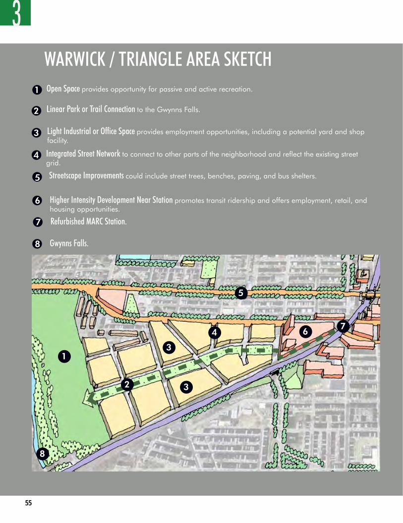
��
3WARWICK / TRIANGLE AREA SKETCH Open Space provides opportunity for passive and active recreation.
Linear Park or Trail Connection to the Gwynns Falls.
1
2
3 Light Industrial or Office Space provides employment opportunities, including a potential yard and shop facility.
4
6
5
Integrated Street Network to connect to other parts of the neighborhood and reflect the existing street grid.
Streetscape Improvements could include street trees, benches, paving, and bus shelters.
Higher Intensity Development Near Station promotes transit ridership and offers employment, retail, and housing opportunities.
1
2
3
6 7
5
4
3
7 Refurbished MARC Station.
8
8 Gwynns Falls.
West Balt imore MARC Transit-Centered Community Development Strategy ��
WARWICK / TRIANGLE AREA SKETCH eDmonDson avenueEdmondson Avenue has served as a neighborhood “Main Street” which supported vibrant community activity. The character and function of Edmondson Avenue will, over time, be revitalized with mixed-use/retail development, similar to its function in the past.
Land Use: Edmondson Avenue will be an area where infill development, building renovations, and occupation of ground floor retail uses and services will be welcome and encouraged. Based on input received at the October 12-13, 2007 public workshops, specific uses desired by the community include:
● Ground floor retail or services such as: ○ Restaurants ○ Ice cream parlor
○ Florist○ Bakery○ Hardware store○ Doctor office○ Pharmacy○ Pet shop○ Bank
Circulation: • Speed limit posting should not exceed 25 mph.• Accept traffic congestion in this area – it will be an indication of its desirability!• Invest in streetscape improvements to Edmonson Avenue, including street trees, benches, paving, and bus shelters. • Improve pedestrian crossing including signage, crosswalk striping, lighting and pedestrian
space for walking, etc .• Specific intersections for pedestrian crossing improvements along Edmonson Avenue are: Warwick Avenue, Wheeler Avenue, Bentalou Street, Pulaski Street, Payson Street, Monroe Street, and Fulton Avenue. Improve the lighting on these streets as well. • Make bus transit improvements, including additions of shelters, signage, lighting, and pedestrian paving.• Incorporate bicycle facilities including: striped on-street bicycle lanes; off street paths connecting the station to the adjacent neighborhoods and Gwynns Falls Trail; and ample, secure, covered bicycle parking.
3
○ Café/coffee shop○ Dry cleaner○ Tailor/seamstress○ Convenience market○ Small post office○ Child care○ Small police substation○ Housing○ Neighborhood-serving offices
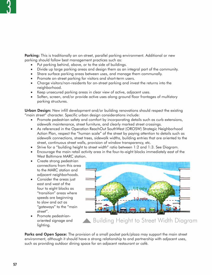
��
Parking: This is traditionally an on-street, parallel parking environment. Additional or new parking should follow best management practices such as:
• Put parking behind, above, or to the side of buildings.• Divide up large parking areas and design them as an integral part of the community.• Share surface parking areas between uses, and manage them communally.• Promote on-street parking for visitors and short-term users.• Charge visitors/non-residents for on-street parking and invest the returns into the
neighborhood.• Keep unsecured parking areas in clear view of active, adjacent uses.• Soften, screen, and/or provide active uses along ground floor frontages of multistory
parking structures.
Urban Design: New infill development and/or building renovations should respect the existing “main street” character. Specific urban design considerations include:
• Promote pedestrian safety and comfort by incorporating details such as curb extensions, sidewalk maintenance, street furniture, and clearly marked street crossings.
• As referenced in the Operation ReachOut SouthWest (OROSW) Strategic Neighborhood Action Plan, respect the “human scale” of the street by paying attention to details such as sidewalk connections, street trees, sidewalk widths, building entries that are oriented to the street, continuous street walls, provision of window transparency, etc.
• Strive for a “building height to street width” ratio between 1:2 and 1:3. See Diagram.• Encourage the main retail activity area in the four-to-eight blocks immediately east of the
West Baltimore MARC station.• Create strong pedestrian
connections from this area to the MARC station and adjacent neighborhoods.
• Consider the areas just east and west of the four to eight blocks as “transition” areas where speeds are beginning to slow and act as “gateways” to the “main street”.
• Promote pedestrian-oriented signage and lighting.
Parks and Open Space: The provision of a small pocket park/plaza may support the main street environment, although it should have a strong relationship to and partnership with adjacent uses, such as providing outdoor dining space for an adjacent restaurant or café.
3
1:3 ratio
1:2 ratio
Building Height to Street Width Diagram
West Balt imore MARC Transit-Centered Community Development Strategy ��
3
resiDential neigHBorHooDsWest Baltimore has many strong owner-occupied residential areas that should be supported and enhanced. The primary long-term function of the area’s neighborhoods should be residential. Their character will be enhanced by aesthetic, recreational, and personal safety improvements. Vacant housing should be sensitively renovated and/or redeveloped, respecting the character of adjacent buildings and uses.
Land Use: Land uses should remain primarily residential, although a more diverse housing stock is encouraged. Provision of housing options that meet a variety of needs and lifestyles is desired. Some local-serving retail or commercial development should be allowed, as long as it respects the residential qualities of the neighborhood. Based on input received at the October 12-13, 2007 public workshops, specific uses desired and mentioned by the community could include:
• A diversity of housing types, such as rowhouses, single family homes, duplexes, live/work units, lofts, stacked flats, apartments over retail, assisted living facilities, etc.
• Small scale, community-serving retail• Community center• Churches• Day care• Schools• Parks and open space
Circulation: To improve safety and street connectivity for all users, the following should be implemented:
• Streetscape improvements to neighborhood streets including street trees, benches, paving, and lighting. Priorities should include: Warwick Avenue, Wheeler Avenue, Bentalou Street, Pulaski Street, Payson Street, Monroe Street, Fulton Avenue, and Saratoga Street.
• Measures to calm and green neighborhood streets including: Harlem Avenue, Saratoga Street, Penrose Avenue and Lexington Street. This includes incorporation of traffic calming measures, landscaping and street trees.
• Pedestrian crossing improvements including signage, crosswalk striping, and lighting.• Specific intersections for pedestrian crossing improvements along Fulton Avenue are:
Edmonson Avenue, Franklin Street, Saratoga Street, Lexington Street, Fayette Street, Baltimore Street, and Frederick Avenue.
• Bus transit improvements including additions of shelters, signage, lighting, and pedestrian paving.
• Incorporation of bicycle facilities including: striped on-street bicycle lanes and/or off-street paths connecting the station to the adjacent neighborhoods and Gwynns Falls Trail; and ample, secure, covered bicycle parking at the station.
��
Parking: As these areas mature, parking for any new uses is envisioned as being accommodated in a combination of on-site and on-street facilities. Some parking best management practices are recommended:
• Put parking behind, under, above, or to the side of buildings.• Divide up large parking areas and design them as an integral part of the community.• Share surface parking areas between uses, and manage them communally.• Promote on-street parking for visitors and short-term users.• Charge visitors/non-residents for on-street parking – invest returns in the neighborhood.• Keep unsecured parking areas in clear view of active, adjacent uses.• Soften, screen, and/or provide active uses along ground floor frontages of multistory
parking structures.• No driveways/garage doors allowed in front of single family homes – parking should be
to the side or serviced from rear alleys.
Urban Design: The opportunity exists to strengthen the positive qualities of the adjacent neighborhoods. There are many potential improvements which could be of benefit including:
• Respect the existing scale and character of occupied housing.• Preserve and renew significant, historic buildings within the neighborhoods.• Introduce new housing types that diversify the mixture of housing choices.• Allow “modern” architectural designs if they functionally relate well to adjacent streets and
uses, to inject new “visual energy” into the urban landscape.• Improve the aesthetic and functional aspects of existing community facilities, such
as schools, to improve upon their function as community gathering places and civic landmarks.
Parks and Open Space: Ideally, each neighborhood should have at least one park or recreational open space within a 5-to-10 minute walk of every residence. The overall study area should include a variety of facilities from tot lots and village greens to playfields and community gardens. These parks and/or open spaces should be configured to have a strong visual connection to adjacent uses, and be located in front of buildings, not behind them. If security concerns are high, then high quality, ornamental security fencing may be required to secure these areas from sun down to sun up.
3
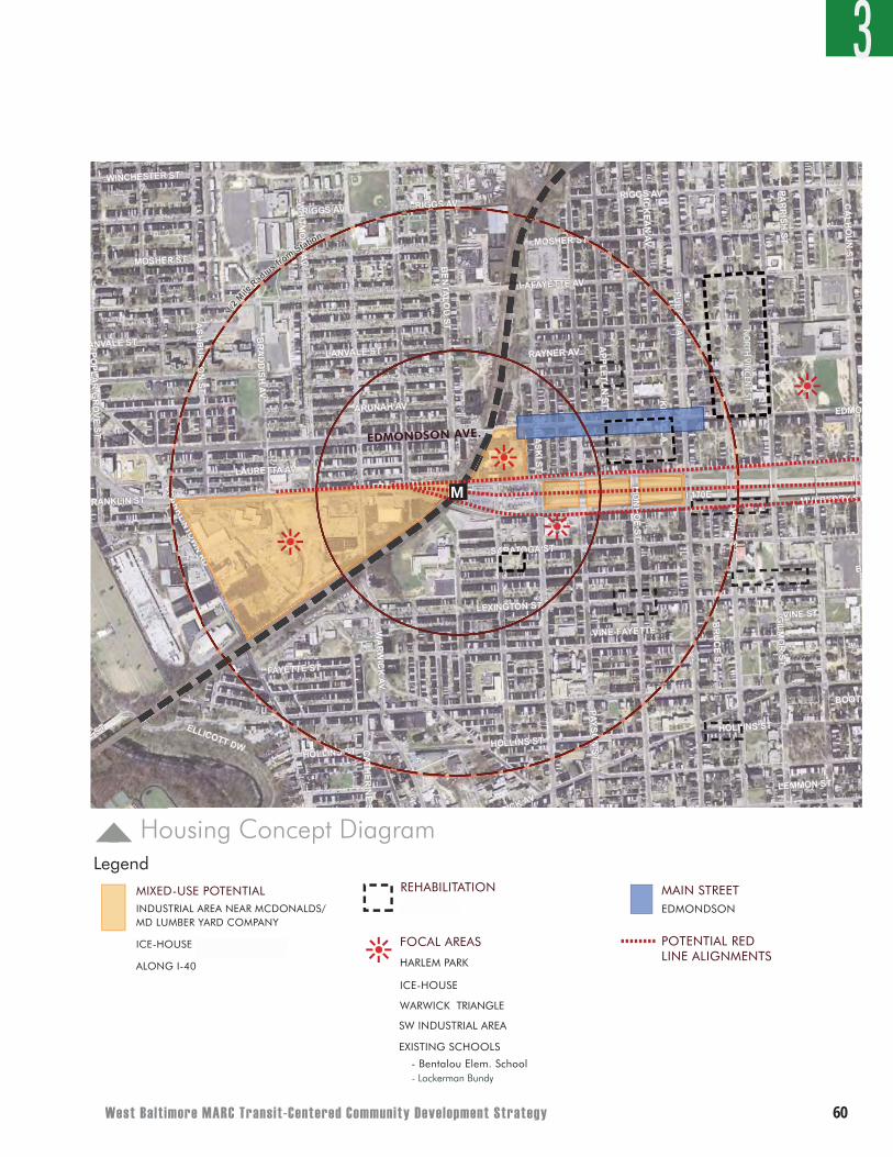
West Balt imore MARC Transit-Centered Community Development Strategy �0
N
0 300 600 1200FEET
WEST BALT IMORE MARC STAT ION
HOUSING
MIXED-USE POTENTIALINDUSTRIAL AREA NEAR MCDONALDS/MD LUMBER YARD COMPANY
ICE-HOUSE (FOR CONDOS)
ALONG I-40
REHABILITATIONMULBERRY
FOCAL AREAS
HARLEM PARK
ICE-HOUSE
SW INDUSTRIAL AREA
EXISTING SCHOOLS
MAIN STREETEDMONDSON
EDMONDSON AVE.
NO
RTH
VIN
CEN
T ST.
M
POTENTIAL RED
LINE ALIGNMENTS
WARWICK TRIANGLE
- Bentalou Elem. School
N
0 300 600 1200FEET
WEST BALT IMORE MARC STAT ION
HOUSING
MIXED-USE POTENTIALINDUSTRIAL AREA NEAR MCDONALDS/MD LUMBER YARD COMPANY
ICE-HOUSE (FOR CONDOS)
ALONG I-40
REHABILITATIONMULBERRY
FOCAL AREAS
HARLEM PARK
ICE-HOUSE
SW INDUSTRIAL AREA
EXISTING SCHOOLS
MAIN STREETEDMONDSON
EDMONDSON AVE.
NO
RTH
VIN
CEN
T ST.
M
POTENTIAL RED LINE ALIGNMENTS
WARWICK TRIANGLE
- Bentalou Elem. School
Housing Concept DiagramLegend
3
N
0 300 600 1200FEET
WEST BALT IMORE MARC STAT ION
HOUSING
MIXED-USE POTENTIALINDUSTRIAL AREA NEAR MCDONALDS/MD LUMBER YARD COMPANY
ICE-HOUSE (FOR CONDOS)
ALONG I-40
REHABILITATIONMULBERRY
FOCAL AREAS
HARLEM PARK
ICE-HOUSE
SW INDUSTRIAL AREA
EXISTING SCHOOLS
MAIN STREETEDMONDSON
EDMONDSON AVE.
NO
RTH
VIN
CEN
T ST.
M
POTENTIAL RED LINE ALIGNMENTS
WARWICK TRIANGLE
- Bentalou Elem. School
N
0 300 600 1200FEET
WEST BALT IMORE MARC STAT ION
HOUSING
MIXED-USE POTENTIALINDUSTRIAL AREA NEAR MCDONALDS/MD LUMBER YARD COMPANY
ICE-HOUSE (FOR CONDOS)
ALONG I-40
REHABILITATIONMULBERRY
FOCAL AREAS
HARLEM PARK
ICE-HOUSE
SW INDUSTRIAL AREA
EXISTING SCHOOLS
MAIN STREETEDMONDSON
EDMONDSON AVE.
NO
RTH
VIN
CEN
T ST.
M
POTENTIAL RED LINE ALIGNMENTS
WARWICK TRIANGLE
- Bentalou Elem. School- Lockerman Bundy
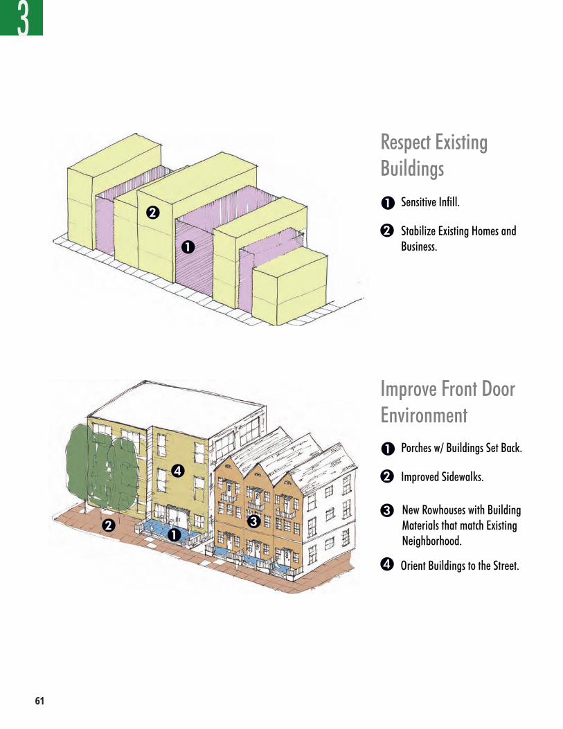
��
3
Improve Front DoorEnvironment
Porches w/ Buildings Set Back.
Improved Sidewalks.
1
2
3 New Rowhouses with Building Materials that match Existing Neighborhood.
4 Orient Buildings to the Street.
Respect Existing Buildings
Sensitive Infill.
Stabilize Existing Homes and Business.
1
2
12 3
4
1
2
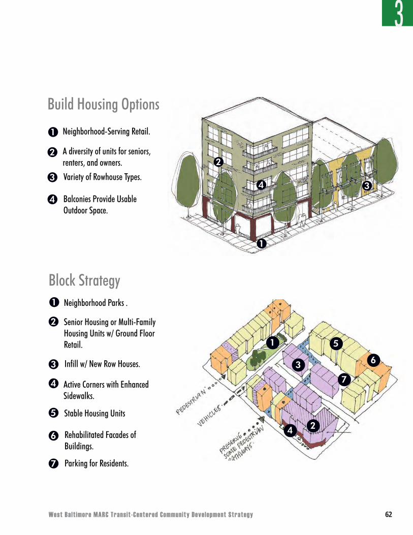
West Balt imore MARC Transit-Centered Community Development Strategy ��
Build Housing Options
Neighborhood-Serving Retail.
A diversity of units for seniors, renters, and owners.
1
2
3 Variety of Rowhouse Types.
1
2
34
4 Balconies Provide Usable Outdoor Space.
1
2
5
4
3
7
Block StrategyNeighborhood Parks .
Senior Housing or Multi-Family Housing Units w/ Ground Floor Retail.
1
2
3 Infill w/ New Row Houses.
4 Active Corners with Enhanced Sidewalks.
5
6
Stable Housing Units
Rehabilitated Facades of Buildings.
7 Parking for Residents.
6
3
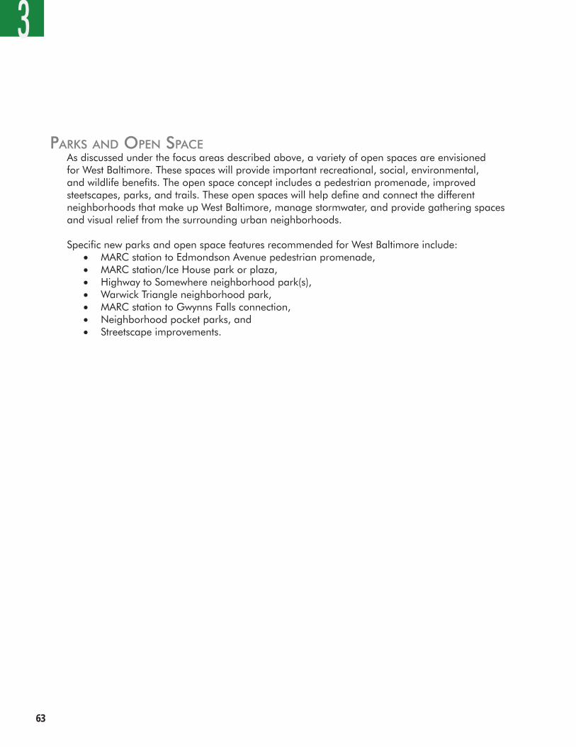
��
33
Parks anD oPen sPaceAs discussed under the focus areas described above, a variety of open spaces are envisioned for West Baltimore. These spaces will provide important recreational, social, environmental, and wildlife benefits. The open space concept includes a pedestrian promenade, improved steetscapes, parks, and trails. These open spaces will help define and connect the different neighborhoods that make up West Baltimore, manage stormwater, and provide gathering spaces and visual relief from the surrounding urban neighborhoods.
Specific new parks and open space features recommended for West Baltimore include: • MARC station to Edmondson Avenue pedestrian promenade,• MARC station/Ice House park or plaza,• Highway to Somewhere neighborhood park(s),• Warwick Triangle neighborhood park,• MARC station to Gwynns Falls connection,• Neighborhood pocket parks, and• Streetscape improvements.
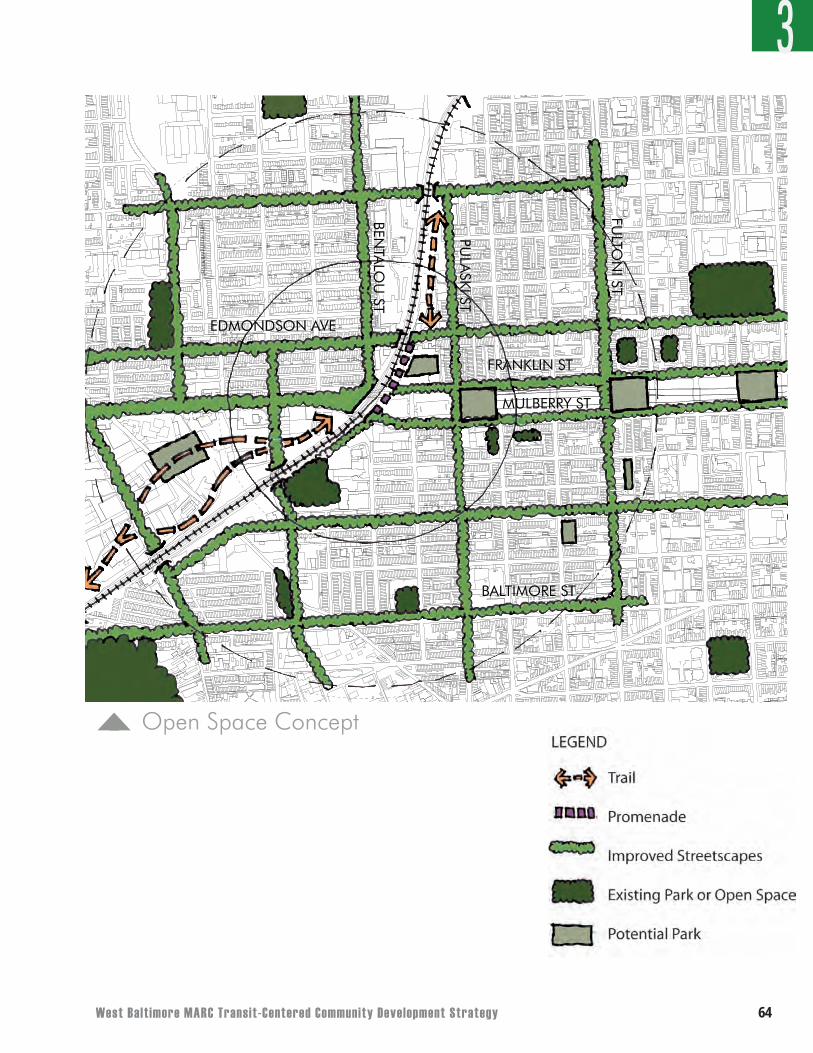
West Balt imore MARC Transit-Centered Community Development Strategy ��
0 400'200'WEST BALTIMORE MARC @ 1:200 SCALE
Open Space Concept
3
EDMONDSON AVE
BENTA
LOU
ST
FRANKLIN STPU
LASKI ST
MULBERRY ST
BALTIMORE ST
FULTO
NI ST
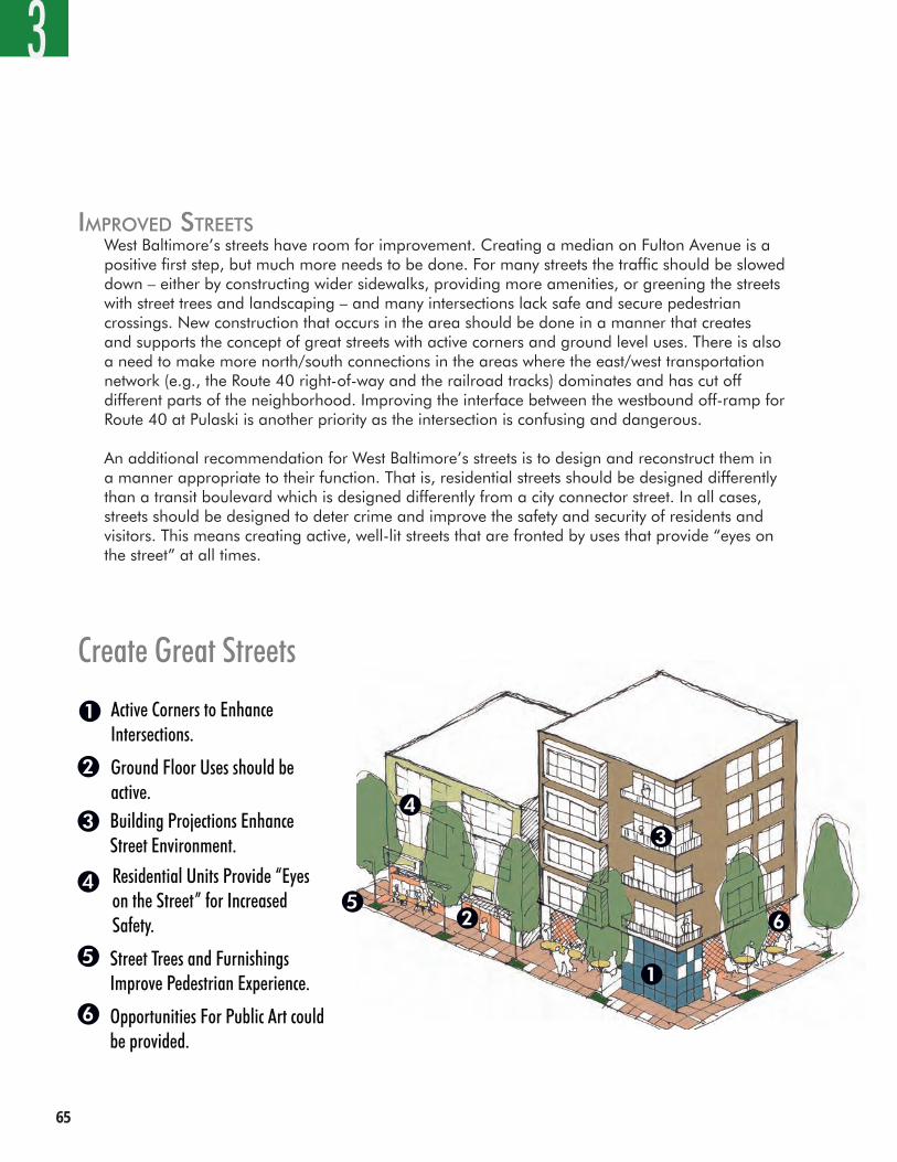
��
imProveD streetsWest Baltimore’s streets have room for improvement. Creating a median on Fulton Avenue is a positive first step, but much more needs to be done. For many streets the traffic should be slowed down – either by constructing wider sidewalks, providing more amenities, or greening the streets with street trees and landscaping – and many intersections lack safe and secure pedestrian crossings. New construction that occurs in the area should be done in a manner that creates and supports the concept of great streets with active corners and ground level uses. There is also a need to make more north/south connections in the areas where the east/west transportation network (e.g., the Route 40 right-of-way and the railroad tracks) dominates and has cut off different parts of the neighborhood. Improving the interface between the westbound off-ramp for Route 40 at Pulaski is another priority as the intersection is confusing and dangerous.
An additional recommendation for West Baltimore’s streets is to design and reconstruct them in a manner appropriate to their function. That is, residential streets should be designed differently than a transit boulevard which is designed differently from a city connector street. In all cases, streets should be designed to deter crime and improve the safety and security of residents and visitors. This means creating active, well-lit streets that are fronted by uses that provide “eyes on the street” at all times.
Create Great Streets
Active Corners to Enhance Intersections.
Ground Floor Uses should be active.
1
2
3
Residential Units Provide “Eyes on the Street” for Increased Safety.
4
Building Projections Enhance Street Environment.
1
2
3
4
5 Street Trees and Furnishings Improve Pedestrian Experience.
5
6 Opportunities For Public Art could be provided.
6
3
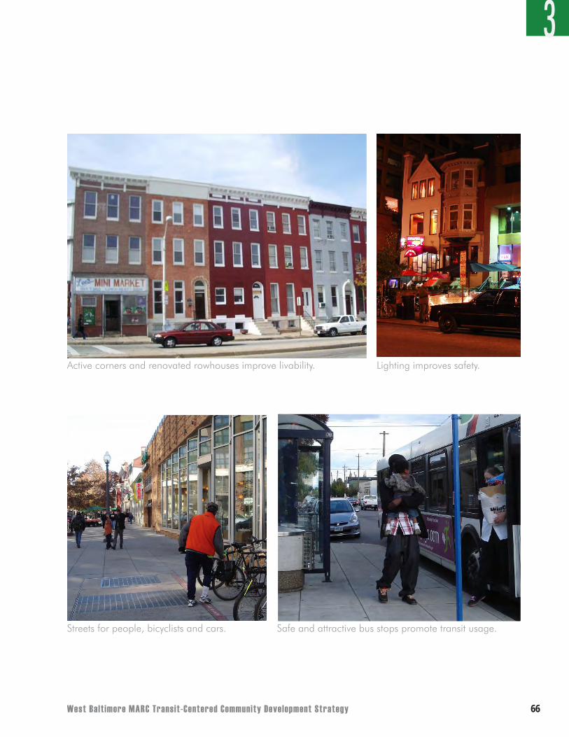
West Balt imore MARC Transit-Centered Community Development Strategy ��
3
Active corners and renovated rowhouses improve livability.
Safe and attractive bus stops promote transit usage.
Lighting improves safety.
Streets for people, bicyclists and cars.
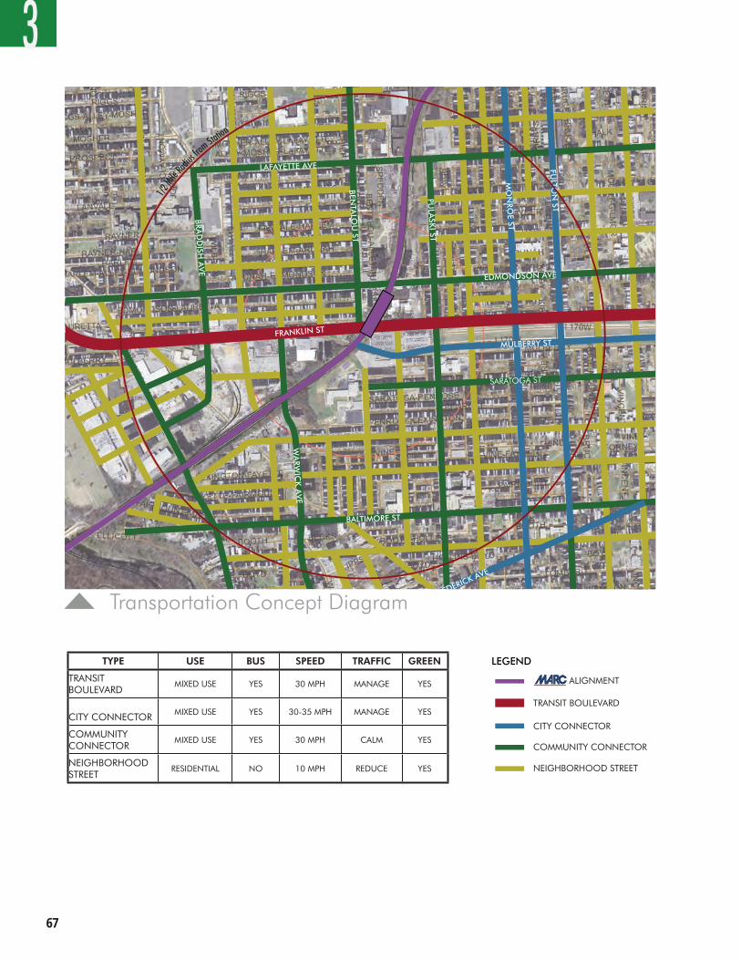
��
3
TRANSIT BOULEVARD
CITY CONNECTOR
COMMUNITY CONNECTOR
NEIGHBORHOOD STREET
MARC ALIGNMENT
TYPE USE BUS SPEED TRAFFIC GREENTRANSITBOULEVARD
MIXED USE YES 30 MPH MANAGE YES
CITYCONNECTOR
MIXED USE YES 30 - 35 MPH MANAGE YES
COMMUNITYCONNECTOR
MIXED USE YES 30 MPH CALM YES
NEIGHBORHOODSTREET
RESIDENTIAL NO 10 MPH REDUCE YES
1/2Mile
Radius
fromStation
LAFAYETTE AVE
BRAD
DISH
AV
E
PULA
SKI ST
BALTIMORE ST
WA
RWIC
KA
VE
LEGEND
FREDERICK AVE
BENTA
LOU
ST
EDMONDSON AVE
SARATOGA ST
TSTTARP
MULBERRY ST
FULTO
N ST
MO
NRO
E ST
FRANKLIN
TOW
N RD
WEST BALTIMORE MARC STATION OCTOBER 2007
FRANKLIN ST
RECOMMENDED TRANSPORTATION AND STREET CHARACTER NETWORK
OCTOBER 2006 WORKSHOP
TYPE USE BUS SPEED TRAFFIC GREEN
TRANSIT BOULEVARD
MIXED USE YES 30 MPH MANAGE YES
CITY CONNECTOR MIXED USE YES 30-35 MPH MANAGE YES
COMMUNITY CONNECTOR
MIXED USE YES 30 MPH CALM YES
NEIGHBORHOOD STREET
RESIDENTIAL NO 10 MPH REDUCE YES
Transportation Concept Diagram
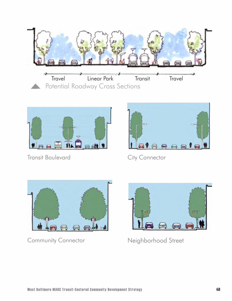
West Balt imore MARC Transit-Centered Community Development Strategy ��
Cut
Potential Roadway Cross Sections
Transit Boulevard City Connector
Community Connector Neighborhood Street
Travel Linear Park Transit Travel
��
CHAPTER 4PHASING
West Balt imore MARC Transit-Centered Community Development Strategy �0
4
This section addresses the development concept’s phasing. Which requires careful consideration of both large-scale development and smaller infill projects. The Transit-Centered Community Development Strategy considers several large opportunity sites and infill areas wholly or partially within the focus area. By concentrating efforts on these properties, resources can be strategically utilized to allow for the greatest neighborhood impact over time.
Moving Forward
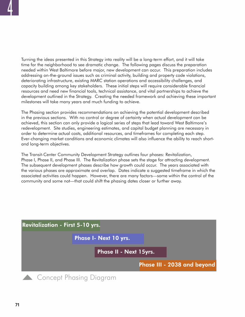
��
4
Turning the ideas presented in this Strategy into reality will be a long-term effort, and it will take time for the neighborhood to see dramatic change. The following pages discuss the preparation needed within West Baltimore before major, new development can occur. This preparation includes addressing on-the-ground issues such as criminal activity, building and property code violations, deteriorating infrastructure, existing MARC station operations and accessibility challenges, and capacity building among key stakeholders. These initial steps will require considerable financial resources and need new financial tools, technical assistance, and vital partnerships to achieve the development outlined in the Strategy. Creating the needed framework and achieving these important milestones will take many years and much funding to achieve.
The Phasing section provides recommendations on achieving the potential development described in the previous sections. With no control or degree of certainty when actual development can be achieved, this section can only provide a logical series of steps that lead toward West Baltimore’s redevelopment. Site studies, engineering estimates, and capital budget planning are necessary in order to determine actual costs, additional resources, and timeframes for completing each step. Ever-changing market conditions and economic climates will also influence the ability to reach short- and long-term objectives.
The Transit-Center Community Development Strategy outlines four phases: Revitalization, Phase I, Phase II, and Phase III. The Revitalization phase sets the stage for attracting development. The subsequent development phases describe how growth could occur. The years associated with the various phases are approximate and overlap. Dates indicate a suggested timeframe in which the associated activities could happen. However, there are many factors—some within the control of the community and some not—that could shift the phasing dates closer or further away.
Revitalization - First 5-10 yrs.
Concept Phasing Diagram
Phase I- Next 10 yrs.
Phase II - Next 15yrs.
Phase III - 2038 and beyond
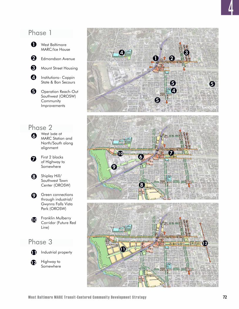
West Balt imore MARC Transit-Centered Community Development Strategy ��
4West Baltimore MARC/Ice House
Edmondson Avenue
Mount Street Housing
Institutions– Coppin State & Bon Secours
Operation Reach-Out Southwest (OROSW) Community Improvements
West Side of MARC Station and North/South along alignment
First 2 blocks of Highway to Somewhere
Shipley Hill/ Southwest Town Center (OROSW)
Green connections through industrial/ Gwynns Falls Vista Park (OROSW)
Franklin Mulberry Corridor (Future Red Line)
Industrial property
Highway to Somewhere
•
•
•
•
•
•
•
•
•
•
•
•
1
2
3
4
5
6
7
8
9
1
10
11
23
4
67
8
9
10
1112
4
Phase 1
Phase 2
Phase 3
12
5
5
5
��
4
Revitalization Phase – First 5 to 10 years (2008 - 2018)Before major development can begin in West Baltimore, the community, with support from government and non-profit stakeholders, needs to achieve some critical first steps toward revitalization. The Action Strategy at the end of this report recommends specific non-development-related actions to encourage and support redevelopment. These include:
• Forcefully addressing crime and safety issues;• Enforcing building codes to reduce substandard properties and dangerous conditions;• Repairing deteriorating infrastructure (for example, streets, sidewalks, public utilities, and
community facilities);• Improving the neighborhood’s image through beautification efforts;• Rezoning redevelopment areas to appropriate zoning designations;• Building capacity to ensure fair and substantive participation by community organizations in a
broader, long-term redevelopment program (see section entitled “Organizational Milestones for the West Baltimore Coalition”); and
• Fostering partnerships with private enterprises, public agencies, and local institutions to create workforce development opportunities for local residents.
While these actions are imperative for all phases, noticeable improvements in these functional areas are particularly important in the revitalization phase as they will establish a framework for new investment.
In order for the desired Phase I development to occur, additional actions will need to be taken to overcome the challenges associated with attracting private investment and new development to West Baltimore. These actions include:
• Acquiring and assembling property to accommodate development;• Finding and securing existing public financial resources and non-profit technical assistance to
encourage and support development;• Creating new financing tools to incentivize development;• Establishing and maintaining strategic partnerships among the community, public agencies,
private sector, and institutional players, including negotiation of community benefits;• Improving safety conditions through better lighting on various streets;• Cleaning any environmentally-contaminated properties in designated redevelopment areas; • Improving the existing MARC station and pedestrian access in order to make the station more
functional and attractive as a community asset; • Addressing the need for commuter parking and additional parking demand generated by
new development; and• Reaching a consensus on the Red Line alignment, including the number and locations of
stations and how they should fit into and benefit the neighborhood.
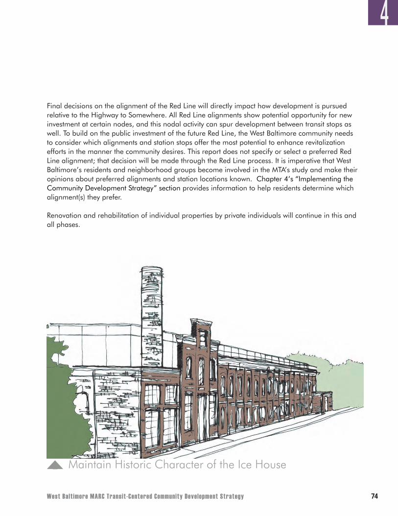
West Balt imore MARC Transit-Centered Community Development Strategy ��
4
Final decisions on the alignment of the Red Line will directly impact how development is pursued relative to the Highway to Somewhere. All Red Line alignments show potential opportunity for new investment at certain nodes, and this nodal activity can spur development between transit stops as well. To build on the public investment of the future Red Line, the West Baltimore community needs to consider which alignments and station stops offer the most potential to enhance revitalization efforts in the manner the community desires. This report does not specify or select a preferred Red Line alignment; that decision will be made through the Red Line process. It is imperative that West Baltimore’s residents and neighborhood groups become involved in the MTA’s study and make their opinions about preferred alignments and station locations known. Chapter 4’s “Implementing the Community Development Strategy” section provides information to help residents determine which alignment(s) they prefer.
Renovation and rehabilitation of individual properties by private individuals will continue in this and all phases.
Maintain Historic Character of the Ice House
��
4
Phase I – Next 10 years (2013-2028)The first phase of major development within West Baltimore concentrates at the MARC station. The concept illustrates clustered mixed-use development on City-owned land currently serving as MTA commuter lots and the site of the former Ice House. The advantages of these sites are:
• The limited number of land owners (owner of the Ice House and Baltimore City are the sole owners);
• The large size of these contiguous properties, • The City’s ability to engage in a public-private partnership, integrate public amenities and
workforce development as part of the project, and ensure First Source hiring requirements are met;
• Direct access to the MARC station, • The site’s compatibility with any future plans for the Red Line, and • The adjacency to infill development areas targeted by the Midtown Edmondson Community
Plan.
Key challenges to developing these sites are the need to temporarily or permanently replace MARC commuter parking, the need to lure pioneering developers into the neighborhood, and the limited availability of existing public subsidy dollars to spur private investment.
The Development Concept depicts the potential ripple effect that could be realized along Edmondson Avenue-points south of Mulberry Street and points north of Edmondson Avenue, depending on the market’s response to redevelopment at the station and the construction of the potential Red Line. Fostered by property rehabilitation programs, tax credit incentives, and gap financing mechanisms for small businesses, these smaller infill properties (many of which are vacant storefronts or substandard structures) have the potential to transform into viable new housing and corner retail. Infill development could also further enhance street connections to area institutions such as Bon Secours and new housing projects such as the Mount Street Redevelopment project. Infill properties with manageable issues and needs could redevelop sooner than more complex large projects requiring creative financing or extensive rehabilitation.
As opportunities arise and without displacing viable businesses, assemblage of land in the Southwest Industrial Area (a.k.a. the Warwick Triangle) should also occur in this phase in addition to continued coordination with Coppin State University on its redevelopment plans for the former Lutheran Hospital site. The need for additional institutional space and university-related uses may dictate the future components on the former Lutheran Hospital site.
West Balt imore MARC Transit-Centered Community Development Strategy ��
This phase should continue the street corridor enhancements and infrastructure improvements begun in the Revitalization Phase, focusing specifically on the MARC/Ice House Focus Area and eventually moving to the west (Edmondson Avenue and Franklin Street), south (Warwick Avenue, Pulaski Street, Monroe Street), and various points northward. Such enhancements include street trees, improved pedestrian and bicycle connections, better lighting, and street furniture. Planning efforts to establish a greenway connection from the MARC station through the Southwest Industrial Area to the Gwynns Falls Trail should begin in the Revitalization Phase and continue in this phase as well.
The implementation of the suggested strategy lends itself to the creation of a new Community Development Corporation, an entity to help guide public and private investment in West Baltimore. While organizations exist in West Baltimore the particular techniques to redevelopment recommended in this document necessitate a lead non-profit organization. As an initial step to becoming West Baltimore’s main non-profit, the organization should work with existing non-profits such as Operation ReachOut Southwest (a local example) and DC One (a CDC in Washington, DC) to understand the roles successful non-profits can play in large-scale redevelopment and neighborhood revitalization efforts.
The organization needs to include all of the area’s stakeholders with an interest in revitalization including area landowners and property-owning educational, medical, and other institutions. The primary activities of the new non-profit would include:
• Facilitate Policy Goals – The new entity will need to facilitate and coordinate the diverse policy goals and objectives of its members while enabling them to realize maximum benefits from their properties.
• Provide Expertise to Lead the TOD– Staff with expertise in TOD and urban revitalization through mixed-use development is needed to enhance the capabilities of each of the member organizations and to balance public and institutional interests.
• Coordinate Public Investments, Secure Debt, and Other Financing – A distinct entity will be best positioned to work with the Baltimore Development Corporation to arrange innovative funding strategies, secure additional debt and grant financing sources from City, State, and federal sources, and potentially receive tax surcharges to support additional services in the area.
• Attract Private Investment – This is vital for implementation of the Strategy and will require a combination of planning, marketing, and facilitation activities.
There are a variety of options for how this organization could be organized. The potential members of this new entity, with leadership from the City and State, should convene a stakeholder committee as soon as possible to work through these choices and decide on how the new entity should be incorporated and governed. Stakeholders will need to provide “seed money” for the non-profit’s start-up.
4
��
Phase II – Next 15 years (2023-2043)Development in this phase begins to stretch northward along both sides of the tracks from the MARC station. The largest property under single ownership at this location is the Acme Industrial Complex, which is owned solely by Baltimore City and offers the potential for a public-private partnership. Given its proximity to transit, the City should consider a high-density mix of uses if market conditions are favorable. Smaller infill development could occur on vacant or abandoned properties surrounding the Acme Industrial Complex and on the opposite side of the tracks facing Pulaski Street. Assemblage of contiguous underutilized properties in this area should also occur to allow for larger developments. The Acme Industrial Complex and the former Lutheran Hospital site frame a strong cluster of owner-occupied housing in the Evergreen Lawn community of West Baltimore and could possibly continue initial development momentum realized from new transit-oriented development in Phase I.
Despite proximity to the MARC station, multiple property ownership in the Southwest Industrial Area and the Shipley Hill Master Plan Area creates development challenges. This condition impacts development potential for these areas, postponing redevelopment due to the need for property acquisition and assembly of contiguous parcels. Ideally, property acquisition within the Southwest Industrial Area should occur from east to west in order to leverage any new station area investment. Uses for the easternmost portion of the Southwest Industrial Area should complement development on the opposite side of the tracks and possibly incorporate some of the desired public amenities outlined earlier in this report. Because of the size of this site and the Shipley Hill Master Plan Area, the potential development effects of both sites for West Baltimore are considerable. Both have the capacity to create a significant critical mass of uses and complement any new investment occurring in the near-term.
East of the MARC station and Pulaski Street, the first section of the Highway to Somewhere could be development-ready for private investment in either Phase I or Phase II. Before the area is development-ready, ownership of this land may need to change from City ownership to private ownership and it is assumed that MTA will have addressed how it will accommodate MARC commuter parking. A strategic mix of higher density uses will be required to make development viable at this location.
Finally, this phase accommodates the block-by-block rehabilitation of smaller properties throughout the neighborhood.
4
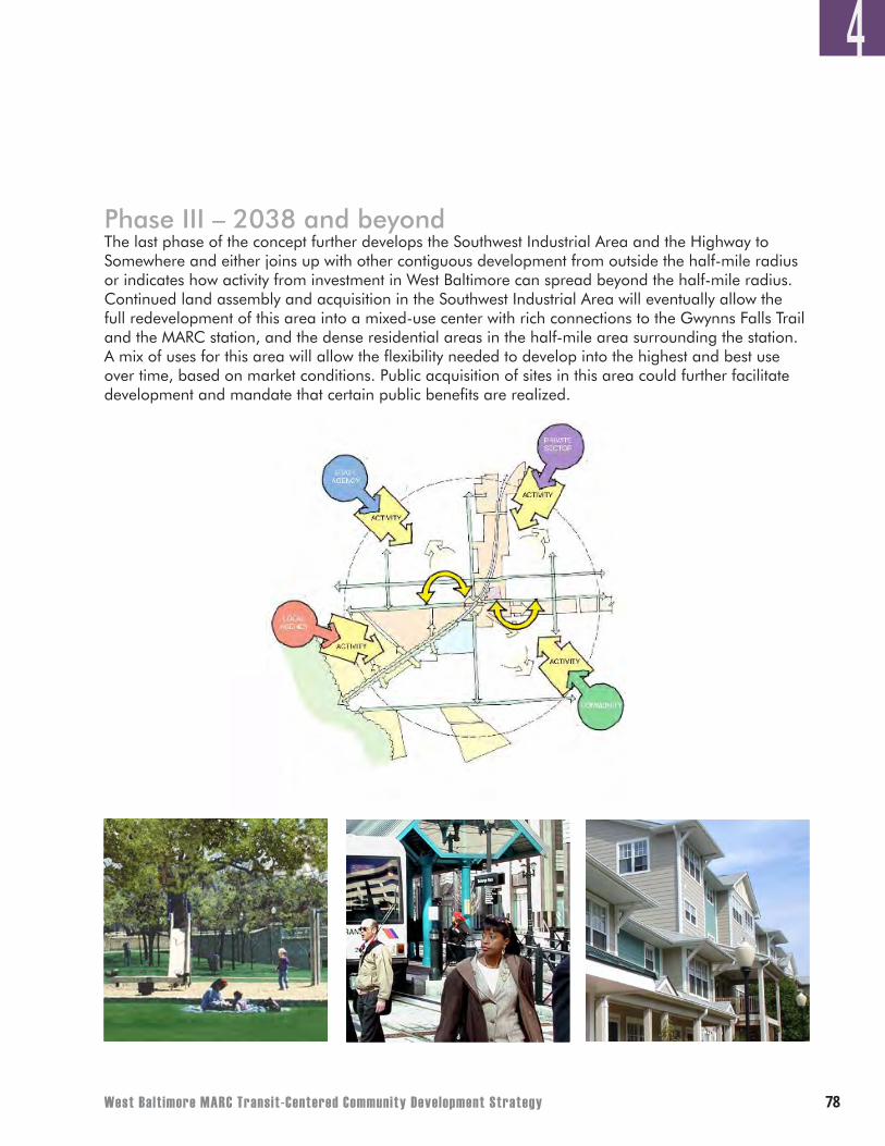
West Balt imore MARC Transit-Centered Community Development Strategy ��
4
Phase III – 2038 and beyondThe last phase of the concept further develops the Southwest Industrial Area and the Highway to Somewhere and either joins up with other contiguous development from outside the half-mile radius or indicates how activity from investment in West Baltimore can spread beyond the half-mile radius. Continued land assembly and acquisition in the Southwest Industrial Area will eventually allow the full redevelopment of this area into a mixed-use center with rich connections to the Gwynns Falls Trail and the MARC station, and the dense residential areas in the half-mile area surrounding the station. A mix of uses for this area will allow the flexibility needed to develop into the highest and best use over time, based on market conditions. Public acquisition of sites in this area could further facilitate development and mandate that certain public benefits are realized.
��
IMPLEMENTING THE COMMUNITY DEVELOPMENT STRATEGY
Leveraging the Red Line and additional Transportation Investments.The Community Development Strategy has been defined in the previous sections. Now is the time for the stakeholders - the community, the City, and MTA - to consider how to leverage future transporta-tion investments toward implementing the vision and achieving a community with improved housing, expanded economic opportunity, and quality transportation choices. This is a positive break from the past, when often the discussion around transportation projects focused more on limiting impacts rather than creating livable communities.
The Red Line, if done well, cannot only provide improved transportation options for the community, but can also provide a focus for new in-fill housing development, enhanced retail services and im-proved access to neighborhood open spaces and institutions as well as access to employment oppor-tunities in the greater Baltimore region.
The following pages provide a summary of the Red Line Alternative Alignments currently under study. The potential alignments include the median of US-40, the Franklin-Mulberry couplet, and the Frank-lin Transit Median. Each of these options should be evaluated for their contributions toward imple-menting the Community Development Strategy. The matrix titled “Evaluation based on Community Principles” provides a preliminary discussion tool and evaluation to assist the stakeholders in reaching consensus for a community-preferred alternative. In the matrix, each alignment is evaluated for how it addresses the Development Strategy themes: Transportation, Economic Development and Housing. A brief summary of each of the alignments is included and then evaluated for how it influences the existing condition – does it worsen?, does it have no impact?, or does it improve the current condi-tion? The scores identified are preliminary and should be vetted further by the community, the city and MTA through the Red Line Draft Environment Impact Study process. To achieve the development strategy most expeditiously and with respect to the community principles, the Red Line alternative which provides the greatest positive influence toward providing improved transportation, enhanced housing choice and neighborhood-serving retail should be pursued as the community-preferred alter-native.
In the same manner, alternatives for MTA-MARC parking sites should be evaluated by the com-munity, the City and MTA. The following matrix provides a summary description of the site, existing short-term land use, and the Development Strategy’s preferred long-term land use. The preliminary analysis in the matrix illustrates that some of the parking alternatives may be considered as short-term actions in the context of the longer-term strategy.
In conclusion, with the Development Strategy in hand, the community, City and MTA can now col-laborate on transportation investments which are both an asset for improved accessibility and a tool for achieving the larger goal of making West Baltimore a more sustainable community.
4
West Balt imore MARC Transit-Centered Community Development Strategy �0
Preliminary Analysis of MTA Parking Alternatives – Evaluation for Consistency with Community Framework
MTA Parking Options
Summary Description
Existing /Short Term Use
Long Term Use PreliminaryAnalysis
Existing MTA Lots
- Surface Parking - Surface Parking - East lot is ideal for mixed-use MTA parking structure wrapped with active uses at street level --West lot area should include enhanced /new transit stops, commercial development, public space and link to Edmondson Ave.
Site 1 West of Station
- Access from west - Minimum negative impacts on station area
- Privately owned, underutilized industrial
Lot is ideal option for mixed-use MTA parking structure wrapped with active uses at street level
- Could be temporary surface parking if linked with development strategy for adjacent parcels
Site 2 South of Station
- Access off of Mulberry
- Privately owned, underutilized industrial
- Mixed-use development
- Could be temporary surface parking if linked with development strategy for adjacent parcels
Site 3 Icehouse
- Access off of Franklin
- Privately owned, vacant - Mixed-use, open space with link to Edmondson
- Could be temporary surface parking if linked with development strategy for adjacent parcels
Site 4 Highway to Somewhere
- Surface parking built on reconstructed end of Highway
- Neighborhood play space
- Residential and open space
- Does not support long-term vision
Site 5 Vest Pocket
- Negative impact to community, no benefit
- Privately owned, vacant; makeshift play area
- Residential and open space
- Bad idea
Preliminary Analysis of MTA Parking Alternatives-Evaluation for Consistency with Community Framework
MTA ParkingOptions
Summary Description
Existing / Short Term Use
Long Term Use Preliminary Analysis
;
4
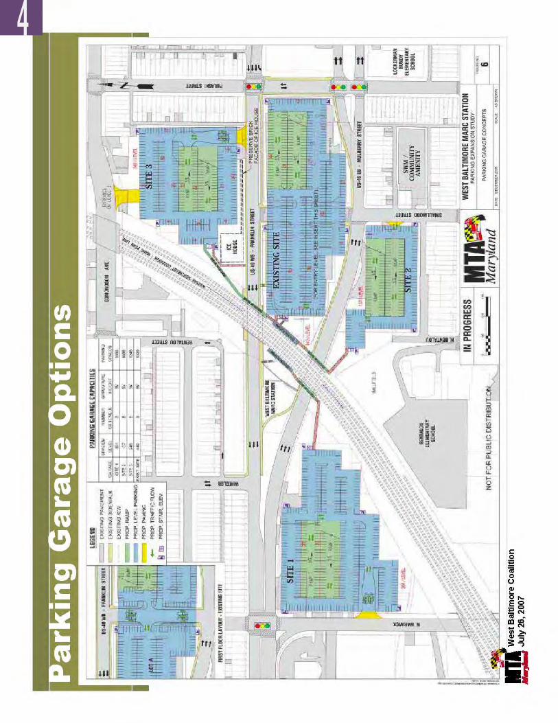
��
4
West Balt imore MARC Transit-Centered Community Development Strategy ��
MTA Red Line Alignment Alternatives – Evaluation based on Community Principles
Red Line Alignment Alternatives
Transportation Economic Development Housing
1AFranklin to Highway Median
- 2 Transit Stops - Requires elevators - Highway remains - Enhanced Streetscape at
station areas +
- Commercial focus at MARC Station /Edmondson Ave
0
- Housing along Franklin
0
1BFranklin to Highway Median with Lid at Stations
- 2 Transit Stops - Requires elevators - Highway remains - Potential 2-way Franklin &
Mulberry- Enhanced Streetscape at
station areas +
- Commercial focus at MARC Station /Edmondson Ave and Calhoun/Carey Stops
+
- Housing along Franklin and adjacent to Redline Stops
+
2Franklin-MulberryCouplet
- Potential for 3 Stops, though separated by highway
- Highway reconfigured - Potential 2-way Franklin &
Mulberry- Enhanced Franklin &
Mulberry Streetscape + +
- Commercial focus at MARC Station /Edmondson Ave and adjacent to stops
+ +
- Housing along Franklin and Mulberry
+ +
3Franklin Transit Median
- Potential for 3 Stops - Highway reconfigured - Potential 2-way Franklin &
Mulberry- Enhanced Franklin
Streetscape+ +
- Commercial focus at MARC Station /Edmondson Ave and adjacent to stops
+ +
- Housing along Franklin, - Potential for housing along
Mulberry with highway consolidation
+ + +
4Franklin Boulevard
- Potential for 3 Stops - Highway eliminated - Potential 2-way Franklin &
Mulberry- Enhanced Franklin
Streetscape+
- Commercial focus at MARC Station /Edmondson Ave and adjacent to stops
+ +
- Maximum opportunity for housing development in highway area
+ + +
Note: Franklin alignments assume R.O.W. adjustments to public property only at W. Baltimore MARC Station. Red Line option that includes new ramp structure around the Ice House is not an acceptable option.
Scoring Key: Worsens” existing condition -“No influence” on existing condition 0“Improves” existing condition +
MTA Red Line Alignment Alternatives-Evaluation based on Community Principles
Red Line Alignment Alternatives
Transportation Economic Development Housing
For clarification: The Options 1 through 4 described above and depicted on the following pages are intended to help illustrate potential community benefits and long-term redevelopment considerations of street level versus highway median approaches to this segment of the Red Line study. The illustrations are intended to inform further discussion and analysis of alternatives, but will not directly coincide with options included in the Red Line Draft Environmental Impact Statement.
4
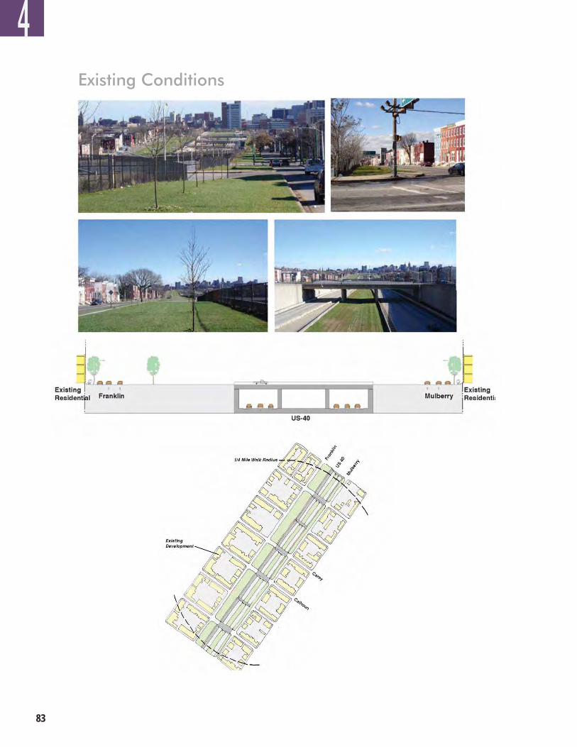
��
Existing Conditions
Existing Conditions
4
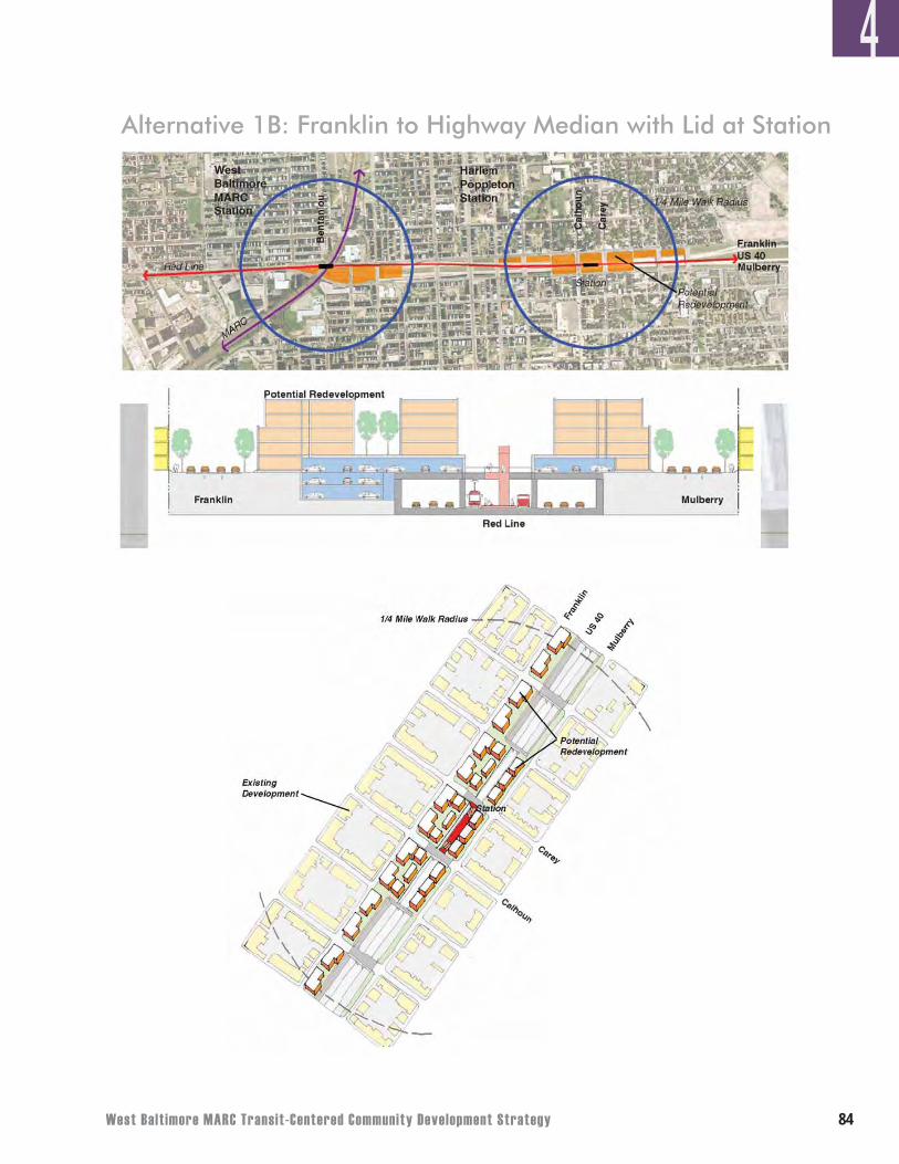
West Balt imore MARC Transit-Centered Community Development Strategy ��
Alternative 1B: Franklin to Highway Median with Lid at Stations
Alternative 1B: Franklin to Highway Median with Lid at Station
4
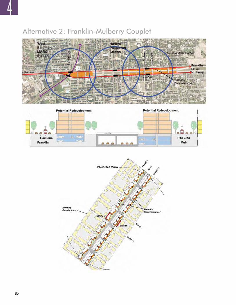
��
Alternative 2: Franklin-Mulberry Couplet
Alternative 2: Franklin-Mulberry Couplet
4
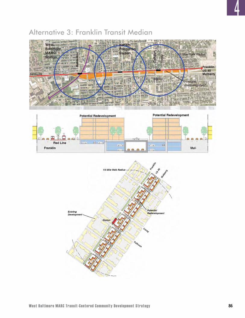
West Balt imore MARC Transit-Centered Community Development Strategy ��
Alternative 3: Franklin Transit Median
Alternative 3: Franklin Transit Median
4
��
4
There are many hurdles that need to be addressed if the West Baltimore MARC Transit-Centered Community Development Strategy is to be successful. The challenges include:
• Multiple Institutional Owners – There are multiple owners of the land in the study area. These owners have their own mandates and institutional objectives that do not necessarily mesh with public interests or market considerations. The plans and actions of other large land owners in the area such as the Baltimore City Public School System and Coppin State University will greatly impact the success of the Strategy. Coordination of decision-making between these owners and implementers of the plan is essential to the Strategy’s success.
• Creative Financing Techniques – The financial analysis shows a need for significant public investment to fund infrastructure and capital improvement costs. Although some funding sources appear to be potentially available, securing those funds for West Baltimore as well as the creation of additional financial resources will require committed actions over several years.
• Need for Innovative Partnerships – The institutional, financial, and parking challenges, as well as overlapping City and State jurisdictions, will require innovation and effective agency coordination to successfully implement this Strategy.
• Stakeholder Participation – The success of this Strategy relies heavily on the participation and leadership of local stakeholders. While the community cannot do it alone, their participation and collaboration with the public and private sector are vital to the revitalization process. Now that these stakeholders have helped to define the vision for the area, they must continue to play a significant role in making the vision a reality.
However, as the community implements and achieves the action items outlined in the Organization Milestones for the West Baltimore Coalition and the Revitalization Action Strategy, the community will be taking valuable steps toward overcoming the challenges facing West Baltimore and will be setting the stage for the area’s revitalization.
OBSTACLES AND CHALLENGES TO IMPLEMENTATION
West Balt imore MARC Transit-Centered Community Development Strategy ��
Baltimore has an extensive and successful history of using a variety of dedicated district-based public benefit corporations or community development corporations to stimulate revitalization of defined areas as well as provide enhanced services and other supporting activities. Notable examples include the Charles Street Development Corporation, Westside Renaissance, Downtown Partnership, Midtown Community Benefits District, and Mount Vernon Cultural District among many others.
In the near-term, community leaders in West Baltimore should: • Actively recruit and expand its core base of committed members to include stakeholders with
diverse expertise – old and new residents of all ages, workers, business owners, and large and small property owners;
• Define specific roles and/or subcommittees (e.g., outreach, marketing/logo design, housing; transportation, economic development, quality of life, etc.) for active members;
• Clarify its relationships with individual civic and neighborhood associations; and • Set measurable goals and actions to be achieved quarterly, semi-annually, or annually.
A proven track record established early on could demonstrate to and excite public, non-profit, private, and institutional stakeholders that significant change within West Baltimore is on the horizon.
Of the action items featured in the implementation section, the following eight action items are suggested priorities that the community could begin immediately. The following list is not exclusive, but begins to define goals attainable for the community during the first year. As the community leaders of West Baltimore improve their organizational capacity and are better able to administer or lead implementation items, this list can expand per recommendations made in the full Revitalization Strategy.
A. Use “311” to report problems and encourage others to do the same. Many West Baltimoreresidents already use this method to report problems within their community. This process must continue as a way to increase safety, ensure a quality standard of life, and enforce city codes and regulations. The City cannot solve a problem if it does not know there is a problem. Getting a specific problem or issue recorded in the “311 system and following up with the City until the problem is resolved is a critical first step for getting many of West Baltimore’s daily standard-of-living issues addressed.
B. Properly secure unsafe, vacant, and abandoned properties. Property owners of vacant andabandoned structures should be held accountable for their investments. In partnership with Baltimore Housing, the community must target unsecured housing stock that threatens the neighborhood’s safety. More eyes on the street to report “problem properties” to City inspection and code enforcement officers can leverage Baltimore Housing’s capacity to reduce noncompliance. Baltimore Housing and the community must work in partnership to eliminate these problems and improve West Baltimore’s image.
ORGANIZATIONAL MILESTONES AND NEXT STEPS FOR COMMUNITY LEADERS OF WEST BALTIMORE
4
��
4
C. Apply for neighborhood grants to install street trees and community gardens. Thereare a number of different non-profit groups and foundations that offer grants for street trees and community gardens. The Home Depot Foundation and Lowe’s Charitable and Educational Foundation are just two examples of non-traditional sources to fund outdoor neighborhood improvements. The West Baltimore community should research and apply for such grants that will enhance the physical environment.
D. Encourage preservation of existing housing stock through use of City and State repairand rehabilitation programs. There are a variety of State and City programs available to residents who want to repair and rehabilitate their homes. Better marketing of these programs needs to occur in West Baltimore to help existing homeowners improve their properties. At least one community member should become knowledgeable about these different programs and provide guidance and outreach to community members who could benefit from these programs.
E. Provide homeownership counseling and endorse homeownership assistance programs.Similar to repair and rehabilitation programs, marketing homeownership counseling and assistance programs to potential members of the community is a start to increasing homeownership within West Baltimore. At least one community member should become knowledgeable about these different programs and provide guidance and outreach to community members who could benefit from these programs.
F. Improve deteriorating infrastructure (for example, streets, sidewalks, medians, storm
drains, etc.). Through the City’s capital improvement budget, the Baltimore City Department of Transportation and the Baltimore City Department of Public Works have resources available to make improvements to deteriorating infrastructure. In order for West Baltimore to take advantage of the potential resources, the community needs to develop a detailed, specific, and prioritized list of improvements to streets, sidewalks, etc. By setting these priorities and collaborating with the appropriate city agencies, such infrastructure projects can get itemized into the capital budget.
G. Study successful partnership models for community benefits agreements. While theconstruction of community benefits agreements is not uncommon, it is important for the community to understand the best practices of other cities while drafting its own versions.
H. Offer workforce training options in target industries (for example, healthcare/medicine, services, construction, and education). Workforce development is of deep concern to the community. In partnership with the Mayor’s Office of Employment Development, Baltimore Development Corporation and local institutions, the community should create workforce development opportunities in existing industries that potentially have workforce gaps.
West Balt imore MARC Transit-Centered Community Development Strategy �0
Because of the unique issues associated with current ownership patterns and the fact that successful community development requires many partners, success will depend, in part, on establishing a West Baltimore Advisory Council in the short-term. Strategic partners with varied capabilities or specialized talents will need to assist community leaders in West Baltimore to achieve their specific goals and objectives. Members of the advisory council should actively participate in the neighborhood initiatives, provide their expertise or influence as necessary through monthly or one-on-one meetings, and help community leaders meet specific milestones along the way. The Advisory Council should be far-reaching, but not unwieldy, so that collaboration with community leaders can be as effective and efficient as possible. Representatives from the following agencies, institutions, or sectors may be considered to serve as advisory council members:
• Abell Foundation• Anne E. Casey Foundation• Baltimore City Community College• Baltimore City Department of Transportation• Baltimore City Department of Planning• Baltimore City Department Police• Baltimore City Recreation & Parks• Baltimore Community Foundation• Baltimore Development Corporation• Baltimore Housing• Baltimore Neighborhood Collaborative• Bon Secours Hospital Foundation• Citizens Planning and Housing Association• City Council Representatives• Coppin State University• Local Educational Institutions• Enterprise Community Partners• Experienced Community Development Corporations• Greater Baltimore Urban League• Local Faith-based Community Groups• Local Financial Institutions• Mayor’s Office of Neighborhoods• Mayor’s Office of Employment Development • Maryland Department of Business and Economic Development• Maryland Department of Housing and Community Development• Maryland Department of Transportation and Maryland Transit Administration• Maryland Small Business Development Center• Morgan State University• University of Maryland Baltimore
4
��
This section of the West Baltimore MARC Transit-Centered Community Development Strategy synthesizes (in narrative and matrix form) recommendations made about enhancing quality of life, providing housing and economic development opportunities, and improving transportation facilities and service throughout the area. The City, the community, and other stakeholders will need to form new partnerships and create new tools to bring about large-scale redevelopment projects in West Baltimore. This Action Strategy aligns directly with the Revitalization Phase described earlier and will serve as a roadmap for public agencies, the community, and other potential partners on actions to be taken over the next five to 10 years in preparation for longer-term redevelopment.
The Action Strategy identifies specific actions and responsible agencies to carry out these tasks as well as the optimal timeframe for their completion. Where possible, potential funding sources and relevant programs are shown for each action. Specific organizational milestones are recommended for the West Baltimore Coalition as it builds experience and capacity and transitions into a more formal community development organization.
Though specific City or State agencies are noted for various actions, other appropriate City or State agencies might be involved as well, depending on the issue.
WEST BALTIMORE REVITALIZATION ACTION STRATEGY
4
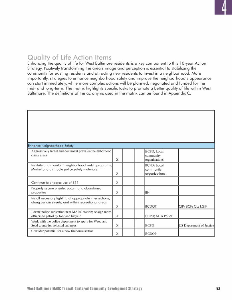
West Balt imore MARC Transit-Centered Community Development Strategy ��
Quality of Life Action ItemsEnhancing the quality of life for West Baltimore residents is a key component to this 10-year Action Strategy. Positively transforming the area’s image and perception is essential to stabilizing the community for existing residents and attracting new residents to invest in a neighborhood. More importantly, strategies to enhance neighborhood safety and improve the neighborhood’s appearance can start immediately, while more complex actions will be planned, negotiated and funded for the mid- and long-term. The matrix highlights specific tasks to promote a better quality of life within West Baltimore. The definitions of the acronyms used in the matrix can be found in Appendix C.
Timeframe for Initiating Effort
(years)
Quality of Life
0-5 6-10 10+
Potential Partners in Process**
Potential Funding Sources/Relevant
Programs**Action Items
Enhance Neighborhood Safety
Aggressively target and document prevalent neighborhood crime areas
X
BCPD, Local community organizations
Institute and maintain neighborhood watch programs; Market and distribute police safety materials
X
BCPD; Local community organizations
Continue to endorse use of 311 X
Properly secure unsafe, vacant and abandoned properties X BH
Install necessary lighting at appropriate intersections, along certain streets, and within recreational areas
X BCDOT CIP; BCF; CL; LGIF
Locate police substation near MARC station; Assign more officers to patrol by foot and bicycle X BCPD; MTA Police Work with the police department to apply for Weed and Seed grants for selected subareas X BCPD US Department of JusticeConsider potential for a new firehouse station
X BCDOP
4
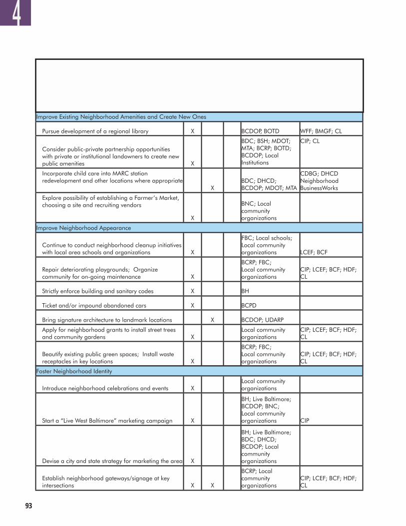
��
4Timeframe for Initiating Effort
(years)
Quality of Life
0-5 6-10 10+
Potential Partners in Process**
Potential Funding Sources/Relevant
Programs**Action Items
Improve Existing Neighborhood Amenities and Create New Ones
Pursue development of a regional library X BCDOP, BOTD WFF; BMGF; CL
Consider public-private partnership opportunities with private or institutional landowners to create new public amenities X
BDC; BSH; MDOT; MTA; BCRP; BOTD; BCDOP; Local Institutions
CIP; CL
Incorporate child care into MARC station redevelopment and other locations where appropriate
XBDC; DHCD; BCDOP; MDOT; MTA
CDBG; DHCD Neighborhood BusinessWorks
Explore possibility of establishing a Farmer’s Market, choosing a site and recruiting vendors
X
BNC; Local community organizations
Improve Neighborhood Appearance
Continue to conduct neighborhood cleanup initiatives with local area schools and organizations X
FBC; Local schools; Local community organizations LCEF; BCF
Repair deteriorating playgrounds; Organize community for on-going maintenance X
BCRP; FBC; Local community organizations
CIP; LCEF; BCF; HDF; CL
Strictly enforce building and sanitary codes X BH
Ticket and/or impound abandoned cars X BCPD
Bring signature architecture to landmark locations X BCDOP; UDARP
Apply for neighborhood grants to install street trees and community gardens X
Local community organizations
CIP; LCEF; BCF; HDF; CL
Beautify existing public green spaces; Install waste receptacles in key locations X
BCRP; FBC; Local community organizations
CIP; LCEF; BCF; HDF; CL
Foster Neighborhood Identity
Introduce neighborhood celebrations and events XLocal community organizations
Start a “Live West Baltimore” marketing campaign X
BH; Live Baltimore; BCDOP; BNC; Local community organizations CIP
Devise a city and state strategy for marketing the area X
BH; Live Baltimore; BDC; DHCD; BCDOP; Local community organizations
Establish neighborhood gateways/signage at key intersections X X
BCRP; Local community organizations
CIP; LCEF; BCF; HDF; CL
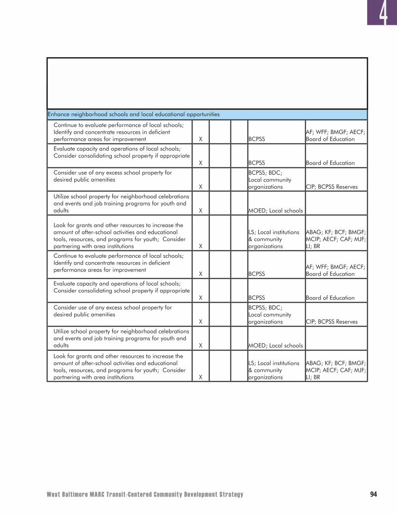
West Balt imore MARC Transit-Centered Community Development Strategy ��
4Timeframe for Initiating Effort
(years)
Quality of Life
0-5 6-10 10+
Potential Partners in Process**
Potential Funding Sources/Relevant
Programs**Action Items
Enhance neighborhood schools and local educational opportunities
Continue to evaluate performance of local schools; Identify and concentrate resources in deficient performance areas for improvement X BCPSS
AF; WFF; BMGF; AECF; Board of Education
Evaluate capacity and operations of local schools; Consider consolidating school property if appropriate
X BCPSS Board of Education
Consider use of any excess school property for desired public amenities
X
BCPSS; BDC; Local community organizations CIP; BCPSS Reserves
Utilize school property for neighborhood celebrations and events and job training programs for youth and adults X MOED; Local schools
Look for grants and other resources to increase the amount of after-school activities and educational tools, resources, and programs for youth; Consider partnering with area institutions X
LS; Local institutions & community organizations
ABAG; KF; BCF; BMGF; MCIP; AECF; CAF; MJF; LI; BR
Continue to evaluate performance of local schools; Identify and concentrate resources in deficient performance areas for improvement
X BCPSSAF; WFF; BMGF; AECF; Board of Education
Evaluate capacity and operations of local schools; Consider consolidating school property if appropriate
X BCPSS Board of Education
Consider use of any excess school property for desired public amenities
X
BCPSS; BDC; Local community organizations CIP; BCPSS Reserves
Utilize school property for neighborhood celebrations and events and job training programs for youth and adults X MOED; Local schools
Look for grants and other resources to increase the amount of after-school activities and educational tools, resources, and programs for youth; Consider partnering with area institutions X
LS; Local institutions & community organizations
ABAG; KF; BCF; BMGF; MCIP; AECF; CAF; MJF; LI; BR
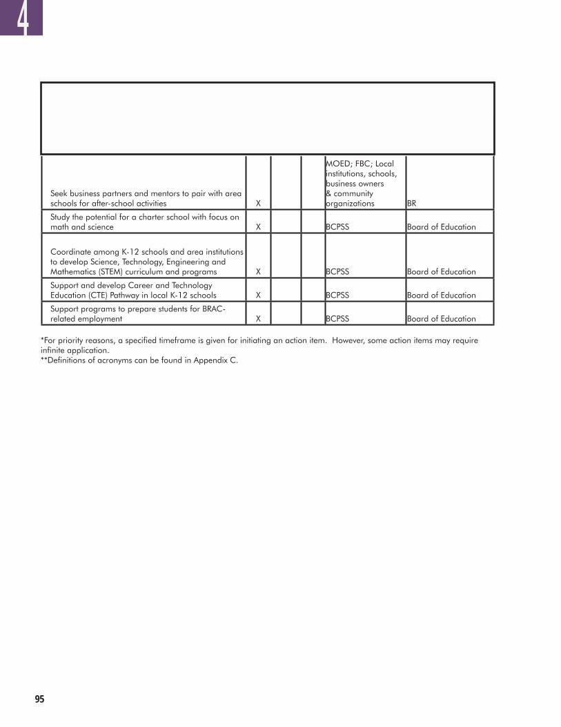
��
*For priority reasons, a specified timeframe is given for initiating an action item. However, some action items may require infinite application. **Definitions of acronyms can be found in Appendix C.
4Timeframe for Initiating Effort
(years)
Quality of Life
0-5 6-10 10+
Potential Partners in Process**
Potential Funding Sources/Relevant
Programs**Action Items
Seek business partners and mentors to pair with area schools for after-school activities X
MOED; FBC; Local institutions, schools, business owners & community organizations BR
Study the potential for a charter school with focus on math and science X BCPSS Board of Education
Coordinate among K-12 schools and area institutions to develop Science, Technology, Engineering and Mathematics (STEM) curriculum and programs X BCPSS Board of Education
Support and develop Career and Technology Education (CTE) Pathway in local K-12 schools X BCPSS Board of Education
Support programs to prepare students for BRAC-related employment X BCPSS Board of Education
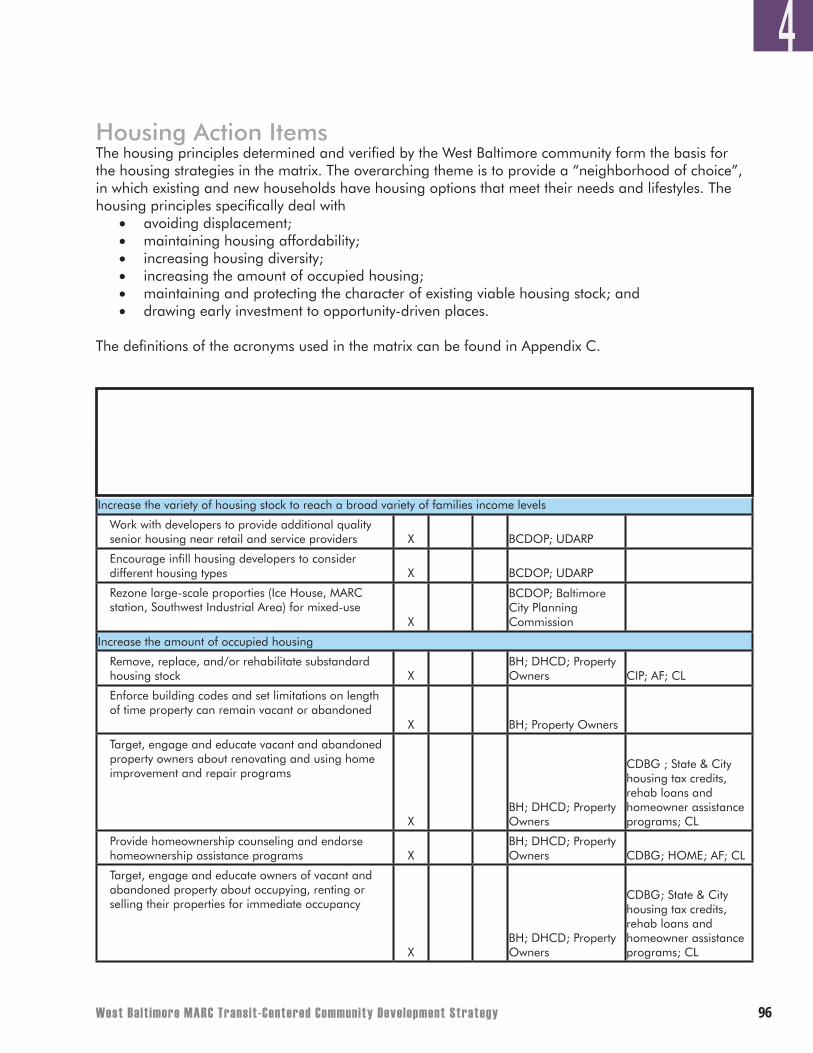
West Balt imore MARC Transit-Centered Community Development Strategy ��
Housing Action ItemsThe housing principles determined and verified by the West Baltimore community form the basis for the housing strategies in the matrix. The overarching theme is to provide a “neighborhood of choice”, in which existing and new households have housing options that meet their needs and lifestyles. The housing principles specifically deal with
• avoiding displacement;• maintaining housing affordability; • increasing housing diversity; • increasing the amount of occupied housing; • maintaining and protecting the character of existing viable housing stock; and • drawing early investment to opportunity-driven places.
The definitions of the acronyms used in the matrix can be found in Appendix C.
4
Timeframe for Initiating Effort
(years)
Housing
0-5 6-10 10+
Potential Partners in Process**
Potential Funding Sources/Relevant
Programs**Action Items
Increase the variety of housing stock to reach a broad variety of families income levels
Work with developers to provide additional quality senior housing near retail and service providers X BCDOP; UDARP
Encourage infill housing developers to consider different housing types X BCDOP; UDARP
Rezone large-scale proporties (Ice House, MARC station, Southwest Industrial Area) for mixed-use
X
BCDOP; Baltimore City Planning Commission
Increase the amount of occupied housing
Remove, replace, and/or rehabilitate substandard housing stock X
BH; DHCD; Property Owners CIP; AF; CL
Enforce building codes and set limitations on length of time property can remain vacant or abandoned
X BH; Property Owners
Target, engage and educate vacant and abandoned property owners about renovating and using home improvement and repair programs
XBH; DHCD; Property Owners
CDBG ; State & City housing tax credits, rehab loans and homeowner assistance programs; CL
Provide homeownership counseling and endorse homeownership assistance programs X
BH; DHCD; Property Owners CDBG; HOME; AF; CL
Target, engage and educate owners of vacant and abandoned property about occupying, renting or selling their properties for immediate occupancy
XBH; DHCD; Property Owners
CDBG; State & City housing tax credits, rehab loans and homeowner assistance programs; CL
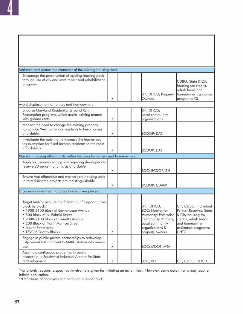
��
*For priority reasons, a specified timeframe is given for initiating an action item. However, some action items may require infinite application. **Definitions of acronyms can be found in Appendix C.
4Timeframe for Initiating Effort
(years)
Housing
0-5 6-10 10+
Potential Partners in Process**
Potential Funding Sources/Relevant
Programs**Action Items
Maintain and protect the character of the existing housing stock
Encourage the preservation of existing housing stock through use of city and state repair and rehabilitation programs
XBH; DHCD; Property Owners
CDBG; State & City housing tax credits, rehab loans and homeowner assistance programs; CL
Avoid displacement of renters and homeowners
Endorse Maryland Residential Ground Rent Redemption program, which assists existing tenants with ground rents X
BH; DHCD; Local community organizations
Monitor the need to change the existing property tax cap for West Baltimore residents to keep homes affordable X BCDOP; DAT
Investigate the potential to increase the homestead tax exemption for fixed-income residents to maintain affordability
X BCDOP; DATSources/Relevant
Programs
Maintain housing affordability within the area for renters and homeowners
Apply inclusionary zoning law requiring developers to reserve 20 percent of units as affordable
X BDC; BCDOP; BH
Ensure that affordable and market-rate housing units in mixed-income projects are indistinguishable
X BCDOP; UDARP
Draw early investment to opportunity-driven places
Target and/or acquire the following infill opportunities block by block: • 1900-2100 block of Edmondson Avenue • 500 block of N. Pulaski Street • 2300-2400 block of Lauretta Avenue • 200 Block of North Monroe Street • Mount Street area • TEVO** Priority Blocks X
BH; DHCD; BDC; Habitat for Humanity; Enterprise Community Partners; Local community organizations & property owners
CIP; CDBG; Individual Partner Reserves; State & City housing tax credits, rehab loans and homeowner assistance programs; LIHTC
Engage in public-private partnerships to redevelop City-owned lots adjacent to MARC station into mixed-use X BDC; MDOT; MTA
Assemble contiguous properties in public ownership in Southwest Industrial Area to facilitate redevelopment X BDC; BH CIP; CDBG; DHCD
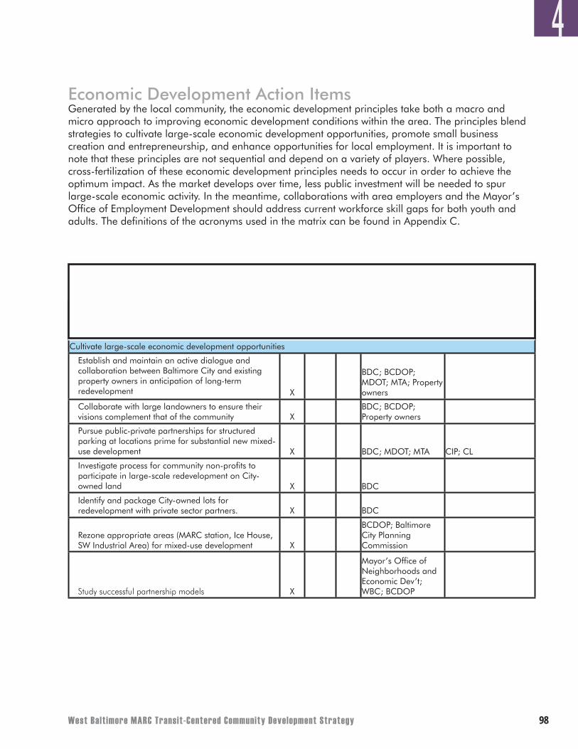
West Balt imore MARC Transit-Centered Community Development Strategy ��
Economic Development Action ItemsGenerated by the local community, the economic development principles take both a macro and micro approach to improving economic development conditions within the area. The principles blend strategies to cultivate large-scale economic development opportunities, promote small business creation and entrepreneurship, and enhance opportunities for local employment. It is important to note that these principles are not sequential and depend on a variety of players. Where possible, cross-fertilization of these economic development principles needs to occur in order to achieve the optimum impact. As the market develops over time, less public investment will be needed to spur large-scale economic activity. In the meantime, collaborations with area employers and the Mayor’s Office of Employment Development should address current workforce skill gaps for both youth and adults. The definitions of the acronyms used in the matrix can be found in Appendix C.
4
Timeframe for Initiating Effort
(years)
Economic Development
0-5 6-10 10+
Potential Partners in Process**
Potential Funding Sources/Relevant
Programs**Action Items
Cultivate large-scale economic development opportunities
Establish and maintain an active dialogue and collaboration between Baltimore City and existing property owners in anticipation of long-term redevelopment X
BDC; BCDOP; MDOT; MTA; Property owners
Collaborate with large landowners to ensure their visions complement that of the community X
BDC; BCDOP; Property owners
Pursue public-private partnerships for structured parking at locations prime for substantial new mixed-use development X BDC; MDOT; MTA CIP; CL
Investigate process for community non-profits to participate in large-scale redevelopment on City-owned land X BDC
Identify and package City-owned lots for redevelopment with private sector partners. X BDC
Rezone appropriate areas (MARC station, Ice House, SW Industrial Area) for mixed-use development X
BCDOP; Baltimore City Planning Commission
Study successful partnership models X
Mayor’s Office of Neighborhoods and Economic Dev’t; WBC; BCDOP
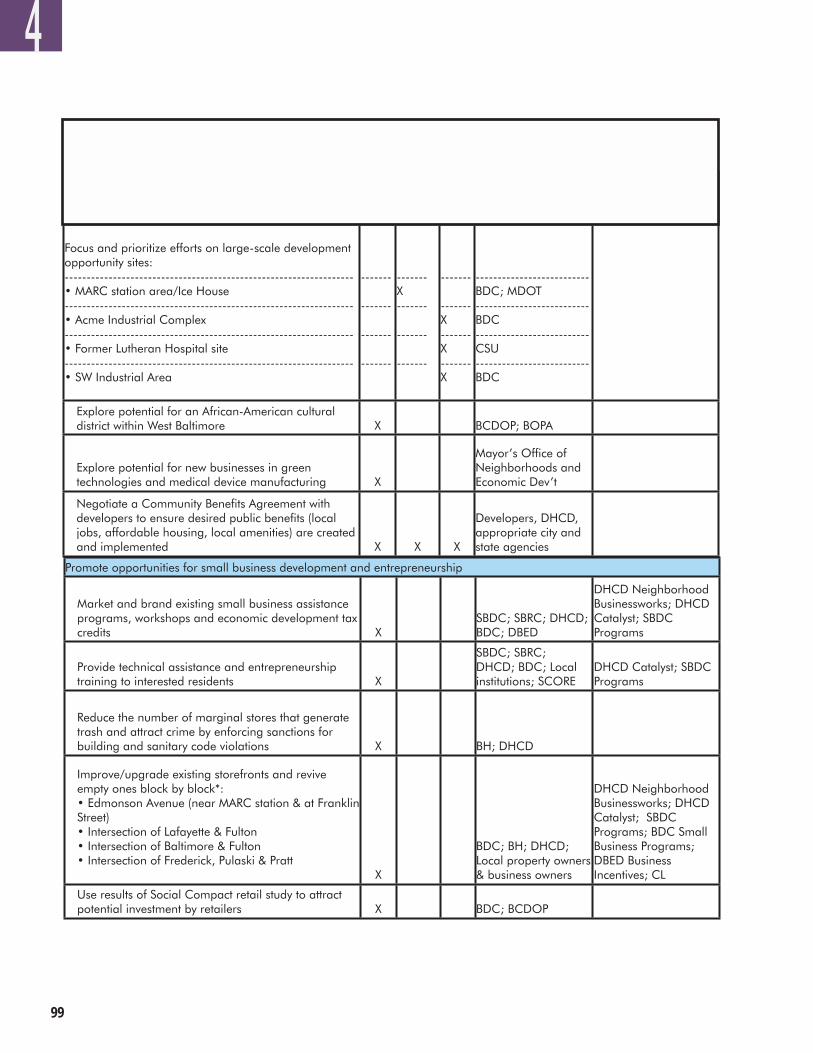
��
4Timeframe for Initiating Effort
(years)
Economic Development
0-5 6-10 10+
Potential Partners in Process**
Potential Funding Sources/Relevant
Programs**Action Items
Focus and prioritize efforts on large-scale development opportunity sites: ------------------------------------------------------------------ • MARC station area/Ice House ------------------------------------------------------------------ • Acme Industrial Complex ------------------------------------------------------------------ • Former Lutheran Hospital site ------------------------------------------------------------------ • SW Industrial Area
------- ------- ------- ------- x x
------- X ------- ------- ------- x x
------- ------- X ------- X ------- X
-------------------------- BDC; MDOT -------------------------- BDC -------------------------- CSU -------------------------- BDC
Explore potential for an African-American cultural district within West Baltimore X BCDOP; BOPA
Explore potential for new businesses in green technologies and medical device manufacturing X
Mayor’s Office of Neighborhoods and Economic Dev’t
Negotiate a Community Benefits Agreement with developers to ensure desired public benefits (local jobs, affordable housing, local amenities) are created and implemented X X X
Developers, DHCD, appropriate city and state agencies
Promote opportunities for small business development and entrepreneurship
Market and brand existing small business assistance programs, workshops and economic development tax credits X
SBDC; SBRC; DHCD; BDC; DBED
DHCD Neighborhood Businessworks; DHCD Catalyst; SBDC Programs
Provide technical assistance and entrepreneurship training to interested residents X
SBDC; SBRC; DHCD; BDC; Local institutions; SCORE
DHCD Catalyst; SBDC Programs
Reduce the number of marginal stores that generate trash and attract crime by enforcing sanctions for building and sanitary code violations X BH; DHCD
Improve/upgrade existing storefronts and revive empty ones block by block*: • Edmonson Avenue (near MARC station & at Franklin Street) • Intersection of Lafayette & Fulton • Intersection of Baltimore & Fulton • Intersection of Frederick, Pulaski & Pratt
X
BDC; BH; DHCD; Local property owners & business owners
DHCD Neighborhood Businessworks; DHCD Catalyst; SBDC Programs; BDC Small Business Programs; DBED Business Incentives; CL
Use results of Social Compact retail study to attract potential investment by retailers X BDC; BCDOP
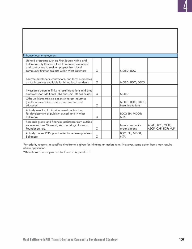
West Balt imore MARC Transit-Centered Community Development Strategy �00
*For priority reasons, a specified timeframe is given for initiating an action item. However, some action items may require infinite application. **Definitions of acronyms can be found in Appendix C.
4Timeframe for Initiating Effort
(years)
Economic Development
0-5 6-10 10+
Potential Partners in Process**
Potential Funding Sources/Relevant
Programs**Action Items
Enhance local employment
Uphold programs such as First Source Hiring and Baltimore City Residents First to require developers and contractors to seek employees from local community first for projects within West Baltimore X MOED; BDC
Educate developers, contractors, and local businesses on tax incentives available for hiring local residents X MOED; BDC; DBED
Investigate potential links to local institutions and area employers for additional jobs and spin-off businesses X MOED
Offer workforce training options in target industries (healthcare/medicine, services, construction and education) X
MOED; BDC; GBUL; Local institutions
Actively seek local minority-owned contractors for development of publicly-owned land in West Baltimore X
BDC; BH; MDOT; MTA
Research grants and financial assistance from outside sources such as Microsoft, Verizon, Magic Johnson Foundation, etc. X
Local community organizations
ABAG; BCF; MCIP; AECF; CAF; ECP; MJF
Actively market RFP opportunities to redevelop in West Baltimore X
BDC; BH; MDOT; MTA
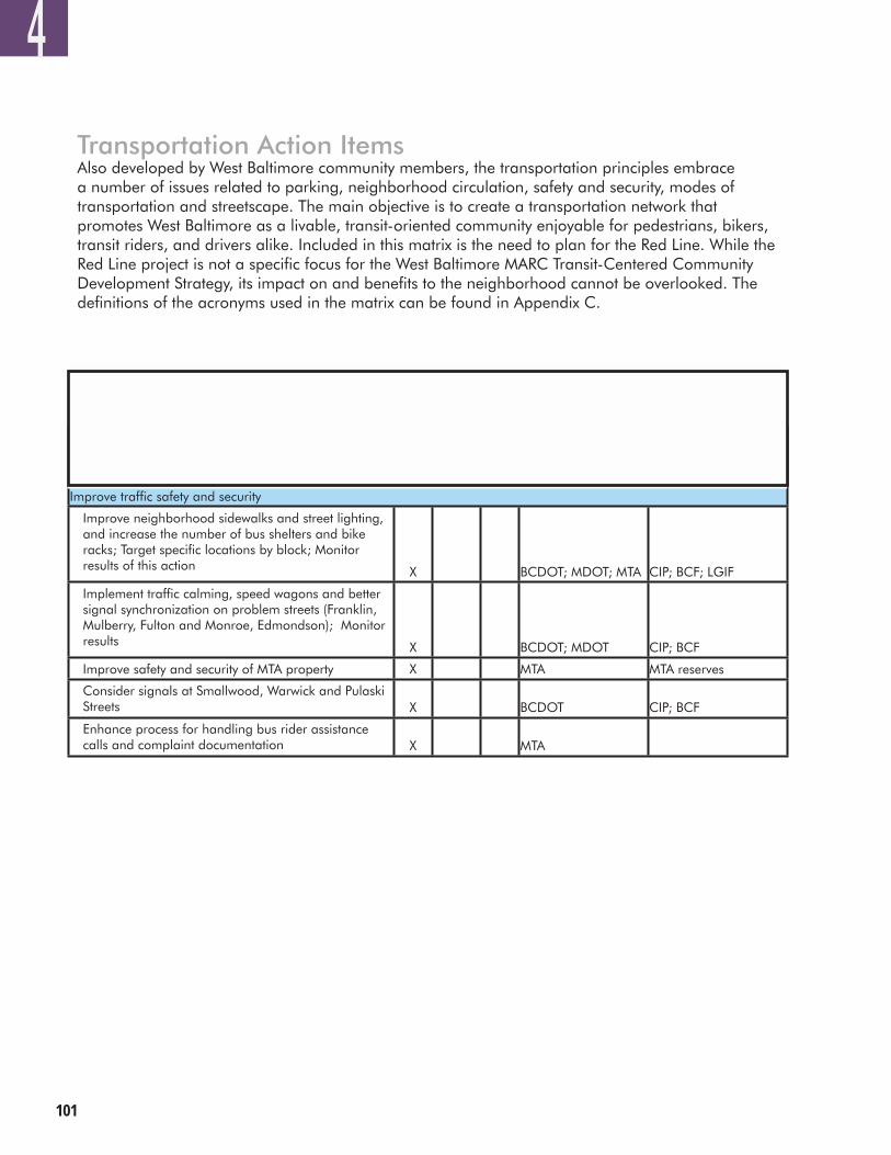
�0�
Transportation Action ItemsAlso developed by West Baltimore community members, the transportation principles embrace a number of issues related to parking, neighborhood circulation, safety and security, modes of transportation and streetscape. The main objective is to create a transportation network that promotes West Baltimore as a livable, transit-oriented community enjoyable for pedestrians, bikers, transit riders, and drivers alike. Included in this matrix is the need to plan for the Red Line. While the Red Line project is not a specific focus for the West Baltimore MARC Transit-Centered Community Development Strategy, its impact on and benefits to the neighborhood cannot be overlooked. The definitions of the acronyms used in the matrix can be found in Appendix C.
4
Timeframe for Initiating Effort
(years)
Transportation
0-5 6-10 10+
Potential Partners in Process**
Potential Funding Sources/Relevant
Programs**Action Items
Improve traffic safety and security
Improve neighborhood sidewalks and street lighting, and increase the number of bus shelters and bike racks; Target specific locations by block; Monitor results of this action X BCDOT; MDOT; MTA CIP; BCF; LGIF
Implement traffic calming, speed wagons and better signal synchronization on problem streets (Franklin, Mulberry, Fulton and Monroe, Edmondson); Monitor results X BCDOT; MDOT CIP; BCF
Improve safety and security of MTA property X MTA MTA reserves
Consider signals at Smallwood, Warwick and Pulaski Streets X BCDOT CIP; BCF
Enhance process for handling bus rider assistance calls and complaint documentation X MTA
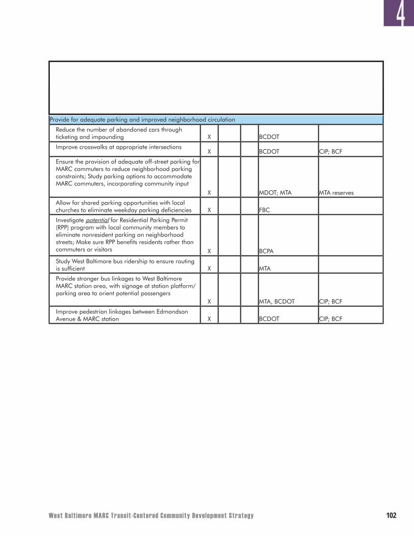
West Balt imore MARC Transit-Centered Community Development Strategy �0�
4Timeframe for Initiating Effort
(years)
Transportation
0-5 6-10 10+
Potential Partners in Process**
Potential Funding Sources/Relevant
Programs**Action Items
Provide for adequate parking and improved neighborhood circulation
Reduce the number of abandoned cars through ticketing and impounding X BCDOT
Improve crosswalks at appropriate intersectionsX BCDOT CIP; BCF
Ensure the provision of adequate off-street parking for MARC commuters to reduce neighborhood parking constraints; Study parking options to accommodate MARC commuters, incorporating community input
X MDOT; MTA MTA reserves
Allow for shared parking opportunities with local churches to eliminate weekday parking deficiencies X FBC
Investigate potential for Residential Parking Permit (RPP) program with local community members to eliminate nonresident parking on neighborhood streets; Make sure RPP benefits residents rather than commuters or visitors X BCPA
Study West Baltimore bus ridership to ensure routing is sufficient X MTA
Provide stronger bus linkages to West Baltimore MARC station area, with signage at station platform/parking area to orient potential passengers
X MTA, BCDOT CIP; BCF
Improve pedestrian linkages between Edmondson Avenue & MARC station X BCDOT CIP; BCF
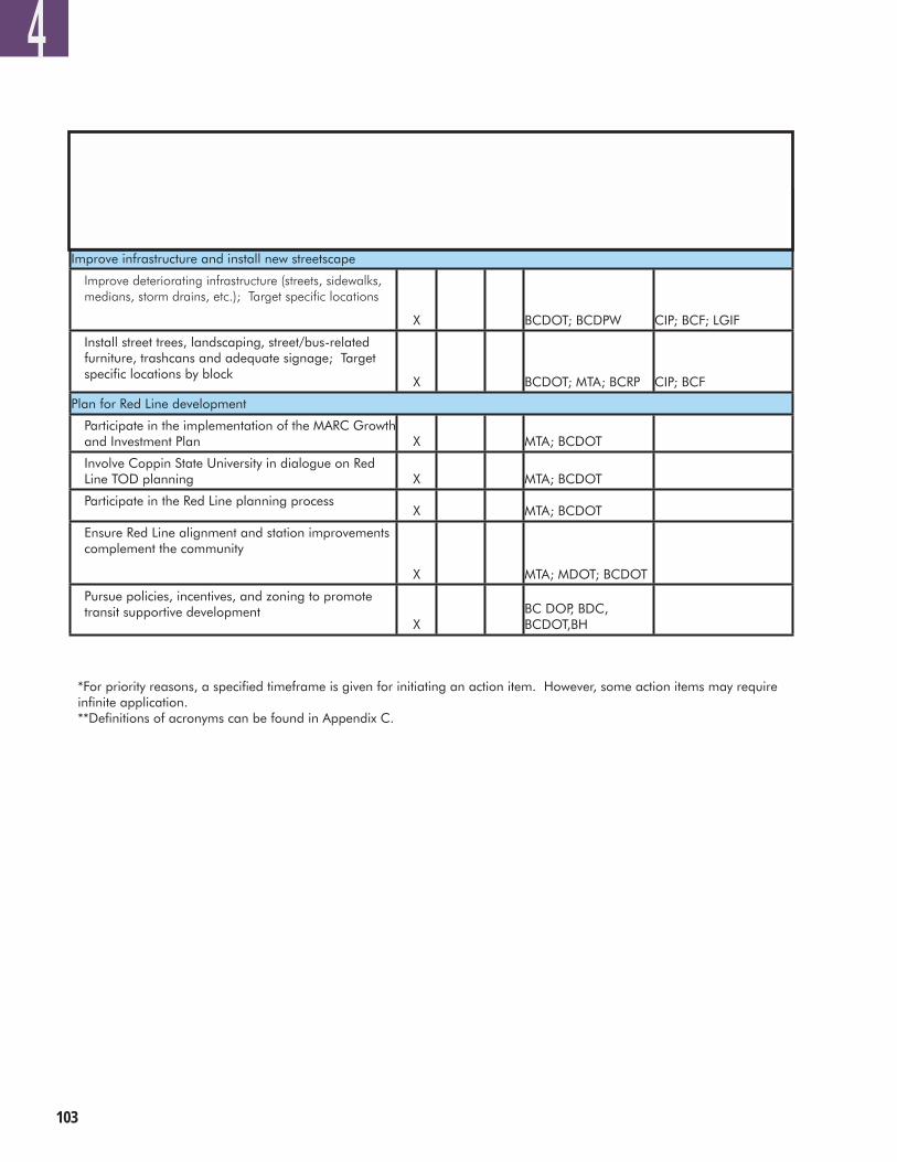
�0�
*For priority reasons, a specified timeframe is given for initiating an action item. However, some action items may require infinite application. **Definitions of acronyms can be found in Appendix C.
4Timeframe for Initiating Effort
(years)
Transportation
0-5 6-10 10+
Potential Partners in Process**
Potential Funding Sources/Relevant
Programs**Action Items
Improve infrastructure and install new streetscape
Improve deteriorating infrastructure (streets, sidewalks, medians, storm drains, etc.); Target specific locations
X BCDOT; BCDPW CIP; BCF; LGIF
Install street trees, landscaping, street/bus-related furniture, trashcans and adequate signage; Target specific locations by block
X BCDOT; MTA; BCRP CIP; BCF
Plan for Red Line development
Participate in the implementation of the MARC Growth and Investment Plan X MTA; BCDOT
Involve Coppin State University in dialogue on Red Line TOD planning X MTA; BCDOT
Participate in the Red Line planning processX MTA; BCDOT
Ensure Red Line alignment and station improvements complement the community
X MTA; MDOT; BCDOT
Pursue policies, incentives, and zoning to promote transit supportive development
XBC DOP, BDC, BCDOT,BH
West Balt imore MARC Transit-Centered Community Development Strategy �0�
APPENDIX A: HOUSING TOOLS AND RESOURCESAPPENDIX A: HOUSING TOOLS AND RESOURCES
A
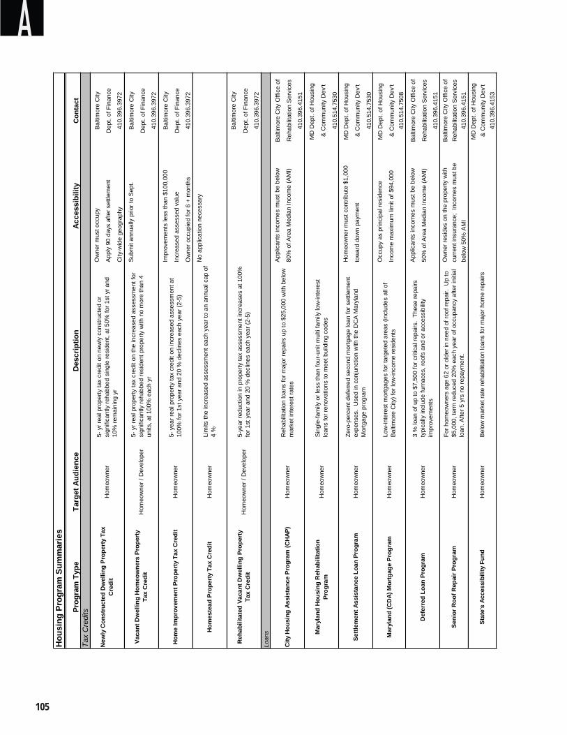
�0�
AH
ousi
ng P
rogr
am S
umm
arie
s
Prog
ram
Typ
eTa
rget
Aud
ienc
eAc
cess
ibili
tyC
onta
ctTa
x C
redi
tsO
wne
r mus
t occ
upy
Bal
timor
e C
ity
App
ly 9
0 da
ys a
fter s
ettle
men
tD
ept.
of F
inan
ce
City
-wid
e ge
ogra
phy
410.
396.
3972
Sub
mit
annu
ally
prio
r to
Sep
t.B
altim
ore
City
Dep
t. of
Fin
ance
410.
396.
3972
Impr
ovem
ents
less
than
$10
0,00
0B
altim
ore
City
Incr
ease
d as
sess
ed v
alue
Dep
t. of
Fin
ance
Ow
ner o
ccup
ied
for 6
+ m
onth
s4 1
0.39
6.39
72
No
appl
icat
ion
nece
ssar
y
Bal
timor
e C
ity
Dep
t. of
Fin
ance
410.
396.
3972
Loan
s
App
lican
ts in
com
es m
ust b
e be
low
Bal
timor
e C
ity O
ffice
of
80%
of A
rea
Med
ian
Inco
me
(AM
I)R
ehab
ilitat
ion
Ser
vice
s
410.
396.
4151
MD
Dep
t. of
Hou
sing
& C
omm
unity
Dev
't
410.
514.
7530
Hom
eow
ner m
ust c
ontri
bute
$1,
000
MD
Dep
t. of
Hou
sing
tow
ard
dow
n pa
ymen
t&
Com
mun
ity D
ev't
410.
514.
7530
Occ
upy
as p
rinci
pal r
esid
ence
MD
Dep
t. of
Hou
sing
Inco
me
max
imum
lim
it of
$94
,000
& C
omm
unity
Dev
't41
0.51
4.75
08
App
lican
ts in
com
es m
ust b
e be
low
Bal
timor
e C
ity O
ffice
of
50%
of A
rea
Med
ian
Inco
me
(AM
I)R
ehab
ilitat
ion
Ser
vice
s
410.
396.
4151
Ow
ner r
esid
es o
n th
e pr
oper
ty w
ith
Bal
timor
e C
ity O
ffice
of
curre
nt in
sura
nce;
Inc
omes
mus
t be
Reh
abilit
atio
n S
ervi
ces
belo
w 5
0% A
MI
4 10.
396.
4151
MD
Dep
t. of
Hou
sing
&
Com
mun
ity D
ev't
410.
396.
4153
Def
erre
d Lo
an P
rogr
amH
omeo
wne
r3
% lo
an o
f up
to $
7,50
0 fo
r crit
ical
repa
irs.
Thes
e re
pairs
ty
pica
lly in
clud
e fu
rnac
es, r
oofs
and
or a
cces
sibi
lity
impr
ovem
ents
Settl
emen
t Ass
ista
nce
Loan
Pro
gram
Hom
eow
ner
Zero
-per
cent
def
erre
d se
cond
mor
tgag
e lo
an fo
r set
tlem
ent
expe
nses
. U
sed
in c
onju
nctio
n w
ith th
e D
CA
Mar
ylan
d M
ortg
age
prog
ram
Mar
ylan
d (C
DA)
Mor
tgag
e Pr
ogra
mH
omeo
wne
rLo
w-in
tere
st m
ortg
ages
for t
arge
ted
area
s (in
clud
es a
ll of
B
altim
ore
City
) for
low
-inco
me
resi
dent
s
New
ly C
onst
ruct
ed D
wel
ling
Prop
erty
Tax
C
redi
t
Vaca
nt D
wel
ling
Hom
eow
ners
Pro
pert
y Ta
x C
redi
t
Hom
e Im
prov
emen
t Pro
pert
y Ta
x C
redi
tH
omeo
wne
r5-
yea
r rea
l pro
perty
tax
cred
it on
incr
ease
d as
sess
men
t at
100%
for 1
st y
ear a
nd 2
0 %
dec
lines
eac
h ye
ar (2
-5)
Hom
este
ad P
rope
rty
Tax
Cre
dit
Hom
eow
ner
Lim
its th
e in
crea
sed
asse
ssm
ent e
ach
year
to a
n an
nual
cap
of
4 %
Des
crip
tion
5- y
r rea
l pro
perty
tax
cred
it on
new
ly c
onst
ruct
ed o
r si
gnifi
cant
ly re
habb
ed s
ingl
e re
side
nt, a
t 50%
for 1
st y
r and
10
% re
mai
ning
yr
5- y
r rea
l pro
perty
tax
cred
it on
the
incr
ease
d as
sess
men
t for
si
gnifi
cant
ly re
habb
ed re
side
nt p
rope
rty w
ith n
o m
ore
than
4
units
, at 1
00%
eac
h yr
Hom
eow
ner
Hom
eow
ner /
Dev
elop
er
Seni
or R
oof R
epai
r Pro
gram
Hom
eow
ner
For h
omeo
wne
rs a
ge 6
2 or
old
er in
nee
d of
roof
repa
ir. U
p to
$5
,000
, ter
m re
duce
d 20
% e
ach
year
of o
ccup
ancy
afte
r ini
tial
loan
. Afte
r 5 y
rs n
o re
paym
ent.
Stat
e's
Acce
ssib
ility
Fun
dH
omeo
wne
rB
elow
mar
ket r
ate
reha
bilit
atio
n lo
ans
for m
ajor
hom
e re
pairs
Reh
abili
tate
d Va
cant
Dw
ellin
g Pr
oper
ty
Tax
Cre
dit
Hom
eow
ner /
Dev
elop
er5-
year
redu
ctio
n in
pro
perty
tax
asse
ssm
ent i
ncre
ases
at 1
00%
fo
r 1st
yea
r and
20
% d
eclin
es e
ach
year
(2-5
)
City
Hou
sing
Ass
ista
nce
Prog
ram
(CH
AP)
Hom
eow
ner
Reh
abili
tatio
n lo
ans
for m
ajor
repa
irs u
p to
$25
,000
with
bel
ow
mar
ket i
nter
est r
ates
Mar
ylan
d H
ousi
ng R
ehab
ilita
tion
Prog
ram
Hom
eow
ner
Sin
gle-
fam
ily o
r les
s th
an fo
ur-u
nit m
ulti
fam
ily lo
w-in
tere
st
loan
s fo
r ren
ovat
ions
to m
eet b
uild
ing
code
s
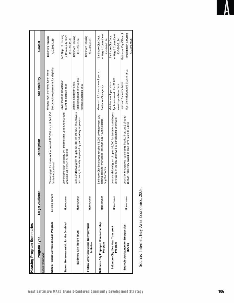
West Balt imore MARC Transit-Centered Community Development Strategy �0�
Sour
ce:
Inte
rnet
; Bay
Are
a Ec
onom
ics,
2008
.
Hou
sing
Pro
gram
Sum
mar
ies
Prog
ram
Typ
eTa
rget
Aud
ienc
eAc
cess
ibili
tyC
onta
ctLo
ans
(con
tinue
d)
Tena
nts
mus
t cur
rent
ly li
ve in
hom
eB
altim
ore
Hou
sing
Stri
ct c
redi
t req
uire
men
ts fo
r elig
ibili
ty41
0.39
6.41
59
Buy
er m
ust b
e di
sabl
ed o
r M
D D
ept.
of H
ousi
ng
pare
nt o
f dis
able
d ch
ild&
Com
mun
ity D
ev't
410.
396.
4159
Mat
ches
em
ploy
er fu
nds
Bal
timor
e H
ousi
ngA
pplic
ants
mus
t offe
r $1,
000
410.
396.
3124
tow
ards
pur
chas
e pr
ice
Bal
timor
e H
ousi
ng41
0.39
6.31
24
Min
imum
of 6
mon
ths
empl
oyed
at
Bal
timor
e C
ity D
ept.
Bal
timor
e C
ity a
genc
y of
Hsg
& C
omm
Dev
't41
0-39
6-31
24M
atch
es e
mpl
oyer
fund
sB
altim
ore
City
Dep
t. A
pplic
ants
mus
t offe
r $1,
000
of H
sg &
Com
m D
ev't
tow
ards
pur
chas
e pr
ice
410-
396-
3124
Loan
s on
1st
com
e ba
sis
Bal
timor
e C
ity O
ffice
of
Mus
t be
in d
esig
nate
d di
sast
er a
rea
Reh
abili
tatio
n S
ervi
ces
410.
396.
4606
Stat
e's
Hom
eow
ners
hip
for t
he D
isab
led
Hom
eow
ner
Low
-inco
me
loan
(pos
sibl
y 5%
) Inc
ome
limit
up to
$79
,000
and
lo
an li
mit
will
exc
eed
$100
,000
Bal
timor
e C
ity L
ive
Nea
r You
r Wor
k Pr
ogra
mH
omeo
wne
rLo
an/c
ondi
tiona
l gra
nt o
f up
to $
2,00
0 fo
r 1st
-tim
e ho
meb
uyer
s pu
rcha
sing
in th
e ci
ty e
mpl
oyed
by
parti
cipa
ting
empl
oyer
s
Stra
tegi
c As
sist
ance
for E
mer
genc
ies
(SAF
E)H
omeo
wne
rLo
ans
for e
mer
genc
y re
pairs
(e.g
. flo
ods,
fire
s, e
tc.)
of u
p to
$5
,000
; ra
tes
vary
bas
ed o
n lo
an te
rm (5
.5%
to 1
.5%
)
Bal
timor
e C
ity E
mpl
oyee
Hom
eow
ners
hip
Prog
ram
Hom
eow
ner
Bal
timor
e C
ity E
mpl
oyee
s re
ceiv
e $3
,000
dow
n pa
ymen
t and
cl
osin
g co
sts
for m
ortg
ages
less
than
$41
7,00
0 in
elig
ible
ne
ighb
orho
ods
Exi
stin
g Te
nant
5% m
ortg
age
for h
ouse
not
to e
xcee
d $7
7,00
0 pr
ice
at $
41,7
50
fam
ily in
com
e le
vel
Bal
timor
e C
ity T
rolle
y To
urs
Hom
eow
ner
Loan
/con
ditio
nal g
rant
of u
p to
$2,
000
for 1
st-ti
me
hom
ebuy
ers
purc
hasi
ng in
the
city
em
ploy
ed b
y pa
rtici
patin
g em
ploy
ers
Fede
ral A
mer
ican
Dre
am D
ownp
aym
ent
Initi
ativ
eH
omeo
wne
r
Stat
e's
Tena
nt C
onve
rsio
n Lo
an P
rogr
am
Des
crip
tion
A
�0�
APPENDIX B: ECONOMIC DEVELOPMENT TOOLS AND RESOURCESAPPENDIX B: ECONOMIC DEVELOPMENT TOOLS AND RESOURCES
B
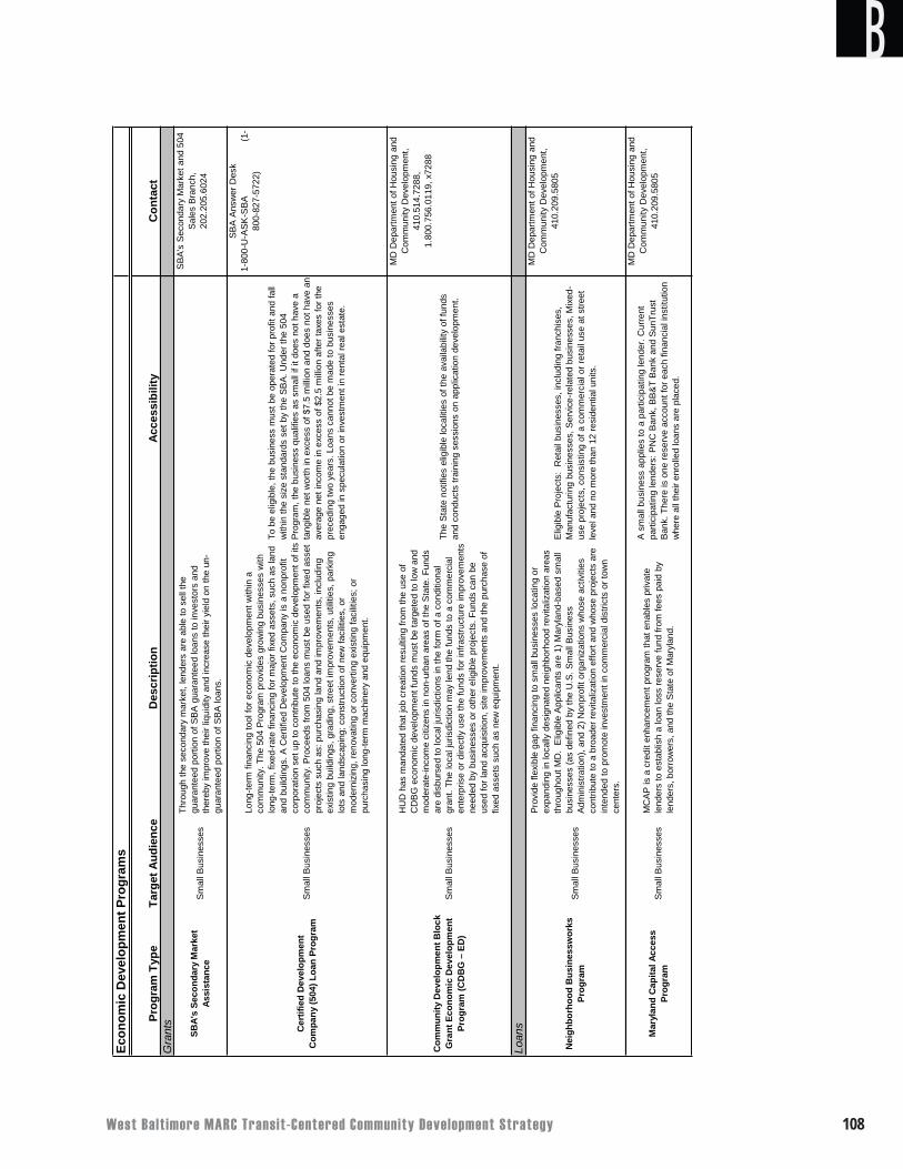
West Balt imore MARC Transit-Centered Community Development Strategy �0�
BEc
onom
ic D
evel
opm
ent P
rogr
ams
Prog
ram
Typ
eTa
rget
Aud
ienc
eAc
cess
ibili
tyC
onta
ctG
rant
s
Loan
s
HU
D h
as m
anda
ted
that
job
crea
tion
resu
lting
from
the
use
of
CD
BG
eco
nom
ic d
evel
opm
ent f
unds
mus
t be
targ
eted
to lo
w a
nd
mod
erat
e-in
com
e ci
tizen
s in
non
-urb
an a
reas
of t
he S
tate
. Fun
ds
are
disb
urse
d to
loca
l jur
isdi
ctio
ns in
the
form
of a
con
ditio
nal
gran
t. Th
e lo
cal j
uris
dict
ion
may
lend
the
fund
s to
a c
omm
erci
al
ente
rpris
e or
dire
ctly
use
the
fund
s fo
r inf
rast
ruct
ure
impr
ovem
ents
ne
eded
by
busi
ness
es o
r oth
er e
ligib
le p
roje
cts.
Fun
ds c
an b
e us
ed fo
r lan
d ac
quis
ition
, site
impr
ovem
ents
and
the
purc
hase
of
fixed
ass
ets
such
as
new
equ
ipm
ent.
Com
mun
ity D
evel
opm
ent B
lock
G
rant
Eco
nom
ic D
evel
opm
ent
Prog
ram
(CD
BG
– E
D)
MC
AP
is a
cre
dit e
nhan
cem
ent p
rogr
am th
at e
nabl
es p
rivat
e le
nder
s to
est
ablis
h a
loan
loss
rese
rve
fund
from
fees
pai
d by
le
nder
s, b
orro
wer
s, a
nd th
e S
tate
of M
aryl
and.
Pro
vide
flex
ible
gap
fina
ncin
g to
sm
all b
usin
esse
s lo
catin
g or
ex
pand
ing
in lo
cally
des
igna
ted
neig
hbor
hood
revi
taliz
atio
n ar
eas
thro
ugho
ut M
D.
Elig
ible
App
lican
ts a
re 1
) Mar
ylan
d-ba
sed
smal
l bu
sine
sses
(as
defin
ed b
y th
e U
.S. S
mal
l Bus
ines
s A
dmin
istra
tion)
, and
2) N
onpr
ofit
orga
niza
tions
who
se a
ctiv
ities
co
ntrib
ute
to a
bro
ader
revi
taliz
atio
n ef
fort
and
who
se p
roje
cts
are
inte
nded
to p
rom
ote
inve
stm
ent i
n co
mm
erci
al d
istri
cts
or to
wn
cent
ers.
SBA'
s Se
cond
ary
Mar
ket
Assi
stan
ce
Mar
ylan
d C
apita
l Acc
ess
Prog
ram
Sm
all B
usin
esse
s
Cer
tifie
d D
evel
opm
ent
Com
pany
(504
) Loa
n Pr
ogra
m
Nei
ghbo
rhoo
d B
usin
essw
orks
Pr
ogra
mS
mal
l Bus
ines
ses
Sm
all B
usin
esse
s
Des
crip
tion
Thro
ugh
the
seco
ndar
y m
arke
t, le
nder
s ar
e ab
le to
sel
l the
gu
aran
teed
por
tion
of S
BA
gua
rant
eed
loan
s to
inve
stor
s an
d th
ereb
y im
prov
e th
eir l
iqui
dity
and
incr
ease
thei
r yie
ld o
n th
e un
-gu
aran
teed
por
tion
of S
BA
loan
s.
Long
-term
fina
ncin
g to
ol fo
r eco
nom
ic d
evel
opm
ent w
ithin
a
com
mun
ity. T
he 5
04 P
rogr
am p
rovi
des
grow
ing
busi
ness
es w
ith
long
-term
, fix
ed-ra
te fi
nanc
ing
for m
ajor
fixe
d as
sets
, suc
h as
land
an
d bu
ildin
gs. A
Cer
tifie
d D
evel
opm
ent C
ompa
ny is
a n
onpr
ofit
corp
orat
ion
set u
p to
con
tribu
te to
the
econ
omic
dev
elop
men
t of i
ts
com
mun
ity. P
roce
eds
from
504
loan
s m
ust b
e us
ed fo
r fix
ed a
sset
pr
ojec
ts s
uch
as: p
urch
asin
g la
nd a
nd im
prov
emen
ts, i
nclu
ding
ex
istin
g bu
ildin
gs, g
radi
ng, s
treet
impr
ovem
ents
, util
ities
, par
king
lo
ts a
nd la
ndsc
apin
g; c
onst
ruct
ion
of n
ew fa
cilit
ies,
or
mod
erni
zing
, ren
ovat
ing
or c
onve
rting
exi
stin
g fa
cilit
ies;
or
purc
hasi
ng lo
ng-te
rm m
achi
nery
and
equ
ipm
ent.
Sm
all B
usin
esse
s
Sm
all B
usin
esse
s
To b
e el
igib
le, t
he b
usin
ess
mus
t be
oper
ated
for p
rofit
and
fall
with
in th
e si
ze s
tand
ards
set
by
the
SB
A. U
nder
the
504
Pro
gram
, the
bus
ines
s qu
alifi
es a
s sm
all i
f it d
oes
not h
ave
a ta
ngib
le n
et w
orth
in e
xces
s of
$7.
5 m
illion
and
doe
s no
t hav
e an
av
erag
e ne
t inc
ome
in e
xces
s of
$2.
5 m
illion
afte
r tax
es fo
r the
pr
eced
ing
two
year
s. L
oans
can
not b
e m
ade
to b
usin
esse
s en
gage
d in
spe
cula
tion
or in
vest
men
t in
rent
al re
al e
stat
e.
SB
A A
nsw
er D
esk
1-80
0-U
-AS
K-S
BA
(1
-80
0-82
7-57
22)
SB
A's
Sec
onda
ry M
arke
t and
504
S
ales
Bra
nch,
202.
205.
6024
The
Sta
te n
otifi
es e
ligib
le lo
calit
ies
of th
e av
aila
bilit
y of
fund
s an
d co
nduc
ts tr
aini
ng s
essi
ons
on a
pplic
atio
n de
velo
pmen
t.
MD
Dep
artm
ent o
f Hou
sing
and
C
omm
unity
Dev
elop
men
t,
410.
514.
7288
,
1.
800.
756.
0119
, x72
88
MD
Dep
artm
ent o
f Hou
sing
and
C
omm
unity
Dev
elop
men
t,
410.
209.
5805
Elig
ible
Pro
ject
s: R
etai
l bus
ines
ses,
incl
udin
g fra
nchi
ses,
M
anuf
actu
ring
busi
ness
es, S
ervi
ce-re
late
d bu
sine
sses
, Mix
ed-
use
proj
ects
, con
sist
ing
of a
com
mer
cial
or r
etai
l use
at s
treet
le
vel a
nd n
o m
ore
than
12
resi
dent
ial u
nits
.
A s
mal
l bus
ines
s ap
plie
s to
a p
artic
ipat
ing
lend
er. C
urre
nt
parti
cipa
ting
lend
ers:
PN
C B
ank,
BB
&T
Ban
k an
d S
unTr
ust
Ban
k. T
here
is o
ne re
serv
e ac
coun
t for
eac
h fin
anci
al in
stitu
tion
whe
re a
ll th
eir e
nrol
led
loan
s ar
e pl
aced
.
MD
Dep
artm
ent o
f Hou
sing
and
C
omm
unity
Dev
elop
men
t,
410.
209.
5805
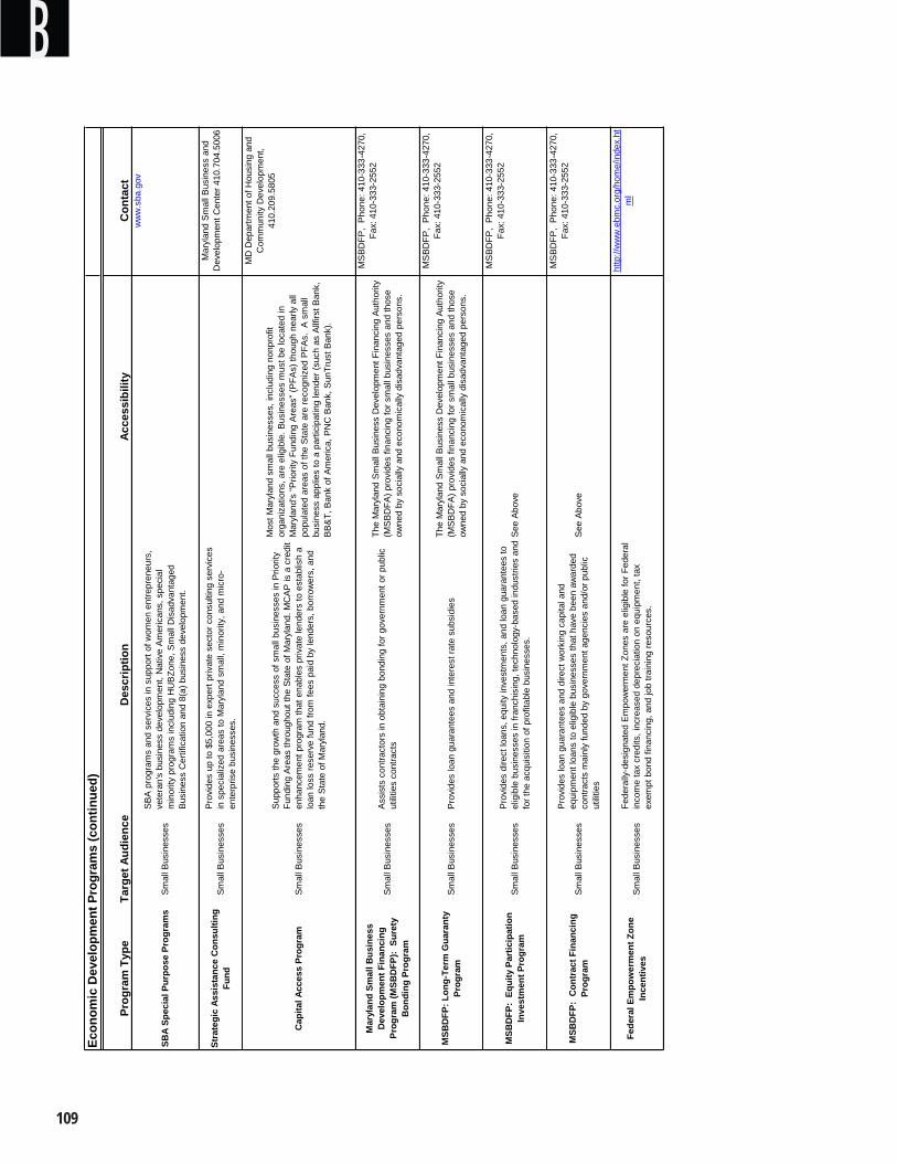
�0�
BEc
onom
ic D
evel
opm
ent P
rogr
ams
(con
tinue
d)
Prog
ram
Typ
eTa
rget
Aud
ienc
eAc
cess
ibili
tyC
onta
ct
Prov
ides
loan
gua
rant
ees
and
dire
ct w
orki
ng c
apita
l and
eq
uipm
ent l
oans
to e
ligib
le b
usin
esse
s th
at h
ave
been
aw
arde
d co
ntra
cts
mai
nly
fund
ed b
y go
vern
men
t age
ncie
s an
d/or
pub
lic
utili
ties
Mar
ylan
d Sm
all B
usin
ess
Dev
elop
men
t Fin
anci
ng
Prog
ram
(MSB
DFP
): S
uret
y B
ondi
ng P
rogr
am
MSB
DFP
: Lon
g-Te
rm G
uara
nty
Prog
ram
Fede
ral E
mpo
wer
men
t Zon
e In
cent
ives
MSB
DFP
: C
ontr
act F
inan
cing
Pr
ogra
m
Sm
all B
usin
esse
sFe
dera
lly-d
esig
nate
d E
mpo
wer
men
t Zon
es a
re e
ligib
le fo
r Fed
eral
in
com
e ta
x cr
edits
, inc
reas
ed d
epre
ciat
ion
on e
quip
men
t, ta
x ex
empt
bon
d fin
anci
ng, a
nd jo
b tra
inin
g re
sour
ces.
Sup
ports
the
grow
th a
nd s
ucce
ss o
f sm
all b
usin
esse
s in
Prio
rity
Fund
ing
Are
as th
roug
hout
the
Sta
te o
f Mar
ylan
d. M
CA
P is
a c
redi
t en
hanc
emen
t pro
gram
that
ena
bles
priv
ate
lend
ers
to e
stab
lish
a lo
an lo
ss re
serv
e fu
nd fr
om fe
es p
aid
by le
nder
s, b
orro
wer
s, a
nd
the
Stat
e of
Mar
ylan
d.
Sm
all B
usin
esse
sP
rovi
des
dire
ct lo
ans,
equ
ity in
vest
men
ts, a
nd lo
an g
uara
ntee
s to
el
igib
le b
usin
esse
s in
fran
chis
ing,
tech
nolo
gy-b
ased
indu
strie
s an
d fo
r the
acq
uisi
tion
of p
rofit
able
bus
ines
ses.
Smal
l Bus
ines
ses
Prov
ides
loan
gua
rant
ees
and
inte
rest
rate
sub
sidi
es
Sm
all B
usin
esse
sAs
sist
s co
ntra
ctor
s in
obt
aini
ng b
ondi
ng fo
r gov
ernm
ent o
r pub
lic
utili
ties
cont
ract
s
Stra
tegi
c As
sist
ance
Con
sulti
ng
Fund
Sm
all B
usin
esse
sP
rovi
des
up to
$5,
000
in e
xper
t priv
ate
sect
or c
onsu
lting
ser
vice
s in
spe
cial
ized
are
as to
Mar
ylan
d sm
all,
min
ority
, and
mic
ro-
ente
rpris
e bu
sine
sses
.
SBA
pro
gram
s an
d se
rvic
es in
sup
port
of w
omen
ent
repr
eneu
rs,
vete
ran'
s bu
sine
ss d
evel
opm
ent,
Nat
ive
Am
eric
ans,
spe
cial
m
inor
ity p
rogr
ams
incl
udin
g H
UB
Zone
, Sm
all D
isad
vant
aged
Bu
sine
ss C
ertif
icat
ion
and
8(a)
bus
ines
s de
velo
pmen
t.
Des
crip
tion
SBA
Spec
ial P
urpo
se P
rogr
ams
Sm
all B
usin
esse
s
Cap
ital A
cces
s Pr
ogra
mS
mal
l Bus
ines
ses
MSB
DFP
: Eq
uity
Par
ticip
atio
n In
vest
men
t Pro
gram
Sm
all B
usin
esse
s
ww
w.s
ba.g
ov
Mar
ylan
d S
mal
l Bus
ines
s an
d D
evel
opm
ent C
ente
r 410
.704
.500
6
MD
Dep
artm
ent o
f Hou
sing
and
C
omm
unity
Dev
elop
men
t,
410.
209.
5805
Mos
t Mar
ylan
d sm
all b
usin
esse
s, in
clud
ing
nonp
rofit
or
gani
zatio
ns, a
re e
ligib
le. B
usin
esse
s m
ust b
e lo
cate
d in
M
aryl
and'
s "P
riorit
y Fu
ndin
g A
reas
" (P
FAs)
thou
gh n
early
all
popu
late
d ar
eas
of th
e S
tate
are
reco
gniz
ed P
FAs.
A s
mal
l bu
sine
ss a
pplie
s to
a p
artic
ipat
ing
lend
er (s
uch
as A
llfirs
t Ban
k,
BB
&T,
Ban
k of
Am
eric
a, P
NC
Ban
k, S
unTr
ust B
ank)
.
http
://w
ww
.ebm
c.or
g/ho
me/
inde
x.ht
ml
MS
BD
FP,
Pho
ne: 4
10-3
33-4
270,
Fa
x: 4
10-3
33-2
552
MS
BD
FP,
Pho
ne: 4
10-3
33-4
270,
Fa
x: 4
10-3
33-2
552
MS
BD
FP,
Pho
ne: 4
10-3
33-4
270,
Fa
x: 4
10-3
33-2
552
MS
BD
FP,
Pho
ne: 4
10-3
33-4
270,
Fa
x: 4
10-3
33-2
552
The
Mar
ylan
d Sm
all B
usin
ess
Dev
elop
men
t Fin
anci
ng A
utho
rity
(MS
BD
FA) p
rovi
des
finan
cing
for s
mal
l bus
ines
ses
and
thos
e ow
ned
by s
ocia
lly a
nd e
cono
mic
ally
dis
adva
ntag
ed p
erso
ns.
The
Mar
ylan
d Sm
all B
usin
ess
Dev
elop
men
t Fin
anci
ng A
utho
rity
(MS
BD
FA) p
rovi
des
finan
cing
for s
mal
l bus
ines
ses
and
thos
e ow
ned
by s
ocia
lly a
nd e
cono
mic
ally
dis
adva
ntag
ed p
erso
ns.
See
Abo
ve
See
Abo
ve
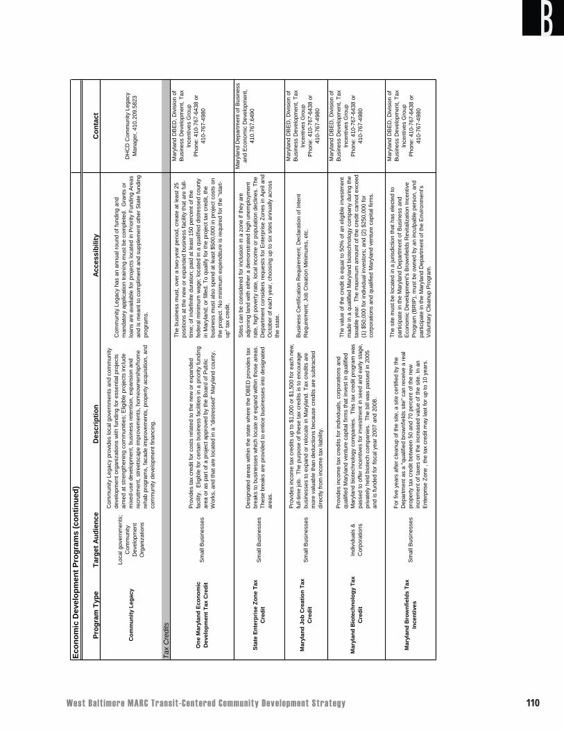
West Balt imore MARC Transit-Centered Community Development Strategy ��0
BEc
onom
ic D
evel
opm
ent P
rogr
ams
(con
tinue
d)
Prog
ram
Typ
eTa
rget
Aud
ienc
eAc
cess
ibili
tyC
onta
ct
Com
mun
ity L
egac
y
Loca
l gov
ernm
ents
; C
omm
unity
D
evel
opm
ent
Org
aniz
atio
ns
Com
mun
ity L
egac
y ha
s an
ann
ual r
ound
of f
undi
ng a
nd
man
dato
ry a
pplic
atio
n tra
inin
g m
ust b
e co
mpl
eted
. G
rant
s or
lo
ans
are
avai
labl
e fo
r pro
ject
s lo
cate
d in
Prio
rity
Fund
ing
Are
as
and
is m
eant
to c
ompl
imen
t and
sup
plem
ent o
ther
Sta
te fu
ndin
g pr
ogra
ms.
DH
CD
Com
mun
ity L
egac
y M
anag
er, 4
10.2
09.5
823
Tax
Cre
dits
Com
mun
ity L
egac
y pr
ovid
es lo
cal g
over
nmen
ts a
nd c
omm
unity
de
velo
pmen
t org
aniz
atio
ns w
ith fu
ndin
g fo
r ess
entia
l pro
ject
s ai
med
at s
treng
then
ing
com
mun
ities
; Elig
ible
pro
ject
s in
clud
e m
ixed
-use
dev
elop
men
t, bu
sine
ss re
tent
ion,
exp
ansi
on a
nd
recr
uitm
ent,
stre
etsc
ape
impr
ovem
ents
, hom
eow
ners
hip/
hom
e re
hab
prog
ram
s, fa
cade
impr
ovem
ents
, pro
perty
acq
uisi
tion,
and
co
mm
unity
dev
elop
men
t fin
anci
ng.
Mar
ylan
d B
row
nfie
lds
Tax
Ince
ntiv
es
Mar
ylan
d Jo
b C
reat
ion
Tax
Cre
dit
One
Mar
ylan
d Ec
onom
ic
Dev
elop
men
t Tax
Cre
dit
Sm
all B
usin
esse
s
Sm
all B
usin
esse
s
Pro
vide
s in
com
e ta
x cr
edits
up
to $
1,00
0 or
$1,
500
for e
ach
new
, fu
ll-tim
e jo
b. T
he p
urpo
se o
f the
se ta
x cr
edits
is to
enc
oura
ge
busi
ness
es to
exp
and
or re
loca
te in
Mar
ylan
d. T
ax c
redi
ts a
re
mor
e va
luab
le th
an d
educ
tions
bec
ause
cre
dits
are
sub
tract
ed
dire
ctly
from
inco
me
tax
liabi
lity.
Des
crip
tion
For f
ive
year
s af
ter c
lean
up o
f the
site
, a s
ite c
ertif
ied
by th
e D
epar
tmen
t as
a "q
ualif
ied
brow
nfie
lds
site
" can
rece
ive
a re
al
prop
erty
tax
cred
it be
twee
n 50
and
70
perc
ent o
f the
new
in
crem
ent o
f tax
es o
n th
e in
crea
sed
valu
e of
the
site
. In
an
Ent
erpr
ise
Zone
, th
e ta
x cr
edit
may
last
for u
p to
10
year
s.
Mar
ylan
d B
iote
chno
logy
Tax
C
redi
tIn
divi
dual
s &
C
orpo
ratio
ns
Pro
vide
s in
com
e ta
x cr
edits
for i
ndiv
idua
ls, c
orpo
ratio
ns a
nd
qual
ified
Mar
ylan
d ve
ntur
e ca
pita
l firm
s th
at in
vest
in q
ualif
ied
Mar
ylan
d bi
otec
hnol
ogy
com
pani
es.
This
tax
cred
it pr
ogra
m w
as
pass
ed to
offe
r inc
entiv
es fo
r inv
estm
ent i
n se
ed a
nd e
arly
sta
ge,
priv
atel
y he
ld b
iote
ch c
ompa
nies
. Th
e bi
ll w
as p
asse
d in
200
5 an
d is
fund
ed fo
r fis
cal y
ear 2
007
and
2008
.
Des
igna
ted
area
s w
ithin
the
stat
e w
here
the
DB
ED
pro
vide
s ta
x br
eaks
to b
usin
esse
s w
hich
loca
te o
r exp
and
with
in th
ose
area
s.
Thes
e br
eaks
are
pro
vide
d to
ent
ice
busi
ness
es in
to d
esig
nate
d ar
eas.
Stat
e En
terp
rise
Zone
Tax
C
redi
tS
mal
l Bus
ines
ses
Sm
all B
usin
esse
s
Pro
vide
s ta
x cr
edit
for c
osts
rela
ted
to th
e ne
w o
r exp
ande
d fa
cilit
y. E
ligib
le fo
r cer
tain
bus
ines
s fa
cilit
ies
in a
prio
rity
fund
ing
area
or a
s pa
rt of
a p
roje
ct a
ppro
ved
by th
e B
oard
of P
ublic
W
orks
, and
that
are
loca
ted
in a
"dis
tress
ed" M
aryl
and
coun
ty.
Mar
ylan
d D
BE
D, D
ivis
ion
of
Bus
ines
s D
evel
opm
ent,
Tax
Ince
ntiv
es G
roup
Pho
ne: 4
10-7
67-6
438
or
41
0-76
7-49
80
Mar
ylan
d D
BE
D, D
ivis
ion
of
Bus
ines
s D
evel
opm
ent,
Tax
Ince
ntiv
es G
roup
Pho
ne: 4
10-7
67-6
438
or
41
0-76
7-49
80
Mar
ylan
d D
BE
D, D
ivis
ion
of
Bus
ines
s D
evel
opm
ent,
Tax
Ince
ntiv
es G
roup
Pho
ne: 4
10-7
67-6
438
or
41
0-76
7-49
80
Mar
ylan
d D
epar
tmen
t of B
usin
ess
and
Eco
nom
ic D
evel
opm
ent,
410.
767.
6490
Mar
ylan
d D
BE
D, D
ivis
ion
of
Bus
ines
s D
evel
opm
ent,
Tax
Ince
ntiv
es G
roup
Pho
ne: 4
10-7
67-6
438
or
41
0-76
7-49
80
The
valu
e of
the
cred
it is
equ
al to
50%
of a
n el
igib
le in
vest
men
t m
ade
in a
qua
lifie
d M
aryl
and
biot
echn
olog
y co
mpa
ny d
urin
g th
e ta
xabl
e ye
ar.
The
max
imum
am
ount
of t
he c
redi
t can
not e
xcee
d (1
) $50
,000
for i
ndiv
idua
l inv
esto
rs; a
nd (2
) $25
0,00
0 fo
r co
rpor
atio
ns a
nd q
ualif
ied
Mar
ylan
d ve
ntur
e ca
pita
l firm
s.
Site
s ca
n be
con
side
red
for i
nclu
sion
in a
zon
e if
they
are
ad
join
ing
land
with
eith
er a
dem
onst
rate
d hi
gh u
nem
ploy
men
t ra
te, h
igh
pove
rty ra
te, l
ocal
inco
me
or p
opul
atio
n de
clin
es. T
he
Dep
artm
ent c
onsi
ders
requ
ests
for E
nter
pris
e Zo
nes
in A
pril
and
Oct
ober
of e
ach
year
, cho
osin
g up
to s
ix s
ites
annu
ally
acr
oss
the
stat
e.
Bus
ines
s C
ertif
icat
ion
Req
uire
men
t; D
ecla
ratio
n of
Inte
nt
Req
uire
men
t; Jo
b C
reat
ion
Min
imum
s, e
tc.
The
busi
ness
mus
t, ov
er a
two-
year
per
iod,
cre
ate
at le
ast 2
5 po
sitio
ns a
t the
new
or e
xpan
ded
busi
ness
faci
lity
that
are
full-
time;
of i
ndef
inite
dur
atio
n; p
aid
at le
ast 1
50 p
erce
nt o
f the
fe
dera
l min
imum
wag
e; lo
cate
d in
a q
ualif
ied
dist
ress
ed c
ount
y in
Mar
ylan
d; o
r fill
ed. T
o qu
alify
for t
he p
roje
ct ta
x cr
edit,
the
busi
ness
mus
t als
o sp
end
at le
ast $
500,
000
in p
roje
ct c
osts
on
the
proj
ect.
No
min
imum
exp
endi
ture
is re
quire
d fo
r the
"sta
rt-up
" tax
cre
dit.
The
site
mus
t be
loca
ted
in a
juris
dict
ion
that
has
ele
cted
to
parti
cipa
te in
the
Mar
ylan
d D
epar
tmen
t of B
usin
ess
and
Eco
nom
ic D
evel
opm
ent's
Bro
wnf
ield
s R
evita
lizat
ion
Ince
ntiv
e P
rogr
am (B
RIP
), m
ust b
e ow
ned
by a
n in
culp
able
per
son,
and
pa
rtici
pate
in th
e M
aryl
and
Dep
artm
ent o
f the
Env
ironm
ent's
V
olun
tary
Cle
anup
Pro
gram
.
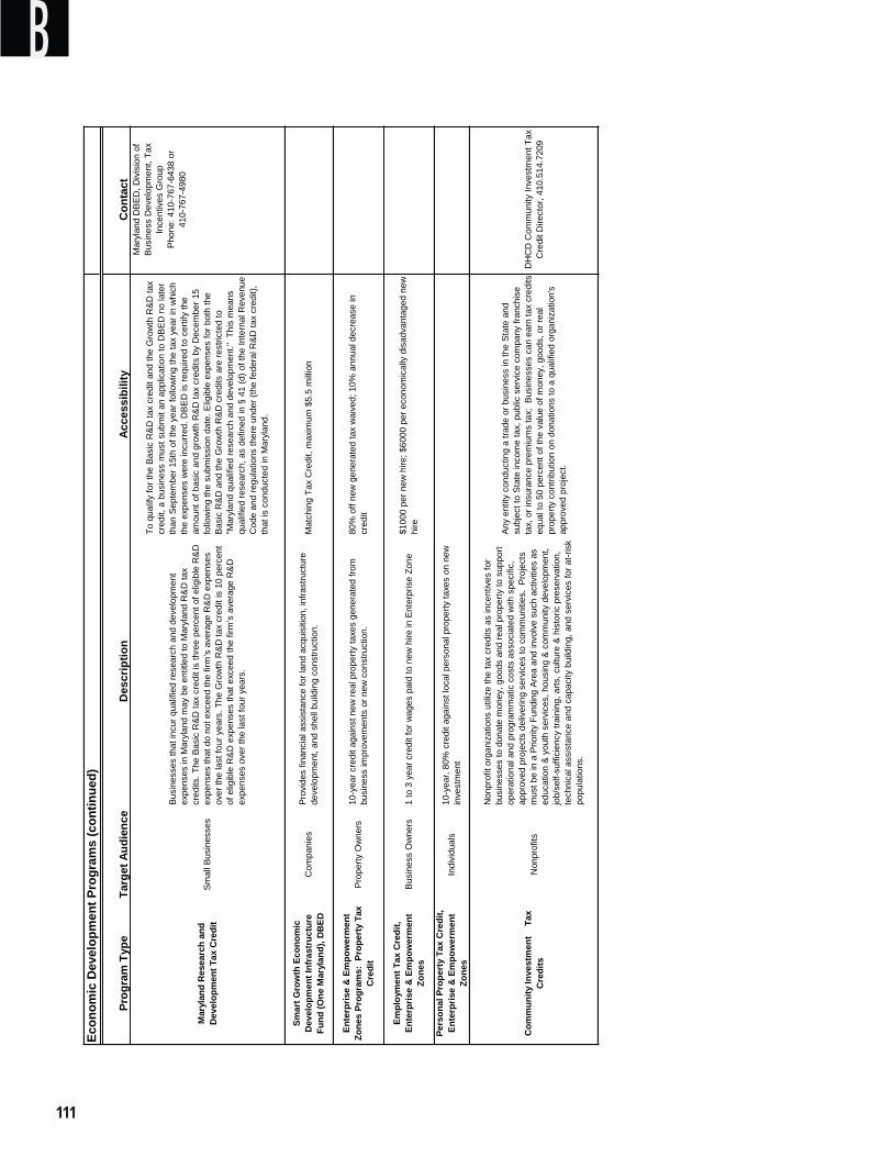
���
BEc
onom
ic D
evel
opm
ent P
rogr
ams
(con
tinue
d)
Prog
ram
Typ
eTa
rget
Aud
ienc
eAc
cess
ibili
tyC
onta
ct
Com
mun
ity In
vest
men
t T
ax
Cre
dits
Non
prof
its
Any
entit
y co
nduc
ting
a tra
de o
r bus
ines
s in
the
Stat
e an
d su
bjec
t to
Stat
e in
com
e ta
x, p
ublic
ser
vice
com
pany
fran
chis
e ta
x, o
r ins
uran
ce p
rem
ium
s ta
x; B
usin
esse
s ca
n ea
rn ta
x cr
edits
eq
ual t
o 50
per
cent
of t
he v
alue
of m
oney
, goo
ds, o
r rea
l pr
oper
ty c
ontri
butio
n on
don
atio
ns to
a q
ualif
ied
orga
niza
tion'
s ap
prov
ed p
roje
ct.
DH
CD
Com
mun
ity In
vest
men
t Tax
C
redi
t Dire
ctor
, 410
.514
.720
9
Non
prof
it or
gani
zatio
ns u
tiliz
e th
e ta
x cr
edits
as
ince
ntiv
es fo
r bu
sine
sses
to d
onat
e m
oney
, goo
ds a
nd re
al p
rope
rty to
sup
port
oper
atio
nal a
nd p
rogr
amm
atic
cos
ts a
ssoc
iate
d w
ith s
peci
fic,
appr
oved
pro
ject
s de
liver
ing
serv
ices
to c
omm
uniti
es.
Pro
ject
s m
ust b
e in
a P
riorit
y Fu
ndin
g Ar
ea a
nd in
volv
e su
ch a
ctiv
ities
as
educ
atio
n &
yout
h se
rvic
es, h
ousi
ng &
com
mun
ity d
evel
opm
ent,
job/
self-
suffi
cien
cy tr
aini
ng, a
rts, c
ultu
re &
his
toric
pre
serv
atio
n,
tech
nica
l ass
ista
nce
and
capa
city
bui
ldin
g, a
nd s
ervi
ces
for a
t-ris
k po
pula
tions
.
Mar
ylan
d R
esea
rch
and
Dev
elop
men
t Tax
Cre
dit
Sm
all B
usin
esse
s
Busi
ness
es th
at in
cur q
ualif
ied
rese
arch
and
dev
elop
men
t ex
pens
es in
Mar
ylan
d m
ay b
e en
title
d to
Mar
ylan
d R
&D
tax
cred
its. T
he B
asic
R&
D ta
x cr
edit
is th
ree
perc
ent o
f elig
ible
R&
D
expe
nses
that
do
not e
xcee
d th
e fir
m’s
ave
rage
R&D
exp
ense
s ov
er th
e la
st fo
ur y
ears
. The
Gro
wth
R&D
tax
cred
it is
10
perc
ent
of e
ligib
le R
&D
exp
ense
s th
at e
xcee
d th
e fir
m’s
ave
rage
R&
D
expe
nses
ove
r the
last
four
yea
rs.
Mar
ylan
d D
BED
, Div
isio
n of
Bu
sine
ss D
evel
opm
ent,
Tax
Ince
ntiv
es G
roup
Pho
ne: 4
10-7
67-6
438
or
41
0-76
7-49
80
To q
ualif
y fo
r the
Bas
ic R
&D
tax
cred
it an
d th
e G
row
th R
&D
tax
cred
it, a
bus
ines
s m
ust s
ubm
it an
app
licat
ion
to D
BED
no
late
r th
an S
epte
mbe
r 15t
h of
the
year
follo
win
g th
e ta
x ye
ar in
whi
ch
the
expe
nses
wer
e in
curre
d. D
BE
D is
requ
ired
to c
ertif
y th
e am
ount
of b
asic
and
gro
wth
R&
D ta
x cr
edits
by
Dec
embe
r 15
follo
win
g th
e su
bmis
sion
dat
e. E
ligib
le e
xpen
ses
for b
oth
the
Basi
c R
&D a
nd th
e G
row
th R
&D c
redi
ts a
re re
stric
ted
to
"Mar
ylan
d qu
alifi
ed re
sear
ch a
nd d
evel
opm
ent."
Thi
s m
eans
qu
alifi
ed re
sear
ch, a
s de
fined
in §
41
(d) o
f the
Inte
rnal
Rev
enue
C
ode
and
regu
latio
ns th
ere
unde
r (th
e fe
dera
l R&D
tax
cred
it),
that
is c
ondu
cted
in M
aryl
and.
Smar
t Gro
wth
Eco
nom
ic
Dev
elop
men
t Inf
rast
ruct
ure
Fund
(One
Mar
ylan
d), D
BED
Com
pani
esM
atch
ing
Tax
Cre
dit,
max
imum
$5.
5 m
illion
Prop
erty
Ow
ners
80%
off
new
gen
erat
ed ta
x w
aive
d; 1
0% a
nnua
l dec
reas
e in
cr
edit
Prov
ides
fina
ncia
l ass
ista
nce
for l
and
acqu
isiti
on, i
nfra
stru
ctur
e de
velo
pmen
t, an
d sh
ell b
uild
ing
cons
truct
ion.
10-y
ear c
redi
t aga
inst
new
real
pro
perty
taxe
s ge
nera
ted
from
bu
sine
ss im
prov
emen
ts o
r new
con
stru
ctio
n.
Des
crip
tion
Pers
onal
Pro
pert
y Ta
x C
redi
t, En
terp
rise
& E
mpo
wer
men
t Zo
nes
Indi
vidu
als
1 to
3 y
ear c
redi
t for
wag
es p
aid
to n
ew h
ire in
Ent
erpr
ise
Zone
10-y
ear,
80%
cre
dit a
gain
st lo
cal p
erso
nal p
rope
rty ta
xes
on n
ew
inve
stm
ent
Empl
oym
ent T
ax C
redi
t, En
terp
rise
& E
mpo
wer
men
t Zo
nes
Bus
ines
s O
wne
rs$1
000
per n
ew h
ire; $
6000
per
eco
nom
ical
ly d
isad
vant
aged
new
hi
re
Ente
rpris
e &
Em
pow
erm
ent
Zone
s Pr
ogra
ms:
Pro
pert
y Ta
x C
redi
t
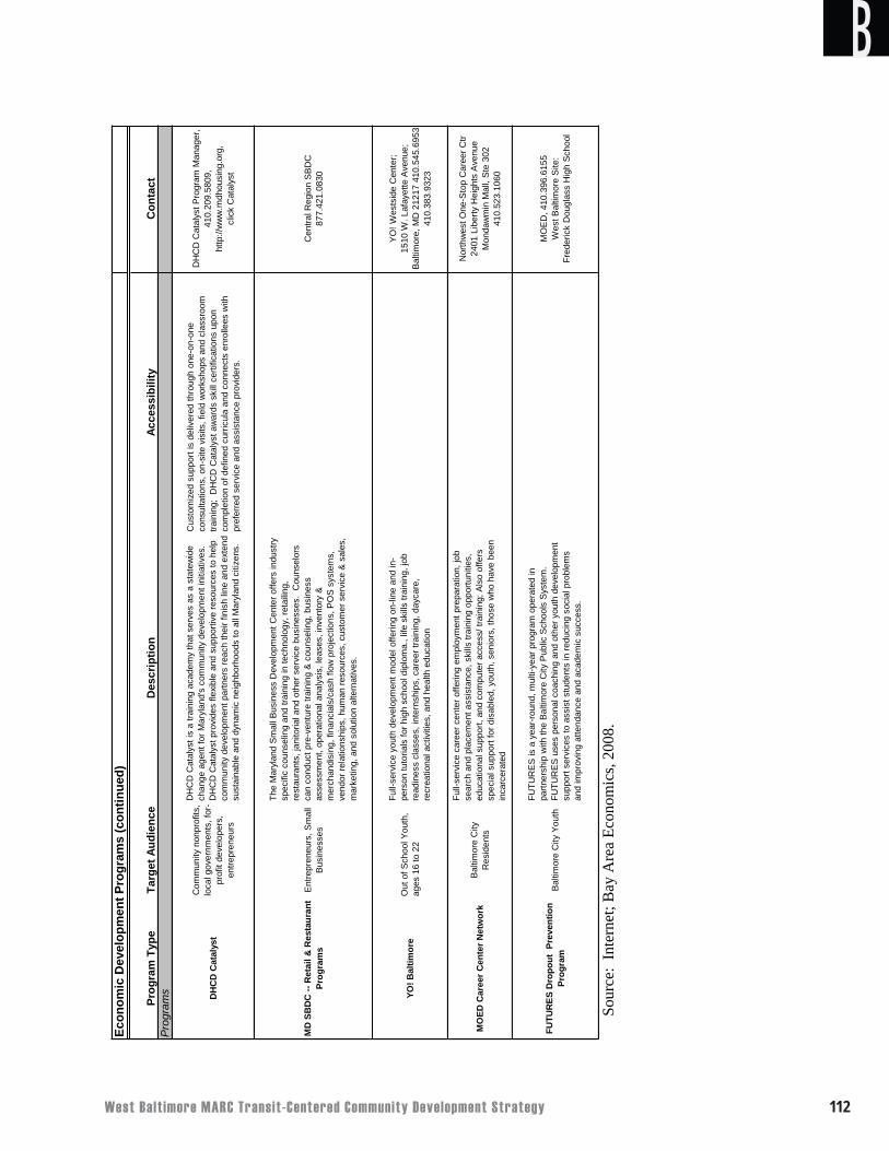
West Balt imore MARC Transit-Centered Community Development Strategy ���
B
Sour
ce:
Inte
rnet
; Bay
Are
a Ec
onom
ics,
2008
.
Econ
omic
Dev
elop
men
t Pro
gram
s (c
ontin
ued)
Prog
ram
Typ
eTa
rget
Aud
ienc
eAc
cess
ibili
tyC
onta
ctP
rogr
ams DH
CD
Cat
alys
t
Com
mun
ity n
onpr
ofits
, lo
cal g
over
nmen
ts, f
or-
prof
it de
velo
pers
, en
trepr
eneu
rs
Cus
tom
ized
sup
port
is d
eliv
ered
thro
ugh
one-
on-o
ne
cons
ulta
tions
, on-
site
vis
its, f
ield
wor
ksho
ps a
nd c
lass
room
tra
inin
g; D
HC
D C
atal
yst a
war
ds s
kill
certi
ficat
ions
upo
n co
mpl
etio
n of
def
ined
cur
ricul
a an
d co
nnec
ts e
nrol
lees
with
pr
efer
red
serv
ice
and
assi
stan
ce p
rovi
ders
.
DH
CD
Cat
alys
t Pro
gram
Man
ager
, 41
0.20
9.58
09,
http
://w
ww
.mdh
ousi
ng.o
rg,
clic
k C
atal
yst
MD
SB
DC
-- R
etai
l & R
esta
uran
t Pr
ogra
ms
Ent
repr
eneu
rs, S
mal
l Bu
sine
sses
Cen
tral R
egio
n S
BD
C
877.
421.
0830
YO! B
altim
ore
Out
of S
choo
l You
th,
ages
16
to 2
2
YO
! Wes
tsid
e C
ente
r;
15
10 W
. Laf
ayet
te A
venu
e;
Balti
mor
e, M
D 2
1217
410
.545
.695
3 41
0.38
3.93
23
MO
ED C
aree
r Cen
ter N
etw
ork
Bal
timor
e C
ity
Res
iden
ts
Nor
thw
est O
ne-S
top
Car
eer C
tr
2401
Lib
erty
Hei
ghts
Ave
nue
M
onda
wm
in M
all,
Ste
302
41
0.52
3.10
60
FUTU
RES
Dro
pout
Pre
vent
ion
Prog
ram
Bal
timor
e C
ity Y
outh
MO
ED, 4
10.3
96.6
155
Wes
t Bal
timor
e S
ite:
Fred
eric
k D
ougl
ass
Hig
h Sc
hool
Full-
serv
ice
yout
h de
velo
pmen
t mod
el o
fferin
g on
-line
and
in-
pers
on tu
toria
ls fo
r hig
h sc
hool
dip
lom
a., l
ife s
kills
trai
ning
, job
re
adin
ess
clas
ses,
inte
rnsh
ips,
car
eer t
rain
ing,
day
care
, re
crea
tiona
l act
iviti
es, a
nd h
ealth
edu
catio
n
Full-
serv
ice
care
er c
ente
r offe
ring
empl
oym
ent p
repa
ratio
n, jo
b se
arch
and
pla
cem
ent a
ssis
tanc
e, s
kills
trai
ning
opp
ortu
nitie
s,
educ
atio
nal s
uppo
rt, a
nd c
ompu
ter a
cces
s/ tr
aini
ng; A
lso
offe
rs
spec
ial s
uppo
rt fo
r dis
able
d, y
outh
, sen
iors
, tho
se w
ho h
ave
been
in
carc
erat
ed
FUTU
RES
is a
yea
r-rou
nd, m
ulti-
year
pro
gram
ope
rate
d in
pa
rtner
ship
with
the
Bal
timor
e C
ity P
ublic
Sch
ools
Sys
tem
. FU
TUR
ES u
ses
pers
onal
coa
chin
g an
d ot
her y
outh
dev
elop
men
t su
ppor
t ser
vice
s to
ass
ist s
tude
nts
in re
duci
ng s
ocia
l pro
blem
s an
d im
prov
ing
atte
ndan
ce a
nd a
cade
mic
suc
cess
.
DH
CD
Cat
alys
t is
a tra
inin
g ac
adem
y th
at s
erve
s as
a s
tate
wid
e ch
ange
age
nt fo
r Mar
ylan
d's
com
mun
ity d
evel
opm
ent i
nitia
tives
. D
HC
D C
atal
yst p
rovi
des
flexi
ble
and
supp
ortiv
e re
sour
ces
to h
elp
com
mun
ity d
evel
opm
ent p
artn
ers
reac
h th
eir f
inis
h lin
e an
d ex
tend
su
stai
nabl
e an
d dy
nam
ic n
eigh
borh
oods
to a
ll M
aryl
and
citiz
ens.
The
Mar
ylan
d S
mal
l Bus
ines
s D
evel
opm
ent C
ente
r offe
rs in
dust
ry
spec
ific
coun
selin
g an
d tra
inin
g in
tech
nolo
gy, r
etai
ling,
re
stau
rant
s, ja
nito
rial a
nd o
ther
ser
vice
bus
ines
ses.
Cou
nsel
ors
can
cond
uct p
re-v
entu
re tr
aini
ng &
cou
nsel
ing,
bus
ines
s as
sess
men
t, op
erat
iona
l ana
lysi
s, le
ases
, inv
ento
ry &
m
erch
andi
sing
, fin
anci
als/
cash
flow
pro
ject
ions
, PO
S s
yste
ms,
ve
ndor
rela
tions
hips
, hum
an re
sour
ces,
cus
tom
er s
ervi
ce &
sal
es,
mar
ketin
g, a
nd s
olut
ion
alte
rnat
ives
.
Des
crip
tion
���
ABAG – Association of Baltimore Area Grantmakers
AECF – Annie E. Casey Foundation
AF – Abell Foundation
BCDOT – Baltimore Department of Transportation
BCDPW – Baltimore City Department of Public Works
BCF – Baltimore Community Foundation
BCPA – Baltimore City Parking Authority
BCPD – Baltimore City Police Department
BCDOP – Baltimore City Department of Planning
BCPSS – Baltimore City Public School System
BCRP – Baltimore City Recreation and Parks
BDC – Baltimore Development Corporation
BH – Baltimore Housing
BMGF – Bill & Melinda Gates Foundation
BMZA – Board of Municipal and Zoning Appeals
BNC – Baltimore Neighborhood Collaborative
BSH – Bon Secours Hospital
BOPA –Baltimore City Office of Promotion and the Arts
BOTD – Baltimore City Library Board of Trustees
BR – Baltimore Rising
CAF – The Carmelo Anthony Foundation
CBT – Chesapeake Bay Trust
CDBG – Community Development Block Grant
APPENDIX C: ACTION ITEM ACRONYM AND ABBREVIATIONS LIST
C
West Balt imore MARC Transit-Centered Community Development Strategy ���
CCIP – Baltimore City Capital Improvements Budget
CL – Community Legacy Program
DAT – Maryland Department of Assessments and Taxation
DHCD – Maryland Department of Housing and Community Development
FBC – Local Faith-based Community
GBUL – Greater Baltimore Urban League
HDF – Home Depot Foundation
KF – Kellogg Foundation
LCEF – Lowe’s Charitable and Educational Foundation
LGIF – Local Government Infrastructure Financing
LIHTC – Low-Income Housing Tax Credits
MCIP – Microsoft Community Investment Program
MDDBED – Maryland Department of Business and Economic Development
MJF – The Magic Johnson Foundation
MDOT – Maryland Department of Transportation
MOED – Mayor’s Office of Employment Development
MTA – Maryland Transit Administration
SBDC – Maryland Small Business Development Center
SBRC – Small Business Resource Center
TEVO – Targeted Enforcement toward Visible Outcomes (Specialized code enforcement initiative of BH)
UDARP - Urban Design and Architecture Review Panel
VF – Verizon Foundation
WBC – West Baltimore Coalition
WFF – Wieler Family Foundation
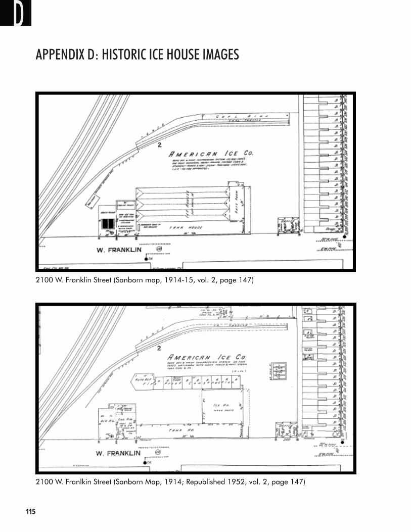
���
Appendix d: Historic ice House imAges
2100 W. Franklin Street (Sanborn map, 1914-15, vol. 2, page 147)
2100 W. Franlkin Street (Sanborn Map, 1914; Republished 1952, vol. 2, page 147)
DAPPENDIX D: HISTORIC ICE HOUSE IMAGES
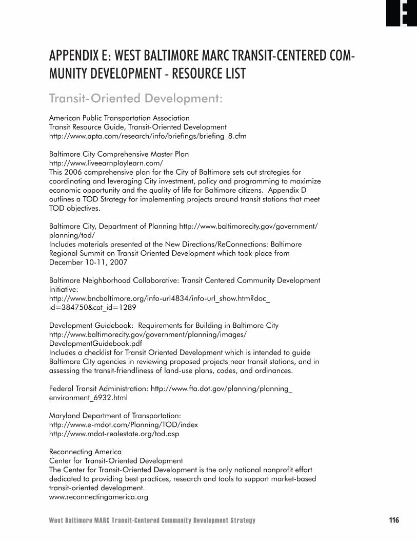
West Balt imore MARC Transit-Centered Community Development Strategy ���
Transit-Oriented Development:American Public Transportation AssociationTransit Resource Guide, Transit-Oriented Development http://www.apta.com/research/info/briefings/briefing_8.cfm
Baltimore City Comprehensive Master Plan http://www.liveearnplaylearn.com/This 2006 comprehensive plan for the City of Baltimore sets out strategies for coordinating and leveraging City investment, policy and programming to maximize economic opportunity and the quality of life for Baltimore citizens. Appendix D outlines a TOD Strategy for implementing projects around transit stations that meet TOD objectives.
Baltimore City, Department of Planning http://www.baltimorecity.gov/government/planning/tod/Includes materials presented at the New Directions/ReConnections: Baltimore Regional Summit on Transit Oriented Development which took place from December 10-11, 2007
Baltimore Neighborhood Collaborative: Transit Centered Community Development Initiative: http://www.bncbaltimore.org/info-url4834/info-url_show.htm?doc_id=384750&cat_id=1289
Development Guidebook: Requirements for Building in Baltimore City http://www.baltimorecity.gov/government/planning/images/DevelopmentGuidebook.pdfIncludes a checklist for Transit Oriented Development which is intended to guide Baltimore City agencies in reviewing proposed projects near transit stations, and in assessing the transit-friendliness of land-use plans, codes, and ordinances.
Federal Transit Administration: http://www.fta.dot.gov/planning/planning_environment_6932.html
Maryland Department of Transportation: http://www.e-mdot.com/Planning/TOD/indexhttp://www.mdot-realestate.org/tod.asp
Reconnecting AmericaCenter for Transit-Oriented Development The Center for Transit-Oriented Development is the only national nonprofit effort dedicated to providing best practices, research and tools to support market-based transit-oriented development.www.reconnectingamerica.org
EAPPENDIX E: WEST BALTIMORE MARC TRANSIT-CENTERED COM-MUNITY DEVELOPMENT - RESOURCE LIST
���
ETransit Resources: B’More Mobile: http://www.bmoremobile.org/
Baltimore Environmental Justice and Transportation Project: http://www.brejtp.com/
Baltimore Region Transit Plan: http://www.baltimoreregiontransitplan.com/
Baltimore Region Transportation Board: http://www.baltometro.org/
Central Maryland Transportation Alliance: http://www.cmtalliance.org/
MARC Growth and Investment Plan: http://www.mtamaryland.com/projects/marc%20plan%20full.pdf
Maryland Transit Administration: http://www.mtamaryland.com/
Mayor’s Red Line Summit and Community Compact: www.mayorsredlinesummit.com
Morgan State University: National Transportation Center: http://www.eng.morgan.edu/~ntc/
Transit Riders Action Council of Metropolitan Baltimore: http://www.getontrac.org/
Data, Initiatives, and Funding Resources for West Balti-more: Art on Purpose: http://www.artonpurpose.org/
Baltimore City Base Re-alignment Action Plan http://www.baltimorecity.gov/mayor/downloads/BRACtion%20Plan.pdf
Baltimore City Comprehensive Economic Development Strategy http://www.baltimorecity.gov/government/planning/ceds/
Baltimore Neighborhood Indicators Alliance: http://www.bnia.org/
Black United Fund: http://www.nbuf.org/profile_affiliates.html
Bon Secours of Maryland Foundation: http://bonsecoursbaltimore.com/pages/bon-secours-of-maryland-foundationcommunity-services.php
Citizens’ Planning and Housing Association: http://www.cphabaltimore.org/
Coppin Heights Community Development Corporation: http://www.coppin.edu/chcdc/
West Balt imore MARC Transit-Centered Community Development Strategy ���
ECulture Works Project - Ashley Milburn: http://www.soros.org/initiatives/baltimore/focus_areas/community_fellowship/case_studies/milburn_2007
Empower Baltimore Management Corporation: http://www.ebmc.org/home/about.html
Enterprise Community Partners: http://www.enterprisecommunity.org/local_work/baltimore/
Greater Baltimore Committee: http://www.gbc.org
Greater Baltimore Urban League: http://www.bul.org/
Neighborhood Design Center: http://www.ndc-md.org/
Parks and People: http://parksandpeople.org/home.html
Community Benefits Agreement (Resources and Samples): Good Jobs First: http://www.goodjobsfirst.org/accountable_development/community_benefit_vic.cfm
Partnership for Working Families: http://www.communitybenefits.org/article.php?list=type&type=39
���
APPENDIX F: SAMPLE COMMUNITY BENEFITS AGREEMENT
Below is a sample community benefits agreement drafted by the West Baltimore Coalition. The text below describes what a community benefits agreement is, specifies the types of public subsidies that could be provided to developers, and lists the types of community benefits should be provided in return.
Draft West Baltimore Coalition Community Benefits Agreement for the West Baltimore MARC Station Area
A Community Benefits Agreement or “CBA” is a legally enforceable contract signed by community groups and a developer setting forth a range of community benefits that the developer agrees to provide as part of a development project.
Community Benefits Agreements developed by individual communities in West Baltimore with the support of the WBC will ensure that projects receiving public benefits – including but not limited to public land, subsidies, zoning changes, tax relief and deferments, easements, even priority approval processing – create tangible benefits and amenities for the West Baltimore Communities and give residents the power to shape projects to their needs. These benefits may include, but are not limited to, living-wage jobs, affordable housing, first-source hiring programs for local residents, funding for parks, space for community services, and monies for local investment.
FAPPENDIX F: SAMPLE COMMUNITY BENEFITS AGREEMENT
West Balt imore MARC Transit-Centered Community Development Strategy ��0
Appendix G
West Baltimore MARC Station Area Potential for a Form-Based Code Approach
Draft – 5.7.08
INTRODUCTION
The West Baltimore MARC Station Area Transit-Centered Community Development Strategy includes a long-term vision for housing, economic development, and transportation as well as a phased implementation plan. Although an important component of this strategy is focused upon preserving and enhancing the physical character of the community, the planning concept also envisions development in key neighborhood centers and along the streets which connect them.
Traditional zoning regulations are not particularly well-suited for predictably creating desired public spaces or relationships between adjoining developments. Form-based codes have gained popularity for their ability to guide new development and redevelopment in a manner that achieves more predictable results. The city and community should consider the form-based code approach as an implementation tool for the West Baltimore MARC Station Area Transit-Centered Community Development Strategy.
This report describes, generally, some background information regarding form-based codes and, more specifically, recommendations about how to advance the development of a form-based code for the area – given the point in the process. It is divided into the following sections:
What is a Form-Based Code (FBC)? Advantages of the FBC Approach FBC in Practice Developing a FBC for West Baltimore MARC Station Area
W. Baltimore FBC Recommendation 1Draft – 5.7.08
GAPPENDIX G: WEST BALTIMORE MARC STATION AREA POTENTIAL FOR A FORM-BASED CODE APPROACH
���
WHAT IS A FORM-BASED CODE (FBC)?
Traditional Euclidian zoning focuses on land use with little consideration given to the physical form and character of neighborhoods and individual developments. Zoning regulations are often applied without a clear vision of what the desired development character should be. Form-based codes differ from traditional zoning because they:
1. Are the result of a public design process, which creates a clear and articulate vision for a defined district or neighborhood. A form-based code is developed as an outcome of this process.
2. Pay greater attention to the design of the public realm and the importance that streetscape design and individual building character have in defining public spaces and a special sense of place. Of special significance is the integration of street standards with the desired physical character of the abutting development.
3. Emphasize site design and building form over density and use regulations. Form-based codes pay more attention to the buildings, which will last many years, instead of uses that change over time.
4. Encourage a mix of uses and housing types to reduce the need to travel as part of one’s daily routine.
5. Make much greater use of illustrations to explain important design elements rather than relying on numeric standards and text.
W. Baltimore FBC Recommendation 2Draft – 5.7.08
G
West Balt imore MARC Transit-Centered Community Development Strategy ���
ADVANTAGES OF THE FBC APPROACH
To a large extent, the ultimate success of the development concept will rely upon thoughtful design solutions. For example, creating safe and pleasant pedestrian places involves more than just furnishing sidewalks. It requires locating different uses and destinations closer together, carefully designing the streetscape, and integrating private and public development to create a safe and inviting public realm. This careful attention to detail represents the overall strength of a well-executed form-based code. Additionally, some other notable advantages of the form-based code approach include:
1. Encouraging active public participation in creating the regulating plan and related design elements. This public participation and consensus-building at the beginning increases public understanding of the plan and its desired results, thereby reducing misunderstanding and conflict during implementation.
2. Focusing on what the community wants and not what it dislikes. This attention to what is desired makes it much easier for developers, citizens, and decision-makers to be “on the same page” when individual development projects are proposed.
3. Providing information that is easier to use than conventional zoning codes because they are shorter, more concise, and emphasize illustrations over text. Therefore, form-based codes are more engaging and comprehensible to non-professionals.
4. Tailoring the requirements to fit a specific place or neighborhood, by reflecting a neighborhoods vernacular architecture and overall character.
W. Baltimore FBC Recommendation 3Draft – 5.7.08
G
���
ADVANTAGES OF THE FBC APPROACH
To a large extent, the ultimate success of the development concept will rely upon thoughtful design solutions. For example, creating safe and pleasant pedestrian places involves more than just furnishing sidewalks. It requires locating different uses and destinations closer together, carefully designing the streetscape, and integrating private and public development to create a safe and inviting public realm. This careful attention to detail represents the overall strength of a well-executed form-based code. Additionally, some other notable advantages of the form-based code approach include:
1. Encouraging active public participation in creating the regulating plan and related design elements. This public participation and consensus-building at the beginning increases public understanding of the plan and its desired results, thereby reducing misunderstanding and conflict during implementation.
2. Focusing on what the community wants and not what it dislikes. This attention to what is desired makes it much easier for developers, citizens, and decision-makers to be “on the same page” when individual development projects are proposed.
3. Providing information that is easier to use than conventional zoning codes because they are shorter, more concise, and emphasize illustrations over text. Therefore, form-based codes are more engaging and comprehensible to non-professionals.
4. Tailoring the requirements to fit a specific place or neighborhood, by reflecting a neighborhoods vernacular architecture and overall character.
W. Baltimore FBC Recommendation 3Draft – 5.7.08
G
West Balt imore MARC Transit-Centered Community Development Strategy ���
FBC IN PRACTICE
FBC Elements
Consistent with the notion that one-size-does-not-fit all, the application of form-based code techniques will also vary from one situation to another. However, they will typically include a regulating plan, requirements and guidelines, and supporting provisions.
Regulating PlanPublic involvement and creation of a clear vision provides the foundation for a form-based code. The regulating plan translates this vision into a plan and map of the regulated area designating the locations, which are to embody specific physical characteristics. This plan is often very detailed, considering specific design treatments for small subareas or individual blocks. A regulating plan map will show where different design standards apply, providing the link between the community vision and the form-based code elements that will help implement it.
Requirements and GuidelinesSupport for the regulating plan is provided by requirements and guidelines that articulate the details of the planning concepts in the regulating plan. Although the organization will vary somewhat from plan to plan, requirements and guidelines typically fall into five categories:
1. Public Realm and Street Standards. These standards focus primarily on the design treatment of streets, plazas, and other public areas. The standards are developed in concert with the site and building standards to create a cohesive set of requirements, which are mutually supportive.
2. Site Design and Circulation Standards. Building placement on the site, pedestrian circulation, surface parking, protection of environmental features, and similar site design issues are addressed by these standards.
3. Building Form Standards. Surrounding buildings, the street system, and the neighborhood context are very important in determining how buildings should be designed to establish an appropriate relationship with their surroundings. Building form standards, relating to building size, form, orientation (especially to the street), entrances, window treatment, and weather protection are designed to create an inviting and functional public realm and a compatible relationship with surrounding development.
4. Land Use Requirements. Although land use regulations are the cornerstone of traditional zoning ordinances, this aspect of zoning is typically incorporated with a FBC approach. Permitted, conditional, and prohibited land uses are controlled in a similar manner as a conventional zoning ordinance, but they are not “micro-managed” with the long lists permitted uses commonly found in conventional zoning ordinances. As part of a FBC, land use is typically regulated more broadly with land use categories in lieu of long lists. This is because form-based code relies primarily on the other four elements to address how development should behave in the context of the surrounding community.
W. Baltimore FBC Recommendation 4Draft – 5.7.08
G
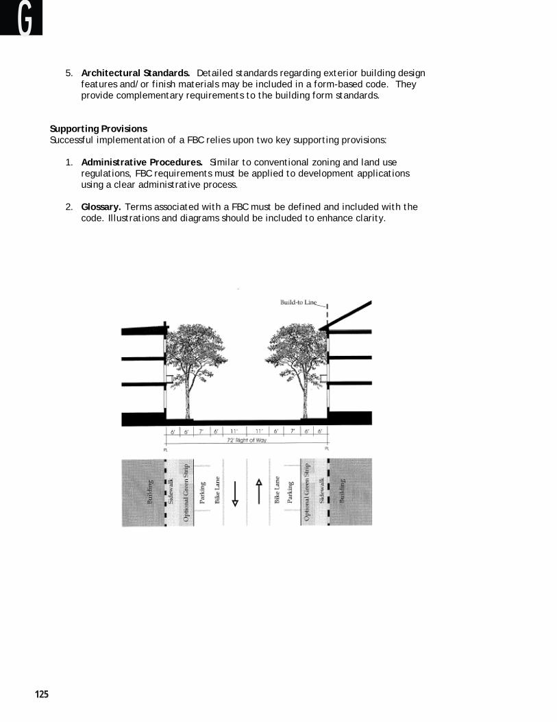
���
5. Architectural Standards. Detailed standards regarding exterior building design features and/or finish materials may be included in a form-based code. They provide complementary requirements to the building form standards.
Supporting ProvisionsSuccessful implementation of a FBC relies upon two key supporting provisions:
1. Administrative Procedures. Similar to conventional zoning and land use regulations, FBC requirements must be applied to development applications using a clear administrative process.
2. Glossary. Terms associated with a FBC must be defined and included with the code. Illustrations and diagrams should be included to enhance clarity.
W. Baltimore FBC Recommendation 5Draft – 5.7.08
G
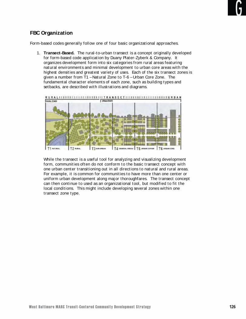
West Balt imore MARC Transit-Centered Community Development Strategy ���
FBC Organization
Form-based codes generally follow one of four basic organizational approaches.
1. Transect-Based. The rural-to-urban transect is a concept originally developed for form-based code application by Duany Plater-Zyberk & Company. It organizes development form into six categories from rural areas featuring natural environments and minimal development to urban core areas with the highest densities and greatest variety of uses. Each of the six transect zones is given a number from T1 – Natural Zone to T-6 – Urban Core Zone. The fundamental character elements of each zone, such as building types and setbacks, are described with illustrations and diagrams.
While the transect is a useful tool for analyzing and visualizing development form, communities often do not conform to the basic transect concept with one urban center transitioning out in all directions to natural and rural areas.For example, it is common for communities to have more than one center or uniform urban development along major thoroughfares. The transect concept can then continue to used as an organizational tool, but modified to fit the local conditions. This might include developing several zones within one transect zone type.
W. Baltimore FBC Recommendation 6Draft – 5.7.08
G
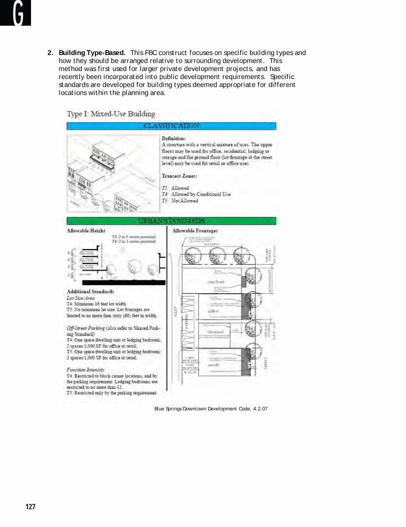
���
2. Building Type-Based. This FBC construct focuses on specific building types and how they should be arranged relative to surrounding development. This method was first used for larger private development projects, and has recently been incorporated into public development requirements. Specific standards are developed for building types deemed appropriate for different locations within the planning area.
Blue Springs Downtown Development Code, 4.2.07
W. Baltimore FBC Recommendation 7Draft – 5.7.08
G
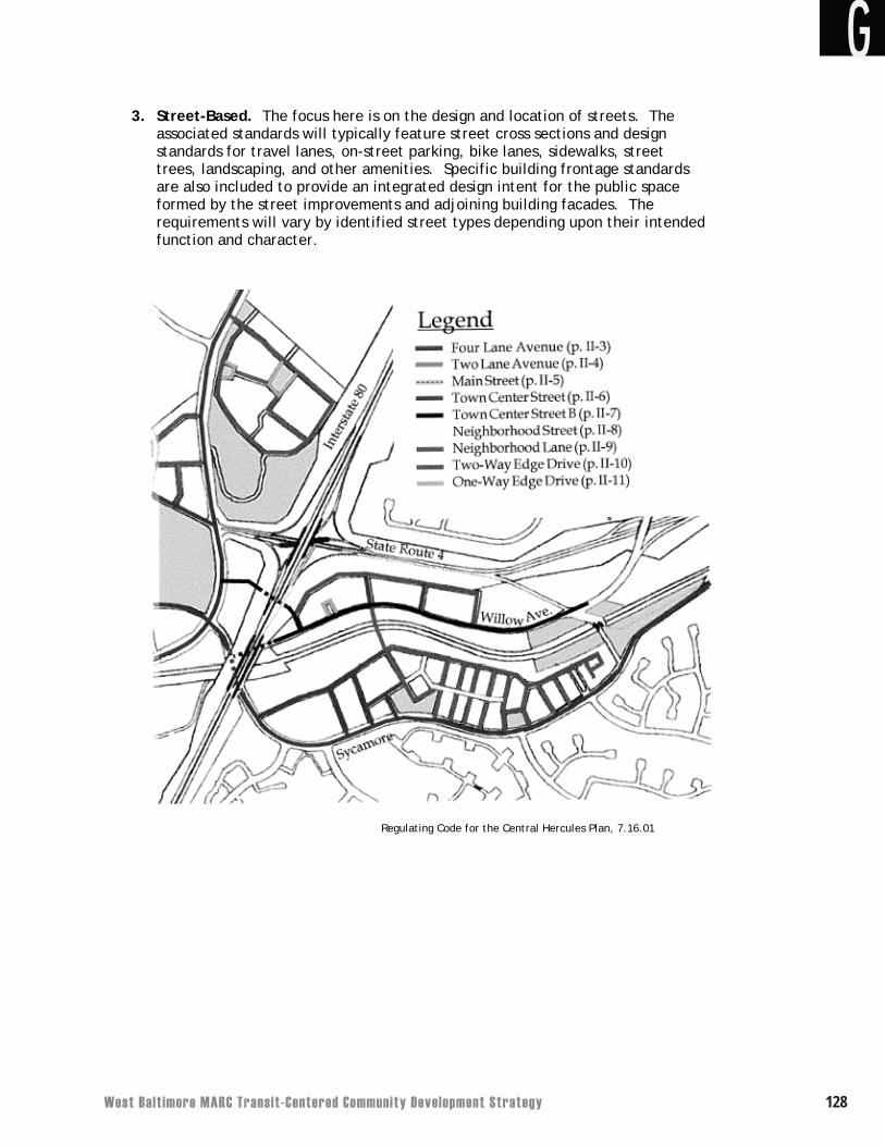
West Balt imore MARC Transit-Centered Community Development Strategy ���
3. Street-Based. The focus here is on the design and location of streets. The associated standards will typically feature street cross sections and design standards for travel lanes, on-street parking, bike lanes, sidewalks, street trees, landscaping, and other amenities. Specific building frontage standards are also included to provide an integrated design intent for the public space formed by the street improvements and adjoining building facades. The requirements will vary by identified street types depending upon their intended function and character.
Regulating Code for the Central Hercules Plan, 7.16.01
W. Baltimore FBC Recommendation 8Draft – 5.7.08
G
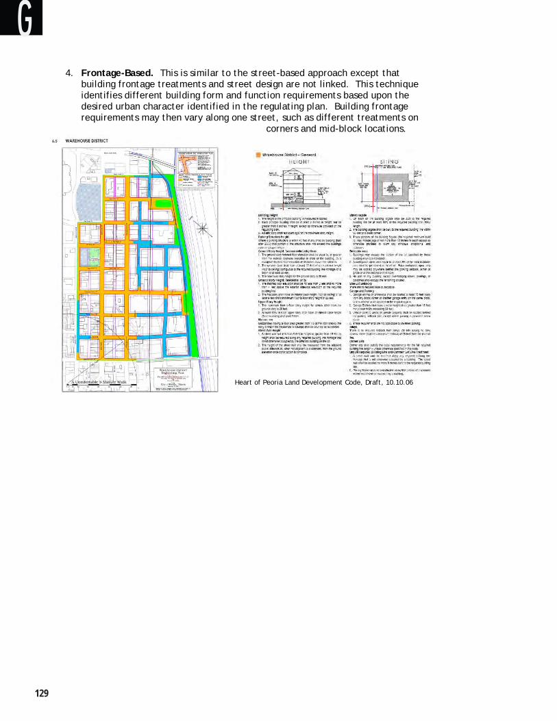
���
4. Frontage-Based. This is similar to the street-based approach except that building frontage treatments and street design are not linked. This technique identifies different building form and function requirements based upon the desired urban character identified in the regulating plan. Building frontage requirements may then vary along one street, such as different treatments on
corners and mid-block locations.
Heart of Peoria Land Development Code, Draft, 10.10.06
W. Baltimore FBC Recommendation 9Draft – 5.7.08
G
West Balt imore MARC Transit-Centered Community Development Strategy ��0
FBC Implementation
Form-based codes need to work in harmony with the existing land use regulatory structure using one of three general methods for proper implementation.
1. Mandatory Requirements
Description. A regulating plan and FBC requirements are applied to all new development in specified areas on the zoning map. With the FBC “rules” in place, new development must comply with these requirements.
Application. The FBC design elements may either be incorporated with other land development regulations as a separate, stand alone document or they can be integrated into the body of existing regulations.
2. Floating Zone
Description. The FBC provisions and zoning district are developed in a similar manner to the mandatory approach, but they are not applied to specific areas on the zoning map. The FBC zoning district “floats” because it is not applied to a specific property until requested by a developer. If a developer elects to develop under the FBC provisions during the review process, the FBC requirements become mandatory.
Application. A developer wishing to develop using the FBC regulations, would create a regulating plan to identify how the adopted FBC provisions would be applied to the property. This application would then go through the development review process to be approved. Project often results in the FBC zoning designation being applied to the property on the zoning map.
3. Optional – Parallel
Description. Similar to the floating zone approach, the FBC provisions are prepared in advance of being applied to a specific property or area. However, in this case, the eligible properties are described, commonly by a minimum size. If a developer elects to develop under the FBC provisions during the review process, the FBC requirements become mandatory.
Application. This functions in the same way as the floating zone.
W. Baltimore FBC Recommendation 10Draft – 5.7.08
G
���
DEVELOPING A FBC FOR THE WEST BALTIMORE MARC STATION AREA
Introduction
The primary focus of the West Baltimore MARC Station Area Transit-Centered Community Development Strategy is improving housing, economic development, and transportation within the study area. The development of a form-based code is a possible tool the city may contribute to advance the implementation of the ideas and concepts from the Strategy. Although this planning effort was not initiated with the expressed intention of creating an adoptable, final code document, much of the planning work could be used as a first step towards creating a regulating plan and form-based code.
This section reviews the recommend stops for creating a form-based code as one of the many tools the city and community may want to employ to implement the Strategy. The FBC steps are described followed by a comment regarding how the completed work may be applied and what additional work remains to be completed.
Because the “Transform Baltimore: Zoning Code Rewrite” is underway to completely review and update the city’s Zoning Code, this could be an opportune time to consider a FBC as an implementation tool in the West Baltimore MARC Station Area. In part, the Zoning Code Rewrite project intent is to preserve the unique characteristics of Baltimore City and to create more opportunities for mixed-use and transit-oriented development - core elements of the development strategy. The Zoning Code Rewrite is scheduled to be in the code drafting stage from this winter to spring of 2009. Introduction of FBC elements in the West Baltimore MARC Station Area and/or other locations in the city should be considered as this code amendment project moves forward.
Development Steps
Although the specific activities in creating a form-based code may vary, a devlopment process should involve five basic steps consisting of initial scoping and organization followed by the remaining steps, which focus on answering four questions:
1. Project Scoping and Organization 2. What Do We Have? 3. What Do We Want? 4. What Do We Need? 5. How Do We Get There?
W. Baltimore FBC Recommendation 11Draft – 5.7.08
G
West Balt imore MARC Transit-Centered Community Development Strategy ���
Project Scoping and Organization
Before the planning project gets underway, preliminary scoping and organization are essential for successful and timely completion of the project. These activities should include generally defining the planning area and the desired outcome. The preferred results will vary depending upon any number of factors. The FBC could be a tool to help preserve existing neighborhood character, to encourage enhancement of an area, to facilitate the evolution of an area to develop a different character over time, or to help transform an area into a different place over a short period.
The FBC organization (transect, street-based, etc.) and regulatory approach (mandatory, optional, etc.) should be considered. The professional team of local planning staff and/or consultants should be determined along with a project schedule to complete the following four steps.
Comment: This step has been largely completed as part of the strategy. However, if a FBC project is initiated, this step would need to be revisited to consider any changes that occurred following completion of the strategy document. In addition, the FBC organization and regulatory approach would need to be determined. The development strategy calls for focused improvements and redevelopment in several centers and along selected streets corridors as well as improvement and stabilization of residential neighborhoods. A street-based FBC approach for centers and corridors combined with a building-based approach for the residential areas would be one appropriate way to organize FBC requirements.
W. Baltimore FBC Recommendation 12Draft – 5.7.08
G
���
What Do We Have?
Define the Planning Area
Because a form-based code applies to individual properties in the same way as traditional zoning districts and regulations, a FBC must be tied to a specific planning area or district. Although the exact boundaries of the planning area may change as the project moves forward, a preliminary planning area should be established.
Comment: The planning area has been generally defined in the strategy. To begin the FBC development process, this boundary is sufficient. However, as the FBC creation progresses, clearly defined boundaries must be established to identify specific properties, which will be subject to the FBC.
Analysis of Existing Conditions
A clear understanding of the current development characteristics of the community is essential to best understand how to move forward. This analysis should focus on the special community attributes regarding:
Public Realm and Street Character and the degree to which they create safe and inviting pedestrian environments and public spaces.Site Design and Circulation and the extent it generally promotes compatibility and easy access between nearby properties. Building Form and how it creates inviting and functional public spaces and compatible relationships with surrounding development. Land Use Requirements and how they promote or inhibit a pedestrian-oriented environment with a proper integration of uses. Architectural Detailing and the degree to which it complements community character and sense of place.
Comment: A general analysis of the primary character-defining aspects of the plan area including the basic neighborhood character and circulation, has been completed as part of the development strategy. Next, the details of existing development should be understood by evaluating typical building forms, locations on building sites, building setbacks, building features (e.g., ground floor commercial space, balconies), driveways, parking, and streetscapes. Much of this has been done to create the development strategy, but these community attributes should be reviewed and supplemented to provide sufficient detail about current development character in terms of the five categories above.
W. Baltimore FBC Recommendation 13Draft – 5.7.08
G
West Balt imore MARC Transit-Centered Community Development Strategy ���
Code Audit
West Baltimore MARC Station AreaTransit-Centered Community Development Strategy In addition to describing and recognizing the key physical characteristics of the planning area, it is equally important to understand how the current ordinance requirements support the West Baltimore MARC Station Area Transit-Centered Community Development Strategy. The following checklist summarizes these important characteristics organized according to the five FBC components. This shares many common elements with the city’s “Checklist for Transit-Oriented Development”, which is part of the “Development Guidebook”.
Public Realm and Streetscape Sidewalks for urban development Pleasant, comfortable and safe pedestrian environment Fine-grained, interconnected street grid – easy access for all modes Frequent opportunities to cross streets Provide additional street, pathway and open space connections Pedestrians buffered from traffic Easy access to open space areas/plazas Building frontages and entries oriented to the street Active ground floor uses along major street frontages Redevelop and improve existing streetscapes Streetscape amenities including landscaping and street trees Building features that provide shade and weather protection for pedestrians Public buildings and open spaces serving as focal points Minimize impervious surface devoted to roadways and parking Utilize “Green Street” techniques to reduce the amount and enhance the quality of storm water runoff
Site Design and Circulation Locate buildings for easy pedestrian access between them Direct access to building entrances from the street Internal pedestrian circulation that is separate from vehicles Connections between buildings, transit and surrounding areas Minimize on-site parking requirements Allow shared parking Surface parking to the rear or side of buildings Secure and convenient bike parking Allow greater building coverage Design projects to allow increased density over time Locate building frontages up to the street in commercial and mixed-use areas
W. Baltimore FBC Recommendation 14Draft – 5.7.08
G
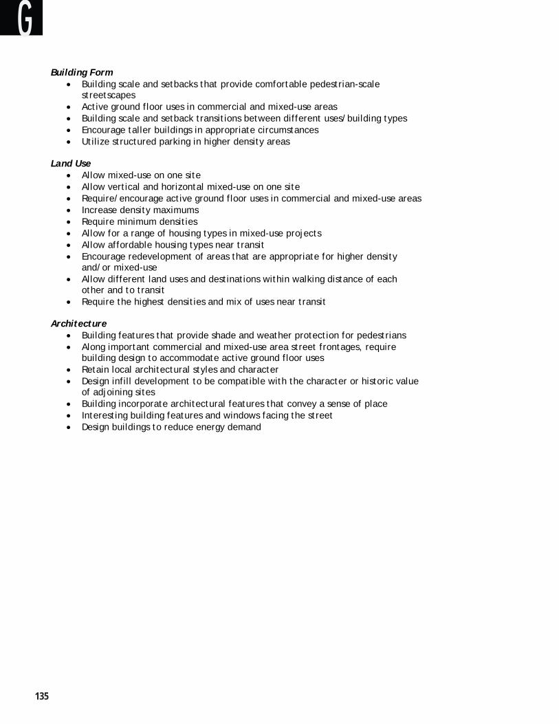
���
Building Form Building scale and setbacks that provide comfortable pedestrian-scale streetscapesActive ground floor uses in commercial and mixed-use areas Building scale and setback transitions between different uses/building types Encourage taller buildings in appropriate circumstances Utilize structured parking in higher density areas
Land Use Allow mixed-use on one site Allow vertical and horizontal mixed-use on one site Require/encourage active ground floor uses in commercial and mixed-use areas Increase density maximums Require minimum densities Allow for a range of housing types in mixed-use projects Allow affordable housing types near transit Encourage redevelopment of areas that are appropriate for higher density and/or mixed-use Allow different land uses and destinations within walking distance of each other and to transit Require the highest densities and mix of uses near transit
Architecture Building features that provide shade and weather protection for pedestrians Along important commercial and mixed-use area street frontages, require building design to accommodate active ground floor uses Retain local architectural styles and character Design infill development to be compatible with the character or historic value of adjoining sites Building incorporate architectural features that convey a sense of place Interesting building features and windows facing the street Design buildings to reduce energy demand
W. Baltimore FBC Recommendation 15Draft – 5.7.08
G
West Balt imore MARC Transit-Centered Community Development Strategy ���
W. Baltimore FBC Recommendation 16Draft – 5.7.08
Audit Checklist Using a checklist, the current zoning regulations should be evaluated systematically for the degree to which they would enable implementation of a form-based code, which promotes the community characteristics noted in the checklist. This analysis should also consider the redevelopment proposals contained in the West Baltimore MARC Station Area Transit-Centered Community Development Strategy. The current code deficiencies should be identified and summarized.
An example checklist framework is presented on the following page to provide a possible structure for identifying the FBC elements reflected in the development strategy, the applicable Zoning Code regulations, and an assessment of the Zoning Code provisions that should be amended to 1) not conflict and 2) better support the development strategy.
Comment: This analysis will give a clear picture regarding how the existing city land use and zoning requirements support or inhibit the community improvement and redevelopment proposals contained in the strategy. As part of the Transform Baltimore: Zoning Code Rewrite, a FBC could be considered as a tool to be integrated with the new Zoning Code.
G
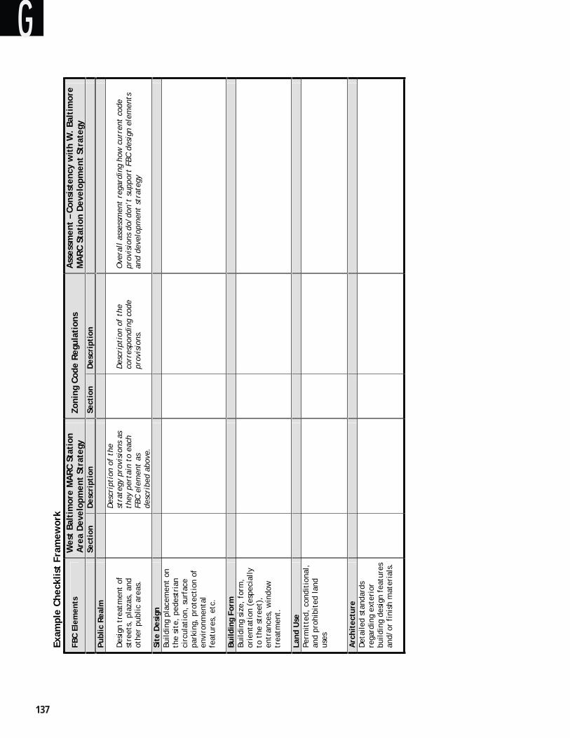
���
dati
on
17t
– 5.
7.08
Exam
ple
Chec
klis
t Fr
amew
ork
FBC
Elem
ents
W
est
Balt
imor
e M
ARC
Sta
tion
A
rea
Dev
elop
men
t St
rate
gy
Zoni
ng C
ode
Regu
lati
ons
Ass
essm
ent
– Co
nsis
tenc
y w
ith
W.
Balt
imor
e M
ARC
Sta
tion
Dev
elop
men
t St
rate
gy
Sect
ion
Des
crip
tion
Sect
ion
Des
crip
tion
Publ
ic R
ealm
Des
ign
trea
tmen
t of
st
reet
s, p
laza
s, a
nd
othe
r pu
blic
are
as.
Des
crip
tion
of
the
stra
tegy
pro
visi
ons
as
they
per
tain
to
each
FB
C el
emen
t as
de
scri
bed
abov
e.
Des
crip
tion
of
the
corr
espo
ndin
g co
de
prov
isio
ns.
Ove
rall
ass
essm
ent
rega
rdin
g ho
w c
urre
nt c
ode
prov
isio
ns d
o/do
n’t
supp
ort
FBC
desi
gn e
lem
ents
an
d de
velo
pmen
t st
rate
gy
Site
Des
ign
Build
ing
plac
emen
t on
th
e si
te,
pede
stri
an
circ
ulat
ion,
sur
face
pa
rkin
g, p
rote
ctio
n of
en
viro
nmen
tal
feat
ures
, et
c.
Build
ing
Form
Bu
ildin
g si
ze,
form
, or
ient
atio
n (e
spec
ially
to
the
str
eet)
, en
tran
ces,
win
dow
tr
eatm
ent.
Land
Use
Pe
rmit
ted,
con
diti
onal
, an
d pr
ohib
ited
land
us
es
Arc
hite
ctur
eD
etai
led
stan
dard
s re
gard
ing
exte
rior
bu
ildin
g de
sign
fea
ture
s an
d/or
fin
ish
mat
eria
ls.
W.
Balt
imor
e FB
C Re
com
men
Dra
f
G
West Balt imore MARC Transit-Centered Community Development Strategy ���
What Do We Want?
Community Outreach and Involvement
Because a FBC is more proactive and context-based, the community – residents, business owners, developers, and agencies - must be involved from the beginning. The importance of active public participation cannot be overstated. For any plan to succeed, and for a FBC to help a community attain its goals, there must be general community consensus about where it is today and what it wants in the future. As noted above, one of the shortcomings of conventional zoning is that it is often generically applied without a detailed planning process in advance to identify what the zoning regulations should achieve.
Comment: The development strategy project included a significant amount of public involvement, establishing closer relationships between citizens, neighborhoods groups, and public agencies – especially the WBC and the city planning staff. If a FBC project is initiated, this active public involvement would need to continue the discussion about the physical character of the improvements and redevelopment described in the strategy.
Create a Vision and Regulating Plan
Specific methods to reach a common community vision vary, but a key ingredient is active participation and discussion using community workshops, design charrettes, and focus interviews with key stakeholders. A visioning process should include specifically defining the planning area. With the community actively engaged, a vision and supporting action plan for a defined area are created. The regulating plan will show how individual properties in the planning area will be affected by the form-based code. This exercise may also conclude with an action plan, which simply outlines the implementation steps and the parties responsible for their completion.
Comment: Community understanding and support is absolutely essential to the success of a FBC or any other community plan for that matter. The public involvement leading to the creation of the development strategy demonstrates ______ how much community support for a redevelopment vision for the community. While the vision provides clear community direction, it must be further refined in a regulating plan, which describes specific design treatment for streets and properties.
A charrette has proven to be an ideal method for bringing the technical skills, stakeholders, and citizens together for an intensive, multi-day planning process. The most important benefits are: 1) shortened visioning and code development process, and 2) a collaborative public process that effectively builds public understanding and support for the vision and FBC implementation method.
W. Baltimore FBC Recommendation 18Draft – 5.7.08
G
���
What Do We Need?
Identify Important Regulatory Elements to Achieve the Vision
With the guidance provided by a vision and plan, specific implementation elements must be developed to support them. A form-based code will normally address the following urban design aspects of a community vision:
Public Realm and Streetscape. Site Design and Circulation. Building Form. Land Use. Architecture.
Land use regulations are the cornerstone of traditional zoning, and they are normally incorporated as part of a FBC for their value in identifying the desired locations for different types of land use activities, such as mixed-use districts, residential neighborhoods, and employment zones. Although land use regulation is important, it is always secondary element when used with a FBC.
The emphasis given to the other four design elements will vary based on the specific circumstances. For example, the primary concern for a historic downtown district might be building form and architecture, while a strip commercial corridor might call for a focus on site design and streetscape issues.
Comment: The development strategy identifies important centers and street corridors for improvement and redevelopment. In addition, the need for compatible infill development in residential neighborhoods is identified as a significant element in the strategy.
Integrate FBC and Conventional Zoning
The audit should provide a clear understanding about the current policies and regulations that apply to the planning area as well as an understanding of the provisions, which may need amendment to be consistent with the FBC. The audit conducted as part of the previous step will underscore the strengths and weaknesses of the existing ordinances. This will help the city determine which provisions will need modification to allow implementation of the vision, regulating plan, and form-based code elements.
Comment: The Transform Baltimore: Zoning Code Rewrite is scheduled to create a draft code by spring 2009. In part, this new code is intended to support mixed-use development, transit-oriented development, and the preservation of the unique character of the city. A FBC approach is an excellent tool to accomplish these objectives, and it can be incorporated as part of the city-wide Zoning Code to apply in specific districts, such as station areas.
Standards v. Guidelines
W. Baltimore FBC Recommendation 19Draft – 5.7.08
G

West Balt imore MARC Transit-Centered Community Development Strategy ��0
Standards should generally be used for development and design elements that are 1) essential for successful plan implementation; and/or 2) are relatively easy to apply using clear and objective language. Guidelines should generally be used for development and design elements that are 1) desirable but not essential for successful plan implementation; and/or 2) are more subjective in nature and difficult to distill into quantifiable standards.
Comment: This should be created in coordination with the Zoning Code Rewrite project to ensure internal consistency in the basic philosophy and approach for the use of standards and guidelines.
Regulations v. Incentives
As noted above, a FBC can be mandatory or be used with a floating zone and be voluntary. In the second instance, incentives are a common method for encouraging property owners and developers to use the FBC routes rather than compliance with normal zoning standards. It is important to remember that once the optional course is selected, the FBC regulations then become mandatory. Offering a shorter and more certain application review and approval process is a common way to encourage use of the FBC approach. In addition, mandatory standards can be used to establish a threshold for basic compliance with incentives being used to create development, which goes further in meeting community objectives. For example, maximum building height requirements might be relaxed when specified affordable housing criteria are met.
Comment: Regardless of the approach – FBC or conventional zoning – the city will need to be aware of market and economic realities in drafting and implementing the regulations. The code needs to clearly distinguish between development strategy elements that must be adhered to versus other elements where more flexibility may be appropriate to encourage private investment.
W. Baltimore FBC Recommendation 20Draft – 5.7.08
G
���
How Do We Get There?
Proper Integration with the Zoning Code
Because the current Zoning Code will be totally rewritten, the city has a perfect opportunity to consider the use of a FBC for specific areas in the city. Promotion of mixed-use and transit-oriented development aligns perfectly with a form-based approach. The city should consider the needs of the West Baltimore MARC Station Area and how the Zoning Code Rewrite could promote the redevelopment and improvement described in the development strategy.
Comment: Probably the least disruptive method for including a FBC for the West Baltimore MARC Station Area will be to create a separate district on the city’s zoning map along with a corresponding ordinance FBC chapter for this area.
Make It Readable
As illustrated in the FBC examples, this code approach relies heavily on supporting graphics and diagrams. The city should format the new Zoning Code so that text and headings are easy to read, topics are logically organized and presented, and all standards are thoroughly illustrated to support the text. Text-heavy documents without highlighted section headings, should be avoided.
Comment: The new Zoning Code, with or without FBC elements, offers an excellent opportunity for the city to create a user-friendly ordinance, which is easy to read and understand for developers, decision makers, and citizens alike. The graphics and illustrations in the development strategy provide a good start from which more detailed code diagrams may be created.
Road Test
Once the draft Zoning Code and/or FBC are completed, they should be tested using past and/or anticipated development applications to determine how well the draft addresses real world development and design issues. The city staff should apply the new FBC and other zoning ordinance procedures and requirements to determine if the draft code would enable successful development strategy implementation without being unnecessarily burdensome to the applicant. All staff responsible for development review and approval should be involved in this evaluation including but not limited to: planning, public works, emergency services, and building officials.
This test should include multiple development types and circumstances, which would be representative of the actual development proposals. The staff should pay particular attention to the following questions:
Does the code yield development outcomes that are consistent with the community vision? Are there any city ordinance requirements or standards that are inconsistent or conflict?
W. Baltimore FBC Recommendation 21Draft – 5.7.08
G
West Balt imore MARC Transit-Centered Community Development Strategy ���
Do the application submittal requirements provide sufficient information and detail to evaluate the application according to the FBC and other ordinance criteria?Are the FBC and other ordinance standards clear, objective, and easily interpreted yielding predictable results, which support the vision?
Following this review, the draft FBC and/or any other ordinance provisions should be amended as necessary to respond to issues identified during the test.
Comment: The development strategy provides specific direction about the types of projects and improvements, which should be encouraged in the station area. These development concepts should be tested to determine how well the new code provisions support the strategy.
Monitoring Performance
After the code provisions have been adopted, its performance should be monitored by jurisdiction staff. The questions used during the initial road test should continue to be asked as development application reviews are completed. Problem areas should be recorded, and an annual update amendment process is recommended.
Comment: The new code requirements for the station area should be monitored to identify regulations or procedural elements, which are not meeting city objectives. This should involve city staff, property owners, developers, and residents to be sure to understand code implementation issues from different perspectives.
W. Baltimore FBC Recommendation 22Draft – 5.7.08
G

Charles L. Benton, Jr. Building ♦ 417 East Fayette Street ♦ Eight Floor ♦ Baltimore, MD 21202-3416 Plan ♦ Preserve ♦ Prosper