Embed Size (px)
Citation preview

Please sign inWalk around and view display boardsThe Project Team wants to hear from you. Please provide commentsand ask questionsComment forms are available tonight or to take home and send to theProject Team by May 18, 2016Panels and comment forms are available on the project website atwww.toronto.ca/riversidedrive
Project Description
Riverside Drive is in poor condition with deteriorating pavement and aretaining wall in need of replacement. In 2015 City staff identified theroad as a priority for reconstruction including a new roadway, retainingwall, watermain and sidewalks in accordance with ‘City of Toronto WalkingStrategy’ and the ‘Essential Links Capital Program’. Riverside Crescent wasidentified for road resurfacing.
Sanitary sewer & storm sewer replacement is not included in this project.
Project Team Contact for Riverside Drive
1
Kate NelischerPublic Consultation Unit
City of TorontoTel: 416.392.4360
Email: [email protected]
WelcomeRiverside Drive Reconstruction Public Open House 2

The Project Team is comprised of the City of Toronto Transportation Services,City Planning, Toronto Water, Engineering and Construction Services (ECS),Public Consultation Unit, engineering and planning firm Candevcon Limitedand Landscape Architecture firm Henry Kortekaas and Associates Inc.
Toronto Transportation ServicesToronto Transportation Services is responsible for identifying roads requiringrehabilitation or reconstruction, arranging for budgets to complete the workand for the coordination of the reconstruction of roads.The City is using the ‘State of Good Repair’ projects planned in 2016 forRiverside Drive, as well as some additional budget from Traffic Safety and thesidewalk program to look at ways we could improve some of the sightlines atintersections and to provide for better pedestrian safety and accessibility.The City is developing ‘Complete Streets Guidelines’ (for 2016) that will ensurethat streets consider all users including people of all ages and abilities. Theproposed Guidelines do not change the State of Good Repair budget itself.
Engineering & Construction Services (ECS)ECS is responsible for the design and construction of the project.
Public Consultation UnitThe Public Consultation Unit is responsible for communication with the publicon the details of the project.
Toronto Water Green Streets‘Green Street’ technical guidelines are being developed to promote the use of‘green infrastructure’ incorporating natural and human made systems designto reduce the environmental impacts of the urban built form.Green infrastructure supports a resilient city by performing importantecological services such as absorbing rain, improving the water quality ofstormwater runoff, reducing the effects of urban heat, enhancing biodiversity, increasing the urban forest canopy, and improving air quality.Designed to meet environmental performance requirements over the longterm, green infrastructure is also a cost effective means of reducing futureinfrastructure demands while creating more desirable communities to live in.
2
Project Team and Responsibilities

3
Neighbourhood Context
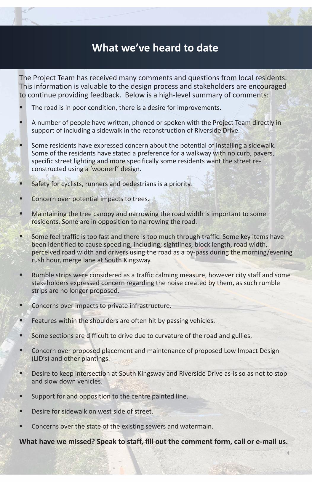
The Project Team has received many comments and questions from local residents.This information is valuable to the design process and stakeholders are encouragedto continue providing feedback. Below is a high level summary of comments:
The road is in poor condition, there is a desire for improvements.
A number of people have written, phoned or spoken with the Project Team directly insupport of including a sidewalk in the reconstruction of Riverside Drive.
Some residents have expressed concern about the potential of installing a sidewalk.Some of the residents have stated a preference for a walkway with no curb, pavers,specific street lighting and more specifically some residents want the street reconstructed using a ‘woonerf’ design.
Safety for cyclists, runners and pedestrians is a priority.
Concern over potential impacts to trees.
Maintaining the tree canopy and narrowing the road width is important to someresidents. Some are in opposition to narrowing the road.
Some feel traffic is too fast and there is too much through traffic. Some key items havebeen identified to cause speeding, including; sightlines, block length, road width,perceived road width and drivers using the road as a by pass during the morning/eveningrush hour, merge lane at South Kingsway.
Rumble strips were considered as a traffic calming measure, however city staff and somestakeholders expressed concern regarding the noise created by them, as such rumblestrips are no longer proposed.
Concerns over impacts to private infrastructure.
Features within the shoulders are often hit by passing vehicles.
Some sections are difficult to drive due to curvature of the road and gullies.
Concern over proposed placement and maintenance of proposed Low Impact Design(LID’s) and other plantings.
Desire to keep intersection at South Kingsway and Riverside Drive as is so as not to stopand slow down vehicles.
Support for and opposition to the centre painted line.
Desire for sidewalk on west side of street.
Concerns over the state of the existing sewers and watermain.
What have we missed? Speak to staff, fill out the comment form, call or e mail us.4
What we’ve heard to date
5
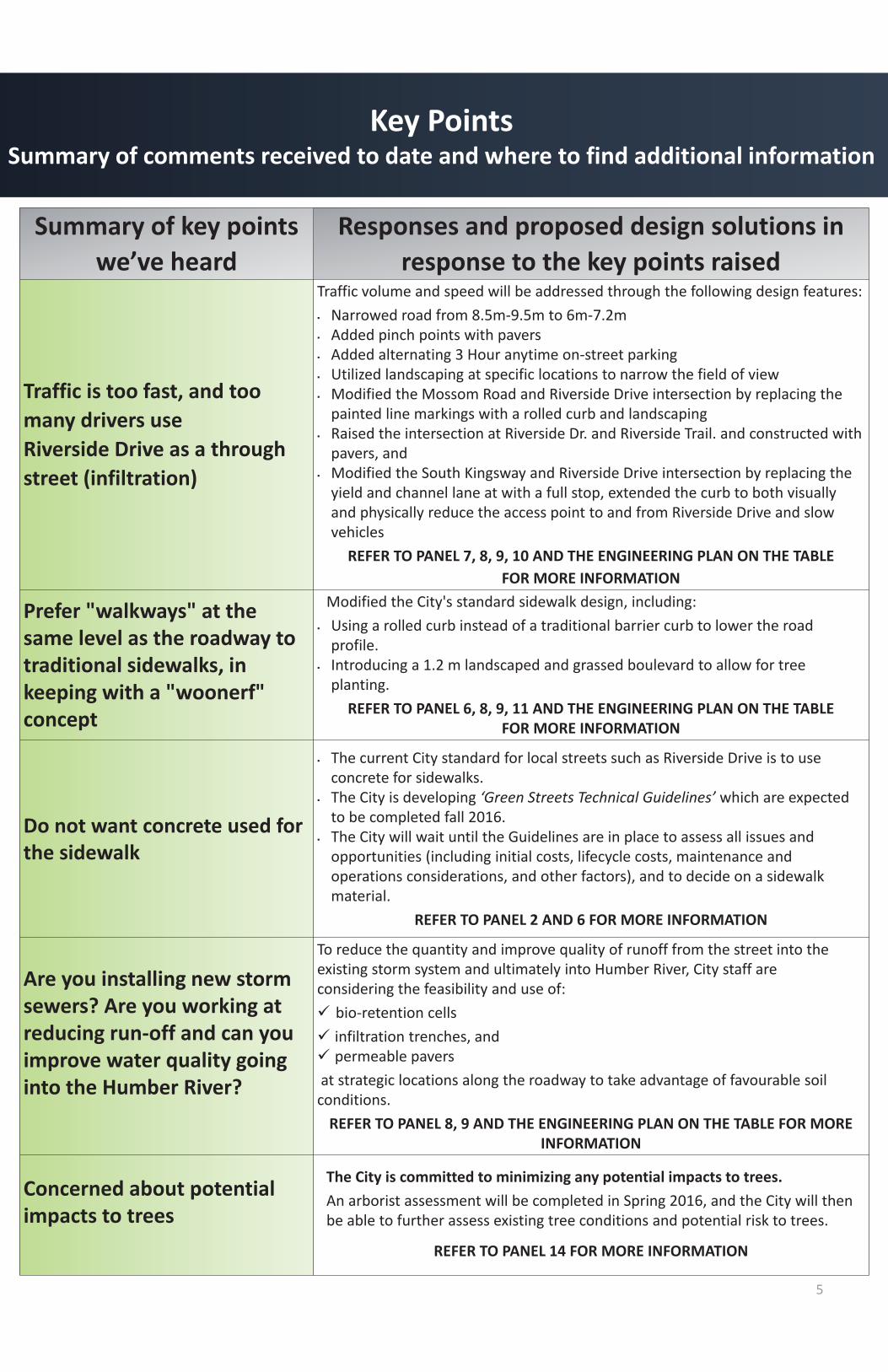
Key PointsSummary of comments received to date and where to find additional information
Summary of key pointswe’ve heard
Responses and proposed design solutions inresponse to the key points raised
Traffic is too fast, and toomany drivers useRiverside Drive as a throughstreet (infiltration)
Traffic volume and speed will be addressed through the following design features:Narrowed road from 8.5m 9.5m to 6m 7.2mAdded pinch points with paversAdded alternating 3 Hour anytime on street parkingUtilized landscaping at specific locations to narrow the field of viewModified the Mossom Road and Riverside Drive intersection by replacing thepainted line markings with a rolled curb and landscapingRaised the intersection at Riverside Dr. and Riverside Trail. and constructed withpavers, andModified the South Kingsway and Riverside Drive intersection by replacing theyield and channel lane at with a full stop, extended the curb to both visuallyand physically reduce the access point to and from Riverside Drive and slowvehicles
REFER TO PANEL 7, 8, 9, 10 AND THE ENGINEERING PLAN ON THE TABLEFOR MORE INFORMATION
Prefer "walkways" at thesame level as the roadway totraditional sidewalks, inkeeping with a "woonerf"concept
Modified the City's standard sidewalk design, including:Using a rolled curb instead of a traditional barrier curb to lower the roadprofile.Introducing a 1.2 m landscaped and grassed boulevard to allow for treeplanting.
REFER TO PANEL 6, 8, 9, 11 AND THE ENGINEERING PLAN ON THE TABLEFOR MORE INFORMATION
Do not want concrete used forthe sidewalk
The current City standard for local streets such as Riverside Drive is to useconcrete for sidewalks.The City is developing ‘Green Streets Technical Guidelines’ which are expectedto be completed fall 2016.The City will wait until the Guidelines are in place to assess all issues andopportunities (including initial costs, lifecycle costs, maintenance andoperations considerations, and other factors), and to decide on a sidewalkmaterial.
REFER TO PANEL 2 AND 6 FOR MORE INFORMATION
Are you installing new stormsewers? Are you working atreducing run off and can youimprove water quality goinginto the Humber River?
To reduce the quantity and improve quality of runoff from the street into theexisting storm system and ultimately into Humber River, City staff areconsidering the feasibility and use of:
bio retention cellsinfiltration trenches, andpermeable pavers
at strategic locations along the roadway to take advantage of favourable soilconditions.REFER TO PANEL 8, 9 AND THE ENGINEERING PLAN ON THE TABLE FOR MORE
INFORMATION
Concerned about potentialimpacts to trees
The City is committed to minimizing any potential impacts to trees.An arborist assessment will be completed in Spring 2016, and the City will thenbe able to further assess existing tree conditions and potential risk to trees.
REFER TO PANEL 14 FOR MORE INFORMATION

6
Key PointsSummary of comments received to date and where to find additional information
Summary of keypoints we’ve
heard
Responses and proposed design solutions inresponse to the key points raised
Why do we need asidewalk?
The City's practice is to build sidewalks on at least one side of a roadway duringreconstruction. Sidewalks promote walkability, enhance pedestrian safety and comfort,and improve accessibility. This project provides a once in 100 year, cost effectiveopportunity to improve the street by implementing a sidewalk and further expandingthe City's pedestrian network.
City staff have considered input received regarding constructing a woonerf and are ofthe opinion the application is not appropriate for Riverside Drive. However, in responseto input received staff are proposing significant modifications to the original proposedplans, where feasible taking elements of the woonerf design into consideration, such as:
The sidewalk will be lowered by using a rolled curb rather than the City’s standardbarrier curb.
Pedestrian safety is a concern for City staff. Pedestrians are vulnerable road userswithout the benefit of having protection when not on a sidewalk, a rolled curb providesa physical separation, making it difficult for vehicles to mount and potentially collidewith a pedestrian.
Curbs discourage vehicles from illegally parking and stopping on the sidewalk surface.Illegal parking on the sidewalk could result in pedestrians having to walk on the roadsurface to negotiate around illegally parked cars.
A landscaped boulevard of mixed materials between the rolled curb and sidewalk hasbeen introduced in response to comments received from residents, who favoured aboulevard instead of designing the sidewalk against the edge of the curb.
REFER TO PANEL 7 FOR MORE INFORMATION
Why is the sidewalkplanned for the eastside instead of thewest side of RiversideDrive?
The City is planning for a sidewalk on the east side of the street for a number of reasons:
There are more homes on the east side of the street.Existing lighting is on the east side of the street, increasing safety for pedestrians.The west side of Riverside Drive along the retaining wall does not provide sufficientspace to construct a sidewalk.The sidewalk will connect with the existing sidewalk at the south end of the road.A sidewalk on the west side of the street would require pedestrians to makeadditional road crossings (at Riverside Crescent, and north and south of Lucy MaudMontgomery Park).
Why are bike lanesnot included?
Riverside Drive is designated as a ‘local road’ which is considered low volume and lowspeed. The Ontario Traffic Manual concludes providing dedicated cycling areas toprotect cyclists from traffic on local roads is not critical. Additionally, the proposed7.2 m – 6 m roadway could only accommodate 1m edge lines for bike lanes, below theminimum requirement for safe bike lanes.
Within the broader neighbourhood the City is currently exploring options for improvingthe existing Ellis/Runnymede cycling route, with upgrades to the Lake Shore Crossing, asection of bike lane, and new markings.

The Project Team must follow the guidance provided by the Essential LinksCapital Program and City of Toronto Walking Strategy in the design for thereconstruction of Riverside Drive.
Essential Links Capital Program (2002)
The Essential Links Capital Program states that:“connected and continuous sidewalks are needed throughout Toronto toensure a safer and more accessible walking environment.”
The objective of the Program is to “ensure(s) that all road reconstructionand resurfacing projects include the construction of new sidewalks wherethey are currently missing.”
Toronto Walking Strategy (2009)
7
Why Sidewalks?
“3.5 Construct new sidewalks – during roadreconstruction and resurfacing, or whenapplicable through the development reviewprocess – on both sides of the street in all areaswhere they are missing.”
Toronto Public Health recognizes the importance of sidewalks inpedestrian safety, noting that pedestrians and vehicles are more likely tocollide at intersections when sidewalks are not provided.
Riverside Drive is classified as a Local Road. The City's practice is torecommend sidewalks on one or both sides of local roads.
Recognizing the character of Riverside Drive and to minimize removal ofhealthy trees, the Project Team is recommending installing a sidewalkwith a planted boulevard on only one side of the road.

8
What is being done to slow vehicles anddiscourage traffic infiltration?
Reduce road width from 8.5 m – 9.5 m to 7.2 m and 6.0 mat designed ‘pinch points’
Re assign and stagger on street parking
Reducing the road width and adding pinch points and will act together to slowtraffic and discourage vehicle infiltration.
Introducing alternating banks of 3 hour anytime on street parking on a narrowerstreet will shorten sight lines and act to slow vehicles down.
3 hr anytimeon street parking
6.O m ‘pinchpoint’

9
What is being done to slow vehicles anddiscourage traffic infiltration?
Raised Intersection at RiversideDrive and Riverside Trail
The raised intersection will be treatedwith pavers and will include pedestriancrossings. The raised intersection withalternative pavers is designed to slowspeeds and encourage motorists tostop at the stop sign and yield topedestrians at the crosswalk.
At grade and raised strips usingpavers
In strategic locations the City isproposing a combination of at gradeand raised 10 m paver strips in tocreate visual and physical breaks in theroadway.
City staff will be taking advantage ofsoil conditions in the vicinity of LucyMaude Montgomery Park to installpermeable pavers for the 10 m paverstrip. The impacts of permeable paverswill be monitored to assess theireffectiveness to determine theirpotential use in other projects.
Sample picture of permeable paversand landscaped area showing
underground details
Example of a raised intersectionBlantyre Ave. and Parkland Rd.
NOTE: rolled curbs, landscaped boulevard, pavers for the raised intersectionand sidewalk on one side is being proposed for Riverside Drive. This is anexample to show the raised intersection only.
Source: City of Toronto
Source: Google and Henry Kortekass & Associates Inc.

10
What is being done to slow vehicles anddiscourage traffic infiltration?
Conceptual landscaping and raingardens added to suitable areas suchas new 1.2 m boulevards, 6.0 mpinch points and adjacent areas tonarrow the field of view encouragingvehicles to slow down.
The landscaped areas may bedesigned as rain gardens in suitableareas which will assist in managingand treating stormwater run off.
Conceptual landscaping at Mossom Road and Riverside Drive includesremoval the existing painted lines, installation of a rolled curb and
landscaping to create a defined street and slow traffic.
Conceptual landscape treatment atspecific locations along RiversideDrive
Intersection of Mossom Road and Riverside Drive
Source: Google and Henry Kortekass & Associates Inc.Source: Google and Henry Kortekass & Associates Inc.
Source: Google and Henry Kortekass & Associates Inc.
Source: Google and Henry Kortekass & Associates Inc
Source: Google and Henry Kortekass & Associates Inc

11
What is being done to slow vehicles anddiscourage traffic infiltration?
Normalized intersection at South Kingsway and Riverside Drive
6.0 m ‘pinch points’ and 10 m paver strips at intentional locationsalong Riverside Drive
Conceptual illustration of pinch points and addition of a lookout on thewest side Riverside Drive adjacent to a replaced retaining wall. Thematerial and surface treatment of the retaining wall is to bedetermined during detailed design.
Replace the yield sign and channel lane at South Kingsway with a fullstop, extend the curb and add landscaping to both visually andphysically reduce the access point to and from Riverside Drive.

Conforms with City Policies & Guidelines.
Provides reconstructed road surface void of potholes for safer conditions forcars in terms of maintenance of vehicles and lessens swerving to avoid poorpavement conditions such as potholes and uneven surface.
Sidewalk provides off street pedestrian connection and improves safety.
Some guide poles may require relocation.
Alternating on street parking can be accommodated on both sides of the road.
Some private features exist within the public road allowance. These features,such as retaining walls or sprinkler systems may require relocation. The City isworking to minimize any disturbance to these features, homeowners will beconsulted prior to construction if removal or re location is required.
12
Typical Proposed Road Cross Sections
House #197 to Brule Gardens
House #163 to House#197

Typical Proposed Road Cross SectionsRiverside Crescent to Bloor Street West
Existing Road Cross Section
Proposed Road Cross Section13
View looking south

The existing retaining wall is in poor condition and will requirereplacement. The following design is being considered:
14
Retaining Wall Design
The construction of the wall is anticipated to be from House# 163 toHouse# 197.During the construction of the retaining wall, one lane of traffic will beopen at all times.The watermain will be relocated due to the construction of the wall.There is a potential for the relocation of the existing sanitary sewer.The outside face of the wall will be covered with vegetation.
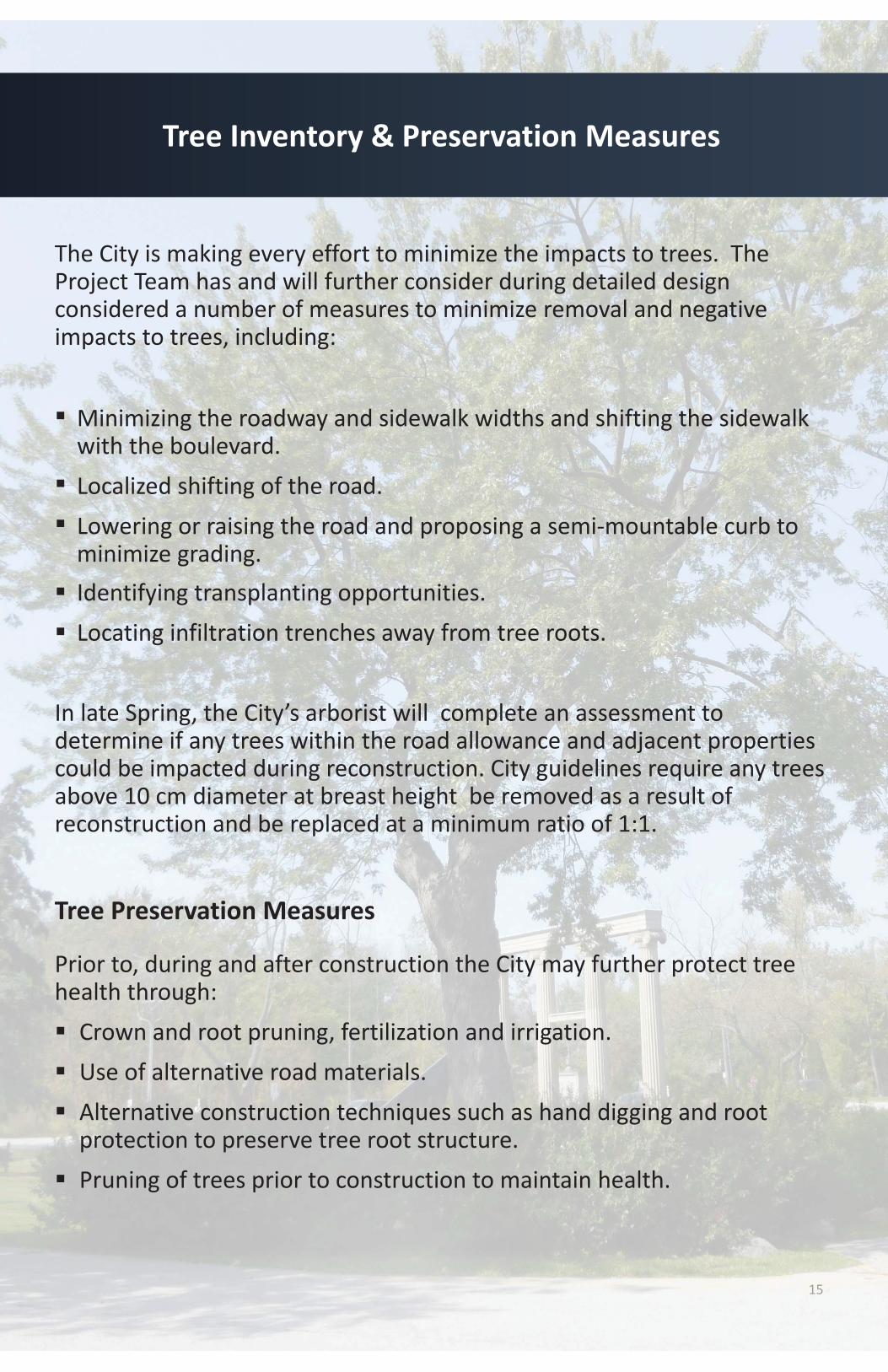
The City is making every effort to minimize the impacts to trees. TheProject Team has and will further consider during detailed designconsidered a number of measures to minimize removal and negativeimpacts to trees, including:
Minimizing the roadway and sidewalk widths and shifting the sidewalkwith the boulevard.Localized shifting of the road.Lowering or raising the road and proposing a semi mountable curb tominimize grading.Identifying transplanting opportunities.Locating infiltration trenches away from tree roots.
In late Spring, the City’s arborist will complete an assessment todetermine if any trees within the road allowance and adjacent propertiescould be impacted during reconstruction. City guidelines require any treesabove 10 cm diameter at breast height be removed as a result ofreconstruction and be replaced at a minimum ratio of 1:1.
Tree Preservation Measures
Prior to, during and after construction the City may further protect treehealth through:Crown and root pruning, fertilization and irrigation.Use of alternative road materials.Alternative construction techniques such as hand digging and rootprotection to preserve tree root structure.Pruning of trees prior to construction to maintain health.
15
Tree Inventory & Preservation Measures

Noise
How will the City address noise concerns during construction?The Noise Bylaw (Chapter 591, City of Toronto Municipal Code)permits operation of construction equipment only during Monday toFriday 7:00 a.m. to 7:00 p.m., Saturdays 9:00 a.m. to 7:00 p.m., and noconstruction noise on Sundays and statutory holidays.
Vibration and Movement Monitoring
What to expect?Precondition surveys of homes along Riverside Drive in the vicinity ofthe retaining wall will be conducted. You should expect a notificationrequesting access to your home to conduct a visual investigation ofyour basement foundation prior to the start of construction.Use of vibratory equipment during construction will be limited.
Access
What will be done before, during and after construction?Access to driveways may be limited at times during construction.Notification will be issued 24hrs in advance of any access restrictions.One lane of traffic will be open at all times during construction.Should short term road closures be required, notifications to residentswill be issued 24hrs in advance.Roadway will be closed to through traffic during construction. Onlylocal access will be made available.
16
Noise and Vibration

Spring 2016
The Project Team will consider feedback from stakeholders received atthis meeting.Stakeholders can continue making comments by e mail or phone untilMay 18, 2016.Panels are posted on the City’s website : www.toronto.ca/riversidedriveThe Project Team will review proposed design options along withcomments received from the public to finalize a preferred design.
Late Spring 2016
The City will refine the design, considering input received at this PublicOpen House.
After the City has finalized the design the tender will be issued.
Fall 2016
Commence construction of retaining wall. The construction of theretaining wall is anticipated to take 6 months.
Spring 2017
Commence reconstruction of Riverside Drive and resurfacing ofRiverside Crescent.
THANK YOU FOR TAKING THE TIME TO BE INVOLVED
17
Proposed Timing and Next Steps