Embed Size (px)
Citation preview
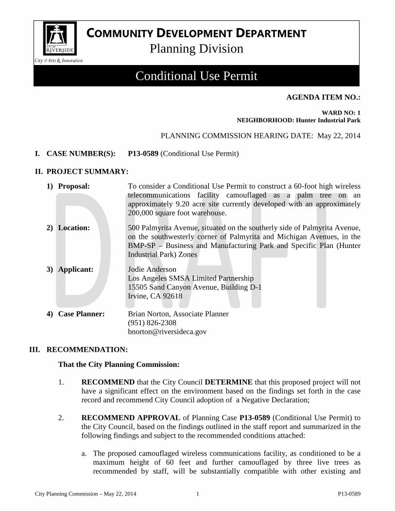
AGENDA ITEM NO.: WARD NO: 1 NEIGHBORHOOD: Hunter Industrial Park
PLANNING COMMISSION HEARING DATE: May 22, 2014
I. CASE NUMBER(S): P13-0589 (Conditional Use Permit)
II. PROJECT SUMMARY:
1) Proposal: To consider a Conditional Use Permit to construct a 60-foot high wireless telecommunications facility camouflaged as a palm tree on an approximately 9.20 acre site currently developed with an approximately 200,000 square foot warehouse.
2) Location: 500 Palmyrita Avenue, situated on the southerly side of Palmyrita Avenue,
on the southwesterly corner of Palmyrita and Michigan Avenues, in the BMP-SP – Business and Manufacturing Park and Specific Plan (Hunter Industrial Park) Zones
3) Applicant: Jodie Anderson
Los Angeles SMSA Limited Partnership 15505 Sand Canyon Avenue, Building D-1 Irvine, CA 92618
4) Case Planner: Brian Norton, Associate Planner (951) 826-2308 [email protected]
III. RECOMMENDATION:
That the City Planning Commission: 1. RECOMMEND that the City Council DETERMINE that this proposed project will not
have a significant effect on the environment based on the findings set forth in the case record and recommend City Council adoption of a Negative Declaration;
2. RECOMMEND APPROVAL of Planning Case P13-0589 (Conditional Use Permit) to
the City Council, based on the findings outlined in the staff report and summarized in the following findings and subject to the recommended conditions attached:
a. The proposed camouflaged wireless communications facility, as conditioned to be a
maximum height of 60 feet and further camouflaged by three live trees as recommended by staff, will be substantially compatible with other existing and
COMMUNITY DEVELOPMENT DEPARTMENT Planning Division
Conditional Use Permit
City Planning Commission – May 22, 2014 1 P13-0589
proposed uses in the area, including factors relating to the nature of its location, operation, facility design, site design, and environmental impacts;
b. The proposal, as conditioned to be a maximum height of 60 feet and further camouflaged by three live trees, will not be materially detrimental to the health, safety and general welfare of the public or otherwise injurious to the environment or to the property or improvements within the area, as it will be required to comply with the American National Standard Institute (ANSI) standards for professionally acceptable radio frequency emissions to ensure the antennas will not interfere with the surrounding land uses;
c. The proposed camouflaged wireless communications facility, as conditioned to be a
maximum height of 60 feet and further camouflaged by three live trees, will be consistent with the purposes of the Zoning Code and the application of any required development standards is in the furtherance of a compelling governmental interest and is the least restrictive means of furthering that compelling governmental interest; and
d. The proposal is in compliance with a majority of the development standards set forth
in the Zoning Code. Any requested variances to implement the project as proposed can be justified, as detailed in this report
IV. BACKGROUND/HISTORY: The project site is approximately 9.20 acres in area and contains an approximately 200,000
square foot warehouse building, a vehicle parking lot and loading dock areas for tractor trailers with two ingress/egress points to Palmyrita Avenue.
The retail buildings located on the subject site were constructed in 1987 and underwent a façade
remodel in 2005 (P05-0696). The site is adjacent to and separated from a multi-family residential development to the west by a 6-foot high block wall. Vehicular access is provided from multiple points on both Van Buren Boulevard and Philbin Avenue, as well as a vehicular access point to the neighboring commercial development to the north.
V. PROJECT DESCRIPTION:
The applicant is requesting a Conditional Use Permit (CUP) to allow the construction of an approximately 60-foot high wireless telecommunications facility camouflaged as a palm tree (monopalm) and related equipment enclosure. The proposed 29 foot by 19 foot lease area and 60-foot tall monopalm are generally situated towards the northeasterly portion of the property and located behind an existing 6 foot tall masonry wall. The monoplam is located approximately 40 feet to the west of the equipment enclosure and is approximately 210 feet from the northerly property line and 93 feet to the easterly property line. The lease area with equipment enclosure is approximately 234 feet to the northerly property line and 29 feet to the easterly property line. Both the monoplam and equipment enclosure are located behind an existing 6 foot high masonry block wall. The facility, including all related ground mounted equipment, will be located at grade level.
City Planning Commission – May 22, 2014 2 P13-0589
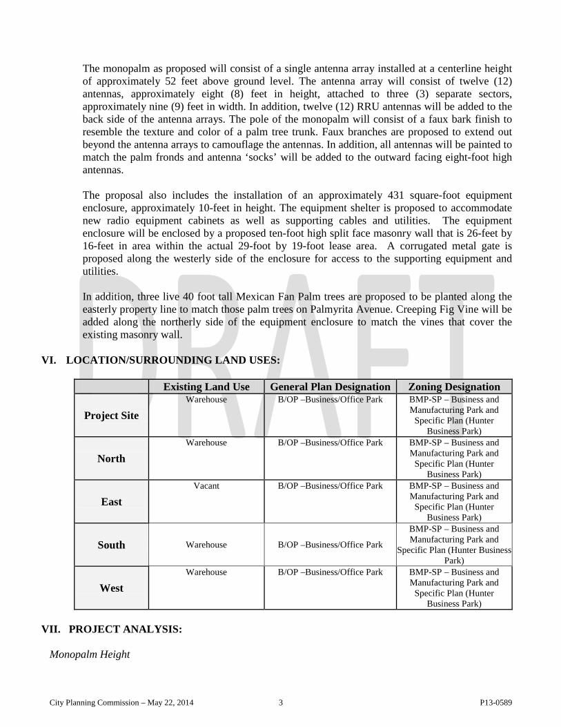
The monopalm as proposed will consist of a single antenna array installed at a centerline height of approximately 52 feet above ground level. The antenna array will consist of twelve (12) antennas, approximately eight (8) feet in height, attached to three (3) separate sectors, approximately nine (9) feet in width. In addition, twelve (12) RRU antennas will be added to the back side of the antenna arrays. The pole of the monopalm will consist of a faux bark finish to resemble the texture and color of a palm tree trunk. Faux branches are proposed to extend out beyond the antenna arrays to camouflage the antennas. In addition, all antennas will be painted to match the palm fronds and antenna ‘socks’ will be added to the outward facing eight-foot high antennas. The proposal also includes the installation of an approximately 431 square-foot equipment enclosure, approximately 10-feet in height. The equipment shelter is proposed to accommodate new radio equipment cabinets as well as supporting cables and utilities. The equipment enclosure will be enclosed by a proposed ten-foot high split face masonry wall that is 26-feet by 16-feet in area within the actual 29-foot by 19-foot lease area. A corrugated metal gate is proposed along the westerly side of the enclosure for access to the supporting equipment and utilities. In addition, three live 40 foot tall Mexican Fan Palm trees are proposed to be planted along the easterly property line to match those palm trees on Palmyrita Avenue. Creeping Fig Vine will be added along the northerly side of the equipment enclosure to match the vines that cover the existing masonry wall.
VI. LOCATION/SURROUNDING LAND USES:
Existing Land Use General Plan Designation Zoning Designation
Project Site Warehouse B/OP –Business/Office Park BMP-SP – Business and
Manufacturing Park and Specific Plan (Hunter
Business Park)
North Warehouse B/OP –Business/Office Park BMP-SP – Business and
Manufacturing Park and Specific Plan (Hunter
Business Park)
East Vacant B/OP –Business/Office Park BMP-SP – Business and
Manufacturing Park and Specific Plan (Hunter
Business Park)
South Warehouse B/OP –Business/Office Park
BMP-SP – Business and Manufacturing Park and
Specific Plan (Hunter Business Park)
West Warehouse B/OP –Business/Office Park BMP-SP – Business and
Manufacturing Park and Specific Plan (Hunter
Business Park)
VII. PROJECT ANALYSIS: Monopalm Height
City Planning Commission – May 22, 2014 3 P13-0589
The proposal to construct a camouflaged wireless telecommunications facility at this site can be supported, but not at the height currently proposed by the applicant. As currently designed, the proposed monopine cannot be considered a “camouflaged ground-mounted facility,” which is defined in the Zoning Code as “any facility that is designed to mask or blend in with the surrounding environment in such a manner to render it unnoticeable to the casual observer.” Based on a cursory survey of the immediate area, no structures approaching 75 feet in height exist in the surrounding area; the project site and the surrounding area are predominantly developed with one- to two-story structures, typically not exceeding 35 feet in height. As such, at the proposed height, the monopine will be out of character in the area, create a visually dominating feature and could set a precedent for taller, out of character structures in other areas of the City.
Staff is recommending the proposed monopine be limited to a maximum height of 60 feet (to the top of the highest branches). A monopine of this height would, in the judgment of staff, strike a reasonable balance between the applicant’s intended service needs for the new facility and the scale of development currently existing in the surrounding area. To further integrate the proposed monopine into its surroundings and de-emphasize the fact that wireless telecommunications facilities would be located on site, it is recommended that the four proposed live trees be of species that would achieve a mature growth height of 45-50 feet. Landscaping is not proposed for the lease area; however, the lease area and related ground mounted equipment are not visible to the public, as the fenced in portion of the project is tucked into an alcove on the back side of an existing commercial building and trees planted in direct proximity to the monopine would create a ‘cluster’ effect of tall features that would call attention to and visually dominate the area in its current setting.
At this point, the applicant is opposed to staff’s recommendation and is still seeking approval of a 75-foot tall monopine. Again, it is believed that a structure of this height would be out of character with the surrounding area and has the potential to create a visual nuisance. However, a 60-foot tall monopine can be supported given that it would be more in line with existing development in the area, would better resemble the height of existing natural pine trees and would be consistent with recent recommendations taken by the Planning Commission for similar proposals around the City. Finally, this recommendation furthers the intent of Policy LU – 9.7 of the General Plan 2025, which states that development adjacent to residential uses should be compatible with planned residential uses and should employ appropriate site design, landscaping and building design to buffer the non-residential uses. With implementation of the recommended conditions of approval, the project would be consistent with this General Plan 2025 policy.
Site Improvements
Consistent with the provisions of Chapter 19.530 of the Zoning Code, enhancements and upgrades to the existing site and/or building(s) is required in conjunction with the installation of a wireless communications facility and such improvements should meet the current development and design standards of the underlying zone. As mentioned above, the subject site was constructed in 2*** and is a relatedly new site with landscaping that continues to be maintained in conformance with current codes. Continued maintenance of all buildings and landscaped areas will be required in conformance with the City’s Municipal Code.
• General Plan/ Zoning Conformance:
City Planning Commission – May 22, 2014 4 P13-0589
The project site has a B/OP – Business/Office Park land use designation and is within the BMP-SP – Business and Manufacturing Park and Specific Plan (Hunter Business Park) Zones. With the recommended conditions of approval and upgraded landscaping, the facility can be defined as a “camouflaged ground-mounted” wireless telecommunications facility. Thus, the proposal is subject to the granting of a Conditional Use Permit (CUP) and must comply with the specific location and development standards and design guidelines set forth in Chapter 19.530 (Wireless Telecommunications Facilities) of the Zoning Code. Below is an analysis of the project relative to the applicable site location criteria and development standards:
Compliance with Locational Criteria
o To minimize any negative aesthetic impact, wireless telecommunication facilities shall be sited so as to minimize views from the public right-of-way and adjacent properties.
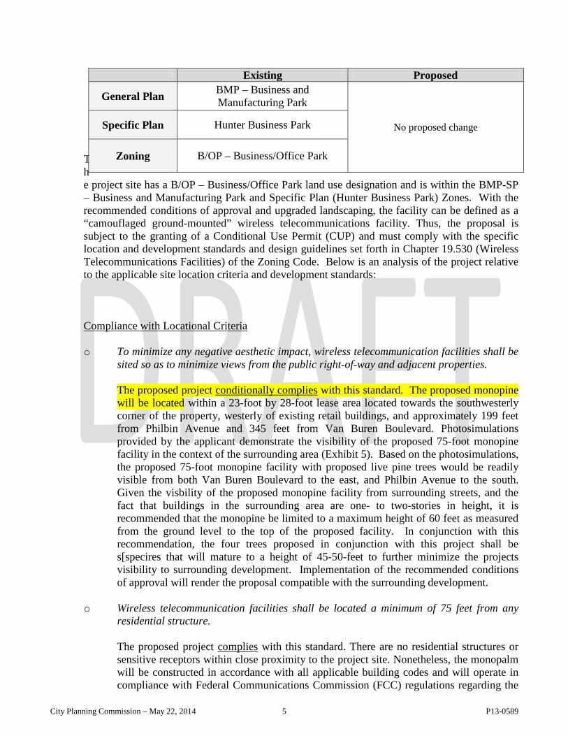
The proposed project conditionally complies with this standard. The proposed monopine will be located within a 23-foot by 28-foot lease area located towards the southwesterly corner of the property, westerly of existing retail buildings, and approximately 199 feet from Philbin Avenue and 345 feet from Van Buren Boulevard. Photosimulations provided by the applicant demonstrate the visibility of the proposed 75-foot monopine facility in the context of the surrounding area (Exhibit 5). Based on the photosimulations, the proposed 75-foot monopine facility with proposed live pine trees would be readily visible from both Van Buren Boulevard to the east, and Philbin Avenue to the south. Given the visbility of the proposed monopine facility from surrounding streets, and the fact that buildings in the surrounding area are one- to two-stories in height, it is recommended that the monopine be limited to a maximum height of 60 feet as measured from the ground level to the top of the proposed facility. In conjunction with this recommendation, the four trees proposed in conjunction with this project shall be s[specires that will mature to a height of 45-50-feet to further minimize the projects visibility to surrounding development. Implementation of the recommended conditions of approval will render the proposal compatible with the surrounding development.
o Wireless telecommunication facilities shall be located a minimum of 75 feet from any
residential structure.
The proposed project complies with this standard. There are no residential structures or sensitive receptors within close proximity to the project site. Nonetheless, the monopalm will be constructed in accordance with all applicable building codes and will operate in compliance with Federal Communications Commission (FCC) regulations regarding the
Existing Proposed
General Plan BMP – Business and Manufacturing Park
No proposed change Specific Plan Hunter Business Park
Zoning B/OP – Business/Office Park
City Planning Commission – May 22, 2014 5 P13-0589
emission and transmission of electromagnetic radiation and radio frequency emissions that may result from the project. Conditions of approval are recommended to ensure that the proposed monopalm facility will not be detrimental to the surrounding area.
Compliance with Development Standards
o Wireless telecommunication facilities shall comply with the provisions (i.e., height, setbacks, etc.) of the underlying zone where the facility is located.
The proposed project complies with this standard. The applicant is proposing to construct a 62-foot high monopalm located towards the northeasterly portion of the project site, approximately 200 feet away from the corner of Palmyrita and Michigan Avenues. The BMP – Business and Manufacturing Zone allows for a maximum building height of 45 feet. While the proposed monopalm facility complies with the height limit of the underlying zone as currently designed, the height of the facility is inconsistent with the predominant development pattern of the surrounding area where most buildings are one- or two-stories in height. To that end, staff is recommending the facility be limited to a maximum height of 60 feet as measured from the ground level to the top of the proposed facility. Not only would this ensure a more compatible scale of development, it would also establish a monopine facility which more closely resembles a natural pine. It is recognized that limiting the height of the structure to 60 feet would affect the service area intended for the proposed facility and potentially lead to the need for additional wireless telecommunications facilities in the City for this carrier. However, as previously described, the recommendation of staff seeks to provide a reasonable balance between the applicant’s needs and the proposed monopine facility’s aesthetic impact on the surrounding area.
Compliance with Design Guidelines
o All camouflaged wireless telecommunication facility components, including antenna
panels, shall be painted or be designed to match the predominant color and/or design of the structure so as to be visually inconspicuous. The use of state-of-the-art technology and implementation of best practices shall be required to ensure high quality camouflage design. Careful consideration of design details including color, texture, and materials shall be made to ensure the camouflaged design of the wireless telecommunication facility.
The proposed project conditionally complies with this standard. As currently designed, the proposed monopalm facility will consist of twelve (12) antennas, approximately eight (8) feet in height, attached to three (3) separate sectors, approximately nine (9) feet in width. The pole of the monopalm will consist of a faux bark finish to resemble the texture and color of a palm tree trunk. Faux palm fronds are proposed to extend at a minimum 18 inches beyond the antenna arrays to camouflage the antennas. To ensure the facility is constructed using the highest quality camouflaged design, staff recommends that all antennas, mounts, and peripherals be installed as close to the main pole as possible and be painted green and include antenna socks to match and be appropriately compatible with the proposed monopalm fronds. With the implementation of the
City Planning Commission – May 22, 2014 6 P13-0589
abovementioned recommendations the proposed monopalm will be consistent with the design guidelines for wireless telecommunications facilities.
o Landscaping shall be provided to screen wireless telecommunication facilities and
related above-ground support equipment from the public right-of-way. The Approving Authority may require additional live mature plantings to assist in mitigating visual impacts of wireless telecommunication facilities.
The proposed project conditionally complies with this standard. As previously noted, the proposed monopalm facility and equipment shelter will be enclosed by a ten-foot high split face masonry wall. The proposed enclosure will be constructed behind the existing 6 foot masonry wall generally towards the northeasterly portion of the subject property, where the euipment shelter will not be readily visible from either Palmyrita and Michigan Avenues. The proposal also includes the planting of three live pine trees, in an existing landscape planter along Michigan Avenue to match those along Palmyrita Avenue. Implementation of the recommended conditions of approval will render the proposal compatible with the surrounding development.
o All support equipment shall be completely screened. Required screening shall be
decorative, of a design, color, and texture that is architecturally integrated with existing structures on the same site.
The proposed project complies with this standard. The proposed monopalm will be situated behind an existing 6 foot high solid masonry wall and all related ground mounted equipment will sited within the 26-foot by 16-foot walled in area generally located towards the northeasterly corner of the subject property and behind the the existing 6 foot high masonry wall. As mentioned above, a portion of the 29-foot by 19-foot lease area will be enclosed by a ten-foot high split face masonry wall with a corrugated metal gate. The approximately 431 square-foot equipment shelter will be approximately ten (10) feet in height and is proposed to accommodate new radio equipment cabinets as well as supporting cables and utilities and will be constructed of a solid split face masonry wall.
• Neighborhood Compatibility Considerations:
As described in detail in this analysis, the proposed use will be compatible with a majority of the specific site location, development, and operation standards related to wireless telecommunications facilities with implementation of the recommended conditions of approval. As conditioned, the proposal will not prove detrimental to the surrounding neighborhood given the recommended conditions of approval that will require the proposed monopalm facility be 60 feet in height and require the planting of three palm trees with a mature growth height of 35-40 feet in height. In addition, to those facts and observations contained in this report to support this request, it is not anticipated that this proposal will interfere with local radio, television, or emergency reception, as the Federal Communications Commission (FCC) regulates transmission frequencies. Furthermore, the applicant will be required to operate the wireless telecommunications facility in compliance with the American National Standard Institute (ANSI) standards for professionally acceptable radio frequency (RF) emissions for all types of communications towers. Compliance with the above regulations will ensure that the facility poses no interference to surrounding land uses.
City Planning Commission – May 22, 2014 7 P13-0589
Pursuant to the Telecommunications Act of 1996, the City of Riverside is prohibited from using environmental effects of RF emissions as justification for approval or denial of a wireless telecommunication facility. However, all wireless telecommunication facilities are required to comply with FCC regulations regarding the emission and transmission of electromagnetic radiation and radio frequency emissions that may result from the project. A condition of approval has been incorporated to require that the facility be tested to insure compliance with FCC standards prior to operation. Based on the above, it is recommended that the proposed monopalm facility be tested annually to ensure compliance with ANSI and FCC standards. A copy of the report verifying compliance with ANSI and FCC standards will need to be submitted to the Planning Division for review.
City Planning Commission – May 22, 2014 8 P13-0589
VIII. PUBLIC NOTICE AND COMMENTS:
Public notices were mailed to property owners and occupants within 300 feet of the project site. No comments have been received by staff. Any additional comments received after the writing of this report will be forwarded to the Planning Commission for consideration.
IX. EXHIBITS:
1. Location/Zoning Map 2. General Plan Map 3. Aerial Photo 4. Project Plans 5. Photo Simulations 6. Existing Site Photographs 7. Property Adjacent Photos 8. Coverage Plot
City Planning Commission – May 22, 2014 9 P13-0589
RECOMMENDED CONDITIONS & GENERAL INFORMATION NOTES Case Number: P13-0589 (Conditional Use Permit) Meeting Date: May 22, 2014 CONDITIONS All mitigation measures are noted by an asterisk (*). The applicant is advised that the business or use for which this conditional use permit is granted cannot be legally conducted on the subject property until all conditions of approval have been met to the approval of the Community Development Department, Planning Division. Case Specific • Planning
1. This project shall comply with the City’s adopted Noise Code. All construction activity will be restricted to between 7:00 a.m. and 7:00 p.m. weekdays and 8:00 a.m. and 5:00 p.m. Saturdays. No construction noise is permitted on Sundays or federal holidays.
2. The antenna shall be designed in accordance with the FCC standards for professionally
acceptable radio frequency emissions for all types of communications towers. 3. The new wireless telecommunication facility shall be designed within the applicable
American National Standards Institute (ANSI) standards 4. An annual inspection report for the monopalm facility shall be submitted to the Planning
Division in order to ensure their long term maintenance. Prior to building permit issuance:
5. Staff Required Plan Conditions: Plans submitted for Design Review staff review and approval shall include the following:
a. The monopalm facility shall not exceed 60 feet in height;
b. The monopalm shall include, at minimum eighty fronds (80);
c. The bark shall extend through the top of the antenna structure;
d. The antennas shall be covered with palm frond socks and the RRU antennas
(radio transceivers) shall be painted to match the proposed palm fronds;
e. Branches shall extend a minimum of 18 inches beyond the antennas;
f. Antennas shall not exceed 8 feet in height;
g. The antenna array shall have a maximum width of six feet six inches (6’6”);
h. All wires shall be run internal to the monopalm pole;
City Planning Commission – May 22, 2014 10 P13-0589
i. All antennas, mounts, wires and peripherals shall be painted to match and be
compatible with the monopalm facility.
6. Staff Required Gate/Fence Plan Conditions: Gate and wall plans submitted for Design Review staff review and approval shall include the following:
a. The equipment enclosure shall be constructed from split face masonry with a
decorative masonry cap;
b. All ground mounted equipment shall be surrounded by a ten-foot high split face decorative masonry wall.
c. No barbed or razor wire shall be permitted around the equipment enclosure.
7. Staff Required Landscape/Irrigation Plan Conditions: Landscaping/irrigation plans
shall be submitted for Design Review staff approval. Design modifications may be required as deemed necessary. A separate application and filing fee are required. Landscaping, irrigation plans must be submitted prior to building permit issuance and shall include the following:
a. The proposed three (3) 40-foot tall Mexican Fan Palms shall planted along the
Michigan Avenue parkway, and spread out to match those existing Mexican Fan Palms on Palmyrita Avenue. The live trees must be permanently irrigated with an automatic irrigation system;
8. Submit three sets of plans depicting the preferred location for an above ground utility
transformer of capacity to accommodate the planned use within the subject site. These plans shall be reviewed and approved by the Planning Division and Public Utilities Department - Electric Division prior to the issuance of a building permit. The proposed location of the transformer shall be level, within 100 feet of the customer's service point, accessible to service trucks and in a location where the transformer can be adequately screened from public view, either by buildings or landscape screening. If landscape screening is the preferred screening method, no landscaping except ground cover shall be allowed within 10 feet of the transformer. The applicant is advised to consult with the City of Riverside Public Utilities, Electrical Engineering Division, at (951) 826-5489 prior to preparing these plans.
Prior to release of utilities
9. The applicant shall obtain approval of all State and local agencies having jurisdiction
over this use including the FAA and the FCC as necessary. 10. The facility shall be tested to ensure compliance with FCC standards. 11. Any unpermitted signage be removed or permitted; 12. Install the landscape and irrigation per the approved plans and submit the completed
“Certificate of Substantial Completion” (Appendix C of the water Efficient Landscaping and Irrigation Ordinance Summary and Design Manual) signed by the Designer/auditor
City Planning Commission – May 22, 2014 11 P13-0589
responsible for the project. Call Brian Norton at (951) 826-2308 to schedule the final inspection at least a week prior to needing the release of utilities.
Operational Conditions
13. The facility shall be tested annually to ensure compliance with ANSI and FCC standards for professionally acceptable radio frequency emissions and radiation. A copy of this report shall be submitted to the Planning Division for review.
14. All equipment shall be located within the equipment enclosure. 15. The monopalm and related support equipment shall be designed to prevent unauthorized
persons from accessing and/or climbing them. 16. The temporary power generator shall be located within a completely enclosed structure
designed to comply with Title 7 (Noise Control) of the Riverside Municipal Code and will only be operated when electrical power is not available.
17. Any graffiti on the facility shall be removed within 24 hours. 18. The subject property shall be developed substantially as shown on the plot plan on file
with this case except for any specific modification that may be required by these condi-tions of approval.
19. The wireless telecommunication facility shall be installed and maintained in compliance
with the requirements of the Uniform Building Code, National Electrical Code, noise standards, and other applicable codes, as well as other restrictions specified in this section. The facility operator and the property owner shall be responsible for maintaining the facility in good condition, which shall include but not be limited to regular cleaning, painting, and general upkeep and maintenance of the site.
20. The wireless telecommunication facilities shall not bear any signs or advertising devices
other than certification, warning, or other legally required seals or legally required signage.
21. All wireless telecommunication facilities and related support equipment shall be removed
within 90 days of the discontinuation of use and the site shall be restored to its original preconstruction condition. The operator’s agreeing to such removal shall be a condition of approval of each permit issued. A performance bond, based on a reasonable cost of removal and subject to the approval of the Planning Director and City Attorney’s Office as to manner and form, shall be required of the applicant and a copy kept on file by the Planning Division.
Standard Conditions
• Planning
22. There shall be a two-year time limit in which to commence construction of the project
beginning the day following approval by the Planning Commission unless a public
City Planning Commission – May 22, 2014 12 P13-0589
hearing is held by City Council; in that event the time limit begins the day following City Council approval.
23. Within 30 days of approval of this case by the City, the developer shall execute an
agreement approved by the City Attorney's Office to defend, indemnify, including reimbursement, and hold harmless the City of Riverside, its agents, officers and employees from any claim, action, or proceeding against the City of Riverside, its agents, officers, or employees to attack, set aside, void, or annul, an approval by the City's advisory agency, appeal board, or legislative body concerning this approval, which action is brought within the time period provided for in Section 66499.37 of the Government Code. The City will promptly notify the developer of any such claim; action or proceeding and the City will cooperate in the defense of the proceeding.
24. This project shall fully and continually comply with all applicable conditions of approval,
State, Federal and local laws in effect at the time the permit is approved and exercised and which may become effective and applicable thereafter, and in accordance with the terms contained within the staff report and all testimony regarding this case. Failure to do so will be grounds for Code Enforcement action, revocation or further legal action.
25. This use permit may be modified or revoked by the City Planning Commission or the
City Council should they determine that the proposed uses or conditions under which it is being operated or maintained is detrimental to the public health, welfare or materially injurious to public safety, property or improvements in the vicinity or if the property is operated or maintained so as to constitute a public nuisance.
26. The applicant shall comply with all federal, state and local laws and shall cooperate with
the Riverside Police Department (RPD) in the enforcement of all laws relating to this permit. Material violation, as determined by the City Planning Commission, of any laws in connection with this use or failure to cooperate with RPD will be cause for revocation of this permit.
27. This permit is issued based upon the business operations plan and information submitted
by the applicant, which has been used as the basis for evaluation of the proposed use in this staff report and for the conditions of approval herein. Permittee shall notify Community Development Department, Planning Division, of any change in operations and such change may require a revision to this permit. Failure to notify the city of any change in operations is material grounds for revocation of this conditional use permit.
28. The applicant herein of the business subject to this conditional use permit acknowledges
all of the conditions imposed and accepts this permit subject to those conditions and with the full awareness of the provisions of Title 19 of the Riverside Municipal Code. The applicant shall inform all its employees and future operators of the business subject to this permit of the restrictions and conditions of this permit as they apply to the business operations.
29. Failure to abide by all conditions of this permit shall be cause for revocation. 30. If necessary, the plans shall be submitted for plan check review to assure that all required
conditions have been met prior to exercising of this permit.
City Planning Commission – May 22, 2014 13 P13-0589
31. The subject property shall be developed and operated substantially as described in the
text of this report and as shown on the plot plan on file with this case except for any specific modifications that may be required by these conditions of approval.
32. Enumeration of the conditions herein shall not exclude or excuse compliance with all
applicable rules and regulations in effect at the time this permit is exercised. 33. The applicant shall continually comply with all applicable rules and regulations in effect
at the time permit is approved and exercised and which may become effective and applicable thereafter.
• Public Works
34. None.
• Fire Department Contact Margaret Albanese at 951-826-5455 for questions regarding fire conditions or corrections. The following to be met prior to construction permit issuance: 35. Requirements for construction shall follow the currently adopted California Building
Code and California Fire Code with City of Riverside amendments. 36. Construction plans shall be submitted and permitted prior to construction. 37. Fire Department access is required to be maintained during all phases of construction.
• Public Utilities Water Contact Paul Baum at [email protected] or (951) 826-5370 with any water questions regarding this project. 38. Advisory: All utilities shall be satisfactorily relocated, protected and/or replaced to the
specifications of the affected departments and agencies. GENERAL INFORMATION NOTES
1. Appeal Information a. Actions by the City Planning Commission, including any environmental finding,
may be appealed to the City Council within ten calendar days after the decision.
b. Appeal filing and processing information may be obtained from the Community Development Department, Planning Division, Public Information Section, 3rd Floor, City Hall.
City Planning Commission – May 22, 2014 14 P13-0589
7
WARD: 1
1. Case Number: P13-0589 (Conditional Use Permit) 2. Project Title: TM Cobb Wireless Telecommunications Facility (Mono-palm) 3. Hearing Date: May 22, 2014 4. Lead Agency: City of Riverside
Community Development Department Planning Division
3900 Main Street, 3rd Floor Riverside, CA 92522 5. Contact Person: Brian Norton, Associate Planner Phone Number: (951) 826-2308 6. Project Location: 500 Palmyrita Avenue, located southwesterly of the corner of Palmyrita and
Michigan Avenues, in BMP-SP – Business and Manufacturing Park and Specific Plan (Hunter Business Park) Zones.
7. Project Applicant/Project Sponsor’s Name and Address:
Property Owner T.M. Cobb Company Jeff Cobb 500 Palmyrita Avenue Riverside, CA 92507
Applicant Verizon Wireless 15505 Sand Canyon Ave Building ‘D’ 1st Floor Irvine, CA 92618
Engineer Smartlink , LLC James Rogers 18301 Van Karman, Suite 910 Irvine, CA 92612
8. General Plan Designation: B/OP – Business/Office Park 9. Zoning: BMP-SP – Business and Manufacturing Park and Specific Plan (Hunter Business Park) Zones
10. Description of Project:
The applicant is requesting a Conditional Use Permit (CUP) to allow the construction of an approximately 60-foot high wireless telecommunications facility camouflaged as a palm tree (monopalm) and related equipment enclosure, within a 29-foot by 19-foot lease area. The proposed lease area is generally situated towards the northeasterly portion of the property and located behind an existing 6-foot high masonry block wall and adjacent to the easterly side of the existing warehouse building, approximately 200 feet
COMMUNITY DEVELOPMENT DEPARTMENT Planning Division
Draft Negative Declaration
DRAFT Negative Declaration 1 P13-0589
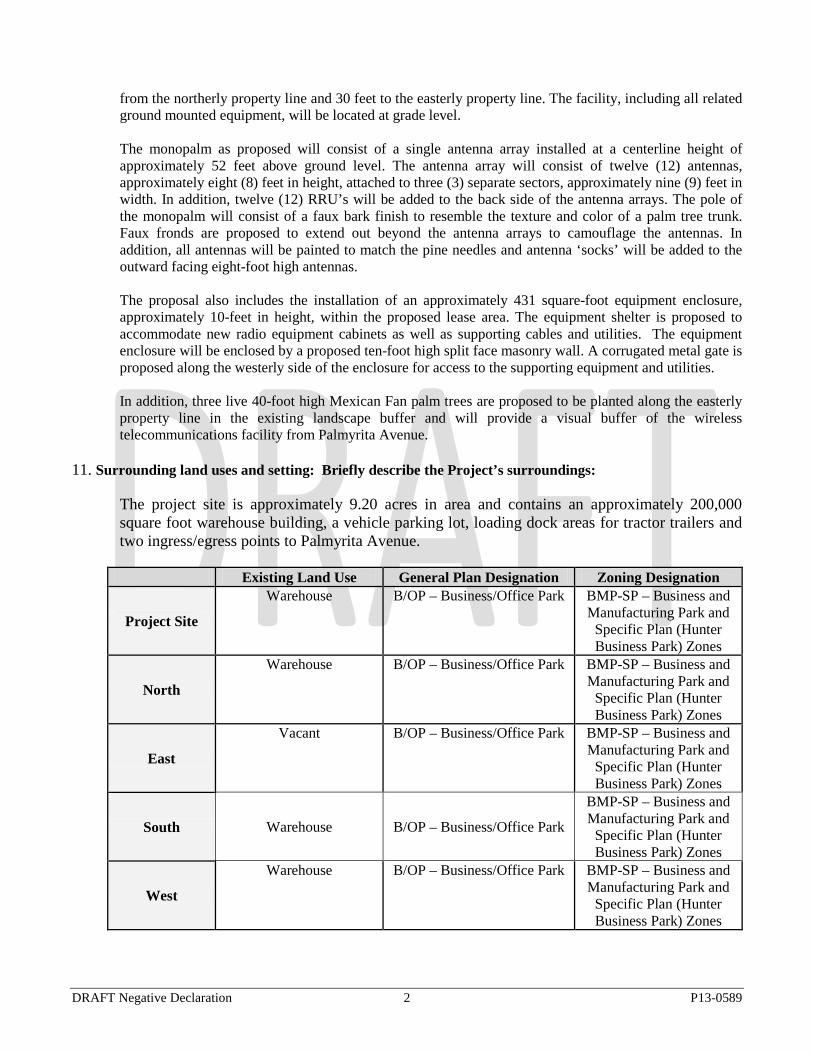
from the northerly property line and 30 feet to the easterly property line. The facility, including all related ground mounted equipment, will be located at grade level. The monopalm as proposed will consist of a single antenna array installed at a centerline height of approximately 52 feet above ground level. The antenna array will consist of twelve (12) antennas, approximately eight (8) feet in height, attached to three (3) separate sectors, approximately nine (9) feet in width. In addition, twelve (12) RRU’s will be added to the back side of the antenna arrays. The pole of the monopalm will consist of a faux bark finish to resemble the texture and color of a palm tree trunk. Faux fronds are proposed to extend out beyond the antenna arrays to camouflage the antennas. In addition, all antennas will be painted to match the pine needles and antenna ‘socks’ will be added to the outward facing eight-foot high antennas. The proposal also includes the installation of an approximately 431 square-foot equipment enclosure, approximately 10-feet in height, within the proposed lease area. The equipment shelter is proposed to accommodate new radio equipment cabinets as well as supporting cables and utilities. The equipment enclosure will be enclosed by a proposed ten-foot high split face masonry wall. A corrugated metal gate is proposed along the westerly side of the enclosure for access to the supporting equipment and utilities. In addition, three live 40-foot high Mexican Fan palm trees are proposed to be planted along the easterly property line in the existing landscape buffer and will provide a visual buffer of the wireless telecommunications facility from Palmyrita Avenue.
11. Surrounding land uses and setting: Briefly describe the Project’s surroundings: The project site is approximately 9.20 acres in area and contains an approximately 200,000
square foot warehouse building, a vehicle parking lot, loading dock areas for tractor trailers and two ingress/egress points to Palmyrita Avenue.
Existing Land Use General Plan Designation Zoning Designation
Project Site
Warehouse B/OP – Business/Office Park BMP-SP – Business and Manufacturing Park and
Specific Plan (Hunter Business Park) Zones
North
Warehouse B/OP – Business/Office Park BMP-SP – Business and Manufacturing Park and
Specific Plan (Hunter Business Park) Zones
East
Vacant B/OP – Business/Office Park BMP-SP – Business and Manufacturing Park and
Specific Plan (Hunter Business Park) Zones
South Warehouse B/OP – Business/Office Park
BMP-SP – Business and Manufacturing Park and
Specific Plan (Hunter Business Park) Zones
West
Warehouse B/OP – Business/Office Park BMP-SP – Business and Manufacturing Park and
Specific Plan (Hunter Business Park) Zones
DRAFT Negative Declaration 2 P13-0589
12. Other public agencies whose approval is required (e.g., permits, financial approval, or participation
agreement.):
None 13. Other Environmental Reviews Incorporated by Reference in this Review:
a. General Plan 2025 b. GP 2025 FPEIR
14. Acronyms AICUZ - Air Installation Compatible Use Zone Study AQMP - Air Quality Management Plan AUSD - Alvord Unified School District CEQA - California Environmental Quality Act CMP - Congestion Management Plan EIR - Environmental Impact Report EMWD - Eastern Municipal Water District EOP - Emergency Operations Plan FEMA - Federal Emergency Management Agency FPEIR - GP 2025 Final Programmatic Environmental Impact Report GIS - Geographic Information System GhG - Green House Gas GP 2025 - General Plan 2025 IS - Initial Study LHMP - Local Hazard Mitigation Plan MARB/MIP - March Air Reserve Base/March Inland Port MJPA-JLUS - March Joint Powers Authority - Joint Land Use Study MSHCP - Multiple-Species Habitat Conservation Plan
MVUSD - Moreno Valley Unified School District NCCP - Natural Communities Conservation Plan OEM - Office of Emergency Services OPR - Office of Planning & Research, State PEIR - Program Environmental Impact Report
PW - Public Works, Riverside RCALUC - Riverside County Airport Land Use Commission
RCALUCP - Riverside County Airport Land Use Compatibility Plan RCP - Regional Comprehensive Plan RCTC - Riverside County Transportation Commission RMC - Riverside Municipal Code
RPD - Riverside Police Department RPU - Riverside Public Utilities RTIP - Regional Transportation Improvement Plan RTP - Regional Transportation Plan
RUSD - Riverside Unified School District SCAG - Southern California Association of Governments SCAQMD - South Coast Air Quality Management District SCH - State Clearinghouse SKR-HCP - Stephens’ Kangaroo Rat - Habitat Conservation Plan SWPPP - Storm Water Pollution Prevention Plan USGS - United States Geologic Survey WMWD - Western Municipal Water District DRAFT Negative Declaration 3 P13-0589

WQMP - Water Quality Management Plan
DRAFT Negative Declaration 4 P13-0589
ENVIRONMENTAL FACTORS POTENTIALLY AFFECTED: The environmental factors checked below would be potentially affected by this Project, involving at least one impact that is a “Potentially Significant Impact” as indicated by the checklist on the following pages.
Aesthetics Agriculture & Forest Resources Air Quality
Biological Resources
Cultural Resources
Geology/Soils
Greenhouse Gas Emissions
Hazards & Hazardous Materials
Hydrology/Water Quality
Land Use/Planning
Mineral Resources
Noise
Population/Housing
Public Service
Recreation
Transportation/Traffic
Utilities/Service Systems
Mandatory Findings of
Significance
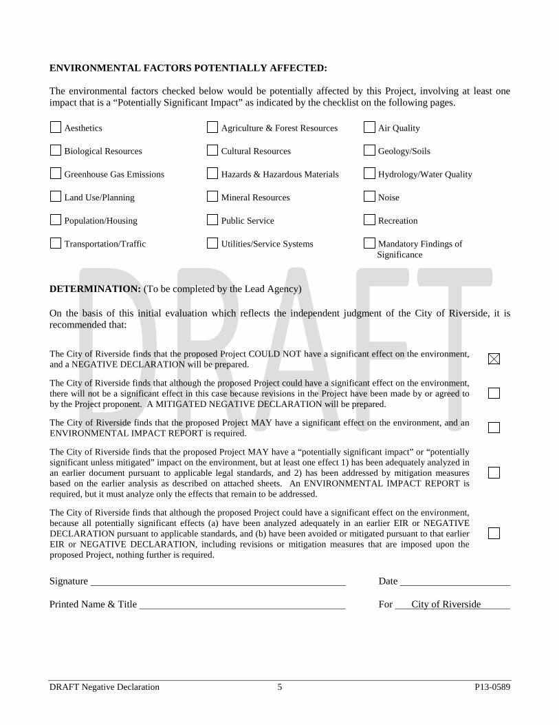
DETERMINATION: (To be completed by the Lead Agency) On the basis of this initial evaluation which reflects the independent judgment of the City of Riverside, it is recommended that: The City of Riverside finds that the proposed Project COULD NOT have a significant effect on the environment, and a NEGATIVE DECLARATION will be prepared.
The City of Riverside finds that although the proposed Project could have a significant effect on the environment, there will not be a significant effect in this case because revisions in the Project have been made by or agreed to by the Project proponent. A MITIGATED NEGATIVE DECLARATION will be prepared.
The City of Riverside finds that the proposed Project MAY have a significant effect on the environment, and an ENVIRONMENTAL IMPACT REPORT is required.
The City of Riverside finds that the proposed Project MAY have a “potentially significant impact” or “potentially significant unless mitigated” impact on the environment, but at least one effect 1) has been adequately analyzed in an earlier document pursuant to applicable legal standards, and 2) has been addressed by mitigation measures based on the earlier analysis as described on attached sheets. An ENVIRONMENTAL IMPACT REPORT is required, but it must analyze only the effects that remain to be addressed.
The City of Riverside finds that although the proposed Project could have a significant effect on the environment, because all potentially significant effects (a) have been analyzed adequately in an earlier EIR or NEGATIVE DECLARATION pursuant to applicable standards, and (b) have been avoided or mitigated pursuant to that earlier EIR or NEGATIVE DECLARATION, including revisions or mitigation measures that are imposed upon the proposed Project, nothing further is required.
Signature Date Printed Name & Title For City of Riverside
DRAFT Negative Declaration 5 P13-0589
EVALUATION OF ENVIRONMENTAL IMPACTS: 1) A brief explanation is required for all answers except “No Impact” answers that are adequately supported
by the information sources a lead agency cites in the parentheses following each question. A “No Impact” answer is adequately supported if the referenced information sources show that the impact simply does not apply to Projects like the one involved (e.g., the Project falls outside a fault rupture zone). A “No Impact” answer should be explained where it is based on Project-specific factors as well as general standards (e.g., the Project will not expose sensitive receptors to pollutants, based on a Project-specific screening analysis).
2) All answers must take account of the whole action involved, including off-site as well as on-site,
cumulative as well as Project-level, indirect as well as direct, and construction as well as operational impacts.
3) Once the lead agency has determined that a particular physical impact may occur, then the checklist
answers must indicate whether the impact is potentially significant, less than significant with mitigation, or less than significant. “Potentially Significant Impact” is appropriate if there is substantial evidence that an effect may be significant. If there are one or more “Potentially Significant Impact” entries when the determination is made, an EIR is required.
4) “Negative Declaration: Less Than Significant With Mitigation Incorporated” applies where the
incorporation of mitigation measures has reduced an effect from “Potentially Significant Impact” to a “Less Than Significant Impact.” The lead agency must describe the mitigation measures, and briefly explain how they reduce the effect to a less than significant level (mitigation measures from “Earlier Analyses,” as described in (5) below, may be cross-referenced).
5) Earlier analyses may be used where, pursuant to the tiering, program EIR, or other CEQA process, an
effect has been adequately analyzed in an earlier EIR or negative declaration. Section 15063(c)(3)(D). In this case, a brief discussion should identify the following:
a. Earlier Analysis Used. Identify and state where they are available for review. b. Impacts Adequately Addressed. Identify which effects from the above checklist were within
the scope of and adequately analyzed in an earlier document pursuant to applicable legal standards, and state whether such effects were addressed by mitigation measures based on the earlier analysis.
c. Mitigation Measures. For effects that are “Less than Significant with Mitigation Measures
Incorporated,” describe the mitigation measure which were incorporated or refined from the earlier document and the extent to which they address site-specific conditions for the Project.
6) Lead agencies are encouraged to incorporate into the checklist references to information sources for
potential impacts (e.g., general plans, zoning ordinances). Reference to a previously prepared or outside document should, where appropriate, include a reference to the page or pages where the statement is substantiated.
COMMUNITY DEVELOPMENT DEPARTMENT Planning Division
Environmental Initial Study
Environmental Initial Study 1 P13-0294
7) Supporting Information Sources: A source list should be attached, and other sources used or individuals
contacted should be cited in the discussion. 8) The explanation of each issue should identify:
a. the significance criteria or threshold, if any, used to evaluate each question; and b. the mitigation measure identified, if any, to reduce the impact to less than significance.
Environmental Initial Study 2 P13-0294
ISSUES (AND SUPPORTING INFORMATION SOURCES):
Potentially Significant
Impact
Less Than Significant
With Mitigation
Incorporated
Less Than Significant
Impact
No Impact
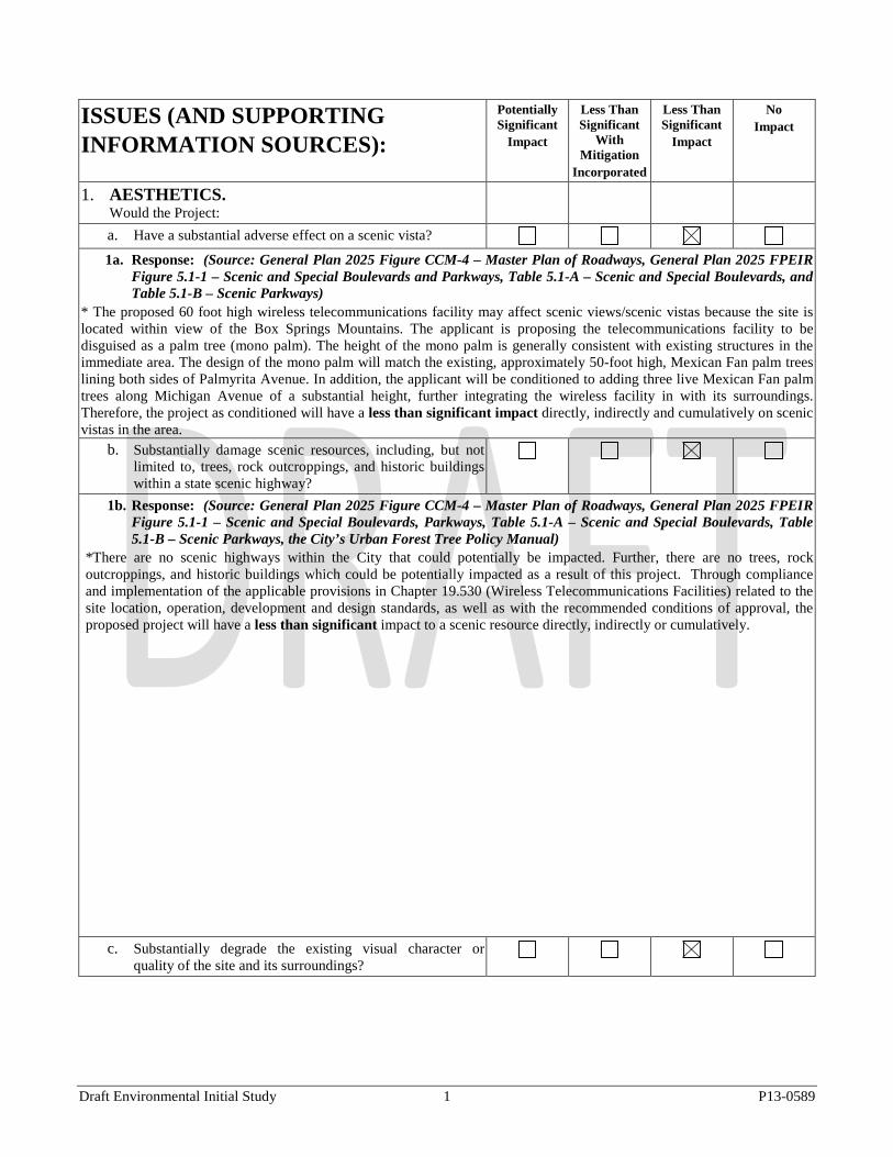
1. AESTHETICS. Would the Project:
a. Have a substantial adverse effect on a scenic vista? 1a. Response: (Source: General Plan 2025 Figure CCM-4 – Master Plan of Roadways, General Plan 2025 FPEIR
Figure 5.1-1 – Scenic and Special Boulevards and Parkways, Table 5.1-A – Scenic and Special Boulevards, and Table 5.1-B – Scenic Parkways)
* The proposed 60 foot high wireless telecommunications facility may affect scenic views/scenic vistas because the site is located within view of the Box Springs Mountains. The applicant is proposing the telecommunications facility to be disguised as a palm tree (mono palm). The height of the mono palm is generally consistent with existing structures in the immediate area. The design of the mono palm will match the existing, approximately 50-foot high, Mexican Fan palm trees lining both sides of Palmyrita Avenue. In addition, the applicant will be conditioned to adding three live Mexican Fan palm trees along Michigan Avenue of a substantial height, further integrating the wireless facility in with its surroundings. Therefore, the project as conditioned will have a less than significant impact directly, indirectly and cumulatively on scenic vistas in the area.
b. Substantially damage scenic resources, including, but not limited to, trees, rock outcroppings, and historic buildings within a state scenic highway?
1b. Response: (Source: General Plan 2025 Figure CCM-4 – Master Plan of Roadways, General Plan 2025 FPEIR Figure 5.1-1 – Scenic and Special Boulevards, Parkways, Table 5.1-A – Scenic and Special Boulevards, Table 5.1-B – Scenic Parkways, the City’s Urban Forest Tree Policy Manual)
*There are no scenic highways within the City that could potentially be impacted. Further, there are no trees, rock outcroppings, and historic buildings which could be potentially impacted as a result of this project. Through compliance and implementation of the applicable provisions in Chapter 19.530 (Wireless Telecommunications Facilities) related to the site location, operation, development and design standards, as well as with the recommended conditions of approval, the proposed project will have a less than significant impact to a scenic resource directly, indirectly or cumulatively.
c. Substantially degrade the existing visual character or quality of the site and its surroundings?
Draft Environmental Initial Study 1 P13-0589
ISSUES (AND SUPPORTING INFORMATION SOURCES):
Potentially Significant
Impact
Less Than Significant
With Mitigation
Incorporated
Less Than Significant
Impact
No Impact
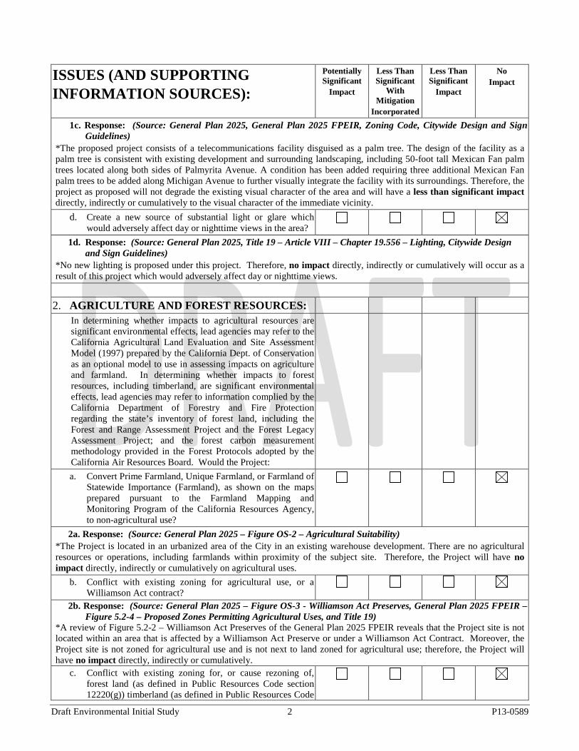
1c. Response: (Source: General Plan 2025, General Plan 2025 FPEIR, Zoning Code, Citywide Design and Sign Guidelines)
*The proposed project consists of a telecommunications facility disguised as a palm tree. The design of the facility as a palm tree is consistent with existing development and surrounding landscaping, including 50-foot tall Mexican Fan palm trees located along both sides of Palmyrita Avenue. A condition has been added requiring three additional Mexican Fan palm trees to be added along Michigan Avenue to further visually integrate the facility with its surroundings. Therefore, the project as proposed will not degrade the existing visual character of the area and will have a less than significant impact directly, indirectly or cumulatively to the visual character of the immediate vicinity.
d. Create a new source of substantial light or glare which would adversely affect day or nighttime views in the area?
1d. Response: (Source: General Plan 2025, Title 19 – Article VIII – Chapter 19.556 – Lighting, Citywide Design and Sign Guidelines)
*No new lighting is proposed under this project. Therefore, no impact directly, indirectly or cumulatively will occur as a result of this project which would adversely affect day or nighttime views.
2. AGRICULTURE AND FOREST RESOURCES:
In determining whether impacts to agricultural resources are significant environmental effects, lead agencies may refer to the California Agricultural Land Evaluation and Site Assessment Model (1997) prepared by the California Dept. of Conservation as an optional model to use in assessing impacts on agriculture and farmland. In determining whether impacts to forest resources, including timberland, are significant environmental effects, lead agencies may refer to information complied by the California Department of Forestry and Fire Protection regarding the state’s inventory of forest land, including the Forest and Range Assessment Project and the Forest Legacy Assessment Project; and the forest carbon measurement methodology provided in the Forest Protocols adopted by the California Air Resources Board. Would the Project:
a. Convert Prime Farmland, Unique Farmland, or Farmland of Statewide Importance (Farmland), as shown on the maps prepared pursuant to the Farmland Mapping and Monitoring Program of the California Resources Agency, to non-agricultural use?
2a. Response: (Source: General Plan 2025 – Figure OS-2 – Agricultural Suitability) *The Project is located in an urbanized area of the City in an existing warehouse development. There are no agricultural resources or operations, including farmlands within proximity of the subject site. Therefore, the Project will have no impact directly, indirectly or cumulatively on agricultural uses.
b. Conflict with existing zoning for agricultural use, or a Williamson Act contract?
2b. Response: (Source: General Plan 2025 – Figure OS-3 - Williamson Act Preserves, General Plan 2025 FPEIR – Figure 5.2-4 – Proposed Zones Permitting Agricultural Uses, and Title 19)
*A review of Figure 5.2-2 – Williamson Act Preserves of the General Plan 2025 FPEIR reveals that the Project site is not located within an area that is affected by a Williamson Act Preserve or under a Williamson Act Contract. Moreover, the Project site is not zoned for agricultural use and is not next to land zoned for agricultural use; therefore, the Project will have no impact directly, indirectly or cumulatively.
c. Conflict with existing zoning for, or cause rezoning of, forest land (as defined in Public Resources Code section 12220(g)) timberland (as defined in Public Resources Code
Draft Environmental Initial Study 2 P13-0589
ISSUES (AND SUPPORTING INFORMATION SOURCES):
Potentially Significant
Impact
Less Than Significant
With Mitigation
Incorporated
Less Than Significant
Impact
No Impact
section 4526), or timberland zoned Timberland Production (as defined by Government Code section 51104(g))?
2c. Response: (Source: GIS Map – Forest Data) *The subject site is zoned BMP-SP – Business and Manufacturing Park and Specific Plan (Hunter Business Park) Zones and does not contain forest land. Further, the City of Riverside has no forest land that can support 10-percent native tree cover nor does it have any timberland. Therefore, no impacts will occur from this Project directly, indirectly or cumulatively.
d. Result in the loss of forest land or conversion of forest land to non-forest use?
2d. Response: (Source: GIS Map – Forest Data) *The City of Riverside has no forest land that can support 10-percent native tree cover nor does it have any timberland, therefore no impacts will occur from this Project directly, indirectly or cumulatively.
e. Involve other changes in the existing environment which, due to their location or nature, could result in conversion of Farmland, to non-agricultural use or conversion of forest land to non-forest use?
2e. Response: (Source: General Plan – Figure OS-2 – Agricultural Suitability, Figure OS-3 – Williamson Act Preserves, Title 19 – Article V – Chapter 19.100 – Residential Zones – RC Zone and RA-5 Zone and GIS Map – Forest Data)
*The Project is located in an urbanized area of the City in an existing warehouse development. Additionally, the site is identified as urban/built out land and therefore does not support agricultural resources or operations. The Project will not result in the conversion of designated farmland to non-agricultural uses. In addition, there are no agricultural resources or operations, including farmlands within proximity of the subject site. The City of Riverside has no forest land that can support 10-percent native tree cover. Therefore, no impacts will occur from this Project directly, indirectly or cumulatively to conversion of Farmland, to non-agricultural use or conversion of forest land to non-forest use.
3. AIR QUALITY. Where available, the significance criteria established by the applicable air quality management or air pollution control district may be relied upon to make the following determinations. Would the Project:
a. Conflict with or obstruct implementation of the applicable air quality plan?
3a. Response: (Source: South Coast Air Quality Management District’s 2007 Air Quality Management Plan (AQMP))
*The proposed wireless telecommunications facility is consistent with the General Plan 2025 Program “Typical Growth Scenario” in all aspects. The Air Quality Management Plan (AQMP) for the South Coast Air Basin (SCAB) sets forth a comprehensive program that will lead the SCAB into compliance with all Federal and State air quality standards. The City of Riverside is located within the Riverside County sub region of the SCAG Projections. The General Plan 2025 FPEIR determined that implementation of the General Plan 2025 would generally meet attainment forecasts and attainment of the standards of the AQMP. The General Plan 2025 contains policies to promote mixed use, pedestrian-friendly communities that serve to reduce air pollutant emissions over time and this Project is consistent with these policies. Because the proposed Project is consistent with the 2007 AQMP, the proposed Project will not conflict or obstruct implementation of the applicable air quality plan – AQMP and therefore this Project will have no impact directly, indirectly or cumulatively to the implementation of an air quality plan.
b. Violate any air quality standard or contribute substantially to an existing or Projected air quality violation?
Draft Environmental Initial Study 3 P13-0589
ISSUES (AND SUPPORTING INFORMATION SOURCES):
Potentially Significant
Impact
Less Than Significant
With Mitigation
Incorporated
Less Than Significant
Impact
No Impact
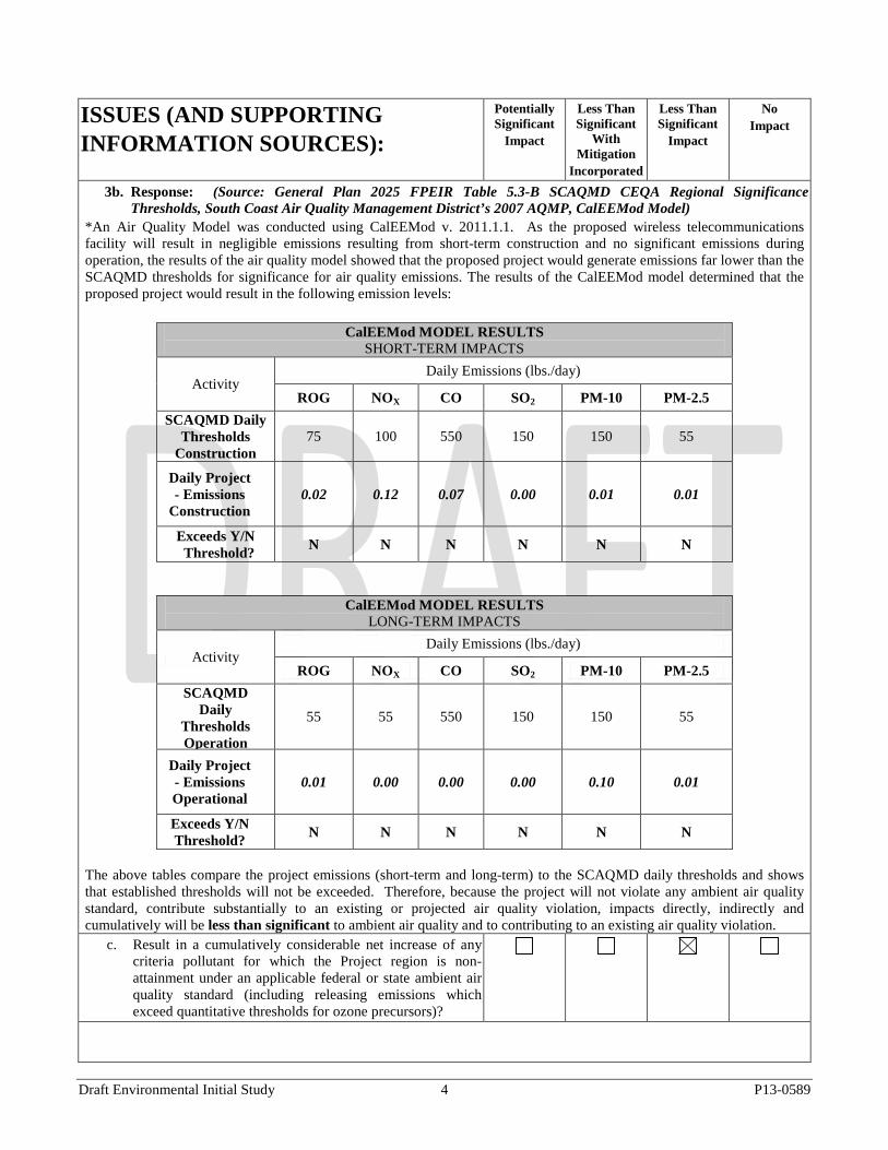
3b. Response: (Source: General Plan 2025 FPEIR Table 5.3-B SCAQMD CEQA Regional Significance Thresholds, South Coast Air Quality Management District’s 2007 AQMP, CalEEMod Model)
*An Air Quality Model was conducted using CalEEMod v. 2011.1.1. As the proposed wireless telecommunications facility will result in negligible emissions resulting from short-term construction and no significant emissions during operation, the results of the air quality model showed that the proposed project would generate emissions far lower than the SCAQMD thresholds for significance for air quality emissions. The results of the CalEEMod model determined that the proposed project would result in the following emission levels:
CalEEMod MODEL RESULTS SHORT-TERM IMPACTS
Activity Daily Emissions (lbs./day)
ROG NOX CO SO2 PM-10 PM-2.5 SCAQMD Daily
Thresholds Construction
75 100 550 150 150 55
Daily Project - Emissions
Construction 0.02 0.12 0.07 0.00 0.01 0.01
Exceeds Y/N Threshold? N N N N N N
CalEEMod MODEL RESULTS LONG-TERM IMPACTS
Activity Daily Emissions (lbs./day)
ROG NOX CO SO2 PM-10 PM-2.5 SCAQMD
Daily Thresholds Operation
55 55 550 150 150 55
Daily Project - Emissions Operational
0.01 0.00 0.00 0.00 0.10 0.01
Exceeds Y/N Threshold? N N N N N N
The above tables compare the project emissions (short-term and long-term) to the SCAQMD daily thresholds and shows that established thresholds will not be exceeded. Therefore, because the project will not violate any ambient air quality standard, contribute substantially to an existing or projected air quality violation, impacts directly, indirectly and cumulatively will be less than significant to ambient air quality and to contributing to an existing air quality violation.
c. Result in a cumulatively considerable net increase of any criteria pollutant for which the Project region is non-attainment under an applicable federal or state ambient air quality standard (including releasing emissions which exceed quantitative thresholds for ozone precursors)?
Draft Environmental Initial Study 4 P13-0589
ISSUES (AND SUPPORTING INFORMATION SOURCES):
Potentially Significant
Impact
Less Than Significant
With Mitigation
Incorporated
Less Than Significant
Impact
No Impact
3c. Response: (Source: General Plan 2025 FPEIR Table 5.3-B SCAQMD CEQA Regional Significance Thresholds, South Coast Air Quality Management District’s 2007 Air Quality Management Plan, CalEEMod Model)
*Per the GP 2025 FPEIR, AQMP thresholds indicate future construction activities under the General Plan are projected to result in significant levels of NOX and ROG, both ozone precursors, PM-10, PM-2.5, and CO. Although long-term emissions are expected to decrease by 2025, all criteria pollutants remain above the SCAQMD thresholds. The portion of the Basin within which the City is located is designated as a non-attainment area for ozone, PM-10 and PM-2.5 under State standards, and as a non-attainment area for ozone, carbon monoxide, PM-10, and PM-2.5 under Federal standards. Because the proposed Project is consistent with the General Plan 2025, cumulative impacts related to criteria pollutants as a result of the Project were previously evaluated as part of the cumulative analysis of build out anticipated under the General Plan 2025 Program. As a result, the proposed Project does not result in any new significant impacts that were not previously evaluated and for which a statement of overriding considerations was adopted as part of the General Plan 2025 FPEIR. Further per the response in 3B above, an air quality model conducted using CaLEEMod found the project emissions (short-term and long-term) to the SCAQMD daily thresholds and shows that established thresholds will not be exceeded. Therefore, cumulative air quality emissions impacts are less than significant.
d. Expose sensitive receptors to substantial pollutant concentrations?
3d. Response: (Source: General Plan 2025 FPEIR Table 5.3-B SCAQMD CEQA Regional Significance Thresholds, South Coast Air Quality Management District’s 2007 Air Quality Management Plan)
*Short-term impacts associated with construction from General Plan 2025 typical build out will result in increased air emissions from grading, earthmoving, and construction activities. Mitigation Measures of the General Plan 2025 FPEIR requires individual development to employ construction approaches that minimize pollutant emissions (e.g., watering for dust control, tuning of equipment, limiting truck idling times). Additionally, the Project will not result in the violation of any ambient air quality standard or contribute substantially to an existing or projected air quality violation because the Project is proposed on a previously developed site and does not involve substantial grading or earthmoving activities and because the Project consists of wireless telecommunications facility. Therefore, the Project will not expose sensitive receptors to substantial pollutant concentrations and a less than significant impact will occur directly, indirectly or cumulatively from this Project.
e. Create objectionable odors affecting a substantial number of people?
3e. Response: *The Project would not expose a substantial number of people to objectionable odors because no odors are anticipated to be generated by the proposed use. Therefore, no impact to creating objectionable odors will occur directly, indirectly or cumulatively.
4. BIOLOGICAL RESOURCES. Would the Project:
a. Have a substantial adverse effect, either directly or through habitat modifications, on any species identified as a candidate, sensitive, or special status species in local or regional plans, policies, or regulations, or by the California Department of Fish and Game or U.S. Fish and Wildlife Service?
4a. Response: (Source: General Plan 2025 – Figure OS-6 – Stephen’s Kangaroo Rat (SKR) Core Reserve and Other Habitat Conservation Plans (HCP), Figure OS-7 – MSHCP Cores and Linkages, Figure OS-8 – MSHCP Cell Areas, General Plan 2025 FPEIR Figure 5.4-2 – MSHCP Area Plans, Figure 5.4-4 - MSHCP Criteria Cells and Subunit Areas, Figure 5.4-6 – MSHCP Narrow Endemic Plant Species Survey Area, Figure 5.4-7 – MSHCP
Draft Environmental Initial Study 5 P13-0589
ISSUES (AND SUPPORTING INFORMATION SOURCES):
Potentially Significant
Impact
Less Than Significant
With Mitigation
Incorporated
Less Than Significant
Impact
No Impact
Criteria Area Species Survey Area, Figure 5.4-8 – MSHCP Burrowing Owl Survey Area) *The project site is located within an urban built-up area and is surrounded by existing development. A search of the MSHCP database and other appropriate databases identified no potential for candidate, sensitive or special status species, suitable habitat for such species on site, Federal Species of Concern, California Species of Special Concern, and California Species Animal or Plants on lists 1-4 of the California Native plant Society (CNPS) Inventory. Thus there is little chance that any Federally endangered, threatened, or rare species or their habitats could persist in this area. Therefore, no impact directly, indirectly and cumulatively will occur to federally endangered threatened, or rare species or their habitats.
b. Have a substantial adverse effect on any riparian habitat or other sensitive natural community identified in local or regional plans, policies, regulations or by the California Department of Fish and Game or U.S. Fish and Wildlife Service?
4b. Response: (Source: General Plan 2025 – Figure OS-6 – Stephen’s Kangaroo Rat (SKR) Core Reserve and Other Habitat Conservation Plans (HCP), Figure OS-7 – MSHCP Cores and Linkages, Figure OS-8 – MSHCP Cell Areas, General Plan 2025 FPEIR Figure 5.4-2 – MSHCP Area Plans, Figure 5.4-4 - MSHCP Criteria Cells and Subunit Areas, Figure 5.4-6 – MSHCP Narrow Endemic Plant Species Survey Area, Figure 5.4-7 – MSHCP Criteria Area Species Survey Area, Figure 5.4-8 – MSHCP Burrowing Owl Survey Area, MSHCP Section 6.1.2 - Protection of Species Associated with Riparian/Riverine Areas and Vernal Pools)
*The project is located on a fully developed site and is not identified as being within any MSCHP Criteria Cells or those that would affect riparian habitat or other sensitive natural community identified in local or regional plans. Therefore, the Project will have no impact directly, indirectly and cumulatively will occur related to any riparian habitat or other sensitive natural community with implementation of the proposed project.
c. Have a substantial adverse effect on federally protected wetlands as defined by Section 404 of the Clean Water Act (including, but not limited to, marsh, vernal pool, coastal, etc.) through direct removal, filling, hydrological interruption, or other means?
4c. Response: (Source: City of Riverside GIS/CADME USGS Quad Map Layer) *The Project is located within an urbanized area where no federally protected wetlands as defined by Section 404 of the Clean Water Act (including, but not limited to, marsh, vernal pool, coastal, etc.) exist on site or within proximity to the Project site. The Project site does not contain any discernible drainage courses, inundated areas, wetland vegetation, or hydric soils and thus does not include USACOE jurisdictional drainages or wetlands. Therefore, the proposed Project would have no impact to federally protected wetlands as defined by Section 404 of the Clean Water Act directly, indirectly and cumulatively.
d. Interfere substantially with the movement of any native resident or migratory fish or wildlife species or with established native resident or migratory wildlife corridors, or impede the use of native wildlife nursery sites?
4d. Response: (Source: MSHCP, General Plan 2025 –Figure OS-7) *The Project site is located within an urban built-up area and is not within an MSHCP linkage area. Further, no candidate, sensitive, species of concern, or special status species or suitable habitat for such species occurs on site and no additional surveys or mitigation measures are required. Therefore, there is little chance that the Project would interfere with the movement of any native resident or migratory fish or wildlife species or with established native resident or migratory wildlife corridors, or impede the use of native wildlife nursery sites. Therefore, a no impact directly, indirectly and cumulatively will occur related to the movement of any native resident or migratory fish or wildlife species or with established native resident or migratory wildlife corridors, or impede the use of native wildlife nursery sites will occur with implementation of the proposed Project.
e. Conflict with any local policies or ordinances protecting biological resources, such as a tree preservation policy or ordinance?
4e. Response: (Source: MSHCP, Title 16 Section 16.72.040 – Establishing the Western Riverside County MSHCP Draft Environmental Initial Study 6 P13-0589
ISSUES (AND SUPPORTING INFORMATION SOURCES):
Potentially Significant
Impact
Less Than Significant
With Mitigation
Incorporated
Less Than Significant
Impact
No Impact
Mitigation Fee, Title 16 Section 16.40.040 – Establishing a Threatened and Endangered Species Fees, City of Riverside Urban Forest Tree Policy Manual)
*Implementation of the proposed Project is subject to all applicable Federal, State, and local policies and regulations related to the protection of biological resources and tree preservation. In addition, the Project is required to comply with Riverside Municipal Code Section 16.72.040 establishing the MSHCP mitigation fee and Section 16.40.040 establishing the Threatened and Endangered Species Fees. Any Project within the City of Riverside’s boundaries that proposes planting a street tree within a City right-of-way must follow the Urban Forest Tree Policy Manual. The Manual documents guidelines for the planting, pruning, preservation, and removal of all trees in City rights-of-way. The specifications in the Manual are based on national standards for tree care established by the International Society of Arboriculture, the National Arborists Association, and the American National Standards Institute. No trees under the applicants project are proposed to be planted or removed from the City right-of-way; therefore the project will have no impacts related to protecting biological resources.
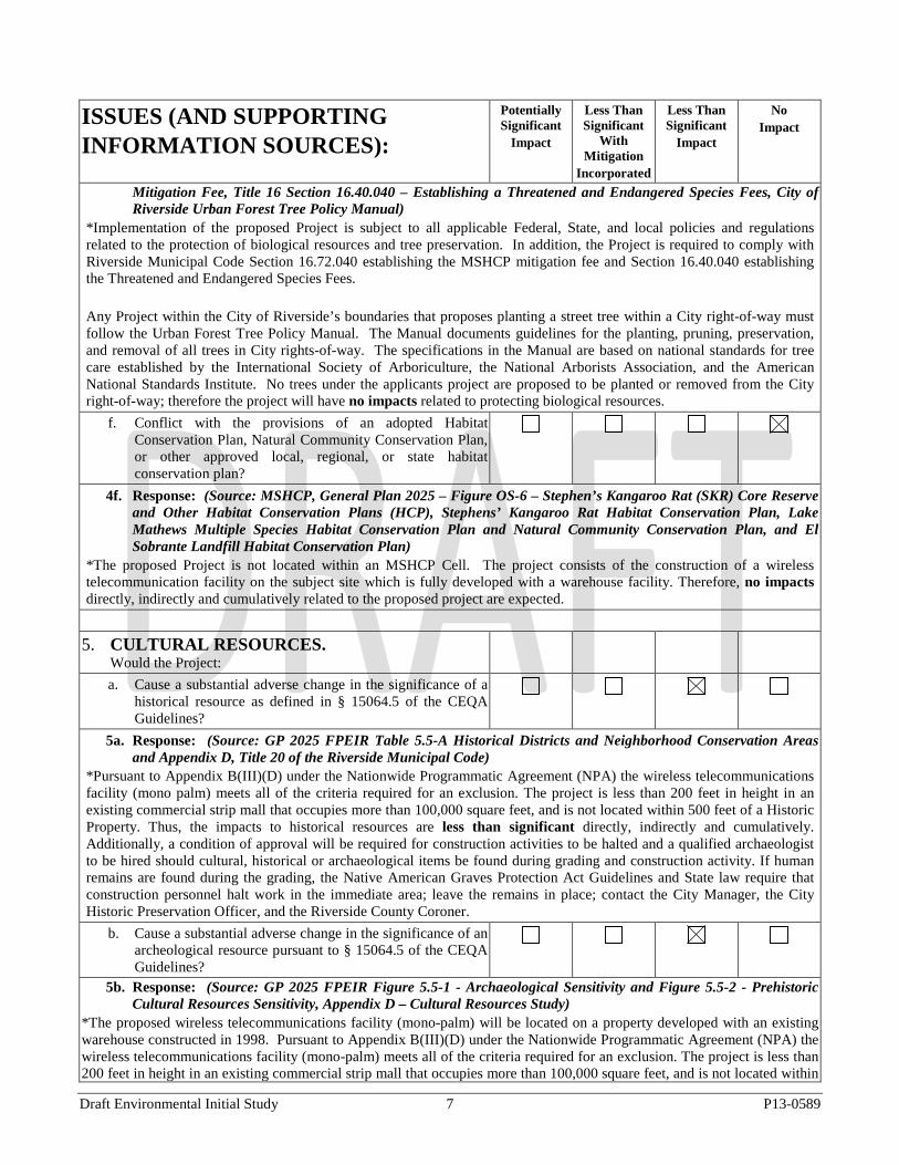
f. Conflict with the provisions of an adopted Habitat Conservation Plan, Natural Community Conservation Plan, or other approved local, regional, or state habitat conservation plan?
4f. Response: (Source: MSHCP, General Plan 2025 – Figure OS-6 – Stephen’s Kangaroo Rat (SKR) Core Reserve and Other Habitat Conservation Plans (HCP), Stephens’ Kangaroo Rat Habitat Conservation Plan, Lake Mathews Multiple Species Habitat Conservation Plan and Natural Community Conservation Plan, and El Sobrante Landfill Habitat Conservation Plan)
*The proposed Project is not located within an MSHCP Cell. The project consists of the construction of a wireless telecommunication facility on the subject site which is fully developed with a warehouse facility. Therefore, no impacts directly, indirectly and cumulatively related to the proposed project are expected.
5. CULTURAL RESOURCES. Would the Project:
a. Cause a substantial adverse change in the significance of a historical resource as defined in § 15064.5 of the CEQA Guidelines?
5a. Response: (Source: GP 2025 FPEIR Table 5.5-A Historical Districts and Neighborhood Conservation Areas and Appendix D, Title 20 of the Riverside Municipal Code)
*Pursuant to Appendix B(III)(D) under the Nationwide Programmatic Agreement (NPA) the wireless telecommunications facility (mono palm) meets all of the criteria required for an exclusion. The project is less than 200 feet in height in an existing commercial strip mall that occupies more than 100,000 square feet, and is not located within 500 feet of a Historic Property. Thus, the impacts to historical resources are less than significant directly, indirectly and cumulatively. Additionally, a condition of approval will be required for construction activities to be halted and a qualified archaeologist to be hired should cultural, historical or archaeological items be found during grading and construction activity. If human remains are found during the grading, the Native American Graves Protection Act Guidelines and State law require that construction personnel halt work in the immediate area; leave the remains in place; contact the City Manager, the City Historic Preservation Officer, and the Riverside County Coroner.
b. Cause a substantial adverse change in the significance of an archeological resource pursuant to § 15064.5 of the CEQA Guidelines?
5b. Response: (Source: GP 2025 FPEIR Figure 5.5-1 - Archaeological Sensitivity and Figure 5.5-2 - Prehistoric Cultural Resources Sensitivity, Appendix D – Cultural Resources Study)
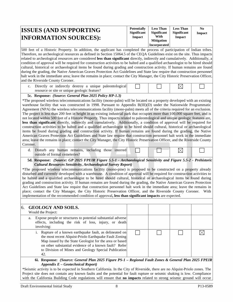
*The proposed wireless telecommunications facility (mono-palm) will be located on a property developed with an existing warehouse constructed in 1998. Pursuant to Appendix B(III)(D) under the Nationwide Programmatic Agreement (NPA) the wireless telecommunications facility (mono-palm) meets all of the criteria required for an exclusion. The project is less than 200 feet in height in an existing commercial strip mall that occupies more than 100,000 square feet, and is not located within
Draft Environmental Initial Study 7 P13-0589
ISSUES (AND SUPPORTING INFORMATION SOURCES):
Potentially Significant
Impact
Less Than Significant
With Mitigation
Incorporated
Less Than Significant
Impact
No Impact
500 feet of a Historic Property. In addition, the applicant has completed the process of participation of Indian tribes. Therefore, no archeological resources as defined in Section 15064.5 of the CEQA Guidelines exist on the site. Thus impacts related to archeological resources are considered less than significant directly, indirectly and cumulatively. Additionally, a condition of approval will be required for construction activities to be halted and a qualified archaeologist to be hired should cultural, historical or archaeological items be found during grading and construction activity. If human remains are found during the grading, the Native American Graves Protection Act Guidelines and State law require that construction personnel halt work in the immediate area; leave the remains in place; contact the City Manager, the City Historic Preservation Officer, and the Riverside County Coroner.
c. Directly or indirectly destroy a unique paleontological resource or site or unique geologic feature?
5c. Response: (Source: General Plan 2025 Policy HP-1.3) *The proposed wireless telecommunications facility (mono-palm) will be located on a property developed with an existing warehouse facility that was constructed in 1998. Pursuant to Appendix B(III)(D) under the Nationwide Programmatic Agreement (NPA) the wireless telecommunications facility (mono-palm) meets all of the criteria required for an exclusion. The project is less than 200 feet in height in an existing industrial park that occupies more than 100,000 square feet, and is not located within 500 feet of a Historic Property. Thus impacts related to paleontological and unique geologic features are, less than significant directly, indirectly and cumulatively. Additionally, a condition of approval will be required for construction activities to be halted and a qualified archaeologist to be hired should cultural, historical or archaeological items be found during grading and construction activity. If human remains are found during the grading, the Native American Graves Protection Act Guidelines and State law require that construction personnel halt work in the immediate area; leave the remains in place; contact the City Manager, the City Historic Preservation Officer, and the Riverside County Coroner.
d. Disturb any human remains, including those interred outside of formal cemeteries?
5d. Response: (Source: GP 2025 FPEIR Figure 5.5-1 - Archaeological Sensitivity and Figure 5.5-2 - Prehistoric Cultural Resources Sensitivity, Archaeological Survey Report)
*The proposed wireless telecommunications facility (mono-pine) is proposed to be constructed on a property already disturbed and currently developed with a warehouse. A condition of approval will be required for construction activities to be halted and a qualified archaeologist to be hired should cultural, historical or archaeological items be found during grading and construction activity. If human remains are found during the grading, the Native American Graves Protection Act Guidelines and State law require that construction personnel halt work in the immediate area; leave the remains in place; contact the City Manager, the City Historic Preservation Officer, and the Riverside County Coroner. With implementation of the recommended condition of approval, less than significant impacts are expected.
6. GEOLOGY AND SOILS. Would the Project:
a. Expose people or structures to potential substantial adverse effects, including the risk of loss, injury, or death involving:
i. Rupture of a known earthquake fault, as delineated on the most recent Alquist-Priolo Earthquake Fault Zoning Map issued by the State Geologist for the area or based on other substantial evidence of a known fault? Refer to Division of Mines and Geology Special Publication 42.
6i. Response: (Source: General Plan 2025 Figure PS-1 – Regional Fault Zones & General Plan 2025 FPEIR Appendix E – Geotechnical Report)
*Seismic activity is to be expected in Southern California. In the City of Riverside, there are no Alquist-Priolo zones. The Project site does not contain any known faults and the potential for fault rupture or seismic shaking is low. Compliance with the California Building Code regulations will ensure that no impacts related to strong seismic ground will occur
Draft Environmental Initial Study 8 P13-0589
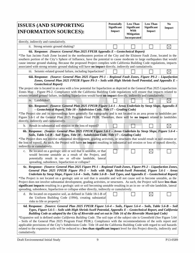
ISSUES (AND SUPPORTING INFORMATION SOURCES):
Potentially Significant
Impact
Less Than Significant
With Mitigation
Incorporated
Less Than Significant
Impact
No Impact
directly, indirectly and cumulatively. ii. Strong seismic ground shaking? 6ii. Response: (Source: General Plan 2025 FPEIR Appendix E – Geotechnical Report)
*The San Jacinto Fault Zone located in the northeastern portion of the City and the Elsinore Fault Zone, located in the southern portion of the City’s Sphere of Influence, have the potential to cause moderate to large earthquakes that would cause intense ground shaking. Because the proposed Project complies with California Building Code regulations, impacts associated with strong seismic ground shaking will have no impact directly, indirectly and cumulatively.
iii. Seismic-related ground failure, including liquefaction? 6iii. Response: (Source: General Plan 2025 Figure PS-1 – Regional Fault Zones, Figure PS-2 – Liquefaction
Zones, General Plan 2025 FPEIR Figure PS-3 – Soils with High Shrink-Swell Potential, and Appendix E – Geotechnical Report)
The project site is located in an area with a low potential for liquefaction as depicted in the General Plan 2025 Liquefaction Zones Map – Figure PS-2. Compliance with the California Building Code regulations will ensure that impacts related to seismic-related ground failure, including liquefaction would have no impact directly, indirectly and cumulatively.
iv. Landslides? 6iv. Response: (Source: General Plan 2025 FPEIR Figure 5.6-1 – Areas Underlain by Steep Slope, Appendix E
– Geotechnical Report, Title 18 – Subdivision Code, Title 17 – Grading Code) *The Project site and its surroundings have generally flat topography and is not located in an area prone to landslides per Figure 5.6-1 of the General Plan 2025 Program Final PEIR. Therefore, there will be no impact related to landslides directly, indirectly and cumulatively.
b. Result in substantial soil erosion or the loss of topsoil? 6b. Response: (Source: General Plan 2025 FPEIR Figure 5.6-1 – Areas Underlain by Steep Slope, Figure 5.6-4 –
Soils, Table 5.6-B – Soil Types, Title 18 – Subdivision Code, Title 17 – Grading Code) *The Project does not involve substantial development, grading activities, or structures that would result in soil erosion or the loss of topsoil. As such, the Project will have no impact resulting in substantial soil erosion or loss of topsoil directly, indirectly or cumulatively.
c. Be located on a geologic unit or soil that is unstable, or that would become unstable as a result of the Project, and potentially result in on- or off-site landslide, lateral spreading, subsidence, liquefaction or collapse?
6c. Response: (Source: General Plan 2025 Figure PS-1 – Regional Fault Zones, Figure PS-2 – Liquefaction Zones, General Plan 2025 FPEIR Figure PS-3 – Soils with High Shrink-Swell Potential, Figure 5.6-1 - Areas Underlain by Steep Slope, Figure 5.6-4 – Soils, Table 5.6-B – Soil Types, and Appendix E – Geotechnical Report)
*The Project is not located on a geologic unit or soil that is unstable and will not cause soil to become unstable, as the Project does not involve substantial development, grading activities, or structures. As such, the Project will have less than significant impacts resulting in a geologic unit or soil becoming unstable resulting in an in on- or off-site landslide, lateral spreading, subsidence, liquefaction or collapse either directly, indirectly or cumulatively.
d. Be located on expansive soil, as defined in Table 18-1-B of the Uniform Building Code (1994), creating substantial risks to life or property?
6d. Response: (Source: General Plan 2025 FPEIR Figure 5.6-4 – Soils, Figure 5.6-4 – Soils, Table 5.6-B – Soil Types, Figure 5.6-5 – Soils with High Shrink-Swell Potential, Appendix E – Geotechnical Report, and California Building Code as adopted by the City of Riverside and set out in Title 16 of the Riverside Municipal Code)
*Expansive soil is defined under California Building Code. The soil type of the subject site is Greenfield (See Figure 5.64 – Soils of the General Plan 2025 Program Final PEIR.). Compliance with the recommendations of the soils report and applicable provisions of the City’s Subdivision Code- Title 18 and the California Building Code with regard to soil hazards related to the expansive soils will be reduced to a less than significant impact level for this Project directly, indirectly and cumulatively.
Draft Environmental Initial Study 9 P13-0589
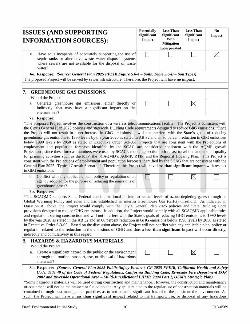
ISSUES (AND SUPPORTING INFORMATION SOURCES):
Potentially Significant
Impact
Less Than Significant
With Mitigation
Incorporated
Less Than Significant
Impact
No Impact
e. Have soils incapable of adequately supporting the use of septic tanks or alternative waste water disposal systems where sewers are not available for the disposal of waste water?
6e. Response: (Source: General Plan 2025 FPEIR Figure 5.6-4 – Soils, Table 5.6-B – Soil Types) The proposed Project will be served by sewer infrastructure. Therefore, the Project will have no impact.
7. GREENHOUSE GAS EMISSIONS. Would the Project:
a. Generate greenhouse gas emissions, either directly or indirectly, that may have a significant impact on the environment?
7a. Response: *The proposed Project involves the construction of a wireless telecommunications facility. The Project is consistent with the City’s General Plan 2025 policies and statewide Building Code requirements designed to reduce GhG emissions. Since the Project will not result in a net increase in GhG emissions, it will not interfere with the State’s goals of reducing greenhouse gas emissions to 1990 levels by the year 2020 as stated in AB 32 and an 80 percent reduction in GhG emissions below 1990 levels by 2050 as stated in Executive Order S-3-05. Projects that are consistent with the Projections of employment and population forecasts identified by the SCAG are considered consistent with the AQMP growth Projections, since these forecast numbers were used by SCAG's modeling section to forecast travel demand and air quality for planning activities such as the RTP, the SCAQMD’s AQMP, RTIP, and the Regional Housing Plan. This Project is consistent with the Projections of employment and population forecasts identified by the SCAG that are consistent with the General Plan 2025 “Typical Growth Scenario.” Therefore, this Project will have less than significant impacts with respect to GhG emissions.
b. Conflict with any applicable plan, policy or regulation of an agency adopted for the purpose of reducing the emissions of greenhouse gases?
7b. Response: *The SCAQMD supports State, Federal and international policies to reduce levels of ozone depleting gases through its Global Warming Policy and rules and has established an interim Greenhouse Gas (GHG) threshold. As indicated in Question A, above, the Project would comply with the City’s General Plan 2025 policies and State Building Code provisions designed to reduce GHG emissions. In addition, the Project would comply with all SCAQMD applicable rules and regulations during construction and will not interfere with the State’s goals of reducing GHG emissions to 1990 levels by the year 2020 as stated in the AB 32 and an 80 percent reduction in GHG emissions below 1990 levels by 2050 as stated in Executive Order S-3-05. Based on the discussion above, the Project will not conflict with any applicable plan, policy or regulation related to the reduction in the emissions of GHG and thus a less than significant impact will occur directly, indirectly and cumulatively in this regard.
8. HAZARDS & HAZARDOUS MATERIALS. Would the Project:
a. Create a significant hazard to the public or the environment through the routine transport, use, or disposal of hazardous materials?
8a. Response: (Source: General Plan 2025 Public Safety Element, GP 2025 FPEIR, California Health and Safety Code, Title 49 of the Code of Federal Regulations, California Building Code, Riverside Fire Department EOP, 2002 and Riverside Operational Area – Multi-Jurisdictional LHMP, 2004 Part 1, OEM’s Strategic Plan)
*Some hazardous materials will be used during construction and maintenance. However, the construction and maintenance of equipment will not be maintained or fueled on site. Any spills related to the regular use of construction materials will be contained through best management practices as to not create a significant hazard to the public or the environment. As such, the Project will have a less than significant impact related to the transport, use, or disposal of any hazardous
Draft Environmental Initial Study 10 P13-0589
ISSUES (AND SUPPORTING INFORMATION SOURCES):
Potentially Significant
Impact
Less Than Significant
With Mitigation
Incorporated
Less Than Significant
Impact
No Impact
material either directly, indirectly and cumulatively. b. Create a significant hazard to the public or the environment
through reasonably foreseeable upset and accident conditions involving the release of hazardous materials into the environment?
8b. Response: (Source: General Plan 2025 Public Safety Element, GP 2025 FPEIR Tables 5.7 A – D, California Health and Safety Code, Title 49 of the Code of Federal Regulations, California Building Code, City of Riverside’s EOP, 2002 and Riverside Operational Area – Multi-Jurisdictional LHMP, 2004 Part 1, OEM’s Strategic Plan)
*Some hazardous materials will be used during construction and maintenance. However, construction and maintenance equipment will not be maintained or fueled on site. Any spills related to the regular use of construction materials will be contained through best management practices as to not create a significant hazard to the public or the environment through reasonably foreseeable upset and accident conditions involving the release of hazardous materials into the environment. As such, the Project will have less than significant impact related to the transport, use, or disposal of any hazardous material either directly, indirectly and cumulatively.
c. Emit hazardous emissions or handle hazardous or acutely hazardous materials, substances, or waste within one-quarter mile of an existing or proposed school?
8c. Response: (Source: General Plan 2025 Public Safety and Education Elements, GP 2025 FPEIR Table 5.7-D - CalARP RMP Facilities in the Project Area, Figure 5.13-2 – RUSD Boundaries, Table 5.13-D RUSD Schools, Figure 5.13-3 AUSD Boundaries, Table 5.13-E AUSD Schools, Figure 5.13-4 – Other School District Boundaries, California Health and Safety Code, Title 49 of the Code of Federal Regulations, California Building Code)
*The project site is not within one-quarter mile of a school or sensitive receptor. However, the project will still comply with all applicable regulations. The Proposed Project will comply with Rule 403, which prohibits fugitive dust from construction activities that results in emissions that are visible in the atmosphere beyond the property line where construction is occurring. The Proposed Project’s construction emissions would be below both the SCAQMD’s regional significance thresholds and the Localized Significance Thresholds (LSTs) for all pollutants for each phase of construction (SRA 2011). Operational emissions would result from periodic inspection and maintenance activities. No additional personnel would be required on a daily basis to maintain and operate the Proposed Project. A small number of personnel may be required during brief periods when certain maintenance operations must be performed. Operational emissions would be less than construction emissions. The Proposed Project would not conflict with or obstruct implementation of the applicable air quality management plan. Impacts from hazardous emissions within one-quarter mile of an existing or proposed school would be less than significant. During construction hazardous materials may be used during construction and maintenance activities. However, construction and maintenance vehicles will not be maintained or fueled on site. The release of any spills to the environment would be prevented through best management practices. Therefore impacts from the handling of hazardous or acutely hazardous materials, substances, or waste greater than one-quarter mile of an existing or proposed school would be less than significant directly, indirectly or cumulatively.
d. Be located on a site which is included on a list of hazardous materials sites compiled pursuant to Government Code Section 65962.5 and, as a result, would it create a significant hazard to the public or the environment?
8d. Response: (Source: General Plan 2025 Figure PS-5 – Hazardous Waste Sites, GP 2025 FPEIR Tables 5.7-A – CERCLIS Facility Information, Figure 5.7-B – Regulated Facilities in TRI Information and 5.7-C – DTSC EnviroStor Database Listed Sites)
*A review of hazardous materials site lists compiled pursuant to Government Code Section 65962.5 found that the Project site is not included on any such lists. Therefore, the Project would have no impact to creating any significant hazard to the public or environment directly, indirectly or cumulatively.
e. For a Project located within an airport land use plan or,
Draft Environmental Initial Study 11 P13-0589
ISSUES (AND SUPPORTING INFORMATION SOURCES):
Potentially Significant
Impact
Less Than Significant
With Mitigation
Incorporated
Less Than Significant
Impact
No Impact
where such a plan has not been adopted, within two miles of a public airport or public use airport, would the Project result in a safety hazard for people residing or working in the Project area?
8e. Response: (Source: General Plan 2025 Figure PS-6 – Airport Safety Zones and Influence Areas, RCALUCP and March Air Reserve Base/March Inland Port Comprehensive Land Use Plan (1999), Air Installation Compatible Use Zone Study for March Air Reserve Base (August 2005))
The Project site is located within Zone D of the Riverside County Airport Land Use Compatibility Plan (RCALUP) which requires an aeronautical study for objects greater than 70 feet in height. The proposed telecommunications facility as submitted has a height of 75 feet. The Federal Aviation Administration (FAA) reviewed the proposal and made a determination of ‘No Hazard to Flight Navigation under Aeronautical Study No. 2013-AWP-5387-OE and has determined that neither marking nor lighting of the structure is necessary for aviation safety. Therefore, the Project will have less than significant impact resulting in a safety hazard for people residing or working in the Project area directly, indirectly or cumulatively.
f. For a Project within the vicinity of a private airstrip, would the Project result in a safety hazard for people residing or working in the Project area?
8f. Response: (Source: General Plan 2025 Figure PS-6 – Airport Safety Zones and Influence Areas, RCALUCP *Because the proposed Project is not located within proximity of a private airstrip, and does not propose a private airstrip, the Project will not expose people residing or working in the City to excessive noise levels related to a private airstrip and would have no impact directly, indirectly or cumulatively.
g. Impair implementation of or physically interfere with an adopted emergency response plan or emergency evacuation plan?
8g. Response: (Source: GP 2025 FPEIR Chapter 7.5.7 – Hazards and Hazardous Materials, City of Riverside’s EOP, GP Figure PS 8.1 – Evacuation Routes, 2002 and Riverside Operational Area – Multi-Jurisdictional LHMP, 2004 Part 1, and OEM’s Strategic Plan)
*The Project will not result in physical alterations to the subject site, as such the project will not impair implementation or physically interfere with an adopted emergency plan. Therefore, no impact, either directly, indirectly or cumulatively to an emergency response or evacuation plan will occur.
h. Expose people or structures to a significant risk of loss, injury or death involving wildland fires, including where wildlands are adjacent to urbanized areas or where residences are intermixed with wildlands?
8h. Response: (Source: General Plan 2025 Figure PS-7 – Fire Hazard Areas, GIS Map Layer VHFSZ 2010, City of Riverside’s EOP, 2002http://intranet/Portal/uploads/Riv City EOP complete.pdf, Riverside Operational Area – Multi-Jurisdictional LHMP, 2004 Part 1/Part 2 and OEM’s Strategic Plan)
*The proposed Project is located in an urbanized area where no wildlands exist and the property is not located within a Very High Fire Severity Zone (VHFSZ) or adjacent to wildland areas or a VHFSZ; therefore no impact regarding wildland fires either directly, indirectly or cumulatively from this Project will occur.
9. HYDROLOGY AND WATER QUALITY. Would the Project:
a. Violate any water quality standards or waste discharge requirements?
9a. Response: (Source: GP 2025 FPEIR Table 5.8-A – Beneficial Uses Receiving Water ) *The proposed Project is located within the Santa Ana River Watershed (see GP 2025 FPEIR Figure 5.8-1). The Project will result in minimal physical alterations to the Project site (i.e. grading, ground disturbance, structure or paving and does not involve any use that would have any effect on water quality or be affected by water quality standards or waste
Draft Environmental Initial Study 12 P13-0589
ISSUES (AND SUPPORTING INFORMATION SOURCES):
Potentially Significant
Impact
Less Than Significant
With Mitigation
Incorporated
Less Than Significant
Impact
No Impact
discharge requirements because the Project involves construction of a wireless telecommunications facility. Therefore, the Project will have no impact directly, indirectly or cumulatively to any water quality standards or waste discharge.
b. Substantially deplete groundwater supplies or interfere substantially with groundwater recharge such that there would be a net deficit in aquifer volume or a lowering of the local groundwater table level (e.g., the production rate of pre-existing nearby wells would drop to a level which would not support existing land uses or planned uses for which permits have been granted)?
9b. Response: (Source: General Plan 2025 Table PF-1 – RPU Projected Domestic Water Supply (AC-FT/YR), Table PF-2 – RPU Projected Water Demand, Table PF-3 – Western Municipal Water District Projected Domestic Water Supply (AC-FT/YR), RPU Map of Water Supply Basins, RPU Urban Water Management Plan, WMWD Urban Water Management Plan )
*The proposed Project is located within the Riverside South Water Supply Basin. This proposed Project involves the construction of a wireless telecommunications facility consistent with the General Plan 2025. The Project will not substantially deplete groundwater supplies or interfere substantially with groundwater recharge given the minimal area of the site to be improved (23-foot by 28-foot lease area) with the antenna structure and because it’s a wireless telecommunications facility, and it will have little demand for water. Therefore, there will be no impact to groundwater supplies and recharge either directly, indirectly or cumulatively.
c. 9c. Response:
*The Project will result in minimal physical alterations to the Project site (i.e. through grading, ground disturbance, structures or paving) and would not significantly alter the existing drainage patterns of the site because the Project involves the construction of a wireless telecommunications facility involving improvement of small portion of the site (29-foot by 19-foot lease area) with an antenna structure, minimal erosion or siltation on- or off-site will occur. Therefore, the Project will have a less than significant impact directly, indirectly or cumulatively to existing drainage patterns.
d. Substantially alter the existing drainage pattern of the site or area, including through the alteration of the course of a stream or river, or substantially increase the rate or amount of surface runoff in a manner which would result in flooding on- or off-site?
9d. Response: *The Project will not directly or indirectly result in any activity or physical alteration of the site or surrounding area, (i.e. through grading, ground disturbance, structures or additional paving) that would alter the existing drainage pattern of the site, alter the course of stream or river, or increase the rate or amount of surface runoff in a manner that would result in flooding on- or off-site because the Project consists of a wireless telecommunications facility involving improvement of small portion of the site (29-foot by 19-foot lease area) with an antenna structure. Therefore no flooding on or off-site as a result of the Project will occur and there will be no impact directly, indirectly or cumulatively that would substantially increase the rate or amount of surface runoff in a manner which would result in flooding on- or off-site.
e. Create or contribute runoff water which would exceed the capacity of existing or planned stormwater drainage systems or provide substantial additional sources of polluted runoff?
9e. Response: (Source: Preliminary Grading Plan) *The Project will not directly or indirectly result in any activity or physical alteration of the site or surrounding area (i.e. through grading, ground disturbance, structures or additional paving) that would create or contribute runoff water which would exceed capacity of existing or planned stormwater drainage systems or provide substantial additional sources of polluted runoff because the Project consists of a wireless telecommunications facility involving improvement of small portion of the site (29-foot by 19-foot lease area) for an antenna structure. Therefore, the Project will not create or contribute runoff water exceeding capacity of existing or planned stormwater drainage systems or provide substantial
Draft Environmental Initial Study 13 P13-0589
ISSUES (AND SUPPORTING INFORMATION SOURCES):
Potentially Significant
Impact
Less Than Significant
With Mitigation
Incorporated
Less Than Significant
Impact
No Impact
additional sources of polluted runoff and there will be no impact directly, indirectly or cumulatively. f. Otherwise substantially degrade water quality? 9f. Response:
*The Project will not directly or indirectly result in any activity or physical alteration of the site or surrounding area, (i.e. through grading, ground disturbance, structures or additional paving) that would create or contribute runoff water which would substantially degrade water quality because the Project consists of the construction of a wireless telecommunications facility involving improvement of small portion of the site (29-foot by 19-foot lease area) with an antenna structure. Therefore, the Project will not degrade water quality and there will be no impact directly, indirectly or cumulatively.
g. Place housing within a 100-year flood hazard area as mapped on a federal Flood Hazard Boundary or Flood Insurance Rate Map or other flood hazard delineation map?
9g. Response: (Source: General Plan 2025 Figure PS-4 – Flood Hazard Areas, and FEMA Flood Hazard Maps Zone X, Map Number 06065C0705G, effective August 28, 2008)
*A review of National Flood Insurance Rate Map (Map Number 06065C0065G Effective Date August 28, 2008) and Figure 5.8-2 – Flood Hazard Areas of the General Plan Program FPEIR, shows that the Project is not located within or near a flood hazard area, and does not involve the construction of housing. Further, the subject site is within Zone X, which indicates the site is outside the 0.2% annual flood chance. There will be less than a significant impact caused by this Project directly, indirectly or cumulatively as it will not place housing within a 100-year flood hazard area.
h. Place within a 100-year flood hazard area structures which would impede or redirect flood flows?
9h. Response: (Source: General Plan 2025 Figure PS-4 – Flood Hazard Areas, and FEMA Flood Hazard Maps Zone X, Map Number 06065C0705G, effective August 28, 2008)
*The Project site is not located within or near a flood hazard area as depicted on General Plan 2025 Program FPEIR Figure 5.8-2 – Flood Hazard Areas and the National Flood Insurance Rate Map (Map Number 06065C0065G Effective Date August 28, 2008). Further, the subject site is within Zone X, which indicates the site is outside the 0.2% annual flood chance. Therefore, the Project will not place a structure within a 100-year flood hazard area that would impede or redirect flood flows and less than significant impact will occur directly, indirectly or cumulatively.
i. Expose people or structures to a significant risk of loss, injury or death involving flooding, including flooding as a result of the failure of a levee or dam?
9i. Response: (Source: General Plan 2025 Figure PS-4 – Flood Hazard Areas, and FEMA Flood Hazard Maps Zone X, Map Number 06065C0705G, effective August 28, 2008) *The Project site is not located within or near a flood hazard area as depicted on General Plan 2025 Program FPEIR Figure 5.8-2 – Flood Hazard Areas and the National Flood Insurance Rate Map (Map Number 06065C0065G Effective Date August 28, 2008) or subject to dam inundation as depicted on General Plan 2025 Program FPEIR Figure 5.8-2 – Flood Hazard Areas. Further, the subject site is within Zone X, which indicates the site is outside the 0.2% annual flood chance. Therefore, the Project will not place a structure within a flood hazard or dam inundation area that would expose people or structures to a significant risk of loss, injury or death involving flooding, including flooding as a result of the failure of a levee or dam and therefore less than significant impact directly, indirectly or cumulatively will occur.
j. Inundation by seiche, tsunami, or mudflow? 9j. Response: (Source: GP 2025 FPEIR Chapter 7.5.8 – Hydrology and Water Quality) *Tsunamis are large waves that occur in coastal areas; therefore, since the City is not located in a coastal area, no impacts due to tsunamis will occur directly, indirectly or cumulatively.
10. LAND USE AND PLANNING: Would the Project:
a. Physically divide an established community? 10a. Response: (Source: General Plan 2025 Land Use and Urban Design Element, Project site plan, City of
Draft Environmental Initial Study 14 P13-0589
ISSUES (AND SUPPORTING INFORMATION SOURCES):
Potentially Significant
Impact
Less Than Significant
With Mitigation
Incorporated
Less Than Significant
Impact
No Impact
Riverside GIS/CADME map layers) *The Project consists of the construction of a wireless telecommunications facility on a site currently served by fully improved public streets and other infrastructure and does not involve the subdivision of land or the creation of streets that could alter the existing surrounding pattern of development or an established community. Further, the Project is consistent with the General Plan 2025, the Zoning Code, the Subdivision Code and the Citywide Design and Sign Guidelines. Therefore, no impact directly, indirectly or cumulatively to an established community will occur.
b. Conflict with any applicable land use plan, policy, or regulation of an agency with jurisdiction over the Project (including, but not limited to the general plan, specific plan, local coastal program, or zoning ordinance) adopted for the purpose of avoiding or mitigating an environmental effect?
10b. Response: (Source: General Plan 2025, General Plan 2025 Figure LU-10 – Land Use Policy Map, Table LU-5 – Zoning/General Plan Consistency Matrix, Title 19 – Zoning Code, Title 18 – Subdivision Code, Title 7 – Noise Code, Title 17 – Grading Code, Title 20 – Cultural Resources Code, Title 16 – Buildings and Construction and Citywide Design and Sign Guidelines)
*The Project has generally been designed to be consistent with the Zoning Code and the Citywide Design Guidelines, with the exception of a height variance. As well, with the recommended conditions of approval, the Project is consistent with the General Plan 2025. This proposal is not a Project of Statewide, Regional or Areawide Significance. Further, this proposal is in compliance with a majority of the development standards set forth in the Zoning Code for Wireless Telecommunications Facilities. Application of these standards would ensure that the Project would not have a detrimental impact on adjacent land uses. Through review of the CUP, specific variances would also be considered. In the judgment of the Planning Division, the potential environmental impacts of any variance should be considered less than significant, given that a process for the consideration of variances is specified in the City’s Municipal Code. Based on the above-referenced information, the proposed Conditional Use Permit to allow a wireless communication facility would not result in significant adverse environmental impacts. Thus, less than significant impacts will result from this Project.
c. Conflict with any applicable habitat conservation plan or natural community conservation plan?
10c. Response: (Source: General Plan 2025, General Plan 2025 – Figure LU-10 – Land Use Policy Map, Table LU-5 – Zoning/General Plan Consistency Matrix, Figure LU-7 – Redevelopment Areas, enter appropriate Specific Plan if one, Title 19 – Zoning Code, Title 18 – Subdivision Code, Title 7 – Noise Code, Title 17 – Grading Code, Title 20 – Cultural Resources Code, Title 16 – Buildings and Construction and Citywide Design and Sign Guidelines
*The proposed Project is not located within an MSHCP Cell and it would not conflict with any habitat conservation plan or natural community conservation plan, as it consists of the construction of a wireless telecommunication facility in the rear of an existing shopping center. Therefore, no impacts directly, indirectly and cumulatively related to the proposed project are expected related to the provisions of an adopted Habitat Conservation Plan, Natural Community Conservation Plan, or other approved local, regional, or State habitat conservation plan.
11. MINERAL RESOURCES.
Would the Project:
a. Result in the loss of availability of a known mineral resource that would be of value to the region and the residents of the state?
11a. Response: (Source: General Plan 2025 Figure – OS-1 – Mineral Resources) *The Project does not involve extraction of mineral resources or substantial grading activity. No mineral resources have been identified on the Project site and there is no historical use of the site or surrounding area for mineral extraction purposes. The Project site is not, nor is it adjacent to, a locally important mineral resource recovery site delineated in the General Plan 2025, specific plan or other land use plan. Therefore, the Project will have no impact on mineral resources directly, indirectly or cumulatively.
b. Result in the loss of availability of a locally-important
Draft Environmental Initial Study 15 P13-0589
ISSUES (AND SUPPORTING INFORMATION SOURCES):
Potentially Significant
Impact
Less Than Significant
With Mitigation
Incorporated
Less Than Significant
Impact
No Impact
mineral resource recovery site delineated on a local general plan, specific plan or other land use plan?
11b. Response: (Source: General Plan 2025 Figure – OS-1 – Mineral Resources) *The GP 2025 FPEIR determined that there are no specific areas within the City or Sphere Area which have locally-important mineral resource recovery sites and that the implementation of the General Plan 2025 would not significantly preclude the ability to extract state-designated resources. The proposed Project is consistent with the General Plan 2025. Therefore, there is no impact.
12. NOISE. Would the Project result in:
a. Exposure of persons to or generation of noise levels in excess of standards established in the local general plan or noise ordinance, or applicable standards of other agencies?
12a. Response: (Source: General Plan Figure N-1 – 2003 Roadway Noise, Figure N-3 – 2003 Railway Noise, Figure N-5 – 2025 Roadway Noise, Figure N-7 – 2025 Railroad Noise, Figure N-10 – Noise/Land Use Noise Compatibility Criteria, FPEIR Table 5.11-I – Existing and Future Noise Contour Comparison, Table 5.11-E – Interior and Exterior Noise Standards, Appendix G – Noise Existing Conditions Report, Title 7 – Noise Code)
*Per Implementation Tool N-1 of the General Plan 2025 Noise Element, this project has been reviewed to ensure that noise standards and compatibility issues have been addressed. The project meets the City’s noise standards as set forth in Title 7 of the Municipal Code, is compliant with the Noise/Land Use Noise Compatibility Criteria Matrix (Figure N-10) of the Noise Element; and therefore, it does not require an acoustical analysis. Therefore, impacts are less than significant on the exposure of persons to or the generation of noise levels in excess of established City standards either directly, indirectly or cumulatively.
b. Exposure of persons to or generation of excessive groundborne vibration or groundborne noise levels?
12b. Response: (Source: General Plan Figure N-1 – 2003 Roadway Noise, Figure N-3 – 2003 Railway Noise, Figure N-5 – 2025 Roadway Noise, Figure N-7 – 2025 Railroad Noise, FPEIR Table 5.11-G – Vibration Source Levels For Construction Equipment, Appendix G – Noise Existing Conditions Report )
*Construction related activities although short term, are the most common source of groundborne noise and vibration that could affect occupants of neighboring uses. Title 7 limits construction related activities from 7:00 a.m. to 7:00 p.m. on weekdays, and 8:00 a.m. to 5:00 p.m. on Saturdays. No construction noise is permitted on Sundays or on Federal holidays. As construction activities are temporary and limited, the Project will cause a less than significant exposure of persons to or generation of excessive ground borne vibration or ground borne noise levels. This Project will not generate or be exposed to long-term vibration impacts during operation of the proposed use or during construction activities as no blasting or pile driving is foreseeable in conjunction with development of this Project. Therefore, impacts are less than significant on the exposure of persons to or the generation of excessive groundborne vibration/noise levels in excess of established City standards either directly, indirectly or cumulatively.
c. A substantial permanent increase in ambient noise levels in the Project vicinity above levels existing without the Project?
12c. Response: (Source: General Plan Figure N-1 – 2003 Roadway Noise, Figure N-3 – 2003 Railway Noise, Figure N-5 – 2025 Roadway Noise, Figure N-7 – 2025 Railroad Noise, FPEIR Table 5.11-G – Vibration Source Levels For Construction Equipment, Appendix G – Noise Existing Conditions Report )
*Refer to Response 12a above. As previously mentioned the ambient noise levels on the Project site and in the vicinity of the Project site will be negligible during construction and operational activities. Therefore, this Project will not cause a substantial increase in ambient noise levels in the Project vicinity above levels existing without the Project and a less than significant impact is expected.
d. A substantial temporary or periodic increase in ambient noise levels in the Project vicinity above levels existing without the Project?
Draft Environmental Initial Study 16 P13-0589
ISSUES (AND SUPPORTING INFORMATION SOURCES):
Potentially Significant
Impact
Less Than Significant
With Mitigation
Incorporated
Less Than Significant
Impact
No Impact
12d. Response: (Source: FPEIR Table 5.11-J – Construction Equipment Noise Levels, Appendix G – Noise Existing Conditions Report)
*The primary source of temporary or periodic noise associated with the proposed Project is from construction activity and maintenance work. Construction noise typically involves the loudest common urban noise events associated with minimal grading and construction activities anticipated with the construction of the wireless telecommunications facility. Both the General Plan 2025 and Municipal Code Title 7 (Noise Code) limit construction activities to specific times and days of the week and during those specified times, construction activity is subject to the noise standards provided in the Title 7. Considering the short-term nature of construction and through compliance with the provisions of the Noise Code, the temporary and periodic increase in noise levels due to the construction which may result from the Project are considered less than significant directly, indirectly and cumulatively.
e. For a Project located within an airport land use plan or, where such a plan has not been adopted, within two miles of a public airport or public use airport, would the Project expose people residing or working in the Project area to excessive noise levels?
12e. Response: (Source: General Plan 2025 Figure N-8 – Riverside and Flabob Airport Noise Contours, Figure N-9 – March ARB Noise Contour, Figure N-10 – Noise/Land Use Noise Compatibility Criteria, RCALUCP, March Air Reserve Base/March inland Port Comprehensive Land Use Plan (1999),Air Installation Compatible Use Zone Study for March Air Reserve Base (August 2005))
*The Project site is located approximately 6.5 miles northerly of the closest airport (March Air Reserve Base) and is not located within the Riverside County Airport Land Use Compatibility Plan (RCALUP). Therefore, the Project will have no impact resulting in a safety hazard for people residing or working in the Project area directly, indirectly or cumulatively.
f. For a Project within the vicinity of a private airstrip, would the Project expose people residing or working in the Project area to excessive noise levels?
12f. Response: (Source: General Plan 2025 Figure PS-6 – Airport Safety Zones and Influence Areas, RCALUCP, March Air Reserve Base/March Inland Port Comprehensive Land Use Plan (1999)and Air Installation Compatible Use Zone Study for March Air Reserve Base (August 2005)
*Per the GP 2025 Program FPEIR, there are no private airstrips within the City that would expose people working or residing in the City to excessive noise levels. Because the proposed Project consists of development anticipated under the General Plan 2025, is not located within proximity of a private airstrip, and does not propose a private airstrip, the Project will not expose people residing or working in the City to excessive noise levels related to a private airstrip and would have no impact directly, indirectly or cumulatively.
13. POPULATION AND HOUSING. Would the Project:
a. Induce substantial population growth in an area, either directly (for example, by proposing new homes and businesses) or indirectly (for example, through extension of roads or other infrastructure)?
13a. Response: (Source: General Plan 2025 Table LU-3 – Land Use Designations, FPEIR Table 5.12-A – SCAG Population and Households Forecast, Table 5.12-B – General Plan Population and Employment Projections–2025, Table 5.12-C – 2025 General Plan and SCAG Comparisons, Table 5.12-D - General Plan Housing Projections 2025, Capital Improvement Program and SCAG’s RCP and RTP)
*The Project is in an urbanized area and does not propose new homes or businesses that would directly induce substantial population growth, and does not involve the addition of new roads or infrastructure that would indirectly induce substantial population growth because the Project consists of the construction of a wireless telecommunications facility. Therefore, this Project will have no impact on population growth either directly or indirectly.
b. Displace substantial numbers of existing housing, necessitating the construction of replacement housing
Draft Environmental Initial Study 17 P13-0589
ISSUES (AND SUPPORTING INFORMATION SOURCES):
Potentially Significant
Impact
Less Than Significant
With Mitigation
Incorporated
Less Than Significant
Impact
No Impact
elsewhere? 13b. Response: (Source: CADME Land Use 2003 Layer)
*The Project will not displace existing housing, necessitating the construction of replacement housing elsewhere because the Project site is proposed on a previously improved site that has no existing housing that will be removed or affected by the proposed Project. Therefore, there will be no impact on existing housing either directly, indirectly or cumulatively.
c. Displace substantial numbers of people, necessitating the construction of replacement housing elsewhere?
13c. Response: (Source: CADME Land Use 2003 Layer) *The Project will not displace any people, necessitating the construction of replacement housing elsewhere because the Project site is proposed on a previously improved site that has no existing housing or residents that will be removed or affected by the proposed Project. Therefore, this Project will have no impact on people, necessitating the need for replacement housing either directly, indirectly or cumulatively.
14. PUBLIC SERVICES.
Would the Project result in substantial adverse physical impacts associated with the provision of new or physically altered governmental facilities, need for new or physically altered governmental facilities, the construction of which could cause significant environmental impacts, in order to maintain acceptable service ratios, response times or other performance objectives for any of the public services:
a. Fire protection? 14a. Response: (Source: FPEIR Table 5.13-B – Fire Station Locations, Table 5.13-C – Riverside Fire Department
Statistics and Ordinance 5948 § 1) *The Project consists of the construction of a wireless telecommunications facility. Adequate fire facilities and services are provided by Station #6 located at 1077 Orange Street to serve this Project. In addition, with implementation of General Plan 2025 policies, compliance with existing codes and standards, and through Fire Department practices, there will be no impacts on the demand for additional fire facilities or services either directly, indirectly or cumulatively.
b. Police protection? 14b. Response: (Source: General Plan 2025 Figure PS-8 – Neighborhood Policing Centers)
*The Project consists of the construction of a wireless telecommunications facility. Adequate police facilities and services are provided by North Neighborhood Policing Center to serve this Project. There will be no impacts on the demand for additional police facilities or services either directly, indirectly or cumulatively.
c. Schools? 14c. Response: (Source: FPEIR Figure 5.13-2 – RUSD Boundaries, Table 5.13-D – RUSD,, Table 5.13-G – Student
Generation for RUSD and AUSD By Education Level) *The Project is non-residential use that will not involve the addition of any housing units that would increase numbers of school age children. Therefore, there will be no impact on the demand for additional school facilities or services either directly, indirectly or cumulatively.
d. Parks? 14d. Response: (Source: General Plan 2025 Figure PR-1 – Parks, Open Spaces and Trails, Table PR-4 – Park and
Recreation Facilities, Parks Master Plan 2003, GP 2025 FPEIR Table 5.14-A – Park and Recreation Facility Types, and Table 5.14-C – Park and Recreation Facilities Funded in the Riverside Renaissance Initiative)
*The Project is a non-residential use that will not involve the addition of any housing units that would increase the population. Therefore, there will be no impact on the demand for additional park facilities or services either directly, indirectly or cumulatively.
e. Other public facilities?
Draft Environmental Initial Study 18 P13-0589

ISSUES (AND SUPPORTING INFORMATION SOURCES):
Potentially Significant
Impact
Less Than Significant
With Mitigation
Incorporated
Less Than Significant
Impact
No Impact
14e. Response: (Source: General Plan 2025 Figure LU-8 – Community Facilities, FPEIR Figure 5.13-5 - Library Facilities, Figure 5.13-6 - Community Centers, Table 5.3-F – Riverside Community Centers, Table 5.13-H – Riverside Public Library Service Standards)
*The Project consists of the construction of a wireless telecommunications facility. Adequate public facilities and services, including libraries and community centers, are provided in the Hunter Business Park Neighborhoods to serve this Project. In addition, with implementation of General Plan 2025 policies, compliance with existing codes and standards, and through Park and Recreation and Community Services and Library practices, there will be no impacts on the demand for additional public facilities or services either directly, indirectly or cumulatively.
15. RECREATION. a. Would the Project increase the use of existing
neighborhood and regional parks or other recreational facilities such that substantial physical deterioration of the facility would occur or be accelerated?
15a. Response: (Source: General Plan 2025 Figure PR-1 – Parks, Open Spaces and Trails, Table PR-4 – Park and Recreation Facilities, Figure CCM-6 – Master plan of Trails and Bikeways, Parks Master Plan 2003, FPEIR Table 5.14-A – Park and Recreation Facility Types, and Table 5.14-C – Park and Recreation Facilities Funded in the Riverside Renaissance Initiative, Table 5.14-D – Inventory of Existing Community Centers, Riverside Municipal Code Chapter 16.60 - Local Park Development Fees, Bicycle Master Plan May 2007)
*The Project will not result in an intensification of land use that would generate any additional demand for park facilities and therefore, there will be no impact on the demand for additional recreational facilities either directly, indirectly or cumulatively.
b. Does the Project include recreational facilities or require the construction or expansion of recreational facilities which might have an adverse physical effect on the environment?
15b. Response: *The Project will not include new recreational facilities or require the construction or expansion of recreational facilities; therefore, there will be no impact directly, indirectly or cumulatively.
16. TRANSPORTATION/TRAFFIC. Would the Project result in:
a. Conflict with an applicable plan, ordinance or policy establishing measures of effectiveness for the performance or policy establishing measures of effectiveness for the performance of the circulation system, taking into account all modes of transportation including mass transit and non-motorized travel and relevant components of the circulation system, including but not limited to intersections, streets, highways and freeways, pedestrian and bicycle paths, and mass transit?
16a. Response: (Source: General Plan 2025 Figure CCM-4 – Master Plan of Roadways, FPEIR Figure 5.15-4 – Volume to Capacity (V/C) Ratio and Level of Service (LOS) (Typical 2025), Table 5.15-D – Existing and Future Trip Generation Estimates, Table 5.15-H – Existing and Typical Density Scenario Intersection Levels of Service, Table 5.15-I – Conceptual General Plan Intersection Improvement Recommendations, Table 5.15-J – Current Status of Roadways Projected to Operate at LOS E or F in 2025, Table 5.15.-K – Freeway Analysis Proposed General Plan, Appendix H – Circulation Element Traffic Study and Traffic Study Appendix, SCAG’s RTP)
*The Project site is located on a previously developed/improved site where no increase in intensity of use resulting in any measureable increase in traffic would occur and therefore no impact directly, indirectly or cumulatively to the capacity of the existing circulation system will occur.
Draft Environmental Initial Study 19 P13-0589
ISSUES (AND SUPPORTING INFORMATION SOURCES):
Potentially Significant
Impact
Less Than Significant
With Mitigation
Incorporated
Less Than Significant
Impact
No Impact
b. Conflict with an applicable congestion management program, including but not limited to level of service standards and travel demand measures, or other standards established by the county congestion management agency for designated roads or highways?
16b. Response: (Source: General Plan 2025 Figure CCM-4 – Master Plan of Roadways, FPEIR Figure 5.15-4 –Volume to Capacity (V/C) Ratio and Level of Service (LOS) (Typical 2025), Table 5.15-D – Existing and Future Trip Generation Estimates, Table 5.15-H – Existing and Typical Density Scenario Intersection Levels of Service, Table 5.15-I – Conceptual General Plan Intersection Improvement Recommendations, Table 5.15-J – Current Status of Roadways Projected to Operate at LOS E or F in 2025, Table 5.15.-K – Freeway Analysis Proposed General Plan, Appendix H – Circulation Element Traffic Study and Traffic Study Appendix, SCAG’s RTP)
*The Project site does not include a state highway or principal arterial within Riverside County’s Congestion Management Program (CMP) and the Project is consistent with the Transportation Demand Management/Air Quality components of the Program; therefore, there is no impact either directly, indirectly or cumulatively to the CMP.
c. Result in a change in air traffic patterns, including either an increase in traffic levels or a change in location that results in substantial safety risks?
16c. Response: (Source: General Plan 2025 Figure PS-6 – Airport Safety Zones and Influence Areas, RCALUCP, March Air Reserve Base/March Inland Port Comprehensive Land Use Plan (1999)and Air Installation Compatible Use Zone Study for March Air Reserve Base (August 2005)
*The Project will not change air traffic patterns, increase air traffic levels or change the location of air traffic patterns. As such, this Project will have no impact directly, indirectly or cumulatively on air traffic patterns.
d. Substantially increase hazards due to a design feature (e.g., sharp curves or dangerous intersections) or incompatible uses (e.g., farm equipment)?
16d. Response: (Source: Project Site Plans) *The Project is located on a site that is currently developed, with all site improvements in place, and where no site modifications will occur that would result in hazards due to design features such as driveways, intersection improvements, etc. In addition, the proposed use is compatible with other uses on the site. As such, the Project will have no impact on increasing hazards through design or incompatible uses either directly, indirectly or cumulatively.
e. Result in inadequate emergency access? 16e. Response: (Source: California Department of Transportation Highway Design Manual, GP Figure PS 8.1 –
Evacuation Routes, Municipal Code, and Fire Code) *The Project is located on a site that is currently developed, with all site improvements in place, and where no site modifications are proposed that would affect emergency access; therefore there will be no impact directly, indirectly or cumulatively to emergency access.
f. Conflict with adopted policies, plans or programs regarding public transit, bicycle, or pedestrian facilities, or otherwise decrease the performance or safety of such facilities)?
16f. Response: (Source: FPEIR, General Plan 2025 Land Use and Urban Design, Circulation and Community Mobility and Education Elements, Bicycle Master Plan, School Safety Program – Walk Safe! – Drive Safe!)
*The Project is located on a site that is currently developed, with all site improvements in place, and where no site modifications will occur that would result in conflicts with adopted policies, plans or programs supporting alternative transportation (e.g. bus turnouts, bicycle racks). As such, the Project will have no impact directly, indirectly or cumulatively on adopted policies, plans, or programs supporting alternative transportation.
Draft Environmental Initial Study 20 P13-0589
ISSUES (AND SUPPORTING INFORMATION SOURCES):
Potentially Significant
Impact
Less Than Significant
With Mitigation
Incorporated
Less Than Significant
Impact
No Impact
17. UTILITIES AND SYSTEM SERVICES. Would the Project:
a. Exceed wastewater treatment requirements of the applicable Regional Water Quality Control Board?
17a. Response: (Source: General Plan 2025 Figure PF-2 – Sewer Facilities Map, FPEIR Figure 5.16-5 – Sewer Service Areas, , Figure 5.8-1 – Watersheds, Wastewater Integrated Master Plan and Certified EIR)
*The Project will not exceed wastewater treatment requirements of the Regional Water Quality Control Board (RWQCB). The Project is located on a site that is currently developed, with all site improvements in place, and where no site modifications are proposed that would affect wastewater treatment; therefore there will be no impact directly, indirectly or cumulatively to wastewater treatment.
b. Require or result in the construction of new water or wastewater treatment facilities or expansion of existing facilities, the construction of which could cause significant environmental effects?
17b. Response: (Source: General Plan 2025 Table PF-1 – RPU PROJECTED DOMESTIC WATER Supply (AC-FT/YR), Table PF-2 – RPU Projected Water Demand, RPU, FPEIR Table 5.16-G – General Plan Projected Water Demand for RPU Including Water Reliability for 2025, Figure 5.16-4 – Water Facilities and Figure 5.16-6 – Sewer Infrastructure and Wastewater Integrated Master Plan and Certified EIR.)
*The Project will not result in the construction of new or expanded water or wastewater treatment facilities. The Project is consistent with the Typical Growth Scenario of the General Plan 2025 where future water and wastewater generation was determined to be adequate. Therefore, the Project will have no impact resulting in the construction of new water or wastewater treatment facilities or the expansion of existing facilities directly, indirectly or cumulatively.
c. Require or result in the construction of new storm water drainage facilities or expansion of existing facilities, the construction of which could cause significant environmental effects?
17c. Response: (Source: FPEIR Figure 5.16-2 - Drainage Facilities) *The Project is located on a previously developed/improved site within an urbanized area where no increase in impervious surfaces will occur that would require or result in the construction of new storm water drainage facilities or expansion of existing facilities. Therefore, the Project will have no impact resulting in the construction of new storm water drainage facilities or the expansion of existing facilities directly, indirectly or cumulatively.
d. Have sufficient water supplies available to serve the Project from existing entitlements and resources, or are new or expanded entitlements needed?
17d. Response: (Source: FPEIR Figure 5.16-3 – Water Service Areas, Figure 5.16-4 – Water Facilities, Table 5.16-E – RPU Projected Domestic Water Supply (AC-FT/YR, Table 5.16-F – Projected Water Demand, Table 5.16-G – General Plan Projected Water Demand for RPU including Water Reliability for 2025)
*The Project will not exceed expected water supplies. The Project is consistent with the General Plan 2025 Typical Growth Scenario where future water supplies were determined to be adequate (see Tables t.16-E, 5.16-F, 5.16-G, 5.16-H, 5.16-I and 5.16-J of the General Plan 2025 Final PEIR). Therefore, the Project will have no impact resulting in the insufficient water supplies either directly, indirectly or cumulatively.
e. Result in a determination by the wastewater treatment provider which serves or may serve the Project that it has adequate capacity to serve the Project’s Projected demand in addition to the provider’s existing commitments?
17e. Response: (Source: FPEIR Figure 5.16-5 - Sewer Service Areas, Figure 5.16-6 -Sewer Infrastructure, Table 5.16-K - Estimated Future Wastewater Generation for the City of Riverside’s Sewer Service Area)
*The Project will not exceed wastewater treatment requirements of (Regional Water Quality Control Board). The Project is consistent with the General Plan 2025 Typical Growth Scenario where future wastewater generation was determined to be adequate (see Table 5.16-K of the General Plan 2025 Final PEIR). Further, the current Wastewater Treatment Master
Draft Environmental Initial Study 21 P13-0589
ISSUES (AND SUPPORTING INFORMATION SOURCES):
Potentially Significant
Impact
Less Than Significant
With Mitigation
Incorporated
Less Than Significant
Impact
No Impact
Plan anticipates and provides for this type of Project. Therefore, no impact to wastewater treatment directly, indirectly or cumulatively will occur.
f. Be served by a landfill with sufficient permitted capacity to accommodate the Project’s solid waste disposal needs?
17f. Response: (Source: FPEIR Table 5.16-A – Existing Landfills and Table 5.16-M – Estimated Future Solid Waste Generation from the Planning Area)
*The Project is consistent with the General Plan 2025 Typical Build-out Project level where future landfill capacity was determined to be adequate (see Tables 5.16-A and 5.16-M of the General Plan 2025 Final PEIR). Therefore, no impact to landfill capacity will occur directly, indirectly or cumulatively.
g. Comply with federal, state, and local statutes and regulations related to solid waste?
17g. Response: (Source: California Integrated Waste Management Board 2002 Landfill Facility Compliance Study) *The California Integrated Waste Management Act under the Public Resource Code requires that local jurisdictions divert at least 50% of all solid waste generated by January 1, 2000. The City is currently achieving a 60% diversion rate, well above State requirements. In addition, the California Green Building Code requires all developments to divert 50% of non-hazardous construction and demolition debris for all Projects and 100% of excavated soil and land clearing debris for all non-residential Projects beginning January 1, 2011. The proposed Project must comply with the City’s waste disposal requirements as well as the California Green Building Code and as such would not conflict with any Federal, State, or local regulations related to solid waste. Therefore, no impacts related to solid waste statutes will occur directly, indirectly or cumulatively.
18. MANDATORY FINDINGS OF SIGNIFICANCE.
a. Does the Project have the potential to degrade the quality of the environment, substantially reduce the habitat of a fish or wildlife species, cause a fish or wildlife population to drop below self-sustaining levels, threaten to eliminate a plant or animal community, reduce the number or restrict the range of a rare or an endangered plant or animal or eliminate important examples of the major periods of California history or prehistory?
18a. Response: (Source: MSHCP, Figure 5.4-8 – MSHCP Burrowing Owl Survey Area, Burrowing Owl Focused Survey Report, prepared by ACT Associates, Inc., dated September 2012, FPEIR Table 5.5-A Historical Districts and Neighborhood Conservation Areas, Figure 5.5-1 - Archaeological Sensitivity, Figure 5.5-2 - Prehistoric Cultural Resources Sensitivity, Appendix D, Title 20 of the Riverside Municipal Code, and Archaeological Survey Report, prepared by ATC Associates, Inc., dated November 2011)
*Potential impacts related to habitat of fish or wildlife species were discussed in the Biological Resources Section of this Initial Study, and were all found to be less than significant. Additionally, potential impacts to cultural, archaeological and paleontological resources related to major periods of California and the City of Riverside’s history or prehistory were discussed in the Cultural Resources Section of this Initial Study, and were found to be less than significant.
b. Does the Project have impacts that are individually limited, but cumulatively considerable? (“Cumulatively considerable” means that the incremental effects of a Project are considerable when viewed in connection with the effects of past Projects, the effects of other current Projects, and the effects of probable future Projects)?
18b. Response: (Source: FPEIR Section 6 – Long-Term Effects/ Cumulative Impacts for the General Plan 2025 Program)
*Because the Project is consistent with the General Plan 2025, no new cumulative impacts are anticipated and therefore cumulative impacts of the proposed Project beyond those previously considered in the GP 2025 FPEIR are less than significant.
Draft Environmental Initial Study 22 P13-0589
ISSUES (AND SUPPORTING INFORMATION SOURCES):
Potentially Significant
Impact
Less Than Significant
With Mitigation
Incorporated
Less Than Significant
Impact
No Impact
c. Does the Project have environmental effects which will cause substantial adverse effects on human beings, either directly or indirectly?
18c. Response: (Source: FPEIR Section 5 – Environmental Impact Analysis for the General Plan 2025 Program) *Effects on human beings were evaluated as part of the aesthetics, air quality, hydrology & water quality, noise, population and housing, hazards and hazardous materials, and traffic sections of this initial study and found to be less than significant for each of the above sections. Based on the analysis and conclusions in this initial study, the Project will not cause substantial adverse effects, directly or indirectly to human beings. Therefore, potential direct and indirect impacts on human beings that result from the proposed Project are less than significant.
Note: Authority cited: Sections 21083 and 21087, Public Resources Code. Reference: Sections 21080(c), 21080.1, 21080.3, 21082.1, 21083, 21083.3, 21093, 21094, 21151, Public Resources Code; Sundstrom v. County of Mendocino, 202 Cal.App.3d 296 (1988); Leonoff v. Monterey Board of Supervisors, 222 Cal.App.3d 1337 (1990).
Draft Environmental Initial Study 23 P13-0589