Embed Size (px)
Citation preview

WebWorldWind, achievements and future of the ESA-NASA partnership Yann Voumard1, Paulo Sacramento1, Pier Giorgio Marchetti2, Patrick Hogan3 1 Solenix Deutschland GmbH, Spreestrasse 3, 64295 Darmstadt, Germany 2 ESRIN, European Space Agency (ESA), Via Galileo Galilei, 00044 Frascati, Italy 3 NASA Ames Research Center, M/S 244-14, Moffett Field, CA, 94035 USA
Corresponding Author:
Paulo Sacramento1
Email Address: [email protected]
ABSTRACT WebWorldWind is a 3D virtual globe API for HTML5 and JavaScript developed by NASA with support of the European Space Agency (ESA) and other partners. In this paper, the results of the first year for the on-going collaboration between ESA and NASA on WebWorldWind development are presented, highlighting concrete examples built with the newly introduced features and putting them in relation to possible research and education use cases. Finally, the next steps and roadmap are briefly introduced.
Keywords: WebWorldWind, Virtual Globe, API, HTML5, JavaScript, ESA, NASA
INTRODUCTION Since its first stable release in 2011, the increased availability of WebGL as part of HTML5, including on mobile platforms, makes it an ideal candidate for powerful 3D virtual globes serving the needs of geospatial activities. Relying on Web technologies enables new paradigms in terms of distribution, portability, access to data sources and ease of use in general that can greatly benefit the research and education activities.
At the end of 2014, capitalizing on its experience building WorldWind technologies over the last decade, NASA started a new project called WebWorldWind that brings their famous 3D virtual globe to the Web via a JavaScript API. Mid-2015, ESA - via the “Fast Prototyping” consortium - joined the project by contributing with software development and requirements in order to support the development of features enabling the visualization of data produced by its Earth Observation missions. Since then, the partners have been steadily building a full-fledged solution in the spirit of true open-source software. All the code is freely available to any interested developer anywhere in the world.
PeerJ Preprints | https://doi.org/10.7287/peerj.preprints.2134v2 | CC BY 4.0 Open Access | rec: 30 Sep 2016, publ: 30 Sep 2016

HOW DOES WEBWORLDWIND COMPARE TO OTHER 3D VIRTUAL GLOBES? The primary mission of WebWorldWind is to support the operational needs of the geospatial community. This is different from other 3D virtual globe platforms such as Google Earth, ESRI and Cesium, which implement business models. Furthermore, these other platforms do not have the history, experience or practical focus of WorldWind and its development team, and particularly they lack its extensible architecture.
Contrarily to Google Earth, WorldWind is an API rather than an application. Thus, it can be plugged into any application that needs virtual globe capabilities, with virtually unlimited possibilities for what concerns the intended interactions. A corollary of this is that Google Earth is one single application whilst WorldWind can be part of many applications. Also, thanks to the ESA-NASA collaboration, WebWorldWind now implements a substantial part of the KML specification, therefore being able to offer similar visualization capabilities w.r.t. Google Earth.
The ESRI suite of tools instead, besides being commercial and expensive, is proprietary and, similarly to Google Earth, is an application rather than an API. Compared to Google Earth and WebWorldWind, it is also not as full-featured. Several government organizations have abandoned ESRI in favor of WorldWind to reduce costs and gain flexibility.
Cesium is also a virtual globe API, but its users often complain that it is very hard to use and in particular to extend. It also does not offer the fine details that WebWorldWind does and these details are exactly the ones that practical applications rely on. There is also a difference in focus, because Cesium aims at satisfying computer graphics needs while WebWorldWind aims at satisfying the geospatial community’s needs, even though the ESA-NASA development team is extremely proficient in computer graphics as well, besides the geospatial visualization.
This paper does not intend to be exhaustive in comparing WorldWind and Cesium, but some of the key technical differences that can be highlighted are: WebWorldWind’s ease and simplicity of extension, on top of standard Javascript and WebGL; the developer’s interface for configuring shape positions and camera positions which in WorldWind is geographic and in Cesium is 3D-centric (xyz); the Terrain Data handling, as WorldWind is designed to combine elevation data from multiple sources at runtime on the client, being able to display it from WCS and DTED data sources, while Cesium supports its own proprietary elevation data source and a proprietary ESRI ArcGIS elevation data source.
Finally, whilst WebWorldWind is 100% free and open-source in all circumstances, Cesium comes in a “Pro” version, which can cost several thousands of Euro.
It should be noted that all the options above, including WebWorldWind, target the Web rather than mobile applications. Therefore, mobile-specific technologies such as Glob3Mobile and other existing flavors of WorldWind (such as WorldWindAndroid) should be seen as outside the scope of this paper. Nevertheless, one of the most popular applications that is currently making use of WebWorldWind is the ESA Sentinel mobile application for Android and iOS smartphones and tablets (freely available on Google Play and on the App Store). As can be inferred from this,
PeerJ Preprints | https://doi.org/10.7287/peerj.preprints.2134v2 | CC BY 4.0 Open Access | rec: 30 Sep 2016, publ: 30 Sep 2016

despite primarily targeting the Web, WebWorldWind is also perfectly suited (and actually advantageous) for implementing cross-platform mobile applications that require a virtual 3D globe. The ESA Sentinel App did rely on Glob3Mobile at its onset and then for more than a year, as WebWorldWind development picked up. Glob3Mobile development however was slow, the community around it was small and, very importantly, the code-base was very poorly documented which made using and extending it extremely difficult and unproductive. The migration of the ESA Sentinel App to WebWorldWind is a demonstration both of the latter platform’s suitability for this kind of use-case and of the validity of relying on pure web technologies for developing mobile applications.
RESULTS OF THE FIRST YEAR Based on the already available feature-set including navigation, viewing and picking, the collaboration began with the addition of new file formats in complement to Shapefiles, JPEG and PNG. File formats for external data were deemed key enablers for the intended use of the framework. The following formats were added:
• GeoJSON for shapes
• GeoTIFF for both strip- and tile-based imagery
• Collada for 3D models
• KML (geometries, placemark, styling, overlays, time primitives, network link…)
The team then focused on implementing visual effects: atmosphere, sun illumination and day/night layers. They not only make the Earth globe very appealing to any user, but also contribute to the analysis of phenomena where the distinction between day and night is relevant.
Figure 1. Satellite tracker combining some of the abovementioned features
In addition to the direct contributions to the WebWordWind framework and the examples related to these contributed features, the ESA-funded team developed reference applications for its own
PeerJ Preprints | https://doi.org/10.7287/peerj.preprints.2134v2 | CC BY 4.0 Open Access | rec: 30 Sep 2016, publ: 30 Sep 2016
purposes. Figure 1 shows a satellite tracker for the Sentinel satellites part of Copernicus, the European Programme for the establishment of a European capacity for Earth Observation. In the development of this application, particular attention is given to performance and compatibility with mobile platforms.
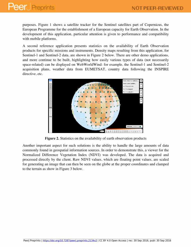
A second reference application presents statistics on the availability of Earth Observation products for specific missions and instruments. Density maps resulting from this application, for Sentinel-1 and Sentinel-2 data, are shown in Figure 2 below. There are other demo applications, and more continue to be built, highlighting how easily various types of data (not necessarily space-related) can be displayed on WebWorldWind: for example, the Sentinel-1 and Sentinel-2 acquisition plans, weather data from EUMETSAT, country data following the INSPIRE directive, etc.
Figure 2. Statistics on the availability of earth observation products
Another important aspect for such solutions is the ability to handle the large amounts of data commonly found in geospatial information sources. In order to demonstrate this, a viewer for the Normalized Difference Vegetation Index (NDVI) was developed. The data is acquired and processed directly by the client. Raw NDVI values, which are floating point values, are scaled for generating an image that can then be seen on the globe at the proper coordinates and clamped to the terrain as show in Figure 3 below.
PeerJ Preprints | https://doi.org/10.7287/peerj.preprints.2134v2 | CC BY 4.0 Open Access | rec: 30 Sep 2016, publ: 30 Sep 2016

Figure 3. NDVI over Sicily
The operation uses JavaScript Web Workers for processing the data without blocking the globe and the web interface. Moreover, multiple scenes creating a timeline can be processed in parallel using this method, making use of multiple threads. When clicking on the surface, the rescaled values for the location are presented for the entire timeline as depicted in Figure 4.
Figure 4. Plot of the rescaled NDVI values for a particular location
OUTLOOK AND CONCLUSIONThe contractual framework for the team supporting the collaboration between ESA and NASA was recently renewed for a year, with plans not only to contribute to the extension of the WebWorldWind framework itself but also to build rich, interesting and useful applications that promote and help visualize ESA data on top of it. Backed by these two agencies,
PeerJ Preprints | https://doi.org/10.7287/peerj.preprints.2134v2 | CC BY 4.0 Open Access | rec: 30 Sep 2016, publ: 30 Sep 2016

WebWorldWind has a bright future with a growing user and developer community and many promising features in the pipeline.
The team, recently enlarged by an industrial partner, is now working on the support of additional OGC standards including WMTS and WCS. The latter is foreseen for both imagery and local elevation models.
The roadmap also includes WPS, WFS, Measurement, Line of Sight, Analytic Surface, HDF and FBX, among others. Inputs from the community as contributions to the roadmap are welcome and important to assure that the framework continues evolving and serving the real needs of geospatial users all over the world, who wish to rely on free and open-source technologies rather than expensive license schemes.
Finally, this venture also opens new doors for education and research purposes. In fact, as mentioned in the introduction, open source Web technologies make access to data and building prototypes much easier and productive. For example, combine WebWorldWind with JS Bin and you get an open platform for education.
REFERENCESKeysers J. H. 2015. Digital Globe Review 2015. Australia and New Zealand Cooperative
Research Centre for Spatial Information. ISBN (online) 978-0-9943019-0-1 Hogan P. 2016. NASA World Wind vs. GE, ESRI and Cesium
PeerJ Preprints | https://doi.org/10.7287/peerj.preprints.2134v2 | CC BY 4.0 Open Access | rec: 30 Sep 2016, publ: 30 Sep 2016