Embed Size (px)
Citation preview
© 2016. Shweta Mishra & Neha Sharma. This is a research/review paper, distributed under the terms of the Creative Commons Attribution-Noncommercial 3.0 Unported License http://creativecommons.org/licenses/by-nc/3.0/), permitting all non-commercial use, distribution, and reproduction inany medium, provided the original work is properly cited.
Webgis based Decision Support System for Disseminating Nowcast based Alerts: Opengis Approach
By Shweta Mishra & Neha Sharma Space Applications Center (ISRO)
Abstract- WebGIS is a kind of distributed information system which holds the potential to make geographic information available worldwide. It is cost effective and provides an easy way of disseminating geospatial data. This paper outlines the design and development of a WebGIS based Decision Support System (DSS) for disseminating Nowcasting of Extreme Orographic Rain events generated at regular intervals from (NETRA) model. Dissemination of events include heavy rainfall alerts all over India and cloudburst alerts over Western Himalayan Region every half an hour. In India, natural calamities like flood and cloudburst results in lot of causalities. If any early Heavy rain alerts dissemination system is developed then it will protect several lives and mitigate damage of property or infrastructure in affected areas. The development of such WebGIS based decision support system originates from this concept.
Keywords: web gis, open source, geoserver, openlayers, cloudburst, spatial decision support system, postgresql database.
GJCST-E Classification: H.3.5,H.5.3
WebgisbasedDecisionSupportSystemforDisseminatingNowcastbasedAlertsOpengisApproach
Strictly as per the compliance and regulations of:
Global Journal of Computer Science and Technology: ENetwork, Web & Security Volume 16 Issue 7 Version 1.0 Year 2016 Type: Double Blind Peer Reviewed International Research JournalPublisher: Global Journals Inc. (USA)Online ISSN: 0975-4172 & Print ISSN: 0975-4350
Webgis based Decision Support System for Disseminating Nowcast based Alerts: Opengis
Approach Shweta Mishra α & Neha Sharma σ
Abstract-
WebGIS is a kind of distributed information system which holds the potential to make geographic information available worldwide. It is cost effective and provides an easy way of disseminating geospatial data. This paper outlines the design and development of a WebGIS based Decision Support System (DSS) for disseminating Nowcasting of Extreme Orographic Rain events generated at regular intervals from (NETRA) model. Dissemination of events include heavy rainfall alerts all over India and cloudburst alerts over Western Himalayan Region every half an hour. In India, natural calamities like flood and cloudburst results in lot of causalities. If any early Heavy rain alerts dissemination system is developed then it will protect several lives and mitigate damage of property or infrastructure in affected areas. The development of such WebGIS based decision support system originates from this concept. Objective of this paper is to describe the near real time WebGIS based Decision support System developed for disseminating rainfall alerts to the general public and administrators about heavy rain (all over India) and cloud burst (over Western Himalayan region) using interactive maps. Users can also get non spatial information like number of affected cities and their names, district level population (census 2011), forecast date and time, Radius of influence etc. This WebGIS based decision support system can help government agencies, NGO’s and general public in planning to save lives, properties and can be used for
decision making to reduce economic and material loss from the resulting floods.
This paper also illustrates use of open source technologies for developing such WebGIS -DSS at low cost. The principal development component includes: GeoServer, Java, PostgreSQL, OpenLayers, and GeoExt. The framework of the system can be divided into two categories:(1) Dissemination system which includes visualization of centroid and precise locations of Heavy Rain all over India and cloudburst over Western Himalayan Region along with related information and other overlay layers like State, District and Taluka boundaries, Roads, Rivers, Railway Tracks, National Highway, District Population as WMS (Web Map Service) Layers, Previous rainfall forecast events. It
also provides various GIS functionalities to users such as zooming, panning, On/Off layers, print maps and many more. (2) Fetching the NETRA model output and storing the same in a database.
Presently, the Application can be accessed from Meteorological and Oceanographic Satellite Data Archival Centre (MOSDAC) through url i.e. www.mosdac.gov.in.
Keywords:
web gis, open source, geoserver, openlayers, cloudburst, spatial decision support system, postgresql database.
I.
Introduction
ecent advancements in internet and interactive content of the World Wide Web (WWW) have made them a powerful means for people to
access, exchange and process information (Peng and Tsou 2003). The fast growing technology like Internet provides
an ideal platform to empower the general public with the GIS technology through WebGIS. WebGIS (also known as Internet GIS) denotes a type of Geographic Information System (GIS), whose client is implemented in a Web browser (Yang C. et. al 2004). It combines the power of the Internet and GIS. It refers to the use of WWW as a primary means to exchange data, perform GIS analysis, and present results. Also the increased popularity of web mapping in recent years has sparked the development of many Open Source WebGIS projects with the similar aim of bringing GIS technology to the general public at little or no cost (Caldeweyher et. al 2006, Sharma and Mishra 2012).
The open source softwares are developed in collaborative manner and are available with source code for reuse, modification and redistribution as per technology-neutral published license (Karnatak et. al 2012). This study illustrates a method of using Open Source technology to design this WebGIS based DSS. It analyses the Web Map Service (WMS), Styled Layer Descriptor (SLD) features of GeoServer platform and builds the framework for publishing spatial information over web.
R
-
-
-
© 2016 Global Journals Inc. (US)
Globa
l Jo
urna
l of C
ompu
ter Sc
ienc
e an
d Te
chno
logy
V
olum
e XVI Issu
e VII
Versio
n I
57
Year
2016
(
)E
-
-
Author α σ: Space Applications Centre, Ahmedabad.e-mail: [email protected]
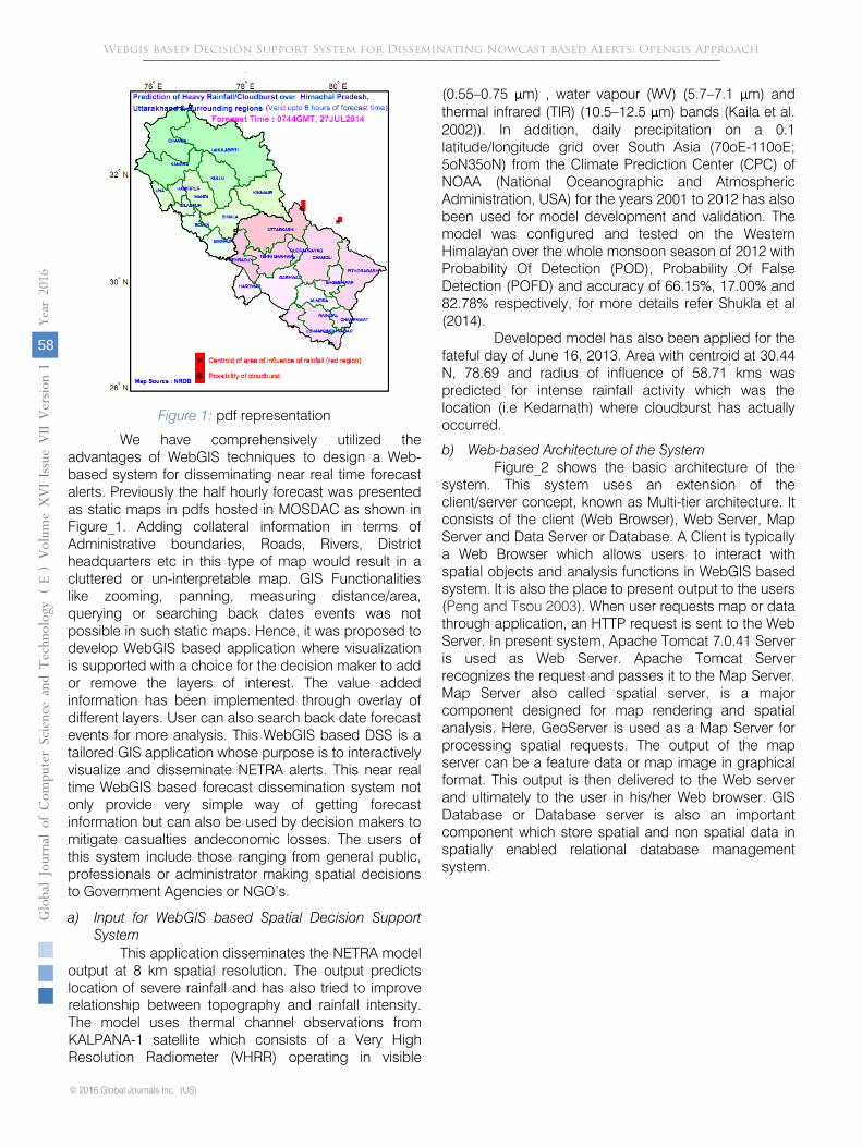
Figure 1:
pdf representation
We have comprehensively utilized the advantages of WebGIS
techniques to design a Web-based system for disseminating near real time forecast alerts. Previously the half hourly forecast was presented as static maps in pdfs hosted in MOSDAC as shown in Figure_1. Adding collateral information in terms of Administrative boundaries, Roads, Rivers, District headquarters etc in this type of map would result in a cluttered or un-interpretable map. GIS Functionalities like zooming, panning, measuring distance/area, querying or searching back dates events was not possible in such static maps. Hence, it was proposed to develop WebGIS based application where visualization is supported with a choice for the decision maker to add or remove the layers of interest. The value added information has been implemented through overlay of different layers. User can also search back date forecast events for more analysis. This WebGIS based DSS is a tailored GIS application whose purpose is to interactively visualize and disseminate NETRA alerts. This near real time WebGIS based forecast dissemination system not only provide very simple way of getting forecast information but can also be used by decision makers to mitigate casualties andeconomic losses. The users of this system include those ranging from general public, professionals or administrator making spatial decisions to Government Agencies or NGO’s.
a)
Input for WebGIS based Spatial Decision Support System
This application disseminates the NETRA model
output at 8 km spatial resolution. The output predicts location of severe rainfall and
has also tried to improve relationship between topography and rainfall intensity. The model uses thermal channel observations from KALPANA-1 satellite which consists of a Very High Resolution Radiometer (VHRR) operating in visible
(0.55–0.75 μm) , water vapour (WV) (5.7–7.1 μm) and thermal infrared (TIR) (10.5–12.5 μm) bands (Kaila et al. 2002)). In addition, daily precipitation on a 0.1 latitude/longitude grid over South Asia (70oE-110oE; 5oN35oN) from the Climate Prediction Center (CPC) of NOAA (National
Oceanographic and Atmospheric Administration, USA) for the years 2001 to 2012 has also been used for model development and validation. The model was configured and tested on the Western Himalayan over the whole monsoon season of 2012 with Probability Of Detection (POD), Probability Of False Detection (POFD) and accuracy of 66.15%, 17.00% and 82.78% respectively, for more details refer Shukla et al (2014).
Developed model has also been applied for the fateful day of June 16, 2013. Area with centroid at 30.44 N, 78.69 and radius of influence of 58.71 kms was predicted for intense rainfall activity which was the location (i.e Kedarnath) where cloudburst has actually occurred.
b)
Web-based Architecture of the System
Figure_2 shows the basic architecture of the system. This system uses an extension of the client/server concept, known as Multi-tier architecture. It consists of the client (Web Browser), Web Server, Map Server and Data Server or Database. A Client is typically a Web Browser which allows users to interact with spatial objects and analysis functions in WebGIS based system. It is also the place to present output to the users (Peng and Tsou 2003). When user requests map or data through application, an HTTP request is sent to the Web Server. In present system, Apache Tomcat 7.0.41 Server is used as Web Server. Apache Tomcat Server recognizes the request and passes it to the Map Server. Map Server also called spatial server, is a major component designed for map rendering and spatial analysis. Here, GeoServer is used as a Map Server for processing spatial requests. The output of the map server can be a feature data or map image in graphical format. This output is then delivered to the Web server and ultimately to the user in his/her Web browser. GIS Database
or Database server is also an important component which store spatial and non spatial data in spatially enabled relational database management system.
Globa
l Jo
urna
l of C
ompu
ter Sc
ienc
e an
d Te
chno
logy
V
olum
e XVI Issu
e VII
Versio
n I
58
Year
2016
(
)
© 2016 Global Journals Inc. (US)1
EWebgis based Decision Support System for Disseminating Nowcast based Alerts: Opengis Approach
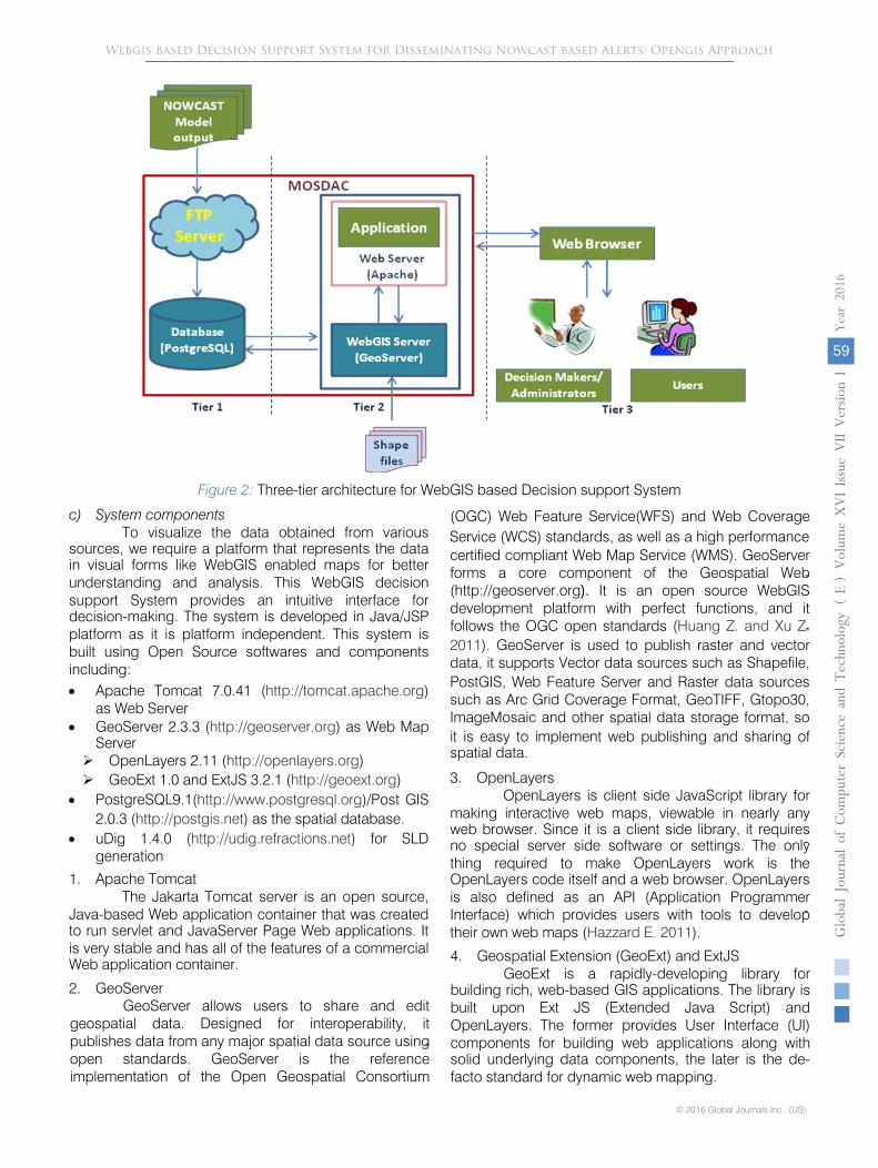
Figure
2:
Three-tier architecture for WebGIS
based Decision support System
c)
System components
To visualize the data obtained from various sources, we require a platform that represents the data in visual forms like WebGIS enabled maps for better understanding and analysis. This WebGIS decision support System provides an intuitive interface for decision-making. The system is developed in Java/JSP platform as it is platform independent. This system is built using Open Source softwares and components including:
•
Apache Tomcat 7.0.41 (http://tomcat.apache.org) as Web Server
•
GeoServer 2.3.3 (http://geoserver.org) as Web Map Server
OpenLayers 2.11 (http://openlayers.org)
GeoExt 1.0 and ExtJS 3.2.1 (http://geoext.org)
•
PostgreSQL9.1(http://www.postgresql.org)/Post
GIS
2.0.3 (http://postgis.net) as the spatial database.
•
uDig 1.4.0 (http://udig.refractions.net) for SLD generation
1.
Apache Tomcat
The Jakarta Tomcat server is an open source, Java-based Web application container that was created to run servlet and JavaServer
Page Web applications. It is very stable and has all of the features of a commercial Web application container.
2.
GeoServer
GeoServer allows users to share and edit geospatial data. Designed for interoperability, it publishes data from any major spatial data source using open standards. GeoServer is the reference implementation of the Open Geospatial Consortium
(OGC) Web Feature Service(WFS) and Web Coverage Service (WCS) standards, as well as a high performance certified compliant Web Map Service (WMS). GeoServer forms a core component of the Geospatial Web
). It is an open source WebGIS development platform with perfect functions, and it follows the OGC open standards (Huang Z. and Xu Z. 2011). GeoServer is used to publish raster and vector data, it supports Vector data sources such as Shapefile, PostGIS, Web Feature Server and Raster data sources such as Arc Grid Coverage Format, GeoTIFF, Gtopo30, ImageMosaic and other spatial data storage format, so it is easy to implement web publishing and sharing of spatial data.
OpenLayers is client side JavaScript library for making interactive web maps, viewable in nearly any web browser. Since it is a client side library, it requires no special server side software or settings. The only thing required to make OpenLayers work is the OpenLayers code itself and a web browser. OpenLayers is also defined as an API (Application Programmer Interface) which provides users with tools to develop their own web maps (Hazzard E. 2011).
-
-
-
© 2016 Global Journals Inc. (US)
Globa
l Jo
urna
l of C
ompu
ter Sc
ienc
e an
d Te
chno
logy
V
olum
e XVI Issu
e VII
Versio
n I
59
Year
2016
(
)E
-
-
4. Geospatial Extension (GeoExt) and ExtJS GeoExt is a rapidly-developing library for
building rich, web-based GIS applications. The library is built upon Ext JS (Extended Java Script) and OpenLayers. The former provides User Interface (UI) components for building web applications along with solid underlying data components, the later is the de-facto standard for dynamic web mapping.
Webgis based Decision Support System for Disseminating Nowcast based Alerts: Opengis Approach
3. OpenLayers
(http://geoserver.org).
Encoding Standard defines an encoding that extends the WMS standard to allow user-defined symbolization and coloring of geographic feature and coverage data. SLD addresses the need for users and software to be able to control the visual portrayal of the geospatial data. It has ability to define styling rules that both client and server can understand. uDIG is open source desktop GIS development platform used for SLD generation.
Spatial Database Management System
GIS is the principal technology motivating interest in Spatial Database Management Systems. Before a GIS can carry out any analysis of spatial data, it accesses that data from Spatial Database Management System (SDBMS). An efficient SDBMS can greatly increase the efficiency and productivity of a GIS (Shekhar S. and Chawla S. 2003). For thisapplication, PostgreSQL database is used for storing both spatial and non spatial data. PostgreSQL is a powerful, open source object-relational database system. It is fully ACID (Atomicity, Consistency, Isolation, Durability) compliant, has full support for foreign keys, joins, views, triggers, and stored procedures (in multiple languages). PostGIS add support for geographic objects to the PostgreSQL object-relational database. In effect, PostGIS "spatially enables" the
PostgreSQL server, allowing it to be used as a backend spatial database for geographic infor-
mation systems (GIS), much like ESRI's SDE or Oracle's Spatial extension.
System Design
The framework of the developed system can be divided into two parts: (i) Fetching NOWCAST based output and storing same in database. (ii) WebGIS based Data Dissemination.
1.
Data Download and Organization
Data Downloading:
Text files containing location of Heavy Rainfall and cloudburst alerts and related information like number of cities affected with their names, radius of influence, forecast date and time are received at predefined Server at thirty minutes interval. Automatic Script is developed for downloading these files to server where database resides whenever files arrive.
Data Organization:
Script written for downloading text files also contain one module for extracting locations of alerts and related information. This script is also responsible for inserting data into PostgreSQL database.
The purpose of physical database design is to translate the logical description of data into the technical specification for storing and retrieving data. Database
organization for present system requires spatially enabled database, capable of storing and managing both spatial (location of heavy rain and cloudburst alerts) and non spatial data (number of affected cities, their name, forecast date and time, radius of influence etc ). For this, PostgreSQL database is chosen which is capable of handling both Spatial and Non Spatial data in efficient way. GeoServer can be connected to database by creating data store and specifying the database connection parameters i.e. database name, host, port, user name and password etc. After establishing connection between GeoServer and PostgresSQL database, spatially enabled tables having alerts information get published through GeoServer as WMS layers that can be displayed in a browser application. The WMS defines the interface for accessing geospatial data uniformly from remote servers in a standard format, such as Portable Network Graphics (PNG) and Graphics Interchange Format (GIF), through HTTP. Three WMS operations are defined and used in the following sequence: (1) ‘GetCapabilities’ requests the service metadata; (2) ‘GetMap’ requests a static map according to given geospatial and other parameters; and (3) ‘GetFeatureInfo’ requests data of selected features (Li Wenwen et. al 2010). Information contained in published layers automatically gets updated with new dataarrival. Other thematic layers such as State, District and Taluka Boundary, Rivers, National Highways and other roads, District Headquarters, Airports, Railway Tracks and Digital Elevation model (DEM) have been published through GeoServer as WMS layers. All Shapefiles have been taken from Natural Resources Data Base (NRDB) (www.nnrms.gov.in) having GCS WGS84 projection. In order to display Geospatial data, it must be styled. Styled Layer Descriptor is used for visual portrayal of the geospatial data.
2.
WebGIS based Data Dissemination system
User interface of system was designed in such a way that it provides a very simple and interactive way of visualizing heavy rainfall and cloudburst alerts along with related information. Currently Cloudburst forecast is provided for Western Himalayan Region and Heavy Rainfall alerts are provided for All India and surroundings. To disseminate these forecasts, separate frontend applications are designed. In
both applications, basic information related to the locations of points of heavy rain and cloudburst is depicted through separate G
loba
l Jo
urna
l of C
ompu
ter Sc
ienc
e an
d Te
chno
logy
V
olum
e XVI Issu
e VII
Versio
n I
60
Year
2016
(
)
© 2016 Global Journals Inc. (US)1
E
icons and a popup window with details available on-click of the icon. The value addition is in terms of interactive overlay of District boundaries, Taluka boundaries, Roads, Rivers and Digital Elevation Model (DEM) etc. WMS Layers of All India Landuse 2012-13, Himachal Pradeh and Uttarakhand Wasteland 2008-09
Webgis based Decision Support System for Disseminating Nowcast based Alerts: Opengis Approach
5. User-friendly Desktop Internet GIS (uDig) The OpenGIS Styled Layer Descriptor (SLD)
Profile of the OpenGIS Web Map Service (WMS)
and Himachal Pradesh Erosion 2005-06 from Bhuvan (bhuvan.nrsc.gov.in) have also been incorporated as

better analysis. Combination of Open source components OpenLayers, GeoExt and ExtJS is used in designing of rich user interface. The System Diagram is shown in Figure_3.
Figure
3:
System Diagram
3.
Results and Discussion
This section covers several aspects and results which make the WebGIS
based decision support system unique compared to other web-based mapping applications and map viewers.
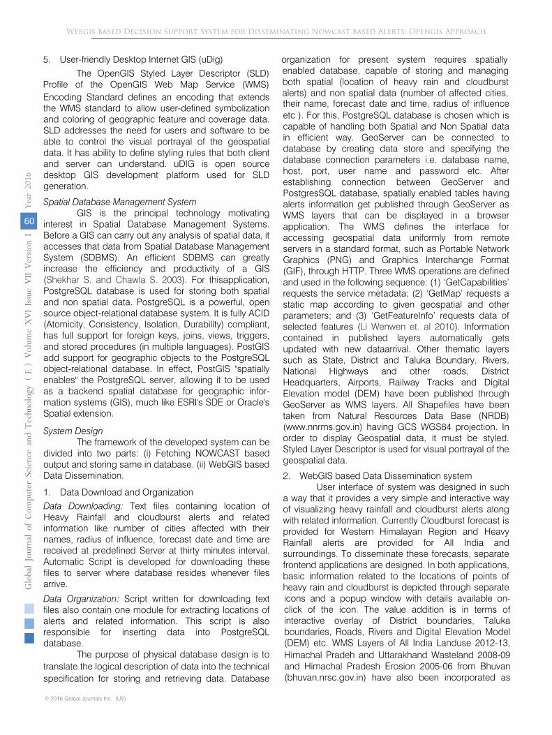
Functionality present in the System
Web Interface of system is shown in Figure_4. Forecast Date and Time shows time for current forecast generated. Forecast Alerts are disseminated in Map Viewer in Figure_4. It is divided into different panels like Layer Panel in left, Map panel (Map Window) at center and Legend panel in right. Each frame can be resized to give a better view of the information contained therein. Layer Panel shows overlay layers and provides basic GIS functionality of turning on and off layers. User can also visualize back date forecast events by selecting date and time (from calendar) for which forecast information is available in database. Dates highlighted in red color are those for which forecast information is
-
-
-
© 2016 Global Journals Inc. (US)
Globa
l Jo
urna
l of C
ompu
ter Sc
ienc
e an
d Te
chno
logy
V
olum
e XVI Issu
e VII
Versio
n I
61
Year
2016
(
)E
-
-
stored in database. Heavy Rainfall and Cloudburst Alert maps along with other overlay layers are shown in Map
Panel. Toolbar is provided with various GIS functionalities like zooming in and out, panning, identifying, selecting and measure distance/area. User can click on the map and display its attributes in the feature info popup.
Furthermore, District and Taluka boundaries maps use selective labeling. That is, as the user zooms into the detail of the map, the name of the district and taluka will be shown on the map. This makes it easy to browse around the map to find more information about the surrounding area and region. User Interface of application along with functionalities present in the application are shown below from Figure 4 to 7.
better decisions. GIS functionalities like panning, zooming, on/off layers, print map, measure distance/ area have been incorporated. User is also provided with
functionality to search back dated forecast events for
Webgis based Decision Support System for Disseminating Nowcast based Alerts: Opengis Approach
users. These value additions will help users in making overlay layers for providing more information to the
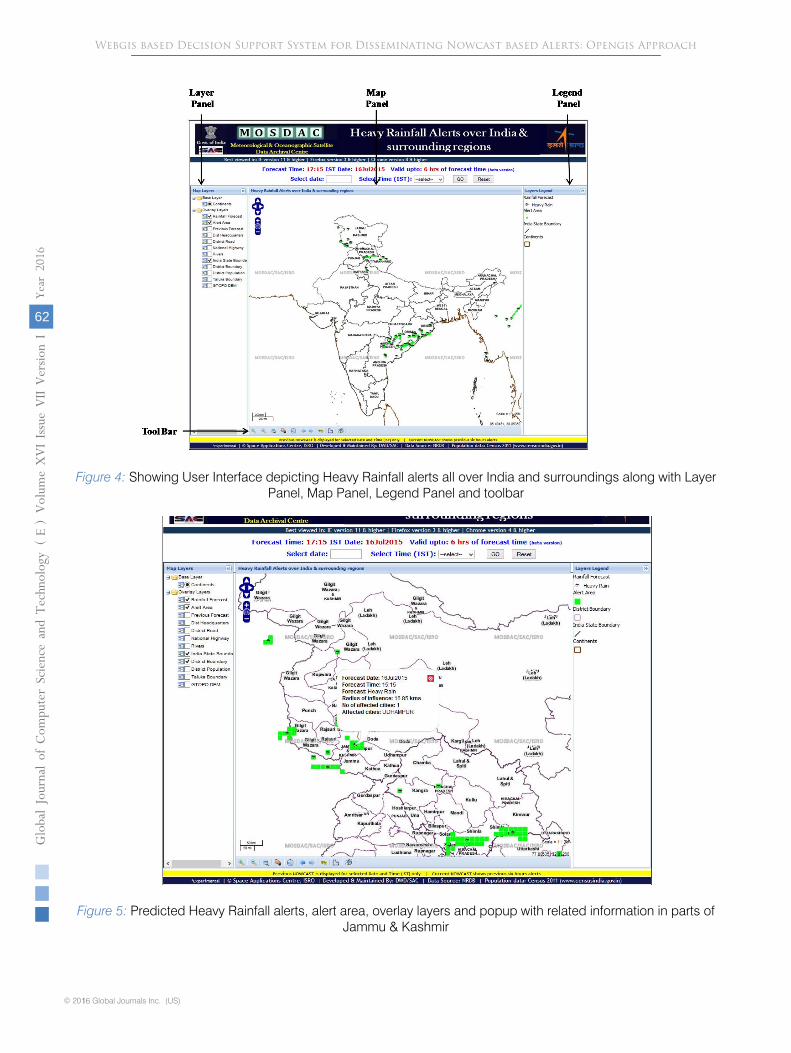
Figure 4:
Showing User Interface depicting Heavy Rainfall alerts all over India and surroundings along with Layer Panel, Map Panel, Legend Panel and toolbar
Figure
5:
Predicted Heavy Rainfall alerts, alert area, overlay layers and popup with related information in parts of Jammu & Kashmir
Globa
l Jo
urna
l of C
ompu
ter Sc
ienc
e an
d Te
chno
logy
V
olum
e XVI Issu
e VII
Versio
n I
62
Year
2016
(
)
© 2016 Global Journals Inc. (US)1
EWebgis based Decision Support System for Disseminating Nowcast based Alerts: Opengis Approach
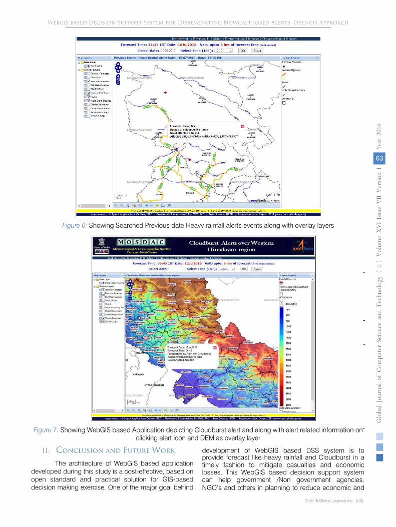
Figure 6:
Showing Searched Previous date Heavy rainfall alerts events along with overlay layers
Figure 7:
Showing WebGIS based Application depicting Cloudburst alert and along with alert related information on
clicking alert icon and DEM as overlay layer
-
-
-
© 2016 Global Journals Inc. (US)
Globa
l Jo
urna
l of C
ompu
ter Sc
ienc
e an
d Te
chno
logy
V
olum
e XVI Issu
e VII
Versio
n I
63
Year
2016
(
)E
-
II. Conclusion and Future Work
Webgis based Decision Support System for Disseminating Nowcast based Alerts: Opengis Approach
The architecture of WebGIS based application developed during this study is a cost-effective, based on open standard and practical solution for GIS-based decision making exercise. One of the major goal behind
development of WebGIS based DSS system is to provide forecast like heavy rainfall and Cloudburst in a timely fashion to mitigate casualties and economic losses. This WebGIS based decision support system can help government /Non government agencies, NGO’s and others in planning to reduce economic and
Similar technique has been adopted to provide information on heavy rain events using INSAT3D data; the same is available and updated at every half hour.
The current implementation of the GeoServer based depiction of heavy rain and or cloud burst events will be enhanced through implementation of probable impact assessment and depiction of the same.
III.
Acknowledgements
The authors express their sincere gratitude to Mr. Tapan Mishra –
Director SAC, Dr P.K. Pal -Deputy Director EPSA/SAC, Dr. B. S. Gohil -
Group Director, ADVG/ EPSA and Mrs. Pushpalata B. Shah Head DWD/ADVG/EPSA for their support and encouragement. The authors would also like to acknowledge AOSG/EPSA for providing Heavy Rainfall and Cloudburst NOWCAST, Natural Resources Database (NRDB) team for providing GIS based thematic layers and Bhuvan for providing WMS layers.
References Références Referencias
1.
Beaujardiere,J., 2004. OGC web map service interface [online], version 1.3.0, OGC 03-109r1. Available
from:
http://portal.opengeospatial.org/files
/index.php?artifact_id=4756
&
passcode=
b9mnkb
6rr7uc1hs1t1ue [Accessed 6 September 2009].
2.
Chaowei (Phil) Yang Corresponding author , David W. Wong , Ruixin Yang , Menas Kafatos & Qi Li (2005) Performance‐improving techniques in web‐ based
GIS, International Journal of Geographical Information Science, 19:3, 319-342, DOI: 10.1080/13658810412331280202
3.
Daniel Caldeweyher, Jinglan Zhang & Binh Pham (2006), OpenCIS—Open Source GIS‐based web community information system, International Journal of Geographical Information Science, 20:8, 885-898, DOI: 10.1080/13658810600711378
4.
Erik Hazzard, (2011). OpenLayers 2.10 Beginner’s Guide, First Edition. ISBN: 978-1-849514-12-5.
5.
Harish Chandra Karnatak , Reedhi Shukla , Vinod Kumar Sharma , Y.V.S. Murthy & V. Bhanumurthy (2012) Spatial mashup technology and real time data integration in geo-web application using open source GIS –
a case study for disaster manage-
ment, Geocarto International, 27:6, 499-514, DOI: 10.1080/10106049.2011.650651
6.
Herbert Schildt (2005). Java-
A Beginners Guide. Third Edition. DOI: 10.1036/0071466509
7.
James Goodwill, (2002). Apache Jakarta-Tomcat. ISBN: 1-893115-36-4
8.
Peng, Z.-R. and Tsou, M.-H., 2003. Internet GIS: distributed geographic information services for the internet and wireless networks. Hoboken, NJ: Wiley.
9.
Sharma, S. A. and Mishra, S. (2012), Web-GIS based monitoring of vegetationusing NDVI profiles, Journal of Geomatics, Vol.6 No.2 October 2012.
10.
Shashi Shekhar and Sanjay Chawla, (2003). Spatial Databases: A Tour,ISBN: 0-13-017480-7
11.
Shukla B.P, Kishtawal C.M. and Pal P.K. (2014), "Nowcasting of Extreme Orographic Rain (NETRA)", Space Applications Centre -
Ahemdabad: Scientific Report. SAC/EPSA/AOSG/SR/12/2014.
Globa
l Jo
urna
l of C
ompu
ter Sc
ienc
e an
d Te
chno
logy
V
olum
e XVI Issu
e VII
Versio
n I
64
Year
2016
(
)
© 2016 Global Journals Inc. (US)1
EWebgis based Decision Support System for Disseminating Nowcast based Alerts: Opengis Approach
material losses from disasters. This paper shows the process and methods of comprehensively using open source software like GeoServer, PostgreSQL, PostGIS, OpenLayers and others to publish geographic information, verifying the technical feasibility of the use of open source software to publish geographical information.