Embed Size (px)
Citation preview

Weather
P.LOBOSCO

Chapter 16-1 Objectives: Explain how solar heating and water vapor
in the atmosphere affect weather. Discuss how clouds form and how they are
classified. Describe how rain, hail, sleet and snow
develop.

Heating the Earth Meteorologists are people who study the
weather. Weather is the daily condition of the
Earth’s atmosphere. The atmospheric factors that interact to
cause weather are heat energy, air pressure, winds and moisture.

Heat Energy and the Atmosphere Almost all of the Earth’s energy comes
from the sun. This energy is called radiant energy.
The sun’s radiant energy warms the Earth. The atmosphere also helps warm the Earth
by absorbing, storing and recycling the sun’s radiant energy.
Temperature Air temperature is a measure of the movement of
the particles in the air. Wind is air that is moving from an area of high
pressure to an area of low pressure. The temperature of air can affect air pressure.
High temperatures have lower air pressure than low temperatures.
Wind speed can be measured with an anemometer.

Measuring Temperatures Air temperature is
measured with a thermometer. Most thermometers consist of a thin glass tube with a bulb at one end. The bulb is filled with a liquid, usually mercury or alcohol that is colored with dye. When the temperature falls, the liquid contracts and takes up less space and drops in the tube.

Air Pressure Air pressure is a measure of the force of the
air pressing down on the Earth’s surface. The air pressure at any point on the Earth is
equal to the weight of the air directly above that point.
Air pressure at any particular point on the Earth depends on the density of the air.
Denser air has more mass per unit volume than less dense air so denser air exerts more air pressure.

Factors that Affect Air Pressure The density of the Earth’s atmosphere, and
thus air pressure is affected by three factors: temperature, water vapor and elevation.

Water Vapor At a given pressure, moist air is less dense
than dry air. This is because a water molecule has less mass than either a nitrogen or an oxygen molecule. Thus air with a large amount of water vapor in it exerts less air pressure than drier air.

Elevation Elevation, or altitude, also affects air
pressure. As the elevation increases, the air becomes thinner, or less dense. So the air pressure decreases with increasing elevation.

Measuring Air Pressure Because air pressure changes with changes
in temperature and elevation, standard air pressure is measured at a temperature of 0 degrees at sea level. Air pressure is measured with an instrument called a barometer. There are two types of barometers.

Evangelista Torricelli The mercury
barometer was invented in 1643 by an Italian scientist named Evangelista Torricelli. A mercury barometer consists of a glass tube closed at one end and filled with mercury.

Mercury Barometer The open end of the
glass tube is placed in a container of mercury. At sea level it is supported at certain level. As air pressure decreases, the column of mercury drops.
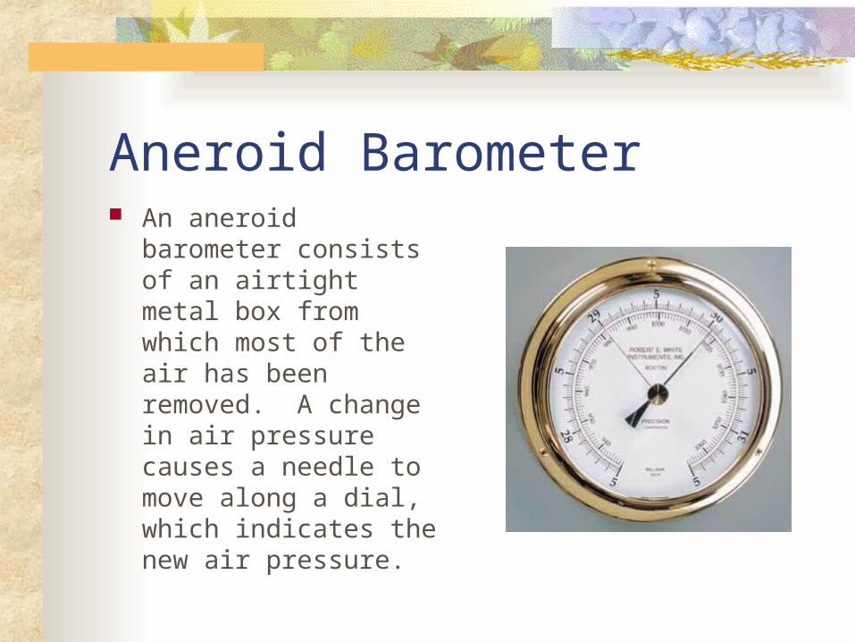
Aneroid Barometer An aneroid barometer
consists of an airtight metal box from which most of the air has been removed. A change in air pressure causes a needle to move along a dial, which indicates the new air pressure.

Humidity Water vapor, or moisture, in the air is called
humidity. The amount of moisture can vary from place to place and time to time.
Relative humidity is the percentage of moisture the air holds relative to the amount it could hold at a particular temperature.
When the relative humidity is 100 percent, the air is saturated.

Measuring Relative Humidity Meteorologists measure the relative
humidity with a psychrometer. A psychrometer consists of two
thermometers. The bulb of one thermometer is covered with a moist cloth. This is the wet-bulb thermometer. The other is the dry-bulb thermometer.

Psychrometer When the air passes over the
wet bulb, the water in the cloth evaporates. Evaporation from the cloth cools the thermometer bulb. If the humidity is low, evaporation will take place quickly and the temperature of the wet-bulb thermometer will drop. If the humidity is high, the wet-bulb will not change much. Relative humidity is determined by the difference between the two and expressed as a percentage.

Clouds Warm air can hold more moisture than cold
air. As warm, moist air rises, its temperature drops. The air becomes saturated and the water vapor begins to condense. The temperature at which water vapor condenses is called the dew point. Clouds form when moisture in the air condenses on small particles of dust or other solids in the air.

Types of Clouds Cumulus Stratus Cirrus

Cumulus Clouds Cumulus clouds are
fluffy and white. They form at altitudes of 2.4 to 13.5 kilometers. They usually indicate fair weather.

Cumulonimbus. Cumulonimbus clouds are
thunderstorm clouds. High winds can flatten the
top of the cloud into an anvil-like shape.
When we see Cumulonimbus clouds, we may have heavy rain, snow, hail, lightning and even tornadoes.

Stratus Clouds Smooth, gray clouds that
cover the whole sky and block out the sun are called stratus clouds. They form at an altitude of about 2.5 kilometers.
Light rain and drizzle are associated with stratus clouds. Nimbostratus clouds bring rain and snow.
When stratus clouds form near the ground, the result is fog.

Cirrus Clouds Feathery or fibrous
clouds are called cirrus clouds. Cirrus clouds form at very high altitudes.
Cirrus clouds are usually made of ice crystals. They often indicate that rain or snow will fall within several hours.

Precipitation Water vapor that condenses and forms
clouds can fall to the Earth as rain, sleet, snow or hail. Water that falls from the atmosphere to the Earth is called precipitation.
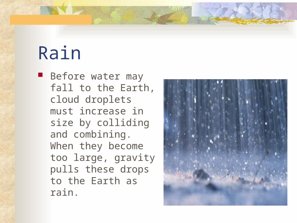
Rain Before water may fall
to the Earth, cloud droplets must increase in size by colliding and combining. When they become too large, gravity pulls these drops to the Earth as rain.
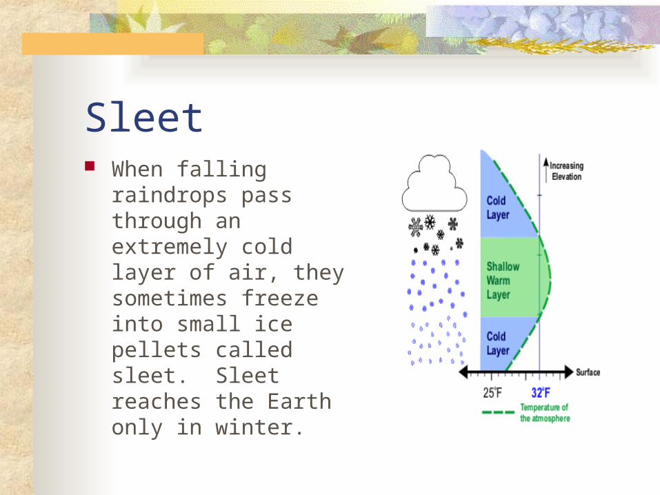
Sleet When falling
raindrops pass through an extremely cold layer of air, they sometimes freeze into small ice pellets called sleet. Sleet reaches the Earth only in winter.

Snow Snow forms when water
vapor changes directly into a solid. Snowflakes are flat six-sided ice crystals that have beautiful shapes. Because they sometimes clump together, it is hard to see the separate crystals. No two snowflakes are exactly alike.

Hail Hail is one of the most
damaging forms of forms in cumulonimbus clouds. Hailstones are small balls of ice ranging from 5-75 mm in diameter.
Hailstones are formed when water droplets hit ice pellets in a cloud and freeze.

Chapter 16-2 Objectives: Describe how weather is associated with
fronts and high and low pressure systems. Explain how tornadoes develop from
thunderstorms. Discuss the dangers of severe weather.

Weather Patterns Air masses Fronts Storms

Air Masses Air masses are large bodies of air that form
over the same area and take on the properties of that area.
Air masses usually cover thousands of square kilometers.
Air mass are classified by where they form which determines two properties: temperature and humidity.

Types of Air Masses The four major types
of air masses that affect the weather in the United States are:
maritime tropical maritime polar continental tropical continental polar.

Maritime Tropical Air Mass The maritime tropical
air mass forms over the ocean near the equator.
It holds warm, moist air.
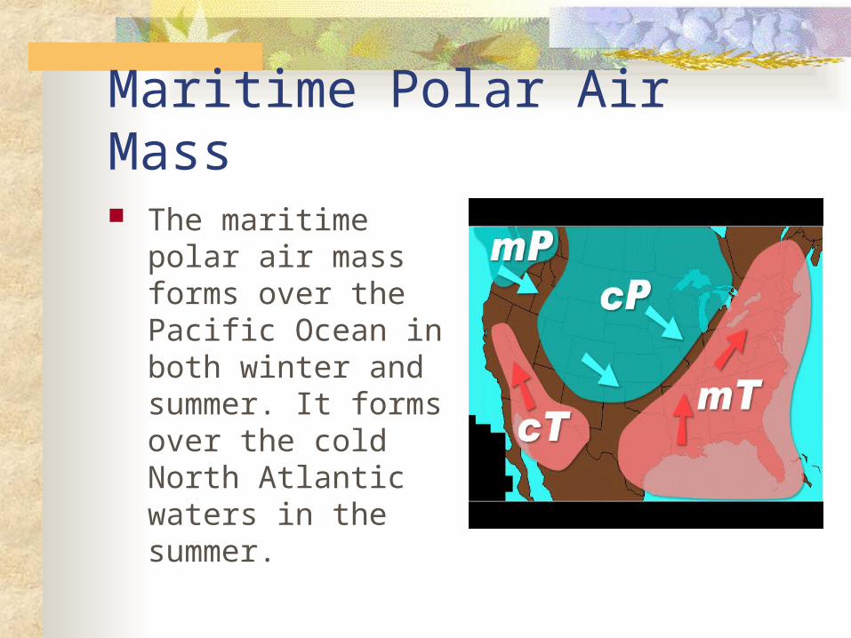
Maritime Polar Air Mass The maritime polar
air mass forms over the Pacific Ocean in both winter and summer. It forms over the cold North Atlantic waters in the summer.

Continental Tropical Air Mass During the summer,
the continental tropical air mass forms over land in Mexico.
This air mass brings dry, hot air to the southwestern states.

Continental Polar Air Mass The continental polar
air mass forms over land in northern Canada.
In winter, this cold, dry air mass causes extremely cold temperatures in the United States.

Fronts When two air masses that have different
properties meet, they do not mix easily. A boundary forms between the two air masses.
This boundary is called a front. The weather at a front is usually unsettled and stormy.
Types of Fronts There are four types of fronts: cold fronts warm fronts occluded fronts stationary fronts.

Cold Front A cold front forms when
a mass of cold air meets and pushes under a mass of warm air. The cold air mass forces its way underneath the warm air mass and pushes it upward. Violent storms are associated with a cold front. Fair, cool weather usually follows.

Warm Front A warm front forms
when a mass of warm air overtakes a cold air mass and moves over it. Rain and showers usually accompany a warm front. Hot, humid weather usually follows.

Occluded Front A cold front travels faster than
a warm front. When a cold front overtakes a warm front, an occluded front forms. As the warm air is pushed upward, the cold air meets cool air. An occluded front may also occur when cool air overtakes a cold front and warm air is pushed upward. An occluded front produces less extreme weather than a cold or warm front.

Stationary Front When a warm air mass
meets a cold air mass and no movement occurs, a stationary front forms. Rain may fall in an area for many days when a stationary front is in place.
Storms or Severe Weather A storm is a violent disturbance in the
atmosphere. It is marked by sudden changes in air pressure and rapid air movements. Some storms may cover a huge area, whereas others cover only a small area.

Rainstorms and Snowstorms When two different fronts collide, rainstorms or
snowstorms form. When a warm front moves in and meets a cold front, heavy nimbostratus clouds develop. In the summer, the result is a steady rainfall that lasts for several hours. In the winter, a heavy snowfall occurs.
If the wind speed is more than 56 kilometers per hour and the temperature is below-7 C, a blizzard results.

Thunderstorms When a cold front moves in
and meets a warm front, cumulonimbus clouds produce thunderstorms.
Thunderstorms are heavy rainstorms accompanied by thunder and lightning.
Violent downdrafts and strong wind shear are often associated with thunderstorms.
Lightning striking the ground is the leading cause of forest fires.

Thunder Loud thunder claps usually accompany the
lightning in a thunderstorm. The electrical discharge of lightning heats the air.
When the air is heated, it expands rapidly. This sudden expansion of the air results in sound waves, or thunder.
Sound waves travel much more slowly than light so they appear to occur at different times.
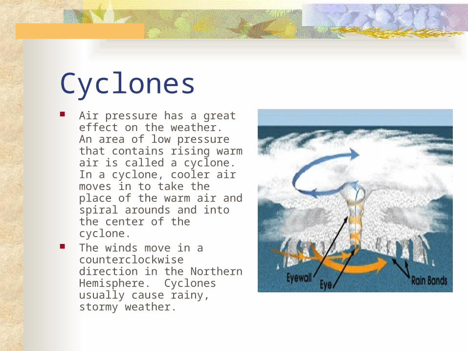
Cyclones Air pressure has a great effect
on the weather. An area of low pressure that contains rising warm air is called a cyclone. In a cyclone, cooler air moves in to take the place of the warm air and spiral arounds and into the center of the cyclone.
The winds move in a counterclockwise direction in the Northern Hemisphere. Cyclones usually cause rainy, stormy weather.

Anticyclones A high-pressure area that
contains cold, dry air is called an anticyclone. Winds spiral around and out from the center of an anticyclone. In the Northern Hemisphere, the winds move in a clockwise direction. The weather caused by anticyclones is usually clear, dry and fair.

Tornadoes A tornado is whirling, funnel-
shaped cloud. It develops in low, heavy cumulonimbus clouds.
The air pressure at the bottom of the funnel of swirling air is extremely low. When this low-pressure area touches the ground, it acts like a giant vacuum cleaner.
A tornado over water is called a water spout. They are common on the Great Plains. They travel 95 km per hour.

Tornadoes Tornadoes often form
from a type of cumulonimbus cloud called a wall cloud.

Fujita Scale The Fujita scale ranks
tornadoes according to how much damage they cause.
Only 1% is classified as an F5.

Hurricanes A hurricane is a powerful
cyclone that forms over tropical oceans. Hurricanes that form over the western Pacific Ocean are called typhoons.
During late summer and early autumn, low-pressure areas often form over the Caribbean or the Gulf of Mexico.
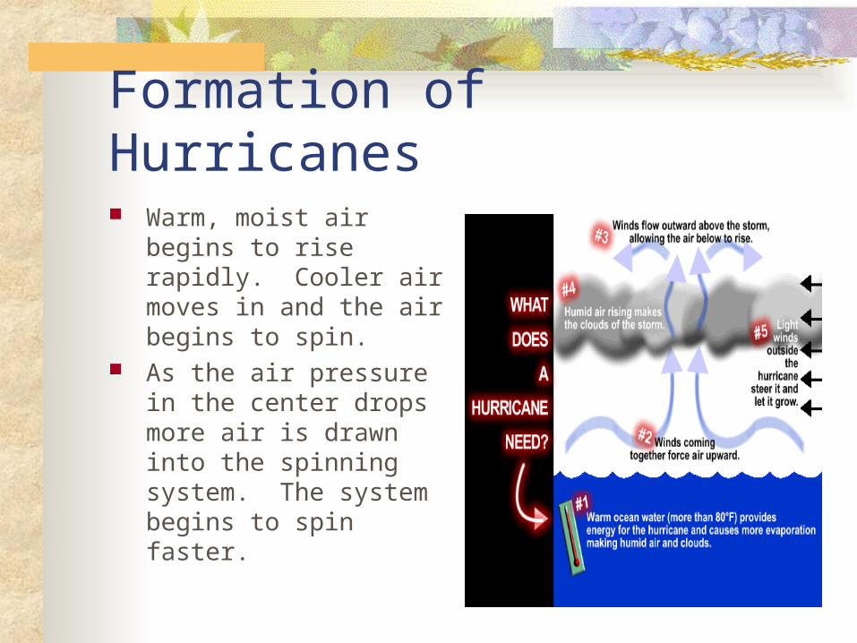
Formation of Hurricanes Warm, moist air begins
to rise rapidly. Cooler air moves in and the air begins to spin.
As the air pressure in the center drops more air is drawn into the spinning system. The system begins to spin faster.

Formation of Hurricane The rapidly spinning,
rising air forms a doughnut-shaped wall of strong winds, clouds and rainfall.
As a hurricane moves inland, it loses force and power.

Eye of the Hurricane Inside the wall, the air
is calm. This calm center is called the eye of the hurricane.
Outside the eye, winds may reach rotational speeds close to 480 kilometers per hour.

Damage of a Hurricane The high waves and strong
winds of a hurricane often cause great damage, especially in coastal areas. Heavy rain may also cause serious flooding.
Meteorologists can track the path of a hurricane and issue watches or warnings. A typical hurricane lasts for about 9 days. Some may last 3 or 4 weeks.

Severe Weather Safety When severe weather threatens, the
National Weather Service will issue a watch or a warning.
During a watch you should stay tuned to a radio or television for instructions.
During a warning, you should immediate action.

Precautions During a tornado warning, you should
move to a basement or a room in the center of the house with no windows.
During a hurricane warning, you should move inland,.
During a blizzard you should stay indoors due to lower visibility and freezing temperatures.

Chapter 16-3 Objectives: Explain how data are collected for weather
maps and forecasts. Identify the symbols used in a weather
map.

Predicting the Weather Meteorologists interpret weather
information from local weather observers, balloons, satellites, and weather stations around the world.
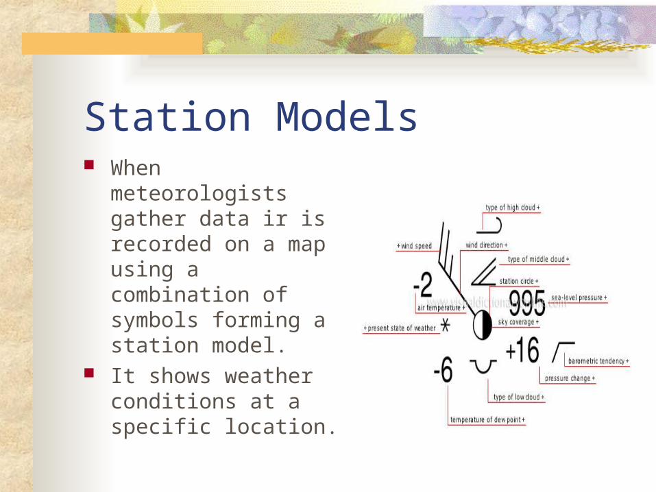
Station Models When meteorologists
gather data ir is recorded on a map using a combination of symbols forming a station model.
It shows weather conditions at a specific location.
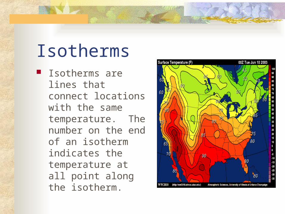
Isotherms Isotherms are lines
that connect locations with the same temperature. The number on the end of an isotherm indicates the temperature at all point along the isotherm.

Isobars Isobars are lines that join
places on a weather map that have the same air pressure.
The number at the end of an isobar represents the air pressure recorded at each observation.
The air pressure can be given in millibars, inches of mercury or both.
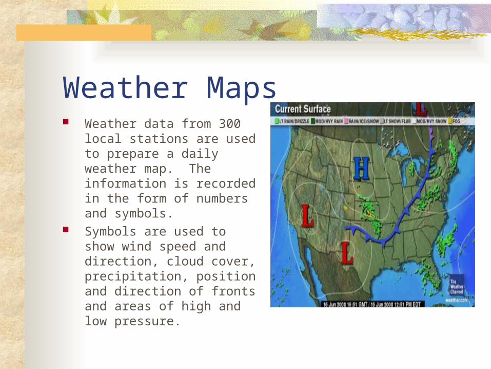
Weather Maps Weather data from 300 local
stations are used to prepare a daily weather map. The information is recorded in the form of numbers and symbols.
Symbols are used to show wind speed and direction, cloud cover, precipitation, position and direction of fronts and areas of high and low pressure.